Kyoto City Landscape Policy · outdoor advertisements, etc. ⇒Implement illegal outdoor...
29
Kyoto City Landscape Policy Forming Timeless and Radiant Kyoto Landscapes (September 2007~) Kyoto City 1
Transcript of Kyoto City Landscape Policy · outdoor advertisements, etc. ⇒Implement illegal outdoor...

Kyoto City Landscape PolicyForming Timeless and Radiant Kyoto Landscapes
(September 2007~)
Kyoto City1

Kyoto City Location and Population
Kyoto City is located west of central Japan, with a metropolitanpopulation of 1.47 million people.
Population : 1,470,000 Area : 828k㎡
2
■ Kyoto City location map (widescale)
Ulaanbaatar
New Delhi
Singapore
Bangkok
Jakarta
Manila
Beijing Seoul
Kyoto
Taipei
Shanghai
Hong Kong
Guangzhou
■ Kyoto City location map
Kyoto City
● Kobe City
●Osaka City
●
NagoyaCity

The Kyoto City terrain is a basin enclosed to the east, west and north by mountains (Higashiyama, Nishiyama, Kitayama), with two rivers to the north and south.
Kyoto Station
HigashiyamaKitayama
Kyoto City Terrain
3
Kitayama
Higashiyam
a
Nishiyam
a
KyotoStation
●
Katsura
River
Kam
oR
iver

Kyoto Imperial Palace
KitayamaHigashiyama
Kyoto, Historical CitySpanning approximately 1000 years as site of the Imperial Dignity, Kyoto is home to the Imperial Palace and many other historical edifices.
4

Kyoto's Beautiful Landscapes
Sagano (pasture)
Kamo River and Kitayama
5
Kyoto features a multitude of exquisite landscapes interweaving historical buildings with abundance scenes of nature.
Kyo-machiya(Kyoto traditional townhouse)
Kiyomizudera Temple (World Heritage Site)
Nijo Castle (World Heritage Site)
Yoshida Residence

Timeline of Measures to Preserve Kyoto's Landscapes
1930 Scenic Landscape Districts designated (3,400ha → 17,938ha at present)
1972 City Ordinances on Urban Landscape established (nation's first)・Aesthetic Landscape Districts ・ Large Scale Construction Restriction Zones・Special Preservation and Improvement Districts (Gion Shimbashi, Sanneizaka)→ 1975 Cultural Property Preservation Act revised (newly Preservation Districts for Groups of Historical Buildings)
1967 Special preservation areas designated under the Ancient Capital Cities Preservation Law
1995 City Ordinances on the Betterment of Urban Landscape established
1973 City Mostly under Height Zone (Center area up to 45m in height)
1996 Landscape Restriction Districts expanded, Outdoor Advertisement Measures reinforced, Building Height Control reinforced
(Aesthetic Landscape Districts 932ha→1,804ha→1,956ha)
2003 3-Point Set Rule for Commercial-Residential Coexisted Districts Introduced
→ 1993 New Kyoto Fundamental Plans(Northern Preservation, Southern Creation, City Center Revitalization)
(117ha→2,861ha at present)
(City Center Building Height Control Districts reinforced, Special Use Districts designated, Aesthetic Landscape Districts Expanded)
1991- 92 Report by Committee for Kyoto Town Development on Land Use and Landscape Measures・Fundamental Concept for Northern Preservation, City Center Revitalization and Southern Creation
6
Various measures were established in Kyoto City to protect these landscapes
Mid 1950's to 1960's Narabigaoka development issue → Ancient Capitals Preservation Law in 1966
1964 Kyoto Tower issue

Loss of Kyoto’ssBeautiful Landscape
Construction projects maladapted to surrounding cityscape
Construction projects maladapted to surrounding cityscape
Loss of scenery and borrowed landscapesLoss of scenery and borrowed landscapes
Loss of Kyo-machiya and other historical buildings
Loss of Kyo-machiya and other historical buildings
Degradation of landscapes due to outdoor advertisements
Degradation of landscapes due to outdoor advertisements
Change in values and lifestylesChange in values and lifestyles
Economy and efficiency driven motivations
Economy and efficiency driven motivations
Outdoor Advertisements
Apartment buildings near World Heritage Site Kamigamo Shrine
East bank of Kamo River as seen from west bank (Ponto-cho)
11Buildings visible behind a
historical park(Shosei Garden)
Machiya houses and high-rise buildings
7
Despite these efforts, beautiful landscapes have been lost. The following societal changes are said to account for this.

Fundamental Concept of Kyoto City Landscape Policy
Features of Kyoto Landscape
Kyoto 50 to 100 years later: Landscaping that will remain relevant as a historical city in the future
Kyoto 50 to 100 years later: Landscaping that will remain relevant as a historical city in the future
Buildings may be private property, but landscape is public assets
Buildings may be private property, but landscape is public assets
It is each and every one of ours duty and responsibility to inheritKyoto's magnificent landscapes for future generations
It is each and every one of ours duty and responsibility to inheritKyoto's magnificent landscapes for future generations
5 basic policies① Landscaping that naturally
conforms to scenery in the basin
① Landscaping that naturally conforms to scenery in the basin
③ Landscaping comprised of multitudinous spaces that bespeak the features of Kyoto
③ Landscaping comprised of multitudinous spaces that bespeak the features of Kyoto
④ Landscaping that generates the city pulse
④ Landscaping that generates the city pulse
⑤ Landscaping through partnerships among thegovernment, residents and enterprises
⑤ Landscaping through partnerships among thegovernment, residents and enterprises
New landscaping policies that suit theregion's characteristics
8
To meet these challenges, 5 basic policies framed investigations into regulations and guidelines that suit the region's characteristics, leading to the implementation of the New Landscape Policy in September 2007.
② Landscaping that coordinates harmony between succession of traditional culture and creation of new
② Landscaping that coordinates harmony between succession of traditional culture and creation of new

Landscape Policies Suited to Regional Characteristics (by region)
9
1 Mountainous and piedmont area①World Heritage Areas② Historical buildings and scenic sites
areas③ Residential areas (residential areas /
areas along community roads)
2 Residential areas borderingmountainous area
① Historical assets areas② Residential areas (residential areas /
areas along community roads)③ Areas along main roads④Waterfronts⑤ Commercial areas
3 Western region① Industrial areas② Residential areas
5 Historical urban area (generally within Kitaoji St., HigashiojiSt., Kujo St. and Nishioji St.)
① Historical urban centedistrict
② Commercial-residential coexisted district
③ Southern historical urban area
④Waterfront and green area⑤ Historical heritage area⑥ Areas along main roads⑦Western and southern
urban areas⑧ Commercial areas
6 Eastern region① Residential areas② Commercial areas
4 Southern region① Highly integrated area② Industrial area③ Residential areas④ Commercial areas
Fine-grained policies suited to regional characteristics.

1 Building Height
3 Surrounding Scenery and Vistaed view
2 The design of buildings, etc.
5 Historical Streets
4 Outdoor Advertisements
Support system
The Landscape Policy 5 Main Elements and the
Support System
Framework of Kyoto City Landscape PolicyChanges in City PlanningBuilding Height Control Districts / Scenic Districts / Scenic Landscape Districts
Changes in City PlanningBuilding Height Control Districts / Scenic Districts / Scenic Landscape Districts
Established and Revised City Ordinances<Established>・City Ordinances on the Preservation of
Vistad Views・An ordinance requiring special permits
for building exceeding height controls
<Revision>・City Ordinances on the Betterment of
Urban Landscapes・City Ordinances on the Scenic
Landscape Districts・Ordinances on advertisements・City Ordinances on the Preservation of
Natural Scenery
Derivative and Supporting Measures
Projects that improve historical cityscapes
Projects that improve historical cityscapes
10
The landscape policy comprise 5 main elements and the support systems. To implement these measures in Kyoto City, a broad range of city planning and ordinances were changed in 2007. The 5 main elements and the support systems are below.

Framework basis for height over the
entire city
Based a set height for buildings in the city center where business is centered. From the center, maximum heights are gradually lowered toward the foothills of the three mountain regions
Framework basis for height over the
entire city
Based a set height for buildings in the city center where business is centered. From the center, maximum heights are gradually lowered toward the foothills of the three mountain regions
② Attention to difference in height with adjacent areas
② Attention to difference in height with adjacent areas
1 Building Height
⇒ Maximum heights have been lowered for Building
※ Heights lowered in 30% of urbanizationareas (approximately 15,000ha)
⇒ (Formerly) 10m, 15m, 20m, 31m, 45m(Currently) 10m, 12m, 15m, 20m, 25m, 31m
Building Height (Building Height Control Districts)
11
The height of buildings is an important element that forms city landscape and environment. To this end, maximum heights have been lowered over a wide range while segmenting height controls according to the areas characteristics.
Height Control Districts in ① Historical City Areas, ② Residential Areas in Mountain Foothills, and ③ Industrial Areas
① Fine-grainedregulations suitingcharacteristics of each area
① Fine-grainedregulations suitingcharacteristics of each area
③ Consideration for both land use and scenery
③ Consideration for both land use and scenery

12
Height Regulations Map (former)
Building Height Control District Regulation Maps
height restriction
height restriction
・
Urbanization promotion area
World Heritage sites
Imperial Palace Park / Detached Palace
Historical Urban area
Height Regulations Map (present)
Urbanization promotion area
Historical Urban area
Imperial Palace Park / Detached PalaceWorld Heritage sites・
height restriction
Urbanization promotion area
Historical Urban area
Imperial Palace Park / Detached PalaceWorld Heritage sites・

Major Areas Where Maximum Heights Were Lowered (Historical Urban areas)
Former regulation at 31m
Current regulation at 15m (continuity of townscape)
13
Maximum heights were lowered in nearly all areas of historical townscapes. Case in point is Kyo-machiya (Kyoto traditional townhouse) and the height of nearby buildings. This is a human scale urban space.
(Ex)
Centrally located artery roadside districts: Commercial-residential coexisted districts:
Other artery roadside areas, Kamo River, East Kamo area, Nishijin, etc.
City center arterial roadsided istrictCommercial-residential coexisteddistrict
Marutamachi St.
Oike St.
Shijyo St.
Gojo St.
Horikaw
aSt.
Karasum
aSt.
45m⇒ 31m
31m⇒ 15m
Kaw
aramachi
St.

Kyo-machiya Urbanscape Features (A Human Scale Town)
14
In a historic town where rows of Kyo-machiya houses are built, deep relationships are fostered where life and livelihood thrive and traditional culture like Gion-Matsuri Festival are passed on. By restricting building heights, this kind of human scale towns continue to be passed on.
Gion-Matsuri Festival
Jizo Bon(A regional event for children)
Hibukuro(A kitchen with open ceiling above in a Kyo-machiyahouse)
Ro-ji(An intimate alley in the neighborhood )
Yoshida Residence
Kyo-machiya

2 BuildingDesign
⇒ Landscape Districts Expanded 1,956ha → 3,431ha (presently)Aesthetic landscape districts expanded, new aesthetic landscape promotion districts designated
⇒ Landscape Improvement Districts Expanded (Notification zones based on Landscape Act)6,704ha → 8,582ha (presently)
⇒ Scenic Landscape Districts Expanded 17,831ha→17,938ha(presently)Expanded to World Heritage areas
⇒ More Detail and Clarification in Design Standards that Suit Regional Characteristics
From categorical standards to regional, using objectivepalette standards
⇒Workpiece Regulations StrengthenedCell phone antennas, solar panel
Building Design Regulations(Landscape District, Landscape Improvement Districts, Scenic Landscape Districts)
15
Building design (shape, materials, color, etc.) is an important element that forms scenery. To this end, regulation districts have been more broadly expanded than before while fine-grained design standards have been set in tune with regional characteristics.

16
Landscape districts are divided into 6 large aesthetic landscape districts, and 2 aesthetic landscape promotion district suited to regional characteristics. Landscape improvement districts are likewise divided into 4 districts suited to regional characteristics.
Landscape district (Aesthetic landscape district, aesthetic landscape promotion district)
Landscape Regulation Map (present)Landscape Regulation Map
Aesthetic landscape district (Piedmont)
Aesthetic landscape district (Mountain-range-background)Aesthetic landscape district(Historical city)
Aesthetic landscape district (Riverside)
Aesthetic landscape district (Historical heritage)
Aesthetic landscape district(Historical heritage) 〔Historical landscapepreservation and improvement district〕
Aesthetic landscape district(Historical heritage) 〔Community scenicbetterment district〕
Aesthetic landscape district(roadside)
Aesthetic landscape promotion district (roadside)
Aesthetic landscape promotion district (urban area)
Urbanization promotion district
Historical urban area
World Heritage Sites, Imperial Palace Park, detached palace
Scenic landscape district
Scenic landscape district expansion,reclassification
Scenic landscape district special improvementdistrict
Landscape promotion district (Piedmont)
Landscape promotion district (Riverside)
Landscape promotion district (Mountain-range-background)
Landscape promotion region (City)

Design Standards for Aesthetic Landscape Districts and Aesthetic Landscape Promotion Districts (Major Common Standards)
Roof PaletteRoof tiles are in principle oxidized silver / copperplates either plain or blue-green / non-copper plates and other roof materials are in principle matte gray or matte black
External Wall Material
Material on major external walls are to be matte (with exception to glass and natural materials).
Balcony Balconies are not to protrude from the wall of the building. However, low buildings, or places out of view from public spaces are not restricted.
External Wall Palette
The following palettes are not to be used on major external walls. However, unstained natural materials are not restricted.(1) Red hues with color saturation greater than 6.(2) Yellow-red hues with color saturation greater than 6. <abbreviated below>
Gates, Fences, Hedges
Parking spaces for automobiles and bicycles should be enclosed by a gate, fence or hedge in keeping with the cityscape.
+Design Standards for Landscape Districts
Design Standards for Landscape Districts
Common StandardsCommon Standards
Region Specific Standards
Region Specific Standards
Quality suggestions gained from practice and suggestions from regions were integrated into design standards, and the standards will continue to advance.
17
Design standards are composed of the following common standards and region specific standards.

Historical city aesthetic landscape district
Historical heritage aesthetic landscape district
Roadside aesthetic landscape district
Roadside aesthetic landscape promotion district
Landscape Districts (Aesthetic Landscape Districts, Aesthetic Landscape Promotion Districts ) Design Standards Illustration
18

3 VistaedViews &
Borrowed Landscapes
⇒ Selected from 597 literary and citizen opinion sources
⇒ As urban areas approach historical assets including World Heritage Sites, visted views and borrowed landscapes are in danger of being lost unless new regulations for height controls and design are formed
38 Locations selected by committee⇒ City Ordinances on the Preservation of Vistaed ViewsBuilding height controls and design regulations / suggestion system
① Temple Views 14 World Heritage Sites, Kyoto Imperial Palace Park, Shugakuin Imperial Villa, Katsura Imperial Villa
② Street Views Oike St., Shijo St., Gojo St., Sanneizaka, etc.
③ Waterfront Views Hori River, Uji River, Biwa Lake Sluice
④ Background view of garden Entsuji Temple, Shosei Garden
⑤ Mountain Views Higashiyama and Kitayama from Kamo River, Nishiyamafrom Katsura River banks
⑥ Bonfire Character Views Gozan no Okuribi as seen from Kamo River, Kitayama St., Funaokayama, etc.
⑦ Lookout Views Arashiyama range as seen from Togetsu Bridge downriver
⑧ Bird's Eye Views Cityscape seen from DaimonjiyamaVistaed view of Daimonji seen from Kamo
River right bank
Conserving Vistaed Views and Borrowed Landscapes-City ordinances are established to preserve vistaed viewsー
19
Kyoto claims many magnificent views – Japan's assets that are unique to Kyoto, admired even in ancient poems. In 2007, Kyoto was the first city to establish a Vistaed View Creation Ordinance to conserve 38 magnificent vistaed views and borrowed landscapes.

■Vistaed View Preservation Zone: Zones where building altitudes are set and may not be exceededin order to leave the viewing element unobstructed from the viewing spot
■Close View Preservation Zone: Zones where shape, design and palette are regulated so that buildings within view from the viewing spot do not blemish the magnificent vistaed view
■Distant View Presentation Zone: Zones where the palettes of external walls and roof tiles, etc. are regulated so that buildings within view from the viewing spot do not blemish the magnificent view
Areas that require preservation and generation of vistaed views are designated Vistaed View Preservation Zones. Vistaed Viewed Preservation Zones are classified by the three zones below according to the regulations they need.
Vistaed view Preservation Zone
Buildings exceeding the standard altitude regulationsAltitude regulation Zone
Close View Preservation Zone
(500m)
Close View Preservation Zone
Vistaed view Preservation ZoneBuildings exceeding the standard altitude regulations
Distant View Preservation Zone
Vistaed View Preservation Zone Designation
20
Viewing spot

4 OutdoorAdvertisements
⇒ Outdoor Advertisement Restrictions○Restrictions on display location, size and palette on outdoor
advertisements○Prohibit outdoor advertisements on roofs throughout the entire
city○Prohibit all outdoor advertisements using flashing lights○Stiffen restrictions on display location, size and palette on
outdoor advertisements○Prohibit side signboards that protrude over roads near centrally
located artery roads⇒Introduce Quality Outdoor Advertisements○Extend permit periods, relax permit standards, promote quality
outdoor advertisements, etc.⇒Implement illegal outdoor advertisement measures
Outdoor Advertisement Restrictions
21
City scenery is formed from not only nature and buildings, but all city activity. By regulating outdoor advertisements across all of Kyoto City, dignified beautiful scenery can be formed.

Outdoor Advertisement Restrictions (Example Images)
22
Road threshold
△△
○
△
△
△○
Road threshold
Prohibit rooftop signs to form a good skyline and generate a beautiful city landscape
Display height for signs will be set at bottom 2/3 of a building or by regional standards, whichever is the lowest.
○ ×
Signs protruding beyond road thresholds will be prohibited in some areas in order to open up the sky above roads and form good road landscape
Signs overlapping window openings and walls, detracting from building design, will be prohibited
○ ×
Advertisements limitedupto 10m inheight

5 Historical Townscapes
⇒ Use of District Designated Systems○Preservation Districts for Groups of Historic Buildings (Law for the Protection
of Cultural Properties)○Cityscape Environment Development Program Districts (National Subsidiary
Projects)○Historical Landscape Preservation and Improvement Districts (City Ordinances
on the Betterment of Urban Landscapes)○Community Scenic Betterment Districts (City Ordinances on the
Betterment of Urban Landscapes)⇒ Preservation Policies for Single Structures○Important Landscape Structures Designated (Landscape Act)○Historical Design Structures Designated (City Ordinances on the
Betterment of Urbanization Landscapes)○Kyo-machiya House Development Fund for Renovation Promotion Model
ProgramPreservations Districts for Groups of
Historic Buildings (Sanneizaka)
Historical Landscape Preservation and Improvement District (Gionmachi- minami)
Community Scenic BettermentDistricts
(Fushimi Minamihama)Important Landscape Structures
(Yoshida Residence)
Preserving and Improving Historical Townscapes
23
Kyo-machiya houses convey Kyoto's historical building style and lifestyle, forming a platform for historical city Kyoto landscape. Their preservation, outer repair and improvement are aided.
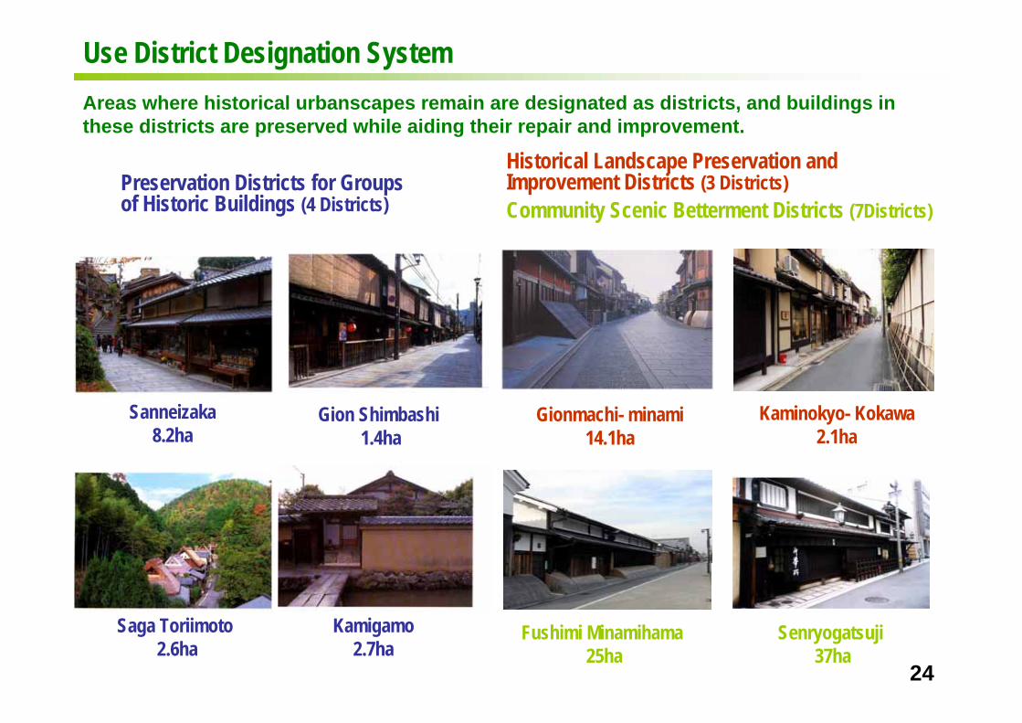
Sanneizaka8.2ha
Gion Shimbashi1.4ha
Saga Toriimoto2.6ha
Kamigamo2.7ha
24
Preservation Districts for Groups of Historic Buildings (4 Districts)
Areas where historical urbanscapes remain are designated as districts, and buildings in these districts are preserved while aiding their repair and improvement.
Historical Landscape Preservation and Improvement Districts (3 Districts)
Use District Designation System
Gionmachi- minami14.1ha
Kaminokyo- Kokawa2.1ha
Fushimi Minamihama25ha
Senryogatsuji37ha
Community Scenic Betterment Districts (7Districts)

●
● Important Landscape Structure● Nominated for Important Landscape
Structure through improvement and aid● Other Kyo-machiya houses
Initial Period
●
●
●
●
●● ●
● ●
●
●
Improvement rules for Important Landscape Structures and
neighboring areas(Landscape Agreement)
●●
●
Prevailing Period
●
●
●
Shibata Residence(Nakagyo-ku)
Yoshida Residence (Nakagyo-ku)
Yamanaka Cooking Oil (Kamigyo-ku)
⇒ Preservation, Repair and Improvement Aid through Single Structure Designation○Proactive Designation of Important Landscape Structures
(Landscape Act) <26 designations>○Designation of Historic Design Structures
(City Ordinances on the Betterment of Urban Landscapes)※Designations are current as of March 2009 <108 designations>
⇒Preservation and Improvement Efforts by KyotoCenter for Community Collaboration○Kyomachi House Development Fund for Renovation Aid Model Program
⇒Placing Important Landscape Structures at the core of areas to improve historic landscapes from points to lines, from lines to planes
Important Landscape Structures
25
Preservation Policy for Single StructuresDesignating structures as Important Landmarks imparts a permit system for changing their appearance while aiding their repair and improvement.
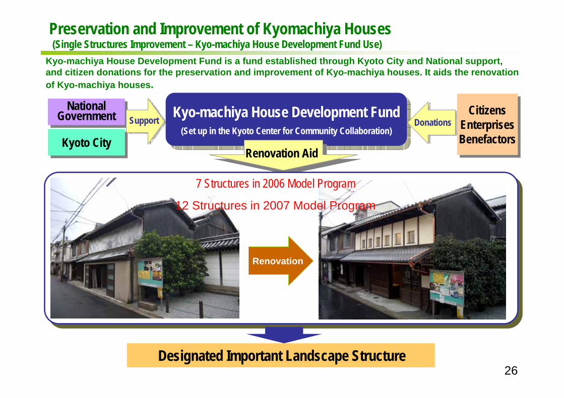
Preservation and Improvement of Kyomachiya Houses(Single Structures Improvement – Kyo-machiya House Development Fund Use)
Kyoto CityKyoto City
NationalGovernment
NationalGovernment Support Kyo-machiya House Development Fund
(Set up in the Kyoto Center for Community Collaboration)
Kyo-machiya House Development Fund(Set up in the Kyoto Center for Community Collaboration)
Renovation Aid
DonationsCitizens
EnterprisesBenefactors
CitizensEnterprisesBenefactors
Renovation
Designated Important Landscape Structure
7 Structures in 2006 Model Program
12 Structures in 2007 Model Program
26
Kyo-machiya House Development Fund is a fund established through Kyoto City and National support, and citizen donations for the preservation and improvement of Kyo-machiya houses. It aids the renovation of Kyo-machiya houses.

Support System
⇒ Support for Maintenance and Rebuilding of Existing Condominium
⇒ Support for Kyo-machiya Houses
Support System Outline
Enriching existing condominiums policyObjective: Proactively inducing proper maintenance of condos as quality stock while supporting
smooth rebuilding.
① Established advisor recruit system for condominium rebuilding and large scale repair (from 2007)② Established aid for seismic diagnosis for condominiums (from 2007)③ Established aid for seismic retrofitting for condominiums (from 2008)④ Established condominium rebuilding loan (from 2007)⑤ Established system for aiding rebuilding construction costs (for specific cases)※ Use of special height permit system to rebuild for good scenery or after damage due to
disasters such as earthquake
27
Kyoto City's Landscape Policy sets up a aid system for existing structures, and a support system for rebuilding condominiums.
(Advisor recruitment system, loans for rebuilding)
(Seismic diagnosis, seismic retrofitting promotion)

Landscape Policy bolsters the Kyoto Brand, adding value and a positive effect to the economy
Conservation and improvement of Kyoto’ landscape generates a new added value of enhancement to city character and allure resulting in increased residents and population for interaction, concentration of excellent human resources, investment growth in local industry, tourist industry, knowledge-based industry, etc. therefore becoming a source for maintaining and enhancing city pulse
In the face of a society declining in population, we have entered an age of city competition where each city appeals to its uniqueness to vie for allure as a city
Enhancing Kyoto's Value
○Effect Analysis of Provisions for Landscape
The following cases gained statistically high land value, confirming the influence landscape over set land values
・Residential areas with many inclined roofs
・Commercial areas with few garish advertisements
・Historical townscapes with many machiya houses and
Extracts from the Investigation Concerning Economic Value Analysis of Landscape Formation Report (Ministry of Land, Infrastructure, Transport and Tourism June 2007)
Gionmachi-minami
Meaning of Landscape Policy ~So that Kyoto will always remain Kyoto~
28
The meaning of Landscape Policy is not merely to improve the city, but maintain and enhance Kyoto's city pulse – in other words, to enhance the value of Kyoto.
Related Induction Regulations
tiled roofs or where the heights of many buildings harmonize with historical structures

So that Kyoto will always remain Kyoto
29