Kent Group National Park
4
Department of Environment, Parks, Heritage and the Arts Deal Island is part of the Kent Group National Park which is managed by the Tasmanian Parks and Wildlife Service. This is the newest of Tasmanian national parks – it was proclaimed in 2001. The national park is comprised of Deal, Erith and Dover Islands, as well as the smaller North East and South West Islands and Judgement Rocks. A Marine Protected Area surrounds Deal, Erith and Dover Islands. Deal Island is an important part of Tasmanian cultural heritage and has a number of significant historic sites including the lighthouse and the superintendent’s residence (now used as a museum) constructed in 1846-48, grave sites, infrastructure from the lighthouse era and various shipwrecks located around the shores of the islands. The Deal Island Lighthouse was decommissioned in 1992. Please note that all historic artifacts are protected. Do not remove or interfere with any historic items during your visit. The Islands also have significant natural values including important remnant island vegetation and many bird species. The waters around the islands have the highest fish diversity of any location in Tasmania as well as great diversity in the marine plants and invertebrates. Caretakers are in residence on the island and can be contacted by walking up to the caretaker’s residence above East Cove, by phone on 5680 8542 or via VHF or HF radio. The caretakers can provide you with additional information about walks on the island, historical interpretation or assist with communications in the case of an emergency. Things to do Visitors to the island can take a day walk, swim, camp, visit the museum or the lighthouse, birdwatch, have a barbecue at the jetty at East Cove or just enjoy the scenery. There are no formal camping facilities on Deal Island and the island is a Fuel Stove Only Area – no campfires permitted except in the constructed barbeques. Bushfire poses a significant threat to the historic buildings as well as vegetation and wildlife. Below are a few of the interesting facts about Deal Island. For more information visit the museum. • The Kent Group of Islands was named by Mathew Flinders in 1798 after the captain of the first fleet vessel Supply. • Lieutenant John Murray surveyed the passage separating Deal from Erith and Dover Islands in 1801-the Pass now bears his name. • Work began on the Deal Island Light Station in 1846 and it became operational in 1848. At 305 meters above sea level it is reputed to be the highest in the southern hemisphere and possibly second highest in the world. • However highest isn’t always best and the light was often obscured by low cloud and fog. It was replaced by two smaller lights on North East and South West Islands in 1992. • The original superintendent’s cottage (now the museum) is the oldest light keeper’s residence in Australia. • There have been a number of serious wildfires on the island in 1919, 1950 and 1986. • Parts of the island were under a grazing lease until the early 1990s. • During the 1940s an RAAF aeroplane crashed on Deal Island killing all on board. • The air strip on Deal Island was closed in 2004 for safety reasons. Helicopters occasionally visit the island, but require written authority from the Parks and Wildlife Service to land or take off. Walks There are a number of walks on the island. Most leave from the residential compound on the hill above East Cove. The caretakers have laminated maps available for walkers to borrow showing the tracks. Kent Group National Park DEAL ISLAND VISITING Walks Time East Cove to the Lighthouse 2 hrs return Barn Hill 45 mins return Squally Cove (Wreck Cove) 2-3 hrs return Garden Cove 1-2 hrs return Winter Cove 2-3 hrs return Little Squally Cove 1 hr return
Transcript of Kent Group National Park

Depar tment of Environment, Par ks, Her itage and the Ar ts
Deal Island is part of the Kent Group National Park which is managed by the Tasmanian Parks and Wildlife Service. This is the newest of Tasmanian national parks – it was proclaimed in 2001. The national park is comprised of Deal, Erith and Dover Islands, as well as the smaller North East and South West Islands and Judgement Rocks. A Marine Protected Area surrounds Deal, Erith and Dover Islands.
Deal Island is an important part of Tasmanian cultural heritage and has a number of significant historic sites including the lighthouse and the superintendent’s residence (now used as a museum) constructed in 1846-48, grave sites, infrastructure from the lighthouse era and various shipwrecks located around the shores of the islands. The Deal Island Lighthouse was decommissioned in 1992.
Please note that all historic artifacts are protected. Do not remove or interfere with any historic items during your visit.
The Islands also have significant natural values including important remnant island vegetation and many bird species. The waters around the islands have the highest fish diversity of any location in Tasmania as well as great diversity in the marine plants and invertebrates.
Caretakers are in residence on the island and can be contacted by walking up to the caretaker’s residence above East Cove, by phone on 5680 8542 or via VHF or HF radio. The caretakers can provide you with additional information about walks on the island, historical interpretation or assist with communications in the case of an emergency.
Things to doVisitors to the island can take a day walk, swim, camp, visit the museum or the lighthouse, birdwatch, have a barbecue at the jetty at East Cove or just enjoy the scenery.
There are no formal camping facilities on Deal Island and the island is a Fuel Stove Only Area – no campfires permitted except in the constructed barbeques. Bushfire poses a significant threat to the historic buildings as well as vegetation and wildlife.
Below are a few of the interesting facts about Deal Island. For more information visit the museum.
• The Kent Group of Islands was named by Mathew Flinders in 1798 after the captain of the first fleet vessel Supply.
• Lieutenant John Murray surveyed the passage separating Deal from Erith and Dover Islands in 1801-the Pass now bears his name.
• Work began on the Deal Island Light Station in 1846 and it became operational in 1848. At 305 meters above sea level it is reputed to be the highest in the southern hemisphere and possibly second highest in the world.
• However highest isn’t always best and the light was often obscured by low cloud and fog. It was replaced by two smaller lights on North East and South West Islands in 1992.
• The original superintendent’s cottage (now the museum) is the oldest light keeper’s residence in Australia.
• There have been a number of serious wildfires on the island in 1919, 1950 and 1986.
• Parts of the island were under a grazing lease until the early 1990s.
• During the 1940s an RAAF aeroplane crashed on Deal Island killing all on board.
• The air strip on Deal Island was closed in 2004 for safety reasons. Helicopters occasionally visit the island, but require written authority from the Parks and Wildlife Service to land or take off.
WalksThere are a number of walks on the island. Most leave from the residential compound on the hill above East Cove. The caretakers have laminated maps available for walkers to borrow showing the tracks.
Kent Group National Park DEAL ISLAND
V I S I T I N G
Walks Time
East Cove to the Lighthouse 2 hrs return
Barn Hill 45 mins return
Squally Cove (Wreck Cove) 2-3 hrs return
Garden Cove 1-2 hrs return
Winter Cove 2-3 hrs return
Little Squally Cove 1 hr return
Visit ing – Kent Group National Park - Deal Is land
Please note that Deal Island is a remote location so visitors should ensure that they are fully equipped for all weather conditions at any time of the year (including sturdy footwear and wind/rain protection), have sufficient water/food and a first aid kit, and allow sufficient time to complete day walks in daylight.
Water is often in short supply on the island so do not rely upon finding drinking water during a day walk.
The following provides an overview of the key features of the walks. Track marking is minimal so visitors must be self-reliant in navigating.
East Cove to the LighthouseThis walk begins from the residential compound and follows a vehicle route up the hill to the lighthouse. The distance is approximately three kms (one-way). The final part of the route is very steep. The walk can take up to two hours (return) depending upon your level of fitness. The lighthouse is usually locked so you will need to make contact with the caretakers before heading off.
Barn HillOn a clear day the views over Erith, Dover and Deal Island from Barn Hill are spectacular. On the way up to Barn Hill you will pass (on a side track towards East Cove) a historic grave and what remains of the whim once used to transport goods up the cliff to the residence and from there on to the lighthouse. The walk up Barn Hill involves a steep climb and takes 45 mins return.
Squally Cove – also known as Wreck CoveSqually Cove contains the wreck of the steamship Karitane which foundered on rocks in 1921.
To get to Squally Cove take the road to the lighthouse and then turn left before the road begins its final ascent to the lighthouse. The track winds its way around the side of a hill which has eucalypt and tea-tree vegetation before descending sharply into the bay. The walk involves a strenuous return journey and can take up to two hours (return).
Squally is a rocky, boulder strewn beach and is a good place for a picnic, snorkel around the wreck or simply a walk.
Garden CoveGarden Cove has a delightful white sand beach. To get to Garden Cove walk through the residential settlement compound and take the path which leaves from the gate to the north. The walk is approximately 2 kms (one-way) and is an easy grade. On the way you will pass the (now decommissioned) airstrip and on a clear day you may gain a spectacular view across the ‘swashway’ between Erith and Dover Islands to Wilsons Promonitory in Victoria. Garden Cove was the site of a small semi-permanent camp of sealers during the early 1800s.
Winter CoveLocated on the North East coast of Deal Island Winter Cove is a sheltered, deep bay which has an array of seaweeds, fish and algae for the snorkeller. The bay is often visited by dolphins and seals. It has a campsite which is sometimes used by sea kayakers. To get to Winter Cove take the northern gate from the compound (the same as for Garden Cove) but take the right hand fork in the track just past the disused fuel tanks.
The walk to Winter Cove is approximately 4 kms one way. The track winds up over a ridge through a dense she-oak thicket and across tussock grass plains before arriving at a sharp descent down a narrow valley into the Cove. This walk also involves a steep ascent on the return journey so allow 2-3 hours for the round trip.
Little Squally CoveTo get to Little Squally Cove head off out the gate of the compound towards the Lighthouse and take the first turn-off to the right. The first part of the route is a mown four-wheel drive track but once you reach the end of this you will have to scramble down the slope towards the cove through the tussock grass. Little Squally has a great deal of marine debris washed up which can make for interesting fossicking! This cove provides a good viewing point of the spectacular cliffs and rock outcrops.
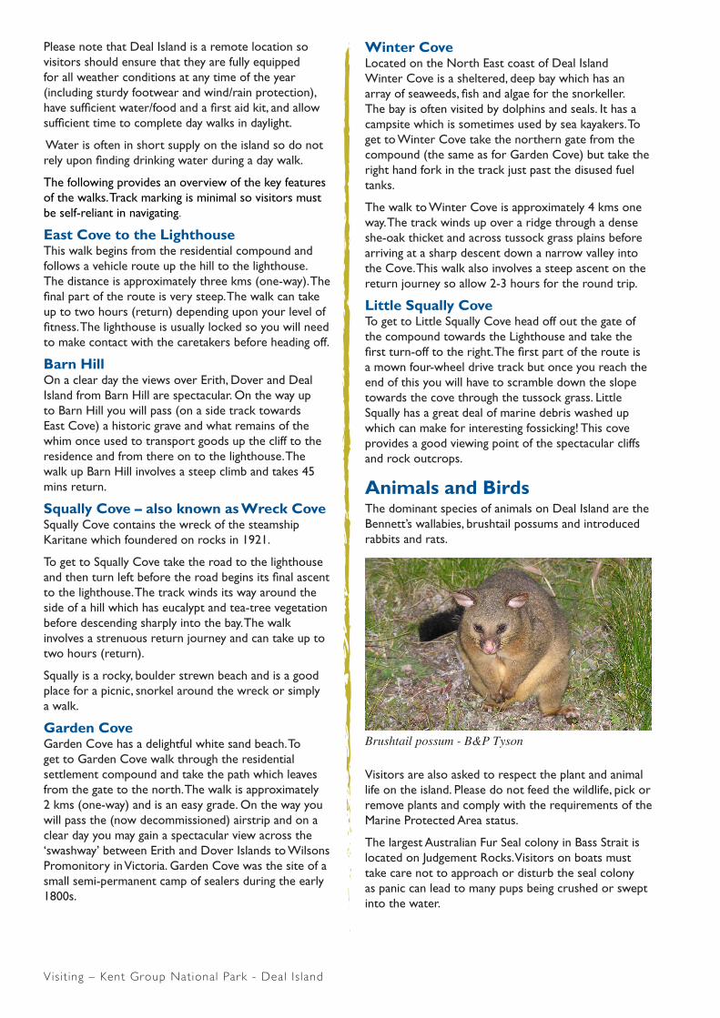
Animals and BirdsThe dominant species of animals on Deal Island are the Bennett’s wallabies, brushtail possums and introduced rabbits and rats.
Visitors are also asked to respect the plant and animal life on the island. Please do not feed the wildlife, pick or remove plants and comply with the requirements of the Marine Protected Area status.
The largest Australian Fur Seal colony in Bass Strait is located on Judgement Rocks. Visitors on boats must take care not to approach or disturb the seal colony as panic can lead to many pups being crushed or swept into the water.
Brushtail possum - B&P Tyson

Visit ing – Kent Group National Park - Deal Is land
There is a rich variety of bird species with over 100 species recorded. Visitors will notice many flame robins and firetail finches around the Island.
Families of Cape Barren geese live around the compound and the air strip.
Little penguins nest in several of the bays around the island and can be seen at dusk and heard most of the night. Sea Eagles are a common sight. Ask the caretakers if you are interested in birds on the island as a checklist of birds recorded is available
VegetationDeal Island has over 300 recorded plant species, including two endemic Tasmanian species and eight species considered to be threatened.
Approximately half the island has low open eucalypt forest or tall shrubs. The rest of the island is covered with she-oak woodland and tussock grasslands. There are small areas of coastal scrub and cliff communities.
Environmental weeds such as sea spurge, ragwort, arum lilies and horehound occur on the island. Volunteers and Parks and Wildlife staff have been working to contain and eradicate these where possible.
The Marine Protected AreaThe marine protected area covers all waters out to 3 nautical miles around the Kent Group and comprises 29,000 hectares. It protects shallow and deep water reefs as well as extensive sponge beds in offshore waters.
The waters around the Kent Group are home to some species normally found in more northern areas including violet roughy, mosaic leatherjacket and Wilson’s weedfish.
It is also the southern limit of distribution of Maori wrasse, one spot puller and Bank’s shovelnose. The habitat is created by the warm Eastern Australian current waters meeting the cooler waters of Bass Strait.
The marine protected area is made up of a sanctuary zone which is a no take zone and allows for swimming, snorkelling and other water based activities but no fishing. The rest of the marine protected area is a habitat protection zone which allows for lower impact fishing (e.g. abalone and rock lobster fishing and hand line fishing for scale fish). For more detailed information please check the map on the signs situated on the foreshore at East Cove and West Cove, Erith Island.
Please take any rubbish with you when you leave the island. Enjoy your visit to this spectacular place. If you need more information please ask the caretakers.
Management of the national parkA volunteer caretaker program to maintain a residential presence on Deal Island has operated successfully since 2000. The volunteers are selected on the basis of their ability to live in an isolated location and their skills and abilities for undertaking the various programs to manage the island. They are asked to spend three-month stints on the island and are transported on and off at the management authority’s expense, are housed in the former head-keepers house and provided with generated power. Volunteers provide their own provisions. In addition to a residential presence, the volunteers have also focussed on conservation management including visitor reception, visitor monitoring, weed management, fauna surveys, and cyclic maintenance of heritage assets.
The Wildcare Friends of Deal Island are a group of volunteers who also assist in management of the National Park. The Group raise funds, organise working bees, and assist Parks and Wildlife Service with a range of management tasks. Membership is open to anyone with an interest in the National Park.
The volunteer programs have been highly successful, producing on-ground results and generating enthusiasm and commitment from the many involved individuals and families.
Coast twin leaf - B&P Tyson
Deal Island lighthouse and oil store ruin - B&P Tyson

Visit ing – Kent Group National Park - Deal Is land
DEA
L IS
LAN
D
ERIT
HIS
LAN
D
DO
VE
R IS
LAN
D
Nor
th E
ast
Isla
nd
Anvi
l R
ock
Nor
folk
Po
int
MURRAY
PASS
Nor
thR
ock
Sout
h B
luff
"Bul
li"18
77
Squa
llyC
ove
Gar
den
Cov
e
Wal
labi
Cov
e
BAS
S
STR
AIT
Ligh
thou
se(d
isus
ed)
"Kar
itane
"19
21
Wes
tC
ove
Gar
den
Poin
t
East
Bluf
f
Thre
e na
utic
al m
ile li
mit
Thre
e na
utic
al m
ile li
mit
East
ing:
526
225
m EH
at
Roc
k
03
N
Mar
ine
Pro
tect
ed A
rea
His
toric
shi
pwre
cks
Aut
omat
ed n
avig
atio
n lig
ht
Map
grid
coo
rdin
ates
: G
DA
94 M
GA
Zon
e 55
Ken
t Gro
up N
atio
nal P
ark
Kilo
met
res
Hab
itat P
rote
ctio
n Zo
nes
San
ctua
ry Z
ones
HA
BIT
AT P
RO
TEC
TIO
N Z
ON
E
East
Bluf
f
Win
ter
Cov
e
Squa
llyC
ove
Sout
h B
luff
Long
: E 1
47.1
8.37
568
deg
Nor
folk
Po
int
Hat
R
ock
Gar
den
Poin
t
East
Cov
e
"Bul
li"18
77`S
was
hway
'
Nor
thR
ock
Wal
labi
Cov
e
Long
: E 1
47.1
9.33
974
deg
East
ing:
527
620
m E
SA
NC
TUA
RY
ZON
E
Wes
tBl
uff
Long
: E 1
47 1
8.37
568
deg
East
ing:
526
225
m E
"Kar
itane
"19
21
Anvi
l R
ock
Nor
th E
ast
Isla
nd
PASS
MURAY
R
Internet: www.parks.tas.gov.au
February 2009 © State of Tasmania

![© Copyright, Kent Consultancy Group, 2012, All rights reserved Kent Consultancy Group Oral English Course: Succeeding in School Lesson Six [Session 1]](https://static.fdocuments.net/doc/165x107/56649e595503460f94b53705/-copyright-kent-consultancy-group-2012-all-rights-reserved-kent-consultancy.jpg)