jolly logic ALTIMETER THREE THREE jolly logic The altitude recorder controlled by your smartphone or...
13
ALTIMETER THREE jolly logic The altitude recorder controlled by your smartphone or tablet
Transcript of jolly logic ALTIMETER THREE THREE jolly logic The altitude recorder controlled by your smartphone or...

ALTIMETERTHREEjolly logic
The altitude recorder controlled by
your smartphone or tablet

Welcome!
Our goal with AltimeterThree was to design an altitude recorder that would help you study flight performance in scientific detail, push your flying to a new level, and to let you share what you learn with others. To do that, we decided to put your smartphones and tablets to good use.
The hardest part will probably be setting up your mobile device to communicate with AltimeterThree. I know that setting up wireless connections can sometimes be frustrating, but this guide and our website should get you up and running quickly, and we’ve tried to make things as easy and automatic as possible.
As your software is updated over time the website will always serve as the most up-to-date and accurate guide on to how to use AltimeterThree and your mobile AltimeterThree app. When you get a chance, wander over to www.jollylogic.com and check out our support resources.
We’d love to hear from you.
Happy flying!
John BeansFounder, Jolly LogicDanville, California
QuickStart
jolly logic2
The BasicsAll of these steps are explained in this guide.
� First, pair your phone/tabletBefore using AltimeterThree, it needs to be “paired” with your phone/tablet. This gives permission for the two devices to communicate via Bluetooth. You only have to do this once, but it’s important!
� Install the AppInstall the AltimeterThree app from the Apple App StoreSM or Google PlayTM, then launch it. You should give permission for GPS usage so that your flights can be stamped with their location.
� Connect to AltimeterThreeYou must already be paired (from step 1) to connect. You can connect in the app, but sometimes it’s best to do it on your phone’s Settings>Bluetooth.
� Customize your settingsSelect a mode for the type of flying you are doing (quadcopter, rocket, plane, etc.), choose feet or meters for measurement, and enter a phone number that the altimeter can display in case it is lost and found.
� Charge your altimeter battery� Make a flight recordingPress Record to start, and Stop to finish. Your flight will be automatically uploaded to your phone or tablet. Practice before your first flight.
� View your flight� Share your flight� Keep your app updated!
jolly logic 3

AltimeterThree AppInstall the free AltimeterThree app from either the Apple App StoreSM or Google PlayTM.
GPS Permission: Say YesWhen you first launch the app, it will ask permission to allow AltimeterThree to use the GPS on your phone. You should allow this so that AltimeterThree can save the location of your flights.
You can still use AltimeterThree without GPS, but your Map page will be blank.
Bluetooth Is RequiredAltimeterThree needs Bluetooth to communicate, so you’ll need to have Bluetooth turned on whenever you are using AltimeterThree.
Keep Your Mobile App UpdatedJolly Logic will release new enhancements and fix any bugs which pop up from time to time. Please keep your app updated to the latest version by searching for “altimeterthree “(all one word) in the appropriate app store.
Altimeter Software UpdatesYour app will periodically update the firmware on your altimeter. You will see “Updating Firmware...” when that’s happening. Just be patient and the software on the altimeter will be automatically updated and re-started.
jolly logic4 jolly logic 5

Bluetooth SetupYou must "pair" your altimeter with your phone or tablet.
Your mobile device and your altimeter must BOTH give permission for pairing.
You only need to do this once when you first get your altimeter.
� Turn on AltimeterThree (it should say it is searching)
� On your mobile device, go to Settings > Bluetooth
� Turn Bluetooth ON You should see a list of nearby Bluetooth devices (in Android™, you may need to press Search for Devices) Apple iOS Google Android
� Click on the name of your altimeter in the list of available Bluetooth devices
jolly logic jolly logic6 7
� IMPORTANT
Approve the pairing on your altimeter FIRST and THEN on your mobile device within 20 seconds
Apple iOS Google Android
If pairing is successful, AltimeterThree will show that it is connected, and your phone/tablet will list it as one of your paired devices in Bluetooth Settings.
Problems?If for some reason you get “stuck” on a step, hold down the altimeter button until you see “Resetting”, ask your phone to “forget” it in Settings>Bluetooth, and start over. See www.jollylogic.com/support for more help.

Controlling AltimeterThree
Connect Before Flight
When you first use your altimeter, the app may say “Not Connected.” The best way to connect is from the list of devices in the Settings>Bluetooth area on your mobile device. If your altimeter never appears on the list, make sure it’s turned on and already paired.
Reconnect After the Flight
During flight, you will lose your Bluetooth connection—that’s normal.
After the flight, go to your mobile device Settings>Bluetooth to reconnect.
SettingsAvailable from most parts of the app.
Last FlightThe most recent flight that was recorded.
All FlightsA list of all of your flights, sorted by date.
Start and Stop RecordingYou must start recording using your mobile device. You can stop recording using your mobile device OR by pressing the button on the altimeter.
While recording, your mobile device will display the length of the current recording as long as you are within Bluetooth range (about 30 feet) of your altimeter.
It is normal for the controls to disappear when your altimeter travels out of range. Don’t worry—it’s still recording!
NOTE: Some phones and tablets do not reconnect well after your altimeter travels out of range. Try turning off Bluetooth right after you begin the recording. Turn it back on right before you need to stop recording. This will save power as well.
98
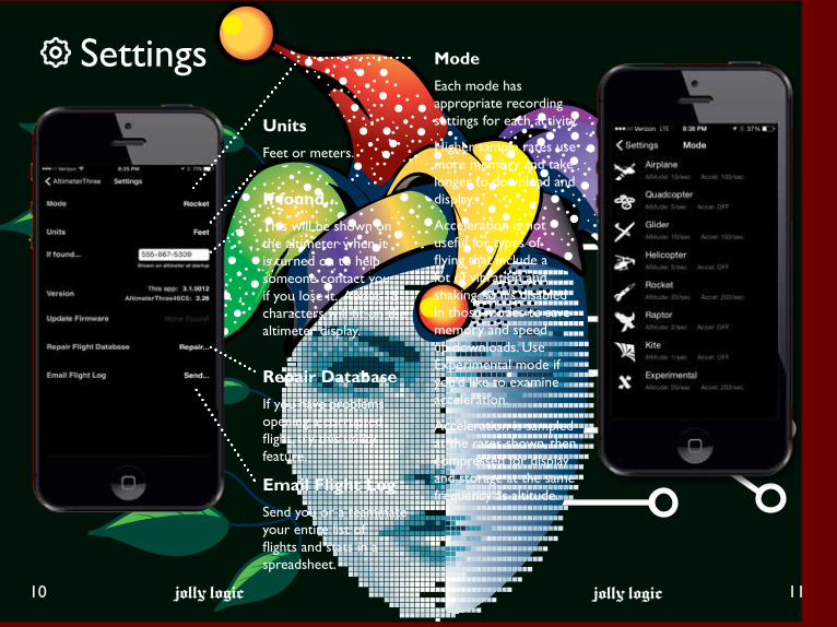
Settings
jolly logic jolly logic10 11
ModeEach mode has appropriate recording settings for each activity.
Higher sample rates use more memory and take longer to download and display.
Acceleration is not useful for types of flying that include a lot of vibration and shaking, so it’s disabled in those modes to save memory and speed up downloads. Use Experimental mode if you’d like to examine acceleration.
Acceleration is sampled at the rates shown, then compressed for display and storage at the same frequency as altitude.
UnitsFeet or meters.
If found...This will be shown on the altimeter when it is turned on to help someone contact you if you lose it. About 15 characters will fit on the altimeter display.
Repair DatabaseIf you have problems opening a corrupted flight, try this utility feature.
Email Flight LogSend you or a teammate your entire list of flights and stats in a spreadsheet.

Flight Review
jolly logic jolly logic12 13
Info PageYou can rename each flight, as well as add notes.
You’ll also see some automatically-calculated flight statistics, which depend on the recording mode when the flight was made. We add new statistics from time to time.
You can also mark a flight as a favorite to make it easier to find in the flight list later.
Chart PageYou can see a graph of the altitude and (depending on the mode) acceleration.
Map PageIf the GPS on your phone or tablet was turned on when you started recording, the location of the start of your flight will be shown on a map.
Share PageYou can share your flight via email or social media networks. You can email a Microsoft ExcelTM spreadsheet that contains all of the flight data in a handy format for further analysis.
You’ll need to have email set up on your mobile device, and you’ll need the appropriate social media accounts.Apple iOS Version
When you select a flight, the first page you’ll see is Info, but there are other pages you can view as well.
Google Android Version

Chart Page Chart FeaturesDrag, Pinch and Zoom
The chart is interactive; you can drag with your finger to move it around, and pinch to zoom in and out to examine your flight in close-up detail.
Refresh
Returns your chart to its original appearance.
Chart Settings
You can:
1. Change the display units (feet or meters)
2. Change various graph display options
3. Show or hide acceleration data and climb/sink rates (depending on recording mode)
Hidden Data
If you recorded a flight in Rocket mode, you may see a notice below the graph that some ground data is hidden. In Rocket mode, the app attempts to hide the parts of the graph that are just the rocket sitting on the pad or on the ground after flight. To show all of this data, tap the link shown here, or in Chart Settings.
jolly logic jolly logic14 15

Marking Your Chart Acceleration Data
Special Chart MarkersA quick tap near any chart point will select the chart point. You will then see a flag icon in the toolbar that you can press to mark the point.
A longer hold will bring up an point inspector that displays the data behind each point. Drag your finger to examine different points. Tap quickly anywhere on the chart to dismiss the inspector.
There are several important marks that control how the flight is analyzed and shared:
Flight Start and Flight End
These round markers indicate when then flight began and when it ended. The flight duration is calculated from these points, and the chart page will be sized to show the entire flight properly. The app tries to set these points automatically, but sometimes you have to set them yourself.
Data Start and Data End
Sometimes you may not want to include all of the data in your spreadsheet. These two lines mark the start and the end of the data that you want to include in spreadsheets.
Not every mode records acceleration data. See the Settings page for more information.
Acceleration and Direction
Acceleration data is collected using a highly sensitive, 3-axis accelerometer. This means that you can sense the direction that acceleration occurs, and view the acceleration that occurs in the X, Y, and Z directions. The positive directions for each axis are shown in the diagram below.
Total Acceleration
Total acceleration is the non-directional combined magnitude of acceleration, calculated using this formula:
jolly logic jolly logic16 17
Data EndData Start Selected Point
Flight EndFlight Start Point Inspector

jolly logic jolly logic18 19
SharingShare important flights with your friends and colleagues, using email or popular social media networks.
Flights that you share will be marked in your flight list with a character for each service.
Using email you can share flight statistics, the flight graph, and a spreadsheet of flight data. This feature uses your existing email account and email client software on your mobile device.
Social NetworksYou can share flight graphs and flight statistics with friends in your social networks. You’ll need to already have your own account with these services to use them.
In some cases, AltimeterThree may launch the social network’s own app to share your flight. Usually this is because the native app for that network has special features (like photo filtering) that you can use to enhance the post.
These services evolve over time, so as new networks are added or as networks add new features this list may change.
The first time that you share via each network, you’ll be required to enter your user credentials. AltimeterThree does not keep a copy of your credentials (they are authenticated using Auth0 so that our app never sees them), and only you (not Jolly Logic) can post to your accounts. Please see the privacy policy on our site if you want more details.
jolly logic jolly logic20 21
Mounting Your AltimeterThreeUsing the Tether Point
The slot at the nose of the altimeter can be used with string, plastic ties, leather straps, rubber bands, or Velcro® fasteners to hold the altimeter in place during flight.
Here are some things you should keep in mind as you mount AltimeterThree:
1. Protect the altimeter from moisture (it is NOT water-resistant). Put it in a plastic bag if it might rain or encounter water.
2. Shelter it from strong direct airflow. You will notice more “bumpiness” in your altitude graphs when pressure waves caused by turbulence disturb the altimeter. Consider wrapping it with a bit of fabric to buffer it somewhat from airflow. Do not worry that fabric will “block” the pressure sensor—it won’t.
3. Make sure it’s secure. Don’t tie it to something that might also fall off. Give it its own secure attachment.
It may take a little trial-and-error to achieve the optimal mounting method for your AltimeterThree. Look for best practices on online bulletin boards and social media sites; people often share setups which have worked well for them.
Using Optional Mounts
Jolly Logic and selected resellers also offer optional mounts (like the Jolly Logic Snap Mount) for AltimeterThree. These mounts provide convenient ways to quickly snap or attach AltimeterThree to whatever you are flying.
Check the Jolly Logic website for more tips.
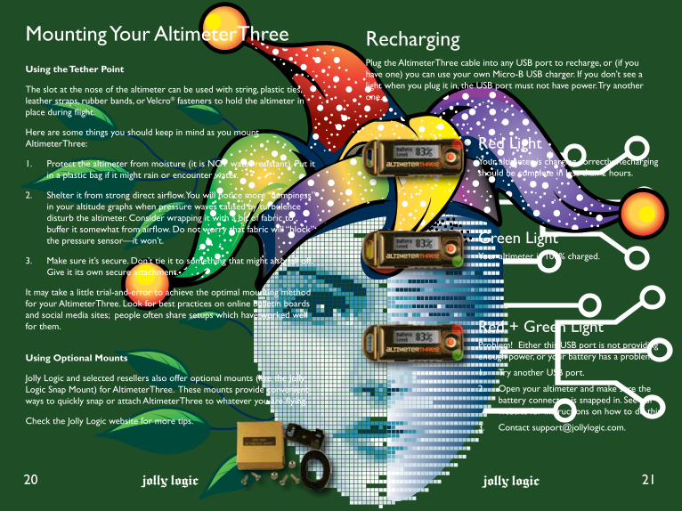
Recharging Plug the AltimeterThree cable into any USB port to recharge, or (if you have one) you can use your own Micro-B USB charger. If you don’t see a light when you plug it in, the USB port must not have power. Try another one.
Red LightYour altimeter is charging correctly. Recharging should be complete in less than 2 hours.
Green LightYour altimeter is 100% charged.
Red + Green LightProblem! Either this USB port is not providing enough power, or your battery has a problem.
1. Try another USB port.
2. Open your altimeter and make sure the battery connector is snapped in. See our website for instructions on how to do this.
3. Contact [email protected].

jolly logic
Repairing Your Altimeter
22
Parts of your altimeter are replaceable.
• Plastic case
• Battery
• LCD display
Repair Instructions
You’ll need to open the plastic case to replace parts. One handy tool for doing this is a thin wooden coffee stirrer, because they are soft enough not to scratch the case and usually narrow enough to press in the plastic tabs on the side of the altimeter case.
See www.jollylogic.com/support for a visual repair guide.
For More Support
More info is available at www.jollylogic.com, including helpful repair instructions, tutorials, FAQs, and troubleshooting guides.
Have questions or suggestions? Contact us at [email protected]. We’d love to hear from you, including your experiences with AltimeterThree.
Legal NoticesCopyright © 2017 Jolly Logic, LLC.
iPad and iPhone, are trademarks of Apple Inc., registered in the U.S. and other countries.
“Made for iPhone,” and “Made for iPad” mean that an electronic accessory has been designed to connect specifically to iPhone, or iPad, respectively, and has been certified by the developer to meet Apple performance standards. Apple is not responsible for the operation of this device or its compliance with safety and regulatory standards. Please note that the use of this accessory with iPod, iPhone, or iPad may affect wireless performance.
Android is a trademark of Google Inc.The Android robot is reproduced or modified from work created and shared by Google and used according to terms described in the Creative Commons 3.0 Attribution License.
Microsoft and Excel are either registered trademarks or trademarks of Microsoft Corporation in the United States and/or other countries.
Velcro is a registered trademark of Velcro Industries B.V.
jolly logic
Support and Troubleshooting
23

ALTIMETERTHREe
Jolly Logic, [email protected]
A PARTIRE DAI 14 ANNI14 ANS ET PLUSAB 14 JAHRENFOR AGES 14 UPA PARTIR DE 14 AÑOS
14+
ATTENZIONE!AVERTISSEMENT!WARNUNG!WARNING!ADVERTENCIA!
Rischio di soffocamento! Contiene piccole parti.Non adatto a bambini di eta’ inferiore a 3 anni.Risque de suffocation! Petite piéces. Neconvient pas à un enfant de moins de 3 ans.Erstickungsgefahr! Vershluckbare Kleinteile. Nichtgeeignet für Kinder unter 3 Jahren.Choking Hazard! Small parts. Not for children under3 years.Peligro de asfixia! Contiene partes pequeñas.Inadecuado para niños menores de 3 años.
jolly logicALTIMETERTHREE
• Graph flight altitude to 29,500 feet (9000 meters)
• Record acceleration in three axes up to 24 Gs
• Examine data in a Microsoft ExcelTM spreadsheet
• Share flight reports via email and social networks
• Modes for quadcopters, rockets, planes, helicopters, gliders, kites, and falconry.
• Recharge from any common USB port
jolly logic
For Google Android™ 4.0.3 or higher
Requires an Apple or Android compatible smartphone or tablet with Bluetooth®
Made for iPhone 7 Plus, iPhone 7, iPhone 7s Plus, iPhone 7s, iPhone 6 Plus, iPhone 6, iPhone 5s, iPhone 5c, iPhone 5, iPad Air 2, iPad mini 3, iPad with Retina display, iPad Air, iPad mini 2, iPad (4th generation), iPad mini, iPad (3rd generation), iPad 2
iPad and iPhone are trademarks of Apple Inc., registered in the U.S. and other countries.