IODP Site Survey Proposal-Final
8
IODP Site Survey of the Shackleton sites, SW Iberian Margin Project Description 3 Scientific Rationale for Drilling the “Shackleton sites” on the Iberian Margin Choosing where to drill is one of the most important activities in which IODP is engaged as such decisions will ultimately determine the successes and failures of the program. Nick Shackleton’s work on the Iberian Margin highlighted the seminal importance of this region for providing high-fidelity records of millennial-scale climate variability for the last glacial cycle [1]. In fact, few marine sediment cores have played such a pivotal role in palaeoclimate research as those from the Portuguese margin (hereafter referred to as the “Shackleton sites”). Millennial-scale variability in these cores can be correlated confidently to polar ice cores in both hemispheres (Fig. 1). Shackleton et al. [1] demonstrated that surface oxygen isotope and temperature records mirror those of Greenland ice core records, whilst the deep-water signal follows the Antarctic ice core climate record, thereby preserving a history of both polar ice cores in a single sedimentary archive. The relative timing of surface (Greenland) and deep-water (Antarctic) signals in the same core provides a means to assess interhemispheric phasing of climate change, which has been independently verified by methane synchronization of ice cores for the last glacial period [2]. Moreover, the narrow continental shelf off Portugal results in the rapid delivery of terrestrial material to the deep-sea environment, permitting correlation of marine and ice core records to European terrestrial sequences [3]. Few, if any, places exist in the world ocean where such detailed and unambiguous marine-ice-terrestrial linkages are possible. For this reason, the Iberian Margin has become a focal point for studies of climate variability over the last several glacial cycles. Extending this remarkable sediment archive further back in time is an obvious and important goal that is worth pursuing through ocean drilling. Fig. 1. Correlation of δ 18 O record of GRIP ice core (red) to δ 18 O of Globigerina bulloides (lower black record) in Core MD95-2042 [1]. Resulting correlation of Vostok δD (green) and benthic δ 18 O of MD95- 2042 (upper black record) based on methane synchronization. Also shown is SST derived from alkenones (U k’ 37 ) in MD95-2043 (blue) [4]. CALYPSO piston cores from the Iberian Margin have yielded a record of remarkable detail spanning the last four glacial cycles to 420 ka [5]. Because of the deposition of highly cohesive nannofossil oozes during MIS 9, 11 and 13, it is impossible to penetrate beyond 420 ka using conventional piston coring systems. Thus, the drilling capability of the JOIDES Resolution is needed to access the deeper section. Toward this end, an international group of 16 proponents, led by the UK, prepared and submitted IODP Proposal 771-Full in April 2010. The proposal outlines plans for a 56-day expedition to drill six sites along a depth transect to recover sediments from the latest Miocene to Recent (Table 1). Recognizing that drilling all sites could not be accomplished in the current phase of IODP, an Ancillary Programme Letter (APL-763) was submitted to drill a single site (Shack-04) to a depth of 150 mbsf. This 4-day drilling programme was approved and will be executed during IODP Expedition 339 (19 Nov 2011 - 19 Jan 2012). Four holes will be drilled to a depth of 150 mbsf. The record obtained at Shack-04 will provide essential material needed to study millennial-scale climate variability through the Middle Pleistocene Transition (MPT). Why are additional holes and sites needed beyond the 150 m to be recovered at Shack- 04? Drilling additional sites will both extend the record beyond the Middle Pleistocene (to the latest Miocene) and recover a full depth transect of sites spanning a range of subsurface water masses. It will allow adoption of a drilling strategy that utilizes multiple sites to target various time period of interest where the relevant sequence is thickest, thereby offering the greatest stratigraphic resolution. For example, older drilling targets can be accomplished by selecting locations where
Transcript of IODP Site Survey Proposal-Final

IODP Site Survey of the Shackleton sites, SW Iberian Margin Project Description
3
Scientific Rationale for Drilling the “Shackleton sites” on the Iberian Margin Choosing where to drill is one of the most important activities in which IODP is engaged as such decisions will ultimately determine the successes and failures of the program. Nick Shackleton’s work on the Iberian Margin highlighted the seminal importance of this region for providing high-fidelity records of millennial-scale climate variability for the last glacial cycle [1]. In fact, few marine sediment cores have played such a pivotal role in palaeoclimate research as those from the Portuguese margin (hereafter referred to as the “Shackleton sites”). Millennial-scale variability in these cores can be correlated confidently to polar ice cores in both hemispheres (Fig. 1). Shackleton et al. [1] demonstrated that surface oxygen isotope and temperature records mirror those of Greenland ice core records, whilst the deep-water signal follows the Antarctic ice core climate record, thereby preserving a history of both polar ice cores in a single sedimentary archive. The relative timing of surface (Greenland) and deep-water (Antarctic) signals in the same core provides a means to assess interhemispheric phasing of climate change, which has been independently verified by methane synchronization of ice cores for the last glacial period [2]. Moreover, the narrow continental shelf off Portugal results in the rapid delivery of terrestrial material to the deep-sea environment, permitting correlation of marine and ice core records to European terrestrial sequences [3]. Few, if any, places exist in the world ocean where such detailed and unambiguous marine-ice-terrestrial linkages are possible. For this reason, the Iberian Margin has become a focal point for studies of climate variability over the last several glacial cycles. Extending this remarkable sediment archive further back in time is an obvious and important goal that is worth pursuing through ocean drilling.
Fig. 1. Correlation of δ18O record of GRIP ice core (red) to δ18O of Globigerina bulloides (lower black record) in Core MD95-2042 [1]. Resulting correlation of Vostok δD (green) and benthic δ18O of MD95-2042 (upper black record) based on methane synchronization. Also shown is SST derived from alkenones (Uk’
37) in MD95-2043 (blue) [4].
CALYPSO piston cores from the Iberian Margin have yielded a record of remarkable detail
spanning the last four glacial cycles to 420 ka [5]. Because of the deposition of highly cohesive nannofossil oozes during MIS 9, 11 and 13, it is impossible to penetrate beyond 420 ka using conventional piston coring systems. Thus, the drilling capability of the JOIDES Resolution is needed to access the deeper section. Toward this end, an international group of 16 proponents, led by the UK, prepared and submitted IODP Proposal 771-Full in April 2010. The proposal outlines plans for a 56-day expedition to drill six sites along a depth transect to recover sediments from the latest Miocene to Recent (Table 1). Recognizing that drilling all sites could not be accomplished in the current phase of IODP, an Ancillary Programme Letter (APL-763) was submitted to drill a single site (Shack-04) to a depth of 150 mbsf. This 4-day drilling programme was approved and will be executed during IODP Expedition 339 (19 Nov 2011 - 19 Jan 2012). Four holes will be drilled to a depth of 150 mbsf. The record obtained at Shack-04 will provide essential material needed to study millennial-scale climate variability through the Middle Pleistocene Transition (MPT).
Why are additional holes and sites needed beyond the 150 m to be recovered at Shack-04? Drilling additional sites will both extend the record beyond the Middle Pleistocene (to the latest Miocene) and recover a full depth transect of sites spanning a range of subsurface water masses. It will allow adoption of a drilling strategy that utilizes multiple sites to target various time period of interest where the relevant sequence is thickest, thereby offering the greatest stratigraphic resolution. For example, older drilling targets can be accomplished by selecting locations where

IODP Site Survey of the Shackleton sites, SW Iberian Margin Project Description
4
the younger sediments are thin, and the older part of the sequence is thick yet close to the surface. Less overburden reduces the effects of burial diagenesis on biogenic carbonate and allows the section to be recovered using the hydraulic piston corer. When coupled with the new seismic data proposed herein, Site Shack-04 will be vital for providing age constraints of traceable seismic reflectors that will be used to optimize site selection and finely tune the drilling plan.
The water depths of sites proposed in IODP Proposal 771-Full range from 2376 to >4000 m, and are designed to recover cores located in Northeast Atlantic Deep Water (NEADW), and Lower Deep Water (LDW) (Table 1). The water depth range is designed to complement those sites to be drilled during Expedition 339, which will focus on the variability of Mediterranean Overflow Water (MOW) at five sites in the Gulf of Cadiz in water depths from 566 to 980 m, and one site (WI-01B) on the SW Iberian Margin at 1074 m. Together Expedition 339 and 771-Full will employ a “dipstick” coring strategy to recover a suite of down-core records with which to study past water mass variability, much of which appears to be related to spatial redistributions on both glacial-to-interglacial and millennial time scales [6].
Table 1. Proposed drilling site locations, water depths, penetration and water masses on the West Iberian Margin. §The upper 150 mbsf will be recovered during Expedition 339. *Site WI-01B will be the last site drilled on Expedition 339 and there’s a possibility that it may be postponed if there are any delays to the schedule. In which case, it will be included in the drill plan of Proposal 771-Full. t.b.d. = to be determined.
Site Lat (Deg) Long (Deg) Water Depth (m) Penetration (m) Water mass WI-01B* 37.359 -9.657 1074 675 MOW
SHACK- 2A 37.828 -9.858 2376 300 NEADW SHACK- 4A§ 37.571 -10.126 2578 500 NEADW SHACK-3A 37.761 -10.035 2614 300 NEAW SHACK-1A 37.852 -10.173 3106 300 LDW SHACK-6A 37.714 -10.497 3753 500 LDW SHACK-7 t.b.d. t.b.d >4000 t.b.d. LDW
IODP Proposal 771-Full seeks to address the following broad objectives (in part):
1. Document the nature of millennial-scale climate variability for older glacial cycles of the Quaternary, including changes in surface and deep-water circulation during the “100-kyr world”, Mid Pleistocene transition, “41-kyr world”, and intensification of Northern Hemisphere Glaciation.
2. Derive a marine sediment proxy record for the Greenland Ice Core beyond the oldest ice (~125 ka) to examine the amplitude and pacing of Dansgaard-Oeschger-type variability during previous ice ages.
3. Determine interhemispheric phase relationships (leads/lags) by comparing the timing of proxy variables that monitor surface (Greenland) and deep-water (Antarctic) components of the climate system, thereby overcoming problems of age determination on millennial and submillennial time scales.
4. Study how changes in orbital forcing and glacial boundary conditions affect the character of suborbital-scale climate variability and, in turn, how millennial-scale variability interact with orbital geometry to produce the observed glacial-to-interglacial patterns of climate change.
5. Reconstruct the climate transitions into and out of glacial periods at high temporal resolution.
6. Reconstruct the history of changing local dominance of northern-sourced versus southern-sourced deep water using the depth transect of IODP sites on orbital and suborbital time scales during the Quaternary.
7. Investigate climate during past interglacial periods, including the warm Pliocene period prior to the intensification of Northern Hemisphere glaciation.
8. Link terrestrial, marine and ice core records by analyzing pollen and terrestrial biomarkers that are delivered to the deep-sea environment by rivers. Site survey data deficiencies
Why are additional site survey data needed for the Iberian Margin? The site survey package for 771-Full was reviewed by the Site Survey Panel (SSP) in July 2010 and Feb 2011. Only one (Shack-4A) of the six sites was classified as ready to be drilled (1Aa). All others were classified as 2Cc (i.e., substantial items of required data are not in the Data Bank and not believed

IODP Site Survey of the Shackleton sites, SW Iberian Margin Project Description
5
to exist, and data do not image target adequately). Because of the potential occurrence of Mass Transport Deposits (MTDs) and local faulting in the region, SSP requested two orthogonal high-resolution multi-channel seismic (MCS) crossing lines at each of the proposed sites. Here we request ship time and resources to collect the deficient seismic and sediment data needed to meet all SSP requirements and recommendations. Drilling of the Shackleton sites on the Iberian Margin cannot proceed without such data. Site Survey Cruise Objectives We propose a 25-day cruise (15 working, 5 transit, 5 contingency) aboard the R/V James Cook to the Southwest Iberian Margin. Our primary mission is to fulfill site survey requirements to advance proposal 771-Full towards drilling. We also propose to conduct science that will be vital for interpreting down-core proxy records. Given the high cost of ship time, we propose to make full use of the ship and scientistsʼ time by conducting water column and near-subsurface sediment studies that will be used to calibrate and improve palaeoceanographic proxies and interpret past changes in deep-water circulation. This value-added science is an essential component of the proposal and constitutes the most effective use of NERCʼs considerable financial investment in ship time. The site survey cruise objectives are to:
I. Acquire and process high-resolution seismic reflection profiles and swath bathymetry to fulfill the site survey requirements and recommendations of IODP’s SSP. The MCS data will also be used to image large-scale oceanographic features and mixing processes in the water column (water-mass boundaries, eddies, meddies, etc.).
II. Acquire CTD data and water samples to characterize the physical and chemical properties of water masses on the Iberian Margin, which will be used to interpret the water-column MCS profiles (e.g., constructing synthetic acoustic impedance profiles) and for groundtruthing palaeoceanographic proxies in surface sediment.
III. Acquire sediment cores along a bathymetric transect to study sediment processes, such as sediment provenance, focusing, bioturbation, and to calibrate geochemical and sedimentological proxies on the Southwest Iberian Margin.
IV. Utilize new water column and pore-water analyses to test the underlying rationale and calibration of a set of key trace-element and isotope proxies. This will include, in particular, an assessment of early diagenetic influences on the chemistry of infaunal versus epifaunal benthic foraminifer species, and will target proxies for temperature (Mg/Ca), carbonate chemistry (e.g., B/Ca), nutrient concentrations (e.g., δ13C, Cd/Ca) and redox state (U, Mo, Mn, V, Fe). A key goal will be to combine these proxies to interpret the down-core record of millennial–scale climate variability for the last glacial cycles.
Work Programme I. Geophysics. A principal part of the site survey will be the acquisition, processing and interpretation of high-resolution seismic reflection data. We plan 10 days of seismic acquisition, during which our maximum speed will be 5 knots. Thus, 100–200 km can be acquired each day, totaling ~1500 km. The MCS data will serve two related purposes. First, perpendicular cross line coverage will be obtained for all sites in the IODP proposal, and potential new sites will be identified that avoid MTDs during reconnaissance surveying (Figure 2, Table 1). The ship’s track will remain flexible to acquire geophysical data from locations not yet specified that appear promising based upon real-time seismic data collected aboard ship using the Promax software package. Second, MCS imaging will be used to identify larger-scale oceanographic features (e.g., water-mass boundaries and fronts) associated with the principal water masses on the margin: upper and lower Mediterranean Overflow Water (MOW) between 600 and 1500 m, recirculated Northeast Atlantic Deep Water (NEADW) below 1500 m, and southern-sourced Lower Deep Water (LDW) below 3000 m. The large temperature and salinity contrasts, especially MOW/NEADW, are ideal for 'seismic oceanography' imaging using MCS [7]. The images will be calibrated with underway hydrographic measurements and used to study the internal structure of MOW.
Considerable geophysical data exists from the West Iberia margin but we lack the crossing high-resolution MCS lines at the proposed sites that are required by the IODP site survey panel. The existing site survey data package was prepared by our Portuguese Project Partners at LNEG (Gabriela Carrara, Pedro Terrinha, and Enrique Duarte), who are co-proponents on IODP Proposal

IODP Site Survey of the Shackleton sites, SW Iberian Margin Project Description
6
771-Full. Preliminary site selection has been made based on compiled regional seismic data from several research projects and national institutions including: Instituto Jaime Almera, CSIC (Spain); Real Observatorio de la Armada de San Fernando (Spain); Instituto Geológico y Minero de España (Spain); Universite de Brest (France); Instituto de Ciencias del Mar, CSIC (Spain); SMAR-BO Istituto Scienze Marine (Bologna, Italy); Universidade de Lisboa (Portugal), LNEG (Portugal). In addition, a SWIM swath bathymetry compilation also exists for the area [8]. Figure 3 shows a representative example of an existing interpreted seismic line for one of the proposed sites (Shack 4A). Existing data lend great confidence that the proposed target intervals can be obtained at each site, but MCS lines are needed to refine site locations to ensure that MTDs and local faulting are avoided. We will closely coordinate the planning and execution of the cruise with our Portuguese colleagues (see letter of support), and submit the revised site survey package to IODP.
Fig. 2. Location and preliminary ship’s track of the survey area off Portugal. The target area (approx. 50x90 km) is a spur on the continental rise on the southwest Iberian Margin that is elevated above the Tagus Abyssal Plain. Labelled black circles = site locations as proposed in IODP Proposal 771-Full. Deepest site is not numbered (location still to be determined). In addition to crossing lines (white) at each of the proposed site locations, we will conduct a gridded survey (yellow) nearby each site as time permits to optimize drilling locations. Swath bathymetry from Zitellini et al. [2009].
We will use the Sercel seismic acquisition system provided by NMR. This system has previously been used for IODP site survey work with excellent results. During the cruise itself, technical support for seismic surveying and shipboard processing will be
provided by technical personnel from Cambridge. Additional technical support for swath bathymetric, gravity and magnetic acquisition will be provided by 2 National Marine Facilities Division engineers. Cambridge has excellent state-of-the-art seismic processing and modelling facilities. Post-cruise processing and interpretation will be carried out by a PDRA using Schlumberger's Omega2/Geoframe software packages.
The methodology and approach described above is contingent upon successful acoustic imaging of the subsurface from the seabed down to the sediment-basement interface. White's previous experience shows that the Sercel seismic acquisition system provides excellent signal penetration through several kilometres of sedimentary cover and will be ideal for our purposes. This system will also enable acoustic imaging of thermohaline circulation of the water column.
The airgun source will consist of 2 Generator Injector guns (2 x 380 cubic inches) that will be towed in series at a depth of 3-4 m. Previous experience shows that excellent signal penetration is achieved when these guns are operated at a pressure of 3000 psi. The streamer will have a minimum of 3 km of active section and will be towed at a depth of 7 m. We expect to use a shotpoint interval of 50 m that yields a fold of cover of 30. Since the cycling time of the air compressors is typically 14 seconds, we will easily be able to acquire seismic data at 5-5.5 kts. The acquisition parameters are chosen to optimize imaging of the sedimentary pile. Likewise, the detailed internal structure of strata and, where appropriate, of the sediment-basement interface will be achieved by careful processing using Schlumberger's Omega-2 processing package. The salient aspects of our processing sequence will be decided once data have been acquired but will include filtering, gain, source signature deconvolution, dense velocity analysis, source/signature deghosting, and post-stack migration. If possible, source signature deconvolution will be applied by using a far-field recorded source signature. In the absence of a far-field source signature for each shot, this form of deterministic deconvolution should successfully remove the bubble pulse and considerably reduce reverberation if we opt for the sleeve gun array. If the GI gun is used, reverberation should not arise. A low-cut filter will help to reduce low-frequency noise. Velocity analyses will be carried out every kilometre. Deghosting will be applied after normal moveout correction and standard multiple energy suppression by assuming a constant source/receiver depth and a flat sea surface. A standard spherical divergence correction will remove amplitude transmission losses but otherwise we do not anticipate applying automatic gain control. We will
IODP Site Survey of the Shackleton sites, SW Iberian Margin Project Description
7
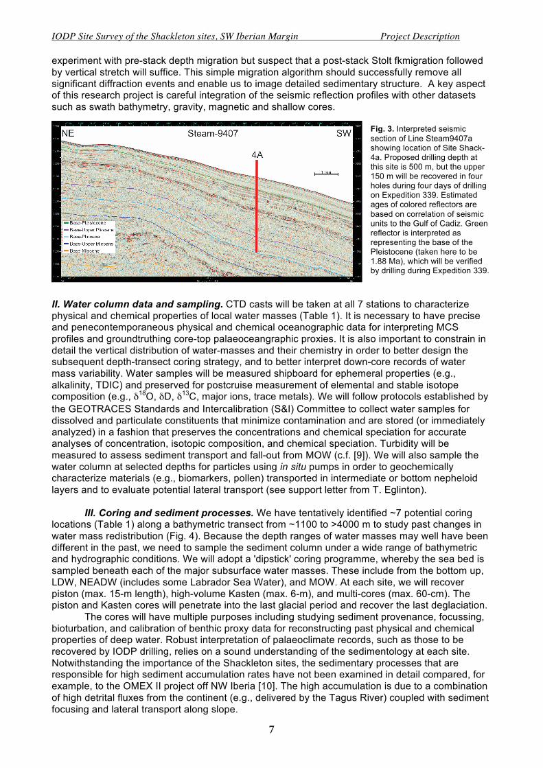
experiment with pre-stack depth migration but suspect that a post-stack Stolt fkmigration followed by vertical stretch will suffice. This simple migration algorithm should successfully remove all significant diffraction events and enable us to image detailed sedimentary structure. A key aspect of this research project is careful integration of the seismic reflection profiles with other datasets such as swath bathymetry, gravity, magnetic and shallow cores.
Fig. 3. Interpreted seismic section of Line Steam9407a showing location of Site Shack-4a. Proposed drilling depth at this site is 500 m, but the upper 150 m will be recovered in four holes during four days of drilling on Expedition 339. Estimated ages of colored reflectors are based on correlation of seismic units to the Gulf of Cadiz. Green reflector is interpreted as representing the base of the Pleistocene (taken here to be 1.88 Ma), which will be verified by drilling during Expedition 339.
II. Water column data and sampling. CTD casts will be taken at all 7 stations to characterize physical and chemical properties of local water masses (Table 1). It is necessary to have precise and penecontemporaneous physical and chemical oceanographic data for interpreting MCS profiles and groundtruthing core-top palaeoceangraphic proxies. It is also important to constrain in detail the vertical distribution of water-masses and their chemistry in order to better design the subsequent depth-transect coring strategy, and to better interpret down-core records of water mass variability. Water samples will be measured shipboard for ephemeral properties (e.g., alkalinity, TDIC) and preserved for postcruise measurement of elemental and stable isotope composition (e.g., δ18O, δD, δ13C, major ions, trace metals). We will follow protocols established by the GEOTRACES Standards and Intercalibration (S&I) Committee to collect water samples for dissolved and particulate constituents that minimize contamination and are stored (or immediately analyzed) in a fashion that preserves the concentrations and chemical speciation for accurate analyses of concentration, isotopic composition, and chemical speciation. Turbidity will be measured to assess sediment transport and fall-out from MOW (c.f. [9]). We will also sample the water column at selected depths for particles using in situ pumps in order to geochemically characterize materials (e.g., biomarkers, pollen) transported in intermediate or bottom nepheloid layers and to evaluate potential lateral transport (see support letter from T. Eglinton).
III. Coring and sediment processes. We have tentatively identified ~7 potential coring
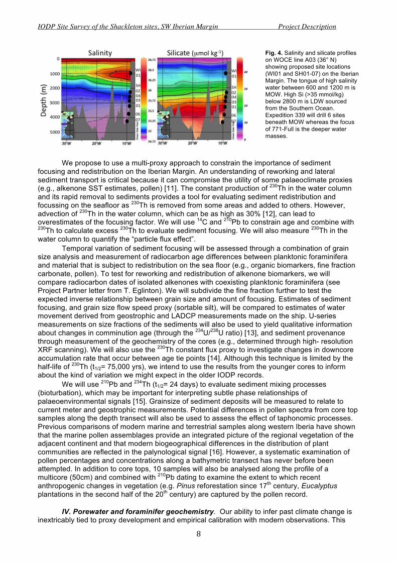
locations (Table 1) along a bathymetric transect from ~1100 to >4000 m to study past changes in water mass redistribution (Fig. 4). Because the depth ranges of water masses may well have been different in the past, we need to sample the sediment column under a wide range of bathymetric and hydrographic conditions. We will adopt a 'dipstick' coring programme, whereby the sea bed is sampled beneath each of the major subsurface water masses. These include from the bottom up, LDW, NEADW (includes some Labrador Sea Water), and MOW. At each site, we will recover piston (max. 15-m length), high-volume Kasten (max. 6-m), and multi-cores (max. 60-cm). The piston and Kasten cores will penetrate into the last glacial period and recover the last deglaciation.
The cores will have multiple purposes including studying sediment provenance, focussing, bioturbation, and calibration of benthic proxy data for reconstructing past physical and chemical properties of deep water. Robust interpretation of palaeoclimate records, such as those to be recovered by IODP drilling, relies on a sound understanding of the sedimentology at each site. Notwithstanding the importance of the Shackleton sites, the sedimentary processes that are responsible for high sediment accumulation rates have not been examined in detail compared, for example, to the OMEX II project off NW Iberia [10]. The high accumulation is due to a combination of high detrital fluxes from the continent (e.g., delivered by the Tagus River) coupled with sediment focusing and lateral transport along slope.
IODP Site Survey of the Shackleton sites, SW Iberian Margin Project Description
8
Fig. 4. Salinity and silicate profiles on WOCE line A03 (36° N) showing proposed site locations (WI01 and SH01-07) on the Iberian Margin. The tongue of high salinity water between 600 and 1200 m is MOW. High Si (>35 mmol/kg) below 2800 m is LDW sourced from the Southern Ocean. Expedition 339 will drill 6 sites beneath MOW whereas the focus of 771-Full is the deeper water masses.
We propose to use a multi-proxy approach to constrain the importance of sediment focusing and redistribution on the Iberian Margin. An understanding of reworking and lateral sediment transport is critical because it can compromise the utility of some palaeoclimate proxies (e.g., alkenone SST estimates, pollen) [11]. The constant production of 230Th in the water column and its rapid removal to sediments provides a tool for evaluating sediment redistribution and focussing on the seafloor as 230Th is removed from some areas and added to others. However, advection of 230Th in the water column, which can be as high as 30% [12], can lead to overestimates of the focusing factor. We will use 14C and 210Pb to constrain age and combine with 230Th to calculate excess 230Th to evaluate sediment focusing. We will also measure 230Th in the water column to quantify the “particle flux effect”.
Temporal variation of sediment focusing will be assessed through a combination of grain size analysis and measurement of radiocarbon age differences between planktonic foraminifera and material that is subject to redistribution on the sea floor (e.g., organic biomarkers, fine fraction carbonate, pollen). To test for reworking and redistribution of alkenone biomarkers, we will compare radiocarbon dates of isolated alkenones with coexisting planktonic foraminifera (see Project Partner letter from T. Eglinton). We will subdivide the fine fraction further to test the expected inverse relationship between grain size and amount of focusing. Estimates of sediment focusing, and grain size flow speed proxy (sortable silt), will be compared to estimates of water movement derived from geostrophic and LADCP measurements made on the ship. U-series measurements on size fractions of the sediments will also be used to yield qualitative information about changes in comminution age (through the 234U/238U ratio) [13], and sediment provenance through measurement of the geochemistry of the cores (e.g., determined through high- resolution XRF scanning). We will also use the 230Th constant flux proxy to investigate changes in downcore accumulation rate that occur between age tie points [14]. Although this technique is limited by the half-life of 230Th (t1/2= 75,000 yrs), we intend to use the results from the younger cores to inform about the kind of variation we might expect in the older IODP records.
We will use 210Pb and 234Th (t1/2= 24 days) to evaluate sediment mixing processes (bioturbation), which may be important for interpreting subtle phase relationships of palaeoenvironmental signals [15]. Grainsize of sediment deposits will be measured to relate to current meter and geostrophic measurements. Potential differences in pollen spectra from core top samples along the depth transect will also be used to assess the effect of taphonomic processes. Previous comparisons of modern marine and terrestrial samples along western Iberia have shown that the marine pollen assemblages provide an integrated picture of the regional vegetation of the adjacent continent and that modern biogeographical differences in the distribution of plant communities are reflected in the palynological signal [16]. However, a systematic examination of pollen percentages and concentrations along a bathymetric transect has never before been attempted. In addition to core tops, 10 samples will also be analysed along the profile of a multicore (50cm) and combined with 210Pb dating to examine the extent to which recent anthropogenic changes in vegetation (e.g. Pinus reforestation since 17th century, Eucalyptus plantations in the second half of the 20th century) are captured by the pollen record.
IV. Porewater and foraminifer geochemistry. Our ability to infer past climate change is inextricably tied to proxy development and empirical calibration with modern observations. This

IODP Site Survey of the Shackleton sites, SW Iberian Margin Project Description
9
part of our work programme is required to provide an adequate science-base for the application and assessment of foraminifer-based geochemical proxies. Here we specifically focus on empirical proxy calibration needed for new work to be carried out on IODP material recovered from the Iberian Margin.
An important focus of the IODP drilling will be to generate detailed records of benthic foraminiferal δ18O and of bottom water temperature, so that seawater δ18O records can be obtained. This will permit us to explain and assess the stratigraphic implications of the observed Antarctic signal in benthic foraminiferal signals. For this we will require accurate calibrations of benthic foraminiferal ‘Mg/Ca thermometry’ using core tops that span a range of hydrographic conditions along a local depth transect (Fig. 4). A particular challenge in this region is that in order to obtain deep-water temperature reconstructions across glacial and interglacial time periods, infaunal as well as epifaunal benthic foraminifera must be used. Thus glacial, and especially stadial conditions on the Iberian Margin are typically associated with a dominance of infaunal, low-oxygen benthic species, including Globobulimina affinis in particular; while interglacial/interstadial conditions favour typically more oxic epifaunal species, such as Cibicides sp. and Gyroidina sp. Previous work in this domain [17] has shown that the most promising deep-water temperature reconstructions in this setting are derived from the infaunal species G. affinis; a finding that has since been confirmed for other facultative infaunal species [18], and may be explained by a reduced carbonate saturation variability, and therefore a reduced or absent ‘carbonate-ion effect’, in sub-oxic to anoxic pore-waters. However, no core-top calibration exists between Mg/Ca and temperature for this species. In addition, our understanding of the redox and early diagenetic processes that control fossil infaunal versus epifaunal benthic Mg/Ca (and arguably stable isotope composition) remains incomplete. We need to establish whether the geochemical signature of a given foraminifer species reflects a bottom water signal, a pore-water signal or some combination of these. This in turn will require the careful study of pore-water data in conjunction with pristine modern core-top sediment (i.e. benthic foraminifer geochemistry and vertical distribution).
To this end, we will analyze multicores for pore water chemistry at each site. The emphasis will be on high-resolution (cm-scale) pore fluid geochemistry in the upper meter of sediment. Sediments from each interval will be returned to the laboratory for benthic foraminiferal species counts and for shell geochemistry analyses. Multi-cores for pore water work will be transferred immediately from the work deck to a climate control room for processing inside an oxygen-free glove box at near bottom water temperatures. Pore-water oxygen gradients will be determined using micro-electrodes and interstitial waters will be extracted at 1-cm intervals using Rhizon samplers (Rhizosphere Research Products, http://www.rhizosphere.com/) through sealed ports in the multicores [19]. Ephemeral measurements will be made onboard and pore water fluids will be preserved for shore-based analyses. Following pore water extraction, sediments will be subsampled to study the vertical distribution and shell geochemistry of living benthic foraminiferal species by utilizing two staining methods, rose Bengal and cell tracker green (CTG).
Shell geochemistry will be measured post-cruise, following standard cleaning and analysis protocols suitable for stable isotope and trace-element analysis. Stable oxygen and carbon isotopes will be measured on the dominant epi- and infaunal benthic foraminifera, in parallel with trace-element ratios (including Mg/Ca, B/Ca, Zn/Ca and U/Ca in particular). These measurements, in conjunction with trace-element ratios measured in co-deposited planktonic foraminifer shells (i.e. U/Ca), will permit an assessment of the seawater versus early diagenetic controls on foraminifer shell geochemistry. By assessing the hydrographic and sedimentary controls on redox-sensitive metal concentration changes within near-surface sediments we will also derive a more robust basis for the interpretation of down-core X-ray fluorescence measurements, which will play an important role in any future IODP work.
There is a shortage of studies in which detailed bottom and pore water sampling is available along with detailed analysis of foraminiferal distributions in the sediments. For this reason we have developed a collaboration with Professor Paul Loubere of Northern Illinois University (see letter of support). Our work is clearly related to that which he has been doing on the Norwegian continental margin (e.g. [20]). His goals coincide with ours in seeking a clear understanding of the micro-ecology and habitats of benthic foraminifera, and the impact of these habitats on foraminiferal chemistry. There is a lack of studies examining in detail the relationships of multiple geochemical proxies in benthic foraminifera to the chemistry of the sediments and pore waters surrounding the foraminifera. Such research is essential to resolving the palaeo-environmental

IODP Site Survey of the Shackleton sites, SW Iberian Margin Project Description
10
information that geochemical proxies carry, and to our understanding of how the proxies relate to one another. Through sharing of samples and expertise his experience focusing on foraminiferal microhabitats will be of great benefit to the goals of our work where we have a strong focus on isotopes and geochemistry. Project Management Success of this project depends upon the combined expertise of six UK scientists and our international project partners. PI Hodell will co-ordinate the research effort, cruise planning and, together with Elderfield, carry out onboard pore water and water column sampling and analysis. Both will be engaged in post-cruise analysis of isotopic and trace element chemistry of water and foraminifera. Co-PI White and the PDRA will be responsible for all aspects of seismic surveying including processing and interpretation. They will prepare the site survey package and submit processed data to the IODP Site Survey Data Bank. Co-PI Skinner will be responsible for sediment core sampling and postcruise foraminifer analysis. Nick McCave will participate in the cruise and contribute coring, sedimentological and hydrographic expertise to the project, offering his considerable experience with geophysical surveying and previous successes at selecting ideal core locations on the Iberian Margin. Co-PI Thomas will be responsible for U-series analyses and Co-PI Tzedakis for palynological investigations. All co-PIs will sail on the cruise and contribute to post-cruise data analysis and publication. Synergies with International Partners and Programs
We have assembled a strong group of international partners who add value to the proposed work. See letters of support for details of collaboration and contribution.
Professor Fatima Abrantes leads the Marine Geology group at LNEG (Lab. Nac. De Energia e Geologia). Abrantes and Hodell have worked closely together in promoting IODP drilling of the southwestern Iberian Margin, including organizing the ECORD-sponsored Magellan Workshop in Lisbon (9-10 November 2009) that brought together 28 people from 5 countries to plan the submission of the IODP proposals. The geophysics group at LNEG has been instrumental in assembling the initial IODP site survey package and will participate in the cruise and post-cruise geophysical research. The palaeoceanography group at LNEG will focus on calibrating surface proxy data to present-day oceanographic and biological (productivity) conditions, which will nicely complement our proposed benthic proxy work (see letter of support).
Professor Paul Loubere is a micropaleontologist with specialty in benthic foraminifera. He will lend taxonomic and palaeocological expertise and is engaged in similar studies of benthic environments and the palaeochemical record of foraminifera on the Norwegian margin.
Professor Timothy Eglinton is an organic geochemist from ETH-Zurich who specializes in radiocarbon dating of organic molecules. He will contribute organic geochemistry expertise and radiocarbon dating of organic matter, including compound-specific dating on alkenones.
Professor James Channell is a palaeomagnetist from the University of Florida who will measure geomagnetic palaeointensity on cores to be recovered on the cruise.
We will also link the hydrographic work with our US American colleagues involved in the US GEOTRACES program in the North Atlantic cruise and European colleagues involved in EuroFLEETS and OVIEDO 2010 hydrographic surveys of the Iberian Margin.
Archiving and Data Management – All seismic data will be archived with the IODP site survey data bank. Archive halves and unsampled multi-cores will be housed and curated by BOSCORF. References [1] Shackleton et al., 2000. Paleoceanography 15, 565–569; [2] Blunier and Brook, 2001. Science 291, 109-112; [3] Tzedakis et al., 2004. Science 306, 2231-2235; [4] Cacho et al., 1999. Paleoceanography 14(6),698-705; [5] Martrat et al., 2007. Science 317, 502–507; [6] Skinner et al., 2003. Geochem. Geophys. Geosyst . 4 (12), doi:10.1029/2003 GC000585; [7] Pinheiro et al., 2010. Journal of Marine Systems 79, 89–100; [8] Zitellini et al., 2009. Earth Planet. Sci. Letts. 280, 3–50; [9] McCave and Hall, 2002. Mar. Geol. 52, 299-314; [10] van Weering and McCave, 2002. Prog. Oceanogr. 52, 121-476; [11] Ohkouchi et al., 2002. Science 298, 1224-1227; [12] Henderson et al., 1999. Deep Sea Res. I 46, 1861-93; [13] DePaolo et al., 2006. Earth Planet. Sci. Letts. 248, 394 – 410; [14] Henderson and Anderson, 2003. Rev. Min. Geochem, MSA,493 - 531; [15] Löwemark et al., 2008. Mar. Geol. 256, 101-106; [16] Naughton, F. et al., 2007. Mar. Micropaleontol. 62, 91-114. [17] Skinner and Elderfield, 2007. Paleoceanography 22, PA1205, doi:10.1029/2006PA001338; [18] Elderfield et al., 2010. Quat. Sci. Rev., 29, 160-169; [19] Seeberg-Elverfeldt et al., 2005. Limnol. Oceanogr., Methods 3, 361–371; [20] Loubere et al., 2011. Deep Sea Res. I, 58, 535‐545.