
Investigation of Controlled Flight into Terrain · Investigation of Controlled Flight into Terrain...
55
Investigation of Controlled Flight into Terrain U. S. Department Of Transportation Federal Aviation Administration Descriptions of Flight Paths for Selected Controlled Flight into Terrain (CFIT) Aircraft Accidents, 1985-1997 Project Memorandum DOT-TSC-FA9D1-99-01 March 1999 Robert O. Phillips Operations Assessment Division, DTS – 43 Aviation Safety Division, DTS – 67 PREPARED BY: PREPARED FOR: U. S. Department of Transportation U. S. Department of Transportation Research and Special Programs Federal Aviation Administration Administration Aircraft Certification Service Volpe National Transportation Washington, DC 20591 Systems Center Cambridge, MA 02142
Transcript of Investigation of Controlled Flight into Terrain · Investigation of Controlled Flight into Terrain...
Investigation ofControlled Flight into Terrain
U. S. DepartmentOf TransportationFederal AviationAdministration
Descriptions of Flight Paths forSelected Controlled Flight intoTerrain (CFIT) Aircraft Accidents,1985-1997
Project MemorandumDOT-TSC-FA9D1-99-01March 1999
Robert O. Phillips
Operations Assessment Division, DTS – 43Aviation Safety Division, DTS – 67
PREPARED BY: PREPARED FOR:U. S. Department of Transportation U. S. Department of TransportationResearch and Special Programs Federal Aviation Administration Administration Aircraft Certification ServiceVolpe National Transportation Washington, DC 20591 Systems CenterCambridge, MA 02142

TABLE OF CONTENTS
SECTION PAGE
1.0 INTRODUCTION........................................................................................1
1.1 Purpose of Study ............................................................................11.2 Controlled Flight Into Terrain ..........................................................11.3 Terrain Awareness Warning Systems (TAWS) ...............................21.4 Contents of this Report ..................................................................4
2.0 STUDY METHODOLOGY ..........................................................................4
2.1 Data Sources ..................................................................................42.2 Selection of Accidents for Study ......................................................42.3 Flight Path Plotting Process ............................................................6
3.0 CFIT ACCIDENT DESCRIPTIONS/FLIGHT PATH PLOTS .......................7
3.1 La Paz, Bolivia – B-727-225 – N819EA – 1/1/85 ............................73.2 Flat Rock, NC – PA-31T – N600CM – 8/23/85 .............................103.3 Windsor, MA – Be-100 – N65TD – 12/10/86 .................................133.4 Eagle, CO – LJ-24A – N31SK – 3/27/87 .......................................163.5 Tegucigalpa, Honduras – B-727-200 – N88705 – 10/21/89 ..........193.6 Halawa Point, HI – DHC-6-300 – N707PV – 10/28/89 ..................223.7 San Diego, CA – HS-125 – N831LC – 3/16/91 .............................253.8 Rome, GA – Be-400 – N25BR – 12/11/91 ....................................283.9 Gabriels, NY – Be-1900C – N55000 – 1/3/92 ...............................313.10 Alamogordo, NM – MU-2B-30 – N108SC – 6/24/92 .....................343.11 East Granby, CT – MD-83 – N566AA – 11/13/92 .........................373.12 Buga, Colombia – B-757-200 –N651AA – 12/20/95 ......................403.13 Nimitz Hill, Guam – B-747-300 – HL-7468 – 8/6/97 ......................44
APPENDIX A – References ................................................................................48
LIST OF TABLES
TABLE PAGE
1. Accidents Selected for Study ................................................................52. Data for La Paz, Bolivia CFIT Accident ................................................83. Data for Flat Rock, NC CFIT Accident ..............................................114. Data for Windsor, MA CFIT Accident .................................................145. Data for Eagle, CO CFIT Accident .....................................................176. Data for Tegucigalpa, Honduras CFIT Accident .................................207. Data for Halawa Point, HI CFIT Accident ..........................................238. Data for San Diego, CA CFIT Accident ..............................................269. Data for Rome, GA CFIT Accident .....................................................2910. Data for Gabriels, NY CFIT Accident ...............................................3211. Data for Alamogordo, NM CFIT Accident .........................................3512. Data for East Granby, CT CFIT Accident .........................................3813. Data for Buga, Colombia CFIT Accident ..........................................4214. Data for Nimitz Hill, Guam CFIT Accident ........................................46
LIST OF FIGURES
FIGURE PAGE
1. La Paz, Bolivia – B-727-225 – N819EA – 1/1/85 ..................................92. Flat Rock, NC – PA-31T – N600CM – 8/23/85 ...................................123. Windsor, MA – Be-100 – N65TD – 12/10/86 ......................................154. Eagle, CO – LJ-24A – N31SK – 3/27/87 ............................................185. Tegucigalpa, Honduras – B-727-200 – N88705 – 10/21/89 ...............216. Halawa Point, HI – DHC-6-300 – N707PV – 10/28/89 .......................247. San Diego, CA – HS-125 – N831LC – 3/16/91 ..................................278. Rome, GA – Be-400 – N25BR – 12/11/91 ..........................................309. Gabriels, NY – Be-1900C – N55000 – 1/3/92 ....................................3310. Alamogordo, NM – NU-2B-30 – N108SC – 6/24/92 .........................3611. East Granby, CT – MD-83 – N566AA – 11/13/92 .............................3912. Buga, Colombia – B-757-200 –N651AA – 12/20/95 .........................4313. Nimitz Hill, Guam – B-747-300 – HL-7468 – 8/6/97 ..........................47
1.0 INTRODUCTION
1.1 Purpose of Study
This report documents an investigation of the flight paths of 13 selected controlled flightinto terrain (CFIT) aircraft accidents that occurred between 1985 and 1997. TheOperations Assessment Division (DTS-43) and the Aviation Safety Division (DTS-67) ofthe Volpe National Transportation Systems Center, Cambridge, MA, conducted thisstudy. The study was performed for the Aircraft Certification Service, AircraftEngineering Division (AIR-100) of the Federal Aviation Administration (FAA).
Information in this study supports development of proposed FAA Technical StandardOrder TSO-C151 addressing terrain awareness and warning systems (TAWS). (1) Thepurpose of the study was to collect and present data describing the flight paths of theaircraft involved in the 13 selected CFIT accidents. These flight path data will be usedto construct CFIT accident scenarios, which will in turn be used to test the effectivenessof alternative TAWS systems, developed by the aircraft avionics industry, in preventingCFIT accidents.
1.2 Controlled Flight Into Terrain
A CFIT accident occurs when an airworthy aircraft, experiencing no contributorysystems or equipment problems, under the control of a certificated, fully qualified flightcrew no suffering from any impairment, is flown into terrain (or water or obstacle) withno demonstrated prior awareness of the impending collision on the part of the crew. Or,if the flight crew was aware of the impending collision, they were unable to prevent it. (2)
Because they involve high-speed impacts, CFIT accidents usually have disastrousconsequences. All but one of the 13 accidents described in this report involvedfatalities. Of the 734 total passengers and crew involved in these 13 accidents, 606(82.6%) were killed; 49 (6.7%) were seriously injured; 2 (0.3%) suffered minor injuries,and 77 (10.5%) were uninjured.
Most CFIT accidents have in common a chain of events leading to what human factorsexperts term “lack of situational awareness” on the part of the flight crew. Conditions oflimited visibility (due to darkness or weather or both) are typically a major contributingfactor. Other such contributing factors include inadequate flight planning, poor pilotdecision-making, poor crew resource management, lack of proper communications withair traffic control personnel, and lack of awareness of, or disregard for, applicable flightrules and procedures. (3)
1.3 Terrain Awareness and Warning Systems
CFIT accident prevention has been the focus of considerable effort over the past 30years on the part of government and industry. Preventing CFIT is unfortunately not anissue to be addressed solely by pilot training and experience, since the historical recordshows pilots involved in CFIT accidents often include highly experienced pilots with tensof thousands of flight hours in their logs. (4)
Introduction of the radio altimeter in the late 1960’s made possible development of anon-board avionics system dedicated to CFIT prevention called the ground proximitywarning system (GPWS). The GPWS used altimeter and barometric data as inputs to acomputer which generated visual and audible alerts (“Terrain! Terrain!) and alarms(“Whoop! Whoop! Pull Up!”) for flight crews if certain threshold parameters of keyvariables, indicating hazardous approach to terrain, were exceeded. GPWS equipmentsounded warnings under five different potentially hazardous flight conditions:
• excessive rate of descent;• excessive rate of closure with terrain;• negative climb rate or altitude loss after takeoff or missed approach;• insufficient terrain clearance when landing gear or flaps are not set in
landing configuration; and• excessive downward deviation from an instrument landing system (ILS)
glide slope signal on a precision approach.
GPWS warnings were intended as a supplement to other on-board flight instrumentationproviding flight crew situational awareness. They provided a “last-ditch” measure ofsafety against inadvertent terrain impact, and warning times before impact weretypically thirty seconds or less. (5)
GPWS equipment has proven remarkably effective in preventing CFIT accidents. TheNational Aeronautics and Space Administration’s Aviation Safety Reporting Systemcontains many pilot reports of “saves” (i.e., accidents prevented) due to GPWS alertsand alarms. The domestic CFIT accident rate for the large commercial passengerFederal Aviation Regulation (FAR) Part 121 aircraft fleet dropped to near zero followingan FAA rulemaking requiring mandatory installation of GPWS equipment in 1974. (6)
Despite these gains, 1970’s-vintage GPWS technology had two major limitations:
• because it relied on altimeter and barometric data, there was no ability to“look ahead” of the aircraft to evaluate the potential danger of oncomingterrain or other obstacles. Thus GPWS warnings could be of very shortduration if the terrain beneath the aircraft suddenly were to rise up at avery steep gradient.
• because it is desirable on approach and landing to descend in closeproximity to terrain, certain GPWS alerts and warnings are inhibited aslanding gear and flaps are extended in landing configuration. If an aircraft
in landing configuration, executing a stabilized non-precision approach(one in which lateral, but not vertical glide slope guidance is provided),descends to a location other than a runway, it will receive no GPWS alertor warning.
To address these limitations, significant enhancements to GPWS technology have beenintroduced over the past several years. These enhancements rely on development oflightweight, low-cost, and powerful computer storage devices and Global PositioningSystem (GPS) signal receivers. These two devices allow storage of detailed terraindata in the cockpit, as well as realtime determination of precise aircraft location in termsof latitude and longitude coordinates. The combination of these capabilities enablesdevelopment of a “forward-looking” terrain display, based on realtime comparison of anaircraft’s location coordinates, as determined by GPS, with stored terrain data. It alsoenables development of a terrain clearance “floor,” based on calculated distance to aspecified runway threshold location, which will provide alerts and warnings on non-precision approaches independent of landing gear or flap settings. These features canbe presented to the flight crew on a cockpit “moving map” display similar to existingnavigational or weather displays. (7)
A terrain awareness and warning system (TAWS) adds these two enhancements totraditional GPWS systems. TAWS, as defined in FAA Proposed Technical StandardOrder TSO-C151, includes the following three capabilities:
• a terrain display;• terrain awareness and alerting functions that use position information
provided by either a suitable internal position sensor or an on-board areanavigational system and an on-board terrain database; and
• ground proximity detection and alerting functions (the traditional GPWSfunctions). (8)
TAWS, because of these added capabilities, offers significant improvements overtraditional GPWS equipment alert and alarm times. The continuous terrain displayfeature of TAWS will greatly heighten flight crew situational awareness in conditions oflimited visibility. Warning times that were once measured in seconds, or were notgenerated at all in non-precision approach situations, may now be measured in minutes. Rather than just providing a “last-ditch” warning of imminent danger, this display willenable crews to maneuver to avoid terrain well before it becomes an obstruction to theirflight path.
1.4 Contents of this Report
Following this introduction, this report contains two additional sections:
• Study methodology, including data sources, selection of accidents forstudy, and the process used to develop flight path plots;
• Accident descriptions and flight path plots. For each of the accidentsinvestigated, a brief description of the aircraft’s flight path over the lastseveral miles before impact is presented, together with a plot andassociated spreadsheet of terrain elevation, aircraft altitude, and otherrelevant data.
2.0 STUDY METHODOLOGY
2.1 Data Sources
Primary data sources for development of flight path profiles for domestic accidents inthis study were National Transportation Safety Board (NTSB) aircraft accident reportsand supporting files. For those accidents occurring in foreign countries, reports issuedby the foreign governmental equivalent of the NTSB were obtained and reviewed. Forsome accidents, applicable news articles were also obtained. Data in these reportsrelevant to this study included the following:
• flight data recorder (FDR) information;• cockpit voice recorder (CVR) transcripts;• air traffic control (ATC) voice transcripts;• ATC radar plots;• NTSB (or foreign equivalent) post-crash investigation information.
Topographical maps of domestic accident locations were obtained from the U. S.Geological Survey (USGS). USGS 1:24,000 quadrangles were used if available. Forforeign accidents, best available topographical data were used (typically maps wereincluded in the accident reports).
2.2 Selection of Accidents for Study
The 13 accidents in this report were selected in consultation with Mr. George Lyddane,FAA National Resource Specialist in the area of Flight Management. Accidents studiedranged from relatively small (i.e., Beechcraft Be-100) private passenger aircraft to verylarge (i.e., Boeing 747-300) commercial passengeraircraft. All accidents selected clearly met the following CFIT classification criteria:
• the aircraft was engaged in routine, cross-country flight at the time of theaccident.
• the aircraft was in controlled flight at the time of impact;• all systems on the aircraft were operating normally at the time of impact;
and• the flight crews of the accident aircraft were not impaired. (9)
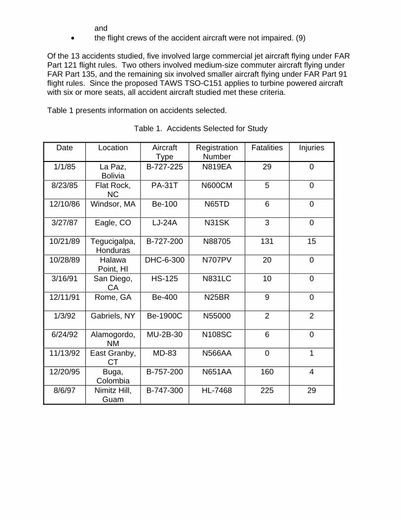
Of the 13 accidents studied, five involved large commercial jet aircraft flying under FARPart 121 flight rules. Two others involved medium-size commuter aircraft flying underFAR Part 135, and the remaining six involved smaller aircraft flying under FAR Part 91flight rules. Since the proposed TAWS TSO-C151 applies to turbine powered aircraftwith six or more seats, all accident aircraft studied met these criteria.
Table 1 presents information on accidents selected.
Table 1. Accidents Selected for Study
Date Location AircraftType
RegistrationNumber
Fatalities Injuries
1/1/85 La Paz,Bolivia
B-727-225 N819EA 29 0
8/23/85 Flat Rock,NC
PA-31T N600CM 5 0
12/10/86 Windsor, MA Be-100 N65TD 6 0
3/27/87 Eagle, CO LJ-24A N31SK 3 0
10/21/89 Tegucigalpa,Honduras
B-727-200 N88705 131 15
10/28/89 HalawaPoint, HI
DHC-6-300 N707PV 20 0
3/16/91 San Diego,CA
HS-125 N831LC 10 0
12/11/91 Rome, GA Be-400 N25BR 9 0
1/3/92 Gabriels, NY Be-1900C N55000 2 2
6/24/92 Alamogordo,NM
MU-2B-30 N108SC 6 0
11/13/92 East Granby,CT
MD-83 N566AA 0 1
12/20/95 Buga,Colombia
B-757-200 N651AA 160 4
8/6/97 Nimitz Hill,Guam
B-747-300 HL-7468 225 29
2.3 Flight Path Plotting Process
To generate plots of flight paths, contents of the accident report were reviewed. If radaror FDR data plots of aircraft altitude and flight track were available, these were useddirectly. If these were unavailable, other sources were used to generate thisinformation, including references to navigational aids and altitude in cockpit or ATCconversations. In all cases, airspeed and heading (with reference to magnetic north) atimpact, as well as impact point latitude and longitude coordinates, were obtained frompost-crash investigation reports. Other known waypoints, if mentioned in these reports,were also tabulated.
Given the available data on aircraft position, the most likely track of the accident aircraftwas plotted on a topographical map. Elevation in feet above mean sea level (MSL) ofrelevant topographical features along the flight track were tabulated. Using bestavailable data on aircraft altitude, altitude data were correlated with points along theflight track.
For those accidents occurring during approach, altitudes and elevations were plottedwith reference to the runway threshold. The specified altitudes, elevations, anddistances associated with approach procedure being used by the accident aircraft werealso tabulated in a similar fashion. If altitude data were incomplete, they were plottedbetween known points using straight-line interpolation. In the case of the Buga,Colombia accident, in which the aircraft deviated significantly from the establishedapproach path in a lateral direction, terrain elevations along both the flight track andalong the established approach procedure were included. For those accidentsoccurring in cruise flight, or at considerable distance from the destination airport,elevations and altitudes were plotted with reference to the point of impact.
The result of the above effort was a spreadsheet for each accident containing thefollowing information:
• specified horizontal distances from reference point (takeoff or destinationrunway threshold or impact point), measured in nautical miles (NM);
• terrain elevation at these specified distances, measured in feet aboveMSL;
• aircraft altitude at these specified distances, measured in feet above MSL;• published approach procedure altitudes at these specified distances, if
applicable, measured in feet above MSL.
From each spreadsheet, a graphic chart was generated. Both spreadsheets and chartsare contained in the following section.
3.0 CFIT ACCIDENT DESCRIPTIONS / FLIGHT PATH PLOTS
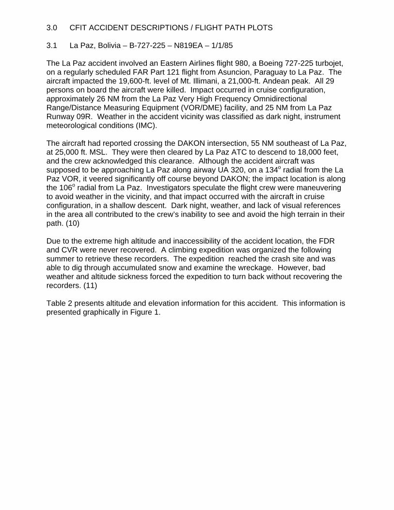
3.1 La Paz, Bolivia – B-727-225 – N819EA – 1/1/85
The La Paz accident involved an Eastern Airlines flight 980, a Boeing 727-225 turbojet,on a regularly scheduled FAR Part 121 flight from Asuncion, Paraguay to La Paz. Theaircraft impacted the 19,600-ft. level of Mt. Illimani, a 21,000-ft. Andean peak. All 29persons on board the aircraft were killed. Impact occurred in cruise configuration,approximately 26 NM from the La Paz Very High Frequency OmnidirectionalRange/Distance Measuring Equipment (VOR/DME) facility, and 25 NM from La PazRunway 09R. Weather in the accident vicinity was classified as dark night, instrumentmeteorological conditions (IMC).
The aircraft had reported crossing the DAKON intersection, 55 NM southeast of La Paz,at 25,000 ft. MSL. They were then cleared by La Paz ATC to descend to 18,000 feet,and the crew acknowledged this clearance. Although the accident aircraft wassupposed to be approaching La Paz along airway UA 320, on a 134o radial from the LaPaz VOR, it veered significantly off course beyond DAKON; the impact location is alongthe 106o radial from La Paz. Investigators speculate the flight crew were maneuveringto avoid weather in the vicinity, and that impact occurred with the aircraft in cruiseconfiguration, in a shallow descent. Dark night, weather, and lack of visual referencesin the area all contributed to the crew’s inability to see and avoid the high terrain in theirpath. (10)
Due to the extreme high altitude and inaccessibility of the accident location, the FDRand CVR were never recovered. A climbing expedition was organized the followingsummer to retrieve these recorders. The expedition reached the crash site and wasable to dig through accumulated snow and examine the wreckage. However, badweather and altitude sickness forced the expedition to turn back without recovering therecorders. (11)
Table 2 presents altitude and elevation information for this accident. This information ispresented graphically in Figure 1.
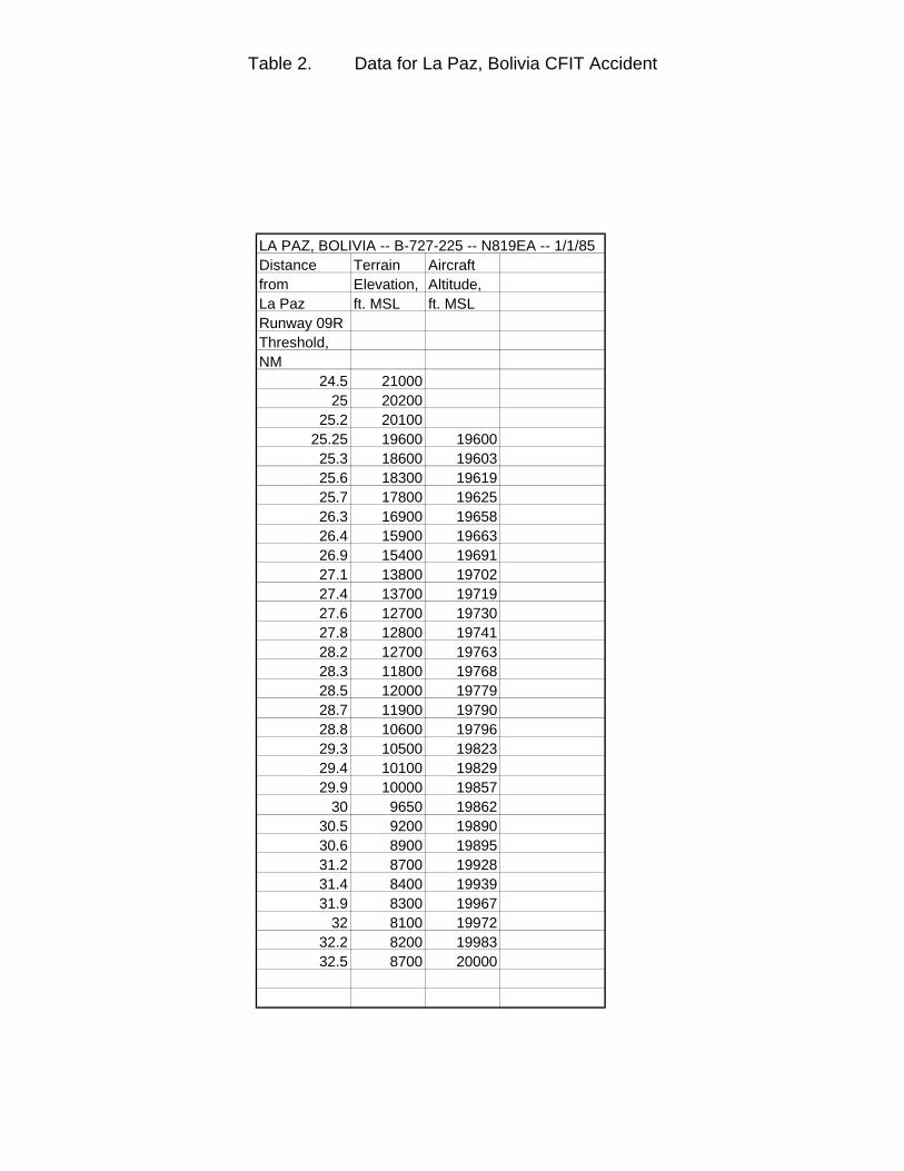
Table 2. Data for La Paz, Bolivia CFIT Accident
LA PAZ, BOLIVIA -- B-727-225 -- N819EA -- 1/1/85Distance Terrain Aircraft from Elevation, Altitude, La Paz ft. MSL ft. MSLRunway 09RThreshold,NM
24.5 2100025 20200
25.2 2010025.25 19600 1960025.3 18600 1960325.6 18300 1961925.7 17800 1962526.3 16900 1965826.4 15900 1966326.9 15400 1969127.1 13800 1970227.4 13700 1971927.6 12700 1973027.8 12800 1974128.2 12700 1976328.3 11800 1976828.5 12000 1977928.7 11900 1979028.8 10600 1979629.3 10500 1982329.4 10100 1982929.9 10000 19857
30 9650 1986230.5 9200 1989030.6 8900 1989531.2 8700 1992831.4 8400 1993931.9 8300 19967
32 8100 1997232.2 8200 1998332.5 8700 20000
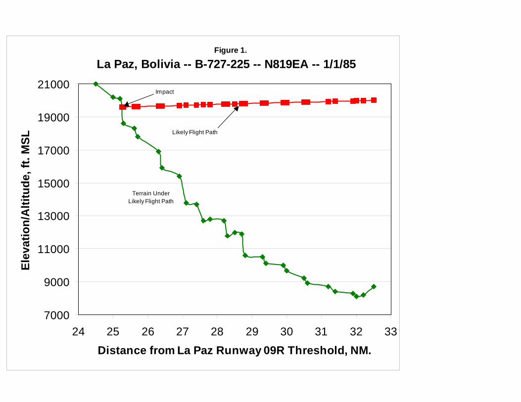
Figure 1.
La Paz, Bolivia -- B-727-225 -- N819EA -- 1/1/85
7000
9000
11000
13000
15000
17000
19000
21000
24 25 26 27 28 29 30 31 32 33Distance from La Paz Runway 09R Threshold, NM.
Elev
atio
n/A
ltitu
de, f
t. M
SL
Likely Flight Path
Terrain UnderLikely Flight Path
Impact
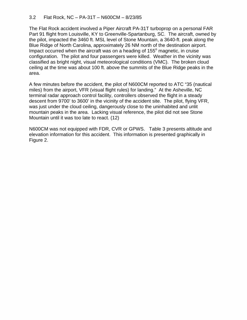
3.2 Flat Rock, NC – PA-31T – N600CM – 8/23/85
The Flat Rock accident involved a Piper Aircraft PA-31T turboprop on a personal FARPart 91 flight from Louisville, KY to Greenville-Spartanburg, SC. The aircraft, owned bythe pilot, impacted the 3460 ft. MSL level of Stone Mountain, a 3640-ft. peak along theBlue Ridge of North Carolina, approximately 26 NM north of the destination airport. Impact occurred when the aircraft was on a heading of 155o magnetic, in cruiseconfiguration. The pilot and four passengers were killed. Weather in the vicinity wasclassified as bright night, visual meteorological conditions (VMC). The broken cloudceiling at the time was about 100 ft. above the summits of the Blue Ridge peaks in thearea.
A few minutes before the accident, the pilot of N600CM reported to ATC “35 (nauticalmiles) from the airport, VFR (visual flight rules) for landing.” At the Asheville, NCterminal radar approach control facility, controllers observed the flight in a steadydescent from 9700’ to 3600’ in the vicinity of the accident site. The pilot, flying VFR,was just under the cloud ceiling, dangerously close to the uninhabited and unlitmountain peaks in the area. Lacking visual reference, the pilot did not see StoneMountain until it was too late to react. (12)
N600CM was not equipped with FDR, CVR or GPWS. Table 3 presents altitude andelevation information for this accident. This information is presented graphically inFigure 2.
Table 3. Data for Flat Rock, NC CFIT Accident
FLAT ROCK, NC -- PA-31T -- N600CM -- 8/23/85Distance Terrain Aircraft from Elevation, Altitude, Impact, NM ft. MSL ft. MSL
0 3460 34600.15 3000 35040.3 2800 35470.5 2610 36030.8 2600 3688
1 2250 37441.2 2180 38001.5 2400 3885
2 2840 40262.3 3000 41112.5 2840 4167
3 2720 43083.6 2720 4477
4 2720 45904.6 2120 4759
5 2400 48725.2 2600 49285.7 2200 5069
6 2160 51546.3 2400 5239
7 2280 54367.6 2400 5605
8 3200 57188.6 2600 5887
9 2800 60009.6 3000 611310 3160 6282
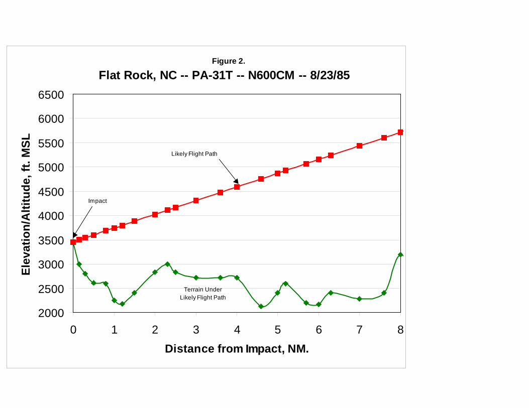
Figure 2.
Flat Rock, NC -- PA-31T -- N600CM -- 8/23/85
2000
2500
3000
3500
4000
4500
5000
5500
6000
6500
0 1 2 3 4 5 6 7 8Distance from Impact, NM.
Elev
atio
n/A
ltitu
de, f
t. M
SL
Likely Flight Path
Terrain UnderLikely Flight Path
Impact
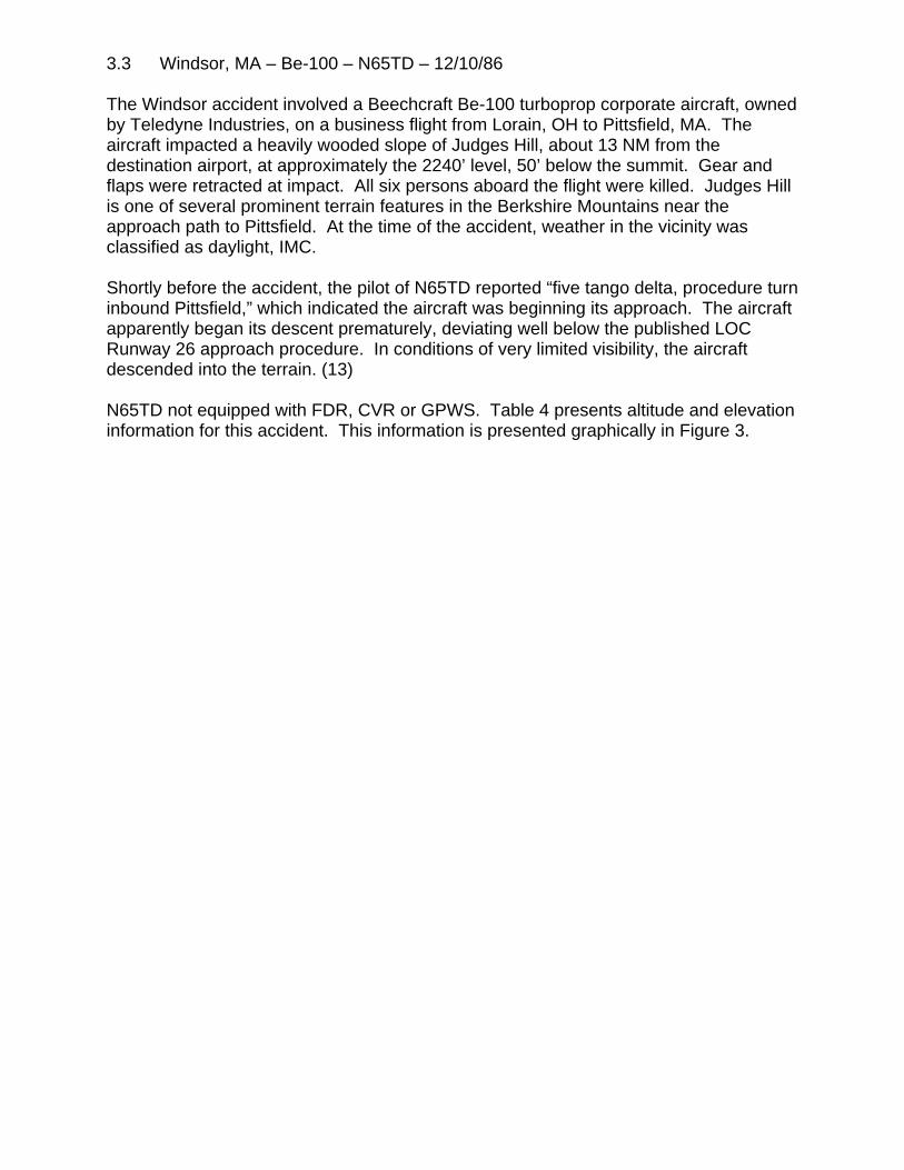
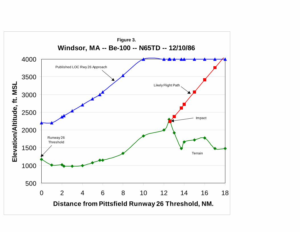
3.3 Windsor, MA – Be-100 – N65TD – 12/10/86
The Windsor accident involved a Beechcraft Be-100 turboprop corporate aircraft, ownedby Teledyne Industries, on a business flight from Lorain, OH to Pittsfield, MA. Theaircraft impacted a heavily wooded slope of Judges Hill, about 13 NM from thedestination airport, at approximately the 2240’ level, 50’ below the summit. Gear andflaps were retracted at impact. All six persons aboard the flight were killed. Judges Hillis one of several prominent terrain features in the Berkshire Mountains near theapproach path to Pittsfield. At the time of the accident, weather in the vicinity wasclassified as daylight, IMC.
Shortly before the accident, the pilot of N65TD reported “five tango delta, procedure turninbound Pittsfield,” which indicated the aircraft was beginning its approach. The aircraftapparently began its descent prematurely, deviating well below the published LOCRunway 26 approach procedure. In conditions of very limited visibility, the aircraftdescended into the terrain. (13)
N65TD not equipped with FDR, CVR or GPWS. Table 4 presents altitude and elevationinformation for this accident. This information is presented graphically in Figure 3.
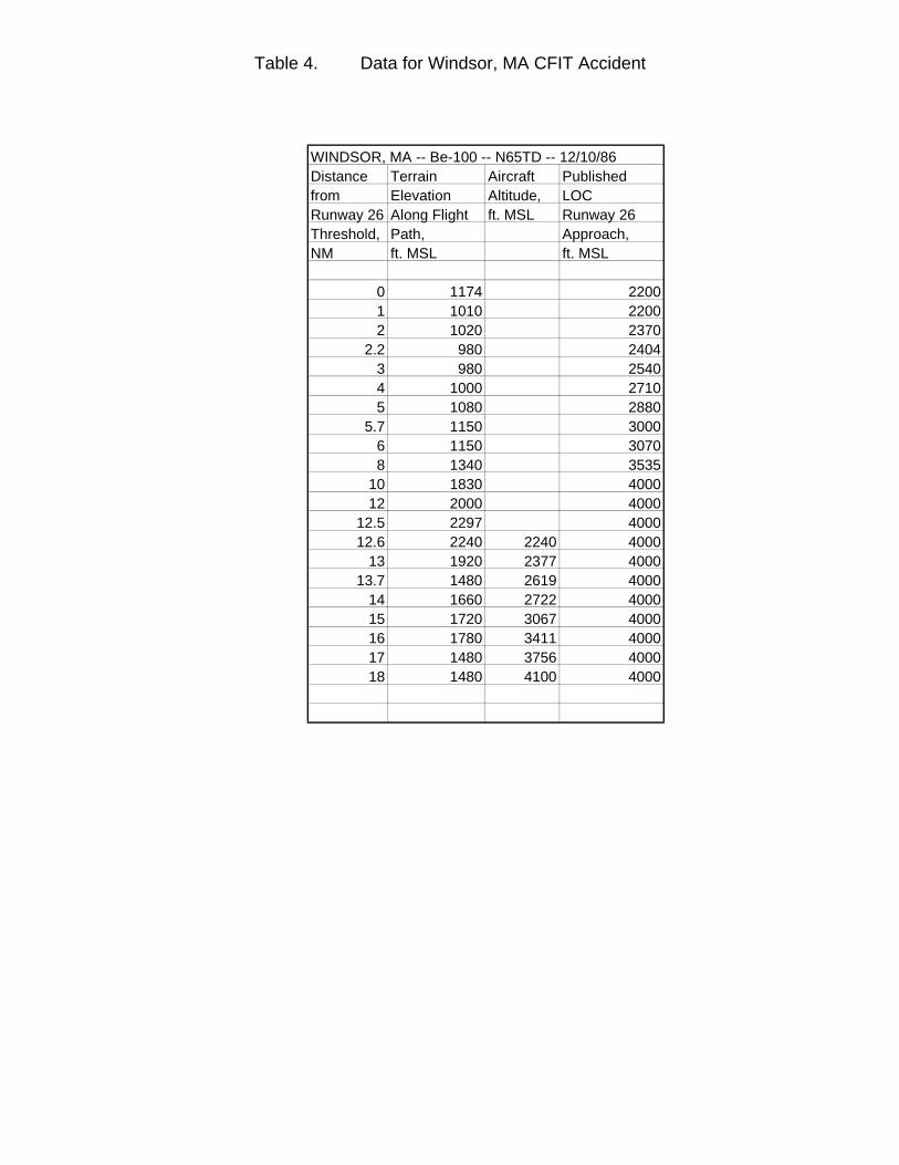
Table 4. Data for Windsor, MA CFIT Accident
WINDSOR, MA -- Be-100 -- N65TD -- 12/10/86Distance Terrain Aircraft Published from Elevation Altitude, LOCRunway 26 Along Flight ft. MSL Runway 26 Threshold, Path, Approach,NM ft. MSL ft. MSL
0 1174 22001 1010 22002 1020 2370
2.2 980 24043 980 25404 1000 27105 1080 2880
5.7 1150 30006 1150 30708 1340 3535
10 1830 400012 2000 4000
12.5 2297 400012.6 2240 2240 4000
13 1920 2377 400013.7 1480 2619 4000
14 1660 2722 400015 1720 3067 400016 1780 3411 400017 1480 3756 400018 1480 4100 4000
(placeholder for Windsor chart)
Figure 3.
Windsor, MA -- Be-100 -- N65TD -- 12/10/86
500
1000
1500
2000
2500
3000
3500
4000
0 2 4 6 8 10 12 14 16 18Distance from Pittsfield Runway 26 Threshold, NM.
Elev
atio
n/A
ltitu
de, f
t. M
SL
Runway 26Threshold
Likely Flight Path
Published LOC Rwy 26 Approach
Terrain
Impact
3.4 Eagle, CO – LJ-24A – N31SK – 3/27/87
The Eagle accident involved a Gates Learjet 24A turbojet, owned by Connie KalittaServices, Inc., which was on a FAR Part 91 positioning flight from Denver to Eagle toenplane a patient for a medical evacuation flight. The aircraft impacted an 8022’mountain ridge at the 8000’ level, 22’ below the summit, approximately 4 NM northwestof Eagle airport on a heading of 195o magnetic. N31SK was in approach configurationat impact. All three persons aboard were killed. Weather in the accident vicinity wasclassified as dark night, VMC.
The pilot of N31SK reported passing the STUPE intersection, and was cleared by ATCfor landing at Eagle. Shortly before the accident, the pilot reported “eight to ten milesout, and it’s clear to Eagle.” From the position and heading of the aircraft at impact,investigators assumed the pilot had elected to fly the circle-to-land LDA-A Runway 07approach to Eagle. The pilot descended well below the altitudes specified for thisapproach, but may have done so because he could see the airport. Post-crashinvestigation showed the pilot would have had the airport in sight for all but the last oneto three seconds of flight, when the uninhabited, unlit mountain ridge obstructed hisview. Only a very small adjustment to the aircraft’s controls would have been requiredto gain the additional 22’ of altitude necessary to clear the ridge. However, lackingvisual reference, the pilot was unable to see the terrain until it was too late. (14)
N31SK not equipped with FDR, CVR or GPWS. Table 5 presents altitude and elevationinformation for this accident. This information is presented graphically in Figure 4.
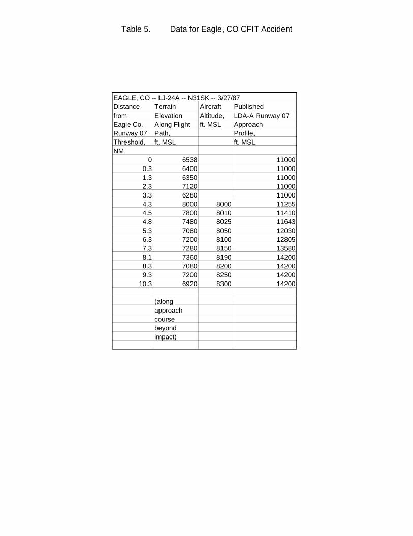
Table 5. Data for Eagle, CO CFIT Accident
EAGLE, CO -- LJ-24A -- N31SK -- 3/27/87Distance Terrain Aircraft Publishedfrom Elevation Altitude, LDA-A Runway 07Eagle Co. Along Flight ft. MSL ApproachRunway 07 Path, Profile, Threshold, ft. MSL ft. MSLNM
0 6538 110000.3 6400 110001.3 6350 110002.3 7120 110003.3 6280 110004.3 8000 8000 112554.5 7800 8010 114104.8 7480 8025 116435.3 7080 8050 120306.3 7200 8100 128057.3 7280 8150 135808.1 7360 8190 142008.3 7080 8200 142009.3 7200 8250 14200
10.3 6920 8300 14200
(along approach course beyond impact)
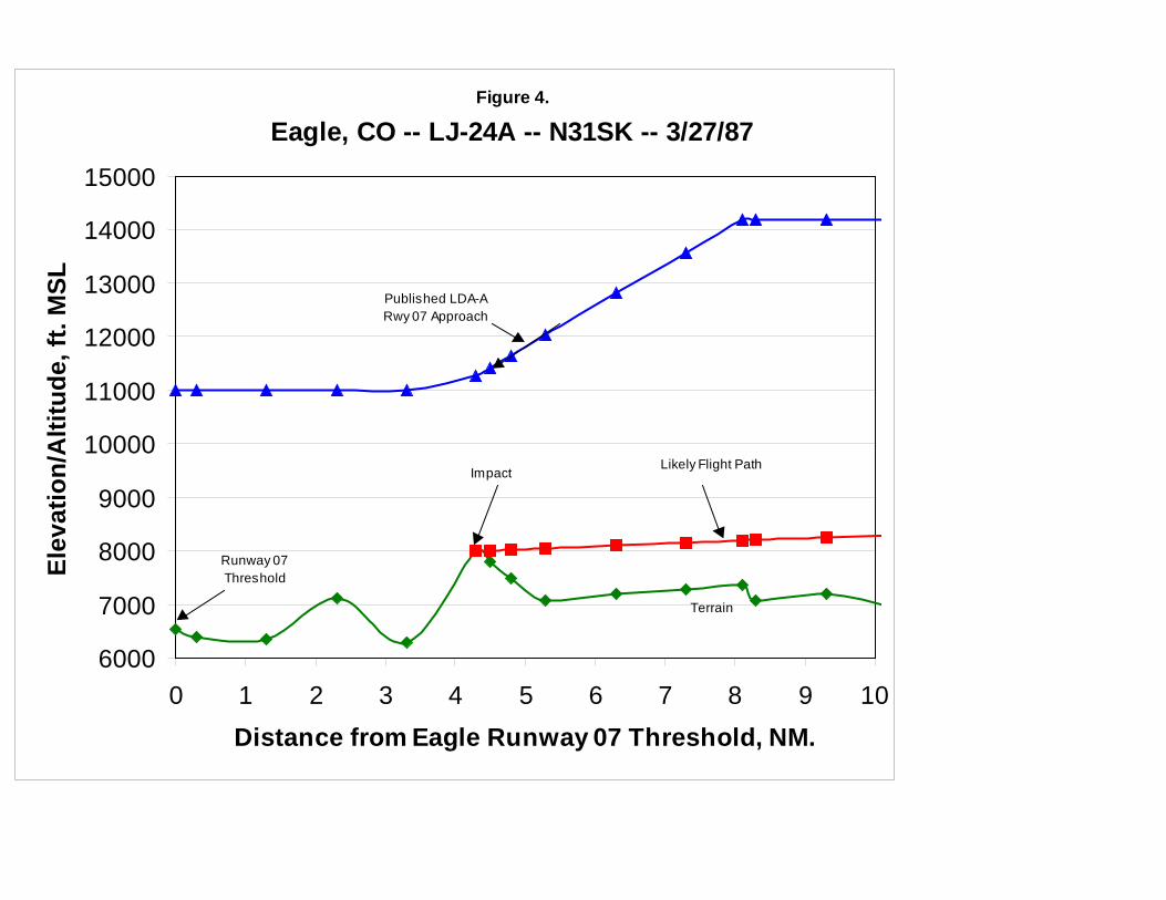
Figure 4.
Eagle, CO -- LJ-24A -- N31SK -- 3/27/87
6000
7000
8000
9000
10000
11000
12000
13000
14000
15000
0 1 2 3 4 5 6 7 8 9 10Distance from Eagle Runway 07 Threshold, NM.
Elev
atio
n/A
ltitu
de, f
t. M
SL
Likely Flight Path
Terrain
Impact
Published LDA-A Rwy 07 Approach
Runway 07 Threshold
3.5 Tegucigalpa, Honduras – B-727-200 – N88705 – 10/21/89
The Tegucigalpa accident involved TAN-SAHSA flight 414, a Boeing 727-200 turbojetleased by TAN–SAHSA from Continental Airlines, on a regularly scheduled commercialpassenger flight from Managua, Nicaragua, to Tegucigalpa. The aircraft impacted amountain known as Cerro de Hula at the 4800’ MSL elevation, approximately 800’below the summit, 4.8 NM from the Tegucigalpa Runway 01 threshold. At impact, theaircraft was in approach configuration. Of the 138 passengers and 12 crewmembers onboard, 131 persons were killed, 17 sustained serious injuries, and 2 persons sustainedminor injuries. Weather in the accident vicinity was classified as daylight, IMC. Locallyheavy rain showers were reported at the accident site.
SAHSA-414 was cleared by Tegucigalpa ATC for the VOR/DME Runway 01 approach,which includes a series of three step-downs from the initial approach fix altitude of 7500’MSL to avoid high terrain in the neighborhood of the airport. Rather than following theprescribed step-down procedure, however, the crew began a continuous descent fromabout 7600’ MSL at about 11 NM from the airport to the accident site. The aircraft’sdescent profile was well below the published step-down course for the entire approach.(15)
N88705 was equipped with FDR, CVR and GPWS. However, because Honduran lawdid not require installation, the GPWS had been disconnected at the time of theaccident. Table 6 presents altitude and elevation information for this accident. Thisinformation is presented graphically inFigure 5.
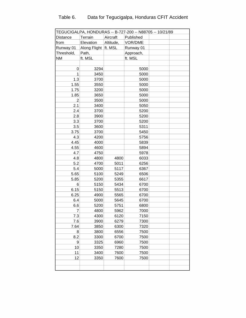
Table 6. Data for Tegucigalpa, Honduras CFIT Accident
TEGUCIGALPA, HONDURAS -- B-727-200 -- N88705 -- 10/21/89Distance Terrain Aircraft Published from Elevation Altitude, VOR/DMERunway 01 Along Flight ft. MSL Runway 01Threshold, Path, Approach,NM ft. MSL ft. MSL
0 3294 50001 3450 5000
1.3 3700 50001.55 3550 50001.75 3200 50001.85 3650 5000
2 3500 50002.1 3400 50502.4 3700 52002.8 3900 52003.3 3700 52003.5 3600 5311
3.75 3700 54504.3 4200 5756
4.45 4000 58394.55 4600 58944.7 4750 59784.8 4800 4800 60335.2 4700 5011 62565.4 5000 5117 6367
5.65 5100 5249 65065.85 5200 5355 6617
6 5150 5434 67006.15 5150 5513 67006.25 4900 5565 67006.4 5000 5645 67006.6 5200 5751 6800
7 4800 5962 70007.3 4300 6120 71507.6 3900 6279 7300
7.64 3850 6300 73208 3800 6556 7500
8.2 3300 6700 75009 3325 6960 7500
10 3350 7280 750011 3400 7600 750012 3350 7600 7500
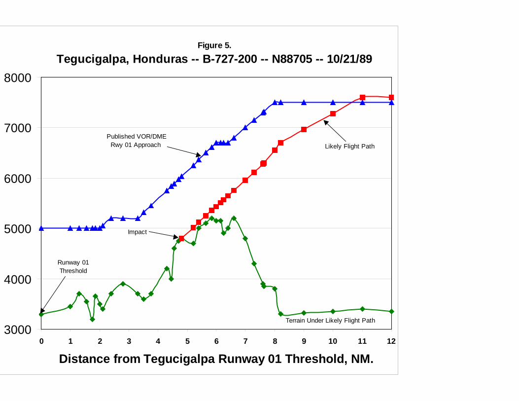
Figure 5.
Tegucigalpa, Honduras -- B-727-200 -- N88705 -- 10/21/89
3000
4000
5000
6000
7000
8000
0 1 2 3 4 5 6 7 8 9 10 11 12
Distance from Tegucigalpa Runway 01 Threshold, NM.
Runway 01Threshold
Likely Flight Path Published VOR/DME
Rwy 01 Approach
Terrain Under Likely Flight Path
Impact
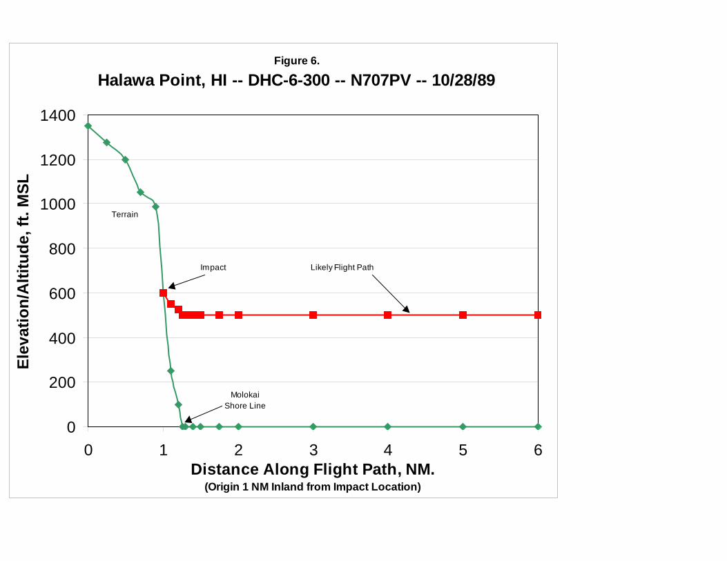
3.6 Halawa Point, HI – DHC-6-300 – N707PV – 10/28/89
The Halawa Point accident involved Aloha Island Air flight 1712, A DeHavilland DHC-6-300 Twin Otter turboprop, on a regularly scheduled FAR Part 135 commuter flight fromKahului, Maui, to Kanunakakai, Molokai. Impact occurred in the coastal mountains onthe north side of the island of Molokai. The aircraft, in cruise configuration, impactedthe 600’ MSL elevation of a ridge near Halawa Point whose summit measured 1050’MSL. All 20 persons aboard were killed. Weather in the accident vicinity was classifiedas dark night, IMC. While weather along the projected flight path of N707PV wasgenerally clear, a localized area of IMC existed at Halawa Point, created when moist,warm winds moving across the Pacific were abruptly lifted upwards into cooler air by thesteep terrain of Molokai.
Radar plots of flight 1712 show that it climbed to an altitude of about 1000’ MSLfollowing takeoff, then descended to 500’ MSL at a point about five miles from theMolokai coast. It is likely the aircraft encountered the localized weather at this point anddescended below the cloud ceiling to maintain visual contact with the terrain as isrequired under visual flight rules. At a point about two miles southeast of Halawa Point,the aircraft turned on a heading of 260o magnetic. The crew made this turn intending tofly their regular route parallel to and just offshore from the north coast of Molokai. However, because of limited visibility, they made this turn prematurely, heading theaircraft directly towards very steep terrain on Halawa Point. Lacking visual references,they were unable to see the terrain ahead until it was too late. (16)
N707PV not equipped with FDR, CVR or GPWS. Table 7 presents altitude andelevation information for this accident. This information is presented graphically inFigure 6.
Table 7. Data for Halawa Point, HI CFIT Accident
HALAWA POINT, HI -- DHC-6-300 -- N707PV -- 10/28/89Distance Terrain AircraftAlong Elevation, Altitude,Flight Path, ft. MSL ft. MSLNM(Originextended1 NM inlandfrom impact)
0 13500.25 12750.5 12000.7 10500.9 985
1 600 6001.1 250 5501.2 100 525
1.26 0 5001.3 0 5001.4 0 5001.5 0 500
1.75 0 5002 0 5003 0 5004 0 5005 0 5006 0 500
(placeholder for Molokai chart)
Figure 6.
Halawa Point, HI -- DHC-6-300 -- N707PV -- 10/28/89
0
200
400
600
800
1000
1200
1400
0 1 2 3 4 5 6Distance Along Flight Path, NM.
(Origin 1 NM Inland from Impact Location)
Elev
atio
n/A
ltitu
de, f
t. M
SL
MolokaiShore Line
Terrain
Likely Flight Path Impact
3.7 San Diego, CA – HS-125 – N831LC – 3/16/91
The San Diego accident involved a Hawker-Siddeley DH-125-1A turbojet in an on-demand FAR Part 91 charter flight from Brown Field, San Diego, CA to Amarillo, TX. The aircraft impacted Otay Mountain, a 3550’ MSL peak in the San Ysidro Mountains,approximately 8 NM from the takeoff point. Impact occurred approximately 250’ MSLbelow the summit on a bearing of 050o magnetic, while the aircraft was in cruiseconfiguration. All ten persons aboard were killed. The accident gained nationalattention as all the passengers were members of country singing star Reba McIntire’sband. Weather in the accident vicinity was classified as dark night, VMC.
Because a late night departure was planned, the aircraft had been positioned at BrownField on the outskirts of San Diego due to a noise curfew in effect at San Diego-Lindbergh field. While waiting for his passengers to arrive, the pilot, who was unfamiliarwith local procedures and terrain, had three separate conversations with the local FlightService Station (FSS). During these conversations, the FSS specialist suggested itwould save time if the flight departed under visual flight rules and picked up its IFRclearance once airborne. The pilot indicated reluctance to climb through 3000’ MSLwithout an IFR clearance, as that would involve flight into the San Diego TerminalControl Area (TCA) whose “floor” was 3000’ MSL. The pilot then stated: “… so I wouldbe better off if I headed right northeast and stayed down … below three thousand.” TheFSS specialist replied “That’ll be fine.” This was a fatal mis-communication: the pilothad been referencing 3000’ MSL, while the FSS specialist understood the pilot’s altitudereference as 3000’ above ground level. (17)
Radar data indicate the flight took off normally and leveled off at approximately 3300’MSL. The pilot had filed an IFR flight plan, but due to a delay in takeoff, this flight planhad expired. Without IFR clearance, the flight could not climb into the San Diego TCAwithout violating flight rules. Responding to the pilot’s request for IFR clearance, theSan Diego TRACON controller indicated N831LC’s flight plan had “clocked out” but thathe would “put it right back in.” Shortly afterward, the aircraft impacted Otay Mountain. Because terrain in this location is uninhabited and unlit, the crew of N831LC did not seethe mountain until it was too late to avoid impact. (18)
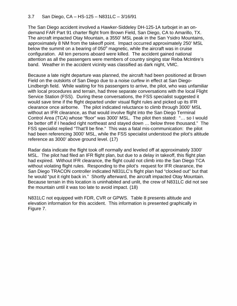
N831LC not equipped with FDR, CVR or GPWS. Table 8 presents altitude andelevation information for this accident. This information is presented graphically inFigure 7.
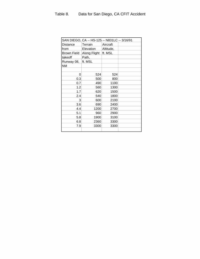
Table 8. Data for San Diego, CA CFIT Accident
SAN DIEGO, CA -- HS-125 -- N831LC -- 3/16/91Distance Terrain Aircraft from Elevation Altitude,Brown Field Along Flight ft. MSLtakeoff Path, Runway 08, ft. MSLNM
0 524 5240.3 500 8000.7 490 11001.2 560 13001.7 620 15002.4 540 1800
3 600 21003.6 690 24004.4 1200 27005.1 960 29005.8 1900 31006.8 2360 33007.9 3300 3300
(placeholder for San Diego chart)
Figure 7.
San Diego, CA -- HS-125 -- N831LC -- 3/16/91
0
500
1000
1500
2000
2500
3000
3500
4000
4500
0 1 2 3 4 5 6 7 8Distance from Takeoff Runway, NM.
Elev
atio
n/A
ltitu
de, f
t. M
SL
Likely Flight Path
Terrain UnderLikely Flight Path
Impact
Brown Field Runway 08Threshold
3.8 Rome, GA – Be-400 – N25BR – 12/11/91
The Rome accident involved a Beechcraft Be-400 turbojet owned by Bruno’s, Inc., aregional grocery store chain, on a business flight from Rome to Huntsville, AL. Theaircraft impacted Lavender Mountain, the highest terrain within a 5 NM radius of theairport, shortly after takeoff. Impact occurred at the 1580’ MSL level, approximately120’ below the summit, on a heading of 025o magnetic. The aircraft was in cruiseconfiguration. All nine persons aboard were killed. Weather in the accident vicinity wasclassified as daylight, IMC. The cloud ceiling obscured the tops of the mountains in thearea.
N25BR was carrying executives of Bruno’s on an annual pre-Christmas tour of thecompany’s various stores. Rather than face what might have been a lengthy delay foran IFR clearance, the flight crew elected to depart Rome under visual flight rules (VFR). CVR transcripts indicate the first officer was at the controls. Shortly after takeoff, thecaptain radioed the Atlanta, GA Air Route Traffic Control Center (ARTCC) andrequested an IFR clearance, which would enable the aircraft to climb above the cloudceiling. Atlanta ATC instructed the flight to remain VFR because of traffic currentlyapproaching Rome. Shortly afterward, the captain remarked to the first officer: “We’regoing to have to get away from that mountain down there pretty soon.” There followeda discussion of how this should be accomplished; the first officer suggested “a one-eighty (degree turn) to the left.” The captain replied “You’re getting close … (turn) to theright.” The first officer replies: “I can’t see over here. That’s why I wanted to go theother way,” and then asks “should I just punch up (i.e., climb through the cloud ceiling)?” Shortly after this conversation, the aircraft impacted Lavender Mountain. In conditionsof limited visibility, the flight crew did not see the terrain until it was too late to react. (19)
N25BR was equipped with a CVR, but did not carry either FDR or GPWS. Table 9 presents altitude and elevation information for this accident. This information ispresented graphically in Figure 8.
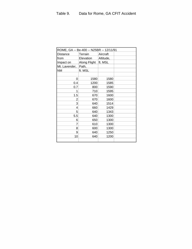
Table 9. Data for Rome, GA CFIT Accident
ROME, GA -- Be-400 -- N25BR -- 12/11/91Distance Terrain Aircraft from Elevation Altitude,Impact on Along Flight ft. MSLMt. Lavender, Path, NM ft. MSL
0 1580 15800.4 1200 15850.7 800 1590
1 710 15951.5 670 1600
2 670 16003 640 15144 660 14295 640 1343
5.5 640 13006 650 13007 610 13008 600 13009 640 1250
10 640 1200
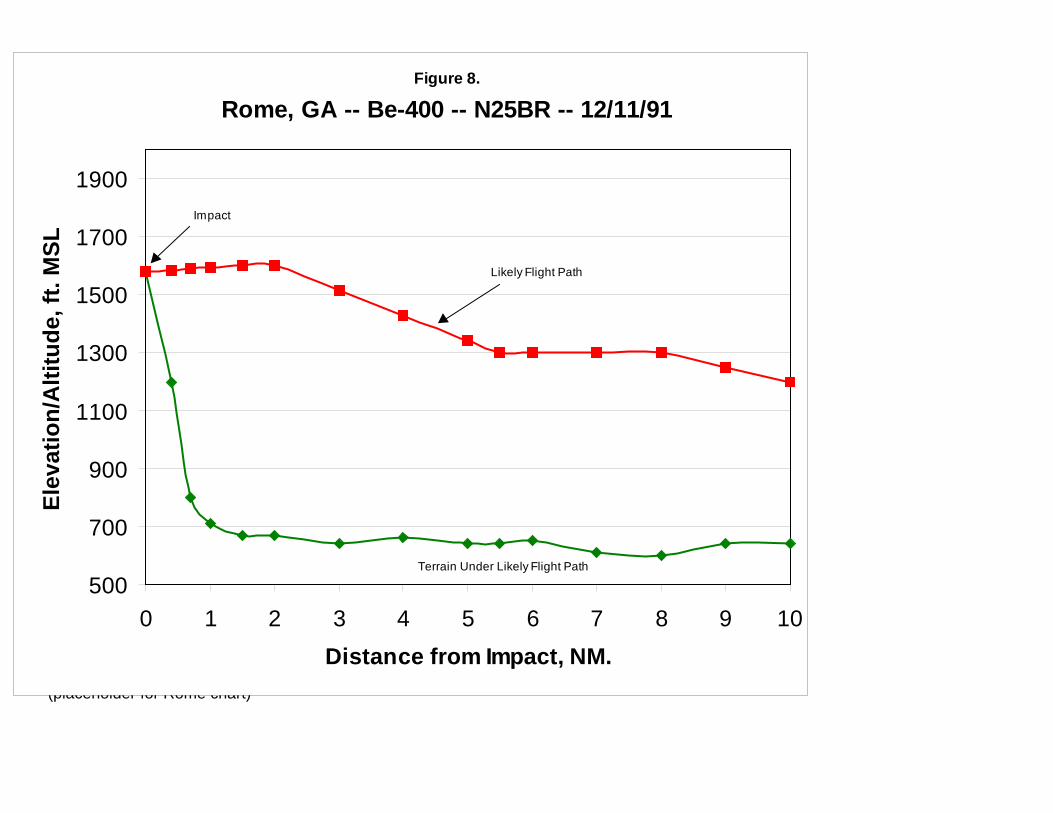
(placeholder for Rome chart)
Figure 8.
Rome, GA -- Be-400 -- N25BR -- 12/11/91
500
700
900
1100
1300
1500
1700
1900
0 1 2 3 4 5 6 7 8 9 10Distance from Impact, NM.
Elev
atio
n/A
ltitu
de, f
t. M
SL
Likely Flight Path
Terrain Under Likely Flight Path
Impact
3.9 Gabriels, NY – Be-1900C – N55000 – 1/3/92
The Gabriels accident involved Commutair Flight 4821, a Beechcraft Be-1900Cturboprop, on a regularly scheduled FAR Part 135 commuter flight between Plattsburgh,NY, and Saranac Lake, NY. The aircraft impacted Blue Hill, approximately 4.3 NM fromthe destination airport, at the 2280’ MSL elevation, about 110’ below the summit, on aheading of 230o magnetic, on course for runway 23 at Saranac Lake. Four personswere on board; two were killed and two suffered serious injuries. At impact, gear andflaps were retracted. Weather in the accident vicinity was classified as dark night, IMC.
Flight 4821 was cleared by the Boston ARTCC for an instrument landing system (ILS)approach to Saranac Lake Runway 23. Radar data plots show the aircraft remained oncourse through the ZECKA intersection (the initial approach fix). After passing thispoint, the flight turned to join the localizer signal, and began a rather rapid descent. Approximately 7.5 NM from the runway threshold, N55000 passed through the midpointof the glide slope signal. Beyond that point, the aircraft descended well below theestablished approach profile to the impact point. Lacking visual reference, the pilot wasunable to see Blue Hill until it was too late to avoid impact. Because the aircraft had noGPWS aboard, the pilot received no warning that his flight path had deviated well belowthe glide slope signal. (20, 21)
N55000 was equipped with a CVR, but did not carry either FDR or GPWS.Unfortunately, the CVR was destroyed in the crash, and did not yield any usefulinformation. Table 10 presents altitude and elevation information for this accident. This information is presented graphically in Figure 9.
Table 10. Data for Gabriels, NY CFIT Accident
GABRIELS, NY -- Be-1900C -- N55000 -- 1/3/92Distance Terrain Aircraft Published from Runway 23 Elevation, Altitude, ILS Runway Threshold, ft. MSL ft. MSL 23 Approach, NM ft. MSL
0 1655 18630.4 1655 1863
1 1655 20522 1740 23683 1720 26844 1770 3000
4.25 2100 30794.3 2280 2280 3095
4.75 2065 2550 32375 1870 2700 3316
5.8 1625 3000 35685.9 1600 3100 3600
6 1575 3200 36416.2 1655 3300 3724
7 1740 3600 40537.6 1690 4000 43007.9 1690 4400 4363
8 1675 4440 43838.3 2000 4600 4446
9 1715 4865 45929.1 1705 4900 461310 2120 5000 4800
10.2 1990 520010.9 1920 5400
11 1680 5415 .11.5 1740 5500
12 1750 558512.1 1750 560012.7 1720 5700
13 1740 575013.3 1725 5800
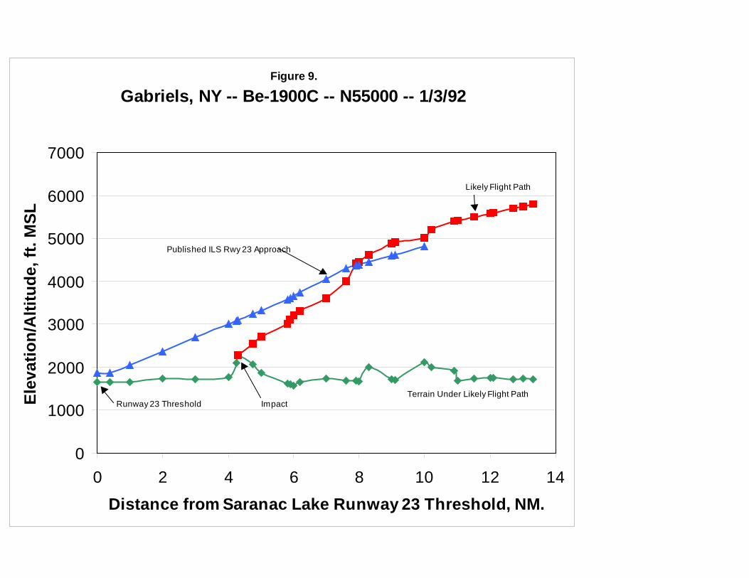
Figure 9.
Gabriels, NY -- Be-1900C -- N55000 -- 1/3/92
0
1000
2000
3000
4000
5000
6000
7000
0 2 4 6 8 10 12 14Distance from Saranac Lake Runway 23 Threshold, NM.
Elev
atio
n/A
ltitu
de, f
t. M
SL
Runway 23 ThresholdTerrain Under Likely Flight Path
Likely Flight Path
Impact
Published ILS Rwy 23 Approach
3.10 Alamogordo, NM – MU-2B-30 – N108SC – 6/24/92
The Alamogordo accident involved a privately owned Mitsubishi MU-2B-30 turboprop ona personal FAR Part 91 flight from Alamogordo to Burnet, TX. Shortly after takeoff, theaircraft impacted a ridge in the Sacramento Mountains to the east of Alamogordo at the6100’ MSL level, approximately 1500’ below the summit, on a heading of 035o
magnetic. The aircraft was in cruise configuration; all six persons aboard were killed. Weather in the accident vicinity was classified as dark night, VMC.
Following takeoff from Alamogordo, N108SC was advised by ATC: “eight sierra charlie,maintain VFR through one one thousand …”. The pilot responded, “Roger, we’re goingto circle up over the airport a little bit, just to ensure terrain clearance …”. A short whilelater, the pilot asked ATC “what’s your minimum terrain clearance out in this neck of thewoods?” That was the last transmission received from the aircraft. Circling to gainaltitude after takeoff, N108SC had strayed too far to the east, into the SacramentoMountains. In the dark night, there were no lights in the uninhabited area to providevisual reference. (22)
N108SC was not equipped with CVR, FDR or GPWS. Table 11 presents altitude andelevation information for this accident. This information is presented graphically inFigure 10.
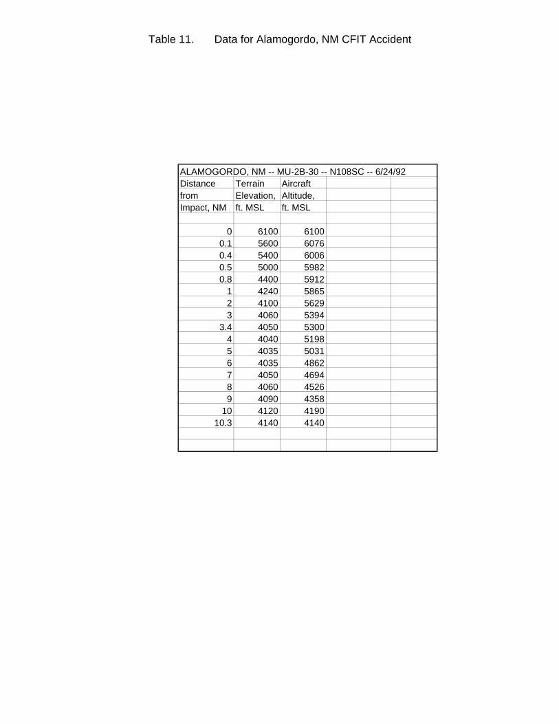
Table 11. Data for Alamogordo, NM CFIT Accident
ALAMOGORDO, NM -- MU-2B-30 -- N108SC -- 6/24/92Distance Terrain Aircraft from Elevation, Altitude, Impact, NM ft. MSL ft. MSL
0 6100 61000.1 5600 60760.4 5400 60060.5 5000 59820.8 4400 5912
1 4240 58652 4100 56293 4060 5394
3.4 4050 53004 4040 51985 4035 50316 4035 48627 4050 46948 4060 45269 4090 4358
10 4120 419010.3 4140 4140
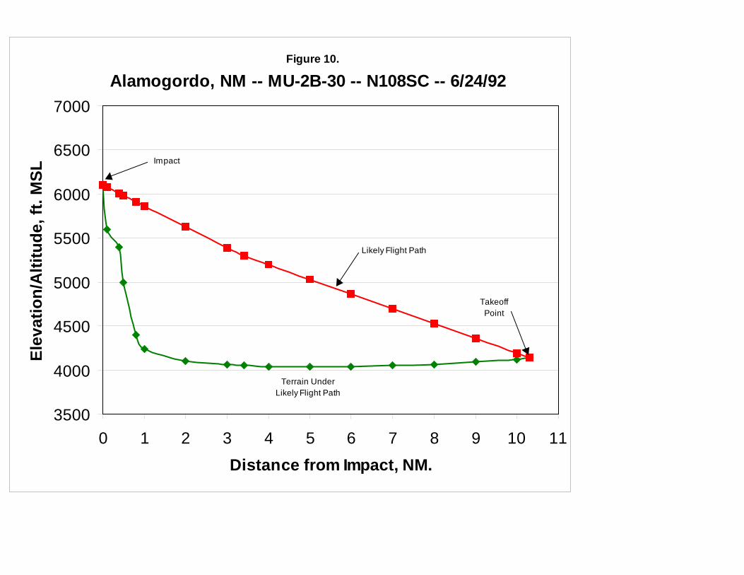
Figure 10.
Alamogordo, NM -- MU-2B-30 -- N108SC -- 6/24/92
3500
4000
4500
5000
5500
6000
6500
7000
0 1 2 3 4 5 6 7 8 9 10 11Distance from Impact, NM.
Elev
atio
n/A
ltitu
de, f
t. M
SL
Likely Flight Path
Terrain UnderLikely Flight Path
Impact
TakeoffPoint
3.11 East Granby, CT – MD-83 – N566AA – 11/13/92
The East Granby accident involved American Airlines flight 1572, a McDonnell-DouglasMD-83 turbojet on a regularly-scheduled FAR Part 121 flight from Chicago, IL toHartford-Bradley Field, Windsor Locks, CT. On a VOR approach to Runway 15 atWindsor Locks, the aircraft impacted trees on the summit of a ridgeline approximately2.5 NM northwest of the runway threshold. Impact occurred on a heading of 149o
magnetic, on course for Runway 15. Although one of its engines failed and the otherengine and control surfaces were damaged, the crew managed to keep the aircraftairborne and made an emergency landing in the safety overrun area for Runway 33 (theopposite end of Runway 15), destroying an antenna array in the process. Because thecrew was able to land the aircraft safely, only one passenger suffered minor injuries inthe emergency evacuation process which commenced once flight 1572 had come to astop. Weather in the accident vicinity was classified as dark night, IMC, and was astrong contributing factor. An extremely powerful cold front was passing through thearea at the time, and atmospheric pressure was dropping rapidly, with high winds,windshear and heavy rain. Post-crash investigation showed the pilots had not receivedan updated weather briefing and had not set their altimeter to the correct barometricpressure reading at the time of the accident, which caused their altimeter to give falselyhigh readings. (23)
The CVR transcript indicates that after passing DILLN, the final approach fix, the firstofficer said to the captain, “You’re going below your… (minimum).” Radar and FDRdata show the aircraft at this point had descended about 300’ below the publishedminimum descent altitude (MDA) for the approach. Shortly after this statement, theGPWS sounded a “Sink Rate!” alert. Four seconds later, the aircraft struck the trees,and the GPWS sounded its “Whoop! Whoop! Pull Up!” alarm. The crew initially appliedfull thrust, intending to fly a missed approach, but soon realized that the engines werenot developing power. The aircraft began a slow descent, and the first officer reportedthe runway was in sight. The captain then called for full flaps to achieve a “ballooneffect,” minimizing the aircraft’s descent rate. The resulting flight path allowed the flightto touch down just short of Runway 15. The NTSB report on this accident states “theexcellent crew resource management and flight skills that the flight crew used …following (the) encounter with the trees, were directly responsible for limiting the numberof injured passengers to one individual.” (24)
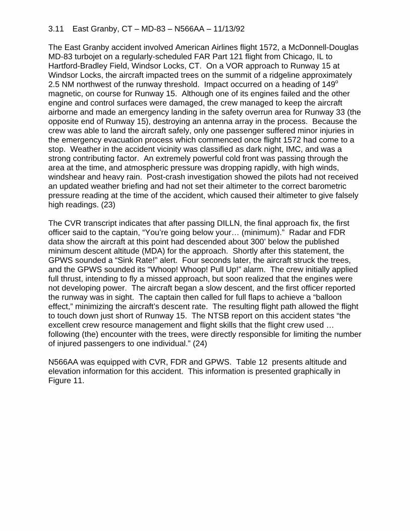
N566AA was equipped with CVR, FDR and GPWS. Table 12 presents altitude andelevation information for this accident. This information is presented graphically inFigure 11.
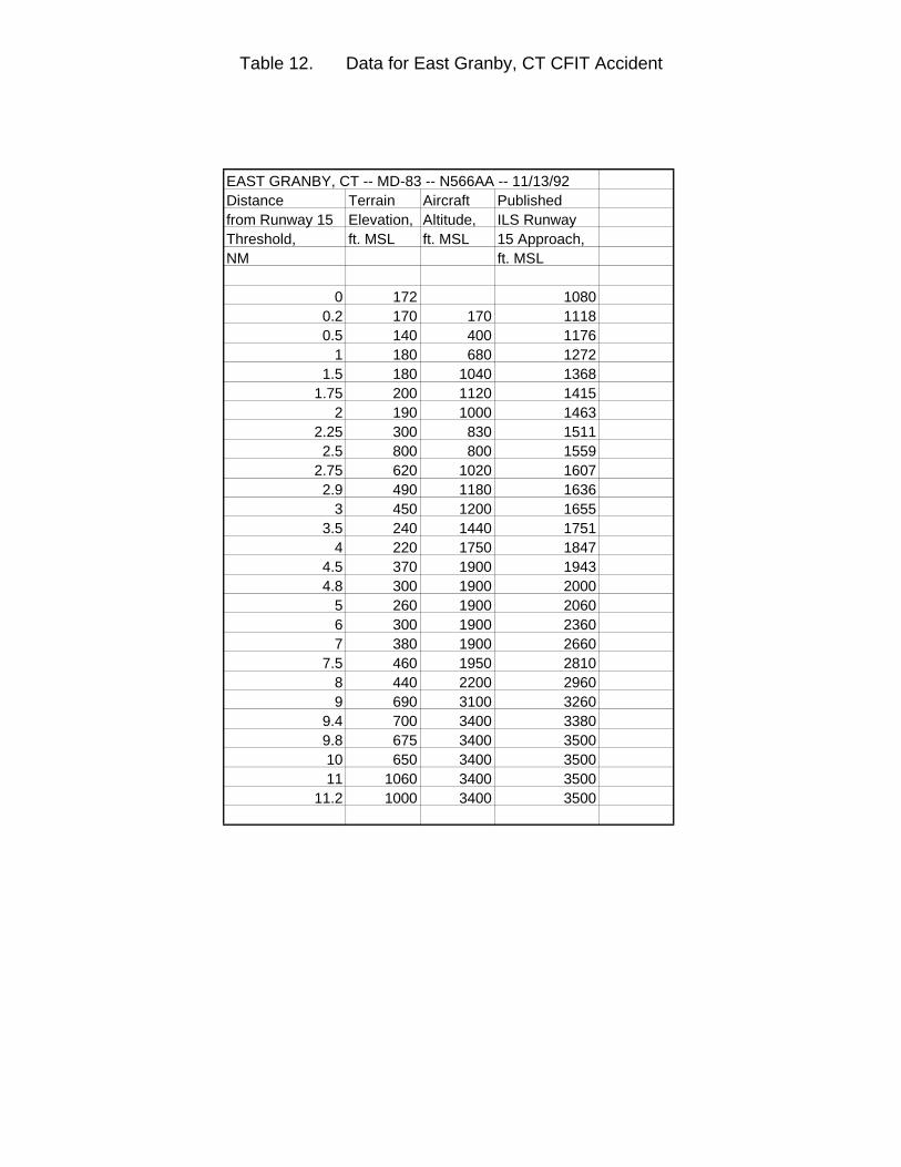
Table 12. Data for East Granby, CT CFIT Accident
EAST GRANBY, CT -- MD-83 -- N566AA -- 11/13/92Distance Terrain Aircraft Published from Runway 15 Elevation, Altitude, ILS RunwayThreshold, ft. MSL ft. MSL 15 Approach,NM ft. MSL
0 172 10800.2 170 170 11180.5 140 400 1176
1 180 680 12721.5 180 1040 1368
1.75 200 1120 14152 190 1000 1463
2.25 300 830 15112.5 800 800 1559
2.75 620 1020 16072.9 490 1180 1636
3 450 1200 16553.5 240 1440 1751
4 220 1750 18474.5 370 1900 19434.8 300 1900 2000
5 260 1900 20606 300 1900 23607 380 1900 2660
7.5 460 1950 28108 440 2200 29609 690 3100 3260
9.4 700 3400 33809.8 675 3400 350010 650 3400 350011 1060 3400 3500
11.2 1000 3400 3500
Figure 11.
East Granby, CT -- MD-83 -- N566AA -- 11/12/95
0
500
1000
1500
2000
2500
3000
3500
4000
0 1 2 3 4 5 6 7 8 9 10 11 12Distance from Windsor Locks Rwy. 15 Threshold, NM.
Elev
atio
n/A
ltitu
de, f
t. M
SL
Runway 15 Threshold
Terrain
Likely Flight Path
Published VOR Rwy 15 Approach
Tree Impact
3.12 Buga, Colombia – B-757-200 –N651AA – 12/20/95
The Buga accident involved American Airlines flight 965, a Boeing B-757-200 turbofanon a regularly scheduled FAR Part 121 flight from Miami, FL to Cali, Colombia. Theaircraft impacted a ridge on San Jose Mountain, which rises above the town of Buga to12,900’ MSL at its highest point, at approximately the 8960’ elevation, on a heading of221o magnetic, while the aircraft was in approach configuration. Impact was 30.4 NMfrom the Cali VOR facility. Of the 167 persons aboard, only four passengers survivedwith serious injuries. Weather in the accident vicinity was classified as dark night, VMC.
The Cali airport lies in the middle of a valley between two mountain ridges. The crew offlight 965 were expecting to fly an ILS approach in which they overflew the field, circledback and landed on the northbound runway (designated 01). However, because windswere calm, the Cali approach controller offered the crew the option of a “straight-in”approach to the opposite end of this runway (19): “would you like the one-nine straightin?” CVR transcripts show the first officer said to the captain: “yeah, we’ll have toscramble to get down (but) we can do it.” The captain then replied to ATC: “Yes sir,we’ll need a lower altitude right away, though.”
The VOR/DME approach to Cali Runway 19 is a non-precision approach starting at theTulua VOR facility, 43 NM from the Cali VOR at an altitude of 14,900’ MSL. BeyondTulua, aircraft follow a heading of 200o magnetic and descend to 5000’ MSL. Followingthe contours of the valley, they then turn to a heading of 190o magnetic 21 NM from theVOR, maintaining a 5000’ MSL altitude until reaching a navigational fix 16 NM from theVOR. At this point, they descend to the 3900’ MSL minimum descent altitude; theROZO non-directional beacon (NDB) is the signal for aircraft to begin final approach.
Because there was no terminal radar at Cali, ATC had to rely on pilot reports forinformation on aircraft position, and requested that flight 965 “report (passing) Tulua(VOR).” The flight crew, after some initial confusion, realized that ROZO was the finalapproach fix, and asked ATC “can 965 go direct (to) ROZO and do the ROZO ONEarrival (procedure)?” ATC replied “Affirmative,” but then reiterated “Report Tulua and 21miles (the point at which the approach course turns), 5000 feet.” (25)
To slow their airspeed and increase their descent rate, the captain extended theaircraft’s speed brakes at this point, and tuned the flight management system to ROZOby entering an “R” on its keyboard. Post-crash investigation shows the flightmanagement computer responded with a list of the 12 nearest navigational facilities,ranked in order of distance from the aircraft, having call signs beginning with “R,”together with their latitude/longitude coordinates. Unknown to the captain, this list didnot contain ROZO; it was not entered as such in the flight management system’smemory. Without bothering to verify its position, the captain selected the topmostfacility on the list, assuming it was ROZO. Unfortunately, it was the ROMEO NDBlocated in Bogota, 130 NM away. (26)
Once this selection was made, the aircraft began a sharp, 90o turn to the east, headingtowards ROMEO. It was just about this point that the aircraft passed over the Tulua

VOR. Because Tulua was no longer an active waypoint for the flight, it was notdisplayed on the flight management system, and the crew was unaware it had beencrossed. For reasons that are unclear, the crew did not notice the aircraft had veeredsharply off course for about 45 seconds, and then took another 45 seconds to takeappropriate corrective action. All the while, the aircraft was descending.
Cali ATC, realizing the flight should have passed Tulua, but had not reported doing so,then asked “distance now?” The captain responded “distance from Cali (VOR) is 38(NM).” Cali ATC acknowledged, but did not question the report. Since Tulua is 43 NMfrom the VOR, it had clearly been passed. Post-crash investigation showed thecontroller in question had command of the English language sufficient to engage inroutine ATC exchanges, but apparently not enough to raise detailed questions to thecrew of flight 965 regarding position and heading as they strayed off course. (27)
Over the next minute, the CVR shows the crew realizing they are heading away fromCali. The captain says: “Where are we? Come right … go to Cali … we got (expletive)up here, didn’t we?” The first officer then disengages the flight management systemand initiates a manual turn to the right of approximately 90 degrees, the end result ofwhich places the aircraft back on the initial approach course. Unfortunately, theexcursion off the approach course had taken the aircraft well beyond the confines of thevalley containing the airport. Still descending, N651AA was now dangerously close tothe peaks on the east side of the valley. Eventually, the aircraft’s GPWS begins tosound a “Terrain! Terrain!” alert, followed quickly by a “Whoop! Whoop! Pull Up!”warning. The crew’s reaction was immediate and decisive; the nose was pitched upand maximum throttle applied. But the speed brakes remained deployed, a factor whichnegatively affected the aircraft’s climb rate. Eleven seconds after the initial alert, theaircraft impacted San Jose Mountain. (28)
N651AA was equipped with CVR, FDR and GPWS. Table 13 presents altitude andelevation information for this accident. This information is presented graphically inFigure 12.
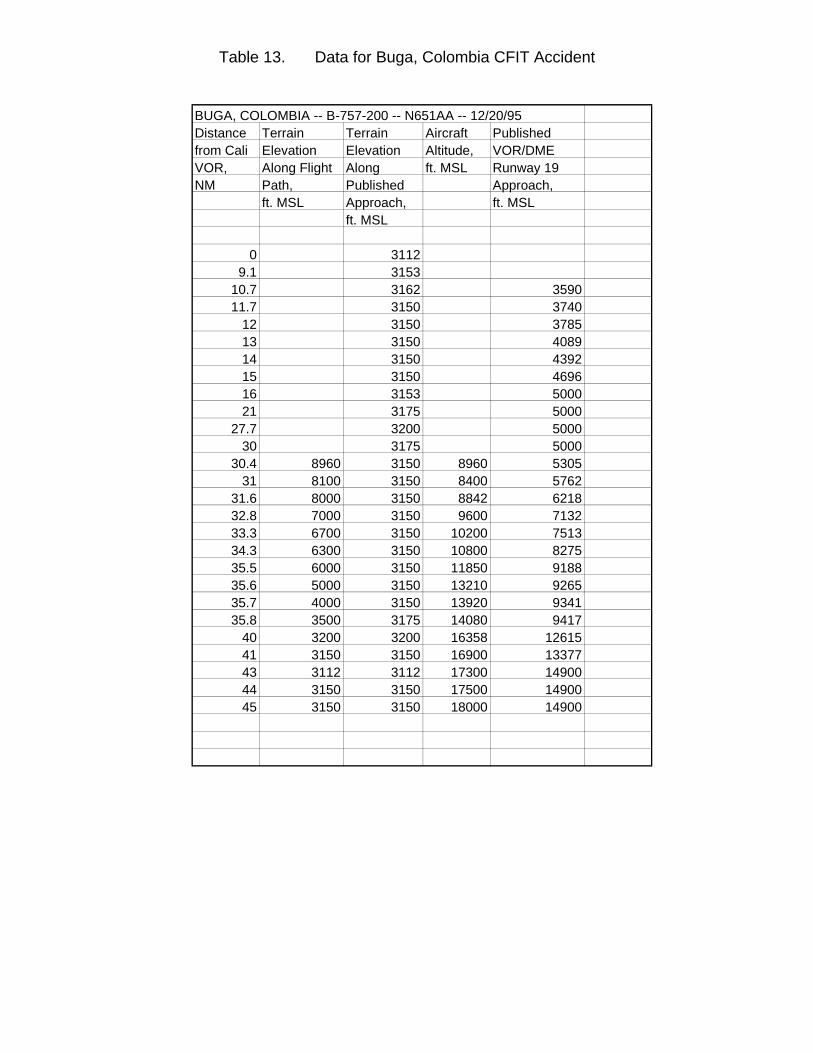
Table 13. Data for Buga, Colombia CFIT Accident
BUGA, COLOMBIA -- B-757-200 -- N651AA -- 12/20/95Distance Terrain Terrain Aircraft Published from Cali Elevation Elevation Altitude, VOR/DME VOR, Along Flight Along ft. MSL Runway 19 NM Path, Published Approach,
ft. MSL Approach, ft. MSLft. MSL
0 31129.1 3153
10.7 3162 359011.7 3150 3740
12 3150 378513 3150 408914 3150 439215 3150 469616 3153 500021 3175 5000
27.7 3200 500030 3175 5000
30.4 8960 3150 8960 530531 8100 3150 8400 5762
31.6 8000 3150 8842 621832.8 7000 3150 9600 713233.3 6700 3150 10200 751334.3 6300 3150 10800 827535.5 6000 3150 11850 918835.6 5000 3150 13210 926535.7 4000 3150 13920 934135.8 3500 3175 14080 9417
40 3200 3200 16358 1261541 3150 3150 16900 1337743 3112 3112 17300 1490044 3150 3150 17500 1490045 3150 3150 18000 14900
(placeholder for Buga chart)
Figure 12.
Buga, Colombia -- B757-200 -- N651AA -- 12/20/95
2000
4000
6000
8000
10000
12000
14000
16000
18000
10 15 20 25 30 35 40 45Distance from Cali VOR, NM.
Elev
atio
n/A
ltitu
de, f
t. M
SL
CaliRunway 19Threshold
Terrain Under Published Approach
Likely Flight Path
Published VOR/DME Rwy 19 ApproachTerrain Under
Likely Flight Path
Impact
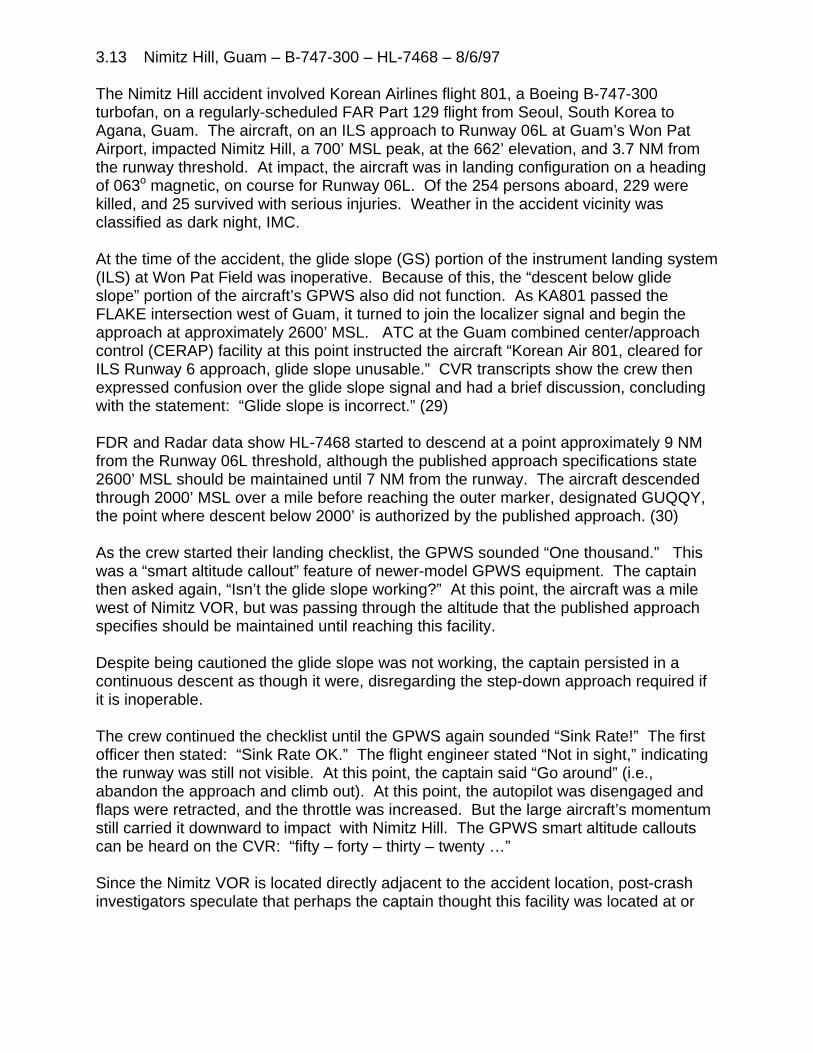
3.13 Nimitz Hill, Guam – B-747-300 – HL-7468 – 8/6/97
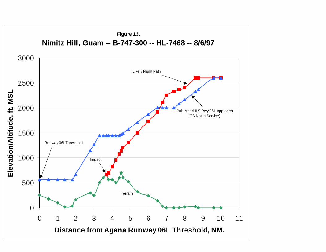
The Nimitz Hill accident involved Korean Airlines flight 801, a Boeing B-747-300turbofan, on a regularly-scheduled FAR Part 129 flight from Seoul, South Korea toAgana, Guam. The aircraft, on an ILS approach to Runway 06L at Guam’s Won PatAirport, impacted Nimitz Hill, a 700’ MSL peak, at the 662’ elevation, and 3.7 NM fromthe runway threshold. At impact, the aircraft was in landing configuration on a headingof 063o magnetic, on course for Runway 06L. Of the 254 persons aboard, 229 werekilled, and 25 survived with serious injuries. Weather in the accident vicinity wasclassified as dark night, IMC.
At the time of the accident, the glide slope (GS) portion of the instrument landing system(ILS) at Won Pat Field was inoperative. Because of this, the “descent below glideslope” portion of the aircraft’s GPWS also did not function. As KA801 passed theFLAKE intersection west of Guam, it turned to join the localizer signal and begin theapproach at approximately 2600’ MSL. ATC at the Guam combined center/approachcontrol (CERAP) facility at this point instructed the aircraft “Korean Air 801, cleared forILS Runway 6 approach, glide slope unusable.” CVR transcripts show the crew thenexpressed confusion over the glide slope signal and had a brief discussion, concludingwith the statement: “Glide slope is incorrect.” (29)
FDR and Radar data show HL-7468 started to descend at a point approximately 9 NMfrom the Runway 06L threshold, although the published approach specifications state2600’ MSL should be maintained until 7 NM from the runway. The aircraft descendedthrough 2000’ MSL over a mile before reaching the outer marker, designated GUQQY,the point where descent below 2000’ is authorized by the published approach. (30)
As the crew started their landing checklist, the GPWS sounded “One thousand.” Thiswas a “smart altitude callout” feature of newer-model GPWS equipment. The captainthen asked again, “Isn’t the glide slope working?” At this point, the aircraft was a milewest of Nimitz VOR, but was passing through the altitude that the published approachspecifies should be maintained until reaching this facility.
Despite being cautioned the glide slope was not working, the captain persisted in acontinuous descent as though it were, disregarding the step-down approach required ifit is inoperable.
The crew continued the checklist until the GPWS again sounded “Sink Rate!” The firstofficer then stated: “Sink Rate OK.” The flight engineer stated “Not in sight,” indicatingthe runway was still not visible. At this point, the captain said “Go around” (i.e.,abandon the approach and climb out). At this point, the autopilot was disengaged andflaps were retracted, and the throttle was increased. But the large aircraft’s momentumstill carried it downward to impact with Nimitz Hill. The GPWS smart altitude calloutscan be heard on the CVR: “fifty – forty – thirty – twenty …”
Since the Nimitz VOR is located directly adjacent to the accident location, post-crashinvestigators speculate that perhaps the captain thought this facility was located at or

near the airport, as is typically the case. In actual fact, it is located 3.3 NM from theRunway 06L threshold. (31)
HL-7468 was equipped with CVR, FDR and GPWS. Table 13 presents altitude andelevation information for this accident. This information is presented graphically inFigure 12.
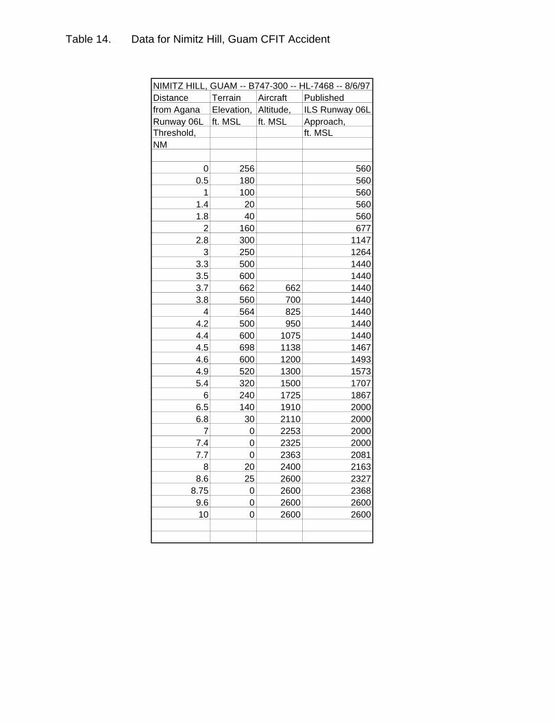
Table 14. Data for Nimitz Hill, Guam CFIT Accident
NIMITZ HILL, GUAM -- B747-300 -- HL-7468 -- 8/6/97Distance Terrain Aircraft Published from Agana Elevation, Altitude, ILS Runway 06LRunway 06L ft. MSL ft. MSL Approach, Threshold, ft. MSLNM
0 256 5600.5 180 560
1 100 5601.4 20 5601.8 40 560
2 160 6772.8 300 1147
3 250 12643.3 500 14403.5 600 14403.7 662 662 14403.8 560 700 1440
4 564 825 14404.2 500 950 14404.4 600 1075 14404.5 698 1138 14674.6 600 1200 14934.9 520 1300 15735.4 320 1500 1707
6 240 1725 18676.5 140 1910 20006.8 30 2110 2000
7 0 2253 20007.4 0 2325 20007.7 0 2363 2081
8 20 2400 21638.6 25 2600 2327
8.75 0 2600 23689.6 0 2600 260010 0 2600 2600
(placeholder for Guam chart)
Figure 13.
Nimitz Hill, Guam -- B-747-300 -- HL-7468 -- 8/6/97
0
500
1000
1500
2000
2500
3000
0 1 2 3 4 5 6 7 8 9 10 11Distance from Agana Runway 06L Threshold, NM.
Elev
atio
n/A
ltitu
de, f
t. M
SL
Runway 06LThreshold
Terrain
Likely Flight Path
Published ILS Rwy 06L Approach(GS Not In Service)
Impact
APPENDIX AREFERENCES
1. Proposed Technical Standard Order TSO-C151, Terrain Awareness andWarning Systems (Washington, DC: Federal Aviation Administration(FAA) Aircraft Certification Service) October 22, 1998.
2. Spiller, David, Investigation of CFIT Accidents Involving Multi-Engine, Fixed-Wing Aircraft Operating under Part 135 and the Potential Application of aGround Proximity Warning System (Cambridge, MA: Volpe NationalTransportation Systems Center) March 1989, Vol. 1, p. 1.
3. Hopkins, Jay, “Avoiding CFIT,” Flying Magazine (Greenwich, CT: HachetteMagazines, Inc.) April 1992, p. 44.
4. Bateman, Don, “Development of Ground Proximity Warning Systems,” Appendix to Flight Into Terrain and the Ground Proximity Warning System(Redmond, WA: Allied Signal Aerospace, Inc.) Engineering Report # 070-4251, April 1996, p. 3.1
5. Ibid., p. 3.2.
6. Loomis, James and Richard Porter, “The Performance of Warning Systems inAvoiding CFIT Accidents,” Proceedings of the Symposium on AviationPsychology (Columbus, OH: Battelle Columbus Laboratories) 1981.
7. Phillips, Robert, Investigation of Controlled Flight Into Terrain for SelectedAircraft Accidents Flying Under FAR Part 121 and 135 Flight Rules andthe Potential for Their Prevention by Enhanced GPWS (Cambridge, MA: Volpe NationalTransportation Systems Center) Project Memorandum # DOT-TSC-FA6D1-96-03, pp.6-7.
8. Proposed TSO-C151, op. cit. , p. 1.
9. Phillips, op. cit., p. 17.
10. Rodriguez, R. G., “Information Involving Operation of EAL 980, La Paz,Bolivia, January 1, 1985”, memorandum included in Aviation AccidentReport (AAR) # DCA85RA007 (Washington, DC: National TransportationSafety Board (NTSB)) May 6, 1985, pp. 1-7.
11. “Team Fails to Find Recorders in Eastern Crash,” Aviation Week and SpaceTechnology Magazine, Oct. 28, 1985, p. 29.
REFERENCES, Cont’d.
12. AAR # ATL85FA256, Flat Rock, NC (Washington, DC: NTSB) Oct. 27,1986.
13. AAR # ATL87MA041, Windsor, MA (Washington, DC: NTSB) Apr. 12,1987.
14. AAR # FTW87NA086, Eagle, CO (Washington, DC: NTSB) Jul. 18, 1988.
15. Civil Aeronautics Board of Honduras, Final Report of the Accident Involving… Boeing 727 Owned by Continental Airlines and Leased to ServicioAereo de Honduras, S.A. (SAHSA) … Which Occurred on … October 21,1989 (Tegucigalpa, Honduras: CAB) Report # MJH/DTB/247023, Nov.28, 1989.
16. AAR # DCA90MA005, Halawa Point, HI (Washington, DC: NTSB)
17. Flight Safety Foundation, “Crew’s Failure to Monitor Terrain Clearance AfterNight Takeoff Results in Collision with Mountain,” Accident Prevention,Vol. 52 # 9, Sept. 1995.
18. AAR # LAX91FA132, San Diego, CA (Washington, DC: NTSB) Dec. 26,1991.
19. AAR # DCA92MA011, Rome, GA (Washington, DC: NTSB) Jul. 8, 1992.
20. AAR # DCA92MA016, Gabriels, NY (Washington, DC: NTSB) May 20,1992.
21. Flight Safety Foundation, “Captain’s Failure to Establish Stabilized ApproachResults in CFIT Commuter Accident,” Accident Prevention, Vol. 52, #7, July 1995.
22. AAR # DEN92FA064, Alamogordo, NM (Washington, DC: NTSB) Jan. 8,1993.
23. AAR # DCA96MA008, East Granby, CT (Washington, DC: NTSB)
24. Flight Safety Foundation, “During Nonprecision Approach at Night, MD-83Descends below MDA and Contacts Trees, Resulting in Engine Flame-outand Touchdown Short of Runway,” Accident Prevention, Vol. 54, #4, April1997.
REFERENCES, Cont’d.
25. “CVR Reveals Last Minutes before Colombia Crash,” Aviation Week andSpace Technology Magazine, May 6, 1996.
26. “Recovered Flight Management Computer Memory Puts New Spin on CaliAccident,” Aviation Week and Space Technology Magazine, Sept. 9,1996.
27. Aeronautica Civil de la Republica de Colombia, Aircraft Accident Report: Controlled Flight Into Terrain, American Airlines Flight 965 … December20, 1995.
28. Flight Safety Foundation, “Preparing for Last-Minute Runway Change,Boeing 757 Flight Crew Loses Situational Awareness, Resulting inCollision with Terrain,” Accident Prevention Vol. 54 #7/8, Jul./Aug. 1997.
29. AAR # DCA97MA058, Nimitz Hill, Guam (Washington, DC: NTSB), Feb. 24,1998, especially Airplane Perfornance Study, Docket # SA-517,Exhibit #13A.
30. Feith, Gregory, “Opening Statement of Investigator in Charge (Washington, DC: NTSB) Public Hearing on KAL Flight 801,Mar. 24, 1998.
31. Roberts, Wally, “TERPS, CFIT and Me,” IFR Refresher, June 1998,pp. 10-15.


