INTERMUNICIPAL DEVELOPMENT PLAN Village... · County of Warner No. 5 and Village of Warner...
46
COUNTY OF WARNER NO. 5 and VILLAGE OF WARNER INTERMUNICIPAL DEVELOPMENT PLAN Bylaw No. 822-03 Bylaw No. 487-03 Prepared by the OLDMAN RIVER INTERMUNICIPAL SERVICE AGENCY September 2003
Transcript of INTERMUNICIPAL DEVELOPMENT PLAN Village... · County of Warner No. 5 and Village of Warner...

COUNTY OF WARNER NO. 5
and
VILLAGE OF WARNER
INTERMUNICIPAL DEVELOPMENT PLAN
Bylaw No. 822-03
Bylaw No. 487-03
Prepared by the
OLDMAN RIVER INTERMUNICIPAL SERVICE AGENCY
September 2003


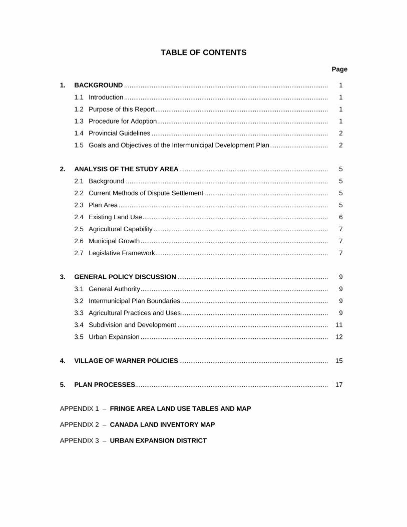
TABLE OF CONTENTS
Page 1. BACKGROUND ............................................................................................................... 1
1.1 Introduction ............................................................................................................... 1
1.2 Purpose of this Report .............................................................................................. 1
1.3 Procedure for Adoption............................................................................................. 1
1.4 Provincial Guidelines ................................................................................................ 2
1.5 Goals and Objectives of the Intermunicipal Development Plan................................ 2 2. ANALYSIS OF THE STUDY AREA ................................................................................. 5
2.1 Background .............................................................................................................. 5
2.2 Current Methods of Dispute Settlement ................................................................... 5
2.3 Plan Area .................................................................................................................. 5
2.4 Existing Land Use..................................................................................................... 6
2.5 Agricultural Capability ............................................................................................... 7
2.6 Municipal Growth ...................................................................................................... 7
2.7 Legislative Framework.............................................................................................. 7 3. GENERAL POLICY DISCUSSION .................................................................................. 9
3.1 General Authority...................................................................................................... 9
3.2 Intermunicipal Plan Boundaries ................................................................................ 9
3.3 Agricultural Practices and Uses................................................................................ 9
3.4 Subdivision and Development .................................................................................. 11
3.5 Urban Expansion ...................................................................................................... 12 4. VILLAGE OF WARNER POLICIES ................................................................................. 15 5. PLAN PROCESSES......................................................................................................... 17 APPENDIX 1 – FRINGE AREA LAND USE TABLES AND MAP APPENDIX 2 – CANADA LAND INVENTORY MAP APPENDIX 3 – URBAN EXPANSION DISTRICT

County of Warner No. 5 and Village of Warner Intermunicipal Development Plan Page 1
COUNTY OF WARNER NO. 5 and VILLAGE OF WARNER
INTERMUNICIPAL DEVELOPMENT PLAN 1. BACKGROUND
1.1 INTRODUCTION
At meetings of the urban municipalities it was determined that, with some exceptions, the concerns about fringe area development and subdivision were the same. The concerns among municipalities can be addressed by individual intermunicipal development plans agreed to independently by the five urban municipalities and the County of Warner No. 5. This level of cooperation can serve as a model for intermunicipal work. The plans will represent an agreement among the County of Warner and the:
• Village of Coutts
• Town of Milk River
• Town of Raymond
• Village of Stirling
• Village of Warner As a working document, this report can act as a basis for discussions with the various participants and assist in identifying the issues involved, solutions available and opportunities to take advantage of.
1.2 PURPOSE OF THIS REPORT
This report focuses on the land use and related matters requiring intermunicipal consultation and cooperation. After the participants in the planning process have reviewed this information and received some public input, an intermunicipal agreement can be developed with the intent of establishing a forum for continued intermunicipal cooperation. The area proposed for plan applicability is shown on Map 1 and is based on the urban fringe district in the County of Warner Land Use Bylaw. This report presents possible solutions for discussion by council and public.
1.3 PROCEDURE FOR ADOPTION
It is important to ensure any interested party has an opportunity to discuss the policies proposed in this report. This would include owners of land in the county, other affected land owners, residents of the urban areas and municipal authorities. To this end, the following procedure is suggested.
(a) discuss issues with individual municipalities – these discussions have been part of the preparation of this document – those discussions may have follow-up meetings to clarify some points;

County of Warner No. 5 and Village of Warner Page 2 Intermunicipal Development Plan
(b) this initial report should be presented to the municipalities participating;
(c) an additional draft plan containing policies revised by municipalities’ comments should be presented to the land owners and advertised widely;
(d) a public information hearing should be held – this may be held in conjunction with the County of Warner municipal development plan public information sessions;
(e) after the public meetings, a further draft intermunicipal development plan can then be prepared for municipal review;
(f) if councils are satisfied with the proposed plan, statutory public hearings can be conducted;
(g) the municipal development plan and intermunicipal development plan may be adopted at the same time.
1.4 PROVINCIAL GUIDELINES
Both the draft Land Use Policies and the Municipal Government Act encourage municipalities to create and adopt agreements on land use in the fringe areas of urban areas. A goal of the land use policies, which are yet to be formally adopted, states:
“To encourage municipalities to work co-operatively in order to pursue joint approaches to common planning issues.”
Implementation of this policy is through the Municipal Government Act in section 631 which gives considerable latitude for the preparation and adoption of an intermunicipal development plan. The policies and the boundaries of the plan are not limited and the Act only requires the following in the document:
“(i) a procedure to be used to resolve or attempt to resolve any conflict between the municipalities that have adopted the plan,
(ii) a procedure to be used, by one or more municipalities, to amend or repeal the plan, and
(iii) provisions relating to the administration of the plan.”
1.5 GOALS AND OBJECTIVES OF THE INTERMUNICIPAL DEVELOPMENT PLAN
It is important to establish what is intended to be accomplished by the plan. This allows decision makers to ensure the application of the policies of the plan are consistent with the intent of the plan. After a period of time it will be necessary to evaluate the plan. Goals and objectives allow for the measurement of success. The final objectives will be the result of committee discussion, public input and council discussion. The overall goal of this plan is to encourage orderly and economical development in the designated fringe area that has regard to the needs of all participating municipalities. The stated objectives of the intermunicipal development plan are:
1.5.1 To identify the concerns and opportunities relevant to each municipality.
1.5.2 To clarify the land use expectations each municipality has for the fringe area.

County of Warner No. 5 and Village of Warner Intermunicipal Development Plan Page 3
1.5.3 To establish priority and policies addressing the concerns and opportunities identified.
1.5.4 To support the ongoing consultation and cooperation that the participating municipalities have established.
1.5.5 To identify possible areas of joint ventures such as the provision of municipal services.
1.5.6 To provide methods to both implement and amend the various plan policies.
1.5.7 To identify areas suitable for urban expansion.
1.5.8 To provide guidelines for the subdivision and development in the fringe areas of municipalities.


County of Warner No. 5 and Village of Warner Intermunicipal Development Plan Page 5
2. ANALYSIS OF THE STUDY AREA
2.1 BACKGROUND
An intermunicipal development plan recognizes that the fringe area of an urban area is subject to different problems and opportunities than a strictly urban or rural area. It has become increasingly clear that municipalities cannot continue to make land use decisions in isolation. Municipalities are encouraged to undertake the preparation of an intermunicipal plan in order to help avoid future land use conflicts. This is consistent with the current trend to employ such cooperative measures in many municipal activities and is part of the Provincial Land Use Policies. It is important that urban and rural municipalities reach an agreement on fringe area issues to avoid a confrontational atmosphere which has occurred in other jurisdictions. Benefits of an agreement are apparent for both municipalities. An urban municipality benefits by having a commitment on the types of uses, development standards and subdivision that can occur in the fringe area. Benefits to the county include an understanding of where urban expansion can occur and gives their ratepayers an understanding that certain development can occur without the urban municipalities using the various methods of intervention available.
2.2 CURRENT METHODS OF DISPUTE SETTLEMENT
Intervention in land use decisions is limited since section 11(1)(b) of the Subdivision and Development Regulation is no longer operational. If municipalities are able to use intermunicipal development plans or some other forms of mediation, the only path available is through the Municipal Government Act. For the purpose of settling disputes regarding land use bylaw amendments, the Municipal Government Act allows for the Municipal Government Board to arbitrate. Section 690 of the Municipal Government Act reads as follows:
“690(1) If a municipality is of the opinion that a statutory plan or amendment or a land use bylaw or amendment adopted by an adjacent municipality has or may have a detrimental effect on it and if it has given written notice of its concerns to the adjacent municipality prior to second reading of the bylaw, it may appeal the matter to the Municipal Government Board.”
Land use planning disputes should be settled locally. A provincially imposed solution would likely not satisfy either municipal concern.
2.3 PLAN AREA
Map 1 indicates the area affected by this plan and is generally one mile surrounding the Village of Warner.
All of the municipal fringe areas in the county are currently outlined as fringe area land use districts and comprise approximately 23,123 acres of land as shown in Table 1. Through discussion, these proposed boundaries may vary.

County of Warner No. 5 and Village of Warner Page 6 Intermunicipal Development Plan
Table 1
MUNICIPAL FRINGE AREAS
FRINGE AREA* MUNICIPALITY Acres (Hectares)
Village of Coutts 2,579 (1,044) Town of Milk River 5,216 (2,111) Town of Raymond 5,699 (2,306) Village of Stirling 5,120 (2,072) Village of Warner 4,518 (1,829) TOTAL 23,123 (9,362)
* All area acreages are approximate calculations.
2.4 EXISTING LAND USE
Map 1 in Appendix 1 indicates the location of various land uses in the fringe area and Table 2 indicates the totals calculated. Individual fringe area calculations are found in Appendix 1. Raymond and Stirling have more existing fragmentation and development. Overall Trends:
• The main type of land use found in the fringe boundary areas around the municipalities is residential use, at 73.1 percent of the total. The second most prominent use is agricultural activities, at almost 10.3 percent.
• Of the residential type of land use, almost 62 percent can be classified as country residential.
• In the fringe area of Milk River, 73.3 percent of the land use is categorized as residential.
• Around the fringe area of Raymond, 82.1 percent is classified as residential, with almost 85 percent of this being country residential. (Country residential makes up 69.4 percent of the total land use in the Raymond fringe area.)
• In the Stirling fringe, 79.6 percent of land uses are categorized as residential, with 75 percent of this comprised of country residential.
Table 2
TYPE OF LAND USE
TYPE OF LAND USE Percent (general description) Number of Total
Residential 163 73.1 Agricultural 23 10.3 Commercial 6 2.7 Industrial 6 2.7 Public 5 2.2 Utilities 6 2.7 Other/Miscellaneous 14 6.3 TOTAL 223 100.0

County of Warner No. 5 and Village of Warner Intermunicipal Development Plan Page 7
2.5 AGRICULTURAL CAPABILITY
The County of Warner is largely agricultural in nature and the same can be said for the urban fringe areas. Much of the land in the fringe areas is high quality land suitable for crop production and held in large parcels. More detailed land assessments for the Village of Warner are shown on Map 2 in Appendix 2.
2.6 MUNICIPAL GROWTH
Section 4 of this plan discusses the likely areas of growth for the applicable municipality. These areas are only for general reference as the details of expansion have not been explored. Areas are based on:
• historical growth patterns,
• type of land use proposed for expansion,
• existing uses in the fringe,
• municipal services potential.
2.7 LEGISLATIVE FRAMEWORK
Currently two legislative documents have an effect on the development of land in the fringe areas of municipalities. Those are the Provincial Land Use Policies and the County of Warner Land Use Bylaw. The Provincial Land Use Policies state:
“In particular, adjoining municipalities are encouraged to cooperate in the planning of future land uses in the vicinity of their adjoining municipal boundaries (fringe areas) respecting the interests of both municipalities and in a manner which does not inhibit or preclude appropriate long term use nor unduly interfere with the continuation of existing uses. Adjoining municipalities are encouraged to jointly prepare and adopt intermunicipal development plans for critical fringe areas; these plans may involve lands which are in both of the adjoining municipalities.”
This outlines basic guidelines for the preparation of intermunicipal development plans. In terms of the land use bylaw, as an interim measure the county council passed several policies affecting municipal fringe areas, including:
(a) within the Urban Fringe districts new livestock operations or expansions to existing livestock operations are prohibited. Council has the ability to designate areas Direct Control;
(b) Grouped Country Residential uses are a discretionary use in the Urban Fringe districts – this was implemented to allow subdivision for multi-lot residential development in fringe areas;
(c) minimum parcel size of ten acres would be considered. In terms of this plan, guidelines for the use of discretionary powers would be a priority.


County of Warner No. 5 and Village of Warner Intermunicipal Development Plan Page 9
3. GENERAL POLICY DISCUSSION
The five plans will implement policy over 10,890 hectares of land in the fringe areas of five urban municipalities. This plan will affect over 1,829 hectares of land in the urban fringe district of the Village of Warner. In order to accommodate the complexities of the landscape, policy is divided into two categories:
• general policies, applicable to all fringe areas;
• specific policy, applicable to specific areas within a fringe.
THE FOLLOWING POLICIES APPLY TO ALL MUNICIPAL FRINGE AREAS
3.1 GENERAL AUTHORITY
POLICIES
3.1.1 This document outlines policies that apply in the urban fringe districts and provides a basis for concensus making but lands covered in this plan are located within a municipality which is mandated to make decisions.
3.1.2 Each municipality will be ultimately responsible for decisions within their municipal boundaries, having regard for the dispute settling process in this plan.
3.1.3 The Raymond Fringe district should be removed from the land use bylaw and the Urban Fringe district applied.
3.2 INTERMUNICIPAL PLAN BOUNDARIES
POLICIES
3.2.1 Map 1 indicates the boundaries within which the policies of this plan will apply.
3.3 AGRICULTURAL PRACTICES AND USES
It is the policy of the County of Warner to both protect agricultural lands and encourage a diversity in the urban fringe areas. In terms of agricultural production, the existing use in the fringe is largely cropland with a few feeding operations. Potentially the livestock industry could expand in the County of Warner because of:
• availability of high-quality feed;
• available water, particularly in the irrigated areas;
• quality roads;
• proximity to the United States border. Agriculture is also protected by the provincial legislation, the “Farm Practices Protection Statutes Amendment Act” and the “Agricultural Operations Practices Act”. Problems have traditionally occurred between agricultural uses and urban areas in terms of:
• noise from farm equipment, such as irrigation pumps;
• odour from feeding operations;
• odour from the spreading of manure;

County of Warner No. 5 and Village of Warner Page 10 Intermunicipal Development Plan
• flies generated from feeding facilities;
• potential environmental problems from agricultural runoff; and
• dust from hauling or harvesting activities. Urban municipalities in the County of Warner understand the positive impact of agriculture on their economies and wish also to support the farm community. Policies in this plan are intended only to affect those uses that have a very negative impact on lifestyles and property values while allowing most agricultural practices to continue unaffected.
POLICIES
Approvals of livestock operations or confined feeding operations (CFOs) lie with the Natural Resources Conservation Board (NRCB). Prior to approvals being given, the staff of the NRCB will review local plans and request comments from the municipality. The following policies will be used when making comments.
3.3.1 New confined feeding operations (CFOs) shall be prohibited within the intermunicipal development plan areas as designated in the land use bylaw as the Urban Fringe district.
3.3.2 With respect to existing confined feeding operations (CFOs), expansions should be restricted in the Urban Fringe district, except in cases where the terms of policy 3.3.5 can be met.
3.3.3 The Natural Resources Conservation Board (NRCB) is requested to circulate all applications for confined feeding operations approvals in the intermunicipal development plan areas to the appropriate municipality.
3.3.4 It is recommended to the Natural Resources Conservation Board (NRCB) that the location or expansion of confined feeding operations up to 1.6 km (1 mile) beyond the boundary of a designated fringe district of a town, village or designated hamlet shall be discouraged, except where the applicant demonstrates that it is reasonable and appropriate to do so.
3.3.5 Existing confined feeding operations may be allowed to limited expansion and to upgrade and modernize within the requirements of the Agricultural Operation Practices Act and Regulations, but it is recommended to the Natural Resources Conservation Board (NRCB) that this includes:
(a) consideration of the minimum distance separation calculation contained in the Agricultural Operation Practices Act, Standards and Administration Regulation;
(b) demonstrating changes will reduce negative impacts to the urban area;
(c) additional environmental protection will be provided;
(d) comments from the urban municipalities are received and considered.
3.3.6 The Natural Resources Conservation Board (NRCB) is requested to discourage the spreading of manure in the municipal fringe areas, but in all cases the procedures outlined in the Agricultural Operation Practices Act, Standards and Administration

County of Warner No. 5 and Village of Warner Intermunicipal Development Plan Page 11
Regulation or the recommendations or conditions of the Natural Resources Conservation Board (NRCB) should be strictly adhered to.
3.3.7 The County of Warner shall regulate intensive livestock operations for threshold numbers that fall below the minimum threshold criteria for approvals under the mandate of the NRCB, and this shall be regulated through policies stipulated in the county’s land use bylaw.
3.3.8 Noise, some odour and dust which are part of normal agricultural activities should be unaffected by the policies of this plan, although irrigation pumps used within the plan area should be equipped with mufflers.
3.4 SUBDIVISION AND DEVELOPMENT
Subdivision is the first step in the process of development approvals. In keeping with the goal to preserve good quality agricultural land, an attempt is made to limit the fragmenting of agricultural land into small parcels for non-agricultural uses. Usually, the larger the parcel the more likely the use will continue to be agricultural. In the fringe area, this policy of large parcels must be balanced with county council’s land use bylaw intent which encourages development and subdivision in the municipal fringe areas. These policies will in part govern subdivision and development in the fringe and are supplemented with policies from the individual municipality in this plan. POLICIES
3.4.1 Non-agricultural subdivisions including for industrial and commercial uses in the fringe areas will be encouraged and guided to locations in the fringe as outlined in this plan based upon:
• municipal growth directions, which should be left in the existing parcel size allowed for in the land use bylaw for agricultural uses;
• areas of special concern such as lagoons or recreational areas, which would be restricted to subdivision allowed for in agricultural uses;
• land uses within the urban area, which would restrict residential uses in areas where a land use may conflict;
• availability of municipal service connections;
• uses would be encouraged in areas that may have services negotiated. 3.4.2 When an application is made for any subdivision in the urban fringe area, it shall be
circulated to the appropriate urban municipality for comment in accordance with section 5(l) of the Subdivision and Development Regulation.
3.4.3 When an application is made for a development permit for a discretionary use or for
the redesignation of a parcel of land in the fringe area, those applications shall be circulated to the appropriate urban municipality for comment.
3.4.4 Any discretionary use development permit, subdivision, redesignation or area
structure plan located within an urban municipal boundary, adjacent to the county boundary shall be circulated to the County of Warner for comment.

County of Warner No. 5 and Village of Warner Page 12 Intermunicipal Development Plan
3.4.5 At the discretion of the development officers of either the urban or rural municipality, any application for a use, subdivision, redesignation or area structure plan may be referred to another municipality for comment if the application may have an adverse effect, even if it is outside the intermunicipal plan boundary.
3.4.6 Subdivision and development should not occur within 300 metres of an urban
municipal sewage lagoon. 3.4.7 When an urban municipality receives an application for a land use bylaw
redesignation, an area structure plan or a subdivision on lands adjacent to the municipal boundary, that application will be sent to the County of Warner No. 5 for comments.
3.4.8 Any application that is made in an urban municipality not adjacent to the municipal
boundary but which may have an impact on the County of Warner No. 5 should be circulated for comment.
3.4.9 The land use bylaw minimum parcel size of 10 acres should be reduced to 3 - 5
acres to allow for a higher density of development on lands that are suited for residential uses.
3.5 URBAN EXPANSION
Municipal growth and expansion are likely to occur with the municipalities in the county. With this is likely a growth in services which should benefit all residents of the county. Some indication of growth direction is found in the policies for individual municipalities and the following is a more general set of policies that would apply to all urban fringe areas. The expansion of urban municipal boundaries should be orderly and employ a process to allow for uncontested annexations. POLICIES
3.5.1 In advance of any annexation, urban municipalities should prepare an “Urbanization Plan” that would:
• have broad public input,
• contain a broad design proposal,
• discuss servicing,
• discuss municipal budget implications,
• propose uses of land,
• suggest a timetable for implementation. 3.5.2 In addition to 3.5.1, prior to an annexation request, urban municipalities should:
• ensure land currently in the municipality has been used to a reasonable potential;
• explore alternative means of growth that may include tax sharing;
• prepare a growth study that reviews the issues related to growth including the financial impact to each municipality;
• gain support from the owners of land in the county affected by the application.

County of Warner No. 5 and Village of Warner Intermunicipal Development Plan Page 13
3.5.3 Growth is encouraged in the urban fringe which may require municipal services. Each urban municipality may provide services outside its boundary if appropriate to do so.
3.5.4 When a new development in the urban fringe is attached to a municipal water and/or
sewer system, the municipal portion of taxes generated from the development may be shared if an agreement is negotiated between the two municipalities.
3.5.5 Areas of future urban expansion shall be subject to the subdivision criteria applied to
rural lands that is more restrictive than the general fringe area. 3.5.6 Any discretionary uses approved in the areas of future expansion should be
compatible with the urban use proposed. 3.5.7 Once an “Urbanization Plan” has identified an area as suitable for industrial or
commercial uses, the county should designate this land a new land use district called “Urban Expansion District”. In this new district (Appendix 3):
• dwellings would be a discretionary use,
• urban comments would be solicited prior to approval,
• only long-term compatible uses should be considered.

County of Warner No. 5 and Village of Warner Intermunicipal Development Plan Page 15
4. VILLAGE OF WARNER POLICIES
The following policies are intended to apply to issues that affect only the Village of Warner. These policies complement policies under section 3, in particular 3.5.5 that would have more restrictive policies applied.
POLICIES
4.1 The village will likely expand north for residential use and to the new highway alignment on the east for commercial and industrial use as shown on Map 1.
4.2 Country residential development should be restricted in the area north of the village,
because of the existence of the village lagoons. Any residential development shall meet the required setback from a wastewater facility, as regulated by the province through the Municipal Government Act, Subdivision and Development Regulations.
4.3 Commercial and industrial development may be considered in areas east of the new
highway alignment, making use of the highway exposure.

County of Warner No. 5 and Village of Warner Intermunicipal Development Plan Page 17
5. PLAN PROCESSES
It is intended that this plan will be a working document allowing for flexibility of decision making and giving a framework for consistent decisions. In part, this requires processes for continued coordination and cooperation. When municipalities disagree, a system to promote a consensus is also an important aspect. 5.1 As stated in section 3.4.5, applications for uses outside the fringe area may be forwarded to
the appropriate municipality if the county subdivision and development authority determines the municipality has some interest.
5.2 This intermunicipal development plan bylaw is valid until (Date: 5 years after adoption)
unless:
• the bylaw is reviewed and the date of expiry is extended by resolution of both councils that are involved;
• by mutual consent of participating municipalities, the bylaw adopting the plan may be totally or partly revoked.
5.3 Variance to the policies of this plan may be made by the approval authority if:
• in the opinion of the approval authority the variance is minor, and
• consider the comments of the council of the appropriate municipality is received, and
• the variance complies with other statutory plans and bylaws. 5.4 An intermunicipal development plan committee should be established and consist of three
members of the County of Warner council and three members from the Village of Warner. The committee will be advisory in nature recommending approaches to cooperative governing of land use issues in the fringe areas.
5.5 The committee should meet to consider:
• concerns regarding policies of the plan,
• amendments to the plan,
• complaints from the public regarding plan policies,
• disagreement on the implementation of plan policies,
• land use concerns that the plan has not addressed.
In general, the committee is intended to promote cooperation and resolve potential conflicts. 5.6 In the interest of avoiding delays in approvals, the development officer for the municipality
may make comments on development applications circulated by municipalities. If the development officer in the responding municipality determines it necessary, then the application may be forwarded to council or the Subdivision and Development Authority for comment.
5.7 Steps in a dispute settlement system include:
• avoid any dispute by ensuring the plan is adhered to as adopted, including full circulation of any permit or application that may affect a municipality and prompt enforcement of the policies of the plan and land use bylaw;

County of Warner No. 5 and Village of Warner Page 18 Intermunicipal Development Plan
• prior to a meeting of the intermunicipal development plan committee, ensure the facts of the dispute are investigated and information is made available to both parties;
• meet with the intermunicipal development plan committee to identify the issues and reach a consensus on a solution;
• the solution and/or dispute may have to be forwarded to a joint meeting of both councils for further discussion; and
• the two councils’ meeting may be the last step in attempting to solve a conflict. At each step it is important to fully discuss and define issues and alternative solutions and to reach a consensus. Except as provided below, the municipality with jurisdiction will make the final decision on the issue. The final stage of dispute settlement, if the dispute is related to a bylaw, is to use the mechanism in Division II, part 17 of the Municipal Government Act. This outlines a procedure for the municipalities to request the Municipal Government Board to solve the issue.
APPENDIX 1
FRINGE AREA LAND USE TABLES AND MAP


County of Warner No. 5 and Village of Warner Intermunicipal Development Plan Appendix 1
VILLAGE OF COUTTS
FRINGE AREA LAND USE – FEBRUARY 1999
Type of Land Use Number of Uses Total Residential: Country Residence Farmstead 3 Ancillary Farm Residence Abandoned Farmstead 2 5 Agricultural: Farm Building 2 Farm Equipment Storage Intensive Livestock 1 (game) 3 Commercial: Misc. Commercial Bus. Industrial: Misc. Industrial Operation Elevators Oil Storage Public: Campground/Park Community Hall Church Cemetery School Utilities: Gas Well Oil Well Sewage Lagoons Water Storage/Treatment Electrical Station Solid Waste Transfer Other: Airport/Airstrip 1 Mining/Crushing Operation Dump/Junkyard Miscellaneous 2 3 TOTAL 11
* Fringe study area includes an approximate one-mile boundary of land uses in each east, west and north
direction.
TOTAL area in the Coutts fringe boundary constitutes approximately 2,579 acres (1,044 ha).

County of Warner No. 5 and Village of Warner Appendix 1 Intermunicipal Development Plan
TOWN OF MILK RIVER
FRINGE AREA LAND USE – FEBRUARY 1999
Type of Land Use Number of Uses Total Residential: Country Residence 2 Farmstead 12 Ancillary Farm Residence 6 Abandoned Farmstead 2 22 Agricultural: Farm Building 1 Farm Equipment Storage Intensive Livestock 1 Commercial: Misc. Commercial Bus. Industrial: Misc. Industrial Operation Elevators Oil Storage 1 1 Public: Campground/Park Community Hall Church Cemetery 1 School 1 Utilities: Gas Well Oil Well Sewage Lagoons 1 Water Storage/Treatment 1 Electrical Station 1 Solid Waste Transfer 3 Other: Airport/Airstrip 1 Mining/Crushing Operation Dump/Junkyard Miscellaneous 1 (ammonia storage) 2 TOTAL 30
*Fringe study area includes an approximate one-mile boundary of land uses in each direction.
TOTAL area in the Milk River fringe boundary constitutes approximately 5,216 acres (2,111 ha).

County of Warner No. 5 and Village of Warner Intermunicipal Development Plan Appendix 1
TOWN OF RAYMOND
FRINGE AREA LAND USE – FEBRUARY 1999
Type of Land Use Number of Uses Total Residential: Country Residence 66 Farmstead 10 Ancillary Farm Residence Abandoned Farmstead 2 78 Agricultural: Farm Building 9 Farm Equipment Storage Intensive Livestock 1 (cattle) 10 Commercial: Misc. Commercial Bus. 1, (1 abandoned) 2 Industrial: Misc. Industrial Operation 1 Bulk Fertilizer 1 2 Public: Campground/Park 1 (golf course) Community Hall Church Cemetery School 1 Utilities: Gas Well Oil Well Sewage Lagoons 1 Water Storage/Treatment Electrical Station Solid Waste Transfer 1 Other: Airport/Airstrip Mining/Crushing Operation Dump/Junkyard Miscellaneous 1 (RID Shop) 1 TOTAL 95
*Fringe study area includes:
• an approximate one-mile boundary of land uses in each east and north direction, • an approximate two-mile boundary in the westerly direction, • an approximate ¾ mile boundary in the southerly direction.
TOTAL area in the Raymond fringe boundary constitutes approximately 5,699 acres (2,306 ha).

County of Warner No. 5 and Village of Warner Appendix 1 Intermunicipal Development Plan
VILLAGE OF STIRLING
FRINGE AREA LAND USE – FEBRUARY 1999
Type of Land Use Number of Uses Total Residential: Country Residence 32 Farmstead 7 Ancillary Farm Residence 1 Abandoned Farmstead 3 43 Agricultural: Farm Building 3 Farm Equipment Storage Intensive Livestock 1 (cattle), 1 (chicken) 5 Commercial: Misc. Commercial Bus. Industrial: Misc. Industrial Operation 1 Elevators 2 3 Oil Storage Public: Campground/Park Community Hall Church Cemetery 1 School 1 Utilities: Gas Well Oil Well Sewage Lagoons Water Storage/Treatment Electrical Station Solid Waste Transfer 1 1 Other: Airport/Airstrip Mining/Crushing Operation Dump/Junkyard 1 Miscellaneous 1 TOTAL 54
*Fringe study area includes an approximate one-mile boundary of land uses in each direction. TOTAL area in the Stirling fringe boundary constitutes approximately 5,120 acres (2,072 ha).

County of Warner No. 5 and Village of Warner Intermunicipal Development Plan Appendix 1
VILLAGE OF WARNER
FRINGE AREA LAND USE – FEBRUARY 1999
Type of Land Use Number of Uses Total Residential: Country Residence Farmstead 5 Ancillary Farm Residence 1 Abandoned Farmstead 1 7 Agricultural: Farm Building 2 Farm Equipment Storage Intensive Livestock 2 Commercial: Misc. Commercial Bus. 4 4 Industrial: Misc. Industrial Operation Elevators Oil Storage Public: Campground/Park Community Hall Church Cemetery 1 School 1 Utilities: Gas Well Oil Well Sewage Lagoons Water Storage/Treatment 1 Electrical Station Solid Waste Transfer 1 Other: Airport/Airstrip 1 Mining/Crushing Operation Dump/Junkyard Miscellaneous 1 (shop) 2 TOTAL 17
*Fringe study area includes an approximate one-mile boundary of land uses in each direction. TOTAL area in the Warner fringe boundary constitutes approximately 4,518 acres (1,829 ha).


APPENDIX 2
CANADA LAND INVENTORY MAP


APPENDIX 3
URBAN EXPANSION DISTRICT


County of Warner No. 5 and Village of Warner Intermunicipal Development Plan Appendix 3
URBAN EXPANSION – UE
1. PURPOSE
This land use district is intended for use on lands that have been identified in a statutory plan as being likely locations for urban expansion. Applications for uses, development or subdivision in this district are to be circulated and evaluated for the impact on future urban growth.
2. PERMITTED, DISCRETIONARY AND PROHIBITED USES
(a) Permitted Uses
The following uses shall be permitted within this land use district upon receipt of a completed development application:
Ancillary buildings and uses
(b) Discretionary Uses
The following uses may be permitted at the discretion of the Subdivision and Development Authority upon receipt of a completed development application:
Abattoirs Agricultural services Automotive uses Boarding stables Breeding farms Farm produce stands First farm residence, including a mobile home as a first farm residence Highway commercial uses Intensive horticulture Isolated single lot commercial Isolated single lot country residential Isolated single lot industrial Kennels Private recreation Public/institutional Second farm residence or mobile home Signs of more than 0.9 m2 (10 sq. ft.) Stockpiles (inside the distances in section 5(a) of this district) Utilities
(c) Prohibited Uses
The following uses are prohibited within this land use district:
Hazardous and noxious uses Intensive livestock operations Resource extraction and associated works Stripping and sale of topsoil
3. SUBDIVISION CRITERIA – See Schedule 4.

County of Warner No. 5 and Village of Warner Appendix 3 Intermunicipal Development Plan
4. MINIMUM PARCEL SIZE
(a) The minimum parcel size for grouped country residential uses shall be 4 hectares (10 acres).
(b) The minimum parcel size for other than grouped country residential use shall be 0.4 hectare (1 acre) in area.
5. MINIMUM SETBACK REQUIREMENTS
(a) No part of a building or structure shall be located within:
(i) 45.7 metres (150 ft.) of the centre line of any public roadway which is not designated as a secondary road or primary highway under the Highway Development Control Regulation;
(ii) 53.3 metres (175 ft.) from the centre line of any road designated as a secondary road under the Highway Development Control Regulation;
(iii) 71.0 metres (233 ft.) of the centre line or 40.5 metres (133 ft.) from the right-of-way (whichever is greater) of roads designated as primary highways under the Highway Development Control Regulation.
(b) Where any parcel or part of a parcel has frontage on a controlled primary highway or secondary road, special standards for setbacks, access, and service roadways may be required by the designated officer or Subdivision and Development Authority in accordance with the recommendations and requirements of Alberta Transportation and Utilities and the Highway Development Control Regulation.
(c) Where it appears that side yard setbacks may be necessary, the Subdivision and Development Authority may impose such a requirement as a condition of a development permit.
(d) No veterinary clinic, kennel or riding stable shall be located within 304.8 metres (1,000 ft.) of a residential building excepting a Subdivision and Development Authority approved farm dwelling ancillary to the designated use.
6. SITE COVERAGE
The amount of area of a site to be covered or occupied by a use may be limited by the Subdivision and Development Authority.
7. PARKING AND LOADING AREA REQUIREMENTS – See Schedule 5.
8. LANDSCAPING AND SCREENING – See Schedule 5.
9. STANDARDS OF DEVELOPMENT – See Schedule 5.
10. SIGN REGULATIONS – See Schedule 8.
County of Warner No. 5 and Village of Warner Intermunicipal Development Plan Appendix 3
11. COMPREHENSIVE DEVELOPMENT PLANS, AREA STRUCTURE PLANS AND DESIGN SCHEMES
Where it becomes apparent to the designated officer or municipality that too much development is being concentrated in one area:
(a) the Subdivision and Development Authority may, with the approval of the council, require that future development applications for the area be accompanied by a comprehensive development plan which has been approved by council; or
(b) the council may require applicants proposing development in the area to undertake the preparation of an area structure plan or design scheme.
12. DEVELOPMENT APPLICATION REFERRALS
Any development application within this land use district shall be referred to the appropriate urban municipality for comments before a decision by the County of Warner Subdivision and Development Authority is finalized.