INTEGRATED FLOOD MANAGEMENT IN KOREA marzo/Floodman/integrated.pdf · INTEGRATED FLOOD MANAGEMENT...
36
INTEGRATED FLOOD MANAGEMENT INTEGRATED FLOOD MANAGEMENT IN KOREA IN KOREA Soontak Soontak LEE LEE , , Ph.D., D.Sc., Hon.D.Eng.Sc. Ph.D., D.Sc., Hon.D.Eng.Sc. Distinguished Professor, Distinguished Professor, Yeungnam Yeungnam University, Republic of Korea University, Republic of Korea President, International Hydrologic Environmental Society (IHES) President, International Hydrologic Environmental Society (IHES) and and Korea Federation of Water Science & Engineering Societies (KFWSE Korea Federation of Water Science & Engineering Societies (KFWSE S) S) Soonkab Soonkab CHUNG CHUNG , Ph.D. , Ph.D. Director Director - - General General Forecast Bureau, Korea Meteorological Administration Forecast Bureau, Korea Meteorological Administration Republic of Korea Republic of Korea
Transcript of INTEGRATED FLOOD MANAGEMENT IN KOREA marzo/Floodman/integrated.pdf · INTEGRATED FLOOD MANAGEMENT...
INTEGRATED FLOOD MANAGEMENTINTEGRATED FLOOD MANAGEMENTIN KOREAIN KOREA
SoontakSoontak LEELEE, , Ph.D., D.Sc., Hon.D.Eng.Sc.Ph.D., D.Sc., Hon.D.Eng.Sc.Distinguished Professor, Distinguished Professor, YeungnamYeungnam University, Republic of KoreaUniversity, Republic of KoreaPresident, International Hydrologic Environmental Society (IHES)President, International Hydrologic Environmental Society (IHES) andandKorea Federation of Water Science & Engineering Societies (KFWSEKorea Federation of Water Science & Engineering Societies (KFWSES)S)
SoonkabSoonkab CHUNGCHUNG, Ph.D., Ph.D.DirectorDirector--GeneralGeneral
Forecast Bureau, Korea Meteorological Administration Forecast Bureau, Korea Meteorological Administration Republic of KoreaRepublic of Korea

FLOOD CHARACTERISTICSFLOOD CHARACTERISTICS
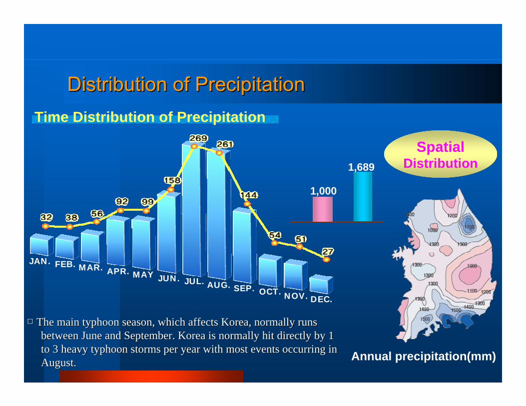
JAN. FEB. MAR. APR. MAY JUN. JUL. AUG. SEP. OCT. NOV. DEC.
SpatialDistribution
1,000
1,689
Annual precipitation(mm)
Time Distribution of Precipitation
□□ The main typhoon season, which affects Korea, normally runsThe main typhoon season, which affects Korea, normally runsbetween June and September. Korea is normally hit directly between June and September. Korea is normally hit directly by 1by 1to 3 heavy typhoon storms per year with most events occurrito 3 heavy typhoon storms per year with most events occurring inng inAugust.August.
Distribution of PrecipitationDistribution of Precipitation
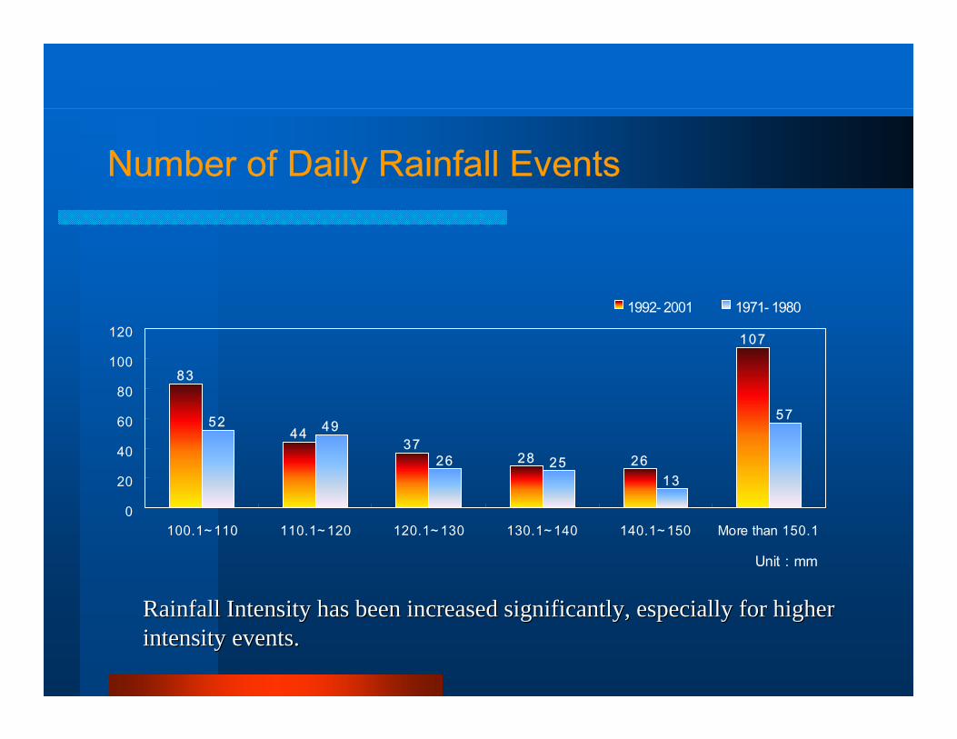
4437
28 26
107
52 49
26 2513
57
83
0
20
40
60
80
100
120
100.1~ 110 110.1~ 120 120.1~ 130 130.1~ 140 140.1~ 150 More than 150.1
Unit : mm
1992- 2001 1971- 1980
Number of Daily Rainfall Events
Rainfall Intensity has been increased significantly, especially Rainfall Intensity has been increased significantly, especially for higherfor higherintensity events.intensity events.
Characteristics of the Rivers in Korea(1/2)
□□ The river reaches are relatively short and channel slopes are reThe river reaches are relatively short and channel slopes are relatively steeplatively steep..
-- The river reaches are short and drainage areas are small in KorThe river reaches are short and drainage areas are small in Korea compared ea compared with other major continental rivers. with other major continental rivers.
-- The channel slopes are relatively steep upstream because of steThe channel slopes are relatively steep upstream because of steep mountains ep mountains and deep valleys in the uplands.and deep valleys in the uplands.
□□ Floods occur quickly and peak flood discharges are enormousFloods occur quickly and peak flood discharges are enormous..
-- Due to the topographical conditions and torrential rainfalls, tDue to the topographical conditions and torrential rainfalls, the hydrographs he hydrographs of rivers in Korea are very sharp and peak flood dischargof rivers in Korea are very sharp and peak flood discharges are enormous es are enormous compared with other comparable rivers in the continent.compared with other comparable rivers in the continent.
Korean River Basin CharacteristicsKorean River Basin Characteristics
□□ Flow variations are highFlow variations are high..
-- The coefficients of the river regime, expressed by maximum discThe coefficients of the river regime, expressed by maximum discharge over harge over minimum discharge for rivers in Korea usually range from minimum discharge for rivers in Korea usually range from 100 up to 700. 100 up to 700.
-- This large variation in the flow discharge causes serious problThis large variation in the flow discharge causes serious problems in river ems in river management concerning flood control and water use.management concerning flood control and water use.
Characteristics of the Rivers in Korea(2/2)
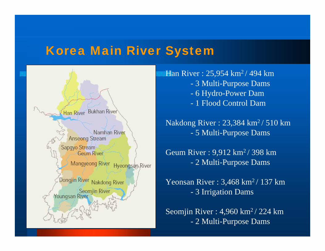
Korea Main River SystemHan River : 25,954 km2 / 494 km
- 3 Multi-Purpose Dams- 6 Hydro-Power Dam- 1 Flood Control Dam
Nakdong River : 23,384 km2 / 510 km- 5 Multi-Purpose Dams
Geum River : 9,912 km2 / 398 km- 2 Multi-Purpose Dams
Yeonsan River : 3,468 km2 / 137 km- 3 Irrigation Dams
Seomjin River : 4,960 km2 / 224 km- 2 Multi-Purpose Dams
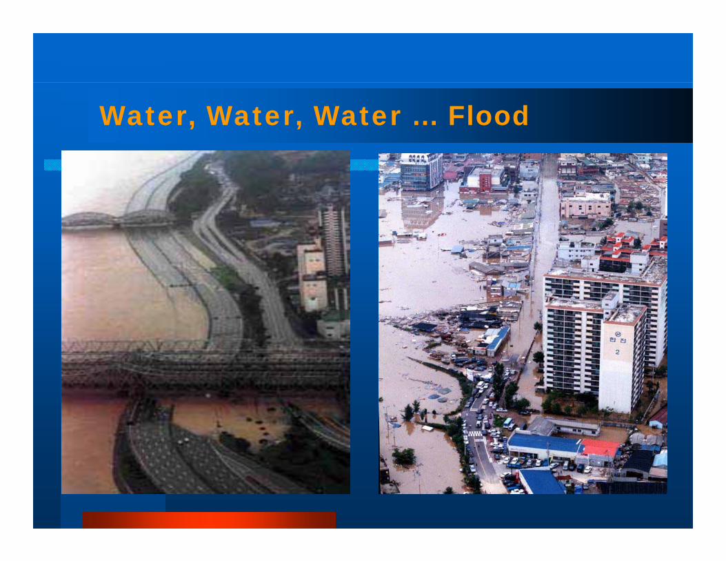
Water, Water, Water … Flood

Flooded Paju City in 1998
Collapse of Yeoncheon Dam in 1996
Floods in a Recent Decade
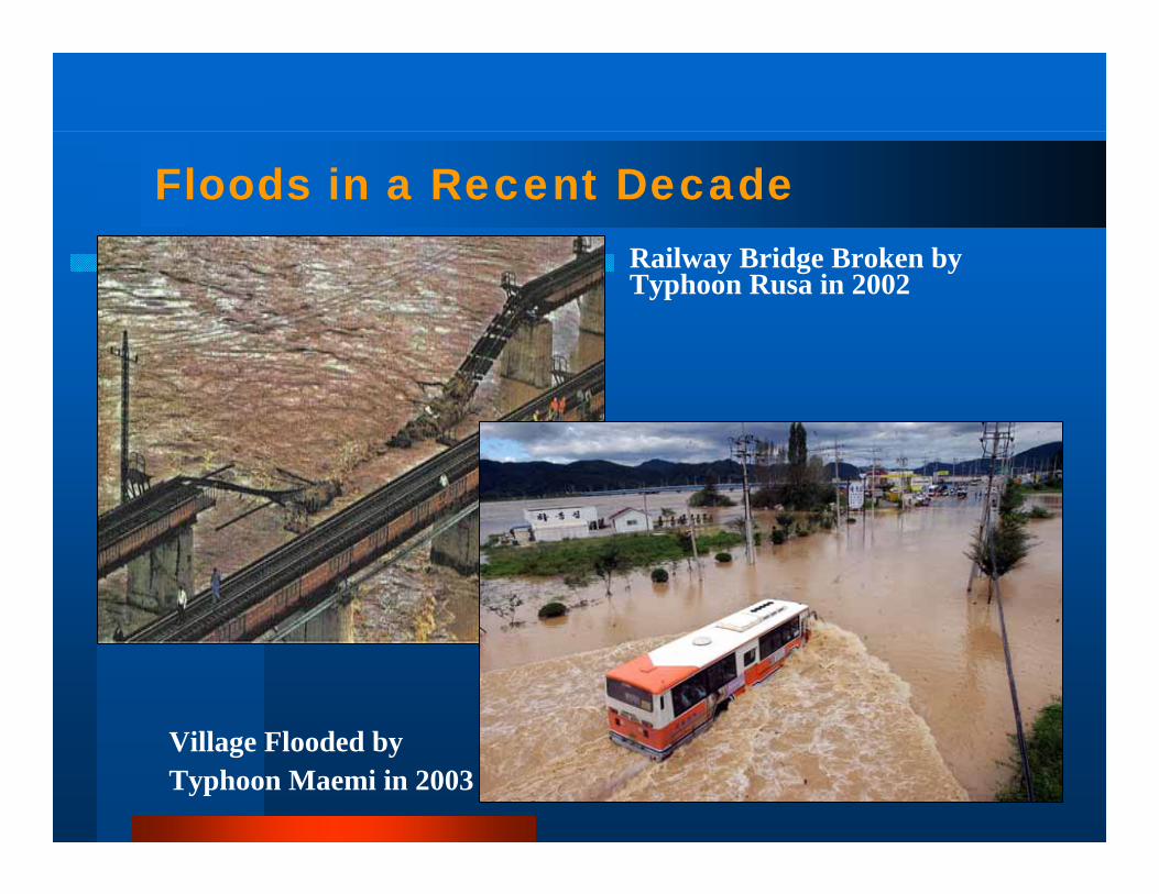
Floods in a Recent DecadeRailway Bridge Broken by Typhoon Rusa in 2002
Village Flooded by Typhoon Maemi in 2003
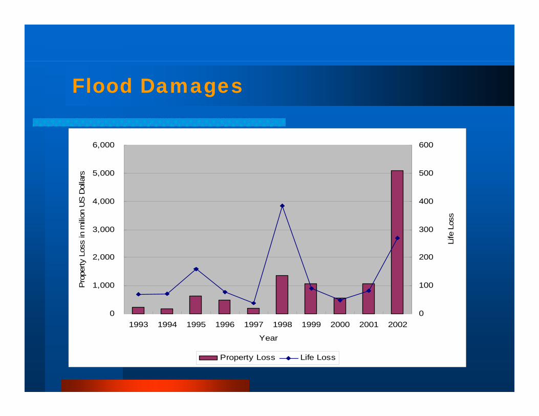
Flood Damages
0
1,000
2,000
3,000
4,000
5,000
6,000
1993 1994 1995 1996 1997 1998 1999 2000 2001 2002
Year
Pro
perty
Los
s in
mili
on U
S D
olla
rs
0
100
200
300
400
500
600
Life
Los
s
Property Loss Life Loss
FLOOD RISK FACTORSFLOOD RISK FACTORS

Risk Factors (1/4)Risk Factors (1/4)
□□ Abnormal weather events due to global warmingAbnormal weather events due to global warming
□□ Rapid urbanization and industrializationRapid urbanization and industrialization
□□ Insufficient infrastructure for flood defenseInsufficient infrastructure for flood defense
□□ Lack of social systems, cooperation between sectors andLack of social systems, cooperation between sectors andpublic participationpublic participation
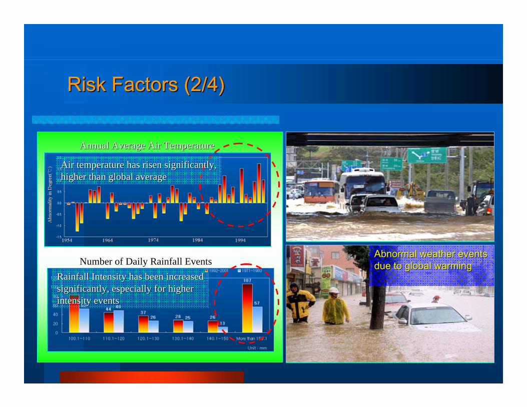
Risk Factors (2/4)Risk Factors (2/4)
Air temperature has risen significantly,Air temperature has risen significantly,higher than global average higher than global average
Annual Average Air TemperatureAnnual Average Air Temperature
Rainfall Intensity has been increasedRainfall Intensity has been increasedsignificantly, especially for higher significantly, especially for higher intensity events intensity events
Number of Daily Rainfall EventsNumber of Daily Rainfall EventsAbnormal weather events Abnormal weather events due to global warmingdue to global warming
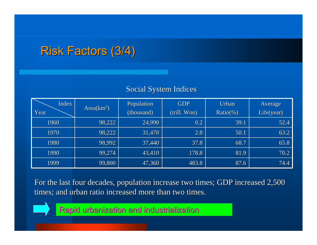
Risk Factors (3/4)Risk Factors (3/4)
74.474.487.687.6483.8483.847,36047,36099,80099,80019991999
70.270.281.981.9178.8178.843,41043,41099,27499,27419901990
65.865.868.768.737.837.837,44037,44098,99298,99219801980
63.263.250.150.12.82.831,47031,47098,22298,22219701970
52.452.439.139.10.20.224,99024,99098,22298,22219601960
AverageAverageLife(yearLife(year))
UrbanUrbanRatio(%)Ratio(%)
GDPGDP(trill. Won)(trill. Won)
PopulationPopulation(thousand)(thousand)
Area(kmArea(km22))IndexIndex
YearYear
Social System IndicesSocial System Indices
For the last four decades, population increase two times; GDP inFor the last four decades, population increase two times; GDP increased 2,500creased 2,500times; and urban ratio increased more than two times.times; and urban ratio increased more than two times.
Rapid urbanization and industrializationRapid urbanization and industrialization
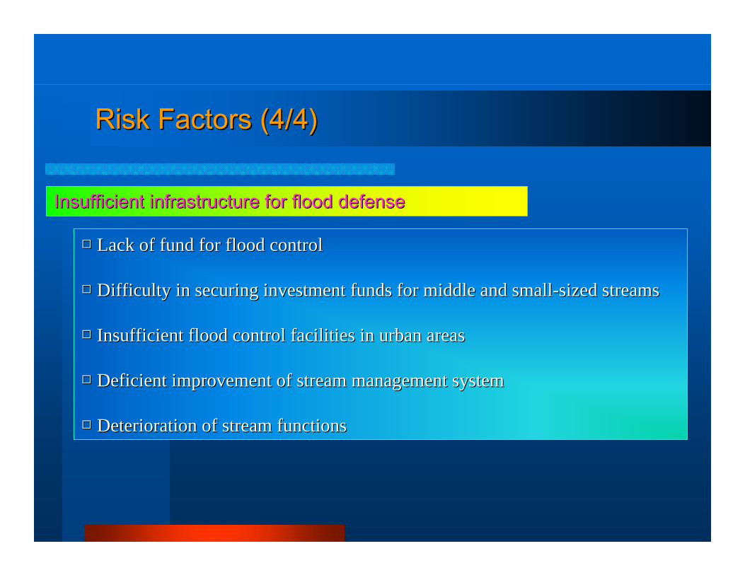
Risk Factors (4/4)Risk Factors (4/4)
□□ Lack of fund for flood controlLack of fund for flood control
□□ Difficulty in securing investment funds for middle and smallDifficulty in securing investment funds for middle and small--sized streamssized streams
□□ Insufficient flood control facilities in urban areasInsufficient flood control facilities in urban areas
□□ Deficient improvement of stream management systemDeficient improvement of stream management system
□□ Deterioration of stream functionsDeterioration of stream functions
Insufficient infrastructure for flood defenseInsufficient infrastructure for flood defense
INTEGRATED FLOODINTEGRATED FLOODMANAGEMENTMANAGEMENT
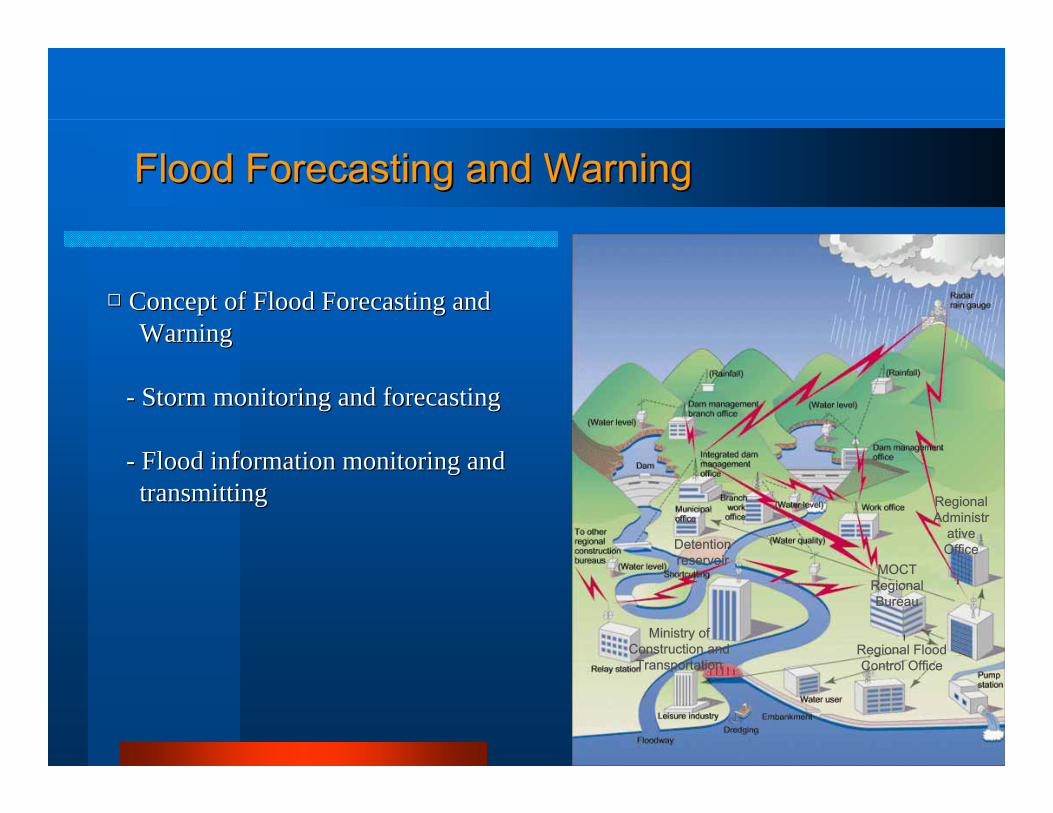
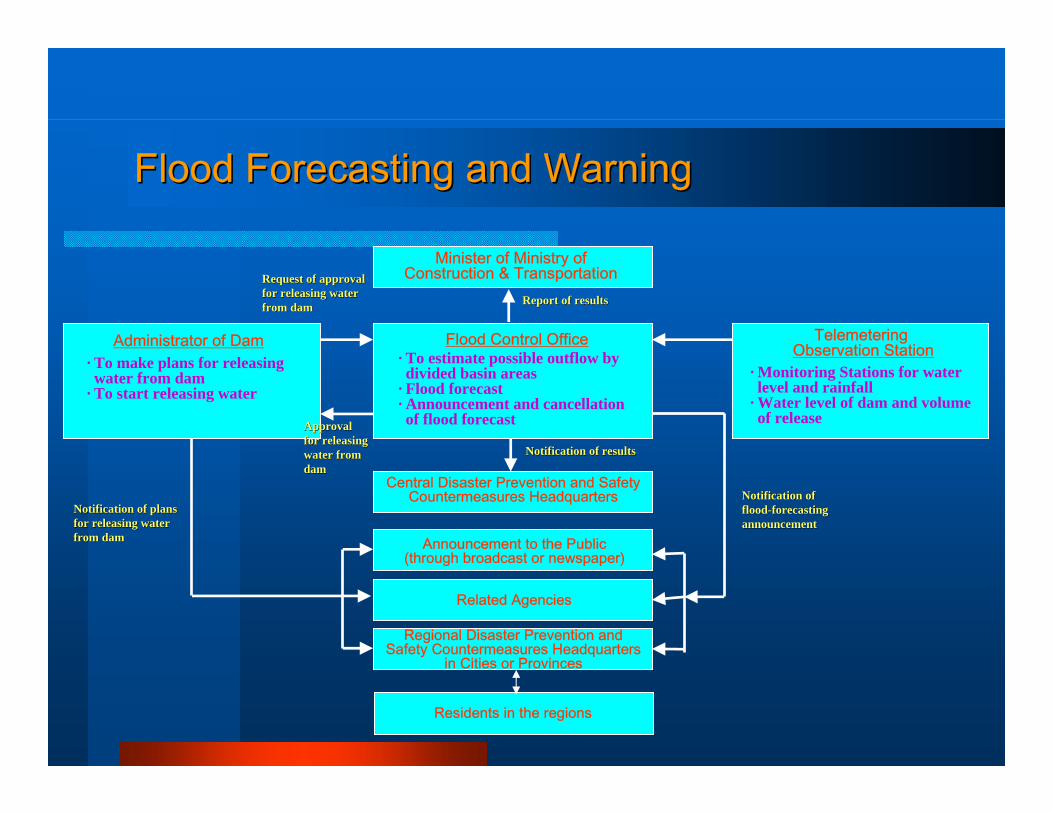
Flood Forecasting and WarningFlood Forecasting and Warning
□□ Concept of Flood Forecasting and Concept of Flood Forecasting and WarningWarning
-- Storm monitoring and forecastingStorm monitoring and forecasting
-- Flood information monitoring andFlood information monitoring andtransmittingtransmitting
Ministry ofConstruction and
TransportationRegional FloodControl Office
MOCTRegional Bureau
Detentionreservoir
RegionalAdministr
ativeOffice
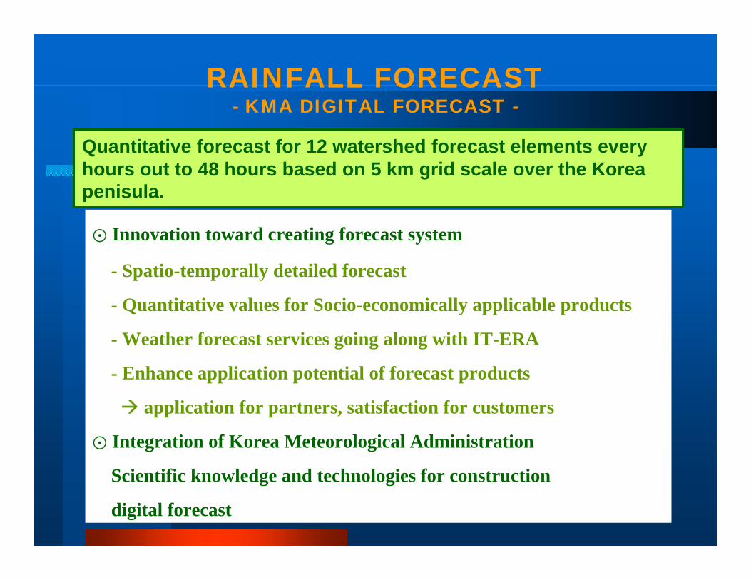
⊙ Innovation toward creating forecast system
- Spatio-temporally detailed forecast
- Quantitative values for Socio-economically applicable products
- Weather forecast services going along with IT-ERA
- Enhance application potential of forecast products
application for partners, satisfaction for customers
⊙ Integration of Korea Meteorological Administration
Scientific knowledge and technologies for construction
digital forecast
Quantitative forecast for 12 watershed forecast elements every hours out to 48 hours based on 5 km grid scale over the Korea penisula.
RAINFALL FORECAST- KMA DIGITAL FORECAST -
1. Use numerical weather prediction output
5. Distribute digital forecast contents from DB system
2. Generate 5 km digital forecast grids DFS
DB
WO
RDED
IMAGE GRAPHIC
TIME-SERIES
TABULAR
VOICE
GRID-PO
INT
4. Edit temporal and spatial modification by forecaster
CONFIGURATION OF DIGITAL FORECAST SYSTEM (DFS)
- ADVANCED HYBRID FORECAST SYSTEM -3. Apply statistical forecast
model to specific stations
WHERE?WHEN?
HOW MUCH?
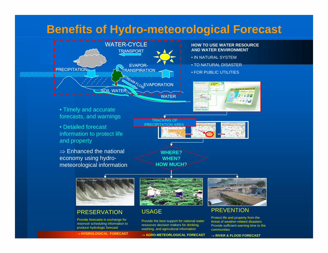
Benefits of Hydro-meteorological Forecast
USAGEProvide the best support for national water resources decision makers for drinking, washing, and agricultural information
→ AGRO-METEORLOGICAL FORECAST
PRESERVATIONProvide forecasts in exchange for reservoir scheduling information to produce hydrologic forecast
→ HYDROLOGICAL FORECAST
• Timely and accurate forecasts, and warnings
• Detailed forecast information to protect life and property
⇒ Enhanced the national economy using hydro-meteorological information
PREVENTIONProtect life and property from the threat of weather-related disasters Provide sufficient warning time to the communities
→ RIVER & FLOOD FORECAST
HOW TO USE WATER RESOURCE AND WATER ENVIRONMENT
• IN NATURAL SYSTEM
• TO NATURAL DISASTER
• FOR PUBLIC UTILITIES
TRACKING OFPRECIPITATION AREA
EVAPORATION
PRECIPITATIONEVAPOR-
TRANSPIRATION
WATER-CYCLE
SOIL WATERWATER
TRANSPORT
STREAM FLOW
Flood Forecasting and WarningFlood Forecasting and Warning
Minister of Ministry ofConstruction & Transportation
Administrator of Dam· To make plans for releasing water from dam
· To start releasing water
Flood Control Office· To estimate possible outflow by divided basin areas
· Flood forecast· Announcement and cancellationof flood forecast
TelemeteringObservation Station
· Monitoring Stations for waterlevel and rainfall
· Water level of dam and volumeof release
Central Disaster Prevention and SafetyCountermeasures Headquarters
Announcement to the Public(through broadcast or newspaper)
Related Agencies
Regional Disaster Prevention and Safety Countermeasures Headquarters
in Cities or Provinces
Residents in the regions
Notification of plansNotification of plansfor releasing waterfor releasing waterfrom damfrom dam
Notification ofNotification offloodflood--forecastingforecastingannouncementannouncement
Notification of resultsNotification of results
Report of resultsReport of results
ApprovalApprovalfor releasingfor releasingwater fromwater fromdamdam
Request of approvalRequest of approvalfor releasing waterfor releasing waterfrom damfrom dam
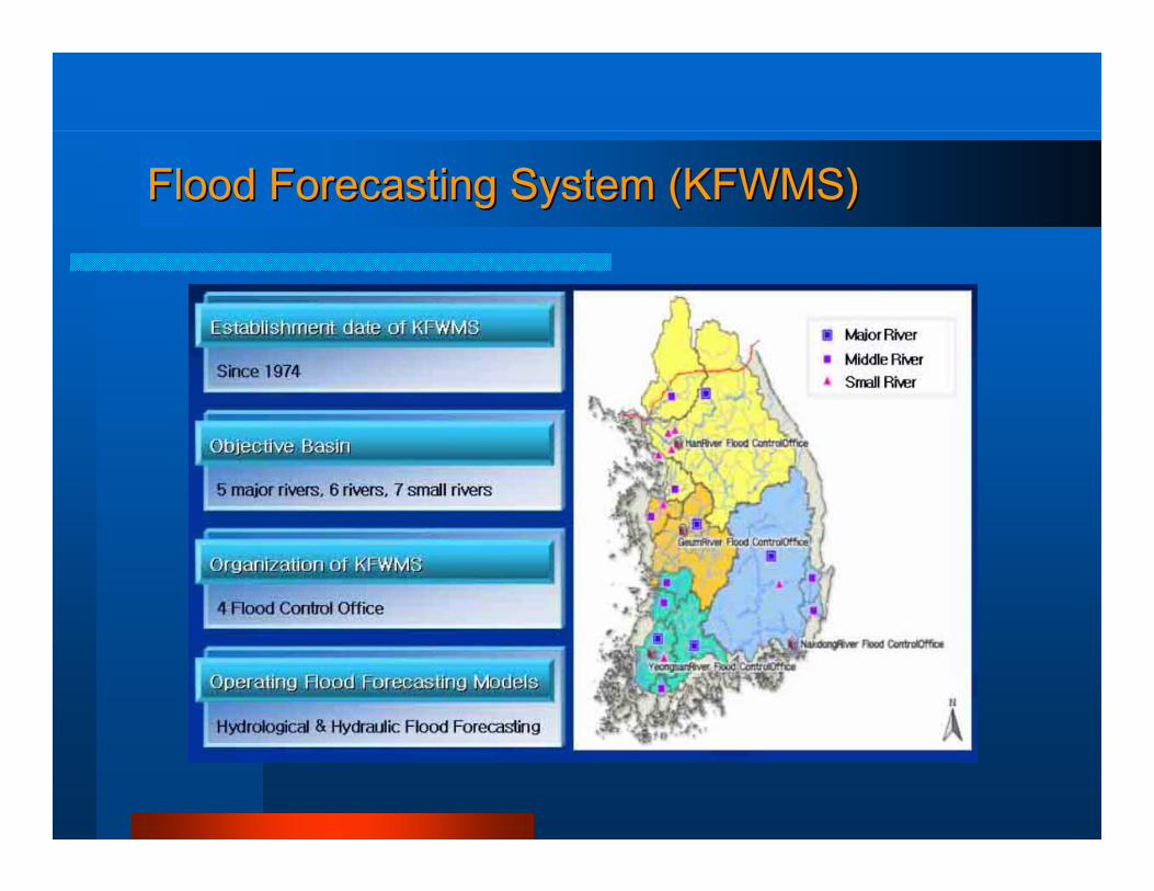
Flood Forecasting System (KFWMS)Flood Forecasting System (KFWMS)
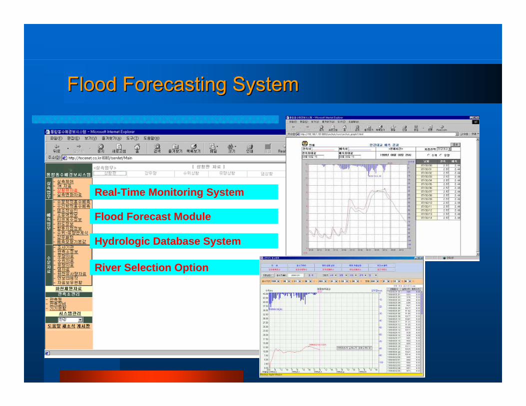
Real-Time Monitoring System
Flood Forecast Module
Hydrologic Database System
River Selection Option
Flood Forecasting SystemFlood Forecasting System
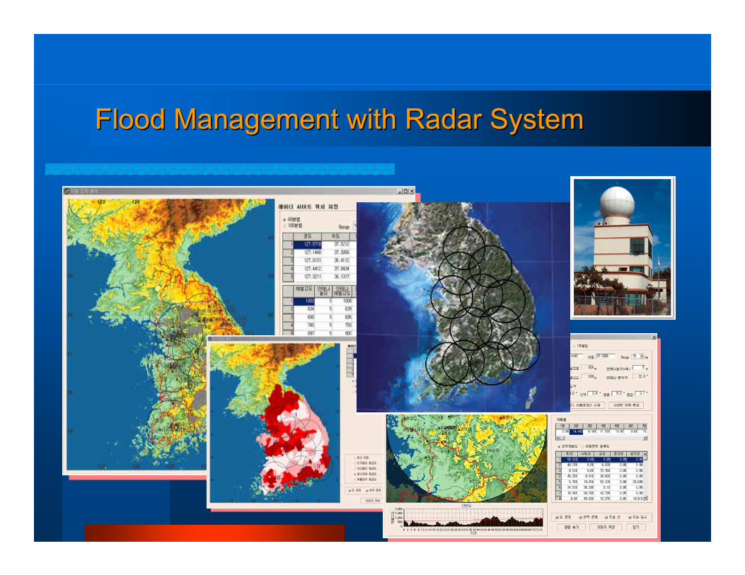
Flood Management with Radar SystemFlood Management with Radar System

Flood Control Flood Control Pr
oced
ures
Proc
edur
es
Rainfall ForecastRainfall Forecast
Runoff AnalysisRunoff Analysis
Inflow EstimationInflow Estimation
Reservoir Operation SimulationReservoir Operation Simulation
Decision MakingDecision Making
Gate Opening & ReleasesGate Opening & ReleasesDam Upstream
Dam Downstream
Flood Control Procedure (1/2)
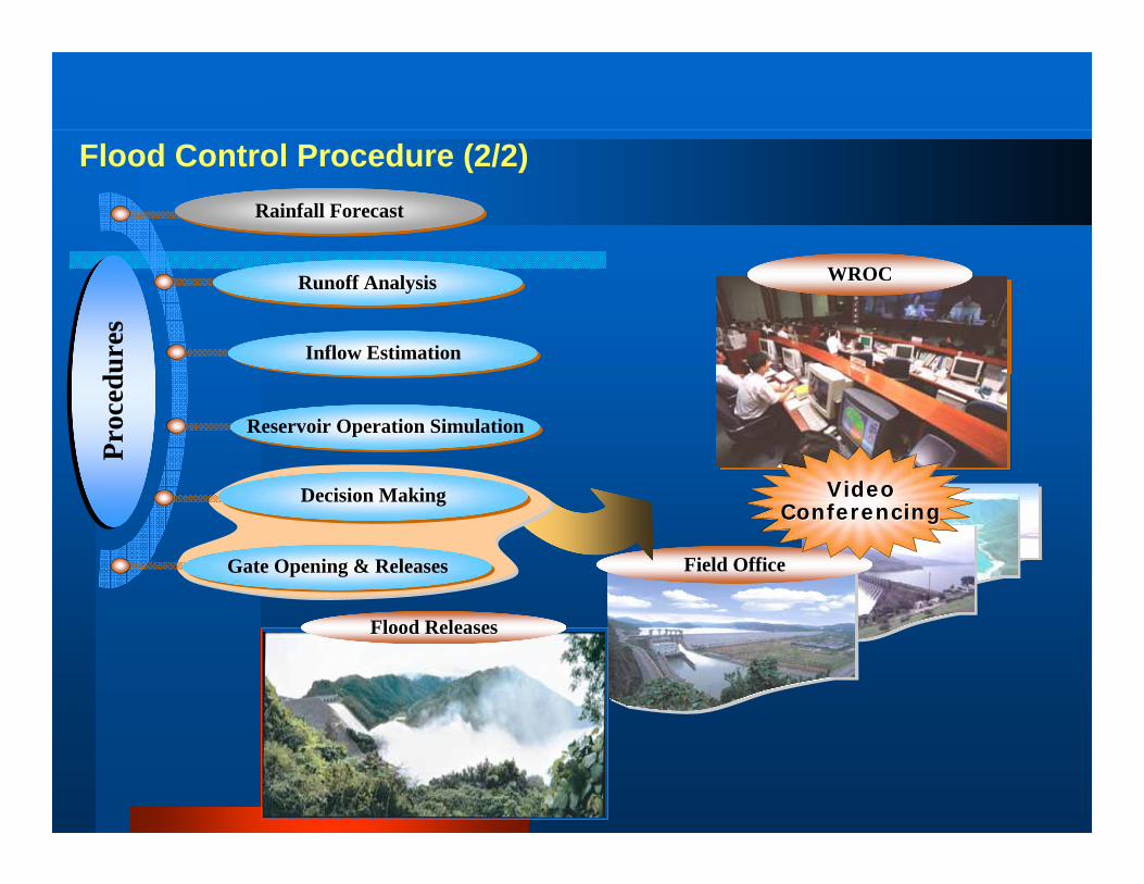
Field Office
WROCWROC
Video Video ConferencingConferencing
Flood ReleasesFlood Releases
Proc
edur
esPr
oced
ures
Rainfall ForecastRainfall Forecast
Runoff AnalysisRunoff Analysis
Inflow EstimationInflow Estimation
Reservoir Operation SimulationReservoir Operation Simulation
Decision MakingDecision Making
Gate Opening & ReleasesGate Opening & Releases
Flood Control Procedure (2/2)
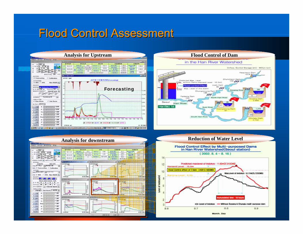
Analysis for downstream Reduction of Water Level
ForecastingForecasting
Analysis for UpstreamAnalysis for Upstream Flood Control of DamFlood Control of Dam
Flood Control AssessmentFlood Control Assessment
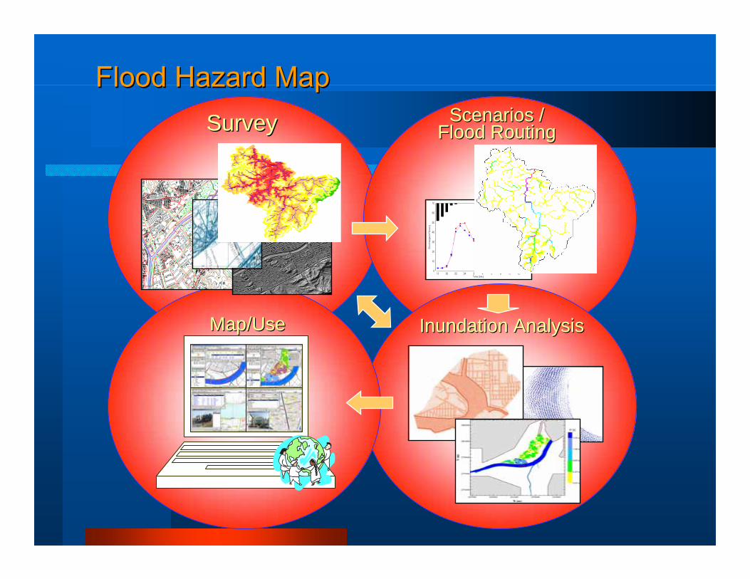
SurveySurvey
Inundation AnalysisInundation Analysis
Scenarios /Scenarios /Flood RoutingFlood Routing
Map/UseMap/Use
Flood Hazard MapFlood Hazard Map
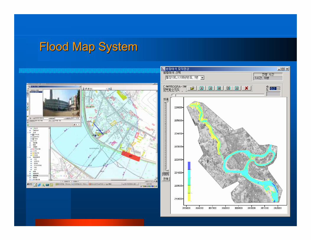
Flood Map SystemFlood Map System
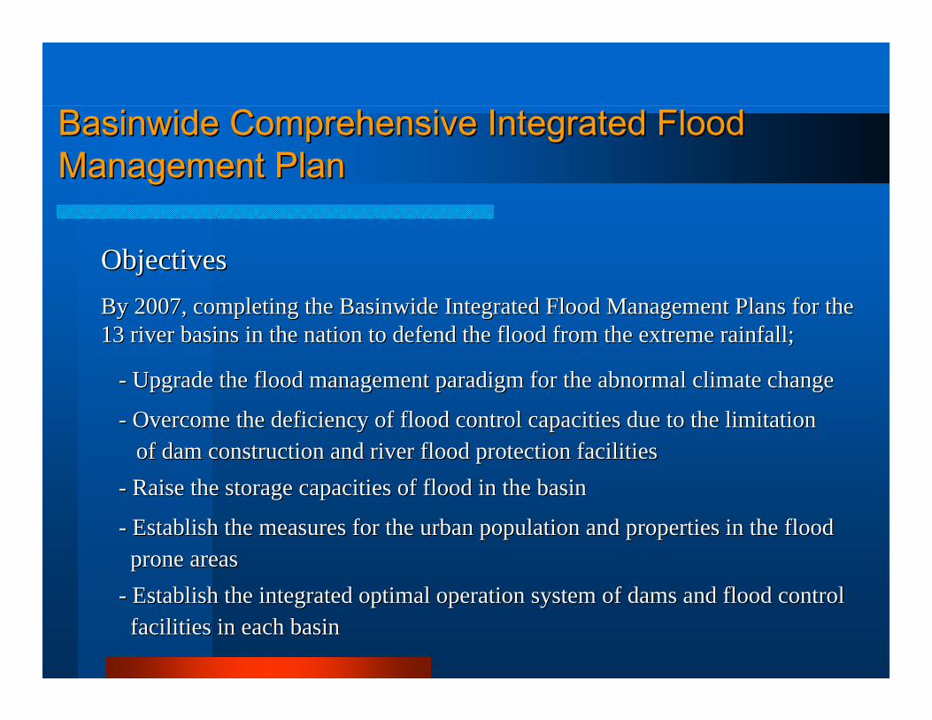
BasinwideBasinwide Comprehensive Integrated Flood Comprehensive Integrated Flood Management PlanManagement Plan
ObjectivesObjectivesBy 2007, completing the By 2007, completing the BasinwideBasinwide Integrated Flood Management Plans for theIntegrated Flood Management Plans for the13 river basins in the nation to defend the flood from the extre13 river basins in the nation to defend the flood from the extreme rainfall;me rainfall;
-- Upgrade the flood management paradigm for the abnormal climate Upgrade the flood management paradigm for the abnormal climate changechange
-- Overcome the deficiency of flood control capacities due to the Overcome the deficiency of flood control capacities due to the limitationlimitationof dam construction and river flood protection facilitiesof dam construction and river flood protection facilities
-- Raise the storage capacities of flood in the basin Raise the storage capacities of flood in the basin
-- Establish the measures for the urban population and properties Establish the measures for the urban population and properties in the floodin the floodprone areasprone areas
-- Establish the integrated optimal operation system of dams and fEstablish the integrated optimal operation system of dams and flood controllood controlfacilities in each basinfacilities in each basin
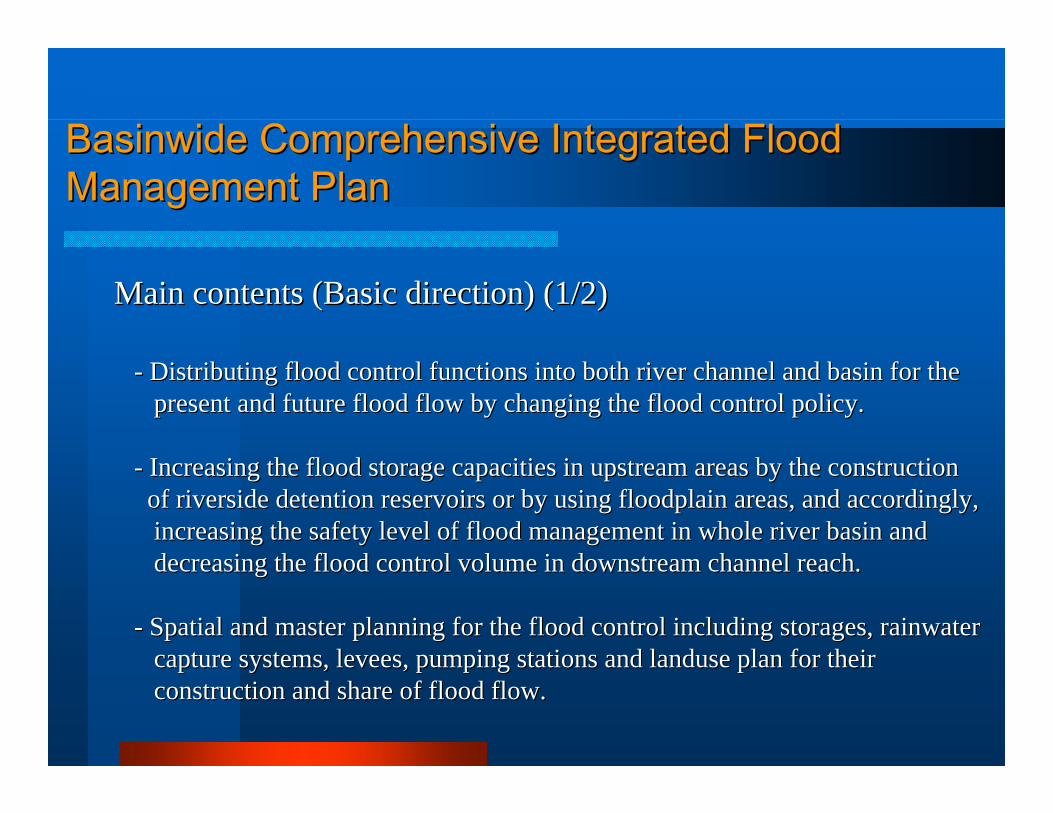
Main contents (Basic direction) (1/2)Main contents (Basic direction) (1/2)
-- Distributing flood control functions into both river channel anDistributing flood control functions into both river channel and basin for the d basin for the present and future flood flow by changing the flood control ppresent and future flood flow by changing the flood control policy.olicy.
-- Increasing the flood storage capacities in upstream areas by thIncreasing the flood storage capacities in upstream areas by the construction e construction of riverside detention reservoirs or by using floodplain areasof riverside detention reservoirs or by using floodplain areas, and accordingly,, and accordingly,increasing the safety level of flood management in whole riveincreasing the safety level of flood management in whole river basin and r basin and decreasing the flood control volume in downstream channel readecreasing the flood control volume in downstream channel reach.ch.
-- Spatial and master planning for the flood control including stoSpatial and master planning for the flood control including storages, rainwaterrages, rainwatercapture systems, levees, pumping stations and capture systems, levees, pumping stations and landuselanduse plan for their plan for their construction and share of flood flow.construction and share of flood flow.
BasinwideBasinwide Comprehensive Integrated Flood Comprehensive Integrated Flood Management PlanManagement Plan
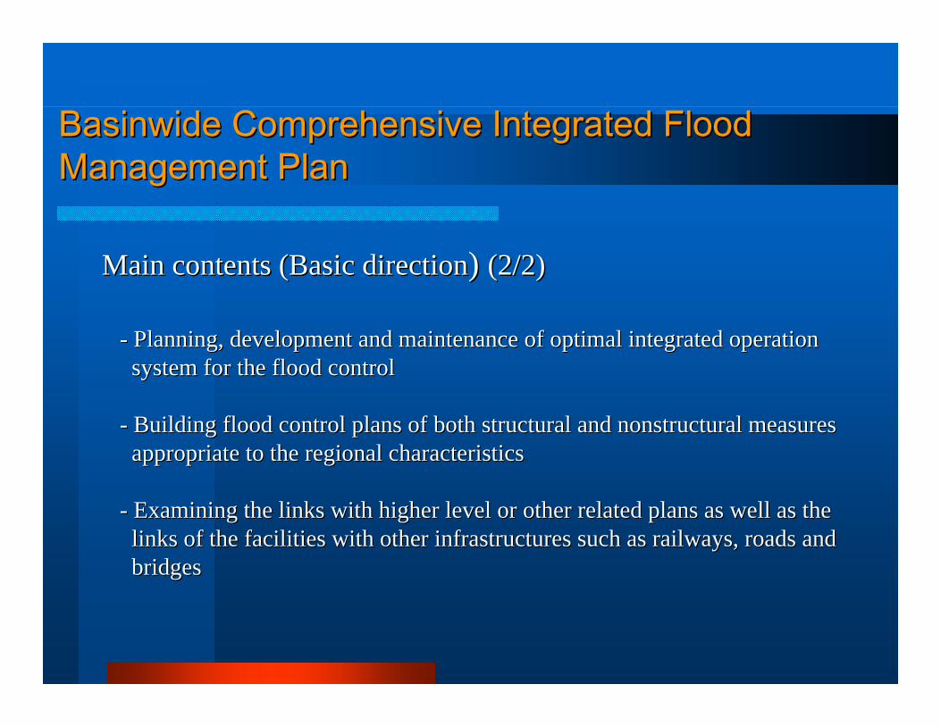
Main contents (Basic directionMain contents (Basic direction) ) (2/2)(2/2)
-- Planning, development and maintenance of optimal integrated opePlanning, development and maintenance of optimal integrated operationrationsystem for the flood controlsystem for the flood control
-- Building flood control plans of both structural and nonstructurBuilding flood control plans of both structural and nonstructural measuresal measuresappropriate to the regional characteristicsappropriate to the regional characteristics
-- Examining the links with higher level or other related plans asExamining the links with higher level or other related plans as well as thewell as thelinks of the facilities with other infrastructures such as railinks of the facilities with other infrastructures such as railways, roads andlways, roads andbridgesbridges
BasinwideBasinwide Comprehensive Integrated Flood Comprehensive Integrated Flood Management PlanManagement Plan
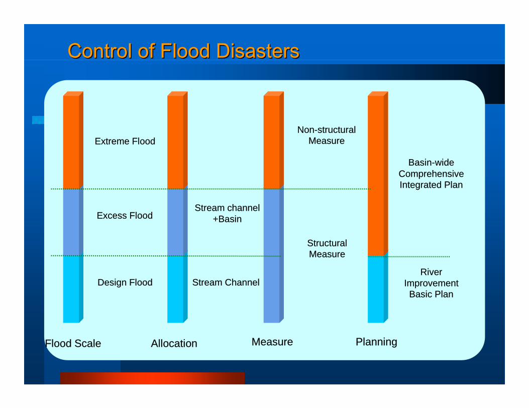
Control of Flood DisastersControl of Flood Disasters
Stream channel+Basin
Extreme Flood
Stream ChannelDesign Flood
Excess Flood
Basin-wideComprehensive Integrated Plan
Non-structural Measure
River Improvement
Basic Plan
Structural Measure
Allocation Measure PlanningFlood Scale
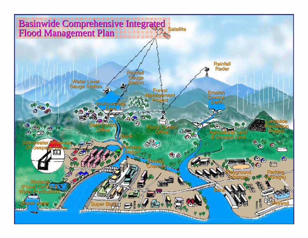
BasinwideBasinwide Comprehensive Integrated Comprehensive Integrated Flood Management PlanFlood Management Plan SatelliteSatellite
Rainfall Rainfall GaugeGaugeStationStationWater LevelWater Level
Gauge StationGauge StationForestForest
ManagementManagementProjectProject
MultipurposeMultipurposeDamDam
Dam ControlDam ControlOfficeOffice
BankBankFlood ControlFlood Control
OfficeOffice
Pumping Pumping StationStation
DrivingDrivingChannelChannel
Super BankSuper Bank
StormwaterStormwater ReservoirReservoirOf Seepage WaterOf Seepage Water
WetlandWetland(Flood Control &(Flood Control &
Water Purification)Water Purification)
Break waterBreak water
BankBank
SeewallSeewall
ParkingParking(storage)(storage)
PlaygroundPlayground(storage)(storage)
Agricultural LandAgricultural Land& Unused Land& Unused Land
LandslideLandslidePreventionPrevention
ProjectProject
ErosionErosionControlControl
DamDam
RainfallRainfallRaderRader

THANK YOUTHANK YOU
FORFOR
YOUR ATTENTION!!YOUR ATTENTION!!