Inspecting Sites Remotely - Start planning immediately with confidence
9
Inspecting Sites Remotely Start planning immediately with confidence By Nina Machotka
-
Upload
nic-denham -
Category
Documents
-
view
43 -
download
0
Transcript of Inspecting Sites Remotely - Start planning immediately with confidence

Inspecting Sites Remotely
Start planning immediately with confidence
By Nina Machotka

Inspecting Sites Remotely - Start planning immediately with confidence
Whether you’re starting a new project, tracking a project’s progress, or overseeing the re-development of an existing site, you need to inspect the site and obtain critical information to plan accordingly. With increasing demands to meet tighter deadlines and restricted budgets, relying solely upon on-site visits has become far too costly and time consuming. The solution is to inspect sites remotely with high-resolution aerial imagery and embedded location data. With remote inspection, you can start planning immediately with confidence.
Inspecting and planning sites efficiently requires the ability to coordinate a myriad of tasks, resources, and information for all stakeholders. Most likely, you’ve found that you’re dealing with the following issues and need a solid solution to resolve them.
Some of the challenges you face when you need to inspect a site are: • Saving time and reducing costly on-site visits • Organising resources • Identifying potential hazards and safety issues at the location • Viewing areas that are prone to natural disasters • Assessing the feasibility of a project in difficult terrain
Additionally, when planning a site you need to: • Obtain accurate information, both visual and analytical • Have clear views on what’s surrounding the site • Validate data and comply with industry regulations • Ensure safety and efficiency for maintenance crews and emergency services • Share information among all stakeholders
This paper addresses the ways in which high-resolution imagery, with its stunning clarity and location data, meets the
Not having to travel to multiple sites dramatically
increases productivity and saves significant
time and cost

Inspecting Sites Remotely - Start planning immediately with confidence
challenges for inspecting and planning site locations. Time and cost savings, critical information about the site and surrounding areas, and easy collaboration with all stakeholders are the immediate benefits when you’re able to visit your site over and over again, remotely.
The clearest aerial imagery uncovers insights on the ground
If you’re relying on satellite imagery or out-dated image maps, you run the risk of making incorrect planning decisions by not seeing what’s truly on the ground. Aerial imagery provides a level of resolution that you just don’t have with satellite imagery, enabling you to discover insights that suddenly become crystal clear. Furthermore, The frequency of imagery updates that leading aerial imagery companies provide, guarantees that you’ll be working with the most current images.
Image source: Victory Heights WA, Nearmap

Particularly important when inspecting site locations is the ability to identify potentially hazardous areas that are prone to flooding or bushfires and better understand the environmental impact of these natural disasters. You may find that a certain area is not appropriate for your project if it’s too close to hazardous areas.
A clear bird’s eye view gives you a wide perspective on large areas and a very detailed view on specific locations, neither of which is possible from ground level. It is truly better than being there. With the high, wide view, you can uncover difficult terrain, locate optimal areas for constructing industrial buildings or installing large utility stations, and pinpoint the nearest rail lines and major highways. By zooming in for a more detailed view to inspect a specific site location, you can study the relationships between your site location and the surrounding areas. You’ll discover if there are schools nearby, parks, residential buildings, or what types of industry are in place.
Image source: Kellyville NSW, Nearmap
By zooming in for a more detailed view to inspect a
specific site location, you can study the
relationships between your site location and the
surrounding areas
Inspecting Sites Remotely - Start planning immediately with confidence
Streamline planning with instant access to visual data
Delays are the bane of project planning, and nothing detains plans more consistently than inaccurate information and the inability to efficiently communicate among all stakeholders. When you collaborate with many stakeholders for planning - including government agencies, project managers, construction site vendors, utilities contractors, and sales and marketing staff - you need instant access to the most
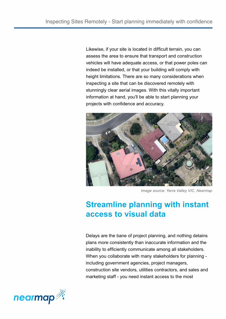
Image source: Yarra Valley VIC, Nearmap
Likewise, if your site is located in difficult terrain, you can assess the area to ensure that transport and construction vehicles will have adequate access, or that power poles can indeed be installed, or that your building will comply with height limitations. There are so many considerations when inspecting a site that can be discovered remotely with stunningly clear aerial images. With this vitally important information at hand, you’ll be able to start planning your projects with confidence and accuracy.
Inspecting Sites Remotely - Start planning immediately with confidence

current visuals, the tools to measure and validate data, and the means to share with everyone anywhere, anytime.
Working remotely with a platform that provides tools for measuring and analysing your site location images gives you the advantage of master planning without having to be present on the site. The detailed visual insights from your site inspections allow you to clearly assess the site and validate the data so that you can begin infrastructure development, plan for the resources the project will require, and contact the proper agencies for compliance regulations. As you return to the site remotely and analyse more visual data, you can also plan various safety strategies for maintenance crews and emergency services.
Image source: Terrigal NSW, Nearmap
Inspecting Sites Remotely - Start planning immediately with confidence

Enhance the accuracy of geospatial data
When you want to enhance the accuracy of your GIS spatial data, you can integrate Nearmap’s high-resolution imagery into your core GIS application. The tools that Nearmap provides let you draw right over the top of the aerial surveys, rectify errors, and produce more accurate designs, thus delivering more detailed information than was originally in place. The flexibility of working with GIS layers and measurement tools all in one place dramatically increases accuracy and productivity for all of your planning needs.
Integrated measurement and site planning toolsAnnotate your images without having to extract them and paste into an external file. Position labels and icons, add notes, calculate distance and area on a location, and determine path, radius, and elevation measures.
Import KML filesEasily upload your KML files and view them in the MapBrowser. You can save changes between sessions so you don’t have to upload the file each time.
Import georeference files into GIS applicationsWhen you choose to include a georeference file with your saved image, a JGW file is downloaded with the JPG file, both of which you can import into a GIS or CAD application.
Further enhancing project planning is the ability to share the images and data with staff and stakeholders in multiple locations, even world-wide. Nearmap’s aerial imagery and its location data is delivered via cloud-based services to your desktop and on all mobile devices. The browser-based PhotoMaps™ tools allow collaboration for site planning, design, and detailed measurement calculations, all of which can be easily shared between personnel in office locations and in the field when a physical site visit may be required.
Then, when it’s time for more in-depth planning, you can integrate Nearmap’s high-resolution imagery into your core GIS application to enhance the accuracy of your GIS spatial data.
And finally, the ability to view historical imagery of site locations and surrounding areas gives you vital information on the lifecycle of the location, further ensuring that your planning will be done with confidence.
Inspecting the past to plan for the future
Uncovering insights in the present is only part of the story. Sometimes you need to look back in order to move forward. Nearmap retains historical imagery and compiles the images over time, giving you instant access to its vast archive with its Timeline feature You can view the recent
Inspecting Sites Remotely - Start planning immediately with confidence

history of the location and the surrounding land use to study how it has evolved through environmental changes and regional effects. Population changes are another important insight that offer factual evidence for your planning decisions.
If your project is seasonal-dependent, you can inspect the conditions that might affect your construction, products, or services. In the case of hazard mitigation, for instance, seeing what has taken place over time helps with better planning for the next event. Adding to the value of viewing historical images is the SplitView feature, which provides side-by-side views in the map browser, allowing you to compare images simultaneously.
Seeing what has taken place over time helps with
better planning for the next event
Image source: Collaroy Beach NSW, Nearmap
Inspecting Sites Remotely - Start planning immediately with confidence

Conclusion
With the pace and scope that inspecting and planning sites demands, it’s no longer feasible to rely solely on time consuming and costly site visits. Remote inspection and planning with stunningly clear, high-resolution aerial images and detailed location data meets the challenges of all industries today. Remote inspections give you the precise status of your locations with insights that are just not available from ground level, and allow you to plan your projects with the knowledge that you’ve obtained all the critical information you need.
Stunning high-resolution aerial imagery and embedded spatialdata are the perfect combination for gaining valuable insights about a site - which are not available from ground level - to start planning with accuracy and confidence. Inspecting sites remotely helps you to transform your business to one that is more cost-effective, efficient and scalable.
Inspecting Sites Remotely - Start planning immediately with confidence