In cooperation with the Louisiana Department of ... cooperation with the Louisiana Department of...
6
In cooperation with the Louisiana Department of Transportation and Development Water Resources of Bossier Parish DOTD DOTD D E P A R T M E N T O F T R A N S P O R T A TI O N A N D D E V E L O P M E N T Introduction In 2005, about 15.8 million gallons per day (Mgal/d) of water were withdrawn in Bossier Parish, Louisiana (fig. 1), including 4.12 Mgal/d from groundwater sources and about 11.7 Mgal/d from surface-water sources 1 (table 1). Public- supply use accounted for about 78 percent (12.4 Mgal/d) of the total water withdrawn. Other categories of use included 1 Tabulation of numbers in text and tables may result in different totals because of rounding; nonrounded numbers are used for calculation of totals. industry, rural domestic, livestock, rice irrigation, general irrigation, and aquaculture (table 2). Based on water-use data collected at 5-year intervals from 1960 to 2005, water withdrawals in the parish increased from 4.96 to 15.8 Mgal/d (fig. 2). This fact sheet summarizes basic information on the water resources of Bossier Parish, La. Information on groundwater and surface-water availability, quality, development, use, and trends is based on previously published reports listed in the Selected References section. Figure 1. Location of study area, Bossier Parish, Louisiana. U.S. Department of the Interior U.S. Geological Survey Fact Sheet 2011–3087 October 2011 Printed on recycled paper
Transcript of In cooperation with the Louisiana Department of ... cooperation with the Louisiana Department of...

In cooperation with the Louisiana Department of Transportation and Development
Water Resources of Bossier Parish
D O TDD O TD
DEPARTMENT OF
TRA
NSPO
RTATION AND DEVELOPMENT
Introduction
In 2005 about 158 million gallons per day (Mgald) of water were withdrawn in Bossier Parish Louisiana (fig 1) including 412 Mgald from groundwater sources and about 117 Mgald from surface-water sources1 (table 1) Public-supply use accounted for about 78 percent (124 Mgald) of the total water withdrawn Other categories of use included
1 Tabulation of numbers in text and tables may result in different totals because of rounding nonrounded numbers are used for calculation of totals
industry rural domestic livestock rice irrigation general irrigation and aquaculture (table 2) Based on water-use data collected at 5-year intervals from 1960 to 2005 water withdrawals in the parish increased from 496 to 158 Mgald (fig 2)
This fact sheet summarizes basic information on the water resources of Bossier Parish La Information on groundwater and surface-water availability quality development use and trends is based on previously published reports listed in the Selected References section
Caspiana
Taylortown
DoylineHaughton
Shreveport
BossierCity
Princeton
Bellevue
MidwayBenton
Dixie
Alden BridgeBelcher
Sarepta
Cotton Valley
Ivan
Rocky Mount
Hughes
Gilliam
Plain Dealing
Bolinger
Fillmore
CullenSpringhill
DESOTOPARISH
RED RIVER PARISH
CADDOPARISH
WEBSTER
PARISH
ARKANSAS
32deg 15
93deg 30
10 KILOMETERS
0
0
10 MILES
93deg 45
33ordm 00
LakeBis tineau
CrossLake
Cypress Bayou Reservoir
Bo-377
A
Aacute
LO
UI S
I AN
A
A R K A N S A S
MI S
SI S
SI P
PIT
EX
AS
G U L F O F M E X I C O
ENLARGEDAREA
INDEX MAP
BOSSIER PARISH
WallaceLake
Red
Ri ver
Red
River
Bodcau
Bayou
Caney Bayo
u
Little
CypressBayou
07349500
07349250
0 and above
0 to -500
Approximate altitude of the base of fresh groundwater in feet above or below National Geodetic Vertical Datum of 1929 (Smoot 1988)
Bo-377 Well for which hydrograph is shown (see fig 4)
A Aacute Trace of hydrogeologic section (see fig 3)
EXPLANATION
07349500Surface-water discharge site
07349250Surface-water water-quality site
71
71
32
157
160
162
160
157
157
157
527
3
3
49
Eastwood
Elm Grove
McDade
07344370
32ordm 45
32ordm 30
Base map modified from Official Map of LouisianaLouisiana Departmentof Transportation and Development 1986
BIE
NV
ILLE
PA
RIS
H
Figure 1 Location of study area Bossier Parish Louisiana
US Department of the InteriorUS Geological Survey
Fact Sheet 2011ndash3087October 2011Printed on recycled paper
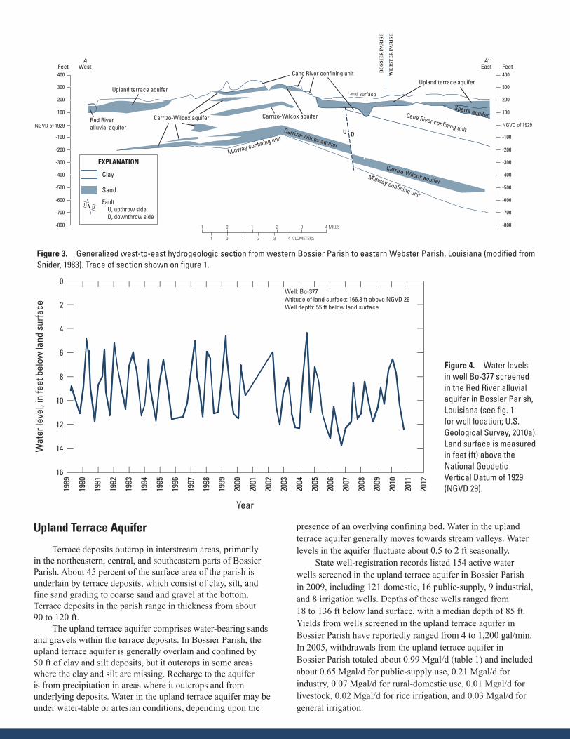
Groundwater Resources The primary groundwater resources of Bossier Parish from
near surface to deepest include the Red River alluvial aquifer the upland terrace aquifer the Sparta aquifer and the Carrizo-Wilcox aquifer (fig 3) Fresh groundwater (water having a chloride concentration of 250 milligrams per liter [mgL] or less) is available throughout most of the parish at depths ranging from about 50 feet (ft) above the National Geodetic Vertical Datum of 1929 (NGVD 29) (sea level) near the southern parish line to about 400 ft below NGVD 29 near the northern parish line (fig 1) Recharge to aquifers in Bossier Parish is from precipitation leakage from adjacent aquifers and seasonal input from streams Discharge from the aquifers is by natural seasonal flow into streams leakage into adjacent aquifers and withdrawals from wells
State well-registration records listed 3236 active water wells in Bossier Parish in 2009 including 2942 domestic 144 public-supply 104 irrigation and 46 industrial wells In 2005 groundwater withdrawals for various uses included public supply industry rural domestic livestock rice irrigation general irrigation and aquaculture (table 2)
Red River Alluvial Aquifer
In Bossier Parish the Red River alluvial aquifer extends about 5 to 7 miles (mi) east of the Red River (fig 1) except between the town of Benton and State Highway 2 where the aquifer extends less than a mile east of the river Alluvial deposits in the Red River flood plain characteristically have a uniform sequence of clay silt sand and gravel with grain size increasing with depth Sand and gravel deposits compose the Red River alluvial aquifer The aquifer is partially confined in some areas by highly organic backswamp clay deposits having low permeability thus restricting infiltration of precipitation In Bossier Parish the alluvial aquifer ranges in thickness from about 15 to 80 ft and is overlain by about 10 to 60 ft of surficial clay and silt
Water levels in the alluvial aquifer fluctuate primarily in response to the stage of the Red River and precipitation The hydrograph for well Bo-337 illustrates water-level fluctuations (fig 4) Groundwater flow in the aquifer is towards the Red River with a general southerly (down valley) component of flow Recharge to the alluvial aquifer is from precipitation that infiltrates the overlying silty soil and from adjacent aquifers
State well-registration records listed 94 active water wells screened in the Red River alluvial aquifer in Bossier Parish in 2009 including 52 irrigation 34 domestic 5 industrial and 3 public-supply wells Depths of these wells ranged from 30 to 110 ft below land surface with a median depth of 70 ft Yields from wells screened in the Red River alluvial aquifer in Bossier Parish have reportedly ranged from 1 to 1000 gallons per minute (galmin) In 2005 withdrawals from the Red River alluvial aquifer in Bossier Parish totaled about 049 Mgald (table 1) and included about 002 Mgald for rural-domestic use 004 Mgald for livestock 009 Mgald for rice irrigation 013 Mgald for general irrigation and 021 Mgald for aquaculture Water in the Red River alluvial aquifer is generally very hard (greater than 180 mgL as calcium carbonate) and has high iron concentrations (greater than 300 microgL)
0
2
4
6
8
10
12
14
16
18
1960 1965 1970 1975 1980 1985 1990 1995 2000 2005
GroundwaterSurface water
EXPLANATION
Year
Annu
al w
ithdr
awal
in
mill
ion
gallo
ns p
er d
ay
Figure 2 Water withdrawals in Bossier Parish Louisiana 1960ndash2005
Table 1 Water withdrawals in million gallons per day by source in Bossier Parish Louisiana 2005 (modified from Sargent 2007)
Aquifer or surface- water body Groundwater Surface water
Red River alluvial aquifer 049 mdashUpland terrace aquifer 99 mdashSparta aquifer 19 mdashCarrizo-Wilcox aquifer 245 mdashRed River mdash 1067Miscellaneous streams mdash 101Total 412 1168
Table 2 Water withdrawals in million gallons per day by category in Bossier Parish Louisiana 2005 (modified from Sargent 2007)
Category GroundwaterSurface water Total
Public supply 173 1067 1240Industrial 42 02 44Rural domestic 128 00 128Livestock 07 02 09Rice irrigation 16 00 16General irrigation 24 97 122Aquaculture 21 00 21Total 412 1168 1580
400
300
200
100
NGVD of 1929
-100
-200
-300
-400
-500
-600
-700
-800
400
300
200
100
NGVD of 1929
-100
-200
-300
-400
-500
-600
-700
-8001 0 1 2 3 4 MILES
1 0 1 2 3 4 KILOMETERS
Feet Feet
Land surface
U D
AWest
ArsquoEast
BO
SSIE
R P
AR
ISH
WE
BST
ER
PA
RIS
H
EXPLANATION
Sand
Clay
Fault U upthrow side D downthrow side
U D
Figure 3 Generalized west-to-east hydrogeologic section from western Bossier Parish to eastern Webster Parish La (modified from Snider 1983) Trace of section shown on figure 1
Midway confining unit
Carrizo-Wilcox aquifer Carrizo-Wilcox aquiferRed Riveralluvial aquifer
Upland terrace aquiferUpland terrace aquifer
Cane River confining unit
Sparta aquifer
Carrizo-Wilcox aquifer
Carrizo-Wilcox aquifer
Cane River confining unit
Midway confining unit
Figure 3 Generalized west-to-east hydrogeologic section from western Bossier Parish to eastern Webster Parish Louisiana (modified from Snider 1983) Trace of section shown on figure 1
Year
Well Bo-377Altitude of land surface 1663 ft above NGVD 29Well depth 55 ft below land surface
Wat
er le
vel
in fe
et b
elow
land
sur
face
0
2
4
6
8
10
12
14
16
1989
1990
1991
1992
1993
1994
1995
1996
1997
1998
1999
2000
2001
2002
2003
2004
2005
2006
2007
2008
2009
2010
2011
2012
Figure 4 Water levels in well Bo-377 screened in the Red River alluvial aquifer in Bossier Parish Louisiana (see fig 1 for well location US Geological Survey 2010a) Land surface is measured in feet (ft) above the National Geodetic Vertical Datum of 1929 (NGVD 29)
Upland Terrace Aquifer
Terrace deposits outcrop in interstream areas primarily in the northeastern central and southeastern parts of Bossier Parish About 45 percent of the surface area of the parish is underlain by terrace deposits which consist of clay silt and fine sand grading to coarse sand and gravel at the bottom Terrace deposits in the parish range in thickness from about 90 to 120 ft
The upland terrace aquifer comprises water-bearing sands and gravels within the terrace deposits In Bossier Parish the upland terrace aquifer is generally overlain and confined by 50 ft of clay and silt deposits but it outcrops in some areas where the clay and silt are missing Recharge to the aquifer is from precipitation in areas where it outcrops and from underlying deposits Water in the upland terrace aquifer may be under water-table or artesian conditions depending upon the
presence of an overlying confining bed Water in the upland terrace aquifer generally moves towards stream valleys Water levels in the aquifer fluctuate about 05 to 2 ft seasonally
State well-registration records listed 154 active water wells screened in the upland terrace aquifer in Bossier Parish in 2009 including 121 domestic 16 public-supply 9 industrial and 8 irrigation wells Depths of these wells ranged from 18 to 136 ft below land surface with a median depth of 85 ft Yields from wells screened in the upland terrace aquifer in Bossier Parish have reportedly ranged from 4 to 1200 galmin In 2005 withdrawals from the upland terrace aquifer in Bossier Parish totaled about 099 Mgald (table 1) and included about 065 Mgald for public-supply use 021 Mgald for industry 007 Mgald for rural-domestic use 001 Mgald for livestock 002 Mgald for rice irrigation and 003 Mgald for general irrigation
A statistical summary of selected water-quality characteristics for freshwater samples collected from 37 wells screened in the upland terrace aquifer is provided in table 3 Freshwater from the aquifer ranges in hardness from soft (less than 60 mgL as calcium carbonate) to very hard (greater than 180 mgL as calcium carbonate) and generally does not exceed the US Environmental Protection Agencyrsquos Secondary Maximum Contaminant Levels (SMCLs)2 for drinking water for color pH iron and dissolved solids The median concentration (140 microgL) of manganese in 13 samples exceeds the SMCL for drinking water of 50 microgL Locally iron concentrations can exceed the SMCL of 300 microgL
Sparta Aquifer
The Sparta aquifer is generally present in the northeastern one-third of Bossier Parish The aquifer consists of thick beds of sand that occur chiefly in the upper and basal parts of the aquifer with clays mostly in the middle The Sparta aquifer
2 The SMCLs are nonenforceable Federal guidelines regarding cosmetic effects (such as tooth or skin discoloration) or aesthetic effects (such as taste odor or color) of drinking water At high concentrations or values health impli-cations as well as aesthetic degradation might exist SMCLs were established as guidelines for the States by the US Environmental Protection Agency (1992)
outcrops in an irregular area southwest of the town of Plain Dealing and in smaller areas to the south-southeast In Bossier Parish the Sparta aquifer dips and thickens to the northeast the base of the aquifer generally ranges from 50 ft or more above NGVD 29 to 150 ft below NGVD 29 The thickness of the Sparta aquifer ranges from a few feet to 300 ft Recharge to the aquifer is provided by precipitation in sandy outcrop areas and by leakage from other aquifers in areas where it is overlain and confined by clays of the Cook Mountain confining unit
State well-registration records listed 199 active water wells screened in the Sparta aquifer in Bossier Parish in 2009 including 172 domestic 13 public-supply 10 industrial and 4 irrigation wells Depths of these wells ranged from 42 to 360 ft below land surface with a median depth of 130 ft Yields from wells screened in the Sparta aquifer in Bossier Parish have reportedly ranged from 5 to 450 galmin In 2005 withdrawals from the Sparta aquifer in Bossier Parish totaled about 019 Mgald (table 1) and included about 007 Mgald for public-supply use 010 Mgald for rural-domestic use 001 Mgald for rice irrigation and 001 Mgald for general irrigation Water from the Sparta aquifer in Bossier Parish is generally soft and does not exceed SMCLs for color pH and dissolved solids however iron concentrations in some areas exceed the SMCL of 300 microgL
Table 3 Summary of selected water-quality characteristics of freshwater in the upland terrace and Carrizo-Wilcox aquifers in Bossier Parish Louisiana
[Values are in milligrams per liter except as noted degC degrees Celsius PCU platinum cobalt units microScm microsiemens per centimeter SU standard units CaCO3 calcium carbonate microgL micrograms per liter NA not applicable SMCL Secondary Maximum Contaminant Level established by the US Environmental Protection Agency (2011)]
Temper-ature (degC)
Color (PCU)
Specific conduc-tance
field(microScm at 25degC)
pH field (SU)
Hardness (as CaCO3)
Chloride filtered (as Cl)
Iron filtered (microgL as
Fe)
Manga-nese
filtered (microgL as
Mn)
Dissolved solids filtered
Upland terrace aquifer 1941ndash83 (37 wells)
Median 202 5 428 72 120 30 290 140 26410th percentile 195 0 170 65 32 96 50 32 12590th percentile 210 10 678 80 260 88 4300 350 413Number of samples 12 17 18 18 37 37 13 13 18Percentage of samples that
do not exceed SMCLsNA 100 NA 89 NA 100 54 23 94
Carrizo-Wilcox aquifer 1941ndash2004 (91 wells)
Median 205 5 698 79 45 67 110 20 39210th percentile 188 0 159 63 10 10 10 2 12290th percentile 225 20 1370 84 200 214 2000 150 798Number of samples 33 49 50 51 91 91 38 29 46Percentage of samples that
do not exceed SMCLsNA 86 NA 82 NA 100 66 69 61
SMCLs
NA 15 NA 65ndash85 NA 250 300 50 500
Carrizo-Wilcox Aquifer
The Carrizo-Wilcox aquifer consists of the Carrizo Sand and sand beds within the undifferentiated Wilcox Group which are hydraulically connected and regionally act as a single unit The Carrizo-Wilcox aquifer consists of clay interbedded with very fine to medium sand and is present throughout Bossier Parish Individual sands of the Carrizo-Wilcox aquifer range in thickness from less than 10 to about 150 ft In Bossier Parish the Carrizo-Wilcox aquifer dips and thickens to the northeast with the base of the aquifer ranging from about 0 ft below NGVD 29 in the southern end of the parish to about 900 ft below NGVD 29 in the northeastern corner of the parish The aquifer is underlain by the clayey Midway confining unit (fig 3) Freshwater can be found in the aquifer throughout Bossier Parish except in the northeastern area and from the town of Elm Grove southward Brackish water occurs locally in shallow basal sands of the aquifer
In the central and southern part of the parish sands in the Carrizo-Wilcox aquifer outcrop or subcrop and receive recharge from precipitation Locally the aquifer discharges to streams and lakes Groundwater movement in the northern third of the parish is generally westward toward the Red River Valley which is a major discharge area The direction of groundwater movement in the southern two-thirds of the parish while generally westward is affected by local water withdrawals Groundwater-level data from 1991 indicate that withdrawals from the Carrizo-Wilcox aquifer near the town of Doyline in southwestern Webster Parish have formed a cone of depression in the water-level surface causing water in the aquifer in east-central Bossier Parish to move towards Doyline Water withdrawals near Wallace Lake in southeastern Caddo Parish have also formed a cone of depression causing water in the aquifer in southwestern Bossier Parish to move towards Wallace Lake
State well-registration records listed 2075 active water wells screened in the Carrizo-Wilcox aquifer in Bossier Parish in 2009 including 1948 domestic 86 public-supply 23 irrigation and 18 industrial wells Depths of these wells ranged from 33 to 710 ft below land surface with a median depth of 200 ft Yields from wells screened in the Carrizo-Wilcox aquifer in Bossier Parish have reportedly ranged from 2 to 400 galmin In 2005 withdrawals from the aquifer in Bossier Parish totaled about 245 Mgald (table 1) and included about 101 Mgald for public-supply use 021 Mgald for industry 109 Mgald for rural-domestic use 002 Mgald for livestock 005 Mgald for rice irrigation and 008 Mgald for general irrigation
A statistical summary of selected water-quality characteristics for freshwater samples collected from 91 wells screened in the Carrizo-Wilcox aquifer is provided in table 3 Based on median values of constituents listed in table 3 freshwater from the Carrizo-Wilcox aquifer is generally soft (less than 60 mgL as calcium carbonate) and does not exceed SMCLs for drinking water for color pH iron manganese and dissolved solids however water from the Carrizo-Wilcox aquifer can locally exceed SMCLs for iron manganese and dissolved-solids
Surface-Water Resources
In 2005 about 117 Mgald of surface water were withdrawn in Bossier Parish for public supply (Bossier City) industry livestock and general irrigation (table 2) The Red River is the primary source of fresh surface water in Bossier Parish In 2005 the Bossier City Water System withdrew about 107 Mgald from the Red River for public-supply purposes Other surface-water resources in the parish include Lake Bistineau Cypress Bayou Reservoir and Bodcau Bayou Bodcau Bayou forms the northeastern parish line before draining southwest through central Bossier Parish The average discharge of the bayou was 598 cubic feet per second (ft3s) during 1939ndash92 at a site near Sarepta La (station number 07349500 US Geological Survey 2008) Many streams draining the upland areas of the parish are not dependable sources of supply because they do not have well-sustained flows during dry seasons
The average discharge of the Red River was 19500 ft3s during 1998ndash2008 at a site about 45 mi upstream from Bossier Parish at Spring Bank Arkansas (station number 07344370 US Geological Survey 2008) The highest mean daily discharge of the Red River during this 10-year period was 138000 ft3s on March 14 2001 and the lowest was 1100 ft3s on October 11 2006 Water samples analyzed during 1995ndash2009 indicate that water in the Red River at Coushatta La located downstream from Bossier Parish in Red River Parish is generally hard (121ndash180 mgL as CaCO3) Based on median values the pH and concentrations of chloride sulfate and iron generally did not exceed the SMCLs (table 4)
Lake Bistineau is a 269-mi2 (17200-acre) reservoir located in southeast Bossier southwest Webster and northwest Bienville Parishes The reservoir has a volume of 120000 acre-ft an average depth of 7 ft and a maximum depth of 25 ft Bayou Dorcheat is the primary tributary Water samples collected at the southern end of the reservoir near the spillway (dam) during 1943ndash70 indicate that the water is soft The pH of the water is generally slightly below the SMCL range of 65 to 85 concentrations of chloride and sulfate did not exceed the SMCLs (table 4)
The Cypress Bayou Reservoir located about 10 mi north of Bossier City was completed in 1975 The reservoir has a drainage area of 155 mi2 and receives inflow from Cypress Bayou Little Caney Bayou and White Oak Bayou The reservoir dam has a 250-ft concrete spillway with a crest elevation of about 180 ft above NGVD 29 When the elevation of the water surface in the reservoir is near the crest elevation the surface area of the reservoir is about 3400 acres maximum depth is about 20 ft average depth is about 67 ft and the water volume is about 22700 acre-ft The reservoir is maintained and operated by the Cypress Black Bayou Recreation and Water Conservation District and is used for flood control conservation and recreation
By Lawrence B Prakken and Jason M Griffith
For additional information contact
Director USGS Louisiana Water Science Center3535 S Sherwood Forest Blvd Suite 120Baton Rouge LA 70816E-mail dc_lausgsgovFax (225) 298-5490Telephone (225) 298-5481Home Page httplawaterusgsgov
This fact sheet was published by the US Geological Survey in cooperation with the Louisiana Department of Transportation and Development (DOTD) Thanks are given to Zahir ldquoBordquo Bolourchi Director Water Resources Programs Louisiana Department of Transportation and Development who contributed to the content and design of the fact sheet
Table 4 Summary of selected water-quality characteristics for the Red River at Coushatta Louisiana (in Red River Parish) and Lake Bistineau (near Ringgold La)
[Values are in milligrams per liter except as noted degC degrees Celsius microScm microsiemens per centimeter SU standard units microgL micrograms per liter CaCO3 calcium carbonate lt less than NA not applicable mdash no data SMCL Secondary Maximum Contaminant Level established by the US Environmental Protection Agency (2011)]
Specific conductance
field (microScm at 25degC)
Oxygen dis-
solved
pH field (SU)
Hard-ness (as
CaCO3)
Calcium filtered (as Ca)
Mag-nesium filtered (as Mg)
Sodium filtered (as Na)
Chloride filtered (as Cl)
Sulfate filtered (as SO4)
Iron fil-
tered (microgL as Fe)
Red River at Coushatta 1995ndash20091
Median 504 81 78 140 37 10 49 65 64 2010th percentile 232 56 73 67 20 45 18 21 23 lt690th percentile 1200 118 82 290 73 23 130 190 160 90Number of samples 170 156 172 167 167 169 168 170 170 66Percentage of samples that
do not exceed SMCLsNA NA 93 NA NA NA NA 99 100 100
Lake Bistineau near Ringgold 1943ndash702
Median 168 mdash 64 28 90 14 20 56 54 mdash10th percentile 137 mdash 60 22 70 09 15 30 19 mdash90th percentile 253 mdash 66 38 11 20 32 110 67 mdashNumber of samples 12 mdash 19 13 12 12 12 20 19 mdashPercentage of samples that
do not exceed SMCLsNA mdash 32 NA NA NA NA 100 100 mdash
SMCLs
NA NA 65ndash85 NA NA NA NA 250 250 3001Station number 07350500 (US Geological Survey 2011 specific data at httpnwiswaterdatausgsgovlanwisqwdatasite_no=07350500) 2Station number 07349250 (US Geological Survey 2011 specific data at httpnwiswaterdatausgsgovlanwisqwdatasite_no=07349250)
Selected References Page LV and May HG 1964 Water Resources of Bossier and
Caddo Parishes Louisiana Department of Conservation Louisiana Geological Survey and Louisiana Department of Public Works Water Resources Bulletin no 5 105 p
Sargent BP 2007 Water use in Louisiana 2005 Louisiana Department of Transportation and Development Water Resources Special Report no 16 133 p
Smoot CW 1988 Louisiana hydrologic atlas map no 3 Altitude of the base of freshwater in Louisiana US Geological Survey Water-Resources Investigations Report 86-4314 1 sheet
Snider JL 1983 Ground-water resources of the Fillmore-Haughton-Red Chute area Bossier and Webster Parishes Louisiana Louisiana Department of Transportation and Development Office of Public Works Water Resources Technical Report no 32 21 p
US Environmental Protection Agency 1992 Secondary Drinking Water Regulationsndashguidance for nuisance chemicals US Environmental Protection Agency publication EPA 810K-92-001 4 p accessed September 28 2011 at httpwaterepagovdrinkcontaminantssecondarystandardscfm
US Environmental Protection Agency 2011 2011 Edition of the drinking water standards and health advisories Washington DC US Environmental Protection Agency Office of Water EPA 820-R-11-002 12 p accessed September 2 2011 at httpwaterepagovactionadvisoriesdrinkinguploaddwstandards2011pdf
US Geological Survey 2008 Water-resources data for the United States Water Year 2008 US Geological Survey Water-Data Report WDR-US-2008 accessed November 6 2009 at httpwdrwaterusgsgov
US Geological Survey 2010 Ground-water levels for Louisiana [data for USGS323103093414201 Bo-377] National Water Information System Web Interface accessed November 5 2009 at httpnwiswaterdatausgsgovlanwisgwlevelsite_no=323103093414201
US Geological Survey 2011 Water quality samples for Louisiana National Water Information System Web Interface accessed February 16 2010 at httpnwiswaterdatausgsgovlanwisqwdata
Whitfield MS Jr 1980 Chemical character of water in the Red River alluvial aquifer Louisiana US Geological Survey Water-Resources Investigations Open-File Report 80-1018 95 p
400
300
200
100
NGVD of 1929
-100
-200
-300
-400
-500
-600
-700
-800
400
300
200
100
NGVD of 1929
-100
-200
-300
-400
-500
-600
-700
-8001 0 1 2 3 4 MILES
1 0 1 2 3 4 KILOMETERS
Feet Feet
Land surface
U D
AWest
ArsquoEast
BO
SSIE
R P
AR
ISH
WE
BST
ER
PA
RIS
H
EXPLANATION
Sand
Clay
Fault U upthrow side D downthrow side
U D
Figure 3 Generalized west-to-east hydrogeologic section from western Bossier Parish to eastern Webster Parish La (modified from Snider 1983) Trace of section shown on figure 1
Midway confining unit
Carrizo-Wilcox aquifer Carrizo-Wilcox aquiferRed Riveralluvial aquifer
Upland terrace aquiferUpland terrace aquifer
Cane River confining unit
Sparta aquifer
Carrizo-Wilcox aquifer
Carrizo-Wilcox aquifer
Cane River confining unit
Midway confining unit
Figure 3 Generalized west-to-east hydrogeologic section from western Bossier Parish to eastern Webster Parish Louisiana (modified from Snider 1983) Trace of section shown on figure 1
Year
Well Bo-377Altitude of land surface 1663 ft above NGVD 29Well depth 55 ft below land surface
Wat
er le
vel
in fe
et b
elow
land
sur
face
0
2
4
6
8
10
12
14
16
1989
1990
1991
1992
1993
1994
1995
1996
1997
1998
1999
2000
2001
2002
2003
2004
2005
2006
2007
2008
2009
2010
2011
2012
Figure 4 Water levels in well Bo-377 screened in the Red River alluvial aquifer in Bossier Parish Louisiana (see fig 1 for well location US Geological Survey 2010a) Land surface is measured in feet (ft) above the National Geodetic Vertical Datum of 1929 (NGVD 29)
Upland Terrace Aquifer
Terrace deposits outcrop in interstream areas primarily in the northeastern central and southeastern parts of Bossier Parish About 45 percent of the surface area of the parish is underlain by terrace deposits which consist of clay silt and fine sand grading to coarse sand and gravel at the bottom Terrace deposits in the parish range in thickness from about 90 to 120 ft
The upland terrace aquifer comprises water-bearing sands and gravels within the terrace deposits In Bossier Parish the upland terrace aquifer is generally overlain and confined by 50 ft of clay and silt deposits but it outcrops in some areas where the clay and silt are missing Recharge to the aquifer is from precipitation in areas where it outcrops and from underlying deposits Water in the upland terrace aquifer may be under water-table or artesian conditions depending upon the
presence of an overlying confining bed Water in the upland terrace aquifer generally moves towards stream valleys Water levels in the aquifer fluctuate about 05 to 2 ft seasonally
State well-registration records listed 154 active water wells screened in the upland terrace aquifer in Bossier Parish in 2009 including 121 domestic 16 public-supply 9 industrial and 8 irrigation wells Depths of these wells ranged from 18 to 136 ft below land surface with a median depth of 85 ft Yields from wells screened in the upland terrace aquifer in Bossier Parish have reportedly ranged from 4 to 1200 galmin In 2005 withdrawals from the upland terrace aquifer in Bossier Parish totaled about 099 Mgald (table 1) and included about 065 Mgald for public-supply use 021 Mgald for industry 007 Mgald for rural-domestic use 001 Mgald for livestock 002 Mgald for rice irrigation and 003 Mgald for general irrigation
A statistical summary of selected water-quality characteristics for freshwater samples collected from 37 wells screened in the upland terrace aquifer is provided in table 3 Freshwater from the aquifer ranges in hardness from soft (less than 60 mgL as calcium carbonate) to very hard (greater than 180 mgL as calcium carbonate) and generally does not exceed the US Environmental Protection Agencyrsquos Secondary Maximum Contaminant Levels (SMCLs)2 for drinking water for color pH iron and dissolved solids The median concentration (140 microgL) of manganese in 13 samples exceeds the SMCL for drinking water of 50 microgL Locally iron concentrations can exceed the SMCL of 300 microgL
Sparta Aquifer
The Sparta aquifer is generally present in the northeastern one-third of Bossier Parish The aquifer consists of thick beds of sand that occur chiefly in the upper and basal parts of the aquifer with clays mostly in the middle The Sparta aquifer
2 The SMCLs are nonenforceable Federal guidelines regarding cosmetic effects (such as tooth or skin discoloration) or aesthetic effects (such as taste odor or color) of drinking water At high concentrations or values health impli-cations as well as aesthetic degradation might exist SMCLs were established as guidelines for the States by the US Environmental Protection Agency (1992)
outcrops in an irregular area southwest of the town of Plain Dealing and in smaller areas to the south-southeast In Bossier Parish the Sparta aquifer dips and thickens to the northeast the base of the aquifer generally ranges from 50 ft or more above NGVD 29 to 150 ft below NGVD 29 The thickness of the Sparta aquifer ranges from a few feet to 300 ft Recharge to the aquifer is provided by precipitation in sandy outcrop areas and by leakage from other aquifers in areas where it is overlain and confined by clays of the Cook Mountain confining unit
State well-registration records listed 199 active water wells screened in the Sparta aquifer in Bossier Parish in 2009 including 172 domestic 13 public-supply 10 industrial and 4 irrigation wells Depths of these wells ranged from 42 to 360 ft below land surface with a median depth of 130 ft Yields from wells screened in the Sparta aquifer in Bossier Parish have reportedly ranged from 5 to 450 galmin In 2005 withdrawals from the Sparta aquifer in Bossier Parish totaled about 019 Mgald (table 1) and included about 007 Mgald for public-supply use 010 Mgald for rural-domestic use 001 Mgald for rice irrigation and 001 Mgald for general irrigation Water from the Sparta aquifer in Bossier Parish is generally soft and does not exceed SMCLs for color pH and dissolved solids however iron concentrations in some areas exceed the SMCL of 300 microgL
Table 3 Summary of selected water-quality characteristics of freshwater in the upland terrace and Carrizo-Wilcox aquifers in Bossier Parish Louisiana
[Values are in milligrams per liter except as noted degC degrees Celsius PCU platinum cobalt units microScm microsiemens per centimeter SU standard units CaCO3 calcium carbonate microgL micrograms per liter NA not applicable SMCL Secondary Maximum Contaminant Level established by the US Environmental Protection Agency (2011)]
Temper-ature (degC)
Color (PCU)
Specific conduc-tance
field(microScm at 25degC)
pH field (SU)
Hardness (as CaCO3)
Chloride filtered (as Cl)
Iron filtered (microgL as
Fe)
Manga-nese
filtered (microgL as
Mn)
Dissolved solids filtered
Upland terrace aquifer 1941ndash83 (37 wells)
Median 202 5 428 72 120 30 290 140 26410th percentile 195 0 170 65 32 96 50 32 12590th percentile 210 10 678 80 260 88 4300 350 413Number of samples 12 17 18 18 37 37 13 13 18Percentage of samples that
do not exceed SMCLsNA 100 NA 89 NA 100 54 23 94
Carrizo-Wilcox aquifer 1941ndash2004 (91 wells)
Median 205 5 698 79 45 67 110 20 39210th percentile 188 0 159 63 10 10 10 2 12290th percentile 225 20 1370 84 200 214 2000 150 798Number of samples 33 49 50 51 91 91 38 29 46Percentage of samples that
do not exceed SMCLsNA 86 NA 82 NA 100 66 69 61
SMCLs
NA 15 NA 65ndash85 NA 250 300 50 500
Carrizo-Wilcox Aquifer
The Carrizo-Wilcox aquifer consists of the Carrizo Sand and sand beds within the undifferentiated Wilcox Group which are hydraulically connected and regionally act as a single unit The Carrizo-Wilcox aquifer consists of clay interbedded with very fine to medium sand and is present throughout Bossier Parish Individual sands of the Carrizo-Wilcox aquifer range in thickness from less than 10 to about 150 ft In Bossier Parish the Carrizo-Wilcox aquifer dips and thickens to the northeast with the base of the aquifer ranging from about 0 ft below NGVD 29 in the southern end of the parish to about 900 ft below NGVD 29 in the northeastern corner of the parish The aquifer is underlain by the clayey Midway confining unit (fig 3) Freshwater can be found in the aquifer throughout Bossier Parish except in the northeastern area and from the town of Elm Grove southward Brackish water occurs locally in shallow basal sands of the aquifer
In the central and southern part of the parish sands in the Carrizo-Wilcox aquifer outcrop or subcrop and receive recharge from precipitation Locally the aquifer discharges to streams and lakes Groundwater movement in the northern third of the parish is generally westward toward the Red River Valley which is a major discharge area The direction of groundwater movement in the southern two-thirds of the parish while generally westward is affected by local water withdrawals Groundwater-level data from 1991 indicate that withdrawals from the Carrizo-Wilcox aquifer near the town of Doyline in southwestern Webster Parish have formed a cone of depression in the water-level surface causing water in the aquifer in east-central Bossier Parish to move towards Doyline Water withdrawals near Wallace Lake in southeastern Caddo Parish have also formed a cone of depression causing water in the aquifer in southwestern Bossier Parish to move towards Wallace Lake
State well-registration records listed 2075 active water wells screened in the Carrizo-Wilcox aquifer in Bossier Parish in 2009 including 1948 domestic 86 public-supply 23 irrigation and 18 industrial wells Depths of these wells ranged from 33 to 710 ft below land surface with a median depth of 200 ft Yields from wells screened in the Carrizo-Wilcox aquifer in Bossier Parish have reportedly ranged from 2 to 400 galmin In 2005 withdrawals from the aquifer in Bossier Parish totaled about 245 Mgald (table 1) and included about 101 Mgald for public-supply use 021 Mgald for industry 109 Mgald for rural-domestic use 002 Mgald for livestock 005 Mgald for rice irrigation and 008 Mgald for general irrigation
A statistical summary of selected water-quality characteristics for freshwater samples collected from 91 wells screened in the Carrizo-Wilcox aquifer is provided in table 3 Based on median values of constituents listed in table 3 freshwater from the Carrizo-Wilcox aquifer is generally soft (less than 60 mgL as calcium carbonate) and does not exceed SMCLs for drinking water for color pH iron manganese and dissolved solids however water from the Carrizo-Wilcox aquifer can locally exceed SMCLs for iron manganese and dissolved-solids
Surface-Water Resources
In 2005 about 117 Mgald of surface water were withdrawn in Bossier Parish for public supply (Bossier City) industry livestock and general irrigation (table 2) The Red River is the primary source of fresh surface water in Bossier Parish In 2005 the Bossier City Water System withdrew about 107 Mgald from the Red River for public-supply purposes Other surface-water resources in the parish include Lake Bistineau Cypress Bayou Reservoir and Bodcau Bayou Bodcau Bayou forms the northeastern parish line before draining southwest through central Bossier Parish The average discharge of the bayou was 598 cubic feet per second (ft3s) during 1939ndash92 at a site near Sarepta La (station number 07349500 US Geological Survey 2008) Many streams draining the upland areas of the parish are not dependable sources of supply because they do not have well-sustained flows during dry seasons
The average discharge of the Red River was 19500 ft3s during 1998ndash2008 at a site about 45 mi upstream from Bossier Parish at Spring Bank Arkansas (station number 07344370 US Geological Survey 2008) The highest mean daily discharge of the Red River during this 10-year period was 138000 ft3s on March 14 2001 and the lowest was 1100 ft3s on October 11 2006 Water samples analyzed during 1995ndash2009 indicate that water in the Red River at Coushatta La located downstream from Bossier Parish in Red River Parish is generally hard (121ndash180 mgL as CaCO3) Based on median values the pH and concentrations of chloride sulfate and iron generally did not exceed the SMCLs (table 4)
Lake Bistineau is a 269-mi2 (17200-acre) reservoir located in southeast Bossier southwest Webster and northwest Bienville Parishes The reservoir has a volume of 120000 acre-ft an average depth of 7 ft and a maximum depth of 25 ft Bayou Dorcheat is the primary tributary Water samples collected at the southern end of the reservoir near the spillway (dam) during 1943ndash70 indicate that the water is soft The pH of the water is generally slightly below the SMCL range of 65 to 85 concentrations of chloride and sulfate did not exceed the SMCLs (table 4)
The Cypress Bayou Reservoir located about 10 mi north of Bossier City was completed in 1975 The reservoir has a drainage area of 155 mi2 and receives inflow from Cypress Bayou Little Caney Bayou and White Oak Bayou The reservoir dam has a 250-ft concrete spillway with a crest elevation of about 180 ft above NGVD 29 When the elevation of the water surface in the reservoir is near the crest elevation the surface area of the reservoir is about 3400 acres maximum depth is about 20 ft average depth is about 67 ft and the water volume is about 22700 acre-ft The reservoir is maintained and operated by the Cypress Black Bayou Recreation and Water Conservation District and is used for flood control conservation and recreation
By Lawrence B Prakken and Jason M Griffith
For additional information contact
Director USGS Louisiana Water Science Center3535 S Sherwood Forest Blvd Suite 120Baton Rouge LA 70816E-mail dc_lausgsgovFax (225) 298-5490Telephone (225) 298-5481Home Page httplawaterusgsgov
This fact sheet was published by the US Geological Survey in cooperation with the Louisiana Department of Transportation and Development (DOTD) Thanks are given to Zahir ldquoBordquo Bolourchi Director Water Resources Programs Louisiana Department of Transportation and Development who contributed to the content and design of the fact sheet
Table 4 Summary of selected water-quality characteristics for the Red River at Coushatta Louisiana (in Red River Parish) and Lake Bistineau (near Ringgold La)
[Values are in milligrams per liter except as noted degC degrees Celsius microScm microsiemens per centimeter SU standard units microgL micrograms per liter CaCO3 calcium carbonate lt less than NA not applicable mdash no data SMCL Secondary Maximum Contaminant Level established by the US Environmental Protection Agency (2011)]
Specific conductance
field (microScm at 25degC)
Oxygen dis-
solved
pH field (SU)
Hard-ness (as
CaCO3)
Calcium filtered (as Ca)
Mag-nesium filtered (as Mg)
Sodium filtered (as Na)
Chloride filtered (as Cl)
Sulfate filtered (as SO4)
Iron fil-
tered (microgL as Fe)
Red River at Coushatta 1995ndash20091
Median 504 81 78 140 37 10 49 65 64 2010th percentile 232 56 73 67 20 45 18 21 23 lt690th percentile 1200 118 82 290 73 23 130 190 160 90Number of samples 170 156 172 167 167 169 168 170 170 66Percentage of samples that
do not exceed SMCLsNA NA 93 NA NA NA NA 99 100 100
Lake Bistineau near Ringgold 1943ndash702
Median 168 mdash 64 28 90 14 20 56 54 mdash10th percentile 137 mdash 60 22 70 09 15 30 19 mdash90th percentile 253 mdash 66 38 11 20 32 110 67 mdashNumber of samples 12 mdash 19 13 12 12 12 20 19 mdashPercentage of samples that
do not exceed SMCLsNA mdash 32 NA NA NA NA 100 100 mdash
SMCLs
NA NA 65ndash85 NA NA NA NA 250 250 3001Station number 07350500 (US Geological Survey 2011 specific data at httpnwiswaterdatausgsgovlanwisqwdatasite_no=07350500) 2Station number 07349250 (US Geological Survey 2011 specific data at httpnwiswaterdatausgsgovlanwisqwdatasite_no=07349250)
Selected References Page LV and May HG 1964 Water Resources of Bossier and
Caddo Parishes Louisiana Department of Conservation Louisiana Geological Survey and Louisiana Department of Public Works Water Resources Bulletin no 5 105 p
Sargent BP 2007 Water use in Louisiana 2005 Louisiana Department of Transportation and Development Water Resources Special Report no 16 133 p
Smoot CW 1988 Louisiana hydrologic atlas map no 3 Altitude of the base of freshwater in Louisiana US Geological Survey Water-Resources Investigations Report 86-4314 1 sheet
Snider JL 1983 Ground-water resources of the Fillmore-Haughton-Red Chute area Bossier and Webster Parishes Louisiana Louisiana Department of Transportation and Development Office of Public Works Water Resources Technical Report no 32 21 p
US Environmental Protection Agency 1992 Secondary Drinking Water Regulationsndashguidance for nuisance chemicals US Environmental Protection Agency publication EPA 810K-92-001 4 p accessed September 28 2011 at httpwaterepagovdrinkcontaminantssecondarystandardscfm
US Environmental Protection Agency 2011 2011 Edition of the drinking water standards and health advisories Washington DC US Environmental Protection Agency Office of Water EPA 820-R-11-002 12 p accessed September 2 2011 at httpwaterepagovactionadvisoriesdrinkinguploaddwstandards2011pdf
US Geological Survey 2008 Water-resources data for the United States Water Year 2008 US Geological Survey Water-Data Report WDR-US-2008 accessed November 6 2009 at httpwdrwaterusgsgov
US Geological Survey 2010 Ground-water levels for Louisiana [data for USGS323103093414201 Bo-377] National Water Information System Web Interface accessed November 5 2009 at httpnwiswaterdatausgsgovlanwisgwlevelsite_no=323103093414201
US Geological Survey 2011 Water quality samples for Louisiana National Water Information System Web Interface accessed February 16 2010 at httpnwiswaterdatausgsgovlanwisqwdata
Whitfield MS Jr 1980 Chemical character of water in the Red River alluvial aquifer Louisiana US Geological Survey Water-Resources Investigations Open-File Report 80-1018 95 p


![Portrait astrologique de Jared Leto · Jared Leto, né le 26 décembre 1971, 00h00mn à Bossier City (Bossier), Louisiana [93.43O ; 32.30N ; 6O00] Planètes natales En Maison Maisons](https://static.fdocuments.net/doc/165x107/602c760cecc0a542cf621b7d/portrait-astrologique-de-jared-leto-jared-leto-n-le-26-dcembre-1971-00h00mn.jpg)

