Hohe Tauern National Park - alpenverein.de
32
The Glockner Trail Hohe Tauern National Park From hut to hut
Transcript of Hohe Tauern National Park - alpenverein.de

The Glockner TrailHohe Tauern National Park
From hut to hut


Hiking around Austria’s highest mountain in seven daysThe Glockner Trail offers hikers and nature lovers a unique experi-ence right in the heart of the Hohe Tauern National Park. This great mountain trail around the Grossglockner massif takes hikers on a tour that passes between towering glaciers, high alpine peaks and pas-tures that have been cultivated by mountain farmers for centuries. The Grossglockner Trail tracks are clearly marked throughout, and hikers need neither cross glaciers nor climb difficult sections of rocks. Yet the hike should not be underestimated, as it does lead into high alpine territory with all of its inherent risks.Each day’s hike ends at a hut or inn, where hikers can find rest, food and accommodation. Alpine huts are equipped and maintained to provide for basic needs in terms of accommodation and food. As access is often difficult, it is essentially impossible to provide greater comfort, but this is not necessarily a bad thing, as it helps preserve the authentic character of these huts. Hikers can choose to end the Grossglockner Trail – or start it – at each of the sections. The hike can be started or ended at Uttendorf, Kals, Heiligenblut, Fusch and Kaprun, all located in the valleys of the national park. Kaprun has been chosen as the start point in this brochure due to the town’s easy accessibility. The circuit around the majestic Grossglockner massif takes hikers through the three Austrian states of Carinthia, Salzburg and Tyrol, which share a strong commitment to protecting the unique natural environment of the Hohe Tauern National Park.The Austrian Alpine Association (ÖAV), the German Alpine Associa-tion (DAV) and the Hohe Tauern National Park tourism region wish you an unforgettable and safe nature and mountain experience hiking around the Grossglockner.
Circling the Grossglockner
3

In the heart of the Hohe Tau ern National Park
How to get thereThe town of Kaprun (786 m) is the main start point for the Gross-glockner Trail, as it is easy to reach even by public transport.
By public transport: International train connections to Zell am See station; then continue by bus (No. 660) to the base station of the Kaprun glacier funicular.Further information: www.bahn.de, www.oebb.at, www.postbus.at
By car: From Munich: Take the A8 motorway to the Siegsdorf exit, then the B306 national highway to the Austrian border at Inzell and the B178 highway to Lofer. Continue on the B311 past Saalfelden and Zell am See to the large, free parking lot next to the Kaprun glacier funicular.
From Innsbruck: Take the A12 Inntal motorway to Wörgl, then the B178 to Lofer via St. Johann i. T., then as above.
From Salzburg: Take the A10 Tauern motorway to the Pongau junction, then the Pinzgau national highway (B311) to Zell am See/Kaprun.
Untamed mountains and well-tended farmlandsThe Hohe Tauern National Park was established in 1981 and ex-tends across the Austrian states of Carinthia, Salzburg and Tyrol. The Glockner Trail takes hikers through the Grossglockner and Granatspitze massif in the heart of the national park.
The Hohe Tauern National Park, the largest nature reserve in the Alps, spans an area of 1836 square kilometres between 1000 and 3798 metres of altitude. It invites visitors to experience truly magic scenery of towering icy peaks, the largest glaciers in the eastern Alps, thunderous waterfalls and romantic alpine lakes.
Nation a l p a r kNation a l p a r k Tauern
TauernH o h eH o h e
NPNPBe rchtes-Be rchtes-g a d e n
g a d e n HallstätterseeKönigssee
A10
A10
B178
B161
B107
B311
B108
B106
B111
B167B165
B169
A12
Felber-tauern-tunnel
Autoverladung
Bad Tölz
Bozen
SalzburgMünchenKufstein
St. JohannWörgl
Schwaz
Villach
Kitz- bühel
Spittal
Zell am See
Mittersill
Matrei in Ostirol
Lienz
Bruneck
Ober-vellach
Mallnitz
Bad Gastein
FlachauLend
Bischofs- hofen
Gerlos
Prettau
MayrhofenFusch
HeiligenblutKals
Kaprun
Lofer
Saal-felden
Gleiwitzer Hütte
Gleiwitzer Hütte
SalmhütteSalmhütteGlocknerhausGlocknerhaus
Glorer HütteGlorer Hütte
SudetendeutscheHütteSudetendeutscheHütte
RudolfshütteRudolfshütte
4
In the heart of the Hohe Tau ern National Park
5 km
Weiß-see
StauseeWasserfall-
boden
2036
1672
P a s t e r z e
Tauernmoos-see
StauseeMooser-boden
Hoch-eiser
StubacherSonnblick
Rudolfs-hütte2311
Glocknerhaus2132
Heiligen-blut
Hoher Tenn
Gleiwitzer Hütte
Fuschan der
Glockner-straße
Tauernhaus-Ferleiten
1152
2174
KalserTauern
UnterePfandlscharte
GroßerMuntanitz
3232
2650
Sudeten-deutscheHütte
1325Kals am Großglockner
2651Glorer Hütte
2663
Brandl-scharte
2371
Kapruner Törl2639
Kitzsteinhorn3203
St
ub
ac
h
t a
l
Granat-spitze
2513
Lärchwand-Schrägaufzug
KesselfallAlpen-
haus
Großglockner-H
ocha lp enstraße
Trauneralm1522
3206
3368
3088
3086
Hochtor
Fürthermoaralm1803
Hohe Riffl3338
Enzinger-boden
Großglockner3798
Eiskögele3426
Johannisberg3453 Fuscherkarkopf
3331
1480Großes
Wiesbach-horn
Klockerin
3564
Fe
r le
i te
nt a
l
Großer Bärenkopf3396
3425
1034
Großdorf
Lucknerhaus1918
2504Franz-Josefs-
Höhe
1291
813
Kalser Tauernhaus1754
Salmhütte2638
L e i t e r t a lWinkl
Schareck2604
© www.rolle-kartografie.de
Kaprun Bruck a. d. Glocknerstr.Zell am See
Uttendorf
Lienz
Lienz
Do
rfe
rt
al
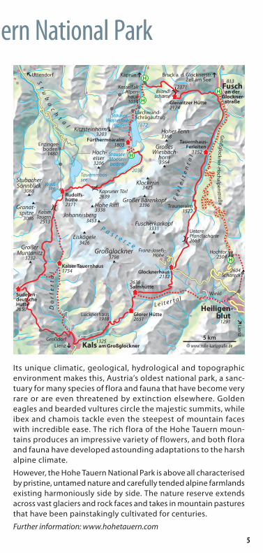
Its unique climatic, geological, hydrological and topographic environment makes this, Austria’s oldest national park, a sanc-tuary for many species of flora and fauna that have become very rare or are even threatened by extinction elsewhere. Golden eagles and bearded vultures circle the majestic summits, while ibex and chamois tackle even the steepest of mountain faces with incredible ease. The rich flora of the Hohe Tauern moun-tains produces an impressive variety of flowers, and both flora and fauna have developed astounding adaptations to the harsh alpine climate.
However, the Hohe Tauern National Park is above all characterised by pristine, untamed nature and carefully tended alpine farmlands existing harmoniously side by side. The nature reserve extends across vast glaciers and rock faces and takes in mountain pastures that have been painstakingly cultivated for centuries.
Further information: www.hohetauern.com
5

Hiking in high alpine terrainThe Glockner Trail is for experienced alpine hikers. While it follows well-marked tracks throughout, it does take hikers into high alpine terrain, for which a good level of fitness, sure-footedness and a head for heights are just as essential as sturdy hiking shoes and adequate equipment.
Times indicated are walking times only and do not take into account any breaks. Altitude differences are given as general guidance only. Consulting maps and guide books is indispensable in planning this hike – this brochure alone will definitely not be sufficient.
Difficulties stated for tracks are given for reasonable (“normal”) weather. However, heavy rain or snow can make tracks difficult or even impassable and hamper orientation. Freezing rain can easily transform rocky sections into insurmountable obstacles. In this case, the only safe option is to take the quickest route to the nearest hut or to descend down into the valley! Be sure to state your next planned stop when registering at huts.
Good to know
Marked mountain tracks
Easy tracks (marked in blue) are mostly narrow. They may include steep sections, but none that pose a risk of falling.
Medium tracks (marked in red) are mostly narrow and frequently steep. They may include sections that pose a risk of falling. They may also include short sections with certain security fixtures such as steel ropes.
Difficult mountain tracks (marked in black) are narrow, frequently steep and pose a risk of falling. They commonly include sections with security fixtures and/or easy rock climbing sections that require hikers to use their hands for stability. These passages absolutely require hikers to be sure-footed and comfortable with heights.
Unmarked terrain
Alpine routes lead into pristine high alpine terrain. They are neither marked nor maintained. Alpine routes require excellent orientation, a sure ability to assess terrain and experience with alpine hiking.
6

Good to know
Good preparation is half the hikeThe following tips should be taken into account in preparing for any alpine hike to make sure you get the most out of it:
� Select tour length and dif-ficulty in keeping with your level of fitness and ability.
� Always adapt tours to the least experienced hiker in the group.
� Check the weather before setting out.
� Check funicular timetables before setting out if planning to use this option.
� Check hut opening times with hut managers if plan-ning to stay overnight.
� Factor in generous times for breaks and book accommo-dation.
� Plan for a return in the early afternoon to leave enough time before dark in case of difficulties.
� Ensure you have adequate equipment.
�Make sure to drink enough water while hiking.
� Set out early on your hike.
� Pack a hat and sunblock for sun protection.
� Pack a First Aid kit.
� Always take an appropriate hiking map on all hikes!
How was your hike?Rate your stay at mountain huts at huettentest.de
Newcomer in the mountains?For tips and information please visit alpenverein.de/at
Current condi-tions, trekking information, a free app and lots more:
7

Alpine emergencies
Alpine distress signalThe alpine distress signal can be used if an alarm cannot be raised by mobile telephone or any other means.
Whistling, shouting and light signals are best.
Distress signal1st minute: Signal once every 10 seconds (6 x per minute)
2nd minute: P a u s e
3rd minute: Continue signalling as in the 1st minute (6 x per minute)
Response:1st minute: Signal once every 20 seconds (3 x per minute)
2nd minute: P a u s e
3rd minute: Continue signalling as in the 1st minute (3 x per minute)
Backpack First AidA First Aid kit should be packed in every backpack to ensure that quick aid can be provided and minor injuries can be treated.
The following is recommended as basic equipment:
Backpack First Aid
Adhesive dressings
Elastic bandage
Sports tape (at least 2.5 cm wide)
Disposable gloves
2 triangular bandages
2 First Aid dressings
Sterile absorbent wound dressing (10 x 10 cm)
Small scissors
2 emergency blankets
Emergency numbersAustrian mountain rescue: 140
European emergency number: 112
Caution: Some emergency calls require an active SIM card!
Once you have called emergency services: � Leave your mobile telephone switched on. �Do not make other calls so you can be contacted by services.
Basic backpack packing rule As much as necessary, as little as possible. Always keep in mind that you will need to carry your backpack across very challenging terrain over extended periods!
8

EquipmentChecklist
Basic equipment
� Hiking boots: secure foot support and protection against water, snow and rocks
� Functional underwear
� Breathable shirt/top
� Fleece jumper or cardigan
� Windproof, water-repellent all-weather jacket with hood
� Long pants made of robust, elastic synthetic fibre material
� Hiking socks or knee socks
� Beanie and gloves
� Lightweight change of underwear
� Backpack, approx. 40 litres for multi-day hikes
� Maps and guides
� Sun protection (sunglasses, sunblock, optional: hat)
� Adequate water (at least 1 litre per day)
� Food
� First Aid kit
� Emergency blanket
� Mobile phone
� Optional: telescopic hiking sticks
Useful extras
� Pocket knife
� Headlamp or torch
� Bivvy bag
For multi-day hikes and staying in huts
� Sleeping bag liner, non-slip socks/slippers
� Change of clothes
� Toiletries and towel
9

Staying overnnight in huts of the alpine associations
Hikers can find food and accommodation in huts of the alpine asso-ciations at the end of most Glockner Trail day sections. These huts are open between about mid-June and late September. During peak season, that is in July and August, it is advisable to book ahead.
As alpine huts are located at high altitudes with extreme climatic conditions and access is therefore generally difficult and expensive, their supply, waste and sewage infrastructure is often only basic. They are equipped and maintained to provide for basic needs in terms of accommodation and food!
Please contact hut keepers for current information, also on dog-friendly accommodation. General, up-to-date information on huts and their opening times is available from alpenvereinaktiv.com.
Staying overnight in huts of the alpine associationsKeep the following rules in mind for your own comfort and that of others:
� Use your own towel, sleeping bag liner and slippers/socks.
� Use water and energy sparingly.
�Minimise rubbish and take your own rubbish with you for disposal in the valley.
�Do not smoke indoors; use ashtrays when smoking outside.
� Read and comply with hut rules and rates displayed.
� Consider the effort required for providing supplies to alpine huts in terms of prices charged for food and bever-ages.
� Luggage is only insured if an accommodation receipt is provided.
10

Staying overnnight in huts of the alpine associations
Legend of hiking signs and symbolsTrack classification Route information
● Easy mountain track ▲ Hazard
● Medium mountain track Total ascent (m)
● Difficult mountain track Total descent (m)
Alpine route Distance (km)
"Taste of the mountains"Huts supporting local suppliers
and offering regional specialties
“Eco-label”Huts with a great environ-
mental record.
“Family-friendly huts” Huts specialised in families.
Legend of hut signs and symbolsActivities Equipment
Hiking Showers available
High alpine hiking Suitable for families
Rock climbing Within mobile range
Via ferrata Seminar facilities available
Mountain biking EC card payment facility
Ski touring Luggage transport facility
I II Hut category (None, 1 or 2)
11

Lärchwand-Inclinator
(1605 m - 2036 m)
Rudolfshütte(2311 m)
Kalser Tauernhaus
(1754 m)
Sudeten-deutsche Hütte
(2650 m)
Glorer Hütte(2651 m)
Salmhütte(2638 m)
Glocknerhaus(2132 m)
Gleiwitzer Hütte(2174 m)
0 km 10 km 20 km 30 km 40 km 50 km 60 km 70 km 80 km 90 km 100 km
1000 m
1500 m
2000 m
2500 m
3000 m
1000 m
1500 m
2000 m
2500 m
3000 m
FürthermoaralmTauernhaus-
Ferleiten
Kaprun Kaprun
Kals
HeiligenblutFerleiten
Fusch
P
The Glockner Trail
En route along the Glockner Trail � An enjoyable, safe Glockner Trail requires not only good equip-ment and a close observation of any weather changes, but also alpine experience, fitness and sure-footedness.
� Some of the day sections involve a total ascent and descent of up to 3000 metres in altitude and hiking times of up to eight hours – excluding breaks!
� Easier or shorter alternatives are often available in addition to the more challenging, longer day sections. These are still very scenic, and hikers feeling in any way insecure should always opt for the safer alternatives.
� Less experienced hikers should only undertake the Glockner Trail with the support of a qualified mountain guide.
� Crossing slopes of hard, old snow is particularly hazardous even in late summer, especially in steep gullies. Always carry full or lightweight crampons in your backpack when hiking during these periods.
� The Glockner Trail can only be completed during the summer months, when the alpine huts in the region are open. It is highly recommended to book accommodation ahead.
� If you are planning to complete the Glockner Trail with your
12

Lärchwand-Inclinator
(1605 m - 2036 m)
Rudolfshütte(2311 m)
Kalser Tauernhaus
(1754 m)
Sudeten-deutsche Hütte
(2650 m)
Glorer Hütte(2651 m)
Salmhütte(2638 m)
Glocknerhaus(2132 m)
Gleiwitzer Hütte(2174 m)
0 km 10 km 20 km 30 km 40 km 50 km 60 km 70 km 80 km 90 km 100 km
1000 m
1500 m
2000 m
2500 m
3000 m
1000 m
1500 m
2000 m
2500 m
3000 m
FürthermoaralmTauernhaus-
Ferleiten
Kaprun Kaprun
Kals
HeiligenblutFerleiten
Fusch
P
The Glockner Trail
dog, always confirm that hut or inn hut keepers allow dogs when booking your accommodation.
� For detailed information on the Glockner Trail please visit alpenvereinaktiv.com.
The Glockner Trail can also be booked as an all-inclusive package through a special service provided by the Hohe Tauern National Park tourism region (Salzburg). Visit www.glocknerrunde.at.
13

Starting from the Kaprun glacier funicular parking lot, take the Lärchwand inclinator and a bus to arrive in comfort at the Moo-serboden reservoir (2036 m), the starting point for the Glockner Trail hike. Walk across the top of the dam, then follow track No. 716 along the lake to the head of the valley. This track starts out flat and then leads across a distinctive moraine ridge in a number of bends. Follow the moraine trough high above the valley. Below Kapruner Törl (2639 m), the terrain becomes steeper and features loose slabs of rock. ▲ Traversing this section can be challenging even in late summer, due to residual, hard snow. Be very careful about the possibility of slipping and falling on the loose slabs of rock!
Follow a well-maintained track from Kapruner Törl down to the Übelkar cirque. Pass Vorderes Eisbichl and then descend a little more steeply to the Tauernmoossee Lake and the turquoise waters of the Ödenwinkelkees glacial stream. Cross this stream via the Gaulmösel-steg bridge (2018 m). The next section is a pleasant hike to a fork in the track: Take either the shorter, but steeper “Stone Stairway”, which is secured with a steel rope and ladder, or the somewhat longer, but gentler alternative via Hinteres Schafbichl (about 1 hour longer). Both take you to Berghotel Rudolfshütte.▲ ● ≈ 915 m alt. ≈ 630 m alt.; hiking time: approx. 6 hrs
Note: Accommodation is also available at Fürthermoaralm (1803 m), located between the Wasserfallboden and Mooserboden reservoirs. This is also another option for starting your hike. From there, the ascent to the start of the Trail at the Mooserboden reservoir is about 45 minutes (200 m altitude).
Day 1Kaprun Rudolfshütte(786 m) (2311 m)
14
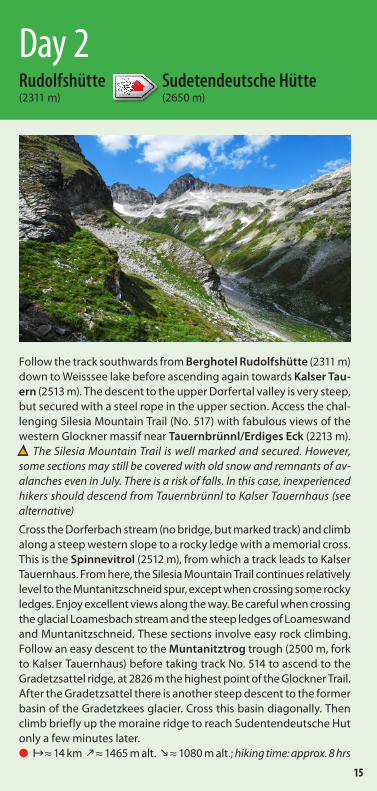
Follow the track southwards from Berghotel Rudolfshütte (2311 m) down to Weisssee lake before ascending again towards Kalser Tau-ern (2513 m). The descent to the upper Dorfertal valley is very steep, but secured with a steel rope in the upper section. Access the chal-lenging Silesia Mountain Trail (No. 517) with fabulous views of the western Glockner massif near Tauernbrünnl/Erdiges Eck (2213 m).▲ The Silesia Mountain Trail is well marked and secured. However, some sections may still be covered with old snow and remnants of av-alanches even in July. There is a risk of falls. In this case, inexperienced hikers should descend from Tauernbrünnl to Kalser Tauernhaus (see alternative)
Cross the Dorferbach stream (no bridge, but marked track) and climb along a steep western slope to a rocky ledge with a memorial cross. This is the Spinnevitrol (2512 m), from which a track leads to Kalser Tauernhaus. From here, the Silesia Mountain Trail continues relatively level to the Muntanitzschneid spur, except when crossing some rocky ledges. Enjoy excellent views along the way. Be careful when crossing the glacial Loamesbach stream and the steep ledges of Loameswand and Muntanitzschneid. These sections involve easy rock climbing. Follow an easy descent to the Muntanitztrog trough (2500 m, fork to Kalser Tauernhaus) before taking track No. 514 to ascend to the Gradetzsattel ridge, at 2826 m the highest point of the Glockner Trail. After the Gradetzsattel there is another steep descent to the former basin of the Gradetzkees glacier. Cross this basin diagonally. Then climb briefly up the moraine ridge to reach Sudentendeutsche Hut only a few minutes later.● ≈ 14 km ≈ 1465 m alt. ≈ 1080 m alt.; hiking time: approx. 8 hrs
Day 2Rudolfshütte Sudetendeutsche Hütte(2311 m) (2650 m)
15

From Sudetendeutsche Hut, retrace your steps from the day be-fore until you reach the fork for the Sudetendeutsche Mountain Trail (No. 502B). Continue along an easy track to the Stellachkar cirque (2790 m) and then along a via ferrata to the Dürrenfeldscharte saddle (2823 m). On the other side of the saddle, descend the bends down to the gently sloped Dürrenfeld valley. The track then be-comes steeper again and passes through rocky terrain below the Tschadinhörndl peak.▲ Residual, hard snow can make traversing the steep gully below Tschadinhörndl difficult even in mid-summer!
Here, steep rocky slopes alternate with alpine meadows, and you may already be able to see the wide, grassy saddle of Hohes Tor (2477 m) in the distance. Continue along track No. 516 (Aussig-Teplitz Track) underneath the Drillingschneid, Blauer Knopf and steep Blauspitze peaks. The track initially undulates gently and then descends to the “Chapel for Ill-Fated Mountaineers” (2080 m) and the Glocknerblick restaurant, offering views of Kals along the way. Track No. 516 (Flow-er and Herb Nature Trail) then continues in bends through steep pine and larch forests, sometimes also passing ski slopes, down to Kals-Grossdorf. The centre of Kals am Grossglockner (1325 m) is only about another kilometre away. ● ≈ 12 km ≈ 243 m alt. ≈ 1530 m alt.; hiking time: approx. 5½ hrs
Day 3Sudetendeutsche Hütte Kals(2650 m) (1325 m)
16

▲ When choosing this option, the very long section to Sudetendeutsche Hut, which can be challenging in early summer due to residual snow, can be either avoided altogether or split into two shorter sections. This, of course, requires an additional day for the overall hike. As noted in the description for Day 2, continue from Berghotel Ru-dolfshütte via Kalser Tauern (2513 m) to the Upper Dorfertal val-ley and Tauernbrünnl/Erdiges Eck. From there, bypass the Silesia Mountain Trail and instead hike along Dorfer Lake and then down to Kalser Tauernhaus (1754 m) through a rugged landslide field. ● ≈ 9 km ≈ 265 m alt. ≈ 800 m alt.; hiking time: approx. 3½ hrs
From Kalser Tauernhaus, hikers can descend straight to Kals through the Dorfertal valley and Drabaschlucht gorge.● ≈ 10 km ≈ 50 m alt. ≈ 480 m alt.; hiking time: approx. 3 hrs
Alternatively, they can ascend again from Kalser Tauernhaus to the Silesia Mountain Trail and Sudetendeutsche Hut. This track follows the Stotzbach stream in innumerable bends, until it eventually forks. Continue south below the Muntanitzschneid spur and then rejoin the Silesia Mountain Trail at the Muntanitztrog trough. Cross the Gradetzsattel saddle and follow the trail to Sudetendeutsche Hut as in the description for Day 2. Continue with Day 3 the next day.● ≈ 7 km ≈ 1100 m alt. ≈ 190 m alt.; hiking time: approx. 4 hrs
Variation Alternative to Days 2/3Rudolfshütte Kalser Tauernhaus Kals(2311 m) (1754 m) (1325 m)
17
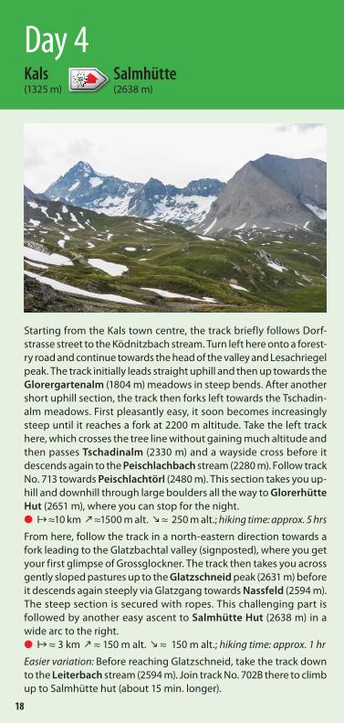
Starting from the Kals town centre, the track briefly follows Dorf-strasse street to the Ködnitzbach stream. Turn left here onto a forest-ry road and continue towards the head of the valley and Lesach riegel peak. The track initially leads straight uphill and then up towards the Glorergartenalm (1804 m) meadows in steep bends. After another short uphill section, the track then forks left towards the Tschadin-alm meadows. First pleasantly easy, it soon becomes increasingly steep until it reaches a fork at 2200 m altitude. Take the left track here, which crosses the tree line without gaining much altitude and then passes Tschadinalm (2330 m) and a wayside cross before it descends again to the Peischlachbach stream (2280 m). Follow track No. 713 towards Peischlachtörl (2480 m). This section takes you up-hill and downhill through large boulders all the way to Glorerhütte Hut (2651 m), where you can stop for the night.● ≈10 km ≈1500 m alt. ≈ 250 m alt.; hiking time: approx. 5 hrs
From here, follow the track in a north-eastern direction towards a fork leading to the Glatzbachtal valley (signposted), where you get your first glimpse of Grossglockner. The track then takes you across gently sloped pastures up to the Glatzschneid peak (2631 m) before it descends again steeply via Glatzgang towards Nassfeld (2594 m). The steep section is secured with ropes. This challenging part is followed by another easy ascent to Salmhütte Hut (2638 m) in a wide arc to the right. ● ≈ 3 km ≈ 150 m alt. ≈ 150 m alt.; hiking time: approx. 1 hr
Easier variation: Before reaching Glatzschneid, take the track down to the Leiterbach stream (2594 m). Join track No. 702B there to climb up to Salmhütte hut (about 15 min. longer).
Day 4Kals Salmhütte(1325 m) (2638 m)
18

The Vienna Mountain Trail (track No. 741) gently descends from Salmhütte Hut across alpine meadows that are often ablaze with colour and flowers. It then ascends again briefly towards Stocker-scharte (2501 m) saddle. The Schwerteck and Schwertkopf peaks, two geologically fascinating formations, are of particular interest here, as is the view to the Leitertal valley far below. Edelweiss and gentian are often found along the track. The view down to the Pas-terze glacier and across to Grossglockner and Johannisberg on the other side of the valley are equally impressive. A number of bends in the track – some of them steep – take hikers down to the Marga-ritzenstausee reservoir (2000 m). The track crosses the dam and then climbs a little on the other side to reach Glocknerhaus Hut (2132 m) on the Grossglockner High Alpine Road.● ≈ 7 km ≈ 300 m alt. ≈ 800 m alt.; hiking time: approx. 3 hrs
Day 5Salmhütte Glocknerhaus(2638 m) (2132 m)
19
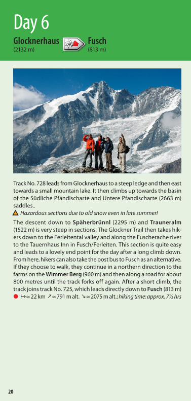
Track No. 728 leads from Glocknerhaus to a steep ledge and then east towards a small mountain lake. It then climbs up towards the basin of the Südliche Pfandlscharte and Untere Pfandlscharte (2663 m) saddles..▲ Hazardous sections due to old snow even in late summer!
The descent down to Späherbrünnl (2295 m) and Trauneralm (1522 m) is very steep in sections. The Glockner Trail then takes hik-ers down to the Ferleitental valley and along the Fuscherache river to the Tauernhaus Inn in Fusch/Ferleiten. This section is quite easy and leads to a lovely end point for the day after a long climb down. From here, hikers can also take the post bus to Fusch as an alternative. If they choose to walk, they continue in a northern direction to the farms on the Wimmer Berg (960 m) and then along a road for about 800 metres until the track forks off again. After a short climb, the track joins track No. 725, which leads directly down to Fusch (813 m)● ≈ 22 km ≈ 791 m alt. ≈ 2075 m alt.; hiking time: approx. 7½ hrs
Day 6Glocknerhaus Fusch(2132 m) (813 m)
20

▲ Hard residual snow can be found in the northern section of this hike, even in late summer, particularly near Pfandlscharte. In case of doubt, the alternative route via Heiligenblut is recommended in order to avoid these hazardous sections.
From Salmhütte Hut (end of Day 4), descend straight down to Heili-genblut through the beautifully scenic Leitertal valley. Follow the Graf Salm track down to the Leiterbach stream and hike across pic-turesque alpine meadows to Trogalm, then continue down towards Heiligenblut (1291 m) past Winkl village. ● ≈ 11 km ≈ 65 m alt. ≈ 1410 m alt.; hiking time: approx. 4½ hrs
The Grossglockner funicular takes hikers from Heiligenblut to the top station (2593 m), from which they continue hiking towards Schareck (2604 m), their first stop. From there, the Geo-Trail Tauernfenster Nature Trail takes them through geologically fascinating terrain down to the Mauskarscharte saddle (2507 m). The track initially descends gently and is secured with ropes in its steeper sections. It then continues from the saddle towards Rossköpfl (2588 m), but veers around to the right to bypass this peak before taking hikers up to Tauernkopf (2626 m). Then it is only a short descent to the Hochtor pass (2575 m) and the southern access to the Glocknerstrasse road, from where hikers can take a post bus to Ferleiten or Fusch.● ≈ 4 km ≈ 177 m alt. ≈ 223 m alt.; hiking time: approx. 3 hrs
Variation Alternative to Days 5/6Salmhütte Heiligenblut Fusch(2638 m) (1291 m) (813 m)
21

From the centre of Fusch, walk past the church in a south-western direction towards the Hirzbachtal valley. The short detour to the Hirzbach waterfall is a worthwhile scenic detour. Then follow track No. 725 through steep terrain up to Feistalpl and the narrow Gra-benschlucht gorge, where you cross the Hirzbach stream and keep climbing up to Hirzbachalm (1715 m). Veer left to reach a wayside cross following an easy climb. The track then leads up in numerous bends and finally reaches wide alpine meadows with a unique flora. This is the scenic location of beautiful Gleiwitzer Hut (2174 m), where hikers can choose to end this section. If staying overnight at this hut, there may even be enough time for a detour to the Imbachhorn peak (2470 m, about 1 hour ascent), which offers supreme views. ● ≈ 8 km ≈ 1350 m alt. ≈ 100 m alt.; hiking time: approx. 3½ hrs
From Gleiwitzer Hut, take track No. 723 north for a short distance until the track forks. Keep to the left and climb steeply up to the Südliche Brandlscharte (2371 m) saddle, which offers a fabulous view of Brandlsee lake. Continue on via the north-western ridge and descend to Harleitenalm past Rosskopf (1999 m) before following the winding track across flower-laced mountain pastures down to the parking lot of the Kaprun glacier funicular (911 m). If you did not travel by car, take the bus back to Kaprun or Alpenhaus Kesselfall.● ≈ 10 km ≈ 330 m alt. ≈ 1580 m alt.; hiking time: approx. 5½ hrs
Day 7Fusch Kaprun(813 m) (911 m)
22

Alternative accommodationKaprun/reservoirs starting point:Fürthermoaralm (1803 m)Opening times: early June to mid-September Tel.: 0043/(0)6547/7158 - 234 35 [email protected] www.fuerthermoar.at
Day 3Kals Tourist Information Ködnitz 7 A-9981 Kals a. Großglockner Tel.: 0043/(0)50212/540 [email protected] www.kals.at
Day 5Heiligenblut Tourism Association Hof 4 A-9844 Heiligenblut Tel.: 0043/(0)4824/20 01 [email protected] www.heiligenblut.at
Day 6Grossglockner-Zellersee Tourist Information Raiffeisenstraße 2 A-5671 Bruck-Fusch Tel.: 0043/(0)6545/72 95 [email protected] www.grossglockner-zellersee.info
Cable cars/funicularsKaprun, Lärchwand Inclinator Tel.: 0043/(0)503/132 32 01 [email protected] www.verbund.com
Grossglockner Funicular Hof 94 A-9844 Heiligenblut Tel.: 0043/(0)4824/22 88 [email protected] www.grossglockner.at
Additional information
23

Open June to September
Contact Hut keeper: Jenny Wiesalla Tel.: 0043/(0)6563/82 21 [email protected] www.rudolfshuette.at
AccessFrom Uttendorf/Enzingerboden (1480 m) take the cable car straight to the hut. Hike from Enzingerboden following track No. 715 to Grünsee lake and on to Weisssee lake and Rudolfshütte Hut. ● Hiking time: approx. 3 hrs
Nearby hutsOberwalder Hütte (2973 m); ● Hiking time: approx. 6 hrs
Kalser Tauernhaus (1754 m); ● Hiking time: approx. 3½ hrs
Sudetendeutsche Hütte (2650 m); ● Hiking time: approx. 8 hrs
PeaksGranatspitze (3086 m); Ascent: approx. 2½ hrs
Stubacher Sonnblick (3088 m); Ascent: approx. 2½ hrs
Tauernkogel (2683 m); ● Ascent: approx. 2 hrs
Medelzkopf (2761 m); ● Aufstieg: ca. 2 hrs
Rudolfshütte (2311 m) Equipment
ActivitiesPrivate
UTM (WGS84): 33T Ost 319938 / Nord 5222825B/L (WGS84): N 47° 08' 3,5" / E 12° 37' 32"
IIAlpine hotelDouble/twin/multi-bed 200
Dormitory 52 Winter room dormitory 0
24

Open Late June to mid-September
Contact Hut keepers: Carol Freisleben and Felix Meier Tel.Hut: 0043/(0)720/34 78 02 Tel. Valley: 0049/(0)94 09/317 04 34 (during off-season) [email protected] www.sudetendeutsche-huette.de www.alpenverein-schwaben.de
AccessFrom Felbertauernstüberl (1160 m) via Steineralm (1909 m); ● Hiking time: approx. 4 ½ hrs
From Glanz (1545 m) or Weiler Stein (1344 m) via Steiner alm (1909 m); ● Hiking time: approx. 4 hrs
From Kals to Adlerlounge by funicular (2405 m) or from Matrei to the top station of the Goldried cable car (2190 m) then via Kals-Matreier-Törl (2207 m); ● Hiking time: approx. 4 ½ hrs
Nearby hutsKalser Tauernhaus (1754 m); ● Hiking time: approx. 4 hrs
Rudolfshütte (2311 m); ● Hiking time: approx. 8 hrs
PeaksGlocknerblick (2800 m); ● Ascent: approx. ½ hrs
Großer Muntanitz (3232 m) via Wellachköpf; ● Ascent: approx. 2½ hrs
Gradetzspitz (3063 m); ● Ascent: approx. 1 hr
Vorderer Kendlspitz (3076 m); ● Ascent: approx. 2 hrs
Sudetendeutsche Hütte (2650 m) Equipment
ActivitiesDAV-Sektion Schwaben
UTM (WGS84): 33T Ost 0315909 / Nord 5215280B/L (WGS84): N 47° 02' 57" / E 12° 34' 34"
IManaged hutDormitory room 20
Dormitory 32 Winter room dormitory 12
25

Open Early June to mid-October
Contact Hut keepers: Gerlinde and Peter Gilber Tel.: 0043/(0)4876/83 93 or 0043/(0)664/985 70 90 [email protected] www.kalser-tauernhaus.de
AccessFrom Kals/Taurer (1521 m); ● Hiking time: approx. 1½ hrs
Nearby hutsRudolfshütte (2311 m); ● Hiking time: approx. 4 hrs
Sudetendeutsche Hütte (2650 m); ● Hiking time: approx. 4½ hrs
Stüdlhütte (2801 m); ● Hiking time: approx. 5½ hrs
PeaksSpinnevitrolkopf (2483 m) ● Ascent: approx. 2½ hrs
Medelzkopf (2761 m) ● Ascent: approx. 4 hrs
Kalser Tauernhaus (1754 m) Equipment
ActivitiesDAV-Sektion Mönchengladbach
UTM (WGS84): 33T Ost 0319597 / Nord 5215751B/L (WGS84): N 47° 04' 14" / E 12° 37' 26"
IManaged hutDormitory room 20
Dormitory 30
26

Open Early June to early October
Contact Hut keeper: Alfred Graf Tel.: 0043/(0)664/303 22 00 www.dav-eichstaett.de
AccessFrom Kals/Lucknerhaus (1920 m); ● Hiking time: approx. 2 hrs
Nearby hutsSalmhütte (2644 m) ● Hiking time: approx. 1 hr
Stüdlhütte (2801 m) ● Hiking time: approx. 2½ hrs
Lucknerhütte (2241 m) ● Hiking time: approx. 2½ hrs
PeaksMedlspitze (2678 m) ● Ascent: approx. 30 min.
Großglockner (3798 m) Ascent: approx. 6½ hrs
Böses Weibl (3121 m) ● Ascent: approx. 4 hrs
Glorer Hütte (2651 m) Equipment
ActivitiesDAV-Sektion Eichstätt
UTM (WGS84): 33T Ost 0326433 / Nord 5211149B/L (WGS84): N 47° 01' 51" / E 12° 42' 56"
IManaged hutDormitory room 12
Dormitory 37 Winter room dormitory 4
27

Open Mid-June to late September
Contact Hut keeper: Helga Pratl Tel.: 0043/(0)4824/2089 [email protected] www.alpenverein.at/salmhuette
AccessFrom Kals/Lucknerhaus (1920 m); ● Hiking time: approx. 2½ hrs
Nearby hutsGlocknerhaus (2132 m) via Stockerscharte (2465 m); ● Hiking time: approx. 2½ hrs
Glorerhütte (2642 m) via Glatzschneid (2650 m); ● Hiking time: approx. 1 hr
Stüdlhütte (2801 m) via Pfortscharte (2828 m); ● Hiking time: approx. 3 hrs
Erzherzog-Johann-Hütte (3451 m) via Hohenwartscharte; Hiking time: approx. 3½ hrs
PeaksGroßglockner (3798 m) Ascent: approx. 5 hrs
Hinterer Leiterkopf (2891 m) ● Ascent: approx. 2 hrs
Schwerteck (3247 m) Ascent: approx. 2 hrs
Salmhütte (2638 m) Equipment
ActivitiesÖAV-Sektion Wien
UTM (WGS84): 33T Ost 0326866 / Nord 5212908B/L (WGS84): N 47° 02' 49" / E 12° 43' 14"
IManaged hutDormitory room 22
Dormitory 30 Winter room dormitory 6
28

Open Mid-May to late October
Contact Tel. Hut: 0043/(0)4824/246 66 Tel. hut keeper Helmut Schlager: 0043/(0)664/201 45 95 [email protected] www.glocknerhaus-alpincenter.at
AccessToll road all the way to the hut
Nearby hutsOberwalderhütte (2973 m); ● Hiking time: approx. 3 hrs
Salmhütte (2644 m) ● Hiking time: approx. 3 hrs
PeaksGroßglockner (3798 m) Ascent: approx. 6½ hrs
Racherin (3093 m) ● Ascent: approx. 3 hrs
Spielmann (3027 m) ● Ascent: approx. 3 hrs
Hinterer Leiterkopf (2891 m) ● Ascent: approx. 3 hrs
Glocknerhaus (1520 m) Equipment
ActivitiesÖAV-Sektion Klagenfurt
UTM (WGS84): 33T Ost 330566 / Nord 5215320B/L (WGS84): N 47° 04' 18" / E 12° 46' 10"
Managed hutDormitory room 48
Dormitory 40
II
29

Open Early May to late October
Contact Hut keeper: Family Unterberger Tel.: 0043/(0)664/158 01 00 www.tauernhaus-ferleiten.at
Nearby hutsSchwarzenberghütte (2267 m) ● Hiking time: approx. 3½ hrs
Gleiwitzer Hütte (2174 m) ● Hiking time: approx. 5 hrs
Glocknerhaus (2135 m) ● Hiking time: approx. 7½ hrs
PeaksGroßes Wiesbachhorn (3564 m) via Schwarzenberghütte ● Ascent: approx. 9 hrs
Hoher Tenn (3368 m) ● Ascent: approx. 4 hrs
Hohe Dock (3348 m) ● Ascent: approx. 6½ hrs
Pfandlscharte (2663 m) ● Ascent: approx. 5 hrs
Tauernhaus-Ferleiten (1152 m) Equipment
ActivitiesPrivate
UTM (WGS84): 33T Ost 334122 / Nord 5226281B/L (WGS84): N 47° 10' 08" / E 12° 12' 40"
InnDouble/twin rooms 2
Holiday home 4
30

Open Mid-June to early October
Contact Hut keepers: Antje Böttcher, Wolfgang Kräh Tel.: 0043/(0)664/929 49 89 [email protected] www.gleiwitzerhuette.at
AccessFrom Fusch (1521 m); ● Hiking time: approx. 3½ hrs
Nearby hutsHeinrich-Schwaiger-Haus (2802 m) ● Hiking time: approx. 8 hrs
PeaksImbachhorn (2470 m) ● Ascent: approx. 1 hr
Rettenzink (2510 m) ● Ascent: approx. 1 hr
Bauernbrachkogel (3125 m) ● Ascent: approx. 3½ hrs
Hoher Tenn (3368 m) ● Ascent: approx. 4½ hrs
Gleiwitzer Hütte (2174 m) Equipment
ActivitiesDAV-Sektion Tittmoning
UTM (WGS84): 33T Ost 331086 / Nord 5231826B/L (WGS84): N 47° 13' 10" / E 12° 46' 13"
Managed hutDormitory room 19
Dormitory 32 Winter room dormitory 12
31

Published by: Deutscher Alpenverein e.V., Von-Kahr-Straße 2-4, 80997 München, Tel. 089/140 03-0, [email protected], www.alpenverein.de | Photo credits: DAV section archive | Editor: Silvia Schmid | Design: Gschwendtner & Partner, www.gschwendtner-partner.de | Print: Kastner & Callwey Medien GmbH, Forst-inning | Auflage: 15,100 copies, March 2017
InformationenMaps and guidesAA map Granatspitzgruppe; sheet 39, 1:25.000 AA map Glocknergruppe; sheet 40, 1:25.000 AA map Schobergruppe; sheet 41, 1:25.000Freytag & Berndt Großglockner-Kaprun-Zell am See; WK 122, 1:50.000KOMPASS Matrei in Osttirol; WK 46, 1:50.000
AA Guide Glockner- und Grantaspitzgruppe; Willi End/Hubert Peterka, Bergverlag Rother, München
This brochure provides a general overview of the Glockner Trail and huts and other accommodation on the way. It cannot replace detailed consultation of maps and guide books.
Bookings and tourist informationNational Park Tourism Region Hohe Tauern GmbH Gerlosstrasse 18 A-5730 Mittersill Tel.: 0043/(0)6562/409 39 [email protected] www.nationalpark.at www.glocknerrunde.at
Tourist informationHohe Tauern – Nationalpark-Region Kärnten Tourismus GmbH Hof 4 A-9844 Heiligenblut am Großglockner Tel.: 0043/(0)4824/27 00 [email protected] www.nationalpark-hohetauern.at
Tourismusinformation Hohe Tauern National Park East Tyrol Rauterplatz 1 A-9971 Matrei i.O. Tel.: 0043/(0)50/21 25 00 [email protected] www.osttirol-nationalpark.at