
HISTORIC RESOURCES INVENTORY - BUILDING … RESOURCES INVENTORY - BUILDING AND STRUCTURES-1- ......
18
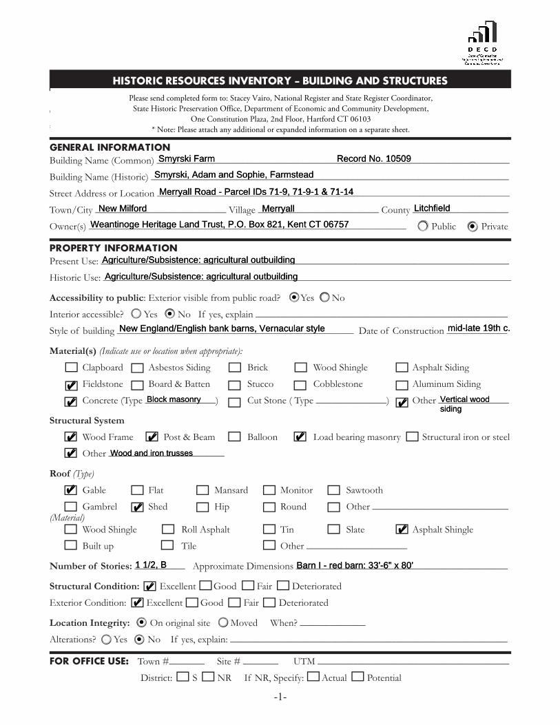
HISTORIC RESOURCES INVENTORY - BUILDING AND STRUCTURES -1- GENERAL INFORMATION Building Name (Common) ______________________________________________________________________ Building Name (Historic) _______________________________________________________________________ Street Address or Location ______________________________________________________________________ Town/City __________________________ Village ________________________ County ___________________ Owner(s) _______________________________________________________________ Public Private PROPERTY INFORMATION Present Use: _________________________________________________________________________________ Historic Use: _________________________________________________________________________________ Accessibility to public: Exterior visible from public road? Yes No Interior accessible? Yes No If yes, explain __________________________________________________ Style of building _______________________________________________ Date of Construction ____________ Material(s) (Indicate use or location when appropriate): Clapboard Asbestos Siding Brick Wood Shingle Asphalt Siding Fieldstone Board & Batten Stucco Cobblestone Aluminum Siding Concrete (Type ______________) Cut Stone ( Type ______________) Other ______________ Structural System Wood Frame Post & Beam Balloon Load bearing masonry Structural iron or steel Other _______________________ Roof (Type) Gable Flat Mansard Monitor Sawtooth Gambrel Shed Hip Round Other ___________________________ (Material) Wood Shingle Roll Asphalt Tin Slate Asphalt Shingle Built up Tile Other ____________________ Number of Stories: __________ Approximate Dimensions __________________________________________ Structural Condition: Excellent Good Fair Deteriorated Exterior Condition: Excellent Good Fair Deteriorated Location Integrity: On original site Moved When? _____________ Alterations? Yes No If yes, explain: _______________________________________________________ FOR OFFICE USE: Town #_______ Site # _______ UTM ______________________________________ District: S NR If NR, Specify: Actual Potential Smyrski Farm Record No. 10509 Smyrski, Adam and Sophie, Farmstead Merryall Road - Parcel IDs 71-9, 71-9-1 & 71-14 New Milford Merryall Litchfield Weantinoge Heritage Land Trust, P.O. Box 821, Kent CT 06757 Agriculture/Subsistence: agricultural outbuilding Agriculture/Subsistence: agricultural outbuilding New England/English bank barns, Vernacular style mid-late 19th c. Block masonry Vertical wood siding Wood and iron trusses 1 1/2, B Barn I - red barn: 33'-6" x 80' Please send completed form to: Stacey Vairo, National Register and State Register Coordinator, State Historic Preservation Office, Department of Economic and Community Development, One Constitution Plaza, 2nd Floor, Hartford CT 06103 * Note: Please attach any additional or expanded information on a separate sheet. Smyrski Farm Record No. 10509 Smyrski, Adam and Sophie, Farmstead Merryall Road - Parcel IDs 71-9, 71-9-1 & 71-14 New Milford Merryall Litchfield Weantinoge Heritage Land Trust, P.O. Box 821, Kent CT 06757 Agriculture/Subsistence: agricultural outbuilding Agriculture/Subsistence: agricultural outbuilding New England/English bank barns, Vernacular style mid-late 19th c. ✔ ✔ Block masonry ✔ Vertical wood siding ✔ ✔ ✔ ✔ Wood and iron trusses ✔ ✔ ✔ 1 1/2, B Barn I - red barn: 33'-6" x 80' ✔ ✔
Transcript of HISTORIC RESOURCES INVENTORY - BUILDING … RESOURCES INVENTORY - BUILDING AND STRUCTURES-1- ......
HISTORIC RESOURCES INVENTORY - BUILDING AND STRUCTURES
-1-
Connecticut Commission on Culture & Tourism, One Constitution Plaza, 2nd Floor, Hartford, CT 06103
* Note: Please attach any additional or expanded information on a separate sheet.
GENERAL INFORMATIONBuilding Name (Common) ______________________________________________________________________
Building Name (Historic) _______________________________________________________________________
Street Address or Location ______________________________________________________________________
Town/City __________________________ Village ________________________ County ___________________
Owner(s) _______________________________________________________________ Public Private
PROPERTY INFORMATIONPresent Use: _________________________________________________________________________________
Historic Use: _________________________________________________________________________________
Accessibility to public: Exterior visible from public road? Yes No
Interior accessible? Yes No If yes, explain __________________________________________________
Style of building _______________________________________________ Date of Construction ____________
Material(s) (Indicate use or location when appropriate):
Clapboard Asbestos Siding Brick Wood Shingle Asphalt Siding
Fieldstone Board & Batten Stucco Cobblestone Aluminum Siding
Concrete (Type ______________) Cut Stone ( Type ______________) Other ______________
Structural System
Wood Frame Post & Beam Balloon Load bearing masonry Structural iron or steel
Other _______________________
Roof (Type)
Gable Flat Mansard Monitor Sawtooth
Gambrel Shed Hip Round Other ___________________________(Material) Wood Shingle Roll Asphalt Tin Slate Asphalt Shingle
Built up Tile Other ____________________
Number of Stories: __________ Approximate Dimensions __________________________________________
Structural Condition: Excellent Good Fair Deteriorated
Exterior Condition: Excellent Good Fair Deteriorated
Location Integrity: On original site Moved When? _____________
Alterations? Yes No If yes, explain: _______________________________________________________
FOR OFFICE USE: Town #_______ Site # _______ UTM ______________________________________
District: S NR If NR, Specify: Actual Potential
Please send completed form to: Stacey Vairo, National Register and State Register Coordinator, State Historic Preservation Office, Department of Economic and Community Development,
One Constitution Plaza, 2nd Floor, Hartford CT 06103 * Note: Please attach any additional or expanded information on a separate sheet.
Smyrski Farm Record No. 10509
Smyrski, Adam and Sophie, Farmstead
Merryall Road - Parcel IDs 71-9, 71-9-1 & 71-14
New Milford Merryall Litchfield
Weantinoge Heritage Land Trust, P.O. Box 821, Kent CT 06757
Agriculture/Subsistence: agricultural outbuilding
Agriculture/Subsistence: agricultural outbuilding
New England/English bank barns, Vernacular style mid-late 19th c.
✔
✔ Block masonry ✔ Vertical woodsiding
✔ ✔ ✔
✔ Wood and iron trusses
✔
✔
✔
1 1/2, B Barn I - red barn: 33'-6" x 80'
✔
✔
Please send completed form to: Stacey Vairo, National Register and State Register Coordinator, State Historic Preservation Office, Department of Economic and Community Development,
One Constitution Plaza, 2nd Floor, Hartford CT 06103 * Note: Please attach any additional or expanded information on a separate sheet.
Smyrski Farm Record No. 10509
Smyrski, Adam and Sophie, Farmstead
Merryall Road - Parcel IDs 71-9, 71-9-1 & 71-14
New Milford Merryall Litchfield
Weantinoge Heritage Land Trust, P.O. Box 821, Kent CT 06757
Agriculture/Subsistence: agricultural outbuilding
Agriculture/Subsistence: agricultural outbuilding
New England/English bank barns, Vernacular style mid-late 19th c.
✔
✔ Block masonry ✔ Vertical wood siding
✔ ✔ ✔
✔ Wood and iron trusses
✔
✔
✔
1 1/2, B Barn I - red barn: 33'-6" x 80'
✔
✔

-2-
Historic Resources Inventory
PROPERTY INFORMATION (CONT’D)
Related outbuildings or landscape features: Barn Shed Garage Carriage House Shop Garden Other landscape features or buildings: _______________________________________________________
Surrounding Environment:
Open land Woodland Residential Commercial Industrial Rural
High building density Scattered buildings visible from site
• Interrelationship of building and surroundings:
• Other notable features of building or site (Interior and/or Exterior)
Architect ______________________________________ Builder _______________________________________
• Historical or Architectural importance:
• Sources:
Photographer __________________________________________________________ Date _________________
View __________________________________________________________ Negative on File _______________
Name ________________________________________________________________ Date _________________
Organization ________________________________________________________________________________
Address ____________________________________________________________________________________
• Subsequent fi eld evaluations:
Threats to the building or site:
None known Highways Vandalism Developers Renewal Private
Deterioration Zoning Other ________________ Explanation ________________
Merryall Road, New Milford CT Record No. 10509
✔ Stone walls, cupola, stream, pasture fencing
✔ ✔ ✔
✔
See continuation sheet.
See continuation sheet.
See continuation sheet.
Cunningham, Jan, Connecticut's Agricultural Heritage: an Architectural and Historical Overview, Connecticut Trust for HistoricPreservation & State Historic Preservation Office, 2012.
See continuation sheet.
Charlotte Hitchcock 11/20/2012
Multiple Views CTHP
Charlotte Hitchcock 12/04/2012
Connecticut Trust for Historic Preservation
940 Whitney Avenue, Hamden CT 06517
Latitude, Longitude:Red barn: 41.639212, -73.417468 White barns: 41.637288, -73.416781
✔
Merryall Road, New Milford CT Record No. 10509
✔ Stone walls, cupola, stream, pasture fencing
✔ ✔ ✔
✔
See continuation sheet.
See continuation sheet.
See continuation sheet.
Cunningham, Jan, Connecticut's Agricultural Heritage: an Architectural and Historical Overview, Connecticut Trust for Historic Preservation & State Historic Preservation Office, 2012. See continuation sheet.
Charlotte Hitchcock 11/20/2012
Multiple Views CTHP
Charlotte Hitchcock 12/04/2012
Connecticut Trust for Historic Preservation
940 Whitney Avenue, Hamden CT 06517
Latitude, Longitude: Red barn: 41.639212, -73.417468 White barns: 41.637288, -73.416781
✔
Connecticut State Historic Preservation Office, Department of Economic and Community Development One Constitution Plaza, 2nd Floor, Hartford CT 06103
HISTORIC RESOURCES INVENTORY FORM – BUILDING AND STRUCTURES continuation sheet 228 Merryall Road, New Milford CT Record No. 10509 3 ______________________________________________________________________________
• Interrelationship of building and surroundings:
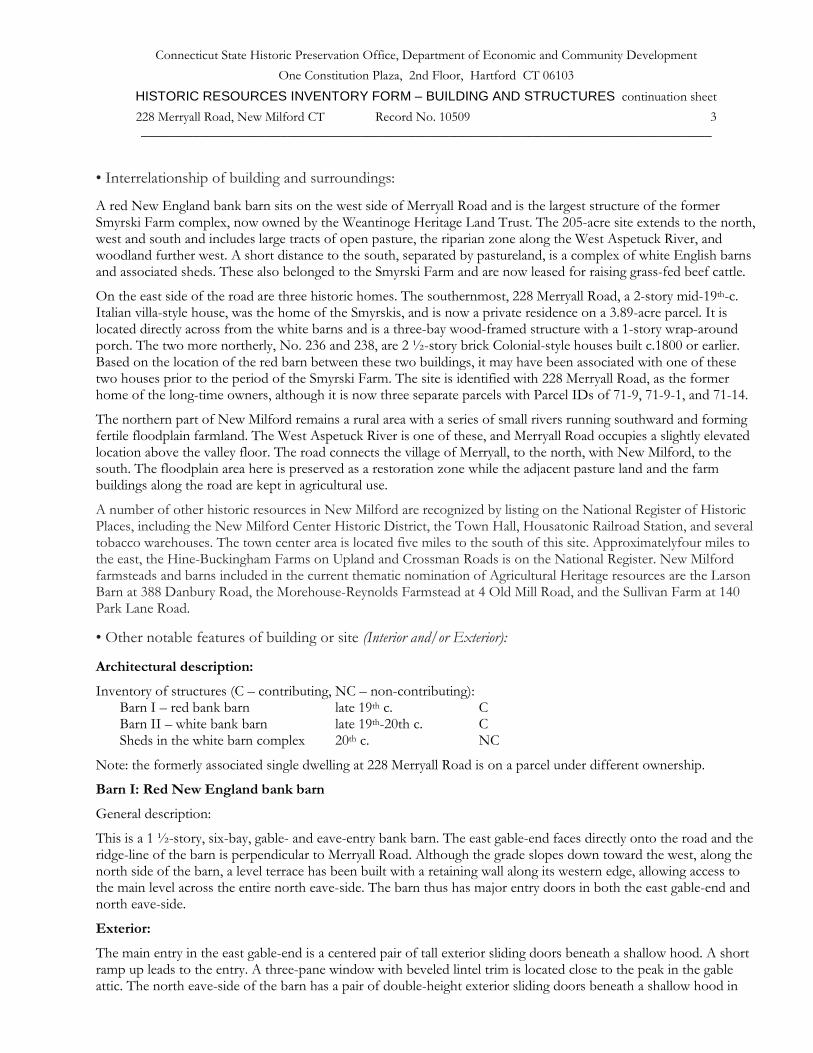
A red New England bank barn sits on the west side of Merryall Road and is the largest structure of the former Smyrski Farm complex, now owned by the Weantinoge Heritage Land Trust. The 205-acre site extends to the north, west and south and includes large tracts of open pasture, the riparian zone along the West Aspetuck River, and woodland further west. A short distance to the south, separated by pastureland, is a complex of white English barns and associated sheds. These also belonged to the Smyrski Farm and are now leased for raising grass-fed beef cattle.
On the east side of the road are three historic homes. The southernmost, 228 Merryall Road, a 2-story mid-19th-c. Italian villa-style house, was the home of the Smyrskis, and is now a private residence on a 3.89-acre parcel. It is located directly across from the white barns and is a three-bay wood-framed structure with a 1-story wrap-around porch. The two more northerly, No. 236 and 238, are 2 ½-story brick Colonial-style houses built c.1800 or earlier. Based on the location of the red barn between these two buildings, it may have been associated with one of these two houses prior to the period of the Smyrski Farm. The site is identified with 228 Merryall Road, as the former home of the long-time owners, although it is now three separate parcels with Parcel IDs of 71-9, 71-9-1, and 71-14.
The northern part of New Milford remains a rural area with a series of small rivers running southward and forming fertile floodplain farmland. The West Aspetuck River is one of these, and Merryall Road occupies a slightly elevated location above the valley floor. The road connects the village of Merryall, to the north, with New Milford, to the south. The floodplain area here is preserved as a restoration zone while the adjacent pasture land and the farm buildings along the road are kept in agricultural use.
A number of other historic resources in New Milford are recognized by listing on the National Register of Historic Places, including the New Milford Center Historic District, the Town Hall, Housatonic Railroad Station, and several tobacco warehouses. The town center area is located five miles to the south of this site. Approximatelyfour miles to the east, the Hine-Buckingham Farms on Upland and Crossman Roads is on the National Register. New Milford farmsteads and barns included in the current thematic nomination of Agricultural Heritage resources are the Larson Barn at 388 Danbury Road, the Morehouse-Reynolds Farmstead at 4 Old Mill Road, and the Sullivan Farm at 140 Park Lane Road.
• Other notable features of building or site (Interior and/or Exterior):
Architectural description:
Inventory of structures (C – contributing, NC – non-contributing): Barn I – red bank barn late 19th c. C Barn II – white bank barn late 19th-20th c. C Sheds in the white barn complex 20th c. NC
Note: the formerly associated single dwelling at 228 Merryall Road is on a parcel under different ownership.
Barn I: Red New England bank barn
General description:
This is a 1 ½-story, six-bay, gable- and eave-entry bank barn. The east gable-end faces directly onto the road and the ridge-line of the barn is perpendicular to Merryall Road. Although the grade slopes down toward the west, along the north side of the barn, a level terrace has been built with a retaining wall along its western edge, allowing access to the main level across the entire north eave-side. The barn thus has major entry doors in both the east gable-end and north eave-side.
Exterior:
The main entry in the east gable-end is a centered pair of tall exterior sliding doors beneath a shallow hood. A short ramp up leads to the entry. A three-pane window with beveled lintel trim is located close to the peak in the gable attic. The north eave-side of the barn has a pair of double-height exterior sliding doors beneath a shallow hood in

Connecticut State Historic Preservation Office, Department of Economic and Community Development One Constitution Plaza, 2nd Floor, Hartford CT 06103
HISTORIC RESOURCES INVENTORY FORM – BUILDING AND STRUCTURES continuation sheet 228 Merryall Road, New Milford CT Record No. 10509 4 ______________________________________________________________________________
the second bay from the west corner. A short ramp leads to this entry. The third bay from the west corner has a centered six-pane window with trim and an identical window is in the easternmost bay. The intermediate bays each have an exterior sliding hay door beneath the eave, with the track extending to the west. The grade declines gradually to the west from the westernmost bay, revealing a mortared field-stone foundation. The grade at the west gable-side declines sharply, revealing a basement level. A stone retaining wall tapers off to the west from the northwest corner.
The west gable-end basement of the barn has two pass-through doors with trim, near the corners. Inward of the doors are two pairs of six-pane hopper stable windows. An eight-pane horizontal window in the gable attic is just beneath the peak of the roof. The foundation of a silo remains west of the barn, and an unpainted area of the west gable-end indicates where the silo appears to have abutted the barn wall.
The south eave-side of the barn has a series of six-pane hopper stable windows with trim in the basement level with a pass-through door with trim at the southeast corner. The windows are generally arranged in pairs except in the left (west) bays where there is a pass-through door flanked by single windows. On the main level of the south eave-side is a hooded sliding hay door with the track extending eastward. Above the door is a three-pane window. The three eastern bays each have a six-over-six double-hung window with trim that includes a beveled lintel. A small hay door is above and to the left of the center window. The grade at the southeast corner inclines sharply to meet the road elevation; a fieldstone retaining wall retains the upper grade close to the building wall. Several courses of mortared fieldstone foundation wall are visible along the south basement wall.
The barn has vertical siding painted red. The roof has a projecting overhang, sloping soffits, and fascia painted white. The roof is covered with asphalt shingles. Atop the center of the ridge-line of the roof is a cupola with a cross-gable roof and paired louvered arches on all four sides.
Interior:
Based on the interior framing layout, it seems likely that the barn was built in two phases. The eastern three-bay section has characteristics of an English barn, with a double door in the north side, in the center of three bays, while the western three bays have several characteristics of a late-19th-century New England barn with a double door in the gable-end.
The eastern three bays are constructed with square rule post and beam framing using chestnut timbers. The two bents adjacent to the north doorway have dropped tie girts, two interior posts located directly below two queen posts which in turn support longitudinal purlin plates at the mid-span of common rafters. Below the tie-girts in the outer aisles are unusual secondary tie girts connecting the interior posts to the outer wall posts. These are diagonally braced to the posts. A set of upper tie-girts connect the tops of the queen-posts slightly below where they join to the purlin plates. Diagonal braces run from the top of the main tie-girts outside the queen posts, cross the queen posts with a let-in joint, and continue to meet the top tie-girt. All members are sawn and the rafters are of sawn dimension lumber. The barn is said to have been used for curing tobacco at one time; nailers on the interior show where the narrow operable panels have been re-secured.
In contrast, the end bent at the east wall and the fourth bent (which would have been the east end wall if the barn was built with only three bays) have a single interior post and lack the extra secondary tie-girts. These three bays are open full height, with short partitions separating the bays and hatch doors in these partitions for pitching hay to the lower level. The plates supporting the rafters have a lap joint near the fourth bent, supporting the hypothesis of two phases of construction.
The eastern three bays are different in design. The main level, which is entered via the doors in the east gable-end, is a single 1-story space without interior posts. A loft floor is accessed by a stair in the northeast corner. At the loft level, the structure supporting the roof has three bays with two intermediate bents and one at the east end wall. The intermediate bents each have a cross girder below the loft floor (visible from below), two interior posts which are truncated at the loft floor level, and an upper tie-girt slightly below the purlin plates. Above each of these upper tie-girts there is a triangular wood truss with an iron rod at the center extending from the apex down through a hole in the tie-girt and down through the floor, ending at the lower face of the floor girder in a washer and nut. The truncated posts are secured by iron straps which are also visible from below at the main level. The assemblage

Connecticut State Historic Preservation Office, Department of Economic and Community Development One Constitution Plaza, 2nd Floor, Hartford CT 06103
HISTORIC RESOURCES INVENTORY FORM – BUILDING AND STRUCTURES continuation sheet 228 Merryall Road, New Milford CT Record No. 10509 5 ______________________________________________________________________________
creates a truss-work system supporting the loft floor and roof while leaving a clear-span area at the ground level. Additional tie members in the outer aisles connect the truncated posts to the outer wall posts, and diagonal braces from the loft floor to the upper tie-girts are let into the tie members. Some members are hand-hewn but the majority are sawn.
The basement level is exposed on the south and west sides at a lower grade level, and on the north and east sides has mortared fieldstone retaining walls. The walls and ceiling are whitewashed and there are old wooden stanchions extant from a period of use as a dairy cow stable. The cows were arranged facing the center aisle. The floor is concrete with manure gutters along the outer perimeter. The structure visible above includes major cross girders corresponding to the bents of the main level frame above. In the eastern three bays the joists run north-south across the barn and bear on a central longitudinal girder. In the western three bays the joists run east-west spanning between the major cross-girders. Timbers are a mix of hand-hewn and sawn. As with many barns, it is possible that old timbers were re-used.
Barn II: White English bank barn
The complex of white barns at the south part of the site, formerly associated with 228 Merryall Road, includes an extended English bank barn (Barn II) and several additions and other barns or sheds. Barn II is a 1 ½-story gable-roofed structure oriented with its ridge-line north-south and its east eave-side opening to the road. The larger portion is a four-bay structure with a pair of full-height exterior sliding doors in the second bay from the left (south) and several doors, hinged and sliding, in the northern bays. Two of the hinged doors have iron strap hinges. A milk room is attached at the south end; this is a 1-story gable-roofed structure accessed from a lower grade level at the west side. The barn has a shed addition along its west side, enlarging the basement footprint to the dimensions needed for a two-aisle dairy stable. This is currently used for beef cattle.
A 1-story addition extends the barn to the north and has a concrete block basement level with glass block inserts for windows. Siding is vertical boards painted white. The gable roof has asphalt shingles and two metal ventilators on the ridge.
The interior of the main level is a square rule post and beam frame of predominantly sawn timbers. It is simpler than that of the red barn, but with some similarities in the use of doubled sawn wood angle braces and an open main level with metal straps around the ceiling girders, evidence of posts at the loft level above.
• Historical or Architectural importance: Applicable Connecticut State Register Criteria:
1. Associated with the lives of persons significant in our past (immigrant history and women’s history); 2. Embodying the distinctive characteristics of a type, period, or method of construction.
The barns and farmland are significant because of the intact and well-preserved character of its barns and the protected landscape. The red barn in particular represents a large-scale barn of the late 19th century with specialized construction techniques to create a clear span across the eastern area of the main level, possibly for carriages or horses. The farmstead derives particular significance from its ownership by an immigrant family from Poland. The Smyrski family evidently consolidated several earlier farmsteads to create their 200-acre farmstead. The story of Sophie Smyrski, as a woman farmer, adds to the significance of this farmstead.
Historical background:
The 1874 Beers Map of the Lower Merryall District of New Milford shows four homesteads along this stretch of the road, on a hill overlooking the West Aspetuck River. From north to south, F. Bennett, N. Morehouse, and C.P. Mervin appear to occupy the area of the three extant homes, with H. Merwin just to the south. Further research may establish whether some of these residents were the builders of the more northerly red barn and the southerly white barns. Based on the use of iron rods to create truss structures, the predominantly sawn timbers, and the Victorian-style cupola, the barns appear to date from the late 19th century. The 1870 census lists Nelson (age 59) and Maria (age 57) Morehouse and two children, living adjacent to Frank Bennett (age 42) and his wife and five children.

Connecticut State Historic Preservation Office, Department of Economic and Community Development One Constitution Plaza, 2nd Floor, Hartford CT 06103
HISTORIC RESOURCES INVENTORY FORM – BUILDING AND STRUCTURES continuation sheet 228 Merryall Road, New Milford CT Record No. 10509 6 ______________________________________________________________________________
There were three Smyrski family farms in New Milford during the 1920s and 30s. Michael Smyrski immigrated in 1905 from Poland. Frank Smyrski was also Polish by birth; his dairy farm was valued at $12,000 in 1930. The Adam and Sophie Smyrski family were the purchasers of this site on Merryall Road. Renovations and additions to the barns converted them to ground level stables for dairy cows, likely in the early 20th century.
By 1930 the census shows the Smyrski family with Adam, age 51, the head of the family, wife Sophie, age 44, and seven children ranging in age from 10 to 23. Sophie, age 12, and John, age 15, were among the younger children. The parents were immigrants from Poland while all the children had been born in Connecticut. John and Sophie took over the property and farmed throughout their lives. They ultimately sold the development rights to the 205-acre farm to the State of Connecticut. They then gave the farm to the Weantinoge Heritage Land Trust, which received it in 2007; John had died in 1999 and Sophie in 2006. The Smyrskis had given up their dairy herd in the early 1990s. Now the land trust has set aside the land along the river as a restoration area, and leased the prime grazing land and the white barn complex for raising grass-fed beef cattle. The red barn has recently been restored, with new roofing and siding and window repairs.
Architectural significance:
The barns and farmland are significant because of the size of the farmstead and the intact and well-preserved character of its barns. The red barn in particular represents a large-scale barn of the late 19th century with specialized construction techniques to create a clear span across the eastern area of the main level, possibly for carriages or horses. The basement level appears likely to have been purpose-built for dairy cows, as the wood stanchions are an early type. The automatic watering system, typical of more modern dairy barns, contrasts with the historic stanchions. Later additions to the white barn complex represent typical 20th-century modifications for commercial dairy operations.
The farmstead derives particular significance from its ownership by an immigrant family from Poland. The Smyrski family represents the importance of European immigrant families to the evolution of dairy farming in Connecticut in the early 20th century. In this case the Smyrskis evidently consolidated several earlier farmsteads to create the 200-acre farmstead. The story of Sophie Smyrski, as a woman farmer, adds to the significance of this farmstead.
Finally, the preservation of this farmstead is significant to local history because the northern sections of New Milford were historically extensively farmed. In addition to dairy farming, this site has a history of growing and curing tobacco, at one time a significant crop in the Housatonic Valley (see also the Sullivan Farm at 140 Park Lane Road). Several tobacco warehouses in New Milford have been listed on the National Register of Historic Places. This site preserves the area’s agricultural heritage when much of the town has been developed with housing subdivisions.
• Sources (continuation): Photographs and field notes by Liba Furhman 3/27/2009, Charlotte Hitchcock 11/20/2012.
Connecticut Trust for Historic Preservation Barns Grant application 2009 and Final Report 2012.
Research notes on immigrant farmers provided by Jan Cunningham, 2011.
Map resources:
Town of New Milford Assessor's Records Vision Appraisal Online Database. www.visionappraisal.com/newmilfordct .
Town of New Milford GIS Viewer http://hosting.tighebond.com/newmilfordct/main.htm .
Aerial views from: http://maps.google.com/ and http://www.bing.com/maps/ accessed 7/04/2012.

Connecticut State Historic Preservation Office, Department of Economic and Community Development One Constitution Plaza, 2nd Floor, Hartford CT 06103
HISTORIC RESOURCES INVENTORY FORM – BUILDING AND STRUCTURES continuation sheet 228 Merryall Road, New Milford CT Record No. 10509 7 ______________________________________________________________________________
Historical aerial photography and maps accessed at UConn MAGIC:
http://magic.lib.uconn.edu/mash_up/1934.html http://magic.lib.uconn.edu/historical_maps_connecticut_towns.html . Beers, F. W., Atlas of Litchfield County, 1874.
USGS Historical Maps accessed 6/22/2012 at http://historical.mytopo.com/ .
UTM coordinates: http://itouchmap.com/latlong.html .
Print and internet resources:
Connecticut Trust for Historic Preservation, Historic Barns of Connecticut Resource Inventory, 2010, http://www.connecticutbarns.org/10509
Devlin, William E., E.A. Wildman Co. Tobacco Warehouse National Register Nomination No. 88000731, National Park Service, 1988.
Gilchrist, Alison, Carl F. Schoverling Tobacco Warehouse National Register Nomination No. 82004446, National Park Service, 1982.
Sexton, James, PhD; Survey Narrative of the Connecticut Barn, Connecticut Trust for Historic Preservation, Hamden, CT, 2005, http://www.connecticutbarns.org/history.
U.S. Federal Census, accessed at http://persi.heritagequestonline.com/hqoweb/library/do/census/search/basic
Visser, Thomas D., Field Guide to New England Barns & Farm Buildings, University Press of New England, 1997.
1. Location map with property boundary of 228 Merryall Road, New Milford CT – base image from
http://maps.google.com/ accessed 12/04/2012.

Connecticut State Historic Preservation Office, Department of Economic and Community Development One Constitution Plaza, 2nd Floor, Hartford CT 06103
HISTORIC RESOURCES INVENTORY FORM – BUILDING AND STRUCTURES continuation sheet 228 Merryall Road, New Milford CT Record No. 10509 8 ______________________________________________________________________________
2. West view – aerial “bird’s-eye” map of 228-238 Merryall Road, New Milford CT – http://www.bing.com/maps
accessed 11/13/2012. Three historic single-family homes occupy the east side of the road (top) while two barn complexes are on the west side (below). The red barn is at lower left and the white barn complex at upper right.
3. Parcel map of Merryall Road, New Milford CT – from Weantinoge Heritage Land Trust. Barn sites are at
locations marked B1 (white barns) and B2 (red barn). The area outlined in green is agricultural land and in blue is the riparian restoration area.
Connecticut State Historic Preservation Office, Department of Economic and Community Development One Constitution Plaza, 2nd Floor, Hartford CT 06103
HISTORIC RESOURCES INVENTORY FORM – BUILDING AND STRUCTURES continuation sheet 228 Merryall Road, New Milford CT Record No. 10509 9 ______________________________________________________________________________
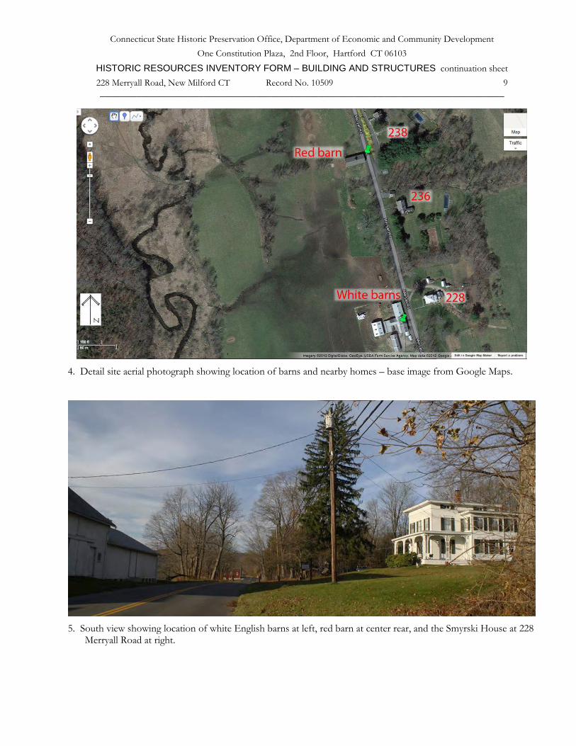
4. Detail site aerial photograph showing location of barns and nearby homes – base image from Google Maps.
5. South view showing location of white English barns at left, red barn at center rear, and the Smyrski House at 228
Merryall Road at right.

Connecticut State Historic Preservation Office, Department of Economic and Community Development One Constitution Plaza, 2nd Floor, Hartford CT 06103
HISTORIC RESOURCES INVENTORY FORM – BUILDING AND STRUCTURES continuation sheet 228 Merryall Road, New Milford CT Record No. 10509 10
______________________________________________________________________________
6. East and north sides of Barn I, the red barn, camera facing southwest.
7. North eave-side of Barn I, the red barn, camera facing southeast.

Connecticut State Historic Preservation Office, Department of Economic and Community Development One Constitution Plaza, 2nd Floor, Hartford CT 06103
HISTORIC RESOURCES INVENTORY FORM – BUILDING AND STRUCTURES continuation sheet 228 Merryall Road, New Milford CT Record No. 10509 11
______________________________________________________________________________
8. West gable-end and south eave-side of Barn I, the red barn, camera facing northeast. Note the round silo
foundation at the west end and the marks in the paint where the silo abutted the west gable-end.
9. Interior view of the west gable-end of Barn I, the red barn, camera facing northeast. Note center post below tie-
girt, in contrast to Figure 10 below, where there are two posts forming a center aisle.

Connecticut State Historic Preservation Office, Department of Economic and Community Development One Constitution Plaza, 2nd Floor, Hartford CT 06103
HISTORIC RESOURCES INVENTORY FORM – BUILDING AND STRUCTURES continuation sheet 228 Merryall Road, New Milford CT Record No. 10509 12
______________________________________________________________________________
10. Interior view of south eave-side of Barn I, the red barn, camera facing south, showing the center bay of the
western three-bay frame.
11. South eave detail of Barn I, the red barn, at the fourth (center) bent, camera facing northeast. Note a lap joint
in the plate indicating two-phase construction; signs of former use for tobacco where vertical operable panels have been nailed shut.
Connecticut State Historic Preservation Office, Department of Economic and Community Development One Constitution Plaza, 2nd Floor, Hartford CT 06103
HISTORIC RESOURCES INVENTORY FORM – BUILDING AND STRUCTURES continuation sheet 228 Merryall Road, New Milford CT Record No. 10509 13
______________________________________________________________________________
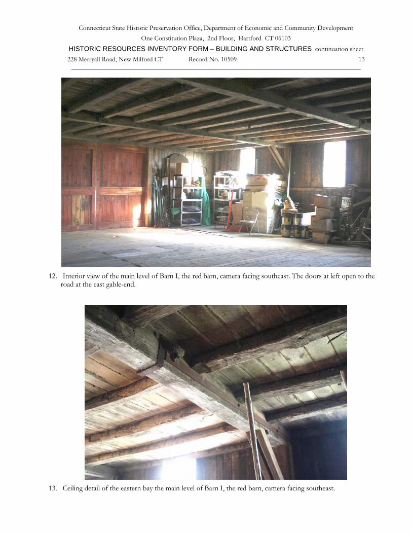
12. Interior view of the main level of Barn I, the red barn, camera facing southeast. The doors at left open to the
road at the east gable-end.
13. Ceiling detail of the eastern bay the main level of Barn I, the red barn, camera facing southeast.

Connecticut State Historic Preservation Office, Department of Economic and Community Development One Constitution Plaza, 2nd Floor, Hartford CT 06103
HISTORIC RESOURCES INVENTORY FORM – BUILDING AND STRUCTURES continuation sheet 228 Merryall Road, New Milford CT Record No. 10509 14
______________________________________________________________________________
14. Doubled angle brace at eastern bay of main level of Barn I, the red barn, camera facing southeast.
15. Loft level framing at east end of Barn I, the red barn, camera facing west. Note the triangular truss and iron
tension rod which supports the floor.

Connecticut State Historic Preservation Office, Department of Economic and Community Development One Constitution Plaza, 2nd Floor, Hartford CT 06103
HISTORIC RESOURCES INVENTORY FORM – BUILDING AND STRUCTURES continuation sheet 228 Merryall Road, New Milford CT Record No. 10509 15
______________________________________________________________________________
16. Interior view of basement level of Barn I, the red barn, camera facing northwest. Note change in framing
direction of main level floor joists, corresponding to the meeting of the two three-bay sections above.
17. Interior view of basement level of Barn I, the red barn, camera facing west. Note change in direction of ceiling
joists, fieldstone retaining wall at left (north).

Connecticut State Historic Preservation Office, Department of Economic and Community Development One Constitution Plaza, 2nd Floor, Hartford CT 06103
HISTORIC RESOURCES INVENTORY FORM – BUILDING AND STRUCTURES continuation sheet 228 Merryall Road, New Milford CT Record No. 10509 16
______________________________________________________________________________
18. East view of Barn II, white English bank barn, camera facing northwest.
19. South view of Barn II, white English bank barn, camera facing north. Milk room at right front. Note shed
addition at left (west) side of barn, enlarging the basement for use as a dairy stable.

Connecticut State Historic Preservation Office, Department of Economic and Community Development One Constitution Plaza, 2nd Floor, Hartford CT 06103
HISTORIC RESOURCES INVENTORY FORM – BUILDING AND STRUCTURES continuation sheet 228 Merryall Road, New Milford CT Record No. 10509 17
______________________________________________________________________________
20. East view of Barn II, white English bank barn, camera facing northwest.
21. Interior view of Barn II, white English bank barn, camera facing west. Note the doubled brace and iron strap
around the girder at upper left – details similar to Barn I, the red barn.

Connecticut State Historic Preservation Office, Department of Economic and Community Development One Constitution Plaza, 2nd Floor, Hartford CT 06103
HISTORIC RESOURCES INVENTORY FORM – BUILDING AND STRUCTURES continuation sheet 228 Merryall Road, New Milford CT Record No. 10509 18
______________________________________________________________________________
22. Southwest view of white barn complex, camera facing north.


