
,- NATURAL RESOURCES INVENTORY
105
- , ,- · • 4 -- , I • • , · - I_ • · - · - · '""" - -- - - - - NATURAL RESOURCES INVENTORY "oU Peppy" TOWNSHIP OF CRANFORD UNION COUNTY, NEW JERSEY DECEMBER 1993
Transcript of ,- NATURAL RESOURCES INVENTORY

-, ,-· • 4 --, I
• • , ~."
· -~
~ I_
• · -· -· '"""
---
----
NATURAL RESOURCES INVENTORY
"oU Peppy"
TOWNSHIP OF CRANFORD UNION COUNTY, NEW JERSEY
DECEMBER 1993
-
--
....
-
-
-
-
-
--
NATURAL RESOURCES INVENTORY
Prepared by the Environmental Commission Township of Cranford
Union County, New Jersey
December 1993

-
-
---
--
---
ENVIRONMENTAL COMMISSION OF THE TOWNSHIP OF CRANFORD
Nelson W. Dittmar, Jr., Chairman Dave DesRochers
Donald E. Ehrenbeck Albert M. Gessler
John Jordan Roberta Kessler
Kurt Krause John Laucius
Joseph H. Musillo Marie J. Seavy Nancy Selfridge
This Natural Resources Inventory was prepared and published by the Environmental Commission - of the Township of Cranford, December 1993 and was made possible by a matching grant from
the New Jersey Department of Environmental Protection and Energy, Office of Environmental Services.
1
-
---
-
-
--
--
-
--
TABLE OF CONTENTS
Introduction ................................................ I-I
Geography and Regional Setting .................................. II-I
Vacant Land and Open Space . . . . . . . . . . . . . . . . . . . . . . . . . . . . . . . . . . . . III-l
History of Cranford . . . . . . . . . . . . . . . . . . . . . . . . . . . . . . . . . . . . . . . . . . IV-l
Geology . . . . . . . . . . . . . . . . . . . . . . . . . . . . . . . . . . . . . . . . . . . . . . . . . V-I
Soils ................................................... VI-l
Hydrology .............................................. VlI-l
Climatic Conditions ......................................... VIII-l
Vegetation ............................................... IX-l
Wildlife . . . . . . . . . . . . . . . . . . . . . . . . . . . . . . . . . . . . . . . . . . . . . . . . . X-I
Glossary . . . . . . . . . . . . . . . . . . . . . . . . . . . . . . . . . . . . . . . . . . . . . . . . . XI-l
References .............................................. XlI-l
Appendix A
Drawing 1 Drawing 2 Drawing 3 Drawing 4 Drawing 5
Drawings
Township Base Map Open Space/Vacant Land Soils Floodplains Wetlands
11
----
-
....
-
-
--
Figure No.
1
2
3
4
5
6
7
8
LIST OF FIGURES
Following Page
Regional Location ............................ . II-I
Historic Sites ................................ IV-3
Geologic History ............................. . V-I
Physiographic Provinces . . . . . . . . . . . . . . . . . . . . . . . . . . V-I
The Hydrologic Cycle .......................... VII-l
Rahway River Watershed . . . . . . . . . . . . . . . . . . . . . . . . VII-2
Wetland Buffer Zones .......................... VII-9
Flood Hazard Areas .......................... . VII-II
111

---
.....
--.
-
-
-
--
Table No.
1
2
3
4
5
6
7
8
9
10
LIST OF TABLES
Page
Water Quality Index Classifications ...................... VII-5
Water Quality Index Profile 1988 ....................... VII-6
Water Quality Index Profile 1990 VII-7
Temperature Statistics ............................... VIII-4
Barometric Pressure and Humidity ....................... VIII-5
Precipitation .................................... VIII-7
Wind Data ..................................... VIII-9
Varying Weather Days ............................. VIII-ll
Swamp and Floodplain Vegetation ........................ IX-3
Upland Vegetation .................................. IX-5
11 Species Known or Expected to Occur in Cranford .............. X-2
12 Audubon Bird Chart ................................. X-6
13 May 14, 1990 Bird Count ............................. X-9
IV

--
-
-
-
-
ACKNOWLEDGEMENTS
The Natural Resources Inventory (NRI) of the Township of Cranford was made possible
through the approval and support of the Township Committee as well as a matching grant from
the New Jersey Department of Environmental Protection and Energy, Office of Environmental
Services.
Many of the Commissioners devoted extraordinary amounts of their time in producing
this document. Much of the research for the NRI came from Commissioners Al Gessler,
Roberta Kessler, Kurt Krause, Joe Musillo and Marie Seavy. Other Commissioners who aided
in reviewing the text were John Jordan, Dave DesRochers, John Laucius and Nancy Selfridge.
The painstaking work of managing the project, producing text and graphics, and tying together
loose ends was borne by Commissioner Donald Ehrenbeck.
Special thanks go to Larry Fuhro, President of the Cranford Historical Society and John
Duryee, Township Tax Assessor, for their contributions, and to Patricia Lynn for her invaluable
assistance.
To all these hardworking individuals, I wish to extend my heartfelt thanks.
v
Nelson Dittmar Chairman Cranford Environmental Commission December 1993
--
-
--
I. INTRODUCTION
-
-
-
--
-
-
I. INTRODUCTION
In 1969, Ian McHarg, considered by many to be the father of environmental planning,
wrote the following:
Among us it is widely believed that the world consists solely of a dialogue between men, or men and God, while nature is a faintly decorative backdrop to the human play. If nature receives attention, then it is only for the purpose of conquest, or even better, exploitation--for the latter not only accomplishes the first objective, but provides a financial reward for the conqueror.
Since that time, the American people have had an increasing understanding of nature and its
"- processes and how we are interrelated. No longer is nature thought of as a commodity to be
bought and sold. There is a greater sensitivity to the fact that Man's actions, no matter how
small, can have a profound effect upon the natural world around us.
Because the Township of Cranford is almost completely developed, it is important to be
aware of and consider the Township's remaining natural resources when evaluating both private
and public actions. A Natural Resource Inventory (NRI) is a compilation of a municipality's
- environmental features and natural resource characteristics in both graphic and narrative formats.
The NRI is a factual, unbiased document which seeks to provide baseline data for evaluating and
measuring environmental issues within the Township, with the ultimate goal being the
preservation of significant environmental resources.
The New Jersey Legislature created environmental commissions for the purpose of
conducting research into the use and possible use of the open land areas of a municipality.
These commissions may advertise, prepare, print and distribute books, maps, charts, plans and
pamphlets when deemed necessary for their purposes. They shall keep an index of all open
- I-I

--
-
areas, publicly or privately owned, including open marshlands, swamps and other wetlands, in
order to obtain information on the proper use of such areas.
As a result of an increasing sensitivity to our environment, the Cranford Environmental
Commission has prepared this Natural Resource Inventory to aid in the identification of
environmentally sensitive areas and to enable the Commission to work toward the protection of
- these areas. In addition, pursuant to the Municipal Land Use Law (N.J.S.A. 40:55D-27),
whenever an Environmental Commission prepares an NRI and submits it to the local Planning
Board and Board of Adjustment, these boards shall forward to the environmental commission
- informational copies of every development application submitted to either board. Although this
referral is for informational purposes only, it will enable the Environmental Commission to -
--
-
-
comment on applications as they are before each board, resulting in a more proactive role for
the Commission in the development of the Township.
The NRI will also serve as a database for the Environmental Commission, Planning
Board and Board of Adjustment, as well as the Township's professional staff and planning
consultant, when evaluating and making recommendations on development proposals. If utilized
properly, the resulting process will enable the Township to protect appropriate resources. The
document will also serve as a point of reference when the Township updates its Master Plan, as
it is required to do every six years. In addition, the NRI can be utilized by concerned citizens
and civic groups when planning community service projects.
This NRI will be distributed to various review boards, as well as to Township offices
such as the library and schools. It is the Commission's hope that the resulting referral process
will raise the environmental awareness of the membership of the Planning Board and the Board
1-2
---
-
-
-
-
--
-
of Adjustment, as well as that of any members of the public who attend the meetings of these
boards.
This NRI contains a chapter on each of the following topics: the township's history,
geography and regional setting; geology; vacant land and open space; soils; hydrology
(groundwater and surface water); meteorology; vegetation and wildlife. In addition, maps of
vacant land and open space, soils, wetlands and floodplains are included in the document.
1-3

--
-
-
--
II. GEOGRAPHY AND REGIONAL SETTING
-
-
--

----
-
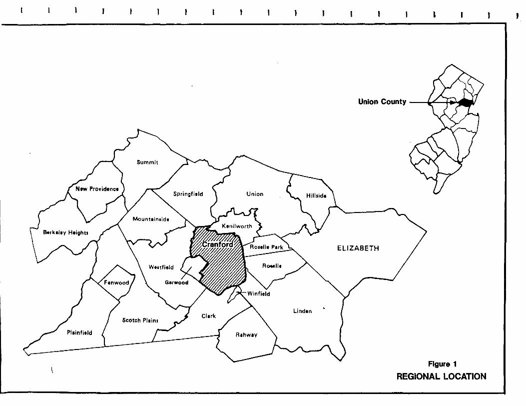
II. GEOGRAPHY AND REGIONAL SETTING
The Township of Cranford, a 4.79 square mile suburban residential community, is
centrally located in Union County. It is approximately halfway between the cities of Elizabeth
and Plainfield on a gently sloping plain east of the Watchung Mountains-three closely spaced
basalt trap-rock ridges (see Figure 1). The Township is bounded on the north by Kenilworth
and Springfield, on the east by Roselle and Roselle Park, on the south by Clark, Winfield Park
- and Linden, and on the west by Garwood and Westfield.
-
-
-
-
-
Cranford is conveniently located for travel, ten miles southwest of Newark International
Airport and approximately 45 minutes from New York City. There is frequent daily bus and
rail service from the Township to Newark and New York City. Three exits of the Garden State
Parkway lead directly into Cranford, providing the Township with easy access to the New Jersey
Shore region and other parts of the country via connections with highways such as the New
Jersey Turnpike and Interstate Routes 78 and 80.
According to the 1990 Census, Cranford had a population of 22,624, a decline of almost
eight percent from the 1980 figure of 24,573. Of the Township's 8,405 housing units, 6,695
are owner-occupied, and 6,689 are single family occupancy.
There is very little vacant developable land remaining In the Township. Notable
exceptions include various isolated infilliots, an abandoned railroad yard on South Avenue East,
a wooded area at the end of Cranford A venue and the 26-acre Conservation Center on
Birchwood A venue. Although not developable, there are also several large county parks and
some vacant land located along the Rahway River.
II-I
I ) I t 1 l
Plainfield
I , I
Union County (.< l.,) F U
ELIZABETH
Figure 1
REGIONAL LOCATION
J I

-
--
---
III. VACANT LAND AND OPEN SPACE
-
--

III. VACANT LAND & OPEN SPACE
-The enabling legislation which created environmental commissions (N.J.S.A. 40:56A-l,
et. seq.) states that a commission, among other responsibilities, " ... shall keep an index of all
open areas, publicly or privately owned, including open marshlands, swamps and other wetlands,
- in order to obtain information on the proper use of such areas ... " Open space is defined by the
-
--
Municipal Land Use Law as being:
any parcel or area of land or water essentially unimproved and set aside, dedicated, designated or reserved for public or private use or enjoyment ... provided that such areas may be improved with only those buildings, structures, streets and off-street parking and other improvements that are designed to be incidental to the natural openness of the land.
The Environmental Commission utilized information provided by the Cranford Tax
Assessor, the Township's Engineering Office and the Union County Planning Department to
determine open areas. Aerial photographs of the Township were also reviewed and a field
reconnaissance was conducted to verify the data. Although recreational areas associated with
the Township's school system contain large areas of open land, they were not included in the
inventory because they are, using a strict interpretation of the law, improVed for uses such as
baseball and soccer.
Vacant land and open space in the Township are depicted in Drawing No.2. There is
very little vacant developable land remaining in the Township. Notable exceptions include
various isolated in fill lots, an abandoned railroad yard on South Avenue East, a wooded area at
the end of Cranford Avenue and the 26-acre Conservation Center on Birchwood Avenue.
Although not available for development, there are also several large county parks in the
III-l

-
Township: Lenape and Nomahegan parks in northwest Cranford; Unami Park in southwest
- Cranford and the Rahway River Parkway, a linear system adjacent to the river for most of its
length through town.
111-2

---
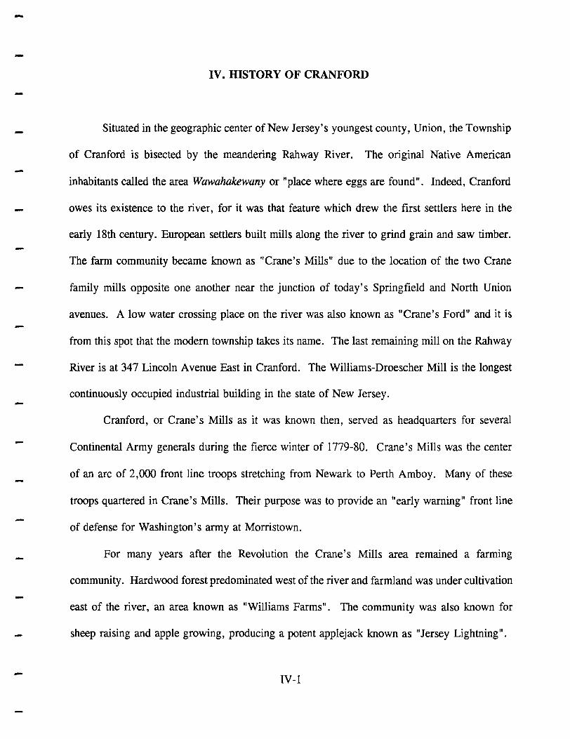
IV. HISTORY OF CRANFORD
-
-
IV. HISTORY OF CRANFORD
Situated in the geographic center of New Jersey's youngest county, Union, the Township
of Cranford is bisected by the meandering Rahway River. The original Native American
inhabitants called the area Wawahakewany or "place where eggs are found". Indeed, Cranford
owes its existence to the river, for it was that feature which drew the first settlers here in the
early 18th century. European settlers built mills along the river to grind grain and saw timber.
The farm community became known as "Crane's Mills" due to the location of the two Crane
family mills opposite one another near the junction of today's Springfield and North Union
avenues. A low water crossing place on the river was also known as "Crane's Ford" and it is
from this spot that the modern township takes its name. The last remaining mill on the Rahway
River is at 347 Lincoln Avenue East in Cranford. The Williams-Droescher Mill is the longest
continuously occupied industrial building in the state of New Jersey.
Cranford, or Crane's Mills as it was known then, served as headquarters for several
Continental Army generals during the fierce winter of 1779-80. Crane's Mills was the center
of an arc of 2,000 front line troops stretching from Newark to Perth Amboy. Many of these
troops quartered in Crane's Mills. Their purpose was to provide an "early warning" front line
of defense for Washington's army at Morristown.
For many years after the Revolution the Crane's Mills area remained a farming
community. Hardwood forest predominated west of the river and farmland was under cultivation
east of the river, an area known as "Williams Farms". The community was also known for
sheep raising and apple growing, producing a potent applejack known as "Jersey Lightning".
IV-l

-Part of the village of Westfield since 1794, in the early 19th century the area became known as
"Crane Town". From about 1849 to 1869 the town was called "Craneville". Tradition has it
that the name was scrawled by school children in chalk on the side of the railroad depot and it
stuck.
An influx of New Yorkers and Brooklynites seeking summer homes after the Civil War
changed the area forever and led to the development of its suburban character. Real estate
speculators bought up many of the farms and divided them into housing lots. This increase and
change in the composition of the local population brought another name change in 1869.
"Craneville" was thought to be too rural by the sophisticated newcomers. Various names were
suggested and finally "Cranford" won out over "Riverdale" by a narrow margin. Soon after,
the descendants of the Crane family, Josiah Sr. and Josiah Jr., led a movement to separate from
Westfield. They successfully petitioned the state legislature, and in 1871 the Township of
Cranford was officially established. Not long after the incorporation of the Township, its
founders made an offer of money and land to the legislature to move the state capital from the
banks of the Delaware River in Trenton to the banks of the Rahway River in Cranford. Their
bid was rejected.
For some time Cranford was known as "The Venice of New Jersey" due to the route of
the Rahway River through town. The appellation is credited to Roselle lawyer William Sulzer,
who later became Governor of New York. In 1886, a small "River Carnival"- the first in an
annual tradition-was held, and each year it became bigger and better. Thousands of people
came to see the evening carnivals with lighted and decorated canoes and floats. These festivals
were eventually discontinued because eager crowds trampled lawns and gardens.
IV-2

-
-
-
Today the 22,624 inhabitants of the Township's 4.79 square miles are living in a
community that looks to its past to see its future. A vigorous program of downtown renewal,
including the state's first Special Improvement District, draws upon the Victorian past for its
architectural features.
The following is a list of historic buildings and sites in the Township. Reference
numbers are keyed to Figure 2.
1. Williams-Droescher Mill.
2.
3.
Located at 347 Lincoln Avenue East, the Williams-Droescher Mill represents a 1910-1919 renovation of an earlier mill (c. 1740). The last remaining mill on the Rahway River, the mill is the longest continuously occupied industrial building in New Jersey. Over its lifetime, the mill has produced things such as blankets, wagon wheel hubs, cut stones, barber supplies, organ consoles and electronic parts. A horizontal Leffel water turbine (c. 1893) is still in place, and the building also shows evidence of a fire set by a Tory raiding party during the American Revolution. The mill is listed on both the State and National Registers of Historic Places.
Droescher Mill Park.
Located on the east bank of the Rahway River north of the mill, this county park has several remnants of Severin Droescher's pre-World War I "Lincoln Park" development including stone walls, a river overlook, a pond, stone bridge supports and a stone gazebo.
The Crane-Phillips House.
Located at 124 North Union Avenue, this building currently houses the museum of the Cranford Historical Society. This 1845 "Little House on the Rahway" is a Victorian country cottage originally assembled from outbuildings located across the street on the Josiah Crane farm. The honeymoon cottage of Josiah Crane, Jr., the house was later owned by inventor Henry Phillips, a seeker of perpetual motion. The house is believed to have been a "station" on the Underground Railroad. A trap-door leading to a large cistern is said to have been a hiding place for escaped slaves prior to the Civil War.
4. Josiah Crane Park.
Located at the intersection of Springfield and North Union avenues, this park is on the site of the early 19th century farm of Josiah Crane, Sr., the "Father of Cranford". An
IV-3
I ~ 1IIIp-~ 0'7- ~
I
I I
Figure 2
HISTORIC SITES
, t

---
5.
ancient tree and a ruined well are the only remnants of the original farm. The CranePhillips House located across the street was built largely from outbuildings taken from this site in the 1840s.
First Presbyterian Church.
Located at the intersection of Springfield and North Union avenues, across from Josiah Crane Park, this church is a local architectural landmark. Completed in 1894, the church is noted for its shingle architecture, interior and President McKinley stained glass window.
6. The Hanson House.
Located at 38 Springfield Avenue, this building is the former office and home of Cranford pediatrician Dr. Carl Hanson, a noted researcher in the field of strep throat. The building currently houses the annex, offices and library of the Cranford Historical Society, as well as numerous other community groups. Mrs. Hanson's Leet organ was manufactured in 1949 by the Leet Organ Company at Droescher's Mill.
7. Cranford Canoe Club.
Located at the intersection of Springfield and Orange avenues, this is the last remaining canoe club on the Rahway River. Once the center for social life on the river, it was recently purchased by the Township and is still being operated as a canoe livery.
8. Crane's Mills Site.
Located on the Rahway River just north of the North Union Avenue bridge, this was the site of the two Crane family mills that gave the village its first name; "Crane's Mills". A gristmill was located on the north bank of the river in what is today's Sperry Park. A sawmill was located on the south bank behind today's Gray's Funeral Home. Both mills flanked the c. 1720 dam known later as "Hansel's Dam" because it was behind the home of Charles Hansel (today's funeral home). Archaeological digs at both mill sites in the early 1970s uncovered foundations, machinery mounts, clay pipes, bottles, buttons and tools.
9. Revolutionary Cantonment Site.
Located at Sperry Park on Riverside Drive, a marker commemorates the winter of 1779-80 cantonment of Continental troops along the river here, part of a 2,000 man front protecting Washington's troops at Morristown. The front stretched in an arc from Newark to Perth Amboy, with Crane's Mills (Cranford) in the center. Several Continental Army generals headquartered here. Alexander Hamilton visited the Crane's Mills cantonment and Hessian prisoners are known to have passed through here.
IV-4

---
10.
11.
Crane's Ford Monument.
Located on Riverside Drive at Springfield Avenue, the monument marks the site of Crane's Ford, the low-water crossing place on the Rahway River. Tradition has it that in the Revolution mounted sentinels stationed at this site carried warning of the approaching British to Washington at Morristown. The Township takes its name from this spot.
Memorial Park.
This Township park or "green" is on Springfield Avenue at Riverside Drive where memorials to the community's war dead are located. These include World War I, World War II, Korea and Vietnam. A circular marble monument memorializes P.O.W.'s and M.I.A.'s. A nearby tree is dedicated to the first Cranford serviceman who fell in Vietnam.
12. The Cranford Hotel.
Located at the intersection of Walnut and South Union avenues, this is the oldest business in Cranford, still operating after one hundred years. A restaurant and bar occupy the premises today. It originally opened as a hotel for railroad travelers on December 31, 1892.
13. The Cranford Pepperidge Tree.
The official Township tree, located on Lincoln Avenue West, is a much-photographed blackgum tree famed for its fiery fall foliage. Once a boundary tree, this 225 year old specimen is the second largest pepperidge tree in the northeastern United States.
14. The Linwood Carriage House.
Located at 12 Forest Avenue, this large Neo-Jacobean 19th century carriage house was once part of a larger estate known as "Linwood". The main house still exists and is located at the intersection of Forest and North Union avenues.
15. The Old Rectory.
This Italianate villa (c. 1860), located at 12 Bloomingdale Avenue, once served as the rectory for the Roman Catholic church that once stood at the corner of Bloomingdale and Elizabeth avenues.
IV-5

---
16. The Pierson-Crane House.
This circa 1737 house, located at 420 Riverside Drive facing Memorial Park, was once occupied by Samuel Pierson, a member of General Washington's Life Guards. It was extensively remodeled and enlarged in the 19th century and again in 1929.
17. The Dunham-Oakey House.
This Revolutionary-era farmhouse with an 1820 addition is located at 1117 Orange Avenue. The home of one of the Dunhams and later occupied by Civil War veteran William Oakey, at various times in its history it functioned as a school, a boarding house and a brothel.
18. The Vreeland House.
This circa 1840 farmhouse, located at 306 Lincoln Avenue East, was built by James Vreeland just up the road from the mill he owned and operated (the Williams-Droescher Mill). The house is said to be haunted.
19. The Williams House.
This circa 1805 farmhouse, located at 506 Lexington Avenue, was the home of Squire Williams in 1828. The house sits at an angle to Lexington Avenue, indicating the position of the original farm road.
20. The Denman Homestead Site.
Located at the intersection of Denman Road and Lincoln Avenue West, this is the site of the home and farm of John Denman, the first European to cross the Rahway River and permanently settle in the Cranford area (1720). The third and last Denman house on this spot was razed in 1951. The Denman lands were primarily hardwood forests yielding fine timber well into the 1890's. Timber from the site went into the re-fitting of the U.S.S. Constitution for the War of 1812.
21. Revolutionary Hospital Site.
An army field hospital was located in the northwest portion of Crane's Mills from 1777 to 1780. The site is now part of the Union County College campus, near Princeton Road. The hospital was a log building similar to the reconstruction that can be seen today at Morristown.
IV-6

-----
--------------
22. Mastodon Site.
Two tusks (one measuring 4 feet, 3 inches) and several bone fragments from an ancient mastodon were found in 1936 in the swampy area directly behind what is now the parking lot of Union County College's main building.
IV-7

---
--
v. GEOLOGY
-
. -
-
----.....
----
-
-
--
-
represented by well-defined layers or beds of sand, silt, gravel and cobbles deposited by water
from the melting ice cap.
Pleistocene sediments in Cranford are in the form of stratified drift, generally located in
the northwest section of the Township. Life during the Pleistocene Epoch is indicated by the
discovery of two tusks and miscellaneous bones of a mastodon in Cranford in 1936. These
specimens, which now reside in the State Museum in Trenton, were obtained from the bed of
a small stream in the swampy area directly behind what is now the parking lot behind the main
building of Union County College. The larger tusk measured 4 feet 3 inches. Closely
resembling an elephant, the mastodon typically lived in the forests which covered Cranford
25,000 years ago and became extinct at the end of the Pleistocene Epoch.
V-3

,"" ....
V.GEOLOGY
To better understand the geology of the Cranford area, one must have a concept of
geologic time, which is measured in millions of years. As illustrated by Figure 3, geologic
history has been divided into three eras: the Paleozoic ("ancient life"), the Mesozoic ("middle
life"), and the Cenozoic ("recent life"). Each era is subdivided into time units known as
periods. The Paleozoic has seven periods, the Mesozoic three and the Cenozoic two. Each of
... the twelve periods is further divided into smaller time units known as epochs. Except for the
.. seven epochs which have been named for the periods of the Cenozoic era, those of other periods !
are not commonly referred to by specific names, but by the terms early, middle and late.
New Jersey can be divided into four geologic regions, known as physiographic provinces,
which have distinctive rocks and landforms (see Figure 4). The Township of Cranford lies
entirely within the Piedmont subdivision of the Appalachian Physiographic Province. Commonly
known as the Piedmont Plateau, or Piedmont Plain, it is the eastern-most subdivision of the
Appalachian Province and is approximately 1,500 square miles in area. Sloping from an altitude
of approximately 400 feet above mean sea level at its northwestern extremity to sea level near
Newark Bay, the Piedmont presents a low, hilly surface, broken by occasional ridges and gently
rounded hills. These hills are separated by wide valleys which slope downward toward the east
and southeast. In the Cranford area, the most notable of these ridges are the Watchung
Mountains.
During the Late Triassic Epoch, a series of northeast-to-southwest trending basins were
formed in the Piedmont Plateau from Nova Scotia to North Carolina. Rocks of Triassic age
V-I

J J
-
-
-
---
Relative Duration of MaJor Geologic Intervals
Cenozoic
Mesozoic
Paleozoic
Precambrian
~
Era
~ CenozOIC
Mesozoic
II) :;J e ~ C
~ lIS 0
Paleozoic
Precambrian
Period Epoch
Millions of Years Ago (Approx.)
- o
r
Quaternary Hecent !:l000 y~ Pleistocene 2 ;;=;,
Pliocene /=.J, Miocene 26--/
Tertiary ~gocene 38~ Eocene 54---
50
Cretaceous
Jurassic
Triassic
Permian
Pennsylvanian
Mississippian
Devonian
Silurian
.0rd0vIcIan .
Cambrian
Paleocene 65------
100
136-150
190-200
225-
250
280-
300
325-
345-350
395-400
.... " 450
500-1- 500
570-
550
I\(jOO
Figure 3
GEOLOGIC HISTORY
J I N
...
--
-
Valley and
Highlands
Piedmont
Coastal
Province Boundary
Limi t of Late Wisconsinan Glaciation
o 10 20 40
I I I I I I
o 10 20
60 km I
40 mi
BURLINGTON
source: NJ State Atlas. Geologic Overlays. 1954.
Figure 4
PHYSIOGRAPHIC PROVINCES

-
....
-...
-
-
occupy these basins and are known as the Newark Group. In New Jersey, the Newark Group
covers a band 16 to 30 miles in width and trends northeast-to-southwest, covering Cranford in
its entirety. Within this band, the Newark Group contains 15,000 to 20,000 feet of various rock
types that overlie rocks of Paleozoic and Precambrian age. All indications are that in the
vicinity of Cranford, the Newark Group consists of rocks of late Triassic and early Jurassic age.
Formerly known as the Brunswick Formation, these deposits were further subdivided in 1980
into four formations, each characterized by its own suite of rock types (Olsen, 1980). The
formation underlying Cranford is known as the Passaic Formation. Composed of red sandstone
and shale, the Passaic Formation has a characteristic reddish-brown color, the result of iron
bearing minerals which were oxidized during the cyclic wetting and drying of the sediments
during their deposition.
Remnants of the Pleistocene Epoch are also present in Cranford. Commonly known as
the Ice Age, this epoch represents the last million years of geologic history. The epoch is
divided into four glacial and three interglacial stages. In the last glacial stage, the Wisconsin,
ice advancing from the north and northeast covered the eastern half of Union County.
Glacial deposits generally fall into three categories: terminal moraine, which is the
material pushed up by the leading edge of the advancing glacier and represented by low,
irregular hills of unsorted boulders, gravel, sand and fines; ground moraine or unstratified drift,
the material carried forward in and beneath the ice and finally being deposited from under its
surface, represented by unsorted and heterogeneous silts and gravels, cobbles, and boulders
predominantly derived from underlying red shales and sandstones; and stratified drift, the
deposits from glacial meltwater which exhibit both sorting and stratification. Stratified drift is
V-2

----
-
--- VI. SOILS
-
-
--
-

---
--
-
-
--
--
VI. SOILS
Soils are an integral part of our environment. They are defined as discrete bodies
produced by interactions of climate, vegetation and surfical geologic materials on the earth's
surface. Soil characteristics vary from location to location, even within very short distances.
These differences may range from very striking texture variations to more subtle color
variations. Because soils are different, they will behave differently when used for foundations,
pavements, or septic systems, and therefore must be managed differently.
There are two main groups of soils: residual, which is soil located in the place in which
it was formed; and transported, which is soil brought by the action of water, wind and ice. As
a result of several glaciations, most of the soil in Cranford is transported soil.
Five major factors contribute to soil formation:
Climate - Temperature and rainfall are responsible for variations in plant and animal life and govern rates of rock weathering and mineral decomposition.
Plant and Animal Life - Vegetation is responsible for the amount of organic matter, color, surface layers and nutrient level. Animals such as rodents are responsible for horizon mixing and assist in keeping the soil open and porous.
Parent Material - The unconsolidated matter from which soils are formed also determine the mineralogical and chemical composition of the soil.
Topography - The land's slope (degree of deviation from the horizontal) and position relative to the water table have a great influence on soil formation.
Time - Millions of years are required for the development of a soil from freshly exposed bedrock.
VI-l

--.....
-.....
-
There are three broad groups of soils:
Loose and single grained. The individual grains can be easily seen or felt. Squeezed when dry, it will fall apart. Squeezed when moist, it will form a cast, but will crumble when touched.
A fine textured soil that usually forms very hard lumps or clods when dry and is quite plastic and usually sticky when wet.
Loams
A soil having a relatively even mixture of different grades of sand, silt and clay. It is mellow with a somewhat gritty feel, yet fairly smooth and slightly plastic. Squeezed when dry, it will
- form a cast, which will be firm and can be handled quite freely without breaking. A loam in which sand is dominant is classified as a sandy loam. In the same way, there are also silt loams, silt-clay loams and clay loams.
In Cranford, soils have been identified, evaluated and mapped through a cooperative
effort of the U.S. Department of Agriculture's Soil Conservation Service, the Somerset-Union
Soil Conservation District, the New Jersey Agricultural Experiment Station at Cook College, and
the New Jersey Department of Agriculture. The Union County Soil Survey was published in
- draft form in February of 1992.
Soils are classified according to physical and behavioral characteristics. The main basis
for soil classification is the soil profile, which is a vertical cut made to expose the various parts
- of the soil. Each profile is evaluated according to properties such as depth, color, mottling,
- texture, structure, consistency, reaction and boundary. Soil types that are found to have similar
properties are then classified together in soil associations.
- VI-2
-

--
As depicted in Drawing No.3, the following soil associations are present in Cranford:
Boonton, Dunellen, Haledon, Hasbrouck, Parsippany, Raritan, Passaic, udifluvents, udorthents,
and urban land. Detailed descriptions of each soil type appear below:
Boonton loam. 3 to 8 percent slopes
Boonton loam, 3 to 8 percent slopes (BoB) is a gently sloping, well drained to moderately well
- drained soil that was formed in glacial till. It is derived from red sandstone, shale, gneiss and
basalt, although typically there are few of these stones on the surface. The permeability of this
soil (its ability to transmit fluid) is moderate to slow, runoff is medium, and available water
-
-
-
....
capacity is moderate. After heavy rains and in winter and early spring, a perched water table
(a localized zone of saturation above the main water table) is at a depth of 18 to 72 inches. This
soil is strongly acidic. Common trees found growing in this soil include red and white oaks,
yellow poplar and white ash. This soil is well suited for lawns and landscaping.
Boonton-Urban Land-Haledon Association, gently sloping
This complex consists mostly of well drained or moderately well drained Boonton soils, areas
of Urban land (areas where more than 90 percent of the surface is covered by asphalt or other
impervious surfaces), and somewhat poorly drained Haledon soils. This complex has limitations
for building sites and other engineering uses. Many areas require drainage improvement to
protect against damage to structures such as foundations and retaining walls. Lateral seepage
in the fragipan (a dense impermeable subsoil layer) commonly occurs in excavations, making
the soils unstable. Roads severely affected by frost action are also common in this complex.
This complex is limited by wetness for lawns, gardens, trees and shrubs.
VI-3

-
....
Dunellen sandy loam, 3 to 8 percent slopes
This soil is gently sloping and well drained. The permeability of this soil is moderate to rapid,
runoff is slow, its erosion hazard is medium and available water capacity is moderate. This soil
is medium to very strongly acidic. Common trees found growing in this soil are oaks, with
minor amounts of maple, black cherry, birch, beech and sweetgum. This soil is well suited for
.- urban use, although a concern exists in that its rapid permeability may permit groundwater
-
-
-
-
pollution, and that excavation sidewalls are unstable.
Dunellen-Urban land Complex, nearly level
This unit consists mostly of Dunellen soils with a wet substratum and areas of Urban land.
Slopes are from 0 to 3 percent. This soil's permeability is moderate to rapid, available water
capacity is moderate, runoff is slow and the erosion hazard is medium. From late winter
through spring this soil has a water table at a depth of 48 to 72 inches, and it is considered to
be medium to very strongly acidic. This unit is limited for urban use by its rapid permeability,
which creates a potential for groundwater pollution. Excavation sidewalls should be considered
unstable in this soil and should be shored. This unit is suited for lawns and landscape site
development. The cost effectiveness of any applied drainage measures would only be marginal.
Haledon silt loam. 0 to 3 percent slopes
This soil is nearly level and somewhat poorly drained. Its permeability is moderate to slow, and
a perched water table is at a depth of 6 to 18 inches from winter through late spring. In this
soil, available water capacity is medium, runoff is slow and the erosion hazard is low. This
soil is very strongly acidic and is best suited for use as a woodland. Common trees found in
this soil include red maple, sweetgum, pin and white oak, and white ash. Urban uses in this soil
VI-4

--
are limited by its slow permeability, seasonally perched water table, and potential for frost
action. This soil is also severely limited for lawn and landscaping site development by wetness
due to a perched water table and runoff from surrounding higher areas.
Haledon-Urban land-Hasbrouck Complex. gently sloping
This unit consists mostly of somewhat poorly drained Haledon soils, areas of Urban land, and
- poorly drained Hasbrouck soils. These strongly acidic soils have a slowly permeable fragipan
which restricts vertical movement of water and root penetration. The permeability of the
Haledon soil is slow to moderate, with a perched water table is at 6 to 18 inches depth from
-. winter through late spring. Its available water capacity is moderate, runoff is slow and the
erosion hazard is moderate. The permeability of the Hasbrouck soil is moderately slow to very
slow, with a perched water table at the surface to 6 inches depth from fall through early
summer. Its available water capacity is high, runoff is ponded and the hazard of erosion is low.
The perched water table above the fragipan, ponding of surface water, and rare flooding are
severe limitations of this unit for urban use. Drainage measures are needed to protect structures
against damage and perennial plants with a tolerance to wetness give the best landscaping results.
-
Hasbrouck silt loam. 0 to 3 percent slopes
This soil is nearly level and poorly drained. The permeability of this soil is moderately slow
to very slow, and a perched water table is at the surface to 6 inches depth from fall through
early summer. Available water capacity is high, runoff is ponded and the erosion hazard is low.
Trees commonly found in this soil include red maple, sweetgum, pin oak and yellow poplar.
This soil is severely limited for urban use by its slow permeability, perched water table, frost
action potential and its flooding and ponding hazard. This soil is also severely limited for lawn
VI-5

---
-
and landscaping by wetness and runoff.
ParsiQQany - Urban land ComQlex, nearly level
This soil consists mostly of poorly drained Parsippany soils and areas of Urban land. The
permeability of this soil is slow and its available water capacity is high. The erosion hazard is
low and runoff is ponded. This soil is very strongly acid near the surface and slightly acid in
- the subsoil. Parsippany - Urban land Complex has a water table at or near the surface from fall
through spring. Because of its high silt and clay content, this soil has poor workability, low
stability and poor compaction characteristics, especially when wet. Landscaping in this soil is
-
-
-
limited to plants that are tolerant of wetness.
Passaic silt loam, 0 to 3 Qercent sloQes
This soil is level and poorly drained. The permeability of this soil is slow and its available
water capacity is high. The erosion hazard is low, runoff is ponded, and there is a water table
at or near the surface from fall through spring. This soil is severely limited for urban use by
the high water table, slow permeability and potential for flooding. Landscaping in this soil is
limited to plants that are tolerant of wetness and restricted rooting depth.
Raritan silt loam. 0 to 3 IJercent sloQes
This soil is nearly level and somewhat poorly drained. Its permeability is moderately slow and
its available water capacity is moderate. The erosion hazard is low, runoff is slow, and the soil
is slightly to moderately acidic. A perched water table is at 6 to 36 inches depth from fall
through early spring. Trees commonly found in this soil include sweetgum, red maple, and oak.
This soil is severely limited for urban use by the high water table, moderately slow permeability
and potential for flooding. Landscaping in this soil is limited to plants that are tolerant of
VI-6
---
....
wetness.
Udifluvents. frequently flooded
This floodplain soil is moderately well to somewhat poorly drained and is, in most areas, nearly
level. This soil's permeability is moderate to rapid. Commonly used as parkland, this soil has
not been extensively developed because of the hazard of flooding and the probability of severe
- flood damage.
-
-
-
Udorthents. loamy
This mapping unit consists of areas that have been cut or filled during site preparation work for
residential development, roadways or recreational areas. This unit is so variable that site
specific investigations are required to determine this unit's potential and limitations.
Udorthents. waste substratum
This mapping unit consists of areas that have been used for the disposal of refuse. It is a
combination of highly variable fill material and refuse. This unit has poor potential for building
purposes, as a result of the underlying refuse, which often generates gas. This unit is also
subject to subsidence and organic materials decay. Anyon-site development requires careful
investigation.
Urban land
This unit is nearly level and consists of areas where more than 90 percent of the surface is
covered by impervious surfaces. The remaining 10 percent of this unit is so variable that site
specific investigations are required to determine any limitations for building purposes.
VI-7

----
VII. HYDROLOGY
-

--
-
VII.HYDROWGY
Hydrology is the science of the properties, distribution, and circulation of water. Water
is continually being exchanged between the oceans, the atmosphere and the continents. This
circulation of the earth's water supply is known as the hydrologic cycle, or water cycle (see
Figure 5). The hydrologic cycle is driven by the interaction of the atmosphere with solar energy
and supplies nearly all of our water resources. Of the water on the earth, only a small fraction
of one percent is in the entire atmosphere, but the freshwater phase of the hydrologic cycle is
dependent upon this small percentage.
In general, the amount of precipitation ultimately determines the amount of water
available for man's use. Some of the precipitation that falls on land evaporates where it falls,
some is absorbed by plants that later transpire the water back to the atmosphere, some flows
overland to streams, and some infiltrates into the ground to become groundwater. The
groundwater is discharged to streams, which flow to the oceans where the water evaporates back
into the atmosphere.
For the purposes of this chapter, only the two most commonly encountered types of water
will be examined: groundwater and surface water.
GROUNDWATER
All of the groundwater in Cranford originates from local precipitation, which averages
42.34 inches annually. As precipitation infiltrates into the ground to become groundwater, it
moves and becomes stored in rock or sediment, the amount depending upon the rock's porosity
and permeability. Areas of rock strata or sediment that allow groundwater to move freely are
VII-I

-~----------------------------------------------------------------------------------~
-
Evaporation
Figure 5
HYDROLOGIC CYCLE
-called aquifers.
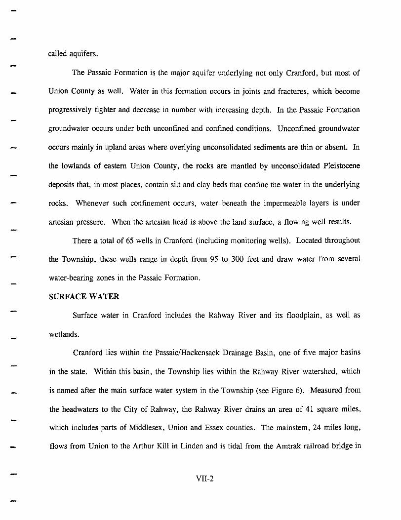
The Passaic Formation is the major aquifer underlying not only Cranford, but most of
Union County as well. Water in this formation occurs in joints and fractures, which become
progressively tighter and decrease in number with increasing depth. In the Passaic Formation
groundwater occurs under both unconfined and confined conditions. Unconfined groundwater
occurs mainly in upland areas where overlying unconsolidated sediments are thin or absent. In
the lowlands of eastern Union County, the rocks are mantled by unconsolidated Pleistocene
deposits that, in most places, contain silt and clay beds that confine the water in the underlying
rocks. Whenever such confinement occurs, water beneath the impermeable layers is under
artesian pressure. When the artesian head is above the land surface, a flowing well results.
There a total of 65 wells in Cranford (including monitoring wells). Located throughout
the Township, these wells range in depth from 95 to 300 feet and draw water from several
water-bearing zones in the Passaic Formation.
SURFACE WATER
Surface water in Cranford includes the Rahway River and its floodplain, as well as
wetlands.
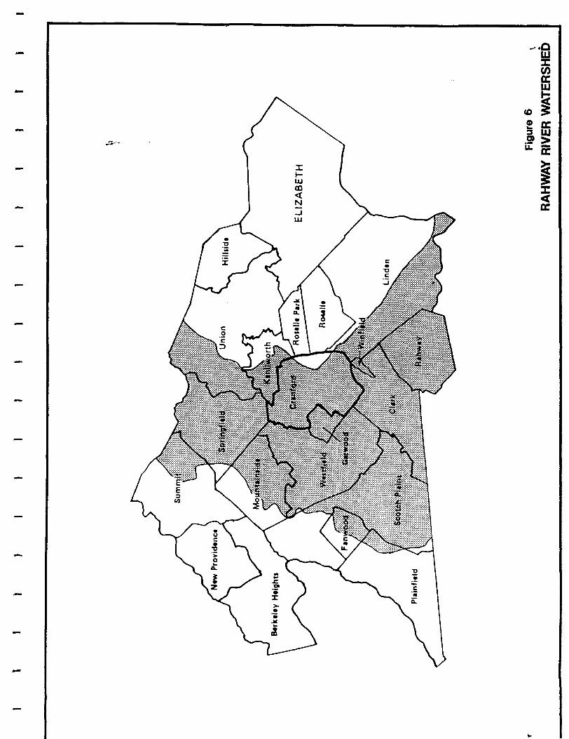
Cranford lies within the Passaic/Hackensack Drainage Basin, one of five major basins
in the state. Within this basin, the Township lies within the Rahway River watershed, which
is named after the main surface water system in the Township (see Figure 6). Measured from
the headwaters to the City of Rahway, the Rahway River drains an area of 41 square miles,
which includes parts of Middlesex, Union and Essex counties. The mainstem, 24 miles long,
flows from Union to the Arthur Kill in Linden and is tidal from the Amtrak railroad bridge in
VII-2
--
-
-
~.--
:x::: Iw m <{ N ...J W

-
--
Rahway down to the mouth. The major impoundments are the Middlesex Reservoir, Orange
Reservoir, Lower and Upper Echo Lakes and Diamond Mill Pond.
All surface waters in New Jersey have been assigned designated uses that reflect national
clean water goals. State-promulgated "Surface Water Quality Standards" set forth designated
uses for these waters, use classifications, water quality criteria based upon such uses, and the
State's policies concerning these uses. The freshwater criteria consist of the following
indicators:
• bacterial quality • dissolved solids
• chloride • sulfate
• taste & odor producing substances • dissolved oxygen
• floating solids and petroleum hydrocarbons • pH
• temperature & heat dissipation areas • toxic substances
• total phosphorus • turbidity
• radioactivity • suspended solids
In Cranford, the Rahway River has been classified as FW2-NT (fresh, non-trout). Designated
uses in all FW2 waters include maintenance, migration and propagation of the natural biota;
primary and secondary contact recreation; industrial and agricultural water supply; public potable
water supply after such treatment as required by law; and any other reasonable uses.
To assess water quality conditions and trends, the State of New Jersey utilizes the water
quality indexing procedure developed by the United States Environmental Protection Agency.
The Water Quality Index (wQI) is based on a scale from 0 to 100, where 0 represents no
VII-3
-
pollution or best conditions, and 100 equals gross pollution or worst case conditions l. Between
these extremes the WQI scale is divided into excellent (0-10), good (11-25), fair (26-60), poor
(61-80) and very poor (81-100) conditions (see Table 1).
Routine water quality monitoring is performed at three locations on the Rahway River:
the West Branch at West Orange, near Springfield and in Rahway. According to the 1990 State
Water Quality Inventory Repon, with a WQI of 38, the Rahway River has fair water quality
along its length with generally improving conditions in the downstream direction. This figure
remains unchanged from the value reported in the 1988 State Water Quality Inventory Repon
(see Tables 2 and 3).
The Rahway River is not of swimmable quality. Due to a moderately degraded fish
community it is considered to partially meet the fish propagation/maintenance use. The river's
water quality is reflective of an urbanized stream. The presence of high nutrients, fecal coliform
and biochemical oxygen demand is thought to be from nonpoint sources and municipal/industrial
point sources. Of the 42 NJPDES permitted discharges on the river or its tributaries, 21 are
upstream of Cranford and therefore impact the water quality of the river in the Township.
WETLANDS
Wet habitats occurring between uplands and deepwater areas are considered to be
wetlands. They are commonly referred to by a number of terms based on their location and
The WQI transforms water data to a value between 0 (best) and 100 (worst) through the use of severity curves. The severity curve is a plot of the water quality constituent concentration (Le. dissolved oxygen, phosphorus, etc.) versus pollution assessment (the 0 to 100 scale or index). The indices for each data value are then averaged and aggregated with the indices for the other indicators assessed to get a single WQI value for a location over time.
VII-4

-TABLE 1
- WATER QUALITY INDEX (WQI) CLASSIFICATIONS
WQI Classification! Condition Description
0-10 Excellent No or minimal pollution; water uses met throughout year.
11-25 Good Generally low amounts of pollution; water uses periodically not met.
26-60 Fair Pollution amounts vary from moderate to high levels; certain water uses prohibited.
61-80 Poor Pollution in high amounts; water uses not met.
81-100 Very Poor Pollution occurs at extremely high levels causing severe stress to streamlife, water uses not met.
Note: An index of 20 is equivalent to the level of water quality criteria.
-
VII-5

I
-- ----------- ------- ------ ---- ----
TABLE 2
I WATER QUALITY INDEX PROFILE 1988
I
!
Rahway River I I
STATION TEMP OXYGEN
West Branch AVG 2 15 Rahway River WQI at W. Orange
WORST 3 June- September-MONTHS August November
Rahway River AVG 2 32 near WQI Springfield
WORST 3 June- May-July MONTHS August
Rahway River AVG 3 15 at Rahway WQI
WORST 3 June- July-MONTHS August September
LEGEND - Water Quality Index Description
WQI Condition
J-I0 Excellent
11-25 Good
26-60 Fair
Description
No or minimal pollution; water uses met throughout the year.
Generally low amounts of periodically not met.
Pollution amounts vary from moderate to high levels; certain water uses prohibited.
PH
2
February-April
3
Feb-April
5
February-April
61-80
81-100
ID
An Index of 20 is equivalent to the level of water quality criteria.
WATER QUALITY INDICATORS
BACTERIA
47
August-October
48
June-August
40
September-November
Poor
NUTRIENTS SOLIDS
27 20
June-August December-February
18 14
May-July December-February
18 11
August- February-October April
Pollution in high amounts; water uses not met.
AMMONIA METALS
2 9
July- September-September November
2 9
April-June June-August
3 15
April-June September-November
Very Poor Pollution occurs at extremely high levels; severe stress to stream life; water uses not met.
Insufficient Data
VII-6
J I I
--------
OVERALL AVERAGE AND CONDITION
41 Fair
58 Fair August-October
43 Fair
72 Poor May-July
29 Fair
39 Fair June-August
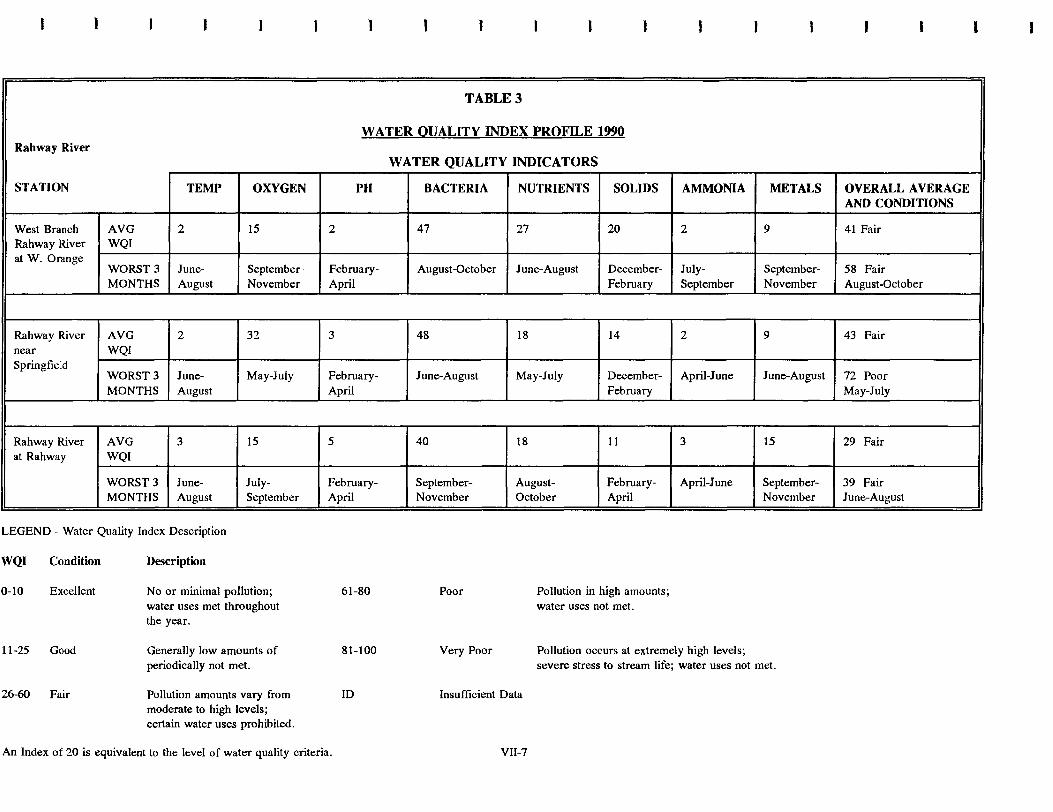
TABLE 3
WATER QUALITY INDEX PROFILE 1990 Rahway River
STATION TEMP OXYGEN
West Branch AVG 2 15 Rahway River WQI at W. Orange
WORST 3 June- September-MONTHS August November
Rahway River AVG 2 32 near WQI Springfield
WORST 3 June- May-July MONTHS August
Rahway River AVG 3 15 at Rahway WQI
WORST 3 June- July-
I MONTHS August September
LEGEND - Water Quality Index Description
WQI Condition
0-10 Excellent
11-25 Good
26-60 Fair
Description
No or minimal pollution; water uses met throughout the year.
Generally low amounts of periodically not met.
Pollution amounts vary from moderate to high levels; certain water uses prohibited.
PH
2
February-April
3
February-April
5
February-April
61-80
81-100
ID
An Index of 20 is equivalent to the level of water quality criteria.
WATER QUALITY INDICATORS
BACTERIA
47
August-October
48
June-August
40
September-November
Poor
NUTRIENTS SOLIDS
27 20
June-August December-February
18 14
May-July December-February
18 11
August- February-October April
Pollution in high amounts; water uses not met.
AMMONIA METALS
2 9
July- September-September November
2 9
April-June June-August
3 15
April-June September-November
Very Poor Pollution occurs at extremely high levels; severe stress to stream life; water uses not met.
Insufficient Data
VII-7
I
i
OVERALL AVERAGE I
AND CONDITIONS
41 Fair
58 Fair August-October
43 Fair
72 Poor May-July
29 Fair
39 Fair June-August

--
characteristics, including salt marsh, tidal marsh, wet meadow, shrub swamp, bog, hardwood
swamp, cedar swamp, and pitch pine lowland.
Because wetlands provide significant public benefits such as fish and wildlife habitat,
flood protection, erosion control, water quality maintenance, and recreation, they are considered
an important natural resource. Prior to about 1970, most people in New Jersey regarded
wetlands as wastelands, whose best use could only be attained through alteration, i.e. draining
for agriculture, dredging and filling for residential and industrial development, or for use as a
sanitary landfill.
Activity in New Jersey's wetlands is regulated by the state's Freshwater Wetlands
Protection Act and by Section 404 of the Federal Clean Water Act of 1977. The state law,
which became effective on July 1, 1988, regulates the following activities in a freshwater
wetland:
• removal, excavation, disturbance or dredging of soil, sand, gravel or aggregate material of any kind;
• drainage or disturbance of the water level or water table;
• dumping, discharging or filling with any materials;
• driving of pilings;
• placing of obstructions; or
• destruction of plant life which would alter the character of a freshwater wetland, including the cutting of trees.
Section 404 requires a permit from the U.S.Army Corps of Engineers for the discharge
of dredged or fill material in wetlands.
VII-8

--
The New Jersey regulations also established buffer zones, or transition areas, around
wetlands to accommodate slight variations in freshwater wetland boundaries over time due to
hydrologic or climatologic effects and to keep human activity at a distance from freshwater
wetlands (see Figure 7). A transition area is determined according to the resource value of the
wetland surrounding it: exceptional, intermediate or ordinary. Exceptional wetlands discharge
into FWI or FW2 Trout Production waters or their tributaries and have a ISO-foot transition
area. Intermediate wetlands are wetlands not defined as exceptional or ordinary and have a 50-
foot transition area. Ordinary wetlands are isolated wetlands with three criteria: 1) they are not
surface water tributary systems discharging into an inland lake, pond, river or stream, 2) they
are surrounded by greater than 50 percent development, and 3) they are less than 5,000 square
feet in area. These wetlands have no transition area.
Major factors creating wetlands vary throughout the state, but glaciation has played an
important role in most areas. Most of northern New Jersey's wetlands were formed in glacial
lakes and depressions during the post-glacial period. When the glacier receded, the glacial lakes
drained and wetlands formed in the basins. In addition, human activity may also create wetlands
by altering hydrologic regimes to flood former upland areas, where wetland plants quickly
invade to take advantage of the wetter conditions. Wetlands also form in floodplains along
rivers, which is generally the case in Cranford.
According to the United States Fish and Wildlife Service (FWS) , wetlands can be divided
into five general systems according to similar hydrologic and biological factors. The five
systems are Marine, Estuarine, Riverine, Lacustrine and Palustrine. The Marine System consists
of the open ocean and its associated coastline, while the Estuarine System encompasses salt and
VII-9
L 1
1
1
1
1
J
J
Plan
Enlarged
View " " " " " ~"",,,,
"""" , , , , , , , , , " " " " " " " " " " , , , , , , , , , , , " " " " " " " " " " " , , , , , , , , , , , ,
" " " " " " " " " " " " , , , , , , , , , , , , , " " " " " " " " " " " " " , , , , , , , , , , , , ,
" " " " " " " " " " " " " " , , , , , , , , , , , , , , " " " " " " " " " " " " " " , , , , , , , , , , , , , ,
-,'-,~,7,~,~-,~:':'~':vVed~dS'·~'~':':':' , , , ~ , , , , , , , . . . . . ~ , , , , , " " " " " " " " " " " " " " " " " " " " " " , , , , , , , , , , , , , , , , , , , , , , ,
" " " " " " " " " " " " " " " " " " " " " " " , , , , , , , , , , , , , , , , , , , , , , , " " " " , " " " " " " " " " " " " " " " " " " " , , , , , , , , , , , , , , , , , , , , , , , ,,-" " " " " " " " " " " " " " " " " " " " " " " -, , , , , , , , , , , , , , , , , , , , , , ';j " " " " " " " " " " " " " " " " " " " " " " , , , , , , , , , , , , , , , , , , , , , , " " " " " ,-,-, " " " " " " " " " " " " " " , , , , , , , " , , , , , , , , , , , , ,-" " " " " " " " " " " " " " " " " " "" -, , , , , , , , , , , , "" """"
" " " " " " " " " " " " " , , , , , , , , , , , " " " " " " " " " , , , , ,
Transition Alea Width
Cross SectionaL--View
Transition Area Width
Ground Surface Elevation
Outside Transition Area Boundary
Fig ... e 7
WETLAND BUFFER ZONES
-brackish marshes and brackish waters of coastal rivers and bays. Freshwater wetlands fall into
one of the remaining three systems: Riverine (e.g. rivers and streams), Lacustrine (e.g. lakes,
reservoirs and large ponds) or Palustrine (e.g. marshes, bogs, swamps and small shallow ponds).
Each system, with the exception of the Palustrine, is further divided into various subsystems.
With the exception of the wetlands located along the Rahway River and its associated
smaller streams and creeks, which are in the Riverine System, the wetlands in Cranford are in
the Palustrine System. Palustrine wetlands contain non tidal wetlands and are dominated by
trees, shrubs, persistent emergents, emergent mosses or lichens.
Specifically, Cranford contains the following wetlands, located mostly in Nomahegan and Lenape
parks and along the Rahway River (see Drawing 5):
• PEMIC
• PSSIB
• PFOIA
• PFOIB
• PFOIC
• PFOIE
• POWH
• R20W
• R20Wx
• MODL
FLOODPLAINS
Palustrine emergent, persistent, seasonal
Palustrine scrub/shrub, broad leaved deciduous, saturated
Palustrine forested, broad leaved deciduous, temporary
Palustrine forested, broad leaved deciduous, saturated
Palustrine forested, broad leaved deciduous, seasonal
Palustrine forested, broad leaved deciduous, seasonally saturated
Palustrine open water, permanent
Riverine, lower perennial, open water
Riverine, lower perennial, open water, excavated
Lawns or Stormwater Management Areas not normally inundated
Flooding is a natural characteristic of rivers and streams. Flooding occurs when more
VII-lO

--
water flows down a stream than can be carried within its channel. The water then overflows
the banks and spreads out within an area called the floodplain or flood hazard area. The limits
of the floodplain are delineated by the rising slopes of the surrounding land. The floodplain is
actually a normal part of the river during times of exceptional storm discharge. Most of the
time however, the floodplain remains free of water.
In 1968, Congress authorized the establishment of the National Flood Insurance Program
to protect property owners who were unable to get coverage through the private insurance
industry. Revised in 1973 and currently under the administration of the Federal Emergency
Management Agency (FEMA), the program requires state and local governments to adopt certain
minimum land use measures to reduce or avoid future flood damage.
In New Jersey, the Department of Environmental Protection and Energy (DEPE) is
authorized by the Flood Hazard Area Control Act and Flood Hazard Area Regulations to
regulate activities that may affect the flow of water through the flood hazard area. Under the
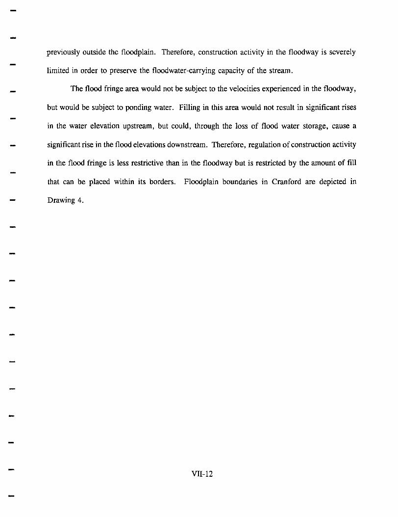
regulations, the flood hazard area is divided into two zones--the flood way and the flood fringe
(see Figure 8). The floodway is the channel of a natural stream and portions of the floodplain
adjoining the channel that are reasonably required to carry and discharge the flood water or flood
flow of any natural stream. In New Jersey, the boundaries of the floodway are the same as
those indicated in the FEMA studies. The flood fringe is the area outside the floodway.
During a flood, the floodway area would experience high velocities of moving water.
The water alone could seriously damage any structure located in its path, but when combined
with debris swept down from upstream, the effects are extremely hazardous. Any structures or
fill placed in the flood way would increase the level of the floodwaters and cause damage in areas
VII-ll

J
:-- FLOOD FRINGE ---~'I--
-
lOO-YEAR FLOODPLAIN
FlOODWAY --,:- flOOD FRINGE ,
---0'
-- .
Figure 8
FLOOD HAZARD AREAS
---
---
-
previously outside the floodplain. Therefore, construction activity in the floodway is severely
limited in order to preserve the floodwater-carrying capacity of the stream.
The flood fringe area would not be subject to the velocities experienced in the floodway,
but would be subject to ponding water. Filling in this area would not result in significant rises
in the water elevation upstream, but could, through the loss of flood water storage, cause a
significant rise in the flood elevations downstream. Therefore, regulation of construction activity
in the flood fringe is less restrictive than in the floodway but is restricted by the amount of fill
that can be placed within its borders. Floodplain boundaries in Cranford are depicted in
Drawing 4.
VII-12

--
-
-
VIII. CLIMATIC CONDITIONS
-
-
-

----
-
VIne CLIMATIC CONDITIONS
The climate of Cranford is typical of the Middle Atlantic seaboard. It may be classified
as a modified continental type climate because the prevailing westerly winds are altered by air
masses originating over the ocean and moving on shore. The moderating effect of the ocean is
felt during both the winter and summer seasons. During this period, coastal storms accompanied
by easterly winds can produce heavy precipitation, although moderate rainfall more commonly
occurs.
A major regional weather characteristic is instability caused by high pressure air masses
which move in from Canada and conflict with low pressure air masses moving from the south.
This results in periodic cool spells during the summer and periods of relatively warm, spring-like
weather in winter.
The storms experienced in Cranford are classified in four general groups: thunderstorms,
cyclonic or transcontinental storms, extratropical storms, and hurricanes.
Thunderstorms normally occur with the most frequency in the months of July and
August. They are usually of brief duration and are limited in area. These storms, when intense,
can cause local flooding in areas of the Township where storm sewers are not of sufficient size
to accommodate the resulting surge flows. The general path of these storms is in a northeasterly
direction.
During autumn, winter and spring, cyclonic storms predominate. These storms are due
to movements of transcontinental air masses with attendant high and low pressure areas. Intense
storms of this type are potent flood producers over large areas because of their wide range.
VIII-l

----
-
-
-
These storms can cluster together and last for many days, depositing four, five or more inches
of precipitation over their duration. The duration of these storms, coupled with the continuous
rainfall, can cause the Rahway River to rise above the storm sewer stream encroachment near
the end of the storm event. This slows storm sewer drainage and causes street flooding as a
result. In extreme cases, the Rahway River rises so high that river water will enter the street,
causing flooding that will linger until the river recedes below the storm sewer encroachment
elevation.
Extratropica1 storms are due to the rapidly convective circulation that results when
tropical marine air masses are lifted suddenly on contact with hills and mountains. They usually
cause heavy rain in the summer and autumn seasons.
A hurricane is defined as a spiralling tropical low pressure system, formed by the release
of latent heat from ocean water condensation, with sustained wind speeds of 74 m.p.h. or
greater. Because of its size and duration, a fully developed hurricane is the most destructive of
storms. Hurricanes only form in certain areas of the earth at specific times of the year. Those
effecting the United States form in the western Atlantic Ocean, near the Cape Verde Islands, and
in the western Carribean Sea. Hurricane season there runs from June 1 to November 30.
METEOROLOGICAL DATA
There are no official meteorological stations located in Cranford. The closest one is
located at Newark International Airport, approximately 10 miles east northeast of the Township
(located at 40 0 42' North Latitude, 74 0 10' West Longitude). This station measures and keeps
records on various weather-related phenomena such as temperature, barometric pressure, relative
humidity, wind and cloud cover. Summaries of each are presented below:
VIII-2

-1. Temperature
The mean annual temperature at the Newark station is 54.0 degrees Fahrenheit. The
coldest month is February, with an average temperature of 31.5 degrees Fahrenheit. July, with
an average temperature of 76.7 degrees Fahrenheit, is the hottest month of the year (see Table
4). Temperature readings of above 90 degrees and below ° degrees Fahrenheit are not unusual
occurrences. The record high is 105 degrees Fahrenheit, first set in July of 1966 and equalled
during July of 1993. The record low temperature of -8 degrees Fahrenheit was set in January
of 1985. The average annual heating degree days is 4,972 and ranges from 5,577 to 4,086.
- The average annual cooling degree days is 1,091 and ranges from 1,490 to 982.
-
-
-
2. Barometric Pressure
Barometric pressure averages 1,016.1 millibars annually, with monthly averages ranging
from 1,013.7 to 1,018.1 millibars (see Table 5).
3. Relative Humidity
Depending upon the time of day, the average annual relative humidity ranges between
53 and 73 percent (see Table 5).
4. Precipitation
An average of 42.34 inches of rain falls annually at the Newark station. Normally, this
rainfall is distributed evenly throughout the year, with average monthly rainfall ranging from 2.9
to 4.3 inches each month. The maximum monthly rainfall was 11.84 inches, which was
recorded in August of 1955. The minimum monthly rainfall was recorded in June of 1949 at
VIU-3

-
TABLE 4
- Temperature - De!::rees Fahrenheit
Normal Normal
- Month Daill: Maximum Daill: Minimum Monthll: A vera!::e Record Hi!::h Record Low
January 38.2 24.2 31.3 74 -8
February 40.3 25.3 32.8 76 -7
March 49.1 33.3 41.2 89 6
April 61.3 42.9 52.1 94 16
May 71.6 53.0 62.3 98 33
June 80.6 62.4 71.5 102 43
July 85.6 67.9 76.8 105 52
August 84.0 67.0 75.5 103 45
September 76.9 59.4 68.2 105 35
October 66.0 48.3 57.2 92 28
November 54.0 39.0 46.5 85 15
December 42.3 28.6 35.5 72 -1
Annual 62.5 45.9 54.2 105 -8
Normal De!::ree Dal:S
Month Heatin!:: Coolin!::
January 1045 0
February 902 0
March 738 0
April 387 0
May 140 56
June 0 199
July 0 366
August 0 326
September 36 132
October 254 12
November 555 0
December 915 0
Annual 4972 1091
VIII-4 -

--
TABLE 5
Monthll Normal Bf!rometric Pressure
Month Barometric Pressure (millibars)
January 1016.9
February 1016.9
March 1016.0
April 1013.7 - May 1014.1
June 1014.0
July 1014.5
August 1015.9
September 1017.5 - October 1018.1
November 1017.6
December 1018.1
Annual 1016.1
Monthly Normal Percent Relative Humidity
Month 0100 Hr. 0700 Hr. 1300 Hr. 1900 Hr.
January 70 74 58 64
February 69 72 54 60
March 66 69 50 57
April 66 66 48 54
May 72 70 51 58
June 72 71 51 58
July 73 72 52 59
August 76 75 53 62 - September 77 78 55 64
October 76 79 53 64
- November 73 77 56 64
December 72 74 59 64
Annual 72 73 53 61
-VIII-5

0.07 inches. The maximum rainfall that occurred in a 24-hour period occurred in August of
- 1971 and amounted to 7.84 inches. Precipitation data is summarized in Table 6.
- The abundant precipitation in the Cranford area has made groundwater recharge adequate
and has helped the area's vegetative ground cover and tree population to temporarily retain water
and minimize erosion.
Precipitation during the winter months often falls in the form of snow. The average
annual snowfall in Cranford is about 27.1 inches. The monthly maximum of snow for the area
is 29.1 inches, recorded in December of 1947. A portion of this amount (26.0 inches) was the
result of a record 24-hour snowfall. Snow can be expected to fall from October to May. The
average monthly snowfall at the Newark station is shown below:
SNOWFALL
Month Snowfall (inches)
November 0.5 December 5.6 January 7.7 February 7.9 March 4.5 April 0.7 May Trace October Trace
Rainfall of 0.01 inches or more occurs on an average of 121. 7 days annually and ranges
from 11.3 to 15.4 days per month. Snowfall of 1.0 inch or more occurs on an average of7.1
days annually and ranges from 0.0 to 2.2 days per month.
- VIII-6

--
TABLE 6
- Monthly A veral:e of Normals Maximums and Minimum Precipitation - Inches
Month Normal A veral:e Maximum Minimum Daily Maximum
- January 3.13 10.10 0.45 3.59
February 3.05 4.94 1.22 2.45
March 4.15 11.14 1.10 2.83
April 3.57 11.14 0.90 3.73
May 3.59 10.22 0.52 4.22
June 2.94 6.40 0.07 2.31
July 3.85 9.98 0.89 3.63
August 4.30 11.84 0.50 7.84
September 3.66 10.28 0.95 5.27
October 3.09 8.20 0.21 3.04
November 3.59 11.53 0.51 7.22
December 3.42 9.47 0.27 2.77
Annual 42.34 11.84 0.07 7.84
Montlhy Maximum and Daily Maximum of Snows Ice Pelletss and Hail - Inches
Month Maximum Daily Maximum
January 27.4 17.8
February 26.1 20.0
March 26.0 17.6
April 13.8 12.8
May Trace Trace
June 0.0 0.0
July 0.0 0.0
August 0.0 0.0
September 0.0 0.0
October 0.3 0.3
November 5.7 5.7 - December 29.1 26.0
Annual 29.1 26.0
VIII-7
--
5. Wind
- The normal prevailing wind direction is from the west to east for eleven months of the
- year. January is the exception, when the prevailing winds are from the northeast. Average
monthly wind velocity ranges from 8.7 miles per hour (mph) to 11. 9 mph, with an annual
average of 10.2 mph. The peak gust recorded at the Newark station was 83 mph. Average and
- peak wind data is presented in Table 7.
6. Cloud Cover
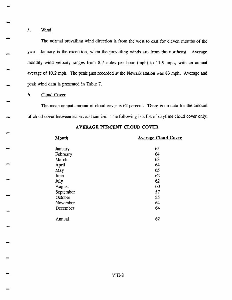
-The mean annual amount of cloud cover is 62 percent. There is no data for the amount
_ of cloud cover between sunset and sunrise. The following is a list of daytime cloud cover only:
-
-
-
-
Month
January February March April May June July August September October November December
Annual
A VERAGE PERCENT CLOUD COVER
VIII-8
A veraee Cloud Cover
65 64 63 64 65 62 62 60 57 55 64 64
62

-TABLE 7 -
Averal:e and Peak Wind Data
Normal - Normal Prevailing Maximum Peak Month Averal:e Speed (mph) Direction ~ (mph)-Direction (degrees) Gust (mph) Direction
• January 11.2 NE 52 300 53 W
February 11.5 NW 46 230 58 NW
March 11.9 NW 43 270 56 W
April 11.3 WNW 50 270 55 E
May 10.1 SW 50 320 58 NW
June 9.5 SW 58 260 83 W
July 8.8 SW 52 350 69 NW
August 8.7 SW 46 090 68 N
September 9.0 SW 51 050 67 W
October 9.4 SW 48 110 53 SW
November 10.2 SW 82 090 63 NW
December 10.8 SW 55 032 60 NW
Annual 10.2 SW 82 090 83 W
• - fastest observed in one minute.
VIII-9

--
-
-
Cranford has a wide variety of weather styles which contribute to the distinct seasonal
differences experienced by the Township. These include rainfall, snowfall, thunderstorms,
hailstorms and windstorms and are generally neither extreme nor severe. Table 8 presents a
listing of the average duration of the distinct weather types by month.
VIU-lO
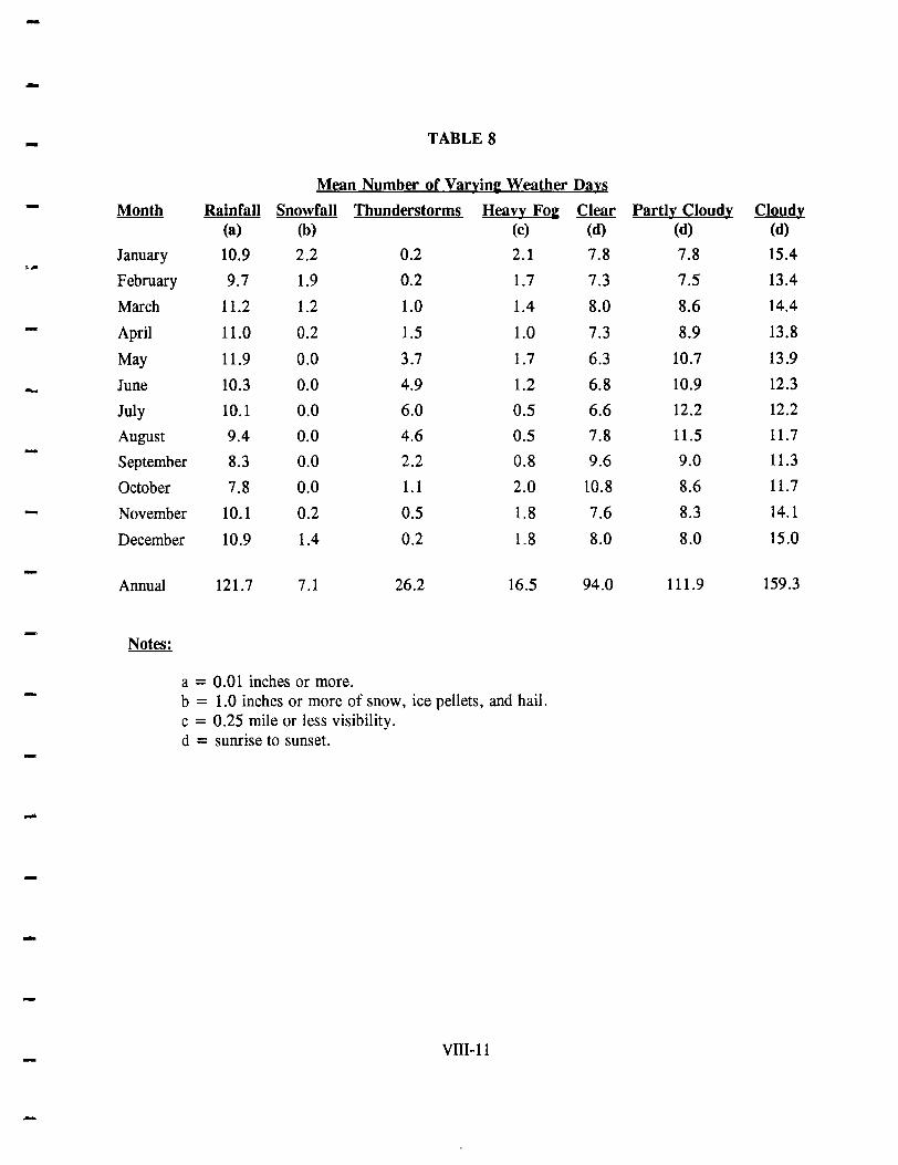
--
,~
-
-
-
-
-
TABLE 8
Mean Number of Varyinl Weather Days
Month Rainfall Snowfall Thunderstorm~ Heavy FOI (a) (b) (c)
January 10.9 2.2 0.2 2.1
February 9.7 1.9 0.2 1.7
March 11.2 1.2 1.0 1.4
April 11.0 0.2 1.5 1.0
May 11.9 0.0 3.7 1.7
June 10.3 0.0 4.9 1.2
July 10.1 0.0 6.0 0.5
August 9.4 0.0 4.6 0.5
September 8.3 0.0 2.2 0.8
October 7.8 0.0 1.1 2.0
November 10.1 0.2 0.5 1.8
December 10.9 1.4 0.2 1.8
Annual 121.7 7.1 26.2 16.5
a = 0.01 inches or more. b = 1.0 inches or more of snow, ice pellets, and hail. c = 0.25 mile or less visibility. d = sunrise to sunset.
VIII-ll
Clear (d)
7.8
7.3
8.0
7.3
6.3
6.8
6.6
7.8
9.6
10.8
7.6
8.0
94.0
Partly Cloudy Cloydy (d) (d)
7.8 15.4
7.5 13.4
8.6 14.4
8.9 13.8
10.7 13.9
10.9 12.3
12.2 12.2
11.5 11.7
9.0 11.3
8.6 11.7
8.3 14.1
8.0 15.0
111.9 159.3
--
-...
-
IX. VEGETATION
---
--
--
-
-
-
----
IX. VEGETATION
Vegetation is defined as the total plant cover of a region. It is comprised of different
species of plants that grow together.
Vegetation interacts with the other four components of the ecosystem (climate, geology
and soil, animals, man) and is affected by each in a different way. Climatic factors such as
precipitation, temperature, wind and light each impact vegetation for obvious reasons.
Geologic processes over millions of years have defined the physical relief of the land
which in turn impacts vegetation because of its influence on drainage and exposure. Geologic
processes also produce the earth's soil, the medium through which vegetation receives
nourishment. Soil types differ greatly in their ability to hold water, in their supply of mineral
elements and in their acidity. Each vegetative species has a specific range of both need and
tolerance for these soil characteristics.
The interaction between animals and vegetation can be both beneficial and harmful and
is usually quite obvious to even the casual observer. Beneficial effects result from the numerous
organisms that live in the soil and improve soil quality (i.e. earthworms), from birds and insects
that are necessary for plant reproduction (through fertilization), and from the various animals
such as squirrels that play a vital role in seed transport. Harmful effects include defoliation
from animals such as deer and cattle (not very common in the Township), and the damage that
results from insects such as the gypsy moth or the parasite carried by the elm bark beetle.
Human activity has had the most profound impact upon vegetation. Man is both directly
- and indirectly dependent upon vegetation for food, air quality, water quality, climatic conditions,
IX-I
-
----
and many types of clothing and cannot exist without it. In addition, man's development
tendencies result in construction activity which usually clears the landscape of most vegetation
and introduces many non-native species through landscaping. Finally, man's indiscriminate use
of pesticides and other chemicals has caused irreparable to vegetation in some areas.
Based on combinations of environmental factors such as soil moisture, temperature, water
-- salinity and water acidity, the natural land area of New Jersey can be divided into twelve major
types of plant habitats (Robichaud and Buell, 1983). In terms of terrestrial plant habitat,
-
-
Cranford is located in Type 5 and Type 7 of the Robichaud and Buell system, a commonly used
classification system by biologists.
Type 5, North Jersey swamps and floodplains, occurs in the broad valleys of the larger
rivers. In Cranford, Type 5 habitat is found along the floodplain and associated wetlands of the
Rahway River. Red maple, elm, pin oak, swamp white oak, silver maple, black gum, and ash
are the most common trees in Type 5 areas. Typical shrubs include the spicebush, witch hazel,
arrowwood and viburnums. Common herbs include skunk cabbage, touch-me-not, mayapple,
jack-in-the-pulpit, spring beauties, trout lilies and the cardinal flower. Vines include poison ivy,
Virginia creeper, Japanese honeysuckle, bittersweet and wild grape (see Table 9).
Type 7, North Jersey uplands, includes slopes, valleys and the ridge and valley sections
as well as the flats of the Piedmont provence. There are four different types of plant
- communities in North Jersey upland areas: successional vegetation, the Mixed Oak forest, the
Hemlock-Mixed Hardwoods forest, and the Sugar Maple-Mixed Hardwoods forest. In Cranford, -Type 5 habitat is only represented by successional vegetation and the Mixed Oak forest.
IX-2
-

TABLE 9
- Vegetation Common to North Jersey Swamp and Floodplain Habitats
- Community Structure Central N.J. More Northern N.J.
Typical Trees Pin oak Yellow birch Red maple Red maple Ash Ash Elm Basswood Swamp white oak Tulip tree Black gum Black gum Silver maple
- Also on Floodplains
Willow Box elder Sycamore River birch -
Typical Shrubs Spicebush Alder Witch hazel Willow Arrowwood Buttonbush Viburnums Spicebush - Others Witch hazel
Others
;;III Typical Herbs Skunk cabbage Skunk cabbage
Spring herbs Spring herbs Sedges & mosses Sedges & mosses
- Source: Robichaud and Buell, 1983
-
--IX-3

--
-.....
-....
-
......
Successional Ve~etation
Plant succession is a directional, cumulative change in the species that occupy a given
area, through time (between 1 and 500 years). If significant changes in species composition for
a given area do not occur within this time span, the community is said to be a mature or climax
community. If a community does exhibit some directional, cumulative, nonrandom change
during this time span, it is said to be a successional or seral community. Seral communities or
species will replace one another until a climax community is achieved. The entire progression
of seral stages, from the first one to occupy bare ground (the pioneer community) to the climax
community, is called a succession or sere.
The most common reason for vegetational succession is man's intervention. Land that
was formerly cultivated or otherwise developed is abandoned and left untouched and over time
a series of different plant communities occupy the site, culminating in a mature forest. Table
10 illustrates the stages of succession and each stage's typical vegetation. Several vacant lots
along both North and South avenues are local examples of the initial stages of vegetational
succession.
The Mixed Oak Forest
The Mixed Oak forest gets its name from three species that in varying mixtures are most
abundant among the large trees that form the forest canopy at heights from about 60 to 100 feet.
The three are the red oak, white oak and black oak (see Table 10). Other typical trees include
chestnut and scarlet oaks, several types of hickories, maples and yellow poplar. A striking
feature of these forests is a lack of a well-developed younger generation of oak trees to replace
the older trees in the future. Instead, red maple, ash and sugar maple are the more abundant
IX-4
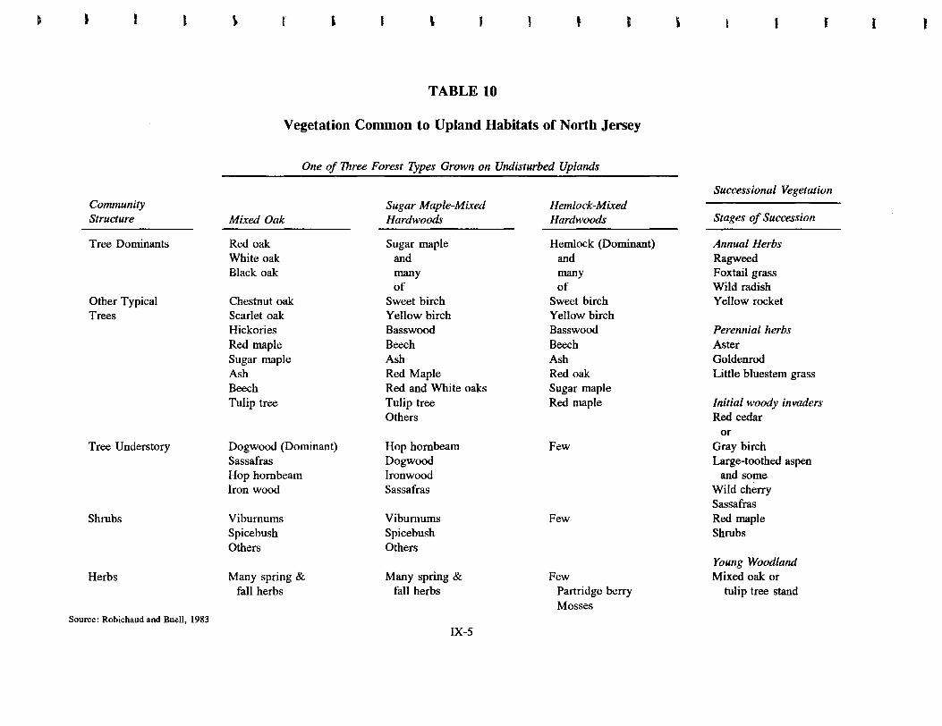
• • l
Community Structure
Tree Dominants
Other Typical Trees
Tree Understory
Shrubs
Herbs
Source: Robichaud and Buell, 1983
~ r , \ • J
TABLE 10
Vegetation Common to Upland Habitats of North Jersey
One of Three Forest Types Grown on Undisturbed Uplands
Mixed Oak
Red oak White oak Black oak
Chestnut oak Scarlet oak Hickories Red maple Sugar maple Ash Beech Tulip tree
Dogwood (Dominant) Sassafras Hop hornbeam Iron wood
Viburnums Spicebush Others
Many spring & fall herbs
Sugar Maple-Mixed Hardwoods
Sugar maple and many of
Sweet birch Yellow birch Basswood Beech Ash Red Maple Red and White oaks Tulip tree Others
Hop hornbeam Dogwood Ironwood Sassafras
Viburnums Spicebush Others
Many spring & fall herbs
IX-5
Hemlock-Mixed Hardwoods
Hemlock (Dominant) and many of
Sweet birch Yellow birch Basswood Beech Ash Red oak Sugar maple Red maple
Few
Few
Few Partridge berry Mosses
, J
Successional Vegetation
Stages of Succession
Annual Herbs Ragweed Foxtail grass Wild radish Yellow rocket
Perennial herbs Aster Goldenrod Little bluestem grass
Initial woody invaders Red cedar
or Gray birch Large-toothed aspen
and some Wild cherry Sassafras Red maple Shrubs
Young Woodland Mixed oak or
tulip tree stand
( I

--
younger trees. The dominant understory (second layer) tree is the dogwood, while other typical
- species include sassafras and ironwood. Typical shrubs include the spicebush and viburnums
- such as the arrowwood and black haw, while the most common vines include poison ivy,
Virginia creeper and wild grape. Common herbs usually found in this type of habitat in the
spring include the mayapple, spring beauties, jewelweed, jack-in-the-pulpit and solomon's seal.
.... In the fall goldenrod, baneberry, New York fern, Christmas fern and partridge berry are
common. The Mixed Oak forest is best represented in Cranford by the woods in Nomahegan
and Lenape parks and along the Rahway River Parkway.
-- TREES
--
-
-.
-
Trees have provided man with everything from basic food and shelter to aesthetic beauty since he first appeared on Earth. Today trees also reduce air and noise pollution and give texture to our often stark environment of concrete and steel. Most people, however, neither recognize the different species of trees nor appreciate the many uses man has found for them ....
Another reason why you might want to study trees is that even a small woodlot is not just a simple aggregation of trees. There are infinitely complex relationships between trees, other living things, and their environment. Only as we begin to recognize the delicate balance of nature will the intensity with which we disrupt nature be abated (Ombrello).
As is the case with most older suburban towns, Cranford has an abundance of trees, not
only along most of its streets, but in places such as Nomahegan Park and along the Rahway
River as well. A common way to identify trees is by the leaf.
Principal trees in several of the larger parks in the Township (Nomahegan, Unami and
McConnell) are as follows:
Nomahegan Park
American sycamore, American beech, yellow poplar, sweetgum, oak, kwanzam, black cherry,
black birch and pin oak.
IX-6

----
Un ami Park
Sweetgum, oak and maple.
McConnell Park
Yellow poplar, white pine, oak, kwanzam and black cherry.
Some of the oldest trees in the Township include the "Pepperidge Tree", a 225 year old
_ blackgum located on Lincoln Avenue at Lincoln Park; a 200 year old bur oak located at
Cleveland Plaza; a 200 year old oak located on West End Place at Berkeley Place; a 175 year ,-old shagbark hickory located at 15 Norman Place; a 150 year old northern catawba located at
...... 1 Bloomingdale Avenue; a 200 year old pin oak located at 726 Gallows Hill Road adjacent to
the tennis courts; and a 150 year old tulip tree in McConnell Park.
--.
--
--
A fairly unusual tree found in the Township is the Ginkgo (Ginkgo biloba). The ginkgo,
or maidenhair tree, is an introduced ornamental from China and is the last remaining species in
its order (Ginkgoales). Although it seems like an ordinary tree, its leaves are fern leaves.
Unlike other trees today, the ginkgo is a survivor from the age of dinosaurs. This ancient tree's
pollen swims through rain or dew instead of being blown by wind or carried by insects. There
are many ginkgo trees in Cranford, including one at 10 Manor Avenue and another on North
Union Avenue opposite Riverside Drive.
IX-7

--
-
-
--- x. WILDLIFE
-
-

-
-
-x. WILDLIFE
Loss of habitat has been the single greatest cause of decline and extirpation of animal species in New Jersey. Consequently, the inventory and protection of Wildlife habitats is of extreme imponance if we are to protect our remaining heritage (Kane, 1981).
Cranford is fortunate to have protected park land and natural waterways to serve as
.... habitats and breeding grounds for many types of animal life. The Township's wild animal
population has remained stable over recent years, although there has been an increase in the
number of deer in the Lenape Park area. This increase is attributable to a migration from the
..... nearby Watchung Mountains and to habitat loss in other areas. The Township's usually large
population of raccoons and skunks has decreased somewhat over the years, due in part to
increased development and noise associated with suburban areas. These species, however, seem
to be making a comeback as they become more accustomed to interaction with man and
machine. Except for an occasional transient bald eagle or peregrine falcon, no state or federally -.
listed or proposed threatened fauna has been identified in Cranford. Table 11 identifies species
(other than birds) which have been observed or are expected to occur in the Township.
- Because New Jersey (i) contains a naturally established diversity of habitat; (ii) lies along
the Atlantic coastal flight pattern and (iii) defines the southern limit of many northern species
and the northern limit of many southern species; the state enjoys a rich collection of bird life.
- The New Jersey Audubon Society lists 421 distinct species of birds in its official New Jersey
State Bird List of 1992. This list includes several bird species which are "accidental" visitors
from outside the United States. In Cranford, 190 of these birds (45 percent) have been identified
-- X-I
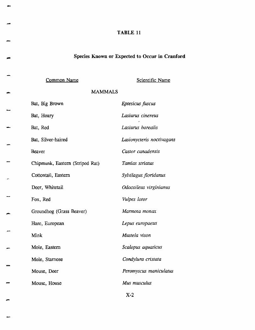
--
TABLE 11
- Species Known or Expected to Occur in Cranford
Common Name Scientific Name
- MAMMALS
Bat, Big Brown Eptesicus fuscus ......
Bat, Hoary Lasiurus cine reus
- Bat, Red Lasiurus borealis
Bat, Silver-haired Lasionycteris noctivagans
Beaver Castor canadensis
Chipmunk, Eastern (Striped Rat) Tamias striatus
Cottontail, Eastern Sylvilagus floridanus
Deer, Whitetail Odocoileus virginian us
Fox, Red Vulpes lotor
- Groundhog (Grass Beaver) Marmota monax
Hare, European Lepus europaeus .-
Mink Mustela vison
- Mole, Eastern Scalopus aquaticus
Mole, Stamose Condylura cristata -Mouse, Deer Peromyscus maniculatus
- Mouse, House Mus musculus
X-2 -

--
Mouse, White-Footed Peromyscus leucopus
- Muskrat Ondatra zibethica
- Myotis, Little Brown Myotis lucifugus
Myotis, Small-footed Myotis subulatus
Opossum Didelphis marsupialis
Pipistrel, Eastern Pipistrellus subflavus
Raccoon Procyon lotor .....
Rat, Norway Rattus norvegicus
- Skunk, Striped Mephitis mephitis
Squirrel, Eastern Gray Sciurus carolinensis
Vole, Meadow Microtus pennsylvanicus
Weasel, Longtail Mustela Jrenata
REPTILES AND AMPHIBIANS
Copperhead Agkistrodon contortrix
- Frog, Bull Rana catesbelana
Frog, Eastern Gray Tree Hyla versicolor
Frog, Green Rana clamitans
Newt, Eastern Notophthalmus viridenscens
Salamander, Marbled Ambystoma opacum
Salamander, Spotted Ambystoma maculatum
Snake, Eastern Garter Thamophis sirtalis
X-3 --

--
Snake, Milk Lampropeltis triangulum
Snake, Rat Elaphe obsoleta
Toad, American Bufo americanus
Turtle, Eastern Box Terrapene carolina
Turtle, Snapping Chelydra serpentina
-
-
--
--
--
X-4
-

---
-
-
--
--
and may be seen, depending on the time of year (see Table 12). In viewing Table 12, the
following reference symbols should be utilized:
•
•
R - Refers to resident birds, such as the Blue Jay, Cardinal and Mockingbird, which are in Cranford year round. There are 37 different species of resident birds in Cranford.
S - Refers to birds such as the Robin, Song Sparrow and Oriole, which are found in Cranford only in the summer. There are 55 different species of these birds found in Cranford.
• W - Refers to birds like the Slate Colored Junco, Purple Finch and Pine Siskin, which are found in the Township only in the winter. There are 20 different winter resident species found in town.
• T - Refers to birds such as the Bobolink, Meadow Lark and Bluebird which are transient in Cranford, that is, simply passing through town on their annual spring or fall migratory journeys. There are 78 different species in this group.
Table 12 also estimates the relative abundance of each bird species in the Township, as indicated by the following symbols:
• 1 -
• 2 -
• 3 -
Very good chance for the bird to be encountered in the right habitat at the right time of year (Mallard Duck, Egret, Mocking Bird-55 species).
Encountered as in 1 above, but not necessarily on any given day (Wood Duck, Pileated Woodpecker, Killdeer-73 species).
Not seen every year, but often enough to check for its presence; may not be encountered for many years in a row (Bald Eagle, Snow Goose, Red Headed Woodpecker-52 species).
Table 12 was compiled by Henry Burk, a local amateur ornithologist.
The abundance of bird life in Cranford, especially during the transient periods (Spring and
Fall) is confirmed by the bird count presented in Table 13. The count was taken in Nomahegan
and Lenape parks on May 14, 1990 by Richard Kane, the Director of the New Jersey Audubon
Society. Since the count was made during a time favorable for transients, Table 13 includes
both a large variety of species and a large number of individual birds. There are, for example,
X-5

--
NEW JERSEY BIRDS - OBSERVER:
-Y MO. E A A DAY
Red·throated Loon
Com. Loon - Pied·billed Grebe
Horned Grebe
Red·necked Grebe
N. Fulmar
Cory's Shurwater
Gr. Shearwater
Sooty Shearwater
Manx Shearwater
Audubon's Shearwater
Wilson's Storm ·Petrel
·Leach's Storm· Petrel - N. Gannet Am. White Pelican
Brown Pelican
Great Cormorant Double·crested Cormorant
Am. Bittern Least Bittern - Great Blue Heron
Great Egret Snowy Egret
Little Blue Heron Tricolored Heron
Cattle Egret
Green~backed Hero" - Black-crowned Night-Heron Yellow-crowned Night-Heron
White Ibis
Glossy Ibis
Fulvous Whistling-Duck
Tundra Swan
Mute Swan
Gr. White-fronted Goose
Snow Goose
Brant Canada Goose Wood Duck
Green-winged Teal Am. Black Duck Mallard N. Pintail
Blue-winged Tell
N. Shoveler - Gadwall Eurasian Wigeon Am. Wigeon
Canvasback
TABLE 12
Audubon Bird Chart
Redhec.d Ring·necked Duck
Gr. Scaup L. Scaup
Com. Eider
Kong Eider Harlequin Duck Oldsquaw
Black Scoter
<;Orf Scoter White ·wi nged Scoter
Com. Goldeneye
T 2. Barrow's Goldeneye
IT 2 Bufflehead
Hooded Merganser
Com. Merganser
Red· breasted Merganser
Ruddy Duck Black Vulture
Turkey Vulture
O~prey
Am. Swallow·tailed Kite
Mississippi Kite
Bald Eagle
-N. Harrier Sharp·shinned Hawk
Cooper's Hawk
-N. Goshawk
T 1:3 Red·shouldered Hawk
Broad·winged Hawk Swainson's Hawk
R. \ Red·tailed Hawk
S I Rough . legged Hawk
S 3 Golden Eagle
S ~ Am. Kestrel Merlin
Peregrine Falcon
5 I Gyrfalcon
S Z Ring·necked Pheasant
Ruffed Grouse Wild Turkey
N. Bobwhite
Yellow Rail
Black Rail
IR 2- Clapper Rail
King Rail
W I'!> Virginia Aail
Sora
RI Purple Gallinule
R 2. Com. Moorhen
T'2. Am. Coot
T 2- Sandhill Crane
IR \ Black·bellied Plover
L. Golden-Plover
IT 12 Wilson's Plover
I, :3 Semipalmated Plover
12 Piping Plover
Killdeer
Iw 13 Am.OYsterCltcher
Black-necked Stilt
W3 W 13 T ;3
T3
T 3
R 2 , ·2
.,.. .3 .,.. 2 "T 1 'T 2 T 13 T '2. T I
R \
Vol :3 T "3
R 2. T 3 I_ :3
R '2.
-r I~
R 2

-TABLE 12 Cont.
- Audubon Bird Chart AIn. Avocet DovekIe
Cit'. Yellowt. .,- 2. Com. Murre
- L Yellowtegs '\ z.. Thick·billed MUHl
Solitary s.ndpiper T I Razorbill
Willet Bl.ck Guillemot
Spotted s.ndpiper S I Atlantic Puffin - Uplend Sandpiper ~ock Dove ,R , Whimbrel Mourning Dove R I Hudsoni.n Godwit BI.:k· billed Cuckoo 5 'z.. a.. tailed Godwit Yellow·bliled Cuckoo 5 2-M~edGodwit Com. Barn·OwI
Ruddy Turnstone IE. Screech·OwI R 2-
"-d Knot Great Horned Owl R 2 - SIndet1ing Snowy Owl
$emiP.hNted Slndpiper Barred Owl
Western Slndpiper Long·eared Owl
LeISt Slndpiper " '1" 2- Short· e.red Owl
Whlte·rumped Slndpiper N. ~w·whet Owl W 3 Baird', Slndpiper .Com. Nighthawk T '2. P.c:torel Slndpiper T :3 O\uck·wiWs·widow - Purple Smdpiper Whip·poor·will. T "3 Dunlin o\imney Swih S \ Q.II1ew Sandpiper -Ruby· throated Hummingbird 5 2 StIlt Slndpiper Belted Kingfisher R. \ Buff'MlSted Slndpiper Red·headed Woodpecker VI "3 Ruff Red·bellied Woodpecker R. , Short·billed Dowitcher Yellow-bellied Sapsucker T 2-Long·billed Dowitcher Downy Woodpecker R. \ Com. Snipe I 2 Hairy Woodpecker R. 2.. Am. Woodcock ..,- "2- Black·backed Woodpecker
Wilson', Phalerope N. Flicker S \ - Red·necked Phalarope Pileated Woodpecker R.. 'Z Red Phalerope Olive· sided Flycatcher T 3 Pomarine Jaeger E. Wood ·Pewee S I Parasitic Jaeger Yellow·bellied Flycatcher T 13 Long·tailed ~r Acadian Flycatcher T 3 Great SkIUl Alder Flycatcher 5 "3 South PoIer Sku. Willow Flycatcher 5 'Z. - laIghing Gull Least Flycatche, S 2 UttitGuIl E. Phoebe S , .Com. Black·headed Gull Great Crested Flycatcher S , Bonapart.'s Gull W. Kingbird
Rlng·billed Gull W, E. Kingbird S , Herring Gull R , Homed Lark
Iceland Gull Purple Martin S 2 L BI.ck·backed Gull TreeSw.llow S \ Glaucous Gull N. Rough·winged Swallow 5 lb Great Black·backed GUll R , Bank Swallow I. ? Black-legged Kittiwake Cliff Swallow T ~ Gull·billed Tern Barn Swallow 5 I Cespi.., T.m Blue J.y R. \ ROVal Tern Am. Crow IR \
Tern fish Crow R. 2-"osute Tern Com. Raven Com. Tim Black·c.pped o\ickadee R. , Arctic Tim Carolin. Chickadee - ['Forster's Tern Boreal Chickadee LeISt Tern Tuhed Titmouse R. ,
IsIIICk Tem Red·bre .. sted Nuthatch T 'Z 'BlICk Skimmer White· breasted Nuthatch R \

-TABLE 12 Cont.
- Audubon Bird Chart
Brown Creeper T ,.., N. Waterthrush S \ <-
Carolma Wren . R. i louIsiana Wate'::"1f\Jsh 5 2 - House Wren S \ Kentucky Warb!' I 3 Winter Wren \tV 2- Connecticut Wa-::J<er "\" "3 Sedge Wren Mourning Warb~' I "3
- Marsh Wren ~ . .., Com. Yellowth':.ll 5 I ~
Golden·crowned Kinglet W \ IHooded Warble' I 2-Ruby-crowned Kinglet " i Wilson's Warble' T 2-Blue-gray Gnatcatcher 5 2. Canada Warbler ~ I ._. N. Wheatear Yellow-breastpc Dlat T 5 E_ Bluebird \' 2 Summer Tanage'
Veery ::> i Scarlet Tanager S I
Gray-cheeked Thrush \ 3 W. Tanager
ts;;;'nson's Thrush T 2. N. Cardinal R \ Hermit Thrush W 2- 'Rose-breasted G.-ost>eak S I Wood Thrush S i Bl ack -headed Grosbeak
Am. Robin S i Blue Grosbeak
Varied Thrush :Indigo Bunting S '2. Gray Catbird S \ Dickcissel T '3 --'-- .
Rufous·sided T o.omee 5 2. N. Mockingbird R I - Brown Thrasher 5 2- Am. Tree Sparrow 'W 2 Water Pipit T 3 O1ipping Sparrow 5 I Cedar Waxwing R 2 aay-colored Spvrow
N, Shrike Field Sparrow R '2. Loggerhead Shrike Vesper Sparrow
European Starling R \ Lark Sparrow
White-eyed Vireo 5 2. Savannah Sparro.w T 2. Solitary Vireo T , Gr3Uhopper 5p¥row
Vellow-throated Vireo 5 2- Henslow's Sparrow Warbling Vireo S I Shlrp·tailed Sparrow Philadelphia Vireo T 3 Seuide Sparrow Red-eyed Vireo S I Fox Sparrow T '2. Blue-winged Warbler S i Song Sparrow R \ "Brewster's Warbler" Lincoln's Sparro.w T 2-"Lawrence's Warbler" SwMnp Sparrow R \ .Golden-winged Warbler T 3 White-throated SQarrow 'vV I Tennessee Warbler T '2. White-crowned SQarrow \'" '2.. Orange-crowned Warbler W ~ Dark·eyed Junco W I Nashville Warbler r 2. Lapland LOrtgspUr N. Parula T \ Snow Bunting Yellow WarbI ... 5 \ Bobolink T "2-Chestnut-sided Warbler 5 2. Red·winged Blac:tbird S I MagnOlia Warbler T '2 E. Meadowlark T 13 Cape May Warbler ,- 12 VIlIow-he.cMd ~bird Black-throated Blue Warbler r \ Rusty Blackbird W 'Z. Vellow·rumptd Warbler r I Boat-tailed Grec:lde Black-throlted GrHn Wlrbler , \ Com. Grackle 5 \ BI~kburnian Warbler T '2. Brown-he.cMd Cowbird 5 \ .y~.thtoeUIdW~ Orchlrd Oriole S 2-Pine Warbler T 2 N.Oriole S , Prairie Wlfbler T Z. Pi .... Grosbeak Palm Warbler T , Purple Finch vi '2. Blv-brllsted Warbler .,- 2 House Finch IR I Blackpoll Warbler T 1 Red Crossbill Cerulean Warbler T '3 Whitt-winged Cf'ossbill
- Black·.nd·white W.rbllf S I Com. Redpoll VI "5 .--Am. Redstan 5 I Pi .... Siskin W '3 Prothonotary Warbler 53 Am. Goldfinch It I Worm-eating Warbler T 2- E_inGGr~ak W 13 Ovenbird 51 House Spurow ~ '.- " '-~
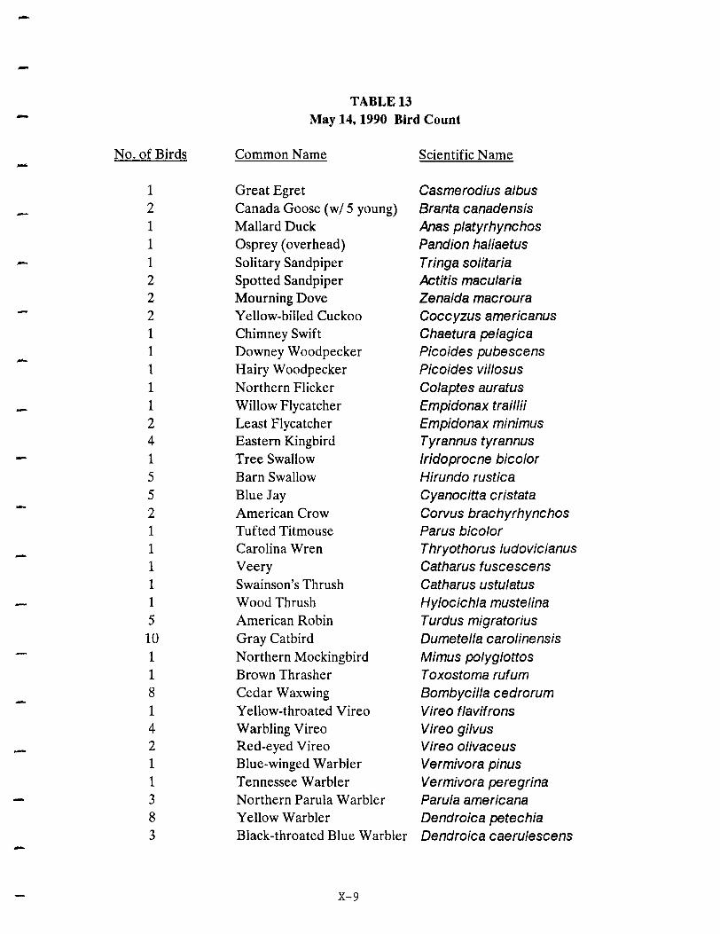
--
TABLE 13 May 14,1990 Bird Count
No. of Birds Common Name Scientific Name -1 Great Egret Casmerodius albus 2 Canada Goose (wi 5 young) Branta canadensis 1 Mallard Duck Anas platyrhynchos 1 Osprey (overhead) Pandion haliaetus 1 Solitary Sandpiper Tringa solitaria 2 Spotted Sandpiper Actitis macularia 2 Mourning Dove Zenaida macroura 2 Yellow-billed Cuckoo Coccyzus americanus 1 Chimney Swift Chaetura pelagica 1 Downey Woodpecker Picoides pubescens - 1 Hairy Woodpecker Picoides villosus 1 Northern Flicker Colaptes auratus 1 Willow Flycatcher Empidonax traillii 2 Least Flycatcher Empidonax minimus 4 Eastern Kingbird Tyrannus tyrannus 1 Tree Swallow Iridoprocne bicolor 5 Barn Swallow Hirundo rustica 5 Blue Jay Cyanocitta cristata 2 American Crow Corvus brachyrhynchos 1 Tufted Titmouse Parus bicolor 1 Carolina Wren Thryothorus ludovicianus 1 Veery Catharus fuscescens 1 Swainson's Thrush Catharus ustulatus 1 Wood Thrush Hylocichla mustelina 5 American Robin Turdus migratorius 10 Gray Catbird Dumetella carolinensis 1 Northern Mockingbird Mimus polyglottos 1 Brown Thrasher T oxostoma rufum 8 Cedar Waxwing Bombycilla cedrorum 1 Yellow-throated Vireo Vireo flavifrons 4 Warbling Vireo Vireo gilvus 2 Red-eyed Vireo Vireo olivaceus 1 Blue-winged Warbler Vermivora pinus 1 Tennessee Warbler Vermivora peregrina 3 Northern Parula Warbler Parula americana 8 Yellow Warbler Dendroica petechia 3 Black-throated Blue Warbler Dendroica caerulescens -
X-9

-
TABLE 13
- May 14, 1990 Bird Count
No. of Birds Common Name Scientific Name -1 Black-throated Green Warble Dendroica virens 2 Canada Warbler Wi/sonia canadensis 1 Wilson's Warbler Wi/sonia pusilla 1 Bay-breasted Warbler Dendroica castanea 2 Blackpoll Warbler Dendroica striata 6 American Redstart Setophaga ruticilla 1 Ovenbird Seiurus aurocapillus 4 Northern Waterthrush Seiurus noveboracensis 6 Common Yellowthroat Geothlypis trichas 2 Scarlet Tanager Piranga olivacea 1 Northern Cardinal Cardinalis cardinalis 1 Rose-breasted Grosbeak Pheucticus ludovicianus 1 Savannah Sparrow Passerculus sandwichensis 2 Song Sparrow Melospiza melodia
25 Bobolink Dolichonyx oryzivorus 7 Red-winged Blackbird Agelaius phoeniceus 15 Common Grackle Quiscalus quiscula 1 Orchard Oriole Icterus spurius 8 Northern Oriole Icterus galbula 10 House Finch Carpodacus mexicanus 8 American Goldfinch Carduelis tristis 2 House Sparrow Passer domesticus
--
X-10
-
-
-
12 species of warblers with a total of 35 individual birds.
In writing about Nomahegan and Lenape parks, Mr. Kane and other representatives of
the New Jersey Audubon Society stated: "These parks are adjacent and contiguous. Thus, they
form a very large and somewhat unfragmented forested area. These are two of the larger tracts
in the entire tributary/estuary system and, as such, should be carefully managed. These parks
should remain as forested as possible. A checklist of birds would be a great project to
encourage birders and other users to work in the area and report their findings".
X-ll

-
--
XI. GLOSSARY
-
-
-Aquifer
Artesian
Basalt
Cenozoic Era
Climate
Connate Water
Cretaceous Period
Ecosystem
Epoch
GLOSSARY
XI-1
A body of permeable sediment or rock through which groundwater moves easily.
A groundwater system where the groundwater is isolated from the surface by a confining layer and the water is under pressure.
A fine grained igneous rock.
A time span on the geologic calendar beginning about 65 million years ago and includes the present time.
A description of aggregate weather conditions; the sum of all statistical weather information that helps describe a place or region.
Water that is no longer in circulation or in contact with the present water cycle.
A time span on the geologic calendar that began approximately 100 million years ago and lasted approximately 40 million years.
A particular type of biological system in which climate, geology and soil, animals and man are related to each other and affected by their interactions.
A unit of the geologic calendar that is a subdivision of a period.

Era
Floodplain
Floodway
Flood Fringe
Fragipan
Ground Moraine
Groundwater
Hydrologic Cycle
Igneous Rocks
Juvenile Water
-
GLOSSARY, Con't.
XI-2
A major subdivision on the geologic calendar; eras are divided into shorter units called periods.
The flat, low-lying portion of a stream valley subject to periodic inundation, the flood hazard area.
The stream channel and the immediately adjacent portions of the floodplain which carry the bulk of the flood flow during storm events.
That portion of the floodplain located outside the floodway.
A natural soil subsurface horizon with high bulk density relative to the horizons above it.
An undulating layer of till deposited as the ice front retreats.
Water found beneath the surface of the earth within the zone of saturation.
The circulation of water from the oceans to the atmosphere and back to the oceans by way of evaporation, runoff from streams and rivers, and groundwater flow.
Rocks formed by the crystallization of molten magma.
Water derived from the interior of the earth that has not previously existed as atmospheric or surface water.

---
Lithosphere
Mesozoic Era
Meteoric Water
Miocene Epoch
Moraine
-NJPDES Pennit
Paleocene Epoch
Paleozoic Era
Penneability
Perched Water Table
GWSSARY, Con't.
XI-3
The outer layer of the earth approximately 100 kilometers thick of which the plates that contain the ocean basins and the continents are composed.
A time span on the geologic calendar between the Paleozoic and Cenozoic eras-from about 225 to 65 million years ago.
Water derived from the atmosphere.
An epoch in the tertiary period of geologic history which began approximately 13 million years ago and lasted approximately 12 million years.
Sediments deposited directly by the ice of a glacier.
New Jersey Pollutant Discharge Elimination System, a permit issued by the state Department of Environmental Protection and Energy to discharge pollutants into navigable waterways.
The oldest epoch in the tertiary period of geologic history, it ended approximately 55 million years ago.
A time span on the geologic calendar between the Precambrian and Mesozoic eras-from about 600 to 225 million years ago.
A measure of a material's ability to transmit fluid.
A localized zone of saturation above the main water table created by an impermeable layer.
Period
Physiographic Province
Pleistocene Epoch
Porosity
Precambrian
Quaternary Period
Sediment
Sedimentary Rocks
Silt
Soil Horizon
GWSSARY, Con't.
XI-4
A basic unit of the geologic calendar that is a subdivision of an era; periods may be divided into smaller units called epochs.
A region characterized by a particular assemblage of landforms, climate and geomorphic history.
The most recent epoch in geologic history. It began approximately one million years ago and may continue into the present.
The percentage of void (empty space) in earth material such as soil or rock.
All geologic time prior to the Paleozoic era.
A time span on the geologic calendar that began approximately I million years ago and is still in progress.
The accumulation of soil particles that have settled out of flowing water.
Rocks formed from the weathered products of pre-existing rocks that have been transported, deposited and lithified.
Finely divided particles of soil or rock often carried in cloudy suspension in water and eventually deposited as sediment.
A layer of soil that has identifiable characteristics produced by chemical weathering and other soil-forming processes.

Soil Prome
Subsurface Water
Surface Water
Tertiary Period
Terminal Moraine
Till
Vegetative Succession
Water Table -Zone of Saturation
GWSSARY, Con't.
XI-5
A vertical section through a soil showing its succession of horizons and the underlying parent material.
All of the waters within the lithosphere.
Waters above the surface of the lithosphere.
A time span on the geologic calendar that began approximately 55 to 60 million years ago and ended approximately 1 million years ago.
The end moraine marking the farthest advance of a glacier.
Unsorted sediment deposited directly by a glacier.
A directional, cumulative change in the species that occupy a given area, through time.
The upper level of the saturated zone of groundwater.
Zone where all open spaces in sediment and rock are completely filled with water.

--
XII. REFERENCES

--
REFERENCES
Anderson, H.R. Special Report No. 27: Groundwater Resources of the Rahway Area. N.J .. Trenton: Division of Water Policy and Supply.
Association of New Jersey Environmental Commissions. Environmental Commissioner's Handbook. Trenton: New Jersey Department of Environmental Protection and the Association of New Jersey Environmental Commissions, 1990.
Association of New Jersey Environmental Commissions. The Environmental Manual for Municipal Officials. Trenton: New Jersey Department of Environmental Protection and the Association of New Jersey Environmental Commissions, 1992.
Banino, George M., et al, Geologic. Hydrologic. and Well Drilling Characteristics of the Rocks of Northern and Central New Jersey. Trenton: Department of Conservation and Development, Bureau of Geology and Topography, 1970.
Behler, John L., and F. Wayne King. The Audubon Society Field Guide to North American Reptiles and Amphibians. New York: Alfred A. Knopf, 1989.
Buell, Murray F., and Beryl Robichaud. Vegetation of New Jersey. New Brunswick: Rutgers University Press, 1983.
Burt, William H., and Richard P. Grossenheider. A Field Guide to the Mammals of America North of Mexico. Boston: Houghton Mifflin, 1976.
Barbour, Michael G., and Jack H. Burk and Wanna D. Pitts. Terrestrial Plant Ecology. Menlo Park: Benjamin/Cummings, 1987.
Harlow, William M., and Ellwood S. Harrar and Fred M. White. Textbook of Dendrology. New York: McGraw-Hill, 1978.
Havens and Emerson, Inc., et.al. The New Jersey Statewide Water Supply Plan. Source Material. Task VII-Watershed Management. Trenton: New Jersey Department of Environmental Protection, 1980.
Havens and Emerson, Inc., et.al. The New Jersey Statewide Water Supply Plan. Source Material. Task VII-Watershed Management. Groundwater Management Appendices. Trenton: New Jersey Department of Environmental Protection, 1980.
Keller, Edward A. Environmental Geology. Columbus: Charles E. Merrill, 1976.
Kiimmel, Henry B., and J. Volney Lewis. Bulletin No. 50. The Geology of New Jersey.
XII-l

---
-
REFERENCES, Con't.
Trenton: Department of Conservation and Development, Division of Geology and Topography, 1940.
Lucey, Carol S. Geolo~y of Essex and Union Counties In Brief. Trenton: Department of Conservation and Development, Bureau of Geology and Topography, 1976.
McHarg, Ian L., Design with Nature. Garden City: Doubleday, 1971.
Miller, David W. The New Jersey Ground-Water Situation. Hackensack: Geraghty & Miller.
Nemickas, Bronius. Geolo~y and Ground-Water Resources of Union County. New Jersey. Water-Resources Investigation 76-73. Trenton: U.S. Geological Survey, 1976.
New Jersey Department of Environmental Protection. Freshwater Wetlands Protection Act Rules. N.J.A.C. 7:7A et seq. Trenton: Division of Coastal Resources, 1989.
New Jersey Department of Environmental Protection. State Water Ouality Inventory Report. 1988. Trenton: Division of Water Resources, 1988.
New Jersey Department of Environmental Protection. State Water Ouality Inventory Report . .122Q. Trenton: Division of Water Resources, 1990.
New Jersey Department of Environmental Protection. Surface Water Ouality Standards. N.J.A.C. 7:9-4.1 et seq. Trenton: Division of Water Resources, 1989.
Olsen, Gerald W. Soils and the Environment. New York: Chapman and Hall, 1983.
Olsen, Paul E. Triassic and Jurassic Formations of the Newark Basin, in Manspeizer, W. ed. Field Studies of New Jersey Geolo~y and Guide to Field Trips. Newark: Rutgers University Geology Department, 1980.
Ombrello, Thomas M. The Trees of Union Col1e~e. Cranford: Union College Biology Department, 1979.
Osborn, Henry Fairfield. Proboscidea. New York: The American Museum Press, 1936 (Vol. I) and 1942 (Vol. II).
Peterson, Roger T. A Field Guide to the Birds. Boston: Houghton Mifflin, 1980.
Richards, Horace G. Some Recent Discoveries of Pleistocene Mammals from New Jersey, in Bulletin No. 60. Short Geolo~ic Papers. Trenton: Department of Conservation and Economic Development, Division of Planning and Development, 1951.
XII-2

--
REFERENCES, Con't.
Rogers, F.C., et. al. En~ineerin~ Soil Survey of New Jersey. Report No.5. Union County. New Brunswick: Rutgers University Engineering Department, 1952.
Scotch Plains Environmental Commission. Environmental Resources Inventory. Scotch Plains: 1991.
Tarbuck, Edward J., and Frederick K. Lutgens. Earth Science. Columbus: Charles E. Merrill, 1988.
Tiner, Ralph W. Jr. Wetlands of New Jersey. National Wetlands Inventory. Newton Comer: U.S. Fish and Wildlife Service, 1985.
United States Department of Agriculture, Soil Conservation Service. Union County. New Jersey. Draft Soil Survey. Bridgewater: USDA, SCS, 1992.
United States Department of Commerce, National Oceanic and Atmospheric Administration. Local Climatolo~ical Data. 1991 Annual Summary with Comparative Data for Newark. New Jersey. Asheville: National Climatic Data Center, 1991.
XII-3
--
-
-
APPENDIX A
DRAWINGS

-, i i I
- ,
I
, i
-~
I
I -~
5~~ 5 ,~== r--~r----=..'\ g Jf===~-=----..J
OAK
LEGEND
_ S1R£M
, ,
I i I , I
]~ II =-.~=.. : trdIbctI ... ""'Ii.taI,..... Ue:: p ... lI0II151.
d< ~,.., G7II2 I _~ ~~~ NATURAL RESOURCE
O~' e;,'" INVENTORY I ~ ~ TOWNSHIP OF CRANFORD i
Dot, Seal, UNION COUNTY NEW JERSEY: MARCH, 1993 1" "" 1200' DnIwIng numb.. ' Drawn by a. by !
:l I ,1
~~.. KLK 1 BASE MAP !
___________ ~~~~~~~~~~~=,="'=.,=,,=,=,===========,.=,,~1,9~05==================~'11 • Ii'" ii, fl. , if· ... . iff i 'i f i I. t Ii r f I
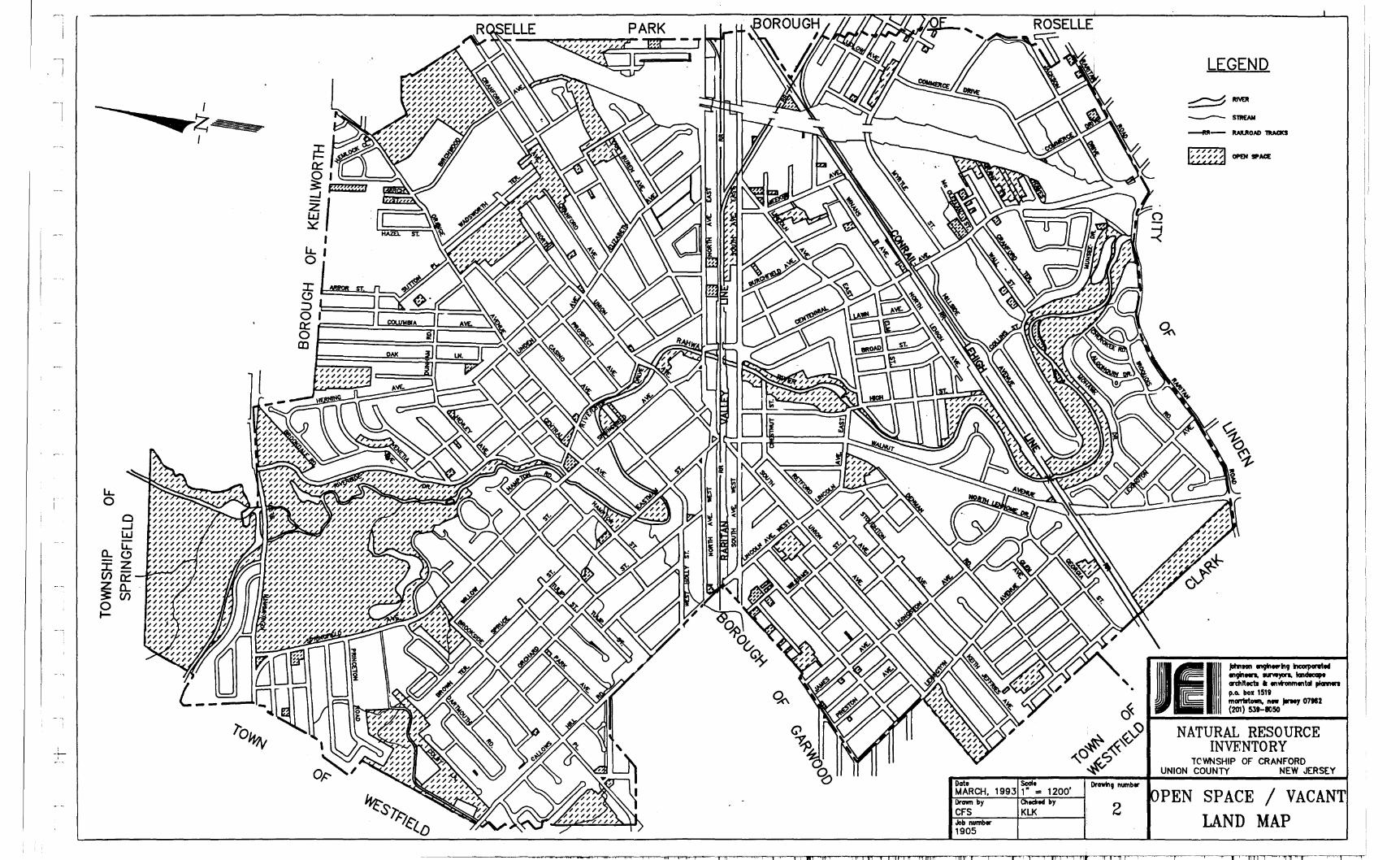
l&... o
I ::t.
£:) ....J W LA:
Q..(!) -Z :r:_ (/)0:::
~B5 o ~
L L
I , u.., o
11 II I I .1 '111' i I! 11 l' f '1I1!1 "111'
Oat. MARCH, Drawn by CFS Job number 1905
'111'1
ScaI. 1200' 1993 ," = OIeclred by
KLK
II!
,
Drawtng numb ..
2
LEGEND
JII'&I ~E=-~ II I (201) 53'-1050
NATURAL RESOURCE INVENTORY
TCYfTIISHIP OF CRAN:~DJERS[Y UNION COUNTY
PEN SPACE / VACANT LAND MAP
, I' 1!l1 n
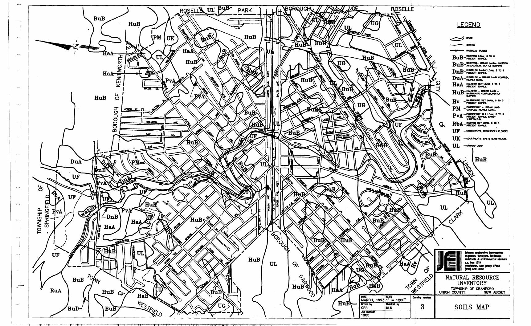
-,
e.G:: -" :r:Z (I) -_LooO-~g: 0(1) I- ,
I I I' I I' "1
PARK
UL
I I 'n In 11 ' n' r 11' IIilliY 1, "If ,.Im' tnll I n 9 I 1II't ., t i" • • I
.1 ... LJ_l <_1. I I ~ I __ _
3
LEGEND
lEI NATURAL RESOURCE
INVENTORY
- j
UNION WWNSHIP OF CRANFORD OUNTY NEW JERSEY
SOILS MAP
I

r
I ~
I :
I I~ I
i i
I ~+ ,
. i
I .--,
I I . ! I "
i
Il
~~~ 5 ,~~ ..---=..=-;;...---==..\
0:: t=====!.~~:=::=~~
gl====~~~~
PARK
Oot, Sede DrawtnO number MARCH, 1993 1· = 1200' Drown by QIec:k y 4 CF"S KLK Job number 1905
LEGENp
- RR- RAIlROAD 1IIAQ(1
,....,s- STAlE n.ooo FIlING[
r::::::l FLOOD HAZNID MEA LIlT L:.:.:.:.:.;.:.
NATURAL RESOURCE INVENTORY
TOWNSHIP OF ~ANF"ORD UNION COUNTY J, NEW JERSEY
LOOD DELINEATION MAP
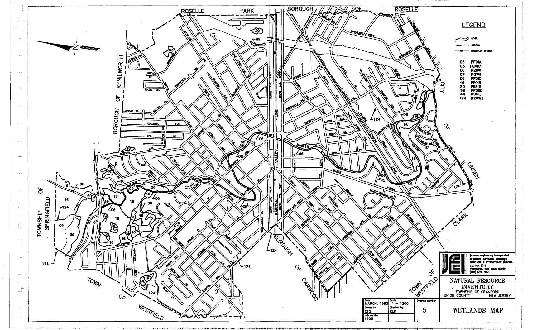
a~~ 5 ~=:::!,---;=...=;;;::; ,;;==.,.\
tr F=====-=~~:=~~' g I======::!==~~
Dot, ~ DnnrIn9 number MARCH, 1993 1 ~ - 1200' Drown by )' 5 CFS KLK Job IIIIRber 1905
LEGEND
03 PrOIA 05 PEMIC 06 R20W 07 POWH 09 PFOIC i6 PF0I8 20 PSSI8 39 PFOIE 44 MOOl 124 R20Wx
NATURAL RESOURCE , INVENTORY
TOWNSHIP OF CRANFORD UNION COUNTY NEW JERSEY
WETLANDS MAP
.~~~~~~~~~~-..,,-.,--,. i~""""'-I" ~'i~' ,.,......." • ..,.."..... .• ........,.,.,fH..,......., ,,.,..,...,..,. i"i~i.i...,....,--• .",.,.",."ifTj...",....."iil~'rT1"1" 11M""""""', 1,.-,---, 1 or-ril f ~'i ---mr'"1iii -----.-,-".--,1 i---.... .. 1r-T1'rHli~1 r--ni ii........-ritlf..,........-, '..,.,..,.,...,11 I'!""""""n"i f'''''''''--hlft ~liii .----.,."...,..-,-, i-r'""T1 '''''''''''-' """'" ''''''-'1 t...,-mlll.h--' TT"'"II ".,..-tll -,-----,------~, -r-r-, i -rrn-rllj"'-""'-' --""-"'--'11""""-'. ~I" I,


