Historic Buildings Survey Phase III Transitional Area ...
71
Historic Buildings Survey Phase III Transitional Area Between Montezuma Avenue and Main Street Cortez, Colorado 2015 CLG grant number CO-14-15 Prepared by Cultural Resource Planning Jill Seyfarth PO Box 295 Durango, Colorado 81302
Transcript of Historic Buildings Survey Phase III Transitional Area ...

Historic Buildings Survey Phase III
Transitional Area Between Montezuma Avenue and Main Street
Cortez, Colorado 2015
CLG grant number CO-14-15
Prepared by
Cultural Resource Planning
Jill Seyfarth PO Box 295
Durango, Colorado 81302


Historic Buildings Survey Phase III
Transitional Area Between Montezuma and Main
Cortez, Colorado 2015
Prepared for the
Cortez Historic Preservation Board The City of Cortez
210 East Main Cortez, Colorado 81321
Historic Preservation Board
Chairman-Linda Towle Dale Davidson
Joyce Lawrence Dan Giannone
Mindy Rosenbaugh Mitchell Toms Janet Weeth
Cortez City Staff Chris Burkett
Dawn McCabe-Lightenburger Doug Roth
Kirsten Sackett
Prepared by: Jill Seyfarth
Cultural Resource Planning PO Box 295
Durango, Colorado 81302 (970) 247-5893
May, 2015
CLG grant number CO-14-015


i
Table of Contents
Introduction .................................................................................................................. 1 Background/Purposes Federal Funding Acknowledgement Project Description
Summary of Additions to the Work and Report Completed in Previous Phases
Survey Area................................................................................................................... 3 Legal Description Physical Setting
Research Design and Methods .................................................................................... 7 Survey Methodology
Historic Contexts ......................................................................................................... 11 Revised Historic Contexts
Survey Results ............................................................................................................. 27 History of the Survey Area Residential/Commercial Buildings Construction Dates Architecture Materials
Montezuma Avenue Historic District ......................................................................... 39
Assessment of Survey Results..................................................................................... 43 National Register Eligibility
State Register Eligibility Local Register Eligibility
Recommendations ...................................................................................................... 49
Bibliography ................................................................................................................. 51 Appendix ...................................................................................................................... 53
Table A1-Previously Recorded Sites Located Near The Survey Area Table A2-Sites surveyed in Phases I and II Table A3-Sites surveyed in Phase III (2014-2015) listed by street address Table A4-Sites surveyed in Phase III (2014-2015) listed by site number

ii
List of Figures
Figure 1 USGS Quad Showing Survey Area ......................................................................... 4 Figure 2 Lot and Block Map Showing Surveyed Properties ................................................ 5 Figure 3 Cortez Townsite Plat Survey Area Outlined ........................................................... 6 Figure 4 Local Historic District Options on Montezuma Avenue ........................................ 42
List of Tables
Table 1 Population of Cortez ............................................................................................. 18 Table 2 Survey Area Construction Dates ........................................................................... 34 Table 3 Properties Eligible for the State Register .............................................................. 45 Table 4 Properties Eligible for the Local Register ............................................................. 48
List of Photographs
Photograph 1 The Montezuma County Courthouse.......................................................... 22 Photograph 2 The Oldest Building in the Survey Area at 27 North Beech ........................ 33 Photographs 3-5 Three Homes from 1900-1916 ................................................................ 33 Photograph 6 Ertel Funeral Home ...................................................................................... 35 Photograph 7 St. Barnabas of the Valley Episcopal Church ............................................... 35 Photograph 8 The Lamb Building ....................................................................................... 36 Photographs 9-10 Warehouses from 1926 and 1942......................................................... 36 Photograph 11 The Former Cortez Medical Clinic .............................................................. 37 Photograph 12 The Former Post Office at 17 North Chestnut ........................................... 37 Photographs 13-14 Bungalows at 34 North Ash and 33 North Chestnut ........................... 38 Photograph 15 Tudor Revival House at 121 North Beech .................................................. 38 Photograph 16 The Mon-Do Title Company ....................................................................... 44
Cortez Survey Phase III Cultural Resource Planning Page 1
Introduction
Background/Purposes
This project is the third phase of an effort to survey the historic properties within and adjoining the original Cortez townsite. In the first two phases of the project, the City of Cortez surveyed the properties along Montezuma Avenue and a few properties located south of the Avenue and within the original Cortez townsite. This project addresses the remaining area located between Montezuma Avenue and Main Street within the original townsite. It is funded by a Certified Local Government (CLG) grant (#CO-14-015). The survey results contribute to the knowledge and appreciation of the history of the development of Cortez. The City will use the survey data to guide future planning, development and interpretation projects. The project results also provide valuable information for property owners contemplating restoration or rehabilitation of their historic property. Federal Funding Acknowledgement The activity that is the subject of this material has been financed in part with Federal funds from the National Historic Preservation Act, administered by the National Park Service, U.S. Department of the Interior for History Colorado. However, the contents and opinions do not necessarily reflect the views or policies of the U.S. Department of the Interior or History Colorado, nor does the mention of trade names or commercial products constitute an endorsement or recommendation by the Department of the Interior or History Colorado. This program receives Federal funds from the National Park Service. Regulations of the U.S. Department of the Interior strictly prohibit unlawful discrimination in departmental Federally-assisted programs on the basis of race, color, national origin, age or handicap. Any person who believes he or she has been discriminated against in any program, activity, or facility operated by a recipient of Federal assistance should write to: Director, Equal Opportunity Program, U.S. Department of the Interior, National Park Service, 1849 C Street, N.W., Washington, D.C. 20240. Project Description This survey area is located within the original townsite, in a transitional area between the primarily residential neighborhood of Montezuma Avenue and the commercial businesses on Main Street. The area contains a mix of homes, churches and commercial properties. Five properties within the survey were not recorded because they had been developed within the past 30 years. Nine other properties within the survey area were documented as part of the previous, Phase II, survey. A parking lot was also excluded from the survey. Thirty-three survey forms were completed for the area. The City of Cortez Historic Preservation Board supervised and coordinated the project under the direction of the Chair, Linda Towle, and with assistance from Chris Burkett, the Cortez Grants and Special Projects Coordinator. Jill Seyfarth, the Principal of Cultural Resource

Cortez Survey Phase III Cultural Resource Planning Page 2
Planning of Durango, Colorado, contracted with the City of Cortez in March of 2014 and completed the project in May of 2015. The History Colorado Office of Historic Preservation staff contacts for this work were Dan Corson (now retired), Patrick Eidman and Elizabeth (Liz) Blackwell. New Information in this Report This report includes new information on the creation of historic contexts for Cortez. The contexts are discussed in the Research Design and Methods section and in the Historic Contexts section.

Cortez Survey Phase III Cultural Resource Planning Page 3
Survey Area Legal Description The cumulative survey area encompasses approximately 14 acres, and encompasses properties located in parts of 12 blocks. The survey area is located within Section 26 of Township 36 N, Range 16W, New Mexico Principal Meridian, Cortez, Montezuma County, Colorado. Figures 1 and 2 illustrate the survey area. Physical Setting The City of Cortez is located in southwest Colorado in the geographic area known as the Montezuma Valley, at an elevation of about 6200 feet above sea level. It is situated in a transitional area between the arid scrublands to the south and the forested montane environment of the Rocky Mountains to the northeast. The climate is semi-arid, with an average annual precipitation of about thirteen inches. In 2010 the census counted 8,482 people in Cortez and 25,535 people in Montezuma County. Cortez is the county seat and the largest community in the county. The City covers 3,930 acres or 6.2 square miles. US Highway 160 runs east-west through the middle of town and serves as the main commercial thoroughfare. The highway bends to the south at the town’s west end and intersects with the north-south oriented US Highway 491.

Cortez Survey Phase III Cultural Resource Planning Page 4
Figure 1: Survey area on the Cortez, Colorado 7.5 minute U.S.G.S. quadrangle map (1965)
Phase III survey area

Cortez Survey Phase III Cultural Resource Planning Page 5
Figure 2: Survey Area parcels with street addresses were included in this survey. Parcels without addresses were surveyed in Phase II. A list of surveyed sites listed by street address is included in the Appendix.
236 208 202 110 Not
Surveyed 20 12
Not
Surveyed
221
33 Parking
Lot
38
33
17
24
44
25 42
30
41
27
25
18
34 4
4
35
Not
Surveyed
12
1
12
2
10
0
10
1 11
1 12
7
12
1
11
4
12
2
210

Cortez Survey Phase III Cultural Resource Planning Page 6
Figure 3: This original Cortez plat was filed in 1886 in La Plata County because Montezuma County was not created until 1889. The survey area is located within the red outline.
Figure 2 Survey Areas with street address numbers

Cortez Survey Phase III Cultural Resource Planning Page 7
Research Design and Methods
Research Design Objectives The survey’s objectives were to document the history and current condition of identified properties, to provide a preliminary evaluation of their eligibility for the National Register of Historic Places, and to determine potential for a historic district within the survey area. Research focused on gathering historical and architectural data that would help determine the historic significance of the resource within the context of local, regional and national history. The resulting data included information specific to the property and identified local influences, such as economic trends or natural settings. Previous Work in the Area A file search requested of History Colorado in June, 2014, revealed 4 sites in the survey area had previously been documented on state survey forms. They are sites 5MT 6923 through 5MT 6926, which were recorded in 1995. They are all commercial buildings. One of these sites is the Ertel Funeral Home (5MT6925), which is listed on the National Register. Information from the old forms was transferred to the current #1403 State Survey form and additional information was provided. The City of Cortez maintains a historic register. Two properties in this survey (5MT6924-The Lamb Building/Cortez Cultural Center, and 5MT2914- St. Barnabas Episcopal Church) are listed on the local register. The file search indicated that the areas immediately surrounding the survey area include the sites documented in Phases I and II of this project (conducted between 2011 and 2013) and forty-six other sites. Most of the sites recorded prior to 2011 were documented in either 1981 as part of a state wide cultural resource planning process, or in 1995 by Preservation Partnership as part of a planning study commissioned by the City of Cortez and partly funded by Preservation Grant #SHF 1995-M3-050. Of these sites, the Montezuma Valley National Bank and Store Building (5MT11979 and 5MT19093), and the previously noted Ertel Funeral Home are listed on the National Register of Historic Places. Tables listing the recorded sites are included in the Appendix. The recorded sites are all historic structures related to the establishment and development of Cortez between 1886 and 1950. They include standing commercial and residential buildings and a remnant of a segment of a Cortez ditch. Research Sources Various books and published material provided histories of the Cortez area. They include The River of Sorrows; The History of the Lower Dolores River Valley, edited by Gregory D. Kendrick and A History of Montezuma County, by Ira Freeman. The Montezuma County Historical Society’s four-volume compendium of local memoirs and biographies provided background. It is

Cortez Survey Phase III Cultural Resource Planning Page 8
called Great Sage Plain to Timberline: Our Pioneer History Volumes I-IV. A recent publication called Cortez is a collaboration of three residents and includes numerous historic photographs. These sources are listed with additional references in the Bibliography. Since the survey area was located in a transitional residential/commercial area the project was anticipated to address residential buildings, churches and some commercial buildings constructed between 1886 and 1964. An initial windshield review of the resources suggested that most of the buildings were constructed between 1910 and 1960. Major archival materials identified for use included:
County property records
Local historical society materials
Locally published informal histories, memoirs and a walking tour brochure
Historic photographs
Newspaper archives
Limited oral interviews
Information volunteered by the public
Publicly accessible federal records, including census and social security death indices
Historical city directories
Sanborn Fire Insurance Map; only one is available for Cortez and it covers part of the survey area
Contexts Historic contexts for the Cortez area are discussed in History Colorado Resources Planning Protection Process Colorado Plateau Country Historic Context by Michael B. Husband (1984). This context document, while in serious need of an update, provides general background information on community development in southwest Colorado. Paul O’Rourke’s Frontier in Transition, A History of Southwestern Colorado (1980) provides additional historical background. History Colorado’s updated archaeological context document for the Southern Colorado River Basin (Lipe et al 1999) is also useful. Full citations for these sources are listed in the Bibliography.
A local historic context was developed in 1995 for the commercial areas of Cortez by Preservation Partnership as part of a planning study commissioned by the City of Cortez. The 1995 context document divided the community’s commercial development into four topics, covering the pioneer era from 1880 to 1920, tourism and transportation from 1906 to the present, the automobile and city expansion era from 1920 to 1945, and modernism/post World War II to the present. The 1995 contexts were focused on commercial development and were not easily applicable to the first two phases of the current project, which focused primarily on residential properties. As a result, three general historic contexts were developed in the first two phases of the

Cortez Survey Phase III Cultural Resource Planning Page 9
current survey project. They are: Founding and Early Development of Cortez 1886-1899; Struggles with prosperity 1900-1939; and Vaulting into the modern age 1940-1960. This third phase of the project has provided additional information to allow for integration and further refinement of the above mentioned commercial and residential historic contexts. Refined historic contexts are provided, along with the related developmental history of Cortez, in the Historic Contexts section of this report.
Survey Methodology The project began with an introduction to the public. All property owners received a letter informing them of the survey and inviting them to come to the meeting with any information they would like to share about the history of their property. The Cortez Historic Preservation Board hosted the public meeting on June 18, 2014, where Jill Seyfarth gave a short presentation on the project. Field survey work was conducted between August and December of 2014, and in January of 2015. Property owners and tenants encountered during the survey were very helpful in providing whatever information they had about their property. The survey practices followed the guidelines of the Colorado Cultural Resource Survey Manual. The project included an intensive survey of all thirty-three properties. The survey area was drawn on a City of Cortez aerial photo and map. A temporary number was assigned to each property, which was later assigned a state site number. Each building was described, photographed, researched, and mapped. Sites were recorded on Colorado Cultural Resource Survey Architectural Inventory forms and located on USGS topographic maps (Cortez 7.5 minute quadrangle map 1965). The Colorado Cultural Resource Survey Manual lexicon table and the Guide to Colorado Architecture defined the architectural styles assigned to the buildings. Terms from the Manual’s various lexicons were used whenever required.1 Each property was photographed during the field review. All photographs were made from digital files and are black and white four by six inch prints on true black and white paper. Photographs were labeled using archivally acceptable foil-backed labels and sleeved as specified by History Colorado. A photo log accompanied the photographs. UTM data was produced via a Garmin WAAS-enabled GPS Unit, and verified through the software program TOPO 2! -National Geographic Society. Site maps incorporated data from the Cortez GIS database.
1 History Colorado’s survey manuals and guidelines are available online at
http://www.historycolorado.org/oahp/survey-inventory-forms

Cortez Survey Phase III Cultural Resource Planning Page 10
This final report explains the survey findings, reviews the general historical development of Cortez, and discusses any properties considered “field eligible” for the local, state or National Register of Historic Places. The report and copies of each survey form will be provided to the Cortez Historic Preservation Board, as well as to History Colorado per the terms of the project contract. The Cortez Historic Preservation Board will provide each property owner with a copy of their survey form. Jill Seyfarth conducted the survey and research. Archival research occurred between June 2014 and February 2015. Research took place in Cortez, Durango and Denver, Colorado. The Cortez Public Library offered clippings files and locally published histories and memoirs, and historic maps. The Montezuma County Historical Society provided publications. The Montezuma County Assessor’s, Treasurer’s and Clerk’s Offices all contained property information. The research included searches in the Fort Lewis College Center of Southwest Studies, the Denver Public Library and the Stephen Hart Library (History Colorado) for historic photographs, business directories and miscellaneous sources. Janet Weeth generously provided an extensive compilation of data that she had prepared for other research projects about Cortez. Doug Roth, the G.I.S. Coordinator for the City of Cortez, prepared and provided base maps for each site. Linda Towle and Chris Burkett ably administered the process. The project was made so much better as a result of the help from these individuals.

Cortez Survey Phase III Cultural Resource Planning Page 11
Historic Contexts Contexts The following contexts divide the developmental history of Cortez into common themes within a specific time period. They combine the four contexts defined in the 1995 study of Cortez with the three general historic contexts developed in the first two phases of the current survey project. They are:
Early Settlement and Euro-American Contact: 400 A.D. to 1886
Founding and Early Development of Cortez: 1886-1904
Agriculture, Water and Prosperity: 1904-1920
The Automobile, Mobility and Tourism: 1919-1945
Vaulting into the Modern Age: 1945-1960
Context 1 Early Settlement and Euro-American Contact: 400 A.D. to 1886 History Southwest Colorado has a rich and longstanding cultural tradition. The remains of people attributed to Archaic (beginning around 7500 B.C), subsequent Basketmaker (500 B.C.-750 A.D.) and Ancestral Puebloan (750-1300 A.D.) traditions have all been identified in the area. Other Native Americans, Europeans and Americans arrived later. Archaeological findings indicate that the first Utes to migrate into the Mesa Verde region may have arrived as early as 1300, at roughly the time the Ancestral Puebloans departed from the area.2 Written historical accounts indicate the Utes were among the tribes trading with the Spanish in present day New Mexico by 1598. Spanish explorers came north to the region from Mexico. Juan De Onate brought the earliest Spanish settlers to the Rio Grande Valley in present day New Mexico in 1598. Between 1761 and 1765, Juan Maria Antonio de Rivera led an expedition from New Mexico on a route toward present day Delta, Colorado, in search of gold and silver. In 1776, Fathers Dominguez and Escalante traversed the area in search of a route from Santa Fe to the California missions. Much of their route later became the Old Spanish Trail, which was used between 1830 and 1840 by Santa Fe traders on their way to California. Spain relinquished its territories to Mexico in 1821. When the Treaty of Guadalupe Hidalgo ended the United States-Mexican War in 1848, Mexico ceded its northern holdings to the United States and much of the future state of Colorado became part of the United States. Cattle men and would-be miners entered this newly opened American territory, but their efforts were considerably diminished in the 1860s by the Civil War. Those who returned after
2 Lipe, William; Varien, Mark; Wilshusen, Richard. Colorado Prehistory: A Context for the Southern Colorado
River Basin. Colorado Council of Professional Archaeologists: Denver, 1999. Page 354.
Cortez Survey Phase III Cultural Resource Planning Page 12
the war faced the issue of trespassing. Almost all of the land they wanted was owned by the Utes. The United States Government aggressively negotiated a series of agreements with the Utes to further Federal control of lucrative minerals located on Ute land, and to obtain property for new settlement. In 1874, the Brunot Agreement with the Utes opened land in the southwestern part of the Colorado territory to non-natives. The scene was set for settlement and development. Typical Cultural Resources Illustrating this Context Since Cortez was not established until the end of this context, and the community has experienced urban development, it is unlikely that many above-ground physical remains illustrating this context will be found within the original city limits. Ancestral Puebloan sites may be found outside of the original townsite. The Hawkins Preserve, for example, is located within the City limits and contains above ground Ancestral Puebloan architectural features. Archaeological remains were recently discovered as part of the construction (2013-2014) of the new Cortez-Montezuma High School. Context 2 Founding and Early Development of Cortez: 1886-1904 This period covers the years of early settlement and ends with, after many failed attempts, the delivery of a reliable water supply to Cortez. History Although early settlers were already moving to the area, the formal townsite of Cortez was launched as part of an entrepreneur’s scheme to develop water and land in the Montezuma Valley. The open country located in the far southwestern corner of Colorado suggested an opportunity to James W. Hanna. He realized that the vast expanses of land in the arid Montezuma Valley could be desirable to farmers-and therefore financially lucrative- if he could somehow provide more water. The Denver-based promoter raised $200,000 in capital to create the Montezuma Valley Water Supply Company (MVWSC). The Colorado State Archives records indicate Hanna filed for incorporation on December 11, 1885.3 Principals were listed as:
Burtis L. Arbecam of Boston who served as president and whose name lives on in Cortez on Arbecam Street,
James W. Hanna as Vice President and General Manager,
Emory S. Turner of New York as Secretary, and
A.B. Chamberlain of Denver as Treasurer. The investors planned to build a 5,400 foot long tunnel with siphons and flumes to divert water from the Dolores River drainage to the Montezuma Valley. The company expected to provide water to up to 50,000 people and to irrigate 200,000 acres.4
3 Colorado State Archives Records of Incorporations; secondary sources cite an incorporation date of September 16,
1885. 4 Kendrick, Gregory D editor. The River of Sorrows; The History of the Lower Dolores River Valley. Accessed on
line on July 21, 2011 at http://www.nps.gov/history/history/online_books/rmr/river_of_sorrows/index.htm.
United States Department of the Interior, 1981.

Cortez Survey Phase III Cultural Resource Planning Page 13
A new town would provide services to the water system workers and a commercial center for the farmers who would flock to the area. Hanna, the brainchild behind the project, envisioned a railroad connection that would seal the new community’s prosperous future. In later years, he lobbied extensively for a railroad connection that never came. But first, he needed to develop the new townsite. There is some uncertainty about who named the City after Spanish explorer Hernán Cortéz, but most historical sources credit either Hanna or his water company with providing the name.5 As the manager of the MVWSC, Hanna went to work to create a city. Using a method quite common to real estate development at that time, the company capitalized on the generous provisions of the Homestead Act to acquire land for the townsite. Under the Homestead Act of 1862, a potential settler could file a claim, make certain improvements to the land to establish that property as a farm or ranch and then receive title without spending any money to purchase the property. The much-abused Homestead Act often resulted in granting title to “homesteads” that quickly became townsites when their owners sold the property to real estate developers. The MVWSC set up two helpful individuals to file abutting homestead claims of 80 acres each. Algernon S. Dutton filed on the northern tract. William A. Upchurch claimed the southern tract. Dutton was a well known pioneer in southwestern Colorado. This project was among the last in his life. He died in nearby Archuleta County on December 14, 1885, about a year before the Land Office gave him clear title to the land.6 On the same day as Dutton’s death, the County Clerk recorded a sale from Dutton’s family to MVWSC president Burtis L. Arbecam.7 Dutton had signed a power of attorney in 1884 to authorize M.J. Wine to transact the sale of this land, so it appears that Dutton had anticipated his own death and how it might have affected the future of Cortez. William A. Upchurch managed to stay alive for the entire process. His 80-acre tract made up the southern half of the original townsite. The officers of the MVWSC established the Cortez Land and Investment Company to develop Cortez and other nearby real estate. Their townsite plat was recorded on December 22, 1886. M.J. Mack, the civil engineer in the employ of the MVWSC surveyed the original 160 acres and laid out a townsite designed to maximize the number of salable lots. Streets were oriented in cardinal directions and consisted of 25-foot- wide lots grouped in 300-foot-long square blocks. Alleys divided the lots and provided access to the rear of the lot. Eighty-foot-wide street rights-of-ways allowed room for horses and buggies. An unusual factor in the original Cortez layout is that the town limits ended mid-block, resulting in blocks located on the edge of town with no side streets. Clearly the founders expected the city to expand.
5 Hall, Frank. History of Colorado Volume 4. Chicago, Illinois: Blakely Printing Company,1895, page 226 and
Freeman, Ira S. A History of Montezuma County. Boulder, Colorado: Johnson Publishing Company, 1958. Page 66. 6 Title was provided on December 9, 1886.
7 Bureau of Land Management General Land Office Records COCOAA 020298 and 020309; and obituary
information included in Pagosa Springs Sun article on local history published December 12, 2002; and deed
information available in the Montezuma County Clerk’s Office.

Cortez Survey Phase III Cultural Resource Planning Page 14
The town company encouraged commerce on Main Avenue and Market Streets. Montezuma Avenue, located at the highest elevation in the townsite, was the premiere residential street. Its 120-foot-wide right-of-way included a central median. The developers envisioned opened ditches in the tree-lined median carrying water from the MVWSC’s flume to the rest of town. A ditch was planned for the median in Montezuma Avenue to carry water into the city. While a flume did eventually reach Montezuma Avenue, the distribution system was never built, but the tree-lined median remains. In 1888 the F.R. Coffin’s Addition, also platted by M.J. Mack, expanded Cortez to the east. Coffin later sold off unplatted portions of homestead to local developers, including C.J. Closson and the real estate firm of Bozman and Blatchford (see Figure 3). Although most of the land sold from the homestead was divided into uniform rectangles, the properties were defined by surveyor’s metes and bounds descriptions, rather than the convenient lot and block division that is typical within cities. These unplatted parcels left a legacy of lengthy legal descriptions for the properties located north of Montezuma Avenue and east of Ash Street. James Hanna filed his own homestead on 80 acres located immediately west of the original town. Montezuma County records show that in 1888 Hanna and his wife collected at least $15,000 through their sale of property to the townsite company. The Chamberlin Addition, constituting land owned by the Cortez Land and Investment Company and containing much of Frank Thompson’s homestead, expanded the City limits to the south in 1890. Cortez’s prosperity relied on successful water development. Water made the arid lands productive, attracting farmers who would support a town. Workers could live in Cortez while they built the water delivery systems. Without an abundant local water source, Cortez residents needed the imported water as much as any farmer. While they waited for the flume, townspeople relied on water hauled in from Mitchell Springs and stored in a cistern. The water delivery system was plagued with problems. The newly arrived farmers had taken jobs to build the water system and had no time to prepare their own farms. The MVWSC had so few customers it could not stay in business. It folded in 1887. The Colorado Water Supply Company took over between 1888 and 1890. The ongoing struggles of the water delivery companies affected the town’s progress, but entrepreneurs were not deterred by this shortcoming. F.M. Goodykoontz started a restaurant before the streets were platted. A post office opened in 1887. The Montezuma Valley Bank started that same year with $30,000 in capital provided primarily by founding members of the Montezuma Valley Water Supply Company. The book Cortez describes the start up frenzy. “The year 1888 dawned on a population of 300 in Cortez, including 60 women and 60 school-age children. Seventeen buildings rose above

Cortez Survey Phase III Cultural Resource Planning Page 15
boardwalks and tents.”8 By 1888, a collection of over forty established businesses included the venerable Hotel Clifton, two restaurants, a general mercantile, three pharmacies, a grocery, a dairy, a sawmill and three laundries, of which one was a Chinese washee. Numerous service businesses included seamstresses, blacksmiths and attorneys. For a town in such a remote location with no direct railroad access, Cortez had a remarkably diverse commercial base. The Cortez School District No. 17 organized and began school on August 1, 1887, in a frame building located on South Linden. Dave Longenbaugh taught the first classes. By 1890 the new Cortez District bought two lots on East Montezuma Avenue for $1 and hired renowned local mason Peter Baxstrom to build a two-story stone school house. He completed the job for $13,374. The fifth through eighth grade children attended school there while the first through fourth grade children received instruction at two other locations on Chestnut Street. The high school children attended school in Mancos until a high school was constructed in Cortez in 1909. Social activities revolved around the Woodmen of the World Hall.9 Early dances, school entertainment, traveling shows, local plays, and exhibits for the Montezuma County Fair were all held in the Hall.10 The earliest church buildings were the Congregational Church (burned 1930) and the Christian Science Church, which were both built in 1889. John R. Curry, a newspaper man from Telluride, started the town’s first newspaper, The Montezuma Journal, in 1888. In an optimistic move, construction on a county courthouse began sometime between 1886 and 1888, before legislation actually created Montezuma County in early 1889. Locals must have been confident that Cortez would best Mancos and Dolores in the election for a county seat. The new developers of Cortez may have been a little ahead of themselves. The energetic burst of the first two years slowed to a lull in activity. Between 1890 and 1900, while the new county’s population doubled, Cortez’s residents dwindled. Only a few homes had been built in the new town. A stately stone mercantile building located at the corner of Main and Market Streets sat unfinished in 1889 and 1890. The courthouse was not completed until 1890. The bank closed in 1891. The 1897 Cortez school census dropped to 38 students. Disastrous fires in 1898 hampered new development. The prosperous Guillet Brothers owned a flour mill that caught fire in February of 1898. The next month a fire started in the Hotel Blackmer. With a limited water supply and no fire department, townspeople watched in horror as the fire spread through the downtown. The long- promised flume finally brought water to Cortez on July 4, 1890. The forty-foot-tall structure carried water three miles from the Cortez Lateral to Montezuma Avenue. Strapped
8 Schwindt, Vila; Janet Weeth and Dale Davidson. Cortez. Charleston, South Carolina: Arcadia Publishing, 2011.
Page 25. 9 Montezuma County Historical Society. Great Sage Plain to Timberline: Our Pioneer History Volume I. Cortez,
Colorado: Montezuma County Historical Society. 2009. Page 127, 145. 10
Southwestern Cowbelles. Pert Near Never Got Nowhere: A Collection of History Compiled by the Southwestern
Cowbelles, Mostly True. Cortez, Colorado:Southwestern Cowbelles, 1979. Page29

Cortez Survey Phase III Cultural Resource Planning Page 16
for cash, the water delivery company faltered, reorganized, merged with another company and reorganized again. It emerged as the Montezuma Land and Water Company in 1894. Although Cortez greeted the new century with many basic civic services in place, the water problems persisted. A portion of the flume blew down in 1901. The damage was quickly repaired, but the locals knew they needed a more reliable water system. At least two attempts to drill wells had come up dry. Realizing that any solution to their water problem would be costly, the citizens voted to incorporate the city to be able to sell bonds for the improvement. Cortez was incorporated on November 10, 1902, with Herman M. Guillet as the mayor. In 1903, thirsty citizens supported a project to install two windmills that pumped water to a reservoir. It seemed like a good idea at the time. The Mancos Times commented on page 4 of their May 22, 1903 edition that “….the citizens of Cortez are up and doing. The newest improvement will be the putting in of a water plant.” When the windmill system quickly proved insufficient, the city bit the bullet and bonded for a steam powered water pump. On June 3, 1904, the Montezuma Journal rejoiced over the opening of the new water plant in a front page article under the headline “CORTEZ WATER WORKS; The Long Felt Want”. For the first time in over two years, the article exclaimed, residents will be able to water their trees and gardens and the town will have an ample supply of water to fight fires. It appeared that, at least for a while, Cortez had solved its water problems. Typical Cultural Resources Illustrating this Context Very few standing buildings or structures survive from this time period, primarily because of the frequent catastrophic fires that leveled large parts of town. The rare surviving structures have been extensively remodeled. The remnant of the first stone schoolhouse that is now a home at 23 East Montezuma Avenue (5MT19949) and the Soens home at 147 East Montezuma Avenue (5MT19940) are examples of these resources. Other significant resources illustrating this context include:
Any resources related to early water delivery systems, such as flume or canal remnants
Historic neighborhoods illustrating the original formal design plans for parts of the city, such as the Montezuma Avenue neighborhood with its formal boulevard design incorporating a median and landscaping treatments.
Context 3 Agriculture, Water and Prosperity: 1904-1920 This time period reflects how, perhaps more than any other time in Cortez, the economy of the rural areas surrounding the town influenced how the town grew and developed. Successful farms and ranches, timber development, and the beginning of the oil and gas extraction industry fueled growth and prosperity in Cortez. History While the town grappled with water, new people moved into the Montezuma Valley, agricultural production improved and Cortez grew. A series of events and activities between 1900 and 1910 in the area around Cortez had significant impacts on the town. Real estate sales took off in the now-irrigated Montezuma Valley. Farm and orchard land sold for prices between

Cortez Survey Phase III Cultural Resource Planning Page 17
$30 and $60 an acre. Those prices were a bargain when compared to similar properties in other parts of Colorado that cost anywhere between $200 to ten times that per acre.11 A large number of the newcomers came from other farming regions in Colorado. Local business owners Tom Omo, orchard developer and real estate salesman C.J. Closson, entrepreneur and realtor R.J. Huff and the Grasse family who ran businesses on Main Street all came from Paonia, Colorado. Mesa Verde National Park was established in 1906 and opened to the public, drawing adventurous tourists from all over the world. Oil discoveries in 1909 drew exploration to nearby Bluff and Aneth. The Montezuma Valley National Bank, followed by the Cortez National Bank (chartered 1907) opened in response to the new money flowing into the community. A big fire blazed through the downtown in September of 1908, burning out the Lamb Mercantile and most of the stores located immediately west of the stone block at the northwest corner of Main and Market. New construction replaced those buildings including a new “Brown” hotel to replace the Clifton and a new mercantile building for the Lambs. In response to the fires, on October 15, 1908, the Cortez City Council passed ordinances requiring that only brick, stone or cement be used for new buildings in the designated “fire district” and that bricks be used for flues. This must have been quite a boon for C.H. Bopp who had just opened Cortez’s first brick works (the Cortez Brick and Tile Manufacturing Company) in March of that year. The fire probably also provided the catalyst behind a movement to complete a pressurized water system. Pressurized water lines were installed between 1907 and 1909, including the town’s first fire hydrants. People began to build homes. Between 1900 and 1910, the population of Cortez more than quadrupled. Social and fraternal groups organized and new systems connected Cortez to the outside world. In addition to the Congregationalist and Christian Science congregations, issues of the Montezuma Journal reference Episcopal, Seventh Day Adventists and Baptist services held in the community during this period. After years of meeting in temporary quarters, the Methodist Congregation laid a cornerstone for their church at the corner of First and Beech Street in 1908. The church was finished in 1910. Fraternal and social organizations formed. The Knights of Pythias (1901) and the Masons (1909) established local chapters. The first county fair led to creation of the County Fair Association in 1909. Another social movement also took hold in Cortez. The Anti-Saloon League was working across the United States to encourage local entities to abolish alcohol. Their fervor carried Cortez and most of Montezuma County. In the spring election of 1908, Cortez voters passed an anti-saloon ordinance by a vote of 78 to 44. The City was officially dry by the end of the year, twelve years before Prohibition was enacted nationwide.
11
Montezuma County Historical Society. Great Sage Plain to Timberline: Our Pioneer History Volume II. Cortez,
Colorado: Montezuma County Historical Society. 2010. Page 85.

Cortez Survey Phase III Cultural Resource Planning Page 18
The Cortez Schools experienced explosive growth when the new residents enrolled their children. The Cortez School District hired local mason Peter Baxstrom to construct a new six-classroom building for $14,000. The new school opened in 1909; all grades (1-12) were taught in the school. Hannah Duward, the first woman Cortez Schools Superintendent, oversaw the construction and the graduation of Cortez’s first four high school graduates in 1909. In such a remote location and with no rail service, Cortez citizens relied on regular shuttle service providing rides over the muddy and rough county roads to the railroad station in Dolores. In 1908 the Bozman Realty Company replaced their old horse-powered rides with an automobile, employing the first car to come to Cortez. The first telephone connection from Cortez to Mancos came in 1905 and the in-town Cortez phone system developed between 1905 and 1908. Prosperity carried forward into the 1910s as local commercial enterprises were established and expanded. The Montezuma Oil and Development Co. formed in 1910, followed by the Montezuma Valley Produce Company in 1911. Mills continued to prosper. Two lumber yards sold building supplies in town. Lumber companies working near Dolores significantly expanded the region’s timber and agricultural production. In 1911, with the new pressurized water system, townspeople organized a volunteer fire department. The sheriff, Jim Gawith, was the chief. Cortez residents also saw their first motion picture in 1911. The school population grew and the first Parent Teacher Association meeting was held in 1915. Dr. Emil E. Johnson came to Cortez and established a hospital in 1917. His facility consisted of two cottages located at 301 West Main. Johnson connected the two buildings and offered ten beds.
Table 1 Cortez and Montezuma County Population Per US Census Data
Year Cortez County
1890 332 1,529
1900 125 3,058
1910 565 5,029
1920 541 6,260
1930 921 7,798
1940 1,778 10,463
1950 2,680 9,991
1960 6,764 14,024
1970 6,032 12,952
1980 7,095 16,510
1990 7,280 18,672
2000 7,977 23,830
2010 8,482 25,535
The decade ended in catastrophe as the country struggled through World War I, a deadly influenza outbreak and more devastating fires. Cortez joined the patriotic fervor that swept the country during World War I. A number of local men volunteered in 1917-1918 and the women

Cortez Survey Phase III Cultural Resource Planning Page 19
organized through the Mesa Verde Chapter of the National League of Women’s Service. Ongoing donations to the Red Cross and purchases of war bonds came from Cortez. Prices for food crops began to rise to address shortages in Europe before the United States entered the war. Demand increased to feed the American troops after the US entry. It was patriotic and profitable to be a farmer in those days. The war and the decade ended with record high prices for crops, and the number of farms in Montezuma County ballooned from 261 in 1900 to 904 in 1920.12 Typical Cultural Resources Illustrating this Context Typical properties reflect the prosperity of the time period in commercial, residential or social/community buildings. The Montezuma Valley National Bank (5MT19093) and the homes constructed just to the north of Main Street (such as 143 East North Street-5MT 20234) and on Montezuma from this time period are examples of these resources. Context 4 The Automobile, Mobility and Tourism: 1916-1945 This period reflects the tremendous impact of the automobile, the associated impacts from this new mobility that contributed to the decline in the influences of agriculture, and the role of the Federal Government in instigating tourism at National Parks and in funding improvements during the Great Depression. History Before the rise of the automobile, and without easy access to a railroad, Cortez struggled to establish a prominent position in the region. Goods were shipped out from railroad depots in other towns and the roads to the community were often muddy and rough. The automobile changed everything. This new contraption was enormously popular throughout Colorado and the United States. Between 1916 and the early 1920s, the number of cars in Colorado rose from 15,000 to 300,000.13 New drivers ventured farther than they ever would in a wagon, and truck freighting competed with the railroads. Roads changed to accommodate this new form of transportation. Truck transportation eased the freighting problems of the remote farmers and ranchers. Cortez saw its first freight truck in 1916. The fuel consumed by the new vehicles dramatically boosted the demand for petroleum products, expanding a burgeoning oil and gas drilling industry. In 1919 Colorado voters approved a gasoline tax, which helped fund a newly created State Highway Department in 1921. Using matching Federal funds, the state poured money into highway improvements. State and federal road improvement funds opened the region to tourism and freighting opportunities.
12
O’Rourke, Paul M. Frontiers in Transition: A History of Southwestern Colorado. Denver, Colorado: Bureau of
Land Management, 1982. Page 136.
13
O’Rourke, Paul M. Frontiers in Transition: A History of Southwestern Colorado. Denver, Colorado: Bureau of
Land Management, 1982. Page 162.

Cortez Survey Phase III Cultural Resource Planning Page 20
In Cortez, the year 1919 began with a fire on January 2, when the Bozman Garage burned to the ground. The fire took at least two other buildings and all thirty-two automobiles housed in the garage. Undaunted, the dealerships brought in more cars. One of the most significant road projects was The Navajo Trail. In 1920 and 1921, a series of roads were connected and improved to create a route between Moab, Utah and Gallup, New Mexico. Supporters of the route realized a valuable promotional point for the highway could be the short detour from Cortez to Mesa Verde National Park. Cortez business promoters jumped at the opportunity and joined a committee to promote the road, which was named the Navajo Trail. The principal towns along the route – Moab, Monticello, Cortez and Gallup – committed to and succeeded in raising $150 each for route-marking signs, which were produced in Cortez and installed in early November 1921. The group also published maps and promotional literature that were distributed through automobile associations nationwide. Beginning in December 1921, efforts were made to have the Navajo Trail designated as a federal interstate highway, thereby making it eligible to receive federal funds for improvements. The Colorado portion quickly received a federal aid designation in early 1922 and improvements between Cortez and Dove Creek were planned for that summer. In 1925, the route was officially designated U.S. Highway 450. The Durango-Cortez road was also designated a national highway in 1925. 14 The Cortez economy continued to serve the surrounding farmers, but tourism also grew, boosted by the newly designated federal highways. The more adventurous motorists travelled to Mesa Verde and to two other new attractions—Yucca House and Hovenweep (designated in 1919 and 1923 respectively) National Monuments.15 In 1921 Mesa Verde welcomed 3,000 tourists who arrived in 651 cars. In 1933, visitation was up to 16,000 people in 4,000 automobiles. Service stations, auto garages and motels sprang up in Cortez to meet the need. Cortez welcomed the increased automobile traffic in town and graveled Main Street in 1922. Concrete sidewalks debuted in 1922 and 1923. The tourist dollars were particularly helpful during a recession in the early 1920s when post World War I crop and livestock prices plunged. A number of new people moved into Cortez in the 1920s, and the percentage of city residents increased. As Cortez grew, so did its number of school age children. The community responded by adding a gym and additional classrooms to the school. Perhaps the most significant improvement to daily life in Cortez in the 1920s was the installation of a city-wide electrical system. Electricity-generating plants require a steady supply of fuel—usually in the form of moving water, steam or gas. Lacking a steady source of any of these elements, Cortez had endured a long wait for large scale electric power.
14
Information on the Navajo Trail from Horn, Jonathon C. Landscape-level History of the Canyons of the Ancients
National Monument. Denver, Colorado: Bureau of Land Management, 1984. Page 29.
15
The State had already cleared Wolf Creek Pass and opened it in 1916 with a single graveled lane ranging from 12
to 16 feet wide.

Cortez Survey Phase III Cultural Resource Planning Page 21
Newspaper articles from the Montezuma Journal relate the details of the wait. The Journal’s 1904 joyful report on the new city water works made a hopeful reference to pending electricity, but no plant emerged. In 1909 Allan Kermode applied to the City for a franchise to construct a power plant and install a power system in Cortez. Apparently this plan never went forward, because four years later, the page one headline of the Journal on January 9, 1913, proclaimed “Proposed Electric Light Plant Before Us. Let’s support it.” Kermode applied for a franchise again in 1919, when the Journal reported on the application and responded “This has long been wished for…”16 While they were waiting for a larger scale electricity service, local merchants and residents could have electrical power if they chose to purchase a small-scale packaged “light plant”, which consisted of a gas engine powering a belt- driven generator that stored electricity in a series of batteries. The most popular of these were the Delco brand. The Johnson Hospital had a Delco Light Plant at least up into the 1920s. Alternatives to electricity included the natural gas lights system offered by the Standard Gillette Light Company. The Harrington Drug Store advertised these lights in Cortez in 1909. It appears the Kermode Franchise reported on in the 1919 paper did not succeed. The first larger scale light plant was installed in the Mowry flour mill and was started in 1922 or 1923 by W.J. Bozman, Ed Johnson, A.W. Cowling and John Coleman.17 By 1923, their Cortez Light and Power Company had installed new street lights and illuminated the county fair.
Local author Ira Freeman noted “This was the feeble beginning of a system for power and light that was to grow into vastly greater things in the few years just ahead”.18 The stock market crash in 1929 marked the beginning of a national depression that gripped Cortez and the rest of the country. Prices tumbled on everything. In Colorado, prices for hogs dropped from $12.10 in 1929 to $3.10 in 1933. Potatoes plummeted from $1.40 to 24 cents a bushel in that same time. Many businesses closed. The thirties were a decade for “holding on” Cortez did not go dormant during this time, but changes were few and carefully developed. The Highland Utilities Company bought the Cortez power plant along with two other plants in Montezuma County. Local cooperatives were formed such as the Cortez Creamery Cooperative (1931); and local businessman Bill Lichliter took over the Cortez Sale Barn after W.D. (Bill) Watson started it. A devastating drought in 1934 caused more distress for farmers.
16
Montezuma Journal March 20, 1919. 17
Freeman, Ira S. A History of Montezuma County. Boulder, Colorado: Johnson Publishing Company, 1958. Page
156. 18
Freeman, Ira S. A History of Montezuma County. Boulder, Colorado: Johnson Publishing Company, 1958. Page
280.

Cortez Survey Phase III Cultural Resource Planning Page 22
The banks in Cortez closed during the federally mandated bank holiday in 1933 and reopened, but the Montezuma Valley Bank faltered and eventually closed in 1936. A new bank, the Citizens State Bank moved into the former Montezuma Valley Bank building that same year. The city’s population almost doubled in the 1930s as people moved to Cortez in search of work. St. Barnabas Episcopal Church opened in 1937, replacing their old church that had burned down in 1919. The Congregational Church, which had also burned down, finished building a new church. The Cortez School District reported in 1935 that 409 students attended school at a cost of $45.10 per pupil. The New Deal stimulus programs injected money into the community through construction projects at Cortez’s school and throughout town. The Works Progress Administration (WPA) had a huge presence in Colorado, employing an estimated 150,000 people statewide and spending more than $120 million in construction.
Photo Source: Ebay listing Photograph 1: The Montezuma County Courthouse was constructed in 1936 for about $60,000 with half of the funding from the WPA program.
Throughout the state, the WPA built or improved more than 9,400 miles of roadways and helped build 1,347 public buildings, 494 schools, 110 parks, 195 playgrounds and athletic fields, 32 wading or swimming pools, 78 utility plants, 279 miles of water distribution pipes and mains and 224 miles of sanitary and storm sewers in Colorado. WPA projects in Cortez included the expansion of the school (1935) a new library on Main (1934-35), the town’s first swimming pool
Cortez Survey Phase III Cultural Resource Planning Page 23
and the County Courthouse.19 Civil Works Administration funding contributed to an airport located east of town. Another federal public works program, the Rural Electrification Administration (REA), brought improved electric service to the area. The REA was created in 1935 under President Franklin D. Roosevelt. Provisions of the REA included the development of cooperatives to expand the reach of electricity in the United States. The Empire Electric Association was the first and only rural electric cooperative established in Montezuma and Dolores Counties under the REA. Empire Electric was incorporated in November of 1939 and the cooperative’s first electric line went live in 1941. Empire bought out its major competitor, Highland Utility, in 1944. Typical Cultural Resources Illustrating this Context Typical properties include tourism related businesses, and automobile oriented businesses such as early car dealerships and service stations. Other important resources illustrating this context include:
Depression-era federally funded buildings, such as the County Courthouse.
Properties associated with Highland Utilities These properties would need to retain features from before 1945 to reflect this context. Context 5 Vaulting into the modern age: 1945-1960 This context begins with World War II, and covers the time when Cortez experienced a historic peak in growth and prosperity, fueled by energy development and post-war prosperity. History The pall of the Depression lifted as crops and livestock values began to go up in the early 1940s. America geared up for World War II and the war efforts employed many who were not serving in the military. After the war, a major oil strike in 1948, on property located twelve miles west of Pleasant View, instigated extensive development that continues to today. Significant oil production in the Aneth area began with wells drilled in early 1956. Although it was located in Utah, the Aneth Oil Field was accessed through nearby McElmo Canyon and was supplied by businesses in Cortez. With unprecedented population growth in the 1950s and a booming economy, Cortez faced a rosy future only slightly tainted by the challenges of meeting the demands of so many new residents. Cortez was the service center for oil and gas exploration in nearby Aneth and Dove Creek, uranium prospecting and tourism development. The Atomic Age had a presence in the region in the radioactive ore processing facilities located in Blanding and Durango. Construction for new housing also poured money into the community. The oil and the uranium-related facilities directed federal money toward building and improving roads in the region.
19
Schwindt, Vila; Janet Weeth and Dale Davidson. Cortez. Charleston, South Carolina: Arcadia Publishing, 2011.
Page 97.

Cortez Survey Phase III Cultural Resource Planning Page 24
The changes were evident on Main Street. It was paved in 1951. Other streets were either graveled or paved in 1953-1954, and the streets north of North Street were paved in 1958. 20 Technology and new businesses arrived from the outside world. While most people came to Cortez by car, the nearby airport began receiving commercial planes in the 1950s. The first commercial airline and the first air mail service began in 1949. The first radio station, KVFC, went on the air in 1955. New commercial businesses opened in the 1950s. A number of chain stores opened in town, including Woolworth’s, which opened in 1958. The Johnson Family built the Turquoise Motel on the site of their old hospital. They opened the 25 unit motel on April 13, 1958 and advertised as having “Southwest Colorado’s only double deck motel”. The Sands and the El Capri motels also opened that year. (The neon signs from these two motels are still in place and are listed on the Cortez Historic Register.) The First National Bank of Cortez opened its third bank in Cortez on May 29, 1958. As money came into Cortez, efforts turned to community improvements. In 1948, the Southwest Community Hospital opened with 30 beds, six doctors and two dentists. A new City Hall building was completed on Main in 1956, and the Police Department boasted eight people on its staff. Town residents voted to became a “home rule” city in 1957. The following year, the Town Council hired a new town manager and created numerous boards authorized under home rule legislation, including a Planning Board and a Sanitation Board. Limited housing supply reached a near crisis. The January 9, 1958 Montezuma Valley Journal reported that 58 homes and 200 rental units were to be built that spring for the acute housing shortage. The homes were to be located just east and north of Kemper School and all were planned to have three or more bedrooms and garages. The Journal also noted that an architect, Bill Nilsen, had moved to town. The Journal believed Nilsen was the first known architect in Cortez. Natural gas was piped into town in 1957. Over 1,000 gas taps had been completed by April of 1958. The Cortez Sanitation District, which had incorporated in 1953, oversaw improvements to central sewer service. It seems that a central sewer system was installed by at least 1942. Plans for sewer lines in 1942 are on file in the Montezuma County records. Locals remember outhouses were still pretty common in the 1940s. A water committee worked toward installation of a new water treatment plant, which was constructed in 1960. The public schools made radical changes in the 1940s and 1950s. The Cortez School (known as the Calkins School) became a junior high school in 1946, when Montezuma County High School opened. Under a mandate from the State of Colorado, the rural schools consolidated into larger regional schools in the 1950s. New elementary schools opened in Cortez, including Downey in 1950 and Manaugh, followed by Kemper Elementary in 1958. By 1957 all high school students in Montezuma County were attending one of the three high schools in the County’s
20
References on this page to activities in 1958 were derived from the 1958 issues of the Montezuma Valley Journal.
Cortez Survey Phase III Cultural Resource Planning Page 25
largest towns of Cortez, Dolores and Mancos. The graduating class of 1958 had a record-setting 108 students. The current (Montezuma-Cortez) High School was constructed in 1967 and the old high school became the middle school. The Calkins School served as an administration building. Cortez maintained a role as a service center for local agriculture, but the energy-related sector and the continually increasing impact of tourism lessened the community’s reliance on farming and ranching. Symbolic of this shift, the Cortez Sale Barn was moved outside of the city limits in 1959. Flour mills remain in town and small scale farmers markets continue the agriculture traditions of the community. Energy development and tourism continue to play a significant role in the town’s future. The prosperous 1950s allowed the city residents an opportunity to enjoy some leisure time in the next decades. Citizens approved a $50,000 bond in 1961 to fund a golf course. Cortez residents of the early 1960s could also look forward to the development of large parks, a new library and (much later) a new recreation center. Further into the future lay the onset of more sophisticated tourism marketing facilities, ground breaking archaeological research and in an ironic nod to James Hanna’s water development company, massive scale water storage and delivery systems. Typical Cultural Resources Illustrating this Context The unprecedented rate of growth and wealth during this time period has left a large legacy of buildings illustrating this context. They include:
Buildings constructed with design characteristics common to mid century modern styles
Public facilities constructed in response to the population explosion, such as the Downey, Manaugh and Kemper elementary schools, or Cortez City Hall
Chain stores that have retained character defining features from before 1960s

Cortez Survey Phase III Cultural Resource Planning Page 26
James W. Hanna was born in 1843 in Cadiz, Ohio, to A.F. and Susanna Craig Hanna. By
the age of 17, in 1860, he was working as a clerk in Cadiz. A few years later he joined the 11th Regiment of the Ohio Calvary Volunteers during the Civil War, where he attained the rank of Lieutenant. At the end of the war, he was stationed at Fort Laramie, Wyoming, in command of Troop L. Hanna might never have lived in Colorado had it not been for a flood of the Cache LaPoudre River. The rising waters demolished a military post in June of 1864, and Lieutenant Hanna was assigned the task of locating a new site. Following the suggestion of Joseph Mason, a local resident, Hanna reestablished Camp Collins four miles downriver and oversaw the construction of new buildings on the post. On August 20, 1864, Colonel Collins officially claimed the site as the new military reservation. The new post was occupied in October 1864 and became known as Fort Collins. The post was officially abandoned at the end of 1867, leaving Hanna to settle on a nearby farm with his wife, Anna. They lived on the farm into the 1870s. By 1880, the Hannas had relocated to Denver, where they raised two boys and two girls. The census counts from 1880 to 1910 list the Hanna family in Denver, even while they also maintained a home on part of their homestead in Montezuma County.
He returned to the Montezuma Valley after he had built a successful portfolio of projects. He died on July 23, 1910 in Denver at the age of 67. His obituary described the cause of death as dropsy, which was a form of edema. James W. Hanna’s photograph when he served in the 8th General Assembly of the Colorado House of Representatives in 1891. Denver Public Library, Western History Collection; Charles A. Nast; Call No. Z2026
James established an influential enough presence in southwestern Colorado to be elected to the Colorado House of Representatives. For one week in January of 1891, he was the Speaker of the House of Representatives before a controversial election within the House membership removed him as Speaker and replaced him with another representative, Jesse White. Hanna served in the House from 1891 to 1893. Hanna made his fortune by investing in livestock, real estate and mining development in the mountains near Denver.

Cortez Survey Phase III Cultural Resource Planning Page 27
Survey Results History of the Survey Area The survey area is located within the original Cortez townsite, in a transitional residential/ commercial area between Main Street and Montezuma Avenue. The primarily residential character of the area shifted strongly toward commercial development after World War II. Development before World War II A Sanborn Fire Insurance map from 1919 and a city map prepared by John Kroeger in 1923 shows that up until World War II the area was primarily residential in character, with a few commercial buildings concentrated along Market Street. Two churches were constructed in the neighborhood before World War II. Notable residents during this time period include the following people. Dr. Royal William Calkins came to the Cortez area in 1909 and purchased land at the corner of Elm and North Streets. Between 1909 and 1932, he developed the lots at 202 West North, 210 West North, 121 North Elm and probably 208 West North Street. Calkins was born on March 18, 1870, in Jones County, Iowa. He and his three brothers all became doctors. He graduated from the University of Iowa and practiced in South Dakota. Calkins married Josephine Caroline Birkey in 1892 and they had a daughter, Charlotte (born in 1897). They divorced, and in 1903 he married Myrtis Chandler. Royal and Myrtis came to Montezuma County in 1909 with their four-year-old son, William Julian. Calkins set up his medical practice and Myrtis, a talented vocalist, performed at many concerts and taught music. They lived in Cortez until about 1912 when they purchased a ranch outside of town. They lived primarily on the ranch between 1912 and 1918 while Calkins worked as the Indian Agency Physician for the Utes. Sometime after 1916 the Calkinses divorced and Myrtis left the area. Dr. Calkins married Margaret A. McKinley on April 20, 1918 in San Juan County, Utah. They had a daughter, Margaret Lorilla, in 1919. By the 1920 census, the Calkins family included Royal and Margaret and his son, William Julian; her 14-year-old daughter, Verna Black; and their 5-month-old daughter, Margaret Lorilla. Dr. and Mrs. Calkins moved to a new house at 121 N Elm in about 1930. Calkins practiced medicine until a heart attack in 1957 forced him into retirement. He was a beloved doctor in the community. During the influenza epidemic in 1918, he took over and successfully treated 462 people when the other doctor in Cortez became ill. He was active in many community organizations and served on the school board. A member of the Republican Party, he served in the Colorado State Legislature from 1920 to 1931 and was the Speaker of the House of Representatives from 1929 to 1931. The Cortez School Board named the Calkins School Building for him in 1950. Royal died in 1961 and Margaret died in 1966.

Cortez Survey Phase III Cultural Resource Planning Page 28
Another prominent Cortez doctor, Dr. Emil Enander Johnson and his wife Virginia Norman “Jimmy” Johnson lived in the house at 34 North Ash Street after it was constructed in 1935. Johnson came to Cortez and established the town’s first and only hospital in 1917. He and his wife lived at the hospital, but they may also have had a residence here. Long time residents of Cortez remember being allowed to play in the play house at the rear of the lot. The Johnsons moved to Santa Monica, California in 1940, where he died in 1943, but the house remained in the family. (Virginia lived until 1986.) Their daughter, Ingrid, lived there with her husband J.W. Hartley. The house remained in the Johnson family until Dr. Johnson’s daughter, Ingrid Hartley, died in 2007. The house is illustrated in Photograph 15. John Henry “Pops” Farmer built and lived in the house at 41 North Beech Street. Farmer was born in Virginia. He moved to Montezuma County from the area near Holly, Colorado, with his wife, Mayme, and their son, Leonard, between 1910 and 1913. In 1913, he filed a homestead entry on land outside Cortez. He and Mayme divorced (between 1917 and 1920) and he married Bessie Case in Cortez on April 29, 1920. Bessie died in 1922. By 1922, John had received a pharmacist license and by 1929 he was operating the Famer Drug Store in Cortez. He built the house in 1933. He owned the Farmer Drug Store on Main Street (which became the Farmer’s Pharmacy in the early 1950s) until his death in 1956. (Farmer’s house is illustrated in Table 4.) Joe McClure and his wife, Clara, are historically associated with the house (constructed 1908) at 35 North Ash (see Photograph 4).21 McClure worked as a rancher and stockman in the McElmo canyon area and had a home in Cortez. He had an automobile dealership and his inventory included Case automobiles which were made between 1911 and 1926. He is listed in the Cortez directories at this residence until 1941. Minnie Johnson is historically associated with the house (constructed 1927) at 33 North Chestnut. Minnie was an active woman. The 1904 Mancos Times paper included advertisements stating she was closing her photography business. She was listed in the 1911 Cortez directory as the wife of attorney Charles Johnson, but he may have died by the time she is listed by herself in the Cortez 1915 directory. She opened a bakery in Cortez in 1913, and she was an employee of the post office from at least 1917.22 By 1920, she was the postmistress. She may have been the postmistress when this home was built. Originally constructed as a single family residence, the building is now used for professional offices (see Photograph 14). Opal and Jimmy Bertwell lived in the house (constructed 1937) at 121 North Beech (see Photograph 15). He moved to Cortez from Compton, California in 1933 to join his father who had previously moved to Cortez. He married Opal Marsell in 1934 and it appears they lived much of their married lives at this address. Opal died in 2003. Her obituary noted that in the 1940s, Opal played the piano in an all-girls band that performed at dances. She was a member of the Methodist Church, and the Elks Emblem Club. Jimmy was a livestock dealer and the
21
Walking Along First and Ash Streets Walking Tour provided by the Cortez Historic Preservation Board. No date. 22
Montezuma Journal, May 5, 1913 .

Cortez Survey Phase III Cultural Resource Planning Page 29
owner of the Cortez Packing Company. He also owned the local Ford garage, which he and business partners sold to Keesee Motors in 1976. Jimmy was a lifetime Charter Member of the Cortez Elks Lodge #1789. He also served the community as a City Councilman from 1950-1958. He died in 2011. The two churches constructed during this time period represent a newly formed congregation and a very traditional one. The building at 44 North Chestnut was constructed in 1927-1928 for the Congregational Church of the Foursquare Gospel. The Foursquare Gospel movement was begun in Los Angeles in 1923. The church provides the following history from their website: The Foursquare Church, officially named the International Church of the Foursquare Gospel, is a Pentecostal denomination that resulted from the dynamic evangelistic ministry of Aimee Semple McPherson, who opened the historic Angelus Temple on Jan. 1, 1923…. The term "Foursquare Gospel" came about during an intense revival in the city of Oakland, Calif., in July 1922… The first “branch” church from Angelus Temple had its beginnings in Oct. 1923 in Long Beach, Calif. Other Los Angeles-area church plants rapidly ensued in Pasadena, Santa Monica, and Santa Ana; all four churches are still open today.23 A recent book about the history of the movement notes that the Correll family was one of the first families to expand the movement beyond California by establishing churches in their home state of Colorado. The Corrells established churches in Cortez and in three other Colorado towns in 1927.24 It appears the church operated in this location into the 1970s, when the property was converted into accountant’s offices. The St. Barnabas of the Valley Episcopal Church at 110 West North Street was constructed in 1937. The Members of the Episcopal Church met in private homes for many years before local congregants organized to build a church. The Montezuma Journal newspaper includes news items dating back to 1901 that note various locations where Episcopal services were held, including the County Courthouse (per the 6-14-1901 issue). By 1908 it appears that services were often held at the Congregational Church and by 1915 at the Methodist Church. Different visiting clergy performed services. Beatrice Burke and Clara Blatchford purchased land for a church some time near 1900. A news item in the September 2, 1909, Montezuma Journal notes that Mrs. Calkins was going to give a concert and the proceeds from the concert would help pay for the church lots. In 1935, the Church organized and received authorization to build a church in 1936. Colorado Bishop Johnson pledged the Episcopal Church would match local fundraisers for half of the cost of construction. The Church was officially dedicated by Bishop Ingley on June 20, 1937. Reverend Samel A. McPhetres was the pastor in 1937. He was also the pastor at the Durango and Mancos churches. Seminarian Dudley Bruce conducted services in 1938. Young people in Cortez were active in fundraising and even helped dig the foundation for the church’s
23
www.foursquare.org accessed August 2014 24
Van Cleave, Nathaniel M. The Vine and the Branches: A History of the International Church of the Foursquare
Gospel. Creation House Publishing: Lake Mary, Florida, 2014.

Cortez Survey Phase III Cultural Resource Planning Page 30
social hall, because they wanted a place for socials and dances. Their efforts paid off in the form of what is now called Mary Blake Hall.25 The commercial buildings constructed before World War II were located primarily along Market Street. They include:
The Lamb Building (5MT6924) at 25 North Market, built in 1909
The Mexirado Distributing Building (5MT6926) at 101 North Market, built in 1926
The Cortez Creamery (5MT6923) at 24 North Chestnut, built in 1931
The Ertel Funeral Home (5MT6925) at 42 North Market, built in 1936 to replace the older mortuary building
The Empire Electric Building (5MT21927; which did not house Empire Electric until after World War II) at 127 North Market, built in 1938
The Lamb Building is illustrated in Photograph 8. Edward R. and Mary A. Lamb constructed this building to house their mercantile in 1909. The building featured a fire-proof cast iron storefront and steam heat and cost $7,000 to build. The Lamb Mercantile carried a wide variety of merchandise including furniture, millinery, drugs, paints, building materials and general merchandise. The Lambs came to Cortez in 1887 from Wisconsin. Although he was not a doctor, Mr. Lamb served as the Agency Physician to the Ute Indians at Navajo Springs from 1901-1905.26 Mrs. Lamb was a seamstress and a hat maker. She was the first reader in the Christian Science Church in Cortez. Mr. Lamb was a bank officer and served as the mayor of Cortez in 1908. Edwin Lamb died in 1918. Mary Lamb sold the business to Walter Lipscomb in about 1919. Lipscomb sold to Walter J. and Caroline Moffitt, who moved their pharmacy business into the building in the early 1920s. A subsequent owner was Dr. Emil E Johnson, who sold the building to Jim Barrett in 1928. The building housed Barrett Furniture until at least 1950. Mr. Barrett remodeled the upstairs into six apartments and for many years the building was known as the Barrett Building. The 1958 Cortez Phone Directory lists Harp’s Furniture in the building. Harp’s remained in the building until 1962. In the 1960s, Rich’s Town Shoppe was in the building. The Cortez Cultural Center was established here in 1986. The Mexirado Distributing Building is illustrated in Photograph 9. Built in 1926 by Bill Lenz, the building was advertised in the local paper in July 1927 as the “Ute Mountain Garage, Agent for Star & Buick, only fire proof garage in Montezuma Valley, storage day and night”. According to the Downtown Cortez Walking Tour, “The Lenzes lived in the front of the building in a small apartment and the agency was in the back.” They moved out of this building and into a home that Bill constructed at 45 East Montezuma Avenue in about 1932. Beginning in about 1932 the building housed the Mexirado Distributing Company, which distributed Sinclair Oil and later Conoco Oil products. The original agent was H.L. (Hayward Landon) Bigler. Born in Illinois in 1903, H.L. Bigler worked in oil development in Montezuma, ending up in Cortez by 1932 with his wife Eloise and their three children. He is listed as the manager of the Mexirado Distributing
25
The History of Montezuma County by Ira Freeman says the Episcopal Church burned down in April 1919. A
review of the newspapers in March, April and May of 1919 did not find any references to this incident. 26
Montezuma Journal March 30, 1906

Cortez Survey Phase III Cultural Resource Planning Page 31
Company in city directories up until 1950 and then as the manager of the Continental Oil Company Distributing agency at the same address in the 1950s. He is listed in the 1938 Who’s Who in Colorado. He emigrated to New Zealand in 1961. James and Cleo Harp, who were in the furniture and moving business, purchased the property in 1962 and subsequently sold it to the Ertel family in about 1993. The Cortez Creamery opened at 24 North Chestnut on September 7, 1931. T.P. Kuhre was the manager and Walter Carpenter operated the plant. A creamery operated at this location through the 1970s under various names, including: Montezuma Creamery Association in the 1930s and 1940s, the Sunfreeze Creamery with O.E.Miller as the manager in the first half of the 1950s and the Arden Meadow Gold Creamery in the 1950s, 1960s and into the 1970s. Beginning in 1978, the property passed to a variety of owners for short terms of ownership until it was acquired by the Grace Fellowship Evangelical Free Church in 2005. The Ertel Funeral Home is illustrated in Photograph 6. J. Walter Ertel purchased the Ames and Omo Funeral Homes of Dolores, Mancos, and Cortez in 1921. In 1933 Ertel consolidated the three funeral homes in an old two-story frame building on the site of the present funeral home. Walter H. Simon drew up plans for a new building in August 1935 and construction began that same year. W. G. Clever, assisted by W. H. Goodhall, had general charge of construction; J. E. Barrett did the painting and decorating; and Olsie Harris installed the plumbing and heating. On January 26, 1936, the Ertels and the Cortez community celebrated the opening of the new facility. Three generations of Ertels have owned and operated the Ertel Funeral Home: J. Walter Ertel from 1921-1956; Walter E. Ertel (son) from 1956-1992; and Keenan G. Ertel (grandson) from 1993 to the present. Development After World War II An influx of cash from the booming oil and gas industry contributed to unprecedented growth and economic prosperity in Cortez and is evident in the numerous construction projects launched after World War II. A number of public and commercial buildings, including churches, medical clinics and government offices, were constructed in the area between 1945 and 1965. Many new commercial buildings either replaced older homes or adapted an existing residential structure to a non-residential use, resulting in a shift to a more commercial character in the area reflected by the current mix of newer commercial and older converted residential structures. Warehouses, medical offices/clinics, professional offices and one church make up the buildings from this time period. The following buildings are the strongest representations of the properties included in the survey. The Cortez Baptist Church (100 North Market) was constructed in response to Cortez’s growing population. The Baptist Congregation organized in 1933 but construction of the current building did not begin until 15 years later. The congregation met at D.B. Wood’s home until 1936, when they purchased a former Presbyterian church for $500 at the site of the current Baptist Church. In 1947, the Church purchased an adjacent lot to the north and initiated construction of a church basement, which was completed and dedicated on February 1, 1948. Services were held

Cortez Survey Phase III Cultural Resource Planning Page 32
in the basement until overcrowding led the congregation to build the present church over the basement. The church was completed and the first service was held on Easter Sunday, April 7, 1957. A two-story education wing was added between 1977 and 1981. The Empire Electric Building (127 North Market) was constructed in 1938 by local business man, W.T. Bozman. It was used for commercial purposes, and was occupied by the Empire Electric Association after World War II. By 1950, the building housed the administrative offices of the Association. The electricity cooperative was incorporated in November of 1939. Empire’s first electric line went live in 1941 and the Association bought out its major competitor, Highland Utility, in 1944. Empire still provides electricity to southwest Colorado and southeast Utah including Cortez. In 1959, Empire Electric constructed a new building and by 1960, the Electric Association offices had moved to the new location. Growth also led to the construction of the U.S. Post Office in 1952 at 17 North Chestnut Street (see Photograph 12). The Postmaster was Floyd Bradfield. When he retired in November of 1956, there were 1220 lock post office boxes and nine full time employees. In 1959 the Post Office moved to 35 South Beech. An influx of people brought a number of professionals to the area. The Cortez Medical Clinic at 33 North Elm, was constructed in 1956 by three doctors Paul Donesky, V.E. Gardner and Clifford Earl Parmley at a cost of $125,000. It had 64 offices and housed the three doctors, a dental clinic, a pharmacy, physical therapy, a lab and an X-ray room. The pharmacist was Robert Maynes. It is pictured in Photograph 11. Two dentists, Dwain R. Love and David Roberts, practiced in the new building constructed at 236 West North Street in 1959 (see Photograph 16). This professional office building now houses a title insurance company. Sam and Grace Merlo, came to Cortez after World War II and owned the property at 202 West North and 208 West North (Photographs 3 and 5). Merlo was born February 9, 1922 in Nazareth, Penn. He joined the United States Army Air Corps in January 1940, at the age of 18. Stationed at Grafton-Underwood in England during World War II, he flew 23 combat missions in B-17s over Germany with the 384th Bomb Group. On the 24th mission, his plane was shot down on April 13, 1944, south of Frankfort. He and his surviving crewmates were captured and became prisoners of war in Germany in Stalag III, the same camp where the "Great Escape" took place. Ultimately, he and his fellow prisoners were liberated by General Patton's armed forces in May 1945. During his service, he received two Purple Hearts. He was retired from the Air Corps on January 13, 1946. He practiced law in Cortez from 1955 until 1995. Grace was appointed the 22nd Judicial District Court Judge in 1987. Both of them officially retired in 1995. At the time of his death in 2010, he held the rank of Captain. Grace still lives in Cortez.

Cortez Survey Phase III Cultural Resource Planning Page 33
Construction Dates This area was part of the earliest development of Cortez, but no buildings survive from the 1880s, as early residences were eventually replaced by newer homes or commercial buildings. Construction dates for the surveyed properties ranged from 1900 up to the 1960s. The oldest building in the survey area is a house that was constructed in 1900 at 27 North Beech Street (5MT21923).
Photograph 2: The oldest building in the survey is the home at 27 North Beech, built about 1900.
The other three houses that were constructed in the early 1900s have been converted to offices. They are 202 West North Street (5MT21915) constructed in 1907, 35 North Ash Street (5MT21920) constructed in 1908, and 208 West North Street (5MT21916) constructed in 1916. One commercial building, the former Lamb Mercantile (5MT6924; now known as the Cortez Cultural Center) was constructed in 1909.
Photographs 3-5: 202 West North Street, 35 North Ash Street and 208 West North Street were the other residences constructed between 1900 and 1916 that survive today. All have been adapted to commercial uses.

Cortez Survey Phase III Cultural Resource Planning Page 34
Twelve residences, two churches and five commercial buildings were constructed between 1920 and 1945. Three of the 12 residences have since been converted to commercial uses. Notable commercial construction from this time period includes the “Mexirado” stone warehouse (5MT6926) at 100 North Market which is so named for its association with the Mexirado Distributing Company, and the Ertel Funeral Home (5MT6925) constructed at 42 North Market to replace an older facility. After World War II, the area evolved into a more commercial
neighborhood with the construction of one church and eight commercial buildings. The commercial buildings reflect the burgeoning economy brought about by the booming energy extraction industry and explosive population growth in Cortez during this time. Architectural Styles and Building Forms The History Colorado Office of Archaeology and Historic Preservation typology for architectural styles and building types was used to classify the structures in the survey. Given the mix of residential, churches and commercial uses in the survey area, it is not surprising that the survey recorded a range of architectural styles and building forms including a mix of bungalows, commercial buildings, warehouses and professional buildings with modernist movement influences. The more notable buildings and building styles are discussed below. Mission Revival Style The Mission Revival Style is characterized by architectural elements similar to those used on the Spanish Mission Churches in the Southwestern United States. Common elements include a curvilinear-shaped gable wall low parapet wall rising above the roofline, smooth stuccoed or plastered walls devoid of ornamentation, tile roofs and semicircular arched windows, entries or arcades. A small round window or ornament may appear in the center of the gable. Roofs may have overhanging eaves with exposed rafters. The Ertel Funeral Home (5MT6925) at 42 North Market was listed on the National Register of Historic Places in 1995. It was constructed in 1936 and is listed to recognize its architectural importance as an excellent example of the Mission Style.
Table 2 Survey Area Construction Dates
Era #
1866-1899 0
1900-1919 5
1920-1945 19
1945-1964 9
Total 33

Cortez Survey Phase III Cultural Resource Planning Page 35
Photo 6: The Ertel Funeral Home is listed on the National Register of Historic Places as an excellent example of the Mission Revival Style in Cortez
St Barnabas of the Valley Episcopal Church (5MT21914) at 110 West North Street was constructed in 1937, a year after the Ertel Funeral Home. It was also constructed in the Mission Style and the trowel-finished stucco on the building suggests it may have been constructed by the same contractors who built the nearby Ertel Funeral Home.
Photograph 7: St Barnabas of the Valley Episcopal Church

Cortez Survey Phase III Cultural Resource Planning Page 36
Late 19thCentury Commercial and 20th Century Commercial The Lamb Building (5MT6924) at 25 North Market Street was constructed in 1909. While the first floor and sides of the building no longer retain the original historic configuration, the building still offers a hint of the typical late 19th century commercial building designs, which are typically two or three stories in height, with a flat roof and a variety of ornamental detailing. The first floor of the Lamb Building no longer retains any of its original architectural features, but the second story has a few of the elements typical of the style, including the historic
Photograph 8: The Lamb Building
cast iron facade with an elaborate roofline cornice and an ornate secondary cornice separating the two stories. The pressed iron storefront on the upper floor of the building would have been shipped to Cortez from a factory in the Midwest. Representations of the 20th century commercial warehouses in this survey span the first half of the century, including the Mexirado Distributing Company Warehouse (5MT6926) at 100 North Market. This building was constructed in 1926 and incorporates local sandstone. Fifteen years later, just around the corner from the Mexirado, the warehouse took on a new form as seen at 12 West North Street (5MT21911), constructed of concrete block in 1942.
Photograph 9: 1926 Mexirado Distributing Warehouse Photograph 10: 1942 Warehouse
Post World War II and Modernism Influences Six buildings constructed in the 1950s all illustrate some influence of modernism such as an emphasis on rectangular forms and on horizontal and vertical lines; a lack of ornamentation; projecting flat canopies and the use of contemporary materials including concrete, glass, and steel. Modest examples in this survey are the Cortez Medical Clinic (now known as the Southwest Memorial Community Health Clinic, site 5MT21931) which was built in 1956 at 33 Elm Street and the former Cortez post office (5MT21928) constructed in 1952 at 17 North Chestnut.

Cortez Survey Phase III Cultural Resource Planning Page 37
Photograph 11: The Former Cortez Medical Clinic
Photograph 12: The former post office at 17 North Chestnut
Residential Properties The survey area includes 16 buildings that were originally constructed as single family homes. The houses were constructed between 1900 and 1937. Ten of these buildings appear to still function as homes, while the other buildings have been adapted to commercial uses. Generally, they are modest single story, gable-roofed homes. Bungalow Form Seven houses have bungalow forms. Many versions of these one or one-and-a- half story homes with large front porches, and broad tapered porch columns were built throughout the Cortez between 1900 and 1940.

Cortez Survey Phase III Cultural Resource Planning Page 38
Photographs 13 and 14: Bungalows at 34 North Ash (left) and 33 North Chestnut (right)
Tudor Revival One house was constructed in the Tudor Revival style which is characterized by steep rooflines, exterior texturing, through the use of brick, stone, or stucco, and decorated chimney detailing. This house has interesting character-defining features, including decorative brickwork with tabs and quoin-like effects, small arched entries, and a brick exterior-chimney with chimney pots placed at the gable end wall.
Photograph 15: Tudor Revival House at 121 North Beech
Materials Most of the houses in the survey have either wood or stucco finishes. Commercial buildings were constructed of a range of materials including concrete block, stone and frame with stucco finishes.

Cortez Survey Phase III Cultural Resource Planning Page 39
Montezuma Avenue Historic District A portion for the funding of this grant included discussion for the creation of a locally designated historic district on Montezuma Avenue, based on the results of the two previous surveys. A locally designated historic district on Montezuma would be significant for its historic landscape setting that reflects the historic theme of the establishment and development of a planned, distinctive neighborhood in Cortez. This landscape was established when the town was platted in 1886, and remains in place today. Preserved historic landscape characteristics include:
Median--The median runs the length of potential district. It is a uniform width and length in each block, is defined by a standing concrete curb and is planted with grass and a formal, linear, arrangement of trees. Most of the trees are large and mature. They are replaced by young small trees when they sicken or die, so a few of the medians have a mix of small and large trees. The median divides the east and west bound traffic lanes of Montezuma Avenue. It is listed as a landmark on the local Cortez Historic Register.
Street/Public Right-of-Way Improvements—The public right of way has a formal landscape treatment. All properties fronting onto Montezuma Avenue abut a strip of right-of- way that contains a sidewalk, a landscape area and standing concrete curb. In six of the blocks between Linden and Ash, the sidewalk is separated from the curb by a landscape strip. In three of the blocks, the sidewalk is attached to the curb and has landscaping (such as trees or bushes) located between the sidewalk and property line.
Lot Orientation/Landscaping—The lots are rectangular and are oriented with the short ends fronting on Montezuma Avenue. Alleys border the rear of most of the parcels. Buildings adhere to a uniform setback from the street and include a landscaped front yard (which is either a grass lawn or xeriscaped) with a hard surface walk way connecting the front door to the public sidewalk.
Building Placement/Orientation---The front of most buildings face Montezuma Avenue. Accessory sheds and garages are located in the rear part of lots. About 1/3 of the lots have driveways from Montezuma Avenue. The buildings that do not front on Montezuma Avenue are located on corners and have front doors facing the side street. They usually have the same setback from Montezuma as the other buildings.
A park - located within the district was established as part of the early development of the street and remains today.
The architecture and the land use within the district support this historic landscape but they are not the most important elements in the establishment of the historic landscape theme. The neighborhood contains an eclectic mix of modestly scaled local interpretations of architectural styles from the early and mid 20th century. The design, scale and materials reflect periods of development in Cortez history, including a number of craftsman-influenced bungalow forms reflecting a period of prosperity in the 1910s and 1920s, and infill of minimal

Cortez Survey Phase III Cultural Resource Planning Page 40
traditional style and ranch forms in response to explosive population growth after World War II. Purposefully constructed commercial buildings exhibit a variant of Pueblo-style architecture, with flat roofs and stucco finishes. Property owners and residents were invited to two meeting to discuss a potential district. These meetings were held in September of 2014 and February 2015. At these meetings participants discussed three options for a historic district that were prepared by the consultant, Jill Seyfarth. Options for District Boundaries: The three options are illustrated in the map in Figure 4. The north and south boundaries for all options would be the alleys abutting the north and south property lines of the lots that front onto Montezuma Avenue. The lot at 101 East Montezuma has been subdivided, so the south boundary at this point would remain on the alley just south of that lot. The median is included as one parcel within the parcel totals. Option A-Within the original townsite: The west end would be Chestnut Street on the north side of Montezuma. On the south side of Montezuma the west end would extend to the west side of the vacant parcel abutting the west side of the park (the park fronts onto Market Street). The west end boundaries reflect the point where modern alterations have changed the streetscape. On the north side of Montezuma, an office complex has replaced the historic building orientation, layout and land use. The east end would be half way between Ash and Washington Streets, reflecting the original east boundary of the original 1886 Cortez Townsite. Total number of parcels within this option =33 (70 % = 23.1 approvals) Option B- Slightly larger than the original townsite: This option would use the same west boundary as described above in Option A, but would extend to the east to Washington Street to provide an easy-to-visualize east boundary. Total number of parcels =38 (70% approval = 26.6) Option C-Original townsite plus Coffins Addition: The west boundary would be the same as described in Options A and B. The east boundary would be at Harrison Street, reflecting the point on the north side of Montezuma where the concentration of unaltered historic buildings drops off and on the south side of Montezuma where the City Market parking lot intrudes. Total number of parcels per the map=55 (70% approval is 38.5 owners)

Cortez Survey Phase III Cultural Resource Planning Page 41
Pros and Cons of the Options All options: The west boundary is the same for all options because it clearly delineates a change in the residential and historic character of the street in terms of both landscaping features and buildings. Unfortunately, the boundary eliminates the house at 146 West Montezuma, which is historically significant for its architecture. This house is, however, listed as a separate landmark. Options A and B: These options reflect the original platting of Cortez and contain a concentration of homes constructed before World War II. Options A and B have the highest concentrations of contributing properties. Option B simplifies the physical outline of the district, but it does extend a little bit beyond the original townsite into the Coffins Addition which was platted two years later, in 1888. Option C: This option includes properties that were developed after World War II. It incorporates a larger number of buildings that have been substantially altered from their historic appearance, resulting in a lower concentration of contributing buildings. District Nomination The Cortez Historic Preservation Ordinance requires 70% approval of the property owners within the proposed district agree to the creation of the district. As of the completion of this report, almost 70% of the property owners have responded in favor of option A and the Cortez Historic Preservation Board is in the process of preparing a nomination to create this district.

Cortez Survey Phase III Cultural Resource Planning Page 42
Figure 4: Historic District Options

Cortez Survey Phase III Cultural Resource Planning Page 43
Assessment of Survey Results A summary of all of the surveyed sites and their recommended eligibility for the local, state and national registers is provided in the Appendix in Tables A3 and A4. National Register Eligibility As discussed previously, one property, the Ertel Funeral Home, is already listed on the National Register. It is also listed on the State historic register. The survey indicated one additional individual property might be eligible for the National Register of Historic Places. It is the Mon-Do Title Company (site # 5MT21917) located at 236 West North Street. The National Historic Preservation Act of 1966 created the National Register of Historic Places. Placement on the National Register is an honorary designation. Criteria for National Register eligibility are set forth in Title 36, Part 60, of the Code of Federal Regulations. A property must meet one of the following criteria:
A. Be associated with events that have made a significant contribution to the broad patterns of our history; or B. Be associated with the lives of persons significant in our past; or C. Embody the distinctive characteristics of a type, period, or method of construction, or represent the work of a master, or possess high artistic values, or represent a significant and distinguishable entity whose components may lack individual distinction; or D. Have yielded, or may be likely to yield, information important in prehistory or history.
The National Register qualifying criteria also states: Ordinarily cemeteries, birthplaces, graves of historical figures, properties owned by religious institutions or used for religious purposes, structures that have been moved from their original locations, reconstructed historic buildings, properties primarily commemorative in nature, and properties that have achieved significance within the past 50 years shall not be considered. Of course, there are exceptions to this last qualifying statement. Religious institutions, for instance, are often considered for their architectural merit. A property listed on the National Register must also still have it’s historic integrity, which is defined as a clear visual representation of how the property looked during the time it was historically important. The National Register includes the following seven considerations to be used in assessing the site’s historic integrity.
Location-is the resource in its original location? Design-are the character defining aspects of the original design clearly evident? Setting-do the surroundings complement or detract from the sense of the historic setting? Materials-are the original materials still intact? If original materials have been replaced, are the replacement materials similar in texture, proportion and finish to the original?

Cortez Survey Phase III Cultural Resource Planning Page 44
Workmanship-are the original evidences of workmanship (such as trim and detailing) still on the structure? Feeling-does the resource convey the same sense it did historically? Association-can the resource still be logically associated with the significant historic event, person or trend?
Historic properties must retain enough of these seven qualities to convey a sense of their historic significance to be eligible for listing in the National Register. The sole property identified as potentially eligible for the National Register is the Mon-Do Title Company (site # 5MT21917) located at 236 West North Street.
Photograph 16: Mon-Do Title Company
The property is significant under Criterion C in the area of Architecture as the best example in Cortez of the Modern Movement architectural design on a commercial building. Built in 1959, this long, low building with broad roof overhangs and exposed beams evokes the popular Ranch form of residential architecture of the 1950s and 1960s. It incorporates generous use of glass and natural light with floor to ceiling glass windows. Colored panels, exposed metal window sashes, and simple panels of brick add to the modern design. The period of significance is 1959, which is the construction date of the building. State Register In addition to the Mon-Do Title Company Building, which is eligible for the National Register, two properties in this survey might be considered eligible for the Colorado State Register.

Cortez Survey Phase III Cultural Resource Planning Page 45
The Colorado General Assembly established the Colorado State Register of Historic Properties by statute in 1975. The State Register became an active program in 1991. The State Register program is administered by the Office of Archaeology and Historic Preservation (OAHP) within History Colorado. Properties that are listed in the National Register of Historic Places are automatically placed in the State Register. Properties may also be nominated separately to the State Register without inclusion in the National Register. The State Register listing criteria is as follows: Significance in history, architecture, archeology, and culture is present in buildings, sites, structures, objects, districts, and areas that possess integrity of location, setting, design, materials, workmanship, feeling, and association, and that meet one or more of the following criteria:
A. The property is associated with events that have made a significant contribution to history; or B. The property is connected with persons significant in history; or C. The property has distinctive characteristics of a type, period, method of construction or artisan; or D. The property has geographic importance; or E. The property contains the possibility of important discoveries related to prehistory or history.
Table 3: Properties identified as potentially eligible for the state register in this survey
Mexirado Distributing Company Warehouse at 101 North Market, site # 5MT6926
Built in 1926, this warehouse could be eligible under Criterion A in the area of Commerce for its long term association with the retail aspect of the oil and gas industry in Cortez.
The period of significance includes the time when the building was a distributorship for oil companies. between 1932 and 1962.
St. Barnabas of the Valley Episcopal Church at 110 West North Street, site #5MT21914
The property could be considered for significance under Criterion C in the area of Architecture as a very good example of the Mission Revival style. It is the best known example of this style on a non-commercial building in Cortez
The period of significance is 1937, which is the construction date of the church.

Cortez Survey Phase III Cultural Resource Planning Page 46
Local Register Cortez maintains a local register of historic places through the City’s Historic Preservation Program. The process for listing a property on the local register is included in section 6.19 of the City’s Land Use Code. The Code states that structures must be at least fifty years old and meet at least one of the criteria for architectural, social or geographic/environmental significance to be considered for listing. A property could be exempt from the age standard if it is found to be exceptionally important in other significant criteria. The Code states the following.
Historic sites shall meet one of the following: a. Architectural.
1. Exemplifies specific elements of an architectural style or period. 2. Example of the work of an architect or builder who is recognized for expertise nationally, state-wide, regionally, or locally. 3. Demonstrates superior craftsmanship or high artistic value. 4. Represents an innovation in construction, materials or design. 5. Represents a built environment of a group of people in an era of history. 6. Pattern or grouping of elements representing at least one of the above criteria. 7. Is a significant historic remodel
b. Social.
1. Site of historic event that had an effect upon society. 2. Exemplifies cultural, political, economic or social heritage of the community. 3. Association with a notable person or the work of a notable person.
c. Geographic/environmental. 1. Enhances sense of identity of the community. 2. An established and familiar natural setting or visual feature of the community.
Prehistoric and historic archaeological sites shall meet one or more of the following:
a. Architectural. 1. Exhibits distinctive characteristics of a type, period or manner of construction. 2. A unique example of structure.
b. Cultural 1. Potential to make an important contribution to the knowledge of the area's history or prehistory. 2. An association with an important event in the area's development. 3. An association with a notable person(s) or the work of a notable person(s). 4. A typical example/association with a particular ethnic group. 5. A unique example of an event in local history.

Cortez Survey Phase III Cultural Resource Planning Page 47
c. Geographic/environmental. 1. Geographically or regionally important.
All properties will be evaluated for their physical integrity using the following criteria (a property need not meet all of the following criteria):
a. Shows character, interest or value as part of the development, heritage or cultural characteristics of the community, region, state, or nation. b. Retains original design features, materials and/or character. c. Original location or same historic context after having been moved. d. Has been accurately reconstructed or restored based on documentation.
Unlike the State and National Registers, the local register provides an opportunity for the local community to consider the historic significance of a property within the very specific context and circumstances of the history of the community. Sometimes this narrower context allows for greater flexibility in applying criteria and considering integrity issues. For instance, a community may only have one building built in a particular architectural style, and it may be desirable to recognize that property by placing it on the local historic register, even if the building’s historic integrity is partially compromised. Two properties in the survey area, the Lamb Building (aka the Cortez Cultural Center) and St. Barnabas of the Valley Episcopal Church are already listed on the local Cortez register. Seven additional properties in this survey appear to be clearly eligible for the local register. They maintain at least a minimal level of integrity and exhibit architectural, cultural, political, economic or social heritage of the community. They include the Ertel Funeral Home, which is already listed on the National and State Registers, the previously mentioned Mon-Do Title Company Building and the Mexirado Distributing Company Warehouse. The other four properties are listed in Table 4 on the next page.

Cortez Survey Phase III Cultural Resource Planning Page 48
The Pops Farmer Home at 41 North Beech Street, site # 5MT21909, constructed in 1933
This property is significant under Criterion b. Social for its long term association with local prominent pharmacist, Pops Farmer.
The Calkins/Merlo house and offices at 202 West North Street, site # 5MT21915, constructed in 1909
This property is significant under Criterion b. Social for its long term association with two prominent Cortez citizens, Dr. Royal Calkins (1909-1961) and attorneys Sam and Grace Merlo, who owned and had their practice at this property from 1969-1995.
The Johnson/Hartley Home at 34 North Ash, site # 5MT21919, constructed in 1933
This property is significant under Criterion b. Social for its long term association with Dr. and Mrs. E. E. Johnson, who built and ran the first and hospital in Cortez.
The Bertwell Home at 121 North Beech, site # 5MT21922, constructed in 1937
This property is significant under Criterion a. Architectural as a very good example of Tudor Revival architecture.
Table 4: Properties Eligible for the Local Register

Cortez Survey Phase III Cultural Resource Planning Page 49
Recommendations The survey is an important step in obtaining and organizing data about the historic buildings within the original townsite in the transitional area between residential Montezuma Avenue and commercial Main Street. This information will help in evaluations of the relative historic importance of a property in Cortez. Many property owners enthusiastically responded to Phases I and II of this survey, resulting in a number of owner-initiated property nominations to the local historic register, and very strong support to establish a local historic district on part of Montezuma Avenue. The local historic district nomination is moving forward through the City of Cortez process. The City should reach out to and encourage property owners to pursue nominations by continuing the contacts made by the Historic Preservation Commission with individual property owners as follow up to this survey. The City of Cortez has used survey data from previous work for interpretive and planning activities, including a walking tour program. Continuation of the walking tours and other public education and planning programs, using the data collected in the survey, is strongly recommended. Examples of interpretive programs include plaques, walking tours, brochures and promotional materials for commercial properties. The City may also want to consider updating and revising its historic preservation plan. A historic preservation plan is a useful tool in developing and prioritizing historic preservation program work and to establish City policies regarding the private and public sector development of historic properties, and the City’s role in heritage tourism. Cortez has recently received funding to review and consider community planning documents. The Preservation Plan should be part of this effort. It can include the newly determined historic contexts and expand on the history of Cortez, providing a stronger context for decision making and goal setting. Efforts to encourage property owners to place their historically important properties on the local register increase the opportunities to preserve these important historic resources. Incentives for properties on the local register could include:
Recognition in a plaque or walking tour
Technical assistance in applying for grants or preservation tax credits
Assistance through local preservation specialty contractor’s workshops
Locally funded grant programs oriented toward preservation issues These efforts could help address the most apparent threat to the community’s historic resources, which appears to be a need for additional information on local history and local assistance programs. Upcoming surveys should continue the effort to inventory all of the buildings located within the original townsite. A review of the buildings located along Main Street will also determine the feasibility of a historic commercial district.

Cortez Survey Phase III Cultural Resource Planning Page 50

Cortez Survey Phase III Cultural Resource Planning Page 51
Bibliography
Animas Museum photograph collection. Animas Museum. Durango, Colorado Colorado State Census 1885 Census. Microfilm in the files of the Fort Lewis College Center of
Southwest Studies, Durango, Colorado.
Colorado State Archives. County Records File. Denver, Colorado.
Daughters of the American Revolution, Sarah Platt Decker Chapter. Pioneers of the San Juan
Country. Reprint of Volumes I-IV in One Edition. Bountiful, Utah: Family History Publishers, 1998.
Durango News, Inc. San Juan Basin Directory. Durango News Inc.: Durango, 1932. Freeman, Ira S. A History of Montezuma County. Boulder, Colorado: Johnson Publishing
Company, 1958. Gilpin, Dennis. Animas-La Plata Project Volume V—Miners, Railroaders and Ranchers. Phoenix, Arizona: SWCA. 2007. Gomez, Arthur R. Quest For the Golden Circle, The Four Corners and the Metropolitan West.
Albuquerque, New Mexico: University of New Mexico Press, 1991. Hall, Frank. History of Colorado Volume 4. Chicago, Illinois: Blakely Printing Company,1895.
Head, June. Interviews with Jill Seyfarth on the telephone and in Cortez at various times between September 1, 2011 and May 15, 2012 on various aspects of Cortez history and the individuals who lived on Montezuma Avenue.
.”Walking Down Montezuma”. Walking tour brochure: Cortez, Colorado: Cortez Historic
Preservation Board, 2010. Horn, Jonathon C. Landscape-Llevel History of the Canyons of the Ancients National Monument.
Denver, Colorado: Bureau of Land Management, 1984. Husband, Michael B. Colorado Plateau County Historic Context. Denver, Colorado: Colorado
Historical Society, 1984. Kendrick, Gregory D editor. The River of Sorrows; The History of the Lower Dolores River Valley. Accessed on line on July 21, 2011 at http://www.nps.gov/history/history/online_books/rmr/river_of_sorrows/index.htm. United States Department of the Interior, 1981.

Cortez Survey Phase III Cultural Resource Planning Page 52
Lipe, William, Mark Varien and Richard Wilshusen. Colorado Prehistory: A Context for the Southern Colorado River Basin. Denver, Colorado: Colorado Council of Professional Archaeologists, 1999.
Montezuma County Assessor’s and Clerk’s and Treasurer’s Office Records. Cortez, Colorado. Montezuma County Historical Society. Great Sage Plain to Timberline: Our Pioneer History
Volumes I-III. Cortez, Colorado: Montezuma County Historical Society. 2009, 2010, 2011. Montezuma Journal Newspaper.
O’Rourke, Paul M. Frontiers in Transition: A History of Southwestern Colorado. Denver, Colorado: Bureau of Land Management, 1982.
Pearce, Sarah J. and Wilson, Merrill A. A Guide to Colorado Architecture Second Edition. Denver, Colorado: Colorado Historical Society, 2003 and updated online at http://oahp.historycolorado.org/guides/fieldguide/fieldindex.htm.
Seyfarth, Jill. Historic Building Survey of Montezuma Avenue, Cortez, Colorado, 2012. Durango, Colorado, Cultural Resource Planning, 2012.
Skinner, A.K. San Juan Basin Directory. Durango, Colorado: A.K. Skinner Publishers, 1921. Schwindt, Vila; Janet Weeth and Dale Davidson. Cortez. Charleston, South Carolina: Arcadia
Publishing, 2011. Southwestern Cowbelles. Pert Near Never Got Nowhere: A Collection of History Compiled by the
Southwestern Cowbelles, Mostly True. Cortez, Colorado:Southwestern Cowbelles, 1979. Ubbeholde, Carl; Benson, Maxine; and Smith, Duane A. A Colorado History 7th ed. Revised.
Boulder, Colorado: Pruett Publishing. 1997. Van Cleave, Nathaniel M. The Vine and the Branches: A History of the International Church of
the Foursquare Gospel. Creation House Publishing: Lake Mary, Florida, 2014.

Cortez Survey Phase III Cultural Resource Planning Page 53
Appendix Table A1-Previously Recorded Sites Located Near The Survey Area
Table A2-Sites surveyed in Phases I and II
Table A3-Sites surveyed in Phase III (2014-2015) listed by street address
Table A4-Sites surveyed in Phase III (2014-2015) listed by site number

Cortez Survey Phase III Cultural Resource Planning Page 54

Cortez Survey Phase III Cultural Resource Planning Page 55
Table A1 Previously Recorded Sites Located Near the Survey Area STATE ID # BUILDING NAME SITE TYPE ADDRESS STATUS
5MT.11979 MONTEZUMA VALLEY NATIONAL BANK~BASIN INDUSTRIAL BANK
Historic 2 E. MAIN ST., CORTEZ
Listed on the State Register
5MT.12686 TROPHY'S T-SHIRTS Historic 44 E MAIN ST., CORTEZ
Field not eligible
5MT.12687 CHRISTIAN BOOKSTORE Historic 25 E MAIN ST., CORTEZ
Field not eligible
5MT.12688 SWEENEY TURNER INSURANCE COMPANY
Historic 48 E MAIN ST., CORTEZ
Field not eligible
5MT.12689 MONTEZUMA COUNTY COURTHOUSE
Historic 109 W MAIN ST., CORTEZ
Field not eligible
5MT.12690 EAGLE AND ROOST Historic 40 E MAIN ST., CORTEZ
Field not eligible
5MT.12691 BUFFALO ICE CREAM COMPANY Historic 30 E MAIN ST., CORTEZ
Field not eligible
5MT.12692 EL GRANDE CAFE Historic 28 E MAIN ST., CORTEZ
Field not eligible
5MT.12693 FIESTA THEATER Historic 23 W MAIN ST., CORTEZ
Field not eligible
5MT.12694 BRU'S HOUSE OF COLOR Historic 37 E MAIN ST., CORTEZ
Field not eligible
5MT.12695 QUALITY BOOKSTORE Historic 40 W MAIN ST., CORTEZ
Field not eligible
5MT.12696 BELGIAN QUALITY BAKERY Historic 44 W MAIN ST., CORTEZ
Field not eligible
5MT.12697 CALKINS SCHOOL Historic 121 FIRST ST. E., CORTEZ
Field not eligible
5MT.12698 J.C. PENNEY BUILDING Historic 20 W MAIN ST., CORTEZ
Field not eligible
5MT.12699 NU-WAY WESTERN WEAR Historic 33 E MAIN ST., CORTEZ
Field not eligible
5MT.12700 HOMESTEADERS RESTAURANT Historic 45 E MAIN ST., CORTEZ
Field not eligible
5MT.12701 MCCABE LAW OFFICE Historic 22 E MAIN, CORTEZ
Field not eligible
5MT.13804 PINON PROJECT ANNEX BUILDING Historic 105 W ARBECAM AVE., CORTEZ
Officially not eligible>Field not eligible
5MT.13805 PINON CHILD DEVELOPMENT CENTER Historic 300 N ELM ST.,
CORTEZ Officially not eligible>Field not eligible
5MT.13822 WESCH RESIDENCE~PRAIRIE MESA ESTATES
Historic 604 1/2 E. 2ND ST., CORTEZ
Officially not eligible
5MT.13868 MONTEZUMA VALLEY IRRIGATION COMPANY OFFICE~COLORADO DIVISION OF WATER RESOURCES OFFICE
Historic 722 E. MAIN ST., CORTEZ
Officially not eligible
5MT.17099.2 CORTEZ LATERAL - SEGMENT Historical Archaeology>Historic
Does not support eligibility of entire linear resource>Field needs data
5MT.19093 MONTEZUMA VALLEY NATIONAL BANK BUILDING AND STORE BUILDING~SECOND TIME FASHIONS
Historic 2 - 8 E MAIN ST., CORTEZ
Listed on National Register>

Cortez Survey Phase III Cultural Resource Planning Page 56
Table A1 Previously Recorded Sites Located Near the Survey Area (cont.) STATE ID # BUILDING NAME SITE TYPE ADDRESS STATUS
5MT.19754 Historical Archaeology Officially not eligible>Field not
eligible
5MT.6904 HAVRAN CLEANERS>FARM BUREAU INSURANCE
Historic 48 W. MAIN ST., CORTEZ
Field not eligible>Field not eligible
5MT.6905 POST OFFICE - CORTEZ>EARTH SONG HAVEN
Historic 34 W. MAIN ST., CORTEZ
Field not eligible>Field not eligible
5MT.6906 WILSON BUILDINGZ>STONEBLOCK BUILDING
Historic 2-16 W MAIN ST., CORTEZ
Field not eligible>Field eligible
5MT.6908 RICO BUILDING>MCEWEN HALL Historic 34 E. MAIN ST., CORTEZ
Field not eligible>Field not eligible
5MT.6909 BOZMAN GARAGE>ANTONIO'S MEXICAN RESTAURANT
Historic 104 E. MAIN ST., CORTEZ
Field not eligible>Field not eligible
5MT.6910 BELMONT BAR BUIDLING>PIONEER PRRINTING
Historic 110 E. MAIN ST., CORTEZ
Field not eligible>Field not eligible
5MT.6911 KENYON PONTIAC>CUTWOOD WHOLESALE FOOD CLUB
Historic 310 E. MAIN ST., CORTEZ
Field not eligible>Field not eligible
5MT.6912 MONTEZUMA REALTY>RAUH INSURANCE COMPANY
Historic 17 W. MAIN ST., CORTEZ
Field not eligible>Field not eligible
5MT.6913 WESTERN AUTO BUILDING>JERRY'S SPORTING GOODS
Historic 15 W. MAIN ST., CORTEZ
Field not eligible>Field not eligible
5MT.6914 DUNCAN BEAUTY SHOP>CORTEZ TRAVEL
Historic 9-11 W. MAIN ST., CORTEZ
Field not eligible>Field not eligible
5MT.6915 WALKER MERCANTILE>VALLEY TOWERS
Historic 1 W MAIN ST., CORTEZ
Field not eligible>Field not eligible
5MT.6916 MOFFITT DRUG BUILDING>TOGGERY Historic 1 E. MAIN ST., CORTEZ
Field not eligible>Field not eligible
5MT.6917 BEN FRANKLIN STORE>THE DREAM CATCHER
Historic 15 E MAIN ST., CORTEZ
Field not eligible>Field not eligible
5MT.6918 JC PENNEY BUILDING Historic 21 E MAIN ST., CORTEZ
Field not eligible>Field not eligible
5MT.6919 MONTEZUMA REALTY AND TITLE>COMMNET CELLULAR
Historic 29-31 E. MAIN ST., CORTEZ
Field not eligible>Field not eligible
5MT.6920 CORTEZ NEWSPAPER BUILDING>SENTINEL JOURNAL BUILDING
Historic 37 E MAIN ST., CORTEZ
Field not eligible>Field not eligible
5MT.6921 CORTEZ MOTOR SALES>MARSELL MOTOES
Historic 145 E MAIN ST., CORTEZ
Field not eligible>Officially not eligible>Field not eligible>Field not eligible
5MT.6922 BROWN PALACE HOTEL Historic 243 E. MAIN ST., CORTEZ
Field not eligible
5MT.6923 Resurveyed as part of this project
MONTEZUMA CREAMERY Historic 24 N. CHESTNUT, CORTEZ
Field not eligible>Field not eligible
5MT.6924 Resurveyed as part of this project
E. R. LAMB & CO. MERCANTILE>C.U. CORTEZ CENTER
Historic 25 N. MARKET ST., CORTEZ
Field not eligible>Recommendation of denial of listing by State Register Review Board>Officially Eligible for the State Register>Field eligible
5MT.6925 Resurveyed as part of this project
ERTEL FUNERAL HOME Historic 42 N. MARKET ST., CORTEZ
Listed on National Register
5MT.6926 Resurveyed as part of this project
MEXIRADO OIL COMPANY Historic 101 N. MARKET, CORTEZ
Field not eligible>Field not eligible

Cortez Survey Phase III Cultural Resource Planning Page 57
Table A2 Sites surveyed in Phases I and II
Site Number Street Number Street Name Property Name On National Register?
5MT19929 48 W Montezuma McNeill Home No
5MT19930 18 W Montezuma Garrison Home No
5MT19931 206 E Montezuma Moffitt Home No
5MT19932 130 E Montezuma Blackmer Home No
5MT19933 142 E Montezuma Finnell Home No
5MT19934 116 E Montezuma Omo Home No
5MT19935 112 E Montezuma None No
5MT19936 102 E Montezuma Nerhood Home No
5MT19937 219 E Montezuma Swank Home No
5MT19938 213 E Montezuma Francis Griswold Home No
5MT19939 205 E Montezuma Fred Johnson Home No
5MT19940 147 E Montezuma Soens Home No
5MT19941 137 E Montezuma None No
5MT19942 129 E Montezuma Manaugh Home No
5MT19943 121 E Montezuma Downey Home No
5MT19944 101 E Montezuma Henry Home No
5MT19945 124 N Beech None No
5MT19946 45 E Montezuma Lenz Home No
5MT19947 37 E Montezuma Ertel Duplex No
5MT19948 33 E Montezuma Thorpe No
5MT19949 23 E Montezuma Bryce Home No
5MT19950 9 E Montezuma Vencil Home No
5MT19951 144 N. Market Street None No
5MT19952 145 N. Elm Street Havran Home No
5MT19953 207 W Montezuma Ray Home No
5MT19954 211 W Montezuma Bernard/Agnes Havran Hme No

Cortez Survey Phase III Cultural Resource Planning Page 58
Table A2 Sites surveyed in Phases I and II continued
Site Number Street Number Street Name Property Name On the National Register?
5MT19955 215 W Montezuma Dr. A.F. Bresee Home No
5MT19956 219 W Montezuma Hicks Home No
5MT19957 140 N Linden None No
5MT19958 218 W Montezuma Pharo Home No
5MT19959 212 W Montezuma None No
5MT19960 208 W Montezuma None No
5MT19961 219 N. Elm Street None No
5MT19962 146 W Montezuma Hutchinson Home No
5MT19963 116 W. Montezuma Crowson Home No
5MT19964 38 W. Montezuma Watson Home No
5MT19965 30 W. Montezuma Wesch Home No
5MT19966 2 W. Montezuma Gibson Home No
5MT19967 28 E Montezuma St. Margaret Mary Catholic Church
No
5MT19968 40 E Montezuma None No
5MT20052 48 E Montezuma Harrison Home No
5MT20194 225 E Montezuma CW Smith Home No
5MT20195 237 E Montezuma Carl Gregory Home No
5MT20196 245 E Montezuma Helen Duncan Home No
5MT20197 305 E Montezuma Wm and Dona Conoley Home No
5MT20198 323 E Montezuma Rauh Home, Warren Home No
5MT20199 137 N Madison Clever Rental No
5MT20200 403 E Montezuma Clever Home No
5MT20201 429 E Montezuma Glenn Home No
5MT20202 435 E Montezuma Bessie Wilson Home No
5MT20203 443 E Montezuma Henry and Idonna Wilson No

Cortez Survey Phase III Cultural Resource Planning Page 59
Table A2 Sites surveyed in Phases I and II continued
5MT20204 537 E Montezuma Dennison Home No
5MT20205 539 E Montezuma Harp Home No
5MT20206 230 E Montezuma Seth Englehart Home, Reid Home No
5MT20207 242 E Montezuma William J. Blatchford Home No
5MT20208 206 N Washington No
5MT20209 312 E Montezuma No
5MT20210 316 E Montezuma No
5MT20211 324 E Montezuma No
5MT20212 340 E Montezuma No
5MT20213 346 E Montezuma No
5MT20214 402 E Montezuma Scott Home No
5MT20215 438 E Montezuma Conoley Home No
5MT20216 440 E Montezuma Claycomb No
5MT20217 444 E Montezuma Wilber Floral and Home No
5MT20218 502 E Montezuma No
5MT20219 510 E Montezuma Willis Home No
5MT20220 516 E Montezuma Dunham Home No
5MT20221 524 E Montezuma Palmer Home No
5MT20222 538 E Montezuma No
5MT20223 540 E Montezuma No
5MT20224 546 E Montezuma No
5MT20225 620 E Montezuma Kemper School No
5MT20226 104 N Ash Leo & Augusta Grasse Home No
5MT20227 112 N Ash Honacker Home No
5MT20228 114 N Ash Pease Apartments No
5MT20229 101 N Ash Davis H. Saylor Home No
5MT20230 123 N Ash Guy Harrison Home No
5MT20231 102 E North Street No

Cortez Survey Phase III Cultural Resource Planning Page 60
Table A2 Sites surveyed in Phases I and II continued
5MT20232 112 E North Street No
5MT20233 120 E North Street Garland Home No
5MT20234 143 E North Street I.O. Miller Family Home No

Cortez Survey Phase III Cultural Resource Planning Page 61
Table A3 Sites surveyed in Phase III (2014-2015) listed by street address
Street Number
Street Name Site Number
Field #
Property Name Eligible for Local Register?
Eligible for the State Register?
Eligible for the National Register?
34 N. Ash St 5MT21919 T 15 Johnson/Hartley Home Yes No No
35 N. Ash St 5MT21920 T 16 McClure House No No No
44 N. Ash St 5MT21908 T 4 House No No No
18 N. Beech St 5MT21906 T 2 New Look Paint Center and Body Works No No No
25 N. Beech St 5MT21924 T 20 Vacant warehouse No No No
27 N. Beech St 5MT21923 T 19 Moreno House No No No
41 N.Beech St 5MT21909 T 5 Pops Farmer Home Yes No No
121 N. Beech St 5MT21922 T 18 Bertwell Home Yes No No
122 N. Beech St 5MT21921 T 17 House No No No
17 N. Chestnut St 5MT21928 T 26 Post Office No No No
24 N. Chestnut St 5MT6923 T 25 Grace Fellowship Evangelical Free Church (formerly Cortez Creamery) No No No
33 N. Chestnut St 5MT21929 T 27 Minnie Johnson Home No No No
44 N. Chestnut St 5MT21913 T 9 Congregational Church of the Foursquare Gospel No No No
33 N. Elm St 5MT21931 T 29 Cortez Medical Clinic No No No
121 N. Elm St 5MT21930 T 28 Calkins Home No No No
38 N. Linden St 5MT21918 T 14 Town and Country Furnishings No No No
114 N. Linden St 5MT21932 T32 House No No No
122 N. Linden St 5MT21910 T 30 Eclipse Beauty Salon No No No
25 N. Market St 5MT6924 T 22 Cortez Cultural Center (aka Lamb Building) Yes on it No No
30 N. Market St 5MT21925 T 21 Flower Cottage No No No
42 N. Market 5MT6925 T 31 Ertel Funeral Home Yes Yes on it Yes on it
100 N. Market St 5MT21907 T 3 1st Baptist Church No No No
101 N. Market St 5MT6926 T 6 Mexirado Distributing Yes Yes A No
111 N. Market St 5MT21926 T 23 Harp Building No No No
127 N. Market St 5MT21927 T 24 Empire Electric Office No No No

Cortez Survey Phase III Cultural Resource Planning Page 62
Table A3 Sites surveyed in Phase III (2014-2015) listed by street address (cont.)
Street Number
Street Name Site Number
Field # Property Name Eligible for Local Register?
Eligible for the State Register?
Eligible for the National Register?
221 E. North St 5MT21905 T 1 Roberts House No No No
12 W. North St 5MT21911 T 7 Warehouse No No No
20 W. North St 5MT21912 T 8 Planned Parenthood No No No
110 W. North St 5MT21914 T 10 St. Barnabas of the Valley Episcopal Church Yes on it yes C No
202 W. North St 5MT21915 T 11 Calkins/ Merlo House Yes No No
208 W. North St 5MT21916 T 12
No No No
210 W. North St 5MT21933 T33
No No No
236 W. North St 5MT21917 T 13 Mon-Do Title Company Yes Yes C Yes C
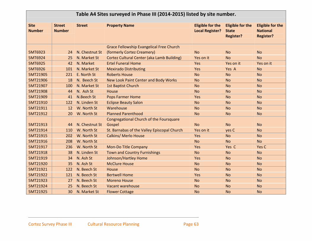
Cortez Survey Phase III Cultural Resource Planning Page 63
Table A4 Sites surveyed in Phase III (2014-2015) listed by site number.
Site Number
Street Number
Street Property Name Eligible for the Local Register?
Eligible for the State Register?
Eligible for the National Register?
5MT6923 24 N. Chestnut St Grace Fellowship Evangelical Free Church (formerly Cortez Creamery) No No No
5MT6924 25 N. Market St Cortez Cultural Center (aka Lamb Building) Yes on it No No
5MT6925 42 N. Market Ertel Funeral Home Yes Yes on it Yes on it
5MT6926 101 N. Market St Mexirado Distributing Yes Yes A No
5MT21905 221 E. North St Roberts House No No No
5MT21906 18 N. Beech St New Look Paint Center and Body Works No No No
5MT21907 100 N. Market St 1st Baptist Church No No No
5MT21908 44 N. Ash St House No No No
5MT21909 41 N.Beech St Pops Farmer Home Yes No No
5MT21910 122 N. Linden St Eclipse Beauty Salon No No No
5MT21911 12 W. North St Warehouse No No No
5MT21912 20 W. North St Planned Parenthood No No No
5MT21913 44 N. Chestnut St Congregational Church of the Foursquare Gospel No No No
5MT21914 110 W. North St St. Barnabas of the Valley Episcopal Church Yes on it yes C No
5MT21915 202 W. North St Calkins/ Merlo House Yes No No
5MT21916 208 W. North St
No No No
5MT21917 236 W. North St Mon-Do Title Company Yes Yes C Yes C
5MT21918 38 N. Linden St Town and Country Furnishings No No No
5MT21919 34 N. Ash St Johnson/Hartley Home Yes No No
5MT21920 35 N. Ash St McClure House No No No
5MT21921 122 N. Beech St House No No No
5MT21922 121 N. Beech St Bertwell Home Yes No No
5MT21923 27 N. Beech St Moreno House No No No
5MT21924 25 N. Beech St Vacant warehouse No No No
5MT21925 30 N. Market St Flower Cottage No No No

Cortez Survey Phase III Cultural Resource Planning Page 64
Table A4 Sites surveyed in Phase III (2014-2015) listed by site number continued. Site Number
Street Number
Street Property Name Eligible for the Local Register?
Eligible for the State Register?
Eligible for the National Register?
5MT21926 111 N. Market St Harp Building No No No
5MT21927 127 N. Market St Empire Electric Office No No No
5MT21928 17 N. Chestnut St Post Office No No No
5MT21929 33 N. Chestnut St Minnie Johnson Home No No No
5MT21930 121 N. Elm St Calkins Home No No No
5MT21931 33 N. Elm St Cortez Medical Clinic No No No
5MT21932 114 N. Linden St House No No No
5MT21933 210 W. North St
No No No

Cortez, Montezuma Avenue Survey Cultural Resource Planning Page 65