
Harnessing the Wind for South Texas -...
40
Harnessing the Wind for South Texas January 7, 2009 Gulf Wind Grand Opening
Transcript of Harnessing the Wind for South Texas -...

Harnessing the Wind for South Texas
January 7, 2009
Gulf Wind Grand Opening

2
Important NoticeThe information contained in this presentation is given without any liability whatsoever to Babcock & Brown Limited or any of its related entities (collectively “Babcock & Brown”) or their respective directors or officers, and is not intendedto constitute legal, tax or accounting advice or opinion. No representation or warranty, expressed or implied, is made as to the accuracy, completeness or thoroughness of the content of the information, including, without limitation, any financial forecasts or projections. The recipient should consult with its own legal, tax or accounting advisers as to the accuracy and application of the information contained herein and should conduct its own due diligence and other enquiries in relation to such information.
This presentation does not carry any right of publication. This presentation is incomplete without reference to, and should be viewed solely in conjunction with, the oral briefing provided by Babcock & Brown. Neither this presentation nor any of its contents may be reproduced or used for any other purpose without the prior written consent of Babcock & Brown.
Neither the existence of this presentation nor its delivery to you shall constitute or be construed to be an offer to sell any securities of Babcock & Brown Limited, its affiliates or its affiliated entities (collectively, "Babcock & Brown"). Any offering of securities of Babcock & Brown may only be made pursuant to (1) an effective registration statement under the Securities Act of 1933, as amended, and the rules and regulations in effect there under (the "Act") and all applicable state securities laws or (2) an exemption from the registration requirements of the Act.
© 2007 Babcock & Brown

3
Agenda
• About Babcock & Brown
• Gulf Wind on the Kenedy Ranch
• Protecting Wildlife
• Gulf Wind Construction

4
Babcock & Brown: A Leader in Wind Energy
• One of the leading wind power companies in the United States
• Founded in 1977 in San Francisco
• 20 years of experience in wind energy
• Strong reputation for developing successful wind farms
• Partner for the long term - we develop, own, operate, and manage
Photo courtesy of Mortenson Photo courtesy of Mortenson

5
Babcock & Brown Project Locations – Operational and Under Construction or In Development
Crescent Ridge
Operational
Under Construction /In Development
Caprock
Buena Vista
Blue Canyon Wind
Bear Creek
Aragonne I-II
Sweetwater I-V
Jersey Atlantic
Kumeyaay
Mendota HillsGSG
Tres Vaqueros
Allegheny ICedar Creek I-II
Allegheny II-III
Gulf Wind
Hatchet RidgeEcogenWessington Springs
Cholla Wind
Rock Run
Spring Valley
South Trent
Majestic
Bluewater (Offshore)Post Rock
Rock CreekWildhorse
Red Hills
Combine Hills
White
PomeroyLancaster
Twin Creeks
El Paso
Minonk
Ripley-WestfieldButler Ridge
6
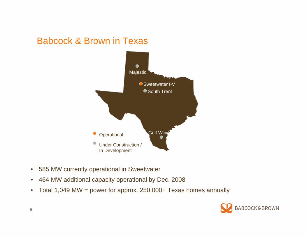
Babcock & Brown in Texas
Majestic
Sweetwater I-VSouth Trent
Gulf WindOperational
Under Construction /In Development
• 585 MW currently operational in Sweetwater
• 464 MW additional capacity operational by Dec. 2008
• Total 1,049 MW = power for approx. 250,000+ Texas homes annually

Why the Kenedy Ranch?

8
Powerful Renewable Resource for South Texas
• Highest wind speeds along the entire Gulf of Mexico
• Three meteorological towers have been in place since 2004
• SODAR was used for over a year to determine the site’s shear profile
Kenedy Wind Farm

9
Producing Power When It’s Needed Most
Annual ERCOT Hourly Avg Load vs Kenedy Hourly Avg Capacity Factor (CF)
0
5,000
10,000
15,000
20,000
25,000
30,000
35,000
40,000
0 10020030040050060070080090010001100120013001400150016001700180019002000210022002300
Hour
MW
0.00%
10.00%
20.00%
30.00%
40.00%
50.00%
60.00%
70.00%
CF
ERCOT Avg Load Kenedy Avg CF
Annual ERCOT Hourly Avg Load vs West TX Avg Hourly Capacity Factor (CF)
0
5,000
10,000
15,000
20,000
25,000
30,000
35,000
40,000
0 10020030040050060070080090010001100120013001400150016001700180019002000210022002300
Hour
MW
0.00%
10.00%
20.00%
30.00%
40.00%
50.00%
60.00%
CF
ERCOT Avg Load West TX Avg CF
On Peak
Super Peak
On Peak
Super Peak
Kenedy wind power production is complimentary to serving ERCOT load during on peak periods.
West TX wind power production is notcomplimentary to serving ERCOT load during on peak periods.
The Texas Southern coast’s peak production occurs when energy demand is the greatest, making Kenedy an ideal candidate for wind development.

10
Gulf Wind Project Overview
• Project area: 7,851 acres
• Affected surface area: less than 300 acres
• Turbines: 118, each 2.4-MW capacity
• Project capacity: 283.2 MW
• Power equivalent: nearly 80,000 Texas homes annually
• Distance from Gulf of Mexico to nearest turbine: 8.1 miles
• Distance from Laguna Madre to nearest turbine: 4.5 miles
• Distance from Hwy 77 to nearest turbine: 11.5 miles
• Distance to nearest property line: 5.2 miles

11

Local Economic Benefits

13
Benefits to South Texas
• Creates job opportunities– 350 – 450 jobs during peak construction period,
9 months– 15 - 20 permanent jobs
• Supports local economy by:– Purchasing goods and services during
construction and operation– Significantly increasing revenue for all service
businesses, i.e. local restaurants and hotels during construction and operation
• Significantly contributes to tax base annually, benefiting:
– Kenedy County– Kenedy County-Wide Central School District

14
John G. and Marie Stella Kenedy Memorial Foundation
• One of the largest philanthropic entities in South Texas
• Donates millions of dollars every year to causes that benefit South Texas
– Catholic Church– Education– Poverty
• Royalties from the Gulf Wind project will allow the Foundation to increase charitable giving in South Texas

Environmental Benefits

16
Environmental Benefits of 283MW Wind Energy in ERCOT
Freshwater Savings 17,019,998,844 gallons / yr
46,630,134 gallons/day*
*can supply 518,113 people each day
Natural Gas4,716,228 million cubic ft / yr
Carbon Dioxide Emission Reductions538,341 tons / year*
*equal to taking 86,135 passenger cars off the road
Source: Based on information from the Energy Information Administration, National Energy Technology Laboratory, and U.S. Geological Survey.
Coal Preserved 130,244 tons / year

Protecting Wildlife

18
Examples of Wind Project Siting Requirements & Studies
• United States Fish & Wildlife Service consultation letter of protected & endangered species
• Wildlife & Avian Assessments: avian radar surveys, biological survey, habitat survey
• Environmental Assessment or Environmental Impact Statement may be required
• U.S. Army Corp of Engineers permit or no action letter relating to wetlands
• Federal Aviation Administration no hazard determination
• Texas Historical Commission & U.S. Advisory Council on Historic Preservation: archaeology/cultural resource studies
• Department of Transportation coordination on load restrictions
• Texas Commission on Environmental Quality: construction storm water permit, Texas pollution discharge elimination permit (TPDES), storm water notice of intent & pollution prevention plan (SWPPP), spill prevention counter measures and control plan (SPCC), concrete batch plant air permits
• Approval of Transmission Line; Interconnection Studies
• Geotechnical site investigation, hurricane risk assessment, topographical surveys

19
Gulf Wind Government Consultations• Met with the U.S. Fish and Wildlife Service (USFWS) Director and Southwest
Regional Director • Met with numerous USFWS biologists and other USFWS personnel • Conducted two site visits for USFWS • Conducted two site visits for U.S. Army Corp of Engineers • Consulted with U.S. Army Corp of Engineers, used LIDAR technology
USFWS April 9, 2008 Letter • “The piping plover, interior least tern, and brown pelican are listed species
known from Kenedy County that are not predicted to be impacted by the project. Interior least terns and piping plovers are not anticipated in the project area, and brown pelicans are not expected to regularly occur in the project area and are being delisted.”
• “….Based on our meetings, conversations, the April 9 report, and the measures being implemented, we believe the potential for taking a listed species has been minimized.”

20
Expert Consultants
• SWCA Environmental Consultants: conducted ecological & avian assessments, wetland evaluation, storm water planning, hydrology analysis, biological surveys, threatened & endangered species surveys, archeological study
– No material impact to avian populations– No federal threatened or endangered species
habitats of concern in project area – USACE confirmed project layout does not
require federal actions or permits
• Curry & Kerlinger, LLC: conducted avian risk assessments
– No impact of biological significance

21
Wetland Avoidance
• Project designed to avoid all wetlands (jurisdictional and non-jurisdictional) –all turbine pads, roads, and other facilities located in uplands
• Roads are built on top of surficial sand layer
• Due to permeable surficial sand layer, surface water runoff occurs only during severe storms & hurricanes
• Culverts placed as appropriate to maintain existing drainage (as is case with the existing road network)
• Neither turbines pads nor access roads, nor any other facilities, will have a discernible effect on surface or groundwater

22
Project Site Environmental Studies• Archaeological Background Review of 16,000-Acre Tract of Kenedy Ranch for the Kenedy Wind
Energy Project. SWCA Environmental Consultants, May 25, 2005.
• Radar-based Study of Migratory Bird Movements at Proposed Kenedy Wind Facility Project Site, Texas, Fall 2004 and Spring 2005. ABR, Inc. Environmental Research & Services, October 2005.
• Jurisdictional Waters Delineation Report for the Approximately 10,000-acre Gulf Wind Project, Kenedy County Texas. November 2005.
• Avian Risk Assessment for the Kenedy Wind Project, Kenedy County, Texas. Curry & Kerlinger, LLC, November 2005.
• Results of an Evaluation of the Potential For Occurrence of Special-Interest Species on the Approximately 9,800-acre Gulf Wind project, Kenedy County, Texas. SWCA EnvironmentalConsultants, Jan. 18, 2006.
• MERLIN Avian Radar Survey Data Report & Mortality Risk Assessment for the Proposed Gulf Wind I, Kenedy County, TX, Data Period October 2006 through September 2007. Detect, Inc. February 11, 2008.
• The Effects of South Texas Weather Patterns on Avian Movements at the Proposed Gulf Wind I Wind Farm Site. Patrick Pyle, Babcock & Brown, Houston, Feb. 2008.
• Analysis of the Potential For Impact to Federally Listed Species on the Gulf Wind Energy Development, Kenedy County, Texas. SWCA Environmental Consultants, April 2008.

23
Endangered Species Summary
• Ocelot– No sightings ever recorded– No suitable habitat– Measures taken to avoid collision risk:
- Speed limit of 25 mph - Mowing along road shoulders- Construction crew training
• Piping Plover– No sightings in 3 years of surveys– No suitable habitat within project boundaries
• Northern Aplomado Falcon– No sightings; no nests– Inappropriate habitat– Predator load– Safe Harbor Agreement

24
State-of-the-Art Avian Radar Technology
• DeTect is a world leader in development, deployment and support of radar systems for bird strike avoidance, avian risk assessment and migratory research
• More than 3 years, 6 migration seasons, of radar observation data recorded onsite; 1.5 years continuous 24/7 radar data collection
• Large majority of migration occurs above the heights of the wind turbines
• Low altitude avian flight patterns correlate to low wind speeds where the wind turbines are usually not operating
• Developed mitigation plan based on low visibility and high passage rate Photo: Avian Radar at Kenedy Ranch, Babcock & Brown

Copyright 2007 DeTect, Inc. All Rights Reserved; Specifications & features are subject to change without notice; this document contains DeTect Confidential materials & distribution is limited to DeTect authorized recipients only© 2008, DeTect, Inc., All Rights Reserved
• High resolution, precision tracking radar system originally developed for USAF & NASA
– Over 40 systems operating in the US, Canada, Europe & Africa
– Used by USEPA, USFWS, USGS, university researchers, airports & military
• Real time 24-7 bird detection & tracking
– Uses military-grade radar software developed specifically for detecting & tracking birds
– 3-6 nm range 360 degrees around site & up 10,000 ft AGL
• Target & track data continuously recorded for analysis
• Provides quantitative modeling of avian mortality risk
MERLIN™ Avian Radar System
NordwindZee offshore wind farm avian survey & monitoring radar system, The Netherlands
MERLIN Avian Radar Systems for wind farm & airport surveys, England
MERLIN Avian Radar System for avian research, Louisiana
MERLIN Avian Radar System avian & bat survey, Butler Ridge Wind Farm, Wisconsin

Copyright 2007 DeTect, Inc. All Rights Reserved; Specifications & features are subject to change without notice; this document contains DeTect Confidential materials & distribution is limited to DeTect authorized recipients only© 2008, DeTect, Inc., All Rights Reserved
Gulf Wind I MERLIN Avian Radar Survey
MERLIN survey & data collection started October 2006:
•System purchased & operated by Babcock & Brown
•Operational support & data analysis provided by DeTect
•Over 19 months of 24-7 data collected to date
• Radar scans & updates tracks every ~2.4 seconds
•Data to date shows periods of avian risk are infrequent (<1% )
Top: MERLIN Avian Radar System at Gulf Wind I
Right: MERLIN system location October 2006
through September 2007

Copyright 2007 DeTect, Inc. All Rights Reserved; Specifications & features are subject to change without notice; this document contains DeTect Confidential materials & distribution is limited to DeTect authorized recipients only© 2008, DeTect, Inc., All Rights Reserved
Avian Risk Mitigation System
MERLIN to be operated as Risk Mitigation System:
•Act as "early warning system" continually monitoring birds approaching wind farms
•MERLIN SCADA software will automatically idle turbines when risk conditions detected
• Derivative of DeTect technology used by USAF to monitor aircraft risk at airfield
• MERLIN will restart turbines when risk has abated
•First such implementation of this technology at a wind farm

Construction Process

29
Road Construction
• Approximately 59 miles of access roads constructed; roughly 18 miles of existing ranch roads used
• Roads are 28 feet wide
• After rolling surface grade cut of 3-4 inches, roads built up with compacted caliche to 9-18 inches Road Cleared, Graded,
and Sub-base Prepared
Completed RoadRoads Routed to Avoid
Environmentally Sensitive Areas

30
Assembled Bolt Cage Bolt Cage and Rebar Installation
Completed Rebar
Foundation Construction

31
ConcretePouring
CompletedFoundation
Backfilled Foundation

32
Cable Trenching Cable Installation
Backfilling the Cable Trench
Electrical & Collection System

33
Switch Station
Completed Overhead Transmission LineFrom Substation
Helicopter Prepping Towersfor Line Installation
Substation Control Room

34
Wind Turbines
• 118 Mitsubishi MWT95 2.4 MW turbines installed
• Largest Mitsubishi turbines constructed in the United States
• The turbine stands 273 feet tall to the top of the nacelle and 419 feet tall to the tip of the blade
• The rotor is 323 feet in diameter

35
Tower Section Delivery
Lower Base Installation
Lower MidInstallation
Tower TopInstallation
Turbine Installation

36
Nacelle InstallationRigging Nacelle for Lift
Rigging Rotor for Lift

37
Rigging Rotor for Lift
Lifting Rotor Erection Complete

38

39

40