Ground Water Scenario - cgwb.gov.incgwb.gov.in/District_Profile/Maharashtra/Sindhudurg.pdfSINDHUDURG...
24
1835/DB/2014 भारत सरकार जल संसाधन मंालय केरीय भ ू ममजल बोड GOVERNMENT OF INDIA MINISTRY OF WATER RESOURCES CENTRAL GROUND WATER BOARD महारार राय के अंतडत मसंध ु द ु ड जजले की भ ू जल विान जानकारी GROUND WATER INFORMATION SINDHUDURG DISTRICT MAHARASHTRA By िारा S.S.P. MISHRA एस. एस. पी. ममा Superintending Hydrogeologist अधधण भूजल बैाननक मय े, नाप ु र CENTRAL REGION NAGPUR 2014
Transcript of Ground Water Scenario - cgwb.gov.incgwb.gov.in/District_Profile/Maharashtra/Sindhudurg.pdfSINDHUDURG...

1835/DB/2014
भारत सरकार
जल संसाधन मंत्रालय
केन्द्रीय भूममजल बोर्ड GOVERNMENT OF INDIA
MINISTRY OF WATER RESOURCES
CENTRAL GROUND WATER BOARD
महाराष्ट्र राज्य के अतंर्डत मसधंुदरु्ड जजले की भूजल विज्ञान
जानकारी GROUND WATER INFORMATION
SINDHUDURG DISTRICT MAHARASHTRA
By द्िारा S.S.P. MISHRA एस. एस. पी. ममश्रा Superintending Hydrogeologist अधधक्षण भजूल बजै्ञाननक
मध्य क्षेत्र, नार्पुर
CENTRAL REGION
NAGPUR 2014

SINDHUDURG DISTRICT AT A GLANCE 1. GENERAL INFORMATION Geographical Area : 5207 sq. km. Administrative Divisions
: Taluka- 8; Sawantwadi, Vengurla,
Kudal, Kankavli, Malvan, Deogad, Dodamarg and Vaibhavwadi
Villages : 743 Population (Census 2011) : 8,68,825 Normal Annual Rainfall : 2300 mm to 3200 mm 2. GEOMORPHOLOGY Major Physiographic unit : 5; Coastline, Estuarine plains,
Lateritic plateaus, Residual hills, Scrap faces of Sahayadri.
Major Drainage : 6; Gad, Karli, Terekhol, Tillari, Wagothan and Deogad
3. LAND USE (2010-11) Forest Area : 386.43 sq. km. Net Area Sown : 1522.00 sq. km. Cultivable Area : 3222.00 sq. km. 4. SOIL TYPE Four types viz., Rice soil, Garden soil, Varkas soil and Alluvial soil. 5. PRINCIPAL CROPS (2011) Food Grains : 828.00 sq. km. Pulses : 91.00 sq. km. Oil Seeds : 137.00sq. km. Sugar Cane : 0.11 sq. km. 6. IRRIGATION BY DIFFERENT SOURCES (2010-11) -
Dugwells/Tube wells : 2263 Ha Canal Irrigation : 6273 Ha Net Irrigated Area : 14603 sq. km. 7. GROUND WATER MONITORING WELLS (As on 31/03/2011) Dugwells : 38 Piezometers : NIL 8. GEOLOGY Recent to sub-Recent : Alluvium, beach sand Pleistocene : Laterite and lateritic spread Miocene Shale with peat and pyrite nodules Cretaceous to Eocene Deccan Trap Basalt lava flows Upper Pre-Cambrian Kaladgi Series: quartzite, sandstone,
shale and associated limestone Dharwar Super Group Phyllite, conglomerate, quartzite 9. HYDROGEOLOGY Water Bearing Formation : Basalt- weathered/fractured/ jointed
vesicular/massive, under phreatic and semi-confined to confined conditions Laterite: GW occurs under phreatic conditions Alluvium- Sand/gravel under
phreatic conditions Premonsoon Depth to Water
Level (May-2011) : 1.65-18.90 m bgl
Postmonsoon Depth to Water
Level (Nov.-2011) : 1.06-14.49 m bgl
Premonsoon Water Level Trend (2002-2011)
: Rise: 0.007-0.25 m/year Fall: 0.02-0.60 m/year
Postmonsoon Water Level Trend (2002-2011)
: Rise: 0.001-0.29 m/year Fall: 0.08-037 m/year
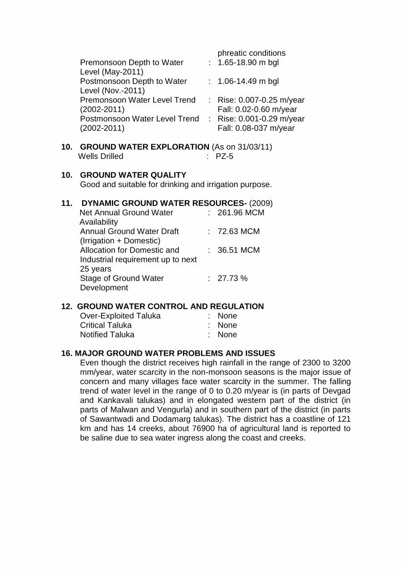
10. GROUND WATER EXPLORATION (As on 31/03/11) Wells Drilled : PZ-5
10. GROUND WATER QUALITY Good and suitable for drinking and irrigation purpose. 11. DYNAMIC GROUND WATER RESOURCES- (2009) Net Annual Ground Water
Availability : 261.96 MCM
Annual Ground Water Draft (Irrigation + Domestic)
: 72.63 MCM
Allocation for Domestic and Industrial requirement up to next 25 years
: 36.51 MCM
Stage of Ground Water Development
: 27.73 %
12. GROUND WATER CONTROL AND REGULATION Over-Exploited Taluka : None Critical Taluka : None Notified Taluka : None
16. MAJOR GROUND WATER PROBLEMS AND ISSUES Even though the district receives high rainfall in the range of 2300 to 3200
mm/year, water scarcity in the non-monsoon seasons is the major issue of concern and many villages face water scarcity in the summer. The falling trend of water level in the range of 0 to 0.20 m/year is (in parts of Devgad and Kankavali talukas) and in elongated western part of the district (in parts of Malwan and Vengurla) and in southern part of the district (in parts of Sawantwadi and Dodamarg talukas). The district has a coastline of 121 km and has 14 creeks, about 76900 ha of agricultural land is reported to be saline due to sea water ingress along the coast and creeks.
Ground Water Information Sindhudurg District
Contents
1.0 Introduction .......................................................................... 2
2.0 Climate and Rainfall ............................................................. 3
3.0 Geomorphology and Soil Types .......................................... 4
4.0 Ground Water Scenario ....................................................... 6
4.1 Hydrogeology ....................................................................................... 6 4.2 Water Level Scenario ........................................................................... 8 4.3 Aquifer Parameters .............................................................................. 8 4.4 Yield of Wells ...................................................................................... 12 4.5 Ground Water Resources .................................................................. 13 4.6 Ground Water Quality......................................................................... 14 4.7 Status of Ground Water Development .............................................. 14
5.0 Ground Water Management Strategy ................................ 17
5.1 Ground Water Development .............................................................. 17 5.2 Water Conservation and Artificial Recharge .................................... 18
6.0 Ground Water Related Issues and Problems ................... 19
7.0 Areas Notified by CGWA/SGWA ........................................ 20
8.0 Recommendations ............................................................. 20
List of Figures
1. Location. 2. Hydrogeology. 3. Depth to Water Level (Premonsoon- May 2011). 4. Depth to Water Level (Postmonsoon- Nov. 2011). 5. Premonsoon Water Level Trend (May 2002-2011). 6. Ground Water Resources (2009).
List of Tables
1. Studies undertaken by CGWB. 2. Annual Rainfall Data (2002-2011). 3. Aquifer Parameters. 4. Yield of Dugwells and Borewells. 5. Ground Water Resources (2009). 6. Classification of Ground Water Samples for Drinking based on BIS
Drinking Water Standards (IS-10500-91, Revised 2003), May 2011. 7. Classification of Ground Water for Irrigation based on EC, May
2011.
2
Ground Water Information
Sindhudurg District
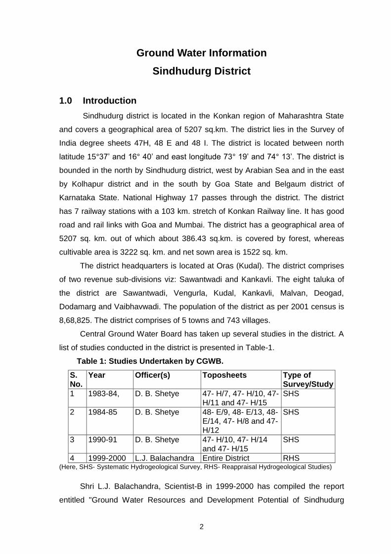
1.0 Introduction
Sindhudurg district is located in the Konkan region of Maharashtra State
and covers a geographical area of 5207 sq.km. The district lies in the Survey of
India degree sheets 47H, 48 E and 48 I. The district is located between north
latitude 15°37’ and 16° 40’ and east longitude 73° 19’ and 74° 13’. The district is
bounded in the north by Sindhudurg district, west by Arabian Sea and in the east
by Kolhapur district and in the south by Goa State and Belgaum district of
Karnataka State. National Highway 17 passes through the district. The district
has 7 railway stations with a 103 km. stretch of Konkan Railway line. It has good
road and rail links with Goa and Mumbai. The district has a geographical area of
5207 sq. km. out of which about 386.43 sq.km. is covered by forest, whereas
cultivable area is 3222 sq. km. and net sown area is 1522 sq. km.
The district headquarters is located at Oras (Kudal). The district comprises
of two revenue sub-divisions viz: Sawantwadi and Kankavli. The eight taluka of
the district are Sawantwadi, Vengurla, Kudal, Kankavli, Malvan, Deogad,
Dodamarg and Vaibhavwadi. The population of the district as per 2001 census is
8,68,825. The district comprises of 5 towns and 743 villages.
Central Ground Water Board has taken up several studies in the district. A
list of studies conducted in the district is presented in Table-1.
Table 1: Studies Undertaken by CGWB.
S. No.
Year Officer(s) Toposheets Type of Survey/Study
1 1983-84, D. B. Shetye 47- H/7, 47- H/10, 47- H/11 and 47- H/15
SHS
2 1984-85 D. B. Shetye 48- E/9, 48- E/13, 48- E/14, 47- H/8 and 47- H/12
SHS
3 1990-91 D. B. Shetye 47- H/10, 47- H/14 and 47- H/15
SHS
4 1999-2000 L.J. Balachandra Entire District RHS (Here, SHS- Systematic Hydrogeological Survey, RHS- Reappraisal Hydrogeological Studies)
Shri L.J. Balachandra, Scientist-B in 1999-2000 has compiled the report
entitled "Ground Water Resources and Development Potential of Sindhudurg

3
District, M.S.” Central Ground Water Board has so far not carried out ground
water exploration work in the district. However, 5 Peizometers (Pz) to monitor
ground water levels have been drilled in the district. A map of the district showing
the taluka boundaries, taluka headquarters, physical features and location of
Peizometers and monitoring wells is presented as Figure-1.
Figure-1: Location
2.0 Climate and Rainfall
Climatic conditions in the district are strongly influenced by its geographical
conditions. The district falls under the ‘Assured and High Rainfall zone’. The
climate is generally humid. The cold season is from December to February

4
followed by summer from March to May. June to September is the southwest
monsoon, while, October and November constitute the post-monsoon season.
Being a coastal district, variation in the temperature during the day and
throughout the season is not large. December is the coldest month with mean
daily maximum temperature at 32.7°C and the mean daily minimum temperature
at 18.7°C. April is the hottest month. The relative humidity during the southwest
monsoon is very high (86 to 90%). The relative humidity during winter and
summer months is also above 57%.
The normal annual rainfall over the district varies from 2300 mm (Malvan)
to about 3205 mm (Kudal). It is minimum in the western part of the district along
the coast and gradually increases towards east and reaches maximum along
Western Ghats. The average annual rainfall for the period 2002-2011 ranges
from 2752.19 mm (Devgadh) to 3980.19 mm (Vaibhawadi). The annual rainfall
data of all talukas is given in Table 2. Perusal of rainfall data from above table
reveals that during last decade (year 2002-2011) also reveals that lowest rainfall
amounting 2261.1 mm was observed during year-2002 in the district, whereas
maximum rainfall 4668.8 mm was recorded in year-2010 in the district.
Table 2: Annual Rainfall Data (2002-2011) (mm)
Taluka 2002 2003 2004 2005 2006 2007 2008 2009 2010 2011 Decadal
Avg.
Devgad 2033.9 2132 2091 2535.4 2889 3316.2 2391 2846.4 3796 3491 2752.19
Malvan 2048.9 2415 2535 2484 2299.2 2836 3291 4209 5568 4303 3198.91
Samantwadi 2962 3570 2503.4 3939.8 4761.4 4103.9 3838 4062.5 5036 4632.6 3940.96
Vengurla 2166.3 2578.1 2525.6 3055.8 2774.5 3479.3 2555.1 3723.1 4362.5 3485.2 3070.55
Kankavali 2116 2066.8 2404 2692 3381 3331 3106.8 3515 5093 4619 3232.46
Kudal 1977.8 2540 2712 3059 2531 3342 3273 3875 4442 4189 3194.08
Vaibhavadi 2799.9 3152 3339.6 4421 4823.4 4692.2 3916.2 3695.6 4179 4783 3980.19
Dodamarg 2784 3053 2751 3600 3826.6 4160.1 3801.6 3625.4 4874.1 4393 3686.88
Dist Av. 2361.1 2688.3 2607.7 3223.3 3410.7 3657.5 3271.5 3694.0 4668.8 4236.9
3.0 Geomorphology and Soil Types
The outstanding feature in the relief of the district is its highly uneven
nature and very narrow riverine plains that fringe the coastline. About 40 to 50%
of the area in the district is hilly. The district has three major physiographic
divisions from east to west. (i) The eastern part close to the Western Ghats, is
5
highly dissected with deep valleys. (ii) The middle part of the district is occupied
by flat-topped hills with undulating plateau with elevations up to 300 meter above
mean sea level (m amsl) covered by Laterite. (iii) The coastal plain in the western
part with elevations of 100 to 150 m amsl. The physiograhic features have given
rise to five characteristic landforms viz. (i) The coast line (ii) The estuarine alluvial
plains (iii) The Lateritic plateau (iv) Highly eroded remnant hills (v) Scarp faces of
Sahayadri hill ranges. The drainage system of the major rivers in the district is
mostly of sub-parallel type and the tributaries drainage pattern tends to be sub-
rectangular type. Major joints in the Basalt control the drainage pattern. The river
systems are young with a small drainage area and westerly seasonal regime.
During monsoon the rivers carry heavy load of water having tremendous
headward eroding capacity and ultimately drain in the Arabian Sea. All the major
rivers originate in the Sahayadri Hill ranges. The five major rivers in the district
are Gad (Length- 84km.), Karli (92km.), Terekhol (69km.), Tillari (53 km.),
Deogad (48km.) and Wagothan (24km.). All these rivers form part of the westerly
flowing river system originating from Sahayadri hill ranges and debouching in
Arabian Sea.
The soil formation in the district in the district is controlled mainly by
climate. Most of the soils are derived from Lateritic rocks. The soils are classified
based on physical characteristics into four types viz., Rice soil, Garden soil,
Varkas soil and Alluvial soil. The Rice soils are termed as ‘Mali soils’ when
situated in higher levels, ‘Kuryat soils’ in lower levels and ‘Panthar or Vaigam’
when situated near water courses. Varkas soils are reddish brown to yellowish
red in colour and are situated on hill slopes. These soils are poor in fertility,
shallow in depth and coarse in texture. Garden soils are of mixed origin, yellow
red to brown in color and are located in the valley portions. These soils are light,
well drained and fairly fertile. Coastal Alluvial soils are recent deposits found
along the coastal tracts and constitute deep loam. Due to inundation of sea, part
of the coastal soils has become salty. In the Deogad, Malwan and Vengurla
talukas practically entire strip is salty.

6
4.0 Ground Water Scenario
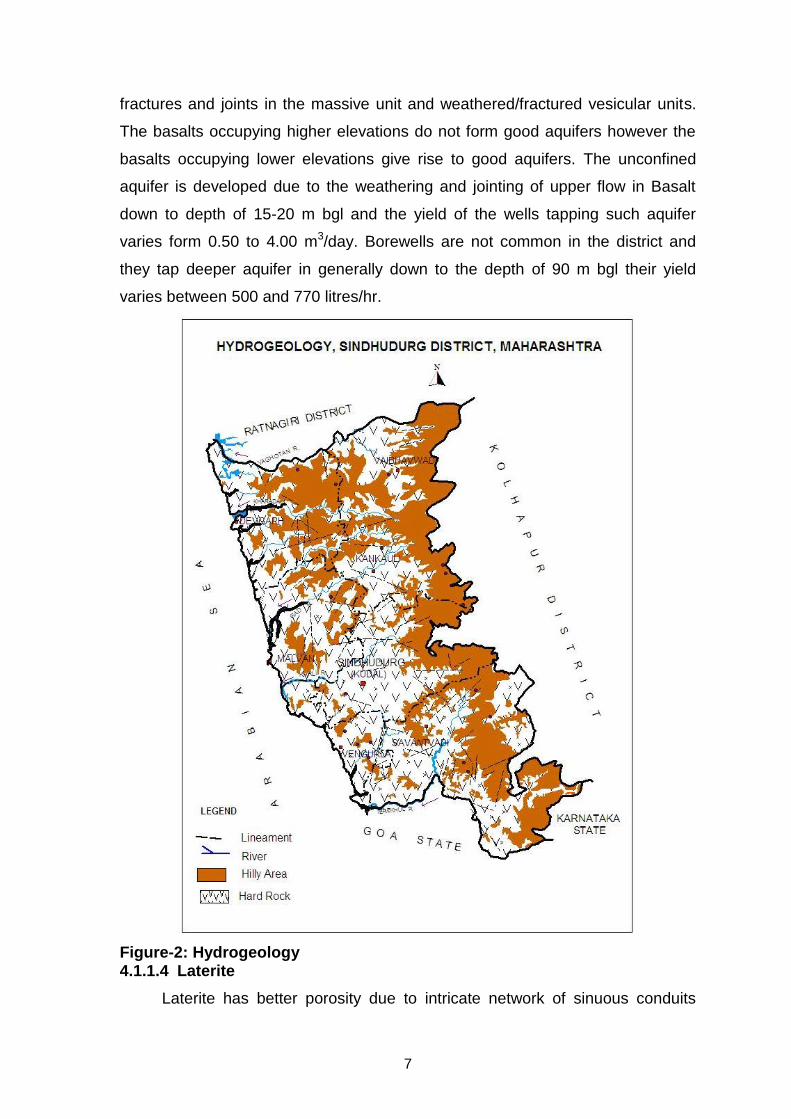
4.1 Hydrogeology
Dharwarian metasediments (Archean), Kaladgi formation (Precambrian),
Deccan Trap lava flows (Upper Cretaceous to Lower Eocene age), , Laterite
(Pleistocene) and Alluvial deposits (Recent to Sub-Recent) are the water bearing
formations observed in Sindhudurg district. However Kaladgi formation occurs in
very limited patches and does not form potential aquifer in the district. The
Alluviums also has limited areal extent found mainly along the coast. A map
depicting the hydrogeological features is shown in Figure-2.
4.1.1 Hard Rock Areas
4.1.1.1 Dharwarian Metasediments
The Dharwarian metasediments and intrusions are devoid of primary
porosity and permeability. The major aquifer formations are Granitic Gneisses
and Granites, which are banded or jointed, locally sheared and weathered that
facilitates movement and storage of water. The secondary porosity and
permeability thus developed gives rise to moderately yielding aquifers. Granulites
are dense and compact and hence not suitable for storage or transmission of
ground water. The unconfined aquifer is developed down to depth of 15 metres
below ground level (m bgl) and the yield of the wells tapping such aquifer varies
form 2 to 3 m3/day. Borewells generally tap deeper aquifer down to the depth of
70 m bgl and their yield varies between 500 and 7770 litres/hr.
4.1.1.2 Kaladgi
The Kaladgi rocks are mainly represented by orthoquartzite, sandstone and
shales. They are jointed in diverse directions and this along with weathered
portion controls the water bearing properties. The unconfined aquifer is
developed down to depth of 10-12 m bgl and the yield of the wells tapping such
aquifer varies form 2 to 5 m3/day. Borewells generally tap deeper aquifer down to
the depth of 60 m bgl and their yield varies between 500 and 9315 litres/hr.
4.1.1.3 Deccan Trap Basalt
The primary porosity is negligent in the Deccan trap basalts. The secondary
porosity imparted due to jointing, fracturing plays an important role in ground
water circulation. In the basaltic terrain ground water occurs under unconfined
conditions in the phreatic zone up to a depth of 15 meters in the weathered zone,
7
fractures and joints in the massive unit and weathered/fractured vesicular units.
The basalts occupying higher elevations do not form good aquifers however the
basalts occupying lower elevations give rise to good aquifers. The unconfined
aquifer is developed due to the weathering and jointing of upper flow in Basalt
down to depth of 15-20 m bgl and the yield of the wells tapping such aquifer
varies form 0.50 to 4.00 m3/day. Borewells are not common in the district and
they tap deeper aquifer in generally down to the depth of 90 m bgl their yield
varies between 500 and 770 litres/hr.
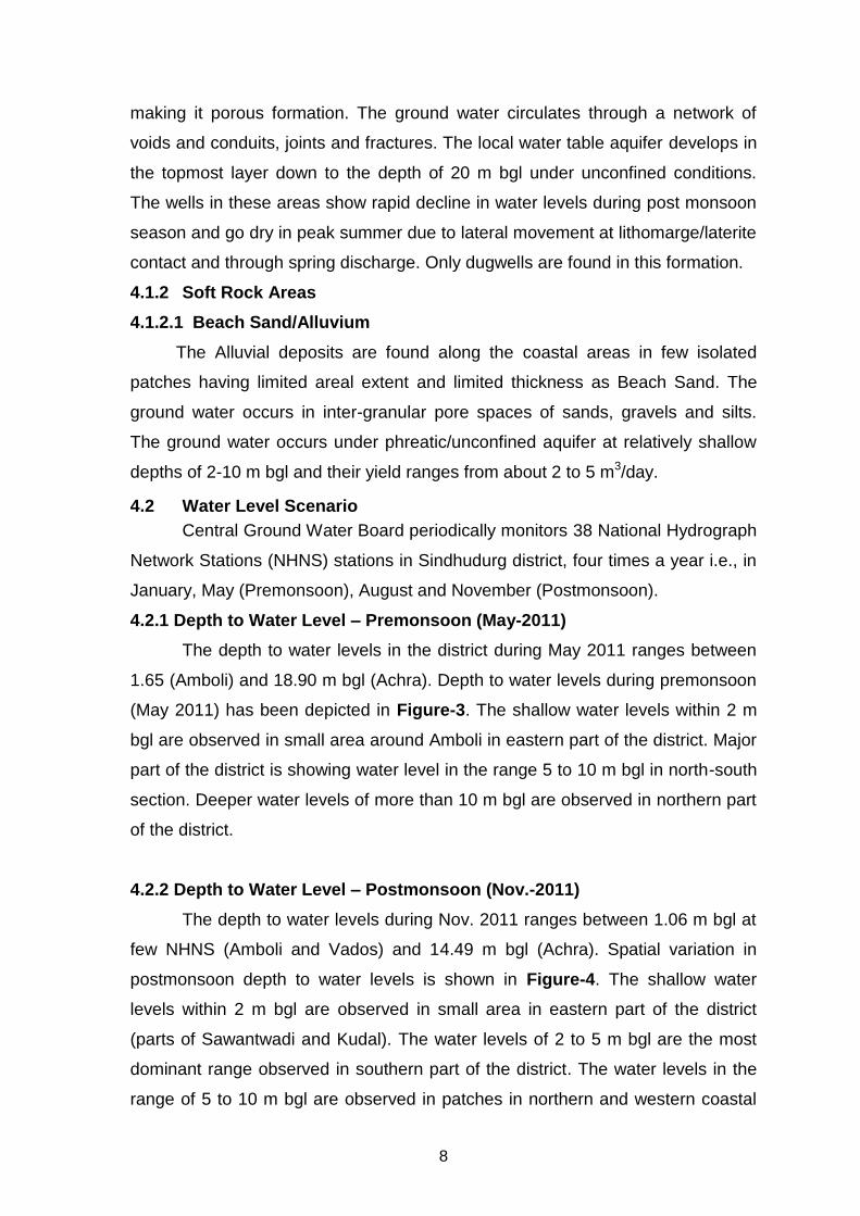
Figure-2: Hydrogeology 4.1.1.4 Laterite
Laterite has better porosity due to intricate network of sinuous conduits
8
making it porous formation. The ground water circulates through a network of
voids and conduits, joints and fractures. The local water table aquifer develops in
the topmost layer down to the depth of 20 m bgl under unconfined conditions.
The wells in these areas show rapid decline in water levels during post monsoon
season and go dry in peak summer due to lateral movement at lithomarge/laterite
contact and through spring discharge. Only dugwells are found in this formation.
4.1.2 Soft Rock Areas
4.1.2.1 Beach Sand/Alluvium
The Alluvial deposits are found along the coastal areas in few isolated
patches having limited areal extent and limited thickness as Beach Sand. The
ground water occurs in inter-granular pore spaces of sands, gravels and silts.
The ground water occurs under phreatic/unconfined aquifer at relatively shallow
depths of 2-10 m bgl and their yield ranges from about 2 to 5 m3/day.
4.2 Water Level Scenario
Central Ground Water Board periodically monitors 38 National Hydrograph
Network Stations (NHNS) stations in Sindhudurg district, four times a year i.e., in
January, May (Premonsoon), August and November (Postmonsoon).
4.2.1 Depth to Water Level – Premonsoon (May-2011)
The depth to water levels in the district during May 2011 ranges between
1.65 (Amboli) and 18.90 m bgl (Achra). Depth to water levels during premonsoon
(May 2011) has been depicted in Figure-3. The shallow water levels within 2 m
bgl are observed in small area around Amboli in eastern part of the district. Major
part of the district is showing water level in the range 5 to 10 m bgl in north-south
section. Deeper water levels of more than 10 m bgl are observed in northern part
of the district.
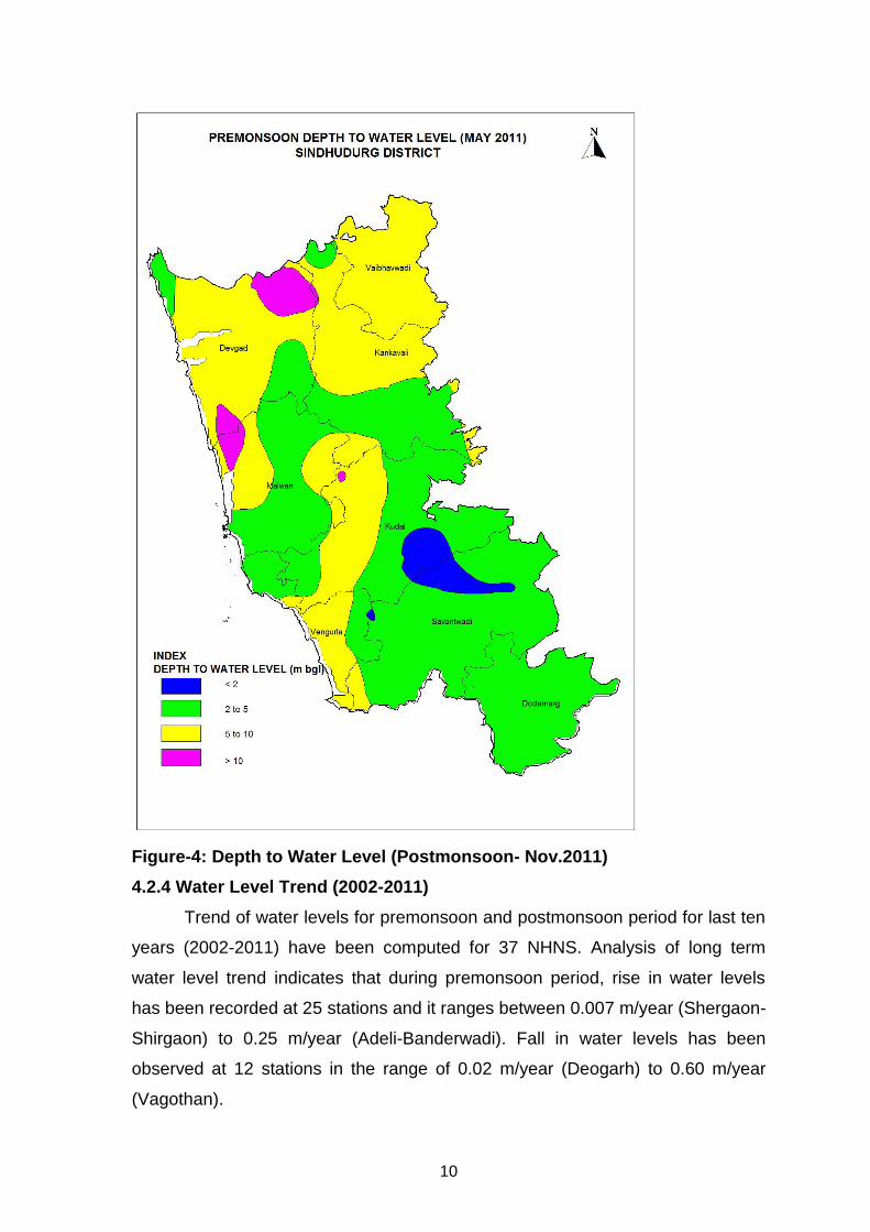
4.2.2 Depth to Water Level – Postmonsoon (Nov.-2011)
The depth to water levels during Nov. 2011 ranges between 1.06 m bgl at
few NHNS (Amboli and Vados) and 14.49 m bgl (Achra). Spatial variation in
postmonsoon depth to water levels is shown in Figure-4. The shallow water
levels within 2 m bgl are observed in small area in eastern part of the district
(parts of Sawantwadi and Kudal). The water levels of 2 to 5 m bgl are the most
dominant range observed in southern part of the district. The water levels in the
range of 5 to 10 m bgl are observed in patches in northern and western coastal

9
areas. The deeper water levels of more than 10 m bgl are observed n small
patches in northern part.
Figure-3: Premonsoon Depth to Water Level (May 2011)
4.2.3 Seasonal Water Level Fluctuation– (May to Nov. 2011)
The rise in water levels in the range of 0.06 m (Ramgarh) to 8.85 m
(Wareri) has been observed. Major part of the district show rise of water level up
to 4 m. Rise above 4 m was observed in few patches in north western coastal
part and in southern part of Savantwadi taluka.
10
Figure-4: Depth to Water Level (Postmonsoon- Nov.2011)
4.2.4 Water Level Trend (2002-2011)
Trend of water levels for premonsoon and postmonsoon period for last ten
years (2002-2011) have been computed for 37 NHNS. Analysis of long term
water level trend indicates that during premonsoon period, rise in water levels
has been recorded at 25 stations and it ranges between 0.007 m/year (Shergaon-
Shirgaon) to 0.25 m/year (Adeli-Banderwadi). Fall in water levels has been
observed at 12 stations in the range of 0.02 m/year (Deogarh) to 0.60 m/year
(Vagothan).
11
During postmonsoon period, rise in water levels has been recorded at 14
stations and it ranges from 0.001 m/year (Matond-Ghodemukh) to 0.29 m/year
(Wareri), fall in water levels ranging between 0.08 m/year (Insuli) and 0.37 m/year
(Kudal) is observed.
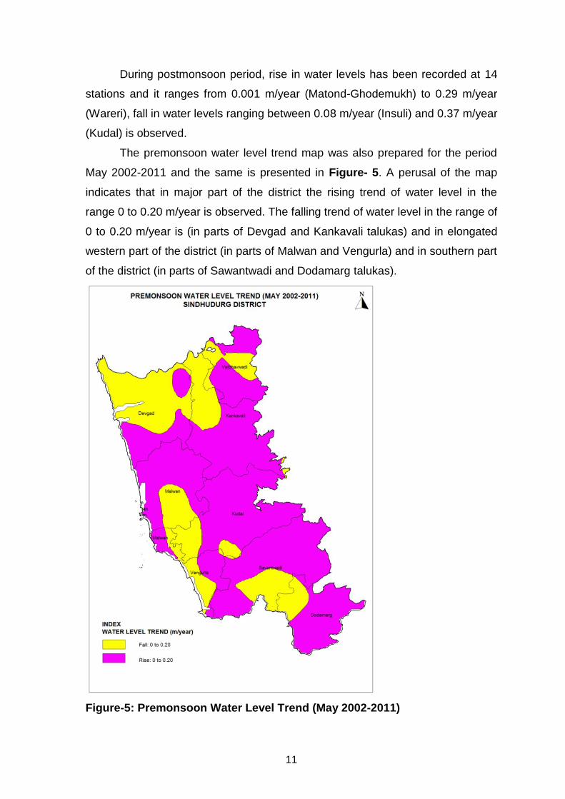
The premonsoon water level trend map was also prepared for the period
May 2002-2011 and the same is presented in Figure- 5. A perusal of the map
indicates that in major part of the district the rising trend of water level in the
range 0 to 0.20 m/year is observed. The falling trend of water level in the range of
0 to 0.20 m/year is (in parts of Devgad and Kankavali talukas) and in elongated
western part of the district (in parts of Malwan and Vengurla) and in southern part
of the district (in parts of Sawantwadi and Dodamarg talukas).
Figure-5: Premonsoon Water Level Trend (May 2002-2011)

12
4.3 Aquifer Parameters
As mentioned earlier, CGWB has not carried out any deep exploratory
drilling in Sindhudurg district and as such no data is available on aquifer
parameters of deeper aquifer. The aquifer parameters are available from dugwell
pumping tests conducted during previous studies by CGWB. The summarised
results of pumping test are given in Table-3. The specific capacity ranges from
3.38 to 424.57 lpm/m of drawdown, transmissivity ranges form 5.58 to 375.22
m2/day, whereas permeability varies from 4.28 to 425.22 m/day.
Table-3: Aquifer Parameters.
S. No.
Aquifer Specific Capacity (lpm/m of dd)
Transmissivity (m2/day)
Permeability (m/day)
1 Laterite 79.10 to 424.57 46.59 to 375.22 7.40 to 425.22
2 Fractured Basalt 3.38 to 51.44 5.58 to 28.95 4.28 to 24.85
4.4 Yield of Wells
The yields of the wells are the functions of the permeability and
transmissivity of aquifer encountered and vary with thickness of the aquifer zone
encountered, location, diameter and depth etc. Ground water in the area is being
developed by two type of abstraction structures i.e., borewells and dugwells.
However dugwells are the main ground water abstraction structures in the district.
Majority of dugwells in the district are basically used for domestic purpose. Some
of the dugwells with good yield are fitted with centrifugal pumps which are used
for irrigation purpose and some with submersible pumps for piped water supply
schemes. Generally dugwells with rope and pulley as well as Persian wheel are
used for domestic purpose.
The yield of dugwells in Coastal Alluvium ranges from 2 to 5 m3/day, in
Deccan Trap it varies from 0.50 to 4.00 m3/day, in Kaladgis it varies between 2
and 5 m3/day, whereas in Metamorphics it ranges between 2 and 3 m3/day. The
depth of the dugwells in all the formations is shallow up to 13 m bgl. The wells
located in topographic lows have better yield than located elsewhere. However,
the yield of the dugwells is more during post-monsoon period and declines with
the approach of summer.
The borewells are mainly constructed for rural water supply. The successful
borewells are fitted with hand pumps and those with high yield are fitted with

13
power pumps. The yield of the borewells drilled by Groundwater Survey and
Development Agency (GSDA) ranges between 500 to 9315 lph, whereas the
depths of the borewells range between 45 and 70 m bgl. The formation-wise
depth and yield of dugwells and borewells are given in Table-4.
Table-4: Yield of Dugwells and Borewells.
S. No.
Formation Dugwells Borewells
Depth (m bgl)
Yield (m3/day)
Depth (m bgl)
Yield (lph)
1 Coastal Alluvium 2.00 to 11.80 2 to 5 --- --
2 Deccan Trap 8.00 to 13.50 0.5 to 4 45 to 65 500 - 770
3 Kaladgis 3.80 to 10.00 2 to 5 50 to 60 500 - 9315
4 Metamorphics 3.00 to 11.50 2 to 3 50 to 70 500 – 7770
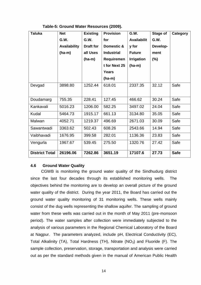
4.5 Ground Water Resources
Central Ground Water Board and Ground Water Survey and Development
Agency (GSDA) of Maharastra State have jointly carried out Taluka and
Watershed wise estimation of ground water resources of Sindhudurg district for
base year 2008-09 according to GEC methodology- 1997.Ground Water
Resource Estimation figures as a whole for Sindhudurg district indicates that Net
Ground Water Availability is 26196.06 ha-m and Existing Ground Water Draft for
all uses is 7262.86 ha-m. After making provision for Domestic and Industrial
Supply for next 25 Years as 3651.19 ha-m, Ground Water Availability for future
Irrigation is 17107.6 ha-m. Over all Stage of Ground Water development of the
district is 27.73%. indicating there is ample scope for ground water development
in the district. All Talukas of Sindhudurg district are categorized under “Safe
Category”. Taluka wise ground water resources figures of Sindhudurg district are
given below in Table-5. Taluka wise figures of ground water resources are
reveling that stage of ground water development in the district is varying from
14.94% at Sawantwadi Taluka to 35.055 at Kudal Taluka and all Taluka are
categorized under “Safe Category” where there are scope for future development
of ground water resources in Sindhudurg district.
14
Table-5: Ground Water Resources (2009).
Taluka Net
G.W.
Availability
(ha-m)
Existing
G.W.
Draft for
all Uses
(ha-m)
Provision
for
Domestic &
Industrial
Requiremen
t for Next 25
Years
(ha-m)
G.W.
Availabilit
y for
Future
Irrigation
(ha-m)
Stage of
G.W.
Develop-
ment
(%)
Category
Devgad
3898.80 1252.44 618.01 2337.35 32.12 Safe
Doudamarg 755.35 228.41 127.45 466.62 30.24 Safe
Kankavali 5016.23 1206.00 582.25 3497.02 24.04 Safe
Kudal 5464.73 1915.17 661.13 3134.80 35.05 Safe
Malwan 4052.71 1219.37 496.69 2671.03 30.09 Safe
Sawantwadi 3363.62 502.43 608.26 2543.66 14.94 Safe
Vaibhavadi 1676.95 399.58 282.01 1136.36 23.83 Safe
Vengurla 1967.67 539.45 275.50 1320.76 27.42 Safe
District Total 26196.06 7262.86 3651.19 17107.6 27.73 Safe
4.6 Ground Water Quality
CGWB is monitoring the ground water quality of the Sindhudurg district
since the last four decades through its established monitoring wells. The
objectives behind the monitoring are to develop an overall picture of the ground
water quality of the district. During the year 2011, the Board has carried out the
ground water quality monitoring of 31 monitoring wells. These wells mainly
consist of the dug wells representing the shallow aquifer. The sampling of ground
water from these wells was carried out in the month of May 2011 (pre-monsoon
period). The water samples after collection were immediately subjected to the
analysis of various parameters in the Regional Chemical Laboratory of the Board
at Nagpur. The parameters analyzed, include pH, Electrical Conductivity (EC),
Total Alkalinity (TA), Total Hardness (TH), Nitrate (NO3) and Fluoride (F). The
sample collection, preservation, storage, transportation and analysis were carried
out as per the standard methods given in the manual of American Public Health
15
Association for the Examination of Water and Wastewater (APHA, 1998). The
ground water quality data thus generated was first checked for completeness and
then the validation of data was carried out using standard checks. Subsequently,
the interpretation of data was carried out to develop the overall picture of ground
water quality in the district in the year 2011.
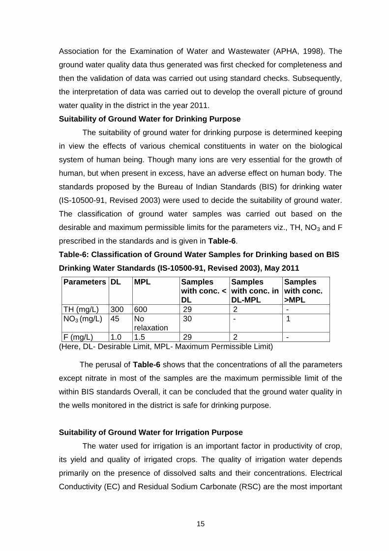
Suitability of Ground Water for Drinking Purpose
The suitability of ground water for drinking purpose is determined keeping
in view the effects of various chemical constituents in water on the biological
system of human being. Though many ions are very essential for the growth of
human, but when present in excess, have an adverse effect on human body. The
standards proposed by the Bureau of Indian Standards (BIS) for drinking water
(IS-10500-91, Revised 2003) were used to decide the suitability of ground water.
The classification of ground water samples was carried out based on the
desirable and maximum permissible limits for the parameters viz., TH, NO3 and F
prescribed in the standards and is given in Table-6.
Table-6: Classification of Ground Water Samples for Drinking based on BIS
Drinking Water Standards (IS-10500-91, Revised 2003), May 2011
Parameters DL MPL Samples with conc. < DL
Samples with conc. in DL-MPL
Samples with conc. >MPL
TH (mg/L) 300 600 29 2 -
NO3 (mg/L) 45 No relaxation
30 - 1
F (mg/L) 1.0 1.5 29 2 -
(Here, DL- Desirable Limit, MPL- Maximum Permissible Limit)
The perusal of Table-6 shows that the concentrations of all the parameters
except nitrate in most of the samples are the maximum permissible limit of the
within BIS standards Overall, it can be concluded that the ground water quality in
the wells monitored in the district is safe for drinking purpose.
Suitability of Ground Water for Irrigation Purpose
The water used for irrigation is an important factor in productivity of crop,
its yield and quality of irrigated crops. The quality of irrigation water depends
primarily on the presence of dissolved salts and their concentrations. Electrical
Conductivity (EC) and Residual Sodium Carbonate (RSC) are the most important

16
quality criteria, which influence the water quality and its suitability for irrigation.
Electrical Conductivity (EC)
The amount of dissolved ions in the water is best represented by the
parameter electrical conductivity. The classification of water for irrigation based
on the EC values is as follows.
Low Salinity Water (EC: 100-250 µS/cm): This water can be used for
irrigation with most crops on most soils with little likelihood that salinity will
develop.
Medium Salinity Water (EC: 250 – 750 µS/cm): This water can be used if
moderate amount of leaching occurs. Plants with moderate salt tolerance can be
grown in most cases without special practices for salinity control.
High Salinity Water (EC: 750 – 2250 µS/cm): This water cannot be used
on soils with restricted drainage. Even with adequate drainage, special
management for salinity control may be required and plants with good salt
tolerance should be selected.
Very High Salinity Water (EC: >2250 µS/cm): This water is not suitable
for irrigation under ordinary condition. The soils must be permeable, drainage
must be adequate, irrigation water must be applied in excess to provide
considerable leaching and very salt tolerant crops should be selected.
The classification of ground water samples collected from monitoring wells
for was carried out irrigation purpose and given below in Table-7.
It is clear from the Table-7 that maximum number of samples (74%) falls
under the category of low salinity water while nearly 19% of samples fall in
medium salinity water category. This shows that the ground water in the pre-
monsoon season from shallow aquifer in the district should be used for irrigation
with proper soil and crop management practices.
Table-7: Classification of Ground Water for Irrigation based on EC (May 2011.
Type EC (µS/cm) No. of Samples % of Samples
Low Salinity Water <250 23 74
Medium Salinity Water 250-750 6 19
High Salinity Water 750-2250 2 7
Very High Salinity Water
>2250 - -
Total 31 100.0

17
4.7 Status of Ground Water Development
Ground water development depends on many factors viz., availability, crop
water requirement, socio-economic fabric and on the yield of the aquifers existing
in that area. Ground water is predominantly used for irrigation, as it is the major
ground water utilising sector. As per the Minor Irrigation Census data available for
year 2006-07, area irrigated by ground water is about 74.19 sq.km., whereas
surface water accounts for 85.35 sq.km. The district had 7439 irrigation dugwells,
which create an irrigation potential of 73.32 sq.km., out of which 71.92 sq.km., of
irrigation potential is utilised. There are 89 bore wells which have created
irrigation potential of 0.87 ham and potential utilised is 0.85 sq km.
State Government agencies have drilled number of borewells fitted with
hand pumps and electric motors for rural drinking water purposes in the district.
In all till March 2007, GSDA, Government of Maharashtra was successfully
operating 2653 borewells for rural water supply under various schemes in the
district, out of which 297 are fitted with electric pumps and 2356 are fitted with
hand pumps.
5.0 Ground Water Management Strategy
Agricultural development in the district mainly depends on rainfall. The
ground water development is on the higher side. The district also faces water
scarcity during summer months in spite of heavy rainfall. There is thus a need to
adopt an integrated approach of development of ground water resources
dovetailed with ground water augmentation and rainwater conservation to provide
sustainability to ground water development.
5.1 Ground Water Development
Major part of the district is covered by Basalt and Laterite. The Kaladgis
and Dharwarian Metamorphics occupy comparatively less area, whereas
Alluvium mainly occurs along the coast as beach sand at shallow depths. In all
these formations dugwells are the most feasible structures for ground water
development. The borewells sites need to be selected only after proper scientific
investigation. The borewells generally tap deeper fractures, which may not be
sustainable. Besides, the borewells should only be used for drinking water supply
and not for irrigation. Apart from dugwells and borewells springs also serve as a

18
dependable source for drinking and irrigation needs as observed from study
around Nadhawade and Kolusra villages. The spring water could be harnessed
for the problematic villages. If one spring does not give sufficient water, water of
two or more springs should be harnessed and used for water supply or co-
operative based irrigation purposes. As far as possible excess spring water
should not be allowed to flow in long open channels/drains instead it should be
arrested and conserved through check dams/bandharas etc., so as to bring more
area under irrigation. The ground water quality of springs is also suitable for
domestic and irrigation purposes.
Major parts of Sindhudurg district are covered by hilly areas. In these areas
rocks are hard and compact, resistant to weathering with steep gradient causing
rapid runoff and low infiltration and such areas are not feasible for ground water
development. The overall stage of ground water development is 27.73%, thus the
scope of ground water development exists in worthy areas. Further ground water
development should be coupled with artificial recharge and water conservation
measures, wherever feasible so as to augment the ground water resources and
adoption of ground water management practices, so that the sustainable
development is achieved.
5.2 Water Conservation and Artificial Recharge
A large number of water conservation structures in the form of check dams,
percolation tanks and KT weirs have been constructed in the district. Till 2006,
698 Nala bunds, 221 cement bunds, 548 farm ponds and 1168 Vanrai Bandharas
have been constructed in the district. The contour bunding has been carried out
in 6996 hectares of land.
In hard rock area, the artificial recharge structures feasible are check dams,
gully plugs, percolation tanks, nalla bunds, etc. The structures like gully plugs,
contour bunds are most favourable in the hilly areas. In the highland area and
wide Lateritic plateau areas, contour trenching should be carried out to arrest the
surface runoff and ensure recharge of rainfall runoff into the ground water
reservoir. Existing dugwells can also be used for artificial recharge, however, the
source water should be properly filtered before being put in the wells. These sites
need to be located where the hydrogeological conditions are favourable, i.e.,
where sufficient thickness of unsaturated/de-saturated aquifer exists and water

19
levels are deeper than 5 m. Occurrence of such areas are limited in the district as
seen from postmonsoon water level map.
It is also observed that sufficient water is available in the rivers and streams
in the post-monsoon period, hence lift irrigation schemes may be encouraged
using small check dams.
6.0 Ground Water Related Issues and Problems
Even though the district receives high rainfall in the range of 2300 to 3200
mm/year, water scarcity in the non-monsoon seasons is the major issue of
concern and many villages face water scarcity in the summer. In such areas in
the basaltic terrain, attempts may be made to increase recharge and create
additional storage spaces by employing unconventional methods like hydro-
fracturing, bore blast technique, horizontal bores in dugwells along the plane of
weakness etc., and artificial recharge structures. Small schemes of water
conservations like storage tanks on hill tops/plateau needs to encouraged for
mitigating the water scarcity situation.
The falling trend of water level in the range of 0 to 0.20 m/year is (in parts
of Devgad and Kankavali talukas) and in elongated western part of the district (in
parts of Malwan and Vengurla) and in southern part of the district (in parts of
Sawantwadi and Dodamarg talukas).
There is a lack of efforts to harness and harvest the rain water in the
region. Mass awareness programmes should be organized in large scale by
district administration. Such programmes are necessary so as to educate the
user regarding yielding capacity of aquifer, benefits of small water conservation
schemes/efforts, appropriate crop planning and irrigation practices etc.
The district has a coastline of 121 km and has 14 creeks, about 76900 ha
of agricultural land is reported to be saline due to sea water ingress along the
coast and creeks. CGWB has carried out a study on sea water ingress in
Mithibhao creek area of the district. About 15 ground water samples were
collected from areas adjacent to the Mithibhao creek and it is observed that only
4 samples collected from 3 wadis viz., Jatewadi, Kondwadi and Yeshwantwadi
which are located very close to the incomplete bund of Kharland Development
Board show sea water contamination. To avoid ground water quality deterioration
the existing damaged bunds/bandharas needs to be repaired in time and
20
incomplete bunds needs to be completed by Kharland Development Board on
priority basis.
7.0 Areas Notified by CGWA/SGWA
As per ground water resource estimation all the talukas fall under “Safe”
category, hence till March 2009 the area has not been notified either by CGWA or
SGWA.
8.0 Recommendations
1 The major part of the district is underlain by hard rocks i.e., Deccan Trap
Basalt, Laterite, Dharwarian Metamorphics and Kaladgis where only
dugwells are most feasible structures for ground water development.
2 The sites for borewell need to be selected only after proper scientific
investigation. The borewells generally tap deeper fractures, which may not
be sustainable and are not recommended for irrigation purpose. However,
to cater to the drinking water requirements the borewells can be used by
installing the hand pumps.
3 The falling trend of water level in the range of 0 to 0.20 m/year is (in parts
of Devgad and Kankavali talukas) and in elongated western part of the
district (in parts of Malwan and Vengurla) and in southern part of the district
(in parts of Sawantwadi and Dodamarg talukas). In such areas dual
approach of ground water development coupled with augmentation needs
to be practised.
4 The spring water should be harnessed for the problematic villages
especially in hilly areas. If one spring does not give sufficient water, water
of two or more springs should be harnessed and used for water supply or
co-operative based irrigation purposes. As far as possible excess spring
water should not be allowed to flow in long open channels/drains instead it
should be arrested and conserved through check dams/bandharas etc., so
as to bring more area under irrigation.
5 The overall stage of ground water development is about 27.73%, thus the
scope of ground water development exists in worthy areas. Further ground
water development should be coupled with artificial recharge and water

21
conservation measures, wherever feasible so as to augment the ground
water resources and adoption of ground water management practices, so
that the sustainable development is achieved.
6 In spite of heavy rainfall over the area, many villages face water scarcity in
the summer. In such areas, attempts may be made to increase recharge
and create additional storage spaces by employing unconventional
methods like hydro-fracturing, bore blast technique, horizontal bores in
dugwells along the plane of weakness etc., and artificial recharge
structures. Small schemes of water conservations like storage tanks on hill
tops/plateau needs to encouraged in mitigating the water scarcity situation.
7 The scope exists for construction of suitable artificial recharge structures in
the district in limited areas. The structures recommended for the hilly areas
are: contour bunds, gully plugs, nala bunds and check dams. For other
hard rock areas, the nala bunds, check dams and KT weirs are suggested.
The existing dugwells may also be used for artificial recharge of ground
water provided source water is free of silt and dissolved impurities.
8 As sufficient water is available in the rivers and streams in the post-
monsoon period for 2-3 months, lift irrigation schemes may be encouraged
using small check dams.
9 The existing village ponds/tanks need to be rejuvenated to act both as
water conservation and artificial recharge structures.
10 About 76900 ha of agricultural land is reported to be saline due to sea
water ingress along the coast and creeks. To avoid ground water quality
deterioration by sea water ingress the existing damaged bunds/bandharas
constructed along the creeks needs to be repaired in time and incomplete
bunds needs to be completed by Kharland Development Board on priority
basis.
11 Mass awareness programmes should be organized in large scale by district
administration. Such programmes are necessary to educate the user
regarding yielding capacity of aquifer, benefits of small water conservation
schemes/efforts, appropriate crop planning and irrigation practices etc.


![International Finance and Trade [Emba]5207 2011 Edition](https://static.fdocuments.net/doc/165x107/553530ec5503468e2b8b4664/international-finance-and-trade-emba5207-2011-edition.jpg)