Goold Island - Upstreampaddle 2009 .pdf · Goold Island camping, regulated by National Parks...
47
Transcript of Goold Island - Upstreampaddle 2009 .pdf · Goold Island camping, regulated by National Parks...


Goold Island Trip Report
Goold Island 17- 19 April 2009
Where are we staying and where do we eat tonight ??? Dunno, guess we’ll work it out when we get to Cardwell, OK ? Sounds like a disaster waiting to happen.
BUT despite the lack of planning our own ability to adapt and overcome turned this trip into a real winner. A quick recap – our Club trip was planned for the weekend for the 18 and 19th April. Due to unforeseen circumstances “the planning” did NOT get done and only Stumpy and I drove to Cardwell. The idea was to paddle along the west coast of Hinchinbrook Island for about 20 kms past Garden Island and camp on Goold Island for the Saturday night.
Having arrived in Cardwell we went to Port’o’Call boat-ramp to check the security of the area. We hoped to leave my car in the car-park overnight. Everything appeared good so off we went to eat then look for accommodation. Annie’s Kitchen provided a great meal for a reasonable price and the Kookaburra Caravan Park had dongas we could stay in. These are air-conditioned units with 2 beds and storage space – perfect for weary kayakers. Close by was a secure area where we parked the car with both kayaks on top.
After a good night’s rest and breakfast we headed to the boat-ramp. The Tackle Shop owners assured us our vehicle would be very safe so we loaded our boats and took off across the Channel. With calm seas, light winds and slight wispy clouds overhead we paddled across to Hinchinbrook Island. The Island always impresses me with its brooding primordial appearance. The recent rains had clothed the hills in a coat of green. In the distance we saw the outline of our own destination, Goold Island.
top: SE corner of Goold Island above: Hinchinbrook Is from north below: Goold Island
text & images HJ Preuss

Crossing to Garden Island we had several encounters with turtles and accidentally interrupted a large pair of mating turtles. These two creatures shot off at terrific speed – much faster than I thought they could achieve. Gradually the wind speed increased to around 12 knots causing a small choppy sea. As we approached Garden Island we stopped for a chat with a local boat owner who gave me some extra water. Quite a few boats had anchored in the lee of the Island in crystal clear waters. As we approached the shoreline fish and crabs darted away from our boats shadows. The shady site on Garden Island is hidden from the sea and until you are nearly inside the tree line. A resident goanna slid out of the shadows looking for a free meal but left disappointed. Several photos later we continued our journey – a brief paddle around the sand-spit into the sheltered side of Goold Island.
Here the undisturbed waters were again crystal clear with fish and crabs scuttling away from us. The campsite here is completely in the shade and looks as if no-one has ever been here. The cleanliness was very impressive – not a sign of humans. After a quick exploratory walk around we set up camp and put our boats in under the trees close to our tents.
The peacefulness was almost tangible in the soft morning light. I noticed that several more craft were now anchored in the lee of Garden Island. After a leisurely breakfast we slowly repacked our boats then paddled off towards the 2 large rocks on the eastern side of Garden Island.
We briefly saw the Marine Parks boat as it motored between the anchored vessels. The crew wished us a safe journey then blasted off to inspect their territory.
We paddled across to Hinchinbrook Island and mooched along it’s side until we felt like a quick break. A most interesting episode followed with us gingerly “beaching” our boats on a rather rocky shoreline.. The slow trip back to Cardwell was broken by frequent sightings of fish and turtles in the shallows. By the way on low tide stay close to the marked channel as the water levels get very low. At last we were back at Cardwell. Car loaded we headed off for a quick meal then back to Townsville. This trip had the three main ingredients of a great trip – excellent company, good sea and great weather.
This was offset by the beauty of Hinchinbrook Island only several kilometres across the Bay. As we slipped through the rocks between Goold and its little neighbour (I forget its name) we nearly shaved the sides off our boats … again. The west coast features many steep drops into the sea with many bommies close to shore. It looked a good place to dive for crayfish and possibly spearfish. The afternoon sunlight and wave motion made photography a little difficult.
As we neared our campsite the shoreline became less steep and the waters much shallower. Everywhere fish moved constantly. We finally arrived at our camp site and spent a good half hour talking to a nice couple from a yacht anchored in the little bay. Having solved the world’s problems both groups separated and headed to our respective eating places. After tea we chatted for a while then retired to our tents. We drifted off to sleep with the surf gently lapping the shore. The next morning I took a walk before dawn around the narrow spit we were camped on to get some early morning photos.
This campsite has some amazing features – a gas BBQ, water (boil or treat before drinking, a tin sheltered area with bench seat and a short distance away a totally new one standing next to an older version. It appears that about 10 tents could be set up quite easily within the leafy canopy. And … because it is so sheltered rain and wind rarely affects this spot.
After lunch Stumpy and I decided to spend the rest of the day paddling around Goold Island. We set off around the east coast hugging the shoreline and the diversity of the vegetation soon became apparent. Gum tree, palms and mangroves within 4 metres of the windswept rocky shoreline.
The east coast does not offer many places to land a kayak as it is far too rocky and the waters hide oyster-encrusted rocks just under the surface. Please note going too close to shore results in nasty scratches on your kayak.
left: campsite, Goold above: rocks SE Garden Island, mainland beyond

Goold Island lies just north of Hinchinbrook Island, 4.6 km from Cape Richards, and 16.5 km from the mainland town of Cardwell. It is a continental island with an impressive peak of 409 metres. The island is quite large, some 4 km east west, and 3 km north south.
A much smaller island, Garden Island, lies 1 km offshore, west of Goold. The photograph above is taken from the south east tip of Garden Island looking to Goold. The Brook Islands lie 9km distant, east north east, from Goold, and the southern Family Island, Coombe Island, is 12 km due north. On the same bearing, Dunk Island is 22km from Goold.
There are day visitors from Cardwell and Port Hinchinbrook, to Goold Island National Park, and the main camping ground on the sandy spit to the south west is popular.
Goold Island image: L. LaRue
western beach, Goold Island. Image: R. Barz sea kayakers, western beach. Image J. Gibson

Goold Island camping, regulated by National Parks permits, is permitted at Western Beach, Southern Beach, and Eastern Beach. During the wetter summer months, drinking water is often available from a small watercourse at the northern end of Western Beach. Note the water tank in the photograph, below, left. The small day shelter includes an electric barbecue.
The island has rocky shorelines of granite with occasional sandy beaches. Most of the island vegetation is eucalypt woodland, with patches of rainforest in gullies and watercourses. below left: camping at Western Beach site. Note the food box hanging from the tree, out of reach of gnawing rats and the local lace monitor.
view from Western Beach to Hinchinbrook Island view from Western Beach to Family Island Group
water should be boiled or treated before using below right: rainforest (lower three images, courtesy R. Barz)
above images: HJ Preuss

left: moving east along the southern coastline of Goold Island from Southern Beach to Eastern Beach

left: Eastern Beach, also known as Wilderness Cove, near SE tip of Goold Island
left: small islet off the south east tip of Goold Island (Eastern Beach or Wilderness Cove Beach around the corner) photos: HJ Preuss

Photos: HJ Preuss below: Goold Island seen from closer towards Cardwell. Garden Island on left.
above: Western Beach, Goold Island on left, Garden Island to the right, and Hinchinbrook Island behind

The Brook Islands is a group of four continental islands and a few rocks located about 7km north-east of Cape Richards on Hinchinbrook Island, about 9kilometres from Goold Island, and about 30km from the nearest mainland town of Cardwell. The islands stretch 3.7 kilometres from southern most shore to northern. There is no more than half a kilometre of open water between the islands, and only 70 metres between Middle Island and Tween (6ha). The three northern islands form Brook Islands National Park.
The islands are low, rocky, and covered in a dense vine-forest. North Brook (65ha) has a maximum altitude of 62m, and South Brook a maximum of 42m. Their eastern shores are rocky while their western shores have beaches of coarse sand and coral rubble. Due to large resident breeding populations of birds (pied imperial-pigeons and significant breeding colonies of bridled terns, black-naped terns, little terns and roseate terns) public access to the islands is not permitted. The exception is South Brook Island, which is, due to its lightstation, Commonwealth Property. Day visiting only, and diving is permitted on the reefs of the other islands.
above: Brook Islands from Goold Island Image courtesy: L. LaRue
below: Looking from Brook Islands to Hinchinbrook Island. Eva Island on left. Image courtesy: G. Young

Middle and North Brooks. Photo: G. Young
North, Tween, Middle and South Brooks
rocks and North Brooks. Dunk Island far distant. Photo: G. Young

The Rous River begins under the Tweed Rim of Lamington National Park. The river is on privately owned land, and is unapproachable, until Hopkins Creek Road crosses it 2 kilometres west of Chillingham.
right: high in the Rous River valley, on Hopkins Creek Road, looking across the river to Wagawn and Mt Hobwee, (mid photo)
left: shallow and rocky right: boulder choked

Possible river sections are from the Hopkins Creek Road bridge to the causeway on Chilcotts Road (total 6.0 km), and from the Chilcotts causeway to the next access point at Kynnumboon Bridge, 17.5 kilometres.
Eventually the Rous River will join the Tweed River at the tiny town of Tumbulgum, after becoming tidal at Boat Harbour, and flowing through flat sugarcane growing land. But at the Hopkins Creek Road bridge, the river is still bouncing down rocky bars and gravel banks, and winding through green tree lined avenues. Some rainforest remnants still cling to its banks.
The Rous River is a seasonal paddle for river sections above Boat Harbour, which is tidal.
The water level at Boat Harbour according to the BOM Rainfall and River Data pages was 1.3m on the day the upper section was paddled. In the previous week there had been over 140mm of rain in the headwaters.
Flood debris in the trees was over 2 metres above the water.
above: looking upstream from Hopkins Creek Road bridge over the Rous. Note the cow in the water and remember not to drink from the river.
below: the Hopkins Creek Road bridge is 300 metres south of Numinbah Road, 2 kms west of Chillingham
left: downstream from the Hopkins Creek Road bridge

By river it is 2.8km from the Hopkins Creek Road bridge down to Chillingham. There is a concrete road causeway over the river a few hundred metres upstream of the village, which may have to be portaged. A further 3.0 kilometres downriver from Chillingham is Chilcotts Road causeway. Be careful if portaging on the causeway that you don't get run over.
The river is grade two. There are a few portages where fallen trees block the river, or shallows where the paddler has to walk. The river is not suitable for fibreglass boats.
There are places where the current swings into the bank through a fallen tree or vines that forms a strainer. These water hazards can be extremely dangerous to the inexperienced paddler. The boat and paddler get pushed by the current into the branches, the boat capsizes, and the force of the water going through the sunken tree holds the two under water.
left: about one kilometre below the Hopkins Creek Road bridge is a rocky bar and rapid, one of many
left: the causeway on Chillcott Road. Water depth on the causeway in this photograph, was about 40cm.

Below the Chillcott Causeway the river runs 4.3km down to Korns Bridge on the Numinbah Road between Murwillumbah and Chillingham. The Korns Crossing bridge is a Dare type timber truss bridge, was completed in 1916, and is heritage listed. Just downstream from Korns Bridge, Crystal Creek joins the Rous River. The name comes from the semi precious stones found in the creek, not the clearness of the waters.
Hopkins Creek Road bridge to Chillingham 2.8 km Chillingham to Chilcotts Road Bridge 3.0km Chilcotts Road Bridge to Korns Bridge 4.3km Korns Bridge to Boat Harbour 6.2km Boat Harbour to Kynnumboon 7.0km
above: the road over Korns Bridge going towards Chillingham. Springbrook nountain range to the west.
above: Rous River from Korns Bridge
left: stones picked up on gravel banks in the Rous River. Pretty but of no value, these are chalcedony (chall sydney). The area near Chillingham is reported to have finds of amethyst. below left: tree strainer about half an hours paddle above Boat Harbour below right: the more mature river slows down as it reaches Boat harbour


below: gun "cheese" above: Command Post
Images courtesy: Alasdair Milne
The Forts Walk, Magnetic Island
Four kilometres offshore from Townsville, Magnetic Island was fortified during World War II to protect Allied shipping anchored in Cleveland Bay. The fortifications included, amongst others, a radar unit in the hills above Arthur Bay, two gun emplacements, searchlights above Florence and Horseshoe Bays, a Command Post, barracks, Signals Post, a Magazine and Explosives Store, and Anti Aircraft Gunsites at Nelly Bay.
The main gun emplacements were M1A1 155mm guns. They were mobile and could be towed by tractor or heavy truck. They weighed 13.9 tonnes (30,600 pounds), had a split trail and eight pneumatic tires, and were served by a combined crew of 15 men. The gun could be pedestal mounted on the so-called "Panama Mount" for its coast-defense mission. On relocation to a fixed site, such as “The Forts” on Magnetic Island, the rear wheels were removed, and the chassis split to form a “Y” shape. The front wheels sat on the concrete Panama Mount or “Gun Cheese” in the middle of the Gun Emplacement, a simple concrete circle designed to stabilize the guns and provide a fixed location to aide in fire control. The guns fired a shell that weighed about 40 kg (90 pounds) a distance of about 22 kilometres (14 miles).

The image to the right is taken from inside the Signal Station, Magnetic Island, looking down to Florence Bay. Hoop pines characteristically frame views of many of the bays.
The image below is of a 155mm coastal artillery field gun, displayed as a advertising fitting for The Big Gun Shopping Centre, Logan Road, Springwood, Brisbane.
The gun is mounted with the barrel elevated. It seems likely that the field piece is one of the guns from the World War II Rous Battery on Moreton Island and is the same type of gun as those placed on Magnetic Island.

Start of walk. A National Parks sign provides information on the native fauna including the Allied Rock Wallaby - a small endearing wallaby - that is common all over rocky parts of the island, and the Death Adder, which although common, is rarely seen due to it's camouflage, small size and very stationary hunting habits - lying in ambush. Koalas are also very common in these parts of the island. They were introduced to the island in the 1930s when it was hoped they would flourish without the threats encountered on the mainland. A bushwalker with a keen eye and some determination is almost guaranteed to see one on this walk.
155mm M1A1 coastal artillery 1939 - 1945.
Towing configuration. Image: Olive-Drab.com
155mm M1A1 coastal artillery 1939 - 1945.
Split trail configuration. Image: Olive-Drab.com
The Forts Walk can be accessed via the closest beach - Arthur Bay which lies on the central eastern side of the island. Keep towards the more southern end of the beach and you should find a track which roughly follows a creekline.
This access goes through National Park and Crown land - avoid the area to the north of the creek which is a small block of private land (with house). When you reach a bitumen road, turn left and follow uphill for about 1km to the start of the Forts walk which is at the junction of the Radical Bay Road and the Horseshoe Bay Road.

Fruit of the kapok tree - a trademark tree of the island which is completely deciduous in the dry season, and bursts forth in large yellow flowers whilst still leafless. The fruit contains seeds surrounded by a dense thick wad of extremely soft white fibres which have been used for stuffing in pillows. The tree in the background is a native almond tree - favoured by the Red-tailed Black Cockatoo for the kernels found inside the fruits which form in the late wet season.
Arthur Bay Lookout.
This view looks north east to Florence Bay.
Arthur Bay lies due east, renowned as having some of the best snorkeling on the island. Hoop pines are an impressive feature on many of the headlands and rocky outcrops on the island. These trees are native to the island and were harvested to some degree for their timber in the late 1800s. They occur on the rockiest sites where they are protected from bushfires.
Lower part of track to the forts. The track winds through a scrubland which is a fascinating mixture of woodland shrubs and trees (wattles, ironbarks and peppermints), and semi-deciduous rainforest plants (native gardenias, figs, native jasmine and ebony).
The Forts walk is about 4 kilometres (1.5 hours) return. There is no water available on the walk, and the track offers little shelter from the sun.

left: the final track of the Forts trail becomes narrow and fairly steep, with granite steps in places.
Florence Bay. Richly scented white-flowered supplejacks (behind boulder) can be seen in the late dry/early wet season.
view to Bolger Bay, and the fascinating mixture of vegetation - includes hoop pines, spinifex, ironbark, native almond and ebony.
Ammunition store, now the home of the Bentwing Bat and possibly other bat species.
Signal Station, Cleveland Bay, and Cape Bowling Green on the mainland. photo: M. Rithalia
On the walk, other remains of buildings, sometimes only concrete foundations, including the Casualty Station, Mess, Kitchen, Sleeping Huts, Workshop, Bulk Oil Store, Womens Quarters, and the Reserve Ration Store, may be seen.
Photographs: all photos H. J. Preuss unless otherwise credited.
Track notes courtesy Jeanette Kemp

below: Kapok tree seed below: Range Finder platform

left:screen ONE
below: GEOD icon
Converting Latitude and Longitude to Eastings and Northings
GPS users may find these notes useful. A good explanation of the technical information involved can be found at http://www.usyd.edu.au/agric/acpa/GRDC/Convert_GEOD.pdf
That site above has an out of date link to the software needed, which can be found (April 06, 2009) at http://www.lands.nsw.gov.au/survey_maps/geodesy/gda/geod_software
The software is a zipped 333 kb file called GEOD ver 3.42 . It can be unzipped into any new folder you have called GEOD. It will not be a Program Files file. Create a subfolder in GEOD called DATA and having also downloaded a file called The National Grid File (ZIP 3.31 mb) from the above Lands site, unzip it into DATA.
Then download the National AGD84 distortion grid (Zip archive, 7.9 MB) from http://www.nrw.qld.gov.au/property/surveying/gdasoftware.html, into DATA. You should have 5 files in your DATA folder.
Perfectionists can look for the Queensland .gsb file Queensland AGD84 distortion grid (GSB file, 2 MB) at http://www.nrw.qld.gov.au/property/surveying/gdasoftware.html, or The South East Australia - NSW and Victoria File (ZIP 2.22 mb) at http://www.lands.nsw.gov.au/survey_maps/geodesy/gda/geod_software
You are now set to open the software program, GEOD. Make a shortcut for your desktop if you wish. Double click on the GEOD icon, then OK to get screen ONE.

left:screen THREE
left: Screen TWO
For East discard the 5 at the start eg 16743562 For North discard the 68 at the start eg 64925816
Screen TWO will have a SELECT FILE option, so click on the Get GSB button, nnd point to the National 84.gsb file in your DATA folder
Eg: C:\geod\DATA\National 84 (02.07.01).gsb
Then click OK.
Screen THREE should come up. Note that eastern Australia is in Zone 56, and other localities have other codes.
In the Latitude (South) white box, is a default 32”.52’ 30”, in the Longitude (East) white box is a default 152° 42’ 30”.
As an example I entered 28° 20’30”S, and 153°10’15”(having had to click the CALCULATE button a few times to enter the data. and correctly re-enter. In the grey data boxes above the white latitude/longitude boxes, I got the following
East 516743.562 North 6864925.816
Eastings and Northings to 5 decimal places! Settle for 167E and 649S. Try it out, read the information in the software HELP pages, read the extra info on the LINKS (this page) webpages. I am sure the software can do much more, and even work out Eastings/ Northings to Latitude/Longitude reverse calculations, but that is another story.

The photograph above shows the twin paddle steamer Maid of Sker tied up at the Gibbs, Bright & Co wharf, Eagle Street, Brisbane. Now resident in the Bischoff Pioneer Park, Ferry Street, next to the Nerang River, Nerang on the Gold Coast, (left), she has her feet encased in concrete, and barring a major flood, will no more go sailing.
The Maid was named after a popular novel (published 1872) by RD Blackmore, whose most famous book was Lorna Doone. The Maid, incidentally was of Sker House in Wales.
The ship was built in Brisbane in 1884 by the J. W. Sutton foundry of Kangaroo Point. She has a rivetted iron hull and measured 52 tons gross, being 74 feet 8 inches long, breadth 17 feet and depth 5 feet 2 inches.
The Maid of Sker was built for C.H. Philpott of the Nerang River to transport timber from Philpott's Mill to Brisbane.Later the ship was owned by the Gentner & Kleinschmidt families, and carried cargo and passengers between Nerang, Southport, the Logan River, and Brisbane.
John Oxley Library, State Library of Queensland. Image number: 37703
The Maid of Sker

The ferry ship eased out of Kagoshima New Port shortly after midnight on Aug. 6th, bound for Naha, Okinawa. We stood on the top deck and watched the lights of the city slide by. Our kayaks, loaded with two weeks of provisions and necessary equipment, were somewhere in the hold below. Another precious 2 week holiday had begun. We were heading south where the sea is brilliant blue and full of promise of adventure.
At 7pm the next day, exactly 24 hours after leaving Amakusa, we arrived at the expansive Naha New Port. In the fading daylight we hastily packed the boats and slid them down the narrow stairs of the tall concrete wharf into the tepid water. We paddled along the long wharf, then an even longer breakwater; by the time we made it to the lighthouse at its end it was already quite dark. We stuck close to the tetrapods while a solitary vessel went by; we were invisible to them, which was just as well. Then finally, we paddled past the light into open water.
Harbour entrance, village of Zamami, and a life like sculpture
10km further west, under a full moon and a myriad lights illuminating brownish clouds over the city well behind us, we neared a group of reefs called Keise-jima, planning to camp on one of the sandbanks in the center. On attempting to penetrate the reef, however, we quickly became beached in shallow water still far away from dry sand. Realizing the inherent difficulties of doing this at night, and not feeling particularly sleepy anyway, we re-crossed into deep sea and headed another 12km west to Mae-shima, where an artificial channel through the reef was marked in the map. This we located without difficulty with the help of the GPS; it led to an abandoned deserted island beach and camping area.

The morning’s heat woke us up. We looked around at the scenery for the first time in full color. We were on the doorstep of the Kerama Islands, a tiny but well-known destination for Japanese sea-lovers. Through a geographic accident three or four of the small islands almost completely enclose an area of sea and reefs, which consequently remains relatively free of waves and yet clean and teeming with life. Thus the islands are popular with divers, whale-watchers, and the like. During our preliminary research we even found processed satellite images revealing in great detail the location of coral for this area.
Aiming for one such place now, we found we weren’t the only ones in the know: a bevy of rubber-clad divers was already plopping into the water from a number of moored motorboats. Full of curiosity, we pulled up our kayaks on the beach, donned our snorkel gear, and swam out for a look. The water was pleasantly warm and a number of sea creatures could be seen on the seabed where rocks protruded from the sandy bottom. Large clams somehow perfectly fitted into pockets in the rock, and their delicate, colorful flesh revealed sinuous silky designs of many different colors.
Though we didn’t plan on it, curiosity somehow pulled us into the village of Zamami located on an island of the same name. A highly realistic whale “sculpture” reared out of the water at the port entrance.

In the village we had geocoded a kayak shop, so after an unexpectedly delicious and cheap lunch at the local cafeteria-style restaurant (with a great view of the seascape to boot), we wandered there.
This was lucky in a way because at Kerama Kayak Centre, the staff was friendly and gave us access to their Internet and sea charts, and we received a day’s warning of an incoming typhoon.
All operations in the archipelago were to cease for the next 3 days. Knowing the Japanese to be overly cautious, we consulted our own sources and discovered that the next day would still be OK, but the typhoon would pass close on the day after next, making movement out of the question. The third day would again probably be OK.
We formulated a plan: we would hang around tomorrow, then wait out the storm at a likely beach on nearby Aka Island, in the lee of the expected winds. We figured we would be protected from the onslaught of the storm by the mountain in the island’s center. Although a small town exists on the island, it would be on the windward side and we would have no recourse to civilization during the storm, as the map showed no roads or trails through the dense jungle backing the beach. Having never done this before, we felt somewhat apprehensive.
But after a short crossing, arriving at our beach, we found a dense clump of adan palm trees with a perfect space to camp underneath. The trunks and branches were short and flexible and would protect us from the storm without danger of breaking. The beach was high and in any case completely enclosed by a wide arc of reef where storm waves (though we did not expect any to come from this direction) would surely break up. Thus placated, we settled down and spent a quiet, peaceful evening and night.
In the town of Geruma we visited a traditional house built about 150 years ago by a wealthy merchant. Like most rural buildings in Okinawa, the house was surrounded by neat stone walls to protect it from typhoon winds, and, like all traditional Japanese dwellings, exuded the sense of balance with its surroundings that is so strikingly absent from nearly all modern structures here.
The weather the next day was glorious, as it nearly always is the day before a typhoon. The sky and the sea were a rich, deep blue. A stiff southeast breeze was the only obvious precursor to the storm. Since the weather was again behaving according to our expectations, we merrily ignored the Japanese warnings and set out on a most enjoyable circumnavigation of Aka and Geruma islands.

typhoon # 13 passes the kayakers home island of Amakusa, later on in the typhoon season

Tonaki Village
We arrived back at our campsite just in time for a beautiful sunset. We listened to the typhoon reports on the AM radio, ignoring all information except the factual reports of its position, barometric pressure, and measured winds. Our campsite was just about line-of-sight with the cell phone antenna over Zamami village, and the phone occasionally sprang to life with more accurate forecasts pulled from the Internet and sent to us from Amakusa by our friend Kenji. Not much stood changed in the new forecasts; the typhoon would pass about 160km to the south of us at 6pm the next day. Final preparations were made, all things were put in waterproof bags and packed away; the boats were hauled into the thicket and tied to the trees with rope. We figured if things got bad we’d take down the tent and sit it out in the open under our clump of bushes.
It turned out we chose our location so well we never witnessed the storm in its full fury. Sure it was quite windy the next day, the sea was gray and heaving and gusts of wind were whipping salt water high in the air, but the full blasts of wind and the huge waves that must have battered the other side of the archipelago never reached us. Even at the height of the storm we could take a walk back and forth along our private beach, being blown by the wind only a little. We spent the day in comfort lounging, listening to American National Public Radio (relayed through by one of Okinawa’s U.S. military bases), and napping. We would have to work hard during the next few days to catch up to schedule, so it was just as well we could use this day to gather strength.
The next day is windy and waves are breaking on the reefs, but the typhoon has moved off fast and things are only going to get better, so there is no reason to stick around. Although all ferries and flights in the area have been cancelled, we make fairly quick work of traversing the 20km or so northwest to Tonaki Island. A wild, cliffy coast greets us and running the reef on the way to port we disturb the slumber of no fewer than six enormous sea turtles.
Tonaki is quite small and has mountains in the north and south, while a saddle shaped depression in the middle is home to its only village and a few sandy fields. This wind-tunnel topography makes typhoons doubly formidable here: all flat land is exposed. From a hilltop viewpoint the town seems so isolated and desolate, so utterly surrounded by the vast sea. But the folks that live here know how to tough it out and today, the day after a typhoon, everyone is lively.
Over time stone walls and live walls of dense trees have been established so that the whole village is enveloped in their quiet shadows and it is a pleasure to walk through on a hot summer day. It is only a short walk from the port to the sea on the other side of the island, where the reef looks most inviting for diving, so we grab our snorkel gear. We have to swim out almost a kilometer before we reach the reef’s edge, but are rewarded with sights of many fish, sea turtles, and even a shark.

Kumejima
We had planned to circumnavigate Kume-jima, which promises to be an interesting island: besides Okinawa, where we touched down so briefly, it is the biggest we would visit, and the most westerly. Off its west cape the warm Kuroshio Current -- the Pacific’s Gulf Stream -- flows through the deep open sea that forms the biggest break in the Ryukyu island chain between Kyushu and Taiwan: Miyako-jima, the next island, lies 220km away.
kayaker paddling towards Aguni
Kume-jima’s most touted tourist attraction is the so-called tatami (mat) rocks. Somehow the sea has effected a neat cross-section of a group of polygonal volcanic basalt columns; these make a curious sight against the pleasing backdrop of distant reefs and shallow lagoons with turquoise water.
editors note: this extract is from the authors blog at: http://vibromama.blogspot.com/2006_09_01_archive.html
Okinawa is the largest of the Ryuku Islands, and the name of the group of 41 inhabited and 16 (or more) uninhabited islands. The area has a sub tropical climate and is known as Typhoon Alley for its summer storms.
We peruse the weather forecast and at midnight set out on our next crossing: about 30km westward to Kume-jima. Altogether the crossing goes smoothly though unexpected currents occur and kick up waves here and there. Rather than fighting the current we allow ourselves to be carried north slightly. 10km before Kume-jima a lighthouse on a reef serves as a landmark; from here the reef stretches all the way ahead.
Once past the lighthouse we attempt once to enter the lagoon inside the reef but in the dark it’s too risky, so we paddle alongside, in deep water. At least the reef had cut off most of the waves. By dawn we are finally able to cross and sunrise finds us on the beach at Ooha-jima, an outlying islet. We had made good time but are sleepy and tired. We grab a nap under some pine trees, in an hour it gets too hot to sleep, so we move on.
Besides, the island has interesting reefs and topography including fresh-water springs in its seaside cliffs. On this trip with so many open crossings we had been looking forward to following a coast for a while. But we cannot afford the extra day the circumnavigation would take on account of the weather forecast, so we content ourselves with a minimal visit to the town of Madomari.
Finally, tourist traps exhausted, there was nothing else to do but to move on. It was getting late anyway, just enough time to make it back to the Ogan-saki lighthouse that we had passed in the wee hours of the morning. From there, we would strike out for Aguni-jima, the next island, 40km to the northeast.


Coomera Gorge
previous page: tree roots and rainforest, Coomera River
The Coomera River begins in a deep mountain gorge on the Lamington Plateau, that runs nor nor east between the Beechmont Range to the east and Darlington Range to the west, on Lamington Plateau. Mt Hobwee and Mt Merino sit either side at the southern most end of the long valley. The river can be visited from Binna Burra, by the Illinbah Circuit track to the lower section of the river within the National Park, and by the Coomera Falls lookout track to the upper section.
The Coomera Falls (64m fall) lookout track leaves the Border Track 1.9km from the track entrance at Binna Burra. It is 5.4 km more to the lookout, with views of the spectacular Coomera and Yarrabilgong Falls, and the Coomera Gorge downriver from the falls. The Coomera Circuit is 16 km roundtrip back to its beginning on the Border Track, passing numerous waterfalls.. The Illinbah Circuit is 16.2 km down and back, from the National Parks Binna Burra Information Centre, which is a kilometre short of the end of the road. When seen in an anticlockwise direction, the track makes an 8 km descent to the river on the national park border, then repeatedly crosses the river as it wanders upstream to Gwongoorool Pool. A shortened trip to Gwongoorool Pool from the Binna Burra Information Centre is still an hour down, and an hour and a half back up. The track can be difficult to pick up on the other side at some river crossings, and stormy weather can cause the track to become hidden by fallen palm fronds, and tree branches.
top left: Coomera Falls circuit track top right: Coomera Falls circuit track below left: upstream view, Illinbah Circuit track below right: under the shadowy canopy of the rainforest, Illinbah Circuit track

Coomera River, Lamington National Park, Coomera Falls circuit track.
Coomera River, Coomera Falls circuit track.

looking downstream at Gwongoorool Pool.
At the lower end of the Illinbah Circuit track (right where the track turns back upstream, at a National Parks sign) it is possible to walk downstream and see the end of the rainforest, and cleared farming land above the Upper Coomera Road's end at Illinbah.

looking downstream from the road's end at Illinbah. The water is mostly ankle deep.
Below the boundaries of the National Park. the Coomera River emerges from rainforest into cleared farming land.
At the road's end is Illinbah, two or three farm houses scattered along the river bank.The road finishes at gates to private property.
There is not much volume in the river flow. In the top photograph a palm tree reveals a clue to the tropical rainforest that lies half a kilometre upstream around the river bend.
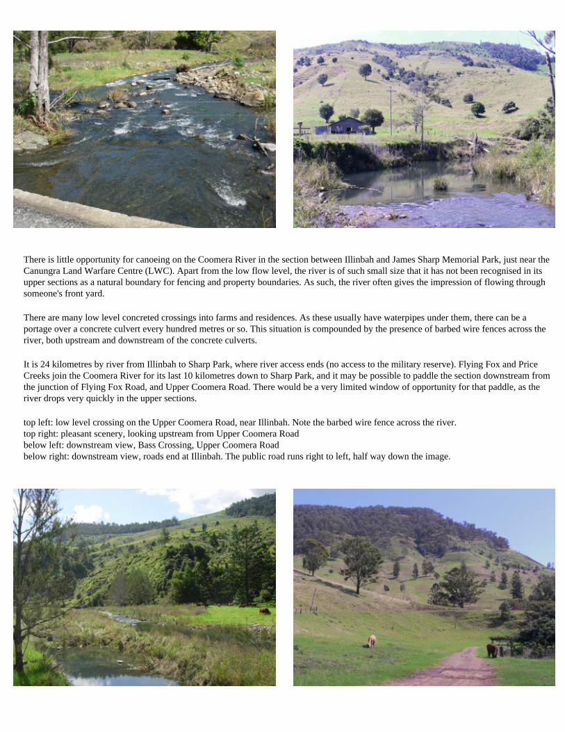
There is little opportunity for canoeing on the Coomera River in the section between Illinbah and James Sharp Memorial Park, just near the Canungra Land Warfare Centre (LWC). Apart from the low flow level, the river is of such small size that it has not been recognised in its upper sections as a natural boundary for fencing and property boundaries. As such, the river often gives the impression of flowing through someone's front yard.
There are many low level concreted crossings into farms and residences. As these usually have waterpipes under them, there can be a portage over a concrete culvert every hundred metres or so. This situation is compounded by the presence of barbed wire fences across the river, both upstream and downstream of the concrete culverts.
It is 24 kilometres by river from Illinbah to Sharp Park, where river access ends (no access to the military reserve). Flying Fox and Price Creeks join the Coomera River for its last 10 kilometres down to Sharp Park, and it may be possible to paddle the section downstream from the junction of Flying Fox Road, and Upper Coomera Road. There would be a very limited window of opportunity for that paddle, as the river drops very quickly in the upper sections.
top left: low level crossing on the Upper Coomera Road, near Illinbah. Note the barbed wire fence across the river. top right: pleasant scenery, looking upstream from Upper Coomera Road below left: downstream view, Bass Crossing, Upper Coomera Road below right: downstream view, roads end at Illinbah. The public road runs right to left, half way down the image.

The public Beaudesert Nerang Road runs through the army reserve beside the Coomera River, so the driver passing through can see much of the river. Image right: looking upstream from under the FG Walker road bridge to the off-limits Coomera River in the army reserve.
From Sharp Park the still shallow Coomera runs through the Canungra LWC and is closed to the public.
Thirteen kilonetres downstream, at the FG Walker bridge, the river becomes open to the public again. Seven and a half kilometres below Sharp Park, Back Creek has joined the Coomera Although by name a creek, Back Creek looks to be of equal flow into the waterway.
Image right: looking upstream from the road bridge at popular camping spot, Sharp Park

The distance by river between the FG Walker Bridge on the Beaudesert Nerang Road, and the next road to cross the Coomera River downstream, is less than one kilometre.
That is Clagiraba Road (right,) but as the river flows through small diameter pipes under the road, and the exit upstream of the crossing is choked with dense vegetation, the recommended canoe launch point is below the crossing.
looking downstream from the left side of the river, Clagiraba Road crossing.
Note the narrowness of the channel. Things will get ugly very quickly if this section is attempted at too high water levels.

From Clagiraba Road crossing it is 1.7km downstream to the CJ Bird bridge near Henry Roberts Drive, 8.1km to Guanaba Creek Road crossing, 10km to Birds Road crossing. The water is grade 2, with occasional rapids, trees in the water, and submerged logs. From Birds Road crossing down to the tidal limit on the Old Tambourine Road (photo below right, below) is 7.4 km. Total distance from Clagiraba Road crossing down to the tidal limit is about 17.5 kilometres by river.
At the Birds Road crossing there were flowers left at the bridge, a memorial to a motorist swept away by floodwater, and a reminder that high water levels in this narrow watercourse makes for a very dangerous place.
The last section, downstream from Birds Road crossing has more flat water. Note that the vehicle with boat trailer parked out on the floodway in the photo below is a City Council vehicle, with the boat in question engaged in spraying noxious weeds. The tidal sections of the Coomera River, with its numerous residential canals, can be explored using your street directory.
top left: looking upstream from Birds Road crossing. top right: Birds Road crossing below left: downstream view, Birds Road crossing below right: old Tambourine Road crossing, and tidal limit, Oxenford, Coomera River.

left:
above: carpark below: banksias
above: clear, clean, 'black water' below: casuarinas and reeds
Seven and a half kilometres before the Rainbow Beach Road reaches town, is Seary's carpark. The walk down to Seary's Creek is one hundred metres on a boardwalk.
It seems to be a popular place to have a dip, but the water is a little over a metre deep. This stream is fed by rainfall draining away from the forested high sand dunes and heathlands that lie to the east, in a crescent from Rainbow Beach township down to Double Island Point.
The water is very clear, but is also stained a deep red by tannins, dissolved organic matter. This water soon looks totally black where it is of any depth.
door to nowhere
One hundred metres upstream from the boardwalk, the creek goes under the Rainbow Beach Road

below: wooden bridge over black water
Crab Creek ramp, Toolara. Yachts anchor in the channel at far mid left.
entrance to Seary's Creek
The upper part of Seary's Creek can be inspected by the boardwalk at the carpark. It is possible to approach the creek from where it joins into Tin Can Inlet. The closest launch point is the Crab Creek boat ramp in Toolara on the western side of Tin Can Inlet. Toolara Road runs east off the Tin Can Bay Road a kilometre or so short of Tin Can Bay township, and runs along the foreshore to the ramp.
As there is often a strong wind blowing, the paddler should be in a kayak. From the ramp head out towards the anchored yachts and along to Teewah Point. From there the main channel turns right, unmistakeable as there is a 16m high cable crossing the channel, with two support pylons. You want to paddle straight ahead towards Cameron Point, which is 3.5 km from the boat ramp. The creek entrance is not visible until quite close, but its position is evident in the stretch of mangrove vegetation, between large groupings of tall eucalypts to the north and south.
The creek entrance is very shallow, and access in the smallest of craft is only possible in the two hours before and after the top of the tide, with a bit of leeway on larger tides. It can be time consuming to try navigating without a map, and a sat photo map is recommended. Print one out and laminate it back to back with a map showing the boat ramp.
The flow of freshwater from the heathlands upstrean can be seen in the inky black water. An old log dump from the days of yesteryear when loggers used Seary's Creek to float out hoop pine logs to sailing ships is visible on the eastern bank as the stream swings close to one of the "islands" of rainforest. About 1.5 kilometres from the entrance of Seary's Creek is a log bridge crossing.
It is possible to portage the log bridge, on the left bank. Note how the mangrove vegetation starts to thin out, being replaced by pandanus trees. It is possible to paddle further upstream.


above: looking from Bullock Point, low tide, across Pelican Bay to the sandspit two kilometres away that the Fraser Island barge leaves from, and the coast of Fraser in the further distance.
above: 4wd vehicles come and go up to Hook Point on the south east tip of Fraser.
Tin Can Bay, and Tin Can Inlet, is a V shaped estuary just south of Fraser Island. The estuary is about 20 kilometres long, from Inskip Point, a kilometre away from Fraser, down to the small town of Cooloola Cove on the south western shore.
There are three points of access on the eastern side of the estuary, Inskip Point at the northern tip, Bullock Point 1.8 kilometres south from Inskip across Pelican Bay, and Carlo Point, about 10 kilometres south, and due west from the only town on the eastern side, Rainbow Beach.
No major flowing creeks drain into the estuary, although there are plenty of bays and inlets branching off. Seary's Creek, Cooloola Creek, Carland Creek and Mullen Creek offer possibilties to explore at high tide. The highest country around is the almost 200m sand dunes behind the beach from Rainbow Beach down to Double Island Point. The Carlo Sandblow next to Rainbow Beach was described by Captain Cook as he sailed past, so it has been around a long time. The high dune offers a view of the Tin Can Inlet to the west, and Double Island Point to the south east.
On the western shore, south to north are the towns of Cooloola Cove, Toolara, and Tin Can Bay. All the land north of the Tin Can Bay Road is a military reserve, with zero admittance. Tin Can Bay town sits on a peninsula with Tin Can Bay inlet to the east, and Snapper Creek to the west. The northern bank of Snapper Creek, just across from town, is part of the reserve. When heavy ordanance is used in the training area, locals say that even at a distance of half a dozen kilometres, the ground shakes.
At low tide the inlet dwindles to a narrow channel lined with wide sandy flats. A constant south east wind seems to be blowing, and it can be a difficult return trip to paddle down the bay, or across to close Fraser Island, then to try and return against the wind. At high tide there is very pleasant foreshore paddling. Sandflies and mosquitoes can be bothersome when the wind drops. National Parks signs remind visitors of estuarine crocodiles.

above: looking from Carlo Point, low tide, across Tin Can Inlet. above: low tide in Pelican Bay. There are numerous National Park camping sites along the shore.
above: view from Carlo Sandblow above Rainbow Beach township to Tin Can Inlet. Carlo Point is near the right end of the small island, mid picture.

above: looking from Norman Point, Tin Can Bay township, low tide, across Tin Can Inlet, with the sandblow far centre.
above: low tide, Mudlo Rocks on the beach in front of Rainbow, looking across the bay to Double Island Point.
above: view from Carlo Sandblow above Rainbow Beach township to Double Island Point. Stormy weather in the Summer and Autumn of 2009 swept away beach sand, closing the beach to traffic from Rainbow Beach down to the Point..