GIS-T Stovepipes 1 GIS-T Stovepipes: Barriers to Geospatial Interoperability David Loukes, P. Eng....
22
GIS-T Stovepipes 1 GIS-T Stovepipes: Barriers to Geospatial Interoperability David Loukes, P. Eng. Geoplan Consultants Inc. March 26, 2002 Atlanta, GA
-
Upload
anabel-jones -
Category
Documents
-
view
216 -
download
0
Transcript of GIS-T Stovepipes 1 GIS-T Stovepipes: Barriers to Geospatial Interoperability David Loukes, P. Eng....

GIS-T Stovepipes1
GIS-T Stovepipes: Barriers to Geospatial Interoperability
David Loukes, P. Eng.
Geoplan Consultants Inc.
March 26, 2002
Atlanta, GA

GIS-T Stovepipes2
Presentation Overview
• Stovepipe technology issues: Lack of GIS-T interoperability standards Proliferation of personal geodatabases Technology architecture complexities IP issues
• Parting thoughts
GIS-T Stovepipes3
Geospatial Trends
• NSDI / GSDI initiatives
• Advanced, more accurate data collection methodologies
• Move toward web enabled applications
• Concern over IP issues

GIS-T Stovepipes4
National / Global SDI Initiatives
• There is a growing interest in national and international Spatial Data Infrastructure (SDI) initiatives
• National: NSDI (US) CGDI (Canada) Others … 27 nations in 1998 (U. of Maine)
• Growing international commitment for a Global Spatial Data Infrastructure (GSDI)

GIS-T Stovepipes5
Clearinghouse SitesClearinghouse Sites
Today: Global Reach On the Way
GatewaysGateways
WebClient
WebClient
CEONetCEONet
NodeNodeNodeNode
NodeNodeNodeNode
FGDCFGDC
NodeNodeNodeNode
NodeNodeNodeNode
OthersOthers
NodeNodeNodeNode
NodeNodeNodeNode
OthersOthers
Source: Mark Reichardt, US FGDC

GIS-T Stovepipes6

GIS-T Stovepipes7
(G)SDI Emerging Standards
• ISO TC 211 / 204
• Open GIS Consortium
• ISO/JTC1 SC32 - SQL/MM
• Others ...

GIS-T Stovepipes8
The DOT Role in NSDI / GDSI• NSDI / GSDI initiatives moving toward interoperability
– access to geospatial data across organizational boundaries
• DOTs and other transportation agencies have a considerable amount of data that should be contributed to these initiatives CGDI studies have clearly identified transportation network
data as the number 1 priority among users
• Result: “enterprise GIS-T” extends far beyond the boundaries of any one transportation agency
• Example: the GeoConnections National Road Network initiative
GIS-T Stovepipes9
National Road Network (NRN)• Being developed by Natural Resources Canada as part
of the GeoConnections program• Objectives:
Develop transportation network “core” data in support of the CGDI
Provide a framework upon which “value added” data can be overlaid
• Concept: collect data once, as close to the source as possible, and share across jurisdictional boundaries
• The NRN will likely incorporate a LRS data model in support of provincial and municipal road network data requirements

GIS-T Stovepipes10
The GIS-T Data Model Stovepipe
• Open GIS standards for interoperability so far are restricted to simple features (points, lines, polygons)
• A great deal of the useful attribution related to transportation networks is stored as LRS events along routes
• There are no open standards at present for the GIS-T data model extensions necessary to support the transfer of LRS event data features among unlike systems
• Result: the GIS-T data model stovepipe

GIS-T Stovepipes11
GIS-T Data Model Research
• Current “best practice” transportation data model standards need to be integrated NCHRP 20-27 (3) ISO GDF others?
• The “new and improved” transportation data model needs to be incorporated into the Open GIS standards
GIS-T Stovepipes12
Advanced Data Collection Methods
• Many advanced data collection technologies are now available: GPS Digital videolog Multi-purpose vehicles Had-held and voice activated computers Others …
• These technologies have made it far easier to collect transportation infrastructure data quickly and with improved location accuracies
• Result: proliferation of personal / workgroup geospatial databases due to stovepipe issues

GIS-T Stovepipes13
GIS-T Data Collection Stovepipes
• The technologies are easy to use and cost effective• It is often possible to justify the acquisition of
these systems in support of very specific applications
• Result: Data may not be collected according to corporate
geospatial data standards Differing accuracies may make integration with
existing data layers difficult Multiple road centerline representations exist

GIS-T Stovepipes14
Data Standards Stovepipe Issues
• Project based data collection missions may not adhere to corporate data standards for: Location (LRS, coordinate framework) Attributes (fields, allowable values) Metadata (lineage tracking)
• Result: inability to integrate data into corporate road asset databases

GIS-T Stovepipes15
Accuracy Stovepipe Issues
• Mixed accuracies: Existing GIS-T basemaps and road network features
commonly based on 1:10K – 1:24K compilation specifications, with associated accuracies of +/- 2.5 meters or greater
GPS data collection methods can now achieve sub-meter positional accuracies
• Result: features show up “in the wrong place: Signs appear on the wrong side of the road Bridges are not positioned over rivers / streams Anchor points don’t fall on topological nodes
• Reconciliation of these problems may be time consuming and expensive

GIS-T Stovepipes16
Centerline Stovepipe Issues
• With GPS, it is possible to collect a new road centerline during each data collection mission.
• This presents the following issues: Do you update the network geometry after each
mission? How do you filter out unnecessary shape points? How do you reconcile the new geometry to the existing
base network:• Which nodes should be moved?• Does the associated LRS need to be updated?
• Result: data may not be used

GIS-T Stovepipes17
Architecture Complexity Issues
• Technology architecture: we have (evolved?) from mainframe to workstation to PC to Client - Server to web-based
• We are now dealing with “n-Tier” architectures and many components (“Plug and Pray”)
• What happens when something goes wrong?
GIS-T Stovepipes18
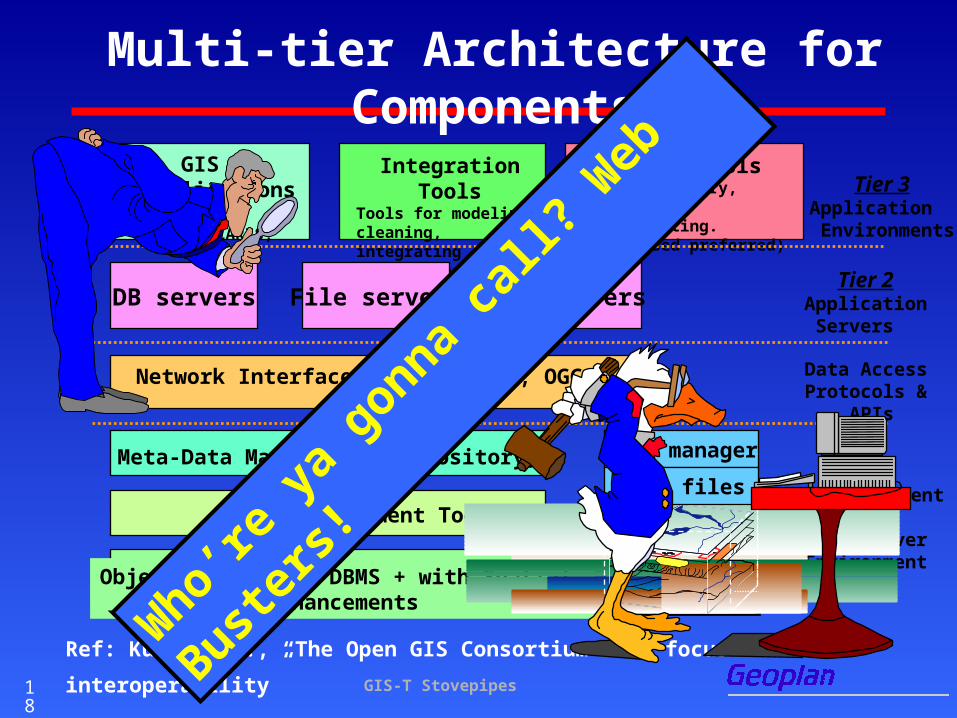
GIS & applications
(ESRI, CARIS, INGR)
Access ToolsTools for query, analysisand reporting.(Web-based preferred)
Integration ToolsTools for modeling, cleaning, integratingand loading data.
Tier 3Application
Environments
Network Interface APIs - (OGDI, OGC & CGI) Data AccessProtocols &
APIs
Tier 2Application
Servers
DB servers File servers App Servers
Data Management Tools
Meta-Data Management (Repository)
Object-Relational DBMS + with Spatial enhancements
Tier 1Data Management
& Data ServerEnvironment
File manager
Data files
Multi-tier Architecture for Components
Ref: Kucera, H., “The Open GIS Consortium … a focus on interoperability” W
ho’re
ya go
nna call
? Web
Buste
rs!

GIS-T Stovepipes19
IP Issues
• In the IT community, it’s never the technology that’s the primary barrier to data integration / interoperability CGDI framework and NGTN studies: the main
barriers are associated with intellectual property (IP) issues: cost, licensing, copyright
• In Canada, cost recovery programs have seriously impeded data sharing Now trying to overcome these barriers
• Don’t repeat our mistakes!
GIS-T Stovepipes20
Final Thoughts …
• General GIS interoperability is achievable in the near term
• Specific GIS-T interoperability (ie, LRS) is farther out• Neither is possible without some convergence on data
model and data content specifications for the spatial database
• Field data collection needs to be carried out within a corporate data standards context
• Geospatial data is a corporate resource The enterprise extends far beyond DOTs
• Don’t let IP issues drag you down
GIS-T Stovepipes21
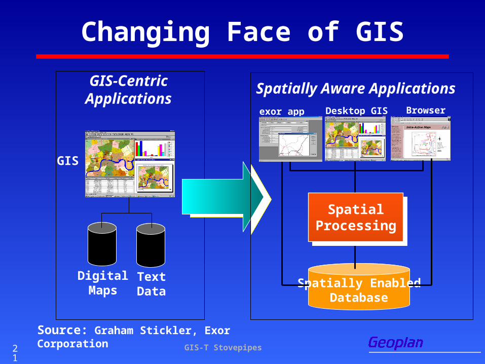
GIS-CentricApplications
TextData
GIS
DigitalMaps
Spatially EnabledDatabase
Spatially Aware Applications
SpatialProcessing
Desktop GIS Browser exor app
Changing Face of GIS
Source: Graham Stickler, Exor Corporation

GIS-T Stovepipes22
Discussion?
• This is one perspective
• There are many others …
• Let’s hear from you!