GIS Strategic Planning - 1&1 Internet · PDF file1 GIS Strategic Planning ... planning efforts...
29
1 GIS Strategic Planning Welcome! Best Practices and Lessons Learned Presented by: Ronald R. Butcher Asset Management Practice Lead Timmons Group
Transcript of GIS Strategic Planning - 1&1 Internet · PDF file1 GIS Strategic Planning ... planning efforts...

1
GIS Strategic Planning
Welcome!
Best Practices and Lessons Learned
Presented by: Ronald R. ButcherAsset Management Practice LeadTimmons Group

2
Enterprise GIS Components
Enterprise GIS
Data
Policy
Standards
SoftwareHardware
Training
People
To provide access to reliable data, maps, and tools……when, where, and how you need it.
It’s important to understand the focus areas for your
strategic planning
It’s very tough to tackle all components at once

3
Growth is tough…..• It takes planning• It takes prioritization• It takes dedication• It takes corporate support• It takes champions• It takes sustained funding• It means Change!
GAP Issues…..• Should be addressed in your
planning efforts
Enterprise GIS Maturity Model

4
GIS Maturity ModelImplementation Process

5
Phase 1 – Current State Assessment (Health Check) Information Collection Knowledge Transfer
Best practices, education Needs Analysis
Identification and Prioritization Recommendation
Phase 2 – Implementation Plan (Road Map) Future state description Easy to understand projects to get there….
Planning Process

6
Detailed Organizational Chart User Interviews Relevant Standard Operating Procedures (SOPs) GIS System Architecture Diagram GIS Data Documentation (Metadata) GIS Applications Relevant Plans and Reports Major Business Systems
Health Check – Discovery Process

7
Are our systems highly functioning? Do we understand our current capacity for growth and
limits? When will it break and what are our thresholds for users? Can we monitor our systems and do we know when
services / systems go down before our users? Do we have good disaster recovery for our systems and
data? Do we have a caching and cloud strategy?
Health Check – Big Questions

8
Total pages 12200 Average pages/s 6.5Total hits 16997 Average hits/s 9.0Total users launched 200 Average Request response time 12sTotal throughput 27.0 MB Average Page response time 13.6sTotal hit errors 3236 Average throughput 0.12 Mb/sTotal action errors 0
Test Results – 100 Concurrent Users
Needs - Evaluation ToolsStress Testing Systems

9
Do we understand our governance model? Do we understand our internal roles and responsibilities? Do we have a sense of priority for services and data? Do we have a data quality plan? Do we have a sustainable funding model?
Are we meeting the needs of the business (other
departments)? Are we ready for more users and deeper integration with
other systems?
Health Check – Big Questions

10
Even Keel Strategies, Inc.
Health Check…..• Describe the current
environment• Grade ourselves on how we
are doing in key priority areas• Lay the foundation for
defining the Target State
Enterprise GIS Maturity Model
These should be relative to your peers in the industry considered
to be Best Practices
YOU ARE HERE

11
Health Check Report CardComponent Grade Key Grading Factors
Processes and Procedures B
ESRI ArcGIS SDE and RDBMS tools for data management, storage and RDBMS transaction management
Knowledge of data models and some adoption Heavy use of caching services and cloud use to maximize storage access speeds Template MXD/MSD for divisions and regional use Use of ArcGIS technologies and RDBMS exist for core GIS data sets Many tools exist for the maintenance and scheduling of recurring jobs / tasks Update cycles for layers exists Many documents related to maintenance tasks such as loading data into SDW Software platform decisions made with PeopleSoft EPM and warehousing tools exist
Weak adoption outside GIS for ArcGIS/RDBMS storage and management Limited use of data models outside of Environmental (limited) and GIS group Weak adoption of ArcGIS data management best practices for version management No usage of ESRI production mapping suite and associated tools (e.g., workflow
manager extension (WMX), Task Assistant Manager (TAM) or Data Reviewer (DR)) for job, process and quality control and overall data management
Weak sense of priority for data maintenance priorities and layer criteria to be solved through the pending prioritization XLS driven by customer input
• Other grading areas may include:
• Policies• Data accessibility• Security• Hardware / Systems• Metadata management• Spatial data management• Many other options…..
Results – Health Check
12
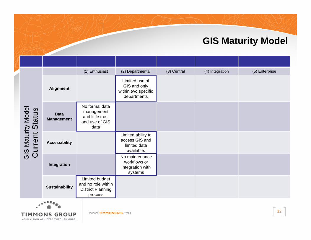
GIS Maturity Model G
IS M
atur
ityM
odel
Cur
rent
Sta
tus
(1) Enthusiast (2) Departmental (3) Central (4) Integration (5) Enterprise
Alignment
Data Management
Accessibility
Integration
Sustainability
Limited use of GIS and only
within two specific departments
No formal data management and little trust
and use of GIS data
Limited ability to access GIS and
limited data available.
No maintenance workflows or
integration with systems
Limited budget and no role within District Planning
process

13
Even Keel Strategies, Inc.
Road Map…..• Describe future Architecture• Describe future organizational
and governance model• Describe the list of products and
services
Enterprise GIS Maturity Model
You want to create a program that:• Can scale, • Can adapt, • is nimble • and addresses the priority needs
of the business
Target State
14
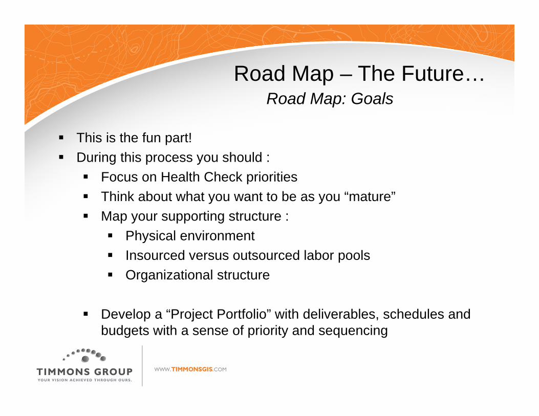
Road Map – The Future…Road Map: Goals
This is the fun part! During this process you should :
Focus on Health Check priorities Think about what you want to be as you “mature” Map your supporting structure :
Physical environment Insourced versus outsourced labor pools Organizational structure
Develop a “Project Portfolio” with deliverables, schedules and budgets with a sense of priority and sequencing
15
Desired GIS Data Set Value to Governm
ent
Value to Con
stitu
ents
Alignm
ent w
ith other Intia
tives
Impo
rtance to
Health
and
Saftety
Data Value
Score (A
verage)
Acqu
isition
Cost
Volume or Size of Data
Complexity
of D
ata
Mainten
ance Cost
Acqu
isition
and
Mainten
ance Cost
Score (Average)
Data Value
‐to‐Co
st Ratio: <1 (Low
) ‐5 (High)
Location of recreational water facilities (public and private) 5 5 5 4 4.8 2 1 1 1 1.3 3.7HIRA (Hazard Identification Risk Assessment) locations/source 5 5 4 5 4.8 2 2 3 2 2.3 2.1Traffic Count Data 3 3 3 3 3 2 2 2 2 2 1.5Air Polution Data (Satellite or Modelled) 3 2 2 5 3 5 4 5 5 4.8 0.6Urban Heat Islands 3 3 3 5 3.5 4 3 3 4 3.5 1Extreme Heat Mapping 3 3 3 5 3.5 4 3 3 4 3.5 1Socioeconomic status 4 3 4 2 3.3 2 4 2 2 2.5 1.3Cases of asthma 2 1 2 4 2.3 4 2 1 4 2.8 0.8Cardiovascular Disease (CVD) 2 1 2 4 2.3 4 2 2 4 3 0.8
Data Value Score: 1 (Low) ‐ 5 (High) Importance
Acquisition and Maintenance Cost Score: 1 (Low) ‐ 5 (High)
Road Map ToolsData Priority Ranking
Value to the organization Pain to the
organization

16
High-Quality
Goal: To understand, document and standardize the QA/QC process for structured GIS data within the organization using improved technologies.
Description: This project will implement consistent use and configuration of the Esri Data Reviewer product. It will define and incorporate rule-based editing, feature validation, visual review and error history tracking in a common multi-user editing environment. It includes visual reviews, batch reviews, scheduling of data reviews and metadata reviews.
Streamline
Goal: To understand, document and standardize data creation and maintenance tasks using improved technologies.
Description: This project will implement Esri Production Mapping Tools to streamline the editing process, reduce button clicks, standardize define procedures and capture vetted workflows and domain knowledge. This project also includes the configuration of Esri Task Assistant Manager.
Roadmap PortfolioSample Projects

17
GIS Maturity Model
FutureGoalCritical
Tasks
Current Status

18
Enterprise GIS ProgramGIS Master Schedule

19
Lessons Learned
Establish the Vision and Mission of the project
Define a project champion
Commit necessary time
Stay on schedule

20
Lessons Learned
Other “take homes”: Your preconceived notions for outcomes may not
come to fruition – be open to that! Think 2-3 year lifespan for plans
Organize your Strategic planning into projects System Architecture, Data Management Governance and Organizational Structures

21
Lessons Learned
Other “take homes”: Seek out help but be prepared when it arrives: Do your homework first…. Leverage consultant experience
It’s very tough to do strategic plans internally Baggage, Management, Time commitments Personalities….
22
Project motivation
• Moving from department level to enterprise GIS• Cost savings and sharing (eliminate duplicate tasks,
leverage existing data)
Local Government Example

23
Lessons learned• Involve major GIS data sources and users early and often• Plan time for client plan review and input• Focus on financial budgeting and cost sharing models• Include executive-level briefing at key points in the project• Provide specific, measurable recommendations
Local Government Example

24
Project motivation
• Update older strategic plan to incorporate new users and applications
• Leverage new technologies• Plan and implement shared GIS resources
State DOT Example

25
Lessons learned• Set expectations for plan extents (what is/isn’t included)• Provide multiple opportunities for business user
participation• Include input from all levels of staff (field staff, operations,
management, executive)
State DOT Example

26
Project motivation • Understand and document the current state• Rank against best practices• Be well-positioned for the future and integration into other
business systems like E911/CAD and Work Order Systems
• Understand current models for data maintenance, QA/QC, security and visibility / discoverability of corporate assets
Regional Example

27
Lessons learned• Be prepared for new outcomes – what you think the
answers and core strategies may be – might not be reality
Regional Example

28
Questions?
29
GIS Strategic PlanningBest Practices and Lessons Learned
CONTACT US:Ron Butcher
www.timmonsgis.com
Webinars.timmons.com