GIS in Archaeology - Esri
44
GIS Best Practices GIS for Archaeology July 2009
-
Upload
duongthien -
Category
Documents
-
view
241 -
download
0
Transcript of GIS in Archaeology - Esri
GIS Best Practices
GIS for Archaeology
July 2009
i
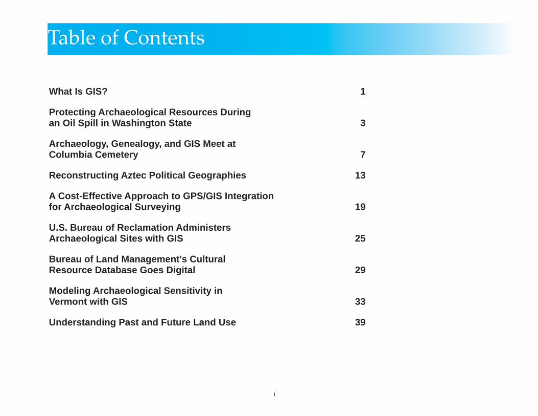
Table of Contents
What Is GIS? 1
Protecting Archaeological Resources Duringan Oil Spill in Washington State 3
Archaeology, Genealogy, and GIS Meet atColumbia Cemetery 7
Reconstructing Aztec Political Geographies 13
A Cost-Effective Approach to GPS/GIS Integrationfor Archaeological Surveying 19
U.S. Bureau of Reclamation AdministersArchaeological Sites with GIS 25
Bureau of Land Management's CulturalResource Database Goes Digital 29
Modeling Archaeological Sensitivity in Vermont with GIS 33
Understanding Past and Future Land Use 39

GIS BEST PRACTICES 1 WWW.ESRI.COM
What Is GIS?Making decisions based on geography is basic to human thinking. Where shall we go, what will it be like, and what shall we do when we get there are applied to the simple event of going to the store or to the major event of launching a bathysphere into the ocean's depths. By understanding geography and people's relationship to location, we can make informed decisions about the way we live on our planet. A geographic information system (GIS) is a technological tool for comprehending geography and making intelligent decisions.
GIS organizes geographic data so that a person reading a map can select data necessary for a specifi c project or task. A thematic map has a table of contents that allows the reader to add layers of information to a basemap of real-world locations. For example, a social analyst might use the basemap of Eugene, Oregon, and select datasets from the U.S. Census Bureau to add data layers to a map that shows residents' education levels, ages, and employment status. With an ability to combine a variety of datasets in an infi nite number of ways, GIS is a useful tool for nearly every fi eld of knowledge from archaeology to zoology.
A good GIS program is able to process geographic data from a variety of sources and integrate it into a map project. Many countries have an abundance of geographic data for analysis, and governments often make GIS datasets publicly available. Map fi le databases often come included with GIS packages; others can be obtained from both commercial vendors and government agencies. Some data is gathered in the fi eld by global positioning units that attach a location coordinate (latitude and longitude) to a feature such as a pump station.
GIS maps are interactive. On the computer screen, map users can scan a GIS map in any direction, zoom in or out, and change the nature of the information contained in the map. They can choose whether to see the roads, how many roads to see, and how roads should be depicted. Then they can select what other items they wish to view alongside these roads such as storm drains, gas lines, rare plants, or hospitals. Some GIS programs are designed to perform sophisticated calculations for tracking storms or predicting erosion patterns. GIS applications can be embedded into common activities such as verifying an address.
From routinely performing work-related tasks to scientifi cally exploring the complexities of our world, GIS gives people the geographic advantage to become more productive, more aware, and more responsive citizens of planet Earth.

GIS BEST PRACTICES 3 WWW.ESRI.COM
Protecting Archaeological Resources During an Oil Spill in Washington StateUsing GIS to Ensure Effective Communication and Protection
There are 29 federally recognized tribes resident in Washington State, as well as a rich history of cultural sites located along coastal shorelines and rivers. Therefore, any oil spill has the potential to damage and contaminate archaeological sites associated with these areas.
Base GIS layer incorporating oil spill geographic response plan and watershed areas with tribal contact areas.
During an emergency response to such an oil spill, an effective response requires accurate information and clear communications. To meet this criteria, the Washington State Department

JULY 2009 4 GIS IN ARCHAEOLOGY
of Archaeology and Historic Preservation (DAHP) and its GIS consultant, GeoEngineers, Inc., have created a GIS application that provides the Oil Spill Incident Command Structure current data on archaeological site locations during an oil spill. This application was developed for the Washington State Department of Ecology Oil Spill Response Program and includes contact information for notifying concerned tribal government cultural staff. This Oil Spill Tribal Contact tool provides quick and easy access to current tribal contact names for geographic regions.
During a recent spill event, the ecology responders were able to quickly identify the tribes of concern by using the application. By clicking on a map at the location of an oil spill, a list of federally recognized tribes was generated on the fl y through an associated database. Dr. Allyson Brooks, State Historic Preservation offi cer and director of DAHP, states, "Our ability to protect these unique and special places in Washington is directly related to the speed with which we can get information to the tribes and other decision makers and fi rst responders on the scene. By providing current data in spatial and tabular format, GIS helps us accomplish that mission."
DAHP uses a combination of ArcView and ArcInfo for digitizing and maintaining archaeology site locations. As part of DAHP's GIS initiative, more than 19,000 archaeological sites have been mapped in GIS and attributed with information regarding site type (e.g., burials, petroglyphs). Each site is mapped within a geodatabase and linked to a scanned image of the original documentation regarding the discovery of the site. This data is available to DAHP staff via a customized ArcGIS Desktop interface. It is not subject to public disclosure; however, data sharing is possible with governmental agencies through memorandums of understanding. In this way, DAHP is able to share this information with the Washington Department of Ecology for protection of these valuable resources during oil spill events.
With funding from the state's Coastal Protection Fund and the assistance of the Tribal Historic Preservation Offi ces and cultural staff of the 29 tribes, DAHP created a series of specifi c GIS layers for each tribal government refl ecting its geographic area of interest, its reservation lands, and watersheds for which each tribe's cultural department wanted notifi cation when a spill occurred.

WWW.ESRI.COMGIS BEST PRACTICES 5
An example of the tribal contact information presentation.
In many parts of the state, multiple tribes require notifi cation. Also along the Columbia and Snake rivers, tribes now resident in Oregon and Idaho have an interest and require notifi cation. The GIS application has a database table identifying any archaeological site potentially at risk and the specifi c cultural staff contact with phone number, an after-hours emergency number, and details on any staff who have hazmat training. These screens were created for ease of use during an emergency and allow for quick printing of contact sheets. Also, since names and phone numbers frequently change, the table was created to allow for ease of updating.
(Reprinted from the Spring 2006 issue of ArcNews magazine)

GIS BEST PRACTICES 7 WWW.ESRI.COM
Archaeology, Genealogy, and GIS Meet at Columbia CemeteryBuilding a Unique, Informative Web Site in Boulder, Colorado
By Mary Reilly-McNellan and Kip White, City of Boulder, Colorado
Cemeteries are a wonderful source of information for anyone interested in digging up information about their past. Genealogists, especially, are known for their tenacity, and generally leave no stone unturned when it comes to researching their roots. But sometimes time and distance preclude travel that is often necessary to discover the clues that may lie buried in preserved cemeteries. Now, thanks to a new Web site developed for historic Columbia Cemetery at Ninth and Pleasant Streets in Boulder, Colorado, the dead can speak any time, anywhere over the Internet (http://gisweb.ci.boulder.co.us/website/parks/parks_columbia/viewer.htm).
Boulder, like many municipalities, offers GIS-enabled Web sites using ArcIMS to provide its citizens with the latest information on fl ood control, zoning, and historic preservation. In 2001, the Columbia Cemetery Preservation project manager approached the GIS team to ask if a Web site dedicated to preserving the history of the cemetery could be created. A great deal of information about the historic cemetery had been compiled, but it was located in many different places.
It was a dark and stormy night. Hemlock Holmes, ace Cemetery Sleuth, sat in his cobwebbed study in the attic, clicking his mouse button dejectedly. He sighed deeply, his bushy brows knitted in a perplexed frown. His research was leading him nowhere. As the wind howled and lightning crackled, Holmes lamented, "If only I could see what was written on the tombstone, I'd know once and for all if he was indeed my great-great uncle!" His faithful companion replied, "Why not visit the poor chap's grave, Holmes?" "Because, my dear Whatsup, he's buried in Columbia Cemetery in Boulder, Colorado. That's a long way from our Backstop Street and Scotland Yard."
Suddenly a URL fl ashed eerily on the screen of his favorite search engine, and a Web site began to load. "Hello! What's this?" Holmes cried excitedly. "Great graveyards, I've struck gold! I can access interactive maps of Columbia Cemetery, a digital photograph of the grave marker, a map of the lot, and biographical information about the deceased! There's even a virtual cemetery tour!"
He poured himself a brandy as he perused the plethora of information, a satisfi ed smile on his face. "Just as I hoped. He is my great-great uncle!" He winked at his companion, saying, "Elementary, my dear Whatsup, you know that I always get my man!"

JULY 2009 8 GIS IN ARCHAEOLOGY
A marvelous opportunity existed, it seemed, to wed history and technology, but the solution had to be able to make maps, display photos, query databases, and allow for customization, all in a Web environment. Since Boulder has been a longtime user of ArcGIS Desktop (ArcView, ArcEditor, ArcInfo) and ArcSDE and knows the power of GIS to integrate information, ArcIMS seemed to be the logical choice to bring this disparate data into a unique and informative Web site.
The interactive map of Columbia Cemetery is an HTML viewer page created by ArcIMS. The user can zoom in and out of the map and get information about who is buried in a particular cemetery lot.
Columbia Cemetery is a virtual "Who's Who" of early Boulder—a historic, cultural, and artistic resource containing the remains of many of the city's founders and pioneers. Initially established in 1870 on 10 acres of cattle-grazed pastureland, the cemetery today has 6,500

GIS BEST PRACTICES 9 WWW.ESRI.COM
burials and 3,000 headstones. Like many other Victorian era cemeteries, Columbia contains grave markers of various types: monuments, crosses, obelisks, and tablets made of marble, granite, sandstone, limestone, and wood. The tombstones not only mark the graves of early pioneers who have helped make Boulder what it is today, but they are also narratives describing Colorado's social and economic structure, its religious tenets, and ethnic composition. The epitaphs, engravings, and decorations provide insight into earlier customs, religious beliefs, folklore, art, and medicine. Homemade Depression-era "folk markers" are juxtaposed with ornate and towering granite monuments belonging to bank presidents. Marble lambs and doves mark the graves of children felled by scarlet fever, diphtheria, and tuberculosis, and graves adorned with fl owers, stuffed animals, and coins poignantly indicate recent visits to century-old burials.
Columbia Cemetery Web site.

JULY 2009 10 GIS IN ARCHAEOLOGY
Columbia Cemetery is owned by the city of Boulder and managed by the Parks and Recreation Department. It is a city landmark and was placed on the National Register of Historic Places in 1997. Over the past decade, the Parks and Recreation Department and Historic Boulder, Inc., have been implementing a Columbia Cemetery Preservation Master Plan—thanks in large part to funding from the Colorado Historical Society's State Historical Fund. Each grave marker was digitally photographed, and more than 100 have received professional restoration work. Several hundred others have received help from a group of volunteers that comprises the Columbia Cemetery Conservation Corps.
Members of the Boulder Genealogical Society, in particular Mary McRoberts, have scoured historic burial ledgers, mortuary documents, obituaries, and court records to compile information about persons interred in Columbia Cemetery. McRoberts' information helped to make history come alive for volunteers as she shared the life story of each person whose stone underwent conservation work. The Boulder Genealogical Society published an eight-volume set entitled, Columbia Cemetery, Boulder, Colorado, 1870 to the Present. In addition, McRoberts prepared maps of each of the burial lots in Columbia Cemetery, indicating who had purchased the lots as well as precisely who is buried within the lot and where. An index of Columbia Cemetery burials is listed on the Boulder Genealogical Society's Web site (www.rootsweb.com/~bgs).
The Web site project actually began in 2002 when the Boulder Genealogical Society kindly gave the city permission for use of its Index of Burials and biographical information contained in the eight volumes. Oracle-based ArcSDE was used to store a cemetery map that was digitized and registered to the city's aerial photography basemap. Tables were created to hold each name, biographical sketch, cemetery lot, and grave marker photograph. By linking the biographical information table to a grave lot feature, Web site visitors are able to query and display biographical information with ArcIMS software's query server. Custom JavaScript was used to send XML requests to ArcIMS software's query server and then parse the responses to generate attractive Web pages presenting maps, scanned records, photographs of grave markers, lists of all people buried in a particular cemetery lot, and biographical information.
What does the future hold for Columbia Cemetery? Hopefully, grant monies will continue to provide funding for ongoing preservation of the burial ground, and grave markers will be carefully repaired or restored one by one. The Columbia Cemetery Conservation Corps has been working in the graveyard on Saturdays for fi ve summers and shows no sign of stopping. New ordinances are in place to help protect the graveyard, and the community enjoys strolling the grounds, picnicking, and studying the fascinating old markers. Tours organized each year

GIS BEST PRACTICES 11 WWW.ESRI.COM
by the Parks and Recreation Department and Historic Boulder, Inc., are hugely successful. Educating the public about Columbia and old cemeteries in general is considered to be the best tool for fostering the appreciation and respect that will ultimately encourage people to help protect these cultural treasures. And with Columbia Cemetery information now available to Web users across the globe, perhaps additional information will come to light as the site is visited by persons who have knowledge of Columbia Cemetery "residents."
A view of Columbia Cemetery with the Boulder Flatirons Mountains in the background.
(Reprinted from the Spring 2004 issue of ArcNews magazine)
GIS BEST PRACTICES 13 WWW.ESRI.COM
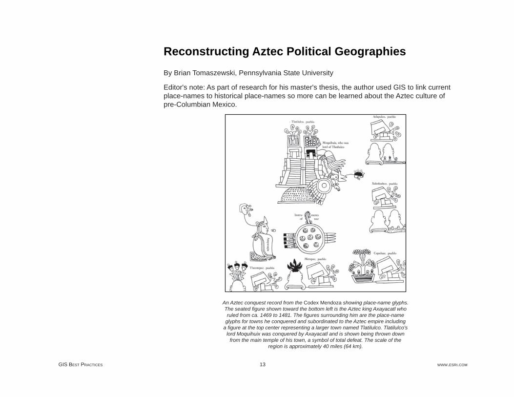
Reconstructing Aztec Political GeographiesBy Brian Tomaszewski, Pennsylvania State University
Editor's note: As part of research for his master's thesis, the author used GIS to link current place-names to historical place-names so more can be learned about the Aztec culture of pre-Columbian Mexico.
An Aztec conquest record from the Codex Mendoza showing place-name glyphs. The seated fi gure shown toward the bottom left is the Aztec king Axayacatl who ruled from ca. 1469 to 1481. The fi gures surrounding him are the place-name
glyphs for towns he conquered and subordinated to the Aztec empire including a fi gure at the top center representing a larger town named Tlatilulco. Tlatilulco's
lord Moquihuix was conquered by Axayacatl and is shown being thrown down from the main temple of his town, a symbol of total defeat. The scale of the
region is approximately 40 miles (64 km).

JULY 2009 14 GIS IN ARCHAEOLOGY
The Aztec culture developed sophisticated political structures composed of complex hierarchical systems of social authority, economic infrastructure, and interprovincial tribute. Following conquest by the Spanish in 1521, elements of these systems formed the base for colonial social and political structures, many of which persist as modern regional divisions.
Previous research on reconstructing Aztec political geographies typically involved identifying modern place-names that have indigenous origins, matching these names to historically referenced locations, and representing these locations with generalized cartographic displays.
This article describes a different approach using GIS. This approach matches uncertain locations from the past to precisely known present-day locations. The GIS approach was decisive in developing detailed cartographic summaries of social, political, and temporal phenomena of interest. Integration with geodatabase technology provided the ability to leverage tabular records derived from historical research at multiple spatial scales. With a geospatial database at the core of the investigation, it was possible to process, visualize, and examine data quickly and effi ciently.
Investigating geospatial historical records relating to the Aztec rule in central Mexico is challenging. The documentary evidence available covers a period approximately 20 to 50 years after the Spanish conquered the region. Investigators used Aztec and Spanish evidence, together with historical and geographic expertise, to look back to the preconquest period.
Spaniards were interested in preserving the Aztecs' political and tribute structures to collect taxes and develop their own political and ecclesiastical systems within existing native systems. The Codex Mendoza [a document created to describe Spain's newly conquered lands to her king, Charles V] is one of the most important primary source documents about ancient central Mexico and Aztec political geographies. The Codex Mendoza provides place-specifi c information describing conquest histories, daily life, and the tributes paid to the central empire. Images in this document function as a map of historical events. These events are depicted in a non-European cartographic manner and demonstrate some of the challenges in creating GIS representations based on the historical record.
A computational system was developed to capture, store, and represent historic information and help understand issues associated with pre-conquest central Mexico. A historical database was developed to support two core tasks: creating a repository for historic information that would provide query and analysis tools for nonspatial information retrieval and generating a database schema that would provide attribute base information for GIS visualization.
The Historical Record
Historical Database Schema Development and
Implementation

GIS BEST PRACTICES 15 WWW.ESRI.COM
Logical model for the historical database.
To visually conceptualize relationships between database objects, a logical model was developed. The database is organized by top-level data clusters or logical grouping of information. Each cluster is interrelated through key-matched information. A user-driven, time period selection query is used to extract information based on research needs. The database was implemented from the logical model. The historical database uses industry-standard database objects (e.g., tables, views) to store and relate information. Seamlessly integrating geodatabase tables with aspatial tables stored in Microsoft Access was especially helpful for data integration and analysis.

JULY 2009 16 GIS IN ARCHAEOLOGY
ArcGIS 9 ArcInfo was used for performing analysis, processing data effi ciently, and querying data structures on the fl y. A place-name matching algorithm was developed to match historic place references to modern place-name points using GIS. The algorithm accepts a time period as an initial input parameter through a simple GUI. The algorithm uses a series of processing steps that determine the match confi dence. These steps proceed from human-focused data matches (e.g., a modern town name for an ancient site has been established through careful historic research) to computational string comparison matches that evaluate multiple partial matches.
National Geospatial-Intelligence Agency (NGA) GEOnet Names Server (GNS) supplied place-name points that were essential to the process of matching ancient place-names to modern place-names. GNS provides access to databases of geographic feature names maintained by NGA and the United States Board on Geographic Names. These databases supply 5.5 million names for approximately four million geographic features worldwide excluding the United States and Antarctica. Data can be downloaded in CSV fi le format with x,y values stored in a latitude/longitude (geographic) coordinate system in World Geodetic System of 1984 (WGS84).
The output table from the name-matching algorithm was joined to the NGA place-name layer, creating a table that contained data keys for both the modern place-name layer and historical location records. With these links established, attribute information derived from historic research could be rendered. Depending on the type of analysis, historical records that could not be located were dropped from the join.
Once the historic attribute information was joined to the modern place-name point layer, attribute renderings were created based on specifi c research needs. The ArcGIS Maplex extension was used for developing automated label schemes that intelligently placed ancient and modern place-name labels for each location. Custom label expressions of contrasting styles for modern and historical names were derived from a single data table. The following code is an example of a label expression that displays the modern place name in Arial, and the ancient name is shown in parentheses in a smaller, italicized font.
[ANCIENT_PLACENAME] & VbCrLf & " _ " & "(" &
[MODERN_PLACENAME] & ")" & ""
Using a GIS-Based Approach

GIS BEST PRACTICES 17 WWW.ESRI.COM
Map-based annotation layers were used extensively for fi ne tuning of label placement after the initial label layout was generated. Given the large number of annotations, the ability to make manual graphic adjustments saved many hours of map production time.
OBJECT_ID FK_PHPRANCIENT PLACE-NAME
MODERN PLACE-NAME
MATCH CONFIDENCE
2464 1365 Comalco San Jose Comalco FOUND_FROM_LIKE
0 1148 Cotlaxticpac NO_MATCH0 1346 Cuauhtenco NO_MATCH
3019 1274 Cuahuacan
SantaMaria
MagdalenaCahuacan
PLACE CONFIRMEDBY RESEARCH
Matching algorithm output sample.
An important feature of Aztec political geographies is how places interacted through political, social, and economic systems. Conceptual representations of place relationships were based on temporal period and visualized using line-direction symbols. Interpretation of the historical record ranged from clear indications of place interactions confi rmed by explicit references to place-names to generalized, inferred, or uncertain references concerning place interactions. A directional arrow showed the interaction between Aztec capitals and subjects. The certainty or uncertainty of an interaction was recorded as an attribute as well as the name of the TO and FROM points of the interaction.
To effectively show these interactions, an automated spider diagram creation procedure was developed using ArcObjects. This procedure helped draw lines of interaction by querying capital/subject relationships stored in the historical database. This saved time and provided an automated, exploratory method for fi nding sites when visual inspection was no longer effective such as when multiple locations with the same name were located near each other. Approximately 25 percent of the time, computer-generated connections were wrong and subsequently dropped from the historic database, but sometimes key links were found.

JULY 2009 18 GIS IN ARCHAEOLOGY
As the analysis moves further back in time, the historical record no longer provides evidence and archaeological investigation will be required. Regional-level place interaction analysis can determine which sites should receive a higher priority when developing research agendas for archaeological fi eld verifi cation of locations.
Improved modern place-name database development, another area for future research, could include a systematic comparison of NGA place-name points with annotation labels shown on 1:50,000-scale quadrangle maps from the Instituto Nacional de Estadística Geografía e Informática (INEGI). In less populated places, place-names don't exist in the NGA database but are shown on the INEGI maps. Locating a broader range of modern place-names makes more effective historic reconstructions possible. Finding a Mexican basemap series that predates the 1988 INEGI series would aid historic name identifi cation by providing additional information on variations in place-name spelling.
GIS can aid interdisciplinary research in history, archaeology, and geography. The use of GIS and relational database management technology and datasets helped manage information and increased understanding of where ancient Aztec places were located and how they interacted with each other over time. Through improved data structuring, visualization, and analysis, GIS has also helped manage issues of uncertainty that exist in the historical record.
Berdan, Frances, and Patricia Rieff Anawalt, Editors. 1997. The Essential Codex Mendoza. Los Angeles: University of California Press.
National Geospatial-Intelligence Agency: GEOnet Names Server (GNS), earth-info.nga.mil/gns/html.
Portions of this research were funded by master's thesis research awards from the Association of American Geographers (AAG) Cartography Specialty Group and the Terry G. Jordan-Bychkov Student Research Award from the AAG Historical Geography Specialty Group.
The author thanks Dr. Michael E. Smith of Arizona State University (formerly of State University of New York, Albany) for providing the idea for the project, many of the critical datasets used in the analysis, and general direction for the project. The author would also like to thank Dr. Alan M. MacEachren and Dr. Deryck W. Holdsworth of Pennsylvania State University, Department of Geography, for their assistance.
(Reprinted from the January–March 2006 issue of ArcUser magazine)
Future Research
Summary
References
Acknowledgments

GIS BEST PRACTICES 19 WWW.ESRI.COM
A Cost-Effective Approach to GPS/GIS Integration for Archaeological SurveyingInvestigation Focus at Mexico's Aztec-Period Calixtlahuaca Site De-emphasizes Temples and Tombs
By Brian Tomaszewski, Pennsylvania State University
Archaeological investigation often begins with systematic fi eld surveys to inventory cultural features and artifacts visible on the ground surface of a particular site or region. These inventories are then used, in part, to gain insight into the overall spatial and temporal dimensions of a site based on artifact types found and to make decisions about which areas within a site will receive priority when conducting traditional ground excavations. Determining which areas to excavate is important not only for the underlying research questions of a given project but also for more pragmatic reasons, as most archaeological investigations are limited by fi nancial and temporal constraints. It is with these constraints in mind that a cost-effective approach to integrating GPS technology with GIS was developed for an archaeological fi eld survey in central Mexico. This approach allowed for the collection of accurate, reliable information about archaeological ground conditions, such as surface artifact densities, subsurface prehistoric structures, and natural features that could be integrated into and visualized with GIS for excavation prioritization and planning.
The fi eld survey using this approach was conducted at the Aztec-period Calixtlahuaca site, located in the Toluca Valley approximately 40 miles (60 kilometers) due west of Mexico City. The earliest known occupancy of the site dates to approximately 1100 A.D. The site was occupied by indigenous peoples until its conquest by the Spanish in the late 15th century. The site has several pyramid or temple structures that were excavated in the 1930s by Mexican authorities.

JULY 2009 20 GIS IN ARCHAEOLOGY
Surface artifact densities at the Calixtlahuaca site collected with GPS (map by Juliana Novic, Arizona State University).
The team of investigators that conducted the survey are part of a National Science Foundation (NSF) grant to examine the nonelite residential occupancy of the site, a research approach that purposely de-emphasizes the investigation of so-called "monumental" structures, such as pyramids, temples, and tombs. A 4.2-square-kilometer systematic survey was conducted to fi nd clues as to where houses and other nonelite structures were located, and the results of the survey will be used to prioritize which areas will be excavated in the following fi eld season.

GIS BEST PRACTICES 21 WWW.ESRI.COM
Earlier archaeological investigations at Calixtlahuaca focused on temples and tombs. Today, archaeologists are looking for evidence of where nonelite residents lived on the site.
ArcGIS Desktop (ArcView) was at the core of the geospatial solution developed for the fi eld survey. In addition, Garmin eTrex Legend GPS devices were used for fi eld data collection. These devices are easy to use and rugged; have large storage capacity; were accurate for the spatial needs of the fi eld survey (within 1 to 5 meters at most control points when tested); and, at a cost of less than $200 per unit, were within the project budget. In addition, the free Minnesota Department of Natural Resources (DNR) Garmin Extension for ArcView facilitated eTrex Legend's GIS functionality.
This DNR program provided the key link to integrating GPS-collected data with ArcView. The program served as a bridge between the Garmin device and the GIS and allowed waypoints to be uploaded and downloaded from the GPS device, exported raw GPS data to shapefi le and geodatabase feature classes, and provided functionality for synchronizing digital photographs with GPS waypoints to create hot link features.
All data collected was stored in a personal geodatabase, which was selected because of its native Microsoft Access fi le format (.mdb). This allowed spatial data to be integrated with nonspatial datasets that were developed in a standard Access database. Access data entry forms were quickly developed on personal geodatabase tables without any concern of

JULY 2009 22 GIS IN ARCHAEOLOGY
damaging the spatial component of the data as spatial fi elds were simply left out of data entry interfaces. In addition, nonspatial data could be quickly and easily visualized in the GIS using join operations onto spatial data without any interoperability issues arising from trying to join data in different fi le formats.
Surface artifacts collected and mapped in the fi eld provide insight into where subsurface structures and other cultural features may lie.
The ArcView functionality proved essential to the project. An important data source used in the fi eld surveys was digital orthophotos purchased from the state of Mexico. When the projection of these photos was found to not correspond with ground-truth data collected by the GPS devices, georeferencing functions of the ArcGIS Spatial Analyst extension were used to adjust the imagery, which after rectifi cation and warping then matched correctly with the GPS data.

GIS BEST PRACTICES 23 WWW.ESRI.COM
Because of budgetary constraints, the crews used hard-copy maps in the fi eld to mark relevant information. A critical component of these maps was Universal Transverse Mercator (UTM) coordinate grids displayed at multiple intervals. Field crews matched the coordinates from these grids shown on the paper maps with their real-time position coordinates shown in the GPS. This allowed the crews to stay oriented in the fi eld and not waste time continually trying to fi gure out their position from the paper maps alone. A custom ArcObjects script was created to generate grid lines at user-defi ned intervals in a grid feature class layer that was used to generate these maps.
In conclusion, the use of ArcGIS Desktop coupled with a cost-effective GPS/GIS solution, ease of use, and integration capabilities of geodatabase technology allowed for the rapid development of a comprehensive geospatial solution to meet the needs of an archaeological fi eld survey. By using this approach, fi nancial and temporal constraints of the project were overcome without compromising the scientifi c integrity of the overall research goals. Although applied to archaeology, this type of approach could be used by any researcher who needs an integrated GIS/GPS/data solution but lacks the fi nancial resources for an optimal solution.
For more information on this archaeological project, visit www.public.asu.edu/~mesmith9/Calix. For more information on the DNR Garmin Extension for ArcView program, visit www.dnr.state.mn.us/mis/gis/tools/arcview/extensions/DNRGarmin/DNRGarmin.html.
Funding for this project comes from NSF grant #0618462, Urbanization and Empire at the Aztec-Period Site of Calixtlahuaca, Dr. Michael E. Smith, principal investigator. Additional funding was provided by Arizona State University. ESRI software was provided through the ESRI campuswide site license program (www.esri.com/campuswidelicense) at Arizona State University. The project also thanks the Instituto Nacional de Antropología e Historia (INAH) and the state of Mexico for their cooperation.
(Reprinted from the Fall 2006 issue of ArcNews magazine)
More Information
Acknowledgments

GIS BEST PRACTICES 25 WWW.ESRI.COM
U.S. Bureau of Reclamation Administers Archaeological Sites with GISThere are more than 2,000 archaeological and historic sites recorded on U.S. Bureau of Reclamation-administered land in the Mid-Pacifi c Region. The region manages more than 900,000 museum property items, primarily prehistoric artifacts, collected in support of cultural resource activities for reclamation projects. These materials are housed at 18 different museums, universities, and storage facilities. The U.S. Bureau of Reclamation is an agency of the Department of the Interior. The policy of the agency is to administer cultural resources in a spirit of stewardship for the benefi t of present and future generations. It carries out this policy through compliance with the laws and regulations that constitute the federal cultural resources management program. This program requires that the bureau identify, evaluate, and manage cultural resources (archaeological, historic, architectural, and traditional cultural properties) under its control and jurisdiction. The bureau must comply with numerous federal laws, including the National Historic Preservation Act (NHPA), the Archaeological Resources Protection Act, and the Native American Graves Protection and Repatriation Act.
The U.S. Bureau of Reclamation's cultural resources management is a multifaceted program that encompasses responsibilities for (1) identifi cation, evaluation, and management of cultural resources under the bureau's jurisdiction or control; (2) the curation of artifacts and museum property; (3) Native American concerns about human remains and associated cultural items; (4) the issuance of permits for cultural resources work on the bureau's lands; and (5) public education and outreach.

JULY 2009 26 GIS IN ARCHAEOLOGY
Archaeology sites, displayed in 3D along the Cosumnes River, California.
For more than 10 years, the Mid-Pacifi c Regional Offi ce has been in the process of digitally capturing archaeological site data. A signifi cant portion of archaeological site information for the region is in a GIS. This information has been collected from a variety of sources for different projects. Site information is considered to be sensitive data, so regional staff archaeologists must review and approve access to cultural resource information.
Managing the digital data became increasingly diffi cult. The spatial data was stored under different project folders, and site attributes were stored in different tables in a variety of formats. For better control of the existing digital records and to avoid duplication of records, the data is being centralized into a geodatabase. The geodatabase offers advantages in identifying potential duplicate site locations. It has common table defi nitions and structures. It permits the
GIS BEST PRACTICES 27 WWW.ESRI.COM
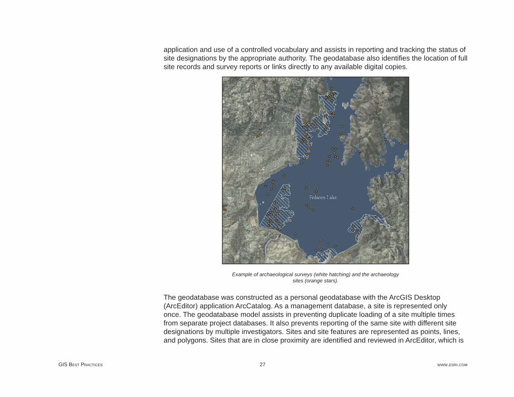
application and use of a controlled vocabulary and assists in reporting and tracking the status of site designations by the appropriate authority. The geodatabase also identifi es the location of full site records and survey reports or links directly to any available digital copies.
Example of archaeological surveys (white hatching) and the archaeology sites (orange stars).
The geodatabase was constructed as a personal geodatabase with the ArcGIS Desktop (ArcEditor) application ArcCatalog. As a management database, a site is represented only once. The geodatabase model assists in preventing duplicate loading of a site multiple times from separate project databases. It also prevents reporting of the same site with different site designations by multiple investigators. Sites and site features are represented as points, lines, and polygons. Sites that are in close proximity are identifi ed and reviewed in ArcEditor, which is

JULY 2009 28 GIS IN ARCHAEOLOGY
also used for verifi cation and validation of proper location and site name. As the geodatabase develops, ArcEditor provides the opportunity to set topological rules to assist in ensuring that the sites and site features are appropriately represented for the different feature types.
The geodatabase model has allowed the development of defi nitions and domains of valid codes that are consistent with the federal cultural resources management program. Defi nitions and the domain of valid codes led to lively discussions among the archaeologists. This included the application and meaning of terms such as Poor, Fair, and Good. These discussions also assisted in identifying components of the geodatabase that the archaeologists needed in performing their tasks.
Domains assist in standardizing information associated with the sites and provide a controlled vocabulary for the geodatabase. These domains cover the time period associated with the site, the organization that has surface jurisdiction for the site, site condition, and collection status. This assists the staff archaeologists in completing surveys and reports for consultation and site designations.
The ArcMap application within ArcEditor makes it easy for the archaeologists to craft maps that meet the needs of the various offi ces of historic preservation. A major issue for the archaeologists has been the assignment of the proper site identifi er or name. The geodatabase and ArcEditor have simplifi ed their task in selecting and formatting the name to meet their needs. It also assists in tracking the status of sites that are currently part of consultations required under sections of the NHPA. A major task for the archaeologists is tracking areas covered by any cultural resource surveys. This is a component of the geodatabase.
Access to the actual site record can assist in categorizing sites for analysis and in refi ning the domain of site types. Viewing the site record is often preferred by the archaeologists when selecting subsets of sites for analysis. At this time, only a portion of the site records is in digital form. The staff members have direct access to these records for review and analysis by linking to the full site record via the geodatabase. Other records only have major characteristics or features identifi ed as historic or prehistoric attributes in the geodatabase. Both methods are used in the GIS by the archaeologists for selecting subsets of sites with spatial or attribute queries.
(Reprinted from the Spring 2006 issue of ArcNews magazine)

GIS BEST PRACTICES 29 WWW.ESRI.COM
Bureau of Land Management's Cultural Resource Database Goes DigitalCalifornia Field Offi ces Unlock Data for Archaeology Program
By Bradley L. Garrett
Recording cultural resources on federal lands has always been a tedious enterprise. Cultural sites have been recorded for some time on hand-drawn maps using x,y coordinates from GPS data. In most offi ces, detailed site records were stored in one place and location maps in another. Often, data was lost in the process of report research when fi les were put back in the wrong place. Even worse, when snap decisions had to be made, such as in the case of fi re emergencies, it took far too long to look up the pertinent data. What was needed was to get all of this data in one place for easy reference.
That time has arrived. The United States Bureau of Land Management (BLM) cultural resource database has gone digital. Kirk Halford at the Bishop, California, fi eld offi ce, in collaboration with Gnomon International, has developed a cultural GIS database tool for use within ArcGIS Desktop. The tool enables cultural resource managers to easily digitize hand-plotted survey and site locations for cultural resources. The tool also lets users copy previously existing GIS data into the resource database. Finally, the software allows for the attachment of metadata collected from site records and fi eld-recorded information.
The software has been implemented across the state of California. BLM fi eld offi ces have been uploading their site and survey data into a central database with the guidance of Halford.
The Alturas, California, fi eld offi ce recently digitized data on cultural resources for integration into the state database. More than 7,000 sites were digitized in the course of 30 days, including some site information metadata.
The new working database will assist archaeologists at BLM in two very important ways. First, the ability to statistically analyze large amounts of data may lead to new research possibilities and interpretation of land use in history. Geospatial data also allows broad cultural patterns to emerge, as population dynamics, temporal use patterns, and habitation centers begin to "pop off" the map.

JULY 2009 30 GIS IN ARCHAEOLOGY
A tool developed for the United States Bureau of Land Management cultural resource database enables cultural resource managers to easily digitize hand-plotted survey
and site locations, attach metadata collected from site records and fi eld recorded information, and copy
existing GIS data.
Second, the construction of the database facilitates quick reference when creating reports on area impacts, such as environmental assessments, or when making quick decisions on potential resource impacts, such as in the case of fi re-line bulldozing in areas of potential cultural sensitivity.
In short, data layering using ArcGIS Desktop allows complex corollaries to be drawn between datasets. For example, when land jurisdiction is in dispute over a located cultural resource,

GIS BEST PRACTICES 31 WWW.ESRI.COM
transparent land allocation maps overlaid on site data easily solve disputes. These seemingly simple ways of working with data will do nothing short of revolutionize the way archaeologists work with cultural data.
Currently, the resource database has seen limited use within BLM due to reluctance to shift to digital formats. The California Desert District and Surprise fi eld offi ce were the fi rst to get 100 percent of their data uploaded. The Alturas fi eld offi ce has digitized the majority of its site information but still has some work to do fi lling out attribute tables for the information. Alturas may be able to fi nish up in another season. Hopefully, 2007 will be the year the rest of the BLM archaeology program goes digital!
Bradley L. Garrett was an archaeological technician for the United States Bureau of Land Management, Alturas fi eld offi ce, for the summers of 2005 and 2006.
(Reprinted from the Spring 2007 issue of ArcNews magazine)
About the Author

GIS BEST PRACTICES 33 WWW.ESRI.COM
Modeling Archaeological Sensitivity in Vermont with GISOver the past several decades, signifi cant improvements in processing capacity and GIS software sophistication have encouraged the development and use of computer-based models of archaeological sensitivity to augment traditional research approaches and fi eld investigations. The Vermont Archaeological Sensitivity Model (VTASM), a GIS-based framework for simulating archaeological sensitivity statewide, is a recent example of this trend.
A key element of archaeological research and cultural resources management is estimating the relative potential for buried cultural deposits in specifi c geographic areas. Reliable estimates of archaeological potential or sensitivity are necessary for the implementation of effective sampling strategies. Quality assessments of relative archaeological potential are also useful planning tools, facilitating the avoidance of potentially signifi cant cultural resources and minimizing the costs of regulatory compliance associated with development.
VTASM emerged out of an interest expressed by the Vermont Division of Historic Preservation (DHP) and the Vermont Agency of Transportation (VTrans) for a statewide GIS map showing relative potential for subsurface prehistoric archaeological deposits. For several years, DHP has been involved in GIS modeling of archaeological sensitivity at the watershed level, utilizing environmental criteria specifi ed on a fi eld assessment scoring form used by the DHP and consulting archaeologists. These criteria were adapted from a paper-based environmental stratifi cation model developed in 1989 by researchers from the University of Maine at Farmington Archaeology Research Center (UMFARC) for a major pipeline project. Most of the criteria highlight proximity to water and landform features that would have been central to prehistoric travel and subsistence strategies.
VTASM is an integrated GIS solution for modeling archaeological sensitivity in Vermont based on the well-established DHP environmental criteria. Structured by the new ArcGIS (ArcInfo) geoprocessing framework, VTASM provides a suite of tools and a custom data management system designed to allow on-the-fl y modifi cation of data inputs and analytical parameters, facilitating the evaluation of different scenarios in a scientifi cally repeatable manner.

JULY 2009 34 GIS IN ARCHAEOLOGY
Screenshot of Vermont Archaeological Sensitivity Model (VTASM) map document showing sensitivity surface, custom toolbox, and a couple model examples.
VTASM was developed by a team of researchers from three organizations: ESRI Business Partner Earth Analytic, Inc.; UMFARC; and the University of Vermont Consulting Archaeology Program (UVMCAP). Project funding was provided by the Vermont Agency of Transportation and the Vermont Division for Historic Preservation. Earth Analytic, Inc., served as the GIS technical lead for the development and implementation of VTASM. A GIS steering committee composed of archaeologists from a variety of state and federal agencies and institutions provided oversight and feedback.
VTASM is implemented with ArcInfo, ArcGIS Spatial Analyst, and ArcGIS 3D Analyst, taking full advantage of ArcGIS ModelBuilder software and the ArcGIS application ArcToolbox. At

GIS BEST PRACTICES 35 WWW.ESRI.COM
the core of the system is a functionally and thematically organized directory structure for GIS data, documents developed with the ArcInfo application ArcMap, toolboxes, exported maps, and documentation. The VTASM user interface is an ArcInfo document that points to all required model inputs and a custom toolbox containing about 20 ArcGIS models: fl owchart-like representations of sequences of GIS data management and analysis processes. The VTASM toolbox is subdivided into two toolsets: one for data preprocessing and one for statewide analysis. Geoprocessing environment settings are confi gured at the level of the toolbox, simplifying the process of changing default settings (workspace and scratch space locations, output extent, mask, and cell resolution) for the entire statewide model.
The project database includes statewide wetland and hydrological datasets, including the high-resolution (1:5,000) Vermont Hydrographic Dataset (VHD), as well as Soil Survey Geographic (SSURGO) data for most of the state. A notable data limitation is the absence of 10-meter digital elevation models (DEMs) for the state, although the model does incorporate lidar-based 8-meter DEMs for a subset of the project area.
Five major preprocessing models prepare specifi c datasets for use in the statewide model: hydrological nodes (confl uence and terminus points, collectively referred to as hydronodes), lidar, fl oodplain soils, streams, and wetlands. For example, one of these models draws on outputs from four watershed-specifi c hydronode preprocessing models applied to each of the 17 Vermont watersheds (USGS HUC8). Another preprocessing model converts multiple CAD point datasets into a triangular irregular network (TIN), then converts the TIN into an eight-meter resolution raster.

JULY 2009 36 GIS IN ARCHAEOLOGY
Putting the model to use, this shows the VTASM surface overlaid on the NRCS Vermont OnePlan map service.
The statewide analysis toolset consists of 11 environmental component models (ECMs) that are combined in a composite archaeological sensitivity model. Each ECM yields a statewide 10-meter resolution raster with binary cell values. In each raster, cells meeting model criteria are assigned a value of one and remaining cells get values of zero.
Six ECM models assign archaeological sensitivity scores to buffer zones associated with specifi c water-related features: drainages, water bodies, wetlands, stream confl uences, stream-water body confl uences, heads of draws, and waterfalls. For example, the Drainage Proximity ECM generates a raster buffer zone of 180 meters around the preprocessed statewide VHD drainages. All cells within 180 meters of streams are assigned a value of one in the output raster. Given the large size of input datasets, the use of raster-based buffering

GIS BEST PRACTICES 37 WWW.ESRI.COM
methods (integer-based reclassifi cations of Euclidean distance surfaces) greatly reduced CPU requirements and time relative to vector-based buffer operations.
The fi ve remaining ECMs assign sensitivity scores to relict lakes, kame terraces, glacial outwash deposits, fl oodplains, and areas of level terrain. One example is the "Paleo" Lake ECM, which creates a statewide raster of all areas covered by soils (Vermont Center for Geographic Information/SSURGO) formed in late glacial periods, just prior to the arrival of Paleo-Indians. "Paleo" lake parent materials are assigned a value of one, and all other areas are assigned a value of zero.
The fi nal archaeological sensitivity model combines the results of the 12 component models using a weighted sum function. For the preliminary release of the VTASM, all ECMs were assigned equal weights by default. The resulting statewide raster has values ranging from zero to nine, representing the number of overlapping environmental criteria for each cell.
While the preliminary results of the VTASM analysis are encouraging given that the model has strong predictive value, project stakeholders recognize that, in many cases, computer modeling is not a substitute for fi rsthand, fi eld-based archaeological assessments. The project has provided tools for modeling and visualizing reasonable proxies of prehistoric archaeological sensitivity that can be used in concert with traditional archaeological approaches.
(Reprinted from the Spring 2006 issue of ArcNews magazine)
GIS BEST PRACTICES 39 WWW.ESRI.COM
Understanding Past and Future Land UseModeling archaeological sensitivity
By J. Brett Hill, Mathew Devitt, and Marina Sergeyeva
Predictive models of archaeological site location have great potential as tools for archaeologists working in cultural resource management, and the ability to model archaeological sensitivity has become increasingly practical with the development of GIS technology and the availability of digital environmental data. A recent initiative to establish a National Heritage Area (NHA) in the Santa Cruz Valley of southern Arizona prompted the Center for Desert Archaeology to develop an archaeological sensitivity map of Santa Cruz County to aid in development planning. GIS data was acquired from public sources including the United States Geological Survey, the Arizona State Land Department, and the AZSITE Arizona archaeological sites database. [The Arizona State Museum, the State Historic Preservation Offi ce, the Museum of Northern Arizona, and Arizona State University form the AZSITE Consortium.] Using this data together with ArcGIS, and SYSTAT software (a statistics and graphing package from SYSTAT Inc.) obtained through conservation grants, a predictive model was developed that proved both effi cient and informative.
Santa Cruz County is located in southeastern Arizona adjacent to the United States-Mexico border. It comprises an area of approximately 3,200 square kilometers (km2) of Basin and Range province topography with elevations ranging from 900 to 2,880 meters (m) above sea level. The Santa Cruz River, the area's dominant geographic feature, fl ows through the border and is fl anked by the Santa Rita and Patagonia mountains. Except in the mountains, where evergreen woodland exists, the Sonoran and Chihuahuan desert environment dominates. Annual precipitation ranges from 300 millimeters (mm) in the low desert to 900 mm at higher elevations.
About the Study Area

JULY 2009 40 GIS IN ARCHAEOLOGY
Map showing the locations of the archaeological sites and survey projects used in the model.
Culturally the area has been the location of human habitation since the early stages of New World occupation up to 13,000 years ago. It is also the location of early agricultural sites and a setting for the introduction of domesticates to the region as much as 4,000 years ago. During the last centuries before European contact, the area was on the border between the Hohokam and Trincheras culture areas, and when the fi rst European explorers arrived, the area was occupied by native Piman groups, whose descendents still live here. Overall, there is good evidence that some parts of the area were occupied fairly consistently for several thousand years, and many areas of occupation in earlier times are still important in contemporary land use.

GIS BEST PRACTICES 41 WWW.ESRI.COM
A goal in creating a sensitivity map of this area was to illustrate the integration of natural and cultural resources and provide a sense of their value in a set of interpretive themes that highlight the area's distinct heritage. Of these 10 themes focused on the unique biological and cultural qualities of the area, two—Native American Lifeways (11,000 B.C. to present) and Desert Farming (2,000 B.C. to present)—are related to prehistoric settlement and land use. Most themes also emphasize various aspects of life along the river oases that are so prominent in this desert environment and provide the unifying principle for NHA. Demonstrating the archaeological aspects of this relationship between land use and the Santa Cruz River system was a key focus of the analysis.
Archaeological sites and survey project locations shown on DEM background.
The Project

JULY 2009 42 GIS IN ARCHAEOLOGY
The larger goal in obtaining NHA designation was the development of heritage and nature tourism in the area. Over the fi rst 10 years, the impact of increased tourism resulting from the NHA designation is estimated at approximately $1.8 billion in revenue and 40,000 new jobs. To most effectively manage this development and its impacts, it is necessary to illustrate where cultural resources are concentrated, their relationship to other resources, and how they will be affected by increased tourism activity.
The statistical technique used for this predictive model was the logistic regression technique, described by K. L. Kvamme in a 1983 article (see References), which provides output ranging from 0–1 that can be interpreted as a probability. Logistic regression is suitable for use with binary-dependent variables and a range of independent types including categorical variables common in environmental studies. For site locations, a set of 160 pre-European contact habitation sites was obtained from AZSITE. These sites were chosen because they were likely to represent the broadest range of activities relevant to the interpretive themes and were most representative of past land-use and cultural resources that need protection.
For nonsite locations, a set of archaeological survey polygons was obtained from AZSITE comprising 148 projects covering more than 70 km2 and representing approximately 2 percent of the area of Santa Cruz County. A nonsite was defi ned as any area where survey work did not reveal the presence of archaeological resources. Nonsite areas were converted to point locations to create a dataset with attribute association comparable to site locations. This process resulted in the identifi cation of 310 nonsite locations distributed broadly across Santa Cruz County.
Obtaining and developing useful environmental data can be the most time-consuming and costly aspect of a predictive modeling project. Project constraints required the use of available data that was typically collected for quite different purposes and recorded at a scale that might not be appropriate for modeling some aspects of prehistoric land use. Consequently, it was necessary to derive meaningful attributes from this data while still discriminating statistically useful variation.
One especially important consideration in site location is diffi cult to address with standard hydrographic data. This is the availability of water. In the deserts of the Southwest, this was an important consideration for prehistoric settlers. It is diffi cult to identify this concern with current data in a way that refl ects actual availability. Hydrographic data available from government sources typically does not adequately indicate subtle variations in water availability in the desert nor does this data address differences between current and past conditions. Simple distinctions
GIS and Statistics
Looking at Water Availability

GIS BEST PRACTICES 43 WWW.ESRI.COM
between perennial and ephemeral streams, or methods of identifying stream order, do little to indicate the actual quantity and timing of water availability that are critical to human uses. Furthermore, surface water availability has changed greatly over time, particularly in the last century, because modern uses have affected fl ow characteristics and the water table.
Map of the results of the BIC approximation model showing areas of archaeological sensitivity in Santa Cruz County.
For example, in the present analysis, only two small segments of the many streams in the area were identifi ed as perennial; the rest were considered ephemeral. However, a more extensive perennial fl ow in the larger streams of this region has been historically well documented. In addition, the mean distance to any stream from sites used in these analyses was 294 m, compared to 303 m for nonsite locations. Such a small difference in distance to ephemeral water sources hardly refl ects its importance in this desert region and would provide little

JULY 2009 44 GIS IN ARCHAEOLOGY
utility in discriminating among likely settlement locations. In the absence of an expensive paleoenvironmental study of past fl uvial conditions, hydrological modeling using the ArcGIS Spatial Analyst extension and the Arc Hydro data model offered the best way to understand the relative availability of water to prehistoric settlers.
Hydrological modeling characterizes the direction and accumulation of fl ow based on terrain. The size of watershed is one of the most important factors affecting the amount of water that fl ows in a given drainage. Based on the slope and aspect of each pixel in relation to its neighbors in the digital elevation model (DEM), it is possible to calculate the total area that fl ows into each location, or its fl ow accumulation. This is a quantity most usefully described as a neighborhood statistic, as sites were typically situated near, rather than in, locations of high accumulation.
A neighborhood sum was used to indicate the total area of watershed contributing to hydrologic fl ow within 1 km of a site location. This measure characterizes the amount of fl ow available in close proximity to a settlement and refl ects variable availability as the distance from sites to drainages increases. The calculation of the neighborhood statistic resulted in a mean fl ow accumulation in the vicinity of sites that is more than 127 times greater than the mean fl ow accumulation for nonsite vicinities and appears far more indicative of the variable availability of water and its relative importance in this environment.
Attributes of environmental variables were assigned to the collection of sites and nonsites by location to produce a table for statistical analysis. An important problem in multivariate statistical models is how to determine which variables will provide the best model. Some discussion in the archaeological literature suggests using stepwise procedures, adding or removing variables based on a predetermined signifi cance value. This procedure has been criticized, however, and the Bayesian Information Criteria (BIC) approximation (Raftery 1995) offered a useful alternative for distinguishing the best set of variables for creating an effi cient predictive model. For this project, BIC approximation indicated that a set of variables including fl ow accumulation, elevation, distance to springs, soils, and vegetation provided the best model. Further tests of this model against models suggested by stepwise procedures indicate superior performance of the BIC model.
Choosing the Most Appropriate Model

GIS BEST PRACTICES 45 WWW.ESRI.COM
The resulting predictive model provided mean probability estimates of .97 for site locations and .03 for nonsite locations, indicating strong discrimination between location types. Reclassifying the probability map, so values above .5 are positive predictions and values below are negative, correctly predicted 98 percent of the sites and 98 percent of the nonsite locations. A more effi cient model correctly predicted at least 90 percent of the site locations by reclassifying positive and negative predictions at a .96 cutpoint that focused attention on only 21.4 percent of the total area as archaeologically sensitive. This model represents a 76 percent gain in effi ciency in identifying areas of interest for cultural resources. Moreover, it is in stronger agreement with other models of natural resources, such as biodiversity, that are also an important part of the NHA.
Despite the present need for a single model, it is essential to consider modeling as an ongoing, iterative process. The current project is only a feasibility study and will be followed by continued efforts as the NHA designation advances. Ultimately, more detailed management plans may require more elaborate modeling efforts and the consideration of new variables as necessary to clarify understanding of particular problems and relationships.
Also, understanding the archaeology of this region will certainly improve as more research is conducted in coming years. As development expands greatly in the area, it will change the articulation of past and present interests. The present model cannot be considered a fi nal word on archaeological sensitivity in Santa Cruz County. Rather, these efforts and the lessons learned will, it is hoped, serve as a productive foundation for continued work. It is encouraging that this initial project has offered a useful model and numerous valuable insights into the modeling process. For a more detailed description of this project, visit www.cdarc.org/pages/national_heritage/areas/scnha.php.
The authors thank William H. Doelle for the support necessary to conduct this research and pursue the establishment of the Santa Cruz Valley National Heritage Area. They also thank Chip Colwell-Chanthaphonh, Jeffery J. Clark, Patrick D. Lyons, Miller McPherson, Anna A. Neuzil, and Linda J. Pierce for their thoughtful comments on this research.
Kvamme, K. L., 1983. "Computer Processing Techniques for Regional Modeling of Archaeological Site Locations," Advances in Computer Archaeology, 1:26–52.
Raftery, A. E., 1995. "Bayesian Model Selection in Social Research," Sociological Methodology, 25:111–163.
Results and Discussion
Acknowledgments
References

JULY 2009 46 GIS IN ARCHAEOLOGY
J. Brett Hill holds a doctorate in anthropology from Arizona State University. He is a preservation archaeologist at the Center for Desert Archaeology in Tucson, Arizona, and a visiting assistant professor of anthropology at Hendrix College in Conway, Arizona. His interests are in GIS, human ecology, and land use in desert environments.
Mathew Devitt is a master's student in anthropology at the University of New Mexico, Albuquerque. His interests are in ceramic analyses and the late prehistory of the southwestern United States and northwestern Mexico.
Marina Sergeyeva is a master's student in anthropology at the University of Illinois, Urbana-Champaign. Her interests are in GIS and Paleolithic archaeology in Russia.
(Reprinted from the April–June 2007 issue of ArcUser magazine)
About the Authors

Copyright © 2009 ESRIAll rights reserved.Printed in the United States of America.
The information contained in this document is the exclusive property of ESRI. This work is protected under United States copyright law and other international copyright treaties and conventions. No part of this work may be reproduced or transmitted in any form or by any means, electronic or mechanical, including photocopying and recording, or by any information storage or retrieval system, except as expressly permitted in writing by ESRI. All requests should be sent to Attention: Contracts and Legal Services Manager, ESRI, 380 New York Street, Redlands, CA 92373-8100, USA.
The information contained in this document is subject to change without notice.
U.S. GOVERNMENT RESTRICTED/LIMITED RIGHTSAny software, documentation, and/or data delivered hereunder is subject to the terms of the License Agreement. In no event shall the U.S. Government acquire greater than RESTRICTED/LIMITED RIGHTS. At a minimum, use, duplication, or disclosure by the U.S. Government is subject to restric-tions as set forth in FAR §52.227-14 Alternates I, II, and III (JUN 1987); FAR §52.227-19 (JUN 1987) and/or FAR §12.211/12.212 (Commercial Technical Data/Computer Software); and DFARS §252.227-7015 (NOV 1995) (Technical Data) and/or DFARS §227.7202 (Computer Software), as applicable. Contractor/Manufacturer is ESRI, 380 New York Street, Redlands, CA 92373-8100, USA.
@esri.com, 3D Analyst, ACORN, ADF, AML, ArcAtlas, ArcCAD, ArcCatalog, ArcCOGO, ArcData, ArcDoc, ArcEdit, ArcEditor, ArcEurope, ArcExplorer, ArcExpress, ArcGIS, ArcGlobe, ArcGrid, ArcIMS, ARC/INFO, ArcInfo, ArcInfo Librarian, ArcInfo—Professional GIS, ArcInfo—The World’s GIS, ArcLocation, ArcLogistics, ArcMap, ArcNetwork, ArcNews, ArcObjects, ArcOpen, ArcPad, ArcPlot, ArcPress, ArcQuest, ArcReader, ArcScan, ArcScene, ArcSchool, ArcSDE, ArcSdl, ArcSketch, ArcStorm, ArcSurvey, ArcTIN, ArcToolbox, ArcTools, ArcUSA, ArcUser, ArcView, ArcVoyager, ArcWatch, ArcWeb, ArcWorld, ArcXML, Atlas GIS, AtlasWare, Avenue, Business Analyst Online, BusinessMAP, Community, CommunityInfo, Data Automation Kit, Database Integrator, DBI Kit, EDN, ESRI, ESRI—Team GIS, ESRI—The GIS Company, ESRI—The GIS People, ESRI—The GIS Software Leader, FormEdit, Geographic Design System, ESRI BIS, Geography Matters, Geography Network, GIS by ESRI, GIS Day, GIS for Everyone, GISData Server, JTX, MapBeans, MapCafé, MapData, MapObjects, Maplex, MapStudio, ModelBuilder, MOLE, NetEngine, PC ARC/INFO, PC ARCPLOT, PC ARCSHELL, PC DATA CONVERSION, PC STARTER KIT, PC TABLES, PC ARCEDIT, PC NETWORK, PC OVERLAY, PLTS, Rent-a-Tech, RouteMAP, SDE, Site·Reporter, SML, Sourcebook·America, Spatial Database Engine, StreetEditor, StreetMap, Tapestry, the ARC/INFO logo, the ArcAtlas logo, the ArcCAD logo, the ArcCAD WorkBench logo, the ArcCOGO logo, the ArcData logo, the ArcData Online logo, the ArcEdit logo, the ArcEurope logo, the ArcExplorer logo, the ArcExpress logo, the ArcGIS logo, the ArcGIS Explorer logo, the ArcGrid logo, the ArcIMS logo, the ArcInfo logo, the ArcLogistics Route logo, the ArcNetwork logo, the ArcPad logo, the ArcPlot logo, the ArcPress for ArcView logo, the ArcPress logo, the ArcScan logo, the ArcScene logo, the ArcSDE CAD Client logo, the ArcSDE logo, the ArcStorm logo, the ArcTIN logo, the ArcTools logo, the ArcUSA logo, the ArcView 3D Analyst logo, the ArcView Business Analyst logo, the ArcView Data Publisher logo, the ArcView GIS logo, the ArcView Image Analysis logo, the ArcView Internet Map Server logo, the ArcView logo, the ArcView Network Analyst logo, the ArcView Spatial Analyst logo, the ArcView StreetMap 2000 logo, the ArcView StreetMap logo, the ArcView Tracking Analyst logo, the ArcWorld logo, the Atlas GIS logo, the Avenue logo, the BusinessMAP logo, the Community logo, the Data Automation Kit logo, the Digital Chart of the World logo, the ESRI Data logo, the ESRI globe logo, the ESRI Press logo, the Geography Network logo, the MapCafé logo, the MapObjects Internet Map Server logo, the MapObjects logo, the MOLE logo, the NetEngine logo, the PC ARC/INFO logo, the Production Line Tool Set logo, the RouteMAP IMS logo, the RouteMAP logo, the SDE logo, The World’s Leading Desktop GIS, Water Writes, www.esri.com, www.esribis.com, www.geographynetwork.com, www.gis.com, www.gisday.com, and Your Personal Geographic Information System are trademarks, registered trademarks, or service marks of ESRI in the United States, the European Community, or certain other jurisdictions.
Other companies and products mentioned in the ESRI Web site may be trademarks or registered trademarks of their respective trademark owners.
G34743_mg

ESRI • 380 New York Street • Redlands, CA 92373-8100 • 909-793-2853 • FAX 909-793-5953 • www.esri.com
Since 1969, ESRI has been giving customers around
the world the power to think and plan geographically.
The market leader in geographic information system
(GIS) solutions, ESRI software is used in more than
300,000 organizations worldwide including each
of the 200 largest cities in the United States, most
national governments, more than two-thirds of Fortune
500 companies, and more than 5,000 colleges and
universities. ESRI applications, running on more than one
million desktops and thousands of Web and enterprise
servers, provide the backbone for the world’s mapping
and spatial analysis. ESRI is the only vendor that provides
complete technical solutions for desktop, mobile, server,
and Internet platforms. Visit us at www.esri.com.