Geomorphology, sedimentology, and stratigraphy … sedimentology, and stratigraphy of tsunami...
9
Geomorphology, sedimentology, and stratigraphy of tsunami deposits at Quidico, Chile Master Thesis Proposal: Isabel Hong Committee Members: Dr. Lisa Ely, Dr. Bre MacInnes, and Dr. Tim Melbourne Research Objectives Tsunami deposits are a good proxy for large earthquake activity and can provide information on the extent and size of an earthquake (Nanayama et al., 2003). The known magnitude and extent of the subsequent tsunami event can be used to approximate the amount of oceanic floor uplift and sea floor deformation caused by an earthquake (Plafker and Savage, 1970). Furthermore, by gaining an understanding of the location and magnitude of tsunami deposits, researchers are better able to evaluate the tsunami hazard of a local region – an area that is often far greater than that affected by an earthquake (Peters and Jaffe, 2010). Quidico, in south-central Chile, is an ideal site for a focused paleotsunami study of fault segmentation because the region is a site of earthquake rupture overlap from the 1960 M w 9.5 and 2010 M w 8.8 earthquakes (Fig. 1) (Bilek, 2009; Melnick et al., 2012). Research in Quidico is especially needed because the region lacks a measured study of historical earthquakes (Bilek, 2009). I hypothesize that due to Quidico’s unique location as a site of rupture overlap there will be more, if not double, the number of tsunami deposits at Quidico compared to other sites located to the north and south. The objective of this research is to construct a paleoseismic and land-level history for Quidico by utilizing geomorphic, microfossil, sedimentological and stratigraphic analysis of tsunami deposits and interbedded deposits within and around the banks of the Quidico River. Results of this study at Quidico will be compared to a neighboring research site, Tirua, in order to assess the consistency of paleotsunami deposit preservation as well as to identify possible differences in coseismic and interseismic activity between different settings.
-
Upload
nguyenxuyen -
Category
Documents
-
view
229 -
download
4
Transcript of Geomorphology, sedimentology, and stratigraphy … sedimentology, and stratigraphy of tsunami...

Geomorphology, sedimentology, and stratigraphy of tsunami deposits at Quidico, Chile
Master Thesis Proposal: Isabel Hong Committee Members: Dr. Lisa Ely, Dr. Bre MacInnes, and Dr. Tim Melbourne Research Objectives
Tsunami deposits are a good proxy for large earthquake activity and can provide
information on the extent and size of an earthquake (Nanayama et al., 2003). The known
magnitude and extent of the subsequent tsunami event can be used to approximate the amount of
oceanic floor uplift and sea floor deformation caused by an earthquake (Plafker and Savage,
1970). Furthermore, by gaining an understanding of the location and magnitude of tsunami
deposits, researchers are better able to evaluate the tsunami hazard of a local region – an area that
is often far greater than that affected by an earthquake (Peters and Jaffe, 2010).
Quidico, in south-central Chile, is an ideal site for a focused paleotsunami study of fault
segmentation because the region is a site of earthquake rupture overlap from the 1960 Mw 9.5
and 2010 Mw 8.8 earthquakes (Fig. 1) (Bilek, 2009; Melnick et al., 2012). Research in Quidico is
especially needed because the region lacks a measured study of historical earthquakes (Bilek,
2009). I hypothesize that due to Quidico’s unique location as a site of rupture overlap there will
be more, if not double, the number of tsunami deposits at Quidico compared to other sites
located to the north and south. The objective of this research is to construct a paleoseismic and
land-level history for Quidico by utilizing geomorphic, microfossil, sedimentological and
stratigraphic analysis of tsunami deposits and interbedded deposits within and around the banks
of the Quidico River. Results of this study at Quidico will be compared to a neighboring research
site, Tirua, in order to assess the consistency of paleotsunami deposit preservation as well as to
identify possible differences in coseismic and interseismic activity between different settings.

Establishing and correlating this record with historical accounts of earthquakes and tsunamis will
lead to an advancement in our understanding of potential seismic hazards in south-central Chile.
Regional Geologic Setting
South-central Chile is conducive for paleotsunami analyses due to its past record of
varying spatial and temporal earthquake activity. The area lies along the South American
subduction zone where the Nazca plate subducts at an oblique angle beneath the South American
plate at an average rate of 8 cm per year (Fig. 2) (Cisternas et al., 2005). Earthquakes with a
magnitude greater than 7.5 have occurred in the south-central region and historical records show
Figure 1: Map of south-central Chile with rupture lengths indicated on the left-hand side. Solid lines are drawn from geodetic and seismologic data. The right box indicates areas of reconnaissance (blue) and study (red). Quidico is marked in green. (Ely et al., 2010)

evidence for greater than magnitude 8.0
earthquakes (Bilek, 2009). Features such
as seamounts, ridges, fracture zones,
transverse faults, and forearc basins add to
the complexity and heterogeneity of the
earthquakes. The high amount of sediment
supply at the trench, for example, may
initially act as a barrier to rupture but later
break as a high-slip event (Bilek, 2009).
Primary features of ocean-island arc
transition zones, such as a topographic deep
with a well-defined negative gravity belt, a
sub-parallel, yet discontinuous chain of
volcanoes and a progressive thickening of the crust away from the ocean basin exist in this
ocean-continent subduction area (Plafker and Savage, 1970).
Background and Context for Study
Researchers rely on a diverse set of methods to reconstruct a historical record of
earthquakes in south-central Chile. Observations by local residents of tide level changes, for
instance, offer quantifiable data on relative sea-level change over human lifespans (Plafker and
Savage, 1970). Historical written descriptions from Spanish settlements help investigators locate
geologic evidence for coseismic subsidence and give insight into the extent of paleotsunami
events. For example, a letter written by Imperial’s town council in a report describing the 1575
earthquake writes that, “the sea caused enormous damage…it rose through the valley up[stream]
Figure 2: Plate-tectonic setting of south-central Chile. The box indicates the south-central region (Cisternas et al., 2005)
South American
Plate
Nazca Plate
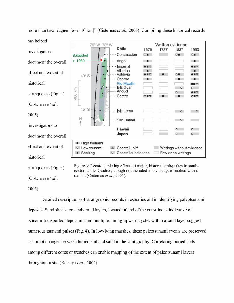
more than two leagues [over 10 km]” (Cisternas et al., 2005). Compiling these historical records
has helped
investigators
document the overall
effect and extent of
historical
earthquakes (Fig. 3)
(Cisternas et al.,
2005).
investigators to
document the overall
effect and extent of
historical
earthquakes (Fig. 3)
(Cisternas et al.,
2005).
Detailed descriptions of stratigraphic records in estuaries aid in identifying paleotsunami
deposits. Sand sheets, or sandy mud layers, located inland of the coastline is indicative of
tsunami-transported deposition and multiple, fining-upward cycles within a sand layer suggest
numerous tsunami pulses (Fig. 4). In low-lying marshes, these paleotsunami events are preserved
as abrupt changes between buried soil and sand in the stratigraphy. Correlating buried soils
among different cores or trenches can enable mapping of the extent of paleotsunami layers
throughout a site (Kelsey et al., 2002).
Figure 3: Record depicting effects of major, historic earthquakes in south-central Chile. Quidico, though not included in the study, is marked with a red dot (Cisternas et al., 2005).

Preliminary research on tsunami deposits in south-
central Chile was conducted by Dr. Ely (Central Washington
University), Dr. Wesson (USGS), and Dr. Cisternas
(Universidad Católica de Valparaíso). Results of the study
provided additional sites impacted by historical earthquakes.
One of the newly identified sites, Quidico (38.250569°S,
73.485333°W), is a promising location where potential tsunami
deposits were located within a river system upstream of the
coast (Fig. 5) (Ely et al., 2010).
Working with Dr. Ely, Dr. Wesson, and Dr. Cisternas
to, I will locate and date tsunami deposits found in the Quidico
River to establish a paleotsunami record and a recurrence
interval for comparison with records south of Quidico in Tirua,
Chile and north of Quidico in Tubul, Chile (Fig. 1) (Ely et al.,
2010). Results of this study will complement the work of the other members of this research
team who are investigating indicators of coseismic, relative sea-level change in regions within
south-central Chile. Dr. Wesson will conduct bathymetry surveys. In addition, Dr. Horton
(University of Pennsylvania) and a PhD student will conduct microfossil analysis to
quantitatively measure past sea-level change.
Methods
Before conducting field work, I utilized air photos and Google Earth imagery to identify
paleochannels and possible sites of tsunami preservation. Field work was conducted from mid-
January to mid-February, when it is summer in Chile. The initial site of investigation was the
Figure 4: Stratigraphic column displaying evidence of tsunami sand deposits (A, B, D) and subsidence (C) at Río Maullín, Chile (Cisternas et al., 2005)

modern channel of the Quidico River. I created a detailed stratigraphic column of the exposed
riverbank section, noting soil characteristics using the Troels-Smith sediment classification, grain
size and shape, sedimentary structures, upper and lower boundaries of units, and unit thickness.
At a notable paleo-meander site, I cored a perpendicular transect to identify and note changes in
the stratigraphy, both laterally and horizontally, of the tsunami sand layers found at Quidico
(Fig 5).
Samples were collected for laboratory analysis of grain size, lithology, and age in order to
gain a better understanding of the stratigraphy of Quidico and its possible tsunami deposits.
Grain size analysis will be conducted with a CAMSIZER (University of Washington), a multi-
camera instrument that measures particle size distribution, particle shape, number and density.
Figure 5: Google Earth imagery of Quidico, Chile. The modern-day channel is dashed in blue and the transects are marked by yellow lines (Google Earth, 2013).

Lithological analysis of the sand units will be conducted at
Central Washington University. I will first determine the
composition of the modern fluvial sand as well as the modern
beach sand by creating thin sections of these samples and
analyzing them under a petrographic microscope. Using these
modern analogues, I will determine provenance of the buried
sand units found within Quidico.
I processed radiocarbon samples for organic material
under the mentorship of Dr. Alan Nelson (USGS – Golden,
CO) over a week-long period (Fig. 6 & 7). Geochronology of
organic material found above likely paleotsunami deposits
will be conducted by AMS radiocarbon dating at the National
Ocean Sciences Accelerator Mass Spectrometry (NOSAMS)
facility in order to provide age constraints of the sand
deposition.
Preliminary Results
Five likely tsunami deposits were identified and described at Quidico (Fig. 8). Upon
completion of the field work, I drew stratigraphic transects depicting the spatial extent of
paleotsunami deposits using the information taken from logged sections and cores across both
transects as well as upstream of the modern-day channel. Results from the radiocarbon sample
processing produced Scirpus sp. seeds above, within, and below sand layers (Fig. 7). Seeds from
Figure 6: Slice of a sediment block taken from Quidico (Photo: Nelson)
Figure 7: Photo capture of Scirpus sp. seeds from Quidico samples (Photo: Hong)

the peat layers directly above the sands have been sent to NOSAMS for AMS radiocarbon
dating.
Anticipated Results
Due to the site’s geographic overlap with major earthquakes and ensuing tsunamis, I
predict that the Quidico River is a site with numerous tsunami deposits and that the results of this
study will provide a paleotsunami record of Quidico. This research will build upon studies
already conducted by Ely et al. in sites to the south (Tirua, Chile) and to the north (Tubul, Chile)
by filling a central gap in the record (Fig. 1) (2010). I anticipate the tsunami deposits at Quidico
will show similar frequency and spatial extents of tsunami deposits at Tirua due to their
proximity to one another and varying results with Tubul due to differences in their location along
the fault. Furthermore, the results of my work will contribute to the research conducted by the
rest of the team as a whole to produce a more comprehensive seismic history of south-central
Chile.
Figure 8: Side bank exposure of the tsunami sand layers found at Quidico (Photo: Hong)
References
Atwater, B.F., Núñez, H.J., Vita-Finzi, C., 1992. Net Late Holocene Emergence Despite Earthquake-Induced Submergence, South-Central Chile: Quaternary International, v. 15/16, p. 77-85.
Bilek, S.L., 2009. Seismicity along the South American subduction zone: Review of large
earthquakes, tsunamis, and subduction zone complexity: Tectonophysics, doi:10.1016/j.tecto.2009.02.037.
Cisternas, M., et al., 2005. Predecessors of the giant 1960 Chile earthquake: Letters to Nature, v.
437, p. 404-407. Ely, L.L., Cisternas, M., Lagos, M., Orem, C., Wesson, R.L., 2010. Geological evidence of past
tsunamis at the boundary between 1960 and 1835 earthquake rupture areas, south-central Chile: American Geophysical Union Chapman Conference on Giant Earthquakes and their Tsunamis, Valparaíso, Chile, p. 22.
Ferguson, R.I., Church, M., 2004. 2004. A Simple Universal Equation for Grain Settling Velocity: Journal of Sedimentary Research, v. 74, no. 6, p. 933-937. Google Earth. Accessed 19 February 2013. <www.earth.google.com>.
Kelsey, H.M., Witter, R.C., Hemphill-Haley, E., 2002. Plate-boundary earthquakes and tsunamis of the past 5500 yr, Sixes River estuary, southern Oregon. Geological Society of America Bulletin, v.114, p. 298-314.
Melnick, D., Moreno, M., Motagh, M., Cisternas, M., Wesson, R.L., 2012. Splay fault slip during
the Mw 8.8 2010 Maule Chile earthquake: Geology, v. 40, no. 3, p. 251-254. Nanayama, F., Satake, K., Furukawa, R., Shimokawa, K., Atwater, B.F., Shigeno, K., Yamaki, S.,
2003. Unusually large earthquakes inferred from tsunami deposits along the Kuril trench: Nature, v. 242, p. 660-663.
Peters, R., Jaffe, B., 2010. Identification of Tsunami Deposits in the Geologic Record: Developing Criteria Using Recent Tsunami Deposits: U.S. Geological Survey Open File Report 2010- 1239. Plafker, G., Savage, J.C., 1970. Mechanism of the Chilean earthquakes of May 21 and 22, 1960: Geological Society of America Bulletin, v. 81, p. 1001-1030. Retsch Technology – CAMSIZER. Accessed 19 February 2013. <www.retsch-technology.com/
rt/products/dynamic-image-analysis/camsizer/function-features/>. Satoshi, I., Baltay, A., Beroza, G.C., 2011. Shallow Dynamic Overshoot and Energetic Deep
Rupture in the 2011 Mw 9.0 Tohoku-Oki Earthquake: Science, v. 332, p. 1426-1429.