STRATIGRAPHY AND SEDIMENTOLOGY OF · PDF fileISBN 959-7117-10-X TKT - 1 STRATIGRAPHY AND...
30
TALLER INTERNACIONAL SOBRE EVENTOS EN EL LÍMITE K/T . TKT.02 MEMORIAS GEOMIN 2001, LA HABANA, 19-23 DE MARZO. ISBN 959-7117-10-X TKT - 1 STRATIGRAPHY AND SEDIMENTOLOGY OF CRETACEOUS- TERTIARY BOUNDARY BRECCIA DEPOSITS IN BELIZE, CENTRAL AMERICA David T. King, Jr. (1) and Lucille W. Petruny (2) (1) Department of Geology, Auburn University, Auburn, Alabama 36849 USA E-mail: [email protected] (2) Department of Curriculum and Teaching, Auburn University, Auburn, Alabama 36849 USA E-mail: [email protected] ABSTRACT At Albion Island, in northern Belize, Cretaceous-Tertiary (KT) boundary deposits, a.k.a. Albion formation, rest upon intensively fractured Maastrichtian dolostones and consist of a basal, spheroid-bearing clay layer (< 1 m thick) and an upper impact-related carbonate-clast breccia (or Adiamictite@) up to 15 m thick. Albion=s diamictite, the focus of this paper, shows crude stratification (2 to 7 m thick) containing intrastratal structures like flow laminations and size grading. Most of Albion=s carbonate clasts show a broad range of angularities and shapes, with the most common being subangular and compact-bladed to compact-elongated, respectively. We made in-situ, apparent-diameter measurements of diamictite carbonate clasts, which ranged in size from 10 to 300 mm (or -3.3 to -8.2 phi). Matrix, the total area comprised of less-than-10 mm (-3.3 phi) particles, ranged from 50 to 70 percent. Log-log distributions of Albion=s grain sizes have consistent, distinctive shapes displaying slope breaks near -4 phi and -7 phi, which may signify a potentially complex origin for this unit. Bedding characteristics and sedimentary structures combined with grain-size frequency analysis suggest to us that multiple events delivered diamictite material of impact-related origin to this region. These multiple events are likely related to sequential stages in the collapse of Chicxulub’s ejecta curtain and/or phases of interaction between that ejecta curtain and Earth’s atmosphere. INTRODUCTION In northern Belize and in closely adjacent areas of the state of Quintana Roo, Mexico, a discontinuous layer of carbonate breccia (or diamictite) lies between Maastrictian dolomites and Paleocene limestones. This breccia unit, known locally as the Albion formation (Pope et al., 1999), represents terrestrial ejecta deposits from Chicxulub impact crater, which is centered 300 to 350 km away in the state of Yucatan, Mexico (Sharpton et al., 1996). Ocampo et al. (1996) marshaled much evidence strongly favoring interpretation of Albion Formation and laterally
Transcript of STRATIGRAPHY AND SEDIMENTOLOGY OF · PDF fileISBN 959-7117-10-X TKT - 1 STRATIGRAPHY AND...
TALLER INTERNACIONAL SOBREEVENTOS EN EL LÍMITE K/T .
TKT.02
MEMORIAS GEOMIN 2001, LA HABANA, 19-23 DE MARZO. ISBN 959-7117-10-X TKT - 1
STRATIGRAPHY AND SEDIMENTOLOGY OF CRETACEOUS-TERTIARY BOUNDARY BRECCIA DEPOSITS IN BELIZE,CENTRAL AMERICA
David T. King, Jr.(1) and Lucille W. Petruny(2)
(1)Department of Geology, Auburn University, Auburn, Alabama 36849 USA E-mail: [email protected]
(2)Department of Curriculum and Teaching, Auburn University, Auburn, Alabama 36849USA E-mail: [email protected]
ABSTRACT
At Albion Island, in northern Belize, Cretaceous-Tertiary (KT) boundary deposits, a.k.a. Albion
formation, rest upon intensively fractured Maastrichtian dolostones and consist of a basal,
spheroid-bearing clay layer (< 1 m thick) and an upper impact-related carbonate-clast breccia (or
Adiamictite@) up to 15 m thick. Albion=s diamictite, the focus of this paper, shows crude
stratification (2 to 7 m thick) containing intrastratal structures like flow laminations and size
grading. Most of Albion=s carbonate clasts show a broad range of angularities and shapes, with
the most common being subangular and compact-bladed to compact-elongated, respectively.
We made in-situ, apparent-diameter measurements of diamictite carbonate clasts, which ranged
in size from 10 to 300 mm (or -3.3 to -8.2 phi). Matrix, the total area comprised of less-than-10
mm (-3.3 phi) particles, ranged from 50 to 70 percent. Log-log distributions of Albion=s grain
sizes have consistent, distinctive shapes displaying slope breaks near -4 phi and -7 phi, which
may signify a potentially complex origin for this unit. Bedding characteristics and sedimentary
structures combined with grain-size frequency analysis suggest to us that multiple events
delivered diamictite material of impact-related origin to this region. These multiple events are
likely related to sequential stages in the collapse of Chicxulub’s ejecta curtain and/or phases of
interaction between that ejecta curtain and Earth’s atmosphere.
INTRODUCTION
In northern Belize and in closely adjacent areas of the state of Quintana Roo, Mexico, a
discontinuous layer of carbonate breccia (or diamictite) lies between Maastrictian dolomites and
Paleocene limestones. This breccia unit, known locally as the Albion formation (Pope et al.,
1999), represents terrestrial ejecta deposits from Chicxulub impact crater, which is centered 300
to 350 km away in the state of Yucatan, Mexico (Sharpton et al., 1996). Ocampo et al. (1996)
marshaled much evidence strongly favoring interpretation of Albion Formation and laterally
TALLER INTERNACIONAL SOBREEVENTOS EN EL LÍMITE K/T .
TKT.02
MEMORIAS GEOMIN 2001, LA HABANA, 19-23 DE MARZO. ISBN 959-7117-10-X TKT - 2
equivalent breccias as coeval ejecta units of Chicxulub, and theirs is the current working
hypothesis for origin of these materials.
The Albion formation consists at least three distinctive members, including basal spheroid-
bearing clay layer, a diamictite unit, and a bed that is rich in highly polished pebbles (called
Pook’s pebbles, hence the informal name Pook’s pebble bed; Ocampo et al., 2000). Albion
formation, as developed at Albion Island, Belize (and exposed within Albion Quarry near San
Antonio) also extends into adjacent parts of the Mexican state of Quintana Roo. In this vicinity,
Albion formation consists of the basal spheroid-bearing clay layer and overlying diamictite bed
(Pope et al., 1999) and ranges from 8 to 15 m thick. Less than 50 km away, in central Belize, this
formation is a few meters thick and consists of the basal spheroid-bearing clay layer and
overlying Pook’s pebble bed, apparently without intervening diamictites (Ocampo et al., 2000).
Both Pope et al. (1999) and Ocampo et al. (2000) have suggested different mechanisms of
emplacement for the three constituent Albion facies in order to account for their stratigraphic and
geographic occurrence. Specifically, they interpret the spheroid-bearing clay bed as having
formed directly upon the karsted and fractured Maastrichtain land surface by action of a very hot,
rapidly expanding vapor cloud. They interpret overlying diamictites as secondary, ballistic
sediments principally formed from a more slowly moving, volatile-rich vapor cloud associated with
the collapsing ejecta curtain. They note that the diamictites seem limited to a distance of
approximately 360 km (or 4 crater radii) from crater center, and beyond this limit they pinch out.
Lastly, they interpret the Pook’s pebble bed as lofty high-velocity ejecta originating mainly from
shallow target rock material, which fell in Belize mainly beyond the limit of the diamictite.
The focus of this paper is upon the Albion’s diamictite bed in northern Belize and what
stratigraphy and sedimentology of that diamictite can tell us about possible emplacement
processes for this diamictite. Various mechanisms have been proposed for development of the
diamictite (reviewed by Pope et al., 1999), and thus our goal is to add basic knowledge of this unit
and its attributes and to comment on possible processes of emplacement based upon our data.
Our work was conducted at Albion Quarry (Figure 1), located on Albion Island, near San Antonio
in the Orange Walk District, Belize.
STRATIGRAPHY
Cretaceous-Tertiary boundary stratigraphy on Albion Island and vicinity consists of the
Maastrictian Barton Creek Formation and overlying Cretaceous-Tertiary boundary deposits (i.e.,
basal spheroid-bearing clay layer and overlying diamictite), which are capped by an erosional
surface and modern soils. A direct upper contact with Paleocene rocks was not observed on
TALLER INTERNACIONAL SOBREEVENTOS EN EL LÍMITE K/T .
TKT.02
MEMORIAS GEOMIN 2001, LA HABANA, 19-23 DE MARZO. ISBN 959-7117-10-X TKT - 3
Albion Island, but occurs 30 km farther south in the Cayo District of central Belize (King, 1996a),
and in adjacent Quintana Roo, Mexico (M.A. Gibson, personal communication). Cornec (1985;
1986) also describes an apparent contact between Cretaceous-Tertiary boundary deposits and
Paleocene rocks in the northern foothills of the Maya Mountains.
Barton Creek Formation
Maastrichtian Barton Creek Formation, a formal stratigraphic unit of northern Belize, is a thick
sequence of tan to medium gray, dolomitized shallow-water carbonates. On Albion Island, Barton
Creek beds consist of cyclically arranged groupings of strata, approximately 5 m thick, each
comprised of two main lithic types (or facies). In each cycle, the upper facies consists of 8 to 15
cm thick beds of planar, cross-stratified, relatively coarsely crystalline dolomitic packstone and
grainstone. Within coarsely crystalline dolostones near the top of some cycles, voids (vugs)
several centimeters across suggest the former presence of nodular evaporite minerals. The
lower facies in each cycle consists of several 3 to 5 cm thick beds of dolomitic wackestone and
packstone.
Barton Creek is largely devoid of substantially intact macrofossils, and the few that may be
discerned are typically moldic voids in dolostone. Abundant microfossils, especially foraminifers,
were present in original sediment texture, but are now reduced to fine moldic voids or textural
ghosts in the rock.
Age of the Barton Creek is established by two relatively rare, but key macrofossils: a
Maastrichtian carcineretid crab (Carcineretes planetarius Vega) and a nerineid gastropod with
infolding wall structures (Vega et al., 1997; Pope et al., 1999). As reported in Ocampo et al.
(1996), late Maastrictian age of upper Barton Creek is supported by 87Sr/86Sr rations ranging from
0.70786 to 0.70796.
The upper surface of Barton Creek outcrops on Albion Island is highly irregular, including solution
pits and pipes (probably related to Late Cretaceous subaerial exposure and solution weathering)
and deep fractures (probably related to impact-generated ground motion from the Cretaceous-
Tertiary bolide event). Pope et al. (1999) report patches of caliche composed of angular Barton
Creek fragments with iron-oxide crusts cemented by calcite and dolomite upon the Barton Creek
upper surface. Fouke et al. (2000) cites “negative covariation trends in d13C and d18O” within
uppermost Barton Creek as evidence of subaerial exposure during time of emplacement of
overlying spheroid-bearing clays. This agrees with Ocampo et al.’s (1996) hypothesis that
erosion by a supersonic vapor plume would have stripped away most paleosol at Albion Island.
TALLER INTERNACIONAL SOBREEVENTOS EN EL LÍMITE K/T .
TKT.02
MEMORIAS GEOMIN 2001, LA HABANA, 19-23 DE MARZO. ISBN 959-7117-10-X TKT - 4
Albion formation
The Albion formation is an informal stratigraphic unit first described by Ocampo et al. (1996). It
remains informal, as no formal description has been given and its mapability has not been
demonstrated. As an astrostratigraphic unit (sensu King and Petruny, 2000), it is a genetic unit
related to the Chicxulub bolide impact. The Albion formation has been subdivided into two
informal members at Albion Island: a spheroid-bearing clay layer and the diamictite unit.
Spheroid-bearing clay layer
Albion’s spheroid-bearing clay layer rests directly upon Barton Creek dolostones (Figure 2) and
consists of brown to rust-colored clay, which is locally rich in oblate, pebble-size dolomitic
spheroids. Near this bed’s base, it is rich in irregular red or green clay clasts. This whole clay
layer ranges from 15 cm to 1.5 m thick, averaging about 90 cm. This bed tends to be thicker in
low areas of the irregular Barton Creek surface. The bed’s basal contact is sharp and is usually
marked by a paper-thin hematitic rind on the underlying Maastrictian dolostone. The spheroid-
bearing clay layer is highly deformed, as attested to by numerous internal planes of glide marked
by distinctive slickensides. Pope et al. (1999) recognized four individual beds within this clay
layer, but we have not been able to consistently delineate such strata. Significant iridium
concentration has been detected at the base of the spheroid-bearing clay layer (W. A. Alvarez,
personal communication).
Spheroids comprise about 5 percent by volume of this layer and are its most unusual
constituents. Pope et al. (1999) likened the internal structure of these spheroids, which consists
typically of a core and crudely layered coating, to that of accretionary lapilli. Ocampo et al. (1996)
conducted petrographic and isotopic analyses of several spheroids and demonstrated that they
are likely high-temperature vapor-phase condensates.
Studies of associated red and green clay clasts suggest that they are glass fragments that have
been altered since impact formation (Ocampo et al., 1996). Green clay clasts (called clay
spheroids by Pope et al., 1999) are smectites with Si:Al ratios higher than normal, but similar to
other Cretaceous-Tertiary boundary glasses (Pope et al., 1999). Green clay clasts have
compositional similarities with palagonites formed during alteration of glass spherules from the
Cretaceous-Tertiary boundary in Haiti (Pope et al., 1999).
TALLER INTERNACIONAL SOBREEVENTOS EN EL LÍMITE K/T .
TKT.02
MEMORIAS GEOMIN 2001, LA HABANA, 19-23 DE MARZO. ISBN 959-7117-10-X TKT - 5
Pope et al. (1999) have given the most parsimonious interpretation of the possible origin of this
unit. They suggest that the spheroid-bearing clay layer consists mainly of fine material, initially
caught up in turbulent clouds of primary ejecta, that became entrained in a rapidly expanding
vapor plume. In this model, dolomitic spheroids are viewed as condensates of Chicxulub’s vapor
plume.
Diamictite unit
The diamictite unit rests directly upon the spheroid-bearing clay layer (Figure 2) and consists of
light tan, moderately indurated and matrix-rich, poorly sorted breccia. At Albion Island, the whole
diamictite unit is approximately 14 m thick and is capped at ground surface by an erosion surface
of unknown age. In adjacent Qunitana Roo, Mexico, some Paleocene carbonates overlie
weathered diamictites, 15 m thick, in what appears to be a primary depositional contact (M. A.
Gibson, personal communication).
The diamictite unit contains at least 5 individual sedimentary beds (Figure 2). Each of these
individual beds ranges from 2 to 7 meters thick, and bed thickness varies laterally over several
hundred meters. Individual beds appear to pinch and swell and cannot be correlated accurately
unless each bed is directly traceable between measured sections (e.g., compare in Figure 2
sections AQ1 and AQ2, 2 m apart, versus sections AQ2 and AQ3, 10 m apart; King, 1996b).
Bases and tops of beds are relatively sharp, but do not show good evidence of significant
intrastratal erosion. Bedding within this diamictite was delineated mainly by slope breaks caused
by weathering, but changes in clast size and composition, changes in sorting and clast density,
and changes in matrix composition played a role too.
Within individual beds, crude grading (with floating boulder clasts near or at the top of beds) is
common (Figure 2). As part of the crude grading, boulders located at the base of some beds
show imbrication and clast support. Other internal structures are crude flow laminations, which
are located in the upper one to 2 meters of each bed. Some beds have rare megaboulders (or
‘boulders with bedding,’ 1 to 9 m diameter) near their bases or tops. Other beds contain rare
matrix-coated boulders, i.e., boulders with concentric layers of armored matrix around them,
which evidently formed by rolling, up to 3 m in diameter. Some of these boulders’ locations are
shown in Figure 2.
Diamictite matrix is mainly highly comminuted dolomite in the silt-clay size range. Matrix content
commonly equals approximately 50 to 70 percent of the rock and matrix is more abundant near
the tops of most beds. This matrix contains some red and green clay clasts, similar to those
TALLER INTERNACIONAL SOBREEVENTOS EN EL LÍMITE K/T .
TKT.02
MEMORIAS GEOMIN 2001, LA HABANA, 19-23 DE MARZO. ISBN 959-7117-10-X TKT - 6
found within the underlying spheroid-bearing clay layer. These clay clasts are thought to have a
similar origin to the ones mentioned earlier from within the spheroid-bearing clay layer (Ocampo
et al., 1996). Red and green clay clasts are much more common in the lower 2 to 3 meters of the
diamictite unit’s matrix.
SEDIMENTOLOGYShape analysis
Albion=s diamictite contains abundant carbonate clasts that show a broad range of angularities
and shapes. The most common stage of angularity is ‘subangular’ and the most common shape
is compact-bladed/compact-elongated. Extremes within clastic angularity are highly abraded and
rounded (“subspherical”) clasts versus highly angular bladed and platy slabs of rock. Angular and
subangular clasts tend to retain bladed and platy shapes, which likely were derived from
comminution of original layering (Petruny and King, 2000). Subrounded and rounded clasts,
which are substantially more highly abraded, apparently were produced by an intensive “milling”
(i.e., rolling and grinding) process (Petruny and King, 2000).
Surface texture analysis
Carbonate clasts within the diamictite unit at Albion have several types of distinctive surface
markings that are related to their genesis and transport history. These surface markings include:
facets; polish; striations; cryptographic markings; pits and bruises; and chips. Facets are primary
bounding surfaces of polygonal blocks. Polish is composed of compound ultrafine striations that
make a smooth and shiny surface. Striations are parallel grooves of a fine to coarse nature that
give the clast surface a distinctive “ruled” surface. Cryptographic markings are branching,
dendritic channel-like networks composed of segments that are in turn made of closely spaced
parallel scratches (bundles) or individual relatively wide scratches (King et al., 1997). Pits and
bruises are indentations in the rock. Pits are generally circular (or concentric) chipped spots with
sharp, fractured rims, whereas bruises are shallow, diffuse and rimless, amoeboid areas. Chips
are the result of brittle deformation of a clast’s edge or margin.
These surface markings are arranged in an approximate order with facets coming first, followed
by polish and striations. Cryptographic markings, if present, are superimposed, and such
markings are followed by pits and bruises. Lastly, chips occur. Not all clasts show this order of
markings entirely, but study of numerous clastic surfaces has established this sequence. King et
al. (1997) interpreted these features as representing effects of hypervelocity clast interactions
during ballistic sedimentation (especially facets, polish, and striations) and later particle
TALLER INTERNACIONAL SOBREEVENTOS EN EL LÍMITE K/T .
TKT.02
MEMORIAS GEOMIN 2001, LA HABANA, 19-23 DE MARZO. ISBN 959-7117-10-X TKT - 7
interactions within turbulent debris clouds (i.e., cryptographic markings, pits and bruises, and
chips).
Grain-size frequency analysis
Using meter-square grids, we made in-situ, apparent-diameter measurements (5 mm-increments)
of the diamictite’s carbonate clasts. We measured all carbonate clasts, which ranged in size from
10 to 300 mm (or -3.3 to -8.2 phi). These apparent-diameter measurements were then converted
to equivalent-area statistics for calculating percents within each size class. The following is a
synopsis of each step involved in this process.
1. We delineated an appropriate one-meter square area on scraped face of diamictite
exposure and divided this one-meter square area into 10 vertical strips, 10 cm wide.
2. Within each successive vertical strip, beginning at the top and moving downward, we
individually measured all particles’ in-situ diameter (i.e., long-axis aspect presented in outcrop) to
within nearest 0.5 cm. All measurements were thus ‘binned’ within 0.5 cm intervals, e.g., 0.5 to
1.0 cm, 1.0 to 1.5 cm, 1.5 to 2.0 cm, etc. All particles under 0.5 cm were considered as part of the
finer matrix, and thus not measured separately. Typically, we measured over 400 particles within
each one-meter square grid.
3. We used percent of area to assess grain-size frequency by converting all
measurements to cross-sectional areas of spheres with diameters equal to the long-axis aspect
measured in step 3. Thus, individual counts within each 0.5-cm ‘bin’ were multiplied by cross-
sectional area to determine the total amount of area assigned to each grain-size ‘bin.’
4. We added together areas of all grain-size ‘bins’ and subtracted from the total area of
one square meter (or 10,000 square cm). This value is equal to all matrix, or the total area of
material under 0.5 cm in diameter.
5. We computed cumulative percent by using the matrix percent area from step 5 as the
value for the first grain-size ‘bin,’ 0.0 to 0.5 cm.
6. We converted grain sizes originally measured in cm to phi units for making log-log
grain-size frequency plots. The unit phi is the negative log2 of the grain size in mm (Folk, 1968).
The phi value of the larger end of each grain-size ‘bin’ is used for this purpose, e.g., 2 cm equals -
4.32 phi. Grain sizes ranged from fine clay (approximately +16 phi) to boulders (< -8.0).
Diamictite matrix, the total area comprised of less-than-10 mm (-3.3 phi) particles, ranged from
approximately 50 to 70 percent, and measured clasts, the balance. Very rare boulders with
bedding (-8.5 to -12.3 phi) and matrix-coated boulders also occur at Albion, but are not part of our
analyses. Log-log distributions of Albion=s grain sizes have consistent, distinctive shapes
displaying slope breaks near -4 phi and -7 phi, which may signify a potentially complex origin for
TALLER INTERNACIONAL SOBREEVENTOS EN EL LÍMITE K/T .
TKT.02
MEMORIAS GEOMIN 2001, LA HABANA, 19-23 DE MARZO. ISBN 959-7117-10-X TKT - 8
this unit (Petruny and King, 2000). Figure 3 shows two characteristic log-log grain-size frequency
distributions from different meter-square areas at Albion Quarry. Area 1 (Figure 3) has matrix
content equal to 67.6% and Area 2 (Figure 3) has 56.5%. Both show breaks at approximately –4
and –7 phi, and have other irregularities in their distribution, which strongly suggests mixing of
populations of grains and a strongly ‘non-normal’ distribution. The coarse tails of both size-
frequency distributions are poorly defined due to low numbers of grains (i.e., many higher size
‘bins’ are empty).
Because such a high percent of matrix is involved in our measurements, and because we could
not disaggregate the matrix for purposes of compatible detailed size-frequency analysis, we are
limited as to the type of statistical analysis that can be performed upon these grain-size data.
Specifically, we are unable to compute a mean grain-size value (sensu Folk (1968) and as
defined in other standard sedimentology texts) owing to absence of data points within the fine tail.
However, using a modified ‘moment method’ (modified from Folk, 1968), which allows
comparisons of standard deviations within grain-size populations without computing a mean (i.e.,
where mean is unknown), we were able to compute an approximation of standard deviation (i.e.,
SDphi see Folk, 1968, p. 50) for comparative purposes.
Grain-size frequency curves from Areas 1 and 2 both yield SDphi values approximately equal to 4
phi, indicating an “extremely poorly sorted” sediment (Folk, 1968). Combined with widely variable
angularities and grain shapes and evident slope breaks in grain-size frequency curves, this
additional quantitative measure of poor sorting suggests mixed populations of clasts from multiple
sources.
DISCUSSION
We find no evidence that might contradict the well-founded interpretations of Ocampo et al.
(1996; 2000) and Pope et al. (1999) regarding ejecta-related origin of Cretaceous-tertiary
boundary strata in northern Belize. As our emphasis in this study was upon the diamictite unit,
we offer the following conclusions regarding some of our specific observations.
Individual beds within the diamictite unit and their intrastratal bedding characteristics suggests to
us that multiple events likely generated the five or more beds at Albion Island. As crude grading
is present throughout most beds and laminar flow features characterize the upper reaches of
most beds, we think that these units were sedimented within a substantially viscous fluid medium.
Considering the presence of matrix-coated boulders and complex surficial markings on most
clasts, we think that sedimentation conditions for each bed may have been initially turbulent, but
TALLER INTERNACIONAL SOBREEVENTOS EN EL LÍMITE K/T .
TKT.02
MEMORIAS GEOMIN 2001, LA HABANA, 19-23 DE MARZO. ISBN 959-7117-10-X TKT - 9
near the end of emplacement they were more nearly laminar. This further implies a sequence of
bed-placement events that would be requisite to development of Albion diamictite stratigraphy as
at Albion Island.
Grain-shape analysis suggests that many diamictite clasts display shape characteristics derived
directly from original sedimentary bedding. However, some clasts are highly abraded and
perhaps transported over very significant distances. Diamictite clasts display surficial evidence of
a sequence of events that may have been initially very violent and on the whole indicates
intensive clast interaction. We think this suggests a mixing of clast populations having different
transport histories and distances.
Comparison of Barton Creek facies at Albion Island and lithologies of diamictite clasts shows
significant differences. For example, none of the cross-stratified, coarsely crystalline dolomitic
packstone and grainstone, which is a common lithic type at Albion, is present in the overlying
diamictite. Mainly for this reason, we think that the underlying Barton Creek at Albion Island was
not the main source for Albion’s diamictite clasts. We recognize that a local Albion source would
seem to be the most likely explanation and is the previous interpretation of the Bunte Breccia
from Ries crater, Germany, a widely cited analogue of the Albion formation (Horz et al., 1983).
However, our interpretation is supported by work of Fouke et al. (1996) who showed that
cathodoluminescent signatures of carbonate cements in Albion diamictite clasts were
substantially different from those of bedrock samples taken from the Barton Creek at Albion
Quarry.
Distinctive slope breaks within grain-size frequency curves and supporting statistical analysis that
shows “extremely poor sorting” within the diamictite. Grain-size distribution at Albion is clearly not
‘normal’ and probably represents a mixing of several populations. We think this supports our
contention that Albion diamictite clasts have a complex provenance.
CONCLUSIONS
Our observations on the stratigraphy and sedimentology of Cretaceous-Tertiary diamictite
deposits of northern Belize lead us to conclude that multiple events delivered material of complex
impact-related origin to this region. These multiple events are likely related to stages in the
collapse of Chicxulub’s ejecta curtain and or interactions between that ejecta curtain and the
atmosphere. More work is needed on the ground in Belize and in modeling ejecta-atmosphere
interactions in order to understand the process-product relationship in more detail.
TALLER INTERNACIONAL SOBREEVENTOS EN EL LÍMITE K/T .
TKT.02
MEMORIAS GEOMIN 2001, LA HABANA, 19-23 DE MARZO. ISBN 959-7117-10-X TKT - 10
REFERENCES
Cornec J.H. (1985): Note on the provisional geological map of Belize at the scale 1:250,000.
Petroleum Office, Belmopan, Belize. 22p.
Cornec J.H. (1986): Provisional geological map of Belize. Petroleum Office, Belmopan, Belize.
Folk R.L. (1968): Petrology of sedimentary rocks. Hemphill’s Company, Austin, Texas.170p.
Fouke B.W., Alvarez W., Claeys P., Ocampo A.C., Pope K.O., Smit J., Vega F.J. (1996):
Cathodoluminescence study of carbonate growth phases in bedrock and KT ejecta from
the Chicxulub impact, Albion Island quarry, Belize. Geol. Soc. Amer. Abst. w. Prog., v.
28, no. 7, A183.
Fouke B.W., Zerkle A.L., Alvarez W., Pope K.O., Ocampo, A.C. (2000): Paleoenvironmental
reconstruction of the KT impact event from proximal sedimentary ejecta, Albion Island,
Belize. Geol. Soc. Amer. Abst. w. Prog., v. 32, no. 7, A451.
Horz F., Ostertag R., Rainey D.A. (1983): Bunte breccia of the Ries: continuous deposits of large
impact craters. Rev. Geophys. Space Phys., v. 21, 1667-1725.
King, Jr. D.T. (1996a): Stratigraphy, layers of evidence (at Albion Quarry). Planetary Rept., v. 16,
no. 3, 10-11.
King, Jr. D.T. (1996b): Cretaceous-Tertiary boundary stratigraphy near San Antonio, Orange
Walk District, Belize, Central America. Gulf Coast Assoc. Geol. Soc. Trans., v. 46, 213-
217.
King, Jr. D.T., Petruny L.W. (2000): Astrostratigraphic units – some proposed nomenclature for
terrestrial impact-derived and impact-related materials. Lunar Planet. Sci., v. 31, abst. no.
2019.
King, Jr. D.T., Pope K.O., Ocampo A.C. (1997): Surface markings on Chicxulub ejecta clasts from
Belize, Central America. Geol. Soc. Amer. Abst. w. Prog., v. 29, no. 3, 12.
Ocampo A.C., Pope K.O., Fischer A.G. (1996): Ejecta blanket deposits of the Chicxulub crater
from Albion Island, Belize. Geol. Soc. Amer. Spec. Paper, no. 307, 75-88.
Ocampo A.C., Pope K.O., Vega F., Fouke B.W. (2000): Depositional facies of the Chicxulub
ejecta blanket in the southern Yucatan Peninsula. Eos, Trans. Amer. Geophys. Union, v.
81, no. 48, F798.
Petruny L.W., King, Jr. D.T. (2000): Grain-size frequency distributions of Cretaceous-Tertiary
boundary breccia deposits in Belize, Central America. Geol. Soc. Amer. Abst. w. Prog., v.
32, no. 7, A451-452.
Pope K.O., Ocampo A.C., Fischer A.G., Alvarez W., Fouke B.W., Webster C.L., Vega F.J., Smit
J., Fritsche A.E., Claeys P. (1999): Chicxulub impact ejecta from Albion Island, Belize.
Earth Planet. Sci. Let., v. 170, 351-364.
Sharpton V.L., Marin L.E., Carney J.L., Lee S., Ryder G., Schuraytz B.C., Sikora P., Spudis P.D.
TALLER INTERNACIONAL SOBREEVENTOS EN EL LÍMITE K/T .
TKT.02
MEMORIAS GEOMIN 2001, LA HABANA, 19-23 DE MARZO. ISBN 959-7117-10-X TKT - 11
(1996): The Cretaceous-Tertiary event and other catastrophies in Earth history. Geol.
Soc. Amer. Spec. Paper, no. 307, 55-74.
Vega F.J., Feldman R.M., Ocampo A.C., Pope K.O. (1997): A new species of Late Cretaceous
carcineretid crab (Brachyura: Carcineretidae) from Albion Island, Belize. Jour. Paleontol.,
v. 71, 615-620.
FIGURES
1. Location map showing the Yucatan peninsula of Mexico. Chicxulub crater rim and the study
site at Albion Quarry (AQ) are indicated.
2. Correlation among five measured sections in Albion Quarry. Top of all sections is the ground
surface. Datum is the Barton Creek-spheroid-bearing clay layer contact. Spacing between
sections is indicated at bottom. Clasts are shown to relative scale; smallest clast shown (dot)
is pebble size. Spheroid symbols indicate degree of flattening. Abbreviations: Cfl = crude
flow lamination; Mcb = matrix-coated boulder; Bwb = boulder with bedding; RGcc = red and
green clay clasts; Gpl = glide planes. Sections: AQ1 = loading road, north end, upper part;
AQ2 = pit road, north end, east side; AQ3 = loading road, north end, lower part; AQ4 = pit
road, south end, east side.
3. Grain-size frequency curves for Areas 1 and 2, Albion Quarry. Matrix smaller than –2.32 phi
(5 mm) was not measured in the field. Rare boulders larger than –8.23 phi (300 mm) were
not part of our analyses.
TALLER INTERNACIONAL SOBREEVENTOS EN EL LÍMITE K/T .
TKT.03
MEMORIAS GEOMIN 2001, LA HABANA, 19-23 DE MARZO. ISBN 959-7117-10-X TKT - 12
EL LÍMITE CRETACICO-TERCIARIO EN LA REGION DE BABINEY,PROVINCIA GRANMA, CUBA.
Dora E. García Delgado, Raisa Delgado Damas, Consuelo Díaz Otero, Rafaela Pérez(*)
( *) Instituto de Geología y Paleontología. MINBAS. Vía Blanca s/n y Carretera Central. San Miguel delPadrón. CP 11000. Ciudad de la Habana. Cuba. Fax: (537) 55-7004Teléfonos: 55-7232, 55-7079. Email: [email protected]
RESUMEN.
En este trabajo proponemos una nueva localidad para el Límite K/T en la región de Babiney, ubicada en unacantera abandonada en el lado oeste de la carretera Babiney-Bayamo, provincia Granma.
La composición litológica predominante es terrígena, terrígeno-carbonatada y en menos proporción tufogénica.El espesor aflorado es de 153.48 metros.
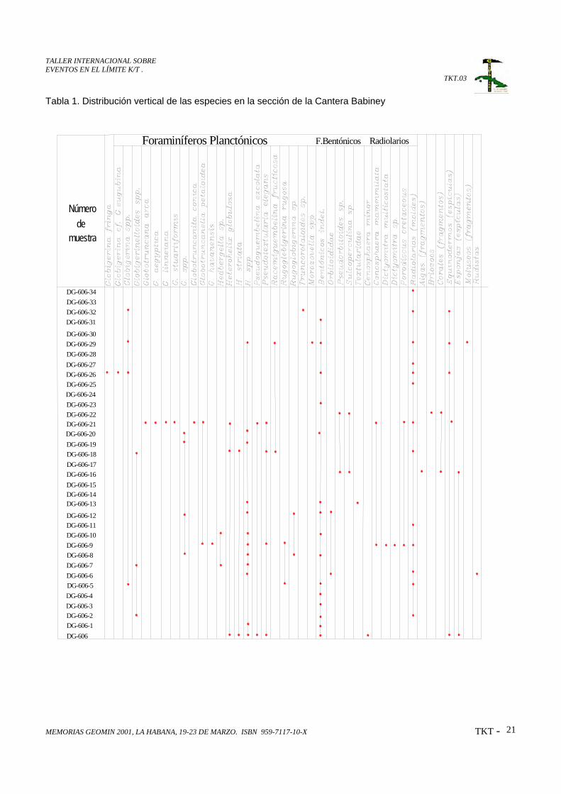
Se confeccionó la columna bioestratigráfica y una tabla con la distribución vertical de cada una de las especiespor muestra, lo que deja ver claramente el cambio brusco de las asociaciones fósiles del Cretácico Superior(Maastrichtiano), biozona Racemiguembelina fructicosa a la asociación del Paleoceno basal con unaasociación típica de la biozona Globigerina eugubina.
Estas asociaciones, así como las relaciones notablemente transicionales entre estos dos paquetes demuestranla presencia de un corte continuo de edad Maastrichtiano-Paleoceno en la región de Babiney y por tanto lapresencia del límite Cretácico-Terciario en esta región.
ABSTRACT
We propose in this paper a new locality for the K/T boundary in the Babiney region, located in an abandonedquarry in the west side of the Babiney-Bayamo road, Granma province.
The predominant litologic composition is terrigenous, terrigenous-carbonated and less tufogenic. Theoutcropping thickness is 153.48 meters.
It was made the bioestratigraphic section and a chart with the vertical distribution of each species for sample,that allows us to see the abrupt change in the fossil associations for the Upper Cretaceous (Maastrichtian),Racemiguembelina fructicosa biozon to the association of the basal Paleocene with a typical association of theGlobigerina eugubina biozon.
These associations, as well as the notably transitional relationships among these two sequences demonstratethe presence of a continuous section Maastrichtian-Paleocene age in the Babiney region and therefore thepresence of the K/T boundary in this region.
TALLER INTERNACIONAL SOBREEVENTOS EN EL LÍMITE K/T .
TKT.03
MEMORIAS GEOMIN 2001, LA HABANA, 19-23 DE MARZO. ISBN 959-7117-10-X TKT - 13
INTRODUCCION
Los depósitos de edad Cretácico Superior Maastrichtiano en la región de Babiney fueron nombrados
como Formación Babiney por M. T. Kozary; 1957. Este autor le asigna a esta unidad “una serie de
capas compuestas por una intercalación regular de arenas con derivados no volcánicos poco
consolidados, esquistos y calizas margosas, que está cubierta por “una serie” de margas, arenas
heterogéneas y gruesas capas de conglomerados”, los cuales designó como Formación Victoria, de
edad Paleoceno, reconociendo su alternancia rítmica y considerando que “ambas pueden formar
parte de un mismo ciclo sedimentario”
Esta Formación bajo este mismo nombre fue reconocida por H. Kenny, 1957, dándole similar posición
en el corte, aunque su descripción litológica es algo diferente.
J. L. Cobiella, (1973) a capas de similar edad en la región del Valle de Mícara las denominó como
Formación Sabanilla. Durante los trabajos de mapeo geológico de la brigada Cubano-Húngara de la
Academia de Ciencias de Cuba (E. Nagy y otros, 1976) esta asociación litológica de edad
Maastrichtiano en la región de Babiney fue incluida dentro de lo que ellos denominaron como
Miembro Mícara de la Formación Picota, con la cual guarda cierta similitud litológica, fosilífera y de
ambiente deposicional bastante notoria, aunque el corte de Babiney es más carbonatado.
En estos momentos la Formación Mícara constituye una unidad independiente (Iturralde-Vinent, 1976;
Gyarmatti y otros, 1981) la cual en la región de la Sierra Cristal ha sido estudiada en detalle por G.
Fernández y otros (1992); proponiendo la existencia de un corte continuo que se extiende desde el
Cretácico Superior Maastrichtiano al Paleoceno Inferior, con las biozonas Racemiguembelinafructicosa y Globigerina eugubina en la localidad de la Alcarraza.
Esta localidad fue muestreada en detalle por nuestro grupo de trabajo y los resultados por
Nannoplancton (T. Bralower, comunicación personal ) no confirmaron la edad Maastrichtiano para
esta sección, pues solo se obtuvieron especies paleocénicas con un abundante redepósito de
foraminíferos planctónicos del Maastrichtiano Superior.
La Formación Mícara constituye una secuencia turbidítica depositada durante la primera etapa de
evolución de las cuencas de piggy back (Iturralde-Vinent, M. A.; 1997) que yacen discordantemente
TALLER INTERNACIONAL SOBREEVENTOS EN EL LÍMITE K/T .
TKT.03
MEMORIAS GEOMIN 2001, LA HABANA, 19-23 DE MARZO. ISBN 959-7117-10-X TKT - 14
sobre el arco volcánico cretácico. Esta unidad presenta algunas diferencias en su contenido litológico
en las diferentes regionesdonde ha sido cartografiada.
En la región de Babiney solo aflora en una
pequeña área de menos de 10 km2 , y su
composición litológica es predominantemente
terrígena y terrígeno-carbonatada y el principal
componente de sus clastos lo constituyen las
rocas volcanogénicas provenientes del arco
volcánico cretácico extinto . Mientras que en las
regiones noreste de las provincias de
Guantánamo y Holguín ocupa grandes áreas,
estrechamente relacionadas con los macisos
ofiolíticos de Sierra de Nipe y Cristal, los que
tienen una gran importancia en la constitución de
los fragmentos de las rocas clásticas, llegando a
formar areníscas serpentiníticas. La Formación
Mícara se formó sincronicamente con el
emplazamiento de los mantos de
sobrecorrimiento del arco volcánico y las
ofiolítas, llegando a presentar secuencias con
características olistostrómicas intercaladas en la
secuencia terrígena de la formación.
La Formación Mícara al igual que otras unidades de igual edad en el resto de nuestro territorio
constituye un testigo de la ocurrencia de una sedimentación continua entre el Maastrichtiano
Superior y el Paleoceno ocurrida en algunas de las cuencas superpuestas.
MATERIALES Y METODOS
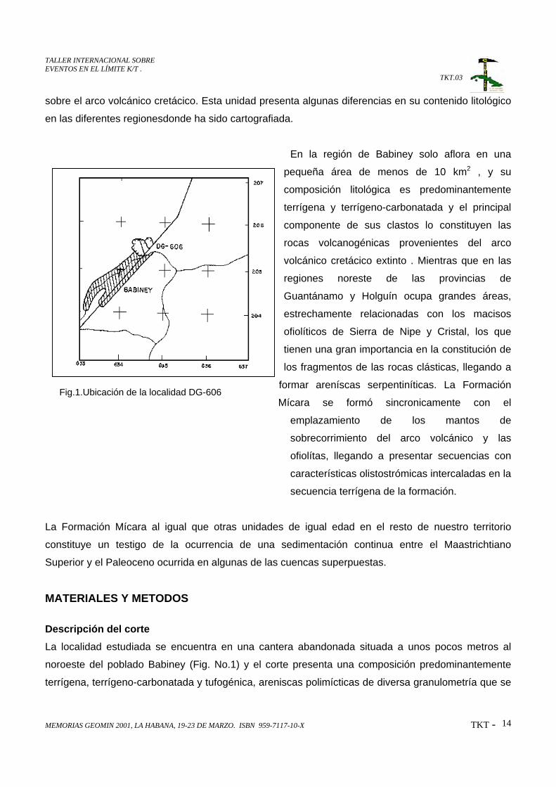
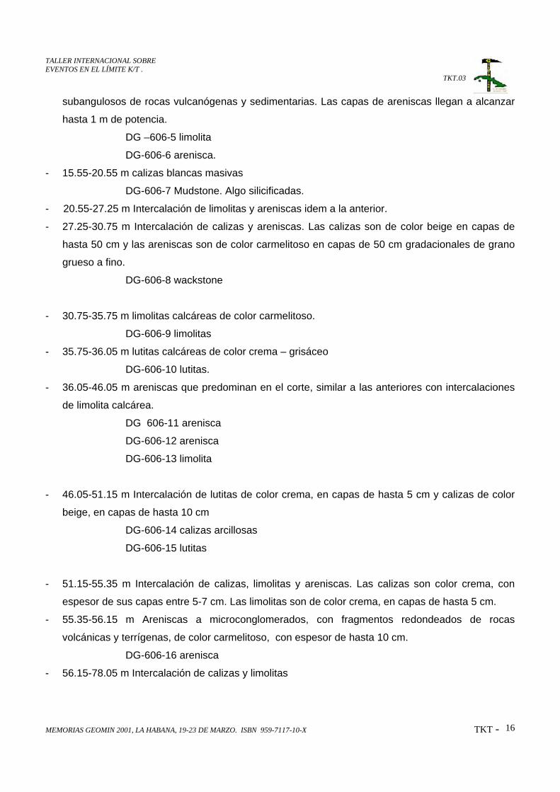
Descripción del corteLa localidad estudiada se encuentra en una cantera abandonada situada a unos pocos metros al
noroeste del poblado Babiney (Fig. No.1) y el corte presenta una composición predominantemente
terrígena, terrígeno-carbonatada y tufogénica, areniscas polimícticas de diversa granulometría que se
Fig.1.Ubicación de la localidad DG-606
TALLER INTERNACIONAL SOBREEVENTOS EN EL LÍMITE K/T .
TKT.03
MEMORIAS GEOMIN 2001, LA HABANA, 19-23 DE MARZO. ISBN 959-7117-10-X TKT - 15
intercalan con limolitas, lutitas, conglomerados y tobas, aunque se observa un considerable volumen
de rocas carbonatadas, calizas y margas, sobre todo hacia la parte superior del corte, de edad
paleocénica. (Fig. No. 2).
Las areniscas son de composición polimíctica, al igual que los conglomerados, que en esta localidad
son de fragmentos pequeños y las limolitas y lutitas pueden ser calcáreas o polimícticas, mientras
que las rocas carbonatadas se clasifican como wackstone o mudstone, en ocasiones ligeramente
silicificadas.
En general este paquete litológico se depositó en un ambiente nerítico-batial, de mares profundos
fríos y de baja salinidad.
Coordenadas Iniciales x: 534 600 Finales x: 534 500
y: 203 500 y: 205 625
Hoja Topográfica 4877-I
- 0.0-0.45 m Intercalación de lutitas, limolitas y margas, las margas son de color crema, las lutitas
son de color crema a gris carmelitoso y las limolitas son de color crema verdoso, en capas de
hasta 5 cm.
DG-606-marga
DG-606-1 limolita
DG-606-2 lutita
- 0.45-10.35 m Intercalación de limolitas y areniscas. Las limolitas son polimícticas y calcáreas, de
color crema en capas de 7-10 cm de espesor con mucho contenido de óxido de hierro. Las
areniscas son de color carmelita a beige en capas finas de 3-4 cm.
DG 606-3 limolita calcárea
DG 606-4 limolita polimíctica
- 10.35-15.55 m Intercalación de limolitas y areniscas. Las limolitas forman capas de 5-7 cm de
espesor de color beige y crema-grisaceo. La superficie de estratificación entre las limolitas y las
calizas es irregular y se observa gradación en las areniscas desde grano grueso en la base hasta
grano fino en el tope de las capas. Son de color carmelita; los fragmentos son angulosos o
TALLER INTERNACIONAL SOBREEVENTOS EN EL LÍMITE K/T .
TKT.03
MEMORIAS GEOMIN 2001, LA HABANA, 19-23 DE MARZO. ISBN 959-7117-10-X TKT - 16
subangulosos de rocas vulcanógenas y sedimentarias. Las capas de areniscas llegan a alcanzar
hasta 1 m de potencia.
DG –606-5 limolita
DG-606-6 arenisca.
- 15.55-20.55 m calizas blancas masivas
DG-606-7 Mudstone. Algo silicificadas.
- 20.55-27.25 m Intercalación de limolitas y areniscas idem a la anterior.
- 27.25-30.75 m Intercalación de calizas y areniscas. Las calizas son de color beige en capas de
hasta 50 cm y las areniscas son de color carmelitoso en capas de 50 cm gradacionales de grano
grueso a fino.
DG-606-8 wackstone
- 30.75-35.75 m limolitas calcáreas de color carmelitoso.
DG-606-9 limolitas
- 35.75-36.05 m lutitas calcáreas de color crema – grisáceo
DG-606-10 lutitas.
- 36.05-46.05 m areniscas que predominan en el corte, similar a las anteriores con intercalaciones
de limolita calcárea.
DG 606-11 arenisca
DG-606-12 arenisca
DG-606-13 limolita
- 46.05-51.15 m Intercalación de lutitas de color crema, en capas de hasta 5 cm y calizas de color
beige, en capas de hasta 10 cm
DG-606-14 calizas arcillosas
DG-606-15 lutitas
- 51.15-55.35 m Intercalación de calizas, limolitas y areniscas. Las calizas son color crema, con
espesor de sus capas entre 5-7 cm. Las limolitas son de color crema, en capas de hasta 5 cm.
- 55.35-56.15 m Areniscas a microconglomerados, con fragmentos redondeados de rocas
volcánicas y terrígenas, de color carmelitoso, con espesor de hasta 10 cm.
DG-606-16 arenisca
- 56.15-78.05 m Intercalación de calizas y limolitas
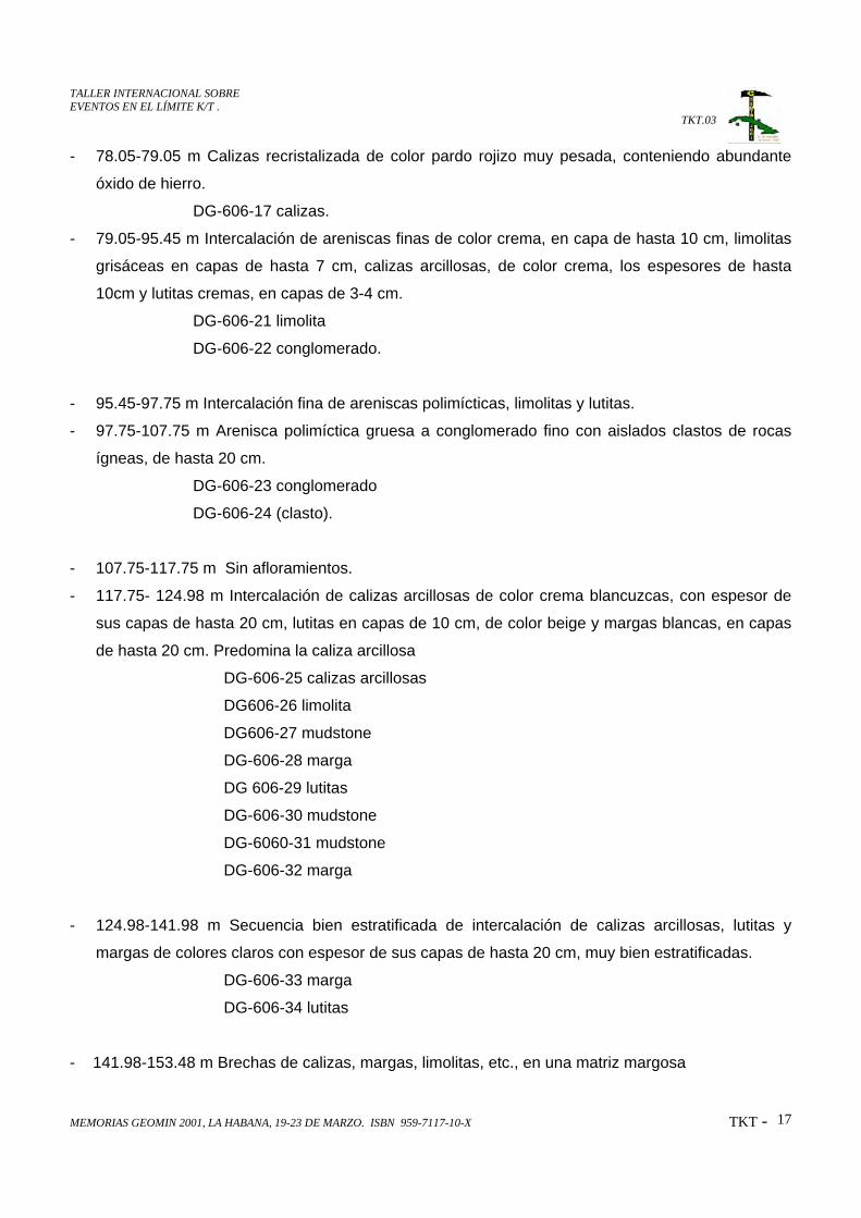
TALLER INTERNACIONAL SOBREEVENTOS EN EL LÍMITE K/T .
TKT.03
MEMORIAS GEOMIN 2001, LA HABANA, 19-23 DE MARZO. ISBN 959-7117-10-X TKT - 17
- 78.05-79.05 m Calizas recristalizada de color pardo rojizo muy pesada, conteniendo abundante
óxido de hierro.
DG-606-17 calizas.
- 79.05-95.45 m Intercalación de areniscas finas de color crema, en capa de hasta 10 cm, limolitas
grisáceas en capas de hasta 7 cm, calizas arcillosas, de color crema, los espesores de hasta
10cm y lutitas cremas, en capas de 3-4 cm.
DG-606-21 limolita
DG-606-22 conglomerado.
- 95.45-97.75 m Intercalación fina de areniscas polimícticas, limolitas y lutitas.
- 97.75-107.75 m Arenisca polimíctica gruesa a conglomerado fino con aislados clastos de rocas
ígneas, de hasta 20 cm.
DG-606-23 conglomerado
DG-606-24 (clasto).
- 107.75-117.75 m Sin afloramientos.
- 117.75- 124.98 m Intercalación de calizas arcillosas de color crema blancuzcas, con espesor de
sus capas de hasta 20 cm, lutitas en capas de 10 cm, de color beige y margas blancas, en capas
de hasta 20 cm. Predomina la caliza arcillosa
DG-606-25 calizas arcillosas
DG606-26 limolita
DG606-27 mudstone
DG-606-28 marga
DG 606-29 lutitas
DG-606-30 mudstone
DG-6060-31 mudstone
DG-606-32 marga
- 124.98-141.98 m Secuencia bien estratificada de intercalación de calizas arcillosas, lutitas y
margas de colores claros con espesor de sus capas de hasta 20 cm, muy bien estratificadas.
DG-606-33 marga
DG-606-34 lutitas
- 141.98-153.48 m Brechas de calizas, margas, limolitas, etc., en una matriz margosa
TALLER INTERNACIONAL SOBREEVENTOS EN EL LÍMITE K/T .
TKT.03
MEMORIAS GEOMIN 2001, LA HABANA, 19-23 DE MARZO. ISBN 959-7117-10-X TKT - 18
Asociación fosilíferaComo se puede observar en la columna litológica (Fig 2) se realizó un detallado muestreo para
estudios paleontológicos tanto en secciones delgadas como en lavados y la distribución vertical de las
especies para cada muestra aparece en la tabla No. 1. Las asociaciones fósiles de las muestras
situadas desde la base (Muestra DG-606) hasta la muestra DG-606-22, reflejan claramente una edad
Maastrichtiano Superior, correspondiente a la biozona Racemiguembelina fructicosa, mientras que
la asociación faunal comprendida entre las muestras DG-606-23 hasta la DG-606-34 muestran el
cambio hacia el Paleógeno, estando representado el Paleoceno basal en la muestra DG-606-26, con
una asociación típica de la biozona Globigerina eugubina. Este perfil alcanza en su parte superior
una edad de Eoceno Inferior con la aparición de Truncorotaloides sp.
ConclusionesLa composición litológica de la sección estudiada conjuntamente con los resultados de los estudios
paleontológicos demuestran la presencia en el intervalo Cretácico Superior Maastrichtiano –
Paleoceno basal e incluso Eoceno Inferior de una cuenca de sedimentación considerablemente
profunda con un abundante aporte de material de origen volcanomíctico de carácter turbidítico con
una sedimentación continua y compensada, que prueba la presencia del Límite Cretácico-Terciario
en esta región.
REFERENCIA BIBLIOGRAFICA- BERMUDEZ, P.J. (1961). Las formaciones geológicas de Cuba. Instituto Cubano Recursos
Minerales. 73, No. 16, August 15. (pag. 5159-5173).
- COBIELLA, J. L., 1973. Estratigrafía de Sabanilla. (Inédito) Universidad de Oriente.
- COBIELLA, J.L.; RODRIGUEZ, J. (1978). Algunos rasgos de la Geología de Cuba Oriental.
Ciencias Técnicas 3. pág. 7-21.
- ITURRALDE-VINENT, M. (1977). Estratigrafía del área Calabazas-Achotal. Rev. La Minería en
Cuba. Vol.2 No.4
- ITURRALDE-VINENT, M. 1994. Arcos volcánicos y ofiolitas de Cuba. (En Prensa).
- JAKUS, P. (1983). Formaciones vulcanógeno-sedimentarias de Cuba Oriental en:
Contribución a la Geología de Cuba Oriental. Editorial Científico-Técnica. La Habana.
Cuba.
- KENNY, H.; 1957. Estratigrafía al este del Cauto para determinar la columna estratigráfica del
area Babiney-Jiguaní, por geología de superficie, en coordinación con 500 pies de
barrenos. Oficina Nacional de Recursos Minerales, MINBAS, La Habana.
TALLER INTERNACIONAL SOBREEVENTOS EN EL LÍMITE K/T .
TKT.03
MEMORIAS GEOMIN 2001, LA HABANA, 19-23 DE MARZO. ISBN 959-7117-10-X TKT - 19
- KOZARY, M. T.; 1957. Geología de la Cuenca del Cautillo. Oficina Nacional de Recursos
Minerales. MINBAS, La Habana.
- NAGY, E.; BREZSNYANSZKY, K.; BRITO, A.; COUTIN, D.P.; FORMELL,F.; FRANCO,G.L.;
GYARMATTI, P.; JAKUS,P. y RADOCZ, G.Y. (1976). Texto Explicativo del Mapa
Geológico de la provincia Oriente a escala 1;250 000 levantado y confec-cionado por la
Brigada Cubano-Húngara entre 1972-1976. Inst. Geología y Paleontología, Academia de
Ciencias de Cuba.

TALLER INTERNACIONAL SOBREEVENTOS EN EL LÍMITE K/T .
TKT.03
MEMORIAS GEOMIN 2001, LA HABANA, 19-23 DE MARZO. ISBN 959-7117-10-X TKT - 20
Fig.2 Columna litológica de la Formación Mícara en la localidad
Hoja topográfica: 4877-I
Coordenadas: X: 534600 Y: 205500Espesor: 153.48 m
Formación MícaraLOCALIDAD: CANTERA BABINEY
TALLER INTERNACIONAL SOBREEVENTOS EN EL LÍMITE K/T .
TKT.03
MEMORIAS GEOMIN 2001, LA HABANA, 19-23 DE MARZO. ISBN 959-7117-10-X TKT - 21
Tabla 1. Distribución vertical de las especies en la sección de la Cantera Babiney
Número
muestrade
Foraminíferos Planctónicos F.Bentónicos Radiolarios
DG-606-33DG-606-34
DG-606-32DG-606-31
DG-606-30DG-606-29DG-606-28DG-606-27DG-606-26DG-606-25DG-606-24DG-606-23DG-606-22DG-606-21DG-606-20DG-606-19DG-606-18DG-606-17DG-606-16DG-606-15DG-606-14DG-606-13
DG-606-12DG-606-11DG-606-10DG-606-9DG-606-8DG-606-7DG-606-6DG-606-5DG-606-4DG-606-3DG-606-2DG-606-1DG-606
TALLER INTERNACIONAL SOBREEVENTOS EN EL LÍMITE K/T .
TKT.04
MEMORIAS GEOMIN 2001, LA HABANA, 19-23 DE MARZO. ISBN 959-7117-10-X TKT - 22
EL EVENTO CHICXULUB DEL LIMITE K/T: SU IMPACTO EN LASEDIMENTACION DE LA PLATAFORMA DE YUCATAN Y SONDA DECAMPECHE, SURESTE DE MEXICO.
J. Manuel Grajales-Nishimura(1), Esteban Cedillo-Pardo(1);Gustavo Murillo-Muñetón(1), Jesús García-Hernández(2), Ignacio Arenillas(3), José AntonioArz(3), Carmen Rosales Domínguez(1), Dante J. Morán-Zenteno(4) PhilippeClaeys, P. (5) y Walter Alvarez(6)
1. Instituto Mexicano Petroleo, Eje Central Norte Lázaro Cárdenas No. 152, México, D.F.07730: [email protected], [email protected], [email protected].
2. Petróleos Mexicanos-PEP, RMNE, Calle 33 No. 90, Col. Burócratas, Cd Carmen,Campeche, México: [email protected]
3. Departamento de Ciencias de la Tierra, Universidad de Zaragoza, E-50009, España:[email protected]; [email protected]
4. Instituto de Geología, Universidad Nacional Autónoma de México, México, D.F 04510,México
5. Vrije Universiteit Brussel, B-1050 Brussels Belgium: [email protected]. Department of Geology and Geophysics; University of California at Berkeley, Berkeley,
CA 94720-4767, USA
RESUMEN
En la Sonda de Campeche del sureste de México, el intervalo estratigráficomás importante productor de hidrocarburos consiste de una brechacarbonatada sedimentaria. Los datos estratigráficos, mineralógicos ymicropaleontológicos indican que esta brecha carbonatada y un intervalo demateriales bentoníticos suprayacente están ligados genéticamente alimpacto en Chicxulub ocurrido en el límite Cretácico-Terciario (K/T). Estabrecha se depositó al pie del talud en un ambiente de plataforma externa yposteriormente fue afectada por eventos tectónicos y diagenéticos quemodificaron su porosidad y permeabilidad principalmente durante el Oligo-Mioceno y posiblemente en el Plio-Pleistoceno. En la plataforma de Yucatán,los efectos del evento Chicxulub se manifiestan por materiales de expulsión(ejecta) seguidos de una brecha formada por megabloques de calizas defacies someras.
Estudios realizados en afloramientos de la brecha en Tabasco y Chiapas, asícomo en columnas estratigráficas del Campo Petrolero Cantarell y otroscampos cercanos de la Sonda de Campeche, permiten correlacionar labrecha en localidades distantes hasta 250 km. La sucesión sedimentaria dellímite K/T en estas localidades consiste de un depósito sedimentario gradadoformado, de la base a la cima, por megabrechas calcáreas, brechas de granofino, arenas y arcillas con abundante material bentonítico. Esta sucesióndescansa sobre mudstone calcáreo hemipelágico con Trinitella scotti,Racemiguembelina fructicosa y Contusotruncana contusa que sugieren unaedad Maastrichtiano Medio-Tardío y está cubierta por margas y/o mudstone
TALLER INTERNACIONAL SOBREEVENTOS EN EL LÍMITE K/T .
TKT.04
MEMORIAS GEOMIN 2001, LA HABANA, 19-23 DE MARZO. ISBN 959-7117-10-X TKT - 23
arcilloso donde se reconoció la biozona de Guembelitria cretacea (zona P0 yparte baja de zona P1) del Daniano basal. Los depósitos asociados al eventodel límite K/T acumulados sobre facies someras de la Plataforma de Yucatánhan sido descritos en Belice y Quintana Roo y consisten de una capa conesferulitas y bentonita, seguida de una brecha con bloques de calizas deambientes someros de hasta 10 m de diámetro.
La presencia de cuarzo y plagioclasa de choque, cuarzo tipo "ballen",fragmentos de esferulitas, lapilli acrecionario y material bentonítico (queaquí se interpreta como vidrio de impacto alterado) hacia la cima de lasecuencia sedimentaria, tanto en las facies de talud como en las someras,así como la anomalía de Iridio en las secciones de Bochil y Guayal, sugierenque el origen de esta sucesión sedimentaria está íntimamente ligado alimpacto en Chicxulub. Asimismo, se reconoció que la capa bentonítica dehasta 30 m de espesor en la Sonda de Campeche actúa como la roca sellodel Campo Cantarell.
Se reconocieron hasta diez diferentes microfacies en los componentes de labrecha que indican que los fragmentos tuvieron su área fuente en diversosambientes de la plataforma de Yucatán y la mayoría corresponden alCretácico Superior.
Finalmente, se concluye que la brecha calcárea del Campo Cantarell tiene unorigen único ligado a un evento catástrófico que ocurrió hace 65 Ma.Posteriormente, durante el Oligo-Mioceno y Plio-Pleistoceno sufrió procesosdiagenéticos ligados a sepultamiento, así como eventos tectono-estructurales que en algunos casos modificaron positivamente y en otrosnegativamente la porosidad y permeabilidad de la roca.
•
TALLER INTERNACIONAL SOBREEVENTOS EN EL LÍMITE K/T .
TKT.05
MEMORIAS GEOMIN 2001, LA HABANA, 19-23 DE MARZO. ISBN 959-7117-10-X TKT - 24
EVIDENCIAS DEL “COCTEL” PALEONTOLÓGICO DEL LÍMITECRETÁCICO-TERCIARIO EN CUBA OCCIDENTAL.
Consuelo Díaz Otero(1), M. Iturralde-Vinent(2) y D. García Delgado(1)).
(1) Instituto de Geología y Paleontología. Vía Blanca s/n y Línea del Ferrocarril, San Miguel delPadrón, Ciudad de la Habana. E mail [email protected]
(2) Museo Nacional de Historia Natural de Cuba. Obispo 61. Plaza de Armas. Habana Vieja. [email protected]
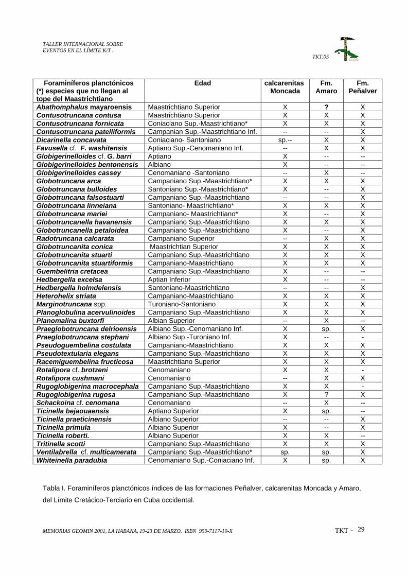
RESUMENLa asociación fósil del Límite Cretácico-Terciario (KTB) para el área del Caribe recientemente se hadescrito como un “coctel” de elementos fósiles redepositados de estratos más viejos que Paleoceno,siguiendo la teoría del impacto cósmico ocurrido hace 65 millones de años en la región de Yucatán,México (Bralower et al., 1998)Una mezcla distintiva similar de foraminíferos redepositados fue encontrada en algunas formaciones deCuba occidental, asociada con cuarzo choqueado, esférulas y presencia de Iridio. Dentro de estasformaciones se encuentran la Formación Peñalver, calcarenitas Moncada y Formación Amaro, quelitológicamente están caracterizadas por secuencias clástico-carbonatadas relacionadas probablementecon el impacto KTB.En la Formación Peñalver esta asociación fósil incluye foraminíferos planctónicos y bentónicos,radiolarios y nannofósiles de diferentes edades dentro del Cretácico. Los foraminíferos planctónicos ybentónicos están representados por especies índices de diferentes intervalos desde el Albiano hasta elMaastrichtiano Superior Tardío. Los nannofósiles corresponden al Neocomiano.En las calcarenitas Moncada sólo se han encontrados foraminíferos planctónicos de diferentes edadesdesde el Aptiano hasta el Maastrichtiano Superior. Es característico en estas calcarenitas encontrar losfósiles deformados por compresión y rellenos de una mezcla de arcilla con material orgánico de colorpardo oscuro.La Formación Amaro está representada por una abundante asociación fósil muy semejante a la reportadapara la Formación Peñalver, pero además incluye fósiles “Incertae Sedis”, calpionélidos y nannofósilesdel intervalo Jurásico Superior-Neocomiano.No se reportan taxones del Paleoceno en ninguna de las formaciones estudiadas.
ABSTRACT
The Cretaceous-Tertiary boundary (KTB) fossil association has been described as a “cocktail” of fossilelements reworked, olderthan Paleocene, according to the theory of Cosmic Impact taking place 65 millionyears ago.A distinctive mixture of reworked foraminifera was found in several formations in western Cuba. It isassociated with shoked quartz, “spherules” and iridium enriched layers.The investigated formations are Peñalver (Pszczolkowski, 1986), Moncada calcarenites (Iturralde-Vinent,1997) and Amaro (Wassall, 1953)The Peñalver Formation fossil assemblage includes cretaceous foraminifera belonging to differentintervals from Albian to Upper Maastrichtian. Nannoconids correspond to Neocomian.In the Moncada calcarenites there are only planktic foraminifera that belong to the Aptian-UpperMaastrichtian.Amaro Formation is represented by a rich fossil assemblage very similar to the Peñalver Formation, but italso includes Upper Jurasic-Neocomian fossils as “Incertae Sedis”, calpionellids and nannoconids.No Paleocene taxa were found in these three formations.
TALLER INTERNACIONAL SOBREEVENTOS EN EL LÍMITE K/T .
TKT.05
MEMORIAS GEOMIN 2001, LA HABANA, 19-23 DE MARZO. ISBN 959-7117-10-X TKT - 25
INTRODUCCIÓNLa cercanía de nuestra isla a la península de Yucatán, México, donde se supone ocurrió el choque del
meteorito que ocasionó el cráter de Chicxolub a finales del Cretácico implica una gran probabilidad de
encontrar las evidencias de esta catástrofe en los sedimentos cubanos.
García y Díaz (1997) presentan un estudio sobre las probabilidades de la presencia del KTB en Cuba,
que incluye las formaciones del occidente de la isla, donde no se realizaron estudios paleontológicos
detallados como los presentados en este trabajo..
Durante los últimos tres años nuevos cortes relacionados con el KTB han sido investigados con gran
detalle como parte de los trabajos que se ejecutan a través del Proyecto Internacional Cuba-Japón sobre
estos estudios y los resultados paleontológicos obtenidos de estas investigaciones constituyen el objetivo
fundamental del presente trabajo.
Los estudios paleontológicos detallados tienen como antecedentes los realizados en el Caribe por
Bralower, Paull y Leckie (1998) sobre la teoría del “coctel” paleontológico del KTB , donde reportan
elementos fósiles redepositados de diferentes edades dentro del Cretácico, más viejos que Paloeceno.
Una mezcla distintiva similar de foraminíferos redepositados fue encontrada en algunas formaciones de
Cuba occidental, asociada con cuarzo choqueado, esférulas y presencia de Iridio. Dentro de estas
formaciones se encuentran la Formación Peñalver (Pszczolkowski, 1986), calcarenitas Moncada
(Iturralde-Vinent, 1992) y Formación Amaro (Wassall, 1953), que litológicamente están caracterizadas
por secuencias clástico-carbonatadas relacionadas probablemente con el impacto KTB.
El reconocimiento del “coctel” en las rocas cubanas constituye una evidencia más a favor de la teoría del
impacto cósmico ocurrido hace 65 millones de años.
MATERIALES Y METODOS.El estudio micropaleontológico presentado está basado en la observación al microscopio biológico de luz
trasmitida de más de 200 secciones delgadas de rocas. Estas secciones delgadas corresponden a
diferentes cortes de las unidades litoestratigráficas mencionadas, en sus localidades tipo.
Las determinaciones de los foraminíferos planctónicos (grupo taxonómico más abundante en estos
sedimentos) están basadas en los trabajos de Premoli-Silva y Sliter (1995) y de Sliter (1989, 1999)
TALLER INTERNACIONAL SOBREEVENTOS EN EL LÍMITE K/T .
TKT.05
MEMORIAS GEOMIN 2001, LA HABANA, 19-23 DE MARZO. ISBN 959-7117-10-X TKT - 26
DISCUSIÓN Y RESULTADOSCalcarenitas Moncada.Las calcarenitas Moncada (Iturralde-Vinent, 1992) están distribuidas solamente en la parte más
occidental de Cuba, en la Sierra de Viñales, provincia de Pinar del Río. Esta unidad contiene
foraminíferos planctónicos y radiolarios y descansa sobre las calizas negras del Cretácico. Los
microfósiles están ligeramente recristalizados, parcialmente rotos, comprimidos y rellenos de una mezcla
de material orgánico y arcilla, de color gris parduzco.
Los foraminíferos redepositados pertenecen al Aptiano (Ticinella bejaouaensis, Hedbergella excelsa),
Albiano-Cenomaniano (Ticinella primula, T. roberti, Hedbergella rischi, Globigerinelloidesbentonensis, Praeglobotruncana delrioensis) y Campaniano Tardío-Maastrichtiano Tardío
(Globotruncana bulloides, G. mariei, G. arca, Ventilabrella multicamerata). Los taxones más jóvenes
están representados por Racemiguembelina fructicosa y Contusotruncana contusa (fig. 5). La
especie Abathomphalus mayaroensis, marcadora del tope del Maastrichtiano, no ha sido identificada
con certeza. Los taxones el Paleoceno no han sido encontrados. (Tabla I).
En esta formación han sido encontradas “esférulas," identificadas al microscopio biológico de luz
trasmitida. Ellas son de color gris claro, constituidas por material vítreo, isótropo y practicamente opaco
(es traslúcido solo en los bordes), con un índice de refracción mayor que el del Bálsamo de Canadá. Con
luz reflejada se observan inclusiones metálicas alineadas concéntricamente. Su forma es de esférica a
elíptica (aerodinámica), de 0.25 mm de tamaño en su eje mayor y 0.20 mm en su eje menor, como
promedio. Además se ha podido determinar la presencia de cuarzo choqueado y enriquecimiento de
iridio.
Formación PeñalverEsta formación sobreyace a la Formación Via Blanca del Campaniano Superior-Maastrichtiano Está
representada por una rica asociación de microfósiles redepositaods que incluye foraminíferos
planctónicos y bentónicos, radiolarios y nannofósiles. La mayor cantidad de microfósiles redepositados
pertenece al intervalo Campaniano-Maastrichtiano, probablemente erosionados de la Formación Vía
Blanca, la cual también contiene microfósiles redepositados de diferentes edades. Esta unidad se
desarrolla en las provincias de Ciudad de La Habana, La Habana, Matanzas y Pina del Río y su área tipo
está localizada en la Avenida Monumental entre la Vía Blanca y la Autopista Nacional, en la provincia
Ciudad de La Habana.
Los foraminíferos planctónicos identificados pertenecen a los intervalos: Albiano (Ticinella primula, T.praeticinensis, Hedbergella rischi), Cenomaniano (Rotalipora cushmani), Coniaciano-Santoniano
(Dicarinella concavata, Marginotruncana ssp.), Campaniano (Radotruncana calcarata) y
TALLER INTERNACIONAL SOBREEVENTOS EN EL LÍMITE K/T .
TKT.05
MEMORIAS GEOMIN 2001, LA HABANA, 19-23 DE MARZO. ISBN 959-7117-10-X TKT - 27
Campaniano Superior-Maastrichtiano Inferior (Globotruncana venticosa, G. arca, G. bulloides, G.linneiana, Gansserina gansseri, Contusotruncana patelliformis). La edad más joven está dada por la
presencia de Abathomphalus mayaroensis (fig, 4), Racemiguembelina fructicosa y
Contusotruncana contusa.
Las especies más frecuentes de foraminíferos bentónicos son: Orbitoides apiculata, Omphalocyclusmacroporus, Torreina torrei y Chubbina cardenasensis, del Maastrichtiano y Nummoloculina heimi,Biconcava bentori y Nezzazatidae del Albiano-Cenomaniano. En esta formación tampoco fueron
encontrados microfósiles del Paleoceno. (Tabla I)
Formación Amaro.La Formación Amaro está bien representada en la parte este y central de Cuba. Buenas secciones han
sido reportadas en pozos profundos de petróleo, en la localidad Boca de Jaruco, al noreste de la
provincia de La Habana. Esta formación sobreyace las unidades marinas profundas del Jurásico
Superior-Cretácico (Veloz, Santa Teresa y Carmita).
La asociación de foraminíferos redepositados incluye Nannoconus s.l., Favreina sp. y Calpionélidos
(Jurásico Superior Tithoniano-Cretácico Inferior Neocomiano), Ticinella roberti Planomalina buxtorfi yBiticinella sp (Albiano), Rotalipora cushmani (Cenomaniano), Marginotruncana spp.,
Globigerinelloides casseyi, Whiteinella spp. (Turoniano-Santoniano) y Globotruncana arca, G.linneiana, Contusotruncana fornicata y Ventilabrella spp. (Campaniano Superior-Maastrichtiano) (fig.
6). La edad más joven de estos sedimentos está dada por la misma asociación determinada en la
Formación Peñalver.
Los foraminíferos bentónicos están representados por Orbitoides apiculata, Omphalocyclusmacroporus, Torreina torrei, Chubbina cardenasensis, Sulcoperculina globosa, Pseudorbitoidessp. y Rudistas del Maastrichtiano Superior.
Al igual que en las demás formaciones no se han reportados especies del Paleoceno (Tabla I)
CONCLUSIONESLas asociaciones fósiles de las formaciones Peñalver, calcarenitas Moncada y Amaro claramente
representan al llamado “coctel” del KTB, reportado por Bralower et al., 1998. La edad de estas
formaciones puede ser resuelta como KTB, de acuerdo a la posición estratigráfica de las mismas por
encima de las rocas del Cretácico y por debajo de los depósitos del Paleoceno. Este hecho es una
contribución más al sustento de la teoría del impacto cósmico en el Caribe hace 65 millones de años.
TALLER INTERNACIONAL SOBREEVENTOS EN EL LÍMITE K/T .
TKT.05
MEMORIAS GEOMIN 2001, LA HABANA, 19-23 DE MARZO. ISBN 959-7117-10-X TKT - 28
REFERENCIAS1. Bralower, T. J., Ch. K Paull and R. M. Leckie, 1998. The Cretaceous-Tertiary boundary cocktail:
Chicxulub impact triggers margin collapse and extensive sediment gravity flows. Geology 26 (4):331-
334
2. García, D. and Díaz-Otero, C., 1997. Probable presence of Cretaceous-Tertiary boundary in Cuba.
Newsletter Project 384 PICG-UNESCO; (3):31-38
3. Iturralde-Vinent, M.1992. A short note on the Cuban late Maastrichtian megaturbidite (an impact-
derived deposit?): Earth & Planetary Science Letters, 109: 225-228.
4. Iturralde-Vinent, M., 1997. Field Guide. Sedimentary Geology of Western Cuba. 1st SEPM Congress
on Sedimentary Geology, St. Pete Beach, Florida, 21 pp.
5. Premoli Silva, I. and Sliter, W. V.; 1995. Paleontographia Italica. LXXXII. 40 pp.
6. Psczczlkowski, A., 1986. Megacapas del Maestrichtiano en Cuba occidental y central. Bulletin of the
Polish Academy of Earth Science, 34(1): 82-94.
7. Sliter, W. V.; 1989. Bioestratigraphy zonation for Cretaceous planctonic foraminifers examinad in thin
section. Journal of Foraminiferal Research. 19(1): 1-19.
8. Sliter, W. V.; 1999. Cretaceous planctonic foraminifers examinad in thin section. U.S. Geological
Survey . Special Publication.
9. Wassall, H., 1953, in: Truitt, P. and Pardo, G., 1953. Geological Memorandum PT-20.
Reconnaissance of Santa Clara, Cuba, Calabazar-Camajuaní- Placetas area. Oficina Nacional de
Recursos Minerales. Minist. Ind. Básica. La Habana, Cuba (inédito)
TALLER INTERNACIONAL SOBREEVENTOS EN EL LÍMITE K/T .
TKT.05
MEMORIAS GEOMIN 2001, LA HABANA, 19-23 DE MARZO. ISBN 959-7117-10-X TKT - 29
Foraminíferos planctónicos(*) especies que no llegan altope del Maastrichtiano
Edad calcarenitasMoncada
Fm.Amaro
Fm.Peñalver
Abathomphalus mayaroensis Maastrichtiano Superior X ? XContusotruncana contusa Maastrichtiano Superior X X XContusotruncana fornicata Coniaciano Sup.-Maastrichtiano* X X XContusotruncana patelliformis Campanian Sup.-Maastrichtiano Inf. -- -- XDicarinella concavata Coniaciano- Santoniano sp.-- X XFavusella cf. F. washitensis Aptiano Sup.-Cenomaniano Inf. -- X XGlobigerinelloides cf. G. barri Aptiano X -- --Globigerinelloides bentonensis Albiano X -- --Globigerinelloides cassey Cenomaniano -Santoniano -- X --Globotruncana arca Campaniano Sup.-Maastrichtiano* X X XGlobotruncana bulloides Santoniano Sup.-Maastrichtiano* X -- XGlobotruncana falsostuarti Campaniano Sup.-Maastrichtiano -- -- XGlobotruncana linneiana Santoniano- Maastrichtiano* X X XGlobotruncana mariei Campaniano- Maastrichtiano* X -- XGlobotruncanella havanensis Campaniano Sup.-Maastrichtiano X X XGlobotruncanella petaloidea Campaniano Sup.-Maastrichtiano X -- XRadotruncana calcarata Campaniano Superior -- X XGlobotruncanita conica Maastrichtian Superior X X XGlobotruncanita stuarti Campaniano Sup.-Maastrichtiano X X XGlobotruncanita stuartiformis Campaniano-Maastrichtiano X X XGuembelitria cretacea Campaniano Sup.-Maastrichtiano X -- --Hedbergella excelsa Aptian Inferior X -- --Hedbergella holmdelensis Santoniano-Maastrichtiano -- -- XHeterohelix striata Campaniano-Maastrichtiano X X XMarginotruncana spp. Turoniano-Santoniano X X XPlanoglobulina acervulinoides Campaniano Sup.-Maastrichtiano X X XPlanomalina buxtorfi Albian Superior -- X --Praeglobotruncana delrioensis Albiano Sup.-Cenomaniano Inf. X sp. XPraeglobotruncana stephani Albiano Sup.-Turoniano Inf. X -- -Pseudoguembelina costulata Campaniano-Maastrichtiano X X XPseudotextularia elegans Campaniano Sup.-Maastrichtiano X X XRacemiguembelina fructicosa Maastrichtiano Superior X X XRotalipora cf. brotzeni Cenomaniano X X -Rotalipora cushmani Cenomaniano -- X XRugoglobigerina macrocephala Campaniano Sup.-Maastrichtiano X X -Rugoglobigerina rugosa Campaniano Sup.-Maastrichtiano X ? XSchackoina cf. cenomana Cenomaniano -- X --Ticinella bejaouaensis Aptiano Superior X sp. --Ticinella praeticinensis Albiano Superior -- -- XTicinella primula Albiano Superior X -- XTicinella roberti. Albiano Superior X X --Tritinella scotti Campaniano Sup.-Maastrichtiano X X XVentilabrella cf. multicamerata Campaniano Sup.-Maastrichtiano* sp. sp. XWhiteinella paradubia Cenomaniano Sup.-Coniaciano Inf. X sp. X
Tabla I. Foraminíferos planctónicos índices de las formaciones Peñalver, calcarenitas Moncada y Amaro,
del Límite Cretácico-Terciario en Cuba occidental.
TALLER INTERNACIONAL SOBREEVENTOS EN EL LÍMITE K/T .
TKT.05
MEMORIAS GEOMIN 2001, LA HABANA, 19-23 DE MARZO. ISBN 959-7117-10-X TKT - 30
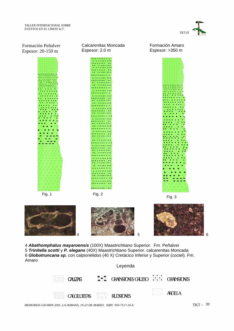
CALCILUTITAS
CALIZAS GRAINSTONES GRUESO
RUDSTONES
GRAINSTONES
ARCILLA
4 5 6
Calcarenitas MoncadaEspesor: 2.0 m
Formación AmaroEspesor: >350 m
Formación PeñalverEspesor: 20-150 m
4 Abathomphalus mayaroensis (100X) Maastrichtiano Superior. Fm. Peñalver5 Trinitella scotti y P. elegans (40X) Maastrichtiano Superior. calcarenitas Moncada6 Globotruncana sp. con calpionélidos (40 X) Cretácico Inferior y Superior (coctel). Fm.Amaro
Leyenda
Fig. 1 Fig. 2Fig. 3