
Geology of the Isa GBA region - Bioregional Assessments
150
A scientific collaboration between the Department of Agriculture, Water and the Environment, Bureau of Meteorology, CSIRO and Geoscience Australia Geology of the Isa GBA region Technical appendix for the Geological and Bioregional Assessment: Stage 2 2020
Transcript of Geology of the Isa GBA region - Bioregional Assessments
A scientific collaboration between the Department of Agriculture, Water and the Environment, Bureau of Meteorology, CSIRO and Geoscience Australia
Geology of the Isa GBA region Technical appendix for the Geological and Bioregional Assessment: Stage 2
2020

v20210706
The Geological and Bioregional Assessment Program The Geological and Bioregional Assessment Program will provide independent scientific advice on the potential impacts from development of selected unconventional hydrocarbon plays on water and the environment. The geological and environmental data and tools produced by the Program will assist governments, industry, landowners and the community to help inform decision making and enhance the coordinated management of potential impacts.
The Program is funded by the Australian Government Department of the Environment and Energy. The Department of the Environment and Energy, Bureau of Meteorology, CSIRO and Geoscience Australia are collaborating to undertake geological and bioregional assessments. For more information, visit http://www.bioregionalassessments.gov.au.
Department of the Environment and Energy The Department designs and implements Australian Government policy and programs to protect and conserve the environment, water and heritage, promote climate action, and provide adequate, reliable and affordable energy. For more information, visit http://www.environment.gov.au.
Bureau of Meteorology The Bureau of Meteorology is Australia’s national weather, climate and water agency. Under the Water Act 2007, the Bureau is responsible for compiling and disseminating Australia's water information. The Bureau is committed to increasing access to water information to support informed decision making about the management of water resources. For more information, visit http://www.bom.gov.au/water/.
CSIRO Australia is founding its future on science and innovation. Its national science agency, CSIRO, is a powerhouse of ideas, technologies and skills for building prosperity, growth, health and sustainability. It serves governments, industries, business and communities across the nation. For more information, visit http://www.csiro.au.
Geoscience Australia Geoscience Australia is Australia’s national geoscience agency and exists to apply geoscience to Australia’s most important challenges. Geoscience Australia provides geoscientific advice and information to the Australian Government to support current priorities. These include contributing to responsible resource development; cleaner and low emission energy technologies; community safety; and improving marine planning and protection. The outcome of Geoscience Australia’s work is an enhanced potential for the Australian community to obtain economic, social and environmental benefits through the application of first-class research and information. For more information, visit http://www.ga.gov.au.
ISBN-PDF 987-1-921069-26-0
Citation Orr ML, Bradshaw BE, Bernardel G, Palu TJ, Hall LS, Bailey AHE, Skeers N, Dehelean A, Reese B and Woods M (2020) Geology of the Isa GBA region. Technical appendix for the Geological and Bioregional Assessment: Stage 2. Department of the Environment and Energy, Bureau of Meteorology, CSIRO and Geoscience Australia, Australia.
Authorship is listed in relative order of contribution.
On 1 February 2020 the Department of the Environment and Energy and the Department of Agriculture merged to form the Department of Agriculture, Water and the Environment. Work for this document was carried out under the then Department of the Environment and Energy. Therefore, references to both departments are retained in this report.
Copyright
© Commonwealth of Australia 2020 With the exception of the Commonwealth Coat of Arms and where otherwise noted, all material in this publication is provided under a Creative Commons Attribution 4.0 International Licence https://creativecommons.org/licenses/by/4.0/. The Geological and Bioregional Assessment Program requests attribution as ‘© Commonwealth of Australia (Geological and Bioregional Assessment Program http://www.bioregionalassessments.gov.au)’.
Disclaimer The information contained in this report is based on the best available information at the time of publication. The reader is advised that such information may be incomplete or unable to be used in any specific situation. Therefore, decisions should not be made based solely on this information or without seeking prior expert professional, scientific and technical advice. The Geological and Bioregional Assessment Program is committed to providing web accessible content wherever possible. If you are having difficulties with accessing this document, please contact [email protected].
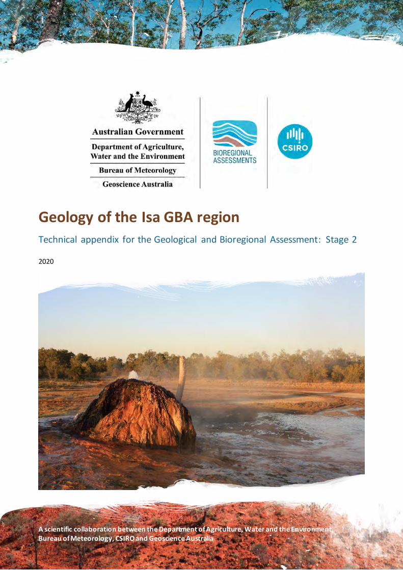
Cover photograph The Burketown Bore, drilled in 1897 by the Queensland Government, is a naturally flowing bore that taps the artesian Gilbert River Formation aquifer at a depth of about 700 m below surface. Groundwater within this aquifer naturally contains a variety of dissolved chemical compounds that have deposited around the bore as the hot water (around 68 °C) has evaporated over the years, leading to the formation of a distinctive multi-coloured mound.
Credit: Steven Lewis, July 2018 Element: GBA-ISA-2-264
Geology of the Isa GBA region | i
Executive summary
This appendix reviews the geological setting, tectonic evolution, depositional environments and structural and stratigraphic framework of the Isa GBA region, part of the geological Isa Superbasin.
The Isa Superbasin is a Paleoproterozoic to earliest Mesoproterozoic superbasin, identified and described in Queensland from surface outcrop exposed on the Mount Isa Inlier and subcrop mapped from well and seismic data across the northern Lawn Hill Platform. Although the full extent of the Isa Superbasin remains undefined, its sequences extend under cover for potentially several hundred kilometres and they have been identified in the McArthur Basin in the NT.
The Isa GBA region is located over the northern Lawn Hill Platform, a relatively undeformed structural element of the superbasin where petroleum exploration has confirmed shale gas resource potential (Section 1). The Isa GBA region extents are based on both the availability of subsurface (well and seismic) data required for the shale gas resource assessment and geological criteria, such as where the sedimentary fill becomes deformed or exhumed, representing the limit of potentially prospective shale gas resources. To the west and south-west of the Isa GBA region, a broader region has been identified which may contain undeformed Isa Superbasin rocks, including organic-rich petroleum source rocks. However, this region currently has insufficient data available for inclusion in this assessment.
A review of existing open file geological, petroleum and environmental data and information was conducted for the Isa GBA region (Section 2). These include geographic and cultural datasets, detailing the location and nature of administrative boundaries, infrastructure and topography; and geological datasets such as surface geology, well and seismic data and other geophysical datasets. A range of public domain publications, reports and data packages for the Isa GBA region are also used to characterise the basin architecture and evolution.
Section 3 reviews the Isa Superbasin’s geological setting and tectonostratigraphic evolution. The Isa Superbasin is considered to be part of the Archean to Paleoproterozoic North Australian Craton and overlies the Paleoproterozoic Leichhardt and Calvert superbasins. Isa Superbasin deposition began ca 1670 Ma and ended with the onset of the Middle Isan Orogeny at ca 1575 Ma. In the Isa GBA region, the Isa Superbasin succession comprises second-order supersequences (Gun, Loretta, River, Term, Lawn, Wide and Doom). The sediments include fluvial, coastal and shallow marine sandstone facies, to shallow and deep marine carbonate successions and deep water shale or fan facies. Shale gas intervals begin from the base of the River Supersequence in the Isa Superbasin and are associated with carbonaceous shales deposited as part of highstand systems tracts in anaerobic marine conditions. The Isa Superbasin succession in the Isa GBA region was not subjected to the full impact of the Isan Orogeny but it has been variably affected by Proterozoic hydrothermal activity.
The Isa Superbasin is directly overlain in the Isa GBA region by fluvial and shallow marine sediments of the Mesoproterozoic South Nicholson Basin and in the east by fluvial and marine sediments of both the Mesozoic Carpentaria Basin and Cenozoic Karumba Basin. Interpreted
ii | Geology of the Isa GBA region
erosion events occurred during the middle to late Mesoproterozoic, Carboniferous to Permian and after the mid-Cretaceous period. No mid-Mesoproterozoic to mid-Mesozoic rocks are preserved in the region.
A more detailed account of the structural and stratigraphic framework of Isa Superbasin and overlying basins in the Isa GBA region is in Section 4. Seismic interpretation was used to describe the region’s major structural elements and a solid geology map was created delineating the maximum extent of the South Nicholson Basin and Isa Superbasin supersequences where they either outcrop at the surface or subcrop beneath the Carpentaria and Karumba basins. Three-dimensional depth-converted structure and isochore maps for key stratigraphic horizons of the Isa Superbasin, South Nicholson Basin, Carpentaria Basin and Karumba Basin further highlight key aspects of the Isa GBA region’s structural architecture (Bradshaw et al., 2018c, 2018a). These maps show that sediment thickness varies from less than 1 km over a basement (i.e. pre-Isa Superbasin rocks) high in the north to approximately 9 km in the south.
Geology of the Isa GBA region | iii
Contents
Executive summary....................................................................................................................... i
Contributors to the Program....................................................................................................... ix
Acknowledgements ..................................................................................................................... x
Abbreviations and acronyms ...................................................................................................... xi
Units.......................................................................................................................................... xii
The Geological and Bioregional Assessment Program ............................................................... xiii 1 Introduction........................................................................................................................ 1
1.1 Aims and rationale of this appendix ............................................................................ 2 1.2 Isa GBA region ............................................................................................................ 3
1.3 Broader area of hydrocarbon potential ....................................................................... 5 2 Data inventory .................................................................................................................... 9
2.1 Introduction ............................................................................................................... 9 2.2 Culture, hydrography and relief .................................................................................. 9 2.3 Geological datasets .................................................................................................. 12 2.4 Published geological studies ..................................................................................... 21
3 Regional geology............................................................................................................... 23 3.1 Overview.................................................................................................................. 23 3.2 Regional geological setting........................................................................................ 23 3.3 Tectonic evolution .................................................................................................... 35 3.4 Stratigraphy and depositional environments ............................................................. 47
4 Isa GBA region structural and stratigraphic framework ..................................................... 65 4.1 Structural architecture.............................................................................................. 65 4.2 Geological surfaces and isochore maps ..................................................................... 76 4.3 Solid geology map ...................................................................................................101 4.4 Regional three-dimensional datasets and schematic sections ...................................104
4.5 Interpretation confidence ........................................................................................108 References................................................................................................................................111 Glossary....................................................................................................................................124
iv | Geology of the Isa GBA region
Figures
Figure 1 Isa GBA region in the northern Lawn Hill Platform superimposed over Frogtech Geoscience’s SEEBASE® depth to basement image ....................................................................4
Figure 2 Area of hydrocarbon potential surrounding the Isa GBA region, and simplified extents of overlying basins....................................................................................................................6
Figure 3 Area of hydrocarbon potential for shale gas resources surrounding the Isa GBA region superimposed over Frogtech Geoscience’s SEEBASE® depth to basement image........................7
Figure 4 Interpreted and uninterpreted images of seismic section 06GA-M2 over the north-eastern margin of the area of hydrocarbon potential shown in two-way time ............................8
Figure 5 Administrative boundaries, road infrastructure and gas pipelines............................... 10
Figure 6 Isa GBA regional surface topography ......................................................................... 11
Figure 7 Isa GBA region surface geology derived from the 1:1,000,000 scale dataset................ 13
Figure 8 Index of the scanned 1:250,000 scale geological map sheets ...................................... 14
Figure 9 Distribution of stratigraphic and petroleum exploration wells across the Isa GBA region and surrounds, classified according to depth of penetration.................................................... 16
Figure 10 Two-dimensional seismic reflection data coverage across the Isa GBA region and surrounds .............................................................................................................................. 17
Figure 11 a) Distribution of point gravity data observations; b) Regional Bouguer gravity coverage ................................................................................................................................ 19
Figure 12 a) Distribution of magnetic survey by resolution; b) Regional TMI (total magnetic intensity) coverage ................................................................................................................. 20
Figure 13 Interpreted basement terranes of the Isa GBA region and surrounds ........................ 25
Figure 14 Modelled radiogenic heat flow of the Isa GBA region and surrounds ........................ 26
Figure 15 Interpreted widespread distribution of Paleoproterozoic superbasin sedimentary rocks in the North Australian Craton: (a) the interpreted distribution and thicknesses of Paleoproterozoic superbasin bodies, derived from magnetic data and surface geology, and (b) spatial distribution of selected SHRIMP (OZCHRON) geochronological ages, in millions of years, of sedimentary rocks and classified by superbasin................................................................... 28
Figure 16 Northern and central Lawn Hill Platform with main structural elements and outcrop exposures of the River, Term, Lawn, Wide and Doom supersequences of the Isa Superbasin.... 30
Figure 17 Simplified geological map of the Mount Isa Inlier, showing major tectonic elements and extent of Paleoproterozoic to Mesoproterozoic rock outcrop ........................................... 32
Geology of the Isa GBA region | v
Figure 18 Geological domains in the Geological Survey of Queensland’s North West Queensland Mineral and Energy Province study area ................................................................................. 33
Figure 19 Distribution of post-Paleoproterozoic basins in the Isa GBA region and surrounds .... 35
Figure 20 Regional Qld-NT comparison of tectonic, igneous, thermal and depositional events interpreted to have affected the Isa (northern Lawn Hill Platform) and Beetaloo (Beetaloo Sub-basin) GBA regions from the time of Isa Superbasin deposition to the present ......................... 37
Figure 21 Australian Proterozoic geodynamic context time slices from 1670 to 1500 Ma ......... 39
Figure 22 Illite K-Ar ages with interpreted thermal and tectonic events experienced by rocks of the northern and central Lawn Hill Platform ........................................................................... 42
Figure 23 Interpreted original extent of the Carpentaria Basin and sub-basins, ridges and contiguous Mesozoic basins of Queensland and the Gulf of Papua .......................................... 46
Figure 24 Sequence stratigraphy, lithostratigraphy and hydrostratigraphy of the Isa Superbasin, South Nicholson Basin, Carpentaria Basin and Karumba Basin, and hydrocarbon occurences ... 49
Figure 25 Chronostratigraphic chart for the Isa Superbasin and Calvert Superbasin, south to north across the northern Lawn Hill Platform .......................................................................... 51
Figure 26 Isopach and facies maps for the Gun Supersequence to the south of the Isa GBA region, indicating a south-east facing ramp with shoreline facies in the north and deeper water basinal facies in the east and south......................................................................................... 54
Figure 27 Structural elements map of the northern Lawn Hill Platform superimposed over the Geological Survey of Queensland’s depth to basement grid..................................................... 66
Figure 28 Structural elements map of the northern Lawn Hill Platform superimposed over an isochore (vertical thickness) map for the River to Doom supersequences ................................ 67
Figure 29 Argyle Creek composite seismic section showing unconformities at the base of each supersequence (solid lines) and sequence (dashed lines) from the Isa, Calvert and Leichhardt superbasins ............................................................................................................................ 68
Figure 30 Desert Creek composite seismic section showing unconformities at the base of each supersequence (solid lines) and sequence (dashed lines) from the Isa, Calvert and Leichhardt superbasins ............................................................................................................................ 69
Figure 31 Central seismic composite section showing unconformities at the base of each supersequence (solid lines) and sequence (dashed lines) from the Isa, Calvert and Leichhardt superbasins ............................................................................................................................ 70
Figure 32 Egilabria composite seismic section showing unconformities at the base of each supersequence (solid lines) and sequence (dashed lines) from the Isa, Calvert and Leichhardt superbasins ............................................................................................................................ 71

vi | Geology of the Isa GBA region
Figure 33 Correlation of lithofacies members from the McNamara Group to the Fickling Group using the NABRE Project sequence stratigraphy framework, based on the S-N composite seismic line presented in Bradshaw et al. (2000) ................................................................................. 72
Figure 34 Base River Supersequence depth-structure map ...................................................... 78
Figure 35 River Supersequence isochore (vertical thickness) map ............................................ 79
Figure 36 Base Term Supersequence depth-structure map ...................................................... 81
Figure 37 Term Supersequence isochore (vertical thickness) map ............................................ 82
Figure 38 Base Lawn Supersequence depth-structure map ...................................................... 84
Figure 39 Lawn Supersequence isochore map ......................................................................... 85
Figure 40 Base Wide Supersequence depth-structure map ...................................................... 87
Figure 41 Wide Supersequence isochore (vertical thickness) map ............................................ 88
Figure 42 Base Doom Supersequence depth-structure map..................................................... 90
Figure 43 Doom Supersequence isochore (vertical thickness) map........................................... 91
Figure 44 Base South Nicholson Basin depth-structure map .................................................... 93
Figure 45 South Nicholson Basin isochore (vertical thickness) map .......................................... 94
Figure 46 Base Carpentaria Basin depth-structure map ........................................................... 96
Figure 47 Carpentaria Basin isochore map............................................................................... 97
Figure 48 Base Karumba Basin depth-structure map ............................................................... 99
Figure 49 Karumba Basin isochore map................................................................................. 100
Figure 50 Solid geology map for Proterozoic supersequences from the Isa Superbasin and the South Nicholson Basin over the Isa GBA region ..................................................................... 102
Figure 51 Oblique view of the regional three-dimensional geological model for the Isa GBA region (looking north)........................................................................................................... 104
Figure 52 Oblique view of the regional three-dimensional geological model for the Isa GBA region (looking east)............................................................................................................. 105
Figure 53 Schematic east to west cross-section through the Isa GBA region generated from the three-dimensional geological model showing the along-strike structural architecture of the northern Lawn Hill Platform ................................................................................................. 106
Figure 54 Schematic north to south cross-section through the Isa GBA region generated from the three-dimensional geological model showing the cross-dip structural architecture of the northern Lawn Hill Platform ................................................................................................. 107

Geology of the Isa GBA region | vii
Figure 55 Data coverage and data quality for interpretation of Isa Superbasin horizons within the Isa GBA region................................................................................................................ 109
Figure 56 Interpretation confidence for the Isa Superbasin grids generated over the Isa GBA region .................................................................................................................................. 110

viii | Geology of the Isa GBA region
Tables
Table 1 Geological summary table for the Isa Superbasin ..........................................................1
Table 2 Stratigraphy of the Isa Superbasin............................................................................... 50
Table 3 Stratigraphy of the South Nicholson Basin................................................................... 60
Table 4 Stratigraphy of the onshore Carpentaria Basin (in the Burketown area) ....................... 62
Table 5 Stratigraphy of the Karumba Basin.............................................................................. 63
Table 6 Solid geology rock units and corresponding supersequence (Isa Superbasin) or basin (South Nicholson Basin) ........................................................................................................ 101
Geology of the Isa GBA region | ix
Contributors to the Program
The following individuals have contributed to the Geological and Bioregional Assessment Program.
Role or team Contributor(s)
Program Director Department of the Environment and Energy: Anthony Swirepik
Program Implementation Board Department of the Environment and Energy: Beth Brunoro, Nicholas Post Bureau of Meteorology: Kirsten Garwood, Kate Vinot CSIRO: Jane Coram, Warwick MacDonald Geoscience Australia: Stuart Minchin, Richard Blewett
Basin Leader CSIRO: Kate Holland, Cameron Huddlestone-Holmes, Paul Wilkes Geoscience Australia: Steven Lewis
Program management CSIRO: Karen Barry, Emanuelle Frery, Linda Merrin, Ruth Palmer Department of the Environment and Energy: Mitchell Bouma, Rod Dann, Andrew Stacey, David Thomas, Alex Tomlinson
Product integration and stakeholder engagement
CSIRO: Clare Brandon, Justine Lacey, Michelle Rodriquez, Sally Tetreault-Campbell
Analysis and visualisation CSIRO: Dennis Gonzalez, Steve Marvanek Geoscience Australia: Adrian Dehelean, Chris Evenden, Chris Lawson, Bianca Reese, Nigel Skeers, Murray Woods
Basin geology and prospectivity Geoscience Australia: Lisa Hall (Discipline Leader), Adam Bailey, George Bernardel, Barry Bradshaw, Donna Cathro, Merrie-Ellen Gunning, Amber Jarrett, Megan Lech, Meredith Orr, Ryan Owens, Tehani Palu, Martin Smith, Liuqu Wang
Chemical assessment CSIRO: Jason Kirby (Discipline Leader), Simon Apte, Lisa Golding, Rai Kookana, Dirk Mallants, Michael Williams
Data management and transparency
Bureau of Meteorology: Andre Zerger (Discipline Leader), Derek Chen, Trevor Christie-Taylor, Donna Phillips CSIRO: Nicholas Car, Philip Davies, Matt Stenson Geoscience Australia: Matti Peljo
Hydrogeology Geoscience Australia: Tim Ransley (Discipline Leader), Sam Buchanan, Scott Cook, Prachi Dixon-Jain, Bex Dunn, Tim Evans, Éamon Lai, Bruce Radke, Baskaran Sundaram
Impact analysis CSIRO: David Post (Discipline Leader), Brent Henderson, Dane Kasperczyk, James Kear, Regina Sander
Impacts on protected matters CSIRO: Anthony O'Grady (Discipline Leader), Alexander Herr, Craig MacFarlane, Justine Murray, Chris Pavey, Stephen Stewart
Spatial analysis CSIRO: Dennis Gonzalez, Steve Marvanek Geoscience Australia: Adrian Dehelean, Murray Woods, Nigel Skeers
Water quantity CSIRO: Russell Crosbie (Discipline Leader), Jorge Martinez Praveen Kumar Rachakonda, Matthias Raiber, Yongqiang Zhang, Hongxing Zheng
x | Geology of the Isa GBA region
Acknowledgements
This technical product was reviewed by several groups:
• Internal Peer Review Group: Geoscience Australia: Robert Langford, Steven Lewis, Merrie-Ellen Gunning, David Robinson
• Technical Peer Review Group: Peter McCabe
• State Government Science Technical Review: This group includes scientists from the Queensland Government
Valuable comments were also provided by Justin Gorton, Laurie Hutton, Alison Troup (Geological Survey of Queensland) and Andrew Stacey (Department of the Environment and Energy)
Geology of the Isa GBA region | xi
Abbreviations and acronyms
Abbreviation/acronym Definition
AGSO Australian Geological Survey Organisation
AHD Australian Height Datum
Ar/Ar argon/argon
BMR Bureau of Mineral Resources
ca circa
C.I. contour interval
DEM digital elevation model
DW deviated well
GAB Great Artesian Basin
GBA Geological and Bioregional Assessment
GIS geographic information system
K-Ar potassium-argon
Ma millions of years before the present
mAHD metres with respect to the Australian Height Datum
m MSL metres with respect to mean sea level
MSL mean sea level
My million years
NABRE North Australian Basins Resource Evaluation
NT Northern Territory
NWQMEP North-West Queensland Mineral and Energy Province
Qld Queensland
QPED Queensland Petroleum Exploration Data
SEEBASE® Structurally Enhanced view of Economic BASEment
SHRIMP Sensitive High-Resolution Ion Microprobe
TMI total magnetic intensity
U-Pb uranium-lead

xii | Geology of the Isa GBA region
Units
Unit Description
Ma millions of years before the present
MPa megapascals
mW/m2 milliwatts per square metre

Geology of the Isa GBA region | xiii
The Geological and Bioregional Assessment Program The $35.4 million Geological and Bioregional Assessment (GBA) Program is assessing the potential environmental impacts of shale and tight gas development to inform regulatory frameworks and appropriate management approaches. The geological and environmental knowledge, data and tools produced by the Program will assist governments, industry, landowners and the community by informing decision making and enabling the coordinated management of potential impacts.
In consultation with state and territory governments and industry, three geological basins were selected based on prioritisation and ranking in Stage 1: Cooper Basin, Isa Superbasin and Beetaloo Sub-basin. In Stage 2, geological, hydrological and ecological data were used to define ‘GBA regions’: the Cooper GBA region in Queensland, SA and NSW; the Isa GBA region in Queensland; and the Beetaloo GBA region in NT.
The Program will assess the potential impacts of selected shale and tight gas development on water and the environment and provide independent scientific advice to governments, landowners, the community, business and investors to inform decision making. Geoscience Australia and CSIRO are conducting the assessments. The Program is managed by the Department of the Environment and Energy and supported by the Bureau of Meteorology.
The Program aims to:
• inform government and industry and encourage exploration to bring new gas supplies to the East Coast Gas Market within five to ten years
• increase understanding of the potential impacts on water and the environment posed by development of shale, tight and deep coal gas resources
• increase the efficiency of assessment and ongoing regulation, particularly through improved reporting and data provision/management approaches
• improve community understanding of the industry.
The Program commenced in July 2017 and comprises three stages:
• Stage 1 Rapid regional basin prioritisation identified and prioritised geological basins with the greatest potential to deliver shale and/or tight gas to the East Coast Gas Market within the next five to ten years.
• Stage 2 Geological and environmental baseline assessments is compiling and analysing available data for the three selected regions to form a baseline and identify gaps to guide collection of additional baseline data where needed. This analysis includes a geological basin assessment to define structural and stratigraphic characteristics and an environmental data synthesis.
• Stage 3 Impact analysis and management will analyse the potential impacts to water resources and matters of environmental significance to inform and support Commonwealth and State management and compliance activities.
The PDF of this report and the supporting technical appendices are available at https://www.bioregionalassessments.gov.au/geological-and-bioregional-assessment-program.
xiv | Geology of the Isa GBA region
About this report
Presented in this technical appendix is a review of the geology of the Isa GBA region. It provides more detailed information regarding the geological setting, tectonic evolution, depositional environments and structural and stratigraphic framework. The structure and focus of the synthesis report and technical appendices reflect the needs of government, industry, landowners and community groups.
Technical appendices
Other technical appendices that support the geological and environmental baseline assessment for the Isa GBA region are:
• Bailey AHE, Bradshaw BE, Palu TJ, Wang L, Jarrett AJM, Orr ML, Hall LS, Evenden C, Skeers N, Woods M, Dehelean A and Hall LS (2020) Shale gas prospectivity of the Isa GBA region.
• Buchanan S, Dixon-Jain P, Martinez J, Raiber M, Kumar PR, Woods M, Arnold D, Dehelean A and Skeers N (2020) Hydrogeology and groundwater systems of the Isa GBA region.
• MacFarlane CM, Herr A, Merrin LE, O’Grady AP and Pavey C (2020) Protected matters for the Isa GBA region.
• Kear J and Kasperczyk D (2020) Hydraulic fracturing and well integrity review for the GBA regions.
• Kirby JK, Golding L, Williams M, Apte S, Mallants D and Kookana R (2020) Qualitative (screening) environmental risk assessment of drilling and hydraulic fracturing chemicals for the Isa GBA region.
All maps for the Isa GBA region use the Map Grid of Australia (MGA) projection (zone 54) and the Geocentric Datum of Australia 1994 (GDA 1994).
1 Introduction
Geology of the Isa GBA region | 1
Stage 2: Geology technical appendix
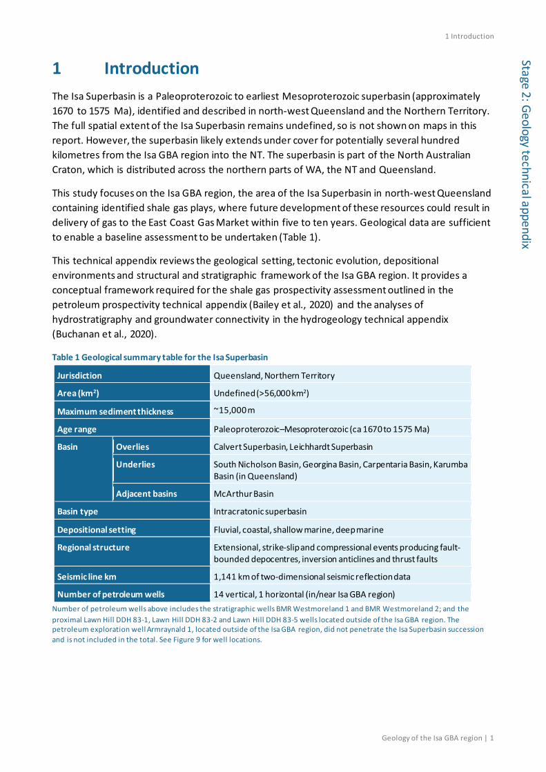
1 Introduction The Isa Superbasin is a Paleoproterozoic to earliest Mesoproterozoic superbasin (approximately 1670 to 1575 Ma), identified and described in north-west Queensland and the Northern Territory. The full spatial extent of the Isa Superbasin remains undefined, so is not shown on maps in this report. However, the superbasin likely extends under cover for potentially several hundred kilometres from the Isa GBA region into the NT. The superbasin is part of the North Australian Craton, which is distributed across the northern parts of WA, the NT and Queensland.
This study focuses on the Isa GBA region, the area of the Isa Superbasin in north-west Queensland containing identified shale gas plays, where future development of these resources could result in delivery of gas to the East Coast Gas Market within five to ten years. Geological data are sufficient to enable a baseline assessment to be undertaken (Table 1).
This technical appendix reviews the geological setting, tectonic evolution, depositional environments and structural and stratigraphic framework of the Isa GBA region. It provides a conceptual framework required for the shale gas prospectivity assessment outlined in the petroleum prospectivity technical appendix (Bailey et al., 2020) and the analyses of hydrostratigraphy and groundwater connectivity in the hydrogeology technical appendix (Buchanan et al., 2020).
Table 1 Geological summary table for the Isa Superbasin
Jurisdiction Queensland, Northern Territory
Area (km2) Undefined (>56,000 km2)
Maximum sediment thickness ~15,000 m
Age range Paleoproterozoic–Mesoproterozoic (ca 1670 to 1575 Ma)
Basin Overlies Calvert Superbasin, Leichhardt Superbasin
Underlies South Nicholson Basin, Georgina Basin, Carpentaria Basin, Karumba Basin (in Queensland)
Adjacent basins McArthur Basin
Basin type Intracratonic superbasin
Depositional setting Fluvial, coastal, shallow marine, deep marine
Regional structure Extensional, strike-slip and compressional events producing fault-bounded depocentres, inversion anticlines and thrust faults
Seismic line km 1,141 km of two-dimensional seismic reflection data
Number of petroleum wells 14 vertical, 1 horizontal (in/near Isa GBA region) Number of petroleum wells above includes the stratigraphic wells BMR Westmoreland 1 and BMR Westmoreland 2; and the proximal Lawn Hill DDH 83-1, Lawn Hill DDH 83-2 and Lawn Hill DDH 83-5 wells located outside of the Isa GBA region. The petroleum exploration well Armraynald 1, located outside of the Isa GBA region, did not penetrate the Isa Superbasin succession and is not included in the total. See Figure 9 for well locations.

1 Introduction
2 | Geology of the Isa GBA region
Stag
e 2:
Geo
logy
tech
nica
l app
endi
x 1.1 Aims and rationale of this appendix A sound scientific understanding of a region’s geology ideally underpins decisions on unconventional petroleum resource development. This appendix provides a geological review of the Isa GBA region and analyses relevant to understanding its structural and stratigraphic characteristics.
This assessment of the Isa Superbasin has been undertaken before the full spatial extents of the superbasin have been defined. Consequently, this review focusses on the Isa GBA region as the most likely part of the Isa Superbasin for future shale gas development, but places it in the context of the broader superbasin and highlights geological factors which underpin its relative prospectivity.
This appendix collates the current geological knowledge of the Isa GBA region relevant to the depositional and post-depositional history of the sedimentary rocks, and to the stratigraphic and structural framework of the region. It begins with an inventory of datasets broadly relevant to the assessment in Section 2. The rationale for the information provided in the regional geology (Section 3) and structural and stratigraphic framework (Section 4) sections is given below.
Several geological factors affect assessments of hydrocarbon prospectivity, groundwater distribution and aquifer connectivity. Many of these are controlled by the depositional and post-depositional history of the rocks. The depositional environment of shales has a direct influence on the type and amount of organic matter they contain, and hence their potential as source rocks for hydrocarbons. Depositional environments also influence the capacity of sedimentary rocks to hold hydrocarbons (as reservoirs) or water (as aquifers). Section 3.4 summarises the current geological knowledge of the depositional environments of the rocks within the Isa GBA region. A Proterozoic to Cenozoic stratigraphic chart, presented in Section 3.4, was compiled from published sources but further developed to integrate lithostratigraphy and hydrostratigraphy.
The post-depositional thermal evolution of the source rocks governs the generation of unconventional hydrocarbons. Basins are not timeless and static: thermal evolution is influenced by burial, uplift, erosion and hydrothermal activity in the basin over prolonged geological time frames. Temperature changes and generation of hydrocarbons may have occurred in any period since deposition of the organic-rich sediments: in the case of the Isa Superbasin’s organic-rich rocks, this could have been at several intervals in the last 1.6 billion years. Section 3.3 reviews the tectonic evolution of the Isa GBA region and surrounds, including interpreted tectonothermal events. The information provides the background for the interpreted timing of hydrocarbon generation and for the burial and thermal history modelling component of the prospectivity technical appendix (Bailey et al., 2020).
Tectonic evolution affects also the degree of fracture porosity in indurated sedimentary rocks and strata displacements in fault systems, which can promote groundwater connectivity (Buchanan et al., 2020). Secondary porosity produced by fracturing, and structural offsets produced by faulting, can enhance connectivity between intervals and potentially permit inter-formational groundwater flow (Buchanan et al., 2020). The timing, distribution and degree of tectonic deformation is summarised in Section 3.3 to the current extent of knowledge, and further analysed in the context of the structural and stratigraphic framework in Section 4.
1 Introduction
Geology of the Isa GBA region | 3
Stage 2: Geology technical appendix
The structural and stratigraphic framework of the Isa GBA region is captured in Section 4 by a three-dimensional geological model created for the assessment. Three-dimensional depth and isochore maps for key Proterozoic and Phanerozoic stratigraphic horizons, based on the methods explained by Bradshaw et al. (2018c), and fault zone architecture are included in this section and available as a dataset (Bradshaw et al., 2018b). These are used to produce the conceptual models of hydrogeological connectivity presented in the hydrogeology technical appendix (Buchanan et al., 2020). In addition, the input parameter maps for the play fairway presence maps presented in the prospectivity technical appendix (Bailey et al., 2020) use the mapped depths and thicknesses of key stratigraphic horizons presented in Section 4.
1.2 Isa GBA region The Isa GBA region is on the northern Lawn Hill Platform of the Isa Superbasin, where industry exploration for shale gas resources has previously occurred (Bailey et al., 2020). The data constraints in the broader frontier Isa Superbasin region currently preclude petroleum prospectivity assessments beyond the northern Lawn Hill Platform.
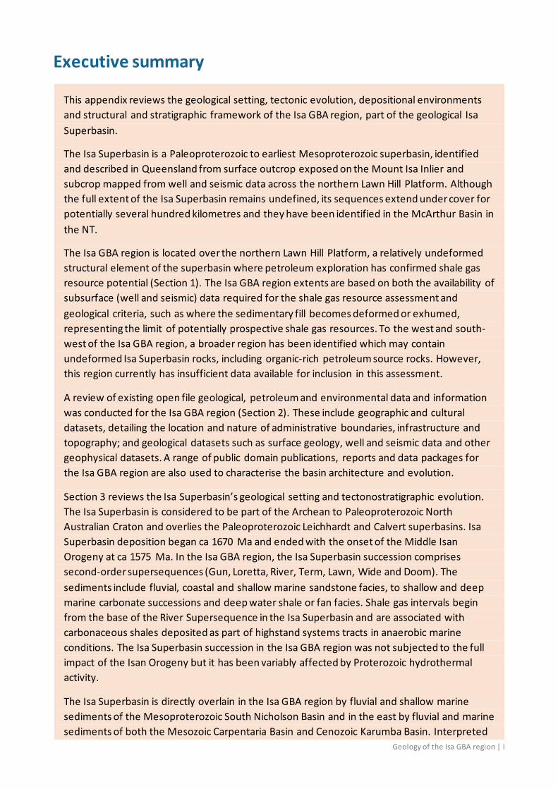
The Isa GBA region extents shown in Figure 1 are constrained by the following geological criteria and data considerations:
• the maximum extent of preserved and relatively continuous sedimentary deposits associated with the northern Lawn Hill Platform
• the limit for potentially prospective shale gas resources, defined where the sedimentary fill becomes extensively folded and faulted, with the potential shale gas intervals either brought closer to the surface, exhumed as outcrop or eroded
• the limit of available subsurface (well and seismic) data required as the basis for the assessment of shale gas resources
• the edge of sedimentary fill as mapped by the Geological Survey of Queensland, where seismic data coverage is insufficient for the interpretation of sedimentary deposit extents and deformation.
The northern boundary of the Isa GBA region represents the maximum extent of preserved and relatively continuous superbasin sediments. In the northern Lawn Hill Platform, the Isa Superbasin succession thins and onlaps a basement high in the north. Seismic data, of variable quantity and quality, are used to define the preserved limits of the Isa Superbasin here, based on interpretations presented in Bradshaw and Scott (1999) and further refined using the North West Queensland SEEBASE® grid (Frogtech Geoscience, 2018a) and Bradshaw et al. (2018c). In the north-west, the Isa Superbasin boundary represents the mapped outcrop limit.
The western boundary of the Isa GBA region marks the limit of available subsurface (well and seismic) data required for the shale gas prospectivity assessment. The eastern extent of the region is based on the Isa Superbasin edge mapped by the Geological Survey of Queensland (Geological Survey of Queensland, 2011b) due to the lack of seismic data coverage in this area.
The southern Isa GBA region boundary is defined where the Isa Superbasin sedimentary fill becomes extensively folded and faulted. As many of the potential shale gas intervals are either

1 Introduction
4 | Geology of the Isa GBA region
Stag
e 2:
Geo
logy
tech
nica
l app
endi
x exhumed or outcrop at the surface, this boundary is interpreted to be the southern limit of potentially prospective shale gas resources. Key information used to map the southern boundary include the North West Queensland SEEBASE® grid (Frogtech Geoscience, 2018a) and interpretation of available seismic datasets.
Figure 1 Isa GBA region in the northern Lawn Hill Platform superimposed over Frogtech Geoscience’s SEEBASE® depth to basement image Data: Queensland SEEBASE® image sourced from Frogtech Geoscience (2018a); NT SEEBASE® image sourced from Frogtech Geoscience (2018b); two-dimensional seismic survey line locations from Department of Natural Resources (2017b), deep crustal seismic line locations from Department of Natural Resources (2017c), petroleum well locations from Department of Natural Resources (2017a). Background image is the GEODATA 9-second digital elevation model, version 3 (hillshade) (Hutchinson et al., 2008) Element: GBA-ISA-2-044
1 Introduction
Geology of the Isa GBA region | 5
Stage 2: Geology technical appendix
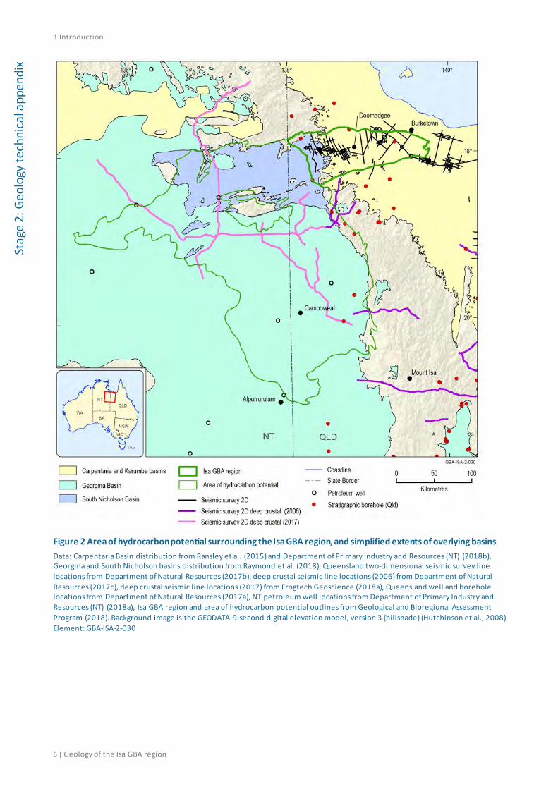
1.3 Broader area of hydrocarbon potential The Isa Superbasin extends beyond the limits of the Isa GBA region. The Isa Superbasin strata are either known or inferred to extend to the south and west of the Isa GBA region beneath the younger Karumba, Carpentaria, Georgina and South Nicholson basins (Figure 2) and this succession has the potential to contain organic-rich source rocks. Although other areas of the superbasin may be prospective for shale gas resources, there is presently insufficient data coverage outside the region to undertake meaningful analysis for the purposes of this assessment.
Isa Superbasin rocks in some areas outside the Isa GBA region are deformed and variably metamorphosed due to post-depositional tectonic events. These deformational events have constrained the likely extent of any petroleum system to the basin sequences that overlie basement terranes resistant to deformation. A region west and south-west of the Isa GBA region (Figure 3) has been identified that may contain undeformed Isa Superbasin sediments, including organic-rich petroleum source rocks, although it has insufficient data available for assessment (at the time that this review was undertaken). This region is delineated based on the modelled depth to basement in the North West Queensland SEEBASE® grid (Frogtech Geoscience, 2018a), which indicates the Isa Superbasin may be present in this region. Supporting evidence for the presence of strata of this age comes from the Lawn Hill DDH 83-2 (Amoco 83/2) and Morstone 1 (Figure 3) well data. In addition, seismic data interpretation by Gibson et al. (2016) show that relatively undeformed superbasin strata may be present along the eastern margin of this area (Figure 3; Figure 4).
This broader area of hydrocarbon potential is currently under investigation by Geoscience Australia as part of the Exploring for the Future Program, which aims to understand the extent of Proterozoic sedimentary basins in the region (Henson et al., 2018). Although new seismic data were acquired over the southern area of hydrocarbon potential in late 2017, interpretations were not available at the time of this assessment. Publication of the L210 South Nicholson Deep Crustal Seismic Reflection Survey data interpretation is expected in 2020.
1 Introduction
6 | Geology of the Isa GBA region
Stag
e 2:
Geo
logy
tech
nica
l app
endi
x
Figure 2 Area of hydrocarbon potential surrounding the Isa GBA region, and simplified extents of overlying basins Data: Carpentaria Basin distribution from Ransley et al. (2015) and Department of Primary Industry and Resources (NT) (2018b), Georgina and South Nicholson basins distribution from Raymond et al. (2018), Queensland two-dimensional seismic survey line locations from Department of Natural Resources (2017b), deep crustal seismic line locations (2006) from Department of Natural Resources (2017c), deep crustal seismic line locations (2017) from Frogtech Geoscience (2018a), Queensland well and borehole locations from Department of Natural Resources (2017a), NT petroleum well locations from Department of Primary Industry and Resources (NT) (2018a), Isa GBA region and area of hydrocarbon potential outlines from Geological and Bioregional Assessment Program (2018). Background image is the GEODATA 9-second digital elevation model, version 3 (hillshade) (Hutchinson et al., 2008) Element: GBA-ISA-2-030

1 Introduction
Geology of the Isa GBA region | 7
Stage 2: Geology technical appendix
Figure 3 Area of hydrocarbon potential for shale gas resources surrounding the Isa GBA region superimposed over Frogtech Geoscience’s SEEBASE® depth to basement image Data: SEEBASE® image from Frogtech Geoscience (2018a) and Frogtech Geoscience (2018b), Queensland two-dimensional seismic survey line locations from Department of Natural Resources (2017b), deep crustal seismic line locations (2006) from Department of Natural Resources (2017c), deep crustal seismic line locations (2017) from Frogtech Geoscience (2018a), Queensland well and borehole locations from Department of Natural Resources (2017a), NT petroleum well locations from Department of Primary Industry and Resources (NT) (2018a), Isa GBA region and area of hydrocarbon potential outlines from Geological and Bioregional Assessment Program (2018) Element: GBA-ISA-2-012
1 Introduction
8 | Geology of the Isa GBA region
Stag
e 2:
Geo
logy
tech
nica
l app
endi
x
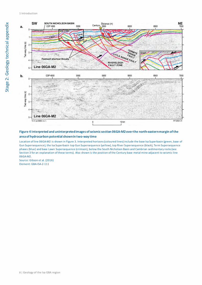
Figure 4 Interpreted and uninterpreted images of seismic section 06GA-M2 over the north-eastern margin of the area of hydrocarbon potential shown in two-way time Location of line 06GA-M2 is shown in Figure 3. Interpreted horizons (coloured lines) include the base Isa Superbasin (green, base of Gun Supersequence), the Isa Superbasin top Gun Supersequence (yellow), top River Supersequence (black), Term Supersequence phases (blue) and base Lawn Supersequence (crimson), below the South Nicholson Basin and Cambrian sedimentary rocks (see Section 3 for an explanation of these terms). Also shown is the position of the Century base metal mine adjacent to seismic line 06GA-M2. Source: Gibson et al. (2016) Element: GBA-ISA-2-111

2 Data inventory
Geology of the Isa GBA region | 9
Stage 2: Geology technical appendix
2 Data inventory
2.1 Introduction This section reviews the available geological and petroleum data and information for the Isa GBA region. The datasets considered as part of this assessment are limited to those in the public domain and considered by the authors as fit for purpose as of October 2018.
2.2 Culture, hydrography and relief
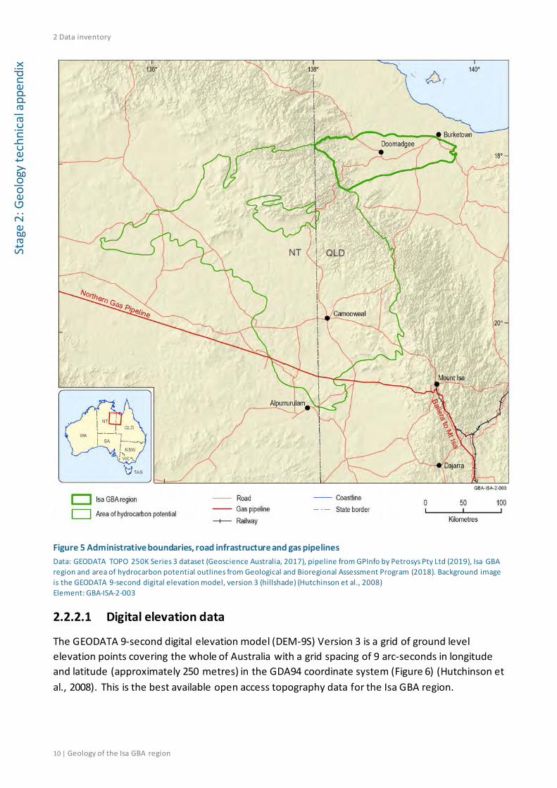
2.2.1 Administrative boundaries and infrastructure
Administrative boundaries, centres of population and infrastructure such as road and rail (Figure 5) shown on maps created for the Isa GBA were sourced from the GEODATA TOPO 250K Series 3 dataset (Geoscience Australia, 2017). The dataset is a vector representation of the major features appearing on 1:250,000 scale NATMAPs in Shape file format
The National Oil and Gas Infrastructure datasets (Petrosys Pty Ltd, 2019) present the spatial locations of onshore pipelines for the transmission of oil and gas within mainland Australia. They also present the location of oil and gas infrastructure facilities for the extraction, processing and/or storage of oil and natural gas. The construction of a new 622 km gas pipeline (Northern Gas Pipeline) (Figure 5) connecting Tennant Creek in the Northern Territory to Mount Isa in Queensland was completed in 2018 and is now operational. There are currently no oil or gas processing facilities in the Isa GBA region or surrounds.
2.2.2 Topographic and remote sensing data
Remotely sensed radiometric, satellite and photographic data have been used in previous studies (Geological Survey of Queensland, 2011a) to understand the surface geology of the Isa Superbasin. These data have also been used for the mapping and assessment of surface geomorphology and soils, which are useful for an assessment of environmental risks of gas extraction.
2 Data inventory
10 | Geology of the Isa GBA region
Stag
e 2:
Geo
logy
tech
nica
l app
endi
x
Figure 5 Administrative boundaries, road infrastructure and gas pipelines Data: GEODATA TOPO 250K Series 3 dataset (Geoscience Australia, 2017), pipeline from GPInfo by Petrosys Pty Ltd (2019), Isa GBA region and area of hydrocarbon potential outlines from Geological and Bioregional Assessment Program (2018). Background image is the GEODATA 9-second digital elevation model, version 3 (hillshade) (Hutchinson et al., 2008) Element: GBA-ISA-2-003
2.2.2.1 Digital elevation data
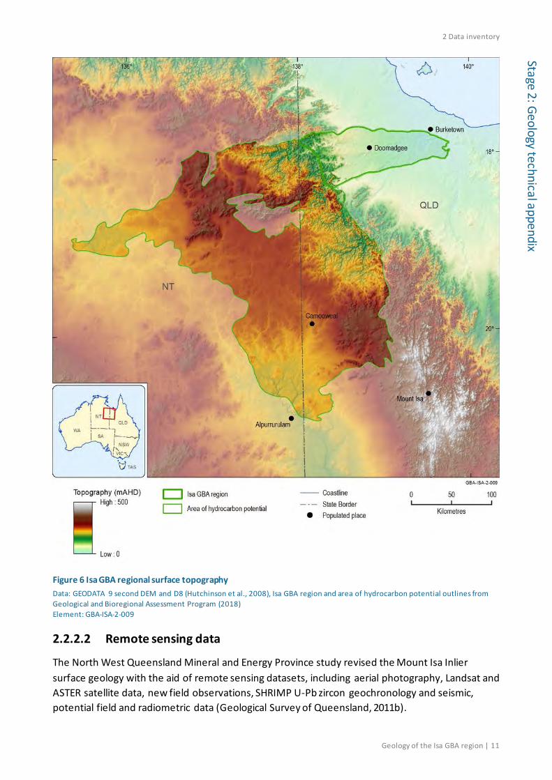
The GEODATA 9-second digital elevation model (DEM-9S) Version 3 is a grid of ground level elevation points covering the whole of Australia with a grid spacing of 9 arc-seconds in longitude and latitude (approximately 250 metres) in the GDA94 coordinate system (Figure 6) (Hutchinson et al., 2008). This is the best available open access topography data for the Isa GBA region.
2 Data inventory
Geology of the Isa GBA region | 11
Stage 2: Geology technical appendix
Figure 6 Isa GBA regional surface topography Data: GEODATA 9 second DEM and D8 (Hutchinson et al., 2008), Isa GBA region and area of hydrocarbon potential outlines from Geological and Bioregional Assessment Program (2018) Element: GBA-ISA-2-009
2.2.2.2 Remote sensing data
The North West Queensland Mineral and Energy Province study revised the Mount Isa Inlier surface geology with the aid of remote sensing datasets, including aerial photography, Landsat and ASTER satellite data, new field observations, SHRIMP U-Pb zircon geochronology and seismic, potential field and radiometric data (Geological Survey of Queensland, 2011b).
2 Data inventory
12 | Geology of the Isa GBA region
Stag
e 2:
Geo
logy
tech
nica
l app
endi
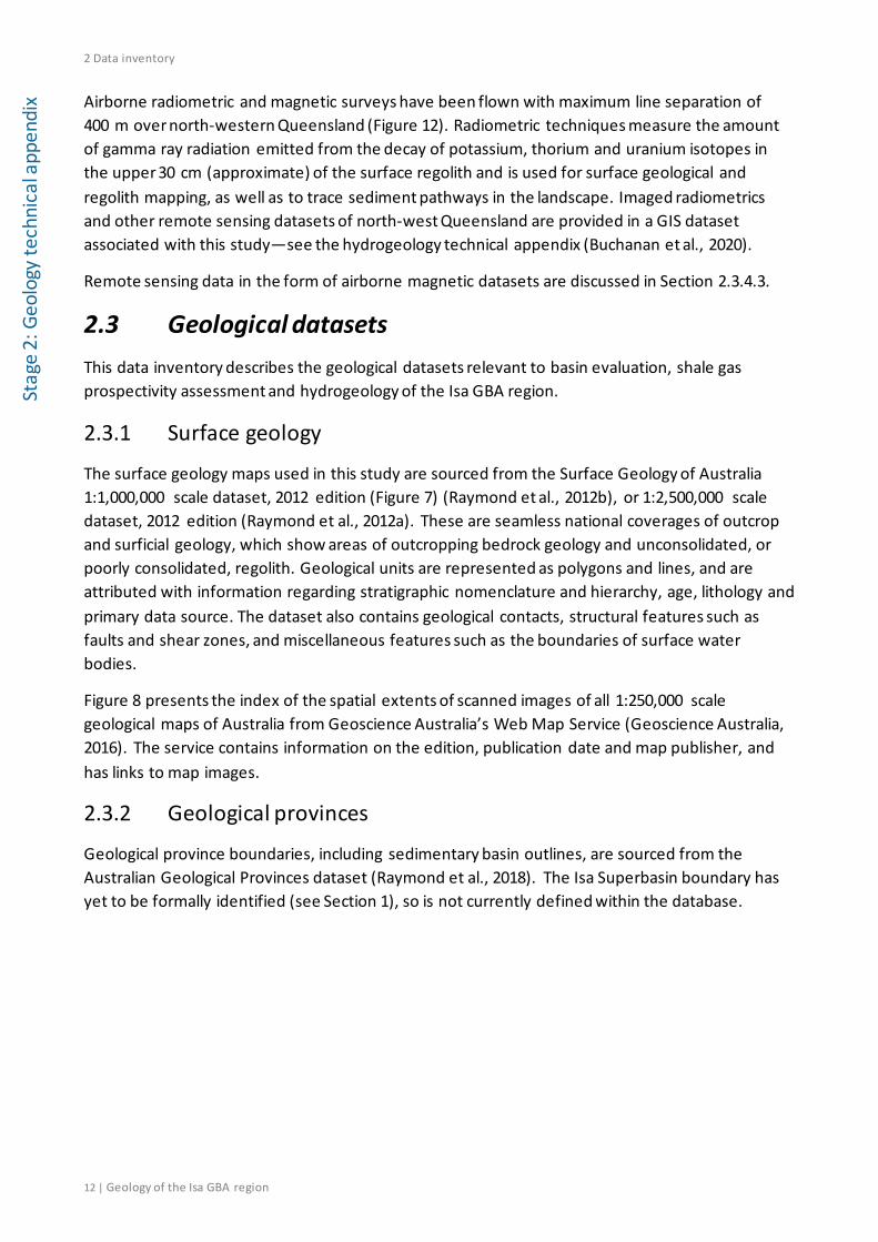
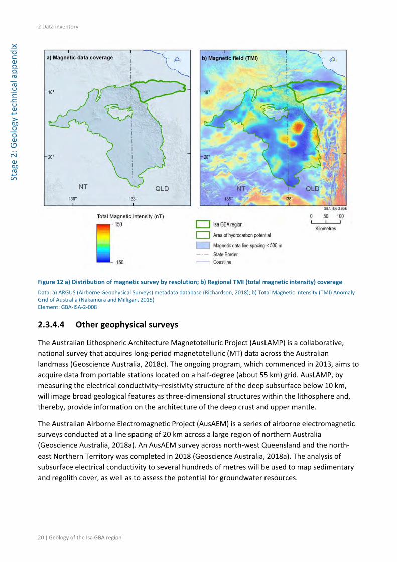
x Airborne radiometric and magnetic surveys have been flown with maximum line separation of 400 m over north-western Queensland (Figure 12). Radiometric techniques measure the amount of gamma ray radiation emitted from the decay of potassium, thorium and uranium isotopes in the upper 30 cm (approximate) of the surface regolith and is used for surface geological and regolith mapping, as well as to trace sediment pathways in the landscape. Imaged radiometrics and other remote sensing datasets of north-west Queensland are provided in a GIS dataset associated with this study—see the hydrogeology technical appendix (Buchanan et al., 2020).
Remote sensing data in the form of airborne magnetic datasets are discussed in Section 2.3.4.3.
2.3 Geological datasets This data inventory describes the geological datasets relevant to basin evaluation, shale gas prospectivity assessment and hydrogeology of the Isa GBA region.
2.3.1 Surface geology
The surface geology maps used in this study are sourced from the Surface Geology of Australia 1:1,000,000 scale dataset, 2012 edition (Figure 7) (Raymond et al., 2012b), or 1:2,500,000 scale dataset, 2012 edition (Raymond et al., 2012a). These are seamless national coverages of outcrop and surficial geology, which show areas of outcropping bedrock geology and unconsolidated, or poorly consolidated, regolith. Geological units are represented as polygons and lines, and are attributed with information regarding stratigraphic nomenclature and hierarchy, age, lithology and primary data source. The dataset also contains geological contacts, structural features such as faults and shear zones, and miscellaneous features such as the boundaries of surface water bodies.
Figure 8 presents the index of the spatial extents of scanned images of all 1:250,000 scale geological maps of Australia from Geoscience Australia’s Web Map Service (Geoscience Australia, 2016). The service contains information on the edition, publication date and map publisher, and has links to map images.
2.3.2 Geological provinces
Geological province boundaries, including sedimentary basin outlines, are sourced from the Australian Geological Provinces dataset (Raymond et al., 2018). The Isa Superbasin boundary has yet to be formally identified (see Section 1), so is not currently defined within the database.

2 Data inventory
Geology of the Isa GBA region | 13
Stage 2: Geology technical appendix
Figure 7 Isa GBA region surface geology derived from the 1:1,000,000 scale dataset Data: Surface Geology of Australia 1:1 million scale dataset 2012 edition (Raymond et al., 2012b), Isa GBA region and area of hydrocarbon potential outlines from Geological and Bioregional Assessment Program (2018) Element: GBA-ISA-2-004

2 Data inventory
14 | Geology of the Isa GBA region
Stag
e 2:
Geo
logy
tech
nica
l app
endi
x
Figure 8 Index of the scanned 1:250,000 scale geological map sheets Data: Scanned 250K geological map index (Geoscience Australia, 2016), Isa GBA region and area of hydrocarbon potential outlines from Geological and Bioregional Assessment Program (2018). Background image is the GEODATA 9-second digital elevation model, version 3 (hillshade) (Hutchinson et al., 2008) Element: GBA-ISA-2-031

2 Data inventory
Geology of the Isa GBA region | 15
Stage 2: Geology technical appendix
2.3.3 Well data
Data and information extracted from Queensland well reports are available from the Queensland Petroleum Exploration Data (QPED) downloadable dataset (Geological Survey of Queensland, 2018). The data are derived from petroleum wells, coal seam gas wells, stratigraphic boreholes and mineral drillholes. Well history (header) information, and compilations that include formation tops, biostratigraphy, hydrocarbon indications, and petrophysical and geochemical data, are provided as thematic datasets (Geological Survey of Queensland, 2018). Well completion reports and log data are available online from the Queensland Government’s QDEX Reports and Data (Department of Natural Resources, 2019b, 2019a).
Fourteen vertical petroleum and stratigraphic wells (and one horizontal well) have been drilled within or very close to the boundary of the Isa GBA region. The distribution of these and other wells in the surrounding area, classified according to their depth of penetration, is shown in Figure 9. The maximum well depth in the Isa GBA region is 2337 m (true vertical depth) at Desert Creek 1 (Figure 9).
Much of the well log data in the Isa GBA region comes from four petroleum wells drilled by Comalco Aluminium Limited in 1988 and 1992: Beamesbrook 1 (Dunster et al., 1989), Argyle Creek 1 (Dunster et al., 1993b), Desert Creek 1 (Dunster et al., 1993c) and Egilabria 1 (Dunster et al., 1993a). The wells Argyle Creek 1, Desert Creek 1 and Egilabria 1 include a comprehensive set of wireline logs that can be confidently tied to seismic data.
Additional well data are available from three wells drilled by Armour Energy in 2013. Egilabria 2 is a step-out well drilled 0.5 km north-east of Egilabria 1 and was completed in a similar stratigraphic section (the Lawn 4 sequence) as Egilabria 1 (Longdon, 2014a). Egilabria 2 DW 1 is a horizontal sidetrack well that kicked off from Egilabria 2 in the Lawn Supersequence and has not been used in this study. Egilabria 4 was drilled 9.7 km north-east of Egilabria 1 to test the extension of the Lawn 4 shale gas fairway, and the potential of the deeper River Supersequence shale gas play (Longdon, 2014b). Egilabria 4 penetrates the oldest stratigraphic section in the eastern part of the Isa GBA region, and provides important stratigraphic data that was not available for this area during previous studies (Bradshaw and Scott, 1999).
Four petroleum wells, drilled in the late 1950s to the mid-1960s, are also located either within, or in the immediate vicinity of, the Isa GBA region: Burketown 1, Scout (Oakey Hole) 1, Scout (Nicholson River) 2, and Scout (Burketown) 2A (Figure 9). A well completion report is available for Burketown 1 (Perryman, 1964). However, the wireline log suite does not include gamma ray or sonic data and was therefore not interpreted. The remaining boreholes are shallow wells that were completed within the Carpentaria and Karumba basins and were therefore not included in this assessment. Several shallow stratigraphic wells and measured outcrop sections from previous work (Bradshaw and Scott, 1999) are located around the Isa GBA region, and have also been used to help define the zero edges for mapped intervals.

2 Data inventory
16 | Geology of the Isa GBA region
Stag
e 2:
Geo
logy
tech
nica
l app
endi
x
Figure 9 Distribution of stratigraphic and petroleum exploration wells across the Isa GBA region and surrounds, classified according to depth of penetration Egilabria 2 DW1 is a lateral well. The Westmoreland 1 and Westmoreland 2 wells to the north of the Isa GBA region are stratigraphic wells drilled by the Geological Survey of Queensland in 1984; those of the same name within the Isa GBA region, and Westmoreland 3 to the north, are stratigraphic wells drilled by the Bureau of Mineral Resources in 1970 and 1972. Data: Queensland wells from Department of Natural Resources (2017a). Background image is the GEODATA 9-second digital elevation model, version 3 (hillshade) (Hutchinson et al., 2008) Element: GBA-ISA-2-005

2 Data inventory
Geology of the Isa GBA region | 17
Stage 2: Geology technical appendix
Figure 10 Two-dimensional seismic reflection data coverage across the Isa GBA region and surrounds Data: Queensland two-dimensional seismic survey line locations from Department of Natural Resources (2017b), deep crustal seismic line locations from Department of Natural Resources (2017c), Queensland petroleum well locations from Department of Natural Resources (2017a). Background image is the GEODATA 9-second digital elevation model, version 3 (hillshade) (Hutchinson et al., 2008) Element: GBA-ISA-2-006
2.3.4 Geophysical data
Geophysical data are available over the Isa GBA region, including seismic, gravity and magnetics (discussed in this section), and radiometrics. Seismic, gravity and magnetic datasets provide valuable insight into the subsurface architecture of the Isa Superbasin.
2 Data inventory
18 | Geology of the Isa GBA region
Stag
e 2:
Geo
logy
tech
nica
l app
endi
x 2.3.4.1 Seismic
The Isa GBA region and surrounds has a sparse coverage of two-dimensional reflection seismic data of varying vintage and quality (Figure 10) (Department of Natural Resources, 2017b, 2017c). Most petroleum wells in the Isa GBA region are intersected by this two-dimensional seismic data.
Comalco Limited acquired approximately 1000 km of two-dimensional vibroseis seismic data over the northern Lawn Hill Platform as part of their Burketown and Burketown-Normanton surveys between 1986 and 1991 (Department of Natural Resources, 2017b). The Comalco seismic data ranges from a series of closely spaced (2 to 5 km) lines around the Argyle Creek 1, Desert Creek 1, Egilabria 1 and Egilabria 2 wells, to widely spaced lines (up to 20 km) elsewhere (Figure 10).
Seismic data quality is highly variable across the Isa Superbasin. Good quality seismic lines with well ties, allowing seismic horizons to be confidently interpreted, extend from east of Argyle Creek 1 to west of Beamesbrook 1. The area around Argyle Creek 1 extending up to the northern Isa GBA region boundary (Figure 10) has poor quality seismic data, thereby reducing the confidence in seismic interpretation. Seismic data quality also deteriorates in the area around Beamesbrook 1.
Two-dimensional, including deep crustal, seismic line locations for Queensland were sourced directly from the state website (Department of Natural Resources, 2017b, 2017c). There are no deep crustal seismic surveys across the Isa GBA region, although several lines occur to the south-west of the region (Figure 10).
2.3.4.2 Gravity
The Australian National Gravity Database contains data from more than 1.5 million point gravity observations on the Australian mainland, over the continental margins, on the Australian Antarctic Territory and other external territories of Australia. These data have been collected from more than 1700 gravity surveys dating back to 1937 (Wynne and Bacchin, 2009). A full coverage of ground-based gravity is available over the Isa GBA region (Geoscience Australia, 2018b) at generally a 2 to 4 km station spacing (Figure 11), with spacing as low as 100 m in some locations. The most recent survey data included in the database from the Isa GBA region was acquired in 2009.

2 Data inventory
Geology of the Isa GBA region | 19
Stage 2: Geology technical appendix
Figure 11 a) Distribution of point gravity data observations; b) Regional Bouguer gravity coverage
Data: a) Australian National Gravity Database (Wynne and Bacchin, 2009); b) Bouguer Gravity Anomaly Grid of Onshore Australia (Nakamura, 2016) Element: GBA‐ISA‐2‐007
2.3.4.3 Magnetics
The sixth edition of the total magnetic intensity (TMI) anomaly grid of Australia with Variable Reduction to Pole (VRTP) covers all of Australia with a grid cell spacing of approximately 3 seconds of arc (approximately 80 m) (Nakamura and Milligan, 2015). Details of the specifications of individual airborne surveys can be found in the Fourteenth Edition of the Index of Airborne Geophysical Surveys (Percival, 2014). Airborne magnetic data are available across the Isa GBA region at flight‐line spacing of 500 m or less (Figure 12).
2 Data inventory
20 | Geology of the Isa GBA region
Stage 2: Geo
logy te
chnical app
endix
Figure 12 a) Distribution of magnetic survey by resolution; b) Regional TMI (total magnetic intensity) coverage
Data: a) ARGUS (Airborne Geophysical Surveys) metadata database (Richardson, 2018); b) Total Magnetic Intensity (TMI) Anomaly Grid of Australia (Nakamura and Milligan, 2015) Element: GBA‐ISA‐2‐008
2.3.4.4 Other geophysical surveys
The Australian Lithospheric Architecture Magnetotelluric Project (AusLAMP) is a collaborative, national survey that acquires long‐period magnetotelluric (MT) data across the Australian landmass (Geoscience Australia, 2018c). The ongoing program, which commenced in 2013, aims to acquire data from portable stations located on a half‐degree (about 55 km) grid. AusLAMP, by measuring the electrical conductivity–resistivity structure of the deep subsurface below 10 km, will image broad geological features as three‐dimensional structures within the lithosphere and, thereby, provide information on the architecture of the deep crust and upper mantle.
The Australian Airborne Electromagnetic Project (AusAEM) is a series of airborne electromagnetic surveys conducted at a line spacing of 20 km across a large region of northern Australia (Geoscience Australia, 2018a). An AusAEM survey across north‐west Queensland and the north‐east Northern Territory was completed in 2018 (Geoscience Australia, 2018a). The analysis of subsurface electrical conductivity to several hundreds of metres will be used to map sedimentary and regolith cover, as well as to assess the potential for groundwater resources.
2 Data inventory
Geology of the Isa GBA region | 21
Stage 2: Geology technical appendix
2.4 Published geological studies Previous federal and state government research programs in northern Australia reflect the frontier status of the Proterozoic superbasins for hydrocarbon exploration. These programs had an emphasis on expanding the geological knowledge of the broad regions under cover and apply broadly to both mineral and energy exploration. Outlined below are those published studies relevant to the Isa Superbasin included in this data inventory.
2.4.1 Northern Australian Basins Resource Evaluation (NABRE)
The Australian Geological Survey Organisation (AGSO), now Geoscience Australia, undertook the North Australian Basins Resource Evaluation (NABRE) program in the period 1995 to 2000 (see Section 3.2.2.1). The NABRE program combined mineral and petroleum exploration techniques, referred to as integrated basin analysis, in recognition that mineral exploration advances would require the subsurface interpretation approaches used in hydrocarbon exploration, in addition to near-surface strata interpretation (Bradshaw and Scott, 1999; Southgate, 2000). The program produced a detailed Proterozoic chronostratigraphic basin framework for part of northern Australia, which included the identification of the Isa Superbasin. Data types used included SHRIMP zircon age and paleomagnetic determinations, potential field data, seismic, drillcore, wireline and outcrop datasets (Bradshaw and Scott, 1999; Southgate, 2000; Southgate et al., 2000a).
2.4.2 North West Queensland Mineral and Energy Province
The Geological Survey of Queensland completed the North West Queensland Mineral and Energy Province study and mapping program from 2006 to 2009. This study synthesised the surface geology of the Mount Isa Inlier to support future mineral and energy resource exploration, including hydrocarbon and geothermal energy (Geological Survey of Queensland, 2011a). This study used publications and integrated public domain geological, geochemical and potential field datasets to classify the structurally complex north-west Queensland region into geological domains of similar structural grain and metamorphic grade. The domains are discussed further in sections 3.1 and 4, and the extent of the study area is shown in Figure 18.
2.4.3 Concurrent programs
The Queensland Government is undertaking the Strategic Resources Exploration Program in north-west Queensland from 2017 to 2021 (Knight, 2018) to help expand resource exploration and development of gas and minerals in north-west Queensland. One completed output of the program is the North West Queensland SEEBASE® update, described in Section 2.4.4.
From 2016 to 2020, Geoscience Australia is undertaking the Exploring for the Future program, in partnership with state and territory government agencies, CSIRO and universities (Henson et al., 2018). The program includes the South Nicholson Seismic Survey, which was acquired between the southern McArthur Basin and the western part of the Mount Isa Province (Figure 2). Acquisition of five seismic lines, covering about 1100 km, was completed in early August 2017 (Henson et al., 2018). Seismic interpretations are expected to be published in 2020.
2 Data inventory
22 | Geology of the Isa GBA region
Stag
e 2:
Geo
logy
tech
nica
l app
endi
x 2.4.4 North West Queensland SEEBASE® update
The North West Queensland SEEBASE® data release, which includes the Isa Superbasin, is a revised depth to basement model of the region (Figure 3), recently developed for the Geological Survey of Queensland (Frogtech Geoscience, 2018a). The revised model used post-2006 acquisition of potential field data in north-west Queensland, deep two-dimensional seismic data and well data. The data release includes an assessment of basement geology and structural evolution of the area.
2.4.5 North Australian Basins Resource Evaluation (NABRE) update
A recent update to the NABRE program (Bradshaw and Scott, 1999) was undertaken by Geoscience Australia in mid-2018 (Bradshaw et al., 2018c). Results included a series of depth-structure and isochore (vertical thickness) maps over the Isa GBA region, which are based primarily on seismic and well log interpretations by the NABRE project (Bradshaw and Scott, 1999; Krassay et al., 1999). The update by Bradshaw et al. (2018c) also includes new interpretations of recently acquired well data by Armour Energy (Egilabria 2 and Egilabria 4). A summary of the results from Bradshaw et al. (2018c) is included in Section 4.2.
Bradshaw et al. (2018c) selected eight seismic horizons originally interpreted by Bradshaw and Scott (1999) for depth-structure and isopach gridding, based on their relevance to exploration for shale gas resources over the northern Lawn Hill Platform, including:
• Base Carpentaria Basin (base Mesozoic groundwater systems)
• Base South Nicholson Basin (top Isa Superbasin)
• Base Doom Supersequence (potential tight gas play)
• Base Wide Supersequence (top of the Lawn 4 shale gas interval)
• Base Lawn 4 Sequence (base of the Lawn 4 shale gas interval)
• Base Lawn Supersequence (base proven shale gas play)
• Base Term Supersequence (top of deepest potential shale gas play)
• Base River Supersequence (base of deepest potential shale gas play).
Deeper Isa Superbasin horizons from the Base Loretta Supersequence and Base Gun Supersequence were not included in the update of Bradshaw et al. (2018c) as these lack organic-rich shales and are therefore assumed to not be prospective for shale gas.
3 Regional geology
Geology of the Isa GBA region | 23
Stage 2: Geology technical appendix
3 Regional geology
3.1 Overview The Isa Superbasin is a Paleoproterozoic to earliest Mesoproterozoic superbasin considered to be part of the Archean to Proterozoic North Australian Craton. It has been primarily identified and described from the exposed rocks of the Mount Isa Inlier and from well and seismic data on the northern Lawn Hill Platform. However, the superbasin has the potential to extend for several hundred kilometres beyond these regions (Betts et al., 2006; Scott et al., 2000) and its sequences have been identified in the McArthur Basin in the NT (Abbott et al., 2001; Jackson and Southgate, 2000; Page et al., 2000; Southgate et al., 2000a).
Petroleum source rocks were first identified in Proterozoic-aged sediments of the North Australian Craton in the 1980s with the retrieval of oil from the BMR Urapunga 4 stratigraphic hole in the NT (Jackson et al., 1986). Not all Proterozoic superbasin rocks of the North Australian Craton, however, are potentially prospective for hydrocarbons, as some regions are highly deformed or metamorphosed (Betts et al., 2006; Spampinato et al., 2015; Withnall and Hutton, 2013).
The craton in north-west Queensland is considered a multiply-deformed terrane (Page and Sweet, 1998) as it was proximal to the eastern margin of the North Australian Craton during the Proterozoic and it experienced a series of extensional and compressional events before further Phanerozoic evolution. The Isa Superbasin on the northern Lawn Hill Platform was less impacted by deformation events, and it contains recognised organic-rich source rocks that exist in the gas generation window (Gorton and Troup, 2018). In other regions, geological interpretation of the North Australian Craton’s Proterozoic basins is constrained by low data density and regional-scale concealment beneath younger basins.
The Isa Superbasin overlies the Paleoproterozoic Leichhardt and Calvert superbasins, which may have a similarly broad distribution across the North Australian Craton. The Isa Superbasin is in turn unconformably overlain in the west of the Isa GBA region by the Mesoproterozoic South Nicholson Basin and by the Mesozoic Carpentaria and the Cenozoic Karumba basins in the east.
3.2 Regional geological setting
3.2.1 Archean to Paleoproterozoic basement
The early history of assembly and evolution of the North Australian Craton is not well known, due to the lack of exposed rocks older than ca 1930 to 1800 Ma. The extent, composition and tectonic history of Archean to early Paleoproterozoic basement terranes older than ca 1930 Ma have been interpreted by the North West Queensland SEEBASE® update study (Figure 13), using a variety of data sources, including gravity, magnetics, literature reviews and geological maps (Frogtech Geoscience, 2018a). Although the early tectonic history of the North Australian Craton remains poorly constrained, evidence from detrital geochronology studies suggest that basement is dominated by Paleoproterozoic crust (ca 2500 to 2200 Ma), with minor Archean crust (Frogtech Geoscience, 2018b and references therein).
3 Regional geology
24 | Geology of the Isa GBA region
Stag
e 2:
Geo
logy
tech
nica
l app
endi
x One of the last accretion events in the amalgamation of the North Australian Craton was that of the Eastern Fold Belt basement (see Section 3.2.3), either before or during the ca 1860 Ma Barramundi Orogeny (Bierlein et al., 2011). The Barramundi Orogeny is recorded over a large area of the North Australian Craton and may represent the final stages of its continental growth (Betts et al., 2006). Widespread and isotopically homogenous magmatism across the Mount Isa Inlier indicates that amalgamation was complete by about 1720 Ma (Bierlein et al., 2011).
The Isa GBA region is closely coincident with the Murphy South Terrane (Figure 13). This basement terrane is interpreted to be Paleoproterozoic in age and represents a cratonised island arc, most likely to have formed and been accreted during the original amalgamation of the North Australian Craton (ca 2500 to 2200 Ma) (Frogtech Geoscience, 2018a). Cratonisation is interpreted to have increased the competence (the resistance of rocks to deformation) of the Murphy South arc terrane (Frogtech Geoscience, 2018a).
The North West Queensland SEEBASE® update study includes an interpretation of basement composition, which provides constraints on possible variations in basement rheology, radiogenic heat production and basement heat flow (Figure 14) (Frogtech Geoscience, 2018a). These variations in basement terrane properties exerted a major control on the subsequent patterns of deformation and structural reactivation across the region. The effects of radiogenic heat production from different basement terranes across the Mount Isa Inlier have been used to explain the development of crustal segments of varying strength, bounded by steep deformation fabrics and structures (Gessner, 2011). Elevated lithosphere temperatures increased potential for shallow crustal melting, thermal weakening of the lithosphere and predisposition to ductile deformation (Gessner, 2011; Giles et al., 2006b). In turn, the influence of basement properties on regional burial and thermal history controlled the maturation of organic matter and preservation of generated oil and gas.
The Murphy South Terrane, over which the Isa GBA region is located, is associated with relatively low radiogenic heat production (Figure 14). Basement across the Isa GBA region was apparently more resistant to post-Paleoproterozoic deformation events than adjacent terranes weakened by radiogenic heat flow. Patterns of deformation change significantly across the southern boundary of the Isa GBA region over the Tennant Terrane, where the basement composition is altered by radiogenic intrusive rocks (Frogtech Geoscience, 2018a).

3 Regional geology
Geology of the Isa GBA region | 25
Stage 2: Geology technical appendix
Figure 13 Interpreted basement terranes of the Isa GBA region and surrounds Data: Frogtech Geoscience (2018a) Element: GBA-ISA-2-048
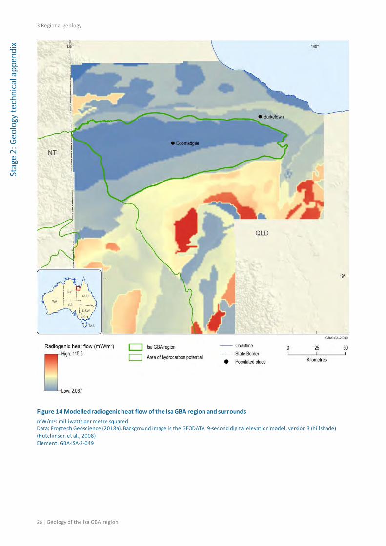
3 Regional geology
26 | Geology of the Isa GBA region
Stag
e 2:
Geo
logy
tech
nica
l app
endi
x
Figure 14 Modelled radiogenic heat flow of the Isa GBA region and surrounds mW/m2: milliwatts per metre squared Data: Frogtech Geoscience (2018a). Background image is the GEODATA 9-second digital elevation model, version 3 (hillshade) (Hutchinson et al., 2008) Element: GBA-ISA-2-049
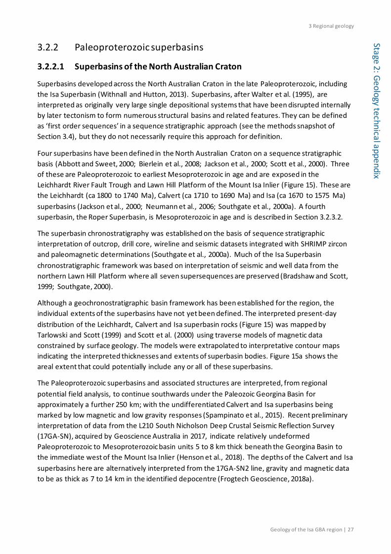
3 Regional geology
Geology of the Isa GBA region | 27
Stage 2: Geology technical appendix
3.2.2 Paleoproterozoic superbasins
3.2.2.1 Superbasins of the North Australian Craton
Superbasins developed across the North Australian Craton in the late Paleoproterozoic, including the Isa Superbasin (Withnall and Hutton, 2013). Superbasins, after Walter et al. (1995), are interpreted as originally very large single depositional systems that have been disrupted internally by later tectonism to form numerous structural basins and related features. They can be defined as ‘first order sequences’ in a sequence stratigraphic approach (see the methods snapshot of Section 3.4), but they do not necessarily require this approach for definition.
Four superbasins have been defined in the North Australian Craton on a sequence stratigraphic basis (Abbott and Sweet, 2000; Bierlein et al., 2008; Jackson et al., 2000; Scott et al., 2000). Three of these are Paleoproterozoic to earliest Mesoproterozoic in age and are exposed in the Leichhardt River Fault Trough and Lawn Hill Platform of the Mount Isa Inlier (Figure 15). These are the Leichhardt (ca 1800 to 1740 Ma), Calvert (ca 1710 to 1690 Ma) and Isa (ca 1670 to 1575 Ma) superbasins (Jackson et al., 2000; Neumann et al., 2006; Southgate et al., 2000a). A fourth superbasin, the Roper Superbasin, is Mesoproterozoic in age and is described in Section 3.2.3.2.
The superbasin chronostratigraphy was established on the basis of sequence stratigraphic interpretation of outcrop, drill core, wireline and seismic datasets integrated with SHRIMP zircon and paleomagnetic determinations (Southgate et al., 2000a). Much of the Isa Superbasin chronostratigraphic framework was based on interpretation of seismic and well data from the northern Lawn Hill Platform where all seven supersequences are preserved (Bradshaw and Scott, 1999; Southgate, 2000).
Although a geochronostratigraphic basin framework has been established for the region, the individual extents of the superbasins have not yet been defined. The interpreted present-day distribution of the Leichhardt, Calvert and Isa superbasin rocks (Figure 15) was mapped by Tarlowski and Scott (1999) and Scott et al. (2000) using traverse models of magnetic data constrained by surface geology. The models were extrapolated to interpretative contour maps indicating the interpreted thicknesses and extents of superbasin bodies. Figure 15a shows the areal extent that could potentially include any or all of these superbasins.
The Paleoproterozoic superbasins and associated structures are interpreted, from regional potential field analysis, to continue southwards under the Paleozoic Georgina Basin for approximately a further 250 km; with the undifferentiated Calvert and Isa superbasins being marked by low magnetic and low gravity responses (Spampinato et al., 2015). Recent preliminary interpretation of data from the L210 South Nicholson Deep Crustal Seismic Reflection Survey (17GA-SN), acquired by Geoscience Australia in 2017, indicate relatively undeformed Paleoproterozoic to Mesoproterozoic basin units 5 to 8 km thick beneath the Georgina Basin to the immediate west of the Mount Isa Inlier (Henson et al., 2018). The depths of the Calvert and Isa superbasins here are alternatively interpreted from the 17GA-SN2 line, gravity and magnetic data to be as thick as 7 to 14 km in the identified depocentre (Frogtech Geoscience, 2018a).
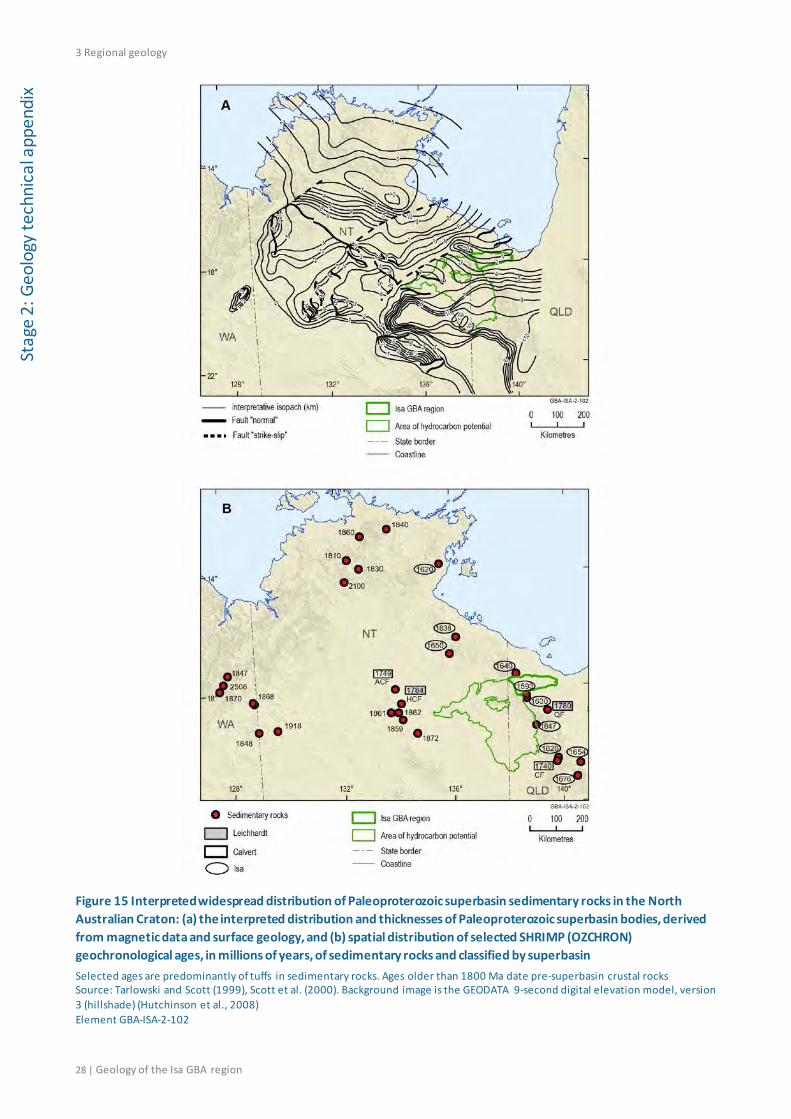
3 Regional geology
28 | Geology of the Isa GBA region
Stag
e 2:
Geo
logy
tech
nica
l app
endi
x
Figure 15 Interpreted widespread distribution of Paleoproterozoic superbasin sedimentary rocks in the North Australian Craton: (a) the interpreted distribution and thicknesses of Paleoproterozoic superbasin bodies, derived from magnetic data and surface geology, and (b) spatial distribution of selected SHRIMP (OZCHRON) geochronological ages, in millions of years, of sedimentary rocks and classified by superbasin Selected ages are predominantly of tuffs in sedimentary rocks. Ages older than 1800 Ma date pre-superbasin crustal rocks Source: Tarlowski and Scott (1999), Scott et al. (2000). Background image is the GEODATA 9-second digital elevation model, version 3 (hillshade) (Hutchinson et al., 2008) Element GBA-ISA-2-102
3 Regional geology
Geology of the Isa GBA region | 29
Stage 2: Geology technical appendix
3.2.2.2 Isa Superbasin
The Isa Superbasin was initiated at approximately 1670 Ma after a major 20 to 25 million-year depositional hiatus (Jackson et al., 2000; Southgate et al., 2000a) and ended with the onset of the Middle Isan Orogeny at about 1575 Ma (Scott and Tarlowski, 1999). The sedimentary succession comprises seven second-order supersequences, which have been subdivided into 30 third-order sequences. These are the Gun 1 to 3, Loretta 1 to 2, River 1 to 8, Term 1 to 5, Lawn 1 to 4, Wide 1 to 3 and Doom 1 to 5 sequences. They include fluvial, coastal and shallow marine sandstone facies, shallow and deep marine carbonate successions and deep water shale or fan deposits (Bradshaw et al., 2000; Krassay et al., 2000b; Krassay et al., 2000a; Southgate et al., 2000a).
Extensive organic-rich shale units in the Isa Superbasin correspond to the periods encompassing maximum marine flooding (highstand intervals) in the marine sediments, with the best developed hydrocarbon source rocks in the River and Lawn supersequences (Gorton and Troup, 2018). Shales of these supersequences on average have more than 2% total organic carbon by weight (Jarrett et al., 2018).
These organic-rich sediments were deposited before the evolution of woody, vascular plants. Organic matter in the northern Lawn Hill Platform sediments may have been derived from planktonic algae (Glikson et al., 2006; Glikson et al., 1992), bacteria (Brocks et al., 2017) or from the growth of microbial mats, such as stromatolites, in Proterozoic marine waters.
The conditions under which the organic matter was preserved in the Isa Superbasin sediments differ substantially from later Phanerozoic marine conditions. Proterozoic organic-rich sediments were deposited under conditions of widespread ocean anoxia in the 1800 to 1000 Ma period (Planavsky et al., 2011). Anoxic conditions in depositional environments are associated with organic matter preservation and can result in enrichment of total organic carbon in sediments.
Some of the traditionally important paleogeographic parameters of Phanerozoic black shale deposition (such restricted circulation and distance from organic matter sources) are less applicable to the interpretation of Proterozoic organic-rich shale development due to these differences in organic matter sources and preservation. Organic-rich shales have the potential to be widely distributed in the marine sedimentary rocks of the Proterozoic superbasins because the conditions for organic matter preservation were more pervasive in the subsurface ocean.
Despite this potential, establishing the current preserved extent of Isa Superbasin sedimentary rocks is difficult due to the geological changes that have occurred in the long period after superbasin formation. The extent of the Isa Superbasin outcrop mapped across the northern and central Lawn Hill Platform region is shown in Figure 16. However, the known occurrence of the Isa Superbasin sequences across the North Australian Craton, indicate that the superbasin’s extent is much broader than its surface exposure and current mapped subsurface extent across the Lawn Hill Platform (Figure 15).
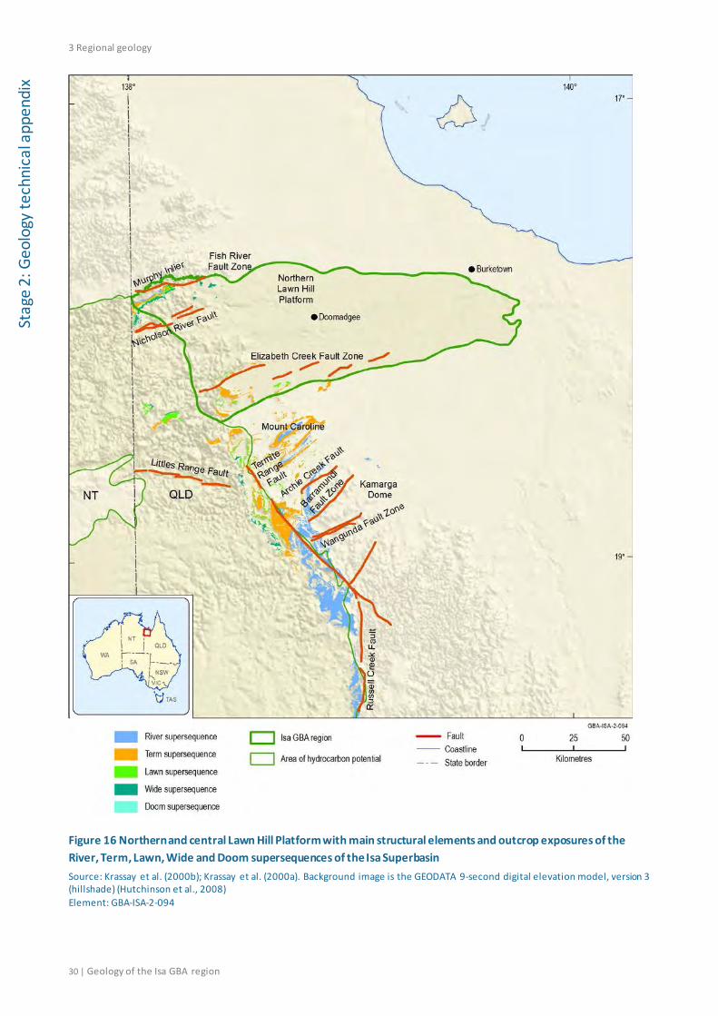
3 Regional geology
30 | Geology of the Isa GBA region
Stag
e 2:
Geo
logy
tech
nica
l app
endi
x
Figure 16 Northern and central Lawn Hill Platform with main structural elements and outcrop exposures of the River, Term, Lawn, Wide and Doom supersequences of the Isa Superbasin Source: Krassay et al. (2000b); Krassay et al. (2000a). Background image is the GEODATA 9-second digital elevation model, version 3 (hillshade) (Hutchinson et al., 2008) Element: GBA-ISA-2-094
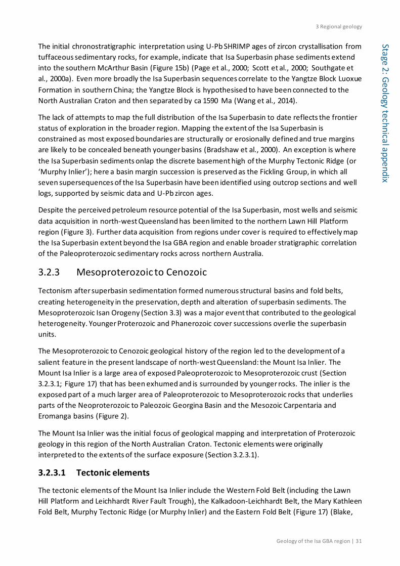
3 Regional geology
Geology of the Isa GBA region | 31
Stage 2: Geology technical appendix
The initial chronostratigraphic interpretation using U-Pb SHRIMP ages of zircon crystallisation from tuffaceous sedimentary rocks, for example, indicate that Isa Superbasin phase sediments extend into the southern McArthur Basin (Figure 15b) (Page et al., 2000; Scott et al., 2000; Southgate et al., 2000a). Even more broadly the Isa Superbasin sequences correlate to the Yangtze Block Luoxue Formation in southern China; the Yangtze Block is hypothesised to have been connected to the North Australian Craton and then separated by ca 1590 Ma (Wang et al., 2014).
The lack of attempts to map the full distribution of the Isa Superbasin to date reflects the frontier status of exploration in the broader region. Mapping the extent of the Isa Superbasin is constrained as most exposed boundaries are structurally or erosionally defined and true margins are likely to be concealed beneath younger basins (Bradshaw et al., 2000). An exception is where the Isa Superbasin sediments onlap the discrete basement high of the Murphy Tectonic Ridge (or ‘Murphy Inlier’); here a basin margin succession is preserved as the Fickling Group, in which all seven supersequences of the Isa Superbasin have been identified using outcrop sections and well logs, supported by seismic data and U-Pb zircon ages.
Despite the perceived petroleum resource potential of the Isa Superbasin, most wells and seismic data acquisition in north-west Queensland has been limited to the northern Lawn Hill Platform region (Figure 3). Further data acquisition from regions under cover is required to effectively map the Isa Superbasin extent beyond the Isa GBA region and enable broader stratigraphic correlation of the Paleoproterozoic sedimentary rocks across northern Australia.
3.2.3 Mesoproterozoic to Cenozoic
Tectonism after superbasin sedimentation formed numerous structural basins and fold belts, creating heterogeneity in the preservation, depth and alteration of superbasin sediments. The Mesoproterozoic Isan Orogeny (Section 3.3) was a major event that contributed to the geological heterogeneity. Younger Proterozoic and Phanerozoic cover successions overlie the superbasin units.
The Mesoproterozoic to Cenozoic geological history of the region led to the development of a salient feature in the present landscape of north-west Queensland: the Mount Isa Inlier. The Mount Isa Inlier is a large area of exposed Paleoproterozoic to Mesoproterozoic crust (Section 3.2.3.1; Figure 17) that has been exhumed and is surrounded by younger rocks. The inlier is the exposed part of a much larger area of Paleoproterozoic to Mesoproterozoic rocks that underlies parts of the Neoproterozoic to Paleozoic Georgina Basin and the Mesozoic Carpentaria and Eromanga basins (Figure 2).
The Mount Isa Inlier was the initial focus of geological mapping and interpretation of Proterozoic geology in this region of the North Australian Craton. Tectonic elements were originally interpreted to the extents of the surface exposure (Section 3.2.3.1).
3.2.3.1 Tectonic elements
The tectonic elements of the Mount Isa Inlier include the Western Fold Belt (including the Lawn Hill Platform and Leichhardt River Fault Trough), the Kalkadoon-Leichhardt Belt, the Mary Kathleen Fold Belt, Murphy Tectonic Ridge (or Murphy Inlier) and the Eastern Fold Belt (Figure 17) (Blake,
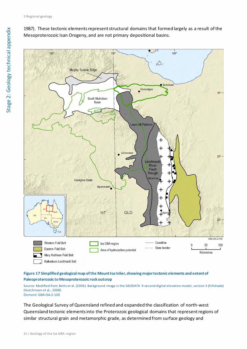
3 Regional geology
32 | Geology of the Isa GBA region
Stag
e 2:
Geo
logy
tech
nica
l app
endi
x 1987). These tectonic elements represent structural domains that formed largely as a result of the Mesoproterozoic Isan Orogeny, and are not primary depositional basins.
Figure 17 Simplified geological map of the Mount Isa Inlier, showing major tectonic elements and extent of Paleoproterozoic to Mesoproterozoic rock outcrop Source: Modified from Betts et al. (2006). Background image is the GEODATA 9-second digital elevation model, version 3 (hillshade) (Hutchinson et al., 2008) Element: GBA-ISA-2-100
The Geological Survey of Queensland refined and expanded the classification of north-west Queensland tectonic elements into the Proterozoic geological domains that represent regions of similar structural grain and metamorphic grade, as determined from surface geology and
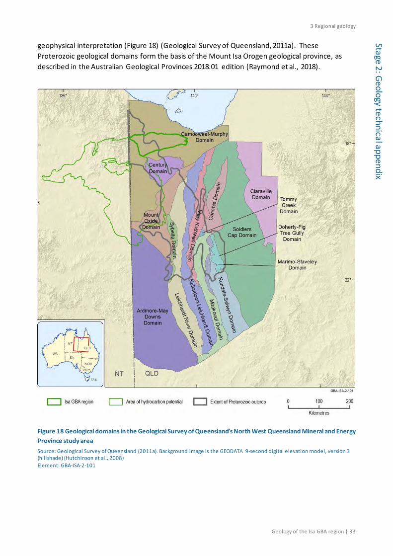
3 Regional geology
Geology of the Isa GBA region | 33
Stage 2: Geology technical appendix
geophysical interpretation (Figure 18) (Geological Survey of Queensland, 2011a). These Proterozoic geological domains form the basis of the Mount Isa Orogen geological province, as described in the Australian Geological Provinces 2018.01 edition (Raymond et al., 2018).
Figure 18 Geological domains in the Geological Survey of Queensland’s North West Queensland Mineral and Energy Province study area Source: Geological Survey of Queensland (2011a). Background image is the GEODATA 9-second digital elevation model, version 3 (hillshade) (Hutchinson et al., 2008) Element: GBA-ISA-2-101
3 Regional geology
34 | Geology of the Isa GBA region
Stag
e 2:
Geo
logy
tech
nica
l app
endi
x 3.2.3.2 Overlying basins
The Isa Superbasin is overlain in the Isa GBA region from the west by the Mesoproterozoic South Nicholson Basin and from the east by the Mesozoic Carpentaria Basin and the Cenozoic Karumba Basin (Figure 19).
The South Nicholson Basin is made up of the South Nicholson Group sedimentary rocks. These rocks form part of the fourth Proterozoic superbasin of the North Australian Craton: the Mesoproterozoic Roper Superbasin (Abbott and Sweet, 2000; Jackson et al., 1999). The Roper Superbasin incorporates the South Nicholson and Roper groups (see Section 3.4.2) of north-west Queensland and the NT in a sequence stratigraphic context. The South Nicholson Group in the Isa GBA region lies over the eroded uppermost supersequence of the Isa Superbasin (Bradshaw et al., 2000).
The Mesozoic Carpentaria Basin overlies the eroded Paleoproterozoic and Mesoproterozoic basin sequences across most of the Isa GBA region (Figure 19). The Karumba Basin forms a thin veneer over the Carpentaria Basin in the Isa GBA region.
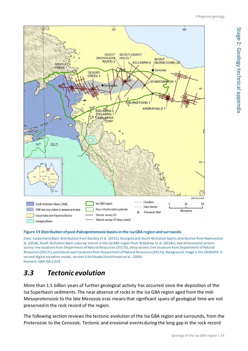
3 Regional geology
Geology of the Isa GBA region | 35
Stage 2: Geology technical appendix
Figure 19 Distribution of post-Paleoproterozoic basins in the Isa GBA region and surrounds Data: Carpentaria Basin distribution from Ransley et al. (2015), Georgina and South Nicholson basins distribution from Raymond et al. (2018), South Nicholson Basin subcrop extent in the Isa GBA region from Bradshaw et al. (2018c), two-dimensional seismic survey line locations from Department of Natural Resources (2017b), deep seismic line locations from Department of Natural Resources (2017c), petroleum well locations from Department of Natural Resources (2017a). Background image is the GEODATA 9-second digital elevation model, version 3 (hillshade) (Hutchinson et al., 2008) Element: GBA-ISA-2-029
3.3 Tectonic evolution More than 1.5 billion years of further geological activity has occurred since the deposition of the Isa Superbasin sediments. The near absence of rocks in the Isa GBA region aged from the mid-Mesoproterozoic to the late Mesozoic eras means that significant spans of geological time are not preserved in the rock record of the region.
The following section reviews the tectonic evolution of the Isa GBA region and surrounds, from the Proterozoic to the Cenozoic. Tectonic and erosional events during the long gap in the rock record
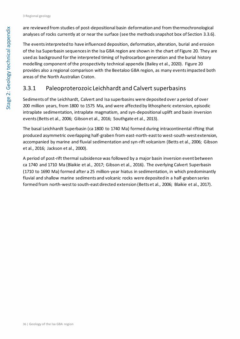
3 Regional geology
36 | Geology of the Isa GBA region
Stag
e 2:
Geo
logy
tech
nica
l app
endi
x are reviewed from studies of post-depositional basin deformation and from thermochronological analyses of rocks currently at or near the surface (see the methods snapshot box of Section 3.3.6).
The events interpreted to have influenced deposition, deformation, alteration, burial and erosion of the Isa Superbasin sequences in the Isa GBA region are shown in the chart of Figure 20. They are used as background for the interpreted timing of hydrocarbon generation and the burial history modelling component of the prospectivity technical appendix (Bailey et al., 2020). Figure 20 provides also a regional comparison with the Beetaloo GBA region, as many events impacted both areas of the North Australian Craton.
3.3.1 Paleoproterozoic Leichhardt and Calvert superbasins
Sediments of the Leichhardt, Calvert and Isa superbasins were deposited over a period of over 200 million years, from 1800 to 1575 Ma, and were affected by lithospheric extension, episodic intraplate sedimentation, intraplate magmatism, and syn-depositional uplift and basin inversion events (Betts et al., 2006; Gibson et al., 2016; Southgate et al., 2013).
The basal Leichhardt Superbasin (ca 1800 to 1740 Ma) formed during intracontinental rifting that produced asymmetric overlapping half-graben from east-north-east to west-south-west extension, accompanied by marine and fluvial sedimentation and syn-rift volcanism (Betts et al., 2006; Gibson et al., 2016; Jackson et al., 2000).
A period of post-rift thermal subsidence was followed by a major basin inversion event between ca 1740 and 1710 Ma (Blaikie et al., 2017; Gibson et al., 2016). The overlying Calvert Superbasin (1710 to 1690 Ma) formed after a 25 million-year hiatus in sedimentation, in which predominantly fluvial and shallow marine sediments and volcanic rocks were deposited in a half-graben series formed from north-west to south-east directed extension (Betts et al., 2006; Blaikie et al., 2017).
3 Regional geology
Geology of the Isa GBA region | 37
Stage 2: Geology technical appendix
Figure 20 Regional Qld-NT comparison of tectonic, igneous, thermal and depositional events interpreted to have affected the Isa (northern Lawn Hill Platform) and Beetaloo (Beetaloo Sub-basin) GBA regions from the time of Isa Superbasin deposition to the present LIP = Large Igneous Province, AFTA = Apatite Fission Track Analysis, K-Ar = potassium-argon dating. Colour scheme is for ease of viewing. This figure has been optimised for printing on A3 paper (297 mm x 420 mm). Source: Tectonic and igneous events from Geological Survey of Queensland (2011a), Scott and Tarlowski (1999), Jackson and Southgate (2000), Giles et al. (2006a), Jackson et al. (1999), Betts et al. (2015), Zhang et al. (2017), Ahmad and Scrimgeour (2013), Walsh et al. (2013), Glass et al. (2013), Marshall et al. (2018), Edgoose and Ahmad (2013); thermal events from Golding et al. (2006), Spikings et al. (2006), Duddy et al. (2003), Delle Piane et al. (2019), Faiz et al. (2016); deposition events from Southgate et al. (2000b), Page et al. (2000), Krassay et al. (2000b), Krassay et al. (2000a), Rawlings (1999), Munson (2016), Betts et al. (2015), Anderson et al. (2019), Munson et al. (2013b), Walter et al. (1995), McConachie et al. (1997), Cook et al. (2013), Cook and Jell (2013), Munson et al. (2013a), Edgoose and Ahmad (2013) Element GBA-ISA-2-012
3 Regional geology
38 | Geology of the Isa GBA region
Stag
e 2:
Geo
logy
tech
nica
l app
endi
x
di
3.3.2 Paleoproterozoic to early Mesoproterozoic Isa Superbasin
The Isa Superbasin was initiated at approximately 1670 Ma after a major 20 to 25 million-year hiatus in sedimentation (Jackson et al., 2000; Southgate et al., 2000a). Sediment deposition terminated at ca 1575 Ma (Southgate et al., 2000a) at the onset of the Middle Isan Orogeny. The Isa Superbasin has been divided into seven supersequences (Gun, Loretta, River, Term, Lawn, Wide, Doom) (e.g. Bradshaw and Scott, 1999), the timing and distribution of which have been strongly influenced by tectonic activity (Betts et al., 2006).
The redeposition of tuffaceous beds, likely sourced from distal fallout from major far-field ignimbrite eruptions, throughout most of the Isa Superbasin sequences suggest that a long-lived magmatic arc was peripheral to the superbasin for much of its history (Southgate et al., 2000a). A north-dipping subduction zone has been interpreted along the southern margin of the North Australian Craton (Figure 21) that was active during the development of the Isa Superbasin (Geological Survey of Queensland, 2011a). The evolution of northern Australia’s superbasins has been increasingly recognised to have been influenced by the distal effects of accretionary events along this southern margin (Betts et al., 2006).
Along the eastern margin an ocean basin opened between the Australian continent and Laurentia (proto-North America) at the time of initiation of Isa Superbasin sedimentation (Figure 21) (Geological Survey of Queensland, 2011a). The eastern margin of the Australian continent is interpreted to have undergone continental thermal subsidence, resulting in broad Isa Superbasin sedimentation, and Laurentia is interpreted to have experienced uplift and erosion, resulting in a depositional hiatus at this time (Geological Survey of Queensland, 2011a).
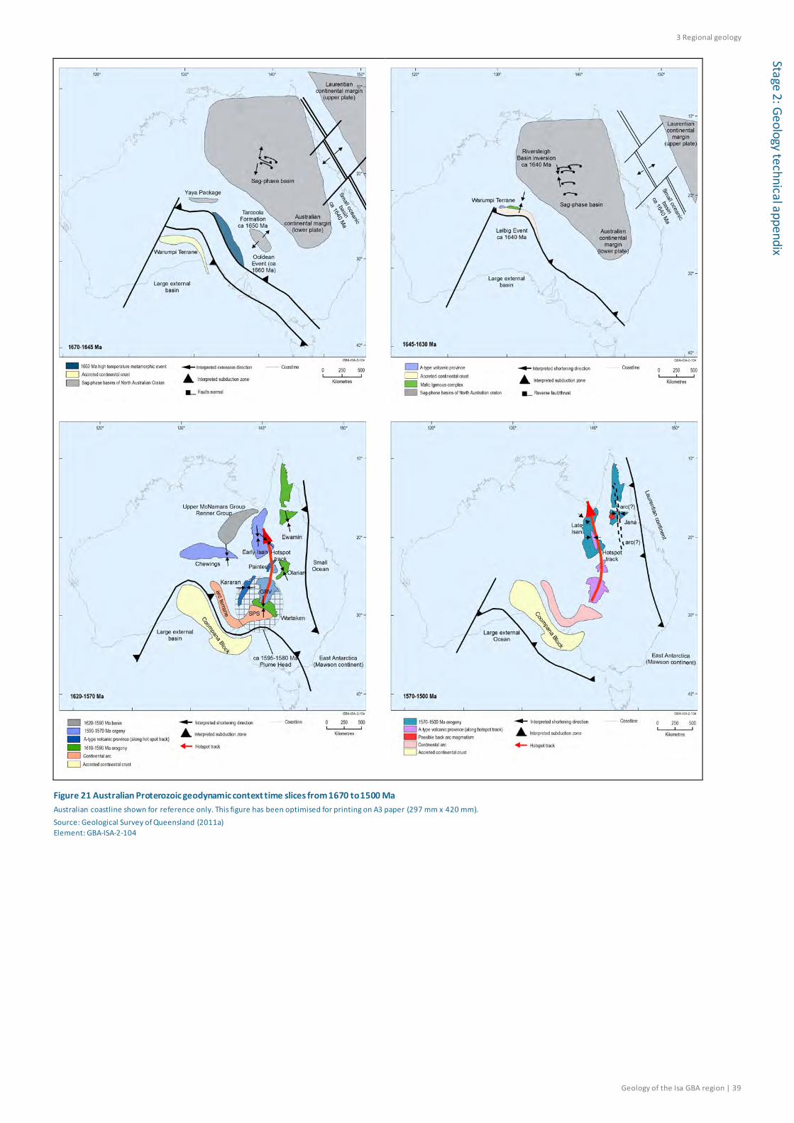
3 Regional geology
Geology of the Isa GBA region | 39
Stage 2: Geology technical appendix
Figure 21 Australian Proterozoic geodynamic context time slices from 1670 to 1500 Ma Australian coastline shown for reference only. This figure has been optimised for printing on A3 paper (297 mm x 420 mm). Source: Geological Survey of Queensland (2011a) Element: GBA-ISA-2-104
3 Regional geology
40 | Geology of the Isa GBA region
Stag
e 2:
Geo
logy
tech
nica
l app
endi
x
di Plate motion changes during Isa Superbasin deposition, evident in palaeomagnetism recorded in
Lawn Hill Platform rocks (Idnurm, 2000), are likely to have produced structural events that changed basin geometry, sediment accommodation rates and sediment supply (Southgate et al., 2000a). Each of the plate motion changes corresponds to a major supersequence boundary (Idnurm, 2000), marking the initiation of the Gun, Loretta, River and Wide supersequences (Southgate et al., 2000a).
Interplate tectonic events at the southern and eastern margins (Figure 21) may have caused the plate motion changes that promoted intraplate deformation (Southgate et al., 2000a). The combination of the opening of the ocean basin in the east at ca 1660 Ma (Geological Survey of Queensland, 2011a) (Figure 21) and compressive tectonic processes beginning at 1680 Ma at the southern convergent margin, created a south-east facing ramp in the Mount Isa region at the initiation of the Isa Superbasin (Southgate et al., 2000b). The ramp, which extended from the Murphy Inlier in the north-west to a depocentre in the south-east, became the depositional setting for the Gun Supersequence (Southgate et al., 2000b) in the Isa GBA region. Strike-slip tectonism, synchronous with 1680 to 1650 Ma orogenic activity at the southern margin, accompanied Gun Supersequence sedimentation (Southgate et al., 2000b).
Active deformation in the northern Lawn Hill Platform is most notable during deposition of the River, Wide and Doom supersequences (Scott et al., 1998; Scott and Tarlowski, 1999). Onset of River Supersequence deposition at ca 1640 Ma was linked to north–south extension (Bradshaw and Scott, 1999), coincident with a plate motion change and interpreted as a response to farfield plate reorganisation (Scott and Tarlowski, 1999). The 1640 to 1630 Ma River Event produced normal faults with downthrow to the north, producing local depocentres within tilt blocks (Scott and Tarlowski, 1999). A probable inversion event also occurred in this period (Scott and Tarlowski, 1999).
After the River Event there is no evidence of active faulting during deposition of the Term and Lawn supersequences, up to ca 1597 Ma. The wrench-style Wide Event of ca 1595 Ma developed a complex strike-slip fault network that was significantly influenced by underlying structures (Scott and Tarlowski, 1999). Sediment thickness changes across the faults indicate syn-tectonic growth of the Wide Supersequence, particularly along north-east trending splays (Scott and Tarlowski, 1999).
3.3.3 Mesoproterozoic Isan Orogeny
Concomitant with, and perhaps related to, changes in basin architecture were indications of the early development of the Isan Orogeny during 1600 to 1580 Ma (Giles et al., 2006a), or Early Isan Orogeny (Geological Survey of Queensland, 2011a). The early orogenic phases are marked by the progressive decrease in accommodation space of the Doom Supersequence, the uppermost Isa Superbasin supersequence (Scott et al., 1998; Scott and Tarlowski, 1999). Joint patterns in the Doom Supersequence in the northern Lawn Hill Platform suggest north to south compression (Scott and Tarlowski, 1999), while regionally both north to south and north-west to south-east shortening are evident (Geological Survey of Queensland, 2011a).
Deposition of the Isa Superbasin ended at about 1575 Ma (Southgate et al., 2000a) with the onset of the Middle Isan Orogeny. This represented a period of major east to west shortening that included reverse reactivation of faults (1570 to 1550 Ma), followed by a transition from ductile to
3 Regional geology
Geology of the Isa GBA region | 41
Stage 2: Geology technical appendix
brittle deformation, characterised by wrench tectonics (1550 to 1540 Ma) (Abu Sharib and Sanislav, 2013; Frogtech Geoscience, 2018a; Geological Survey of Queensland, 2011a). A peak in metamorphism occurred between 1540 and 1530 Ma in the western Mount Isa Inlier (Giles et al., 2006b). Isan Orogeny metamorphic grade varies by geological domain (Figure 18), increasing from sub-greenschist facies in the north-west to upper amphibolite facies in the south-east, where maximum temperatures and pressures of 650 to 700 °C and 400 to 600 MPa were reached (Giles et al., 2006b and references therein).
The Late Isan Orogeny (ca 1530 to 1500 Ma) was characterised by east-south-east to west-north-west shortening and brittle fault reactivation (Geological Survey of Queensland, 2011a). Collision between Laurentia and Australia on the eastern margin of the continent (Figure 21) is interpreted to have caused the extensive east-west shortening of the Middle and Late Isan orogenic phases (Geological Survey of Queensland, 2011a).
The Isan Orogeny was superimposed on crust that was already unusually hot (Giles et al., 2006a; Giles et al., 2006b). Igneous rocks of the Mount Isa Inlier emplaced both before and during the Isan Orogeny were enriched in heat-producing radiogenic isotopes, believed to have increased geothermal gradients, weakened continental crust and increased hydrothermal fluid flow (Gessner, 2011). Hydrothermal alteration was extensive but varied regionally (Duncan et al., 2014). Higher geothermal gradients in the Eastern Fold Belt domains created more vigorous fluid flow and large-scale fluid mixing, whereas in the west geographically separate areas produced distinct fluids (Duncan et al., 2014).
The Isan Orogeny contributed to the complex juxtaposition of fault blocks on the Mount Isa and Murphy inliers that vary in metamorphic grade, intensity of deformation and age (Spikings et al., 2006). The Isa GBA region, located in the Camooweal–Murphy Domain (Figure 18), did not receive the full impact of orogenic deformation and metamorphism as experienced in those domains to the south and south-east. Further detail on the impact of the Isan Orogeny on the Isa Superbasin units in the Isa GBA region is provided in Section 4.1.
3.3.4 Mesoproterozoic erosion and South Nicholson Basin
After the Isan Orogeny the North Australian Craton was tectonically reactivated and cooled several times in response to supercontinent amalgamation and break-up (Golding et al., 2006; Spikings et al., 1997; Spikings et al., 2006; Spikings et al., 2002). The Proterozoic rocks of the Mount Isa Inlier and northern Lawn Hill Platform experienced thermal events that are revealed by thermochronological analyses, as explained in the methods snapshot box ahead (Section 3.3.6). Uplifted regions experienced erosional cooling and contemporaneous basin regions experienced heating from sediment burial.
Lithospheric extension associated with the separation of the North Australian Craton from Laurentia led to Mesoproterozoic basin formation (Yang et al., 2018). Sedimentation in the Mesoproterozoic South Nicholson Basin (Figure 19) is generally interpreted to have begun after 1500 Ma following the prolonged period of deformation during the Isan Orogeny (Frogtech Geoscience, 2018a; Jackson et al., 1999; Rawlings et al., 2008; Sweet, 2017). Erosional cooling of the Isa Superbasin rocks in the southern central Lawn Hill Platform at 1500 Ma indicate a potential provenance region for South Nicholson Basin sediments at this time (Golding et al., 2006).

3 Regional geology
42 | Geology of the Isa GBA region
Stag
e 2:
Geo
logy
tech
nica
l app
endi
x
di Provenance analysis of other Mesoproterozoic sedimentary units in the NT suggests that the
sediments were initially sourced from the Mount Isa Orogen and other eastern areas due to erosion after the Isan Orogeny (Yang et al., 2019).
The South Nicholson Basin fill thickens significantly to the west from the Isa GBA region. Direct ages have not been determined for the South Nicholson Basin, as ages from the constituent South Nicholson Group units are controlled by recycled older crustal material (Carson et al., 2011). Recent geochronological data suggest that the South Nicholson Group is temporally related to the Roper Group of the NT, with deposition from 1483 Ma to before 1266 Ma, the latter being the age of post-diagenetic fluid flow in the sampled units (Anderson et al., 2019).
40Ar-39Ar analyses by Perkins et al. (1999) and Spikings et al. (2002) suggest that erosional cooling of the Mount Isa Inlier region occurred after 1460 Ma and reached the highest erosion rates between 1440 and 1390 Ma. Differential uplift and fault-related tectonic activity continued in the Mount Isa Inlier after the end of the Isan Orogeny (Perkins et al., 1999). High grade metamorphic rocks were uplifted along faults to their present position after 1460 Ma (Perkins et al., 1999).
Tectonic activity is also recorded by syn-depositional deformation of the South Nicholson Basin sediments. Inversion, associated with faulting and minor uplift along mainly east-north-east trending faults, affected the regional distribution of the lower South Nicholson Basin units in Queensland (Sweet, 2017). Another period of inversion led to an unconformity associated with folding and uplift within the upper units (Sweet, 2017). Thrust faulting, of up to one kilometre vertical displacement along the Elizabeth Creek Fault Zone west of the Isa GBA region (Section 4.1), occurred during and after deposition of the South Nicholson Group (Sweet, 2017).
Figure 22 Illite K-Ar ages with interpreted thermal and tectonic events experienced by rocks of the northern and central Lawn Hill Platform X axis indicates sample number. Source: Uysal et al. (2004) Element: GBA-ISA-2-112

3 Regional geology
Geology of the Isa GBA region | 43
Stage 2: Geology technical appendix
Thermal pulse or hydrothermal fluid flow events occurred in the central Lawn Hill Platform between 1440 and 1400 Ma (Golding et al., 2006) (Figure 22). High heating rates and temperatures of up to 350 °C experienced in this period were focused around the Termite Range Fault (Figure 16) (Golding et al., 2006).
Crustal cooling from 1400 to 1300 Ma followed on the Lawn Hill Platform (Golding et al., 2006). In this 1400 to 1300 Ma period the North Australian Craton began to separate from the North China Craton as part of the final break-up of the Nuna (Columbia) supercontinent (Zhang et al., 2017).
3.3.5 Mesoproterozoic non-deposition and basin inversion
Tectonic deformation terminated South Nicholson Basin sedimentation (Sweet, 2017). The timing is poorly known but likely to be before 1324 Ma by correlation with the end of Mesoproterozoic Roper Group deposition in the NT (Sweet, 2017). Plume-related uplift of northern Australia during the break-up of the Nuna supercontinent may have terminated Roper Group deposition (Yang et al., 2019; Zhang et al., 2017).
Widespread moderate deformation of the South Nicholson Group occurred at a later period (Sweet, 2017). North-block-up movement on east-north-east to east trending faults indicate north-north-west to south-south-east compression (Sweet, 2017). Minor thrusting and strike-slip movement occurred on predominantly high angle reverse faults (Sweet, 2017).
The deformation likely corresponded to a regionally extensive compressional event in the NT termed the Post-Roper Inversion (Rawlings et al., 1997). The timing of the Post-Roper Inversion is unconstrained and may relate to any of the Mesoproterozoic orogenic events that affected large tracts of central Australia between 1300 and 1050 Ma (Betts et al., 2015).
The northern Lawn Hill Platform experienced a further thermal event in the later Mesoproterozoic, between 1250 and 1150 Ma (Golding et al., 2006) (Figure 22). A thermal pulse and likely hydrothermal fluid flows crystallised illite in the Isa Superbasin rocks, including those sampled from the Desert Creek and Egilabria wells in the Isa GBA region (Golding et al., 2006; Uysal et al., 2004). The timing coincides in part with the 1200 to 1160 Ma Musgrave Orogeny of central Australia (Ahmad and Scrimgeour, 2013). Hydrothermal events in the Isa GBA region are interpreted to have particularly affected rocks near faults, near supersequence and sequence boundaries, away from the northern Lawn Hill Platform onlap margin in the north and below the shallowest stratigraphic levels of the Isa Superbasin sequences (Glikson et al., 2006).
3.3.6 Neoproterozoic to Paleozoic
The near absence of rocks in the Isa GBA region aged from the mid-Mesoproterozoic to the late Mesozoic eras indicates that significant spans of geological time are not preserved in the rock record in the region. However, the tectonic history of the broader region can be still interpreted using a range of thermochronological analyses (see method box for further details). Those events interpreted to directly affect the Isa GBA region are selected from the broader regional review and summarised in Figure 20. They inform the interpreted timing of hydrocarbon generation and the burial history modelling component of the prospectivity technical appendix (Bailey et al., 2020).
3 Regional geology
44 | Geology of the Isa GBA region
Stag
e 2:
Geo
logy
tech
nica
l app
endi
x
di
Methods snapshot: measuring temperature changes through time on the Mount Isa Inlier
The tectonic history of the Mount Isa Inlier and northern Lawn Hill Platform, after the Isan Orogeny, is interpreted regionally using a range of thermochronological analyses, including 40Ar/39Ar (Perkins et al., 1999; Spikings et al., 2001, 2002), K-Ar (Golding et al., 2006) and fission track (Spikings et al., 1997; Spikings et al., 2006), which date the temperature changes experienced by the rocks through geological time. These studies, in conjunction with evidence of syn- and post-depositional basin deformation, are used to describe tectonic events that may explain spatial heterogeneity in the thermal history of the Lawn Hill Platform. These differences in thermal history can be related to hydrocarbon generation and expulsion in and around the Isa GBA region.
K-Ar (40K/40Ar), and the related 40Ar/39Ar, analyses estimate the amount of time since rocks cooled through mineral crystallisation temperatures by measuring the products of radioactive decay preserved in the minerals since their formation. As the temperature windows differ by mineral types the techniques enable quantification of the rate, timing and magnitude of crustal cooling, which can be further related to crustal exhumation and fault displacements. Ages from within the Isa GBA region and proximally to the south were obtained using K-Ar dating from illite in Isa Superbasin mudstones, siltstones and carbonates of the northern and central Lawn Hill Platform (Golding et al., 2006). In conjunction with the K-Ar analyses, illite and chlorite crystallinity values are used to obtain temperature estimates for the formation of the clays and organic matter reflectance values to determine maximum paleotemperatures reached (Golding et al., 2006).
Apatite fission track analysis provides information on the cooling history of the Mount Isa Inlier after the Proterozoic (Spikings et al., 1997; Spikings et al., 2006). Fission track analyses record the accumulation over time of linear damage tracks caused by spontaneous nuclear fission of 238U that are preserved in apatite crystals after rocks cool to below 110 °C. Apatite fission track analyses were undertaken by Spikings et al. (1997) for rocks exposed across the southern half of the Mount Isa Inlier and by Spikings et al. (2006) for those of both the Mount Isa and Murphy inliers.
The timing of thermal changes in the rocks of the Mount Isa Inlier and northern Lawn Hill Platform is measurable at the temperature windows of mineral crystallisation and the formation of fission tracks in crystals, but between these temperature windows there are periods of geological time over which thermal changes will not be recorded using current techniques.
Changes in temperature recorded in the region relate to cooling periods in which rocks progressively approached the surface. Increased rates of cooling and exhumation of the northern Kalkadoon-Leichhardt Belt (Figure 17; Figure 18) over the 600 to 400 Ma period is suggested by modelling of 40Ar/39Ar thermochronological data (Spikings et al., 2002). The cooling may be a response to the amalgamation of Gondwana, which included events such as the 580 to 530 Ma Petermann Orogeny (Spikings et al., 2002).
3 Regional geology
Geology of the Isa GBA region | 45
Stage 2: Geology technical appendix
Sediments of the central-northern platform succession of the Georgina Basin, located to the south of the Isa GBA region in the area of hydrocarbon potential, were deposited in this period, from the Neoproterozoic (Ediacaran) to Paleozoic (Cambrian). Unlike the southern Georgina Basin, the thin cover of sediments on the platform are little deformed and flat-lying (Munson, 2014).
Modelling of fission track data suggests that an episode of relatively rapid cooling of the Mount Isa and Murphy inliers occurred between 350 and 250 Ma, during the Carboniferous and early Permian periods (Spikings et al., 1997; Spikings et al., 2006). More than two kilometres of erosional exhumation occurred across the Mount Isa and Murphy inliers at that time, broadly coincident with intracontinental deformation associated with the Alice Springs Orogeny and Australian eastern margin events (Spikings et al., 2006). Intracratonic stresses associated with orogenic events may have led to erosional cooling of the inlier rocks by around 30°C or more (Spikings et al., 1997). Variable cooling histories of fault-bounded blocks indicate reactivation of minor faults and segments of major faults since ca 350 Ma (Spikings et al., 2006).
This was followed by a period of relative tectonic stability between the Late Permian to Early Cretaceous (Spikings et al., 2006).
3.3.7 Mesozoic Carpentaria Basin
The Carpentaria Basin (Figure 23) deepens to the north from the Carpentaria Lowlands and underlies most of the Gulf of Carpentaria (Bradshaw et al., 2009; McConachie et al., 1997). The onshore Carpentaria Basin is the northernmost of a number of onshore basins that consist of Mesozoic sediments deposited during Cretaceous marine incursion across the Australian continent. Marine transgression commenced in the earliest Cretaceous and reached the maximum extent across more than half of the Australian continent during the Aptian (125 to 113 Ma) (Campbell and Haig, 1999).
Four sub-basins are recognised in the onshore and offshore Carpentaria Basin (Figure 23) based on the provenance and timing of Mesozoic sedimentary fill: the Western Gulf, Weipa, Staaten and Boomarra sub-basins (McConachie et al., 1990). The thickest section, of 1600 m, is offshore in the Weipa Sub-basin (McConachie et al., 1990). Sediments of Jurassic age are confined primarily to the Weipa and Staaten sub-basins (McConachie et al., 1990).
The Isa GBA region is located in the southern Staaten Sub-basin and the Western Gulf Sub-basin (Figure 23). It consists almost entirely of Cretaceous sediments (Section 3.4.3). The present boundaries of the Carpentaria Basin, in the vicinity of the Isa GBA region, are erosional (Figure 2) and the original extent of the basin was once much greater (Figure 23). Seismic interpretation suggests that at least 700 m of Cretaceous strata may have been eroded from over the western part of the Isa GBA region (Section 4.2.3).
The offshore Carpentaria Basin formed from relatively uniform flexural downwarping, with some reactivation of basement faults before Mesozoic sedimentation (McConachie et al., 1997). It experienced only minor extensional tectonism during its evolution, according to seismic interpretation of the Gulf of Carpentaria and Weipa regions (McConachie et al., 1990) and minor fault growth during the Jurassic and Cretaceous (McConachie et al., 1997). The nature of minor
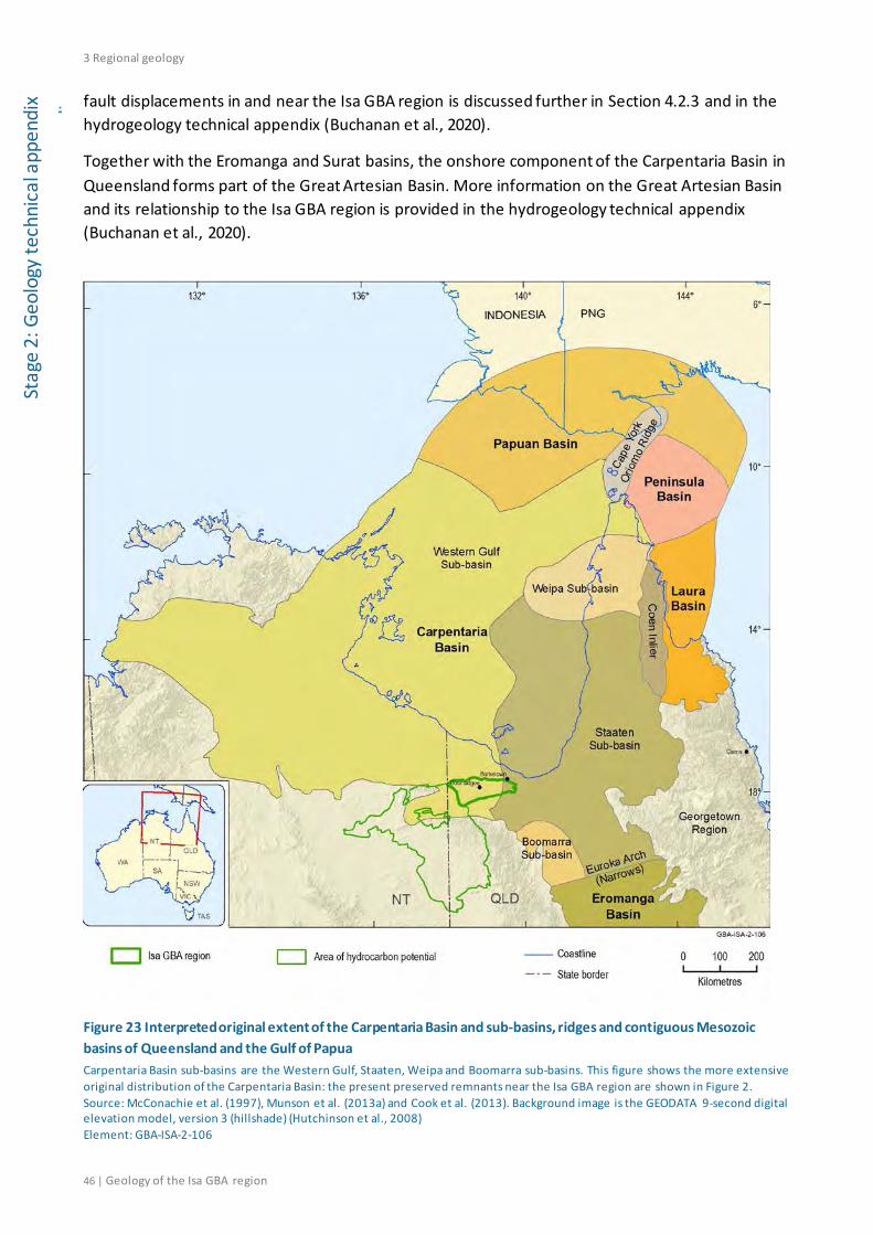
3 Regional geology
46 | Geology of the Isa GBA region
Stag
e 2:
Geo
logy
tech
nica
l app
endi
x
di fault displacements in and near the Isa GBA region is discussed further in Section 4.2.3 and in the
hydrogeology technical appendix (Buchanan et al., 2020).
Together with the Eromanga and Surat basins, the onshore component of the Carpentaria Basin in Queensland forms part of the Great Artesian Basin. More information on the Great Artesian Basin and its relationship to the Isa GBA region is provided in the hydrogeology technical appendix (Buchanan et al., 2020).
Figure 23 Interpreted original extent of the Carpentaria Basin and sub-basins, ridges and contiguous Mesozoic basins of Queensland and the Gulf of Papua Carpentaria Basin sub-basins are the Western Gulf, Staaten, Weipa and Boomarra sub-basins. This figure shows the more extensive original distribution of the Carpentaria Basin: the present preserved remnants near the Isa GBA region are shown in Figure 2. Source: McConachie et al. (1997), Munson et al. (2013a) and Cook et al. (2013). Background image is the GEODATA 9-second digital elevation model, version 3 (hillshade) (Hutchinson et al., 2008) Element: GBA-ISA-2-106

3 Regional geology
Geology of the Isa GBA region | 47
Stage 2: Geology technical appendix
3.3.8 Cenozoic erosion and Karumba Basin
Much of the original distribution of Carpentaria Basin fill has been eroded to the present distribution indicated in Figure 2 (Section 3.3.7). Erosion of the Carpentaria Basin cover (Section 3.3.7) appears to coincide with erosion also of the Mount Isa Inlier rocks. Modelling of fission track data from the Mount Isa Inlier suggest that around 30 to 50 °C of cooling occurred within the last 100 Ma, corresponding to approximately 1.2 to 2.0 km of exhumation for an assumed geothermal gradient of 25 °C per km (Spikings et al., 1997).
Duddy et al. (2003) compiled apatite fission track analysis results across northern Australia and interpreted Cenozoic uplift and erosion that was widely experienced in northern and north-western basin areas during the Eocene, Oligocene and Pliocene to recent epochs. The erosion may be related to Oligocene to Miocene collision at the northern margin of the Australian plate.
The Carpentaria Basin is unconformably overlain by the Cenozoic Karumba Basin, which extends into the NT and parts of Papua New Guinea. Mid-Cretaceous extensional tectonics in eastern Australia may have initiated the Karumba Basin while Cenozoic collision at the northern Australian margin contributed regionally to its sedimentation and growth (Spikings et al., 2006 and references therein). More locally the erosion of the Mount Isa Inlier may have provided a sedimentary source for the Cenozoic Karumba Basin in the Gulf of Carpentaria (Spikings et al., 1997). The Karumba Basin experienced periodic localised deformation during its evolution (Bradshaw et al., 2009; McConachie et al., 1997).
3.4 Stratigraphy and depositional environments The following section describes the stratigraphy and depositional environments of the Isa Superbasin and the overlying South Nicholson, Carpentaria and Karumba basins (Figure 24). Published stratigraphic frameworks for basins in the Isa GBA region vary between the sub-disciplines of sequence stratigraphy and lithostratigraphy. The Isa Superbasin is described using sequence stratigraphy, whereas the Carpentaria and Karumba basins are described using lithostratigraphy. Both approaches are applied to the South Nicholson Basin.
Methods snapshot: sequence stratigraphy vs lithostratigraphy
The supersequences and sequences of sequence stratigraphy are composed of genetically linked strata related in time. Supersequences are controlled by the periodicity of tectonic evolution; third-order sequences encompass conformable lowstand tract to highstand tract sedimentation (that is, sedimentation controlled by relative sea level change from the initial marine flooding surface to the maximum marine flooding surface); and sediment lithologies vary not only temporally but laterally for the sequences to encompass these cycles. The boundaries between sequences are time-correlative. The implication of sequence stratigraphy is that the lithological characteristics of sediments assigned to a sequence in one area may be different from those of the same sequence and age in another area. Accordingly, the descriptions provided here for the Isa Superbasin describe locations and lateral variations in the lithology of sediments within each of the supersequences as well as changes over time.

3 Regional geology
48 | Geology of the Isa GBA region
Stag
e 2:
Geo
logy
tech
nica
l app
endi
x
di By contrast, units in lithostratigraphy are defined on mappable units of comparable lithology
or similar properties, in which a formation is the unit based on primary lithology. Formations may be subdivided into members or beds or aggregated with other formations into groups. The descriptions provided here for the South Nicholson Basin, Carpentaria and Karumba basins refer to the primary lithological characteristics of the formations, beds and groups in the region, and as the classification is based on these characteristics there is not the same requirement to describe lateral variations.
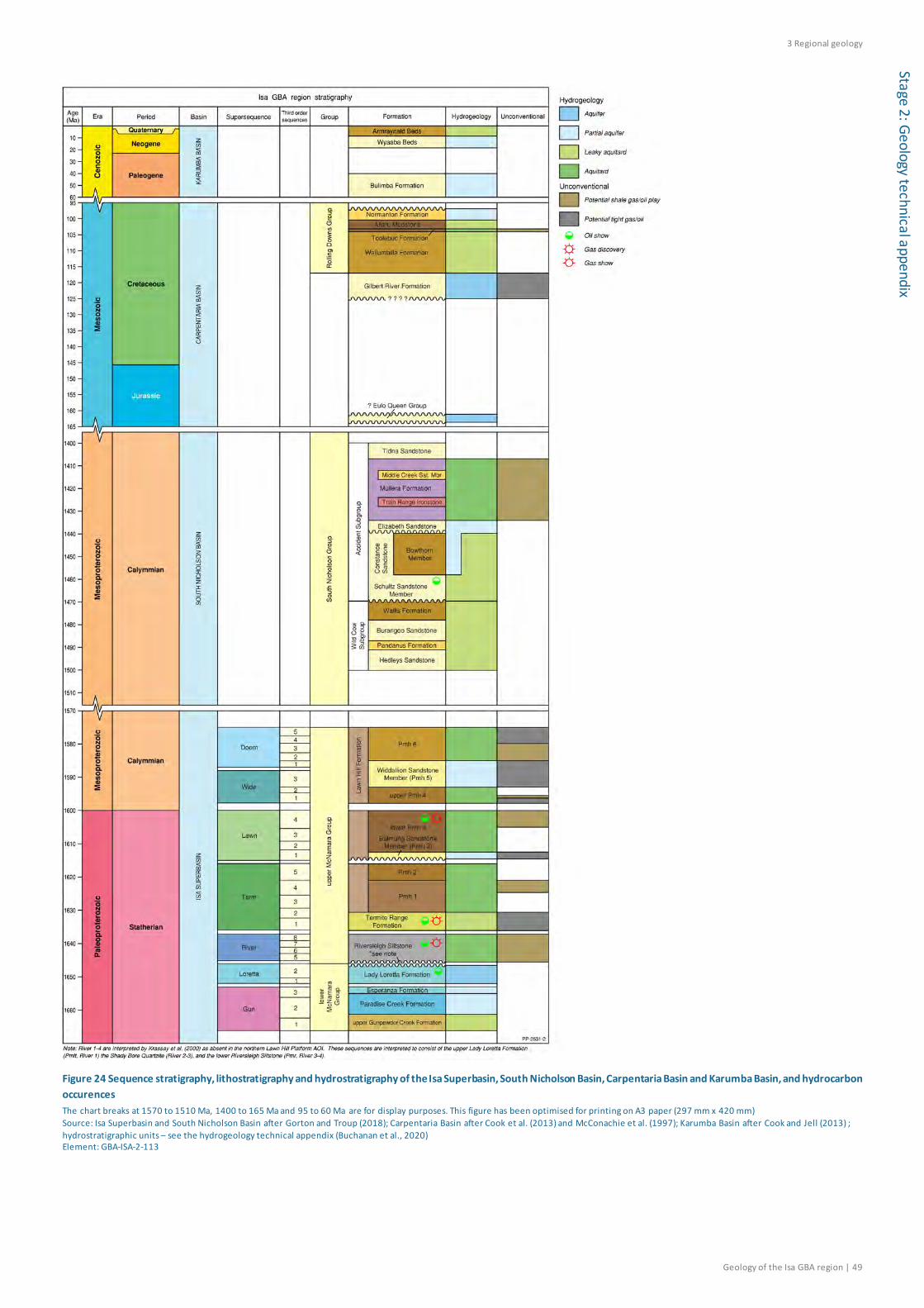
3 Regional geology
Geology of the Isa GBA region | 49
Stage 2: Geology technical appendix
Figure 24 Sequence stratigraphy, lithostratigraphy and hydrostratigraphy of the Isa Superbasin, South Nicholson Basin, Carpentaria Basin and Karumba Basin, and hydrocarbon occurences The chart breaks at 1570 to 1510 Ma, 1400 to 165 Ma and 95 to 60 Ma are for display purposes. This figure has been optimised for printing on A3 paper (297 mm x 420 mm) Source: Isa Superbasin and South Nicholson Basin after Gorton and Troup (2018); Carpentaria Basin after Cook et al. (2013) and McConachie et al. (1997); Karumba Basin after Cook and Jell (2013) ; hydrostratigraphic units – see the hydrogeology technical appendix (Buchanan et al., 2020) Element: GBA-ISA-2-113
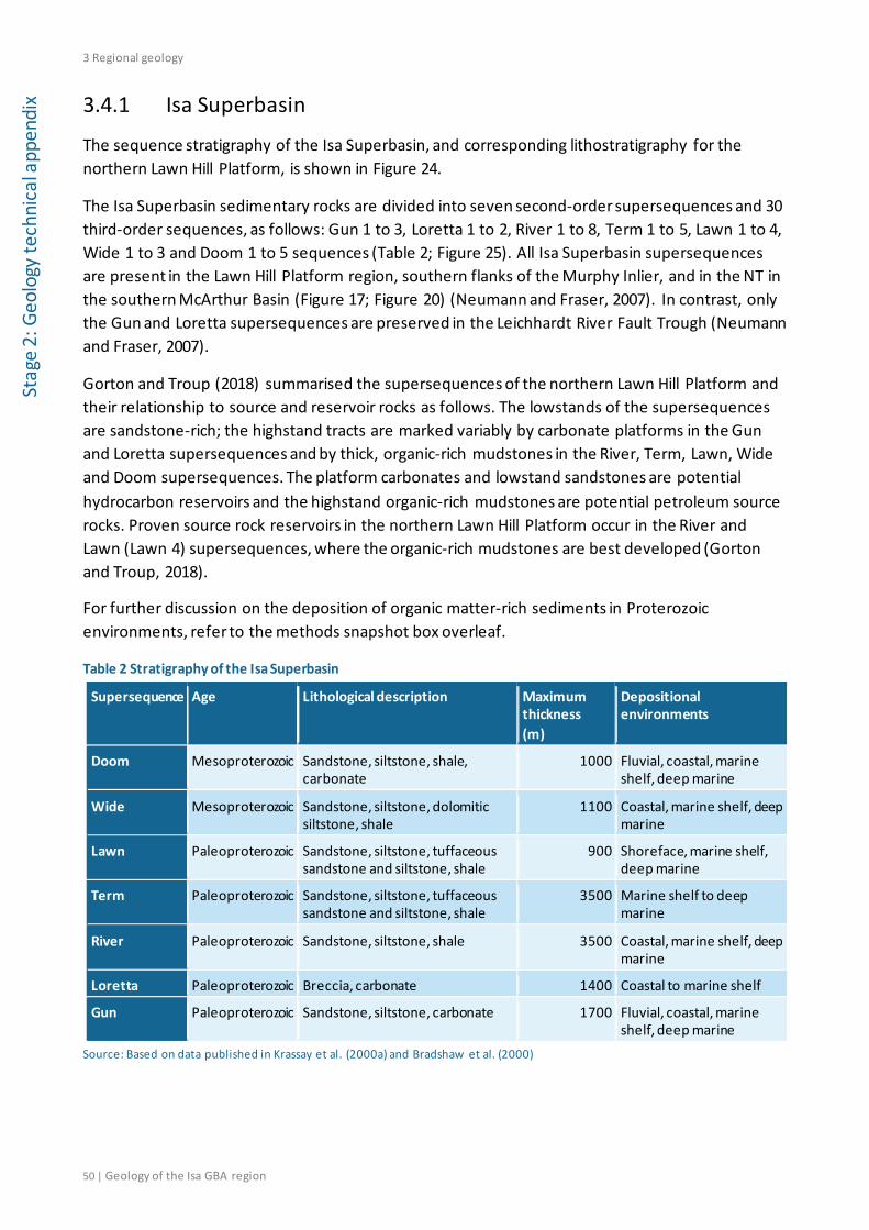
3 Regional geology
50 | Geology of the Isa GBA region
Stag
e 2:
Geo
logy
tech
nica
l app
endi
x 3.4.1 Isa Superbasin
The sequence stratigraphy of the Isa Superbasin, and corresponding lithostratigraphy for the northern Lawn Hill Platform, is shown in Figure 24.
The Isa Superbasin sedimentary rocks are divided into seven second-order supersequences and 30 third-order sequences, as follows: Gun 1 to 3, Loretta 1 to 2, River 1 to 8, Term 1 to 5, Lawn 1 to 4, Wide 1 to 3 and Doom 1 to 5 sequences (Table 2; Figure 25). All Isa Superbasin supersequences are present in the Lawn Hill Platform region, southern flanks of the Murphy Inlier, and in the NT in the southern McArthur Basin (Figure 17; Figure 20) (Neumann and Fraser, 2007). In contrast, only the Gun and Loretta supersequences are preserved in the Leichhardt River Fault Trough (Neumann and Fraser, 2007).
Gorton and Troup (2018) summarised the supersequences of the northern Lawn Hill Platform and their relationship to source and reservoir rocks as follows. The lowstands of the supersequences are sandstone-rich; the highstand tracts are marked variably by carbonate platforms in the Gun and Loretta supersequences and by thick, organic-rich mudstones in the River, Term, Lawn, Wide and Doom supersequences. The platform carbonates and lowstand sandstones are potential hydrocarbon reservoirs and the highstand organic-rich mudstones are potential petroleum source rocks. Proven source rock reservoirs in the northern Lawn Hill Platform occur in the River and Lawn (Lawn 4) supersequences, where the organic-rich mudstones are best developed (Gorton and Troup, 2018).
For further discussion on the deposition of organic matter-rich sediments in Proterozoic environments, refer to the methods snapshot box overleaf.
Table 2 Stratigraphy of the Isa Superbasin
Supersequence Age Lithological description Maximum thickness (m)
Depositional environments
Doom Mesoproterozoic Sandstone, siltstone, shale, carbonate
1000 Fluvial, coastal, marine shelf, deep marine
Wide Mesoproterozoic Sandstone, siltstone, dolomitic siltstone, shale
1100 Coastal, marine shelf, deep marine
Lawn Paleoproterozoic Sandstone, siltstone, tuffaceous sandstone and siltstone, shale
900 Shoreface, marine shelf, deep marine
Term Paleoproterozoic Sandstone, siltstone, tuffaceous sandstone and siltstone, shale
3500 Marine shelf to deep marine
River Paleoproterozoic Sandstone, siltstone, shale 3500 Coastal, marine shelf, deep marine
Loretta Paleoproterozoic Breccia, carbonate 1400 Coastal to marine shelf
Gun Paleoproterozoic Sandstone, siltstone, carbonate 1700 Fluvial, coastal, marine shelf, deep marine
Source: Based on data published in Krassay et al. (2000a) and Bradshaw et al. (2000)

3 Regional geology
Geology of the Isa GBA region | 51
Stage 2: Geology technical appendix
Figure 25 Chronostratigraphic chart for the Isa Superbasin and Calvert Superbasin, south to north across the northern Lawn Hill Platform Source: Bradshaw and Scott (1999) Element: GBA-ISA-2-115
3 Regional geology
52 | Geology of the Isa GBA region
Stag
e 2:
Geo
logy
tech
nica
l app
endi
x
Methods snapshot: Proterozoic depositional environments
Proterozoic depositional environments of organic matter-rich sediments differ in some key aspects from Phanerozoic environments. Organic-rich shale formation requires both low energy and low oxygen depositional environments in a sediment-starved setting to allow organic matter concentration. In the Proterozoic this was assisted by widespread ocean anoxia that corresponded to the return to low atmospheric oxygen levels by ca 1850 Ma, after the Great Oxidation Event (Daines et al., 2017; Planavsky et al., 2014). Atmospheric oxygen and ocean oxygenation remained low, barring transient excursions, until they eventually approached modern levels during about 600 to 400 Ma (Daines et al., 2017). Anoxic (Fe2+- rich) conditions were widespread in the mid-Proterozoic ocean in the 1800 to 1000 Ma period (Planavsky et al., 2011).
Proterozoic sediments were deposited before the evolution of woody, vascular plants. Organic matter in the northern Lawn Hill Platform sediments may have been derived from planktonic algae, interpreted as Botryococcus, based on the imaging of algal cell walls in younger undermature alginite in Cambrian Georgina Basin sediments and compared on a maturation scale to the middle Proterozoic alginite of the McArthur Basin (Glikson et al., 2006; Glikson et al., 1992; Gorton and Troup, 2018). Alternatively bacteria may have been the dominant primary producers of oceanic sedimentary organic matter before the Neoproterozoic (Brocks et al., 2017). In either case, alginite dominated the resulting macerals; analysis of samples collected from Isa Superbasin source rocks consistently indicate alginite, pyrobitumen and bitumen as the primary organic matter types (Energy Resources Consulting, 2017; Glikson et al., 2006).
Organic matter deposition may also occur in shallow waters from the growth of microbial mats, such as stromatolites. Proterozoic carbonate platforms are believed to have developed from the accretion of carbonate sediments by stromatolites, as they are the principal component of Proterozoic platform and shelf carbonates (Grotzinger and Knoll, 1999).
3.4.1.1 Gun Supersequence
The Gun Supersequence (1670 to 1655 Ma) developed as a response to sinistral strike-slip tectonism associated with compressive stresses generated in central Australia (Southgate et al., 2000b). Ancestral north and north-east structures in the Leichhardt River Fault Trough and Lawn Hill Platform controlled deposition of the Gun Supersequence in these locations (Southgate et al., 2000b).
All three third-order sequences recognised in the Gun Supersequence are present on the Lawn Hill Platform south of the Isa GBA region and in the Leichhardt River Fault Trough, while only Gun 2 and Gun 3 are in the Isa GBA region on the northern Lawn Hill Platform (Southgate et al., 2000a). The supersequence was deposited on a ramp; by terminal Gun 2 time it extended from the Murphy Inlier in the north-west to a depocentre in the south-east (Southgate et al., 2000b). Siliciclastic shoreline facies developed in the north and west and deeper water basinal facies to the east and south, shown by facies maps for an area south of the Isa GBA region in Figure 26 (Southgate et al., 1999; Southgate et al., 2000b).
3 Regional geology
Geology of the Isa GBA region | 53
Stage 2: Geology technical appendix
The Gun Supersequence can be characterised laterally by transitions from fluvial and coastal facies in the north and west to progressively peritidal, inner to outer ramp carbonate facies and deeper water, fine-grained siliciclastic and carbonate rocks in the south and east (Southgate et al., 1999). It is characterised also by changes over time between siliciclastic and carbonate facies. Siliciclastic sediments dominate the transgressive deposits on the Leichhardt River Fault Trough; high rates of sediment supply led to the accumulation of 1000 m of siltstone and shale in the trough by Gun 2.3f time, as indicated in Figure 26b (Southgate et al., 1999; Southgate et al., 2000b).
Initial transgression on the Lawn Hill Platform produced siliciclastic very fine-grained sandstone and siltstone, fining upwards into shale, dolomudstone and carbonaceous shale (Southgate et al., 2000a). Gradual onlap, the drowning of the siliciclastic provenance area and declining sedimentation rates led to the transition from siliciclastic sediments to those dominated by carbonates (Southgate et al., 1999; Southgate et al., 2000a). The upper Gun 2 and Gun 3 highstand deposits reached the basement high of the Murphy Inlier in the north-west (Southgate et al., 2000a) and across the Isa GBA region. An example section is shown in Section 4 (Figure 33).
The prevalence of algal (or microbial) mats near the end of the supersequence could have generated hydrocarbons that subsequently migrated, however the Gun Supersequence is not considered to contain potential shale gas source rocks (Gorton and Troup, 2018).

3 Regional geology
54 | Geology of the Isa GBA region
Stag
e 2:
Geo
logy
tech
nica
l app
endi
x
Figure 26 Isopach and facies maps for the Gun Supersequence to the south of the Isa GBA region, indicating a south-east facing ramp with shoreline facies in the north and deeper water basinal facies in the east and south Eastern boundary of the area of hydrocarbon potential shown for reference. Source: From the full set provided in Southgate et al. (2000b). Background image is the GEODATA 9-second digital elevation model, version 3 (hillshade) (Hutchinson et al., 2008) Element: GBA-ISA-2-105
3 Regional geology
Geology of the Isa GBA region | 55
Stage 2: Geology technical appendix
3.4.1.2 Loretta Supersequence
Uplift extending from the basement high of the Murphy Inlier produced a regional south-east-dipping monocline that resulted in the erosion of the Gun Supersequence and controlled the geometry of subsequent Loretta Supersequence sedimentation (Southgate et al., 2000a). The erosion may have supplied the basal breccia of the Loretta Supersequence (Southgate et al., 2000a) classified as the Loretta 1 sequence (Bradshaw et al., 1999). Initiation of deposition is dated at about 1655 Ma at a sequence boundary and a further depositional age is given by a SHRIMP zircon date at 1647 ± 4 Ma (Page et al., 2000).
The eroded monocline was transgressed in the south by a carbonate platform and the supersequence is characterised by deposition of a thick carbonate succession in a largely shallow marine ramp setting (Krassay et al., 2000b; Scott and Bradshaw, 1999; Southgate et al., 2000a). In the Isa GBA region it thins to the north primarily due to erosion at the overlying River Supersequence boundary with minor thinning due to onlap (Scott and Bradshaw, 1999). The platform carbonates of the Loretta Supersequence are indicated as potential reservoirs for the northern Lawn Hill Platform but potential unconventional hydrocarbon source rocks are not identified in this supersequence (Gorton and Troup, 2018).
Much of the Loretta Supersequence was eroded over the southern flanks of the Murphy Inlier and on the shoaling hinge side of half-graben depocentres before River Supersequence deposition during a basin-wide north-east to south-west crustal shortening and inversion event (Gibson et al., 2017; Gibson et al., 2016; Idnurm, 2000; Scott and Bradshaw, 1999).
3.4.1.3 River Supersequence
The River Supersequence was deposited during a period of regional north to south extension, which generated a series of east, east-north-east and south-east trending faults downthrown to the north across the northern Lawn Hill Platform (Scott and Tarlowski, 1999).
The erosion of the Loretta Supersequence along the southern margin of the Murphy Inlier basement high produced a terrigenous sediment influx in River 1, in contrast to the underlying shallow-water carbonate facies (Krassay et al., 2000b). Up to 700 m of incision occurred before the River Supersequence was deposited on the northern Lawn Hill Platform (Krassay et al., 2000b).
SHRIMP age determinations indicate that the River Supersequence was deposited probably between 1645 and 1630 Ma (Krassay et al., 2000b). Eight third-order sequences are identified for the River Supersequence on the central Lawn Hill Platform, but only River 5, 6 and 7 are present on the southern flanks of the Murphy Inlier (Krassay et al., 2000b; Lindsay et al., 1999). The River Supersequence is marked by the partitioning of sedimentation into fault-controlled sub-basins. It forms at least two southward-thickening depositional wedges, bounded in the north by regional basement highs (Krassay et al., 2000b). The area of the present Murphy Inlier formed the bounding basement high for the northern Lawn Hill Platform wedge and the central Lawn Hill Platform wedge was bounded by a basement high that extended westwards from the Kamarga Dome (Figure 16) (Krassay et al., 2000b) south of the Isa GBA region. Syn-sedimentary fault movement also produced smaller half-graben across which abrupt changes in sediment thickness occur (Krassay et al., 2000b). Extension during the River Event at about 1640 Ma created local

3 Regional geology
56 | Geology of the Isa GBA region
Stag
e 2:
Geo
logy
tech
nica
l app
endi
x depocentres within tilt blocks in the northern Lawn Hill Platform, evidenced by growth of River Supersequence strata across faults (Krassay et al., 2000b; Scott and Tarlowski, 1999).
River 5 is the oldest sequence of the River Supersequence preserved on the northern Lawn Hill Platform and it rests directly on the Loretta Supersequence carbonate rocks (Krassay et al., 2000b). The River 5 to 7 sequences of the northern Lawn Hill Platform are marked by lowstand tracts that consist of silty sandstones (River 5), siltstones (River 6) and variably canyon-base marine siltstones and valley-base fluvial to shallow marine conglomerates and sandstones in River 7 (Bradshaw et al., 2000; Bradshaw et al., 1999). Transgressive systems tracts include siltstones transgressing into carbonaceous shales. Highstand systems tracts in River 5 to River 7 were periods of deep water or below storm wave-base anaerobic deposition of carbonaceous shale coarsening up to dolomitic siltstone and sandstone with tuff interbeds (Bradshaw et al., 2000). River 8 was intersected by wells in the western portion of the Isa GBA region but was believed to have been removed by erosion from the area of the southern Murphy Inlier during the next supersequence phase (Bradshaw et al., 2000).
The organic-rich shales of the River Supersequence are among the main shale gas source rocks in the Isa Superbasin (Gorton and Troup, 2018).
3.4.1.4 Term Supersequence
The Term Supersequence was deposited between ≥1630 to 1615 Ma (Krassay et al., 2000a). Scott and Bradshaw (1999) interpreted that the Term Supersequence formed during a post-extensional thermal subsidence phase. More recently, Gibson et al. (2017) have used regional seismic data over the central Lawn Hill Platform to interpret ongoing extension during the initial depositional stages of the Term Supersequence, with thermal subsidence occurring during later stages of deposition.
A change in sedimentation from the River Supersequence is marked by the influx of thick bedded turbidite and hemipelagic deposits resulting from broad regional transgression on a surface newly downwarped to the south-west, with emergence and truncation in the north (Krassay et al., 2000a; Southgate et al., 2000a). The Term Supersequence forms a series of onlapping wedges which gradually thin to the north; in the western part of the Isa GBA region the sequences thicken significantly to the south-west (Southgate et al., 2000a). Only the upper part of the Term Supersequence is present on the southern flanks of the Murphy Inlier (Southgate et al., 2000a) and the emergent basement high here is considered as the source of the coarse-grained sandy sediments that were deposited as turbidites (Frogtech Geoscience, 2018a).
Lowstand systems tract deposits in Term 1 and Term 2 are characterised by thick, sandy, deep water fan sediments (Krassay et al., 2000a). The Term 1 sequence occurs only in the southern part of the Isa GBA region, being absent in the north due to stratal onlap (Bradshaw et al., 1999). The Term 2 transgressive deposits in the western part of the Isa GBA region culminated in the most shale-rich part of the section, with highstand deposits from low-energy deep water sedimentation of silt-sized clastic material (Krassay et al., 2000a).
The lower Term Supersequence occurs on the western side of the central Lawn Hill Platform as mid- to outer-shelf turbidites and outer fan sequences (Polito et al., 2006). The Term 3

3 Regional geology
Geology of the Isa GBA region | 57
Stage 2: Geology technical appendix
sedimentation on the central Lawn Hill Platform was constrained by the north-eastern side of the Termite Range Fault (Figure 16) and deposition to the south-west of the fault is missing due to onlap and non-deposition (Krassay et al., 2000a). Syn-sedimentary fault activity along the Termite Range Fault and major north-east trending faults, such as those within the Elizabeth Creek Fault Zone (Figure 16), contributed to overthickened sections and switching of provenance areas and depocentres (Krassay et al., 2000a).
Term 3 to Term 4 sequences include transgressive deposits of siltstones and carbonaceous shales (Krassay et al., 2000a) that thin to the north in the Isa GBA region, and transgressional deposits that gradually coarsen in Term 4 and indicate progradation in the north (Bradshaw et al., 1999; Krassay et al., 2000a). The Term 5 sequence is more widely eroded and includes a significant tuffaceous component, interpreted to result from tectonically controlled regression that probably began during the Term 4 highstand (Bradshaw et al., 1999). The upper age of the Term Supersequence is about 1615 Ma based on SHRIMP zircon ages of tuffaceous sediments (Krassay et al., 2000a).
A potential shale gas source rock interval is recognised at the top of the Term Supersequence (Gorton and Troup, 2018).
3.4.1.5 Lawn Supersequence
The Lawn Supersequence appears to have formed during a period of broad regional subsidence over the northern Lawn Hill Platform (Scott and Bradshaw, 1999; Scott and Tarlowski, 1999). Alternatively, Gibson et al. (2017) proposed that the Lawn Supersequence was deposited at the beginning of a syn-inversion basin phase associated with onset of the Isan Orogeny, based on their seismic interpretations over the central Lawn Hill Platform. However, there is no evidence for inversion at the base of the Lawn Supersequence over the northern Lawn Hill Platform, with the seismic interpretations of Scott and Bradshaw (1999) showing a relatively conformable surface in most areas.
The Lawn Supersequence was deposited over a likely age range of 1615 to 1600 Ma (Krassay et al., 2000a). The Term and Lawn supersequences together form a megawedge which thins rapidly from 4000 m in the south to only 250 m thick on the southern edge of the Murphy Inlier (Scott et al., 1998). The Lawn Supersequence thins by erosional truncation in addition to onlap (Krassay et al., 2000a; Scott et al., 1999).
An erosional boundary and a decrease in the accommodation space in the Lawn Supersequence marks its initial stages (Krassay et al., 2000a). Coarser grained sand body deposits representing much shallower, higher energy depositional environments indicate a basin-ward shift in facies (Krassay et al., 2000a). Two main tectonostratigraphic phases are identified: initial low accommodation conditions in the lowstand systems tract of Lawn 1, followed by rapid subsidence and transgression into deep marine carbonaceous shales in upper Lawn 1, continuing into further deepening during the Lawn 2 to 4 sequences (Krassay et al., 1999). The Lawn 1 transgressive systems tract marks the change from the sand bodies to progressively finer grained and more carbonaceous sediments (Krassay et al., 2000a). The Lawn 2, 3 and 4 sequences share the characteristics of thick, fine-grained transgressive systems tract deposits (Krassay et al., 2000a). Maximum flooding occurred during Lawn 4; high total organic carbon values and elevated ditch-
3 Regional geology
58 | Geology of the Isa GBA region
Stag
e 2:
Geo
logy
tech
nica
l app
endi
x gas concentrations, evident in Egilabria 1 and Beamesbrook 1 in the Isa GBA region, indicate a very condensed section in the deep part of the basin during Lawn 4 deposition (Krassay et al., 2000a).
The Lawn 2, 3 and 4 sequences have all been truncated in the north and north-west in the Fickling Group of the southern flanks of the Murphy Inlier; only the coarser grained Lawn 1 lowstand systems tract and an overlying transgressive systems tract have been preserved below the Wide Supersequence here (Bradshaw et al., 2000). The extensive distribution of the Lawn 1 sandstones suggests deposition in a shallow sea with little variation in sea level, which allowed significant progradation (Krassay et al., 2000a). The rapid transgression evident in Lawn 1 is interpreted to be due to broad regional subsidence as there is a lack of evidence of syn-depositional fault activity in seismic profiles (Bradshaw et al., 2000). Evidence of volcaniclastic material being incorporated into Term 5 and Lawn 1 sediments has led to a further interpretation of volcano-tectonic thermal doming and subsequent collapse to explain the changes in accommodation and the rapid drowning of the Lawn 1 lowstand shorelines (Krassay et al., 2000a).
The highly organic-rich shale units of Lawn 4 are, along with the River Supersequence, considered to be the principal shale gas source rocks for the Isa Superbasin (Gorton and Troup, 2018). Refer to the prospectivity technical appendix for further information (Bailey et al., 2020).
3.4.1.6 Wide Supersequence
The Wide Supersequence formed during a period of wrench tectonics in the early stages of the Isan Orogeny (Bradshaw et al., 2018c; Scott and Bradshaw, 1999), most likely in the period 1600 to 1585 Ma (Krassay et al., 2000a; Page et al., 2000).
The Wide Supersequence began with east-south-east strike-slip deformation on steep west-north-west trending faults and sub-basin development, folding and truncation of part of the underlying Lawn Supersequence (Krassay et al., 2000a; Scott et al., 1998). The Early Isan Orogeny began around 1600 Ma (see Section 3.3) and it overlapped with deposition of the Wide Supersequence and the subsequent Doom Supersequence (Frogtech Geoscience, 2018a). The base of the Wide Supersequence varies from relatively conformable contacts to major truncation surfaces with removal of the Lawn 2 to 4 sequences, but generally occurs as a clear unconformity with channels and erosion (Bradshaw et al., 2000; Scott et al., 1998). The oldest measured age for the Wide Supersequence is 1595 ± 6 Ma (Krassay et al., 2000a; Page and Sweet, 1998).
Three third-order sequences are defined, in which dolomitic limestone and siltstone characterise the lower Wide Supersequence and arkosic sandstone and siltstone comprise the upper part (Southgate et al., 2000a). The upward coarsening to sandier facies is unusual compared to the underlying supersequences (Krassay et al., 2000a). Syn-depositional growth fault activity is evident; thickening occurred within the hanging walls of faults defining small sub-basins (Bradshaw et al., 2000; Krassay et al., 2000a; Southgate et al., 2000a). Basin margin instability is indicated by commonly observed debris flows in the upper Wide 3 sequence (Scott and Bradshaw, 1999). The stratigraphy of the Wide Supersequence indicates broad regional transgression and locally high subsidence rates (Scott and Bradshaw, 1999) with Wide 3 sediments varying from deep marine lowstand sandstones in the south to interbedded sandstones and siltstones at Egilabria 1 and interbedded siltstones and shales at Beamesbrook 1 in the Isa GBA region (Bradshaw et al., 1999).
3 Regional geology
Geology of the Isa GBA region | 59
Stage 2: Geology technical appendix
3.4.1.7 Doom Supersequence
The Doom Supersequence was deposited during a period of post-deformational subsidence following the Wide Event and prior to basin closure at the culmination of the Isan Orogeny.
The Doom Supersequence does not have the evidence of syn-depositional growth that characterises the Wide Supersequence (Southgate et al., 2000a). The complex geometry of the Wide Supersequence changes to a tabular planar geometry in the Doom Supersequence; the boundary is mostly conformable between the two (Bradshaw et al., 1999). The five Doom sequences were intersected in the Egilabria 1 well in the Isa GBA region but in most areas the sequences are poorly preserved due to truncation at the base of the South Nicholson Group (Bradshaw et al., 1999). The supersequence is interpreted to have formed a sediment cover of relatively uniform thickness before being variably eroded (Southgate et al., 2000a).
Doom 1 has a marked increase in sand content from the Wide Supersequence in a regionally extensive, lithologically immature sandstone (Bradshaw et al., 1999; Krassay et al., 2000a). Sediment characteristics of the Doom 1 lowstand systems tract regionally indicate rapid deposition in deep water beyond the influence of currents, with a possible but rare overlying thin siltstone-dominated transgressive systems tract (Krassay et al., 2000a). Subsequent retrogradation led to sediment starvation and the Doom 2 and 3 deep marine siltstones and carbonates, coarsening up to shelfal and fluvial sandstones in the Doom 4 and 5 sequences (Bradshaw et al., 2000). Fluvial incision and deposition in the Doom 5 sequence may indicate a rapid decline in accommodation space in response to the Isan Orogeny, marking the end of Isa Superbasin deposition (Bradshaw et al., 1999).
3.4.2 South Nicholson Basin
The South Nicholson Basin in the Isa GBA region comprises the fluvial to shallow marine South Nicholson Group sediments (Figure 24). Like the Isa Superbasin sequences, the base of the South Nicholson Group onlaps the basement high of the Murphy Inlier, but the group thickens instead to the south-west to south (Jackson et al., 1999). The South Nicholson Group is divided into the Wild Cow Subgroup and Accident Subgroup, which are separated by a regional unconformity (Gorton and Troup, 2018; Sweet, 2017) (Figure 24 and Table 3). Descriptions of the South Nicholson Basin sequences are summarised below from Sweet (2017).
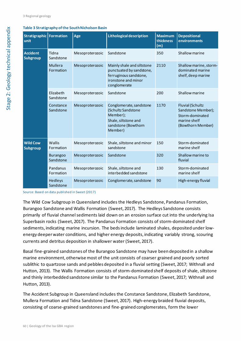
3 Regional geology
60 | Geology of the Isa GBA region
Stag
e 2:
Geo
logy
tech
nica
l app
endi
x Table 3 Stratigraphy of the South Nicholson Basin
Stratigraphic unit
Formation Age Lithological description Maximum thickness (m)
Depositional environments
Accident Subgroup
Tidna Sandstone
Mesoproterozoic Sandstone 350 Shallow marine
Mullera Formation
Mesoproterozoic Mainly shale and siltstone punctuated by sandstone, ferruginous sandstone, ironstone and minor conglomerate
2110 Shallow marine, storm-dominated marine shelf, deep marine
Elizabeth Sandstone
Mesoproterozoic Sandstone 200 Shallow marine
Constance Sandstone
Mesoproterozoic
Conglomerate, sandstone (Schultz Sandstone Member); Shale, siltstone and sandstone (Bowthorn Member)
1170
Fluvial (Schultz Sandstone Member); Storm-dominated marine shelf (Bowthorn Member)
Wild Cow Subgroup
Wallis Formation
Mesoproterozoic Shale, siltstone and minor sandstone
150 Storm-dominated marine shelf
Burangoo Sandstone
Mesoproterozoic Sandstone 320
Shallow marine to fluvial
Pandanus Formation
Mesoproterozoic Shale, siltstone and interbedded sandstone
130 Storm-dominated marine shelf
Hedleys Sandstone
Mesoproterozoic Conglomerate, sandstone 90 High-energy fluvial
Source: Based on data published in Sweet (2017)
The Wild Cow Subgroup in Queensland includes the Hedleys Sandstone, Pandanus Formation, Burangoo Sandstone and Wallis Formation (Sweet, 2017). The Hedleys Sandstone consists primarily of fluvial channel sediments laid down on an erosion surface cut into the underlying Isa Superbasin rocks (Sweet, 2017). The Pandanus Formation consists of storm-dominated shelf sediments, indicating marine incursion. The beds include laminated shales, deposited under low-energy deeper water conditions, and higher energy deposits, indicating variably strong, scouring currents and detritus deposition in shallower water (Sweet, 2017).
Basal fine-grained sandstones of the Burangoo Sandstone may have been deposited in a shallow marine environment, otherwise most of the unit consists of coarser grained and poorly sorted sublithic to quartzose sands and pebbles deposited in a fluvial setting (Sweet, 2017; Withnall and Hutton, 2013). The Wallis Formation consists of storm-dominated shelf deposits of shale, siltstone and thinly interbedded sandstone similar to the Pandanus Formation (Sweet, 2017; Withnall and Hutton, 2013).
The Accident Subgroup in Queensland includes the Constance Sandstone, Elizabeth Sandstone, Mullera Formation and Tidna Sandstone (Sweet, 2017). High-energy braided fluvial deposits, consisting of coarse-grained sandstones and fine-grained conglomerates, form the lower
3 Regional geology
Geology of the Isa GBA region | 61
Stage 2: Geology technical appendix
Constance Sandstone (Sweet, 2017). These are overlain by alternating marine mudstone and fine-grained sandstone, indicating progradation across a relatively shallow shelf (Sweet, 2017).
A second unconformity marks the boundary in this region between the Constance Sandstone and the overlying Elizabeth Sandstone (Sweet, 2017). The Elizabeth Sandstone represents shallow marine upper shoreface deposits of variably medium- to coarse-grained and fine- to medium-grained sandstones (Sweet, 2017). Deeper marine siltstones and shales of the Mullera Formation include some sandstone, ironstone and minor conglomerate units (Sweet, 2017; Withnall and Hutton, 2013). The Tidna Sandstone consists of shallow marine medium- to fine-grained massive quartzose sandstone (Carr et al., 2016; Withnall and Hutton, 2013).
The South Nicholson Group does not occur across the full extent of the Isa GBA region. Seismic sections indicate that up to 300 m of strata are preserved in incised valleys around Argyle Creek 1, but in most parts of the Isa GBA region the South Nicholson Group thins, through onlap and truncation, to less than 100 m (Jackson et al., 1999). Only a thin remnant was intersected in the Comalco well Beamesbrook 1 (Figure 19) in the east (Krassay and Bradshaw, 1999) and it was not intersected in the Armour Energy well Egilabria 4 in the north-east of the Isa GBA region (Bradshaw et al., 2018c). At Argyle Creek 1 the South Nicholson Group consists predominantly of fine-grained coastal or fluvial sandstones at the base, and a thick glauconitic shelf siltstone interval at the top (Krassay and Bradshaw, 1999).
3.4.3 Carpentaria Basin
The stratigraphy of the Carpentaria Basin is summarised in Figure 24 and formations intersected in the Burketown region (including the Isa GBA region) are described in Table 4. The Jurassic Eulo Queen Group has not been identified in the Isa GBA region, but it is included in this review as it could be potentially present as thin isolated paleovalley fill. Additional detail is provided in the hydrogeology technical appendix (Buchanan et al., 2020).
The onshore Jurassic Eulo Queen Group is thin to absent in the onshore Western Gulf and southern Staaten sub-basins (Section 3.3.7). In the Western Gulf Sub-basin it is interpreted as isolated valley fill in highlands (McConachie et al., 1990). In the southern Staaten Sub-basin it occurs as thin but variable fluvial sandstones (McConachie et al., 1990).
The Gilbert River Formation is associated with the development of Cretaceous marine transgression. It commenced deposition in fluvial environments, with increasing marine influence until deeper marine conditions developed during the Aptian age of the early Cretaceous (Cook et al., 2013; McConachie et al., 1997). The Gilbert River Formation is dominated by clayey quartzose sandstones, fining upwards into siltstone and glauconitic sandstone (Cook et al., 2013). The formation is typically 30 m and up to 260 m thick (McConachie et al., 1997).
The Gilbert River Formation is significant in the Isa GBA region as it is a stratigraphic equivalent of the Cadna-owie–Hooray aquifer of the adjacent Eromanga Basin (Radke et al., 2012), the most widely utilised aquifer within the Great Artesian Basin. The southern Carpentaria Basin is contiguous with the Eromanga Basin across the Euroka Arch (Figure 23). The formation was intersected in the eastern part of the Isa GBA region in the Armour Energy well Egilabria 4 and Comalco well Beamesbrook 1 (Figure 9).

3 Regional geology
62 | Geology of the Isa GBA region
Stag
e 2:
Geo
logy
tech
nica
l app
endi
x Table 4 Stratigraphy of the onshore Carpentaria Basin (in the Burketown area)
Stratigraphic unit Age Lithological description
Maximum thickness (m)
Depositional environments
Normanton Formation
Upper Cretaceous (Cenomanian)
Glauconitic sandstone and siltstone
300 Marginal marine to shallow marine
Allaru Mudstone Lower Cretaceous (Albian)
Claystone, siltstone, calcareous siltstone, glauconitic sandstone
700 Shallow marine
Toolebuc Formation Lower Cretaceous (Albian)
Carbonaceous shale and carbonate
65 Restricted marine
Wallumbilla Formation
Lower Cretaceous (Aptian to Albian)
Glauconitic sandstone fining-up to siltstone, claystone and silty limestone
600 Marginal marine to deep marine
Gilbert River Formation
Lower Cretaceous (Barremian to Aptian)
Sandstone and siltstone
260 Fluvial to shallow marine
Eulo Queen Group Upper Jurassic (Oxfordian to Kimmeridgian)
Sandstone interbedded with siltstone and claystone
150 Fluvial
Source: Based on data published in Bradshaw et al. (2009)
The Wallumbilla Formation contains thick successions of entirely marine siltstone, glauconitic sandstone and silty limestone, marking a major late Aptian marine transgression (Cook et al., 2013). The upper part consists of siltstone and claystone sequences, deposited in more open-water marine conditions than the lower part, which has varying proportions of sandstone from terrestrial input (McConachie et al., 1997). The Wallumbilla Formation was intersected widely by exploration wells in the Isa GBA region.
The Toolebuc Formation is a thin unit of limestone and carbonaceous shale, with minor siltstone and sandstone, representing maximum marine conditions (Cook et al., 2013). The Toolebuc Formation was also intersected widely in the exploration wells of the Isa GBA region.
The Allaru Mudstone contains siltstone, claystone and minor fine-grained sandstone, deposited in shallow marine to paralic conditions with minimum terrestrial influx (McConachie et al., 1997). It was intersected in the Comalco wells Egilabria 1, Desert Creek 1 and Beamesbrook 1 and the Armour Energy wells Egilabria 2 and Egilabria 4.
The Normanton Formation consists of glauconitic sandstone and siltstone, interpreted as the final phase of Cretaceous sedimentation (McConachie et al., 1997). Carbonaceous phases are locally common (McConachie et al., 1997). In the Isa GBA region it was intersected in the Mid-Eastern Oil well Burketown 1 only, as a soft carbonaceous grey clay shale (Perryman, 1964).
3.4.4 Karumba Basin
The Cenozoic Karumba Basin unconformably overlies much of the onshore and offshore Carpentaria Basin (McConachie et al., 1997). It is less than 250 m thick onshore, and consists of fluvial, lacustrine and minor shallow marine sediments (Table 5) (Bradshaw et al., 2009). This review draws on the updated stratigraphy and interpreted ages presented in Cook and Jell (2013),

3 Regional geology
Geology of the Isa GBA region | 63
Stage 2: Geology technical appendix
in which the Floraville Formation is synonymised into the Paleogene Bulimba Formation. Additional detail on the Karumba Basin is provided in the hydrogeology technical appendix (Buchanan et al., 2020).
The Karumba Basin was superimposed on the Carpentaria Basin after Cretaceous extensional tectonics in eastern Australia, while Cenozoic collision at the northern Australian margin contributed to its sedimentation and growth (Section 3.3.8). The Paleogene Bulimba Formation was deposited as clayey quartzose sand, sandstone, conglomerate, siltstone and claystone, in fluvial to nearshore environments (Bradshaw et al., 2009). It is generally recognisable as intensely weathered clayey sandstone (Radke et al., 2012). Erosion and deep weathering after deposition of the Bulimba Formation produced the widespread late Eocene to earliest Oligocene Aurukun Surface, consisting of deep laterites and sporadic silcretes (Cook and Jell, 2013).
The overlying Miocene to Pliocene Wyaaba beds (Cook and Jell, 2013) were deposited after the onset of collision at the northern Australian margin. The onshore units consist of fluvial to nearshore clayey sandstone, conglomerate, sandy claystone and calcareous siltstone (Cook and Jell, 2013). Localised lacustrine limestone formed to the south-west of the Isa GBA region in the Riversleigh area.
The Pleistocene to Recent Armraynald beds consist of silt, clay, sandy clay and minor sand and gravel, deposited in episodes related to tectonic, eustatic and climate variations (Cook and Jell, 2013). The presently onshore units were deposited in fluvial to nearshore environments.
Table 5 Stratigraphy of the Karumba Basin
Stratigraphic unit Age Lithological descriptions
Maximum thickness (m)
Depositional environments
Armraynald beds Pleistocene to Recent Gravel, clayey sand, silt, clay
60 Fluvial to marginal marine
Wyaaba beds Miocene to Pliocene Conglomerate, sandstone, calcareous siltstone
120 Fluvial to marginal marine
Bulimba Formation Paleocene to Eocene Conglomerate, sandstone, siltstone and claystone
65 Fluvial to marginal marine
Source: Based on data published in Bradshaw et al. (2009) and Cook and Jell (2013)
The Karumba Basin geological history was simplified by Smart et al. (1980) to three cycles of deposition, weathering and erosion, termed the Bulimba, Wyaaba and Claraville cycles (Cook and Jell, 2013). These cycles are discussed further in the hydrogeology technical appendix (Buchanan et al., 2020).
Karumba Basin sediments were not recorded in the exploration wells in the Isa GBA region, except for a tentative ascription to the (now obsolete) Lynd Formation of the surface sediments to a depth of 27 m in the Mid-Eastern Oil well Burketown 1 (Perryman, 1964). Cenozoic alluvium, not ascribed to a formation, was also intersected in the drilling of the Comalco well Beamesbrook 1 from the surface to 26 m measured depth (Dunster et al., 1989). Both wells are located near the far eastern edge of the Isa GBA region (Figure 9).

3 Regional geology
64 | Geology of the Isa GBA region
Stag
e 2:
Geo
logy
tech
nica
l app
endi
x The Cenozoic sediments intersected in the Mid-Eastern Oil well Burketown 1 are composed predominantly of reddish-brown clay with loosely clustered subrounded quartz grains and a 2 m thick layer of very fine friable sandstone at the base (Perryman, 1964). The Cenozoic sediments of the Comalco well Beamesbrook 1 were recorded as fine- to very fine-grained quartz sandstone with locally abundant clayey matrix, that is partly calcareous (Dunster et al., 1989).
4 Isa GBA region structural and stratigraphic framework
Geology of the Isa GBA region | 65
Stage 2: Geology technical appendix
4 Isa GBA region structural and stratigraphic framework
This section presents a more detailed account of the structural and stratigraphic framework of the Isa GBA region, and the relationships between deposition of supersequences and potential connectivity with overlying geological basins.
4.1 Structural architecture The structural elements map for the Isa GBA region produced as part of this assessment is shown in Figure 27 and Figure 28. This is based on seismic interpretation by Bradshaw et al. (2018c), and has been extrapolated outside the limits of seismic data control using the Geological Survey of Queensland’s depth to basement grid (Frogtech Geoscience, 2018a) and surface geology maps (Geological Survey of Queensland, 2011b).
Structural elements associated with the River Supersequence were used as this sequence was deposited during the tectonic event (River Event) that generated the major structural systems in the northern Lawn Hill Platform. Many of these structures were reactivated and made more complex by later tectonic events, including wrench tectonics during the Wide Event and compressional inversion during the Isan Orogeny (Frogtech Geoscience, 2018a; Scott and Tarlowski, 1999).
Example seismic sections used to highlight aspects of the regions structural and stratigraphic architecture are shown in Figure 29, Figure 30, Figure 31 and Figure 32, interpreted after Bradshaw and Scott (1999). These data show that the northern Lawn Hill Platform forms a northward-thinning wedge of gently to moderately deformed sedimentary rocks of the Isa Superbasin. Strata from the Isa Superbasin range in thickness from less than 1 km over the southern flanks of the Murphy Inlier, where the Fickling Group outcrops, to a maximum of about 9 km to the south, where the McNamara Group outcrops (Figure 33) (Scott and Bradshaw, 1999).
The northward thinning of strata over the northern Lawn Hill Platform is mainly due to a combination of onlap and truncation. Truncation is associated with a series of unconformities within the Isa Superbasin, together with younger unconformities at the base of the South Nicholson and Carpentaria basins (Bradshaw et al., 2000).
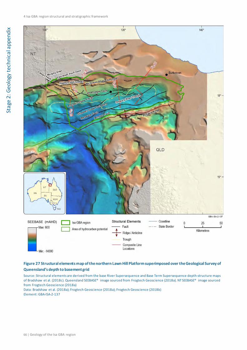
4 Isa GBA region structural and stratigraphic framework
66 | Geology of the Isa GBA region
Stag
e 2:
Geo
logy
tech
nica
l app
endi
x
Figure 27 Structural elements map of the northern Lawn Hill Platform superimposed over the Geological Survey of Queensland’s depth to basement grid Source: Structural elements are derived from the base River Supersequence and Base Term Supersequence depth-structure maps of Bradshaw et al. (2018c). Queensland SEEBASE® image sourced from Frogtech Geoscience (2018a). NT SEEBASE® image sourced from Frogtech Geoscience (2018a) Data: Bradshaw et al. (2018a); Frogtech Geoscience (2018a); Frogtech Geoscience (2018b) Element: GBA-ISA-2-137

4 Isa GBA region structural and stratigraphic framework
Geology of the Isa GBA region | 67
Stage 2: Geology technical appendix
Figure 28 Structural elements map of the northern Lawn Hill Platform superimposed over an isochore (vertical thickness) map for the River to Doom supersequences Contour interval (C.I.) = 500 m Source: Generated using the published depth to base River Supersequence, depth to base South Nicholson Basin and depth to base Carpentaria Basin grids of Bradshaw et al. (2018c) Data: Isochore grid, contours and structural elements from Bradshaw et al. (2018a). Background image is the GEODATA 9-second digital elevation model, version 3 (hillshade) (Hutchinson et al., 2008) Element: GBA-ISA-2-023

4 Isa GBA region structural and stratigraphic framework
68 | Geology of the Isa GBA region
Stag
e 2:
Geo
logy
tech
nica
l app
endi
x
Figure 29 Argyle Creek composite seismic section showing unconformities at the base of each supersequence (solid lines) and sequence (dashed lines) from the Isa, Calvert and Leichhardt superbasins The section shows major faults only from multiple deformation events (polyphase faulting) as per the original interpretation of Scott and Bradshaw (1999). Minor faults, expected to occur at greater density, are not interpreted at this seismic resolution. Refer to Figure 26 for interpreted lithofacies. Location of section shown on Figure 27 and Figure 28. SNB = South Nicholson Basin; LSB = Leichhardt Superbasin Source: Bradshaw and Scott (1999) Element: GBA-ISA-2-116
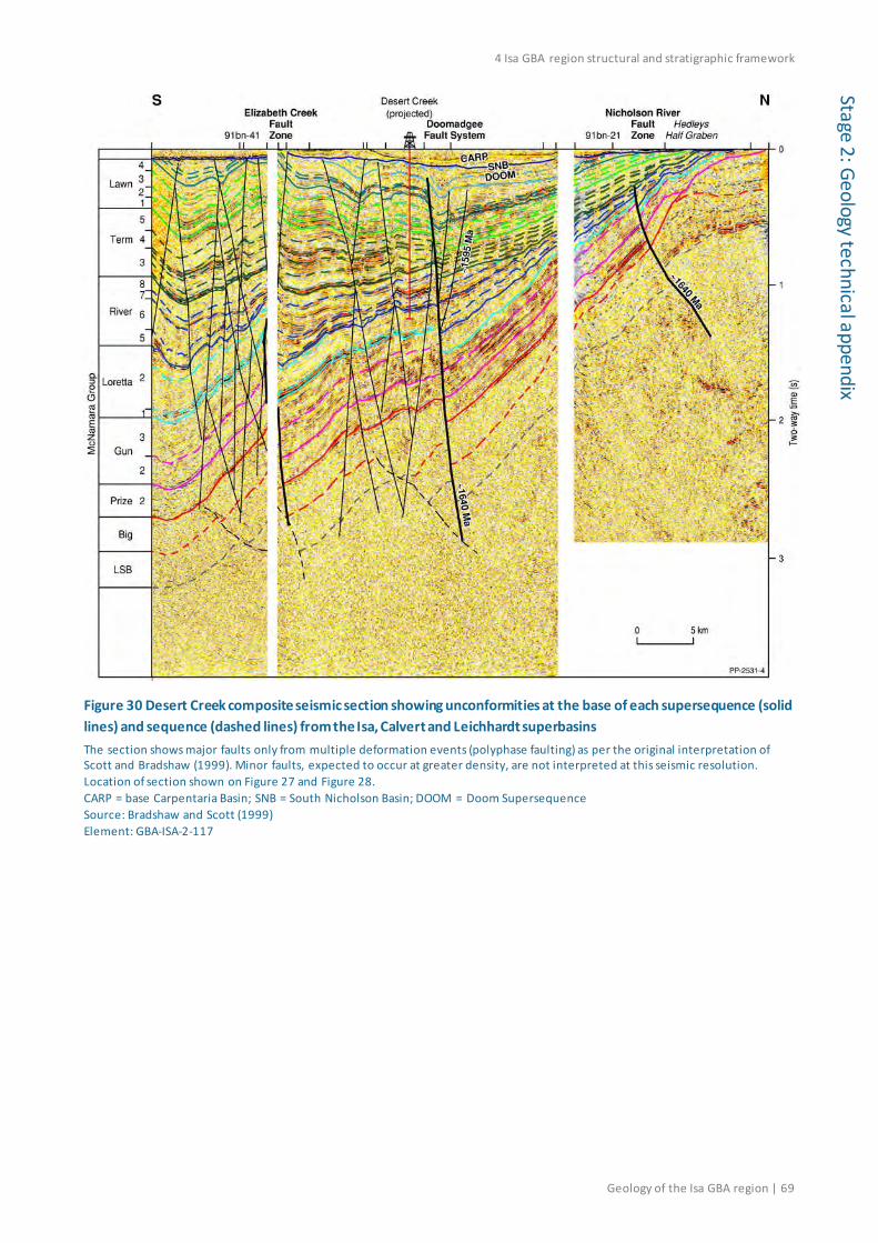
4 Isa GBA region structural and stratigraphic framework
Geology of the Isa GBA region | 69
Stage 2: Geology technical appendix
Figure 30 Desert Creek composite seismic section showing unconformities at the base of each supersequence (solid lines) and sequence (dashed lines) from the Isa, Calvert and Leichhardt superbasins The section shows major faults only from multiple deformation events (polyphase faulting) as per the original interpretation of Scott and Bradshaw (1999). Minor faults, expected to occur at greater density, are not interpreted at this seismic resolution. Location of section shown on Figure 27 and Figure 28. CARP = base Carpentaria Basin; SNB = South Nicholson Basin; DOOM = Doom Supersequence Source: Bradshaw and Scott (1999) Element: GBA-ISA-2-117
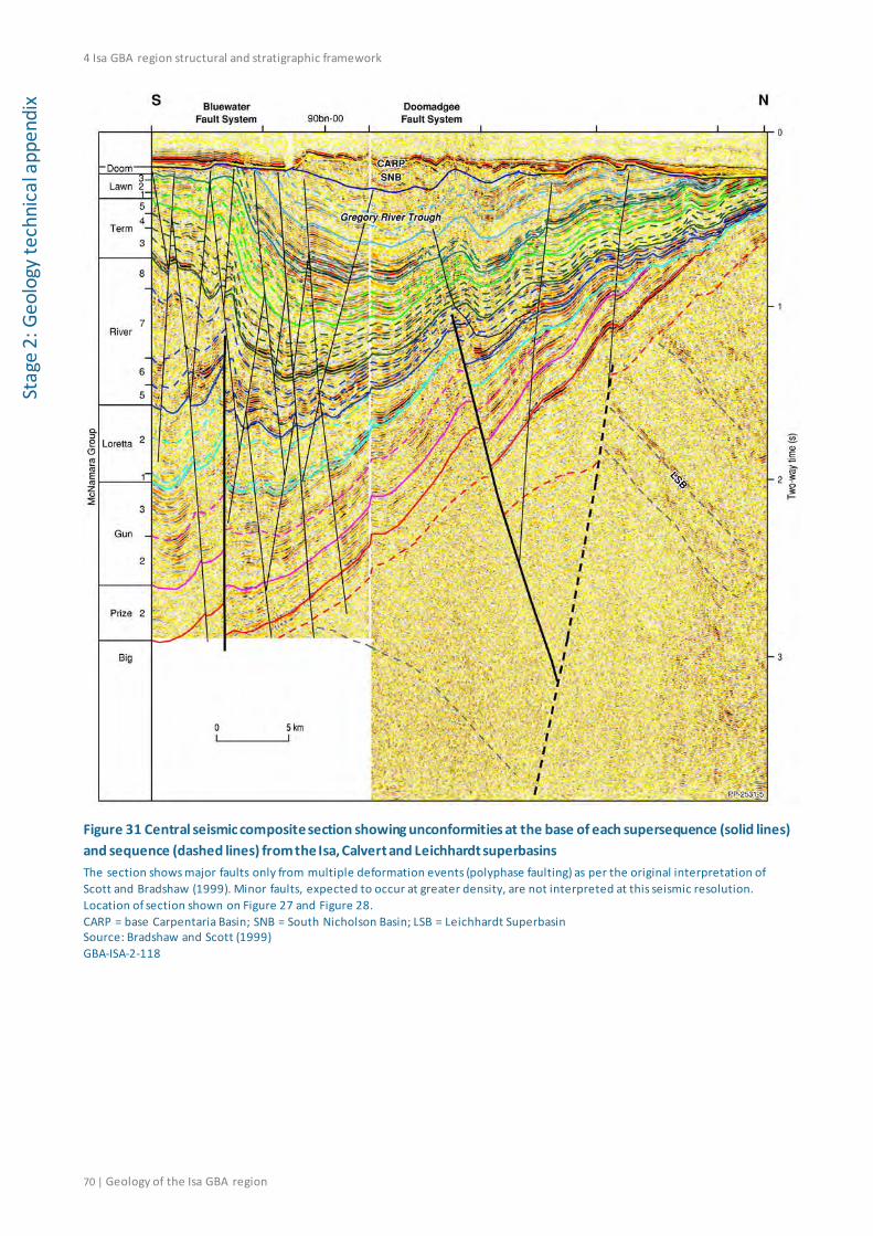
4 Isa GBA region structural and stratigraphic framework
70 | Geology of the Isa GBA region
Stag
e 2:
Geo
logy
tech
nica
l app
endi
x
Figure 31 Central seismic composite section showing unconformities at the base of each supersequence (solid lines) and sequence (dashed lines) from the Isa, Calvert and Leichhardt superbasins The section shows major faults only from multiple deformation events (polyphase faulting) as per the original interpretation of Scott and Bradshaw (1999). Minor faults, expected to occur at greater density, are not interpreted at this seismic resolution. Location of section shown on Figure 27 and Figure 28. CARP = base Carpentaria Basin; SNB = South Nicholson Basin; LSB = Leichhardt Superbasin Source: Bradshaw and Scott (1999) GBA-ISA-2-118

4 Isa GBA region structural and stratigraphic framework
Geology of the Isa GBA region | 71
Stage 2: Geology technical appendix
Figure 32 Egilabria composite seismic section showing unconformities at the base of each supersequence (solid lines) and sequence (dashed lines) from the Isa, Calvert and Leichhardt superbasins The section shows major faults only from multiple deformation events (polyphase faulting) as per the original interpretation of Scott and Bradshaw (1999). Minor faults, expected to occur at greater density, are not interpreted at this seismic resolution. Location of section shown on Figure 27 and Figure 28. CARP = base Carpentaria Basin; SNB = South Nicholson Basin; DOOM = Doom Supersequence; LSB = Leichhardt Superbasin Source: Bradshaw et al. (2000) Element: GBA-ISA-2-119
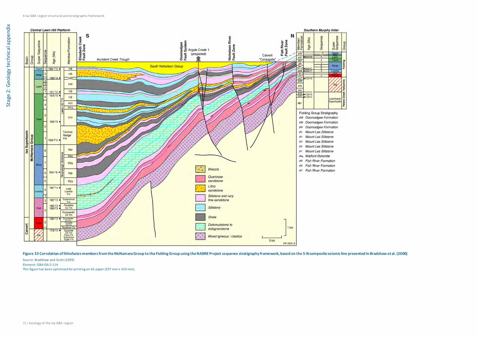
4 Isa GBA region structural and stratigraphic framework
72 | Geology of the Isa GBA region
Stag
e 2:
Geo
logy
tech
nica
l app
endi
x
Figure 33 Correlation of lithofacies members from the McNamara Group to the Fickling Group using the NABRE Project sequence stratigraphy framework, based on the S-N composite seismic line presented in Bradshaw et al. (2000) Source: Bradshaw and Scott (1999) Element: GBA-ISA-2-114 This figure has been optimised for printing on A3 paper (297 mm x 420 mm).

4 Isa GBA region structural and stratigraphic framework
Geology of the Isa GBA region | 73
Stage 2: Geology technical appendix
4.1.1 Murphy Inlier
The northern Lawn Hill Platform is adjacent to an enduring east-north-east trending basement high, part of which manifests in the present landscape as the Murphy Inlier or the Murphy Tectonic Ridge (Grimes and Sweet, 1979) (Figure 27 and Figure 28). The Murphy Inlier basement complex has as its centre the isoclinally folded Murphy Metamorphics (older than 1900 Ma), which are overlain by the approximately 4000 m thick Cliffdale Volcanics (1850 to 1770 Ma) (Scott et al., 1999). Both basement units are intruded by the Nicholson Granite Complex, and are in turn overlain by the Peters Creek Volcanics of the Leichhardt Superbasin (Scott et al., 1999). Calvert and Isa superbasin sediments thin substantially over the basement high due to both truncation and onlap, resulting in an attenuated basin margin succession, the Fickling Group (Bradshaw et al., 2000).
4.1.2 Fish River Fault Zone
The Fish River Fault Zone was defined by Sweet and Slater (1975) as a north-east trending fault system, which has offset the Murphy Inlier with a 500 to 1000 m downthrow to the south. Subsequent mapping by Grimes and Sweet (1979), Rohrlach et al. (1998) and the Geological Survey of Queensland (2011b) show the Fish River Fault Zone as a series of interlinked east-north-east to south-east trending faults. Seismic interpretations by Scott and Bradshaw (1999) show that the Fish River Fault Zone is antithetic to the principal north-dipping Nicholson River growth fault located to the south, and it is associated with only minor syn-depositional growth of the River Supersequence (Figure 27 and Figure 28).
4.1.3 Calvert Fault
The Calvert Fault is a south-east trending fault system that extends for over 200 km in Queensland and the NT. It has up to 7 km of strike-slip displacement (probably dextral) and 750 m of normal displacement in basement rocks (Roberts et al., 1963; Sweet et al., 1981). The Calvert Fault appears to have been episodically active during accumulation of the Peters Creek Volcanics and the overlying Fickling Group (Calvert and Isa superbasins) (Rohrlach et al., 1998). Scott and Tarlowski (1999) documented large normal displacements on the Calvert Fault in seismic data following deposition of the Doom Supersequence, which suggest that it remained active following deposition of the Isa Superbasin. Sweet (2017) also documented 700 to 800 m of sinistral strike-slip movement along the Calvert Fault following deposition of the Hedleys Sandstone and the Pandanus Siltstone in the South Nicholson Basin.
Recently published structure maps by Bradshaw et al. (2018c) indicate that the Calvert Fault terminates to the south-east as a series of south-east to south-south-east striking and north-east dipping fault splays, which interconnect with the Doomadgee Fault System (Figure 27 and Figure 28).
4.1.4 Nicholson River Fault Zone and ‘Hedleys Half Graben’
The Nicholson River Fault Zone was first named by Rohrlach et al. (1998), but was originally mapped by Sweet et al. (1981) as a disconnected series of east-north-east trending faults that dip down to the north and are offset across the Calvert Fault. Rohrlach et al. (1998) and Scott and

4 Isa GBA region structural and stratigraphic framework
74 | Geology of the Isa GBA region
Stag
e 2:
Geo
logy
tech
nica
l app
endi
x Tarlowski (1999) interpreted the Nicholson River Fault Zone as the bounding fault for a half-graben that formed over the southern flanks of the Murphy Inlier during deposition of the Mount Les Siltstone (River Supersequence); this half-graben is informally termed the ‘Hedleys Half Graben’ by Rohrlach et al. (1998).
Recent mapping by Bradshaw et al. (2018c) indicates that the Nicholson River Fault Zone as mapped by Rohrlach et al. (1998) represents two distinct fault systems (Figure 27 and Figure 28). Bradshaw et al. (2018c) suggested restricting the name Nicholson River Fault Zone to the fault system that bounds the northernmost half-graben depocentre (‘Hedleys Half Graben’), which formed over the southern Murphy Inlier during the River extensional event. The ‘Hedleys Half Graben’ is a relatively small extensional depocentre containing up to 550 m of syn-extensional sediments from the River Supersequence (Bradshaw et al., 2018c). The second of these distinct fault systems, the Doomadgee Fault System, is discussed below in Section 4.1.5.
4.1.5 Doomadgee Fault System
The Doomadgee Fault System (Figure 27 and Figure 28), as recently defined by Bradshaw et al. (2018c), forms an en-echelon series of east to west-north-west-trending north-dipping faults which originated through oblique north–south extension during the River Event, and were subsequently reactivated during the Wide Event and Isan Orogeny (Scott and Tarlowski, 1999). This fault system was originally mapped by Scott and Tarlowski (1999), and was informally termed the ‘Egilabria Shear Zone’ by Southgate et al. (1999). However, this old nomenclature has never been adopted in subsequent publications and is somewhat confusing given that the fault system is located south of the Egilabria wells.
The Doomadgee Fault System originated as an intrabasinal extensional system during the River Event, and bounds a series of half-graben depocentres containing up to 1500 m of syn-extensional sediments from the River Supersequence (Bradshaw et al., 2018c). Subsequent strike-slip reactivation during the Wide Event produced a series of localised depocentres for up to 500 m of strata from the Wide Supersequence over the western part of the Doomadgee Fault System (Bradshaw et al., 2018c).
4.1.6 Elizabeth Creek Fault Zone and Accident Creek Trough
The Elizabeth Creek Fault Zone (Figure 27 and Figure 28) is a major east-north-east trending fault system which extends from outcrop sections of the South Nicholson Basin in the western Isa GBA region to its north-eastern subsurface termination against the Doomadgee Fault System (Bradshaw et al., 2018c). McConachie (1993) originally named the structure as the Elizabeth Creek Thrust Zone, and defined it as an east to west striking frontal thrust fault system extending from outcrop sections in the Bowthorn region to just south of Burketown 1. Scott et al. (1998) subsequently redefined the structure as the Elizabeth Creek Fault Zone, which they interpreted as a more discontinuous en-echelon series of east-north-east trending and north-dipping faults with a complex polyphase history of multiple extension and inversion events.
The Elizabeth Creek Fault Zone has a complex tectonic history including extension during the 1640 to 1630 Ma River Event, and major compressional inversion during the Isan Orogeny and subsequent deformation events (Bradshaw et al., 2018c). Extension during the River Event
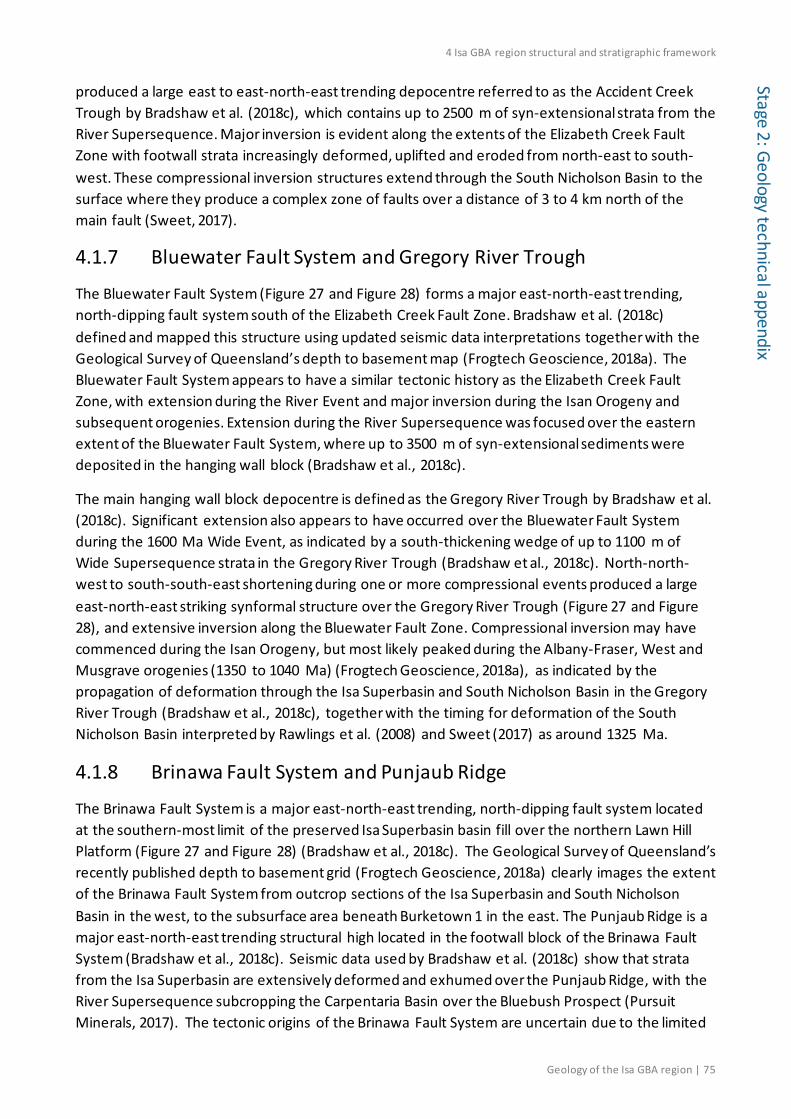
4 Isa GBA region structural and stratigraphic framework
Geology of the Isa GBA region | 75
Stage 2: Geology technical appendix
produced a large east to east-north-east trending depocentre referred to as the Accident Creek Trough by Bradshaw et al. (2018c), which contains up to 2500 m of syn-extensional strata from the River Supersequence. Major inversion is evident along the extents of the Elizabeth Creek Fault Zone with footwall strata increasingly deformed, uplifted and eroded from north-east to south-west. These compressional inversion structures extend through the South Nicholson Basin to the surface where they produce a complex zone of faults over a distance of 3 to 4 km north of the main fault (Sweet, 2017).
4.1.7 Bluewater Fault System and Gregory River Trough
The Bluewater Fault System (Figure 27 and Figure 28) forms a major east-north-east trending, north-dipping fault system south of the Elizabeth Creek Fault Zone. Bradshaw et al. (2018c) defined and mapped this structure using updated seismic data interpretations together with the Geological Survey of Queensland’s depth to basement map (Frogtech Geoscience, 2018a). The Bluewater Fault System appears to have a similar tectonic history as the Elizabeth Creek Fault Zone, with extension during the River Event and major inversion during the Isan Orogeny and subsequent orogenies. Extension during the River Supersequence was focused over the eastern extent of the Bluewater Fault System, where up to 3500 m of syn-extensional sediments were deposited in the hanging wall block (Bradshaw et al., 2018c).
The main hanging wall block depocentre is defined as the Gregory River Trough by Bradshaw et al. (2018c). Significant extension also appears to have occurred over the Bluewater Fault System during the 1600 Ma Wide Event, as indicated by a south-thickening wedge of up to 1100 m of Wide Supersequence strata in the Gregory River Trough (Bradshaw et al., 2018c). North-north-west to south-south-east shortening during one or more compressional events produced a large east-north-east striking synformal structure over the Gregory River Trough (Figure 27 and Figure 28), and extensive inversion along the Bluewater Fault Zone. Compressional inversion may have commenced during the Isan Orogeny, but most likely peaked during the Albany-Fraser, West and Musgrave orogenies (1350 to 1040 Ma) (Frogtech Geoscience, 2018a), as indicated by the propagation of deformation through the Isa Superbasin and South Nicholson Basin in the Gregory River Trough (Bradshaw et al., 2018c), together with the timing for deformation of the South Nicholson Basin interpreted by Rawlings et al. (2008) and Sweet (2017) as around 1325 Ma.
4.1.8 Brinawa Fault System and Punjaub Ridge
The Brinawa Fault System is a major east-north-east trending, north-dipping fault system located at the southern-most limit of the preserved Isa Superbasin basin fill over the northern Lawn Hill Platform (Figure 27 and Figure 28) (Bradshaw et al., 2018c). The Geological Survey of Queensland’s recently published depth to basement grid (Frogtech Geoscience, 2018a) clearly images the extent of the Brinawa Fault System from outcrop sections of the Isa Superbasin and South Nicholson Basin in the west, to the subsurface area beneath Burketown 1 in the east. The Punjaub Ridge is a major east-north-east trending structural high located in the footwall block of the Brinawa Fault System (Bradshaw et al., 2018c). Seismic data used by Bradshaw et al. (2018c) show that strata from the Isa Superbasin are extensively deformed and exhumed over the Punjaub Ridge, with the River Supersequence subcropping the Carpentaria Basin over the Bluebush Prospect (Pursuit Minerals, 2017). The tectonic origins of the Brinawa Fault System are uncertain due to the limited

4 Isa GBA region structural and stratigraphic framework
76 | Geology of the Isa GBA region
Stag
e 2:
Geo
logy
tech
nica
l app
endi
x seismic data coverage over this structure. Strata from the River Supersequence appear to thicken into the Brinawa Fault System, which suggests similar extension during the River Event as seen over the Elizabeth Creek Fault Zone and Bluewater Fault System (Bradshaw et al., 2018c).
4.2 Geological surfaces and isochore maps Depth-structure and isochore maps are an essential component of the Geological and Bioregional Assessment of the Isa Superbasin. Of particular importance to this assessment are the proven shale gas intervals contained within the River Supersequence and the Lawn Supersequence.
Economic basement over the northern Lawn Hill Platform from the perspective of shale gas resources begins at the base of the River Supersequence (Bradshaw et al., 2018c). Older stratigraphic intervals are present, but these show no evidence of organic-rich source rocks in either well data or outcrop sections within the Isa GBA region (Bradshaw et al., 2000; Gorton and Troup, 2018). The assessment therefore excludes any stratigraphic intervals older then the River Supersequence.
The depth-structure and isochore maps for each of the Isa Superbasin supersequences and overlying basins are summarised below (see methods snapshot box for detailed workflow).
Methods snapshot: mapping geological surfaces at depth
The depth-structure and isochore maps used in this assessment are sourced from the recently published Geoscience Australia update (Bradshaw et al., 2018c) to the original NABRE seismic interpretations over the northern Lawn Hill Platform (Bradshaw and Scott, 1999).
Maps produced by Bradshaw et al. (2018b) include depth-structure and isochore maps for the base River Supersequence, Term Supersequence, Lawn Supersequence, Lawn 4 Sequence, Wide Supersequence, Doom Supersequence, South Nicholson Basin and Carpentaria Basin. These maps, and a base Karumba Basin map, are provided in this section in metres below mean sea level.
Additional maps for Mesozoic aquifer and aquitard intervals, not mapped by Bradshaw et al. (2018b), include the base Gilbert River Formation, Rolling Downs Group, Normanton Formation and Karumba Basin. These intervals have previously been mapped at a regional scale over the full extent of the Great Artesian Basin by Smerdon et al. (2012).
A set of maps, incorporating seismic data over the groundwater assessment area and at greater resolution than the regional maps, was prepared for the groundwater assessment presented in the hydrogeology technical appendix (Buchanan et al., 2020) in metres relative to the Australian Height Datum. The regional maps of Smerdon et al. (2012) were updated using the following workflow:
1. Interpret the base Carpentaria Basin (top Proterozoic), top Gilbert River Formation and base Normanton Formation on seismic sections that extend over the groundwater assessment area using well log interpretations and time-depth data in Argyle Creek 1, Desert Creek 1, Egilabria 1, Egilabria 2, Egilabria 4, Beamesbrook 1, Burketown 1, and Armraynald 1.

4 Isa GBA region structural and stratigraphic framework
Geology of the Isa GBA region | 77
Stage 2: Geology technical appendix
It was not possible to interpret the base Karumba Basin on seismic sections due to very shallow depths of this stratigraphic interval.
2. Convert the seismic two-way time interpretations into depth relative to seismic datum (metres below mean sea level) using the same workflow documented by Bradshaw et al. (2018c) and their Mesozoic velocity model.
3. Convert the maps from seismic datum (metres below mean sea level) to groundwater datum (metres relative to the Australian Height Datum).
4. Merge the depth-converted seismic grid with the regional grids of Smerdon et al. (2012) over the groundwater assessment area.
5. Verify and refine the merged grids using all available stratigraphic tops in well data over the groundwater assessment area.
6. Refine the outcrop expression of these surfaces by merging with digital elevation model data (Hutchinson et al., 2008) where they are subaerially exposed.
4.2.1 Isa Superbasin
4.2.1.1 River Supersequence
The base of the River Supersequence is a major south-dipping onlap and truncation surface that extends from surface outcrops of the Mount Les Siltstone over the southern flanks of the Murphy Inlier, to maximum depths of 7500 m in the Accident Creek Trough and 4800 m in the Gregory River Trough (Figure 34) (Bradshaw et al., 2018c).
The River Supersequence thins overall to the north, and is characterised by progressively smaller half-graben depocentres, with maximum thicknesses of 1500 m in the hanging wall block of Doomadgee Fault System, and 550 m in the ‘Hedleys Half Graben’ (Bradshaw et al., 2018c). Northward thinning of the River Supersequence occurs due to a combination of onlap over the basal unconformity and within component third-order sequences, together with some erosion by the Base Term Supersequence unconformity and the base Carpentaria Basin unconformity (Scott and Bradshaw, 1999).
Syn-depositional growth is evident across most faults that intersect the River Supersequence (Scott and Bradshaw, 1999; Scott and Tarlowski, 1999). Extension and subsidence appear to have been particularly focused within the Gregory River and Accident Creek troughs where the River Supersequence reaches thicknesses of 2500 to 3500 m (Bradshaw et al., 2018c) (Figure 35).
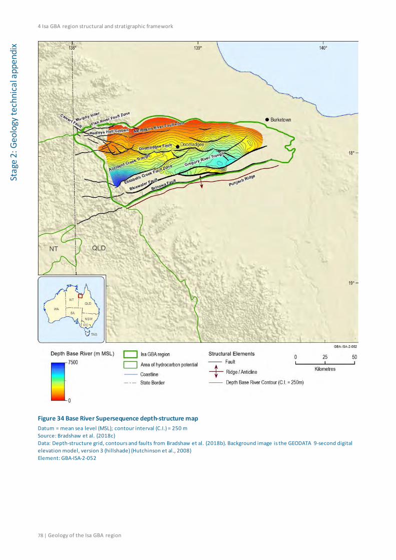
4 Isa GBA region structural and stratigraphic framework
78 | Geology of the Isa GBA region
Stag
e 2:
Geo
logy
tech
nica
l app
endi
x
Figure 34 Base River Supersequence depth-structure map Datum = mean sea level (MSL); contour interval (C.I.) = 250 m Source: Bradshaw et al. (2018c) Data: Depth-structure grid, contours and faults from Bradshaw et al. (2018b). Background image is the GEODATA 9-second digital elevation model, version 3 (hillshade) (Hutchinson et al., 2008) Element: GBA-ISA-2-052
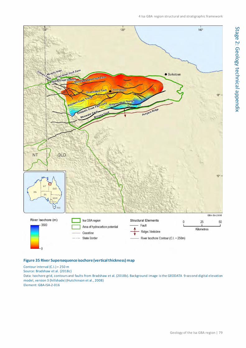
4 Isa GBA region structural and stratigraphic framework
Geology of the Isa GBA region | 79
Stage 2: Geology technical appendix
Figure 35 River Supersequence isochore (vertical thickness) map Contour interval (C.I.) = 250 m Source: Bradshaw et al. (2018c) Data: Isochore grid, contours and faults from Bradshaw et al. (2018b). Background image is the GEODATA 9-second digital elevation model, version 3 (hillshade) (Hutchinson et al., 2008) Element: GBA-ISA-2-016
4 Isa GBA region structural and stratigraphic framework
80 | Geology of the Isa GBA region
Stag
e 2:
Geo
logy
tech
nica
l app
endi
x 4.2.1.2 Term Supersequence
The Term Supersequence forms a northward-thinning clastic wedge across the northern Lawn Hill Platform.
The base of the Term Supersequence extends from surface outcrops of the Doomadgee Formation over the southern flanks of the Murphy Inlier, to maximum depths of 4800 m in the Accident Creek Trough and 3500 m in the Gregory River Trough (Figure 36) (Bradshaw et al., 2018c). The original wedge geometry of the Term Supersequence is partly preserved in the Accident Creek Trough, but elsewhere has been overprinted by deformation during the Isan Orogeny and subsequent deformation events (Bradshaw et al., 2018c). Compressional inversion was particularly focused between the Brinawa Fault System and Elizabeth Creek Fault Zone where the base of the Term Supersequence is deformed into a series of shallow domes and depressions, and within the Gregory River Trough where strata are deformed into a broad east-north-east trending synformal structure (Figure 36).
The Accident Creek Trough forms the main depocentre for Term Supersequence deposits over the northern Lawn Hill Platform (Figure 37). It contains up to 3500 m of massive turbidite sandstones from the Termite Range Formation (Term 1 and Term 2 sequences) in outcrop sections to the south, which fine upwards into marine siltstones, turbidite sandstones and carbonaceous shales from the Pmh1-2 members of the Lawn Hill Formation (Term 3, 4 and 5 sequences) (Bradshaw et al., 2018c; Krassay et al., 2000a). The two basal sequences pinch out and are absent to the north and east of the Accident Creek Trough (Bradshaw et al., 2018c; Krassay et al., 2000a).
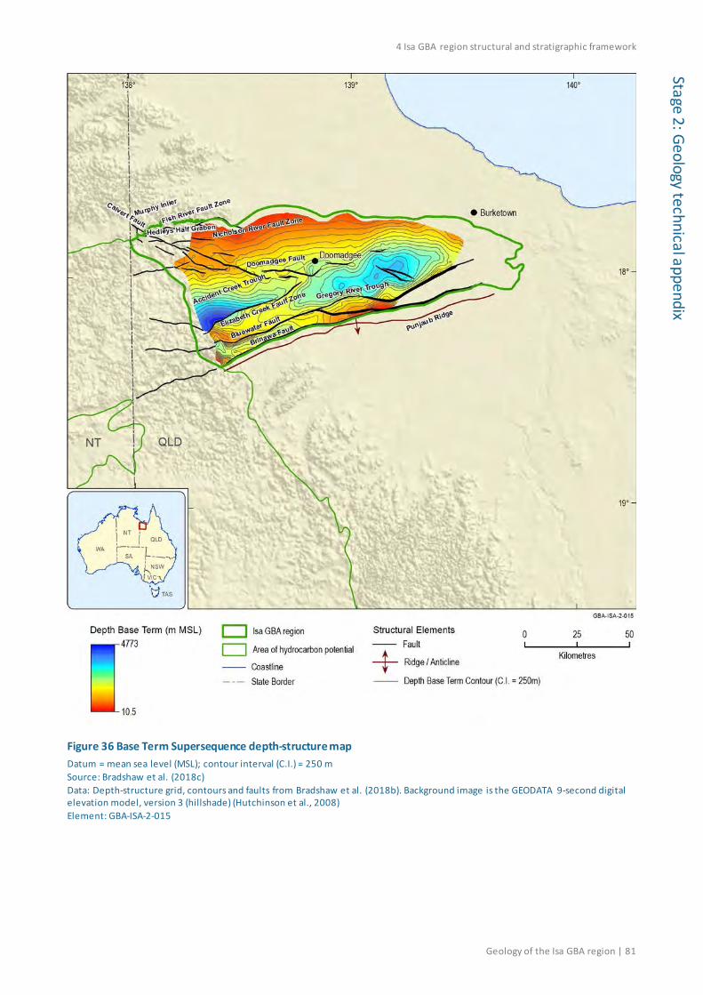
4 Isa GBA region structural and stratigraphic framework
Geology of the Isa GBA region | 81
Stage 2: Geology technical appendix
Figure 36 Base Term Supersequence depth-structure map Datum = mean sea level (MSL); contour interval (C.I.) = 250 m Source: Bradshaw et al. (2018c) Data: Depth-structure grid, contours and faults from Bradshaw et al. (2018b). Background image is the GEODATA 9-second digital elevation model, version 3 (hillshade) (Hutchinson et al., 2008) Element: GBA-ISA-2-015

4 Isa GBA region structural and stratigraphic framework
82 | Geology of the Isa GBA region
Stag
e 2:
Geo
logy
tech
nica
l app
endi
x
Figure 37 Term Supersequence isochore (vertical thickness) map Contour interval (C.I.) = 250 m Source: Bradshaw et al. (2018c) Data: Isochore grid, contours and faults from Bradshaw et al. (2018b). Background image is the GEODATA 9-second digital elevation model, version 3 (hillshade) (Hutchinson et al., 2008) Element: GBA-ISA-2-054
4.2.1.3 Lawn Supersequence
In contrast to the underlying Term Supersequence, the base Lawn Supersequence is deepest (about 3100 m below mean sea level) in the axis of the Gregory River Trough, and is significantly shallower (about 1500 m below mean sea level) in the Accident Creek Trough (Figure 38).

4 Isa GBA region structural and stratigraphic framework
Geology of the Isa GBA region | 83
Stage 2: Geology technical appendix
The Lawn Supersequence reaches maximum thicknesses of 800 to 900 m in the Accident Creek Trough and the Gregory River Trough, and thins to the north and east (Figure 39) (Bradshaw et al., 2018c). Northward thinning is recognised by truncation at the base of the Wide Supersequence, where the Lawn 4, Lawn 3 and Lawn 2 sequences have been eroded over the southern flanks of the Murphy Inlier (Bradshaw et al., 2000). The eastward thinning is recognised by onlap against the base Lawn Supersequence unconformity, together with internal pinchouts within the Lawn 1, Lawn 2 and Lawn 3 sequences (Scott and Bradshaw, 1999).
Deformation during the Isan Orogeny and subsequent compressional events has uplifted and eroded most of the Lawn Supersequence between the Brinawa Fault System and the Elizabeth Creek Fault Zone (Bradshaw et al., 2018c).

4 Isa GBA region structural and stratigraphic framework
84 | Geology of the Isa GBA region
Stag
e 2:
Geo
logy
tech
nica
l app
endi
x
Figure 38 Base Lawn Supersequence depth-structure map Datum = mean sea level; contour interval (C.I.) = 250 m Source: Bradshaw et al. (2018c) Data: Depth-structure grid, contours and faults from Bradshaw et al. (2018b). Background image is the GEODATA 9-second digital elevation model, version 3 (hillshade) (Hutchinson et al., 2008) Element: GBA-ISA-2-055
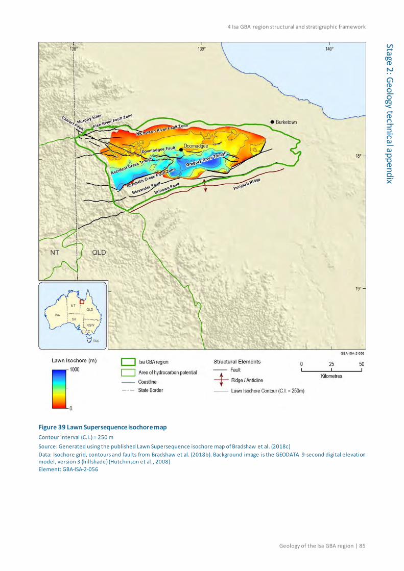
4 Isa GBA region structural and stratigraphic framework
Geology of the Isa GBA region | 85
Stage 2: Geology technical appendix
Figure 39 Lawn Supersequence isochore map Contour interval (C.I.) = 250 m Source: Generated using the published Lawn Supersequence isochore map of Bradshaw et al. (2018c) Data: Isochore grid, contours and faults from Bradshaw et al. (2018b). Background image is the GEODATA 9-second digital elevation model, version 3 (hillshade) (Hutchinson et al., 2008) Element: GBA-ISA-2-056
4 Isa GBA region structural and stratigraphic framework
86 | Geology of the Isa GBA region
Stag
e 2:
Geo
logy
tech
nica
l app
endi
x 4.2.1.4 Wide Supersequence
The base Wide Supersequence unconformity is relatively shallow over the western part of the northern Lawn Hill Platform, where it extends to depths of 1000 m below mean sea level in the Accident Creek Trough. However, post-depositional deformation has produced a much deeper surface over the Gregory River Trough, where the Wide Supersequence extends to depths of 2700 m below mean sea level (Figure 40).
Syn-depositional growth across faults is evident in the Wide Supersequence, particularly across the Bluewater Fault System where up to 1100 m of strata are preserved in the Gregory River Trough, and across the Doomadgee Fault System where the supersequence thickens southward into the fault up to 500 m thick (Figure 41). The Wide Supersequence thins to the north and north-east, recognised by onlap over the basal unconformity and within component third-order sequences (Bradshaw et al., 2018c).
Uplift and erosion during the Isan Orogeny and subsequent deformation events have removed most of the Wide Supersequence between the Brinawa Fault System and the Elizabeth Creek Fault Zone (Bradshaw et al., 2018c). The Wide Supersequence is preserved over parts of the south-eastern Murphy Inlier as the Pfd3 member of the Doomadgee Formation (Bradshaw et al., 2000).
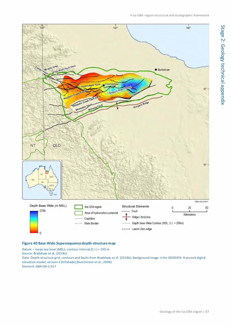
4 Isa GBA region structural and stratigraphic framework
Geology of the Isa GBA region | 87
Stage 2: Geology technical appendix
Figure 40 Base Wide Supersequence depth-structure map Datum = mean sea level (MSL); contour interval (C.I.) = 250 m Source: Bradshaw et al. (2018c) Data: Depth-structure grid, contours and faults from Bradshaw et al. (2018b). Background image is the GEODATA 9-second digital elevation model, version 3 (hillshade) (Hutchinson et al., 2008) Element: GBA-ISA-2-017
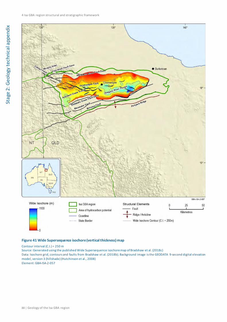
4 Isa GBA region structural and stratigraphic framework
88 | Geology of the Isa GBA region
Stag
e 2:
Geo
logy
tech
nica
l app
endi
x
Figure 41 Wide Supersequence isochore (vertical thickness) map Contour interval (C.I.) = 250 m Source: Generated using the published Wide Supersequence isochore map of Bradshaw et al. (2018c) Data: Isochore grid, contours and faults from Bradshaw et al. (2018b). Background image is the GEODATA 9-second digital elevation model, version 3 (hillshade) (Hutchinson et al., 2008) Element: GBA-ISA-2-057

4 Isa GBA region structural and stratigraphic framework
Geology of the Isa GBA region | 89
Stage 2: Geology technical appendix
4.2.1.5 Doom Supersequence
The base Doom Supersequence surface is relatively conformable in most areas, with little evidence for erosion or onlap (Scott and Bradshaw, 1999). The base surface is relatively shallow (600 m below mean sea level) over the Accident Creek Trough, however it deepens to 2100 m below mean sea level over the Gregory River Trough (Figure 42).
Up to 1000 m of strata from the Doom Supersequence are preserved in the Gregory River Trough (Figure 43). The Doom Supersequence is only rarely preserved in outcrop sections over the southern Murphy Inlier, and was uplifted and eroded over the Elizabeth Creek Fault Zone and Bluewater Fault System during the Isan Orogeny and subsequent deformation events.

4 Isa GBA region structural and stratigraphic framework
90 | Geology of the Isa GBA region
Stag
e 2:
Geo
logy
tech
nica
l app
endi
x
Figure 42 Base Doom Supersequence depth-structure map Datum = mean sea level (MSL); contour interval (C.I.) = 250 m Source: Bradshaw et al. (2018c) Data: Depth-structure grid, contours and faults from Bradshaw et al. (2018b). Background image is the GEODATA 9-second digital elevation model, version 3 (hillshade) (Hutchinson et al., 2008) Element: GBA-ISA-2-058

4 Isa GBA region structural and stratigraphic framework
Geology of the Isa GBA region | 91
Stage 2: Geology technical appendix
Figure 43 Doom Supersequence isochore (vertical thickness) map Contour interval (C.I.) = 250 m Source: Generated using the published Doom Supersequence isochore map of Bradshaw et al. (2018c) Data: Isochore grid, contours and faults from Bradshaw et al. (2018b). Background image is the GEODATA 9-second digital elevation model, version 3 (hillshade) (Hutchinson et al., 2008) Element: GBA-ISA-2-059
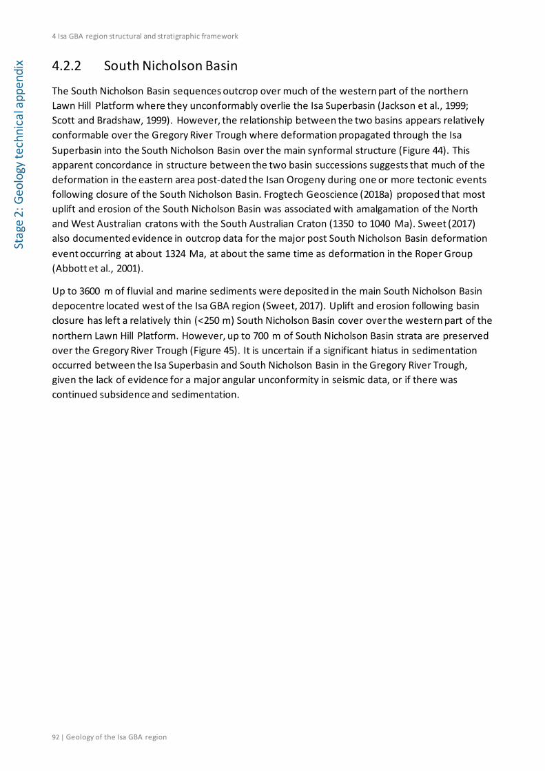
4 Isa GBA region structural and stratigraphic framework
92 | Geology of the Isa GBA region
Stag
e 2:
Geo
logy
tech
nica
l app
endi
x 4.2.2 South Nicholson Basin
The South Nicholson Basin sequences outcrop over much of the western part of the northern Lawn Hill Platform where they unconformably overlie the Isa Superbasin (Jackson et al., 1999; Scott and Bradshaw, 1999). However, the relationship between the two basins appears relatively conformable over the Gregory River Trough where deformation propagated through the Isa Superbasin into the South Nicholson Basin over the main synformal structure (Figure 44). This apparent concordance in structure between the two basin successions suggests that much of the deformation in the eastern area post-dated the Isan Orogeny during one or more tectonic events following closure of the South Nicholson Basin. Frogtech Geoscience (2018a) proposed that most uplift and erosion of the South Nicholson Basin was associated with amalgamation of the North and West Australian cratons with the South Australian Craton (1350 to 1040 Ma). Sweet (2017) also documented evidence in outcrop data for the major post South Nicholson Basin deformation event occurring at about 1324 Ma, at about the same time as deformation in the Roper Group (Abbott et al., 2001).
Up to 3600 m of fluvial and marine sediments were deposited in the main South Nicholson Basin depocentre located west of the Isa GBA region (Sweet, 2017). Uplift and erosion following basin closure has left a relatively thin (<250 m) South Nicholson Basin cover over the western part of the northern Lawn Hill Platform. However, up to 700 m of South Nicholson Basin strata are preserved over the Gregory River Trough (Figure 45). It is uncertain if a significant hiatus in sedimentation occurred between the Isa Superbasin and South Nicholson Basin in the Gregory River Trough, given the lack of evidence for a major angular unconformity in seismic data, or if there was continued subsidence and sedimentation.
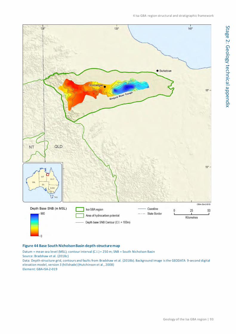
4 Isa GBA region structural and stratigraphic framework
Geology of the Isa GBA region | 93
Stage 2: Geology technical appendix
Figure 44 Base South Nicholson Basin depth-structure map Datum = mean sea level (MSL); contour interval (C.I.) = 250 m; SNB = South Nicholson Basin Source: Bradshaw et al. (2018c) Data: Depth-structure grid, contours and faults from Bradshaw et al. (2018b). Background image is the GEODATA 9-second digital elevation model, version 3 (hillshade) (Hutchinson et al., 2008) Element: GBA-ISA-2-019
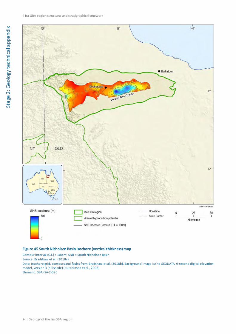
4 Isa GBA region structural and stratigraphic framework
94 | Geology of the Isa GBA region
Stag
e 2:
Geo
logy
tech
nica
l app
endi
x
Figure 45 South Nicholson Basin isochore (vertical thickness) map Contour interval (C.I.) = 100 m; SNB = South Nicholson Basin Source: Bradshaw et al. (2018c) Data: Isochore grid, contours and faults from Bradshaw et al. (2018b). Background image is the GEODATA 9-second digital elevation model, version 3 (hillshade) (Hutchinson et al., 2008) Element: GBA-ISA-2-020
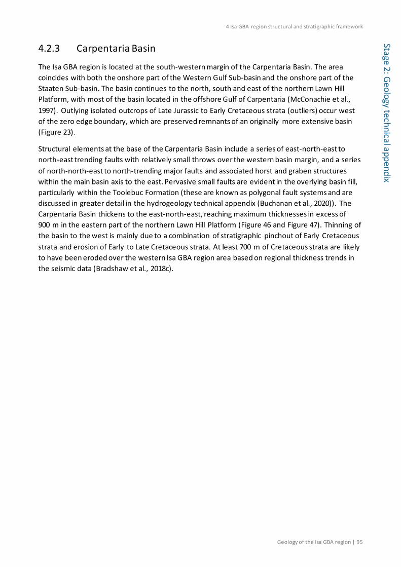
4 Isa GBA region structural and stratigraphic framework
Geology of the Isa GBA region | 95
Stage 2: Geology technical appendix
4.2.3 Carpentaria Basin
The Isa GBA region is located at the south-western margin of the Carpentaria Basin. The area coincides with both the onshore part of the Western Gulf Sub-basin and the onshore part of the Staaten Sub-basin. The basin continues to the north, south and east of the northern Lawn Hill Platform, with most of the basin located in the offshore Gulf of Carpentaria (McConachie et al., 1997). Outlying isolated outcrops of Late Jurassic to Early Cretaceous strata (outliers) occur west of the zero edge boundary, which are preserved remnants of an originally more extensive basin (Figure 23).
Structural elements at the base of the Carpentaria Basin include a series of east-north-east to north-east trending faults with relatively small throws over the western basin margin, and a series of north-north-east to north-trending major faults and associated horst and graben structures within the main basin axis to the east. Pervasive small faults are evident in the overlying basin fill, particularly within the Toolebuc Formation (these are known as polygonal fault systems and are discussed in greater detail in the hydrogeology technical appendix (Buchanan et al., 2020)). The Carpentaria Basin thickens to the east-north-east, reaching maximum thicknesses in excess of 900 m in the eastern part of the northern Lawn Hill Platform (Figure 46 and Figure 47). Thinning of the basin to the west is mainly due to a combination of stratigraphic pinchout of Early Cretaceous strata and erosion of Early to Late Cretaceous strata. At least 700 m of Cretaceous strata are likely to have been eroded over the western Isa GBA region area based on regional thickness trends in the seismic data (Bradshaw et al., 2018c).
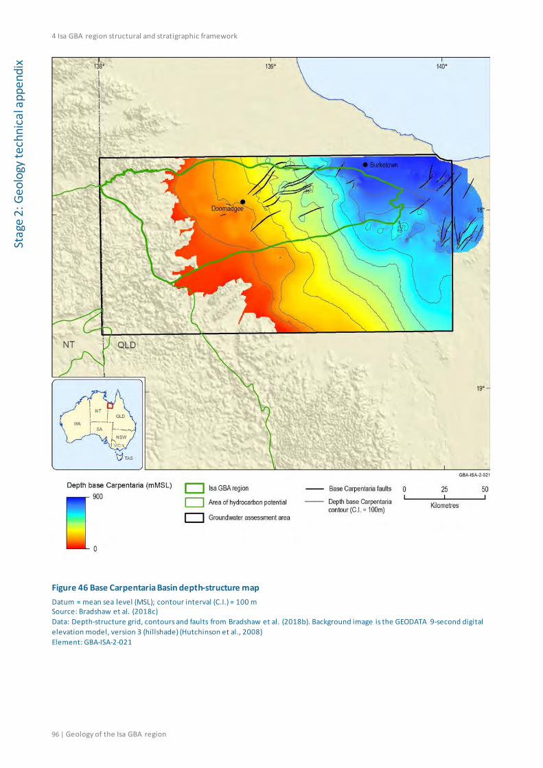
4 Isa GBA region structural and stratigraphic framework
96 | Geology of the Isa GBA region
Stag
e 2:
Geo
logy
tech
nica
l app
endi
x
Figure 46 Base Carpentaria Basin depth-structure map Datum = mean sea level (MSL); contour interval (C.I.) = 100 m Source: Bradshaw et al. (2018c) Data: Depth-structure grid, contours and faults from Bradshaw et al. (2018b). Background image is the GEODATA 9-second digital elevation model, version 3 (hillshade) (Hutchinson et al., 2008) Element: GBA-ISA-2-021
4 Isa GBA region structural and stratigraphic framework
Geology of the Isa GBA region | 97
Stage 2: Geology technical appendix
Figure 47 Carpentaria Basin isochore map Contour interval (C.I.) = 100 m Source: Bradshaw et al. (2018c) Data: Isochore grid, contours and faults from Bradshaw et al. (2018b). Background image is the GEODATA 9-second digital elevation model, version 3 (hillshade) (Hutchinson et al., 2008) Element: GBA-ISA-2-022

4 Isa GBA region structural and stratigraphic framework
98 | Geology of the Isa GBA region
Stag
e 2:
Geo
logy
tech
nica
l app
endi
x 4.2.4 Karumba Basin
The Cenozoic Karumba Basin is the youngest sedimentary basin succession in the Isa GBA region and forms a very thin (<50 m) veneer of Cenozoic strata across the northern Lawn Hill Platform (Figure 49).
The Karumba Basin is generally too shallow to be interpreted and mapped from seismic data. Smerdon et al. (2012) have published an isopach map for the Paleogene to Neogene sedimentary component of the Great Artesian Basin, which has been modified using the digital elevation model of Hutchinson et al. (2008) and formation tops in wells across the Isa GBA region to produce depth-structure and isochore maps for the Karumba Basin.
The derived depth-structure map shows a similar extent for the Karumba Basin as the underlying Carpentaria Basin, with strata tilted down to the east and north-east to maximum depths of 30 m below mean sea level before the basin extends offshore into the Gulf of Carpentaria (Figure 48).
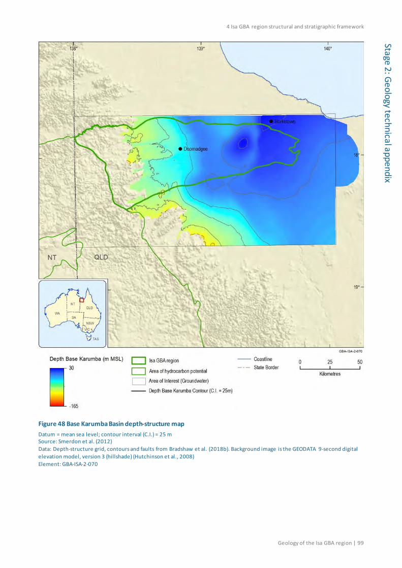
4 Isa GBA region structural and stratigraphic framework
Geology of the Isa GBA region | 99
Stage 2: Geology technical appendix
Figure 48 Base Karumba Basin depth-structure map Datum = mean sea level; contour interval (C.I.) = 25 m Source: Smerdon et al. (2012) Data: Depth-structure grid, contours and faults from Bradshaw et al. (2018b). Background image is the GEODATA 9-second digital elevation model, version 3 (hillshade) (Hutchinson et al., 2008) Element: GBA-ISA-2-070

4 Isa GBA region structural and stratigraphic framework
100 | Geology of the Isa GBA region
Stag
e 2:
Geo
logy
tech
nica
l app
endi
x
Figure 49 Karumba Basin isochore map Contour interval (C.I.) = 25 m Source: Derived using the published Karumba Basin isopach map in Smerdon et al. (2012) Data: Depth-structure grid, contours and faults from Bradshaw et al. (2018b). Background image is the GEODATA 9-second digital elevation model, version 3 (hillshade) (Hutchinson et al., 2008) Element: GBA-ISA-2-071
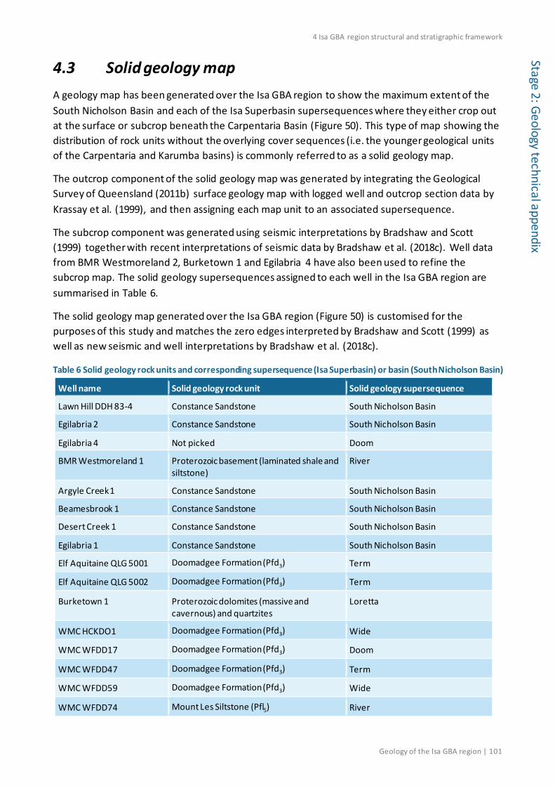
4 Isa GBA region structural and stratigraphic framework
Geology of the Isa GBA region | 101
Stage 2: Geology technical appendix
4.3 Solid geology map A geology map has been generated over the Isa GBA region to show the maximum extent of the South Nicholson Basin and each of the Isa Superbasin supersequences where they either crop out at the surface or subcrop beneath the Carpentaria Basin (Figure 50). This type of map showing the distribution of rock units without the overlying cover sequences (i.e. the younger geological units of the Carpentaria and Karumba basins) is commonly referred to as a solid geology map.
The outcrop component of the solid geology map was generated by integrating the Geological Survey of Queensland (2011b) surface geology map with logged well and outcrop section data by Krassay et al. (1999), and then assigning each map unit to an associated supersequence.
The subcrop component was generated using seismic interpretations by Bradshaw and Scott (1999) together with recent interpretations of seismic data by Bradshaw et al. (2018c). Well data from BMR Westmoreland 2, Burketown 1 and Egilabria 4 have also been used to refine the subcrop map. The solid geology supersequences assigned to each well in the Isa GBA region are summarised in Table 6.
The solid geology map generated over the Isa GBA region (Figure 50) is customised for the purposes of this study and matches the zero edges interpreted by Bradshaw and Scott (1999) as well as new seismic and well interpretations by Bradshaw et al. (2018c).
Table 6 Solid geology rock units and corresponding supersequence (Isa Superbasin) or basin (South Nicholson Basin)
Well name Solid geology rock unit Solid geology supersequence
Lawn Hill DDH 83-4 Constance Sandstone South Nicholson Basin
Egilabria 2 Constance Sandstone South Nicholson Basin
Egilabria 4 Not picked Doom
BMR Westmoreland 1 Proterozoic basement (laminated shale and siltstone)
River
Argyle Creek 1 Constance Sandstone South Nicholson Basin
Beamesbrook 1 Constance Sandstone South Nicholson Basin
Desert Creek 1 Constance Sandstone South Nicholson Basin
Egilabria 1 Constance Sandstone South Nicholson Basin
Elf Aquitaine QLG 5001 Doomadgee Formation (Pfd3) Term
Elf Aquitaine QLG 5002 Doomadgee Formation (Pfd3) Term
Burketown 1 Proterozoic dolomites (massive and cavernous) and quartzites
Loretta
WMC HCKDO1 Doomadgee Formation (Pfd3) Wide
WMC WFDD17 Doomadgee Formation (Pfd3) Doom
WMC WFDD47 Doomadgee Formation (Pfd3) Term
WMC WFDD59 Doomadgee Formation (Pfd3) Wide
WMC WFDD74 Mount Les Siltstone (Pfl5) River
4 Isa GBA region structural and stratigraphic framework
102 | Geology of the Isa GBA region
Stag
e 2:
Geo
logy
tech
nica
l app
endi
x
Figure 50 Solid geology map for Proterozoic supersequences from the Isa Superbasin and the South Nicholson Basin over the Isa GBA region Source: Bradshaw et al. (2018c) Data: Proterozoic solid geology map sourced from Bradshaw et al. (2018b). Background image is the GEODATA 9-second digital elevation model, version 3 (hillshade) (Hutchinson et al., 2008) Element: GBA-ISA-2-027

4 Isa GBA region structural and stratigraphic framework
Geology of the Isa GBA region | 103
Stage 2: Geology technical appendix
Future data acquisition would refine the solid geology interpretations. Data made available in recent years has resulted in differences between the solid geology map presented here and the solid geology map compiled earlier by the Geological Survey of Queensland (2011b). The differences include:
• a westward shift in the South Nicholson Basin boundary because Egilabria 4 (drilled in 2013) did not intersect South Nicholson Basin sediments. The basin subcrops the Carpentaria Basin at Beamesbrook 1
• the placement of the Term Supersequence as the subcrop unit in the hanging wall block of the Brinawa Fault System, due to the recent interpretations of seismic data by Bradshaw et al. (2018c).
Another difference is due to a variation in the stratigraphic placement of the Lawn Supersequence boundary. Krassay et al. (2000a) noted two different but valid placements of the Lawn Supersequence boundary, as follows:
• at the base Bulmung Sandstone, which represents a significant unconformity-bounded lowstand sandstone, and;
• the base of the Pmh 2 member, which represents a major change in sediment provenance to locally sourced volcaniclastic deposits.
The solid geology map of Figure 50 uses the former definition and so outlines a large outcropping area of the Term Supersequence in the south-western Isa GBA region.

4 Isa GBA region structural and stratigraphic framework
104 | Geology of the Isa GBA region
Stag
e 2:
Geo
logy
tech
nica
l app
endi
x 4.4 Regional three-dimensional datasets and schematic sections
The depth-converted structure maps published by Bradshaw et al. (2018c) for the Isa Superbasin, South Nicholson and Carpentaria basins were used to generate a simplified three-dimensional geological model for the Isa GBA region. Two three-dimensional perspective views of this model are shown in Figure 51 and Figure 52, while example cross-sections are shown in Figure 53 and Figure 54. Faults and other geological structures have not been explicitly incorporated into the model structure, but major structural features are clearly evident in areas where stratigraphy shows significant disruption/displacement over relatively short distances.
The regional three-dimensional geological model for the Isa GBA region underpins Isa GBA region shale gas prospectivity assessment (Bailey et al., 2020) and hydrostratigraphic analysis (Buchanan et al., 2020).
Figure 51 Oblique view of the regional three-dimensional geological model for the Isa GBA region (looking north) The structural surface shown is the Base Term Supersequence. Depth is in metres below mean sea level. The locations of key petroleum wells are also shown. The three-dimensional geological model is available from the GBA data repository. Source: Based on the grids of Bradshaw et al. (2018b) Element: GBA-ISA-2-120

4 Isa GBA region structural and stratigraphic framework
Geology of the Isa GBA region | 105
Stage 2: Geology technical appendix
Figure 52 Oblique view of the regional three-dimensional geological model for the Isa GBA region (looking east) The structural surface shown is the Base Term Supersequence. The locations of key petroleum wells are also shown. The three-dimensional geological model is available from the GBA data repository. Source: Based on the grids of Bradshaw et al. (2018b) Element: GBA-ISA-2-121

4 Isa GBA region structural and stratigraphic framework
106 | Geology of the Isa GBA region
Stag
e 2:
Geo
logy
tech
nica
l app
endi
x
Figure 53 Schematic east to west cross-section through the Isa GBA region generated from the three-dimensional geological model showing the along-strike structural architecture of the northern Lawn Hill Platform Both the Isa GBA region and the line location are shown on the inset map. The three-dimensional geological model is available from the GBA data repository. Source: Based on the grids of Bradshaw et al. (2018b). Element: GBA-ISA-2-122

4 Isa GBA region structural and stratigraphic framework
Geology of the Isa GBA region | 107
Stage 2: Geology technical appendix
Figure 54 Schematic north to south cross-section through the Isa GBA region generated from the three-dimensional geological model showing the cross-dip structural architecture of the northern Lawn Hill Platform Both the Isa GBA region and the line location are shown on the inset map. The three-dimensional geological model is available from the GBA data repository. Source: Based on the grids of Bradshaw et al. (2018b) Element: GBA-ISA-2-123

4 Isa GBA region structural and stratigraphic framework
108 | Geology of the Isa GBA region
Stag
e 2:
Geo
logy
tech
nica
l app
endi
x
Adi
4.5 Interpretation confidence The structural and stratigraphic interpretations presented here remain limited by the small number of seismic surveys and well data available over the northern Lawn Hill Platform (Figure 55). The variability in data coverage and quality corresponds to different degrees of confidence in the interpreted subsurface horizons and structural element maps derived from these data (Figure 56) (Bradshaw et al., 2018c).
An elongate area from just east of Argyle Creek 1 to just west of Beamesbrook 1 has good quality seismic data with well ties, allowing confident interpretation and mapping of seismic horizons (Figure 56) (Bradshaw et al., 2018c). In contrast, data coverage and quality are greatly reduced to the north and south of Argyle Creek 1, to the north of Desert Creek 1, to the south of the Egilabria 1 and 2 wells, and in the area surrounding Beamesbrook 1 (Figure 56). Consequently, interpretation confidence becomes low to very low in the areas extending to the southern flanks of the Murphy Inlier in the north and in the southern Isa GBA region (Figure 56).
This variability in data coverage and quality impacts both the accuracy of the interpreted surfaces and that of all derived products. Future additional data acquisition would add detail and accuracy to the geological characterisation of the Isa GBA region.
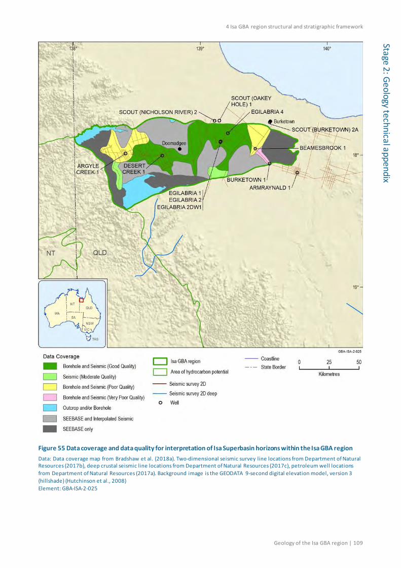
4 Isa GBA region structural and stratigraphic framework
Geology of the Isa GBA region | 109
Stage 2: Geology technical appendix
Figure 55 Data coverage and data quality for interpretation of Isa Superbasin horizons within the Isa GBA region Data: Data coverage map from Bradshaw et al. (2018a). Two-dimensional seismic survey line locations from Department of Natural Resources (2017b), deep crustal seismic line locations from Department of Natural Resources (2017c), petroleum well locations from Department of Natural Resources (2017a). Background image is the GEODATA 9-second digital elevation model, version 3 (hillshade) (Hutchinson et al., 2008) Element: GBA-ISA-2-025
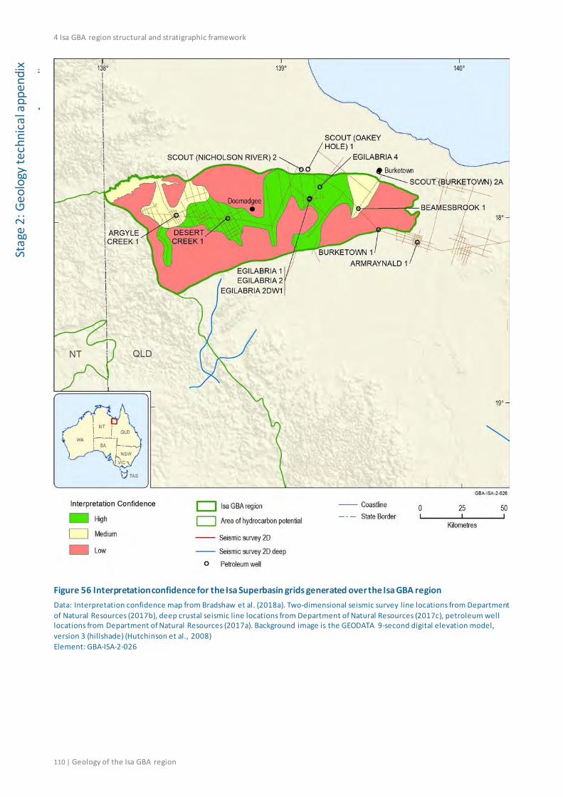
4 Isa GBA region structural and stratigraphic framework
110 | Geology of the Isa GBA region
Stag
e 2:
Geo
logy
tech
nica
l app
endi
x
Adi
Figure 56 Interpretation confidence for the Isa Superbasin grids generated over the Isa GBA region Data: Interpretation confidence map from Bradshaw et al. (2018a). Two-dimensional seismic survey line locations from Department of Natural Resources (2017b), deep crustal seismic line locations from Department of Natural Resources (2017c), petroleum well locations from Department of Natural Resources (2017a). Background image is the GEODATA 9-second digital elevation model, version 3 (hillshade) (Hutchinson et al., 2008) Element: GBA-ISA-2-026

References
Geology of the Isa GBA region | 111
Stage 2: Geology technical appendix
References Abbott ST and Sweet IP (2000) Tectonic control on third-order sequences in a siliciclastic ramp-
style basin: An example from the Roper Superbasin (Mesoproterozoic), northern Australia. Australian Journal of Earth Sciences 47(3), 637-657. Doi: 10.1046/j.1440-0952.2000.00795.x.
Abbott ST, Sweet IP, Plumb KA, Young DN, Cutovinos A, Ferenczi PA, Brakel A and Pietsch BA (2001) Roper Region: Urapunga and Roper River Special, Northern Territory (Second Edition). 1:250 000 geological map series explanatory notes, SD 53-10, 11. Northern Territory Geological Survey and Geoscience Australia (National Geoscience Mapping Accord), Darwin.
Abu Sharib ASAA and Sanislav IV (2013) Polymetamorphism accompanied switching in horizontal shortening during Isan Orogeny: Example from the Eastern Fold Belt, Mount Isa Inlier, Australia. Tectonophysics 587, 146-167. Doi: 10.1016/j.tecto.2012.06.05.
Ahmad M and Scrimgeour IR (2013) Chapter 2: Geological Framework. In: Ahmad M and Munson TJ (eds), Geology and mineral resources of the Northern Territory. Northern Territory Geological Survey, Special Publication 5, Darwin, 16.
Anderson J, Carson C, Lewis C, Kositcin N, Cross A, Carr L and Henson P (2019) Exploring for the Future: new U–Pb geochronology for the South Nicholson region and implications for stratigraphic correlations. In: Australasian Exploration Geoscience Conference (AEGC) 2019 Proceedings, Perth.
Bailey AHE, Bradshaw BE, Palu T, Wang L, Jarrett AJM, Orr ML, Lech M, Evenden C, Arnold D, Reese B, Skeers N, Woods M, Dehelean A, Lawson C and Hall L (2020) Shale gas prospectivity for the Isa GBA region. Technical appendix for the Geological and Bioregional Assessment: Stage 2. Department of the Environment and Energy, Bureau of Meteorology, CSIRO and Geoscience Australia, Australia.
Betts P, Armit R and Ailleres L (2015) Potential-field interpretation mapping of the greater McArthur Basin. PGN Geoscience Report 15/2014, in Northern Territory Geological Survey, Digital Information Package DIP 015. Northern Territory Geological Survey, Darwin. Viewed 12 September 2018, https://geoscience.nt.gov.au/gemis/ntgsjspui/handle/1/81754.
Betts PG, Giles D, Mark G, Lister GS, Goleby BR and Aillères L (2006) Synthesis of the Proterozoic evolution of the Mt Isa Inlier. Australian Journal of Earth Sciences 53(1), 187-211. Doi: 10.1080/08120090500434625.
Bierlein FP, Black LP, Hergt J and Mark G (2008) Evolution of Pre-1.8 Ga basement rocks in the western Mt Isa Inlier, northeastern Australia—Insights from SHRIMP U–Pb dating and in-situ Lu–Hf analysis of zircons. Precambrian Research 163, 159-173. Doi: 10.1016/j.precamres.2007.08.017.
Bierlein FP, Maas R and Woodhead J (2011) Pre-1.8 Ga tectono-magmatic evolution of the Kalkadoon–Leichhardt Belt: implications for the crustal architecture and metallogeny of the Mount Isa Inlier, northwest Queensland, Australia. Australian Journal of Earth Sciences 58(8), 887-915. Doi: 10.1080/08120099.2011.571286.
References
112 | Geology of the Isa GBA region
Stag
e 2:
Geo
logy
tech
nica
l app
endi
x Blaikie TN, Betts PG, Armit RJ and Ailleres L (2017) The ca. 1740–1710Ma Leichhardt Event: Inversion of a continental rift and revision of the tectonic evolution of the North Australian Craton. Precambrian Research 292, 75-92. Doi: 10.1016/j.precamres.2017.02.003.
Blake DH (1987) Geology of the Mount Isa Inlier and environs, Queensland and Northern Territory. Bureau of Mineral Resources (BMR) Bulletin 225. Canberra.
Bradshaw BE and Scott DL (1999) Integrated basin analysis of the Isa Superbasin using seismic, well log and geopotential data: An evaluation of the economic potential of the Northern Lawn Hill Platform. Australian Geological Survey Organisation (AGSO) Record 1999/19. Canberra.
Bradshaw BE, Scott DL, Southgate PN, Krassay AA, Lindsay JF, Page RW, Sami TT and Jackson MJ (1999) Evolution of contemporaneous depositional systems in the Isa Superbasin. In: Bradshaw BE and Scott DL (eds), Integrated basin analysis of the Isa Superbasin using seismic, well log and geopotential data: An evaluation of the economic potential of the Northern Lawn Hill Platform. Australian Geological Survey Organisation (AGSO) Record 1999/19, Canberra, 128-162.
Bradshaw BE, Lindsay JF, Krassay AA and Wells AT (2000) Attenuated basin-margin sequence stratigraphy of the Palaeoproterozoic Calvert and Isa Superbasins: The Fickling Group, southern Murphy Inlier, Queensland. Australian Journal of Earth Sciences 47(3), 599-623. Doi: 10.1046/j.1440-0952.2000.00794.x.
Bradshaw BE, Spencer LK, Lahtinen AC, Khinder K, Ryand DJ, Colwell JB, Chirinos A and Bradshaw J (2009) Queensland Carbon Dioxide Geological Storage Atlas. Department of Employment, Economic Development and Innovation, Queensland Government.
Bradshaw BE, Orr ML, Bailey AHE, Palu TJ and Hall LS (2018a) Isa GBA region sub-surface mapping data set. GBA data repository GUID: GUID38661A8A-5FC0-44BD-A979-AE48B3726D25.
Bradshaw BE, Orr ML, Bailey AHE, Palu TJ and Hall LS (2018b) Northern Lawn Hill Platform Depth Structure and Isochore Mapping Update: data release. GBA data repository GUID: 14042057-ACF5-48DA-8B68-28219FE561A9.
Bradshaw BE, Orr ML, Bailey AHE, Palu TJ and Hall LS (2018c) Northern Lawn Hill Platform Depth Structure and Isochore Mapping Update. Geoscience Australia (GA) Record 2018/47. Doi: 10.11636/Record.2018.047.
Brocks JJ, Jarrett AJM, Sirantoine E, Hallmann C, Hoshino Y and Liyanage T (2017) The rise of algae in Cryogenian oceans and the emergence of animals. Nature 548, 578. Doi: 10.1038/nature23457.
Buchanan S, Dixon-Jain P, Martinez J, Raiber M, Kumar P, Woods M, Arnold D, Dehelean A and Skeers N (2020) Hydrogeology and groundwater systems of the Isa GBA region. Technical appendix for the Geological and Bioregional Assessment: Stage 2. Department of the Environment and Energy, Bureau of Meteorology, CSIRO and Geoscience Australia, Australia.

References
Geology of the Isa GBA region | 113
Stage 2: Geology technical appendix
Campbell RJ and Haig DW (1999) Bathymetric change during Early Cretaceous intracratonic marine transgression across the northeastern Eromanga Basin, Australia. Cretaceous Research 20(4), 403-446. Doi: 10.1006/cres.1999.0161.
Carr LK, Korsch RJ, Palu TJ and Reese B (2016) Onshore Basin Inventory: the McArthur, South Nicholson, Georgina, Wiso, Amadeus, Warburton, Cooper and Galilee basins, central Australia. Geoscience Australia (GA) Record 2016/04. Canberra, Doi: 10.11636/Record.2016.004.
Carson CJ, Hutton LJ, Withnall IW, Perkins WG, Donchak PJT, Parsons A, Blake PR, Sweet IP, Neumann NL and Lambek A (2011) Joint GSQ-GA NGA geochronology project Mt Isa region, 2009-2010. Queensland Geological Record 2011/03. Geological Survey of Queensland, Brisbane.
Cook AG and Jell JS (2013) Chapter 8: Paleogene and Neogene. In: Jell PA (ed), Geology of Queensland. Geological Survey of Queensland, Brisbane, 577-652.
Cook AG, Bryan SE and Draper JJ (2013) Chapter 7: Post-orogenic Mesozoic basins and magmatism. In: Jell PA (ed), Geology of Queensland. Geological Survey of Queensland, Brisbane, 515-576.
Daines SJ, Mills BJW and Lenton TM (2017) Atmospheric oxygen regulation at low Proterozoic levels by incomplete oxidative weathering of sedimentary organic carbon. Nature Communications 8, 14379. Doi: 10.1038/ncomms14379.
Delle Piane C, Uysal T, Pan Z, Bourdet J, Li Z, Raven MD and Dewhurst DN (2019) A multidisciplinary evaluation of the Velkerri Formation in the Beetaloo Sub- Basin: Implications for geological history and reservoir quality. In: Annual Geoscience Exploration Seminar (AGES) 2019 Presentations. Northern Territory Geological Survey. Viewed 01 April 2019, https://dpir.nt.gov.au/__data/assets/pdf_file/0004/669379/940_DellePiane.pdf.
Department of Natural Resources, Mines and Energy (Qld) (2017a) Petroleum Well Locations – Queensland. Viewed 06 April 2018, http://qldspatial.information.qld.gov.au/catalogue/custom/search.page?q=%22Petroleum%20well%20locations%20-%20Queensland%22. GBA data repository GUID: F2E516E4-5FC6-44FC-A70A-C45A1288AE83.
Department of Natural Resources, Mines and Energy (Qld), (2017b) Seismic Survey 2D – Queensland. Viewed 05 April 2018, http://qldspatial.information.qld.gov.au/catalogue/custom/index.page. GBA data repository GUID: 9E51EC92-FDF7-4630-8AE3-72D3B6CA316D.
Department of Natural Resources, Mines and Energy (Qld), (2017c) Seismic Survey Deep – Queensland. Viewed 05 April 2018, http://qldspatial.information.qld.gov.au/catalogue/custom/index.page. GBA data repository GUID: 4DB45BBE-3952-435F-9B26-A21800E72689.
Department of Natural Resources, Mines and Energy (Qld), (2019a) QDEX - Queensland Digital Exploration Data. Viewed 30 August 2019, http://qdexdata.dnrm.qld.gov.au/flamingo/.
References
114 | Geology of the Isa GBA region
Stag
e 2:
Geo
logy
tech
nica
l app
endi
x Department of Natural Resources, Mines and Energy (Qld), (2019b) QDEX - Queensland Digital Exploration Reports. Viewed 30 August 2019, http://qdexguest.dnrm.qld.gov.au/portal/site/qdex/.
Department of Primary Industry and Resources (NT) (2018a) Northern Territory Statewide Wells and Drillholes. Viewed 15 October 2018, https://dpir.nt.gov.au/mining-and-energy/STRIKE/accessing-nt-datasets/nt-wide-geoscience-datasets. GBA data repository GUID: 89932245-A9F0-41D5-BBFE-889EE85F970D.
Department of Primary Industry and Resources (NT) (2018b) STRIKE tenure and geoscience information - Geology Maps. Viewed 27 November 2018, https://dpir.nt.gov.au/mining-and-energy/STRIKE/accessing-nt-datasets/nt-wide-geoscience-datasets. GBA data repository GUID: 566232BD-119F-4910-9CC1-DD4E3B2667FF.
Duddy IR, Green PF, Gibson HJ and Hegarty KA (2003) Regional palaeo-thermal episodes in northern Australia. Proceedings of the Timor Sea Symposium 2003. In: Ellis GK, Baillie PW and Munson TJ (eds), Timor Sea Petroleum Geoscience. Northern Territory Geological Survey, Special Publication 1, 567–591.
Duncan RJ, Buick IS, Kobayashi K and Wilde AR (2014) Chemical and stable isotopic characteristics of syn-tectonic tourmaline from the Western fold belt, Mount Isa inlier, Queensland, Australia. Chemical Geology 381, 131-143. Doi: 10.1016/j.chemgeo.2014.05.002.
Dunster JN, McConachie BA and Brown MG (1989) PRC Beamesbrook-1 Well Completion Report, ATP 373P, Carpentaria Basin, Queensland. Comalco Aluminium Limited.
Dunster JN, Barlow MG, McConachie BA and Stainton PW (1993a) Egilabria-1 Well Completion Report, ATP 423P, Queensland. Comalco Aluminium Limited.
Dunster JN, Barlow MG, McConachie BA and Stainton PW (1993b) Argyle Creek-1 Well Completion Report, ATP 423P, Queensland. Comalco Aluminium Limited.
Dunster JN, Barlow MG, McConachie BA and Stainton PW (1993c) Desert Creek-1 Well Completion Report, ATP 423P, Queensland. Comalco Aluminium Limited.
Edgoose CJ and Ahmad M (2013) Chapter 42: Cenozoic Geology and Regolith. In: Ahmad M and Munson TJ (eds), Geology and mineral resources of the Northern Territory. Northern Territory Geological Survey, Special Publication 5, Darwin.
Energy Resources Consulting (2017) Analytical report: source rock organic matter reflectance and typing. Geological Survey of Queensland. Brisbane.
Faiz M, Altmann C, Dunne M, Baruch E, Close D, Côté A, Richards B and Ranasinghe P (2016) Precambrian Organic Matter and Thermal Maturity of the Beetaloo Basin, Northern Territory, Australia. In: Australian Earth Sciences Convention (AESC) 2016 Abstracts, Adelaide.
Frogtech Geoscience (2018a) North West Queensland SEEBASE study and GIS. Queensland Geological Record 2018/03, Geological Survey of Queensland. GBA data repository GUID: B8F94284-278A-4F0F-8215-802FFBE972DB.
References
Geology of the Isa GBA region | 115
Stage 2: Geology technical appendix
Frogtech Geoscience (2018b) SEEBASE® study and GIS for greater McArthur Basin. Northern Territory Geological Survey, Digital Information Package DIP 017 (ESRI file format, March 2018). Viewed 25 May 2018, https://geoscience.nt.gov.au/gemis/ntgsjspui/handle/1/87064. GBA data repository GUID: 563A5349-DC7F-42B8-B6CC-892B3B4C3C3F.
Geological and Bioregional Assessment Program (2018) Isa GBA region and area of hydrocarbon potential. GBA data repository GUID: 18F6E2B1-F59C-4176-812A-B5E813A33F38.
Geological Survey of Queensland (2011a) North-West Queensland Mineral and Energy Province report. Queensland Department of Employment, Economic Development and Innovation, Brisbane.
Geological Survey of Queensland (2011b) North-West Queensland Mineral and Energy Province data package. GBA data repository GUID: FB134E56-8F94-4307-933F-32D49CC8DD91.
Geological Survey of Queensland (2018) Queensland Petroleum Exploration Database (QPED). Viewed 18 May 2018, http://qldspatial.information.qld.gov.au/catalogue/custom/detail.page?fid={840912C6-50F8-4234-8198-E035056664B0}.
Geoscience Australia (2016) Scanned 250K Geological Map Index. Viewed 10 September 2018, http://services.ga.gov.au/gis/rest/services/Scanned_250k_Geological_Map_Index/MapServer. GBA data repository GUID: 28BC1BC4-F07B-44DC-9943-04FBFAC8EECC.
Geoscience Australia (2017) GEODATA TOPO 250K Series 3 Topographic Data. Viewed 1 October 2018, http://pid.geoscience.gov.au/dataset/ga/64058. GBA data repository GUID: BCA7C9F6-6639-45C4-ABC8-5027EFA14B40.
Geoscience Australia (2018a) Exploring for the Future - AusAEM. Geoscience Australia. Viewed 07 January 2019, http://www.ga.gov.au/eftf/minerals/nawa/ausaem.
Geoscience Australia (2018b) Australian National Gravity Database: Isa GBA region subset. GBA data repository GUID: A1690212-3435-447D-8399-5616E476D6F2.
Geoscience Australia (2018c) AusLAMP - Illuminating Australia's deep earth. Geoscience Australia. Viewed 21 November 2018, http://www.ga.gov.au/about/projects/resources/auslamp.
Gessner K (2011) Hot lithosphere at Mount Isa: implications for Proterozoic tectonics and mineralisation. Australian Journal of Earth Sciences 58(8), 875-886. Doi: 10.1080/08120099.2011.571284.
Gibson GM, Meixner AJ, Withnall IW, Korsch RJ, Hutton LJ, Jones LEA, Holzschuh J, Costelloe RS, Henson PA and Saygin E (2016) Basin architecture and evolution in the Mount Isa mineral province, northern Australia: Constraints from deep seismic reflection profiling and implications for ore genesis. Ore Geology Reviews 76, 414-441.
Gibson GM, Hutton LJ and Holzschuh J (2017) Basin inversion and supercontinent assembly as drivers of sediment-hosted Pb–Zn mineralization in the Mount Isa region, northern Australia. Journal of the Geological Society 174, 773-786. Doi: 10.1144/jgs2016-105.

References
116 | Geology of the Isa GBA region
Stag
e 2:
Geo
logy
tech
nica
l app
endi
x Giles D, Ailléres L, Jeffries D, Betts P and Lister G (2006a) Crustal architecture of basin inversion during the Proterozoic Isan Orogeny, Eastern Mount Isa Inlier, Australia. Precambrian Research 148(1), 67-84. Doi: 10.1016/j.precamres.2006.03.002.
Giles D, Betts PG, Aillères L, Hulscher B, Hough M and Lister GS (2006b) Evolution of the Isan Orogeny at the southeastern margin of the Mt Isa Inlier. Australian Journal of Earth Sciences 53(1), 91-108. Doi: 10.1080/08120090500432470.
Glass LM, Ahmad M and Dunster JN (2013) Chapter 30: Kalkarindji Province. In: Ahmad M and Munson TJ (eds), Geology and mineral resources of the Northern Territory. Northern Territory Geological Survey, Special Publication 5, Darwin, 18.
Glikson M, Taylor D and Morris D (1992) Lower palaeozoic and precambrian petroleum source rocks and the coalification path of alginite. Organic Geochemistry 18(6), 881-897. Doi: 10.1016/0146-6380(92)90056-4.
Glikson M, Golding SD and Southgate P (2006) Thermal Evolution of the Ore-Hosting Isa Superbasin: Central and Northern Lawn Hill Platform. Economic Geology 101, 1211-1229. Doi: 10.2113/gsecongeo.101.6.1211.
Golding SD, Uysal IT, Glikson M, Baublys KA and Southgate PN (2006) Timing and chemistry of fluid-flow events in the Lawn Hill platform, northern Australia. Economic Geology 101(6), 1231-1250.
Gorton J and Troup A (2018) Petroleum systems of the Proterozoic in northwest Queensland and a description of various play types. The APPEA Journal 58(1), 311-320. Doi: 10.1071/AJ17115.
Grimes KG and Sweet IP (1979) Westmoreland, Queensland, sheet SE/54-5 (Second Edition). 1:250 000 geological map series explanatory notes. Bureau of Mineral Resources and Geological Survey of Queensland, Canberra.
Grotzinger JP and Knoll AH (1999) Stromatolites in Precambrian carbonates: Evolutionary mileposts or environmental dipsticks? Annual review of earth and planetary sciences 27, 313-358. Doi: 10.1146/annurev.earth.27.1.313.
Henson PA, Carr L, Fomin F, Gerner E, Costelloe RS, Southby C, Anderson J, Bailey AHE, Lewis C, Champion D and Huston D (2018) Exploring for the Future - Discovering the South Nicholson Basin region with new seismic data. Annual Geoscience Exploration Seminar (AGES) 2018. Northern Territory Geological Survey, NTGS Record 2018-002, 52-54.
Hutchinson MF, Stein JL, Stein JA, Anderson H and Tickle PK (2008) GEODATA 9 second DEM and D8: Digital Elevation Model Version 3 and Flow Direction Grid. Viewed 13 February 2019, http://pid.geoscience.gov.au/dataset/ga/66006. GBA data repository GUID: A9745284-35AC-4AB5-8976-C2F5F1E1B85A, 612D78FB-DAAB-4156-93F7-6CB32F17DF41.
Idnurm M (2000) Towards a high resolution Late Palaeoproterozoic - earliest Mesoproterozoic apparent polar wander path for northern Australia. Australian Journal of Earth Sciences 47(3), 405-429. Doi: 10.1046/j.1440-0952.2000.00788.x.
References
Geology of the Isa GBA region | 117
Stage 2: Geology technical appendix
Jackson MJ, Powell TG, Summons RE and Sweet IP (1986) Hydrocarbon shows and petroleum source rocks in sediments as old as 1.7 × 10⁹ years. Nature 322, 727-729. Doi: 10.1038/322727a0.
Jackson MJ, Sweet IP, Page RW and Bradshaw BE (1999) The South Nicholson and Roper Groups: evidence for the early Mesoproterozoic Roper Superbasin. In: Bradshaw BE and Scott DL (eds), Integrated basin analysis of the Isa Superbasin using seismic, well-log and geopotential data: an evaluation of the economic potential of the northern Lawn Hill Platform. Australian Geological Survey Organisation (AGSO) Record 1999/19, 36–45.
Jackson MJ and Southgate PN (2000) Evolution of three unconformity-bounded sandy carbonate successions in the McArthur River region of northern Australia: the Lawn, Wide and Doom Supersequences in a proximal part of the Isa Superbasin. Australian Journal of Earth Sciences 47(3), 625-635.
Jackson MJ, Scott DL and Rawlings DJ (2000) Stratigraphic framework for the Leichhardt and Calvert Superbasins: review and correlations of the pre-1700 Ma successions between Mt Isa and McArthur River. Australian Journal of Earth Sciences 47(3), 381-403.
Jarrett AJM, Hall L, Carr L, Anderson J, Orr ML, Bradshaw BE and Henson P (2018) Source rock geochemistry of the Isa Superbasin and South Nicholson Basin, northern Australia: Baseline regional hydrocarbon prospectivity. Geoscience Australia (GA) Record 2018/032. Canberra.
Knight T (2018) Strategic Resources Exploration Program. In: Queensland Exploration Council - Technical Forum, 16. Viewed 30 October 2018, https://queenslandexploration.com.au/wp-content/uploads/2018/03/Tony-Knight-SREP-overview_Feb2018.pdf.
Krassay AA, Bradshaw BE, Domagala J, McConachie BA, Lindsay JF, Jackson MJ, Southgate PN, Barnett KW and Zeilinger I (1999) Measured Sections and Sequence Stratigraphic Interpretations: Upper McNamara and Fickling Groups. Australian Geological Survey Organisation (AGSO) Record 1999/15. Canberra.
Krassay AA and Bradshaw BE (1999) Well log sequence stratigraphy. In: Bradshaw BE and Scott DL (eds), Integrated basin analysis of the Isa Superbasin using seismic, well log and geopotential data: An evaluation of the economic potential of the Northern Lawn Hill Platform. Australian Geological Survey Organisation (AGSO) Record 1999/09, Canberra, 109-126.
Krassay AA, Domagala J, Bradshaw BE and Southgate PN (2000a) Lowstand ramps, fans and deep-water Palaeoproterozoic and Mesoproterozoic facies of the Lawn Hill Platform: The Term, Lawn, Wide and Doom Supersequences of the Isa Superbasin, northern Australia. Australian Journal of Earth Sciences 47(3), 563-597. Doi: 10.1046/j.1440-0952.2000.00791.x.
Krassay AA, Bradshaw BE, Domagala J and Jackson MJ (2000b) Siliciclastic shoreline to growth-faulted, turbiditic sub-basins: The Proterozoic River Supersequence of the upper McNamara Group on the Lawn Hill Platform, northern Australia. Australian Journal of Earth Sciences 47(3), 533-562. Doi: 10.1046/j.1440-0952.2000.00790.x.
Lindsay JF, Bradshaw BE, Krassay AA and Wells AT (1999) Attenuated sequence stratigraphy of the Isa Superbasin: The Fickling Group, southern Murphy Inlier. In: Bradshaw BE and Scott DL

References
118 | Geology of the Isa GBA region
Stag
e 2:
Geo
logy
tech
nica
l app
endi
x (eds), Integrated basin analysis of the Isa Superbasin using seismic, well log and geopotential data: An evaluation of the economic potential of the northern Lawn Hill Platform. Australian Geological Survey Organisation (AGSO) Record 1999/19, Canberra, 27-36.
Longdon N (2014a) Well Completion Report, Egilabria 2, ATP 1087, Queensland. Armour Energy Limited.
Longdon N (2014b) Well Completion Report, Egilabria 4, ATP 1087, Queensland. Armour Energy Limited.
Marshall PE, Halton AM, Kelley SP, Widdowson M and Sherlock SC (2018) New 40Ar/39Ar dating of the Antrim Plateau Volcanics, Australia: clarifying an age for the eruptive phase of the Kalkarindji continental flood basalt province. Journal of the Geological Society 175, 974-985. Doi: 10.1144/jgs2018-035.
McConachie BA, Filatoff J and Senapati N (1990) Stratigraphy and petroleum potential of the onshore Carpentaria Basin, Queensland. APPEA Journal 30(1), 149-164.
McConachie BA (1993) Basin analysis and economic geology of the northern Mount Isa Basin. Doctor of Philosophy thesis. Queensland University of Technology, Brisbane.
McConachie BA, Dunster JN, Wellman P, Denaro TJ, Pain CF, Habermehl MA and Draper JJ (1997) Carpentaria Lowlands and Gulf of Carpentaria regions. In: Bain JHC and Draper JJ (eds), North Queensland Geology. AGSO Bulletin 240, Queensland Geology 9. Australian Geological Survey Organisation and Department of Mines and Energy Queensland, Canberra, 365-398.
Munson TJ, Ahmad M and Dunster JN (2013a) Chapter 39: Carpentaria Basin In: Ahmad M and Munson TJ (eds), Geology and mineral resources of the Northern Territory. Northern Territory Geological Survey, Special Publication 5, Darwin, 18.
Munson TJ, Kruse PD and Ahmad M (2013b) Chapter 22: Centralian Superbasin. In: Ahmad M and Munson TJ (eds), Geology and mineral resources of the Northern Territory. Northern Territory Geological Survey, Special Publication 5, Darwin, 639-657.
Munson TJ (2014) Petroleum geology and potential of the onshore Northern Territory. Northern Territory Geological Survey, Report 22.
Munson TJ (2016) Sedimentary Characterisation of the Wilton Package, greater McArthur Basin, Northern Territory. Northern Territory Geological Survey (NTGS) Record 2016-003.
Nakamura A and Milligan PR (2015) Total Magnetic Intensity (TMI) Anomaly Grid of Australia with Variable Reduction to Pole (VRTP), sixth edition. Geoscience Australia, Canberra. Viewed 06 September 2018, http://pid.geoscience.gov.au/dataset/89596. GBA data repository GUID: 520F9414-A540-4A25-95DA-179CBAFA1974.
Nakamura A (2016) Complete Bouguer Gravity Anomaly Grid of Onshore Australia 2016. Geoscience Australia, Canberra. Viewed 08 June 2018, http://pid.geoscience.gov.au/dataset/ga/101103. GBA data repository GUID: 90051000-453B-4259-A909-C627C3F2EBE1.

References
Geology of the Isa GBA region | 119
Stage 2: Geology technical appendix
Neumann N and Fraser GL (2007) Geochronological synthesis and time-space plots for Proterozoic Australia, Geoscience Australia (GA) Record 2007/06.
Neumann NL, Southgate PN, Gibson GM and McIntyre A (2006) New SHRIMP geochronology for the Western Fold Belt of the Mt Isa Inlier: Developing a 1800-1650 Ma event framework. Australian Journal of Earth Sciences 53(6), 1023-1039. Doi: 10.1080/08120090600923287.
Page RW and Sweet IP (1998) Geochronology of basin phases in the western Mt Isa Inlier, and correlation with the McArthur Basin. Australian Journal of Earth Sciences 45(2), 219-232. Doi: 10.1080/08120099808728383.
Page RW, Jackson MJ and Krassay AA (2000) Constraining sequence stratigraphy in north Australian basins: SHRIMP U-Pb zircon geochronology between Mt Isa and McArthur River. Australian Journal of Earth Sciences 47(3), 431-459. Doi: 10.1046/j.1440-0952.2000.00797.x.
Percival PJ (2014) Index of Airborne Geophysical Surveys, 14th edition. Geoscience Australia (GA) Record 2014/14. Canberra, Doi: 10.11636/Record.2014.014.
Perkins C, Heinrich CA and Wyborn LAI (1999) 40 Ar/ 39 Ar geochronology of copper mineralization and regional alteration, Mount Isa, Australia. Economic Geology 94, 23-36. Doi: 10.2113/gsecongeo.94.1.23.
Perryman JC (1964) Well Completion Report, Burketown No. 1 Well, ATP 91-P, Queensland. Mid-Eastern Oil N.L.
Petrosys Pty Ltd (2019) Oil and gas field outlines and pipeline routes from the GPinfo petroleum database [spatial]. Viewed 05 August 2019, http://www.gpinfo.com.au/. GBA data repository GUID: A7CD2D93-7BDD-40CB-B8D4-D77BB9837A06.
Planavsky NJ, McGoldrick P, Scott CT, Li C, Reinhard CT, Kelly AE, Chu X, Bekker A, Love GD and Lyons TW (2011) Widespread iron-rich conditions in the mid-Proterozoic ocean. Nature 477, 448-451. Doi: 10.1038/nature10327.
Planavsky NJ, Reinhard CT, Wang X, Thomson D, McGoldrick P, Rainbird RH, Johnson T, Fischer WW and Lyons TW (2014) Low Mid-Proterozoic atmospheric oxygen levels and the delayed rise of animals. Science 346(6209), 635.
Polito PA, Kyser TK, Southgate PN and Jackson MJ (2006) Sandstone Diagenesis in the Mount Isa Basin: An Isotopic and Fluid Inclusion Perspective in Relationship to District-Wide Zn, Pb, and Cu Mineralization. Economic Geology 101(6), 1159-1188. Doi: 10.2113/gsecongeo.101.6.1159.
Pursuit Minerals (2017) Pursuit Minerals Limited lists on ASX and immediately commences Bluebush Drilling Program. Viewed 05 November 2018, http://pursuitminerals.com.au/wp-content/uploads/2017/09/PUR-lists-on-ASX-and-Commences-Bluebush-Drilling-Program.pdf.
Radke BM, Kellett JR, Ransley TR, Carey H, Bell JG and Stewart GA (2012) Hydrogeological framework. In: Smerdon BD, Welsh WD and Ransley TR (eds), Water resource assessment for the Carpentaria region. A report to the Australian Government from the CSIRO Great
References
120 | Geology of the Isa GBA region
Stag
e 2:
Geo
logy
tech
nica
l app
endi
x Artesian Basin Water Resource Assessment. CSIRO Water for a Healthy Country Flagship, Australia. CSIRO, 65-92.
Ransley T, Radke B, Kellett J, Bell J and Stewart G (2015) Great Artesian Basin - Hydrogeology and Extent Boundary. Viewed 27 November 2018, http://pid.geoscience.gov.au/dataset/ga/81672. GBA data repository GUID: FACA24B4-6643-4F1D-8FB6-2EE0F2D1A37D.
Rawlings DJ, Haines PW, Madigan TLA, Pietsch BA, Sweet IP, Plumb KA and Krassay AA (1997) Arnhem Bay–Gove, Northern Territory (Second Edition). 1:250 000 geological map series explanatory notes, SD 53-03, 04. 1:250:000 geological map series. Northern Territory Geological Survey and Australian Geological Survey Organisation (National Geoscience Mapping Accord), Darwin.
Rawlings DJ (1999) Stratigraphic resolution of a multiphase intracratonic basin system: the McArthur Basin, northern Australia. Australian Journal of Earth Sciences 46, 703-723. Doi: 10.1046/j.1440-0952.1999.00739.x.
Rawlings DJ, Sweet IP and Kruse PD (2008) Mount Drummond, Northern Territory (Second Edition). 1:250 000 geological map series explanatory notes, SE, 53–12. Northern Territory Geological Survey, Darwin.
Raymond OL, Gallagher R, Shaw R, Yeates AN, Doutch HF, Palferyman WD, Blale DH and Highet LM (2012a) Surface Geology of Australia 1:2.5 million scale dataset 2012 edition. Viewed 06 September 2018, http://pid.geoscience.gov.au/dataset/ga/73140. GBA data repository GUID: DC10F78B-715F-4EE0-BD42-067E7B975BE6.
Raymond OL, Lui S, Gallagher R, Zhang W and Highet LM (2012b) Surface Geology of Australia 1:1 million scale dataset 2012 edition. Viewed 06 September 2018, http://pid.geoscience.gov.au/dataset/ga/74619. GBA data repository GUID: A74CCABD-CB40-4741-A301-DAC9F53CEAE1.
Raymond OL, Totterdell JM, Stewart AJ and Woods MA (2018) Australian Geological Provinces, 2018.01 edition. Viewed 06 May 2018, http://pid.geoscience.gov.au/dataset/ga/116823. GBA data repository GUID: 686747D2-44B0-4ECD-A880-58C8FC7F4110.
Richardson LM (2018) ARGUS - Airborne Geophysical Surveys Metadata Database. Unpublished. (Accessed: 21 May 2018).
Roberts HG, Rhodes JH and Yates KR (1963) Calvert Hills, Northern Territory, 1:250 000 geological map series explanatory notes. Bureau of Mineral Resources, Canberra.
Rohrlach BD, Fu M and Clarke JDA (1998) Geological setting, paragenesis and fluid history of the Walford Creek Zn-Pb-Cu-Ag prospect, Mt Isa Basin, Australia. Australian Journal of Earth Sciences 45(1), 63-81. Doi: 10.1080/08120099808728367.
Scott DL, Bradshaw BE and Tarlowski CZ (1998) The tectonostratigraphic history of the Proterozoic Northern Lawn Hill Platform, Australia: an integrated intracontinental basin analysis. Tectonophysics 300, 329-358.
References
Geology of the Isa GBA region | 121
Stage 2: Geology technical appendix
Scott DL and Tarlowski C (1999) Structural framework. In: Bradshaw BE and Scott DL (eds), Integrated basin analysis of the Isa Superbasin using seismic, well-log and geophysical data: an evaluation of the economic potential of the Northern Lawn Hill Platform. Australian Geological Survey Organisation (AGSO) Record 1999/19, Canberra, 87-107.
Scott DL, Jackson MJ and Rawlings DJ (1999) Southern Murphy Inlier: Peters Creek Volcanics. In: Bradshaw BE and Scott DL (eds), Integrated basin analysis of the Isa Superbasin using seismic, well-log and geophysical data: an evaluation of the economic potential of the Northern Lawn Hill Platform. Australian Geological Survey Organisation (AGSO) Record 1999/19, Canberra, 23-26.
Scott DL and Bradshaw BE (1999) Seismic sequence stratigraphy and basin evolution. In: Bradshaw BE and Scott DL (eds), Integrated basin analysis of the Isa Superbasin using seismic, well-log and geophysical data: an evaluation of the economic potential of the Northern Lawn Hill Platform. Australian Geological Survey Organisation (AGSO) Record 1999/19, 61-85.
Scott DL, Rawlings DJ, Page RW, Tarlowski CZ, Idnurm M, Jackson MJ and Southgate PN (2000) Basement framework and geodynamic evolution of the Palaeoproterozoic superbasins of north-central Australia: An integrated review of geochemical, geochronological and geophysical data. Australian Journal of Earth Sciences 47(3), 341-380. Doi: 10.1046/j.1440-0952.2000.00793.x.
Smart J, Grimes KG, Doutch HF and Pinchin J (1980) The Carpentaria and Karumba Basins, North Queensland. Bureau of Mineral Resources (BMR) Bulletin 202. Canberra.
Smerdon BD, Welsh WD and Ransley TR (2012) Water resource assessment for the Carpentaria region. A report to the Australian Government from the CSIRO Great Artesian Basin Water Resource Assessment. CSIRO Water for a Healthy Country Flagship, Australia. CSIRO.
Southgate PN, Bradshaw BE, Scott DL, Domagala J, Idnurm M, Jackson MJ, Krassay AA, Lindsay JF, Page RW, Sami TT and Wells AT (1999) Tectonostratigraphic overview of the Isa Superbasin. In: Bradshaw BE and Scott DL (eds), Integrated basin analysis of the Isa Superbasin using seismic, well-log and geopotential data: an evaluation of the economic potential of the Northern Lawn Hill Platform. Australian Geological Survey Organisation (AGSO) Record 1999/19, Canberra, 9-13.
Southgate PN, Bradshaw BE, Domagala J, Jackson MJ, Idnurm M, Krassay AA, Page RW, Sami TT, Scott DL, Lindsay JF, McConachie BA and Tarlowski C (2000a) Chronostratigraphic basin framework for Palaeoproterozoic rocks (1730–1575 Ma) in northern Australia and implications for base-metal mineralisation. Australian Journal of Earth Sciences 47(3), 461-483. Doi: 10.1046/j.1440-0952.2000.00787.x.
Southgate PN (2000) Carpentaria - Mt Isa Zinc Belt: Basement framework, chronostratigraphy and geodynamic evolution of Proterozoic successions. Australian Journal of Earth Sciences 47(3), 337-340. Doi: 10.1046/j.1440-0952.2000.00798.x.
Southgate PN, Scott DL, Sami TT, Domagala J, Jackson MJ, James NP and Kyser TK (2000b) Basin shape and sediment architecture in the Gun Supersequence: A strike-slip model for Pb–Zn–
References
122 | Geology of the Isa GBA region
Stag
e 2:
Geo
logy
tech
nica
l app
endi
x Ag ore genesis at Mt Isa. Australian Journal of Earth Sciences 47(3), 509-531. Doi: 10.1046/j.1440-0952.2000.00792.x.
Southgate PN, Neumann NL and Gibson GM (2013) Depositional systems in the Mt Isa Inlier from 1800 Ma to 1640 Ma: Implications for Zn–Pb–Ag mineralisation. Australian Journal of Earth Sciences 60(2), 157-173.
Spampinato GPT, Betts PG, Ailleres L and Armit RJ (2015) Structural architecture of the southern Mount Isa terrane in Queensland inferred from magnetic and gravity data. Precambrian Research 269, 261-280. Doi: 10.1016/j.precamres.2015.08.017.
Spikings RA, Foster DA and Kohn BP (1997) Phanerozoic Denudation History of the Mount Isa Inlier, Northern Australia: Response of a Proterozoic Mobile Belt to Intraplate Tectonics. International Geology Review 39(2), 107-124. Doi: 10.1080/00206819709465262.
Spikings RA, Foster DA, Kohn BP and Lister GS (2001) Post-orogenic (<1500 Ma) thermal history of the Proterozoic Eastern Fold Belt, Mount Isa Inlier, Australia. Precambrian Research 109(1), 103-144. Doi: 10.1016/S0301-9268(01)00143-7.
Spikings RA, Foster DA, Kohn BP and Lister GS (2002) Post-orogenic (<1500 Ma) thermal history of the Palaeo-Mesoproterozoic, Mt Isa province, NE Australia. Tectonophysics 349(1), 327-365. Doi: 10.1016/S0040-1951(02)00060-4.
Spikings RA, Foster DA and Kohn BP (2006) Low-temperature (<110°C) thermal history of the Mt Isa and Murphy Inliers, northeast Australia: evidence from apatite fission track thermochronology. Australian Journal of Earth Sciences 53(1), 151-165. Doi: 10.1080/08120090500434609.
Sweet IP and Slater PJ (1975) Precambrian geology of the Westmoreland region, northern Australia. Part 1: Regional setting and cover rocks. Bureau of Mineral Resources (BMR) Record 1975/88. Canberra.
Sweet IP, Mock CM and Mitchell JE (1981) Seigal, Northern Territory and Hedleys Creek, Queensland. 1:100 000 geological map series commentary. Bureau of Mineral Resources, Canberra.
Sweet IP (2017) The geology of the South Nicholson Group, northwest Queensland. Queensland Geological Record 2017/07. Geological Survey of Queensland, Brisbane.
Tarlowski C and Scott DL (1999) Geophysical investigations in north central Australia: images, algorithms and crustal models. Australian Geological Survey Organisation (AGSO) Record 1999/29. Canberra.
Uysal IT, Glikson M, Golding SD and Southgate PN (2004) Hydrothermal control on organic matter alteration and illite precipitation, Mt Isa Basin, Australia. Geofluids 4(2), 131-142. Doi: 10.1111/j.1468-8115.2004.00077.x.
Walsh AK, Raimondo T, Kelsey DE, Hand M, Pfitzner HL and Clark C (2013) Duration of high-pressure metamorphism and cooling during the intraplate Petermann Orogeny. Gondwana Research 24(3), 969-983. Doi: 10.1016/j.gr.2012.09.006.

References
Geology of the Isa GBA region | 123
Stage 2: Geology technical appendix
Walter MR, Veevers JJ, Calver CR and Grey K (1995) Neoproterozoic stratigraphy of the Centralian Superbasin, Australia. Precambrian Research 73(1), 173-195. Doi: 10.1016/0301-9268(94)00077-5.
Wang W, Zhou M-F, Zhao X-F, Chen W-T and Yan D-P (2014) Late Paleoproterozoic to Mesoproterozoic rift successions in SW China: Implication for the Yangtze Block–North Australia–Northwest Laurentia connection in the Columbia supercontinent. Sedimentary Geology 309, 33-47. Doi: 10.1016/j.sedgeo.2014.05.004.
Withnall IW and Hutton L (2013) Chapter 2: North Australian Craton. In: Jell PA (ed), Geology of Queensland. Geological Survey of Queensland, Brisbane, 23-111.
Wynne P and Bacchin M (2009) Index of gravity surveys (Second Edition). Geoscience Australia (GA) Record 2009/07. Canberra. Viewed 29 October 2018, http://pid.geoscience.gov.au/dataset/ga/68264.
Yang B, Smith TM, Collins AS, Munson TJ, Schoemaker B, Nicholls D, Cox G, Farkas J and Glorie S (2018) Spatial and temporal variation in detrital zircon age provenance of the hydrocarbon-bearing upper Roper Group, Beetaloo Sub-basin, Northern Territory, Australia. Precambrian Research 304, 140-155. Doi: 10.1016/j.precamres.2017.10.025.
Yang B, Collins AS, Blades ML, Capogreco N, Payne JL, Munson TJ, Cox GM and Glorie S (2019) Middle-late Mesoproterozoic tectonic geography of the North Australia Craton: U–Pb and Hf isotopes of detrital zircon grains in the Beetaloo Sub-basin, Northern Territory, Australia. Journal of the Geological Society, 2018-2159. Doi: 10.1144/jgs2018-159 %J
Zhang S-H, Zhao Y, Li X-H, Ernst RE and Yang Z-Y (2017) The 1.33–1.30 Ga Yanliao large igneous province in the North China Craton: Implications for reconstruction of the Nuna (Columbia) supercontinent, and specifically with the North Australian Craton. Earth and Planetary Science Letters 465, 112-125. Doi: 10.1016/j.epsl.2017.02.034.
Glossary
124 | Geology of the Isa GBA region
Stag
e 2:
Geo
logy
tec
hnic
al a
ppen
dix
Glossary
The register of terms and definitions used in the Geological and Bioregional Assessment Program
is available online at https://w3id.org/gba/glossary (note that terms and definitions are
respectively listed under the 'Name' and 'Description' columns in this register). This register is a list
of terms, which are the preferred descriptors for concepts. Other properties are included for each
term, including licence information, source of definition and date of approval. Semantic
relationships (such as hierarchical relationships) are formalised for some terms, as well as linkages
to other terms in related vocabularies. Many of the definitions for these terms have been sourced
from external glossaries – several from international sources; spelling variations have been
preserved to maintain authenticity of the source.
accumulation: in petroleum geosciences, an ‘accumulation’ is referred to as an individual body of
moveable petroleum
activity: for the purposes of Impact Modes and Effects Analysis (IMEA), a planned event associated
with unconventional gas resource development. For example, activities during the exploration life -
cycle stage include drilling and coring, ground-based geophysics and surface core testing. Activities
are grouped into ten major activities, which can occur at different life-cycle stages.
aquifer: rock or sediment in a formation, group of formations, or part of a formation that is
saturated and sufficiently permeable to transmit quantities of water to bores and springs
asset: an entity that has value to the community and, for the purposes of geological and
bioregional assessments, is associated with a GBA region. An asset is a store of value and may be
managed and/or used to maintain and/or produce further value. An asset may have many values
associated with it that can be measured from a range of perspectives; for example, the values of a
wetland can be measured from ecological, sociocultural and economic perspectives.
barrel: a standard unit of measurement for all production and sales of oil. It has a volume of 42
US gallons [0.16 m3].
basement: the oldest rocks in an area; commonly igneous or metamorphic rocks of Precambrian
or Paleozoic age that underlie other sedimentary formations. Basement generally does not contain
significant oil or gas, unless it is fractured and in a position to receive these materials from
sedimentary strata.
bed: in geosciences, the term 'bed' refers to a layer of sediment or sedimentary rock, or stratum. A
bed is the smallest stratigraphic unit, generally a centimetre or more in thickness. To be labelled a
bed, the stratum must be distinguishable from adjacent beds.
bore: a narrow, artificially constructed hole or cavity used to intercept, collect or store water from
an aquifer, or to passively observe or collect groundwater information. Also known as a borehole
or piezometer.
carbonaceous shale: organic-rich shales that contain less total organic carbon (TOC) than coals
(50 wt.% TOC)
Glossary
Geology of the Isa GBA region | 125
Stage 2: Geo
logy technical appendix
clastic: sedimentary rock that consists of fragments or clasts of pre-existing rock, such as
sandstone or shale
coal: a rock containing greater than 50 wt.% organic matter
coal seam gas: coal seam gas (CSG) is a form of natural gas (generally 95% to 97% pure methane,
CH4) extracted from coal seams, typically at depths of 300 to 1000 m. Also called coal seam
methane (CSM) or coalbed methane (CBM).
compression: lateral force or stress (e.g. tectonic) that tends to decrease the volume of, or
shorten, a substance
conceptual model: an abstraction or simplification of reality that describes the most important
components and processes of natural and/or anthropogenic systems, and their response to
interactions with extrinsic activities or stressors. They provide a transparent and general
representation of how complex systems work, and identify gaps or differences in understanding.
They are often used as the basis for further modelling, form an important backdrop for
assessment and evaluation, and typically have a key role in communication. Conceptual models
may take many forms, including descriptive, influence diagrams and pictorial representations.
conglomerate: a sedimentary rock dominated by rounded pebbles, cobbles, or boulders
context: the circumstances that form the setting for an event, statement or idea
continental crust : the part of the Earth’s crust that underlies the continents and
continental shelves
conventional gas: conventional gas is obtained from reservoirs that largely consist of porous
sandstone formations capped by impermeable rock, with the gas trapped by buoyancy. The gas
can often move to the surface through the gas wells without the need to pump.
craton: the old, geologically stable interior of a continent. Commonly composed of Precambrian
rocks at the surface or covered only thinly by younger sedimentary rocks.
crust: the outer part of the Earth, from the surface to the Mohorovicic discontinuity (Moho)
dataset: a collection of data in files, in databases or delivered by services that comprise a related
set of information. Datasets may be spatial (e.g. a shape file or geodatabase or a Web Feature
Service) or aspatial (e.g. an Access database, a list of people or a model configuration file).
deep coal gas: gas in coal beds at depths usually below 2000 m are often described as ‘deep coal
gas’. Due to the loss of cleat connectivity and fracture permeability with depth, hydraulic
fracturing is used to release the free gas held within the organic porosity and fracture system of
the coal seam. As dewatering is not needed, this makes deep coal gas exploration and
development similar to shale gas reservoirs.
deformation: folding, faulting, shearing, compression or extension of rocks due to the Earth’s
forces
depocentre: an area or site of maximum deposition; the thickest part of any specified stratigraphic
unit in a depositional basin
Glossary
126 | Geology of the Isa GBA region
Stag
e 2:
Geo
logy
tec
hnic
al a
ppen
dix
deposition: sedimentation of any material, as in the mechanical settling of sediment from
suspension in water, precipitation of mineral matter by evaporation from solution, and
accumulation of organic material
depositional environment: the area in which, and physical conditions under which, sediments are
deposited. This includes sediment source; depositional processes such as deposition by wind,
water or ice; and location and climate, such as desert, swamp or river.
development: a phase in which newly discovered oil or gas fields are put into production by
drilling and completing production wells
dolomite: a rhombohedral carbonate mineral with the formula CaMg(CO3)2
dome: a type of anticline where rocks are folded into the shaped of an inverted bowl. Strata in a
dome dip outward and downward in all directions from a central area.
effect: for the purposes of Impact Modes and Effects Analysis (IMEA), a change to water or the
environment, such as changes to the quantity and/or quality of surface water or groundwater, or
to the availability of suitable habitat. An effect is a specific type of an impact (any change resulting
from prior events).
Eromanga Basin: an extensive geologic sedimentary basin formed from the Early Jurassic to the
Late Cretaceous that can be over 2500 m thick. It overlies several older geological provinces
including the Cooper Basin, and is in part overlain by the younger Cenozoic province, the Lake Eyre
Basin. The Eromanga Basin is found across much of Queensland, northern SA, southern NT, as well
as north-western NSW. The Eromanga Basin encompasses a significant portion of the Great
Artesian Basin.
erosion: the wearing away of soil and rock by weathering, mass wasting, and the action of
streams, glaciers, waves, wind, and underground water
1. exploration: the search for new hydrocarbon resources by improving geological and
prospectivity understanding of an area and/or play through data acquisition, data analysis and
interpretation. Exploration may include desktop studies, field mapping, seismic or other
geophysical surveys, and drilling.
extraction: the removal of water for use from waterways or aquifers (including storages) by
pumping or gravity channels. In the oil and gas industry, extraction refers to the removal of oil and
gas from its reservoir rock.
facies: the characteristics of a rock unit that reflect the conditions of its depositional environment
fairway: a term used in geology to describe a regional trend along which a particular geological
feature is likely to occur, such as a hydrocarbon fairway. Understanding and predicting fairways
can help geologists explore for various types of resources, such as minerals, oil and gas.
fault: a fracture or zone of fractures in the Earth’s crust along which rocks on one side were
displaced relative to those on the other side

Glossary
Geology of the Isa GBA region | 127
Stage 2: Geo
logy technical appendix
field: in petroleum geoscience, a 'field' refers to an accumulation, pool, or group of pools of
hydrocarbons or other mineral resources in the subsurface. A hydrocarbon field consists of a
reservoir with trapped hydrocarbons covered by an impermeable sealing rock, or trapped by
hydrostatic pressure.
fluvial: sediments or other geologic features formed by streams
fold: a curve or bend of a formerly planar structure, such as rock strata or bedding planes, that
generally results from deformation
footwall: the underlying side of a fault, below the hanging wall
formation: rock layers that have common physical characteristics (lithology) deposited during a
specific period of geological time
fracture: a crack or surface of breakage within rock not related to foliation or cleavage in
metamorphic rock along which there has been no movement. A fracture along which there has
been displacement is a fault. When walls of a fracture have moved only normal to each other, the
fracture is called a joint. Fractures can enhance permeability of rocks greatly by connecting pores
together, and for that reason, fractures are induced mechanically in some reservoirs in order to
boost hydrocarbon flow. Fractures may also be referred to as natural fractures to distinguish them
from fractures induced as part of a reservoir stimulation or drilling operation. In some shale
reservoirs, natural fractures improve production by enhancing effective permeability. In other
cases, natural fractures can complicate reservoir stimulation.
geothermal gradient: the rate of increase in temperature with depth in the Earth
granite: an intrusive igneous rock with high silica (SiO2) content typical of continental regions
groundwater: water occurring naturally below ground level (whether stored in or flowing through
aquifers or within low-permeability aquitards), or water occurring at a place below ground that
has been pumped, diverted or released to that place for storage there. This does not include water
held in underground tanks, pipes or other works.
groundwater system: see water system
hanging wall: the overlying side of a fault, above the footwall
hydrocarbons: various organic compounds composed of hydrogen and carbon atoms that can exist
as solids, liquids or gases. Sometimes this term is used loosely to refer to petroleum.
hydrogeology: the study of groundwater, including flow in aquifers, groundwater resource
evaluation, and the chemistry of interactions between water and rock
immature: a hydrocarbon source rock that has not fully entered optimal conditions for generation
of hydrocarbons

Glossary
128 | Geology of the Isa GBA region
Stag
e 2:
Geo
logy
tec
hnic
al a
ppen
dix
impact: the difference between what could happen as a result of activities and processes
associated with extractive industries, such as shale, tight and deep coal gas development, and
what would happen without them. Impacts may be changes that occur to the natural
environment, community or economy. Impacts can be a direct or indirect result of activities, or a
cumulative result of multiple activities or processes.
intrusion: the process of emplacement of magma into pre-existing rock
isopach: a contour that connects points of equal thickness. Commonly, the isopachs, or contours
that make up an isopach map, display the stratigraphic thickness of a rock unit as opposed to the
true vertical thickness. Isopachs are true stratigraphic thicknesses (i.e. perpendicular to bedding
surfaces).
lithology: the description of rocks, especially in hand specimen and in outcrop, on the basis of
characteristics such as colour, mineralogic composition and grain size
lithosphere: the outermost shell of the solid Earth, consisting of approximately 100 km of crust
and upper mantle
material: pertinent or relevant
mature: a hydrocarbon source rock that has started generating hydrocarbons
mudstone: a general term for sedimentary rock made up of clay-sized particles, typically massive
and not fissile
natural gas : the portion of petroleum that exists either in the gaseous phase or is in solution in
crude oil in natural underground reservoirs, and which is gaseous at atmospheric conditions of
pressure and temperature. Natural gas may include amounts of non-hydrocarbons.
normal fault: a fault in which the hanging wall appears to have moved downward relative to the
footwall, normally occurring in areas of crustal tension
oil: a mixture of liquid hydrocarbons and other compounds of different molecular weights. Gas is
often found in association with oil. Also see petroleum.
organic matter: biogenic, carbonaceous materials. Organic matter preserved in rocks includes
kerogen, bitumen, oil and gas. Different types of organic matter can have different oil-generative
potential.
orogeny: the process of mountain building; the process whereby structures within fold-belt
mountainous areas formed
outcrop: a body of rock exposed at the surface of the Earth
petroleum: a naturally occurring mixture consisting predominantly of hydrocarbons in the
gaseous, liquid or solid phase

Glossary
Geology of the Isa GBA region | 129
Stage 2: Geo
logy technical appendix
petroleum system: the genetic relationship between a pod of source rock that is actively
producing hydrocarbon, and the resulting oil and gas accumulations. It includes all the essential
elements and processes needed for oil and gas accumulations to exist. These include the source,
reservoir, seal, and overburden rocks, the trap formation, and the hydrocarbon generation,
migration and accumulation processes. All essential elements and processes must occur in the
appropriate time and space in order for petroleum to accumulate.
play: a conceptual model for a style of hydrocarbon accumulation used during exploration to
develop prospects in a basin, region or trend and used by development personnel to continue
exploiting a given trend. A play (or group of interrelated plays) generally occurs in a single
petroleum system.
porosity: the proportion of the volume of rock consisting of pores, usually expressed as a
percentage of the total rock or soil mass
potential source rock: a gas- or oil-prone, organic-rich rock that has not yet generated petroleum.
A potential source rock becomes an effective source rock when it generates microbial gas at low
temperatures or when it reaches the level of thermal maturity necessary to generate petroleum.
producing: a well or rock formation from which oil, gas or water is produced
production: in petroleum resource assessments, 'production' refers to the cumulative quantity of
oil and natural gas that has been recovered already (by a specified date). This is primarily output
from operations that has already been produced.
progradation: movement of the shoreline into a sedimentary basin when clastic input exceeds the
accommodation space, as might occur due to reduced basinal subsidence or increased erosion and
sediment supply
prospectivity assessment: the assessment of an area to determine the likelihood of discovering a
given resource (e.g. oil, gas, groundwater) by analysing the spatial patterns of foundation datasets.
The key objective is to identify areas of increased likelihood of discovering previously
unrecognised potential. Sometimes referred to as ‘chance of success’ or ‘common risk segment’
analysis.
regression: the retreat or contraction of the sea from land areas, and the consequent evidence of
such withdrawal (such as enlargement of the area of deltaic deposition). Also, any change (such as
fall of sea level or uplift of land) that brings nearshore, typically shallow-water environments to
areas formerly occupied by offshore, typically deep-water conditions, or that shifts the boundary
between marine and nonmarine deposition (or between deposition and erosion) toward the
center of a marine basin.
reservoir: a subsurface body of rock having sufficient porosity and permeability to store and
transmit fluids and gases. Sedimentary rocks are the most common reservoir rocks because they
have more porosity than most igneous and metamorphic rocks and form under temperature
conditions at which hydrocarbons can be preserved. A reservoir is a critical component of a
complete petroleum system.
Glossary
130 | Geology of the Isa GBA region
Stag
e 2:
Geo
logy
tec
hnic
al a
ppen
dix
reservoir rock: any porous and permeable rock that contains liquids or gases (e.g. petroleum,
water, CO2), such as porous sandstone, vuggy carbonate and fractured shale
reverse fault: a fault in which the hanging wall appears to have moved upward relative to the
footwall. Common in compressional regimes.
ridge: a narrow, linear geological feature that forms a continuous elevated crest for some distance
(e.g. a chain of hills or mountains or a watershed)
risk: the effect of uncertainty on objectives (ASNZ ISO 3100). This involves assessing the potential
consequences and likelihood of impacts to environmental and human values that may stem from
an action, under the uncertainty caused by variability and incomplete knowledge of the system of
interest.
sandstone: a sedimentary rock composed of sand-sized particles (measuring 0.05–2.0 mm in
diameter), typically quartz
sediment: various materials deposited by water, wind or glacial ice, or by precipitation from water
by chemical or biological action (e.g. clay, sand, carbonate)
sedimentary rock : a rock formed by lithification of sediment transported or precipitated at the
Earth’s surface and accumulated in layers. These rocks can contain fragments of older rock
transported and deposited by water, air or ice, chemical rocks formed by precipitation from
solution, and remains of plants and animals.
sedimentation: the process of deposition and accumulation of sediment (unconsolidated
materials) in layers
seismic survey: a method for imaging the subsurface using controlled seismic energy sources and
receivers at the surface. Measures the reflection and refraction of seismic energy as it travels
through rock.
shale: a fine-grained sedimentary rock formed by lithification of mud that is fissile or fractures
easily along bedding planes and is dominated by clay-sized particles
shale gas: generally extracted from a clay-rich sedimentary rock, which has naturally low
permeability. The gas it contains is either adsorbed or in a free state in the pores of the rock.
shear: a frictional force that tends to cause contiguous parts of a body to slide relative to each
other in a direction parallel to their plane of contact
siliciclastic: clastic, non-carbonate rocks dominated by quartz or silicate minerals
siltstone: a sedimentary rock composed of silt-sized particles (0.004 to 0.063 mm in diameter)

Glossary
Geology of the Isa GBA region | 131
Stage 2: Geo
logy technical appendix
source rock: a rock rich in organic matter which, if heated sufficiently, will generate oil or gas.
Typical source rocks, usually shales or limestones, contain about 1% organic matter and at least
0.5% total organic carbon (TOC), although a rich source rock might have as much as 10% organic
matter. Rocks of marine origin tend to be oil-prone, whereas terrestrial source rocks (such as coal)
tend to be gas-prone. Preservation of organic matter without degradation is critical to creating a
good source rock, and necessary for a complete petroleum system. Under the right conditions,
source rocks may also be reservoir rocks, as in the case of shale gas reservoirs.
stratigraphy: the study of the history, composition, relative ages and distribution of stratified rock
strata, and its interpretation to reveal Earth’s history. However, it has gained broader usage to
refer to the sequential order and description of rocks in a region.
stress: the force applied to a body that can result in deformation, or strain, usually described in
terms of magnitude per unit of area, or intensity
strike-slip fault: a type of fault whose surface is typically vertical or nearly so. The motion along a
strike-slip fault is parallel to the strike of the fault surface, and the fault blocks move sideways past
each other. A strike-slip fault in which the block across the fault moves to the right is described as
a dextral strike-slip fault. If it moves left, the relative motion is described as sinistral.
structure: a geological feature produced by deformation of the Earth’s crust, such as a fold or a
fault; a feature within a rock, such as a fracture or bedding surface; or, more generally, the spatial
arrangement of rocks
subcrop: 1 - A subsurface outcrop, e.g. where a formation intersects a subsurface plane such as an
unconformity. 2 - In mining, any near-surface development of a rock or orebody, usually beneath
superficial material.
subsidence: the sudden sinking or gradual downward settling of the Earth's surface with little or
no horizontal motion. The movement is not restricted in rate, magnitude, or area involved.
surface water: water that flows over land and in watercourses or artificial channels and can be
captured, stored and supplemented from dams and reservoirs
tectonics: the structural behaviour of the Earth’s crust
tectonostratigraphic: relating to the correlation of rock formations with each other in terms of
their connection with a tectonic event
terrane: an area of crust with a distinct assemblage of rocks (as opposed to terrain, which implies
topography, such as rolling hills or rugged mountains)
thrust fault: a low-angle reverse fault, with inclination of fault plane generally less than 45 °
tight gas: tight gas is trapped in reservoirs characterised by very low porosity and permeability.
The rock pores that contain the gas are minuscule, and the interconnections between them are so
limited that the gas can only migrate through it with great difficulty.

Glossary
132 | Geology of the Isa GBA region
Stag
e 2:
Geo
logy
tec
hnic
al a
ppen
dix total organic carbon: the quantity of organic matter (kerogen and bitumen) is expressed in terms
of the total organic carbon (TOC) content in mass per cent. The TOC value is the most basic
measurement for determining the ability of sedimentary rocks to generate and expel
hydrocarbons.
transgression: any change (such as rise of sea level or subsidence of land) that brings offshore,
typically deep-water environments to areas formerly occupied by nearshore, typically shallow-
water conditions, or that shifts the boundary between marine and nonmarine deposition (or
between deposition and erosion) outward from the center of a marine basin.
trap: a geologic feature that permits an accumulation of liquid or gas (e.g. natural gas, water, oil,
injected CO2) and prevents its escape. Traps may be structural (e.g. domes, anticlines),
stratigraphic (pinchouts, permeability changes) or combinations of both.
unconformity: a surface of erosion between rock bodies that represents a significant hiatus or gap
in the stratigraphic succession. Some kinds of unconformities are (a) angular unconformity – an
unconformity in which the bedding planes above and below the unconformity are at an angle to
each other; and (b) disconformity – an unconformity in which the bedding planes above and below
the stratigraphic break are essentially parallel.
unconventional gas: unconventional gas is generally produced from complex geological systems
that prevent or significantly limit the migration of gas and require innovative technological
solutions for extraction. There are numerous types of unconventional gas such as coal seam gas,
deep coal gas, shale gas and tight gas.
water system: a system that is hydrologically connected and described at the level desired for
management purposes (e.g. subcatchment, catchment, basin or drainage division, or groundwater
management unit, subaquifer, aquifer, groundwater basin)
well: typically a narrow diameter hole drilled into the earth for the purposes of exploring,
evaluating, injecting or recovering various natural resources, such as hydrocarbons (oil and gas),
water or carbon dioxide. Wells are sometimes known as a ‘wellbore’.

Glossary
Geology of the Isa GBA region | 133
Stage 2: Geology technical appendix