Geological constraints on the emplacement mechanism of the ... · e-mail: [email protected]...
15
Abstract The Holocene Parinacota Volcanic Debris Av- alanche (ca. 8,000 years B.P .) is located in the central An- des of northern Chile. The avalanche formed by the sec- tor collapse of a major stratovolcano adjacent to a lake basin in a single, catastrophic event. The deposit has an estimated volume of ca. 6 km 3 , a run-out of over 22 km, and covers more than 140 km 2 of the surrounding ter- rain. The values of the Heim coefficient (≈0.08) and the ratio A/V 2/3 (ca. 50), where A is the area covered and V the volume of the deposit, indicate high mobility of the avalanche debris in transport. Two avalanche units can be distinguished. The lower unit consists mainly of blocks of rhyodacitic lavas and domes and pyroclastic flow deposits, and glacial, fluvial and lacustrine sedi- ments. The upper unit consists of a coarse-grained brec- cia with little matrix, largely composed of andesite blocks, which are angular with little or no rounding by abrasion. The avalanche displays pronounced hummocky topography, in which hummock volume and amplitude, as well as maximum block size within individual hum- mocks, tends to decrease with transport distance and to- wards the lateral margins of the avalanche deposit. Some surfaces of individual breccia blocks are covered by tens to thousands of small-scale impact marks, indicating that neighbouring blocks were vibrating and colliding with- out significant shearing motion. Most of the deformation and shearing was, instead, accommodated in a basal lay- er of wet, structureless sediments incorporated into the avalanche debris from the inundated lake basin. We pro- pose that the ancestral Parinacota stratovolcano col- lapsed because of loading of underlying fluvioglacial and lacustrine sediments. The edifice disintegrated dur- ing collapse along existing fractures into large rock do- mains (volumes from 10 to greater than 1×10 6 m 3 ), which were transported with little internal deformation, and then fragmented into hummocks of breccia as they were deposited. The decrease of hummock volume with distance suggests that material that travelled further broke up and had an initial greater kinetic energy. Keywords Debris avalanche · Hummocks · Impact marks · Northern Chile · Parinacota Volcano Introduction The Parinacota debris avalanche of Holocene age is situ- ated in the Nevados de Payachata volcanic region (18°S) in the Central Andes Volcanic Zone of northern Chile (Figs. 1 and 2). Parinacota Volcano is located on the Chile–Bolivia border and is a large composite stratocone of Late Quaternary age. The present-day symmetrical stratocone (summit altitude 6,350 m and 20–25 km 3 in volume; Fig. 3a) is younger than the large debris ava- lanche, which was first described by Wörner et al. (1988). The young stratocone is built on the foundations of an earlier stratocone of approximately similar size, which pre-dates the debris avalanche, constructed in the upper Lauca sedimentary basin. We describe evidence that loading of the low-density sediments and pyroclastic deposits by the stratocone resulted in conditions that were favourable for edifice failure. Geological observations can help to constrain em- placement mechanisms. Here we describe the Parinacota debris avalanche deposit with emphasis on morphologi- cal and textural features, including a basal layer of struc- tureless sedimentary material and impact marks on the surfaces of blocks. The upper unit of the debris ava- lanche shows pronounced hummocky topography. The Editorial responsibility: J. Gilbert J.E. Clavero ( ✉ ) Servicio Nacional de Geología y Minería, Av. Santa María 0104, Santiago-Chile e-mail: [email protected] or [email protected] Tel.: +44-117-9545243, Fax: +44-117-9253385 J.E. Clavero · R.S.J. Sparks Dept. of Earth Sciences, University of Bristol, Wills Memorial Building, Queen’s Road, Bristol BS8 1RJ, UK H.E. Huppert · W.B. Dade Institute of Theoretical Geophysics, Cambridge University, Cambridge CB3 9EW, UK Bull Volcanol (2002) 64:40–54 DOI 10.1007/s00445-001-0183-0 RESEARCH ARTICLE J.E. Clavero · R.S.J. Sparks · H.E. Huppert W.B. Dade Geological constraints on the emplacement mechanism of the Parinacota debris avalanche, northern Chile Received: 22 September 2001 / Accepted: 8 October 2001 / Published online: 9 November 2001 © Springer-Verlag 2001
-
Upload
duongquynh -
Category
Documents
-
view
216 -
download
0
Transcript of Geological constraints on the emplacement mechanism of the ... · e-mail: [email protected]...

Abstract The Holocene Parinacota Volcanic Debris Av-alanche (ca. 8,000 years B.P.) is located in the central An-des of northern Chile. The avalanche formed by the sec-tor collapse of a major stratovolcano adjacent to a lakebasin in a single, catastrophic event. The deposit has anestimated volume of ca. 6 km3, a run-out of over 22 km,and covers more than 140 km2 of the surrounding ter-rain. The values of the Heim coefficient (≈0.08) and theratio A/V2/3 (ca. 50), where A is the area covered and Vthe volume of the deposit, indicate high mobility of theavalanche debris in transport. Two avalanche units canbe distinguished. The lower unit consists mainly ofblocks of rhyodacitic lavas and domes and pyroclasticflow deposits, and glacial, fluvial and lacustrine sedi-ments. The upper unit consists of a coarse-grained brec-cia with little matrix, largely composed of andesiteblocks, which are angular with little or no rounding byabrasion. The avalanche displays pronounced hummockytopography, in which hummock volume and amplitude,as well as maximum block size within individual hum-mocks, tends to decrease with transport distance and to-wards the lateral margins of the avalanche deposit. Somesurfaces of individual breccia blocks are covered by tensto thousands of small-scale impact marks, indicating thatneighbouring blocks were vibrating and colliding with-out significant shearing motion. Most of the deformationand shearing was, instead, accommodated in a basal lay-er of wet, structureless sediments incorporated into the
avalanche debris from the inundated lake basin. We pro-pose that the ancestral Parinacota stratovolcano col-lapsed because of loading of underlying fluvioglacialand lacustrine sediments. The edifice disintegrated dur-ing collapse along existing fractures into large rock do-mains (volumes from 10 to greater than 1×10⁶ m3),which were transported with little internal deformation,and then fragmented into hummocks of breccia as theywere deposited. The decrease of hummock volume withdistance suggests that material that travelled furtherbroke up and had an initial greater kinetic energy.
Keywords Debris avalanche · Hummocks · Impactmarks · Northern Chile · Parinacota Volcano
Introduction
The Parinacota debris avalanche of Holocene age is situ-ated in the Nevados de Payachata volcanic region (18°S)in the Central Andes Volcanic Zone of northern Chile(Figs. 1 and 2). Parinacota Volcano is located on the Chile–Bolivia border and is a large composite stratoconeof Late Quaternary age. The present-day symmetricalstratocone (summit altitude 6,350 m and 20–25 km3 involume; Fig. 3a) is younger than the large debris ava-lanche, which was first described by Wörner et al.(1988). The young stratocone is built on the foundationsof an earlier stratocone of approximately similar size,which pre-dates the debris avalanche, constructed in theupper Lauca sedimentary basin. We describe evidencethat loading of the low-density sediments and pyroclasticdeposits by the stratocone resulted in conditions thatwere favourable for edifice failure.
Geological observations can help to constrain em-placement mechanisms. Here we describe the Parinacotadebris avalanche deposit with emphasis on morphologi-cal and textural features, including a basal layer of struc-tureless sedimentary material and impact marks on thesurfaces of blocks. The upper unit of the debris ava-lanche shows pronounced hummocky topography. The
Editorial responsibility: J. Gilbert
J.E. Clavero (✉ )Servicio Nacional de Geología y Minería, Av. Santa María 0104, Santiago-Chilee-mail: [email protected] or [email protected].: +44-117-9545243, Fax: +44-117-9253385
J.E. Clavero · R.S.J. SparksDept. of Earth Sciences, University of Bristol, Wills Memorial Building, Queen’s Road, Bristol BS8 1RJ, UK
H.E. Huppert · W.B. DadeInstitute of Theoretical Geophysics, Cambridge University, Cambridge CB3 9EW, UK
Bull Volcanol (2002) 64:40–54DOI 10.1007/s00445-001-0183-0
R E S E A R C H A RT I C L E
J.E. Clavero · R.S.J. Sparks · H.E. HuppertW.B. Dade
Geological constraints on the emplacement mechanism of the Parinacota debris avalanche, northern Chile
Received: 22 September 2001 / Accepted: 8 October 2001 / Published online: 9 November 2001© Springer-Verlag 2001

41
volume and height to width ratio of the hummocks de-crease with distance from the proximal to distal and mar-ginal areas. Individual hummocks consist of coarse-grained, clast-supported breccia of lava fragments. Indi-vidual clasts are angular with little signs of abrasion andthere is typically little matrix in the breccias, except nearthe base. The lack of fine-grained matrix in the depositmakes the Parinacota avalanche an end member case be-cause many descriptions of debris avalanche deposits in-dicate significant proportions of fine-grained matrix (Ui1983; Siebert 1984; Glicken 1996). However, the basalsedimentary layer may have accommodated much of theshear during the avalanche emplacement. One strikingand unexpected feature of the Parinacota avalanche de-posit, which we describe here for the first time, aresmall-scale impact marks commonly found on the sur-faces of individual clasts. They occur most prominentlyon weathered surfaces of andesite blocks and indicate re-peated collision of neighbouring blocks with little rela-tive movement between blocks. Accordingly, we applieda simple model for the block collisions to estimate typi-cal impact velocities. These impact marks contrast withfeatures in pyroclastic flow deposits, which showmarked abrasion of blocks and friction marks related totumbling and sliding of blocks in the flow (Grunewald etal. 2000). We also describe features of the deposit, suchas large depressions and anomalously thin distal edges tothe avalanche, which are attributed to the incorporationof ice and snow.
Several hypotheses and theoretical models have beendeveloped to explain the long run-out of large debris av-alanches. Mechanisms that may contribute to mass-flowmobility include rapid and pervasively sheared granular
flow (Drake 1990; Straub 1996; Iverson 1997), in whichfrictional contacts may be reduced by intense acousticenergy generated by the spreading mass (Melosh 1979,1987). In addition, solid-body friction at the base of mo-bile avalanche debris may be reduced because of thepresence of a cushion of trapped air (Shreve 1968), mol-ten material associated with intense heating (Goguel1978; Erismann 1979; Legros et al. 2000), a “self-lubri-cating” layer of confined and intense granular flow(Campbell 1989) or the incorporation of water-saturatedsediments (Crandell et al. 1984; Siebe et al. 1992). Thesemechanisms have been variously accommodated in thebulk treatment of avalanche debris as viscous (Hsü 1975)and Bingham flows (Eppler et al. 1987; McEwen andMalin 1989; Belousov et al. 1999; Takarada et al. 1999).Recently, Dade and Huppert (1998) advanced a modelfor long run-out debris avalanches for which a widerange of observations is accommodated with a constantresisting stress in the range of 10–100 kPa.
The lack of consensus among these explanations andthe intriguing explanatory power of Dade and Huppert’sanalysis serve, in part, as motivation for our study of theParinacota avalanche deposit. We believe that none ofthe commonly proposed mechanisms for debris ava-lanche emplacement are entirely consistent with the ob-servations and that some models, such as rapid and per-vasively sheared granular flow, cannot be invoked to ac-count for the mobility of the Parinacota avalanche. Wepropose that the debris avalanche was caused by failureof the overloaded water-saturated sediments of the UpperLauca basin, underlying the ancestral Parinacota strato-volcano. The debris avalanche formed by disintegrationalong existing fractures and planes of weaknesses of the
Fig. 1 Satellite TM Landsatimage (bands 7, 4, 1) of Neva-dos de Payachata area. Torevablocks can be seen at the west-ern foot of the volcano andmany kettle hole structures inthe central and medial part ofthe avalanche deposit areshown. The avalanche marginis shown in dashed whitecurve. Geographical areas men-tioned in the text are labelled inFig. 2. Lakes are in black, iceand snow in blue and vegeta-tion in green

42
stratovolcano during failure into large rock domains(with individual volumes in the range of 10 m3 to greaterthan 1×10⁶ m3) that were transported with little internaldeformation apart from vibrations, modest internal shearin some domains and some dilation as individual do-mains fragmented during transport and emplacement.Spreading of the mobile debris avalanche in a fluid-likemanner was mainly accommodated by the dislocation ofindividual domains and intense shear concentrated in abasal layer of sediment incorporated from the inundatedLauca basin. The basal layer was possibly related initial-ly to the main décollement failure zone and, as the ava-lanche progressed, this probably involved water-saturat-ed material downstream. The hummocks of breccia,which are a key characteristic of avalanche deposits,formed by disintegration of the domains as they weretransported and finally deposited.
Age of the Parinacota avalanche
Francis and Wells (1988) suggested a minimum age of13,500 years B.P. for the avalanche, based on a radiocar-bon date of a peat layer at Cotacotani Lakes (Figs. 1 and2). They interpreted the Cotacotani Lakes as being gen-erated within the avalanche deposit and, therefore, inter-preted the date as a minimum age for the collapse. Re-cently, Wörner et al. (2000) interpreted the age of theParinacota avalanche as being ca. 18,000 years B.P. basedon a He-exposure age obtained on a block from the de-posit.
However new C14 geochronological data (Table 1) in-dicate that the avalanche occurred less than 8,000 yearsB.P. Four dates were obtained in organic-rich sediments,interbedded with tephra fallout layers at CotacotaniLakes (Figs. 1 and 2), ranging between 12,750 and10,650 years B.P. Two dates were obtained in palaeo-soilhorizons incorporated in the debris avalanche deposit,
Fig. 2 Location map of thestudy area and distribution ofthe Parinacota debris avalanchedeposit
43
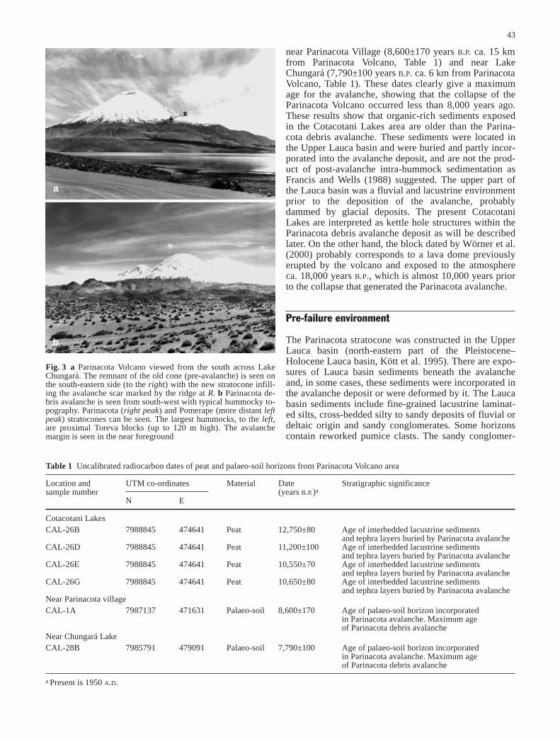
near Parinacota Village (8,600±170 years B.P. ca. 15 kmfrom Parinacota Volcano, Table 1) and near LakeChungará (7,790±100 years B.P. ca. 6 km from ParinacotaVolcano, Table 1). These dates clearly give a maximumage for the avalanche, showing that the collapse of theParinacota Volcano occurred less than 8,000 years ago.These results show that organic-rich sediments exposedin the Cotacotani Lakes area are older than the Parina-cota debris avalanche. These sediments were located inthe Upper Lauca basin and were buried and partly incor-porated into the avalanche deposit, and are not the prod-uct of post-avalanche intra-hummock sedimentation asFrancis and Wells (1988) suggested. The upper part ofthe Lauca basin was a fluvial and lacustrine environmentprior to the deposition of the avalanche, probablydammed by glacial deposits. The present CotacotaniLakes are interpreted as kettle hole structures within theParinacota debris avalanche deposit as will be describedlater. On the other hand, the block dated by Wörner et al.(2000) probably corresponds to a lava dome previouslyerupted by the volcano and exposed to the atmosphereca. 18,000 years B.P., which is almost 10,000 years priorto the collapse that generated the Parinacota avalanche.
Pre-failure environment
The Parinacota stratocone was constructed in the UpperLauca basin (north-eastern part of the Pleistocene–Holocene Lauca basin, Kött et al. 1995). There are expo-sures of Lauca basin sediments beneath the avalancheand, in some cases, these sediments were incorporated inthe avalanche deposit or were deformed by it. The Laucabasin sediments include fine-grained lacustrine laminat-ed silts, cross-bedded silty to sandy deposits of fluvial ordeltaic origin and sandy conglomerates. Some horizonscontain reworked pumice clasts. The sandy conglomer-
Fig. 3 a Parinacota Volcano viewed from the south across LakeChungará. The remnant of the old cone (pre-avalanche) is seen onthe south-eastern side (to the right) with the new stratocone infill-ing the avalanche scar marked by the ridge at R. b Parinacota de-bris avalanche is seen from south-west with typical hummocky to-pography. Parinacota (right peak) and Pomerape (more distant leftpeak) stratocones can be seen. The largest hummocks, to the left,are proximal Toreva blocks (up to 120 m high). The avalanchemargin is seen in the near foreground
Table 1 Uncalibrated radiocarbon dates of peat and palaeo-soil horizons from Parinacota Volcano area
Location and UTM co-ordinates Material Date Stratigraphic significancesample number (years B.P.)a
N E
Cotacotani LakesCAL-26B 7988845 474641 Peat 12,750±80 Age of interbedded lacustrine sediments
and tephra layers buried by Parinacota avalancheCAL-26D 7988845 474641 Peat 11,200±100 Age of interbedded lacustrine sediments
and tephra layers buried by Parinacota avalancheCAL-26E 7988845 474641 Peat 10,550±70 Age of interbedded lacustrine sediments
and tephra layers buried by Parinacota avalancheCAL-26G 7988845 474641 Peat 10,650±80 Age of interbedded lacustrine sediments
and tephra layers buried by Parinacota avalancheNear Parinacota villageCAL-1A 7987137 471631 Palaeo-soil 8,600±170 Age of palaeo-soil horizon incorporated
in Parinacota avalanche. Maximum ageof Parinacota debris avalanche
Near Chungará LakeCAL-28B 7985791 479091 Palaeo-soil 7,790±100 Age of palaeo-soil horizon incorporated
in Parinacota avalanche. Maximum ageof Parinacota debris avalanche
a Present is 1950 A.D.
44
ates are particularly important in that we will later de-scribe a basal deposit of the avalanche, which is derivedfrom them. The conglomerates display well-developedbedding and consist of a mixture of pebbles and sand.The pebbles are largely derived from Tertiary and Qua-ternary volcanic rocks.
The stratocone that failed in the debris avalanche canbe reconstructed from the lithology of the avalanche de-posit and the remnants of the stratocone partially buriedby the new post-avalanche stratocone. The reconstruc-tion is partly based on previous work (Wörner et al.1988) and new observations. The stratocone consistedof an older sequence of rhyodacitic lava domes and as-sociated block-and-ash flow deposits and minor daciticlava flows (Fig. 3a), and a younger stratocone succes-sion predominantly composed of pyroxene andesite andhornblende andesite lava flows. The rhyodacitic block-and-ash flow deposits formed fans extending into theLauca basin and mixed with the sediments of the basin.Remnants of the old edifice crop out in the southern andeastern flanks of the volcano (Fig. 2). They consistmainly of rhyodacitic domes and andesitic to dacitic la-va flows. Their surfaces are usually weathered and showabundant thermal fractures. The remnant of the ava-lanche scar can be seen in the southern flank of the vol-cano (Fig. 3a).
General features of Parinacota debris avalanche
The geology of the area was first described by Katsuiand González (1968). Wörner et al. (1988) produced areconnaissance map of the debris avalanche and outlineda five-stage history for the Parinacota Volcano. Rocksfrom the first three stages defined by Wörner et al.(1988) can be identified as major constituents of the de-bris avalanche, with compositions ranging from basalticandesite to rhyodacite, with andesite being the dominantrock type.
The debris avalanche deposit covers a minimum areaof 140 km2 and extends for at least 22 km (Figs. 1 and2), with an estimated volume of 6 km3. The volume isnot well constrained because of uncertainties about pre-existing topography, lack of deep dissection, and burialof distal parts of the avalanche under younger lake sedi-ments and vegetation. The relative run-out (the ratio ofvertical fall height, assumed to have been similar to theheight of the new stratocone, to run-out) known as theHeim coefficient, is estimated to be 0.08. This value fallswithin the range of other volcanic dry avalanches (Ui1983). The ratio, A/V2/3, where A is the area and V is thevolume, is approximately 50, so the Parinacota ava-lanche mobility, in terms of this ratio, is typical of othercatastrophic debris avalanches of volcanic and non-vol-canic origin (Dade and Huppert 1998). The excessivetravel distance (the ratio between the travelled distanceand the theoretical distance, defined by Hsü 1975) is 20,falling at the more mobile end of volcanic dry avalanchevalues (Ui 1983).
The debris avalanche deposit has a wedge shape, be-ing widest near the volcano and narrowing at greater dis-tances (Figs. 1 and 2) and displays the classic hummockytopography (Fig. 3b) of volcanic avalanches (Ui 1983;Siebert 1984). The avalanche was confined by the sidesof the Lauca depression, but climbed ca. 100 m abovethe valley floor on the southern margins of the depres-sion, more than 200 m above the eastern slope of GuaneGuane Hill (12 km west of the source area, Fig. 2), andalso more than 30 m near Chucuyo Dome (more than20 km from the source, Fig. 2).
Field observations
The debris avalanche consists of two units with slightlydifferent distributions, but with marked differences in com-position and morphology (Fig. 2). The lower unit is pre-dominantly composed of breccias of flow-banded rhyoda-cite, glassy dacite, minor fluvial and glacial deposits, pum-iceous rhyodacitic block-and-ash flow deposits and largeblocks of flow banded rhyodacite, the last two constituentsbeing dominant. The lower unit can be divided into twosubunits according to its morphology and granulometry.One subunit consists of large Toreva blocks (Reiche 1937)of rhyodacitic lava domes that crop out in the proximal fa-cies of the avalanche at the western foot of the present vol-cano (Fig. 2). They correspond to large tilted blocks of theoriginal edifice that slid and came to rest near the volcano.Some Toreva blocks show internal contacts between lavaflow units dipping backwards towards the volcano(Fig. 4a). The other subunit is composed mainly ofrhyodacitic block-and-ash flow deposits and breccias offlow-banded rhyodacite and minor fluvioglacial deposits. Itis buried in many places by the upper unit, outcropping on-ly in the southern and northern margins of the avalanche(Fig. 2). The lower unit shows a smooth undulating mor-phology with numerous low amplitude hummocks.
The upper unit is composed predominantly of lava,ranging from large coherent blocks to hummocks com-posed of breccias. The rock types in the upper unit rangefrom basaltic andesite to dacite, with pyroxene andesiteand hornblende andesite being dominant. There are nu-merous, often lake-filled, depressions, tens to hundredsof metres across, in the central and proximal parts of thedebris avalanche (Figs. 1 and 4b). In these areas, undis-turbed exposures of the lower unit indicate that the upperunit breccia was generally not emplaced in the area ofthe depression, although, in some of them, there are afew small isolated upper unit hummocks. These depres-sions are interpreted as large kettle holes, which wereoriginally occupied by large ice blocks when the debrisavalanche was first emplaced, which then melted leavingdepressions between the hummocks. These blocks camefrom an ice cap and possible valley glaciers of the oldedifice that were incorporated into the avalanche whenthe collapse took place. Similar but smaller-scale struc-tures were observed and described by Branney and Gilbert (1995) in an eruption-induced lahar deposit from

45
Hudson Volcano in southern Chile. Those structures dif-fer from those of Parinacota avalanche in that the icemelting produced collapse pits and ring fractures. Thereis no evidence of collapse pits nor ring fractures in theParinacota avalanche deposit, probably because of thecoarse character of the deposit and because the iceblocks were big enough not to be buried by the deposit.This study is largely concerned with the features of theupper unit, which buries the lower unit in most places(Fig. 2).
The hummocks of the upper avalanche unit areformed of large single blocks or more commonly brec-ciated lava (Fig. 5a, b). We measured the overall geome-
try of 150 hummocks from proximal to distal and centralto marginal areas of the avalanche deposit. For eachhummock, we located the summit and measured the dis-tances and declination from the summit to the edge infour orthogonal directions. For elongated hummocks,two of the directions were along the long axis. Fromthese data we calculated the height of the hummock andaverage radius using the four distance measurements. Weapproximated each hummock as an ellipse in plan-formand calculated the volume from the minor and major el-lipse axes of the plan-form and from the height. We haveconsidered, for the purpose of volume estimation, com-pound hummocks (as will be described later) as individ-ual hummocks. We also measured the three orthogonallengths of the largest block within each hummock, andcalculated block volumes assuming an ellipsoidal shape.
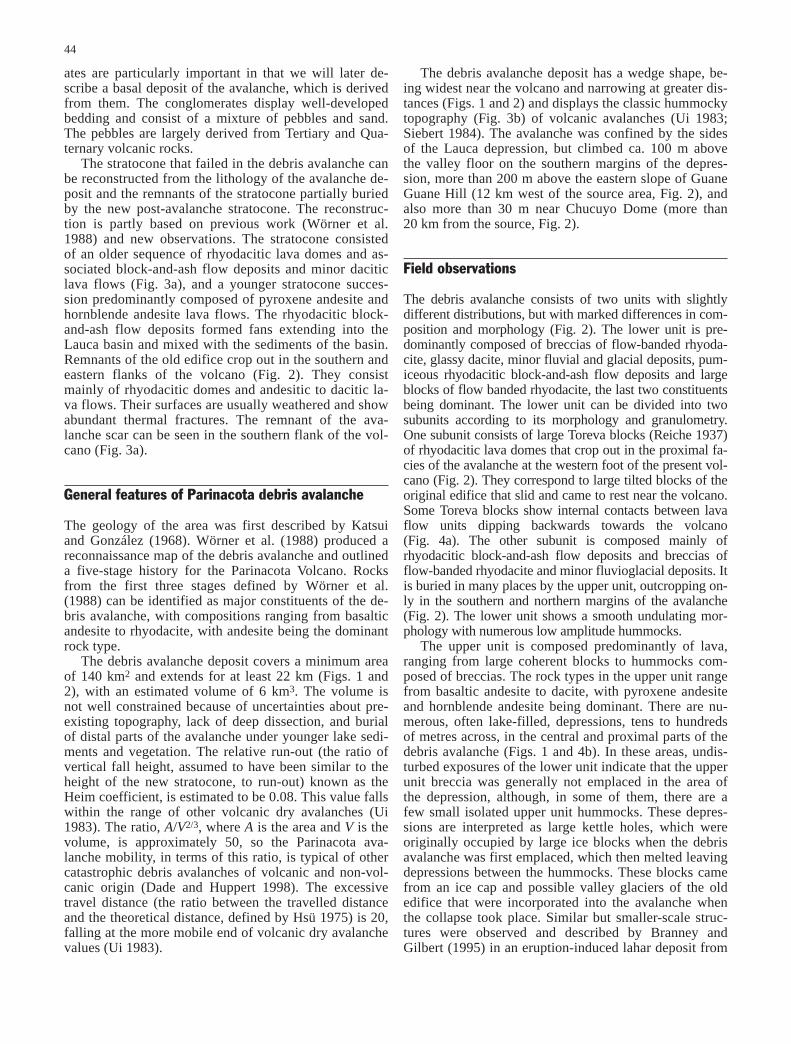
There is a general tendency for hummock volumes(ranging from about 1×10⁶ m3 to less than 10 m3) andthe maximum block volume to decrease with distance(Fig. 6a, b). However, at any given distance, there is awide range of both hummock and maximum block vol-umes. There is a wide range in the maximum slope angleof the hummocks (Fig. 6c). There is also a tendency forlarger hummocks to have higher maximum slopes than
Fig. 4 a Proximal Toreva block (3 km west of Parinacota Volca-no) view from north, showing original bedding dipping back-wards. Hummock is ca. 100 m high. b Kettle hole structure in me-
dial facies of Parinacota avalanche (ca. 8 km from Parinacota Vol-cano). Lake is ca. 150 m in diameter, surrounded by hummocks ofthe upper flow unit
Fig. 5 a Cross section through a hummock near the southern mar-gins of the Parinacota debris avalanche (13 km west of the source,near Parinacota village). Here the upper unit rests directly on lakesediments of the Lauca basin. The hummock is made of a coarse-grained clast-supported breccia, consisting mainly of hornblendeandesite. b Close-up of the base of the exposure in Fig. 5a show-ing the fines-poor character of the breccia and angular shape ofclasts. Clast surfaces are mixtures of pre-existing fracture facesand new fractures related to fragmentation during emplacement.Note that some fragments are incorporated into the top of the lakesediments. Hammer is 30 cm long
46
smaller hummocks (Fig. 6c). Many hummocks havemaximum slope angles well below typical angles of stat-ic friction for granular materials (26–35°). There is a ten-dency of the hummock aspect ratio, defined as the hum-mock height, H, divided by the mean hummock diame-ter, D, to decrease with decreasing hummock volume(Fig. 6d). In general, hummock size, aspect ratio andmaximum slope tend to decrease with distance along theavalanche. A north–south cross section of the hum-mocks, almost orthogonal to the flow direction, locatedbetween 13 and 16 km from the volcano, shows thathummock height and aspect ratio tend to decrease fromcentral areas to flow margins (Fig. 6e, f). It is also clearthat hummocks of the lower unit are smaller and have
lower angle slopes than those from the upper unit(Fig. 6a, c, e).
These geometric variations are accompanied by someprogressions in the characteristic features of the hum-mocks. Near the foot of the volcano, Toreva blocks withcoherent internal stratigraphy are found with heights ofup to 100 m and areas of several hundreds of square met-res (Fig. 4a). Other large hummocks in proximal areascan sometimes show coherent internal stratigraphy, suchas large blocks (up to several tens of cubic metres) in-cluding internal brecciated contacts between different la-va flows. Smaller, more distal hummocks usually are on-ly made of brecciated lava with internal structures thatare no longer preserved. Asymmetric and elongated
Fig. 6 Geometric features ofhummocks from Parinacota av-alanche deposit (150 hum-mocks measured). a Hummockvolume vs distance from thesource. b Volume of largestblock in hummock vs distancefrom the source. c Maximumangle of hummock slope vshummock volume. d Hummockaspect ratio vs hummock vol-ume. e Height variation in aN–S cross section. f Aspect ra-tio variation in a N–S crosssection

47
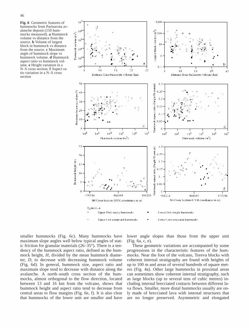
(Fig. 8b). Deformation of the substrate has also been de-scribed in other volcanic debris avalanche deposits,where the phenomenon has been named a bulldozerstructure (Belousov et al. 1999). Although bulldozerstructures are more common in marginal areas and theavalanche front in distal areas, they also occur locally inthe central part of the avalanche. The other kind of mar-gin consists of a wedge in which the deposit thins andthen merges into a zone of isolated small hummocks andscattered blocks (Fig. 8c, d). A well-defined margin can-not be recognised because the separation of isolatedhummocks and scattered blocks increases until there isnegligible deposit over distances of tens to hundreds ofmetres (Fig. 8d). This wedge-type margin characterisesmore distal areas, covering more than 30 km2. Some iso-lated distal hummocks in the central part of the depositalso show these features. A semicircle of scatteredblocks commonly occurs a few metres downstream ofisolated hummocks. The scattered blocks are interpretedas the consequence of loose surface blocks that contin-ued their forward motion as the hummock came to rest.
Cross sections through hummocks show that, internal-ly, the breccias of the upper unit are typically clast-sup-ported with almost no fine-grained matrix (particlessmaller than 1 cm form less than 1% by volume of thedeposit) even in distal facies (Fig. 5a, b). Breccia frag-ments are always angular, despite the distance from thesource area (Fig. 5b). There are no indications of abra-sion of the individual clasts. Corners and edges are usu-
Fig. 7 a Simple conical distal hummock made-up of one lithologybreccia (hornblende andesite). Hummock is ca. 25 m high. b Com-pound distal hummock (ca. 16 km from Parinacota Volcano)formed by three individual hummocks (each with different lith-ologies) amalgamated in one complex hummock. Numbers showorder of emplacement, view towards direction of flow (arrowmarks man for scale). c Plan view scheme of Fig. 6b compoundhummock showing the relationship between the order of deposi-tion and direction of flow
hummocks mainly show two systematic trends of longaxes or steepest sides with respect to flow direction.They are usually parallel or orthogonal to the main flowdirection, being predominantly parallel to the flow at ornear the flow margins.
We have identified two main categories of hummockswith slightly different features. Simple hummocks(Fig. 7a) are those that have relatively simple shapes,commonly conical, and are usually made of only onerock type, which can occur as just one megablock or apile of breccia. Compound hummocks (Fig. 7b, c) arethose that have complex shapes and commonly containmore than one lithology. Commonly, they consist of indi-vidual hummocks, each one with its own characteristiclithology. The individual hummocks were amalgamatedto each other preferentially along the flow direction. Asseen in Fig. 7b, c, the earlier hummock that first came torest is overlain by two younger hummocks that came torest on the upstream side of the first hummock to form amore complex shaped compound hummock. These com-pound hummocks sometimes form ridges up to severalhundreds of metres long, especially near and parallel tothe margins in the proximal and medial areas. Compoundhummocks also occur in the central part of the avalanchedeposit where their elongated ridge is usually parallel ororthogonal to the main flow direction.
Two kinds of avalanche margins have been recogni-sed in the deposit. One is very sharp and steep, and tendsto develop in proximal and medial areas (Fig. 8a), but itcan also occur in distal areas. Typically this kind of mar-gin consists of a linear ridge of coalesced hummocks.Underlying deposits of the lower avalanche unit, fluvialgravels and lacustrine sediments are commonly de-formed at the margins with complex folding and faulting
48
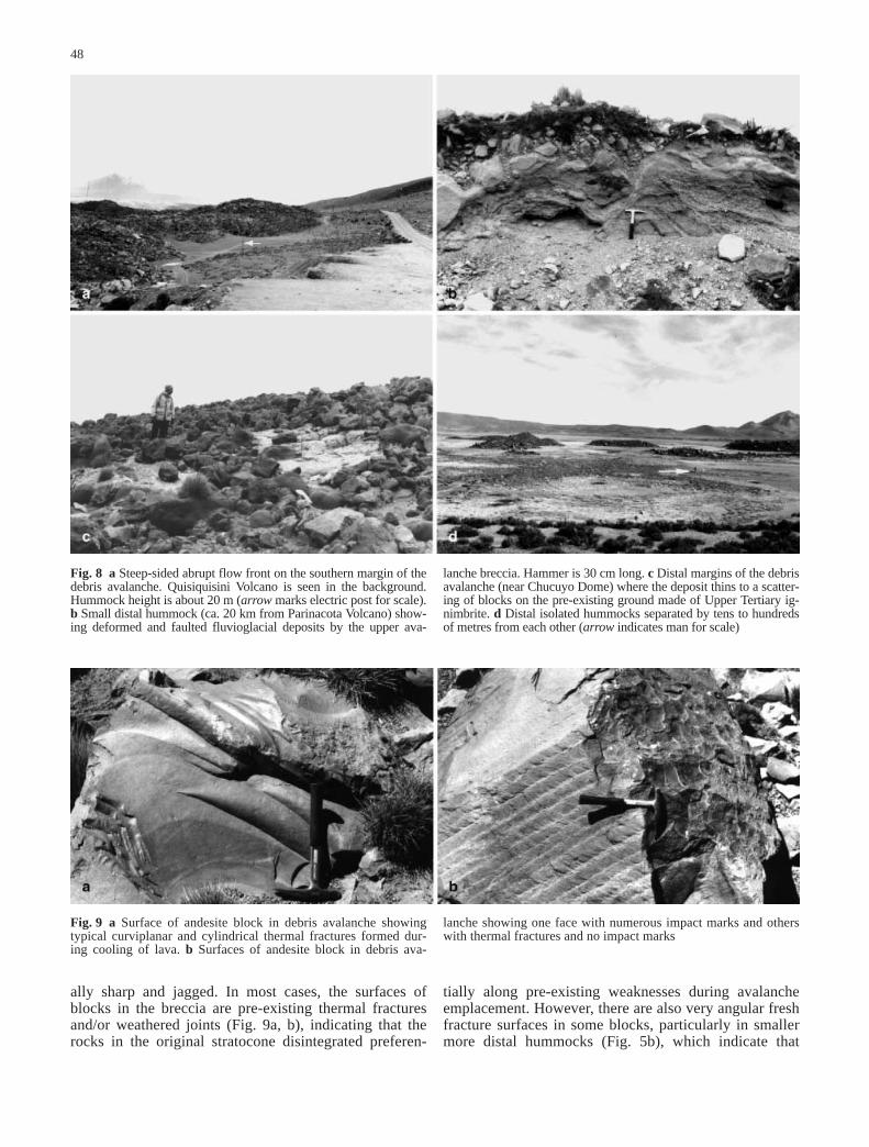
ally sharp and jagged. In most cases, the surfaces ofblocks in the breccia are pre-existing thermal fracturesand/or weathered joints (Fig. 9a, b), indicating that therocks in the original stratocone disintegrated preferen-
Fig. 8 a Steep-sided abrupt flow front on the southern margin of thedebris avalanche. Quisiquisini Volcano is seen in the background.Hummock height is about 20 m (arrow marks electric post for scale).b Small distal hummock (ca. 20 km from Parinacota Volcano) show-ing deformed and faulted fluvioglacial deposits by the upper ava-
lanche breccia. Hammer is 30 cm long. c Distal margins of the debrisavalanche (near Chucuyo Dome) where the deposit thins to a scatter-ing of blocks on the pre-existing ground made of Upper Tertiary ig-nimbrite. d Distal isolated hummocks separated by tens to hundredsof metres from each other (arrow indicates man for scale)
Fig. 9 a Surface of andesite block in debris avalanche showingtypical curviplanar and cylindrical thermal fractures formed dur-ing cooling of lava. b Surfaces of andesite block in debris ava-
lanche showing one face with numerous impact marks and otherswith thermal fractures and no impact marks
tially along pre-existing weaknesses during avalancheemplacement. However, there are also very angular freshfracture surfaces in some blocks, particularly in smallermore distal hummocks (Fig. 5b), which indicate that
49
some fragmentation occurred during the final stages ofemplacement.
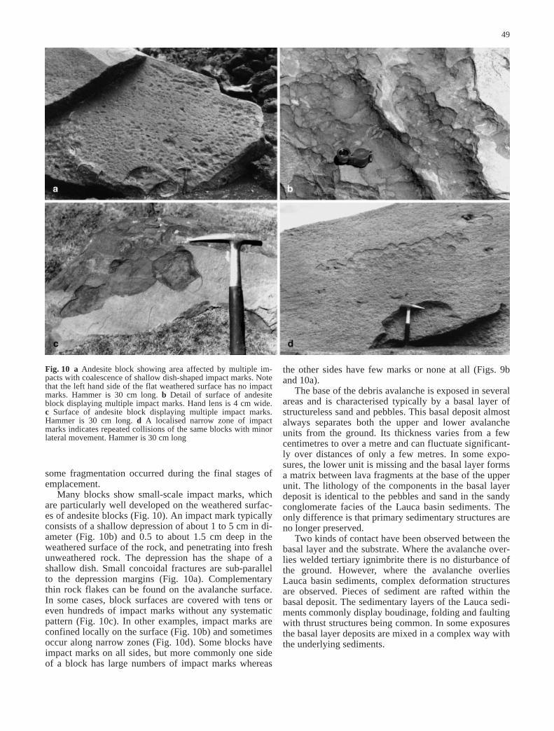
Many blocks show small-scale impact marks, whichare particularly well developed on the weathered surfac-es of andesite blocks (Fig. 10). An impact mark typicallyconsists of a shallow depression of about 1 to 5 cm in di-ameter (Fig. 10b) and 0.5 to about 1.5 cm deep in theweathered surface of the rock, and penetrating into freshunweathered rock. The depression has the shape of ashallow dish. Small concoidal fractures are sub-parallelto the depression margins (Fig. 10a). Complementarythin rock flakes can be found on the avalanche surface.In some cases, block surfaces are covered with tens oreven hundreds of impact marks without any systematicpattern (Fig. 10c). In other examples, impact marks areconfined locally on the surface (Fig. 10b) and sometimesoccur along narrow zones (Fig. 10d). Some blocks haveimpact marks on all sides, but more commonly one sideof a block has large numbers of impact marks whereas
the other sides have few marks or none at all (Figs. 9band 10a).
The base of the debris avalanche is exposed in severalareas and is characterised typically by a basal layer ofstructureless sand and pebbles. This basal deposit almostalways separates both the upper and lower avalancheunits from the ground. Its thickness varies from a fewcentimetres to over a metre and can fluctuate significant-ly over distances of only a few metres. In some expo-sures, the lower unit is missing and the basal layer formsa matrix between lava fragments at the base of the upperunit. The lithology of the components in the basal layerdeposit is identical to the pebbles and sand in the sandyconglomerate facies of the Lauca basin sediments. Theonly difference is that primary sedimentary structures areno longer preserved.
Two kinds of contact have been observed between thebasal layer and the substrate. Where the avalanche over-lies welded tertiary ignimbrite there is no disturbance ofthe ground. However, where the avalanche overlies Lauca basin sediments, complex deformation structuresare observed. Pieces of sediment are rafted within thebasal deposit. The sedimentary layers of the Lauca sedi-ments commonly display boudinage, folding and faultingwith thrust structures being common. In some exposuresthe basal layer deposits are mixed in a complex way withthe underlying sediments.
Fig. 10 a Andesite block showing area affected by multiple im-pacts with coalescence of shallow dish-shaped impact marks. Notethat the left hand side of the flat weathered surface has no impactmarks. Hammer is 30 cm long. b Detail of surface of andesiteblock displaying multiple impact marks. Hand lens is 4 cm wide. c Surface of andesite block displaying multiple impact marks.Hammer is 30 cm long. d A localised narrow zone of impactmarks indicates repeated collisions of the same blocks with minorlateral movement. Hammer is 30 cm long

Discussion
The geological observations of the Parinacota debris ava-lanche place some important constraints on the mecha-nisms of transport and emplacement of debris avalanches.The avalanche is attributed to the failure of a large volca-nic edifice constructed over a sedimentary basin filledwith lacustrine, fluvial, glacial and pyroclastic deposits.There was also significant ice and perhaps snow present,probably as an ice-cap to the stratocone and valley gla-ciers. Loading deformation, sometimes with eventual edi-fice sector collapse, have been documented elsewhere(Merle and Borgia 1996; Van Wyk de Vries and Borgia1996; Van Wyk de Vries and Francis 1997). Strong defor-mation of these basin sediments and pyroclastics indi-cates that an important part of the upper Lauca basin tothe west of Parinacota Volcano was occupied by a lake.The ancestral volcanic edifice failed sequentially to pro-duce a lower avalanche unit derived from the rhyodaciticlower parts of the edifice, and an upper avalanche unitderived from the predominantly andesitic upper parts ofthe edifice. Where the avalanche base is exposed there isalways a basal layer (typically less than 1 m thick) ofstructureless pebbly sand, which is attributed to shearingof coarse-grained fluvial deposits as the avalanche ad-vanced across the basin. This basal layer of sedimentarymaterial is thought to have accommodated much of theshear needed for the avalanche to flow. A similar basallayer, of different origin, has also been observed in otherdebris avalanche deposits (Belousov et al. 1999).
We now focus on the coarse-grained upper avalancheunit. The most prominent feature of the upper avalanchedeposit is its very coarse grain size, with no fine matrix(fragments smaller than 1 cm form less than 1% by vol-ume of the deposit). The blocks in the breccia are char-acteristically angular with sharp edges and corners.Thus, there is no evidence of significant abrasive round-ing. At least within the interior of hummocks, the ava-lanche cannot be the result of agitated granular flowmechanisms (Drake 1990; Straub 1996; Iverson 1997) inwhich there are strong interactions between particles, in-cluding rotations, numerous collisions, sliding and localmixing. Most of the rock fragments of the avalanche de-posits are mostly bounded by weathered or thermal frac-ture surfaces that must have existed in the edifice beforethe collapse. Thus, much of the character of the depositreflects the distribution of fractures and weaknesses inthe edifice prior to collapse that are observed in olderParinacota domes and lava flows not involved in the col-lapse. The edifice disintegrated during the failure to formthe breccia. Some rock clasts, however, have relativelyfreshly-formed surfaces because of some break-up dur-ing avalanche emplacement.
The occurrence of the impact marks shows that therewere localised collisions between neighbouring blocksand projectiles. There is no evidence of rapid slidingwith strong frictional contacts, as has been inferred fromthe friction marks with slickensided surfaces observedon blocks from pyroclastic flow deposits of the Soufrière
50
Hills volcano, Montserrat (Grunewald et al. 2000). Thecommon occurrence of many impact marks in localisedareas (some of them defining narrow trends of impacts)suggests that some neighbouring blocks were vibratingand repeatedly colliding, but without significant shearingmotion relative to one another. However, minor flow dif-ferential motion is implied by the occurrence of narrowzones of localised impact marks. We observed most im-pact marks at the surfaces of hummocks. Therefore,some impact marks may have been caused by freelymoving projectiles in the overlying avalanche immedi-ately after deposition of a hummock. The occurrence offree projectiles in the upper part of the moving avalanchehas also been suggested for the Jocotitlán avalanche (Siebe et al. 1992), but these authors have not describedthe presence of impact marks in that deposit. Melosh(1979) has proposed the idea of acoustic fluidisation inwhich vibrations reduce the strength of debris. Althoughour observations support the idea of vibrational interac-tions, the very coarse-grained character of the Parinacotaavalanche does not favour a fluidisation mechanism. Melosh (1979) also proposed that vibrations lowered thefriction of the rock mass enabling easier flow, but obser-vations at Parinacota avalanche deposit do not supportinternal flow within the domains during transport.
We have applied ideas on the impact of projectiles on-to rock surfaces to estimate flow conditions. Consider alocally spherical portion of rock with radius r impactinga plane rock surface at normal velocity V. The impactcould be the result of either two large rocks collidingwith a protrusion of the first impacting onto the secondor by a fast-moving projectile hitting the rock surface.The rock surface is compressed at first elastically andthen plastically to lead to lateral spall cracks emanatingfrom the base of the damage zone, as described in Lawn(1993). Extending the concepts laid out there to thissomewhat different situation, we consider a protrusionthat penetrates into the rock a distance h. This will leadto a roughly hemispherical damage zone of radius a. Byuse of Pythagoras’ theorem for h<<r, or by geometry, itis straightforward to show that h=0.5a2/r. The force, F,of the impact is distributed over the damage zone to leadto a contact pressure, ρ0, which is known as the hardnessof the material and is related to F by F=πa2ρ0. Duringthe collision the kinetic energy of the impacting rock,E=1/2 MV2, where M is the mass of the rock, is trans-formed into plastic strain energy, P, which is stored inthe damaged rock. In terms of the quantities already de-fined, P is given by
(1)
Equating E to P, we obtain:
(2)

Assuming a typical value of ρ0=2×10⁹ Pa, M=103 kg,r=0.02 m and a=0.01 m, we obtain V=1.3 m s–1. Thus,the impact marks can be generated by movements thatare a small fraction of the expected typical velocity ofthe avalanche. In this case, the avalanche velocity can beestimated as at least 60 m s–1 when it reached the GuaneGuane Hill and ca. 25 m s–1 near Chucuyo (12 and20 km from the source, respectively) by using v=(2 gH)1/2,with H being the run-up.
The hummocky topography provides further con-straints on emplacement mechanisms. There are generalprogressions of hummock size, shape and internal orga-nisation from proximal to distal areas and towards theflow margins. In proximal areas many larger hummocksare composed of shattered rock, but with internal stratig-raphy derived from the original edifice preserved. Suchhummocks form a continuum, with Toreva blocks thatlack internal disruption. Smaller hummocks and thosefurther from the source are internally fragmented into achaotic breccia, although remnant stratigraphy can some-times be discerned. Taken together with the absence ofabrasive rounding of the breccia blocks, we surmise thateach hummock represents a domain of rock within theedifice. We propose that when the edifice failed it disin-tegrated preferentially along pre-existing fractures andplanes of weakness into a wide range of domains andthat there was further break-up into smaller domains dur-ing emplacement and spreading of the avalanche. Thegeneral decrease of hummock size with distance and thewide range of hummock sizes deposited at any given dis-tance (Fig. 5a) can be explained by an interplay of threefactors. First, the edifice broke up initially into a widerange of domain sizes. Second, there was further breakup of the rock mass during emplacement so that size de-creased with residence time in the avalanche and there-fore distance. Third, there were variations of strength ofthe rocks composing the domains such that weaker re-gions broke up more than stronger regions. The role ofrock strength is also indicated by the observation that theamplitude and size of hummocks composed of block-and-ash flow deposits in the lower avalanche unit areboth smaller than most of the lava hummocks in the up-per avalanche unit (see Fig. 6a, c, e).
Many of the hummocks have maximum slope angleswell below the expected angle of repose of granular ma-terials (>25°). Thus their shapes cannot be attributedsimply to adjustments of the hummock margins after em-placement to a static equilibrium. Rather we postulatethat the low maximum slope angles of many hummocksare governed by dynamic processes related to emplace-ment. In distal areas, cross sections through low-ampli-tude hummocks show blocks with fresh fractures surfac-es as well as pre-existing fracture surfaces. Two mecha-nisms may have contributed to the formation of low am-plitude hummocks, well below the angle of repose ofgranular material. First, the domains that travelled fur-thest may have been deposited with higher kinetic ener-gy and have spread out dynamically as they were depos-ited. Second, the avalanche spread out as it was em-
placed with much of the deformation accommodated onthe basal layer. Thus, a mechanism of reducing the hum-mock slope angle and amplitude is by spreading of theunderlying basal layer, as has been shown experimental-ly (Merle and Borgia 1996). Coupling of the overlyingbreccia domains with the basal layer would result inspreading of a hummock.
Where exposed, the base of the debris avalanche de-posit consists of a structureless sedimentary layer. Thevery coarse character of the whole deposit, with the ex-ception of this structureless basal layer, and the absenceof any fluidisation structure make very unlikely that factors, such as the presence of a pressurised air layer (Shreve 1968) or “self lubrication” (Campbell 1989),could explain the transport and long run-out of the Par-inacota avalanche. The presence of a fine-grained basallayer, as has been observed in other debris avalanche de-posits (Belousov et al. 1999), can explain where most ofthe shearing and deformation was accommodated duringemplacement.
Here we emphasise that this debris avalanche essen-tially involved the deformation of a conical-shaped rockmass (the volcanic edifice) into a thin sheet (the ava-lanche deposit) in a fluid-like manner. Thus, deformationwithin the basal layer alone cannot explain the overallspreading of the whole body of the flow. Also, becausespreading does occur and because of the sedimentary ori-gin of the basal layer it is suggested that Bingham flow(Eppler et al. 1987; McEwen and Malin 1989) or plug-flow models (Takarada et al. 1999) are not appropriate toexplain its transport. The absence of any basal meltedlayer, as has been observed in other debris avalanches(Goguel 1978; Erismann 1979; Legros et al. 2000), sug-gests that frictional heating was unimportant. Indeed, theoverall spreading of the avalanche above the basal layerrequires extension of the domains. We envisage thatthere is negligible frictional resistance between the do-mains to extension. Some compression, however, is lo-cally evident at the flow margins, where hummocks areoriented parallel to the flow margins, and also by the oc-currence of bulldozer structures.
The role of water in the transport of long run-out de-bris avalanches is still controversial. Crandell et al.(1984) and Crandell (1989) have suggested that the in-corporation of water-rich sediments into the matrix ofthe ancestral Mount Shasta debris avalanche could havehelped give it its great mobility, whereas Siebe et al.(1992) suggested a similar ‘helping’ mechanism to ex-plain the long run-out of the Jocotitlán avalanche inMexico. On the other hand, McEwen (1989) deducedthat Valles Marineris avalanches on Mars were dry,whereas Stoopes and Sheridan (1992) have suggestedthat the role of water in the transport mechanism of theColima debris avalanche, Mexico, was irrelevant. In thecase of the Parinacota debris avalanche, the basal sedi-ment shear layer is likely to have had a high water con-tent. The upper part of the Lauca basin (where the ava-lanche was deposited) was partially occupied by a lakeand wet lacustrine sediments. Water incorporated into
51
the base could also have aided avalanche transport by re-ducing the basal frictional resistance. The occurrence oflarge kettle hole structures indicates that a significantamount of ice and snow was involved in the collapse andwas incorporated into the avalanche. As was the case inthe 1980 debris avalanche of Mount St Helens (Glicken1996), melting of large ice blocks would have been neg-ligible during the time-scale of avalanche emplacement.On the other hand, significant amounts of ice and snowmight help explain the enigmatic origin of the wedge-shaped distal margins where the deposit becomes discon-tinuous with isolated hummocks and scattered blocks inbetween. If the distal avalanche had either contained orincorporated ice and snow that subsequently melted (asis suggested by the presence of kettle hole structures inmore proximal areas), then the discontinuous characterof the margins could result. This interpretation is alsoconsistent with the origin of small isolated hummocks inthe depressions of kettle holes, where there is good evi-dence that the avalanche deposit consisted largely of ice.
Synopsis of the model for Parinacota avalanche emplacement
We interpret the features of the debris avalanche depositin terms of the concept of domains. The original strato-cone was probably comparable in volume to the Holoc-ene cone, and largely made of lava with subsidiary flowmargin breccias built above a series of rhyodaciticdomes and their related pyroclastic flow deposits. Thisedifice was partially constructed on top of fluvial andlacustrine sediments. From the occurrence of kettle holesand the post-glacial age of the deposit we also surmisethat there was an ice cap, valley glaciers, shallow lakesand wet soft sediments present in the area. The debrisavalanche is divided into two units. The lower unit ispredominantly composed of pyroclastic deposits andsubsidiary fluvial, glacial and lacustrine sediments of theLauca basin. We suggest that the dense edifice loadedthe lower density sediments. Failure of the relativelyweak sedimentary lithologies beneath and adjacent to thestratocone caused the edifice to collapse to form the ava-lanche. The failure could have been triggered by a re-gional earthquake or because of magmatic activity, butthere is no direct evidence yet of either mechanism.However, loading of low-density sedimentary and pyro-clastic basin-fill sequences by a dense andesite strato-cone is likely to have been the major causative factor insector collapse.
When the failure took place the volcanic edifice disin-tegrated preferentially along pre-existing fractures andplanes of weakness into large-scale coherent domains ofrock with volumes ranging from less than 10 to over1×106 m3. We propose that each domain on depositionformed a hummock and that separation of the domainsby original weaknesses in the edifice allowed the disinte-grating volcano to spread in a fluid-like manner to formthe debris avalanche. The concept of domains can ex-
plain the limited internal deformation within individualhummocks, preservation of internal stratigraphy in somehummocks and the lack of abrasive rounding of blocksin the breccias.
The origin of the hummocks is explained by deposi-tion of these domains. As the front of the avalanche ad-vances, domains will impact the ground. We propose thatit is at this late stage that the domains deposit as hum-mocks. Some of the fragmentation of a domain may oc-cur during transport, with perhaps vibrations contributingto disintegration. The general changes in hummock vol-umes, aspect ratios and internal features can be accountedfor by postulating that material that travels further hasbroken up into smaller domains because of longer resi-dence time in the avalanche that forms smaller and loweramplitude hummocks. Domains that travel further mayalso have original higher velocities. The spreading of theavalanche predominantly on its basal layer may cause theoverlying breccia domains to spread. Near the source, thedomains are generally large and had very low energy.Thus, some do not disintegrate on deposition, resulting inToreva blocks and large steep-sided hummocks. Thus, theoccurrence of smaller and lower amplitude hummocks inmore distal areas is a combined effect of both the pres-ence of smaller domains, which were originally morefragmented and travelled further as they had higher ve-locities, and the result of some fragmentation of biggerdomains during transportation of the debris.
The hypothesis of progressive break up of the rockmass and the higher initial kinetic energy of rock massdomains with distance can also explain the difference be-tween proximal and distal flow margins. Near the source,the debris avalanche has sufficient coherence that itsmargins stop abruptly to form a well-defined flow mar-gin. In more distal localities, the rock mass has disinte-grated to such an extent that the small-scale, high energydomains spread out and thin, and even separate from oneanother, with the formation of isolated small hummocksand rock spray across the ground. The original presenceof ice and snow, which subsequently melted, might alsocontribute to the discontinuous character of these thinmargins.
The concept of rock domains may also help to explainthe low frictional resistance of debris avalanches (Dadeand Huppert 1998). The deformation of the spreadingavalanche is accommodated along pre-existing weak-nesses, which define the domain volumes, and thus theresisting strength is low. We envisage the rock mass ofthe edifice dilating as the loading stresses in the edificeare relieved during failure. The basal layer itself, whichaccommodated much of the deformation, is formed ofloose unconsolidated wet sediments, which are expectedto have low frictional resistance.
Conclusions
In this study we describe the morphological and texturalfeatures of the Holocene Parinacota debris avalanche de-
52

posit. Key features of this deposit include (1) pro-nounced hummocky topography, (2) a basal layer ofstructureless sedimentary material incorporated duringrun-out from the underlying Lauca basin sediments, (3) the lack of fine-grained matrix in the avalanche de-posit, which is otherwise a predominantly andesite-rich,coarse-grained and angular breccia, and (4) ubiquitous,small-scale impact structures on the surfaces of some ofthe breccia blocks. Additionally we note that (1) the vol-umes and height to width ratios of individual hummockstend to decrease with transport distance, (2) the basalsedimentary layer apparently accommodated much of theshear that occurred during emplacement of the spreadingavalanche rock mass, and (3) the impact marks occurmost prominently on weathered surfaces of large ande-site blocks.
These observations on the Parinacota avalanche de-posit show that several of the emplacement mechanismscommonly invoked to explain the mobility of large rockavalanches either are inconsistent with the data or fail toexplain its major features. The upper unit contains negli-gible fine matrix, so the role of lubrication by or fluidi-sation of fines cannot be invoked in the deformation andmobility of the main rock mass. The existence of a pres-surised air cushion at the base also seems improbablegiven the high permeability of the fines-poor breccia andthinness of the deposit in distal areas. Likewise, the ab-sence of abrasive rounding and surface shear features onblocks in the breccia suggest that component particleswere not in prolonged shearing contact during transport.Thus, the avalanche mass was not subject to pervasivelysheared granular flow. Instead, the impact marks, de-scribed here for the first time, record the fact that someclasts were subject to intense vibration, but little relativeshear. Overall, the impact marks are interpreted to be theresult of repeated collision of neighbouring blocks andperhaps the existence of free rock projectiles. Neverthe-less, the debris avalanche has involved the collapse, dis-integration and fluid-like spreading of an originally coni-cal rock mass into a thin and very extensive debris ava-lanche sheet. The main deformation of the spreading av-alanche is attributed to the deformation of probably wetsedimentary material at the base of the edifice. The basallayer of sheared sediments probably originated as adécollement surface and accommodated most of theshearing and deformation needed for the avalanche toflow.
We propose that the avalanche resulted from the sec-tor collapse of an ancestral stratovolcano built on top ofa lake basin. Upon mobilisation, the edifice disintegratedpreferentially along pre-existing fractures and planes ofweaknesses, breaking up the rock mass into domains,mainly at early stages when the avalanche first impactedthe ground, with some break up occurring during trans-port and emplacement. The combination of break up intosmaller domains as the avalanche spread and higher en-ergies of domains that reached more distal areas resultedin the characteristic hummocky topography, with the de-crease in hummock size and amplitude with distance.
Acknowledgements J.E.C. was supported by Servicio Nacionalde Geología y Minería-Chile and Pdte. de la República Scolarship(Mideplan-Chile). R.S.J.S. was supported by a NERC (UK) Pro-fessorship. W.B.D. is supported by a NERC (UK) Fellowship. Ra-diocarbon dates were obtained through a project between Sern-ageomin-Chile and GSC-Canada. The authors gratefully acknowl-edge D. Ballard, C. Bonadonna, S. Couch, A. Díaz, M. Gardeweg,J. Hale, S. Mánquez, E. Polanco, M. Robles, O. Roche, D. Sparksand R. Watts for help in the field, and B. Lawn and J. Vallance forhelpful comments. The manuscript has benefited from reviews byJ.A. Naranjo and M.R. James.
References
Belousov A, Belousova M, Voight B (1999) Multiple edifice fail-ures, debris avalanches and associated eruptions in the Holoc-ene history of Shiveluch volcano, Kamchatka, Russia. BullVolcanol 61:324–342
Branney M, Gilbert J (1995) Ice-melt collapse pits and associatedfeatures in the 1991 lahar deposits of Volcán Hudson, Chile:criteria to distinguish eruption-induced glacier melt. BullVolcanol 57:293–302
Campbell C (1989) Self-lubrication for long run-out landslides. JGeol 97(6):653–665
Crandell D (1989) Gigantic debris avalanche of Pleistocene agefrom ancestral Mount Shasta Volcano, California, and debris-avalanche hazard zonation. US Geol Surv Bull 1861:1–32
Crandell D, Miller C, Glicken H, Christiansen R, Newhall C(1984) Catastrophic debris avalanche from ancestral MountShasta Volcano, California. Geology 12:143–146
Dade W, Huppert HE (1998) Long run-out rockfalls. Geology26:803–806
Drake T (1990) Structural features in granular flows. J GeophysRes 95(B6):8681–8696
Eppler DB, Fink J, Fletcher R (1987) Rheological properties ofthe Chaos Jumbles rock fall avalanche, Lassen Volcanic Na-tional Park, California. J Geophys Res 92:3623–3633
Erismann TH (1979) Mechanisms of large landslides. Rocks Mech12:15–46
Francis PW (1993) Volcanoes: a planetary perspective. OxfordUniversity Press, Oxford, pp 1–443
Francis PW, Wells G (1988) Landsat thematic mapper observa-tions of debris avalanche deposits in the Central Andes. BullVolcanol 50:258–278
Glicken H (1996) Rockslide-debris avalanche of May 18, 1980,Mount St Helens, Washington. USGS Open File Rep 96-677
Goguel J (1978) Scale-dependent rockslide mechanisms, with em-phasis on the role of pore fluid vaporisation. In: Voight B (ed)Rockslides and avalanches, vol 1. Natural phenomena. Else-vier, Amsterdam, pp 693–705
Grunewald U, Sparks RSJ, Kearns S, Komorovski JC (2000) Fric-tion marks on blocks from pyroclastic flows at the SoufrièreHills Volcano, Montserrat: implications for flow mechanisms.Geology 28:827–830
Hsü K (1975) Catastrophic debris streams (sturzstroms) generatedby rockfalls. Geol Soc Am Bull 86:128–140
Iverson RM (1997) The physics of debris flows. Rev Geophys35:245–296
Katsui Y, González O (1968) Geology of the neovolcanic area ofNevados de Payachata (in Spanish). Geology Department,Publication no 29, University of Chile
Kött A, Gaupp R, Wörner, G (1995) Miocene to Recent history of the Western Altiplano in Northern Chile revealed by lacustrine sediments of the Lauca Basin (18°15′–18°40′S/69°30′–69°05′W). Geol Rundsch 84:770–780
Lawn B (1993) Fracture of brittle solids, 2nd edn. Cambridge Uni-versity Press, Cambridge
Legros F, Cantagrel JM, Devouard B (2000) Pseudotachylyte atthe base of a volcanic landslide deposit: implications for em-placement mechanisms. Abstracts International Association of
53

Straub (1996) Self-organisation in the rapid flow of granular mate-rial: evidence for a major flow mechanism. Geol Rundsch86:85–91
Takarada S, Ui T, Yamamoto Y (1999) Depositional features andtransportation mechanism of valley-filling Iwasegawa andKaida debris avalanches, Japan. Bull Volcanol 60:508–522
Ui T (1983) Volcanic dry avalanche deposits: identifications andcomparison with nonvolcanic debris stream deposits. J Volc-anol Geotherm Res 18:135–150
Van Wyk de Vries B, Borgia A (1996) The role of basement involcano deformation. In: Mcguire WJ, Jones AP, Neuberg J(eds) Volcano instability on the earth and other Planets. GeolSoc Spec Publ 110:95–110
Van Wyk de Vries B, Francis P (1997) Catastrophic collapse atstratovolcanoes induced by gradual volcano spreading. Nature387:387–390
Wörner G, Harmon R, Davidson J, Moorbath S, Turner D, McMillan N, Nye C, López L (1988) The Nevados de Payachata volcanic region (18°S/69°W, N Chile). 1. Geologi-cal, geochemical, and isotopic observations. Bull Volcanol50:287–303
Wörner G, Hammerschmidt K, Henjes-Kunst F, Lezaun J, WilkeH (2000) Geochronology (40Ar/39Ar, K–Ar and He-exposureages) of Cenozoic magmatic rocks from northern Chile(18–22°S): implications for magmatism and tectonic evolutionof the central Andes. Rev Geol Chile 27(2):205–240
54
Volcanology and Chemistry of the Earth’s Interior General As-sembly, Bali, Indonesia
McEwen A (1989) Mobility of large rock avalanches: evidencefrom Valles Marineris, Mars. Geology 17:1111–1114
McEwen A, Malin M (1989) Dynamics of Mount St. Helens’ 1980pyroclastic flows, rockslide-avalanche, lahars, and blast. JVolcanol Geotherm Res 37:205–231
Melosh HJ (1979) Acoustic fluidisation: a new geological pro-cess? J Geophys Res 84:7513–7520
Melosh HJ (1987) The mechanics of large rock avalanches. In:Costa JE, Wieczorek GF (eds) Debris flows/avalanches: pro-cess, recognition and mitigation. Geol Soc Am Rev Eng Geol7:41–49
Merle O, Borgia A (1996) Scaled experiments of volcanic spread-ing. J Geophys Res 101:13805–13817
Reiche P (1937) The Toreva block – a distinctive landslide type. JGeol 45:538–548
Shreve RL (1968) The Blackhawk landslide. Geol Soc Am SpecPap 108:1–47
Siebe C, Komorowski JC, Sheridan M (1992) Morphology andemplacement of an unusual debris-avalanche deposit atJocotitlán, central Mexico. Bull Volcanol 54:573–589
Siebert L (1984) Large volcanic debris avalanches: characteristicsof source areas, deposits, and associated eruptions. J VolcanolGeotherm Res 22:163–197
Stoopes G, Sheridan M (1992) Giant debris avalanches from theColima Volcanic Complex, Mexico: implications for long-run-out landslides (>100 km) and hazard assessment. Geology20:299–302