Geologic Map of the Camas Quadrangle, Clark County ... · Geologic Map of the Camas Quadrangle,...
32
Geologic Map of the Camas Quadrangle, Clark County, Washington, and Multnomah County, Oregon By Russell C. Evarts and Jim E. O’Connor Pamphlet to accompany Scientific Investigations Map 3017 2008 U.S. Department of the Interior U.S. Geological Survey
Transcript of Geologic Map of the Camas Quadrangle, Clark County ... · Geologic Map of the Camas Quadrangle,...

Geologic Map of the Camas Quadrangle Clark County Washington and Multnomah County Oregon
By Russell C Evarts and Jim E OrsquoConnor
Pamphlet to accompany Scientific Investigations Map 3017 2008 US Department of the Interior US Geological Survey
1
INTRODUCTION
GEOGRAPHIC AND GEOLOGIC SETTING
The Camas 75 quadrangle is located within the eastern Portland Basin near the mouth of the Columbia River Gorge approximately 20 km east of downtown Portland Oregon (fig 1) The Columbia River transects the map area and separates hilly terrain in Washington State to the north from low-relief terrain to the south in Oregon Almost all parts of the map area are rapidly urbanizing In Oregon the Sandy River at the east edge of the quadrangle forms the eastern limit of the Portland metropolitan area urban growth boundary and what were formerly areas of truck farms nursery stock and pasture land have mostly converted to housing and light industry In Washington substantial and continuing residential development has replaced small farms quarries and forestlands in this part of Clark County over the last 20 years
The geology of the Camas quadrangle reflects its setting along the eastern margin of the Portland Basin Paleogene bedrock that floors this part of the basin is exposed only on the south side of Prune Hill and east of Lacamas Creek and Lacamas Lake Elsewhere these older rocks are buried beneath weakly to well-consolidated Neogene and younger basin-fill sedimentary rocks and Quaternary volcanic rocks The Portland Basin is part of the Puget-Willamette Lowland that separates the Cascade Range from the Oregon Coast Range (fig 1) The Portland Basin has been interpreted as a pull-apart basin located in the releasing stepover between two en echelon northwest-striking right-lateral fault zones (Beeson and others 1985 1989 Yelin and Patton 1991 Blakely and others 1995) These fault zones are thought to reflect regional transpression transtension and dextral shear within the forearc in response to oblique subduction of the Pacific Plate along the Cascadia Subduction Zone (Pezzopane and Weldon 1993 Wells and others 1998) The southwestern margin of the Portland Basin is a well-defined topographic break along the base of the Tualatin Mountains an asymmetric anticlinal ridge that is bounded on its northeast flank by the Portland Hills Fault Zone (Balsillie and Benson 1971 Beeson and others 1989 Blakely and others 1995) which is probably an active structure (Wong and others 2001) The nature of the corresponding northeastern margin of the basin is less clear but a series of poorly defined and partially buried dextral extensional structures has been hypothesized from topography microseismicity potential field-anomalies and reconnaissance geologic mapping (Yelin and Patton 1991 Davis 1987 Beeson and others 1989 Blakely and others 1995) Young geologic units in the Camas map area record a variety of processes and events including cataclysmic Columbia River flooding from glacial Lake Missoula at the end of the last glaciation landslides volcanic debris flows
(lahars) and river aggradation triggered by eruptions of Mount Hood Columbia River floodplain aggradation in response to post-glacial sea level rise and deposition of wind-blown sediment
This map is a contribution to a program designed to improve geologic knowledge of the Portland Basin region of the Pacific Northwest urban corridor the densely populated Cascadia forearc region of western Washington and Oregon Better and more detailed information on the bedrock and surficial geology in this rapidly growing region of the basin and its surrounding area will allow for refined assessments of seismic risk (Yelin and Patton 1991 Bott and Wong 1993 Palmer and others 2004) ground-failure hazards (Wegmann and Walsh 2001) and resource availability (Johnson and others 2005)
PREVIOUS GEOLOGIC INVESTIGATIONS
The lower Columbia River region has attracted the attention of geologists for over a century Among early descriptions of geologic relations in the Columbia River GorgendashPortland Basin region are those of Williams (1916) Hodge (1938) Lowry and Baldwin (1952) and Treasher (1942)
Trimble (1957 1963) mapped the Portland metropolitan area at a scale of 162500 described the geology and established the basic stratigraphic framework and distribution of geologic units throughout the Portland Basin Working simultaneously but independently Mundorff (1964) mapped the northern part of the Camas quadrangle at a scale of 148000 as part of a groundwater-resources evaluation of Clark County Washington The maps of Trimble and Mundorff are very similar and both reports provided detailed descriptions of the basin-fill deposits
Phillips (1987) compiled a geologic map of the Vancouver 30x60 quadrangle which includes the Camas 75 quadrangle at 1100000 scale as part of the state geologic map program of the Washington Division of Geology and Earth Resources (Walsh and others 1987) Although relying heavily on previous work he undertook some original reconnaissance mapping and his was the first map to show major lithostratigraphic units within the Tertiary bedrock sequence He acquired chemical analyses for some of the volcanic rocks of the region as well as a few whole-rock K-Ar ages but none of these data were obtained from within this quadrangle
More recently Madin (1994) mapped the adjacent Damascus 75-minute quadrangle to the south providing considerable detail particularly regarding geologic structures He was the first to divide the young volcanic rocks of the Portland area (Boring Lava) into separate units based on geochemistry and K-Ar dates
2
OREGONCALIFORNIA
BRITISH COLUMBIA
WASHINGTON
NE
VA
DA
CO
AS
T R
AN
GE
Cascadia S
ubduction Zone
CA
SC
AD
E R
AN
GE
PAC
IFIC O
CE
AN
120deg125deg49deg
45deg
A
PUGET-WILLAMETTE
LOWLAND
Portland Basin
Area of 1B
Mount St Helens
0
0
100 200 KM
MI50 100
Figure 1A Regional setting of the Camas quadrangle showing major tectonic and physiographic features of the Pacific Northwest
Since 1975 considerable effort has been expended to understand the subsurface stratigraphy of the basin fill in the vicinity of the Portland Well Field an area west of the Sandy River between Interstate Route 84 and the Columbia River that was developed as a ground-water source by the City of Portland Water Bureau (Hoffstetter 1984 Hartford and McFarland 1989 Bet and Rosner 1993) Swanson and others (1993) used the detailed stratigraphic relations observed in the well field as the basis for an evaluation of ground-water resources throughout the Portland Basin They analyzed lithologic logs of 1500 field-located water wells to produce a set of maps that show the elevations and thicknesses of hydrogeologic units throughout the basin thus constructing a rough 3-dimensional view of the subsurface stratigraphy of the basin fill
Other relevant studies conducted in and near the map area include several Portland State University Masters theses that examined the stratigraphy and composition of the sediments that fill the Portland Basin (Cole 1983 Swanson 1986 1988 Lite 1992 Gates 1994) Allen (1975) discussed the Quaternary volcanic rocks some of which were analyzed and dated
by Conrey and others (1996a) Allison (1978) Waitt (1996) and Minervini and others (2003) described features in the map area created by the late Pleistocene cataclysmic Missoula floods Fiksdal (1975) published a map of landslides and landslide-prone areas for Clark County Washington Rapp (2005) mapped and analyzed the Holocene stratigraphy in the area of the Sandy River confluence with the Columbia River Geophysical investigations that bear on geologic relations in the map area include those of Davis (1987) Ryan and Stephenson (1995) Blakely and others (1995) Pratt and others (2001) and Liberty (2002 written commun 2006)
ACKNOWLEDGMENTS
Many landowners granted access that was essential for detailed mapping of the Camas quadrangle Tim Marshall of MBI arranged access to the Gresham Sand and Gravel pit Philip A Dinterman assisted with fieldwork and prepared the digital database Diane M Johnson Cornelius of Washington State University performed chemical analyses
3
45 30
122 00
Willamette River
LAKE MERWIN
YALE LAKE
123 0046 00
Portland
Basin
CascadeRange
Oregon C
oast Range
Oregon C
oast Range
Oregon C
oast Range
Portland Hills Fault Zone
Yacolt
WASHINGTONOREGON
Vancouver
Portland
Woodland
Ridgefield
Battle GroundScappoose
Saint Helens
Troutdale
Columbia River Gorge
Colum
bia
River
B
Camas
Tualatin Mountains
Lewis
River
ElkhornMtn
EXPLANATION
Quaternary-Miocene sediments
Quaternary-Pliocene volcanic and volcaniclastic deposits
Miocene Columbia River Basalt Group
Tertiary granitic rocks
Paleogene volcanic and volcaniclastic rocks undifferentiated
Paleogene marine sedimentary rocksAREA
OF MAP
Figure 1B Simplified geologic map of the Vancouver 30 x 60 quadrangle modified from Phillips (1987)
0 10 20 KM
0 MI5 10
Gresham
4
Robert J Fleck and Jonathan T Hagstrum of the US Geological Survey (USGS) provided 40Ar39Ar ages and paleomagnetic data respectively John P McGeehan provided 14C ages and Andrei Sarna-Wojcicki analyzed compositions of tephra samples Andrei Sarna-Wojcicki Elmira Wan Kenneth Bishop and Judith Fierstein of the USGS made available essential laboratory facilities We obtained water-well drillersrsquo logs from the Washington Department of Ecology website (httpappsecywagovwelllog) and the Oregon Water Resources Department website (httpwwwstampwrdstateorusappsgwwell_logwell_logphp) Connie Manson and Lee Walkling aided in extracting information from the Washington Division of Geology and Earth Resources Library in Olympia Washington and Carol Edwards provided the unpublished field notes and map sheets of Donald E Trimble from the USGS Field Records Library in Denver Colo We have benefited immensely from discussions on various aspects of the regional stratigraphy structure and geologic history with Roger Ashley Alex Bourdeau Ann Donnelly Michael Donnelly Paul Hammond Keith Howard Lee Liberty Ian Madin Alan Niem William Phillips Thomas Pierson Patrick Pringle Elizabeth Rapp David Sherrod James Smith Rodney Swanson Terry Tolan Richard Waitt Ray Wells and Linton Wildrick Technical reviews by Ray E Wells and William E Scott inspired considerable improvements in presentation and content
SYNOPSIS OF GEOLOGY
For the past 40 million years the Cascade Range has been the locus of an episodically active volcanic arc associated with underthrusting of oceanic lithosphere beneath the North American continent along the Cascadia Subduction Zone Bedrock exposed in the Camas quadrangle consists of volcanic rocks predominantly basaltic andesite flows erupted in the arc during Oligocene time In most of the map area this bedrock is buried beneath weakly lithified middle Miocene to Quaternary sediment most of which was carried into the area by the ancestral Columbia River and accumulated in the slowly subsiding Portland Basin Quaternary time has been marked by alternating episodes of incision and aggradation leaving prominent gravel fills and terraces along the Columbia and Sandy Rivers The depositional pulses particularly along the Sandy River were likely associated with alpine glaciations In latest Pleistocene time huge Columbia River floods from glacial Lake Missoula inundated the Portland Basin eroding channels such as the Lacamas Lake trough but also leaving immense bars of sand and gravel and a blanket of sand silt and clay in slack water areas During the late Pleistocene and Holocene sea-level rise associated with deglaciation the Columbia River aggraded nearly 90
m filling a deep paleovalley with sand and silt supplemented with volcaniclastic debris that moved down the Sandy River following eruptions of Mount Hood
Several faults some potentially active offset the Paleogene floor of the basin as well as strata of the basin fill Prune Hill is a block of basement rocks and overlying sediments that has been uplifted along some of these structures West of Prune Hill eroded scoria deposits mark the vent of a middle-Pleistocene volcano one of several dozen late Neogene monogenetic volcanoes that constitute the Boring Volcanic Field of the greater Portland region (Treasher 1942 Trimble 1963 Allen 1975 Fleck and others 2002)
Geologic exposures are sparse in much of the map area owing to intense weathering obscuring vegetation and urban development Scouring by the Missoula floods left Paleogene bedrock and basin-fill deposits below about 400 ft (120 m) elevation relatively well exposed and quarries provide good local exposures of basin-fill and Missoula-flood deposits At higher elevations however bedrock is buried beneath thick soils and loess accumulations and most of the nearly flat-lying basin-fill strata in the map area are buried by flood gravel Therefore many contacts are extrapolated on the basis of topography from limited surface observations and such information was supplemented with lithologic data obtained from several hundred water-well reports in the files of the Washington Department of Ecology and Oregon Water Resources Department Well locations were taken as described in logs or in published reports and were not field checked by us only wells considered reliably located were used to infer the distribution and thicknesses of units in the subsurface
PALEOGENE VOLCANIC AND
SEDIMENTARY ROCKS
Trimble (1963) mapped all Paleogene rocks in eastern Clark County Washington as the Skamania volcanic series We have not adopted this name because regional mapping has shown it to have limited utility Neither the top nor the base of the unit were adequately defined and as used by Trimble the Skamania is simply a synonym for Tertiary volcanic rocks of the southern Washington Cascade Range Furthermore equivalent strata elsewhere in the region have been given other names (Wilkinson and others 1946 Roberts 1958 Wise 1970 Hammond 1980 Phillips 1987) and no reliable criteria have been found for mapping contacts between these various units Therefore we employ strictly lithologic units or where appropriate informal lithostratigraphic units
Structural attitudes in Paleogene rocks of the map area are difficult to determine because mappable
5
sedimentary interbeds are rare and the commonly well-developed platy parting within flows tends to vary erratically over short distances In places however individual flows can be traced laterally and indicate that these rocks generally dip 0 to 15deg to the south or southeast
BASALTIC ANDESITE OF ELKHORN MOUNTAIN
Most of the Paleogene rocks exposed in the Camas quadrangle are assigned to an informal unit the basaltic andesite of Elkhorn Mountain (Tbem) This unit consists largely of tholeiitic basaltic andesite and basalt flows with sparse thin volcaniclastic interbeds This package of flows extends from Lady Island northward nearly to Amboy about 19 km north of the map area (Evarts 2005 2006a b) and has a maximum thickness of at least 800 m Individual flows are typically 4 to 10 m thick but locally reach 70 m thick The flows are characterized by blocky platy or columnar-jointed interiors that typically grade into upper and lower flow breccia zones The upper zones commonly contain abundant zeolite- quartz- and clay-filled vesicles and have been oxidized to reddish-orange colors during cooling All flows were apparently emplaced subaerially many rest on red paleosols developed on previously emplaced flows or on thin sedimentary deposits with no pillow lavas or other indications of subaqueous environments Only one dike was found in the map area and dikes are similarly rare to the north (Evarts 2005 2006 a b) The basaltic andesite of Elkhorn Mountain probably formed the flank of a large mafic shield volcano that was centered northeast of the Camas quadrangle
Flows in the basaltic andesite of Elkhorn Mountain range from aphyric to highly porphyritic Aphyric and sparsely phyric flows commonly exhibit a closely spaced platy parting that is parallel to the alignment of feldspar microlites observed in thin section Seriate to porphyritic flows contain phenocrysts of plagioclase and olivine with or without augite in an intergranular to trachytic groundmass Extremely porphyritic to glomeroporphyritic basalts are common in the unit to the north but are sparse in the map area
The lava flows of the Elkhorn Mountain unit vary from basalt to low-silica andesite but most are basaltic andesite (table 1) they are uniformly tholeiitic with low to medium potassium contents (fig 2) The densely plagioclase-phyric basalts exhibit exceptionally high Al2O3 contents (as high as 21 wt percent) that correlate with the abundance of plagioclase phenocrysts (fig 3a) Rocks with more than about 18 percent Al2O3 almost certainly accumulated plagioclase crystals prior to eruption and most basalts in the unit were actually basaltic andesite liquids that contained excess feldspar crystals (fig 3b) Compared to mafic
flows elsewhere in the southern Washington Cascade Range (duBray and others 2006 RC Evarts unpub data) the Elkhorn Mountain flows are relatively rich in Fe (about 102 to 133 wt percent FeO for sparsely phyric flows that approximate liquid compositions fig 3c) and poor in Sr (generally less than 310 ppm Sr fig 3d) Incompatible-element ratios such as BaNb (about 10-20) BaZr (about 15) and ZrNb (about 135) are constant throughout the suite suggesting that the lavas are related primarily by fractional crystallization processes (Evarts 2005 2006a b)
An incremental-heating 40Ar39Ar plateau age of 255 plusmn 02 Ma was obtained for plagioclase in a lava flow north of Camas Slough near the stratigraphic top of the basaltic andesite of Elkhorn Mountain (table 2) 40Ar39Ar ages for this unit north of the Camas quadrangle range between 264 plusmn 01 and 271 plusmn 01 Ma (Evarts 2006a b) Collectively these results indicate that most of the basaltic andesite of Elkhorn Mountain was emplaced between 27 and 255 Ma
OTHER VOLCANIC AND VOLCANICLASTIC ROCKS
Andesite and dacite flows
The southernmost outcrop of Paleogene bedrock in the Camas quadrangle consists of porphyritic andesite (Ta table 1 no 24) that forms the islands of Ione Reef A very platy sparsely phyric dacite (Td table 1 no 25) crops out on Lady Island a short distance to the northeast The stratigraphic relation of these isolated flows to the basaltic andesite of Elkhorn Mountain is uncertain but the general southeasterly dips of structural attitudes in the map area indicates the more silicic flows most likely overlie the basaltic andesites The chemistry of the andesite and dacite is consistent with an origin as silicic differentiates of the Elkhorn Mountain mafic magmas (fig 2)
Tuff breccia and lapilli tuff
A section of stratified lithic tuff breccia lapilli tuff and minor tuff (Tmv) crops out on the bank of the Columbia River north of the west tip of Lady Island This section at least 50 m thick is truncated on the east by a normal fault and is covered on the west by Quaternary deposits The upper part of the unit overlain by a basaltic andesite flow is well exposed in roadcuts on State Route 14 west of the bridge over Camas Slough Angular fragments of dense to scoriaceous basalt and basaltic andesite dominate the clast population and broken crystals of plagioclase are abundant in the fine-grained fraction The lithic clasts resemble associated Elkhorn Mountain flows The beds are well indurated owing to cementation by calcite clay and zeolites scoriaceous clasts are completely
6
Figure 2 Chemical characteristics of volcanic rocks from the Camas 75 quadrangle (analyses recalculated volatile-free) A K2O+Na2O versus SiO2 showing IUGS classification (Le Maitre 2002) B K2O versus SiO2 showing low- medium- and high-potassium fields extrapolated from Gill (1981 p 6) C FeOMgO versus SiO2 showing classification into tholeiitic and calc-alkaline rocks according to Miyashiro (1974) FeO total Fe as FeO
0
2
4
6
8
10
12
K2 O
+N
a O
IN
WE
IGH
T P
ER
CE
NT
2
Dacite
Rhyolite
Trachyte
AndesiteBasalticandesiteBasalt
Trachy-andesite
Basaltictrachy-
andesiteTrachy-basalt
45 50 55 60 65 70 75 80
SiO 2 IN WEIGHT PERCENT
A
FFFFFFFF
K2O
IN
WE
IGH
T P
ER
CE
NT
0
1
2
3
4
45 50 55 60 65 70 75
Low-potassium
Medium-potassium
High-potassiumB
FFF
FFFFF
0
2
4
6
8
45 50 55 60 65 70 75 80
FeO
M
gO
SiO2 IN WEIGHT PERCENT
THOLEIITIC
CALC-ALKALINE
C
FFFFFFFF
Paleogene volcanic rocksQuaternary volcanic rocksF
7
replaced by palagonite The unit is interpreted as mafic pyroclastic debris from an explosive eruption of the Elkhorn Mountain volcano Local variations in bedding orientation probably reflect post-eruptive slumping or minor downslope transport
A poorly exposed interval of volcaniclastic rocks (Tvs) is present within the basaltic andesite of Elkhorn Mountain east of Lacamas Creek Roadcuts and excavations in that area reveal weathered massive poorly sorted tuff and lapilli tuff composed of angular to subrounded pumiceous and lithic volcanic clasts Their textural and compositional characteristics indicate these are primarily debris-flow deposits
METAMORPHISM AND HYDROTHERMAL ALTERATION
Paleogene rocks in the Camas quadrangle have been subjected to zeolite-facies regional metamorphism the general character of which is similar to that described from other areas in the southern Washington Cascade Range (Fiske and others 1963 Wise 1970 Evarts and others 1987 Evarts and
Swanson 1994) This region-wide metamorphism reflects burial of the Oligocene rocks by younger volcanic rocks within the relatively high-heat-flow environment of an active volcanic arc
Zeolite-facies mineral assemblages are best developed in permeable volcaniclastic rocks associated massive lava flows are commonly much less affected In the mafic lava flows the primary effect of very low-grade metamorphism is the nearly universal development of clay minerals and zeolites replacing labile interstitial glass filling vesicles and deposited on joint surfaces Feldspar may display partial alteration to clay minerals and (or) zeolites along fractures and cleavage planes Olivine phenocrysts in the basalts and basaltic andesites are totally replaced by smectite with or without hematite and calcite Primary pyroxenes and Fe-Ti oxides are largely unaffected by the zeolite-facies metamorphism Volcaniclastic rocks of unit Tvs are pervasively altered to clay minerals and zeolites
Figure 3 Chemical characteristics of lavas in the basaltic andesite of Elkhorn Mountain (Tbem) illustrating the effects of plagioclase accumulation Filled symbols designate samples from Camas quadrangle unfilled symbols designate samples from adjacent areas strongly plagioclase-accumulative samples shown as diamonds contain more than 25 percent plagioclase phenocrysts A Al2O3 versus abundance of plagioclase phenocrysts showing that the lavas plot along a plagioclase-accumulation line (shown in red) that projects to the composition of a calcic labradorite (about 30 wt percent Al2O3) B SiO2 versus abundance of plagioclase phenocrysts showing that many basalts (SiO2 less than 52 wt percent) are strongly plagioclase-accumulative lavas C FeO versus abundance of plagioclase phenocrysts showing that FeO contents of most non-accumulative lavas (lt10 percent plagioclase phenocrysts) are greater than 90 wt percent FeO total Fe as FeO D Sr versus abundance of plagioclase phenocrysts showing that Sr contents of non-plagioclase accumulative lavas are mostly less than 320 ppm
0 20 40 60 80 10010
15
20
25
30
MODAL PERCENT PLAGIOCLASE
Al 2
O3
IN W
EIG
HT
PE
RC
EN
T
A
0
10
20
30
40
50
60
70
MO
DA
L P
ER
CE
NT
PLA
GIO
CLA
SE
SiO 2 IN WEIGHT PERCENT
48 50 52 54 56 58
B
0 10 20 30 40 50 60 705
7
9
11
13
15
FeO
IN
WE
IGH
T P
ER
CE
NT
MODAL PERCENT PLAGIOCLASE
C
100
200
300
400
500
0 10 20 30 40 50 60 70
MODAL PERCENT PLAGIOCLASE
0
Sr
IN P
PM
D
8
BASIN-FILL DEPOSITS1
As the Portland Basin gradually subsided during the late Miocene and Pliocene it filled with continental fluvial and lacustrine sediments transported through the Cascade Range by the ancestral Columbia River and with locally derived detritus carried in by tributaries draining the surrounding highlands Previous workers (Wilkinson and others 1946 Lowry and Baldwin 1952 Trimble 1957 Mundorff 1964 Tolan and Beeson 1984 Howard 2002) have generally mapped this fill as the Troutdale Formation which was named by Hodge (1938) for exposures near Troutdale Oregon Throughout most of the Portland Basin the older part of this nonmarine section rests unconformably on Paleogene bedrock or the Miocene Columbia River Basalt Group and consists predominantly of fine-grained beds quite different than the coarse-grained sandstone and conglomerate that typifies the Troutdale section in the type area This observation prompted Trimble (1957) Mundorff (1964) and Howard (2002) to divide the Troutdale Formation of Hodge (1938) into informal upper and lower members based on the pronounced lithologic difference Trimble (1963) formally named the lower fine-grained member the Sandy River Mudstone while retaining the name Troutdale Formation for the overlying sandstone and conglomerate He also noted that the youngest conglomeratic beds south of the Columbia River included volcanic debris flow deposits and consisted largely of clasts derived from the nearby Cascade Range rather than sediment transported from the east by the Columbia River He mapped these beds as the Springwater Formation of probable Pleistocene age (Trimble 1963) Similarly on the basis of position and clast composition Howard (2002) and Evarts (2004a c d 2006b) distinguished a separate late Pliocene or Pleistocene conglomerate unconformably overlying the Troutdale Formation These deposits previously included in the Troutdale are locally overlain by mafic volcanic rocks the Boring Lava of Treasher (1942) which erupted from scattered local centers in Quaternary time
Recent studies have shown that stratigraphic relations within the basin fill of the eastern Portland Basin are considerably more complex than portrayed by Trimble (1963) and Mundorff (1964) These complications are well illustrated in the vicinity of the Portland Well Field (fig 4) where it is evident that the
1 The distinction between basin-fill and surficial fluvial deposits is necessarily somewhat arbitrary Deposits mapped as basin fill in this report are relatively widespread voluminous and typically bear no direct relation to modern drainage Surficial deposits include unconsolidated late Quaternary sediments with distributions restricted to modern stream valleys (Qa Qac Qh and terrace deposits) and the widespread but relatively thin cataclysmic-flood deposits (Qfg Qfs)
stratigraphic intervals previously mapped as Troutdale Formation and Sandy River Mudstone are interbedded and rapid facies changes related to alternating periods of deposition and incision and a general downstream fining of average grain size are apparent (Hogenson and Foxworthy 1965 Hoffstetter 1984 Swanson 1986 Hartford and McFarland 1989 Swanson and others 1993 Bet and Rosner 1993 Koreny and Fisk 2000) Figure 5 shows a comparison of our nomenclature with the schemes employed by previous workers these relationships are discussed in more detail below
SANDY RIVER MUDSTONE
The Sandy River Mudstone as defined by Trimble (1963) consists largely of thin-bedded claystone siltstone and sandstone with minor interbeds of pebbly conglomerate fine-grained tuff and lignite Most of the sandy beds are micaceous lithic and arkosic sandstones indicative of an eastern Washington and Idaho provenance and deposition by an ancestral Columbia River Claystone beds are commonly carbonaceous and locally contain well-preserved leaf impressions early Pliocene fossil floras have been collected from the upper part of the Sandy River Mudstone at several localities (Treasher 1942 Chaney 1944 Trimble 1963 Tolan and Beeson 1984) Trimble interpreted the Sandy River Mudstone as a lacustrine deposit but sedimentary structures indicate deposition in low-energy fluvial or overbank settings
Strata lithologically similar to the Sandy River Mudstone crop out at several localities in the map area but are too small and discontinuous to map they intertongue and are mapped with coarse-grain beds assigned to the hyaloclastic sandstone member of the Troutdale Formation (Ttfh) Well logs in the Portland Well Field (Hoffstetter 1984 Hartford and McFarland 1989 Swanson and others 1993) show that several fine-grained intervals forming aquitards or confining units are interbedded with sandstone and conglomerate in the shallow subsurface (fig 4) The fine-grained beds which we consider tongues of the Sandy River Mudstone become more abundant to the west and may be more than 300 m thick near the west boundary of map area (Swanson and others 1993) The uppermost confining unit (CU1 in fig 4) is probably equivalent to a 7ndash15-m-thick interval of leaf-bearing beds below Broughton Bluff that Trimble (1963) mapped as Troutdale Formation A likely correlative section exposed at the mouth of Beaver Creek contains multiple paleosols developed in very fine felsic sand as well as a thin volcanic debris flow A lower confining unit (CU2 in fig 4) probably corresponds to the Sandy River Mudstone that Trimble (1963) mapped along the Sandy River southeast of the Camas quadrangle Similar fine-grained sediments not mapped separately due to limited exposure are interbedded with
9
VERTICAL EXAGGERATION X 20VERTICAL EXAGGERATION X 20
W
SEA LEVEL SEA LEVEL
100
200
300
400
500
600
700
100
100100
200
300
400
500
600
700
FEETE
100FEET
0 1 2 KILOMETERS
OB
UGTGACRSA
CU1
CU2
TSA
TSA
SGA
SGA
SGA
BLGA
OB
Gravel
Sand
Silt and Clay
SGA
LithologyLithostratigraphic units (this report)
Sandy River Mudstone
Troutdale Fm conglomerate member
Troutdale Fm hyaloclastic sandstone member
Ancestral Sandy River sediments
Holocene and late Pleistocene sediments
Mou
nt T
abor
Cam
as
Blue Lake
OB Overbank deposits
BLGA Blue Lake gravel aquifer
CRSA Columbia River sand aquifer
UGTGA Unconsolidated gravelTroutdale gravel aquifer
CU2 Confining unit 2
CU1 Confining unit 1
TSA Troutdale sandstone aquifer
SGA Sand and gravel aquifer
Hydrogeologic units from Hartford and McFarland (1989)
Figure 4 Cross section along the south shore of the Columbia River after Hartford and McFarland (1989) showing stratigraphic relations of basin-fill deposits in the Portland Well Field and correspondence between lithologic hydrogeologic and lithostratigraphic nomenclature as discussed in text Vertical blue lines denote wells along profile Depth to basin floor is unknown nearby wells penetrate 1100 ft of fine-grained beds without reaching bedrock Note that the Troutdale gravel aquifer (TGA) consists of deposits that postdate the Troutdale Formation as defined in this report The Blue Lake gravel aquifer (BLGA) probably consists of the gravel facies of Missoula-flood deposits The Columbia River sand aquifer (CRSA) consists of Holocene sediments that fill the Pleistocene channel of the Columbia River (Gates 1994 Pratt and others 2001) Overbank deposits (OB) are modern Columbia River floodplain sediments Correlations near east end of the profile are uncertain owing to vertical displacement on the Blue Lake Fault which obliquely crosses the profile in this area
10
hyaloclastic sandstone on Prune Hill and east of Lacamas Lake
The only direct age information for the Sandy River Mudstone comes from late Pliocene paleofloras obtained from the upper part of the formation (Chaney 1944 Treasher 1942 Trimble 1963 Tolan and Beeson 1984) one of these sites is directly below Broughton Bluff (Trimble 1963 and unpub field notes) The unit largely postdates the Columbia River Basalt Group (Trimble 1963 Tolan and Beeson 1984 Madin 1994 2004 Mabey and Madin 1995) although the lowest beds were invaded by the 156-Ma Grande Ronde Basalt near Woodland Washington (Evarts 2004a)
TROUTDALE FORMATION
The Troutdale Formation is mapped as two lithologically distinct informal members The older member (Ttfc) consists of quartzite-bearing conglomerate and arkosic sandstone The younger member (Ttfh) is composed largely of hyaloclastic basaltic debris These two members correspond closely to the informal upper and lower members of the Troutdale as mapped by Tolan and Beeson (1984) in the western Columbia River Gorge
Conglomerate member
The conglomerate member (Ttfc) crops out only in the valley wall of Little Washougal River near the northeast corner of the map area but is widespread to the north and east (Evarts 2004a d 2006a b RC Evarts unpub mapping) It is unconformably overlain by a younger but similar conglomerate (QTc) the location of the contact is inferred from relations in adjacent areas (Evarts 2006b RC Evarts unpub mapping) Water-well logs indicate the conglomerate member is underlain by the Sandy River Mudstone
The Troutdale Formation conglomerate member consists of weakly to moderately cemented pebble and cobble conglomerate and lenses of medium to coarse sandstone Well-rounded pebbles and cobbles eroded from the Columbia River Basalt Group are the most abundant constituent of the conglomerate the remainder includes light-colored granitic and quartzofeldspathic metamorphic rocks Fe-oxide stained quartzite and minor amounts of volcanic rocks eroded from the Cascade Range The interbedded sandstone ranges in composition from basaltic to muscovite-bearing arkosic and quartzose and is lithologically similar to the sandy matrix of the conglomerate Significantly the conglomerate member of the Troutdale Formation (Ttfc) lacks clasts of Pliocene and younger basalts like those that are abundant in the basaltic hyaloclastic sandstone member (Ttfh) Sedimentological characteristics of the
conglomerate such as the massive to crudely stratified beds clast-support moderate to good sorting and clast imbrication are consistent with deposition during high flow in a large perhaps braided gravel-bed river system (Miall 1977 1996 Rust 1978)
Hyaloclastic sandstone member
In its type area along the lower Sandy River the Troutdale Formation consists of complexly interbedded sandstone and conglomerate and includes a distinctive lithofacies of basaltic hyaloclastic debris called yellow grit tuffaceous sandstone or vitric sandstone by previous workers (Williams 1916 Hodge 1938 Lowry and Baldwin 1952 Trimble 1963 Tolan and Beeson 1984) Similar strata underlie eastern Camas and are well exposed in lower Lacamas Creek along the shores of Lacamas Lake and south of the Columbia River near Blue Lake and along Interstate 84 Hyaloclastic sediment also constitutes prominent intervals at depth in the Portland Well Field (fig 4) (Hoffstetter 1984 Swanson 1986 Hartford and McFarland 1989 Swanson and others 1993 Bet and Rosner 1993) The hyaloclastic sediment is generally coarse to very coarse-grained sandstone that is moderately well sorted to poorly sorted and composed chiefly of angular fragments of vesicular to nonvesicular vitric to lithic basalt that contain olivine and plagioclase microlites The black basaltic glass is partly to completely altered to palagonite which imparts a distinctive yellow-brown color to the sandstone in outcrop and serves as a cementing agent
Beds and lenses of conglomerate are interbedded with the hyaloclastic sandstone and locally as in the type area along the Sandy River are predominant Many conglomerate beds are well sorted and consist largely of well-rounded cobbles and pebbles of dark gray to black aphyric basalts eroded from the Columbia River Basalt Group Clasts of light-colored granitic and quartzofeldspathic metamorphic rocks and Fe-oxide stained quartzite that were derived from source areas in eastern Washington and Idaho are minor but persistent components Rounded to subangular cobbles and boulders of variably vesicular olivine- and plagioclase-phyric basalt are abundant in some conglomerates These beds tend to be lensoidal poorly sorted and possess a matrix of basaltic sand compositionally similar to the associated sandstone beds and resemble hyperconcentrated flood-flow deposits as described by Smith (1986)
The angular vitric clasts were generated by rapid chilling and quench fragmentation during interaction of basaltic lava with water Crude to distinct stratification foreset bedding cut-and-fill structures intergradational contacts with conglomerate and the presence of minor but nearly ubiquitous nonvolcanic debris all signify fluvial reworking of the hyaloclasts
1
1
Coarse-grained deposits Fine-grained deposits
Paleogene
Pleistocene
Pliocene
Miocene
Holocene
Howard (2002)Battle Ground quad This map
cataclysmicflood deposits
Boring Lava
Troutdale Fmupper member
Troutdale Fmlower member
High Cascadeslavas
Rhododendron
Pomona Mbr
Boring L
Boring Lava
Troutdale Fmvolcanic- amp quartzite-
clast members
Troutdale Fmfine-grained
member
Troutdale Fmalluvial-fan
member
Sandy RiverMudstone
conglomerate mbr
alluviumand other
surficial deposits
alluviumand other
surficial deposits
cataclysmicflood deposits
Trimble (1963)Portland area
Rhododendron Fmand equivalents
Sandy RiverMudstone
Troutdale Fm
alluviumand other
surficial deposits
EstacadaGresham
SpringwaterWalters HillFormations
lacustrine deposits
Boring Lava
Mundorff (1964)Clark County WA
Troutdale Fmupper member
Troutdale Fmlower member
Boring Lava
alluvial deposits
glacial drift
alluviumand other
surficial deposits
Columbia RiverBasalt Group
Skamaniavolcanic series Older rocks
Wanapum Basalt ampGrande Ronde
Basalt
SkamaniaVolcanics
SkamaniaVolcanics
basaltic andesiteof Elkhorn Mtn
Tolan amp Beeson (1984)Columbia River Gorge
AncestralSandy River
gravelsunnamed
conglomerateWalters Hill Fm
hyaloclastic ss mbrTroutdale Fm
Troutdale Fm
Boring Volcs
Figure 5 Comparison of stratigraphic nomenclature and age assignments for Neogene basin-fill units of the Portland Basin and vicinity
12
However the textural immaturity poor sorting and nearly monolithologic character of many beds suggest relatively short transport distances in a river system highly loaded with such sediment and rapid deposition Following Trimble (1963) Tolan and Beeson (1984) and Swanson (1986 1988) we interpret these sediments as hyaloclastic debris generated by basalt flows entering the ancestral Columbia River upstream from the map area This voluminous debris was swept downstream and aggraded the eastern Portland Basin its distribution (Swanson and others 1993) indicates that the ancestral western Columbia River valley was considerably wider than the present gorge The north side of this paleovalley is visible in lower Lacamas Creek where hyaloclastic sandstone and conglomerate are banked against a steep wall of eroded Oligocene rocks Paleocurrent directions inferred from steep foreset bedding and clast imbrication measured in the Sandy River (Cole 1983) and Lacamas Creek valleys indicate transport to the north and north-northwest in the northern part of the paleovalley
Tolan (1982) and Tolan and Beeson (1984) mapped a section of Troutdale Formation conglomerate and sandstone more than 335 m thick in the western Columbia River Gorge and observed that the distinctive hyaloclastic sandstone beds were restricted to the upper 75 m of the section and on this basis divided the Troutdale Formation into informal upper and lower members (fig 5) Their upper member is correlative with our hyaloclastic sandstone member (Ttfh) Tolan and Beeson (1984) also suggested that the contact between their members was equivalent to the Troutdale FormationndashSandy River Mudstone contact mapped by Trimble (1963 p 34) along the Sandy River southeast of the Camas quadrangle However the fine-grained beds mapped as Sandy River Mudstone by Trimble can be traced in the subsurface to the Portland Well Field where they overlie hyaloclastic sandstone and conglomerate (fig 4) (Swanson 1986 Hartford and McFarland 1989 Swanson and others 1993) Hence as noted above the Sandy River Mudstone mapped by Trimble is actually a tongue of fine-grained beds within the hyaloclastic sandstone-bearing sequence This tongue (CU2 in fig 4) separates two intervals dominated by hyaloclastic debris (TSA and upper part of SGA in fig 4) that may represent hyaloclastites generated by two large eruptive events to the east The base of the informal upper member of Tolan and Beeson (1984) likely corresponds to the base of the lower hyaloclastite-rich interval (fig 5) The total thickness of the hyaloclastite-bearing section in the Portland Well Field is approximately 125 m (fig 4) (Swanson 1986 Hartford and McFarland 1989 Swanson and others 1993) and is correlated with the 140-m-thick hyaloclastic sandstone member (Ttfh) mapped in the Prune HillndashLacamas Lake area
Chemical analyses (Swanson 1986 Andrei Sarna-Wojcicki written commun 2005) show that the
vitric clasts in the hyaloclastic sandstone and the olivine+plagioclase-phyric basalt cobbles in the associated conglomerate (table 1 no 34) both possess a low-potassium tholeiite composition similar to basalt flows in the Cascade Range but unlike locally erupted lavas in the Boring Volcanic Field (Swanson 1986 RC Evarts and RM Conrey unpub data) Their chemistry thus suggests that the sediments are genetically related to the compositionally similar lava flows erupted to the east (Tolan and Beeson 1984 Swanson 1986 RC Evarts and RM Conrey unpub data) several of which have yielded late Pliocene radiometric ages (28 to 35 Ma Conrey and others 1996a b RJ Fleck written commun 2006)
WALTERS HILL FORMATION
Trimble (1963) gave the name Walters Hill Formation to a sequence of deeply weathered generally coarse-grained fluvial deposits that form a group of hills south of Gresham The most northerly of these hills is Grant Butte at the southern quadrangle boundary This unit (QTwh) is poorly exposed in the map area but most clasts exposed in roadcuts ascending Grant Butte are deeply weathered porphyritic andesites of Cascadian provenance Trimble (1963) described poorly indurated weathered gravel and debris-flow deposits locally interbedded with sandstone as thick as 300 ft (90 m) south of the map area Hill summits are between 650 and 1000 ft (200 and 300 m) elevation and the hills are probably erosional remnants of an alluvial fan or bajada extending west or northwest from the Cascade Range These sediments were mapped as Springwater Formation by Madin (1994) in the Damascus quadrangle to the south but they grade to a distinctly higher level than the Springwater Formation in its type area (Trimble 1963) although the elevation difference could reflect unrecognized structural deformation The age of the Walters Hill Formation is poorly constrained but deposits that were mapped as Walter Hill Formation by Trimble (1963) in the Gladstone quadrangle to the southwest appear to be interbedded with basalts dated at about 16 to 14 Ma (RJ Fleck written commun 2002)
UNNAMED CONGLOMERATE
Evarts (2004a c d 2006b) mapped an unnamed conglomerate unit (QTc) north and northwest of the Camas quadrangle that is similar to but considerably younger than nearby Troutdale Formation conglomerate Although included with the Troutdale Formation by most previous workers the younger conglomerate differs from the older unit in that it contains sparse clasts of olivine basalt and interbeds of reworked hyaloclastic sands has a higher proportion of volcanic clasts derived from the Cascade Range is
13
commonly more poorly sorted and forms an extensive geomorphic bench (mostly capped by Missoula Flood sediment) within the Portland Basin Beds of weathered conglomerate that overlie the hyaloclastic sandstone member of the Troutdale Formation on Prune Hill and underlie much the area east of Lacamas Lake are assigned to this unit The unnamed conglomerate unit is also present in the Portland Well Field (UGTGA in fig 4) where it overlies the Troutdale Formation (Ttfh) and Sandy River Mudstone (Tsr) along an erosional unconformity (Hartford and McFarland 1989 Swanson and others 1993 Bet and Rosner 1993) In the map area the unnamed conglomerate is as thick as 90 m Except where severely eroded by Pleistocene cataclysmic floods the upper several meters of the unit is deeply weathered The unnamed conglomerate is probably of latest Pliocene to early Pleistocene age because it overlies the hyaloclastic sandstone member of the Troutdale Formation and is overlain by the basaltic andesite of Prune Hill which is about 595 ky old (table 2) The elevation age and depositional setting of the unnamed conglomerate (QTc) and the unnamed fan gravel (QTfg) are similar suggesting that both reflect periods of regional Columbia River aggradation coincident with widespread piedmont deposition of Cascadian volcaniclastic detritus
UNNAMED FAN GRAVEL
The distal edge of a broad west-northwest-sloping moderately dissected piedmont extends into the southeasternmost part of the map area Where exposed along Division Street west of Beaver Creek the deposits (QTfg) beneath this surface consist of weathered fluvial gravel of Cascade Range provenance interbedded with lithic-rich sand and matrix-supported diamicts which contain angular hornblende-andesite clasts up to 1m in diameter These deposits are overlain by about 25 m of strongly oxidized micaceous silt and clay interpreted as loess (Qlo)
This piedmont is apparently the remnant of a broad alluvial fan associated with aggradation of an ancient Sandy River Geomorphic relations southeast of the map area show that this fan emanated from a confined valley located near Sandy about 10 km south of the quadrangle boundary Fan aggradation probably occurred in conjunction with alpine glaciation and associated outwash-gravel production in the Cascade Range punctuated by lahars The volcaniclastic deposits may have been derived from the early Pleistocene Sandy Glacier volcano (Wise 1969 Sherrod and Scott 1995) located in the Mount Hood area
The fan deposits were mapped by Trimble (1963) and Madin (1994) as Springwater Formation but their slightly lower elevation and less dissected surface indicate that they are probably younger than the
Springwater Formation in the type area about 30 km south of Gresham There are no direct age determinations on these deposits but the profile of this piedmont grades to an elevation 50 to 70 m higher than the base of the basaltic andesite exposed at Broughton Bluff The unnamed fan gravels therefore probably predate the basaltic andesite which has an 40Ar39Ar age of 128 Ma (RJ Fleck written commun 2003)
GRAVEL WEST OF GRESHAM
An isolated flat-topped hill 2 km west of Gresham along the southern map edge is underlain by fluvial gravel (Qgwg) Temporary construction excavations up to 4 m deep show cobble gravel overlain by less than 1 m of silt Most clasts are rounded to well-rounded with maximum intermediate diameters less than 20 cm Clasts are mostly andesites and other Cascade Range rock types The clasts are relatively fresh weathering rinds on fine-grained volcanic rocks are thinner than 5 mm The matrix is strongly oxidized silt and clay
The stratigraphic relation of this gravel to other fluvial deposits in the map area and surrounding terrain is uncertain Clast composition and location suggest deposition by an ancient Sandy River perhaps in conjunction with regional aggradation associated with Cascade Range alpine glaciation but correlative surfaces are not evident Its higher topographic position indicates a greater age than the youngest ancestral Sandy River gravel (Qaas) exposed in the MBI gravel pit 1 km northwest of the hill although it may be a high-standing erosional remnant of one of the deeper gravel units exposed in the pit Alternatively the gravel of the hill may be equivalent to that in the pit and has been vertically displaced along faults buried beneath Missoula-flood deposits
These deposits (Qgwg) were mapped by Trimble (1963) as Springwater Formation but the minimal silt cover and lack of clast weathering and soil development suggest a much younger age than the deposits of the type area Madin (1994) mapped the southern part of this hill in the Damascus quadrangle as coarse-grained Missoula Flood deposits but the common 1-3 mm weathering rinds and lack of typical Columbia River provenance clasts such as Columbia River Basalt and quartzite indicate instead that the hill is underlain by older deposits of Cascade Range provenance
ALLUVIUM OF ANCESTRAL SANDY RIVER
A thick gravel section (Qaas) apparently underlies cataclysmic-flood deposits throughout much of the area south of Interstate 84 in Oregon Although only minimally exposed along Beaver Creek south of Mount Hood Community College more than 60m of cobbly gravel is well exposed in the large MBI gravel
14
pit 1 km north of Grant Butte The gravel beds here are several meters thick massive to crudely stratified well sorted and tabular to slightly west-tapering Thin sand beds are scattered throughout the gravel but are laterally discontinuous and volumetrically minor Sharp contacts within the sequence are planar and apparently conformable but are not associated with significant soil profiles so apparently do not represent large time intervals We interpret the coarse grain size apparent rapid deposition and absence of channel features to indicate deposition on an aggrading braid plain or fan Clasts in the gravel and sand are dominated by volcanic rocks derived from the nearby Cascade Range include likely Mt Hood andesites By contrast clasts of Columbia River provenance such as Columbia River Basalt Group granitic rocks quartzite quartz and muscovite are uncommon This composition indicates that the gravels were deposited by a tributary of the Columbia emanating from in the adjacent Cascade Range most likely the ancestral Sandy River Clast imbrication indicating deposition by west- to north-flowing currents is consistent with this interpretation
In the MBI gravel pit the ancestral Sandy River gravels are overlain by 15 m of cataclysmic flood gravel (Qfg) Where the contact is conformable the upper part of the Sandy River deposits consists of a fining-up sequence of alternating sand and gravel surmounted by about 1 m of massive pedogenically altered silt and very fine sand probably loess Cobbles directly below the loess() have weathering rinds ranging from 1 to 5 mm thick The weathering characteristics are consistent with an exposure duration of 100 ky indicating late Pleistocene deposition perhaps during a glacial period of enhanced sediment production in the ancestral Sandy River headwaters The ancestral Sandy River alluvium corresponds in part with terraces that were mapped by Trimble (1963) as Estacada Formation along the Sandy River southeast of the map area (JE OrsquoConnor unpub mapping)
VOLCANIC ROCKS OF THE BORING
VOLCANIC FIELD
The Boring Volcanic Field (Fleck and others 2002) consists of several dozen late Pliocene to Quaternary monogenetic vents and associated lava flows scattered throughout the greater Portland area (Treasher 1942 Trimble 1963 Allen 1975) Lava compositions are diverse but predominantly mafic The products of two Boring volcanoes are present in the Camas quadrangle (Qbph and Qbbb) both exhibit calc-alkaline compositions that are typical of volcanic-arc magmas (fig 2)
Thick deposits of variably agglutinated scoria on the west flank of Prune Hill associated with a strong positive aeromagnetic anomaly mark a Quaternary volcanic vent At approximately 595 ka (table 2) lava
flows of olivine-phyric basaltic andesite (Qbph) erupted from this center and flowed about 2 km to the north and west and an unknown distance to the south burying unweathered gravel (presumably in the contemporary channel of the Columbia River) at an elevation of 150ndash170 ft (45ndash55 m) Late Pleistocene cataclysmic floods severely eroded the cinder cone and undercut and removed the southern part of the associated flow field
An older basaltic andesite flow (Qbbb) crops out at the top of Broughton Bluff above the Sandy River It overlies the hyaloclastic sandstone member of the Troutdale Formation and probably erupted from a vent located at Chamberlain Hill about 3 km east of the bluff A sample collected just east of the map area yielded an 40Ar39Ar age of 1282plusmn0014 Ma (RJ Fleck written commun 2003) At 230ndash250 ft (70ndash75 m) elevation on Broughton Bluff the pillowed base of this flow rests on unweathered micaceous sand this contact presumably marks the position of the Columbia River channel at about 1 Ma
QUATERNARY ALLUVIAL EOLIAN
AND MASS WASTAGE DEPOSITS
Surficial deposits in the Camas quadrangle include sediment deposited by the cataclysmic Missoula floods deposits along the Sandy River related to eruptions of Mount Hood and various alluvial eolian and mass-wastage deposits
TERRACE DEPOSITS
Sand and gravel deposits that record channel positions older and higher than modern levels border the Sandy Washougal and Little Washougal Rivers Younger probable late Pleistocene or early Holocene gravel deposits flank the lower Washougal and Sandy Rivers Gravel deposits along the Washougal River (Qtdwl) underlie a prominent and extensively quarried terrace tread at about 50 ft (15 m) above sea level Gravel deposits along the lower Sandy River and Beaver Creek (Qtds) underlie a prominent bench whose surface is between 170 and 190 ft (52 and 58 m) above sea level In both areas these deposits are scantly weathered and are not capped by Missoula flood deposits so must be either latest Pleistocene or Holocene although the high elevation of the Sandy River gravel suggests a late Pleistocene age is more likely Both accumulations are thought to represent aggradation while the mouths of their source rivers were impounded by large and coarse Missoula-flood bars and were left as terraces when the rivers incised the bars Coarse boulder lags in the channels of both rivers where they pass the margins of Missoula flood bars (Qfg) may be the remnants of such blockages The Sandy River gravel contains a 1-m-thick bed of gray
15
silty gravelly sand bed interpreted as a lahar-runout deposit indicating that Mount Hood was active at the time sediment was accumulating behind this blockage
Thin (lt5 m thick) gravel deposits (Qtdl) border the Little Washougal River near the northeast corner of the map area They reflect aggradation in response to blockage of the river by landslides downstream to the east (RC Evarts and JE OrsquoConnor unpub mapping) The ages of the landslides is unknown but their relatively undissected morphology indicates they are probably late Pleistocene or Holocene
CATACLYSMIC FLOOD DEPOSITS
During the last glacial maximum in late Pleistocene time an ice dam at Pleistocene Lake Missoula in western Montana failed repeatedly each breach generating enormous floods commonly referred to as the Missoula floods that coursed down the Columbia River and into the Portland Basin (Bretz 1925 1959 Bretz and others 1956 Trimble 1963 Allison 1978 Baker and Bunker 1985 Waitt 1985 1994 1996 OrsquoConnor and Baker 1992 Benito and OrsquoConnor 2003) The sediment-laden floodwaters were hydraulically dammed by the relatively narrow constriction of the Columbia River valley at the north end of the Portland Basin causing temporary ponding in the Portland Basin and tributary valleys to elevations as high as 400 ft (120 m) Radiocarbon ages paleomagnetic measurements and tephrochronologic data indicate that these floods occurred chiefly between about 17 and 12 ka (Waitt 1994 Benito and OrsquoConnor 2003 Clague and others 2003)
The Camas quadrangle is located at the mouth of the Columbia River Gorge which formed one of the most profound constrictions along the flood route Because of this constriction the largest floods achieved tremendous flow velocities in the western gorge perhaps as great as 35 ms (Benito and OrsquoConnor 2003) These high velocities rapidly diminished as flood waters emerged from the gorge into the broad Portland Basin resulting in deposition of debris carried as bedload by the deep and fast flows Where flow first expanded large broadly convex bars of coarse gravel formed including the prominent bar transected by the Washougal River at Camas and the 6-km-long 100-m-high bar extending southwest from Broughton Bluff Hydrogeologic studies in east Portland also show correlative bouldery gravel up to 68 m thick and extending to 230 ft (70 m) below sea level in the area northeast of Blue Lake (Hoffstetter 1984 Hartford and McFarland 1989)
Within the map area flood flow spread out from the Columbia River valley sweeping through the Lacamas Lake trough in Washington and winding through remnants of older basin fill and terrace deposits in Oregon Floodwaters scoured the landscape near
Camas completely denuding Paleogene bedrock and the Troutdale Formation of soil and other surficial material to elevations as high as 400 ft (120 m) On both sides of the river the floods deposited multiple lenticular gravel sheets at elevations as high as 370 ft (110 m) which have been extensively quarried for sand and aggregate In conjunction with decreasing flow velocity maximum clast diameter diminishes westward (Trimble 1963) from greater than 7 m at Troutdale (where they provide a significant obstruction to grading and landscaping) to less than 1 m at the western edge of the map area At Prune Hill the floods undercut a Pleistocene lava flow (Qbph) leaving a talus-like lag deposit composed of huge (as large as 7 m across) angular basaltic andesite boulders with interstices occupied by well-rounded pebbles and cobbles the landslides at Camas may have a similar origin Later Missoula floods were smaller than earlier ones (Benito and OrsquoConnor 2003) and were probably confined to the immediate Columbia River valley (the floor of which was about 90 m below modern sea level) but left thin onlapping sequences of sand and gravel on the margins of the older deposits
The suspended load of the floods composed of micaceous quartzofeldspathic silt clay and sand entrained from the loess-covered plains of eastern Washington was deposited in slack-water areas along the flood route in the map area slack-water deposits are found at Grass Valley and Gresham Exposures in these areas are limited to shallow excavations which reveal massive silt that resembles and may include compositionally similar loess Where better exposed in eastern Washington and the Willamette Valley multiple graded slack-water beds separated by tephra layers and bioturbated zones indicate that several dozen Missoula floods affected the lower Columbia River (Glenn 1965 Waitt 1980 1985 Atwater 1986 Smith 1993 OrsquoConnor and others 2001 Benito and OrsquoConnor 2003) In the Portland Basin slack-water silts and ice-rafted erratic boulders are found at elevations as high as 400 ft (120 m) and mappable deposits at elevations as high as 300 ft (90 m) (Minervini and others 2003 Evarts 2002 2004a b c d) At least 40 of these floods apparently achieved stages of 115 to 170 ft (35 to 50 m) in the Portland Basin and spilled southward into the northern Willamette Valley where that many individual beds are preserved in that elevation range (Glenn 1965 OrsquoConnor and others 2001)
ALLUVIAL AND LAHAR DEPOSITS DERIVED FROM MOUNT HOOD VOLCANO
The lower Sandy River has been episodically inundated by volcaniclastic debris generated at Mount Hood Pleistocene terrace-gravel deposits (Qtds) along the Sandy River in the map area contain volcanic debris flow deposits Additionally older terrace deposits
16
along the Sandy River upstream from the map area locally contain lahar deposits and several-meter-thick sections of stratified gray sand that record lahar-runout deposition and post-eruption channel aggradation (JW Vallance and JE OrsquoConnor unpub mapping) Late Holocene eruptive activity is recorded by stratified sand and gravel and diamictons that crop out from near present Columbia River level (about 3 ft [1 m] above sea level at low flow) to 30-40 ft (9 to 12 m) elevation (Qh) These deposits were produced during the Timberline and Old Maid eruptive periods of Mount Hood (Crandell 1980) both of which significantly affected the lower Sandy River and nearby Columbia River (Rapp 2005 TC Pierson unpublished mapping)
The Timberline eruptive period (Crandell 1980) began about 1500 years ago and may have persisted episodically for several decades or perhaps centuries Eruptive activity included numerous pyroclastic flows and ash clouds affecting the edifice area and extensive volcanic debris flows (lahars) that moved down several drainages (Cameron and Pringle 1986 Scott and others 1997) At least three Timberline-age lahars flowed down the Sandy River into the map area and presumably all the way to the Columbia River (Rapp 2005) These lahars and subsequent eruption-induced sedimentation constructed an extensive lowland at the mouth of the Sandy River known locally as the Sandy River delta Charcoal in Columbia River sediment beneath the oldest lahar indicates that all three lahars are younger than 1520plusmn40 14C yr BP (AD 430-620 Rapp 2005) River-bank exposures excavations auguring and drill logs show that locally more than 8 m of lahar deposits and stratified sand associated with the Timberline Eruptive Period underlie much of the delta In places these deposits buried standing forests of large conifers Little or no pedogenic alteration within this sequence suggests that aggradation was rapid and essentially continuous Radiocarbon dating of Columbia River sediment inset into Timberline-age deposits indicates that incision through Timberline-age deposits to near present levels at least near the Columbia River confluence was accomplished by 1240plusmn40 14C yr BP (AD 690-890 Rapp 2005)
Following a several-century-long hiatus during which little sediment accumulated on the uneroded top of Timberline-age deposits but Columbia River overbank deposits filled channels and swales etched into Timberline deposits near the mouth of the Sandy River renewed volcanic activity at Mount Hood triggered another period of Sandy River aggradation The Old Maid eruptive period (Crandell 1980) dated by dendrochronology began in the 1760s or 1770s and lasted to as late as 1807 (Lawrence 1948 Cameron and Pringle 1986 1987 T C Pierson written commun 2006) This was a smaller eruptive episode producing only about one fifth of the clastic debris produced
during the Timberline period Several lahars flowed into and down the Sandy River (Cameron and Pringle 1987) but none reached the map area Downstream fluvial transport of Old Maid-age volcaniclastic debris however caused up to 5 m of aggradation and the occupation and abandonment of several channels on the Sandy River delta (Rapp 2005) These channel fills are composed of very loose stratified sand and gravel and where forming the banks of the present Sandy River are subject to rapid bank erosion at high flows Aggradation had probably ceased by the mid 19th century since there have been no avulsions and little channel shifting in historical time
OTHER ALLUVIAL EOLIAN AND MASS WASTAGE DEPOSITS
Holocene Columbia River alluvium
Since the end of the last glacial epoch sea level has been rising and the Columbia River has aggraded its channel and floodplain Borehole data from Warrenton Oregon at the modern mouth of the Columbia River shows that river level was about 370 ft (112 m) below present sea level at approximately 13000 14C yr BP (about 15000 cal yr BP Baker 2002) Consistent with this well records and seismic-reflection profiles in the map area indicate that nearly 100 m of predominantly sand and silt fill a buried late Pleistocene paleochannel that trends eastward across the quadrangle from Government Island to the Portland-Troutdale Airport (Hoffstetter 1984 Hartford and McFarland 1989 Gates 1994 Pratt and others 2001 Rapp 2005) Gates (1994) identified fluvially concentrated Mazama tephra (7700 cal yr BP) at 45 ft (14 m) below sea level in a boring near Blue Lake
Sea level rise slowed in the late Holocene and most deposits above present low-water elevation (about 3 ft [1 m] above sea level) are less than 2000 years old (table 3) These deposits (Qac) have accumulated by overbank deposition and bar accretion primarily during snowmelt floods that inundated the historic floodplain each summer before 20th century construction of dams and floodplain dikes The largest floods such as those in 1894 and 1948 achieved stages of nearly 40 ft (12 m) above sea level in the map area but their deposits above 30 ft (10 m) elevation are too thin to map Local diatomaceous beds and layers of organic rich sediment probably formed in floodplain marshes ponds and lakes
Several islands in the Columbia River are formed mostly of Holocene alluvium Lady Island is fringed by older bedrock which has probably anchored accumulations of Columbia River overbank deposits since the river migrated to its present position after the Timberline eruptive period Radiocarbon dates from lowermost stratigraphic units exposed along the banks of Government Island (table 3) indicate that this island has formed in the last 500 years McGuire Island has
17
largely formed during historic time as a result of sand-dike construction
Holocene alluvium of tributary streams
Thin areally restricted alluvium and lacustrine deposits (Qa) flank small streams Lacamas Lake and small closed depressions in the map area Although not directly dated they almost certainly post-date the late Pleistocene Missoula floods Some of these areas have been modified by diking and draining
Landslide and talus deposits
Several landslides (Qls) composed largely of debris derived from the Troutdale Formation (Ttfh) and unnamed conglomerate (QTc) have descended the flanks of Prune Hill Although none are dated the landslides may have been triggered by undercutting of hillslopes during cataclysmic floods Talus continues to accumulate below steep cliff faces along the southern edge of Prune Hill and at Broughton Bluff where Quaternary volcanic rocks overlie weakly consolidated sedimentary rocks
Loess
Massive micaceous quartzofeldspathic silt (Qlo) blankets most upland surfaces in the map area above the 400-ft (120-m) maximum stage of the largest Missoula floods although they are mapped only on Prune Hill and east of Gresham where they are exceptionally thick These deposits are equivalent to the Portland Hills Silt a regionally extensive loess deposit found west of the Portland Basin (Lentz 1981) In the type area the Portland Hills Silt contains paleosols which indicate episodic accumulation separated by periods of relative surface stability enabling soil development (Lentz 1981) The distribution of the loess indicates deposition by easterly winds which regularly occur in winter when atmospheric high pressure in the interior drives easterly airflow in the Columbia River Gorge Easterly winds may have been more common during Quaternary glacial ages Such winds could readily entrain particles from Columbia River beach and floodplain deposits and redeposit them on surrounding uplands (Lentz 1981)
STRUCTURAL FEATURES
The Camas quadrangle lies along the east margin of the Portland Basin part of Puget-Willamette Lowland that separates the Cascade Range to the east from the Oregon and Washington Coast Ranges to the west (fig 1) The basin began to form in middle Miocene time (Beeson and others 1989) In contrast to the sharply defined southwest side of the basin (fig1b) the east and north margins are topographically and
structurally complex reflecting the interplay between local tectonics and Columbia River erosion and deposition
Oligocene bedrock east of Lacamas Creek dips about 25deg southeast whereas exposures to the north (Evarts 2006b) and on Prune Hill exhibit lower dips This suggests the bedrock east of Lacamas Lake forms a fault-bounded block that has been tilted relative to adjacent blocks This deformation apparently predates deposition of the Troutdale Formation which is not noticeably tilted in this area
Neogene basin-fill strata in the Camas quadrangle generally dip about 1deg to the west but have been disrupted by uplift of a Paleogene basement block in the Prune Hill area (Swanson 1986 Swanson and others 1993 Bet and Rosner 1993) The Prune Hill uplift located west of the main Portland Basin margin is bounded by three faults the Lacamas Lake Fault on the northeast the Prune Hill Fault on the northwest and the Blue Lake Fault on the south
LACAMAS LAKE FAULT
Many previous workers have suggested that the northwest-trending elongate basin occupied by Lacamas Lake is controlled by a major fault which parallels several major northwest-striking structures in northwestern Oregon including the Portland Hills Fault that bounds the southwestern margin of the Portland Basin (fig 1B Mundorff 1964 Davis 1987 Beeson and others 1989 Tolan and Reidel 1989 Beeson and Tolan 1990 Blakely and others 1995 2000) Mundorff (1964) reported slickensides and sheared zones of unspecified orientation in lower Lacamas Creek and inferred a west-side-down normal fault along the northeastern lakeshore Davis (1987) modeled a gravity profile across the northwest projection of the Lacamas Lake Fault as reflecting a set of steep down-to-the-west normal faults Blakely and others (1995) noted an aeromagnetic gradient coincident with the Lacamas Lake Fault which they interpreted as a dextral strike-slip structure Beeson and Tolan (1990) consider the fault along Lacamas Lake to be a strand of a larger structure the Sandy River Fault Zone with both dextral and dip-slip displacement The existence of this structure is also supported by the divergence in bedrock attitudes across it as noted above
The main trace of the Lacamas Lake Fault is not exposed but Oligocene bedrock in lower Lacamas Creek exhibits pronounced subvertical jointing oriented about N40degW and minor faults cut bedrock along the northeast side of Lacamas Lake and in lower Lacamas Creek The orientation of the minor faults suggests they are Riedel shears related to right-lateral movement on the major structure Northwest of Lacamas Lake bedrock may deepen to the southwest of the Lacamas Lake Fault (Swanson and others 1993)
18
suggesting a component of dip slip but wells in this area are too shallow to demonstrate this conclusively We conclude that the Lacamas Lake Fault is primarily a dextral oblique-slip structure with possible minor() west-side-down normal() displacement
The segment of the Lacamas Lake Fault east of Prune Hill appears to have a more complex kinematic history The surface of the unnamed conglomerate (QTc) and the top of the hyaloclastic sandstone member of the Troutdale Formation are both about 100 m higher on Prune Hill than they are east of the fault Paleogene bedrock (Tbem) however crops out at about the same elevation about 550ndash600 ft (167ndash182 m) on both sides of the fault Restoring the inferred post-QTc throw places the surface bedrock approximately 100 m lower on Prune Hill than it is east of the fault similar to relations observed in water wells north of the Lacamas Lake as noted above The relatively recent uplift of Prune Hill appears to have occurred in part along a reactivated segment of the Lacamas Lake Fault reversing earlier normal offset of bedrock basement
High-resolution seismic reflection profiles acquired by Pratt and others (2001) along the southeast projection of the Lacamas Lake Fault failed to yield evidence for late Pleistocene or younger deformation They noted however that the fault may be a strike-slip structure with no detectable vertical displacement or that it has not moved significantly since late Pleistocene time
PRUNE HILL FAULT
A relatively sharp and steep northwestern slope forms the northwest boundary of the Prune Hill block This slope is in unlikely position to be an erosional scarp leading us to infer a northeast-striking northwest-side-down structure the Prune Hill Fault along its base The total vertical throw across the fault may exceed 300 m based on the elevation difference of the bedrock surface across it (approximately 600 ft (190 m) on the south side of Prune Hill compared to -420 ft (-130 m) in a well at Grass Valley) Apparent displacement of the unnamed conglomerate (QTc) however is much less about 100 m indicating that considerable movement occurred prior to deposition of QTc or that part of the elevation difference reflects erosional topography rather than structure The location of the vent of the Prune Hill volcano (Qbph) may owe to the Prune Hill Fault providing a pathway for injection of magma into the shallow crust
BLUE LAKE FAULT
Several investigators have reported structural disruption of basin-fill sediments in and near the Portland Well Field Swanson (1986) and Hartford and McFarland (1989) noted that hyaloclastic sandstone
beds on the south shore of Blue Lake dip 10ndash15deg southwestward from which Swanson (1986) interpreted a northwest-trending monoclinal fold between the lake and Prune Hill Swanson and others (1993) mapped a south-southwest-plunging anticline in the Troutdale Formation south of Blue Lake whereas Bet and Rosner (1993) postulated an east-west-elongated structural dome in the same area Bet and Rosner (1993) also suggested that the upturned beds at Blue Lake are truncated to the north by a north-northwest-striking south-side-down fault with as much as 150 m of vertical separation Swanson and others (1993) inferred a northwest-trending fault (not shown on their map) along the southwest side of Prune Hill stating that Paleogene bedrock has been displaced vertically more than 480 m and hyaloclastic sandstone as much as 150 m on this structure The variety of interpretations are not surprising given the difficulty of correlating strata between well logs in an area characterized by complex and rapid facies changes but the indications of structural disruption are clear We agree with Swanson and others (1993) and Bet and Rosner (1993) and infer that a major structure the Blue Lake Fault bounds the south side of the Prune Hill uplift and places uplifted Paleogene bedrock against the Sandy River Mudstone (Tsr) and the hyaloclastic sandstone member of the Troutdale Formation (Ttfh) (cross section B-Brsquo) The fault is interpreted to extend just east and north of Government Island where seismic reflection experiments reveal a west-side-down offset of the basin floor and structural disruption of the uppermost basin-fill deposits (Pratt and others 2001 LB Liberty written commun 2006) We speculate that west of Prune Hill this structure truncates the Prune Hill Fault and continues northwest of the map area along a trend marked by a pronounced aeromagnetic lineament (west edge of anomaly III) noted by Blakely and others (1995) The hyaloclastic sandstone beds near Blue Lake may correlate with similar beds located above 500 ft (150 m) elevation on Prune Hill implying vertical throw of as much as 240 m Bedrock crops out at sea level north of the fault but is not penetrated by a 335-m-deep well located 1 km west of Blue Lake (Bet and Rosner 1993) suggesting that offset of the basin floor is even greater although erosion by the Columbia River may partly account for the elevation difference
SANDY RIVER FAULT
Beeson and others (1989) Beeson and Tolan (1990) and Blakely and others (1995) inferred the presence of a fault parallel to the Lacamas Lake Fault along the lower Sandy River If it exists recent displacement on this fault must be predominantly strike-slip because no vertical offset of Troutdale Formation sediments is apparent from well logs (Swanson and others 1993) Working in the Sandy
19
quadrangle southeast of the map area Lite (1992) suggested that the top of the Grande Ronde Basalt was displaced approximately 245 m down to the west on the Sandy River Fault but he also found no evidence for deformation in the overlying sedimentary units Possibly the Sandy River Fault originated as a basin-bounding normal fault but significant vertical motion ceased before deposition of the Pliocene sediment Subsequent displacement if any has been lateral (no boreholes in the map area penetrate deep enough to determine if the bedrock basement floor is similarly offset here) In any case such a structure cannot simply continue northwestward as previously inferred but must merge with or terminate against the Blue Lake Fault
OTHER FAULTS
A buried northwest-striking unnamed fault is mapped northeast of Lacamas Lake This fault is inferred from water-well logs indicating that the Oligocene bedrock surface has dropped about 200 m on the northeast (Evarts 2006b) This fault which may extend northwest to near Saint Helens Oregon (Evarts 2004c d) forms the southwestern side of a graben-like structure in the bedrock basement (Evarts 2006b) and together with Lacamas Lake Fault bounds a northwestward-narrowing block of uplifted basement rock
The top of the Oligocene mafic volcaniclastic rocks unit (Tmv) is displaced at least 65 m vertically along a northeast-striking fault near Hassalo Rock To the northeast the basal contact of the unnamed conglomerate (QTc) may also be displaced to a lesser extent but exposures are insufficient to demonstrate this Mundorff (1964) mapped a northeast-striking normal fault in the same area and extended it northeastward to beyond Round Lake A fault on this alignment may extend along the gully east of Round Lake as shown on this map but we find no evidence that this structure links up the fault near Hassalo Rock
AGE OF DEFORMATION
Subsidence of the Portland Basin and accumulation of its fluvial sedimentary fill occurred throughout late Neogene time Some of this deformation may have taken place on northwest-striking structures like the Lacamas Lake Fault which offsets Paleogene basement and the inferred Sandy River Fault Differential tilting of Paleogene bedrock across the Lacamas Lake Fault is not seen in the overlying basin-fill deposits indicating that significant movement along this structure occurred prior to their deposition In lower Lacamas Creek the hyaloclastic sandstone member of the Troutdale Formation (Ttfh) is banked against the older rocks along a steep west-facing valley wall the location of which may have been
controlled by the Lacamas Lake Fault The Prune Hill uplift however must be a younger feature because both the hyaloclastic sandstone member of the Troutdale Formation and the unnamed conglomerate (QTc) have been affected The hyaloclastic sandstone is approximately 3ndash4 my old and the unnamed conglomerate may be as young as early Pleistocene so most uplift is probably post-Pliocene The basaltic andesite of Prune Hill has not been noticeably displaced however so uplift was largely completed by about 600 ka
Late Quaternary deformation in the map area is likely but difficult to detect owing in large part to burial by cataclysmic flood deposits in latest Pleistocene time Evidence for late Pleistocene or younger faulting in the map area from a seismic reflection surveys along the Columbia River is equivocal (Ryan and Stephenson 1995 Pratt and others 2001)
GEOLOGIC EVOLUTION
Most Paleogene volcanic bedrock in the Camas quadrangle comprises tholeiitic lava flows of the basaltic andesite of Elkhorn Mountain These flows form a chemically related suite and were probably emplaced on the middle and lower flanks of large shield volcano Only one dike and no zones of hydrothermal alteration are present in the map area indicating that the vent for this large volcano is located outside the quadrangle probably to the northeast Age determinations in this and adjacent quadrangles (table 2 Evarts 2006a b) show that this volcano was active in Oligocene time about 27ndash255 Ma The andesite and dacite flows that overlie the Elkhorn Mountain unit may be late differentiates of the same magmatic system The Oligocene rocks exhibit minor but widespread zeolite-facies metamorphism owing to shallow burial The south to southeastward dips of these strata may record mild deformation related to middle Miocene regional folding (Evarts and Swanson 1994) and (or) to early subsidence of the Portland Basin (Beeson and others 1989 Beeson and Tolan 1990) Normal or oblique-slip on the northwest-striking Lacamas Lake Fault may have started at this time
By late Miocene time the Portland Basin was subsiding and accumulating mostly fine-grained sediments of the ancestral Columbia River This sediment the Sandy River Mudstone was deposited in low-energy fluvial environments probably near sea level Maintenance of this setting throughout Sandy River time and onlap of sediment against eroded Oligocene bedrock indicate that subsidence and accumulation rates were roughly balanced
In latest Miocene time the sedimentary regime in the Portland Basin changed dramatically The low-energy environment recorded by the Sandy River Mudstone was succeeded by progradation of a gravelly
20
braid plain across the basin Clast compositions in these Troutdale Formation gravels (Ttfc) indicate transport from terranes east of Cascades by an ancestral Columbia River This pronounced change in Columbia River sedimentation may record regional uplift and consequent erosion of the Columbia River Basalt Group east of the map area integration of upstream basin areas or climate changes resulting in a higher-energy gravel-rich river system Later the east side of the Portland Basin was raised and tilted and the Troutdale gravels were eroded from much of the basin leaving remnants preserved only on its uplifted eastern flank
In late Pliocene time about 4ndash3 Ma voluminous basaltic lava flows erupted in the Cascade Range east of the map area (Tolan and Beeson 1984 Conrey and others 1996b) Some of these lavas entered the Columbia River and interacted explosively with river water to produce huge quantities of hyaloclastic sediment which may have temporarily dammed the river If so such dams were probably short-lived and the loose hyaloclastic debris was rapidly flushed downriver and deposited in a rapidly aggrading valley bottom considerably wider than modern gorge that opened into the eastern Portland Basin (Tolan and Beeson 1984) Part of the northern edge of this valley has been exhumed in lower Lacamas Creek where massive hyaloclastic sandstone is banked against Oligocene volcanic bedrock There may have been at least two such events judging from relations in the Portland Well Field where two thick sequences of hyaloclastic sandstone and conglomerate are separated by a section of fine-grained largely nonvolcanic strata similar to the Sandy River Mudstone In the well field the hyaloclastic sandstone beds are now located at depths as great as 150 m below sea level indicating continuing subsidence of the basin depocenter
Andesitic volcanism in the northern Oregon Cascade Range during Pliocene and early Pleistocene time generated voluminous debris that was carried westward by lahars in the ancestral Sandy River and Clackamas River drainages These volcaniclastic flows and associated fluvial deposits built a suite of west-sloping piedmont surfaces along the western flank of the Cascade Range locally preserved in the map area as the Walters Hill Formation (QTwh) and unnamed fan gravels (QTfg) The unnamed fan gravel may be broadly coincident with (and partly owe to) the aggradation of the Columbia River recorded by the unnamed conglomerate unit (QTc) to the north Compared to the older Troutdale Formation conglomerate (Ttfc) the unnamed conglomerate contains a higher proportion of volcanic clasts derived from the adjacent Cascade Range Sometime after deposition of the unnamed conglomerate Prune Hill was uplifted along the Lacamas Lake Prune Hill and Blue Lake Faults
Beginning about 25 Ma mafic volcanic activity spread westward from the Cascade Range into
the Portland Basin to form the Boring Volcanic Field (Treasher 1942 Trimble 1963 Allen 1975 Conrey and others 1996a Fleck and others 2002) The Camas quadrangle is in the northern part of the volcanic field and contains volcanic rocks of two centers one located on the west side of Prune Hill in Washington and the other at Chamberlain Hill about 3 km east of the map area in Oregon The basaltic andesite of Broughton Bluff erupted at about 128 Ma from the vent at Chamberlain Hill The Prune Hill volcano west of Camas is younger about 595 ka
The Camas quadrangle lies beyond the limits of Pleistocene glaciers emanating from the Cascade Range (Crandell 1980 Mundorff 1984 Evarts 2006a) although glacial outwash may be present in the Quaternary gravel deposits in the southern part of the map area and formed terraces flanking the Sandy River (QTfg Qgwg Qaas Qtds) and loess episodically blanketed uplands during glacial periods The map area was also profoundly affected by the latest Pleistocene glacier-outburst floods from Glacial Lake Missoula (Bretz 1925 Trimble 1963 Allison 1978 Waitt 1994 1996 Minervini and others 2003) Several dozen floods exited the Columbia River Gorge and spread out into the Portland Basin spilling through the trough now occupied by Lacamas Lake and over the older basin-fill deposits in east Portland The floods left thick bouldery gravel deposits in large bar complexes on uplands up to 370 ft (112 m) elevation and deposited slack-water silt and sand in areas of lower flow velocity
Since the last glacial sea-level low stand of about 370 ft (112 m) below present sea level at about 15000 cal yr BP (Baker 2002) the Columbia River has aggraded nearly 90 m in the map area to its present low-water elevation of about 3 ft (1 m) and formed the historic floodplain beach deposits and mid-channel islands (Qac) Coarse-grained volcaniclastic deposits generated by two late Holocene eruptions of Mount Hood constitute much of the Holocene sediment entering the Columbia River within the map area Voluminous lahars and eruption-induced alluvium moved down the Sandy River and built out the Sandy River delta Formation of this delta pushed the Columbia River northward narrowing the main channel and placing it onto and against the older bedrock of Ione Reef and along the southern edge of Lady Island Since the early 1900s much of the historic floodplain has been diked and drained and in-channel patterns and processes of deposition have been modified by dike and jetty construction dredging and upriver impoundments that now strongly control the Columbia River flow regime
GEOLOGIC RESOURCES
Known geologic resources available in the Camas quadrangle are limited to nonmetallic industrial
21
materials chiefly aggregate for road construction and similar purposes (Johnson and others 2005) Large blocks of the basaltic andesite of Prune Hill have been excavated at the Fisher Quarry for over a century and used to construct jetties piers bridge foundations and roadbeds (Shedd 1903 Darton 1909 Landes and others 1911 Glover 1936) Both massive and scoriaceous basaltic andesite from this unit have been used for landscaping projects (Huntting 1960 Trimble 1963)
The abundant sand and gravel deposits in the Camas quadrangle have long been exploited (Darton 1909) Several large gravel pits have been developed in the Mill Plain bar near the northwest corner of the map area (Johnson and others 2005) Large pits between Grant Butte and Fairview in Oregon have excavated through Missoula-flood gravel (Qfg) and into underlying ancestral Sandy River gravel (Qaas) Smaller operations scattered throughout the quadrangle have obtained sand and gravel from Quaternary alluvium along the Columbia Sandy and Washougal Rivers
REFERENCES CITED
Allen JE 1975 Volcanoes of the Portland area Ore Bin v 37 p 145ndash157
Allison IS 1978 Late Pleistocene sediments and floods in the Willamette Valley The Ore Bin v 40 p 177ndash203
Atwater BF 1986 Pleistocene glacial-lake deposits of the Sanpoil River Valley northeastern Washington US Geological Survey Bulletin 1661 39 p
Baker DL 2002 Holocene (2-16 ka) sedimentation in the Columbia River estuary Portland Oreg Portland State University MS thesis 261 p
Baker VR and Bunker RC 1985 Cataclysmic late Pleistocene flooding from glacial Lake Missoulamdasha review Quaternary Science Reviews v 4 p 1ndash41
Balsillie JH and Benson GT 1971 Evidence for the Portland Hills Fault The Ore Bin v 33 p 109ndash118
Beeson MH Fecht KR Reidel SP and Tolan TL 1985 Regional correlations within the Frenchman Springs Member of the Columbia River Basalt Groupmdashnew insights into the middle Miocene tectonics of northwestern Oregon Oregon Geology v 47 p 87ndash96
Beeson MH and Tolan TL 1990 The Columbia River Basalt Group in the Cascade Range a middle Miocene reference datum for structural analysis Journal of Geophysical Research v 96 p 19547ndash19559
Beeson MH Tolan TL and Anderson JL 1989 The Columbia River Basalt Group in western Oregon geologic structures and other factors
that controlled flow emplacement patterns in Reidel SP and Hooper PR eds Volcanism and tectonism in the Columbia River flood-basalt province Geologic Society of America Special Paper 239 p 223ndash246
Benito G and OrsquoConnor JE 2003 Number and size of last-glacial Missoula floods in the Columbia River valley between the Pasco Basin Washington and Portland Oregon Geological Society of America Bulletin v 115 p 624ndash638
Bet JN and Rosner ML 1993 Geology near Blue Lake County Park eastern Multnomah County Oregon Oregon Geology v 55 p 59-69
Blakely RJ Wells RE Tolan TL Beeson MH Trehu AM and Liberty LM 2000 New aeromagnetic data reveal large strike-slip() faults in the northern Willamette Valley Oregon Geological Society of America Bulletin v 112 p 1225ndash1233
Blakely RJ Wells RE Yelin TS Madin IP and Beeson MH 1995 Tectonic setting of the Portland-Vancouver area Oregon and Washingtonmdashconstraints from low-altitude aeromagnetic data Geological Society of America Bulletin v 107 p 1051ndash1062
Bott JDJ and Wong IG 1993 Historical earthquakes in and around Portland Oregon Oregon Geology v 55 p 116ndash122
Bretz J H 1925 The Spokane flood beyond the Channeled Scablands Journal of Geology v 33 p 97ndash115 236ndash259
Bretz J H 1959 Washingtonrsquos Channeled Scabland Washington Division of Mines and Geology Bulletin 45 55 p
Bretz J H Smith HTU and Neff GE 1956 Channeled Scabland of Washingtonmdashnew data and interpretations Geological Society of America Bulletin v 67 p 957ndash1049
Cameron KA and Pringle PT 1986 Post-glacial lahars of the Sandy River basin Mount Hood Oregon Northwest Science v 60 p 225-237
Cameron KA and Pringle PT 1987 A detailed chronology of the most recent major eruptive period at Mount Hood Oregon Geological Society of America Bulletin v 99 p 845-851
Chaney RW 1944 Pliocene floras of California and Oregon in Contributions to Paleontology Carnegie Institution of Washington Publication 553 407 p
Clague JJ Barendregt R Enkin RJ and Foit FF Jr 2003 Paleomagnetic and tephra evidence for tens of Missoula floods in southern Washington Geology v 31 p 247ndash250
Cole DL 1983 A preliminary investigation of the lithological characteristics of the Troutdale
22
Formation in portions of the Camas Sandy Washougal and Bridal Veil quadrangles Portland Oreg Portland State University MS thesis 69 p
Conrey RM Sherrod DR Uto K Uchiumi S 1996b Potassium-argon ages from Mount Hood area of Cascade Range northern Oregon Isochron West no 63 p 10ndash20
Conrey RM Uto K Uchiumi S Beeson MH Madin IP Tolan TL and Swanson DA 1996a Potassium-argon ages of Boring Lava northwest Oregon and southwest Washington Isochron West no 63 p 3-9
Crandell DR 1980 Recent eruptive history of Mount Hood Oregon and potential hazards from future eruptions US Geological Survey Bulletin 1492 81 p
Darton NH 1909 Structural materials in parts of Oregon and Washington US Geological Survey Bulletin 387 33 p
Davis SA 1987 An analysis of the eastern margin of the Portland Basin using gravity surveys Portland Oreg Portland State University MS thesis 135 p
du Bray EA John DA Sherrod DR Evarts RC Conrey RM and Lexa J 2006 Geochemical database for volcanic rocks of the western Cascades Washington Oregon and California US Geological Survey Data Series 155 [httppubsusgsgovds2006 155]
Evarts RC 2002 Geologic map of the Deer Island quadrangle Columbia County Oregon and Cowlitz County Washington US Geological Survey Miscellaneous Field Studies Map MF-2392 scale 124000 with 33-p pamphlet [httppubsusgsgovmf 20022392]
Evarts RC 2004a Geologic map of the Woodland quadrangle Cowlitz and Clark Counties Washington US Geological Survey Scientific Investigations Map 2827 scale 124000 with 38-p pamphlet [http pubsusgsgovsim20042827]
Evarts RC 2004b Geologic map of the Ariel quadrangle Cowlitz and Clark Counties Washington US Geological Survey Scientific Investigations Map 2826 scale 124000 with 35-p pamphlet [http pubsusgsgovsim20042826]
Evarts RC 2004c Geologic map of the Saint Helens quadrangle Columbia County Oregon and Cowlitz and Clark Counties Washington US Geological Survey Scientific Investigations Map 2834 scale 124000 with 23-p pamphlet [httppubsusgsgovsim 20042834]
Evarts RC 2004d Geologic map of the Ridgefield quadrangle Clark and Cowlitz Counties Washington US Geological Survey Scientific Investigations Map 2844 scale 124000 with 22-p pamphlet [http pubsusgsgovsim20042844]
Evarts RC 2005 Geologic map of the Amboy quadrangle Clark and Cowlitz Counties Washington US Geological Survey Scientific Investigations Map 2885 scale 124000 with 25-p pamphlet [http pubsusgsgovsim20052885]
Evarts RC 2006a Geologic map of the Yacolt quadrangle Clark County Washington US Geological Survey Scientific Investigations Map 2901 scale 124000 with 31-p pamphlet [httppubsusgsgovsim2006 2901]
Evarts RC 2006b Geologic map of the Lacamas Creek quadrangle Clark County Washington US Geological Survey Scientific Investigations Map 2924 scale 124000 with 21-p pamphlet [http pubsusgsgovsim20062924]
Evarts RC Ashley RP and Smith JG 1987 Geology of the Mount St Helens areamdashrecord of discontinuous volcanic and plutonic activity in the Cascade arc of southern Washington Journal of Geophysical Research v 92 p 10155ndash10169
Evarts RC and Swanson DA 1994 Geologic transect across the Tertiary Cascade Range southern Washington in Swanson DA Haugerud RA eds Geologic field trips in the Pacific Northwest 1994 Geological Society of America Meeting Seattle University of Washington Department of Geological Sciences v 2 p 2H1ndash2H31
Fiksdal AJ 1975 Slope stability of Clark County Washington Washington Division of Geology and Earth Resources Open-File Report 75-10 scale 162500 with 4-p pamphlet
Fiske RS Hopson CA and Waters AC 1963 Geology of Mount Rainier National Park Washington US Geological Survey Professional Paper 444 93 p
Fleck RJ Evarts RC Hagstrum JT and Valentine MJ 2002 The Boring Volcanic Field of the Portland Oregon areamdashgeochronology and neotectonic significance Geological Society of America Abstracts with Program v 33 no 5 p 33ndash34
Gates EB 1994 The Holocene sedimentary framework of the lower Columbia River basin Portland Oreg Portland State University MS thesis 210 p
23
Gill JB 1981 Orogenic andesites and plate tectonics New York Springer-Verlag 390 p
Glenn JL 1965 Later Quaternary sedimentation and geological history of the north Willamette Valley Oregon Corvallis Oreg Oregon State University PhD dissertation 231 p
Glover SL 1936 Nonmetallic mineral resources of Washington with statistics for 1933 Washington Division of Geology Bulletin 33 135 p
Gradstein FM Ogg JG and Smith AG Agterberg FP Bleeker W Cooper RA Davydov V Gibbard P Hinnov LA House MR Lourens L Luterbacher HP McArthur J Melchin MJ Robb LJ Shergold J Villeneuve M Wardlaw BR Ali J Brinkhuis H Hilgen FJ Hooker J Howarth RJ Knoll AH Laskar J Monechi S Plumb KA Powell J Raffi I Roumlhl U Sadler P Sanfilippo A Schmitz B Shackleton NJ Shields GA Strauss H Van Dam J van Kolfschoten T Veizer J and Wilson D 2004 A geologic time scale 2004 Cambridge Cambridge University Press 589 pages
Hammond PE 1980 Reconnaissance geologic map and cross sections of southern Washington Cascade Range latitude 45deg30ndash47deg15 N longitude 120deg45ndash122deg225 W Portland Oreg Department of Earth Sciences Publications Portland State University scale 1125000 2 sheets with accompanying 31-p pamphlet
Hartford SV and McFarland WD 1989 Lithology thickness and extent of hydrogeologic units underlying the east Portland area Oregon US Geological Survey Water-Resources Investigations Report 88-4110 23 p
Hodge ET 1938 Geology of the lower Columbia River Geological Society of America Bulletin v 49 p 836ndash929
Hoffstetter WF 1984 Geology of the Portland well field Oregon Geology v 46 p 63-67
Hogenson GM and Foxworthy BL 1965 Ground water in the East Portland area US Geological Survey Water-Supply Paper 1793 78 p
Howard KA 2002 Geologic map of the Battle Ground 75-minute quadrangle Clark County Washington US Geological Survey Miscellaneous Field Studies Map MF-2395 scale 124000 with 18-p pamphlet [http geopubswrusgsgovmap-mfmf2395]
Huntting MT 1960 Inventory of Washington minerals Part I Nonmetallic minerals (2d ed) Washington Division of Mines and Geology Bulletin 37 173 p
Johnson CN Palmer SP and Poelstra JL 2005 Rock-aggregate lands inventory map for Clark County Washington Washington Division of Geology and Earth Resources Resource Map 1 scale 1100000
Johnson DM Hooper PR and Conrey RM 1999 XRF analysis of rocks and minerals for major and trace elements on a single low dilution Li-tetraborate fused bead Advances in X-ray Analysis v 41 p 843ndash867
Koreny JS and Fisk TT 2000 Hydraulic continuity of the Portland Basin deep aquifer system Environmental and Engineering Geoscience v 6 p 279-292
Landes H Stromme O and Grainger C 1911 The road materials of Washington Washington Geological Survey Bulletin 2 204 p
Lawrence DB 1948 Mt Hoodrsquos latest eruption and glacier advances Mazama v 30 no 13 p 22ndash29
Le Maitre RW 2002 Igneous rocksndasha classification and glossary of terms (2d ed) Cambridge University Press 236 p
Lentz RL 1981 The petrology and stratigraphy of the Portland Hills Siltmdasha Pacific Northwest loess Oregon Geology v 43 no 1 p 3ndash10
Liberty LM 2002 The Portland Basin as imaged by a reprocessed industry seismic profile on the Columbia Riverndashimplications for earthquake hazards [abs] Seismological Research Letters v 73 no 2 p 249
Lite KE Jr 1992 Stratigraphy and structure of the southeast part of the Portland Basin Oregon Portland Oreg Portland State University MS thesis 82 p
Lowry WD and Baldwin EM 1952 Late Cenozoic geology of the lower Columbia River valley Oregon and Washington Geological Society of America Bulletin v 63 p 1ndash24
Mabey MA and Madin IP 1995 Downhole and seismic cone penetrometer shear-wave velocity measurements for the Portland metropolitan area 1993 and 1994 Oregon Department of Geology and Mineral Industries Open-File Report O-95-7 69 p
Madin IP 1994 Geologic map of the Damascus quadrangle Clackamas and Multnomah Counties Oregon Oregon Department of Geology and Mineral Industries Geologic Map Series Map GMS-60 scale 124000
Madin IP 2004 Geologic mapping and database for Portland area fault studies Oregon Department of Geology and Mineral Industries Open-file Report O-04-02
Miall AD 1977 A review of the braided river depositional environment Earth-Science Reviews v 13 p 1ndash62
24
Miall AD 1996 The geology of fluvial depositsmdashsedimentary facies basin analysis and petroleum geology Berlin Springer 582 p
Minervini JJ OrsquoConnor JE and Wells RE 2003 Maps showing inundation depths ice-rafted erratics and sedimentary facies of late Pleistocene Missoula Floods in the Willamette Valley Oregon US Geological Survey Open-File Report 03-408 scale 1250000
Miyashiro A 1974 Volcanic rocks series in island arcs and active continental margins American Journal of Science v 274 p 321ndash355
Mundorff MJ 1964 Geology and ground-water conditions of Clark County Washington with a description of a major alluvial aquifer along the Columbia River US Geologic Survey Water-Supply Paper 1600 268 p scale 148000
Mundorff MJ 1984 Glaciation in the lower Lewis River basin southwestern Cascade Range Washington Northwest Science v 58 p 269-281
OrsquoConnor JE and Baker VR 1992 Magnitudes and implications of peak discharges from glacial Lake Missoula Geological Society of America Bulletin v 104 p 267ndash279
OrsquoConnor JE Sarna-Wojcicki A Wozniak KC Pollette PJ and Fleck RJ 2001 Origin extent and thickness of Quaternary geologic units in the Willamette Valley Oregon US Geological Survey Professional Paper 1620 52 p
Palmer SP Magsino SL Bilderback EL Poelstra JL Folger DA and Niggeman RA 2004 Liquefaction susceptibility and site class maps for Washington State Washington Division of Geology and Earth Resources Hazard Mitigation Grant Program report [available from ftp198187344geologyhazardshmgp]
Pezzopane SK and Weldon RJ II 1993 Tectonic role of active faulting in central Oregon Tectonics v 12 p 1140ndash1169
Phillips WM 1987 comp Geologic map of the Vancouver quadrangle Washington Washington Division of Geology and Earth Resources Open-File Report 87-10 scale 1100000 with 27-p pamphlet
Pratt TL Odum J Stephenson W Williams R Dadisman S Holmes M and Haug Brian 2001 Late Pleistocene and Holocene tectonics of the Portland Basin Oregon and Washington from high-resolution seismic profiling Bulletin of the Seismological Society of America v 91 p 637-650
Rapp EK 2005 The Holocene stratigraphy of the Sandy River delta Oregon Portland Oreg Portland State University MS thesis 93 p
Roberts AE 1958 Geology and coal resources of the Toledo-Castle Rock district Cowlitz and Lewis Counties Washington US Geological Survey Bulletin 1062 71 p
Rust BR 1978 Depositional models for braided alluvium in Miall AD ed Fluvial sedimentology Canadian Society of Petroleum Geologists Memoir 5 p 605ndash625
Ryan HF and Stephenson AJ 1995 Cruise report for C1-94-OW Reconnaissance high resolution Geopulse data acquired for seismic hazard studies along the Columbia River from July 18-22 1994 US Geological Survey Open-File Report 95-668 38 p
Scott WE Pierson TC Schilling SP Costa JE Gardner CA Vallance JW and Major JJ 1997 Volcano hazards in the Mount Hood region Oregon US Geological Survey Open-File Report 97-89 14 p
Shedd S 1903 The building and ornamental stones of Washington Washington Geological Survey Annual Report for 1902 v II pt 1 p 1-163
Sherrod DR and Scott WE 1995 Preliminary geologic map of the Mount Hood 30- by 60-minute quadrangle northern Cascade Range Oregon US Geological Survey Open-File Report 95-219 scale 1100000 with 28-p pamphlet
Smith GA 1986 Coarse-grained nonmarine volcaniclastic sedimentmdashterminology and depositional processes Geological Society of America Bulletin v 97 p 1-10
Smith GA 1993 Missoula Flood dynamics and magnitudes inferred from sedimentology of slack-water deposits on the Columbia Plateau Washington Geological Society of America Bulletin v 105 p 77-100
Snyder SL Felger TJ Blakely RJ and Wells RE 1993 Aeromagnetic map of the Portland-Vancouver metropolitan area Oregon and Washington US Geological Survey Open-File Report 93-211 scale 1100000
Stuiver M Reimer PJ Bard E Beck JW Burr GS Hughen KA Kromer B McCormac G VanderPlicht J and Spurk M 1998 INTCAL98 radiocarbon age calibration 24000ndash0 cal BP Radiocarbon v 40 p 1041ndash1083
Swanson RD 1986 A stratigraphic-geochemical study of the Troutdale Formation and Sandy River Mudstone in the Portland basin and lower Columbia River Gorge Portland Oreg Portland State University MS thesis 103 p
Swanson RD 1988 A stratigraphic-geochemical study of the Troutdale Formation and Sandy
25
River Mudstone in the Portland basin and lower Columbia River Gorge [abs] Oregon Geology v 50 no 5ndash6 p 66
Swanson RD McFarland WD Gonthier JB and Wilkinson JM 1993 A description of hydrogeologic units in the Portland Basin Oregon and Washington US Geological Survey Water-Resources Investigations Report 90-4196 56 p scale 1100000
Tolan TL 1982 The stratigraphic relationships of the Columbia River Basalt Group in the lower Columbia River Gorge of Oregon and Washington Portland Oreg Portland State University MS thesis 151 p
Tolan TL and Beeson MH 1984 Intracanyon flows of the Columbia River Basalt Group in the lower Columbia River Gorge and their relationship to the Troutdale Formation Geological Society of America Bulletin v 95 p 463ndash477
Tolan TL and Reidel SP 1989 comp Structure map of a portion of the Columbia River flood-basalt province in Reidel SP and Hooper PR eds Volcanism and tectonism in the Columbia River flood-basalt province Geologic Society of America Special Paper 239 scale approx 1550000
Treasher RC 1942 Geologic history of the Portland area Oregon Department of Geology and Mineral Industries Short Paper 7 17 p
Trimble DE 1957 Geology of the Portland quadrangle Oregon-Washington US Geological Survey Geologic Quadrangle Map GQ-104 scale 162500
Trimble DE 1963 Geology of Portland Oregon and adjacent areas US Geological Survey Bulletin 1119 119 p scale 162500
Waitt RB Jr 1980 About 40 last-glacial Lake Missoula joumlkulhlaups through southern Washington Journal of Geology v 88 p 653ndash679
Waitt RB Jr 1985 Case for periodic colossal joumlkulhlaups from Pleistocene glacial Lake Missoula Geological Society of America v 96 p 1271ndash1286
Waitt RB Jr 1994 Scores of gigantic successively smaller Lake Missoula floods through channeled scabland and Columbia valley in Swanson DA and Haugerud RA eds Geologic field trips in the Pacific Northwest Seattle University of Washington Department of Geological Sciences p 1K1ndash1K88
Waitt RB Jr 1996 Numerous colossal Missoula Floods through Columbia Gorge and Portland-Vancouver basin [abs] Geological Society of America Abstracts with Program v 28 no 5 p 120ndash121
Walsh TJ Korosec MA Phillips WM Logan RL and Schasse HW 1987 Geologic map of Washingtonmdashsouthwest quadrant Washington Division of Geology and Earth Resources Map GM-34 scale 1250000
Wegmann KW and Walsh TJ 2001 Landslide hazards mapping in Cowlitz Countymdasha progress report Washington Geology v 29 no 12 p 30ndash33
Wells RE Weaver CS and Blakely RJ 1998 Fore-arc migration in Cascadia and its neotectonic significance Geology v 26 p 759ndash762
Wilkinson WD Lowry WD and Baldwin EM 1946 Geology of the St Helens quadrangle Oregon Oregon Department of Geology and Mineral Industries Bulletin 31 39 p scale 162500
Williams IA 1916 The Columbia River Gorgemdashits geologic history interpreted from the Historic Columbia River Highway Oregon Bureau of Mines and Geology Mineral Resources of Oregon v 2 no 3 130 p (2d ed published 1923 revised and reprinted by the Oregon Historical Society 1991)
Wise WS 1969 Geology and petrology of the Mt Hood areamdasha study of High Cascade volcanism Geological Society of America Bulletin v 80 p 969ndash1006
Wise WS 1970 Cenozoic volcanism in the Cascade Mountains of southern Washington Washington Division of Mines and Geology Bulletin 60 45 p
Wong IG Hemphill-Haley A Liberty LM and Madin IP 2001 The Portland Hills FaultmdashAn earthquake generator or just another old fault Oregon Geology v 63 p 39-50
Yelin TS and Patton HJ 1991 Seismotectonics of the Portland Oregon region Seismological Society of America Bulletin v 81 p 109ndash130
26
Table 1 Chemical analyses of volcanic rocks Camas 75 quadrangle
[X-ray fluorescence analyses Rock-type names assigned in accordance with IUGS system (Le Maitre 2002) applied to recalculated analyses FeO total Fe calculated as FeO Mg atomic ratio 100Mg(Mg+Fe
2+) with Fe
2+ set to 085x Fe
total Modal analyses secondary minerals
counted as primary mineral replaced - not present X-ray fluorescence analyses by DM Johnson Cornelius at GeoAnalytical Laboratory of Washington State University using methods described in Johnson and others (1999)]
Map No 1 2 3 4 5 6 7 8 9
Field sample No 02CM-T50 03CM-T185 02CM-T41B 02CM-T53 02CM-T70A 02CM-T69C 02CM-T73 02CM-T102 03CM-T232 Latitude (N) 45deg3587 45deg3727 45deg3469 45deg3623 45deg3719 45deg3695 45deg3689 45deg3520 45deg3492
Longitude (W) 122deg2377 122deg2495 122deg2602 122deg2367 122deg2552 122deg2515 122deg2489 122deg2568 122deg2666 Map unit Tbem Tbem Tbem Tbem Tbem Tbem Tbem Tbem Tbem Rock type Basalt Basalt Basalt Basalt Basaltic Basaltic Basaltic Basaltic Basaltic
andesite andesite andesite andesite andesite
Analyses as reported (wt percent)
SiO2 5111 5152 5152 5155 5222 5201 5233 5265 5290
TiO2 150 182 134 171 142 178 164 155 139
Al2O3 1694 1577 1886 1558 1890 1559 1661 1838 1872
FeO 1244 1298 1047 1307 943 1221 1021 993 939
MnO 019 024 019 027 018 024 020 019 015
MgO 432 475 390 435 377 446 484 379 377
CaO 908 922 954 878 1039 924 1004 915 976
Na2O 309 333 312 314 302 324 318 330 316
K2O 041 029 049 050 046 039 031 052 064
P2O5 014 019 015 016 014 018 017 017 018 Total 9922 10011 9958 9910 9993 9933 9952 9963 10006
Analyses recalculated volatile-free and normalized to 100 with all Fe as FeO (wt percent)
SiO2 5151 5146 5174 5202 5226 5236 5258 5285 5286
TiO2 151 182 135 172 142 179 165 156 139
Al2O3 1707 1575 1894 1572 1891 1569 1669 1845 1870
FeO 1254 1296 1052 1319 944 1229 1026 996 939
MnO 019 024 019 027 018 024 020 019 015
MgO 435 474 392 439 377 449 486 380 377
CaO 915 922 958 886 1040 930 1009 918 975
Na2O 311 333 313 317 302 326 320 331 316
K2O 041 029 049 050 046 039 031 052 064
P2O5 014 019 015 016 014 018 017 017 018
Mg 421 434 439 411 456 434 499 445 457
Modes (volume percent)
Plagioclase 111 19 374 28 281 52 14 212 602
Clinopyroxene - - - trace - - - - 184
Orthopyroxene - - trace - - - - - -
Olivine 02 trace 25 02 03 03 02 05 12
Fe-Ti Oxide - - - - - - - trace 26
Hornblende - - - - - - - - -
Biotite - - - - - - - - -
Quartz - - - - - - - - -
K-feldspar - - - - - - - - -
Other - - - - - - - - - Groundmass 887 981 601 970 716 945 984 783 interstit glass No points counted 8100 7750 8100 810 810 810 8100 810 810 Texture (rock porphyritic sparsely porphyritic sparsely porphyritic seriate sparsely porphyritic seriate
groundmass) trachytic trachytic intergranular trachytic intergranular trachytic trachytic intergranular intersertal
Trace element analyses (ppm)
Ba 133 149 138 139 113 173 139 142 177 Rb 5 3 12 12 10 6 2 11 18 Sr 275 277 308 245 306 275 298 318 312 Y 26 29 24 30 24 30 34 24 28 Zr 71 107 88 89 78 101 90 92 110 Nb 61 70 75 74 58 82 66 82 63 Ni 10 8 15 10 12 11 13 9 18 Cu 207 247 144 204 204 205 199 176 136 Zn 102 119 83 114 90 109 107 86 97 Cr 23 28 25 30 38 42 73 16 24
27
Table 1 Chemical analyses of volcanic rocks Camas 75 quadranglemdashContinued
Map No 10 11 12 13 14 15 16 17 18
Field sample No 00CM-T16 02CM-T57 02CM-T44 00CM-T02C 02CM-T58A 00CM-T01 03CM-T230 00CM-T17 02CM-T80 Latitude (N) 45deg3422 45deg3576 45deg3517 45deg3478 45deg3558 45deg3485 45deg3485 45deg3468 45deg3450
Longitude (W) 122deg2499 122deg2286 122deg2476 122deg2637 122deg2300 122deg2552 122deg2552 122deg2422 122deg2657 Map unit Tbem Tbem Tbem Tbem Tbem Tbem Tbem Tbem Tbem Rock type Basaltic Basaltic Basaltic Basaltic Basaltic Basaltic Basaltic Basaltic Basaltic
andesite andesite andesite andesite andesite andesite andesite andesite andesite
Analyses as reported (wt percent)
SiO2 5296 5262 5288 5358 5396 5412 5426 5436 5377
TiO2 152 112 187 205 133 147 147 121 169
Al2O3 1625 1961 1600 1516 1760 1733 1764 1990 1546
FeO 1202 867 1211 1273 1018 1075 1074 829 1216
MnO 022 018 023 025 021 021 020 017 023
MgO 441 349 380 373 350 334 310 299 343
CaO 875 978 823 778 876 871 865 915 809
Na2O 338 321 357 355 350 350 360 361 355
K2O 051 046 051 066 052 045 049 053 057
P2O5 018 016 017 032 017 015 015 020 020 Total 10018 9930 9937 9981 9973 10002 10032 10041 9915
Analyses recalculated volatile-free and normalized to 100 with all Fe as FeO (wt percent)
SiO2 5286 5299 5321 5368 5411 5411 5409 5414 5423
TiO2 151 113 188 205 134 146 147 121 170
Al2O3 1622 1975 1610 1519 1765 1733 1759 1982 1559
FeO 1199 873 1219 1275 1020 1074 1071 826 1227
MnO 022 018 023 025 021 021 020 017 023
MgO 440 351 382 374 351 334 309 298 346
CaO 873 985 828 780 878 871 862 911 816
Na2O 337 323 359 356 351 350 359 360 358
K2O 051 046 051 066 052 045 049 053 057
P2O5 017 016 018 032 017 015 015 020 020
Mg 435 458 397 381 419 395 377 431 372
Modes (volume percent)
Plagioclase 112 312 02 36 117 445 300 333 32
Clinopyroxene trace 01 - - 03 06 05 - 01
Orthopyroxene - - - - - - 03 - -
Olivine 16 19 01 01 07 19 16 18 05
Fe-Ti Oxide trace trace trace trace trace 02 05 04 02
Hornblende - - - - - - - - -
Biotite - - - - - - - - -
Quartz - - - - - - - - -
K-feldspar - - - - - - - - -
Other - - - - - - - - - Groundmass 872 668 997 963 873 528 671 645 960 No points counted 810 810 810 810 810 810 810 810 810 Texture (rock seriate porphyritic seriate seriate glomerophyric seriate porphyritic porphyritic seriate
groundmass) intergranular intergranular trachytic trachytic intergranular intergranular intergranular intergranular trachytic
Trace element analyses (ppm)
Ba 143 115 143 186 127 147 136 147 152
Rb 12 9 11 13 10 11 11 12 13
Sr 252 284 280 247 270 277 287 300 257
Y 29 25 29 42 28 25 26 28 32
Zr 94 95 86 164 106 82 88 111 109
Nb 79 80 77 139 78 78 50 87 88
Ni 5 6 5 5 4 3 1 4 3
Cu 198 94 158 194 115 163 221 78 235
Zn 100 78 109 124 87 99 105 85 114
Cr 27 24 12 16 24 21 2 11 14
28
Table 1 Chemical analyses of volcanic rocks Camas 75 quadranglemdashContinued
Map No 19 20 21 22 23 24 25 26 27
Field sample No 02CM-T62 02CM-T42 02CM-T59 02CM-T66 02CM-T41A 02CM-T79 00CM-T15 99CM-T03 02CM-T24 Latitude (N) 45deg3499 45deg3471 45deg3565 45deg3577 45deg3466 45deg3411 45deg3439 45deg3515 45deg3537
Longitude (W) 122deg2531 122deg2565 122deg2258 122deg2309 122deg2628 122deg2456 122deg2394 122deg2870 122deg2826 Map unit Tbem Tbem Tbem Tbem Tbem Ta Td Qbph Qbph Rock type Basaltic Basaltic Basaltic Basaltic Basaltic Andesite Dacite Basaltic Basaltic
andesite andesite andesite andesite andesite andesite andesite
Analyses as reported (wt percent)
SiO2 5384 5407 5510 5525 5588 5725 6474 5429 5442
TiO2 177 177 129 189 160 132 084 126 121
Al2O3 1577 1553 1866 1541 1634 1720 1507 1722 1705
FeO 1150 1176 890 1085 1068 851 737 782 743
MnO 023 023 020 030 023 018 021 013 013
MgO 360 358 262 309 258 266 124 605 604
CaO 804 786 823 761 708 717 390 780 770
Na2O 358 363 390 377 404 404 516 385 391
K2O 059 061 050 068 073 075 115 107 103
P2O5 023 023 018 027 022 025 031 034 032 Total 9916 9926 9958 9912 9938 9932 9999 9982 9925
Analyses recalculated volatile-free and normalized to 100 with all Fe as FeO (wt percent)
SiO2 5430 5447 5533 5574 5623 5764 6475 5439 5484
TiO2 179 178 130 190 161 133 084 126 122
Al2O3 1590 1565 1874 1555 1644 1732 1507 1725 1718
FeO 1160 1184 893 1095 1075 857 737 783 749
MnO 023 023 020 030 023 018 021 013 013
MgO 363 361 263 312 260 268 124 606 608
CaO 811 792 826 768 71 72 39 782 776
Na2O 361 366 392 380 407 407 516 386 393
K2O 060 061 050 069 073 076 115 107 104
P2O5 023 023 018 028 022 025 031 034 032
Mg 396 390 382 374 336 396 261 619 630
Modes (volume percent)
Plagioclase 146 31 272 17 105 180 09 01 trace
Clinopyroxene 03 trace - trace - - trace - -
Orthopyroxene - - - - - 01 - - -
Olivine 09 04 03 02 trace - 01 50 52
Fe-Ti Oxide 01 01 03 trace trace trace trace - -
Hornblende - - - - - - - - -
Biotite - - - - - - - - -
Quartz - - - - - - - - -
K-feldspar - - - - - - - - -
Other - - - - - - trace apatite - - Groundmass 841 964 722 981 895 819 990 949 948 No points counted 810 810 796 810 810 810 800 800 800 Texture (rock seriate seriate porphyritic seriate porphyritic seriate sparsely phyric porphyritic porphyritic
groundmass) trachytic intergranular intergranular intergranular intergranular intergranular pilotaxitic trachytic trachytic
Trace element analyses (ppm)
Ba 160 168 143 192 210 173 301 426 416
Rb 13 14 11 15 16 17 28 11 12
Sr 261 259 299 266 276 267 213 780 747
Y 35 34 29 42 35 37 52 21 20
Zr 119 120 99 141 118 158 217 151 147
Nb 94 104 78 113 90 126 157 108 117
Ni 7 5 1 2 3 4 7 125 131
Cu 213 134 77 184 95 73 40 55 55
Zn 112 110 89 126 112 94 103 93 92
Cr 12 13 13 12 13 9 0 197 215
29
Table 1 Chemical analyses of volcanic rocks Camas 75 quadranglemdashContinued
Map No 28 29 30 31 32 33 34 Field sample No 02CM-T34B 02CM-T68 03CM-T247 03CM-T248 QV99-22 02CM-T34A
dagger 02CM-T48A
Dagger
Latitude (N) 45deg3489 45deg3579 45deg3546 45deg3546 45deg3519 45deg3488 45deg3593
Longitude (W) 122deg2690 122deg2807 122deg2875 122deg2875 122deg2900 122deg2708 122deg2409 Map unit Qbph Qbph Qbph Qbph Qbph Qbph Ttfh Rock type Basaltic Basaltic Basaltic Basaltic Basaltic Basaltic Basalt
andesite andesite andesite andesite andesite andesite
Analyses as reported (wt percent)
SiO2 5358 5444 5335 5366 5418 5490 5009
TiO2 129 121 127 126 121 122 147
Al2O3 1718 1712 1702 1706 1705 1711 1732
FeO 779 750 761 765 764 724 1018
MnO 013 013 013 013 013 013 015
MgO 580 601 537 579 600 598 672
CaO 765 769 749 766 774 806 987
Na2O 380 389 394 384 377 343 314
K2O 110 103 101 111 100 126 035
P2O5 033 032 034 034 031 037 020 Total 9865 9933 9751 9850 9903 9970 9949
Analyses recalculated volatile-free and normalized to 100 with all Fe as FeO (wt percent)
SiO2 5432 5481 5471 5448 5467 5506 5032
TiO2 131 122 130 128 122 123 148
Al2O3 1742 1723 1745 1732 1720 1716 1740
FeO 790 755 780 777 778 726 1027
MnO 013 013 013 013 013 013 015
MgO 588 605 551 587 605 600 675
CaO 775 774 768 777 781 808 992
Na2O 385 391 404 390 381 344 315
K2O 111 104 104 113 101 127 035
P2O5 034 032 035 034 031 037 020
Mg 610 627 597 613 620 634 580
Modes (volume percent)
Plagioclase trace trace trace trace trace trace
Clinopyroxene 01 trace trace 01 - -
Orthopyroxene - - - - - -
Olivine 56 51 32 64 65 25
Fe-Ti Oxide - - - - - -
Hornblende - - - - - -
Biotite - - - - - -
Quartz - - - - - -
K-feldspar - - - - - -
Other - - - - - - Groundmass 943 949 968 935 935 975 No points counted 8000 8000 800 800 745 800 Texture (rock porphyritic porphyritic porphyritic porphyritic porphyritic porphyritic
groundmass) trachytic trachytic trachytic trachytic trachytic intergranular
Trace element analyses (ppm)
Ba 425 413 427 425 372 587 117
Rb 12 12 10 12 11 16 4
Sr 749 750 748 760 680 933 364
Y 21 22 22 21 20 21 28
Zr 151 148 151 151 131 170 94
Nb 114 107 113 113 82 123 75
Ni 118 128 108 113 139 129 115
Cu 56 52 51 52 59 35 44
Zn 94 89 95 94 86 83 95
Cr 187 212 181 185 221 191 206 dagger bomb in agglutinate
Dagger cobble in conglomerate
30
Table 2 Summary of K-Ar and 40
Ar39
Ar incremental-heating age determinations Camas 75 quadrangle
Field Location Map Rock Material Method Age Source
sample no Latitude (N) Longitude (W) unit type dated (plusmn1 error)
92TB-4 45deg3488 122deg2733 Qbph Basaltic andesite Whole rock K-Ar 590plusmn50 ka Conrey and others 1996a
99CM-T03 45deg3515 122deg2870 Qbph Basaltic andesite Whole rock 40Ar39Ar 596plusmn47 ka RJ Fleck written commun 2001
02CM-T41A 45deg3466 122deg2628 Tbem Basaltic andesite Plagioclase 40Ar39Ar 255plusmn02 Ma RJ Fleck written commun 2001
Location as given in source is incorrect sample probably collected from roadcut on State Route 14 near 99CM-T03
31
Table 3 Summary of radiocarbon age determinations Camas 75 quadrangle
[Conventional corrected radiocarbon ages referenced to AD 1950 calculated on basis of Libby half-life of 5568 years 1- error based on combined measurements of sample background and modern reference standards Calibrated ages
referenced to AD 1950 calculated on basis of CALIB REV442 using intcal98 calibration data set (Stuiver and others 1998) and a laboratory error multiplier of 1 where multiple intercepts calculated we list solutions in order of greatest
likelihood summing to gt90 percent of the probability density function]
Map Field Lab Location Stratigraphic Material Conventional age 13C12C Calibrated 2- age ranges Source
No sample sample Latitude Longitude context dated in 14C yr BP in calendar yr BP
No Nodagger N W plusmn1- error (fraction of probablity density function)
1 91301-4(1) WW 3970 45deg34009 122deg29214 Within Qac 75 m below surface but stratigraphically below 91301-4(3) leaf
fragments 500plusmn36 497-556 (095) 606-621 (005) this report
1 91301-4(3) WW 3969 45deg34009 122deg29214 Within Qac 75 m below surface Douglas-fir
cone 386plusmn38 422-512 (063) 317-399 (037) this report
2 82102-1(1) WW 4355 45deg33756 122deg23638 Within Qac above Timberline-age lahar (Qh) charcoal 1240plusmn40 1063-1263 (10) Rapp (2005 Reynolds Al2 section)
2 82102-1(2) Beta 170603 45deg33756 122deg23638 Within Qac above Timberline-age lahar (Qh) organic
fragments 1050plusmn40 -262 917-1059 (10) Rapp (2005 Reynolds Al2 section)
2 82102-1(8) Beta 170604 45deg33756 122deg23638 Within Qac above Timberline-age lahar (Qh) wood 390plusmn40 -245 422-513 (064) 317-399 (036) Rapp (2005 Reynolds Al2 section)
2 82002-1(1) Beta 170600 45deg33756 122deg23638 Within Qac above Timberline-age lahar (Qh) charcoal 140plusmn40 -249 169-282 (045) 55-154 (038) 0-44 (018) Rapp (2005 Reynolds Al1 section)
2 82002-1(2) Beta 170601 45deg33756 122deg23638 Within Qac above Timberline-age lahar (Qh) organic
fragments 1850plusmn40 -248 1701-1876 (098) Rapp (2005 Reynolds Al1 section)
2 82002-1(5) Beta 170602 45deg33756 122deg23638 Within Qac at contact with underlying Timberline-age deposits (Qh) wood 1600plusmn50 -250 1385-1572 (093) Rapp (2005 Reynolds Al1 section)
2 82002-1(6) WW 4682 45deg33756 122deg23638 Within Qac above Timberline-age lahar (Qh) charcoal 250plusmn35 272-327 (054) 146-192 (022) 358-431 (021) Rapp (2005 Reynolds Al1 section)
2 82602-1(2) Beta 170605 45deg33756 122deg23638 Within Qac above Timberline-age lahar (Qh) charcoal 450plusmn40 -261 439-545 (097) Rapp (2005 Reynolds Al4 section)
2 82602-1(4) Beta 170606 45deg33756 122deg23638 Within Qh below Qac charcoal 1870plusmn140 -250 1510-2149 (099) Rapp (2005 Reynolds Al4 section)
3 TCP 930630-8 Beta 66187 45deg33250 122deg23133 Within Qh 09 m below surface charcoal 190plusmn70 0-321 (096) TC Pierson written commun 1993
3 TCP 930630-9 Beta 66188 45deg33250 122deg23133 Within Qac near contact with overlying Qh 47 m below surface charcoal 2060plusmn60 -272 1879-2152 (098) TC Pierson written commun 1993
4 41902-1(4) Beta 189662 45deg33477 122deg28558 Within Qac 30 m below surface charcoal 330plusmn40 -241 304-478 (10) this report
4 41902-1(5) Beta 189663 45deg33477 122deg28558 Within Qac 35 m below surface charcoal 470plusmn40 -253 462-551 (099) this report
4 41902-1(6) Beta 189663 45deg33477 122deg28558 Within Qac 60 m below surface charcoal 930plusmn40 -283 759-928 (099) this report
5 7904-1(2) WW 4937 45deg33386 122deg25361 Within thin unmapped alluvial deposit above Qh 12 m below surface charcoal 180plusmn40 131-230 (052) 245-300 (021) 0-37 (017) 67-122 (011) Rapp (2005)
6 7804-4(1) WW 4938 45deg33322 122deg24459 Within Qh at basal contact with underlying Qac wood 1620plusmn35 1413-1569 (096) Rapp (2005)
7 62402-1(7) Beta 170588 45deg33159 122deg23373 Within Qh near base of Timberline-age lahar 78 m below surface wood 1630plusmn40 -257 1413-1611 (099) Rapp (2005 shop well)
7 62602-1(11) WW 4354 45deg33159 122deg23373 Within Qac below Qh 93 m below surface wood 1970plusmn40 1858-1995 (092) 1824-1852 (008) Rapp (2005 shop well)
7 62602-1(15) Beta 170591 45deg33159 122deg23373 Within Qac below Qh 125 m below surface charcoal 4510plusmn40 -253 5039-5306 (099) Rapp (2005 shop well)
7 62602-1(3) Beta 170590 45deg33159 122deg23373 Within Qh near base of Timberline-age lahar 78 m below surface wood 1640plusmn40 -268 1414-1614 (096) Rapp (2005 shop well)
7 TCP 030918-4 Beta 183680 45deg33159 122deg23373 Within Qac below Qh 138 m below surface wood 4110plusmn40 -269 4519-4732 (073) 4752-4818 (025) Rapp (2005 shop well)
8 71202-1(4) Beta 171398 45deg32742 122deg23093 Within Qh 04 m below surface charcoal 1730plusmn40 -252 1534-1723 (10) Rapp (2005 Outhouse 10 section)
8 71202-1(7) Beta 170598 45deg32742 122deg23093 Within Qh 03 m below surface wood 130plusmn40 -233 8-150 (058) 172-277 (041) Rapp (2005 Outhouse 10 section)
8 71202-1(8) Beta 171399 45deg32742 122deg23093 Within Qh 07 m below surface charcoal 1740plusmn40 -240 1540-1720 (10) Rapp (2005 Outhouse 10 section)
8 7902-1(10) Beta 170594 45deg32742 122deg23093 Within Qac beneath Qh 62 m below surface charcoal 1520plusmn40 -250 1329-1517 (10) Rapp (2005 Outhouse 2 section)
8 7902-1(13) Beta 170595 45deg32742 122deg23093 Within Qac beneath Qh 64 m below surface wood 1650plusmn40 -274 1477-1627 (082) 1418-1473 (012) 1670-1689 (006) Rapp (2005 Outhouse 2 section)
8 7902-1(3) Beta 170592 45deg32742 122deg23093 Within Qh between two Timberline-age lahars 54 m below surface wood 1570plusmn40 -248 1368-1536 (098) Rapp (2005 Outhouse 2 section)
8 7902-1(6) Beta 170593 45deg32742 122deg23093 Within Qh in lower-most Timberline-age lahar 57 m below surface wood 1670plusmn40 -293 1509-1634 (080) 1645-1694 (016) Rapp (2005 Outhouse 2 section)
9 70293-2 Beta 67082 45deg32537 122deg23141 Within Qac at contact with overlying Qh 14 m below surface detrital wood 1630plusmn110 -255 1308-1739 (098) this report
9 RBW-93-PV30C Beta 67082 45deg32537 122deg23141
Rooted stump within Qac at contact with underlying Qh ~15 m below
surface wood 1510plusmn50 1311-1516 (10) RB Waitt written commun 1993
9 TCP 930630-4 Beta 67082 45deg32537 122deg23141 Within Qac near contact with overlying Qh 14 m below surface detrital wood 1540plusmn50 1329-1529 (10) TC Pierson written commun 1993
13C12C not measured value of -25 permil assumed for determining conventional corrected age dagger WW samples analyzed in US Geological Survey radiocarbon laboratory Reston Virginia by J McGeehin Beta samples analyzed by Beta Analytic Inc Miami Florida
- TITLE PAGE
- INTRODUCTION
-
- GEOGRAPHIC AND GEOLOGIC SETTING
- PREVIOUS GEOLOGIC INVESTIGATIONS
-
- Figure 1A
-
- ACKNOWLEDGMENTS
-
- Figure 1B
-
- SYNOPSIS OF GEOLOGY
- PALEOGENE VOLCANIC ANDSEDIMENTARY ROCKS
-
- BASALTIC ANDESITE OF ELKHORNMOUNTAIN
- OTHER VOLCANIC AND VOLCANICLASTICROCKS
-
- Andesite and dacite flows
- Tuff breccia and lapilli tuff
-
- Figure 2
-
- METAMORPHISM AND HYDROTHERMALALTERATION
-
- Figure 3
-
- BASIN-FILL DEPOSITS
-
- SANDY RIVER MUDSTONE
-
- Figure 4
-
- TROUTDALE FORMATION
-
- Conglomerate member
- Hyaloclastic sandstone member
-
- Figure 5
-
- WALTERS HILL FORMATION
- UNNAMED CONGLOMERATE
- UNNAMED FAN GRAVEL
- GRAVEL WEST OF GRESHAM
- ALLUVIUM OF ANCESTRAL SANDY RIVER
-
- VOLCANIC ROCKS OF THE BORINGVOLCANIC FIELD
- QUATERNARY ALLUVIAL EOLIANAND MASS WASTAGE DEPOSITS
-
- TERRACE DEPOSITS
- CATACLYSMIC FLOOD DEPOSITS
- ALLUVIAL AND LAHAR DEPOSITS DERIVEDFROM MOUNT HOOD VOLCANO
- OTHER ALLUVIAL EOLIAN AND MASSWASTAGE DEPOSITS
-
- Holocene Columbia River alluvium
- Holocene alluvium of tributary streams
- Landslide and talus deposits
- Loess
-
- STRUCTURAL FEATURES
-
- LACAMAS LAKE FAULT
- PRUNE HILL FAULT
- BLUE LAKE FAULT
- SANDY RIVER FAULT
- OTHER FAULTS
- AGE OF DEFORMATION
-
- GEOLOGIC EVOLUTION
- GEOLOGIC RESOURCES
- REFERENCES CITED
- TABLES
-
- Table 1
- Table 2
- Table 3
-
1
INTRODUCTION
GEOGRAPHIC AND GEOLOGIC SETTING
The Camas 75 quadrangle is located within the eastern Portland Basin near the mouth of the Columbia River Gorge approximately 20 km east of downtown Portland Oregon (fig 1) The Columbia River transects the map area and separates hilly terrain in Washington State to the north from low-relief terrain to the south in Oregon Almost all parts of the map area are rapidly urbanizing In Oregon the Sandy River at the east edge of the quadrangle forms the eastern limit of the Portland metropolitan area urban growth boundary and what were formerly areas of truck farms nursery stock and pasture land have mostly converted to housing and light industry In Washington substantial and continuing residential development has replaced small farms quarries and forestlands in this part of Clark County over the last 20 years
The geology of the Camas quadrangle reflects its setting along the eastern margin of the Portland Basin Paleogene bedrock that floors this part of the basin is exposed only on the south side of Prune Hill and east of Lacamas Creek and Lacamas Lake Elsewhere these older rocks are buried beneath weakly to well-consolidated Neogene and younger basin-fill sedimentary rocks and Quaternary volcanic rocks The Portland Basin is part of the Puget-Willamette Lowland that separates the Cascade Range from the Oregon Coast Range (fig 1) The Portland Basin has been interpreted as a pull-apart basin located in the releasing stepover between two en echelon northwest-striking right-lateral fault zones (Beeson and others 1985 1989 Yelin and Patton 1991 Blakely and others 1995) These fault zones are thought to reflect regional transpression transtension and dextral shear within the forearc in response to oblique subduction of the Pacific Plate along the Cascadia Subduction Zone (Pezzopane and Weldon 1993 Wells and others 1998) The southwestern margin of the Portland Basin is a well-defined topographic break along the base of the Tualatin Mountains an asymmetric anticlinal ridge that is bounded on its northeast flank by the Portland Hills Fault Zone (Balsillie and Benson 1971 Beeson and others 1989 Blakely and others 1995) which is probably an active structure (Wong and others 2001) The nature of the corresponding northeastern margin of the basin is less clear but a series of poorly defined and partially buried dextral extensional structures has been hypothesized from topography microseismicity potential field-anomalies and reconnaissance geologic mapping (Yelin and Patton 1991 Davis 1987 Beeson and others 1989 Blakely and others 1995) Young geologic units in the Camas map area record a variety of processes and events including cataclysmic Columbia River flooding from glacial Lake Missoula at the end of the last glaciation landslides volcanic debris flows
(lahars) and river aggradation triggered by eruptions of Mount Hood Columbia River floodplain aggradation in response to post-glacial sea level rise and deposition of wind-blown sediment
This map is a contribution to a program designed to improve geologic knowledge of the Portland Basin region of the Pacific Northwest urban corridor the densely populated Cascadia forearc region of western Washington and Oregon Better and more detailed information on the bedrock and surficial geology in this rapidly growing region of the basin and its surrounding area will allow for refined assessments of seismic risk (Yelin and Patton 1991 Bott and Wong 1993 Palmer and others 2004) ground-failure hazards (Wegmann and Walsh 2001) and resource availability (Johnson and others 2005)
PREVIOUS GEOLOGIC INVESTIGATIONS
The lower Columbia River region has attracted the attention of geologists for over a century Among early descriptions of geologic relations in the Columbia River GorgendashPortland Basin region are those of Williams (1916) Hodge (1938) Lowry and Baldwin (1952) and Treasher (1942)
Trimble (1957 1963) mapped the Portland metropolitan area at a scale of 162500 described the geology and established the basic stratigraphic framework and distribution of geologic units throughout the Portland Basin Working simultaneously but independently Mundorff (1964) mapped the northern part of the Camas quadrangle at a scale of 148000 as part of a groundwater-resources evaluation of Clark County Washington The maps of Trimble and Mundorff are very similar and both reports provided detailed descriptions of the basin-fill deposits
Phillips (1987) compiled a geologic map of the Vancouver 30x60 quadrangle which includes the Camas 75 quadrangle at 1100000 scale as part of the state geologic map program of the Washington Division of Geology and Earth Resources (Walsh and others 1987) Although relying heavily on previous work he undertook some original reconnaissance mapping and his was the first map to show major lithostratigraphic units within the Tertiary bedrock sequence He acquired chemical analyses for some of the volcanic rocks of the region as well as a few whole-rock K-Ar ages but none of these data were obtained from within this quadrangle
More recently Madin (1994) mapped the adjacent Damascus 75-minute quadrangle to the south providing considerable detail particularly regarding geologic structures He was the first to divide the young volcanic rocks of the Portland area (Boring Lava) into separate units based on geochemistry and K-Ar dates
2
OREGONCALIFORNIA
BRITISH COLUMBIA
WASHINGTON
NE
VA
DA
CO
AS
T R
AN
GE
Cascadia S
ubduction Zone
CA
SC
AD
E R
AN
GE
PAC
IFIC O
CE
AN
120deg125deg49deg
45deg
A
PUGET-WILLAMETTE
LOWLAND
Portland Basin
Area of 1B
Mount St Helens
0
0
100 200 KM
MI50 100
Figure 1A Regional setting of the Camas quadrangle showing major tectonic and physiographic features of the Pacific Northwest
Since 1975 considerable effort has been expended to understand the subsurface stratigraphy of the basin fill in the vicinity of the Portland Well Field an area west of the Sandy River between Interstate Route 84 and the Columbia River that was developed as a ground-water source by the City of Portland Water Bureau (Hoffstetter 1984 Hartford and McFarland 1989 Bet and Rosner 1993) Swanson and others (1993) used the detailed stratigraphic relations observed in the well field as the basis for an evaluation of ground-water resources throughout the Portland Basin They analyzed lithologic logs of 1500 field-located water wells to produce a set of maps that show the elevations and thicknesses of hydrogeologic units throughout the basin thus constructing a rough 3-dimensional view of the subsurface stratigraphy of the basin fill
Other relevant studies conducted in and near the map area include several Portland State University Masters theses that examined the stratigraphy and composition of the sediments that fill the Portland Basin (Cole 1983 Swanson 1986 1988 Lite 1992 Gates 1994) Allen (1975) discussed the Quaternary volcanic rocks some of which were analyzed and dated
by Conrey and others (1996a) Allison (1978) Waitt (1996) and Minervini and others (2003) described features in the map area created by the late Pleistocene cataclysmic Missoula floods Fiksdal (1975) published a map of landslides and landslide-prone areas for Clark County Washington Rapp (2005) mapped and analyzed the Holocene stratigraphy in the area of the Sandy River confluence with the Columbia River Geophysical investigations that bear on geologic relations in the map area include those of Davis (1987) Ryan and Stephenson (1995) Blakely and others (1995) Pratt and others (2001) and Liberty (2002 written commun 2006)
ACKNOWLEDGMENTS
Many landowners granted access that was essential for detailed mapping of the Camas quadrangle Tim Marshall of MBI arranged access to the Gresham Sand and Gravel pit Philip A Dinterman assisted with fieldwork and prepared the digital database Diane M Johnson Cornelius of Washington State University performed chemical analyses
3
45 30
122 00
Willamette River
LAKE MERWIN
YALE LAKE
123 0046 00
Portland
Basin
CascadeRange
Oregon C
oast Range
Oregon C
oast Range
Oregon C
oast Range
Portland Hills Fault Zone
Yacolt
WASHINGTONOREGON
Vancouver
Portland
Woodland
Ridgefield
Battle GroundScappoose
Saint Helens
Troutdale
Columbia River Gorge
Colum
bia
River
B
Camas
Tualatin Mountains
Lewis
River
ElkhornMtn
EXPLANATION
Quaternary-Miocene sediments
Quaternary-Pliocene volcanic and volcaniclastic deposits
Miocene Columbia River Basalt Group
Tertiary granitic rocks
Paleogene volcanic and volcaniclastic rocks undifferentiated
Paleogene marine sedimentary rocksAREA
OF MAP
Figure 1B Simplified geologic map of the Vancouver 30 x 60 quadrangle modified from Phillips (1987)
0 10 20 KM
0 MI5 10
Gresham
4
Robert J Fleck and Jonathan T Hagstrum of the US Geological Survey (USGS) provided 40Ar39Ar ages and paleomagnetic data respectively John P McGeehan provided 14C ages and Andrei Sarna-Wojcicki analyzed compositions of tephra samples Andrei Sarna-Wojcicki Elmira Wan Kenneth Bishop and Judith Fierstein of the USGS made available essential laboratory facilities We obtained water-well drillersrsquo logs from the Washington Department of Ecology website (httpappsecywagovwelllog) and the Oregon Water Resources Department website (httpwwwstampwrdstateorusappsgwwell_logwell_logphp) Connie Manson and Lee Walkling aided in extracting information from the Washington Division of Geology and Earth Resources Library in Olympia Washington and Carol Edwards provided the unpublished field notes and map sheets of Donald E Trimble from the USGS Field Records Library in Denver Colo We have benefited immensely from discussions on various aspects of the regional stratigraphy structure and geologic history with Roger Ashley Alex Bourdeau Ann Donnelly Michael Donnelly Paul Hammond Keith Howard Lee Liberty Ian Madin Alan Niem William Phillips Thomas Pierson Patrick Pringle Elizabeth Rapp David Sherrod James Smith Rodney Swanson Terry Tolan Richard Waitt Ray Wells and Linton Wildrick Technical reviews by Ray E Wells and William E Scott inspired considerable improvements in presentation and content
SYNOPSIS OF GEOLOGY
For the past 40 million years the Cascade Range has been the locus of an episodically active volcanic arc associated with underthrusting of oceanic lithosphere beneath the North American continent along the Cascadia Subduction Zone Bedrock exposed in the Camas quadrangle consists of volcanic rocks predominantly basaltic andesite flows erupted in the arc during Oligocene time In most of the map area this bedrock is buried beneath weakly lithified middle Miocene to Quaternary sediment most of which was carried into the area by the ancestral Columbia River and accumulated in the slowly subsiding Portland Basin Quaternary time has been marked by alternating episodes of incision and aggradation leaving prominent gravel fills and terraces along the Columbia and Sandy Rivers The depositional pulses particularly along the Sandy River were likely associated with alpine glaciations In latest Pleistocene time huge Columbia River floods from glacial Lake Missoula inundated the Portland Basin eroding channels such as the Lacamas Lake trough but also leaving immense bars of sand and gravel and a blanket of sand silt and clay in slack water areas During the late Pleistocene and Holocene sea-level rise associated with deglaciation the Columbia River aggraded nearly 90
m filling a deep paleovalley with sand and silt supplemented with volcaniclastic debris that moved down the Sandy River following eruptions of Mount Hood
Several faults some potentially active offset the Paleogene floor of the basin as well as strata of the basin fill Prune Hill is a block of basement rocks and overlying sediments that has been uplifted along some of these structures West of Prune Hill eroded scoria deposits mark the vent of a middle-Pleistocene volcano one of several dozen late Neogene monogenetic volcanoes that constitute the Boring Volcanic Field of the greater Portland region (Treasher 1942 Trimble 1963 Allen 1975 Fleck and others 2002)
Geologic exposures are sparse in much of the map area owing to intense weathering obscuring vegetation and urban development Scouring by the Missoula floods left Paleogene bedrock and basin-fill deposits below about 400 ft (120 m) elevation relatively well exposed and quarries provide good local exposures of basin-fill and Missoula-flood deposits At higher elevations however bedrock is buried beneath thick soils and loess accumulations and most of the nearly flat-lying basin-fill strata in the map area are buried by flood gravel Therefore many contacts are extrapolated on the basis of topography from limited surface observations and such information was supplemented with lithologic data obtained from several hundred water-well reports in the files of the Washington Department of Ecology and Oregon Water Resources Department Well locations were taken as described in logs or in published reports and were not field checked by us only wells considered reliably located were used to infer the distribution and thicknesses of units in the subsurface
PALEOGENE VOLCANIC AND
SEDIMENTARY ROCKS
Trimble (1963) mapped all Paleogene rocks in eastern Clark County Washington as the Skamania volcanic series We have not adopted this name because regional mapping has shown it to have limited utility Neither the top nor the base of the unit were adequately defined and as used by Trimble the Skamania is simply a synonym for Tertiary volcanic rocks of the southern Washington Cascade Range Furthermore equivalent strata elsewhere in the region have been given other names (Wilkinson and others 1946 Roberts 1958 Wise 1970 Hammond 1980 Phillips 1987) and no reliable criteria have been found for mapping contacts between these various units Therefore we employ strictly lithologic units or where appropriate informal lithostratigraphic units
Structural attitudes in Paleogene rocks of the map area are difficult to determine because mappable
5
sedimentary interbeds are rare and the commonly well-developed platy parting within flows tends to vary erratically over short distances In places however individual flows can be traced laterally and indicate that these rocks generally dip 0 to 15deg to the south or southeast
BASALTIC ANDESITE OF ELKHORN MOUNTAIN
Most of the Paleogene rocks exposed in the Camas quadrangle are assigned to an informal unit the basaltic andesite of Elkhorn Mountain (Tbem) This unit consists largely of tholeiitic basaltic andesite and basalt flows with sparse thin volcaniclastic interbeds This package of flows extends from Lady Island northward nearly to Amboy about 19 km north of the map area (Evarts 2005 2006a b) and has a maximum thickness of at least 800 m Individual flows are typically 4 to 10 m thick but locally reach 70 m thick The flows are characterized by blocky platy or columnar-jointed interiors that typically grade into upper and lower flow breccia zones The upper zones commonly contain abundant zeolite- quartz- and clay-filled vesicles and have been oxidized to reddish-orange colors during cooling All flows were apparently emplaced subaerially many rest on red paleosols developed on previously emplaced flows or on thin sedimentary deposits with no pillow lavas or other indications of subaqueous environments Only one dike was found in the map area and dikes are similarly rare to the north (Evarts 2005 2006 a b) The basaltic andesite of Elkhorn Mountain probably formed the flank of a large mafic shield volcano that was centered northeast of the Camas quadrangle
Flows in the basaltic andesite of Elkhorn Mountain range from aphyric to highly porphyritic Aphyric and sparsely phyric flows commonly exhibit a closely spaced platy parting that is parallel to the alignment of feldspar microlites observed in thin section Seriate to porphyritic flows contain phenocrysts of plagioclase and olivine with or without augite in an intergranular to trachytic groundmass Extremely porphyritic to glomeroporphyritic basalts are common in the unit to the north but are sparse in the map area
The lava flows of the Elkhorn Mountain unit vary from basalt to low-silica andesite but most are basaltic andesite (table 1) they are uniformly tholeiitic with low to medium potassium contents (fig 2) The densely plagioclase-phyric basalts exhibit exceptionally high Al2O3 contents (as high as 21 wt percent) that correlate with the abundance of plagioclase phenocrysts (fig 3a) Rocks with more than about 18 percent Al2O3 almost certainly accumulated plagioclase crystals prior to eruption and most basalts in the unit were actually basaltic andesite liquids that contained excess feldspar crystals (fig 3b) Compared to mafic
flows elsewhere in the southern Washington Cascade Range (duBray and others 2006 RC Evarts unpub data) the Elkhorn Mountain flows are relatively rich in Fe (about 102 to 133 wt percent FeO for sparsely phyric flows that approximate liquid compositions fig 3c) and poor in Sr (generally less than 310 ppm Sr fig 3d) Incompatible-element ratios such as BaNb (about 10-20) BaZr (about 15) and ZrNb (about 135) are constant throughout the suite suggesting that the lavas are related primarily by fractional crystallization processes (Evarts 2005 2006a b)
An incremental-heating 40Ar39Ar plateau age of 255 plusmn 02 Ma was obtained for plagioclase in a lava flow north of Camas Slough near the stratigraphic top of the basaltic andesite of Elkhorn Mountain (table 2) 40Ar39Ar ages for this unit north of the Camas quadrangle range between 264 plusmn 01 and 271 plusmn 01 Ma (Evarts 2006a b) Collectively these results indicate that most of the basaltic andesite of Elkhorn Mountain was emplaced between 27 and 255 Ma
OTHER VOLCANIC AND VOLCANICLASTIC ROCKS
Andesite and dacite flows
The southernmost outcrop of Paleogene bedrock in the Camas quadrangle consists of porphyritic andesite (Ta table 1 no 24) that forms the islands of Ione Reef A very platy sparsely phyric dacite (Td table 1 no 25) crops out on Lady Island a short distance to the northeast The stratigraphic relation of these isolated flows to the basaltic andesite of Elkhorn Mountain is uncertain but the general southeasterly dips of structural attitudes in the map area indicates the more silicic flows most likely overlie the basaltic andesites The chemistry of the andesite and dacite is consistent with an origin as silicic differentiates of the Elkhorn Mountain mafic magmas (fig 2)
Tuff breccia and lapilli tuff
A section of stratified lithic tuff breccia lapilli tuff and minor tuff (Tmv) crops out on the bank of the Columbia River north of the west tip of Lady Island This section at least 50 m thick is truncated on the east by a normal fault and is covered on the west by Quaternary deposits The upper part of the unit overlain by a basaltic andesite flow is well exposed in roadcuts on State Route 14 west of the bridge over Camas Slough Angular fragments of dense to scoriaceous basalt and basaltic andesite dominate the clast population and broken crystals of plagioclase are abundant in the fine-grained fraction The lithic clasts resemble associated Elkhorn Mountain flows The beds are well indurated owing to cementation by calcite clay and zeolites scoriaceous clasts are completely
6
Figure 2 Chemical characteristics of volcanic rocks from the Camas 75 quadrangle (analyses recalculated volatile-free) A K2O+Na2O versus SiO2 showing IUGS classification (Le Maitre 2002) B K2O versus SiO2 showing low- medium- and high-potassium fields extrapolated from Gill (1981 p 6) C FeOMgO versus SiO2 showing classification into tholeiitic and calc-alkaline rocks according to Miyashiro (1974) FeO total Fe as FeO
0
2
4
6
8
10
12
K2 O
+N
a O
IN
WE
IGH
T P
ER
CE
NT
2
Dacite
Rhyolite
Trachyte
AndesiteBasalticandesiteBasalt
Trachy-andesite
Basaltictrachy-
andesiteTrachy-basalt
45 50 55 60 65 70 75 80
SiO 2 IN WEIGHT PERCENT
A
FFFFFFFF
K2O
IN
WE
IGH
T P
ER
CE
NT
0
1
2
3
4
45 50 55 60 65 70 75
Low-potassium
Medium-potassium
High-potassiumB
FFF
FFFFF
0
2
4
6
8
45 50 55 60 65 70 75 80
FeO
M
gO
SiO2 IN WEIGHT PERCENT
THOLEIITIC
CALC-ALKALINE
C
FFFFFFFF
Paleogene volcanic rocksQuaternary volcanic rocksF
7
replaced by palagonite The unit is interpreted as mafic pyroclastic debris from an explosive eruption of the Elkhorn Mountain volcano Local variations in bedding orientation probably reflect post-eruptive slumping or minor downslope transport
A poorly exposed interval of volcaniclastic rocks (Tvs) is present within the basaltic andesite of Elkhorn Mountain east of Lacamas Creek Roadcuts and excavations in that area reveal weathered massive poorly sorted tuff and lapilli tuff composed of angular to subrounded pumiceous and lithic volcanic clasts Their textural and compositional characteristics indicate these are primarily debris-flow deposits
METAMORPHISM AND HYDROTHERMAL ALTERATION
Paleogene rocks in the Camas quadrangle have been subjected to zeolite-facies regional metamorphism the general character of which is similar to that described from other areas in the southern Washington Cascade Range (Fiske and others 1963 Wise 1970 Evarts and others 1987 Evarts and
Swanson 1994) This region-wide metamorphism reflects burial of the Oligocene rocks by younger volcanic rocks within the relatively high-heat-flow environment of an active volcanic arc
Zeolite-facies mineral assemblages are best developed in permeable volcaniclastic rocks associated massive lava flows are commonly much less affected In the mafic lava flows the primary effect of very low-grade metamorphism is the nearly universal development of clay minerals and zeolites replacing labile interstitial glass filling vesicles and deposited on joint surfaces Feldspar may display partial alteration to clay minerals and (or) zeolites along fractures and cleavage planes Olivine phenocrysts in the basalts and basaltic andesites are totally replaced by smectite with or without hematite and calcite Primary pyroxenes and Fe-Ti oxides are largely unaffected by the zeolite-facies metamorphism Volcaniclastic rocks of unit Tvs are pervasively altered to clay minerals and zeolites
Figure 3 Chemical characteristics of lavas in the basaltic andesite of Elkhorn Mountain (Tbem) illustrating the effects of plagioclase accumulation Filled symbols designate samples from Camas quadrangle unfilled symbols designate samples from adjacent areas strongly plagioclase-accumulative samples shown as diamonds contain more than 25 percent plagioclase phenocrysts A Al2O3 versus abundance of plagioclase phenocrysts showing that the lavas plot along a plagioclase-accumulation line (shown in red) that projects to the composition of a calcic labradorite (about 30 wt percent Al2O3) B SiO2 versus abundance of plagioclase phenocrysts showing that many basalts (SiO2 less than 52 wt percent) are strongly plagioclase-accumulative lavas C FeO versus abundance of plagioclase phenocrysts showing that FeO contents of most non-accumulative lavas (lt10 percent plagioclase phenocrysts) are greater than 90 wt percent FeO total Fe as FeO D Sr versus abundance of plagioclase phenocrysts showing that Sr contents of non-plagioclase accumulative lavas are mostly less than 320 ppm
0 20 40 60 80 10010
15
20
25
30
MODAL PERCENT PLAGIOCLASE
Al 2
O3
IN W
EIG
HT
PE
RC
EN
T
A
0
10
20
30
40
50
60
70
MO
DA
L P
ER
CE
NT
PLA
GIO
CLA
SE
SiO 2 IN WEIGHT PERCENT
48 50 52 54 56 58
B
0 10 20 30 40 50 60 705
7
9
11
13
15
FeO
IN
WE
IGH
T P
ER
CE
NT
MODAL PERCENT PLAGIOCLASE
C
100
200
300
400
500
0 10 20 30 40 50 60 70
MODAL PERCENT PLAGIOCLASE
0
Sr
IN P
PM
D
8
BASIN-FILL DEPOSITS1
As the Portland Basin gradually subsided during the late Miocene and Pliocene it filled with continental fluvial and lacustrine sediments transported through the Cascade Range by the ancestral Columbia River and with locally derived detritus carried in by tributaries draining the surrounding highlands Previous workers (Wilkinson and others 1946 Lowry and Baldwin 1952 Trimble 1957 Mundorff 1964 Tolan and Beeson 1984 Howard 2002) have generally mapped this fill as the Troutdale Formation which was named by Hodge (1938) for exposures near Troutdale Oregon Throughout most of the Portland Basin the older part of this nonmarine section rests unconformably on Paleogene bedrock or the Miocene Columbia River Basalt Group and consists predominantly of fine-grained beds quite different than the coarse-grained sandstone and conglomerate that typifies the Troutdale section in the type area This observation prompted Trimble (1957) Mundorff (1964) and Howard (2002) to divide the Troutdale Formation of Hodge (1938) into informal upper and lower members based on the pronounced lithologic difference Trimble (1963) formally named the lower fine-grained member the Sandy River Mudstone while retaining the name Troutdale Formation for the overlying sandstone and conglomerate He also noted that the youngest conglomeratic beds south of the Columbia River included volcanic debris flow deposits and consisted largely of clasts derived from the nearby Cascade Range rather than sediment transported from the east by the Columbia River He mapped these beds as the Springwater Formation of probable Pleistocene age (Trimble 1963) Similarly on the basis of position and clast composition Howard (2002) and Evarts (2004a c d 2006b) distinguished a separate late Pliocene or Pleistocene conglomerate unconformably overlying the Troutdale Formation These deposits previously included in the Troutdale are locally overlain by mafic volcanic rocks the Boring Lava of Treasher (1942) which erupted from scattered local centers in Quaternary time
Recent studies have shown that stratigraphic relations within the basin fill of the eastern Portland Basin are considerably more complex than portrayed by Trimble (1963) and Mundorff (1964) These complications are well illustrated in the vicinity of the Portland Well Field (fig 4) where it is evident that the
1 The distinction between basin-fill and surficial fluvial deposits is necessarily somewhat arbitrary Deposits mapped as basin fill in this report are relatively widespread voluminous and typically bear no direct relation to modern drainage Surficial deposits include unconsolidated late Quaternary sediments with distributions restricted to modern stream valleys (Qa Qac Qh and terrace deposits) and the widespread but relatively thin cataclysmic-flood deposits (Qfg Qfs)
stratigraphic intervals previously mapped as Troutdale Formation and Sandy River Mudstone are interbedded and rapid facies changes related to alternating periods of deposition and incision and a general downstream fining of average grain size are apparent (Hogenson and Foxworthy 1965 Hoffstetter 1984 Swanson 1986 Hartford and McFarland 1989 Swanson and others 1993 Bet and Rosner 1993 Koreny and Fisk 2000) Figure 5 shows a comparison of our nomenclature with the schemes employed by previous workers these relationships are discussed in more detail below
SANDY RIVER MUDSTONE
The Sandy River Mudstone as defined by Trimble (1963) consists largely of thin-bedded claystone siltstone and sandstone with minor interbeds of pebbly conglomerate fine-grained tuff and lignite Most of the sandy beds are micaceous lithic and arkosic sandstones indicative of an eastern Washington and Idaho provenance and deposition by an ancestral Columbia River Claystone beds are commonly carbonaceous and locally contain well-preserved leaf impressions early Pliocene fossil floras have been collected from the upper part of the Sandy River Mudstone at several localities (Treasher 1942 Chaney 1944 Trimble 1963 Tolan and Beeson 1984) Trimble interpreted the Sandy River Mudstone as a lacustrine deposit but sedimentary structures indicate deposition in low-energy fluvial or overbank settings
Strata lithologically similar to the Sandy River Mudstone crop out at several localities in the map area but are too small and discontinuous to map they intertongue and are mapped with coarse-grain beds assigned to the hyaloclastic sandstone member of the Troutdale Formation (Ttfh) Well logs in the Portland Well Field (Hoffstetter 1984 Hartford and McFarland 1989 Swanson and others 1993) show that several fine-grained intervals forming aquitards or confining units are interbedded with sandstone and conglomerate in the shallow subsurface (fig 4) The fine-grained beds which we consider tongues of the Sandy River Mudstone become more abundant to the west and may be more than 300 m thick near the west boundary of map area (Swanson and others 1993) The uppermost confining unit (CU1 in fig 4) is probably equivalent to a 7ndash15-m-thick interval of leaf-bearing beds below Broughton Bluff that Trimble (1963) mapped as Troutdale Formation A likely correlative section exposed at the mouth of Beaver Creek contains multiple paleosols developed in very fine felsic sand as well as a thin volcanic debris flow A lower confining unit (CU2 in fig 4) probably corresponds to the Sandy River Mudstone that Trimble (1963) mapped along the Sandy River southeast of the Camas quadrangle Similar fine-grained sediments not mapped separately due to limited exposure are interbedded with
9
VERTICAL EXAGGERATION X 20VERTICAL EXAGGERATION X 20
W
SEA LEVEL SEA LEVEL
100
200
300
400
500
600
700
100
100100
200
300
400
500
600
700
FEETE
100FEET
0 1 2 KILOMETERS
OB
UGTGACRSA
CU1
CU2
TSA
TSA
SGA
SGA
SGA
BLGA
OB
Gravel
Sand
Silt and Clay
SGA
LithologyLithostratigraphic units (this report)
Sandy River Mudstone
Troutdale Fm conglomerate member
Troutdale Fm hyaloclastic sandstone member
Ancestral Sandy River sediments
Holocene and late Pleistocene sediments
Mou
nt T
abor
Cam
as
Blue Lake
OB Overbank deposits
BLGA Blue Lake gravel aquifer
CRSA Columbia River sand aquifer
UGTGA Unconsolidated gravelTroutdale gravel aquifer
CU2 Confining unit 2
CU1 Confining unit 1
TSA Troutdale sandstone aquifer
SGA Sand and gravel aquifer
Hydrogeologic units from Hartford and McFarland (1989)
Figure 4 Cross section along the south shore of the Columbia River after Hartford and McFarland (1989) showing stratigraphic relations of basin-fill deposits in the Portland Well Field and correspondence between lithologic hydrogeologic and lithostratigraphic nomenclature as discussed in text Vertical blue lines denote wells along profile Depth to basin floor is unknown nearby wells penetrate 1100 ft of fine-grained beds without reaching bedrock Note that the Troutdale gravel aquifer (TGA) consists of deposits that postdate the Troutdale Formation as defined in this report The Blue Lake gravel aquifer (BLGA) probably consists of the gravel facies of Missoula-flood deposits The Columbia River sand aquifer (CRSA) consists of Holocene sediments that fill the Pleistocene channel of the Columbia River (Gates 1994 Pratt and others 2001) Overbank deposits (OB) are modern Columbia River floodplain sediments Correlations near east end of the profile are uncertain owing to vertical displacement on the Blue Lake Fault which obliquely crosses the profile in this area
10
hyaloclastic sandstone on Prune Hill and east of Lacamas Lake
The only direct age information for the Sandy River Mudstone comes from late Pliocene paleofloras obtained from the upper part of the formation (Chaney 1944 Treasher 1942 Trimble 1963 Tolan and Beeson 1984) one of these sites is directly below Broughton Bluff (Trimble 1963 and unpub field notes) The unit largely postdates the Columbia River Basalt Group (Trimble 1963 Tolan and Beeson 1984 Madin 1994 2004 Mabey and Madin 1995) although the lowest beds were invaded by the 156-Ma Grande Ronde Basalt near Woodland Washington (Evarts 2004a)
TROUTDALE FORMATION
The Troutdale Formation is mapped as two lithologically distinct informal members The older member (Ttfc) consists of quartzite-bearing conglomerate and arkosic sandstone The younger member (Ttfh) is composed largely of hyaloclastic basaltic debris These two members correspond closely to the informal upper and lower members of the Troutdale as mapped by Tolan and Beeson (1984) in the western Columbia River Gorge
Conglomerate member
The conglomerate member (Ttfc) crops out only in the valley wall of Little Washougal River near the northeast corner of the map area but is widespread to the north and east (Evarts 2004a d 2006a b RC Evarts unpub mapping) It is unconformably overlain by a younger but similar conglomerate (QTc) the location of the contact is inferred from relations in adjacent areas (Evarts 2006b RC Evarts unpub mapping) Water-well logs indicate the conglomerate member is underlain by the Sandy River Mudstone
The Troutdale Formation conglomerate member consists of weakly to moderately cemented pebble and cobble conglomerate and lenses of medium to coarse sandstone Well-rounded pebbles and cobbles eroded from the Columbia River Basalt Group are the most abundant constituent of the conglomerate the remainder includes light-colored granitic and quartzofeldspathic metamorphic rocks Fe-oxide stained quartzite and minor amounts of volcanic rocks eroded from the Cascade Range The interbedded sandstone ranges in composition from basaltic to muscovite-bearing arkosic and quartzose and is lithologically similar to the sandy matrix of the conglomerate Significantly the conglomerate member of the Troutdale Formation (Ttfc) lacks clasts of Pliocene and younger basalts like those that are abundant in the basaltic hyaloclastic sandstone member (Ttfh) Sedimentological characteristics of the
conglomerate such as the massive to crudely stratified beds clast-support moderate to good sorting and clast imbrication are consistent with deposition during high flow in a large perhaps braided gravel-bed river system (Miall 1977 1996 Rust 1978)
Hyaloclastic sandstone member
In its type area along the lower Sandy River the Troutdale Formation consists of complexly interbedded sandstone and conglomerate and includes a distinctive lithofacies of basaltic hyaloclastic debris called yellow grit tuffaceous sandstone or vitric sandstone by previous workers (Williams 1916 Hodge 1938 Lowry and Baldwin 1952 Trimble 1963 Tolan and Beeson 1984) Similar strata underlie eastern Camas and are well exposed in lower Lacamas Creek along the shores of Lacamas Lake and south of the Columbia River near Blue Lake and along Interstate 84 Hyaloclastic sediment also constitutes prominent intervals at depth in the Portland Well Field (fig 4) (Hoffstetter 1984 Swanson 1986 Hartford and McFarland 1989 Swanson and others 1993 Bet and Rosner 1993) The hyaloclastic sediment is generally coarse to very coarse-grained sandstone that is moderately well sorted to poorly sorted and composed chiefly of angular fragments of vesicular to nonvesicular vitric to lithic basalt that contain olivine and plagioclase microlites The black basaltic glass is partly to completely altered to palagonite which imparts a distinctive yellow-brown color to the sandstone in outcrop and serves as a cementing agent
Beds and lenses of conglomerate are interbedded with the hyaloclastic sandstone and locally as in the type area along the Sandy River are predominant Many conglomerate beds are well sorted and consist largely of well-rounded cobbles and pebbles of dark gray to black aphyric basalts eroded from the Columbia River Basalt Group Clasts of light-colored granitic and quartzofeldspathic metamorphic rocks and Fe-oxide stained quartzite that were derived from source areas in eastern Washington and Idaho are minor but persistent components Rounded to subangular cobbles and boulders of variably vesicular olivine- and plagioclase-phyric basalt are abundant in some conglomerates These beds tend to be lensoidal poorly sorted and possess a matrix of basaltic sand compositionally similar to the associated sandstone beds and resemble hyperconcentrated flood-flow deposits as described by Smith (1986)
The angular vitric clasts were generated by rapid chilling and quench fragmentation during interaction of basaltic lava with water Crude to distinct stratification foreset bedding cut-and-fill structures intergradational contacts with conglomerate and the presence of minor but nearly ubiquitous nonvolcanic debris all signify fluvial reworking of the hyaloclasts
1
1
Coarse-grained deposits Fine-grained deposits
Paleogene
Pleistocene
Pliocene
Miocene
Holocene
Howard (2002)Battle Ground quad This map
cataclysmicflood deposits
Boring Lava
Troutdale Fmupper member
Troutdale Fmlower member
High Cascadeslavas
Rhododendron
Pomona Mbr
Boring L
Boring Lava
Troutdale Fmvolcanic- amp quartzite-
clast members
Troutdale Fmfine-grained
member
Troutdale Fmalluvial-fan
member
Sandy RiverMudstone
conglomerate mbr
alluviumand other
surficial deposits
alluviumand other
surficial deposits
cataclysmicflood deposits
Trimble (1963)Portland area
Rhododendron Fmand equivalents
Sandy RiverMudstone
Troutdale Fm
alluviumand other
surficial deposits
EstacadaGresham
SpringwaterWalters HillFormations
lacustrine deposits
Boring Lava
Mundorff (1964)Clark County WA
Troutdale Fmupper member
Troutdale Fmlower member
Boring Lava
alluvial deposits
glacial drift
alluviumand other
surficial deposits
Columbia RiverBasalt Group
Skamaniavolcanic series Older rocks
Wanapum Basalt ampGrande Ronde
Basalt
SkamaniaVolcanics
SkamaniaVolcanics
basaltic andesiteof Elkhorn Mtn
Tolan amp Beeson (1984)Columbia River Gorge
AncestralSandy River
gravelsunnamed
conglomerateWalters Hill Fm
hyaloclastic ss mbrTroutdale Fm
Troutdale Fm
Boring Volcs
Figure 5 Comparison of stratigraphic nomenclature and age assignments for Neogene basin-fill units of the Portland Basin and vicinity
12
However the textural immaturity poor sorting and nearly monolithologic character of many beds suggest relatively short transport distances in a river system highly loaded with such sediment and rapid deposition Following Trimble (1963) Tolan and Beeson (1984) and Swanson (1986 1988) we interpret these sediments as hyaloclastic debris generated by basalt flows entering the ancestral Columbia River upstream from the map area This voluminous debris was swept downstream and aggraded the eastern Portland Basin its distribution (Swanson and others 1993) indicates that the ancestral western Columbia River valley was considerably wider than the present gorge The north side of this paleovalley is visible in lower Lacamas Creek where hyaloclastic sandstone and conglomerate are banked against a steep wall of eroded Oligocene rocks Paleocurrent directions inferred from steep foreset bedding and clast imbrication measured in the Sandy River (Cole 1983) and Lacamas Creek valleys indicate transport to the north and north-northwest in the northern part of the paleovalley
Tolan (1982) and Tolan and Beeson (1984) mapped a section of Troutdale Formation conglomerate and sandstone more than 335 m thick in the western Columbia River Gorge and observed that the distinctive hyaloclastic sandstone beds were restricted to the upper 75 m of the section and on this basis divided the Troutdale Formation into informal upper and lower members (fig 5) Their upper member is correlative with our hyaloclastic sandstone member (Ttfh) Tolan and Beeson (1984) also suggested that the contact between their members was equivalent to the Troutdale FormationndashSandy River Mudstone contact mapped by Trimble (1963 p 34) along the Sandy River southeast of the Camas quadrangle However the fine-grained beds mapped as Sandy River Mudstone by Trimble can be traced in the subsurface to the Portland Well Field where they overlie hyaloclastic sandstone and conglomerate (fig 4) (Swanson 1986 Hartford and McFarland 1989 Swanson and others 1993) Hence as noted above the Sandy River Mudstone mapped by Trimble is actually a tongue of fine-grained beds within the hyaloclastic sandstone-bearing sequence This tongue (CU2 in fig 4) separates two intervals dominated by hyaloclastic debris (TSA and upper part of SGA in fig 4) that may represent hyaloclastites generated by two large eruptive events to the east The base of the informal upper member of Tolan and Beeson (1984) likely corresponds to the base of the lower hyaloclastite-rich interval (fig 5) The total thickness of the hyaloclastite-bearing section in the Portland Well Field is approximately 125 m (fig 4) (Swanson 1986 Hartford and McFarland 1989 Swanson and others 1993) and is correlated with the 140-m-thick hyaloclastic sandstone member (Ttfh) mapped in the Prune HillndashLacamas Lake area
Chemical analyses (Swanson 1986 Andrei Sarna-Wojcicki written commun 2005) show that the
vitric clasts in the hyaloclastic sandstone and the olivine+plagioclase-phyric basalt cobbles in the associated conglomerate (table 1 no 34) both possess a low-potassium tholeiite composition similar to basalt flows in the Cascade Range but unlike locally erupted lavas in the Boring Volcanic Field (Swanson 1986 RC Evarts and RM Conrey unpub data) Their chemistry thus suggests that the sediments are genetically related to the compositionally similar lava flows erupted to the east (Tolan and Beeson 1984 Swanson 1986 RC Evarts and RM Conrey unpub data) several of which have yielded late Pliocene radiometric ages (28 to 35 Ma Conrey and others 1996a b RJ Fleck written commun 2006)
WALTERS HILL FORMATION
Trimble (1963) gave the name Walters Hill Formation to a sequence of deeply weathered generally coarse-grained fluvial deposits that form a group of hills south of Gresham The most northerly of these hills is Grant Butte at the southern quadrangle boundary This unit (QTwh) is poorly exposed in the map area but most clasts exposed in roadcuts ascending Grant Butte are deeply weathered porphyritic andesites of Cascadian provenance Trimble (1963) described poorly indurated weathered gravel and debris-flow deposits locally interbedded with sandstone as thick as 300 ft (90 m) south of the map area Hill summits are between 650 and 1000 ft (200 and 300 m) elevation and the hills are probably erosional remnants of an alluvial fan or bajada extending west or northwest from the Cascade Range These sediments were mapped as Springwater Formation by Madin (1994) in the Damascus quadrangle to the south but they grade to a distinctly higher level than the Springwater Formation in its type area (Trimble 1963) although the elevation difference could reflect unrecognized structural deformation The age of the Walters Hill Formation is poorly constrained but deposits that were mapped as Walter Hill Formation by Trimble (1963) in the Gladstone quadrangle to the southwest appear to be interbedded with basalts dated at about 16 to 14 Ma (RJ Fleck written commun 2002)
UNNAMED CONGLOMERATE
Evarts (2004a c d 2006b) mapped an unnamed conglomerate unit (QTc) north and northwest of the Camas quadrangle that is similar to but considerably younger than nearby Troutdale Formation conglomerate Although included with the Troutdale Formation by most previous workers the younger conglomerate differs from the older unit in that it contains sparse clasts of olivine basalt and interbeds of reworked hyaloclastic sands has a higher proportion of volcanic clasts derived from the Cascade Range is
13
commonly more poorly sorted and forms an extensive geomorphic bench (mostly capped by Missoula Flood sediment) within the Portland Basin Beds of weathered conglomerate that overlie the hyaloclastic sandstone member of the Troutdale Formation on Prune Hill and underlie much the area east of Lacamas Lake are assigned to this unit The unnamed conglomerate unit is also present in the Portland Well Field (UGTGA in fig 4) where it overlies the Troutdale Formation (Ttfh) and Sandy River Mudstone (Tsr) along an erosional unconformity (Hartford and McFarland 1989 Swanson and others 1993 Bet and Rosner 1993) In the map area the unnamed conglomerate is as thick as 90 m Except where severely eroded by Pleistocene cataclysmic floods the upper several meters of the unit is deeply weathered The unnamed conglomerate is probably of latest Pliocene to early Pleistocene age because it overlies the hyaloclastic sandstone member of the Troutdale Formation and is overlain by the basaltic andesite of Prune Hill which is about 595 ky old (table 2) The elevation age and depositional setting of the unnamed conglomerate (QTc) and the unnamed fan gravel (QTfg) are similar suggesting that both reflect periods of regional Columbia River aggradation coincident with widespread piedmont deposition of Cascadian volcaniclastic detritus
UNNAMED FAN GRAVEL
The distal edge of a broad west-northwest-sloping moderately dissected piedmont extends into the southeasternmost part of the map area Where exposed along Division Street west of Beaver Creek the deposits (QTfg) beneath this surface consist of weathered fluvial gravel of Cascade Range provenance interbedded with lithic-rich sand and matrix-supported diamicts which contain angular hornblende-andesite clasts up to 1m in diameter These deposits are overlain by about 25 m of strongly oxidized micaceous silt and clay interpreted as loess (Qlo)
This piedmont is apparently the remnant of a broad alluvial fan associated with aggradation of an ancient Sandy River Geomorphic relations southeast of the map area show that this fan emanated from a confined valley located near Sandy about 10 km south of the quadrangle boundary Fan aggradation probably occurred in conjunction with alpine glaciation and associated outwash-gravel production in the Cascade Range punctuated by lahars The volcaniclastic deposits may have been derived from the early Pleistocene Sandy Glacier volcano (Wise 1969 Sherrod and Scott 1995) located in the Mount Hood area
The fan deposits were mapped by Trimble (1963) and Madin (1994) as Springwater Formation but their slightly lower elevation and less dissected surface indicate that they are probably younger than the
Springwater Formation in the type area about 30 km south of Gresham There are no direct age determinations on these deposits but the profile of this piedmont grades to an elevation 50 to 70 m higher than the base of the basaltic andesite exposed at Broughton Bluff The unnamed fan gravels therefore probably predate the basaltic andesite which has an 40Ar39Ar age of 128 Ma (RJ Fleck written commun 2003)
GRAVEL WEST OF GRESHAM
An isolated flat-topped hill 2 km west of Gresham along the southern map edge is underlain by fluvial gravel (Qgwg) Temporary construction excavations up to 4 m deep show cobble gravel overlain by less than 1 m of silt Most clasts are rounded to well-rounded with maximum intermediate diameters less than 20 cm Clasts are mostly andesites and other Cascade Range rock types The clasts are relatively fresh weathering rinds on fine-grained volcanic rocks are thinner than 5 mm The matrix is strongly oxidized silt and clay
The stratigraphic relation of this gravel to other fluvial deposits in the map area and surrounding terrain is uncertain Clast composition and location suggest deposition by an ancient Sandy River perhaps in conjunction with regional aggradation associated with Cascade Range alpine glaciation but correlative surfaces are not evident Its higher topographic position indicates a greater age than the youngest ancestral Sandy River gravel (Qaas) exposed in the MBI gravel pit 1 km northwest of the hill although it may be a high-standing erosional remnant of one of the deeper gravel units exposed in the pit Alternatively the gravel of the hill may be equivalent to that in the pit and has been vertically displaced along faults buried beneath Missoula-flood deposits
These deposits (Qgwg) were mapped by Trimble (1963) as Springwater Formation but the minimal silt cover and lack of clast weathering and soil development suggest a much younger age than the deposits of the type area Madin (1994) mapped the southern part of this hill in the Damascus quadrangle as coarse-grained Missoula Flood deposits but the common 1-3 mm weathering rinds and lack of typical Columbia River provenance clasts such as Columbia River Basalt and quartzite indicate instead that the hill is underlain by older deposits of Cascade Range provenance
ALLUVIUM OF ANCESTRAL SANDY RIVER
A thick gravel section (Qaas) apparently underlies cataclysmic-flood deposits throughout much of the area south of Interstate 84 in Oregon Although only minimally exposed along Beaver Creek south of Mount Hood Community College more than 60m of cobbly gravel is well exposed in the large MBI gravel
14
pit 1 km north of Grant Butte The gravel beds here are several meters thick massive to crudely stratified well sorted and tabular to slightly west-tapering Thin sand beds are scattered throughout the gravel but are laterally discontinuous and volumetrically minor Sharp contacts within the sequence are planar and apparently conformable but are not associated with significant soil profiles so apparently do not represent large time intervals We interpret the coarse grain size apparent rapid deposition and absence of channel features to indicate deposition on an aggrading braid plain or fan Clasts in the gravel and sand are dominated by volcanic rocks derived from the nearby Cascade Range include likely Mt Hood andesites By contrast clasts of Columbia River provenance such as Columbia River Basalt Group granitic rocks quartzite quartz and muscovite are uncommon This composition indicates that the gravels were deposited by a tributary of the Columbia emanating from in the adjacent Cascade Range most likely the ancestral Sandy River Clast imbrication indicating deposition by west- to north-flowing currents is consistent with this interpretation
In the MBI gravel pit the ancestral Sandy River gravels are overlain by 15 m of cataclysmic flood gravel (Qfg) Where the contact is conformable the upper part of the Sandy River deposits consists of a fining-up sequence of alternating sand and gravel surmounted by about 1 m of massive pedogenically altered silt and very fine sand probably loess Cobbles directly below the loess() have weathering rinds ranging from 1 to 5 mm thick The weathering characteristics are consistent with an exposure duration of 100 ky indicating late Pleistocene deposition perhaps during a glacial period of enhanced sediment production in the ancestral Sandy River headwaters The ancestral Sandy River alluvium corresponds in part with terraces that were mapped by Trimble (1963) as Estacada Formation along the Sandy River southeast of the map area (JE OrsquoConnor unpub mapping)
VOLCANIC ROCKS OF THE BORING
VOLCANIC FIELD
The Boring Volcanic Field (Fleck and others 2002) consists of several dozen late Pliocene to Quaternary monogenetic vents and associated lava flows scattered throughout the greater Portland area (Treasher 1942 Trimble 1963 Allen 1975) Lava compositions are diverse but predominantly mafic The products of two Boring volcanoes are present in the Camas quadrangle (Qbph and Qbbb) both exhibit calc-alkaline compositions that are typical of volcanic-arc magmas (fig 2)
Thick deposits of variably agglutinated scoria on the west flank of Prune Hill associated with a strong positive aeromagnetic anomaly mark a Quaternary volcanic vent At approximately 595 ka (table 2) lava
flows of olivine-phyric basaltic andesite (Qbph) erupted from this center and flowed about 2 km to the north and west and an unknown distance to the south burying unweathered gravel (presumably in the contemporary channel of the Columbia River) at an elevation of 150ndash170 ft (45ndash55 m) Late Pleistocene cataclysmic floods severely eroded the cinder cone and undercut and removed the southern part of the associated flow field
An older basaltic andesite flow (Qbbb) crops out at the top of Broughton Bluff above the Sandy River It overlies the hyaloclastic sandstone member of the Troutdale Formation and probably erupted from a vent located at Chamberlain Hill about 3 km east of the bluff A sample collected just east of the map area yielded an 40Ar39Ar age of 1282plusmn0014 Ma (RJ Fleck written commun 2003) At 230ndash250 ft (70ndash75 m) elevation on Broughton Bluff the pillowed base of this flow rests on unweathered micaceous sand this contact presumably marks the position of the Columbia River channel at about 1 Ma
QUATERNARY ALLUVIAL EOLIAN
AND MASS WASTAGE DEPOSITS
Surficial deposits in the Camas quadrangle include sediment deposited by the cataclysmic Missoula floods deposits along the Sandy River related to eruptions of Mount Hood and various alluvial eolian and mass-wastage deposits
TERRACE DEPOSITS
Sand and gravel deposits that record channel positions older and higher than modern levels border the Sandy Washougal and Little Washougal Rivers Younger probable late Pleistocene or early Holocene gravel deposits flank the lower Washougal and Sandy Rivers Gravel deposits along the Washougal River (Qtdwl) underlie a prominent and extensively quarried terrace tread at about 50 ft (15 m) above sea level Gravel deposits along the lower Sandy River and Beaver Creek (Qtds) underlie a prominent bench whose surface is between 170 and 190 ft (52 and 58 m) above sea level In both areas these deposits are scantly weathered and are not capped by Missoula flood deposits so must be either latest Pleistocene or Holocene although the high elevation of the Sandy River gravel suggests a late Pleistocene age is more likely Both accumulations are thought to represent aggradation while the mouths of their source rivers were impounded by large and coarse Missoula-flood bars and were left as terraces when the rivers incised the bars Coarse boulder lags in the channels of both rivers where they pass the margins of Missoula flood bars (Qfg) may be the remnants of such blockages The Sandy River gravel contains a 1-m-thick bed of gray
15
silty gravelly sand bed interpreted as a lahar-runout deposit indicating that Mount Hood was active at the time sediment was accumulating behind this blockage
Thin (lt5 m thick) gravel deposits (Qtdl) border the Little Washougal River near the northeast corner of the map area They reflect aggradation in response to blockage of the river by landslides downstream to the east (RC Evarts and JE OrsquoConnor unpub mapping) The ages of the landslides is unknown but their relatively undissected morphology indicates they are probably late Pleistocene or Holocene
CATACLYSMIC FLOOD DEPOSITS
During the last glacial maximum in late Pleistocene time an ice dam at Pleistocene Lake Missoula in western Montana failed repeatedly each breach generating enormous floods commonly referred to as the Missoula floods that coursed down the Columbia River and into the Portland Basin (Bretz 1925 1959 Bretz and others 1956 Trimble 1963 Allison 1978 Baker and Bunker 1985 Waitt 1985 1994 1996 OrsquoConnor and Baker 1992 Benito and OrsquoConnor 2003) The sediment-laden floodwaters were hydraulically dammed by the relatively narrow constriction of the Columbia River valley at the north end of the Portland Basin causing temporary ponding in the Portland Basin and tributary valleys to elevations as high as 400 ft (120 m) Radiocarbon ages paleomagnetic measurements and tephrochronologic data indicate that these floods occurred chiefly between about 17 and 12 ka (Waitt 1994 Benito and OrsquoConnor 2003 Clague and others 2003)
The Camas quadrangle is located at the mouth of the Columbia River Gorge which formed one of the most profound constrictions along the flood route Because of this constriction the largest floods achieved tremendous flow velocities in the western gorge perhaps as great as 35 ms (Benito and OrsquoConnor 2003) These high velocities rapidly diminished as flood waters emerged from the gorge into the broad Portland Basin resulting in deposition of debris carried as bedload by the deep and fast flows Where flow first expanded large broadly convex bars of coarse gravel formed including the prominent bar transected by the Washougal River at Camas and the 6-km-long 100-m-high bar extending southwest from Broughton Bluff Hydrogeologic studies in east Portland also show correlative bouldery gravel up to 68 m thick and extending to 230 ft (70 m) below sea level in the area northeast of Blue Lake (Hoffstetter 1984 Hartford and McFarland 1989)
Within the map area flood flow spread out from the Columbia River valley sweeping through the Lacamas Lake trough in Washington and winding through remnants of older basin fill and terrace deposits in Oregon Floodwaters scoured the landscape near
Camas completely denuding Paleogene bedrock and the Troutdale Formation of soil and other surficial material to elevations as high as 400 ft (120 m) On both sides of the river the floods deposited multiple lenticular gravel sheets at elevations as high as 370 ft (110 m) which have been extensively quarried for sand and aggregate In conjunction with decreasing flow velocity maximum clast diameter diminishes westward (Trimble 1963) from greater than 7 m at Troutdale (where they provide a significant obstruction to grading and landscaping) to less than 1 m at the western edge of the map area At Prune Hill the floods undercut a Pleistocene lava flow (Qbph) leaving a talus-like lag deposit composed of huge (as large as 7 m across) angular basaltic andesite boulders with interstices occupied by well-rounded pebbles and cobbles the landslides at Camas may have a similar origin Later Missoula floods were smaller than earlier ones (Benito and OrsquoConnor 2003) and were probably confined to the immediate Columbia River valley (the floor of which was about 90 m below modern sea level) but left thin onlapping sequences of sand and gravel on the margins of the older deposits
The suspended load of the floods composed of micaceous quartzofeldspathic silt clay and sand entrained from the loess-covered plains of eastern Washington was deposited in slack-water areas along the flood route in the map area slack-water deposits are found at Grass Valley and Gresham Exposures in these areas are limited to shallow excavations which reveal massive silt that resembles and may include compositionally similar loess Where better exposed in eastern Washington and the Willamette Valley multiple graded slack-water beds separated by tephra layers and bioturbated zones indicate that several dozen Missoula floods affected the lower Columbia River (Glenn 1965 Waitt 1980 1985 Atwater 1986 Smith 1993 OrsquoConnor and others 2001 Benito and OrsquoConnor 2003) In the Portland Basin slack-water silts and ice-rafted erratic boulders are found at elevations as high as 400 ft (120 m) and mappable deposits at elevations as high as 300 ft (90 m) (Minervini and others 2003 Evarts 2002 2004a b c d) At least 40 of these floods apparently achieved stages of 115 to 170 ft (35 to 50 m) in the Portland Basin and spilled southward into the northern Willamette Valley where that many individual beds are preserved in that elevation range (Glenn 1965 OrsquoConnor and others 2001)
ALLUVIAL AND LAHAR DEPOSITS DERIVED FROM MOUNT HOOD VOLCANO
The lower Sandy River has been episodically inundated by volcaniclastic debris generated at Mount Hood Pleistocene terrace-gravel deposits (Qtds) along the Sandy River in the map area contain volcanic debris flow deposits Additionally older terrace deposits
16
along the Sandy River upstream from the map area locally contain lahar deposits and several-meter-thick sections of stratified gray sand that record lahar-runout deposition and post-eruption channel aggradation (JW Vallance and JE OrsquoConnor unpub mapping) Late Holocene eruptive activity is recorded by stratified sand and gravel and diamictons that crop out from near present Columbia River level (about 3 ft [1 m] above sea level at low flow) to 30-40 ft (9 to 12 m) elevation (Qh) These deposits were produced during the Timberline and Old Maid eruptive periods of Mount Hood (Crandell 1980) both of which significantly affected the lower Sandy River and nearby Columbia River (Rapp 2005 TC Pierson unpublished mapping)
The Timberline eruptive period (Crandell 1980) began about 1500 years ago and may have persisted episodically for several decades or perhaps centuries Eruptive activity included numerous pyroclastic flows and ash clouds affecting the edifice area and extensive volcanic debris flows (lahars) that moved down several drainages (Cameron and Pringle 1986 Scott and others 1997) At least three Timberline-age lahars flowed down the Sandy River into the map area and presumably all the way to the Columbia River (Rapp 2005) These lahars and subsequent eruption-induced sedimentation constructed an extensive lowland at the mouth of the Sandy River known locally as the Sandy River delta Charcoal in Columbia River sediment beneath the oldest lahar indicates that all three lahars are younger than 1520plusmn40 14C yr BP (AD 430-620 Rapp 2005) River-bank exposures excavations auguring and drill logs show that locally more than 8 m of lahar deposits and stratified sand associated with the Timberline Eruptive Period underlie much of the delta In places these deposits buried standing forests of large conifers Little or no pedogenic alteration within this sequence suggests that aggradation was rapid and essentially continuous Radiocarbon dating of Columbia River sediment inset into Timberline-age deposits indicates that incision through Timberline-age deposits to near present levels at least near the Columbia River confluence was accomplished by 1240plusmn40 14C yr BP (AD 690-890 Rapp 2005)
Following a several-century-long hiatus during which little sediment accumulated on the uneroded top of Timberline-age deposits but Columbia River overbank deposits filled channels and swales etched into Timberline deposits near the mouth of the Sandy River renewed volcanic activity at Mount Hood triggered another period of Sandy River aggradation The Old Maid eruptive period (Crandell 1980) dated by dendrochronology began in the 1760s or 1770s and lasted to as late as 1807 (Lawrence 1948 Cameron and Pringle 1986 1987 T C Pierson written commun 2006) This was a smaller eruptive episode producing only about one fifth of the clastic debris produced
during the Timberline period Several lahars flowed into and down the Sandy River (Cameron and Pringle 1987) but none reached the map area Downstream fluvial transport of Old Maid-age volcaniclastic debris however caused up to 5 m of aggradation and the occupation and abandonment of several channels on the Sandy River delta (Rapp 2005) These channel fills are composed of very loose stratified sand and gravel and where forming the banks of the present Sandy River are subject to rapid bank erosion at high flows Aggradation had probably ceased by the mid 19th century since there have been no avulsions and little channel shifting in historical time
OTHER ALLUVIAL EOLIAN AND MASS WASTAGE DEPOSITS
Holocene Columbia River alluvium
Since the end of the last glacial epoch sea level has been rising and the Columbia River has aggraded its channel and floodplain Borehole data from Warrenton Oregon at the modern mouth of the Columbia River shows that river level was about 370 ft (112 m) below present sea level at approximately 13000 14C yr BP (about 15000 cal yr BP Baker 2002) Consistent with this well records and seismic-reflection profiles in the map area indicate that nearly 100 m of predominantly sand and silt fill a buried late Pleistocene paleochannel that trends eastward across the quadrangle from Government Island to the Portland-Troutdale Airport (Hoffstetter 1984 Hartford and McFarland 1989 Gates 1994 Pratt and others 2001 Rapp 2005) Gates (1994) identified fluvially concentrated Mazama tephra (7700 cal yr BP) at 45 ft (14 m) below sea level in a boring near Blue Lake
Sea level rise slowed in the late Holocene and most deposits above present low-water elevation (about 3 ft [1 m] above sea level) are less than 2000 years old (table 3) These deposits (Qac) have accumulated by overbank deposition and bar accretion primarily during snowmelt floods that inundated the historic floodplain each summer before 20th century construction of dams and floodplain dikes The largest floods such as those in 1894 and 1948 achieved stages of nearly 40 ft (12 m) above sea level in the map area but their deposits above 30 ft (10 m) elevation are too thin to map Local diatomaceous beds and layers of organic rich sediment probably formed in floodplain marshes ponds and lakes
Several islands in the Columbia River are formed mostly of Holocene alluvium Lady Island is fringed by older bedrock which has probably anchored accumulations of Columbia River overbank deposits since the river migrated to its present position after the Timberline eruptive period Radiocarbon dates from lowermost stratigraphic units exposed along the banks of Government Island (table 3) indicate that this island has formed in the last 500 years McGuire Island has
17
largely formed during historic time as a result of sand-dike construction
Holocene alluvium of tributary streams
Thin areally restricted alluvium and lacustrine deposits (Qa) flank small streams Lacamas Lake and small closed depressions in the map area Although not directly dated they almost certainly post-date the late Pleistocene Missoula floods Some of these areas have been modified by diking and draining
Landslide and talus deposits
Several landslides (Qls) composed largely of debris derived from the Troutdale Formation (Ttfh) and unnamed conglomerate (QTc) have descended the flanks of Prune Hill Although none are dated the landslides may have been triggered by undercutting of hillslopes during cataclysmic floods Talus continues to accumulate below steep cliff faces along the southern edge of Prune Hill and at Broughton Bluff where Quaternary volcanic rocks overlie weakly consolidated sedimentary rocks
Loess
Massive micaceous quartzofeldspathic silt (Qlo) blankets most upland surfaces in the map area above the 400-ft (120-m) maximum stage of the largest Missoula floods although they are mapped only on Prune Hill and east of Gresham where they are exceptionally thick These deposits are equivalent to the Portland Hills Silt a regionally extensive loess deposit found west of the Portland Basin (Lentz 1981) In the type area the Portland Hills Silt contains paleosols which indicate episodic accumulation separated by periods of relative surface stability enabling soil development (Lentz 1981) The distribution of the loess indicates deposition by easterly winds which regularly occur in winter when atmospheric high pressure in the interior drives easterly airflow in the Columbia River Gorge Easterly winds may have been more common during Quaternary glacial ages Such winds could readily entrain particles from Columbia River beach and floodplain deposits and redeposit them on surrounding uplands (Lentz 1981)
STRUCTURAL FEATURES
The Camas quadrangle lies along the east margin of the Portland Basin part of Puget-Willamette Lowland that separates the Cascade Range to the east from the Oregon and Washington Coast Ranges to the west (fig 1) The basin began to form in middle Miocene time (Beeson and others 1989) In contrast to the sharply defined southwest side of the basin (fig1b) the east and north margins are topographically and
structurally complex reflecting the interplay between local tectonics and Columbia River erosion and deposition
Oligocene bedrock east of Lacamas Creek dips about 25deg southeast whereas exposures to the north (Evarts 2006b) and on Prune Hill exhibit lower dips This suggests the bedrock east of Lacamas Lake forms a fault-bounded block that has been tilted relative to adjacent blocks This deformation apparently predates deposition of the Troutdale Formation which is not noticeably tilted in this area
Neogene basin-fill strata in the Camas quadrangle generally dip about 1deg to the west but have been disrupted by uplift of a Paleogene basement block in the Prune Hill area (Swanson 1986 Swanson and others 1993 Bet and Rosner 1993) The Prune Hill uplift located west of the main Portland Basin margin is bounded by three faults the Lacamas Lake Fault on the northeast the Prune Hill Fault on the northwest and the Blue Lake Fault on the south
LACAMAS LAKE FAULT
Many previous workers have suggested that the northwest-trending elongate basin occupied by Lacamas Lake is controlled by a major fault which parallels several major northwest-striking structures in northwestern Oregon including the Portland Hills Fault that bounds the southwestern margin of the Portland Basin (fig 1B Mundorff 1964 Davis 1987 Beeson and others 1989 Tolan and Reidel 1989 Beeson and Tolan 1990 Blakely and others 1995 2000) Mundorff (1964) reported slickensides and sheared zones of unspecified orientation in lower Lacamas Creek and inferred a west-side-down normal fault along the northeastern lakeshore Davis (1987) modeled a gravity profile across the northwest projection of the Lacamas Lake Fault as reflecting a set of steep down-to-the-west normal faults Blakely and others (1995) noted an aeromagnetic gradient coincident with the Lacamas Lake Fault which they interpreted as a dextral strike-slip structure Beeson and Tolan (1990) consider the fault along Lacamas Lake to be a strand of a larger structure the Sandy River Fault Zone with both dextral and dip-slip displacement The existence of this structure is also supported by the divergence in bedrock attitudes across it as noted above
The main trace of the Lacamas Lake Fault is not exposed but Oligocene bedrock in lower Lacamas Creek exhibits pronounced subvertical jointing oriented about N40degW and minor faults cut bedrock along the northeast side of Lacamas Lake and in lower Lacamas Creek The orientation of the minor faults suggests they are Riedel shears related to right-lateral movement on the major structure Northwest of Lacamas Lake bedrock may deepen to the southwest of the Lacamas Lake Fault (Swanson and others 1993)
18
suggesting a component of dip slip but wells in this area are too shallow to demonstrate this conclusively We conclude that the Lacamas Lake Fault is primarily a dextral oblique-slip structure with possible minor() west-side-down normal() displacement
The segment of the Lacamas Lake Fault east of Prune Hill appears to have a more complex kinematic history The surface of the unnamed conglomerate (QTc) and the top of the hyaloclastic sandstone member of the Troutdale Formation are both about 100 m higher on Prune Hill than they are east of the fault Paleogene bedrock (Tbem) however crops out at about the same elevation about 550ndash600 ft (167ndash182 m) on both sides of the fault Restoring the inferred post-QTc throw places the surface bedrock approximately 100 m lower on Prune Hill than it is east of the fault similar to relations observed in water wells north of the Lacamas Lake as noted above The relatively recent uplift of Prune Hill appears to have occurred in part along a reactivated segment of the Lacamas Lake Fault reversing earlier normal offset of bedrock basement
High-resolution seismic reflection profiles acquired by Pratt and others (2001) along the southeast projection of the Lacamas Lake Fault failed to yield evidence for late Pleistocene or younger deformation They noted however that the fault may be a strike-slip structure with no detectable vertical displacement or that it has not moved significantly since late Pleistocene time
PRUNE HILL FAULT
A relatively sharp and steep northwestern slope forms the northwest boundary of the Prune Hill block This slope is in unlikely position to be an erosional scarp leading us to infer a northeast-striking northwest-side-down structure the Prune Hill Fault along its base The total vertical throw across the fault may exceed 300 m based on the elevation difference of the bedrock surface across it (approximately 600 ft (190 m) on the south side of Prune Hill compared to -420 ft (-130 m) in a well at Grass Valley) Apparent displacement of the unnamed conglomerate (QTc) however is much less about 100 m indicating that considerable movement occurred prior to deposition of QTc or that part of the elevation difference reflects erosional topography rather than structure The location of the vent of the Prune Hill volcano (Qbph) may owe to the Prune Hill Fault providing a pathway for injection of magma into the shallow crust
BLUE LAKE FAULT
Several investigators have reported structural disruption of basin-fill sediments in and near the Portland Well Field Swanson (1986) and Hartford and McFarland (1989) noted that hyaloclastic sandstone
beds on the south shore of Blue Lake dip 10ndash15deg southwestward from which Swanson (1986) interpreted a northwest-trending monoclinal fold between the lake and Prune Hill Swanson and others (1993) mapped a south-southwest-plunging anticline in the Troutdale Formation south of Blue Lake whereas Bet and Rosner (1993) postulated an east-west-elongated structural dome in the same area Bet and Rosner (1993) also suggested that the upturned beds at Blue Lake are truncated to the north by a north-northwest-striking south-side-down fault with as much as 150 m of vertical separation Swanson and others (1993) inferred a northwest-trending fault (not shown on their map) along the southwest side of Prune Hill stating that Paleogene bedrock has been displaced vertically more than 480 m and hyaloclastic sandstone as much as 150 m on this structure The variety of interpretations are not surprising given the difficulty of correlating strata between well logs in an area characterized by complex and rapid facies changes but the indications of structural disruption are clear We agree with Swanson and others (1993) and Bet and Rosner (1993) and infer that a major structure the Blue Lake Fault bounds the south side of the Prune Hill uplift and places uplifted Paleogene bedrock against the Sandy River Mudstone (Tsr) and the hyaloclastic sandstone member of the Troutdale Formation (Ttfh) (cross section B-Brsquo) The fault is interpreted to extend just east and north of Government Island where seismic reflection experiments reveal a west-side-down offset of the basin floor and structural disruption of the uppermost basin-fill deposits (Pratt and others 2001 LB Liberty written commun 2006) We speculate that west of Prune Hill this structure truncates the Prune Hill Fault and continues northwest of the map area along a trend marked by a pronounced aeromagnetic lineament (west edge of anomaly III) noted by Blakely and others (1995) The hyaloclastic sandstone beds near Blue Lake may correlate with similar beds located above 500 ft (150 m) elevation on Prune Hill implying vertical throw of as much as 240 m Bedrock crops out at sea level north of the fault but is not penetrated by a 335-m-deep well located 1 km west of Blue Lake (Bet and Rosner 1993) suggesting that offset of the basin floor is even greater although erosion by the Columbia River may partly account for the elevation difference
SANDY RIVER FAULT
Beeson and others (1989) Beeson and Tolan (1990) and Blakely and others (1995) inferred the presence of a fault parallel to the Lacamas Lake Fault along the lower Sandy River If it exists recent displacement on this fault must be predominantly strike-slip because no vertical offset of Troutdale Formation sediments is apparent from well logs (Swanson and others 1993) Working in the Sandy
19
quadrangle southeast of the map area Lite (1992) suggested that the top of the Grande Ronde Basalt was displaced approximately 245 m down to the west on the Sandy River Fault but he also found no evidence for deformation in the overlying sedimentary units Possibly the Sandy River Fault originated as a basin-bounding normal fault but significant vertical motion ceased before deposition of the Pliocene sediment Subsequent displacement if any has been lateral (no boreholes in the map area penetrate deep enough to determine if the bedrock basement floor is similarly offset here) In any case such a structure cannot simply continue northwestward as previously inferred but must merge with or terminate against the Blue Lake Fault
OTHER FAULTS
A buried northwest-striking unnamed fault is mapped northeast of Lacamas Lake This fault is inferred from water-well logs indicating that the Oligocene bedrock surface has dropped about 200 m on the northeast (Evarts 2006b) This fault which may extend northwest to near Saint Helens Oregon (Evarts 2004c d) forms the southwestern side of a graben-like structure in the bedrock basement (Evarts 2006b) and together with Lacamas Lake Fault bounds a northwestward-narrowing block of uplifted basement rock
The top of the Oligocene mafic volcaniclastic rocks unit (Tmv) is displaced at least 65 m vertically along a northeast-striking fault near Hassalo Rock To the northeast the basal contact of the unnamed conglomerate (QTc) may also be displaced to a lesser extent but exposures are insufficient to demonstrate this Mundorff (1964) mapped a northeast-striking normal fault in the same area and extended it northeastward to beyond Round Lake A fault on this alignment may extend along the gully east of Round Lake as shown on this map but we find no evidence that this structure links up the fault near Hassalo Rock
AGE OF DEFORMATION
Subsidence of the Portland Basin and accumulation of its fluvial sedimentary fill occurred throughout late Neogene time Some of this deformation may have taken place on northwest-striking structures like the Lacamas Lake Fault which offsets Paleogene basement and the inferred Sandy River Fault Differential tilting of Paleogene bedrock across the Lacamas Lake Fault is not seen in the overlying basin-fill deposits indicating that significant movement along this structure occurred prior to their deposition In lower Lacamas Creek the hyaloclastic sandstone member of the Troutdale Formation (Ttfh) is banked against the older rocks along a steep west-facing valley wall the location of which may have been
controlled by the Lacamas Lake Fault The Prune Hill uplift however must be a younger feature because both the hyaloclastic sandstone member of the Troutdale Formation and the unnamed conglomerate (QTc) have been affected The hyaloclastic sandstone is approximately 3ndash4 my old and the unnamed conglomerate may be as young as early Pleistocene so most uplift is probably post-Pliocene The basaltic andesite of Prune Hill has not been noticeably displaced however so uplift was largely completed by about 600 ka
Late Quaternary deformation in the map area is likely but difficult to detect owing in large part to burial by cataclysmic flood deposits in latest Pleistocene time Evidence for late Pleistocene or younger faulting in the map area from a seismic reflection surveys along the Columbia River is equivocal (Ryan and Stephenson 1995 Pratt and others 2001)
GEOLOGIC EVOLUTION
Most Paleogene volcanic bedrock in the Camas quadrangle comprises tholeiitic lava flows of the basaltic andesite of Elkhorn Mountain These flows form a chemically related suite and were probably emplaced on the middle and lower flanks of large shield volcano Only one dike and no zones of hydrothermal alteration are present in the map area indicating that the vent for this large volcano is located outside the quadrangle probably to the northeast Age determinations in this and adjacent quadrangles (table 2 Evarts 2006a b) show that this volcano was active in Oligocene time about 27ndash255 Ma The andesite and dacite flows that overlie the Elkhorn Mountain unit may be late differentiates of the same magmatic system The Oligocene rocks exhibit minor but widespread zeolite-facies metamorphism owing to shallow burial The south to southeastward dips of these strata may record mild deformation related to middle Miocene regional folding (Evarts and Swanson 1994) and (or) to early subsidence of the Portland Basin (Beeson and others 1989 Beeson and Tolan 1990) Normal or oblique-slip on the northwest-striking Lacamas Lake Fault may have started at this time
By late Miocene time the Portland Basin was subsiding and accumulating mostly fine-grained sediments of the ancestral Columbia River This sediment the Sandy River Mudstone was deposited in low-energy fluvial environments probably near sea level Maintenance of this setting throughout Sandy River time and onlap of sediment against eroded Oligocene bedrock indicate that subsidence and accumulation rates were roughly balanced
In latest Miocene time the sedimentary regime in the Portland Basin changed dramatically The low-energy environment recorded by the Sandy River Mudstone was succeeded by progradation of a gravelly
20
braid plain across the basin Clast compositions in these Troutdale Formation gravels (Ttfc) indicate transport from terranes east of Cascades by an ancestral Columbia River This pronounced change in Columbia River sedimentation may record regional uplift and consequent erosion of the Columbia River Basalt Group east of the map area integration of upstream basin areas or climate changes resulting in a higher-energy gravel-rich river system Later the east side of the Portland Basin was raised and tilted and the Troutdale gravels were eroded from much of the basin leaving remnants preserved only on its uplifted eastern flank
In late Pliocene time about 4ndash3 Ma voluminous basaltic lava flows erupted in the Cascade Range east of the map area (Tolan and Beeson 1984 Conrey and others 1996b) Some of these lavas entered the Columbia River and interacted explosively with river water to produce huge quantities of hyaloclastic sediment which may have temporarily dammed the river If so such dams were probably short-lived and the loose hyaloclastic debris was rapidly flushed downriver and deposited in a rapidly aggrading valley bottom considerably wider than modern gorge that opened into the eastern Portland Basin (Tolan and Beeson 1984) Part of the northern edge of this valley has been exhumed in lower Lacamas Creek where massive hyaloclastic sandstone is banked against Oligocene volcanic bedrock There may have been at least two such events judging from relations in the Portland Well Field where two thick sequences of hyaloclastic sandstone and conglomerate are separated by a section of fine-grained largely nonvolcanic strata similar to the Sandy River Mudstone In the well field the hyaloclastic sandstone beds are now located at depths as great as 150 m below sea level indicating continuing subsidence of the basin depocenter
Andesitic volcanism in the northern Oregon Cascade Range during Pliocene and early Pleistocene time generated voluminous debris that was carried westward by lahars in the ancestral Sandy River and Clackamas River drainages These volcaniclastic flows and associated fluvial deposits built a suite of west-sloping piedmont surfaces along the western flank of the Cascade Range locally preserved in the map area as the Walters Hill Formation (QTwh) and unnamed fan gravels (QTfg) The unnamed fan gravel may be broadly coincident with (and partly owe to) the aggradation of the Columbia River recorded by the unnamed conglomerate unit (QTc) to the north Compared to the older Troutdale Formation conglomerate (Ttfc) the unnamed conglomerate contains a higher proportion of volcanic clasts derived from the adjacent Cascade Range Sometime after deposition of the unnamed conglomerate Prune Hill was uplifted along the Lacamas Lake Prune Hill and Blue Lake Faults
Beginning about 25 Ma mafic volcanic activity spread westward from the Cascade Range into
the Portland Basin to form the Boring Volcanic Field (Treasher 1942 Trimble 1963 Allen 1975 Conrey and others 1996a Fleck and others 2002) The Camas quadrangle is in the northern part of the volcanic field and contains volcanic rocks of two centers one located on the west side of Prune Hill in Washington and the other at Chamberlain Hill about 3 km east of the map area in Oregon The basaltic andesite of Broughton Bluff erupted at about 128 Ma from the vent at Chamberlain Hill The Prune Hill volcano west of Camas is younger about 595 ka
The Camas quadrangle lies beyond the limits of Pleistocene glaciers emanating from the Cascade Range (Crandell 1980 Mundorff 1984 Evarts 2006a) although glacial outwash may be present in the Quaternary gravel deposits in the southern part of the map area and formed terraces flanking the Sandy River (QTfg Qgwg Qaas Qtds) and loess episodically blanketed uplands during glacial periods The map area was also profoundly affected by the latest Pleistocene glacier-outburst floods from Glacial Lake Missoula (Bretz 1925 Trimble 1963 Allison 1978 Waitt 1994 1996 Minervini and others 2003) Several dozen floods exited the Columbia River Gorge and spread out into the Portland Basin spilling through the trough now occupied by Lacamas Lake and over the older basin-fill deposits in east Portland The floods left thick bouldery gravel deposits in large bar complexes on uplands up to 370 ft (112 m) elevation and deposited slack-water silt and sand in areas of lower flow velocity
Since the last glacial sea-level low stand of about 370 ft (112 m) below present sea level at about 15000 cal yr BP (Baker 2002) the Columbia River has aggraded nearly 90 m in the map area to its present low-water elevation of about 3 ft (1 m) and formed the historic floodplain beach deposits and mid-channel islands (Qac) Coarse-grained volcaniclastic deposits generated by two late Holocene eruptions of Mount Hood constitute much of the Holocene sediment entering the Columbia River within the map area Voluminous lahars and eruption-induced alluvium moved down the Sandy River and built out the Sandy River delta Formation of this delta pushed the Columbia River northward narrowing the main channel and placing it onto and against the older bedrock of Ione Reef and along the southern edge of Lady Island Since the early 1900s much of the historic floodplain has been diked and drained and in-channel patterns and processes of deposition have been modified by dike and jetty construction dredging and upriver impoundments that now strongly control the Columbia River flow regime
GEOLOGIC RESOURCES
Known geologic resources available in the Camas quadrangle are limited to nonmetallic industrial
21
materials chiefly aggregate for road construction and similar purposes (Johnson and others 2005) Large blocks of the basaltic andesite of Prune Hill have been excavated at the Fisher Quarry for over a century and used to construct jetties piers bridge foundations and roadbeds (Shedd 1903 Darton 1909 Landes and others 1911 Glover 1936) Both massive and scoriaceous basaltic andesite from this unit have been used for landscaping projects (Huntting 1960 Trimble 1963)
The abundant sand and gravel deposits in the Camas quadrangle have long been exploited (Darton 1909) Several large gravel pits have been developed in the Mill Plain bar near the northwest corner of the map area (Johnson and others 2005) Large pits between Grant Butte and Fairview in Oregon have excavated through Missoula-flood gravel (Qfg) and into underlying ancestral Sandy River gravel (Qaas) Smaller operations scattered throughout the quadrangle have obtained sand and gravel from Quaternary alluvium along the Columbia Sandy and Washougal Rivers
REFERENCES CITED
Allen JE 1975 Volcanoes of the Portland area Ore Bin v 37 p 145ndash157
Allison IS 1978 Late Pleistocene sediments and floods in the Willamette Valley The Ore Bin v 40 p 177ndash203
Atwater BF 1986 Pleistocene glacial-lake deposits of the Sanpoil River Valley northeastern Washington US Geological Survey Bulletin 1661 39 p
Baker DL 2002 Holocene (2-16 ka) sedimentation in the Columbia River estuary Portland Oreg Portland State University MS thesis 261 p
Baker VR and Bunker RC 1985 Cataclysmic late Pleistocene flooding from glacial Lake Missoulamdasha review Quaternary Science Reviews v 4 p 1ndash41
Balsillie JH and Benson GT 1971 Evidence for the Portland Hills Fault The Ore Bin v 33 p 109ndash118
Beeson MH Fecht KR Reidel SP and Tolan TL 1985 Regional correlations within the Frenchman Springs Member of the Columbia River Basalt Groupmdashnew insights into the middle Miocene tectonics of northwestern Oregon Oregon Geology v 47 p 87ndash96
Beeson MH and Tolan TL 1990 The Columbia River Basalt Group in the Cascade Range a middle Miocene reference datum for structural analysis Journal of Geophysical Research v 96 p 19547ndash19559
Beeson MH Tolan TL and Anderson JL 1989 The Columbia River Basalt Group in western Oregon geologic structures and other factors
that controlled flow emplacement patterns in Reidel SP and Hooper PR eds Volcanism and tectonism in the Columbia River flood-basalt province Geologic Society of America Special Paper 239 p 223ndash246
Benito G and OrsquoConnor JE 2003 Number and size of last-glacial Missoula floods in the Columbia River valley between the Pasco Basin Washington and Portland Oregon Geological Society of America Bulletin v 115 p 624ndash638
Bet JN and Rosner ML 1993 Geology near Blue Lake County Park eastern Multnomah County Oregon Oregon Geology v 55 p 59-69
Blakely RJ Wells RE Tolan TL Beeson MH Trehu AM and Liberty LM 2000 New aeromagnetic data reveal large strike-slip() faults in the northern Willamette Valley Oregon Geological Society of America Bulletin v 112 p 1225ndash1233
Blakely RJ Wells RE Yelin TS Madin IP and Beeson MH 1995 Tectonic setting of the Portland-Vancouver area Oregon and Washingtonmdashconstraints from low-altitude aeromagnetic data Geological Society of America Bulletin v 107 p 1051ndash1062
Bott JDJ and Wong IG 1993 Historical earthquakes in and around Portland Oregon Oregon Geology v 55 p 116ndash122
Bretz J H 1925 The Spokane flood beyond the Channeled Scablands Journal of Geology v 33 p 97ndash115 236ndash259
Bretz J H 1959 Washingtonrsquos Channeled Scabland Washington Division of Mines and Geology Bulletin 45 55 p
Bretz J H Smith HTU and Neff GE 1956 Channeled Scabland of Washingtonmdashnew data and interpretations Geological Society of America Bulletin v 67 p 957ndash1049
Cameron KA and Pringle PT 1986 Post-glacial lahars of the Sandy River basin Mount Hood Oregon Northwest Science v 60 p 225-237
Cameron KA and Pringle PT 1987 A detailed chronology of the most recent major eruptive period at Mount Hood Oregon Geological Society of America Bulletin v 99 p 845-851
Chaney RW 1944 Pliocene floras of California and Oregon in Contributions to Paleontology Carnegie Institution of Washington Publication 553 407 p
Clague JJ Barendregt R Enkin RJ and Foit FF Jr 2003 Paleomagnetic and tephra evidence for tens of Missoula floods in southern Washington Geology v 31 p 247ndash250
Cole DL 1983 A preliminary investigation of the lithological characteristics of the Troutdale
22
Formation in portions of the Camas Sandy Washougal and Bridal Veil quadrangles Portland Oreg Portland State University MS thesis 69 p
Conrey RM Sherrod DR Uto K Uchiumi S 1996b Potassium-argon ages from Mount Hood area of Cascade Range northern Oregon Isochron West no 63 p 10ndash20
Conrey RM Uto K Uchiumi S Beeson MH Madin IP Tolan TL and Swanson DA 1996a Potassium-argon ages of Boring Lava northwest Oregon and southwest Washington Isochron West no 63 p 3-9
Crandell DR 1980 Recent eruptive history of Mount Hood Oregon and potential hazards from future eruptions US Geological Survey Bulletin 1492 81 p
Darton NH 1909 Structural materials in parts of Oregon and Washington US Geological Survey Bulletin 387 33 p
Davis SA 1987 An analysis of the eastern margin of the Portland Basin using gravity surveys Portland Oreg Portland State University MS thesis 135 p
du Bray EA John DA Sherrod DR Evarts RC Conrey RM and Lexa J 2006 Geochemical database for volcanic rocks of the western Cascades Washington Oregon and California US Geological Survey Data Series 155 [httppubsusgsgovds2006 155]
Evarts RC 2002 Geologic map of the Deer Island quadrangle Columbia County Oregon and Cowlitz County Washington US Geological Survey Miscellaneous Field Studies Map MF-2392 scale 124000 with 33-p pamphlet [httppubsusgsgovmf 20022392]
Evarts RC 2004a Geologic map of the Woodland quadrangle Cowlitz and Clark Counties Washington US Geological Survey Scientific Investigations Map 2827 scale 124000 with 38-p pamphlet [http pubsusgsgovsim20042827]
Evarts RC 2004b Geologic map of the Ariel quadrangle Cowlitz and Clark Counties Washington US Geological Survey Scientific Investigations Map 2826 scale 124000 with 35-p pamphlet [http pubsusgsgovsim20042826]
Evarts RC 2004c Geologic map of the Saint Helens quadrangle Columbia County Oregon and Cowlitz and Clark Counties Washington US Geological Survey Scientific Investigations Map 2834 scale 124000 with 23-p pamphlet [httppubsusgsgovsim 20042834]
Evarts RC 2004d Geologic map of the Ridgefield quadrangle Clark and Cowlitz Counties Washington US Geological Survey Scientific Investigations Map 2844 scale 124000 with 22-p pamphlet [http pubsusgsgovsim20042844]
Evarts RC 2005 Geologic map of the Amboy quadrangle Clark and Cowlitz Counties Washington US Geological Survey Scientific Investigations Map 2885 scale 124000 with 25-p pamphlet [http pubsusgsgovsim20052885]
Evarts RC 2006a Geologic map of the Yacolt quadrangle Clark County Washington US Geological Survey Scientific Investigations Map 2901 scale 124000 with 31-p pamphlet [httppubsusgsgovsim2006 2901]
Evarts RC 2006b Geologic map of the Lacamas Creek quadrangle Clark County Washington US Geological Survey Scientific Investigations Map 2924 scale 124000 with 21-p pamphlet [http pubsusgsgovsim20062924]
Evarts RC Ashley RP and Smith JG 1987 Geology of the Mount St Helens areamdashrecord of discontinuous volcanic and plutonic activity in the Cascade arc of southern Washington Journal of Geophysical Research v 92 p 10155ndash10169
Evarts RC and Swanson DA 1994 Geologic transect across the Tertiary Cascade Range southern Washington in Swanson DA Haugerud RA eds Geologic field trips in the Pacific Northwest 1994 Geological Society of America Meeting Seattle University of Washington Department of Geological Sciences v 2 p 2H1ndash2H31
Fiksdal AJ 1975 Slope stability of Clark County Washington Washington Division of Geology and Earth Resources Open-File Report 75-10 scale 162500 with 4-p pamphlet
Fiske RS Hopson CA and Waters AC 1963 Geology of Mount Rainier National Park Washington US Geological Survey Professional Paper 444 93 p
Fleck RJ Evarts RC Hagstrum JT and Valentine MJ 2002 The Boring Volcanic Field of the Portland Oregon areamdashgeochronology and neotectonic significance Geological Society of America Abstracts with Program v 33 no 5 p 33ndash34
Gates EB 1994 The Holocene sedimentary framework of the lower Columbia River basin Portland Oreg Portland State University MS thesis 210 p
23
Gill JB 1981 Orogenic andesites and plate tectonics New York Springer-Verlag 390 p
Glenn JL 1965 Later Quaternary sedimentation and geological history of the north Willamette Valley Oregon Corvallis Oreg Oregon State University PhD dissertation 231 p
Glover SL 1936 Nonmetallic mineral resources of Washington with statistics for 1933 Washington Division of Geology Bulletin 33 135 p
Gradstein FM Ogg JG and Smith AG Agterberg FP Bleeker W Cooper RA Davydov V Gibbard P Hinnov LA House MR Lourens L Luterbacher HP McArthur J Melchin MJ Robb LJ Shergold J Villeneuve M Wardlaw BR Ali J Brinkhuis H Hilgen FJ Hooker J Howarth RJ Knoll AH Laskar J Monechi S Plumb KA Powell J Raffi I Roumlhl U Sadler P Sanfilippo A Schmitz B Shackleton NJ Shields GA Strauss H Van Dam J van Kolfschoten T Veizer J and Wilson D 2004 A geologic time scale 2004 Cambridge Cambridge University Press 589 pages
Hammond PE 1980 Reconnaissance geologic map and cross sections of southern Washington Cascade Range latitude 45deg30ndash47deg15 N longitude 120deg45ndash122deg225 W Portland Oreg Department of Earth Sciences Publications Portland State University scale 1125000 2 sheets with accompanying 31-p pamphlet
Hartford SV and McFarland WD 1989 Lithology thickness and extent of hydrogeologic units underlying the east Portland area Oregon US Geological Survey Water-Resources Investigations Report 88-4110 23 p
Hodge ET 1938 Geology of the lower Columbia River Geological Society of America Bulletin v 49 p 836ndash929
Hoffstetter WF 1984 Geology of the Portland well field Oregon Geology v 46 p 63-67
Hogenson GM and Foxworthy BL 1965 Ground water in the East Portland area US Geological Survey Water-Supply Paper 1793 78 p
Howard KA 2002 Geologic map of the Battle Ground 75-minute quadrangle Clark County Washington US Geological Survey Miscellaneous Field Studies Map MF-2395 scale 124000 with 18-p pamphlet [http geopubswrusgsgovmap-mfmf2395]
Huntting MT 1960 Inventory of Washington minerals Part I Nonmetallic minerals (2d ed) Washington Division of Mines and Geology Bulletin 37 173 p
Johnson CN Palmer SP and Poelstra JL 2005 Rock-aggregate lands inventory map for Clark County Washington Washington Division of Geology and Earth Resources Resource Map 1 scale 1100000
Johnson DM Hooper PR and Conrey RM 1999 XRF analysis of rocks and minerals for major and trace elements on a single low dilution Li-tetraborate fused bead Advances in X-ray Analysis v 41 p 843ndash867
Koreny JS and Fisk TT 2000 Hydraulic continuity of the Portland Basin deep aquifer system Environmental and Engineering Geoscience v 6 p 279-292
Landes H Stromme O and Grainger C 1911 The road materials of Washington Washington Geological Survey Bulletin 2 204 p
Lawrence DB 1948 Mt Hoodrsquos latest eruption and glacier advances Mazama v 30 no 13 p 22ndash29
Le Maitre RW 2002 Igneous rocksndasha classification and glossary of terms (2d ed) Cambridge University Press 236 p
Lentz RL 1981 The petrology and stratigraphy of the Portland Hills Siltmdasha Pacific Northwest loess Oregon Geology v 43 no 1 p 3ndash10
Liberty LM 2002 The Portland Basin as imaged by a reprocessed industry seismic profile on the Columbia Riverndashimplications for earthquake hazards [abs] Seismological Research Letters v 73 no 2 p 249
Lite KE Jr 1992 Stratigraphy and structure of the southeast part of the Portland Basin Oregon Portland Oreg Portland State University MS thesis 82 p
Lowry WD and Baldwin EM 1952 Late Cenozoic geology of the lower Columbia River valley Oregon and Washington Geological Society of America Bulletin v 63 p 1ndash24
Mabey MA and Madin IP 1995 Downhole and seismic cone penetrometer shear-wave velocity measurements for the Portland metropolitan area 1993 and 1994 Oregon Department of Geology and Mineral Industries Open-File Report O-95-7 69 p
Madin IP 1994 Geologic map of the Damascus quadrangle Clackamas and Multnomah Counties Oregon Oregon Department of Geology and Mineral Industries Geologic Map Series Map GMS-60 scale 124000
Madin IP 2004 Geologic mapping and database for Portland area fault studies Oregon Department of Geology and Mineral Industries Open-file Report O-04-02
Miall AD 1977 A review of the braided river depositional environment Earth-Science Reviews v 13 p 1ndash62
24
Miall AD 1996 The geology of fluvial depositsmdashsedimentary facies basin analysis and petroleum geology Berlin Springer 582 p
Minervini JJ OrsquoConnor JE and Wells RE 2003 Maps showing inundation depths ice-rafted erratics and sedimentary facies of late Pleistocene Missoula Floods in the Willamette Valley Oregon US Geological Survey Open-File Report 03-408 scale 1250000
Miyashiro A 1974 Volcanic rocks series in island arcs and active continental margins American Journal of Science v 274 p 321ndash355
Mundorff MJ 1964 Geology and ground-water conditions of Clark County Washington with a description of a major alluvial aquifer along the Columbia River US Geologic Survey Water-Supply Paper 1600 268 p scale 148000
Mundorff MJ 1984 Glaciation in the lower Lewis River basin southwestern Cascade Range Washington Northwest Science v 58 p 269-281
OrsquoConnor JE and Baker VR 1992 Magnitudes and implications of peak discharges from glacial Lake Missoula Geological Society of America Bulletin v 104 p 267ndash279
OrsquoConnor JE Sarna-Wojcicki A Wozniak KC Pollette PJ and Fleck RJ 2001 Origin extent and thickness of Quaternary geologic units in the Willamette Valley Oregon US Geological Survey Professional Paper 1620 52 p
Palmer SP Magsino SL Bilderback EL Poelstra JL Folger DA and Niggeman RA 2004 Liquefaction susceptibility and site class maps for Washington State Washington Division of Geology and Earth Resources Hazard Mitigation Grant Program report [available from ftp198187344geologyhazardshmgp]
Pezzopane SK and Weldon RJ II 1993 Tectonic role of active faulting in central Oregon Tectonics v 12 p 1140ndash1169
Phillips WM 1987 comp Geologic map of the Vancouver quadrangle Washington Washington Division of Geology and Earth Resources Open-File Report 87-10 scale 1100000 with 27-p pamphlet
Pratt TL Odum J Stephenson W Williams R Dadisman S Holmes M and Haug Brian 2001 Late Pleistocene and Holocene tectonics of the Portland Basin Oregon and Washington from high-resolution seismic profiling Bulletin of the Seismological Society of America v 91 p 637-650
Rapp EK 2005 The Holocene stratigraphy of the Sandy River delta Oregon Portland Oreg Portland State University MS thesis 93 p
Roberts AE 1958 Geology and coal resources of the Toledo-Castle Rock district Cowlitz and Lewis Counties Washington US Geological Survey Bulletin 1062 71 p
Rust BR 1978 Depositional models for braided alluvium in Miall AD ed Fluvial sedimentology Canadian Society of Petroleum Geologists Memoir 5 p 605ndash625
Ryan HF and Stephenson AJ 1995 Cruise report for C1-94-OW Reconnaissance high resolution Geopulse data acquired for seismic hazard studies along the Columbia River from July 18-22 1994 US Geological Survey Open-File Report 95-668 38 p
Scott WE Pierson TC Schilling SP Costa JE Gardner CA Vallance JW and Major JJ 1997 Volcano hazards in the Mount Hood region Oregon US Geological Survey Open-File Report 97-89 14 p
Shedd S 1903 The building and ornamental stones of Washington Washington Geological Survey Annual Report for 1902 v II pt 1 p 1-163
Sherrod DR and Scott WE 1995 Preliminary geologic map of the Mount Hood 30- by 60-minute quadrangle northern Cascade Range Oregon US Geological Survey Open-File Report 95-219 scale 1100000 with 28-p pamphlet
Smith GA 1986 Coarse-grained nonmarine volcaniclastic sedimentmdashterminology and depositional processes Geological Society of America Bulletin v 97 p 1-10
Smith GA 1993 Missoula Flood dynamics and magnitudes inferred from sedimentology of slack-water deposits on the Columbia Plateau Washington Geological Society of America Bulletin v 105 p 77-100
Snyder SL Felger TJ Blakely RJ and Wells RE 1993 Aeromagnetic map of the Portland-Vancouver metropolitan area Oregon and Washington US Geological Survey Open-File Report 93-211 scale 1100000
Stuiver M Reimer PJ Bard E Beck JW Burr GS Hughen KA Kromer B McCormac G VanderPlicht J and Spurk M 1998 INTCAL98 radiocarbon age calibration 24000ndash0 cal BP Radiocarbon v 40 p 1041ndash1083
Swanson RD 1986 A stratigraphic-geochemical study of the Troutdale Formation and Sandy River Mudstone in the Portland basin and lower Columbia River Gorge Portland Oreg Portland State University MS thesis 103 p
Swanson RD 1988 A stratigraphic-geochemical study of the Troutdale Formation and Sandy
25
River Mudstone in the Portland basin and lower Columbia River Gorge [abs] Oregon Geology v 50 no 5ndash6 p 66
Swanson RD McFarland WD Gonthier JB and Wilkinson JM 1993 A description of hydrogeologic units in the Portland Basin Oregon and Washington US Geological Survey Water-Resources Investigations Report 90-4196 56 p scale 1100000
Tolan TL 1982 The stratigraphic relationships of the Columbia River Basalt Group in the lower Columbia River Gorge of Oregon and Washington Portland Oreg Portland State University MS thesis 151 p
Tolan TL and Beeson MH 1984 Intracanyon flows of the Columbia River Basalt Group in the lower Columbia River Gorge and their relationship to the Troutdale Formation Geological Society of America Bulletin v 95 p 463ndash477
Tolan TL and Reidel SP 1989 comp Structure map of a portion of the Columbia River flood-basalt province in Reidel SP and Hooper PR eds Volcanism and tectonism in the Columbia River flood-basalt province Geologic Society of America Special Paper 239 scale approx 1550000
Treasher RC 1942 Geologic history of the Portland area Oregon Department of Geology and Mineral Industries Short Paper 7 17 p
Trimble DE 1957 Geology of the Portland quadrangle Oregon-Washington US Geological Survey Geologic Quadrangle Map GQ-104 scale 162500
Trimble DE 1963 Geology of Portland Oregon and adjacent areas US Geological Survey Bulletin 1119 119 p scale 162500
Waitt RB Jr 1980 About 40 last-glacial Lake Missoula joumlkulhlaups through southern Washington Journal of Geology v 88 p 653ndash679
Waitt RB Jr 1985 Case for periodic colossal joumlkulhlaups from Pleistocene glacial Lake Missoula Geological Society of America v 96 p 1271ndash1286
Waitt RB Jr 1994 Scores of gigantic successively smaller Lake Missoula floods through channeled scabland and Columbia valley in Swanson DA and Haugerud RA eds Geologic field trips in the Pacific Northwest Seattle University of Washington Department of Geological Sciences p 1K1ndash1K88
Waitt RB Jr 1996 Numerous colossal Missoula Floods through Columbia Gorge and Portland-Vancouver basin [abs] Geological Society of America Abstracts with Program v 28 no 5 p 120ndash121
Walsh TJ Korosec MA Phillips WM Logan RL and Schasse HW 1987 Geologic map of Washingtonmdashsouthwest quadrant Washington Division of Geology and Earth Resources Map GM-34 scale 1250000
Wegmann KW and Walsh TJ 2001 Landslide hazards mapping in Cowlitz Countymdasha progress report Washington Geology v 29 no 12 p 30ndash33
Wells RE Weaver CS and Blakely RJ 1998 Fore-arc migration in Cascadia and its neotectonic significance Geology v 26 p 759ndash762
Wilkinson WD Lowry WD and Baldwin EM 1946 Geology of the St Helens quadrangle Oregon Oregon Department of Geology and Mineral Industries Bulletin 31 39 p scale 162500
Williams IA 1916 The Columbia River Gorgemdashits geologic history interpreted from the Historic Columbia River Highway Oregon Bureau of Mines and Geology Mineral Resources of Oregon v 2 no 3 130 p (2d ed published 1923 revised and reprinted by the Oregon Historical Society 1991)
Wise WS 1969 Geology and petrology of the Mt Hood areamdasha study of High Cascade volcanism Geological Society of America Bulletin v 80 p 969ndash1006
Wise WS 1970 Cenozoic volcanism in the Cascade Mountains of southern Washington Washington Division of Mines and Geology Bulletin 60 45 p
Wong IG Hemphill-Haley A Liberty LM and Madin IP 2001 The Portland Hills FaultmdashAn earthquake generator or just another old fault Oregon Geology v 63 p 39-50
Yelin TS and Patton HJ 1991 Seismotectonics of the Portland Oregon region Seismological Society of America Bulletin v 81 p 109ndash130
26
Table 1 Chemical analyses of volcanic rocks Camas 75 quadrangle
[X-ray fluorescence analyses Rock-type names assigned in accordance with IUGS system (Le Maitre 2002) applied to recalculated analyses FeO total Fe calculated as FeO Mg atomic ratio 100Mg(Mg+Fe
2+) with Fe
2+ set to 085x Fe
total Modal analyses secondary minerals
counted as primary mineral replaced - not present X-ray fluorescence analyses by DM Johnson Cornelius at GeoAnalytical Laboratory of Washington State University using methods described in Johnson and others (1999)]
Map No 1 2 3 4 5 6 7 8 9
Field sample No 02CM-T50 03CM-T185 02CM-T41B 02CM-T53 02CM-T70A 02CM-T69C 02CM-T73 02CM-T102 03CM-T232 Latitude (N) 45deg3587 45deg3727 45deg3469 45deg3623 45deg3719 45deg3695 45deg3689 45deg3520 45deg3492
Longitude (W) 122deg2377 122deg2495 122deg2602 122deg2367 122deg2552 122deg2515 122deg2489 122deg2568 122deg2666 Map unit Tbem Tbem Tbem Tbem Tbem Tbem Tbem Tbem Tbem Rock type Basalt Basalt Basalt Basalt Basaltic Basaltic Basaltic Basaltic Basaltic
andesite andesite andesite andesite andesite
Analyses as reported (wt percent)
SiO2 5111 5152 5152 5155 5222 5201 5233 5265 5290
TiO2 150 182 134 171 142 178 164 155 139
Al2O3 1694 1577 1886 1558 1890 1559 1661 1838 1872
FeO 1244 1298 1047 1307 943 1221 1021 993 939
MnO 019 024 019 027 018 024 020 019 015
MgO 432 475 390 435 377 446 484 379 377
CaO 908 922 954 878 1039 924 1004 915 976
Na2O 309 333 312 314 302 324 318 330 316
K2O 041 029 049 050 046 039 031 052 064
P2O5 014 019 015 016 014 018 017 017 018 Total 9922 10011 9958 9910 9993 9933 9952 9963 10006
Analyses recalculated volatile-free and normalized to 100 with all Fe as FeO (wt percent)
SiO2 5151 5146 5174 5202 5226 5236 5258 5285 5286
TiO2 151 182 135 172 142 179 165 156 139
Al2O3 1707 1575 1894 1572 1891 1569 1669 1845 1870
FeO 1254 1296 1052 1319 944 1229 1026 996 939
MnO 019 024 019 027 018 024 020 019 015
MgO 435 474 392 439 377 449 486 380 377
CaO 915 922 958 886 1040 930 1009 918 975
Na2O 311 333 313 317 302 326 320 331 316
K2O 041 029 049 050 046 039 031 052 064
P2O5 014 019 015 016 014 018 017 017 018
Mg 421 434 439 411 456 434 499 445 457
Modes (volume percent)
Plagioclase 111 19 374 28 281 52 14 212 602
Clinopyroxene - - - trace - - - - 184
Orthopyroxene - - trace - - - - - -
Olivine 02 trace 25 02 03 03 02 05 12
Fe-Ti Oxide - - - - - - - trace 26
Hornblende - - - - - - - - -
Biotite - - - - - - - - -
Quartz - - - - - - - - -
K-feldspar - - - - - - - - -
Other - - - - - - - - - Groundmass 887 981 601 970 716 945 984 783 interstit glass No points counted 8100 7750 8100 810 810 810 8100 810 810 Texture (rock porphyritic sparsely porphyritic sparsely porphyritic seriate sparsely porphyritic seriate
groundmass) trachytic trachytic intergranular trachytic intergranular trachytic trachytic intergranular intersertal
Trace element analyses (ppm)
Ba 133 149 138 139 113 173 139 142 177 Rb 5 3 12 12 10 6 2 11 18 Sr 275 277 308 245 306 275 298 318 312 Y 26 29 24 30 24 30 34 24 28 Zr 71 107 88 89 78 101 90 92 110 Nb 61 70 75 74 58 82 66 82 63 Ni 10 8 15 10 12 11 13 9 18 Cu 207 247 144 204 204 205 199 176 136 Zn 102 119 83 114 90 109 107 86 97 Cr 23 28 25 30 38 42 73 16 24
27
Table 1 Chemical analyses of volcanic rocks Camas 75 quadranglemdashContinued
Map No 10 11 12 13 14 15 16 17 18
Field sample No 00CM-T16 02CM-T57 02CM-T44 00CM-T02C 02CM-T58A 00CM-T01 03CM-T230 00CM-T17 02CM-T80 Latitude (N) 45deg3422 45deg3576 45deg3517 45deg3478 45deg3558 45deg3485 45deg3485 45deg3468 45deg3450
Longitude (W) 122deg2499 122deg2286 122deg2476 122deg2637 122deg2300 122deg2552 122deg2552 122deg2422 122deg2657 Map unit Tbem Tbem Tbem Tbem Tbem Tbem Tbem Tbem Tbem Rock type Basaltic Basaltic Basaltic Basaltic Basaltic Basaltic Basaltic Basaltic Basaltic
andesite andesite andesite andesite andesite andesite andesite andesite andesite
Analyses as reported (wt percent)
SiO2 5296 5262 5288 5358 5396 5412 5426 5436 5377
TiO2 152 112 187 205 133 147 147 121 169
Al2O3 1625 1961 1600 1516 1760 1733 1764 1990 1546
FeO 1202 867 1211 1273 1018 1075 1074 829 1216
MnO 022 018 023 025 021 021 020 017 023
MgO 441 349 380 373 350 334 310 299 343
CaO 875 978 823 778 876 871 865 915 809
Na2O 338 321 357 355 350 350 360 361 355
K2O 051 046 051 066 052 045 049 053 057
P2O5 018 016 017 032 017 015 015 020 020 Total 10018 9930 9937 9981 9973 10002 10032 10041 9915
Analyses recalculated volatile-free and normalized to 100 with all Fe as FeO (wt percent)
SiO2 5286 5299 5321 5368 5411 5411 5409 5414 5423
TiO2 151 113 188 205 134 146 147 121 170
Al2O3 1622 1975 1610 1519 1765 1733 1759 1982 1559
FeO 1199 873 1219 1275 1020 1074 1071 826 1227
MnO 022 018 023 025 021 021 020 017 023
MgO 440 351 382 374 351 334 309 298 346
CaO 873 985 828 780 878 871 862 911 816
Na2O 337 323 359 356 351 350 359 360 358
K2O 051 046 051 066 052 045 049 053 057
P2O5 017 016 018 032 017 015 015 020 020
Mg 435 458 397 381 419 395 377 431 372
Modes (volume percent)
Plagioclase 112 312 02 36 117 445 300 333 32
Clinopyroxene trace 01 - - 03 06 05 - 01
Orthopyroxene - - - - - - 03 - -
Olivine 16 19 01 01 07 19 16 18 05
Fe-Ti Oxide trace trace trace trace trace 02 05 04 02
Hornblende - - - - - - - - -
Biotite - - - - - - - - -
Quartz - - - - - - - - -
K-feldspar - - - - - - - - -
Other - - - - - - - - - Groundmass 872 668 997 963 873 528 671 645 960 No points counted 810 810 810 810 810 810 810 810 810 Texture (rock seriate porphyritic seriate seriate glomerophyric seriate porphyritic porphyritic seriate
groundmass) intergranular intergranular trachytic trachytic intergranular intergranular intergranular intergranular trachytic
Trace element analyses (ppm)
Ba 143 115 143 186 127 147 136 147 152
Rb 12 9 11 13 10 11 11 12 13
Sr 252 284 280 247 270 277 287 300 257
Y 29 25 29 42 28 25 26 28 32
Zr 94 95 86 164 106 82 88 111 109
Nb 79 80 77 139 78 78 50 87 88
Ni 5 6 5 5 4 3 1 4 3
Cu 198 94 158 194 115 163 221 78 235
Zn 100 78 109 124 87 99 105 85 114
Cr 27 24 12 16 24 21 2 11 14
28
Table 1 Chemical analyses of volcanic rocks Camas 75 quadranglemdashContinued
Map No 19 20 21 22 23 24 25 26 27
Field sample No 02CM-T62 02CM-T42 02CM-T59 02CM-T66 02CM-T41A 02CM-T79 00CM-T15 99CM-T03 02CM-T24 Latitude (N) 45deg3499 45deg3471 45deg3565 45deg3577 45deg3466 45deg3411 45deg3439 45deg3515 45deg3537
Longitude (W) 122deg2531 122deg2565 122deg2258 122deg2309 122deg2628 122deg2456 122deg2394 122deg2870 122deg2826 Map unit Tbem Tbem Tbem Tbem Tbem Ta Td Qbph Qbph Rock type Basaltic Basaltic Basaltic Basaltic Basaltic Andesite Dacite Basaltic Basaltic
andesite andesite andesite andesite andesite andesite andesite
Analyses as reported (wt percent)
SiO2 5384 5407 5510 5525 5588 5725 6474 5429 5442
TiO2 177 177 129 189 160 132 084 126 121
Al2O3 1577 1553 1866 1541 1634 1720 1507 1722 1705
FeO 1150 1176 890 1085 1068 851 737 782 743
MnO 023 023 020 030 023 018 021 013 013
MgO 360 358 262 309 258 266 124 605 604
CaO 804 786 823 761 708 717 390 780 770
Na2O 358 363 390 377 404 404 516 385 391
K2O 059 061 050 068 073 075 115 107 103
P2O5 023 023 018 027 022 025 031 034 032 Total 9916 9926 9958 9912 9938 9932 9999 9982 9925
Analyses recalculated volatile-free and normalized to 100 with all Fe as FeO (wt percent)
SiO2 5430 5447 5533 5574 5623 5764 6475 5439 5484
TiO2 179 178 130 190 161 133 084 126 122
Al2O3 1590 1565 1874 1555 1644 1732 1507 1725 1718
FeO 1160 1184 893 1095 1075 857 737 783 749
MnO 023 023 020 030 023 018 021 013 013
MgO 363 361 263 312 260 268 124 606 608
CaO 811 792 826 768 71 72 39 782 776
Na2O 361 366 392 380 407 407 516 386 393
K2O 060 061 050 069 073 076 115 107 104
P2O5 023 023 018 028 022 025 031 034 032
Mg 396 390 382 374 336 396 261 619 630
Modes (volume percent)
Plagioclase 146 31 272 17 105 180 09 01 trace
Clinopyroxene 03 trace - trace - - trace - -
Orthopyroxene - - - - - 01 - - -
Olivine 09 04 03 02 trace - 01 50 52
Fe-Ti Oxide 01 01 03 trace trace trace trace - -
Hornblende - - - - - - - - -
Biotite - - - - - - - - -
Quartz - - - - - - - - -
K-feldspar - - - - - - - - -
Other - - - - - - trace apatite - - Groundmass 841 964 722 981 895 819 990 949 948 No points counted 810 810 796 810 810 810 800 800 800 Texture (rock seriate seriate porphyritic seriate porphyritic seriate sparsely phyric porphyritic porphyritic
groundmass) trachytic intergranular intergranular intergranular intergranular intergranular pilotaxitic trachytic trachytic
Trace element analyses (ppm)
Ba 160 168 143 192 210 173 301 426 416
Rb 13 14 11 15 16 17 28 11 12
Sr 261 259 299 266 276 267 213 780 747
Y 35 34 29 42 35 37 52 21 20
Zr 119 120 99 141 118 158 217 151 147
Nb 94 104 78 113 90 126 157 108 117
Ni 7 5 1 2 3 4 7 125 131
Cu 213 134 77 184 95 73 40 55 55
Zn 112 110 89 126 112 94 103 93 92
Cr 12 13 13 12 13 9 0 197 215
29
Table 1 Chemical analyses of volcanic rocks Camas 75 quadranglemdashContinued
Map No 28 29 30 31 32 33 34 Field sample No 02CM-T34B 02CM-T68 03CM-T247 03CM-T248 QV99-22 02CM-T34A
dagger 02CM-T48A
Dagger
Latitude (N) 45deg3489 45deg3579 45deg3546 45deg3546 45deg3519 45deg3488 45deg3593
Longitude (W) 122deg2690 122deg2807 122deg2875 122deg2875 122deg2900 122deg2708 122deg2409 Map unit Qbph Qbph Qbph Qbph Qbph Qbph Ttfh Rock type Basaltic Basaltic Basaltic Basaltic Basaltic Basaltic Basalt
andesite andesite andesite andesite andesite andesite
Analyses as reported (wt percent)
SiO2 5358 5444 5335 5366 5418 5490 5009
TiO2 129 121 127 126 121 122 147
Al2O3 1718 1712 1702 1706 1705 1711 1732
FeO 779 750 761 765 764 724 1018
MnO 013 013 013 013 013 013 015
MgO 580 601 537 579 600 598 672
CaO 765 769 749 766 774 806 987
Na2O 380 389 394 384 377 343 314
K2O 110 103 101 111 100 126 035
P2O5 033 032 034 034 031 037 020 Total 9865 9933 9751 9850 9903 9970 9949
Analyses recalculated volatile-free and normalized to 100 with all Fe as FeO (wt percent)
SiO2 5432 5481 5471 5448 5467 5506 5032
TiO2 131 122 130 128 122 123 148
Al2O3 1742 1723 1745 1732 1720 1716 1740
FeO 790 755 780 777 778 726 1027
MnO 013 013 013 013 013 013 015
MgO 588 605 551 587 605 600 675
CaO 775 774 768 777 781 808 992
Na2O 385 391 404 390 381 344 315
K2O 111 104 104 113 101 127 035
P2O5 034 032 035 034 031 037 020
Mg 610 627 597 613 620 634 580
Modes (volume percent)
Plagioclase trace trace trace trace trace trace
Clinopyroxene 01 trace trace 01 - -
Orthopyroxene - - - - - -
Olivine 56 51 32 64 65 25
Fe-Ti Oxide - - - - - -
Hornblende - - - - - -
Biotite - - - - - -
Quartz - - - - - -
K-feldspar - - - - - -
Other - - - - - - Groundmass 943 949 968 935 935 975 No points counted 8000 8000 800 800 745 800 Texture (rock porphyritic porphyritic porphyritic porphyritic porphyritic porphyritic
groundmass) trachytic trachytic trachytic trachytic trachytic intergranular
Trace element analyses (ppm)
Ba 425 413 427 425 372 587 117
Rb 12 12 10 12 11 16 4
Sr 749 750 748 760 680 933 364
Y 21 22 22 21 20 21 28
Zr 151 148 151 151 131 170 94
Nb 114 107 113 113 82 123 75
Ni 118 128 108 113 139 129 115
Cu 56 52 51 52 59 35 44
Zn 94 89 95 94 86 83 95
Cr 187 212 181 185 221 191 206 dagger bomb in agglutinate
Dagger cobble in conglomerate
30
Table 2 Summary of K-Ar and 40
Ar39
Ar incremental-heating age determinations Camas 75 quadrangle
Field Location Map Rock Material Method Age Source
sample no Latitude (N) Longitude (W) unit type dated (plusmn1 error)
92TB-4 45deg3488 122deg2733 Qbph Basaltic andesite Whole rock K-Ar 590plusmn50 ka Conrey and others 1996a
99CM-T03 45deg3515 122deg2870 Qbph Basaltic andesite Whole rock 40Ar39Ar 596plusmn47 ka RJ Fleck written commun 2001
02CM-T41A 45deg3466 122deg2628 Tbem Basaltic andesite Plagioclase 40Ar39Ar 255plusmn02 Ma RJ Fleck written commun 2001
Location as given in source is incorrect sample probably collected from roadcut on State Route 14 near 99CM-T03
31
Table 3 Summary of radiocarbon age determinations Camas 75 quadrangle
[Conventional corrected radiocarbon ages referenced to AD 1950 calculated on basis of Libby half-life of 5568 years 1- error based on combined measurements of sample background and modern reference standards Calibrated ages
referenced to AD 1950 calculated on basis of CALIB REV442 using intcal98 calibration data set (Stuiver and others 1998) and a laboratory error multiplier of 1 where multiple intercepts calculated we list solutions in order of greatest
likelihood summing to gt90 percent of the probability density function]
Map Field Lab Location Stratigraphic Material Conventional age 13C12C Calibrated 2- age ranges Source
No sample sample Latitude Longitude context dated in 14C yr BP in calendar yr BP
No Nodagger N W plusmn1- error (fraction of probablity density function)
1 91301-4(1) WW 3970 45deg34009 122deg29214 Within Qac 75 m below surface but stratigraphically below 91301-4(3) leaf
fragments 500plusmn36 497-556 (095) 606-621 (005) this report
1 91301-4(3) WW 3969 45deg34009 122deg29214 Within Qac 75 m below surface Douglas-fir
cone 386plusmn38 422-512 (063) 317-399 (037) this report
2 82102-1(1) WW 4355 45deg33756 122deg23638 Within Qac above Timberline-age lahar (Qh) charcoal 1240plusmn40 1063-1263 (10) Rapp (2005 Reynolds Al2 section)
2 82102-1(2) Beta 170603 45deg33756 122deg23638 Within Qac above Timberline-age lahar (Qh) organic
fragments 1050plusmn40 -262 917-1059 (10) Rapp (2005 Reynolds Al2 section)
2 82102-1(8) Beta 170604 45deg33756 122deg23638 Within Qac above Timberline-age lahar (Qh) wood 390plusmn40 -245 422-513 (064) 317-399 (036) Rapp (2005 Reynolds Al2 section)
2 82002-1(1) Beta 170600 45deg33756 122deg23638 Within Qac above Timberline-age lahar (Qh) charcoal 140plusmn40 -249 169-282 (045) 55-154 (038) 0-44 (018) Rapp (2005 Reynolds Al1 section)
2 82002-1(2) Beta 170601 45deg33756 122deg23638 Within Qac above Timberline-age lahar (Qh) organic
fragments 1850plusmn40 -248 1701-1876 (098) Rapp (2005 Reynolds Al1 section)
2 82002-1(5) Beta 170602 45deg33756 122deg23638 Within Qac at contact with underlying Timberline-age deposits (Qh) wood 1600plusmn50 -250 1385-1572 (093) Rapp (2005 Reynolds Al1 section)
2 82002-1(6) WW 4682 45deg33756 122deg23638 Within Qac above Timberline-age lahar (Qh) charcoal 250plusmn35 272-327 (054) 146-192 (022) 358-431 (021) Rapp (2005 Reynolds Al1 section)
2 82602-1(2) Beta 170605 45deg33756 122deg23638 Within Qac above Timberline-age lahar (Qh) charcoal 450plusmn40 -261 439-545 (097) Rapp (2005 Reynolds Al4 section)
2 82602-1(4) Beta 170606 45deg33756 122deg23638 Within Qh below Qac charcoal 1870plusmn140 -250 1510-2149 (099) Rapp (2005 Reynolds Al4 section)
3 TCP 930630-8 Beta 66187 45deg33250 122deg23133 Within Qh 09 m below surface charcoal 190plusmn70 0-321 (096) TC Pierson written commun 1993
3 TCP 930630-9 Beta 66188 45deg33250 122deg23133 Within Qac near contact with overlying Qh 47 m below surface charcoal 2060plusmn60 -272 1879-2152 (098) TC Pierson written commun 1993
4 41902-1(4) Beta 189662 45deg33477 122deg28558 Within Qac 30 m below surface charcoal 330plusmn40 -241 304-478 (10) this report
4 41902-1(5) Beta 189663 45deg33477 122deg28558 Within Qac 35 m below surface charcoal 470plusmn40 -253 462-551 (099) this report
4 41902-1(6) Beta 189663 45deg33477 122deg28558 Within Qac 60 m below surface charcoal 930plusmn40 -283 759-928 (099) this report
5 7904-1(2) WW 4937 45deg33386 122deg25361 Within thin unmapped alluvial deposit above Qh 12 m below surface charcoal 180plusmn40 131-230 (052) 245-300 (021) 0-37 (017) 67-122 (011) Rapp (2005)
6 7804-4(1) WW 4938 45deg33322 122deg24459 Within Qh at basal contact with underlying Qac wood 1620plusmn35 1413-1569 (096) Rapp (2005)
7 62402-1(7) Beta 170588 45deg33159 122deg23373 Within Qh near base of Timberline-age lahar 78 m below surface wood 1630plusmn40 -257 1413-1611 (099) Rapp (2005 shop well)
7 62602-1(11) WW 4354 45deg33159 122deg23373 Within Qac below Qh 93 m below surface wood 1970plusmn40 1858-1995 (092) 1824-1852 (008) Rapp (2005 shop well)
7 62602-1(15) Beta 170591 45deg33159 122deg23373 Within Qac below Qh 125 m below surface charcoal 4510plusmn40 -253 5039-5306 (099) Rapp (2005 shop well)
7 62602-1(3) Beta 170590 45deg33159 122deg23373 Within Qh near base of Timberline-age lahar 78 m below surface wood 1640plusmn40 -268 1414-1614 (096) Rapp (2005 shop well)
7 TCP 030918-4 Beta 183680 45deg33159 122deg23373 Within Qac below Qh 138 m below surface wood 4110plusmn40 -269 4519-4732 (073) 4752-4818 (025) Rapp (2005 shop well)
8 71202-1(4) Beta 171398 45deg32742 122deg23093 Within Qh 04 m below surface charcoal 1730plusmn40 -252 1534-1723 (10) Rapp (2005 Outhouse 10 section)
8 71202-1(7) Beta 170598 45deg32742 122deg23093 Within Qh 03 m below surface wood 130plusmn40 -233 8-150 (058) 172-277 (041) Rapp (2005 Outhouse 10 section)
8 71202-1(8) Beta 171399 45deg32742 122deg23093 Within Qh 07 m below surface charcoal 1740plusmn40 -240 1540-1720 (10) Rapp (2005 Outhouse 10 section)
8 7902-1(10) Beta 170594 45deg32742 122deg23093 Within Qac beneath Qh 62 m below surface charcoal 1520plusmn40 -250 1329-1517 (10) Rapp (2005 Outhouse 2 section)
8 7902-1(13) Beta 170595 45deg32742 122deg23093 Within Qac beneath Qh 64 m below surface wood 1650plusmn40 -274 1477-1627 (082) 1418-1473 (012) 1670-1689 (006) Rapp (2005 Outhouse 2 section)
8 7902-1(3) Beta 170592 45deg32742 122deg23093 Within Qh between two Timberline-age lahars 54 m below surface wood 1570plusmn40 -248 1368-1536 (098) Rapp (2005 Outhouse 2 section)
8 7902-1(6) Beta 170593 45deg32742 122deg23093 Within Qh in lower-most Timberline-age lahar 57 m below surface wood 1670plusmn40 -293 1509-1634 (080) 1645-1694 (016) Rapp (2005 Outhouse 2 section)
9 70293-2 Beta 67082 45deg32537 122deg23141 Within Qac at contact with overlying Qh 14 m below surface detrital wood 1630plusmn110 -255 1308-1739 (098) this report
9 RBW-93-PV30C Beta 67082 45deg32537 122deg23141
Rooted stump within Qac at contact with underlying Qh ~15 m below
surface wood 1510plusmn50 1311-1516 (10) RB Waitt written commun 1993
9 TCP 930630-4 Beta 67082 45deg32537 122deg23141 Within Qac near contact with overlying Qh 14 m below surface detrital wood 1540plusmn50 1329-1529 (10) TC Pierson written commun 1993
13C12C not measured value of -25 permil assumed for determining conventional corrected age dagger WW samples analyzed in US Geological Survey radiocarbon laboratory Reston Virginia by J McGeehin Beta samples analyzed by Beta Analytic Inc Miami Florida
- TITLE PAGE
- INTRODUCTION
-
- GEOGRAPHIC AND GEOLOGIC SETTING
- PREVIOUS GEOLOGIC INVESTIGATIONS
-
- Figure 1A
-
- ACKNOWLEDGMENTS
-
- Figure 1B
-
- SYNOPSIS OF GEOLOGY
- PALEOGENE VOLCANIC ANDSEDIMENTARY ROCKS
-
- BASALTIC ANDESITE OF ELKHORNMOUNTAIN
- OTHER VOLCANIC AND VOLCANICLASTICROCKS
-
- Andesite and dacite flows
- Tuff breccia and lapilli tuff
-
- Figure 2
-
- METAMORPHISM AND HYDROTHERMALALTERATION
-
- Figure 3
-
- BASIN-FILL DEPOSITS
-
- SANDY RIVER MUDSTONE
-
- Figure 4
-
- TROUTDALE FORMATION
-
- Conglomerate member
- Hyaloclastic sandstone member
-
- Figure 5
-
- WALTERS HILL FORMATION
- UNNAMED CONGLOMERATE
- UNNAMED FAN GRAVEL
- GRAVEL WEST OF GRESHAM
- ALLUVIUM OF ANCESTRAL SANDY RIVER
-
- VOLCANIC ROCKS OF THE BORINGVOLCANIC FIELD
- QUATERNARY ALLUVIAL EOLIANAND MASS WASTAGE DEPOSITS
-
- TERRACE DEPOSITS
- CATACLYSMIC FLOOD DEPOSITS
- ALLUVIAL AND LAHAR DEPOSITS DERIVEDFROM MOUNT HOOD VOLCANO
- OTHER ALLUVIAL EOLIAN AND MASSWASTAGE DEPOSITS
-
- Holocene Columbia River alluvium
- Holocene alluvium of tributary streams
- Landslide and talus deposits
- Loess
-
- STRUCTURAL FEATURES
-
- LACAMAS LAKE FAULT
- PRUNE HILL FAULT
- BLUE LAKE FAULT
- SANDY RIVER FAULT
- OTHER FAULTS
- AGE OF DEFORMATION
-
- GEOLOGIC EVOLUTION
- GEOLOGIC RESOURCES
- REFERENCES CITED
- TABLES
-
- Table 1
- Table 2
- Table 3
-
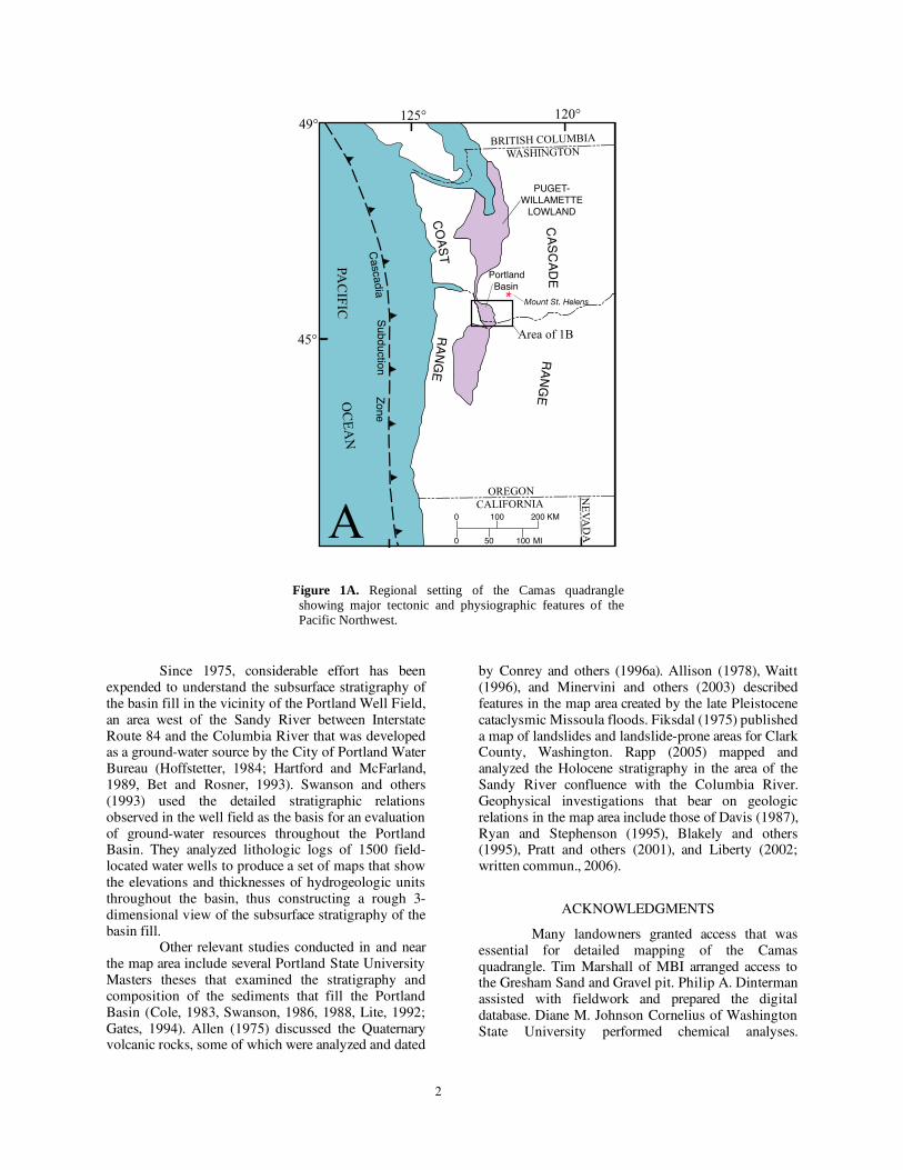
2
OREGONCALIFORNIA
BRITISH COLUMBIA
WASHINGTON
NE
VA
DA
CO
AS
T R
AN
GE
Cascadia S
ubduction Zone
CA
SC
AD
E R
AN
GE
PAC
IFIC O
CE
AN
120deg125deg49deg
45deg
A
PUGET-WILLAMETTE
LOWLAND
Portland Basin
Area of 1B
Mount St Helens
0
0
100 200 KM
MI50 100
Figure 1A Regional setting of the Camas quadrangle showing major tectonic and physiographic features of the Pacific Northwest
Since 1975 considerable effort has been expended to understand the subsurface stratigraphy of the basin fill in the vicinity of the Portland Well Field an area west of the Sandy River between Interstate Route 84 and the Columbia River that was developed as a ground-water source by the City of Portland Water Bureau (Hoffstetter 1984 Hartford and McFarland 1989 Bet and Rosner 1993) Swanson and others (1993) used the detailed stratigraphic relations observed in the well field as the basis for an evaluation of ground-water resources throughout the Portland Basin They analyzed lithologic logs of 1500 field-located water wells to produce a set of maps that show the elevations and thicknesses of hydrogeologic units throughout the basin thus constructing a rough 3-dimensional view of the subsurface stratigraphy of the basin fill
Other relevant studies conducted in and near the map area include several Portland State University Masters theses that examined the stratigraphy and composition of the sediments that fill the Portland Basin (Cole 1983 Swanson 1986 1988 Lite 1992 Gates 1994) Allen (1975) discussed the Quaternary volcanic rocks some of which were analyzed and dated
by Conrey and others (1996a) Allison (1978) Waitt (1996) and Minervini and others (2003) described features in the map area created by the late Pleistocene cataclysmic Missoula floods Fiksdal (1975) published a map of landslides and landslide-prone areas for Clark County Washington Rapp (2005) mapped and analyzed the Holocene stratigraphy in the area of the Sandy River confluence with the Columbia River Geophysical investigations that bear on geologic relations in the map area include those of Davis (1987) Ryan and Stephenson (1995) Blakely and others (1995) Pratt and others (2001) and Liberty (2002 written commun 2006)
ACKNOWLEDGMENTS
Many landowners granted access that was essential for detailed mapping of the Camas quadrangle Tim Marshall of MBI arranged access to the Gresham Sand and Gravel pit Philip A Dinterman assisted with fieldwork and prepared the digital database Diane M Johnson Cornelius of Washington State University performed chemical analyses
3
45 30
122 00
Willamette River
LAKE MERWIN
YALE LAKE
123 0046 00
Portland
Basin
CascadeRange
Oregon C
oast Range
Oregon C
oast Range
Oregon C
oast Range
Portland Hills Fault Zone
Yacolt
WASHINGTONOREGON
Vancouver
Portland
Woodland
Ridgefield
Battle GroundScappoose
Saint Helens
Troutdale
Columbia River Gorge
Colum
bia
River
B
Camas
Tualatin Mountains
Lewis
River
ElkhornMtn
EXPLANATION
Quaternary-Miocene sediments
Quaternary-Pliocene volcanic and volcaniclastic deposits
Miocene Columbia River Basalt Group
Tertiary granitic rocks
Paleogene volcanic and volcaniclastic rocks undifferentiated
Paleogene marine sedimentary rocksAREA
OF MAP
Figure 1B Simplified geologic map of the Vancouver 30 x 60 quadrangle modified from Phillips (1987)
0 10 20 KM
0 MI5 10
Gresham
4
Robert J Fleck and Jonathan T Hagstrum of the US Geological Survey (USGS) provided 40Ar39Ar ages and paleomagnetic data respectively John P McGeehan provided 14C ages and Andrei Sarna-Wojcicki analyzed compositions of tephra samples Andrei Sarna-Wojcicki Elmira Wan Kenneth Bishop and Judith Fierstein of the USGS made available essential laboratory facilities We obtained water-well drillersrsquo logs from the Washington Department of Ecology website (httpappsecywagovwelllog) and the Oregon Water Resources Department website (httpwwwstampwrdstateorusappsgwwell_logwell_logphp) Connie Manson and Lee Walkling aided in extracting information from the Washington Division of Geology and Earth Resources Library in Olympia Washington and Carol Edwards provided the unpublished field notes and map sheets of Donald E Trimble from the USGS Field Records Library in Denver Colo We have benefited immensely from discussions on various aspects of the regional stratigraphy structure and geologic history with Roger Ashley Alex Bourdeau Ann Donnelly Michael Donnelly Paul Hammond Keith Howard Lee Liberty Ian Madin Alan Niem William Phillips Thomas Pierson Patrick Pringle Elizabeth Rapp David Sherrod James Smith Rodney Swanson Terry Tolan Richard Waitt Ray Wells and Linton Wildrick Technical reviews by Ray E Wells and William E Scott inspired considerable improvements in presentation and content
SYNOPSIS OF GEOLOGY
For the past 40 million years the Cascade Range has been the locus of an episodically active volcanic arc associated with underthrusting of oceanic lithosphere beneath the North American continent along the Cascadia Subduction Zone Bedrock exposed in the Camas quadrangle consists of volcanic rocks predominantly basaltic andesite flows erupted in the arc during Oligocene time In most of the map area this bedrock is buried beneath weakly lithified middle Miocene to Quaternary sediment most of which was carried into the area by the ancestral Columbia River and accumulated in the slowly subsiding Portland Basin Quaternary time has been marked by alternating episodes of incision and aggradation leaving prominent gravel fills and terraces along the Columbia and Sandy Rivers The depositional pulses particularly along the Sandy River were likely associated with alpine glaciations In latest Pleistocene time huge Columbia River floods from glacial Lake Missoula inundated the Portland Basin eroding channels such as the Lacamas Lake trough but also leaving immense bars of sand and gravel and a blanket of sand silt and clay in slack water areas During the late Pleistocene and Holocene sea-level rise associated with deglaciation the Columbia River aggraded nearly 90
m filling a deep paleovalley with sand and silt supplemented with volcaniclastic debris that moved down the Sandy River following eruptions of Mount Hood
Several faults some potentially active offset the Paleogene floor of the basin as well as strata of the basin fill Prune Hill is a block of basement rocks and overlying sediments that has been uplifted along some of these structures West of Prune Hill eroded scoria deposits mark the vent of a middle-Pleistocene volcano one of several dozen late Neogene monogenetic volcanoes that constitute the Boring Volcanic Field of the greater Portland region (Treasher 1942 Trimble 1963 Allen 1975 Fleck and others 2002)
Geologic exposures are sparse in much of the map area owing to intense weathering obscuring vegetation and urban development Scouring by the Missoula floods left Paleogene bedrock and basin-fill deposits below about 400 ft (120 m) elevation relatively well exposed and quarries provide good local exposures of basin-fill and Missoula-flood deposits At higher elevations however bedrock is buried beneath thick soils and loess accumulations and most of the nearly flat-lying basin-fill strata in the map area are buried by flood gravel Therefore many contacts are extrapolated on the basis of topography from limited surface observations and such information was supplemented with lithologic data obtained from several hundred water-well reports in the files of the Washington Department of Ecology and Oregon Water Resources Department Well locations were taken as described in logs or in published reports and were not field checked by us only wells considered reliably located were used to infer the distribution and thicknesses of units in the subsurface
PALEOGENE VOLCANIC AND
SEDIMENTARY ROCKS
Trimble (1963) mapped all Paleogene rocks in eastern Clark County Washington as the Skamania volcanic series We have not adopted this name because regional mapping has shown it to have limited utility Neither the top nor the base of the unit were adequately defined and as used by Trimble the Skamania is simply a synonym for Tertiary volcanic rocks of the southern Washington Cascade Range Furthermore equivalent strata elsewhere in the region have been given other names (Wilkinson and others 1946 Roberts 1958 Wise 1970 Hammond 1980 Phillips 1987) and no reliable criteria have been found for mapping contacts between these various units Therefore we employ strictly lithologic units or where appropriate informal lithostratigraphic units
Structural attitudes in Paleogene rocks of the map area are difficult to determine because mappable
5
sedimentary interbeds are rare and the commonly well-developed platy parting within flows tends to vary erratically over short distances In places however individual flows can be traced laterally and indicate that these rocks generally dip 0 to 15deg to the south or southeast
BASALTIC ANDESITE OF ELKHORN MOUNTAIN
Most of the Paleogene rocks exposed in the Camas quadrangle are assigned to an informal unit the basaltic andesite of Elkhorn Mountain (Tbem) This unit consists largely of tholeiitic basaltic andesite and basalt flows with sparse thin volcaniclastic interbeds This package of flows extends from Lady Island northward nearly to Amboy about 19 km north of the map area (Evarts 2005 2006a b) and has a maximum thickness of at least 800 m Individual flows are typically 4 to 10 m thick but locally reach 70 m thick The flows are characterized by blocky platy or columnar-jointed interiors that typically grade into upper and lower flow breccia zones The upper zones commonly contain abundant zeolite- quartz- and clay-filled vesicles and have been oxidized to reddish-orange colors during cooling All flows were apparently emplaced subaerially many rest on red paleosols developed on previously emplaced flows or on thin sedimentary deposits with no pillow lavas or other indications of subaqueous environments Only one dike was found in the map area and dikes are similarly rare to the north (Evarts 2005 2006 a b) The basaltic andesite of Elkhorn Mountain probably formed the flank of a large mafic shield volcano that was centered northeast of the Camas quadrangle
Flows in the basaltic andesite of Elkhorn Mountain range from aphyric to highly porphyritic Aphyric and sparsely phyric flows commonly exhibit a closely spaced platy parting that is parallel to the alignment of feldspar microlites observed in thin section Seriate to porphyritic flows contain phenocrysts of plagioclase and olivine with or without augite in an intergranular to trachytic groundmass Extremely porphyritic to glomeroporphyritic basalts are common in the unit to the north but are sparse in the map area
The lava flows of the Elkhorn Mountain unit vary from basalt to low-silica andesite but most are basaltic andesite (table 1) they are uniformly tholeiitic with low to medium potassium contents (fig 2) The densely plagioclase-phyric basalts exhibit exceptionally high Al2O3 contents (as high as 21 wt percent) that correlate with the abundance of plagioclase phenocrysts (fig 3a) Rocks with more than about 18 percent Al2O3 almost certainly accumulated plagioclase crystals prior to eruption and most basalts in the unit were actually basaltic andesite liquids that contained excess feldspar crystals (fig 3b) Compared to mafic
flows elsewhere in the southern Washington Cascade Range (duBray and others 2006 RC Evarts unpub data) the Elkhorn Mountain flows are relatively rich in Fe (about 102 to 133 wt percent FeO for sparsely phyric flows that approximate liquid compositions fig 3c) and poor in Sr (generally less than 310 ppm Sr fig 3d) Incompatible-element ratios such as BaNb (about 10-20) BaZr (about 15) and ZrNb (about 135) are constant throughout the suite suggesting that the lavas are related primarily by fractional crystallization processes (Evarts 2005 2006a b)
An incremental-heating 40Ar39Ar plateau age of 255 plusmn 02 Ma was obtained for plagioclase in a lava flow north of Camas Slough near the stratigraphic top of the basaltic andesite of Elkhorn Mountain (table 2) 40Ar39Ar ages for this unit north of the Camas quadrangle range between 264 plusmn 01 and 271 plusmn 01 Ma (Evarts 2006a b) Collectively these results indicate that most of the basaltic andesite of Elkhorn Mountain was emplaced between 27 and 255 Ma
OTHER VOLCANIC AND VOLCANICLASTIC ROCKS
Andesite and dacite flows
The southernmost outcrop of Paleogene bedrock in the Camas quadrangle consists of porphyritic andesite (Ta table 1 no 24) that forms the islands of Ione Reef A very platy sparsely phyric dacite (Td table 1 no 25) crops out on Lady Island a short distance to the northeast The stratigraphic relation of these isolated flows to the basaltic andesite of Elkhorn Mountain is uncertain but the general southeasterly dips of structural attitudes in the map area indicates the more silicic flows most likely overlie the basaltic andesites The chemistry of the andesite and dacite is consistent with an origin as silicic differentiates of the Elkhorn Mountain mafic magmas (fig 2)
Tuff breccia and lapilli tuff
A section of stratified lithic tuff breccia lapilli tuff and minor tuff (Tmv) crops out on the bank of the Columbia River north of the west tip of Lady Island This section at least 50 m thick is truncated on the east by a normal fault and is covered on the west by Quaternary deposits The upper part of the unit overlain by a basaltic andesite flow is well exposed in roadcuts on State Route 14 west of the bridge over Camas Slough Angular fragments of dense to scoriaceous basalt and basaltic andesite dominate the clast population and broken crystals of plagioclase are abundant in the fine-grained fraction The lithic clasts resemble associated Elkhorn Mountain flows The beds are well indurated owing to cementation by calcite clay and zeolites scoriaceous clasts are completely
6
Figure 2 Chemical characteristics of volcanic rocks from the Camas 75 quadrangle (analyses recalculated volatile-free) A K2O+Na2O versus SiO2 showing IUGS classification (Le Maitre 2002) B K2O versus SiO2 showing low- medium- and high-potassium fields extrapolated from Gill (1981 p 6) C FeOMgO versus SiO2 showing classification into tholeiitic and calc-alkaline rocks according to Miyashiro (1974) FeO total Fe as FeO
0
2
4
6
8
10
12
K2 O
+N
a O
IN
WE
IGH
T P
ER
CE
NT
2
Dacite
Rhyolite
Trachyte
AndesiteBasalticandesiteBasalt
Trachy-andesite
Basaltictrachy-
andesiteTrachy-basalt
45 50 55 60 65 70 75 80
SiO 2 IN WEIGHT PERCENT
A
FFFFFFFF
K2O
IN
WE
IGH
T P
ER
CE
NT
0
1
2
3
4
45 50 55 60 65 70 75
Low-potassium
Medium-potassium
High-potassiumB
FFF
FFFFF
0
2
4
6
8
45 50 55 60 65 70 75 80
FeO
M
gO
SiO2 IN WEIGHT PERCENT
THOLEIITIC
CALC-ALKALINE
C
FFFFFFFF
Paleogene volcanic rocksQuaternary volcanic rocksF
7
replaced by palagonite The unit is interpreted as mafic pyroclastic debris from an explosive eruption of the Elkhorn Mountain volcano Local variations in bedding orientation probably reflect post-eruptive slumping or minor downslope transport
A poorly exposed interval of volcaniclastic rocks (Tvs) is present within the basaltic andesite of Elkhorn Mountain east of Lacamas Creek Roadcuts and excavations in that area reveal weathered massive poorly sorted tuff and lapilli tuff composed of angular to subrounded pumiceous and lithic volcanic clasts Their textural and compositional characteristics indicate these are primarily debris-flow deposits
METAMORPHISM AND HYDROTHERMAL ALTERATION
Paleogene rocks in the Camas quadrangle have been subjected to zeolite-facies regional metamorphism the general character of which is similar to that described from other areas in the southern Washington Cascade Range (Fiske and others 1963 Wise 1970 Evarts and others 1987 Evarts and
Swanson 1994) This region-wide metamorphism reflects burial of the Oligocene rocks by younger volcanic rocks within the relatively high-heat-flow environment of an active volcanic arc
Zeolite-facies mineral assemblages are best developed in permeable volcaniclastic rocks associated massive lava flows are commonly much less affected In the mafic lava flows the primary effect of very low-grade metamorphism is the nearly universal development of clay minerals and zeolites replacing labile interstitial glass filling vesicles and deposited on joint surfaces Feldspar may display partial alteration to clay minerals and (or) zeolites along fractures and cleavage planes Olivine phenocrysts in the basalts and basaltic andesites are totally replaced by smectite with or without hematite and calcite Primary pyroxenes and Fe-Ti oxides are largely unaffected by the zeolite-facies metamorphism Volcaniclastic rocks of unit Tvs are pervasively altered to clay minerals and zeolites
Figure 3 Chemical characteristics of lavas in the basaltic andesite of Elkhorn Mountain (Tbem) illustrating the effects of plagioclase accumulation Filled symbols designate samples from Camas quadrangle unfilled symbols designate samples from adjacent areas strongly plagioclase-accumulative samples shown as diamonds contain more than 25 percent plagioclase phenocrysts A Al2O3 versus abundance of plagioclase phenocrysts showing that the lavas plot along a plagioclase-accumulation line (shown in red) that projects to the composition of a calcic labradorite (about 30 wt percent Al2O3) B SiO2 versus abundance of plagioclase phenocrysts showing that many basalts (SiO2 less than 52 wt percent) are strongly plagioclase-accumulative lavas C FeO versus abundance of plagioclase phenocrysts showing that FeO contents of most non-accumulative lavas (lt10 percent plagioclase phenocrysts) are greater than 90 wt percent FeO total Fe as FeO D Sr versus abundance of plagioclase phenocrysts showing that Sr contents of non-plagioclase accumulative lavas are mostly less than 320 ppm
0 20 40 60 80 10010
15
20
25
30
MODAL PERCENT PLAGIOCLASE
Al 2
O3
IN W
EIG
HT
PE
RC
EN
T
A
0
10
20
30
40
50
60
70
MO
DA
L P
ER
CE
NT
PLA
GIO
CLA
SE
SiO 2 IN WEIGHT PERCENT
48 50 52 54 56 58
B
0 10 20 30 40 50 60 705
7
9
11
13
15
FeO
IN
WE
IGH
T P
ER
CE
NT
MODAL PERCENT PLAGIOCLASE
C
100
200
300
400
500
0 10 20 30 40 50 60 70
MODAL PERCENT PLAGIOCLASE
0
Sr
IN P
PM
D
8
BASIN-FILL DEPOSITS1
As the Portland Basin gradually subsided during the late Miocene and Pliocene it filled with continental fluvial and lacustrine sediments transported through the Cascade Range by the ancestral Columbia River and with locally derived detritus carried in by tributaries draining the surrounding highlands Previous workers (Wilkinson and others 1946 Lowry and Baldwin 1952 Trimble 1957 Mundorff 1964 Tolan and Beeson 1984 Howard 2002) have generally mapped this fill as the Troutdale Formation which was named by Hodge (1938) for exposures near Troutdale Oregon Throughout most of the Portland Basin the older part of this nonmarine section rests unconformably on Paleogene bedrock or the Miocene Columbia River Basalt Group and consists predominantly of fine-grained beds quite different than the coarse-grained sandstone and conglomerate that typifies the Troutdale section in the type area This observation prompted Trimble (1957) Mundorff (1964) and Howard (2002) to divide the Troutdale Formation of Hodge (1938) into informal upper and lower members based on the pronounced lithologic difference Trimble (1963) formally named the lower fine-grained member the Sandy River Mudstone while retaining the name Troutdale Formation for the overlying sandstone and conglomerate He also noted that the youngest conglomeratic beds south of the Columbia River included volcanic debris flow deposits and consisted largely of clasts derived from the nearby Cascade Range rather than sediment transported from the east by the Columbia River He mapped these beds as the Springwater Formation of probable Pleistocene age (Trimble 1963) Similarly on the basis of position and clast composition Howard (2002) and Evarts (2004a c d 2006b) distinguished a separate late Pliocene or Pleistocene conglomerate unconformably overlying the Troutdale Formation These deposits previously included in the Troutdale are locally overlain by mafic volcanic rocks the Boring Lava of Treasher (1942) which erupted from scattered local centers in Quaternary time
Recent studies have shown that stratigraphic relations within the basin fill of the eastern Portland Basin are considerably more complex than portrayed by Trimble (1963) and Mundorff (1964) These complications are well illustrated in the vicinity of the Portland Well Field (fig 4) where it is evident that the
1 The distinction between basin-fill and surficial fluvial deposits is necessarily somewhat arbitrary Deposits mapped as basin fill in this report are relatively widespread voluminous and typically bear no direct relation to modern drainage Surficial deposits include unconsolidated late Quaternary sediments with distributions restricted to modern stream valleys (Qa Qac Qh and terrace deposits) and the widespread but relatively thin cataclysmic-flood deposits (Qfg Qfs)
stratigraphic intervals previously mapped as Troutdale Formation and Sandy River Mudstone are interbedded and rapid facies changes related to alternating periods of deposition and incision and a general downstream fining of average grain size are apparent (Hogenson and Foxworthy 1965 Hoffstetter 1984 Swanson 1986 Hartford and McFarland 1989 Swanson and others 1993 Bet and Rosner 1993 Koreny and Fisk 2000) Figure 5 shows a comparison of our nomenclature with the schemes employed by previous workers these relationships are discussed in more detail below
SANDY RIVER MUDSTONE
The Sandy River Mudstone as defined by Trimble (1963) consists largely of thin-bedded claystone siltstone and sandstone with minor interbeds of pebbly conglomerate fine-grained tuff and lignite Most of the sandy beds are micaceous lithic and arkosic sandstones indicative of an eastern Washington and Idaho provenance and deposition by an ancestral Columbia River Claystone beds are commonly carbonaceous and locally contain well-preserved leaf impressions early Pliocene fossil floras have been collected from the upper part of the Sandy River Mudstone at several localities (Treasher 1942 Chaney 1944 Trimble 1963 Tolan and Beeson 1984) Trimble interpreted the Sandy River Mudstone as a lacustrine deposit but sedimentary structures indicate deposition in low-energy fluvial or overbank settings
Strata lithologically similar to the Sandy River Mudstone crop out at several localities in the map area but are too small and discontinuous to map they intertongue and are mapped with coarse-grain beds assigned to the hyaloclastic sandstone member of the Troutdale Formation (Ttfh) Well logs in the Portland Well Field (Hoffstetter 1984 Hartford and McFarland 1989 Swanson and others 1993) show that several fine-grained intervals forming aquitards or confining units are interbedded with sandstone and conglomerate in the shallow subsurface (fig 4) The fine-grained beds which we consider tongues of the Sandy River Mudstone become more abundant to the west and may be more than 300 m thick near the west boundary of map area (Swanson and others 1993) The uppermost confining unit (CU1 in fig 4) is probably equivalent to a 7ndash15-m-thick interval of leaf-bearing beds below Broughton Bluff that Trimble (1963) mapped as Troutdale Formation A likely correlative section exposed at the mouth of Beaver Creek contains multiple paleosols developed in very fine felsic sand as well as a thin volcanic debris flow A lower confining unit (CU2 in fig 4) probably corresponds to the Sandy River Mudstone that Trimble (1963) mapped along the Sandy River southeast of the Camas quadrangle Similar fine-grained sediments not mapped separately due to limited exposure are interbedded with
9
VERTICAL EXAGGERATION X 20VERTICAL EXAGGERATION X 20
W
SEA LEVEL SEA LEVEL
100
200
300
400
500
600
700
100
100100
200
300
400
500
600
700
FEETE
100FEET
0 1 2 KILOMETERS
OB
UGTGACRSA
CU1
CU2
TSA
TSA
SGA
SGA
SGA
BLGA
OB
Gravel
Sand
Silt and Clay
SGA
LithologyLithostratigraphic units (this report)
Sandy River Mudstone
Troutdale Fm conglomerate member
Troutdale Fm hyaloclastic sandstone member
Ancestral Sandy River sediments
Holocene and late Pleistocene sediments
Mou
nt T
abor
Cam
as
Blue Lake
OB Overbank deposits
BLGA Blue Lake gravel aquifer
CRSA Columbia River sand aquifer
UGTGA Unconsolidated gravelTroutdale gravel aquifer
CU2 Confining unit 2
CU1 Confining unit 1
TSA Troutdale sandstone aquifer
SGA Sand and gravel aquifer
Hydrogeologic units from Hartford and McFarland (1989)
Figure 4 Cross section along the south shore of the Columbia River after Hartford and McFarland (1989) showing stratigraphic relations of basin-fill deposits in the Portland Well Field and correspondence between lithologic hydrogeologic and lithostratigraphic nomenclature as discussed in text Vertical blue lines denote wells along profile Depth to basin floor is unknown nearby wells penetrate 1100 ft of fine-grained beds without reaching bedrock Note that the Troutdale gravel aquifer (TGA) consists of deposits that postdate the Troutdale Formation as defined in this report The Blue Lake gravel aquifer (BLGA) probably consists of the gravel facies of Missoula-flood deposits The Columbia River sand aquifer (CRSA) consists of Holocene sediments that fill the Pleistocene channel of the Columbia River (Gates 1994 Pratt and others 2001) Overbank deposits (OB) are modern Columbia River floodplain sediments Correlations near east end of the profile are uncertain owing to vertical displacement on the Blue Lake Fault which obliquely crosses the profile in this area
10
hyaloclastic sandstone on Prune Hill and east of Lacamas Lake
The only direct age information for the Sandy River Mudstone comes from late Pliocene paleofloras obtained from the upper part of the formation (Chaney 1944 Treasher 1942 Trimble 1963 Tolan and Beeson 1984) one of these sites is directly below Broughton Bluff (Trimble 1963 and unpub field notes) The unit largely postdates the Columbia River Basalt Group (Trimble 1963 Tolan and Beeson 1984 Madin 1994 2004 Mabey and Madin 1995) although the lowest beds were invaded by the 156-Ma Grande Ronde Basalt near Woodland Washington (Evarts 2004a)
TROUTDALE FORMATION
The Troutdale Formation is mapped as two lithologically distinct informal members The older member (Ttfc) consists of quartzite-bearing conglomerate and arkosic sandstone The younger member (Ttfh) is composed largely of hyaloclastic basaltic debris These two members correspond closely to the informal upper and lower members of the Troutdale as mapped by Tolan and Beeson (1984) in the western Columbia River Gorge
Conglomerate member
The conglomerate member (Ttfc) crops out only in the valley wall of Little Washougal River near the northeast corner of the map area but is widespread to the north and east (Evarts 2004a d 2006a b RC Evarts unpub mapping) It is unconformably overlain by a younger but similar conglomerate (QTc) the location of the contact is inferred from relations in adjacent areas (Evarts 2006b RC Evarts unpub mapping) Water-well logs indicate the conglomerate member is underlain by the Sandy River Mudstone
The Troutdale Formation conglomerate member consists of weakly to moderately cemented pebble and cobble conglomerate and lenses of medium to coarse sandstone Well-rounded pebbles and cobbles eroded from the Columbia River Basalt Group are the most abundant constituent of the conglomerate the remainder includes light-colored granitic and quartzofeldspathic metamorphic rocks Fe-oxide stained quartzite and minor amounts of volcanic rocks eroded from the Cascade Range The interbedded sandstone ranges in composition from basaltic to muscovite-bearing arkosic and quartzose and is lithologically similar to the sandy matrix of the conglomerate Significantly the conglomerate member of the Troutdale Formation (Ttfc) lacks clasts of Pliocene and younger basalts like those that are abundant in the basaltic hyaloclastic sandstone member (Ttfh) Sedimentological characteristics of the
conglomerate such as the massive to crudely stratified beds clast-support moderate to good sorting and clast imbrication are consistent with deposition during high flow in a large perhaps braided gravel-bed river system (Miall 1977 1996 Rust 1978)
Hyaloclastic sandstone member
In its type area along the lower Sandy River the Troutdale Formation consists of complexly interbedded sandstone and conglomerate and includes a distinctive lithofacies of basaltic hyaloclastic debris called yellow grit tuffaceous sandstone or vitric sandstone by previous workers (Williams 1916 Hodge 1938 Lowry and Baldwin 1952 Trimble 1963 Tolan and Beeson 1984) Similar strata underlie eastern Camas and are well exposed in lower Lacamas Creek along the shores of Lacamas Lake and south of the Columbia River near Blue Lake and along Interstate 84 Hyaloclastic sediment also constitutes prominent intervals at depth in the Portland Well Field (fig 4) (Hoffstetter 1984 Swanson 1986 Hartford and McFarland 1989 Swanson and others 1993 Bet and Rosner 1993) The hyaloclastic sediment is generally coarse to very coarse-grained sandstone that is moderately well sorted to poorly sorted and composed chiefly of angular fragments of vesicular to nonvesicular vitric to lithic basalt that contain olivine and plagioclase microlites The black basaltic glass is partly to completely altered to palagonite which imparts a distinctive yellow-brown color to the sandstone in outcrop and serves as a cementing agent
Beds and lenses of conglomerate are interbedded with the hyaloclastic sandstone and locally as in the type area along the Sandy River are predominant Many conglomerate beds are well sorted and consist largely of well-rounded cobbles and pebbles of dark gray to black aphyric basalts eroded from the Columbia River Basalt Group Clasts of light-colored granitic and quartzofeldspathic metamorphic rocks and Fe-oxide stained quartzite that were derived from source areas in eastern Washington and Idaho are minor but persistent components Rounded to subangular cobbles and boulders of variably vesicular olivine- and plagioclase-phyric basalt are abundant in some conglomerates These beds tend to be lensoidal poorly sorted and possess a matrix of basaltic sand compositionally similar to the associated sandstone beds and resemble hyperconcentrated flood-flow deposits as described by Smith (1986)
The angular vitric clasts were generated by rapid chilling and quench fragmentation during interaction of basaltic lava with water Crude to distinct stratification foreset bedding cut-and-fill structures intergradational contacts with conglomerate and the presence of minor but nearly ubiquitous nonvolcanic debris all signify fluvial reworking of the hyaloclasts
1
1
Coarse-grained deposits Fine-grained deposits
Paleogene
Pleistocene
Pliocene
Miocene
Holocene
Howard (2002)Battle Ground quad This map
cataclysmicflood deposits
Boring Lava
Troutdale Fmupper member
Troutdale Fmlower member
High Cascadeslavas
Rhododendron
Pomona Mbr
Boring L
Boring Lava
Troutdale Fmvolcanic- amp quartzite-
clast members
Troutdale Fmfine-grained
member
Troutdale Fmalluvial-fan
member
Sandy RiverMudstone
conglomerate mbr
alluviumand other
surficial deposits
alluviumand other
surficial deposits
cataclysmicflood deposits
Trimble (1963)Portland area
Rhododendron Fmand equivalents
Sandy RiverMudstone
Troutdale Fm
alluviumand other
surficial deposits
EstacadaGresham
SpringwaterWalters HillFormations
lacustrine deposits
Boring Lava
Mundorff (1964)Clark County WA
Troutdale Fmupper member
Troutdale Fmlower member
Boring Lava
alluvial deposits
glacial drift
alluviumand other
surficial deposits
Columbia RiverBasalt Group
Skamaniavolcanic series Older rocks
Wanapum Basalt ampGrande Ronde
Basalt
SkamaniaVolcanics
SkamaniaVolcanics
basaltic andesiteof Elkhorn Mtn
Tolan amp Beeson (1984)Columbia River Gorge
AncestralSandy River
gravelsunnamed
conglomerateWalters Hill Fm
hyaloclastic ss mbrTroutdale Fm
Troutdale Fm
Boring Volcs
Figure 5 Comparison of stratigraphic nomenclature and age assignments for Neogene basin-fill units of the Portland Basin and vicinity
12
However the textural immaturity poor sorting and nearly monolithologic character of many beds suggest relatively short transport distances in a river system highly loaded with such sediment and rapid deposition Following Trimble (1963) Tolan and Beeson (1984) and Swanson (1986 1988) we interpret these sediments as hyaloclastic debris generated by basalt flows entering the ancestral Columbia River upstream from the map area This voluminous debris was swept downstream and aggraded the eastern Portland Basin its distribution (Swanson and others 1993) indicates that the ancestral western Columbia River valley was considerably wider than the present gorge The north side of this paleovalley is visible in lower Lacamas Creek where hyaloclastic sandstone and conglomerate are banked against a steep wall of eroded Oligocene rocks Paleocurrent directions inferred from steep foreset bedding and clast imbrication measured in the Sandy River (Cole 1983) and Lacamas Creek valleys indicate transport to the north and north-northwest in the northern part of the paleovalley
Tolan (1982) and Tolan and Beeson (1984) mapped a section of Troutdale Formation conglomerate and sandstone more than 335 m thick in the western Columbia River Gorge and observed that the distinctive hyaloclastic sandstone beds were restricted to the upper 75 m of the section and on this basis divided the Troutdale Formation into informal upper and lower members (fig 5) Their upper member is correlative with our hyaloclastic sandstone member (Ttfh) Tolan and Beeson (1984) also suggested that the contact between their members was equivalent to the Troutdale FormationndashSandy River Mudstone contact mapped by Trimble (1963 p 34) along the Sandy River southeast of the Camas quadrangle However the fine-grained beds mapped as Sandy River Mudstone by Trimble can be traced in the subsurface to the Portland Well Field where they overlie hyaloclastic sandstone and conglomerate (fig 4) (Swanson 1986 Hartford and McFarland 1989 Swanson and others 1993) Hence as noted above the Sandy River Mudstone mapped by Trimble is actually a tongue of fine-grained beds within the hyaloclastic sandstone-bearing sequence This tongue (CU2 in fig 4) separates two intervals dominated by hyaloclastic debris (TSA and upper part of SGA in fig 4) that may represent hyaloclastites generated by two large eruptive events to the east The base of the informal upper member of Tolan and Beeson (1984) likely corresponds to the base of the lower hyaloclastite-rich interval (fig 5) The total thickness of the hyaloclastite-bearing section in the Portland Well Field is approximately 125 m (fig 4) (Swanson 1986 Hartford and McFarland 1989 Swanson and others 1993) and is correlated with the 140-m-thick hyaloclastic sandstone member (Ttfh) mapped in the Prune HillndashLacamas Lake area
Chemical analyses (Swanson 1986 Andrei Sarna-Wojcicki written commun 2005) show that the
vitric clasts in the hyaloclastic sandstone and the olivine+plagioclase-phyric basalt cobbles in the associated conglomerate (table 1 no 34) both possess a low-potassium tholeiite composition similar to basalt flows in the Cascade Range but unlike locally erupted lavas in the Boring Volcanic Field (Swanson 1986 RC Evarts and RM Conrey unpub data) Their chemistry thus suggests that the sediments are genetically related to the compositionally similar lava flows erupted to the east (Tolan and Beeson 1984 Swanson 1986 RC Evarts and RM Conrey unpub data) several of which have yielded late Pliocene radiometric ages (28 to 35 Ma Conrey and others 1996a b RJ Fleck written commun 2006)
WALTERS HILL FORMATION
Trimble (1963) gave the name Walters Hill Formation to a sequence of deeply weathered generally coarse-grained fluvial deposits that form a group of hills south of Gresham The most northerly of these hills is Grant Butte at the southern quadrangle boundary This unit (QTwh) is poorly exposed in the map area but most clasts exposed in roadcuts ascending Grant Butte are deeply weathered porphyritic andesites of Cascadian provenance Trimble (1963) described poorly indurated weathered gravel and debris-flow deposits locally interbedded with sandstone as thick as 300 ft (90 m) south of the map area Hill summits are between 650 and 1000 ft (200 and 300 m) elevation and the hills are probably erosional remnants of an alluvial fan or bajada extending west or northwest from the Cascade Range These sediments were mapped as Springwater Formation by Madin (1994) in the Damascus quadrangle to the south but they grade to a distinctly higher level than the Springwater Formation in its type area (Trimble 1963) although the elevation difference could reflect unrecognized structural deformation The age of the Walters Hill Formation is poorly constrained but deposits that were mapped as Walter Hill Formation by Trimble (1963) in the Gladstone quadrangle to the southwest appear to be interbedded with basalts dated at about 16 to 14 Ma (RJ Fleck written commun 2002)
UNNAMED CONGLOMERATE
Evarts (2004a c d 2006b) mapped an unnamed conglomerate unit (QTc) north and northwest of the Camas quadrangle that is similar to but considerably younger than nearby Troutdale Formation conglomerate Although included with the Troutdale Formation by most previous workers the younger conglomerate differs from the older unit in that it contains sparse clasts of olivine basalt and interbeds of reworked hyaloclastic sands has a higher proportion of volcanic clasts derived from the Cascade Range is
13
commonly more poorly sorted and forms an extensive geomorphic bench (mostly capped by Missoula Flood sediment) within the Portland Basin Beds of weathered conglomerate that overlie the hyaloclastic sandstone member of the Troutdale Formation on Prune Hill and underlie much the area east of Lacamas Lake are assigned to this unit The unnamed conglomerate unit is also present in the Portland Well Field (UGTGA in fig 4) where it overlies the Troutdale Formation (Ttfh) and Sandy River Mudstone (Tsr) along an erosional unconformity (Hartford and McFarland 1989 Swanson and others 1993 Bet and Rosner 1993) In the map area the unnamed conglomerate is as thick as 90 m Except where severely eroded by Pleistocene cataclysmic floods the upper several meters of the unit is deeply weathered The unnamed conglomerate is probably of latest Pliocene to early Pleistocene age because it overlies the hyaloclastic sandstone member of the Troutdale Formation and is overlain by the basaltic andesite of Prune Hill which is about 595 ky old (table 2) The elevation age and depositional setting of the unnamed conglomerate (QTc) and the unnamed fan gravel (QTfg) are similar suggesting that both reflect periods of regional Columbia River aggradation coincident with widespread piedmont deposition of Cascadian volcaniclastic detritus
UNNAMED FAN GRAVEL
The distal edge of a broad west-northwest-sloping moderately dissected piedmont extends into the southeasternmost part of the map area Where exposed along Division Street west of Beaver Creek the deposits (QTfg) beneath this surface consist of weathered fluvial gravel of Cascade Range provenance interbedded with lithic-rich sand and matrix-supported diamicts which contain angular hornblende-andesite clasts up to 1m in diameter These deposits are overlain by about 25 m of strongly oxidized micaceous silt and clay interpreted as loess (Qlo)
This piedmont is apparently the remnant of a broad alluvial fan associated with aggradation of an ancient Sandy River Geomorphic relations southeast of the map area show that this fan emanated from a confined valley located near Sandy about 10 km south of the quadrangle boundary Fan aggradation probably occurred in conjunction with alpine glaciation and associated outwash-gravel production in the Cascade Range punctuated by lahars The volcaniclastic deposits may have been derived from the early Pleistocene Sandy Glacier volcano (Wise 1969 Sherrod and Scott 1995) located in the Mount Hood area
The fan deposits were mapped by Trimble (1963) and Madin (1994) as Springwater Formation but their slightly lower elevation and less dissected surface indicate that they are probably younger than the
Springwater Formation in the type area about 30 km south of Gresham There are no direct age determinations on these deposits but the profile of this piedmont grades to an elevation 50 to 70 m higher than the base of the basaltic andesite exposed at Broughton Bluff The unnamed fan gravels therefore probably predate the basaltic andesite which has an 40Ar39Ar age of 128 Ma (RJ Fleck written commun 2003)
GRAVEL WEST OF GRESHAM
An isolated flat-topped hill 2 km west of Gresham along the southern map edge is underlain by fluvial gravel (Qgwg) Temporary construction excavations up to 4 m deep show cobble gravel overlain by less than 1 m of silt Most clasts are rounded to well-rounded with maximum intermediate diameters less than 20 cm Clasts are mostly andesites and other Cascade Range rock types The clasts are relatively fresh weathering rinds on fine-grained volcanic rocks are thinner than 5 mm The matrix is strongly oxidized silt and clay
The stratigraphic relation of this gravel to other fluvial deposits in the map area and surrounding terrain is uncertain Clast composition and location suggest deposition by an ancient Sandy River perhaps in conjunction with regional aggradation associated with Cascade Range alpine glaciation but correlative surfaces are not evident Its higher topographic position indicates a greater age than the youngest ancestral Sandy River gravel (Qaas) exposed in the MBI gravel pit 1 km northwest of the hill although it may be a high-standing erosional remnant of one of the deeper gravel units exposed in the pit Alternatively the gravel of the hill may be equivalent to that in the pit and has been vertically displaced along faults buried beneath Missoula-flood deposits
These deposits (Qgwg) were mapped by Trimble (1963) as Springwater Formation but the minimal silt cover and lack of clast weathering and soil development suggest a much younger age than the deposits of the type area Madin (1994) mapped the southern part of this hill in the Damascus quadrangle as coarse-grained Missoula Flood deposits but the common 1-3 mm weathering rinds and lack of typical Columbia River provenance clasts such as Columbia River Basalt and quartzite indicate instead that the hill is underlain by older deposits of Cascade Range provenance
ALLUVIUM OF ANCESTRAL SANDY RIVER
A thick gravel section (Qaas) apparently underlies cataclysmic-flood deposits throughout much of the area south of Interstate 84 in Oregon Although only minimally exposed along Beaver Creek south of Mount Hood Community College more than 60m of cobbly gravel is well exposed in the large MBI gravel
14
pit 1 km north of Grant Butte The gravel beds here are several meters thick massive to crudely stratified well sorted and tabular to slightly west-tapering Thin sand beds are scattered throughout the gravel but are laterally discontinuous and volumetrically minor Sharp contacts within the sequence are planar and apparently conformable but are not associated with significant soil profiles so apparently do not represent large time intervals We interpret the coarse grain size apparent rapid deposition and absence of channel features to indicate deposition on an aggrading braid plain or fan Clasts in the gravel and sand are dominated by volcanic rocks derived from the nearby Cascade Range include likely Mt Hood andesites By contrast clasts of Columbia River provenance such as Columbia River Basalt Group granitic rocks quartzite quartz and muscovite are uncommon This composition indicates that the gravels were deposited by a tributary of the Columbia emanating from in the adjacent Cascade Range most likely the ancestral Sandy River Clast imbrication indicating deposition by west- to north-flowing currents is consistent with this interpretation
In the MBI gravel pit the ancestral Sandy River gravels are overlain by 15 m of cataclysmic flood gravel (Qfg) Where the contact is conformable the upper part of the Sandy River deposits consists of a fining-up sequence of alternating sand and gravel surmounted by about 1 m of massive pedogenically altered silt and very fine sand probably loess Cobbles directly below the loess() have weathering rinds ranging from 1 to 5 mm thick The weathering characteristics are consistent with an exposure duration of 100 ky indicating late Pleistocene deposition perhaps during a glacial period of enhanced sediment production in the ancestral Sandy River headwaters The ancestral Sandy River alluvium corresponds in part with terraces that were mapped by Trimble (1963) as Estacada Formation along the Sandy River southeast of the map area (JE OrsquoConnor unpub mapping)
VOLCANIC ROCKS OF THE BORING
VOLCANIC FIELD
The Boring Volcanic Field (Fleck and others 2002) consists of several dozen late Pliocene to Quaternary monogenetic vents and associated lava flows scattered throughout the greater Portland area (Treasher 1942 Trimble 1963 Allen 1975) Lava compositions are diverse but predominantly mafic The products of two Boring volcanoes are present in the Camas quadrangle (Qbph and Qbbb) both exhibit calc-alkaline compositions that are typical of volcanic-arc magmas (fig 2)
Thick deposits of variably agglutinated scoria on the west flank of Prune Hill associated with a strong positive aeromagnetic anomaly mark a Quaternary volcanic vent At approximately 595 ka (table 2) lava
flows of olivine-phyric basaltic andesite (Qbph) erupted from this center and flowed about 2 km to the north and west and an unknown distance to the south burying unweathered gravel (presumably in the contemporary channel of the Columbia River) at an elevation of 150ndash170 ft (45ndash55 m) Late Pleistocene cataclysmic floods severely eroded the cinder cone and undercut and removed the southern part of the associated flow field
An older basaltic andesite flow (Qbbb) crops out at the top of Broughton Bluff above the Sandy River It overlies the hyaloclastic sandstone member of the Troutdale Formation and probably erupted from a vent located at Chamberlain Hill about 3 km east of the bluff A sample collected just east of the map area yielded an 40Ar39Ar age of 1282plusmn0014 Ma (RJ Fleck written commun 2003) At 230ndash250 ft (70ndash75 m) elevation on Broughton Bluff the pillowed base of this flow rests on unweathered micaceous sand this contact presumably marks the position of the Columbia River channel at about 1 Ma
QUATERNARY ALLUVIAL EOLIAN
AND MASS WASTAGE DEPOSITS
Surficial deposits in the Camas quadrangle include sediment deposited by the cataclysmic Missoula floods deposits along the Sandy River related to eruptions of Mount Hood and various alluvial eolian and mass-wastage deposits
TERRACE DEPOSITS
Sand and gravel deposits that record channel positions older and higher than modern levels border the Sandy Washougal and Little Washougal Rivers Younger probable late Pleistocene or early Holocene gravel deposits flank the lower Washougal and Sandy Rivers Gravel deposits along the Washougal River (Qtdwl) underlie a prominent and extensively quarried terrace tread at about 50 ft (15 m) above sea level Gravel deposits along the lower Sandy River and Beaver Creek (Qtds) underlie a prominent bench whose surface is between 170 and 190 ft (52 and 58 m) above sea level In both areas these deposits are scantly weathered and are not capped by Missoula flood deposits so must be either latest Pleistocene or Holocene although the high elevation of the Sandy River gravel suggests a late Pleistocene age is more likely Both accumulations are thought to represent aggradation while the mouths of their source rivers were impounded by large and coarse Missoula-flood bars and were left as terraces when the rivers incised the bars Coarse boulder lags in the channels of both rivers where they pass the margins of Missoula flood bars (Qfg) may be the remnants of such blockages The Sandy River gravel contains a 1-m-thick bed of gray
15
silty gravelly sand bed interpreted as a lahar-runout deposit indicating that Mount Hood was active at the time sediment was accumulating behind this blockage
Thin (lt5 m thick) gravel deposits (Qtdl) border the Little Washougal River near the northeast corner of the map area They reflect aggradation in response to blockage of the river by landslides downstream to the east (RC Evarts and JE OrsquoConnor unpub mapping) The ages of the landslides is unknown but their relatively undissected morphology indicates they are probably late Pleistocene or Holocene
CATACLYSMIC FLOOD DEPOSITS
During the last glacial maximum in late Pleistocene time an ice dam at Pleistocene Lake Missoula in western Montana failed repeatedly each breach generating enormous floods commonly referred to as the Missoula floods that coursed down the Columbia River and into the Portland Basin (Bretz 1925 1959 Bretz and others 1956 Trimble 1963 Allison 1978 Baker and Bunker 1985 Waitt 1985 1994 1996 OrsquoConnor and Baker 1992 Benito and OrsquoConnor 2003) The sediment-laden floodwaters were hydraulically dammed by the relatively narrow constriction of the Columbia River valley at the north end of the Portland Basin causing temporary ponding in the Portland Basin and tributary valleys to elevations as high as 400 ft (120 m) Radiocarbon ages paleomagnetic measurements and tephrochronologic data indicate that these floods occurred chiefly between about 17 and 12 ka (Waitt 1994 Benito and OrsquoConnor 2003 Clague and others 2003)
The Camas quadrangle is located at the mouth of the Columbia River Gorge which formed one of the most profound constrictions along the flood route Because of this constriction the largest floods achieved tremendous flow velocities in the western gorge perhaps as great as 35 ms (Benito and OrsquoConnor 2003) These high velocities rapidly diminished as flood waters emerged from the gorge into the broad Portland Basin resulting in deposition of debris carried as bedload by the deep and fast flows Where flow first expanded large broadly convex bars of coarse gravel formed including the prominent bar transected by the Washougal River at Camas and the 6-km-long 100-m-high bar extending southwest from Broughton Bluff Hydrogeologic studies in east Portland also show correlative bouldery gravel up to 68 m thick and extending to 230 ft (70 m) below sea level in the area northeast of Blue Lake (Hoffstetter 1984 Hartford and McFarland 1989)
Within the map area flood flow spread out from the Columbia River valley sweeping through the Lacamas Lake trough in Washington and winding through remnants of older basin fill and terrace deposits in Oregon Floodwaters scoured the landscape near
Camas completely denuding Paleogene bedrock and the Troutdale Formation of soil and other surficial material to elevations as high as 400 ft (120 m) On both sides of the river the floods deposited multiple lenticular gravel sheets at elevations as high as 370 ft (110 m) which have been extensively quarried for sand and aggregate In conjunction with decreasing flow velocity maximum clast diameter diminishes westward (Trimble 1963) from greater than 7 m at Troutdale (where they provide a significant obstruction to grading and landscaping) to less than 1 m at the western edge of the map area At Prune Hill the floods undercut a Pleistocene lava flow (Qbph) leaving a talus-like lag deposit composed of huge (as large as 7 m across) angular basaltic andesite boulders with interstices occupied by well-rounded pebbles and cobbles the landslides at Camas may have a similar origin Later Missoula floods were smaller than earlier ones (Benito and OrsquoConnor 2003) and were probably confined to the immediate Columbia River valley (the floor of which was about 90 m below modern sea level) but left thin onlapping sequences of sand and gravel on the margins of the older deposits
The suspended load of the floods composed of micaceous quartzofeldspathic silt clay and sand entrained from the loess-covered plains of eastern Washington was deposited in slack-water areas along the flood route in the map area slack-water deposits are found at Grass Valley and Gresham Exposures in these areas are limited to shallow excavations which reveal massive silt that resembles and may include compositionally similar loess Where better exposed in eastern Washington and the Willamette Valley multiple graded slack-water beds separated by tephra layers and bioturbated zones indicate that several dozen Missoula floods affected the lower Columbia River (Glenn 1965 Waitt 1980 1985 Atwater 1986 Smith 1993 OrsquoConnor and others 2001 Benito and OrsquoConnor 2003) In the Portland Basin slack-water silts and ice-rafted erratic boulders are found at elevations as high as 400 ft (120 m) and mappable deposits at elevations as high as 300 ft (90 m) (Minervini and others 2003 Evarts 2002 2004a b c d) At least 40 of these floods apparently achieved stages of 115 to 170 ft (35 to 50 m) in the Portland Basin and spilled southward into the northern Willamette Valley where that many individual beds are preserved in that elevation range (Glenn 1965 OrsquoConnor and others 2001)
ALLUVIAL AND LAHAR DEPOSITS DERIVED FROM MOUNT HOOD VOLCANO
The lower Sandy River has been episodically inundated by volcaniclastic debris generated at Mount Hood Pleistocene terrace-gravel deposits (Qtds) along the Sandy River in the map area contain volcanic debris flow deposits Additionally older terrace deposits
16
along the Sandy River upstream from the map area locally contain lahar deposits and several-meter-thick sections of stratified gray sand that record lahar-runout deposition and post-eruption channel aggradation (JW Vallance and JE OrsquoConnor unpub mapping) Late Holocene eruptive activity is recorded by stratified sand and gravel and diamictons that crop out from near present Columbia River level (about 3 ft [1 m] above sea level at low flow) to 30-40 ft (9 to 12 m) elevation (Qh) These deposits were produced during the Timberline and Old Maid eruptive periods of Mount Hood (Crandell 1980) both of which significantly affected the lower Sandy River and nearby Columbia River (Rapp 2005 TC Pierson unpublished mapping)
The Timberline eruptive period (Crandell 1980) began about 1500 years ago and may have persisted episodically for several decades or perhaps centuries Eruptive activity included numerous pyroclastic flows and ash clouds affecting the edifice area and extensive volcanic debris flows (lahars) that moved down several drainages (Cameron and Pringle 1986 Scott and others 1997) At least three Timberline-age lahars flowed down the Sandy River into the map area and presumably all the way to the Columbia River (Rapp 2005) These lahars and subsequent eruption-induced sedimentation constructed an extensive lowland at the mouth of the Sandy River known locally as the Sandy River delta Charcoal in Columbia River sediment beneath the oldest lahar indicates that all three lahars are younger than 1520plusmn40 14C yr BP (AD 430-620 Rapp 2005) River-bank exposures excavations auguring and drill logs show that locally more than 8 m of lahar deposits and stratified sand associated with the Timberline Eruptive Period underlie much of the delta In places these deposits buried standing forests of large conifers Little or no pedogenic alteration within this sequence suggests that aggradation was rapid and essentially continuous Radiocarbon dating of Columbia River sediment inset into Timberline-age deposits indicates that incision through Timberline-age deposits to near present levels at least near the Columbia River confluence was accomplished by 1240plusmn40 14C yr BP (AD 690-890 Rapp 2005)
Following a several-century-long hiatus during which little sediment accumulated on the uneroded top of Timberline-age deposits but Columbia River overbank deposits filled channels and swales etched into Timberline deposits near the mouth of the Sandy River renewed volcanic activity at Mount Hood triggered another period of Sandy River aggradation The Old Maid eruptive period (Crandell 1980) dated by dendrochronology began in the 1760s or 1770s and lasted to as late as 1807 (Lawrence 1948 Cameron and Pringle 1986 1987 T C Pierson written commun 2006) This was a smaller eruptive episode producing only about one fifth of the clastic debris produced
during the Timberline period Several lahars flowed into and down the Sandy River (Cameron and Pringle 1987) but none reached the map area Downstream fluvial transport of Old Maid-age volcaniclastic debris however caused up to 5 m of aggradation and the occupation and abandonment of several channels on the Sandy River delta (Rapp 2005) These channel fills are composed of very loose stratified sand and gravel and where forming the banks of the present Sandy River are subject to rapid bank erosion at high flows Aggradation had probably ceased by the mid 19th century since there have been no avulsions and little channel shifting in historical time
OTHER ALLUVIAL EOLIAN AND MASS WASTAGE DEPOSITS
Holocene Columbia River alluvium
Since the end of the last glacial epoch sea level has been rising and the Columbia River has aggraded its channel and floodplain Borehole data from Warrenton Oregon at the modern mouth of the Columbia River shows that river level was about 370 ft (112 m) below present sea level at approximately 13000 14C yr BP (about 15000 cal yr BP Baker 2002) Consistent with this well records and seismic-reflection profiles in the map area indicate that nearly 100 m of predominantly sand and silt fill a buried late Pleistocene paleochannel that trends eastward across the quadrangle from Government Island to the Portland-Troutdale Airport (Hoffstetter 1984 Hartford and McFarland 1989 Gates 1994 Pratt and others 2001 Rapp 2005) Gates (1994) identified fluvially concentrated Mazama tephra (7700 cal yr BP) at 45 ft (14 m) below sea level in a boring near Blue Lake
Sea level rise slowed in the late Holocene and most deposits above present low-water elevation (about 3 ft [1 m] above sea level) are less than 2000 years old (table 3) These deposits (Qac) have accumulated by overbank deposition and bar accretion primarily during snowmelt floods that inundated the historic floodplain each summer before 20th century construction of dams and floodplain dikes The largest floods such as those in 1894 and 1948 achieved stages of nearly 40 ft (12 m) above sea level in the map area but their deposits above 30 ft (10 m) elevation are too thin to map Local diatomaceous beds and layers of organic rich sediment probably formed in floodplain marshes ponds and lakes
Several islands in the Columbia River are formed mostly of Holocene alluvium Lady Island is fringed by older bedrock which has probably anchored accumulations of Columbia River overbank deposits since the river migrated to its present position after the Timberline eruptive period Radiocarbon dates from lowermost stratigraphic units exposed along the banks of Government Island (table 3) indicate that this island has formed in the last 500 years McGuire Island has
17
largely formed during historic time as a result of sand-dike construction
Holocene alluvium of tributary streams
Thin areally restricted alluvium and lacustrine deposits (Qa) flank small streams Lacamas Lake and small closed depressions in the map area Although not directly dated they almost certainly post-date the late Pleistocene Missoula floods Some of these areas have been modified by diking and draining
Landslide and talus deposits
Several landslides (Qls) composed largely of debris derived from the Troutdale Formation (Ttfh) and unnamed conglomerate (QTc) have descended the flanks of Prune Hill Although none are dated the landslides may have been triggered by undercutting of hillslopes during cataclysmic floods Talus continues to accumulate below steep cliff faces along the southern edge of Prune Hill and at Broughton Bluff where Quaternary volcanic rocks overlie weakly consolidated sedimentary rocks
Loess
Massive micaceous quartzofeldspathic silt (Qlo) blankets most upland surfaces in the map area above the 400-ft (120-m) maximum stage of the largest Missoula floods although they are mapped only on Prune Hill and east of Gresham where they are exceptionally thick These deposits are equivalent to the Portland Hills Silt a regionally extensive loess deposit found west of the Portland Basin (Lentz 1981) In the type area the Portland Hills Silt contains paleosols which indicate episodic accumulation separated by periods of relative surface stability enabling soil development (Lentz 1981) The distribution of the loess indicates deposition by easterly winds which regularly occur in winter when atmospheric high pressure in the interior drives easterly airflow in the Columbia River Gorge Easterly winds may have been more common during Quaternary glacial ages Such winds could readily entrain particles from Columbia River beach and floodplain deposits and redeposit them on surrounding uplands (Lentz 1981)
STRUCTURAL FEATURES
The Camas quadrangle lies along the east margin of the Portland Basin part of Puget-Willamette Lowland that separates the Cascade Range to the east from the Oregon and Washington Coast Ranges to the west (fig 1) The basin began to form in middle Miocene time (Beeson and others 1989) In contrast to the sharply defined southwest side of the basin (fig1b) the east and north margins are topographically and
structurally complex reflecting the interplay between local tectonics and Columbia River erosion and deposition
Oligocene bedrock east of Lacamas Creek dips about 25deg southeast whereas exposures to the north (Evarts 2006b) and on Prune Hill exhibit lower dips This suggests the bedrock east of Lacamas Lake forms a fault-bounded block that has been tilted relative to adjacent blocks This deformation apparently predates deposition of the Troutdale Formation which is not noticeably tilted in this area
Neogene basin-fill strata in the Camas quadrangle generally dip about 1deg to the west but have been disrupted by uplift of a Paleogene basement block in the Prune Hill area (Swanson 1986 Swanson and others 1993 Bet and Rosner 1993) The Prune Hill uplift located west of the main Portland Basin margin is bounded by three faults the Lacamas Lake Fault on the northeast the Prune Hill Fault on the northwest and the Blue Lake Fault on the south
LACAMAS LAKE FAULT
Many previous workers have suggested that the northwest-trending elongate basin occupied by Lacamas Lake is controlled by a major fault which parallels several major northwest-striking structures in northwestern Oregon including the Portland Hills Fault that bounds the southwestern margin of the Portland Basin (fig 1B Mundorff 1964 Davis 1987 Beeson and others 1989 Tolan and Reidel 1989 Beeson and Tolan 1990 Blakely and others 1995 2000) Mundorff (1964) reported slickensides and sheared zones of unspecified orientation in lower Lacamas Creek and inferred a west-side-down normal fault along the northeastern lakeshore Davis (1987) modeled a gravity profile across the northwest projection of the Lacamas Lake Fault as reflecting a set of steep down-to-the-west normal faults Blakely and others (1995) noted an aeromagnetic gradient coincident with the Lacamas Lake Fault which they interpreted as a dextral strike-slip structure Beeson and Tolan (1990) consider the fault along Lacamas Lake to be a strand of a larger structure the Sandy River Fault Zone with both dextral and dip-slip displacement The existence of this structure is also supported by the divergence in bedrock attitudes across it as noted above
The main trace of the Lacamas Lake Fault is not exposed but Oligocene bedrock in lower Lacamas Creek exhibits pronounced subvertical jointing oriented about N40degW and minor faults cut bedrock along the northeast side of Lacamas Lake and in lower Lacamas Creek The orientation of the minor faults suggests they are Riedel shears related to right-lateral movement on the major structure Northwest of Lacamas Lake bedrock may deepen to the southwest of the Lacamas Lake Fault (Swanson and others 1993)
18
suggesting a component of dip slip but wells in this area are too shallow to demonstrate this conclusively We conclude that the Lacamas Lake Fault is primarily a dextral oblique-slip structure with possible minor() west-side-down normal() displacement
The segment of the Lacamas Lake Fault east of Prune Hill appears to have a more complex kinematic history The surface of the unnamed conglomerate (QTc) and the top of the hyaloclastic sandstone member of the Troutdale Formation are both about 100 m higher on Prune Hill than they are east of the fault Paleogene bedrock (Tbem) however crops out at about the same elevation about 550ndash600 ft (167ndash182 m) on both sides of the fault Restoring the inferred post-QTc throw places the surface bedrock approximately 100 m lower on Prune Hill than it is east of the fault similar to relations observed in water wells north of the Lacamas Lake as noted above The relatively recent uplift of Prune Hill appears to have occurred in part along a reactivated segment of the Lacamas Lake Fault reversing earlier normal offset of bedrock basement
High-resolution seismic reflection profiles acquired by Pratt and others (2001) along the southeast projection of the Lacamas Lake Fault failed to yield evidence for late Pleistocene or younger deformation They noted however that the fault may be a strike-slip structure with no detectable vertical displacement or that it has not moved significantly since late Pleistocene time
PRUNE HILL FAULT
A relatively sharp and steep northwestern slope forms the northwest boundary of the Prune Hill block This slope is in unlikely position to be an erosional scarp leading us to infer a northeast-striking northwest-side-down structure the Prune Hill Fault along its base The total vertical throw across the fault may exceed 300 m based on the elevation difference of the bedrock surface across it (approximately 600 ft (190 m) on the south side of Prune Hill compared to -420 ft (-130 m) in a well at Grass Valley) Apparent displacement of the unnamed conglomerate (QTc) however is much less about 100 m indicating that considerable movement occurred prior to deposition of QTc or that part of the elevation difference reflects erosional topography rather than structure The location of the vent of the Prune Hill volcano (Qbph) may owe to the Prune Hill Fault providing a pathway for injection of magma into the shallow crust
BLUE LAKE FAULT
Several investigators have reported structural disruption of basin-fill sediments in and near the Portland Well Field Swanson (1986) and Hartford and McFarland (1989) noted that hyaloclastic sandstone
beds on the south shore of Blue Lake dip 10ndash15deg southwestward from which Swanson (1986) interpreted a northwest-trending monoclinal fold between the lake and Prune Hill Swanson and others (1993) mapped a south-southwest-plunging anticline in the Troutdale Formation south of Blue Lake whereas Bet and Rosner (1993) postulated an east-west-elongated structural dome in the same area Bet and Rosner (1993) also suggested that the upturned beds at Blue Lake are truncated to the north by a north-northwest-striking south-side-down fault with as much as 150 m of vertical separation Swanson and others (1993) inferred a northwest-trending fault (not shown on their map) along the southwest side of Prune Hill stating that Paleogene bedrock has been displaced vertically more than 480 m and hyaloclastic sandstone as much as 150 m on this structure The variety of interpretations are not surprising given the difficulty of correlating strata between well logs in an area characterized by complex and rapid facies changes but the indications of structural disruption are clear We agree with Swanson and others (1993) and Bet and Rosner (1993) and infer that a major structure the Blue Lake Fault bounds the south side of the Prune Hill uplift and places uplifted Paleogene bedrock against the Sandy River Mudstone (Tsr) and the hyaloclastic sandstone member of the Troutdale Formation (Ttfh) (cross section B-Brsquo) The fault is interpreted to extend just east and north of Government Island where seismic reflection experiments reveal a west-side-down offset of the basin floor and structural disruption of the uppermost basin-fill deposits (Pratt and others 2001 LB Liberty written commun 2006) We speculate that west of Prune Hill this structure truncates the Prune Hill Fault and continues northwest of the map area along a trend marked by a pronounced aeromagnetic lineament (west edge of anomaly III) noted by Blakely and others (1995) The hyaloclastic sandstone beds near Blue Lake may correlate with similar beds located above 500 ft (150 m) elevation on Prune Hill implying vertical throw of as much as 240 m Bedrock crops out at sea level north of the fault but is not penetrated by a 335-m-deep well located 1 km west of Blue Lake (Bet and Rosner 1993) suggesting that offset of the basin floor is even greater although erosion by the Columbia River may partly account for the elevation difference
SANDY RIVER FAULT
Beeson and others (1989) Beeson and Tolan (1990) and Blakely and others (1995) inferred the presence of a fault parallel to the Lacamas Lake Fault along the lower Sandy River If it exists recent displacement on this fault must be predominantly strike-slip because no vertical offset of Troutdale Formation sediments is apparent from well logs (Swanson and others 1993) Working in the Sandy
19
quadrangle southeast of the map area Lite (1992) suggested that the top of the Grande Ronde Basalt was displaced approximately 245 m down to the west on the Sandy River Fault but he also found no evidence for deformation in the overlying sedimentary units Possibly the Sandy River Fault originated as a basin-bounding normal fault but significant vertical motion ceased before deposition of the Pliocene sediment Subsequent displacement if any has been lateral (no boreholes in the map area penetrate deep enough to determine if the bedrock basement floor is similarly offset here) In any case such a structure cannot simply continue northwestward as previously inferred but must merge with or terminate against the Blue Lake Fault
OTHER FAULTS
A buried northwest-striking unnamed fault is mapped northeast of Lacamas Lake This fault is inferred from water-well logs indicating that the Oligocene bedrock surface has dropped about 200 m on the northeast (Evarts 2006b) This fault which may extend northwest to near Saint Helens Oregon (Evarts 2004c d) forms the southwestern side of a graben-like structure in the bedrock basement (Evarts 2006b) and together with Lacamas Lake Fault bounds a northwestward-narrowing block of uplifted basement rock
The top of the Oligocene mafic volcaniclastic rocks unit (Tmv) is displaced at least 65 m vertically along a northeast-striking fault near Hassalo Rock To the northeast the basal contact of the unnamed conglomerate (QTc) may also be displaced to a lesser extent but exposures are insufficient to demonstrate this Mundorff (1964) mapped a northeast-striking normal fault in the same area and extended it northeastward to beyond Round Lake A fault on this alignment may extend along the gully east of Round Lake as shown on this map but we find no evidence that this structure links up the fault near Hassalo Rock
AGE OF DEFORMATION
Subsidence of the Portland Basin and accumulation of its fluvial sedimentary fill occurred throughout late Neogene time Some of this deformation may have taken place on northwest-striking structures like the Lacamas Lake Fault which offsets Paleogene basement and the inferred Sandy River Fault Differential tilting of Paleogene bedrock across the Lacamas Lake Fault is not seen in the overlying basin-fill deposits indicating that significant movement along this structure occurred prior to their deposition In lower Lacamas Creek the hyaloclastic sandstone member of the Troutdale Formation (Ttfh) is banked against the older rocks along a steep west-facing valley wall the location of which may have been
controlled by the Lacamas Lake Fault The Prune Hill uplift however must be a younger feature because both the hyaloclastic sandstone member of the Troutdale Formation and the unnamed conglomerate (QTc) have been affected The hyaloclastic sandstone is approximately 3ndash4 my old and the unnamed conglomerate may be as young as early Pleistocene so most uplift is probably post-Pliocene The basaltic andesite of Prune Hill has not been noticeably displaced however so uplift was largely completed by about 600 ka
Late Quaternary deformation in the map area is likely but difficult to detect owing in large part to burial by cataclysmic flood deposits in latest Pleistocene time Evidence for late Pleistocene or younger faulting in the map area from a seismic reflection surveys along the Columbia River is equivocal (Ryan and Stephenson 1995 Pratt and others 2001)
GEOLOGIC EVOLUTION
Most Paleogene volcanic bedrock in the Camas quadrangle comprises tholeiitic lava flows of the basaltic andesite of Elkhorn Mountain These flows form a chemically related suite and were probably emplaced on the middle and lower flanks of large shield volcano Only one dike and no zones of hydrothermal alteration are present in the map area indicating that the vent for this large volcano is located outside the quadrangle probably to the northeast Age determinations in this and adjacent quadrangles (table 2 Evarts 2006a b) show that this volcano was active in Oligocene time about 27ndash255 Ma The andesite and dacite flows that overlie the Elkhorn Mountain unit may be late differentiates of the same magmatic system The Oligocene rocks exhibit minor but widespread zeolite-facies metamorphism owing to shallow burial The south to southeastward dips of these strata may record mild deformation related to middle Miocene regional folding (Evarts and Swanson 1994) and (or) to early subsidence of the Portland Basin (Beeson and others 1989 Beeson and Tolan 1990) Normal or oblique-slip on the northwest-striking Lacamas Lake Fault may have started at this time
By late Miocene time the Portland Basin was subsiding and accumulating mostly fine-grained sediments of the ancestral Columbia River This sediment the Sandy River Mudstone was deposited in low-energy fluvial environments probably near sea level Maintenance of this setting throughout Sandy River time and onlap of sediment against eroded Oligocene bedrock indicate that subsidence and accumulation rates were roughly balanced
In latest Miocene time the sedimentary regime in the Portland Basin changed dramatically The low-energy environment recorded by the Sandy River Mudstone was succeeded by progradation of a gravelly
20
braid plain across the basin Clast compositions in these Troutdale Formation gravels (Ttfc) indicate transport from terranes east of Cascades by an ancestral Columbia River This pronounced change in Columbia River sedimentation may record regional uplift and consequent erosion of the Columbia River Basalt Group east of the map area integration of upstream basin areas or climate changes resulting in a higher-energy gravel-rich river system Later the east side of the Portland Basin was raised and tilted and the Troutdale gravels were eroded from much of the basin leaving remnants preserved only on its uplifted eastern flank
In late Pliocene time about 4ndash3 Ma voluminous basaltic lava flows erupted in the Cascade Range east of the map area (Tolan and Beeson 1984 Conrey and others 1996b) Some of these lavas entered the Columbia River and interacted explosively with river water to produce huge quantities of hyaloclastic sediment which may have temporarily dammed the river If so such dams were probably short-lived and the loose hyaloclastic debris was rapidly flushed downriver and deposited in a rapidly aggrading valley bottom considerably wider than modern gorge that opened into the eastern Portland Basin (Tolan and Beeson 1984) Part of the northern edge of this valley has been exhumed in lower Lacamas Creek where massive hyaloclastic sandstone is banked against Oligocene volcanic bedrock There may have been at least two such events judging from relations in the Portland Well Field where two thick sequences of hyaloclastic sandstone and conglomerate are separated by a section of fine-grained largely nonvolcanic strata similar to the Sandy River Mudstone In the well field the hyaloclastic sandstone beds are now located at depths as great as 150 m below sea level indicating continuing subsidence of the basin depocenter
Andesitic volcanism in the northern Oregon Cascade Range during Pliocene and early Pleistocene time generated voluminous debris that was carried westward by lahars in the ancestral Sandy River and Clackamas River drainages These volcaniclastic flows and associated fluvial deposits built a suite of west-sloping piedmont surfaces along the western flank of the Cascade Range locally preserved in the map area as the Walters Hill Formation (QTwh) and unnamed fan gravels (QTfg) The unnamed fan gravel may be broadly coincident with (and partly owe to) the aggradation of the Columbia River recorded by the unnamed conglomerate unit (QTc) to the north Compared to the older Troutdale Formation conglomerate (Ttfc) the unnamed conglomerate contains a higher proportion of volcanic clasts derived from the adjacent Cascade Range Sometime after deposition of the unnamed conglomerate Prune Hill was uplifted along the Lacamas Lake Prune Hill and Blue Lake Faults
Beginning about 25 Ma mafic volcanic activity spread westward from the Cascade Range into
the Portland Basin to form the Boring Volcanic Field (Treasher 1942 Trimble 1963 Allen 1975 Conrey and others 1996a Fleck and others 2002) The Camas quadrangle is in the northern part of the volcanic field and contains volcanic rocks of two centers one located on the west side of Prune Hill in Washington and the other at Chamberlain Hill about 3 km east of the map area in Oregon The basaltic andesite of Broughton Bluff erupted at about 128 Ma from the vent at Chamberlain Hill The Prune Hill volcano west of Camas is younger about 595 ka
The Camas quadrangle lies beyond the limits of Pleistocene glaciers emanating from the Cascade Range (Crandell 1980 Mundorff 1984 Evarts 2006a) although glacial outwash may be present in the Quaternary gravel deposits in the southern part of the map area and formed terraces flanking the Sandy River (QTfg Qgwg Qaas Qtds) and loess episodically blanketed uplands during glacial periods The map area was also profoundly affected by the latest Pleistocene glacier-outburst floods from Glacial Lake Missoula (Bretz 1925 Trimble 1963 Allison 1978 Waitt 1994 1996 Minervini and others 2003) Several dozen floods exited the Columbia River Gorge and spread out into the Portland Basin spilling through the trough now occupied by Lacamas Lake and over the older basin-fill deposits in east Portland The floods left thick bouldery gravel deposits in large bar complexes on uplands up to 370 ft (112 m) elevation and deposited slack-water silt and sand in areas of lower flow velocity
Since the last glacial sea-level low stand of about 370 ft (112 m) below present sea level at about 15000 cal yr BP (Baker 2002) the Columbia River has aggraded nearly 90 m in the map area to its present low-water elevation of about 3 ft (1 m) and formed the historic floodplain beach deposits and mid-channel islands (Qac) Coarse-grained volcaniclastic deposits generated by two late Holocene eruptions of Mount Hood constitute much of the Holocene sediment entering the Columbia River within the map area Voluminous lahars and eruption-induced alluvium moved down the Sandy River and built out the Sandy River delta Formation of this delta pushed the Columbia River northward narrowing the main channel and placing it onto and against the older bedrock of Ione Reef and along the southern edge of Lady Island Since the early 1900s much of the historic floodplain has been diked and drained and in-channel patterns and processes of deposition have been modified by dike and jetty construction dredging and upriver impoundments that now strongly control the Columbia River flow regime
GEOLOGIC RESOURCES
Known geologic resources available in the Camas quadrangle are limited to nonmetallic industrial
21
materials chiefly aggregate for road construction and similar purposes (Johnson and others 2005) Large blocks of the basaltic andesite of Prune Hill have been excavated at the Fisher Quarry for over a century and used to construct jetties piers bridge foundations and roadbeds (Shedd 1903 Darton 1909 Landes and others 1911 Glover 1936) Both massive and scoriaceous basaltic andesite from this unit have been used for landscaping projects (Huntting 1960 Trimble 1963)
The abundant sand and gravel deposits in the Camas quadrangle have long been exploited (Darton 1909) Several large gravel pits have been developed in the Mill Plain bar near the northwest corner of the map area (Johnson and others 2005) Large pits between Grant Butte and Fairview in Oregon have excavated through Missoula-flood gravel (Qfg) and into underlying ancestral Sandy River gravel (Qaas) Smaller operations scattered throughout the quadrangle have obtained sand and gravel from Quaternary alluvium along the Columbia Sandy and Washougal Rivers
REFERENCES CITED
Allen JE 1975 Volcanoes of the Portland area Ore Bin v 37 p 145ndash157
Allison IS 1978 Late Pleistocene sediments and floods in the Willamette Valley The Ore Bin v 40 p 177ndash203
Atwater BF 1986 Pleistocene glacial-lake deposits of the Sanpoil River Valley northeastern Washington US Geological Survey Bulletin 1661 39 p
Baker DL 2002 Holocene (2-16 ka) sedimentation in the Columbia River estuary Portland Oreg Portland State University MS thesis 261 p
Baker VR and Bunker RC 1985 Cataclysmic late Pleistocene flooding from glacial Lake Missoulamdasha review Quaternary Science Reviews v 4 p 1ndash41
Balsillie JH and Benson GT 1971 Evidence for the Portland Hills Fault The Ore Bin v 33 p 109ndash118
Beeson MH Fecht KR Reidel SP and Tolan TL 1985 Regional correlations within the Frenchman Springs Member of the Columbia River Basalt Groupmdashnew insights into the middle Miocene tectonics of northwestern Oregon Oregon Geology v 47 p 87ndash96
Beeson MH and Tolan TL 1990 The Columbia River Basalt Group in the Cascade Range a middle Miocene reference datum for structural analysis Journal of Geophysical Research v 96 p 19547ndash19559
Beeson MH Tolan TL and Anderson JL 1989 The Columbia River Basalt Group in western Oregon geologic structures and other factors
that controlled flow emplacement patterns in Reidel SP and Hooper PR eds Volcanism and tectonism in the Columbia River flood-basalt province Geologic Society of America Special Paper 239 p 223ndash246
Benito G and OrsquoConnor JE 2003 Number and size of last-glacial Missoula floods in the Columbia River valley between the Pasco Basin Washington and Portland Oregon Geological Society of America Bulletin v 115 p 624ndash638
Bet JN and Rosner ML 1993 Geology near Blue Lake County Park eastern Multnomah County Oregon Oregon Geology v 55 p 59-69
Blakely RJ Wells RE Tolan TL Beeson MH Trehu AM and Liberty LM 2000 New aeromagnetic data reveal large strike-slip() faults in the northern Willamette Valley Oregon Geological Society of America Bulletin v 112 p 1225ndash1233
Blakely RJ Wells RE Yelin TS Madin IP and Beeson MH 1995 Tectonic setting of the Portland-Vancouver area Oregon and Washingtonmdashconstraints from low-altitude aeromagnetic data Geological Society of America Bulletin v 107 p 1051ndash1062
Bott JDJ and Wong IG 1993 Historical earthquakes in and around Portland Oregon Oregon Geology v 55 p 116ndash122
Bretz J H 1925 The Spokane flood beyond the Channeled Scablands Journal of Geology v 33 p 97ndash115 236ndash259
Bretz J H 1959 Washingtonrsquos Channeled Scabland Washington Division of Mines and Geology Bulletin 45 55 p
Bretz J H Smith HTU and Neff GE 1956 Channeled Scabland of Washingtonmdashnew data and interpretations Geological Society of America Bulletin v 67 p 957ndash1049
Cameron KA and Pringle PT 1986 Post-glacial lahars of the Sandy River basin Mount Hood Oregon Northwest Science v 60 p 225-237
Cameron KA and Pringle PT 1987 A detailed chronology of the most recent major eruptive period at Mount Hood Oregon Geological Society of America Bulletin v 99 p 845-851
Chaney RW 1944 Pliocene floras of California and Oregon in Contributions to Paleontology Carnegie Institution of Washington Publication 553 407 p
Clague JJ Barendregt R Enkin RJ and Foit FF Jr 2003 Paleomagnetic and tephra evidence for tens of Missoula floods in southern Washington Geology v 31 p 247ndash250
Cole DL 1983 A preliminary investigation of the lithological characteristics of the Troutdale
22
Formation in portions of the Camas Sandy Washougal and Bridal Veil quadrangles Portland Oreg Portland State University MS thesis 69 p
Conrey RM Sherrod DR Uto K Uchiumi S 1996b Potassium-argon ages from Mount Hood area of Cascade Range northern Oregon Isochron West no 63 p 10ndash20
Conrey RM Uto K Uchiumi S Beeson MH Madin IP Tolan TL and Swanson DA 1996a Potassium-argon ages of Boring Lava northwest Oregon and southwest Washington Isochron West no 63 p 3-9
Crandell DR 1980 Recent eruptive history of Mount Hood Oregon and potential hazards from future eruptions US Geological Survey Bulletin 1492 81 p
Darton NH 1909 Structural materials in parts of Oregon and Washington US Geological Survey Bulletin 387 33 p
Davis SA 1987 An analysis of the eastern margin of the Portland Basin using gravity surveys Portland Oreg Portland State University MS thesis 135 p
du Bray EA John DA Sherrod DR Evarts RC Conrey RM and Lexa J 2006 Geochemical database for volcanic rocks of the western Cascades Washington Oregon and California US Geological Survey Data Series 155 [httppubsusgsgovds2006 155]
Evarts RC 2002 Geologic map of the Deer Island quadrangle Columbia County Oregon and Cowlitz County Washington US Geological Survey Miscellaneous Field Studies Map MF-2392 scale 124000 with 33-p pamphlet [httppubsusgsgovmf 20022392]
Evarts RC 2004a Geologic map of the Woodland quadrangle Cowlitz and Clark Counties Washington US Geological Survey Scientific Investigations Map 2827 scale 124000 with 38-p pamphlet [http pubsusgsgovsim20042827]
Evarts RC 2004b Geologic map of the Ariel quadrangle Cowlitz and Clark Counties Washington US Geological Survey Scientific Investigations Map 2826 scale 124000 with 35-p pamphlet [http pubsusgsgovsim20042826]
Evarts RC 2004c Geologic map of the Saint Helens quadrangle Columbia County Oregon and Cowlitz and Clark Counties Washington US Geological Survey Scientific Investigations Map 2834 scale 124000 with 23-p pamphlet [httppubsusgsgovsim 20042834]
Evarts RC 2004d Geologic map of the Ridgefield quadrangle Clark and Cowlitz Counties Washington US Geological Survey Scientific Investigations Map 2844 scale 124000 with 22-p pamphlet [http pubsusgsgovsim20042844]
Evarts RC 2005 Geologic map of the Amboy quadrangle Clark and Cowlitz Counties Washington US Geological Survey Scientific Investigations Map 2885 scale 124000 with 25-p pamphlet [http pubsusgsgovsim20052885]
Evarts RC 2006a Geologic map of the Yacolt quadrangle Clark County Washington US Geological Survey Scientific Investigations Map 2901 scale 124000 with 31-p pamphlet [httppubsusgsgovsim2006 2901]
Evarts RC 2006b Geologic map of the Lacamas Creek quadrangle Clark County Washington US Geological Survey Scientific Investigations Map 2924 scale 124000 with 21-p pamphlet [http pubsusgsgovsim20062924]
Evarts RC Ashley RP and Smith JG 1987 Geology of the Mount St Helens areamdashrecord of discontinuous volcanic and plutonic activity in the Cascade arc of southern Washington Journal of Geophysical Research v 92 p 10155ndash10169
Evarts RC and Swanson DA 1994 Geologic transect across the Tertiary Cascade Range southern Washington in Swanson DA Haugerud RA eds Geologic field trips in the Pacific Northwest 1994 Geological Society of America Meeting Seattle University of Washington Department of Geological Sciences v 2 p 2H1ndash2H31
Fiksdal AJ 1975 Slope stability of Clark County Washington Washington Division of Geology and Earth Resources Open-File Report 75-10 scale 162500 with 4-p pamphlet
Fiske RS Hopson CA and Waters AC 1963 Geology of Mount Rainier National Park Washington US Geological Survey Professional Paper 444 93 p
Fleck RJ Evarts RC Hagstrum JT and Valentine MJ 2002 The Boring Volcanic Field of the Portland Oregon areamdashgeochronology and neotectonic significance Geological Society of America Abstracts with Program v 33 no 5 p 33ndash34
Gates EB 1994 The Holocene sedimentary framework of the lower Columbia River basin Portland Oreg Portland State University MS thesis 210 p
23
Gill JB 1981 Orogenic andesites and plate tectonics New York Springer-Verlag 390 p
Glenn JL 1965 Later Quaternary sedimentation and geological history of the north Willamette Valley Oregon Corvallis Oreg Oregon State University PhD dissertation 231 p
Glover SL 1936 Nonmetallic mineral resources of Washington with statistics for 1933 Washington Division of Geology Bulletin 33 135 p
Gradstein FM Ogg JG and Smith AG Agterberg FP Bleeker W Cooper RA Davydov V Gibbard P Hinnov LA House MR Lourens L Luterbacher HP McArthur J Melchin MJ Robb LJ Shergold J Villeneuve M Wardlaw BR Ali J Brinkhuis H Hilgen FJ Hooker J Howarth RJ Knoll AH Laskar J Monechi S Plumb KA Powell J Raffi I Roumlhl U Sadler P Sanfilippo A Schmitz B Shackleton NJ Shields GA Strauss H Van Dam J van Kolfschoten T Veizer J and Wilson D 2004 A geologic time scale 2004 Cambridge Cambridge University Press 589 pages
Hammond PE 1980 Reconnaissance geologic map and cross sections of southern Washington Cascade Range latitude 45deg30ndash47deg15 N longitude 120deg45ndash122deg225 W Portland Oreg Department of Earth Sciences Publications Portland State University scale 1125000 2 sheets with accompanying 31-p pamphlet
Hartford SV and McFarland WD 1989 Lithology thickness and extent of hydrogeologic units underlying the east Portland area Oregon US Geological Survey Water-Resources Investigations Report 88-4110 23 p
Hodge ET 1938 Geology of the lower Columbia River Geological Society of America Bulletin v 49 p 836ndash929
Hoffstetter WF 1984 Geology of the Portland well field Oregon Geology v 46 p 63-67
Hogenson GM and Foxworthy BL 1965 Ground water in the East Portland area US Geological Survey Water-Supply Paper 1793 78 p
Howard KA 2002 Geologic map of the Battle Ground 75-minute quadrangle Clark County Washington US Geological Survey Miscellaneous Field Studies Map MF-2395 scale 124000 with 18-p pamphlet [http geopubswrusgsgovmap-mfmf2395]
Huntting MT 1960 Inventory of Washington minerals Part I Nonmetallic minerals (2d ed) Washington Division of Mines and Geology Bulletin 37 173 p
Johnson CN Palmer SP and Poelstra JL 2005 Rock-aggregate lands inventory map for Clark County Washington Washington Division of Geology and Earth Resources Resource Map 1 scale 1100000
Johnson DM Hooper PR and Conrey RM 1999 XRF analysis of rocks and minerals for major and trace elements on a single low dilution Li-tetraborate fused bead Advances in X-ray Analysis v 41 p 843ndash867
Koreny JS and Fisk TT 2000 Hydraulic continuity of the Portland Basin deep aquifer system Environmental and Engineering Geoscience v 6 p 279-292
Landes H Stromme O and Grainger C 1911 The road materials of Washington Washington Geological Survey Bulletin 2 204 p
Lawrence DB 1948 Mt Hoodrsquos latest eruption and glacier advances Mazama v 30 no 13 p 22ndash29
Le Maitre RW 2002 Igneous rocksndasha classification and glossary of terms (2d ed) Cambridge University Press 236 p
Lentz RL 1981 The petrology and stratigraphy of the Portland Hills Siltmdasha Pacific Northwest loess Oregon Geology v 43 no 1 p 3ndash10
Liberty LM 2002 The Portland Basin as imaged by a reprocessed industry seismic profile on the Columbia Riverndashimplications for earthquake hazards [abs] Seismological Research Letters v 73 no 2 p 249
Lite KE Jr 1992 Stratigraphy and structure of the southeast part of the Portland Basin Oregon Portland Oreg Portland State University MS thesis 82 p
Lowry WD and Baldwin EM 1952 Late Cenozoic geology of the lower Columbia River valley Oregon and Washington Geological Society of America Bulletin v 63 p 1ndash24
Mabey MA and Madin IP 1995 Downhole and seismic cone penetrometer shear-wave velocity measurements for the Portland metropolitan area 1993 and 1994 Oregon Department of Geology and Mineral Industries Open-File Report O-95-7 69 p
Madin IP 1994 Geologic map of the Damascus quadrangle Clackamas and Multnomah Counties Oregon Oregon Department of Geology and Mineral Industries Geologic Map Series Map GMS-60 scale 124000
Madin IP 2004 Geologic mapping and database for Portland area fault studies Oregon Department of Geology and Mineral Industries Open-file Report O-04-02
Miall AD 1977 A review of the braided river depositional environment Earth-Science Reviews v 13 p 1ndash62
24
Miall AD 1996 The geology of fluvial depositsmdashsedimentary facies basin analysis and petroleum geology Berlin Springer 582 p
Minervini JJ OrsquoConnor JE and Wells RE 2003 Maps showing inundation depths ice-rafted erratics and sedimentary facies of late Pleistocene Missoula Floods in the Willamette Valley Oregon US Geological Survey Open-File Report 03-408 scale 1250000
Miyashiro A 1974 Volcanic rocks series in island arcs and active continental margins American Journal of Science v 274 p 321ndash355
Mundorff MJ 1964 Geology and ground-water conditions of Clark County Washington with a description of a major alluvial aquifer along the Columbia River US Geologic Survey Water-Supply Paper 1600 268 p scale 148000
Mundorff MJ 1984 Glaciation in the lower Lewis River basin southwestern Cascade Range Washington Northwest Science v 58 p 269-281
OrsquoConnor JE and Baker VR 1992 Magnitudes and implications of peak discharges from glacial Lake Missoula Geological Society of America Bulletin v 104 p 267ndash279
OrsquoConnor JE Sarna-Wojcicki A Wozniak KC Pollette PJ and Fleck RJ 2001 Origin extent and thickness of Quaternary geologic units in the Willamette Valley Oregon US Geological Survey Professional Paper 1620 52 p
Palmer SP Magsino SL Bilderback EL Poelstra JL Folger DA and Niggeman RA 2004 Liquefaction susceptibility and site class maps for Washington State Washington Division of Geology and Earth Resources Hazard Mitigation Grant Program report [available from ftp198187344geologyhazardshmgp]
Pezzopane SK and Weldon RJ II 1993 Tectonic role of active faulting in central Oregon Tectonics v 12 p 1140ndash1169
Phillips WM 1987 comp Geologic map of the Vancouver quadrangle Washington Washington Division of Geology and Earth Resources Open-File Report 87-10 scale 1100000 with 27-p pamphlet
Pratt TL Odum J Stephenson W Williams R Dadisman S Holmes M and Haug Brian 2001 Late Pleistocene and Holocene tectonics of the Portland Basin Oregon and Washington from high-resolution seismic profiling Bulletin of the Seismological Society of America v 91 p 637-650
Rapp EK 2005 The Holocene stratigraphy of the Sandy River delta Oregon Portland Oreg Portland State University MS thesis 93 p
Roberts AE 1958 Geology and coal resources of the Toledo-Castle Rock district Cowlitz and Lewis Counties Washington US Geological Survey Bulletin 1062 71 p
Rust BR 1978 Depositional models for braided alluvium in Miall AD ed Fluvial sedimentology Canadian Society of Petroleum Geologists Memoir 5 p 605ndash625
Ryan HF and Stephenson AJ 1995 Cruise report for C1-94-OW Reconnaissance high resolution Geopulse data acquired for seismic hazard studies along the Columbia River from July 18-22 1994 US Geological Survey Open-File Report 95-668 38 p
Scott WE Pierson TC Schilling SP Costa JE Gardner CA Vallance JW and Major JJ 1997 Volcano hazards in the Mount Hood region Oregon US Geological Survey Open-File Report 97-89 14 p
Shedd S 1903 The building and ornamental stones of Washington Washington Geological Survey Annual Report for 1902 v II pt 1 p 1-163
Sherrod DR and Scott WE 1995 Preliminary geologic map of the Mount Hood 30- by 60-minute quadrangle northern Cascade Range Oregon US Geological Survey Open-File Report 95-219 scale 1100000 with 28-p pamphlet
Smith GA 1986 Coarse-grained nonmarine volcaniclastic sedimentmdashterminology and depositional processes Geological Society of America Bulletin v 97 p 1-10
Smith GA 1993 Missoula Flood dynamics and magnitudes inferred from sedimentology of slack-water deposits on the Columbia Plateau Washington Geological Society of America Bulletin v 105 p 77-100
Snyder SL Felger TJ Blakely RJ and Wells RE 1993 Aeromagnetic map of the Portland-Vancouver metropolitan area Oregon and Washington US Geological Survey Open-File Report 93-211 scale 1100000
Stuiver M Reimer PJ Bard E Beck JW Burr GS Hughen KA Kromer B McCormac G VanderPlicht J and Spurk M 1998 INTCAL98 radiocarbon age calibration 24000ndash0 cal BP Radiocarbon v 40 p 1041ndash1083
Swanson RD 1986 A stratigraphic-geochemical study of the Troutdale Formation and Sandy River Mudstone in the Portland basin and lower Columbia River Gorge Portland Oreg Portland State University MS thesis 103 p
Swanson RD 1988 A stratigraphic-geochemical study of the Troutdale Formation and Sandy
25
River Mudstone in the Portland basin and lower Columbia River Gorge [abs] Oregon Geology v 50 no 5ndash6 p 66
Swanson RD McFarland WD Gonthier JB and Wilkinson JM 1993 A description of hydrogeologic units in the Portland Basin Oregon and Washington US Geological Survey Water-Resources Investigations Report 90-4196 56 p scale 1100000
Tolan TL 1982 The stratigraphic relationships of the Columbia River Basalt Group in the lower Columbia River Gorge of Oregon and Washington Portland Oreg Portland State University MS thesis 151 p
Tolan TL and Beeson MH 1984 Intracanyon flows of the Columbia River Basalt Group in the lower Columbia River Gorge and their relationship to the Troutdale Formation Geological Society of America Bulletin v 95 p 463ndash477
Tolan TL and Reidel SP 1989 comp Structure map of a portion of the Columbia River flood-basalt province in Reidel SP and Hooper PR eds Volcanism and tectonism in the Columbia River flood-basalt province Geologic Society of America Special Paper 239 scale approx 1550000
Treasher RC 1942 Geologic history of the Portland area Oregon Department of Geology and Mineral Industries Short Paper 7 17 p
Trimble DE 1957 Geology of the Portland quadrangle Oregon-Washington US Geological Survey Geologic Quadrangle Map GQ-104 scale 162500
Trimble DE 1963 Geology of Portland Oregon and adjacent areas US Geological Survey Bulletin 1119 119 p scale 162500
Waitt RB Jr 1980 About 40 last-glacial Lake Missoula joumlkulhlaups through southern Washington Journal of Geology v 88 p 653ndash679
Waitt RB Jr 1985 Case for periodic colossal joumlkulhlaups from Pleistocene glacial Lake Missoula Geological Society of America v 96 p 1271ndash1286
Waitt RB Jr 1994 Scores of gigantic successively smaller Lake Missoula floods through channeled scabland and Columbia valley in Swanson DA and Haugerud RA eds Geologic field trips in the Pacific Northwest Seattle University of Washington Department of Geological Sciences p 1K1ndash1K88
Waitt RB Jr 1996 Numerous colossal Missoula Floods through Columbia Gorge and Portland-Vancouver basin [abs] Geological Society of America Abstracts with Program v 28 no 5 p 120ndash121
Walsh TJ Korosec MA Phillips WM Logan RL and Schasse HW 1987 Geologic map of Washingtonmdashsouthwest quadrant Washington Division of Geology and Earth Resources Map GM-34 scale 1250000
Wegmann KW and Walsh TJ 2001 Landslide hazards mapping in Cowlitz Countymdasha progress report Washington Geology v 29 no 12 p 30ndash33
Wells RE Weaver CS and Blakely RJ 1998 Fore-arc migration in Cascadia and its neotectonic significance Geology v 26 p 759ndash762
Wilkinson WD Lowry WD and Baldwin EM 1946 Geology of the St Helens quadrangle Oregon Oregon Department of Geology and Mineral Industries Bulletin 31 39 p scale 162500
Williams IA 1916 The Columbia River Gorgemdashits geologic history interpreted from the Historic Columbia River Highway Oregon Bureau of Mines and Geology Mineral Resources of Oregon v 2 no 3 130 p (2d ed published 1923 revised and reprinted by the Oregon Historical Society 1991)
Wise WS 1969 Geology and petrology of the Mt Hood areamdasha study of High Cascade volcanism Geological Society of America Bulletin v 80 p 969ndash1006
Wise WS 1970 Cenozoic volcanism in the Cascade Mountains of southern Washington Washington Division of Mines and Geology Bulletin 60 45 p
Wong IG Hemphill-Haley A Liberty LM and Madin IP 2001 The Portland Hills FaultmdashAn earthquake generator or just another old fault Oregon Geology v 63 p 39-50
Yelin TS and Patton HJ 1991 Seismotectonics of the Portland Oregon region Seismological Society of America Bulletin v 81 p 109ndash130
26
Table 1 Chemical analyses of volcanic rocks Camas 75 quadrangle
[X-ray fluorescence analyses Rock-type names assigned in accordance with IUGS system (Le Maitre 2002) applied to recalculated analyses FeO total Fe calculated as FeO Mg atomic ratio 100Mg(Mg+Fe
2+) with Fe
2+ set to 085x Fe
total Modal analyses secondary minerals
counted as primary mineral replaced - not present X-ray fluorescence analyses by DM Johnson Cornelius at GeoAnalytical Laboratory of Washington State University using methods described in Johnson and others (1999)]
Map No 1 2 3 4 5 6 7 8 9
Field sample No 02CM-T50 03CM-T185 02CM-T41B 02CM-T53 02CM-T70A 02CM-T69C 02CM-T73 02CM-T102 03CM-T232 Latitude (N) 45deg3587 45deg3727 45deg3469 45deg3623 45deg3719 45deg3695 45deg3689 45deg3520 45deg3492
Longitude (W) 122deg2377 122deg2495 122deg2602 122deg2367 122deg2552 122deg2515 122deg2489 122deg2568 122deg2666 Map unit Tbem Tbem Tbem Tbem Tbem Tbem Tbem Tbem Tbem Rock type Basalt Basalt Basalt Basalt Basaltic Basaltic Basaltic Basaltic Basaltic
andesite andesite andesite andesite andesite
Analyses as reported (wt percent)
SiO2 5111 5152 5152 5155 5222 5201 5233 5265 5290
TiO2 150 182 134 171 142 178 164 155 139
Al2O3 1694 1577 1886 1558 1890 1559 1661 1838 1872
FeO 1244 1298 1047 1307 943 1221 1021 993 939
MnO 019 024 019 027 018 024 020 019 015
MgO 432 475 390 435 377 446 484 379 377
CaO 908 922 954 878 1039 924 1004 915 976
Na2O 309 333 312 314 302 324 318 330 316
K2O 041 029 049 050 046 039 031 052 064
P2O5 014 019 015 016 014 018 017 017 018 Total 9922 10011 9958 9910 9993 9933 9952 9963 10006
Analyses recalculated volatile-free and normalized to 100 with all Fe as FeO (wt percent)
SiO2 5151 5146 5174 5202 5226 5236 5258 5285 5286
TiO2 151 182 135 172 142 179 165 156 139
Al2O3 1707 1575 1894 1572 1891 1569 1669 1845 1870
FeO 1254 1296 1052 1319 944 1229 1026 996 939
MnO 019 024 019 027 018 024 020 019 015
MgO 435 474 392 439 377 449 486 380 377
CaO 915 922 958 886 1040 930 1009 918 975
Na2O 311 333 313 317 302 326 320 331 316
K2O 041 029 049 050 046 039 031 052 064
P2O5 014 019 015 016 014 018 017 017 018
Mg 421 434 439 411 456 434 499 445 457
Modes (volume percent)
Plagioclase 111 19 374 28 281 52 14 212 602
Clinopyroxene - - - trace - - - - 184
Orthopyroxene - - trace - - - - - -
Olivine 02 trace 25 02 03 03 02 05 12
Fe-Ti Oxide - - - - - - - trace 26
Hornblende - - - - - - - - -
Biotite - - - - - - - - -
Quartz - - - - - - - - -
K-feldspar - - - - - - - - -
Other - - - - - - - - - Groundmass 887 981 601 970 716 945 984 783 interstit glass No points counted 8100 7750 8100 810 810 810 8100 810 810 Texture (rock porphyritic sparsely porphyritic sparsely porphyritic seriate sparsely porphyritic seriate
groundmass) trachytic trachytic intergranular trachytic intergranular trachytic trachytic intergranular intersertal
Trace element analyses (ppm)
Ba 133 149 138 139 113 173 139 142 177 Rb 5 3 12 12 10 6 2 11 18 Sr 275 277 308 245 306 275 298 318 312 Y 26 29 24 30 24 30 34 24 28 Zr 71 107 88 89 78 101 90 92 110 Nb 61 70 75 74 58 82 66 82 63 Ni 10 8 15 10 12 11 13 9 18 Cu 207 247 144 204 204 205 199 176 136 Zn 102 119 83 114 90 109 107 86 97 Cr 23 28 25 30 38 42 73 16 24
27
Table 1 Chemical analyses of volcanic rocks Camas 75 quadranglemdashContinued
Map No 10 11 12 13 14 15 16 17 18
Field sample No 00CM-T16 02CM-T57 02CM-T44 00CM-T02C 02CM-T58A 00CM-T01 03CM-T230 00CM-T17 02CM-T80 Latitude (N) 45deg3422 45deg3576 45deg3517 45deg3478 45deg3558 45deg3485 45deg3485 45deg3468 45deg3450
Longitude (W) 122deg2499 122deg2286 122deg2476 122deg2637 122deg2300 122deg2552 122deg2552 122deg2422 122deg2657 Map unit Tbem Tbem Tbem Tbem Tbem Tbem Tbem Tbem Tbem Rock type Basaltic Basaltic Basaltic Basaltic Basaltic Basaltic Basaltic Basaltic Basaltic
andesite andesite andesite andesite andesite andesite andesite andesite andesite
Analyses as reported (wt percent)
SiO2 5296 5262 5288 5358 5396 5412 5426 5436 5377
TiO2 152 112 187 205 133 147 147 121 169
Al2O3 1625 1961 1600 1516 1760 1733 1764 1990 1546
FeO 1202 867 1211 1273 1018 1075 1074 829 1216
MnO 022 018 023 025 021 021 020 017 023
MgO 441 349 380 373 350 334 310 299 343
CaO 875 978 823 778 876 871 865 915 809
Na2O 338 321 357 355 350 350 360 361 355
K2O 051 046 051 066 052 045 049 053 057
P2O5 018 016 017 032 017 015 015 020 020 Total 10018 9930 9937 9981 9973 10002 10032 10041 9915
Analyses recalculated volatile-free and normalized to 100 with all Fe as FeO (wt percent)
SiO2 5286 5299 5321 5368 5411 5411 5409 5414 5423
TiO2 151 113 188 205 134 146 147 121 170
Al2O3 1622 1975 1610 1519 1765 1733 1759 1982 1559
FeO 1199 873 1219 1275 1020 1074 1071 826 1227
MnO 022 018 023 025 021 021 020 017 023
MgO 440 351 382 374 351 334 309 298 346
CaO 873 985 828 780 878 871 862 911 816
Na2O 337 323 359 356 351 350 359 360 358
K2O 051 046 051 066 052 045 049 053 057
P2O5 017 016 018 032 017 015 015 020 020
Mg 435 458 397 381 419 395 377 431 372
Modes (volume percent)
Plagioclase 112 312 02 36 117 445 300 333 32
Clinopyroxene trace 01 - - 03 06 05 - 01
Orthopyroxene - - - - - - 03 - -
Olivine 16 19 01 01 07 19 16 18 05
Fe-Ti Oxide trace trace trace trace trace 02 05 04 02
Hornblende - - - - - - - - -
Biotite - - - - - - - - -
Quartz - - - - - - - - -
K-feldspar - - - - - - - - -
Other - - - - - - - - - Groundmass 872 668 997 963 873 528 671 645 960 No points counted 810 810 810 810 810 810 810 810 810 Texture (rock seriate porphyritic seriate seriate glomerophyric seriate porphyritic porphyritic seriate
groundmass) intergranular intergranular trachytic trachytic intergranular intergranular intergranular intergranular trachytic
Trace element analyses (ppm)
Ba 143 115 143 186 127 147 136 147 152
Rb 12 9 11 13 10 11 11 12 13
Sr 252 284 280 247 270 277 287 300 257
Y 29 25 29 42 28 25 26 28 32
Zr 94 95 86 164 106 82 88 111 109
Nb 79 80 77 139 78 78 50 87 88
Ni 5 6 5 5 4 3 1 4 3
Cu 198 94 158 194 115 163 221 78 235
Zn 100 78 109 124 87 99 105 85 114
Cr 27 24 12 16 24 21 2 11 14
28
Table 1 Chemical analyses of volcanic rocks Camas 75 quadranglemdashContinued
Map No 19 20 21 22 23 24 25 26 27
Field sample No 02CM-T62 02CM-T42 02CM-T59 02CM-T66 02CM-T41A 02CM-T79 00CM-T15 99CM-T03 02CM-T24 Latitude (N) 45deg3499 45deg3471 45deg3565 45deg3577 45deg3466 45deg3411 45deg3439 45deg3515 45deg3537
Longitude (W) 122deg2531 122deg2565 122deg2258 122deg2309 122deg2628 122deg2456 122deg2394 122deg2870 122deg2826 Map unit Tbem Tbem Tbem Tbem Tbem Ta Td Qbph Qbph Rock type Basaltic Basaltic Basaltic Basaltic Basaltic Andesite Dacite Basaltic Basaltic
andesite andesite andesite andesite andesite andesite andesite
Analyses as reported (wt percent)
SiO2 5384 5407 5510 5525 5588 5725 6474 5429 5442
TiO2 177 177 129 189 160 132 084 126 121
Al2O3 1577 1553 1866 1541 1634 1720 1507 1722 1705
FeO 1150 1176 890 1085 1068 851 737 782 743
MnO 023 023 020 030 023 018 021 013 013
MgO 360 358 262 309 258 266 124 605 604
CaO 804 786 823 761 708 717 390 780 770
Na2O 358 363 390 377 404 404 516 385 391
K2O 059 061 050 068 073 075 115 107 103
P2O5 023 023 018 027 022 025 031 034 032 Total 9916 9926 9958 9912 9938 9932 9999 9982 9925
Analyses recalculated volatile-free and normalized to 100 with all Fe as FeO (wt percent)
SiO2 5430 5447 5533 5574 5623 5764 6475 5439 5484
TiO2 179 178 130 190 161 133 084 126 122
Al2O3 1590 1565 1874 1555 1644 1732 1507 1725 1718
FeO 1160 1184 893 1095 1075 857 737 783 749
MnO 023 023 020 030 023 018 021 013 013
MgO 363 361 263 312 260 268 124 606 608
CaO 811 792 826 768 71 72 39 782 776
Na2O 361 366 392 380 407 407 516 386 393
K2O 060 061 050 069 073 076 115 107 104
P2O5 023 023 018 028 022 025 031 034 032
Mg 396 390 382 374 336 396 261 619 630
Modes (volume percent)
Plagioclase 146 31 272 17 105 180 09 01 trace
Clinopyroxene 03 trace - trace - - trace - -
Orthopyroxene - - - - - 01 - - -
Olivine 09 04 03 02 trace - 01 50 52
Fe-Ti Oxide 01 01 03 trace trace trace trace - -
Hornblende - - - - - - - - -
Biotite - - - - - - - - -
Quartz - - - - - - - - -
K-feldspar - - - - - - - - -
Other - - - - - - trace apatite - - Groundmass 841 964 722 981 895 819 990 949 948 No points counted 810 810 796 810 810 810 800 800 800 Texture (rock seriate seriate porphyritic seriate porphyritic seriate sparsely phyric porphyritic porphyritic
groundmass) trachytic intergranular intergranular intergranular intergranular intergranular pilotaxitic trachytic trachytic
Trace element analyses (ppm)
Ba 160 168 143 192 210 173 301 426 416
Rb 13 14 11 15 16 17 28 11 12
Sr 261 259 299 266 276 267 213 780 747
Y 35 34 29 42 35 37 52 21 20
Zr 119 120 99 141 118 158 217 151 147
Nb 94 104 78 113 90 126 157 108 117
Ni 7 5 1 2 3 4 7 125 131
Cu 213 134 77 184 95 73 40 55 55
Zn 112 110 89 126 112 94 103 93 92
Cr 12 13 13 12 13 9 0 197 215
29
Table 1 Chemical analyses of volcanic rocks Camas 75 quadranglemdashContinued
Map No 28 29 30 31 32 33 34 Field sample No 02CM-T34B 02CM-T68 03CM-T247 03CM-T248 QV99-22 02CM-T34A
dagger 02CM-T48A
Dagger
Latitude (N) 45deg3489 45deg3579 45deg3546 45deg3546 45deg3519 45deg3488 45deg3593
Longitude (W) 122deg2690 122deg2807 122deg2875 122deg2875 122deg2900 122deg2708 122deg2409 Map unit Qbph Qbph Qbph Qbph Qbph Qbph Ttfh Rock type Basaltic Basaltic Basaltic Basaltic Basaltic Basaltic Basalt
andesite andesite andesite andesite andesite andesite
Analyses as reported (wt percent)
SiO2 5358 5444 5335 5366 5418 5490 5009
TiO2 129 121 127 126 121 122 147
Al2O3 1718 1712 1702 1706 1705 1711 1732
FeO 779 750 761 765 764 724 1018
MnO 013 013 013 013 013 013 015
MgO 580 601 537 579 600 598 672
CaO 765 769 749 766 774 806 987
Na2O 380 389 394 384 377 343 314
K2O 110 103 101 111 100 126 035
P2O5 033 032 034 034 031 037 020 Total 9865 9933 9751 9850 9903 9970 9949
Analyses recalculated volatile-free and normalized to 100 with all Fe as FeO (wt percent)
SiO2 5432 5481 5471 5448 5467 5506 5032
TiO2 131 122 130 128 122 123 148
Al2O3 1742 1723 1745 1732 1720 1716 1740
FeO 790 755 780 777 778 726 1027
MnO 013 013 013 013 013 013 015
MgO 588 605 551 587 605 600 675
CaO 775 774 768 777 781 808 992
Na2O 385 391 404 390 381 344 315
K2O 111 104 104 113 101 127 035
P2O5 034 032 035 034 031 037 020
Mg 610 627 597 613 620 634 580
Modes (volume percent)
Plagioclase trace trace trace trace trace trace
Clinopyroxene 01 trace trace 01 - -
Orthopyroxene - - - - - -
Olivine 56 51 32 64 65 25
Fe-Ti Oxide - - - - - -
Hornblende - - - - - -
Biotite - - - - - -
Quartz - - - - - -
K-feldspar - - - - - -
Other - - - - - - Groundmass 943 949 968 935 935 975 No points counted 8000 8000 800 800 745 800 Texture (rock porphyritic porphyritic porphyritic porphyritic porphyritic porphyritic
groundmass) trachytic trachytic trachytic trachytic trachytic intergranular
Trace element analyses (ppm)
Ba 425 413 427 425 372 587 117
Rb 12 12 10 12 11 16 4
Sr 749 750 748 760 680 933 364
Y 21 22 22 21 20 21 28
Zr 151 148 151 151 131 170 94
Nb 114 107 113 113 82 123 75
Ni 118 128 108 113 139 129 115
Cu 56 52 51 52 59 35 44
Zn 94 89 95 94 86 83 95
Cr 187 212 181 185 221 191 206 dagger bomb in agglutinate
Dagger cobble in conglomerate
30
Table 2 Summary of K-Ar and 40
Ar39
Ar incremental-heating age determinations Camas 75 quadrangle
Field Location Map Rock Material Method Age Source
sample no Latitude (N) Longitude (W) unit type dated (plusmn1 error)
92TB-4 45deg3488 122deg2733 Qbph Basaltic andesite Whole rock K-Ar 590plusmn50 ka Conrey and others 1996a
99CM-T03 45deg3515 122deg2870 Qbph Basaltic andesite Whole rock 40Ar39Ar 596plusmn47 ka RJ Fleck written commun 2001
02CM-T41A 45deg3466 122deg2628 Tbem Basaltic andesite Plagioclase 40Ar39Ar 255plusmn02 Ma RJ Fleck written commun 2001
Location as given in source is incorrect sample probably collected from roadcut on State Route 14 near 99CM-T03
31
Table 3 Summary of radiocarbon age determinations Camas 75 quadrangle
[Conventional corrected radiocarbon ages referenced to AD 1950 calculated on basis of Libby half-life of 5568 years 1- error based on combined measurements of sample background and modern reference standards Calibrated ages
referenced to AD 1950 calculated on basis of CALIB REV442 using intcal98 calibration data set (Stuiver and others 1998) and a laboratory error multiplier of 1 where multiple intercepts calculated we list solutions in order of greatest
likelihood summing to gt90 percent of the probability density function]
Map Field Lab Location Stratigraphic Material Conventional age 13C12C Calibrated 2- age ranges Source
No sample sample Latitude Longitude context dated in 14C yr BP in calendar yr BP
No Nodagger N W plusmn1- error (fraction of probablity density function)
1 91301-4(1) WW 3970 45deg34009 122deg29214 Within Qac 75 m below surface but stratigraphically below 91301-4(3) leaf
fragments 500plusmn36 497-556 (095) 606-621 (005) this report
1 91301-4(3) WW 3969 45deg34009 122deg29214 Within Qac 75 m below surface Douglas-fir
cone 386plusmn38 422-512 (063) 317-399 (037) this report
2 82102-1(1) WW 4355 45deg33756 122deg23638 Within Qac above Timberline-age lahar (Qh) charcoal 1240plusmn40 1063-1263 (10) Rapp (2005 Reynolds Al2 section)
2 82102-1(2) Beta 170603 45deg33756 122deg23638 Within Qac above Timberline-age lahar (Qh) organic
fragments 1050plusmn40 -262 917-1059 (10) Rapp (2005 Reynolds Al2 section)
2 82102-1(8) Beta 170604 45deg33756 122deg23638 Within Qac above Timberline-age lahar (Qh) wood 390plusmn40 -245 422-513 (064) 317-399 (036) Rapp (2005 Reynolds Al2 section)
2 82002-1(1) Beta 170600 45deg33756 122deg23638 Within Qac above Timberline-age lahar (Qh) charcoal 140plusmn40 -249 169-282 (045) 55-154 (038) 0-44 (018) Rapp (2005 Reynolds Al1 section)
2 82002-1(2) Beta 170601 45deg33756 122deg23638 Within Qac above Timberline-age lahar (Qh) organic
fragments 1850plusmn40 -248 1701-1876 (098) Rapp (2005 Reynolds Al1 section)
2 82002-1(5) Beta 170602 45deg33756 122deg23638 Within Qac at contact with underlying Timberline-age deposits (Qh) wood 1600plusmn50 -250 1385-1572 (093) Rapp (2005 Reynolds Al1 section)
2 82002-1(6) WW 4682 45deg33756 122deg23638 Within Qac above Timberline-age lahar (Qh) charcoal 250plusmn35 272-327 (054) 146-192 (022) 358-431 (021) Rapp (2005 Reynolds Al1 section)
2 82602-1(2) Beta 170605 45deg33756 122deg23638 Within Qac above Timberline-age lahar (Qh) charcoal 450plusmn40 -261 439-545 (097) Rapp (2005 Reynolds Al4 section)
2 82602-1(4) Beta 170606 45deg33756 122deg23638 Within Qh below Qac charcoal 1870plusmn140 -250 1510-2149 (099) Rapp (2005 Reynolds Al4 section)
3 TCP 930630-8 Beta 66187 45deg33250 122deg23133 Within Qh 09 m below surface charcoal 190plusmn70 0-321 (096) TC Pierson written commun 1993
3 TCP 930630-9 Beta 66188 45deg33250 122deg23133 Within Qac near contact with overlying Qh 47 m below surface charcoal 2060plusmn60 -272 1879-2152 (098) TC Pierson written commun 1993
4 41902-1(4) Beta 189662 45deg33477 122deg28558 Within Qac 30 m below surface charcoal 330plusmn40 -241 304-478 (10) this report
4 41902-1(5) Beta 189663 45deg33477 122deg28558 Within Qac 35 m below surface charcoal 470plusmn40 -253 462-551 (099) this report
4 41902-1(6) Beta 189663 45deg33477 122deg28558 Within Qac 60 m below surface charcoal 930plusmn40 -283 759-928 (099) this report
5 7904-1(2) WW 4937 45deg33386 122deg25361 Within thin unmapped alluvial deposit above Qh 12 m below surface charcoal 180plusmn40 131-230 (052) 245-300 (021) 0-37 (017) 67-122 (011) Rapp (2005)
6 7804-4(1) WW 4938 45deg33322 122deg24459 Within Qh at basal contact with underlying Qac wood 1620plusmn35 1413-1569 (096) Rapp (2005)
7 62402-1(7) Beta 170588 45deg33159 122deg23373 Within Qh near base of Timberline-age lahar 78 m below surface wood 1630plusmn40 -257 1413-1611 (099) Rapp (2005 shop well)
7 62602-1(11) WW 4354 45deg33159 122deg23373 Within Qac below Qh 93 m below surface wood 1970plusmn40 1858-1995 (092) 1824-1852 (008) Rapp (2005 shop well)
7 62602-1(15) Beta 170591 45deg33159 122deg23373 Within Qac below Qh 125 m below surface charcoal 4510plusmn40 -253 5039-5306 (099) Rapp (2005 shop well)
7 62602-1(3) Beta 170590 45deg33159 122deg23373 Within Qh near base of Timberline-age lahar 78 m below surface wood 1640plusmn40 -268 1414-1614 (096) Rapp (2005 shop well)
7 TCP 030918-4 Beta 183680 45deg33159 122deg23373 Within Qac below Qh 138 m below surface wood 4110plusmn40 -269 4519-4732 (073) 4752-4818 (025) Rapp (2005 shop well)
8 71202-1(4) Beta 171398 45deg32742 122deg23093 Within Qh 04 m below surface charcoal 1730plusmn40 -252 1534-1723 (10) Rapp (2005 Outhouse 10 section)
8 71202-1(7) Beta 170598 45deg32742 122deg23093 Within Qh 03 m below surface wood 130plusmn40 -233 8-150 (058) 172-277 (041) Rapp (2005 Outhouse 10 section)
8 71202-1(8) Beta 171399 45deg32742 122deg23093 Within Qh 07 m below surface charcoal 1740plusmn40 -240 1540-1720 (10) Rapp (2005 Outhouse 10 section)
8 7902-1(10) Beta 170594 45deg32742 122deg23093 Within Qac beneath Qh 62 m below surface charcoal 1520plusmn40 -250 1329-1517 (10) Rapp (2005 Outhouse 2 section)
8 7902-1(13) Beta 170595 45deg32742 122deg23093 Within Qac beneath Qh 64 m below surface wood 1650plusmn40 -274 1477-1627 (082) 1418-1473 (012) 1670-1689 (006) Rapp (2005 Outhouse 2 section)
8 7902-1(3) Beta 170592 45deg32742 122deg23093 Within Qh between two Timberline-age lahars 54 m below surface wood 1570plusmn40 -248 1368-1536 (098) Rapp (2005 Outhouse 2 section)
8 7902-1(6) Beta 170593 45deg32742 122deg23093 Within Qh in lower-most Timberline-age lahar 57 m below surface wood 1670plusmn40 -293 1509-1634 (080) 1645-1694 (016) Rapp (2005 Outhouse 2 section)
9 70293-2 Beta 67082 45deg32537 122deg23141 Within Qac at contact with overlying Qh 14 m below surface detrital wood 1630plusmn110 -255 1308-1739 (098) this report
9 RBW-93-PV30C Beta 67082 45deg32537 122deg23141
Rooted stump within Qac at contact with underlying Qh ~15 m below
surface wood 1510plusmn50 1311-1516 (10) RB Waitt written commun 1993
9 TCP 930630-4 Beta 67082 45deg32537 122deg23141 Within Qac near contact with overlying Qh 14 m below surface detrital wood 1540plusmn50 1329-1529 (10) TC Pierson written commun 1993
13C12C not measured value of -25 permil assumed for determining conventional corrected age dagger WW samples analyzed in US Geological Survey radiocarbon laboratory Reston Virginia by J McGeehin Beta samples analyzed by Beta Analytic Inc Miami Florida
- TITLE PAGE
- INTRODUCTION
-
- GEOGRAPHIC AND GEOLOGIC SETTING
- PREVIOUS GEOLOGIC INVESTIGATIONS
-
- Figure 1A
-
- ACKNOWLEDGMENTS
-
- Figure 1B
-
- SYNOPSIS OF GEOLOGY
- PALEOGENE VOLCANIC ANDSEDIMENTARY ROCKS
-
- BASALTIC ANDESITE OF ELKHORNMOUNTAIN
- OTHER VOLCANIC AND VOLCANICLASTICROCKS
-
- Andesite and dacite flows
- Tuff breccia and lapilli tuff
-
- Figure 2
-
- METAMORPHISM AND HYDROTHERMALALTERATION
-
- Figure 3
-
- BASIN-FILL DEPOSITS
-
- SANDY RIVER MUDSTONE
-
- Figure 4
-
- TROUTDALE FORMATION
-
- Conglomerate member
- Hyaloclastic sandstone member
-
- Figure 5
-
- WALTERS HILL FORMATION
- UNNAMED CONGLOMERATE
- UNNAMED FAN GRAVEL
- GRAVEL WEST OF GRESHAM
- ALLUVIUM OF ANCESTRAL SANDY RIVER
-
- VOLCANIC ROCKS OF THE BORINGVOLCANIC FIELD
- QUATERNARY ALLUVIAL EOLIANAND MASS WASTAGE DEPOSITS
-
- TERRACE DEPOSITS
- CATACLYSMIC FLOOD DEPOSITS
- ALLUVIAL AND LAHAR DEPOSITS DERIVEDFROM MOUNT HOOD VOLCANO
- OTHER ALLUVIAL EOLIAN AND MASSWASTAGE DEPOSITS
-
- Holocene Columbia River alluvium
- Holocene alluvium of tributary streams
- Landslide and talus deposits
- Loess
-
- STRUCTURAL FEATURES
-
- LACAMAS LAKE FAULT
- PRUNE HILL FAULT
- BLUE LAKE FAULT
- SANDY RIVER FAULT
- OTHER FAULTS
- AGE OF DEFORMATION
-
- GEOLOGIC EVOLUTION
- GEOLOGIC RESOURCES
- REFERENCES CITED
- TABLES
-
- Table 1
- Table 2
- Table 3
-

3
45 30
122 00
Willamette River
LAKE MERWIN
YALE LAKE
123 0046 00
Portland
Basin
CascadeRange
Oregon C
oast Range
Oregon C
oast Range
Oregon C
oast Range
Portland Hills Fault Zone
Yacolt
WASHINGTONOREGON
Vancouver
Portland
Woodland
Ridgefield
Battle GroundScappoose
Saint Helens
Troutdale
Columbia River Gorge
Colum
bia
River
B
Camas
Tualatin Mountains
Lewis
River
ElkhornMtn
EXPLANATION
Quaternary-Miocene sediments
Quaternary-Pliocene volcanic and volcaniclastic deposits
Miocene Columbia River Basalt Group
Tertiary granitic rocks
Paleogene volcanic and volcaniclastic rocks undifferentiated
Paleogene marine sedimentary rocksAREA
OF MAP
Figure 1B Simplified geologic map of the Vancouver 30 x 60 quadrangle modified from Phillips (1987)
0 10 20 KM
0 MI5 10
Gresham
4
Robert J Fleck and Jonathan T Hagstrum of the US Geological Survey (USGS) provided 40Ar39Ar ages and paleomagnetic data respectively John P McGeehan provided 14C ages and Andrei Sarna-Wojcicki analyzed compositions of tephra samples Andrei Sarna-Wojcicki Elmira Wan Kenneth Bishop and Judith Fierstein of the USGS made available essential laboratory facilities We obtained water-well drillersrsquo logs from the Washington Department of Ecology website (httpappsecywagovwelllog) and the Oregon Water Resources Department website (httpwwwstampwrdstateorusappsgwwell_logwell_logphp) Connie Manson and Lee Walkling aided in extracting information from the Washington Division of Geology and Earth Resources Library in Olympia Washington and Carol Edwards provided the unpublished field notes and map sheets of Donald E Trimble from the USGS Field Records Library in Denver Colo We have benefited immensely from discussions on various aspects of the regional stratigraphy structure and geologic history with Roger Ashley Alex Bourdeau Ann Donnelly Michael Donnelly Paul Hammond Keith Howard Lee Liberty Ian Madin Alan Niem William Phillips Thomas Pierson Patrick Pringle Elizabeth Rapp David Sherrod James Smith Rodney Swanson Terry Tolan Richard Waitt Ray Wells and Linton Wildrick Technical reviews by Ray E Wells and William E Scott inspired considerable improvements in presentation and content
SYNOPSIS OF GEOLOGY
For the past 40 million years the Cascade Range has been the locus of an episodically active volcanic arc associated with underthrusting of oceanic lithosphere beneath the North American continent along the Cascadia Subduction Zone Bedrock exposed in the Camas quadrangle consists of volcanic rocks predominantly basaltic andesite flows erupted in the arc during Oligocene time In most of the map area this bedrock is buried beneath weakly lithified middle Miocene to Quaternary sediment most of which was carried into the area by the ancestral Columbia River and accumulated in the slowly subsiding Portland Basin Quaternary time has been marked by alternating episodes of incision and aggradation leaving prominent gravel fills and terraces along the Columbia and Sandy Rivers The depositional pulses particularly along the Sandy River were likely associated with alpine glaciations In latest Pleistocene time huge Columbia River floods from glacial Lake Missoula inundated the Portland Basin eroding channels such as the Lacamas Lake trough but also leaving immense bars of sand and gravel and a blanket of sand silt and clay in slack water areas During the late Pleistocene and Holocene sea-level rise associated with deglaciation the Columbia River aggraded nearly 90
m filling a deep paleovalley with sand and silt supplemented with volcaniclastic debris that moved down the Sandy River following eruptions of Mount Hood
Several faults some potentially active offset the Paleogene floor of the basin as well as strata of the basin fill Prune Hill is a block of basement rocks and overlying sediments that has been uplifted along some of these structures West of Prune Hill eroded scoria deposits mark the vent of a middle-Pleistocene volcano one of several dozen late Neogene monogenetic volcanoes that constitute the Boring Volcanic Field of the greater Portland region (Treasher 1942 Trimble 1963 Allen 1975 Fleck and others 2002)
Geologic exposures are sparse in much of the map area owing to intense weathering obscuring vegetation and urban development Scouring by the Missoula floods left Paleogene bedrock and basin-fill deposits below about 400 ft (120 m) elevation relatively well exposed and quarries provide good local exposures of basin-fill and Missoula-flood deposits At higher elevations however bedrock is buried beneath thick soils and loess accumulations and most of the nearly flat-lying basin-fill strata in the map area are buried by flood gravel Therefore many contacts are extrapolated on the basis of topography from limited surface observations and such information was supplemented with lithologic data obtained from several hundred water-well reports in the files of the Washington Department of Ecology and Oregon Water Resources Department Well locations were taken as described in logs or in published reports and were not field checked by us only wells considered reliably located were used to infer the distribution and thicknesses of units in the subsurface
PALEOGENE VOLCANIC AND
SEDIMENTARY ROCKS
Trimble (1963) mapped all Paleogene rocks in eastern Clark County Washington as the Skamania volcanic series We have not adopted this name because regional mapping has shown it to have limited utility Neither the top nor the base of the unit were adequately defined and as used by Trimble the Skamania is simply a synonym for Tertiary volcanic rocks of the southern Washington Cascade Range Furthermore equivalent strata elsewhere in the region have been given other names (Wilkinson and others 1946 Roberts 1958 Wise 1970 Hammond 1980 Phillips 1987) and no reliable criteria have been found for mapping contacts between these various units Therefore we employ strictly lithologic units or where appropriate informal lithostratigraphic units
Structural attitudes in Paleogene rocks of the map area are difficult to determine because mappable
5
sedimentary interbeds are rare and the commonly well-developed platy parting within flows tends to vary erratically over short distances In places however individual flows can be traced laterally and indicate that these rocks generally dip 0 to 15deg to the south or southeast
BASALTIC ANDESITE OF ELKHORN MOUNTAIN
Most of the Paleogene rocks exposed in the Camas quadrangle are assigned to an informal unit the basaltic andesite of Elkhorn Mountain (Tbem) This unit consists largely of tholeiitic basaltic andesite and basalt flows with sparse thin volcaniclastic interbeds This package of flows extends from Lady Island northward nearly to Amboy about 19 km north of the map area (Evarts 2005 2006a b) and has a maximum thickness of at least 800 m Individual flows are typically 4 to 10 m thick but locally reach 70 m thick The flows are characterized by blocky platy or columnar-jointed interiors that typically grade into upper and lower flow breccia zones The upper zones commonly contain abundant zeolite- quartz- and clay-filled vesicles and have been oxidized to reddish-orange colors during cooling All flows were apparently emplaced subaerially many rest on red paleosols developed on previously emplaced flows or on thin sedimentary deposits with no pillow lavas or other indications of subaqueous environments Only one dike was found in the map area and dikes are similarly rare to the north (Evarts 2005 2006 a b) The basaltic andesite of Elkhorn Mountain probably formed the flank of a large mafic shield volcano that was centered northeast of the Camas quadrangle
Flows in the basaltic andesite of Elkhorn Mountain range from aphyric to highly porphyritic Aphyric and sparsely phyric flows commonly exhibit a closely spaced platy parting that is parallel to the alignment of feldspar microlites observed in thin section Seriate to porphyritic flows contain phenocrysts of plagioclase and olivine with or without augite in an intergranular to trachytic groundmass Extremely porphyritic to glomeroporphyritic basalts are common in the unit to the north but are sparse in the map area
The lava flows of the Elkhorn Mountain unit vary from basalt to low-silica andesite but most are basaltic andesite (table 1) they are uniformly tholeiitic with low to medium potassium contents (fig 2) The densely plagioclase-phyric basalts exhibit exceptionally high Al2O3 contents (as high as 21 wt percent) that correlate with the abundance of plagioclase phenocrysts (fig 3a) Rocks with more than about 18 percent Al2O3 almost certainly accumulated plagioclase crystals prior to eruption and most basalts in the unit were actually basaltic andesite liquids that contained excess feldspar crystals (fig 3b) Compared to mafic
flows elsewhere in the southern Washington Cascade Range (duBray and others 2006 RC Evarts unpub data) the Elkhorn Mountain flows are relatively rich in Fe (about 102 to 133 wt percent FeO for sparsely phyric flows that approximate liquid compositions fig 3c) and poor in Sr (generally less than 310 ppm Sr fig 3d) Incompatible-element ratios such as BaNb (about 10-20) BaZr (about 15) and ZrNb (about 135) are constant throughout the suite suggesting that the lavas are related primarily by fractional crystallization processes (Evarts 2005 2006a b)
An incremental-heating 40Ar39Ar plateau age of 255 plusmn 02 Ma was obtained for plagioclase in a lava flow north of Camas Slough near the stratigraphic top of the basaltic andesite of Elkhorn Mountain (table 2) 40Ar39Ar ages for this unit north of the Camas quadrangle range between 264 plusmn 01 and 271 plusmn 01 Ma (Evarts 2006a b) Collectively these results indicate that most of the basaltic andesite of Elkhorn Mountain was emplaced between 27 and 255 Ma
OTHER VOLCANIC AND VOLCANICLASTIC ROCKS
Andesite and dacite flows
The southernmost outcrop of Paleogene bedrock in the Camas quadrangle consists of porphyritic andesite (Ta table 1 no 24) that forms the islands of Ione Reef A very platy sparsely phyric dacite (Td table 1 no 25) crops out on Lady Island a short distance to the northeast The stratigraphic relation of these isolated flows to the basaltic andesite of Elkhorn Mountain is uncertain but the general southeasterly dips of structural attitudes in the map area indicates the more silicic flows most likely overlie the basaltic andesites The chemistry of the andesite and dacite is consistent with an origin as silicic differentiates of the Elkhorn Mountain mafic magmas (fig 2)
Tuff breccia and lapilli tuff
A section of stratified lithic tuff breccia lapilli tuff and minor tuff (Tmv) crops out on the bank of the Columbia River north of the west tip of Lady Island This section at least 50 m thick is truncated on the east by a normal fault and is covered on the west by Quaternary deposits The upper part of the unit overlain by a basaltic andesite flow is well exposed in roadcuts on State Route 14 west of the bridge over Camas Slough Angular fragments of dense to scoriaceous basalt and basaltic andesite dominate the clast population and broken crystals of plagioclase are abundant in the fine-grained fraction The lithic clasts resemble associated Elkhorn Mountain flows The beds are well indurated owing to cementation by calcite clay and zeolites scoriaceous clasts are completely
6
Figure 2 Chemical characteristics of volcanic rocks from the Camas 75 quadrangle (analyses recalculated volatile-free) A K2O+Na2O versus SiO2 showing IUGS classification (Le Maitre 2002) B K2O versus SiO2 showing low- medium- and high-potassium fields extrapolated from Gill (1981 p 6) C FeOMgO versus SiO2 showing classification into tholeiitic and calc-alkaline rocks according to Miyashiro (1974) FeO total Fe as FeO
0
2
4
6
8
10
12
K2 O
+N
a O
IN
WE
IGH
T P
ER
CE
NT
2
Dacite
Rhyolite
Trachyte
AndesiteBasalticandesiteBasalt
Trachy-andesite
Basaltictrachy-
andesiteTrachy-basalt
45 50 55 60 65 70 75 80
SiO 2 IN WEIGHT PERCENT
A
FFFFFFFF
K2O
IN
WE
IGH
T P
ER
CE
NT
0
1
2
3
4
45 50 55 60 65 70 75
Low-potassium
Medium-potassium
High-potassiumB
FFF
FFFFF
0
2
4
6
8
45 50 55 60 65 70 75 80
FeO
M
gO
SiO2 IN WEIGHT PERCENT
THOLEIITIC
CALC-ALKALINE
C
FFFFFFFF
Paleogene volcanic rocksQuaternary volcanic rocksF
7
replaced by palagonite The unit is interpreted as mafic pyroclastic debris from an explosive eruption of the Elkhorn Mountain volcano Local variations in bedding orientation probably reflect post-eruptive slumping or minor downslope transport
A poorly exposed interval of volcaniclastic rocks (Tvs) is present within the basaltic andesite of Elkhorn Mountain east of Lacamas Creek Roadcuts and excavations in that area reveal weathered massive poorly sorted tuff and lapilli tuff composed of angular to subrounded pumiceous and lithic volcanic clasts Their textural and compositional characteristics indicate these are primarily debris-flow deposits
METAMORPHISM AND HYDROTHERMAL ALTERATION
Paleogene rocks in the Camas quadrangle have been subjected to zeolite-facies regional metamorphism the general character of which is similar to that described from other areas in the southern Washington Cascade Range (Fiske and others 1963 Wise 1970 Evarts and others 1987 Evarts and
Swanson 1994) This region-wide metamorphism reflects burial of the Oligocene rocks by younger volcanic rocks within the relatively high-heat-flow environment of an active volcanic arc
Zeolite-facies mineral assemblages are best developed in permeable volcaniclastic rocks associated massive lava flows are commonly much less affected In the mafic lava flows the primary effect of very low-grade metamorphism is the nearly universal development of clay minerals and zeolites replacing labile interstitial glass filling vesicles and deposited on joint surfaces Feldspar may display partial alteration to clay minerals and (or) zeolites along fractures and cleavage planes Olivine phenocrysts in the basalts and basaltic andesites are totally replaced by smectite with or without hematite and calcite Primary pyroxenes and Fe-Ti oxides are largely unaffected by the zeolite-facies metamorphism Volcaniclastic rocks of unit Tvs are pervasively altered to clay minerals and zeolites
Figure 3 Chemical characteristics of lavas in the basaltic andesite of Elkhorn Mountain (Tbem) illustrating the effects of plagioclase accumulation Filled symbols designate samples from Camas quadrangle unfilled symbols designate samples from adjacent areas strongly plagioclase-accumulative samples shown as diamonds contain more than 25 percent plagioclase phenocrysts A Al2O3 versus abundance of plagioclase phenocrysts showing that the lavas plot along a plagioclase-accumulation line (shown in red) that projects to the composition of a calcic labradorite (about 30 wt percent Al2O3) B SiO2 versus abundance of plagioclase phenocrysts showing that many basalts (SiO2 less than 52 wt percent) are strongly plagioclase-accumulative lavas C FeO versus abundance of plagioclase phenocrysts showing that FeO contents of most non-accumulative lavas (lt10 percent plagioclase phenocrysts) are greater than 90 wt percent FeO total Fe as FeO D Sr versus abundance of plagioclase phenocrysts showing that Sr contents of non-plagioclase accumulative lavas are mostly less than 320 ppm
0 20 40 60 80 10010
15
20
25
30
MODAL PERCENT PLAGIOCLASE
Al 2
O3
IN W
EIG
HT
PE
RC
EN
T
A
0
10
20
30
40
50
60
70
MO
DA
L P
ER
CE
NT
PLA
GIO
CLA
SE
SiO 2 IN WEIGHT PERCENT
48 50 52 54 56 58
B
0 10 20 30 40 50 60 705
7
9
11
13
15
FeO
IN
WE
IGH
T P
ER
CE
NT
MODAL PERCENT PLAGIOCLASE
C
100
200
300
400
500
0 10 20 30 40 50 60 70
MODAL PERCENT PLAGIOCLASE
0
Sr
IN P
PM
D
8
BASIN-FILL DEPOSITS1
As the Portland Basin gradually subsided during the late Miocene and Pliocene it filled with continental fluvial and lacustrine sediments transported through the Cascade Range by the ancestral Columbia River and with locally derived detritus carried in by tributaries draining the surrounding highlands Previous workers (Wilkinson and others 1946 Lowry and Baldwin 1952 Trimble 1957 Mundorff 1964 Tolan and Beeson 1984 Howard 2002) have generally mapped this fill as the Troutdale Formation which was named by Hodge (1938) for exposures near Troutdale Oregon Throughout most of the Portland Basin the older part of this nonmarine section rests unconformably on Paleogene bedrock or the Miocene Columbia River Basalt Group and consists predominantly of fine-grained beds quite different than the coarse-grained sandstone and conglomerate that typifies the Troutdale section in the type area This observation prompted Trimble (1957) Mundorff (1964) and Howard (2002) to divide the Troutdale Formation of Hodge (1938) into informal upper and lower members based on the pronounced lithologic difference Trimble (1963) formally named the lower fine-grained member the Sandy River Mudstone while retaining the name Troutdale Formation for the overlying sandstone and conglomerate He also noted that the youngest conglomeratic beds south of the Columbia River included volcanic debris flow deposits and consisted largely of clasts derived from the nearby Cascade Range rather than sediment transported from the east by the Columbia River He mapped these beds as the Springwater Formation of probable Pleistocene age (Trimble 1963) Similarly on the basis of position and clast composition Howard (2002) and Evarts (2004a c d 2006b) distinguished a separate late Pliocene or Pleistocene conglomerate unconformably overlying the Troutdale Formation These deposits previously included in the Troutdale are locally overlain by mafic volcanic rocks the Boring Lava of Treasher (1942) which erupted from scattered local centers in Quaternary time
Recent studies have shown that stratigraphic relations within the basin fill of the eastern Portland Basin are considerably more complex than portrayed by Trimble (1963) and Mundorff (1964) These complications are well illustrated in the vicinity of the Portland Well Field (fig 4) where it is evident that the
1 The distinction between basin-fill and surficial fluvial deposits is necessarily somewhat arbitrary Deposits mapped as basin fill in this report are relatively widespread voluminous and typically bear no direct relation to modern drainage Surficial deposits include unconsolidated late Quaternary sediments with distributions restricted to modern stream valleys (Qa Qac Qh and terrace deposits) and the widespread but relatively thin cataclysmic-flood deposits (Qfg Qfs)
stratigraphic intervals previously mapped as Troutdale Formation and Sandy River Mudstone are interbedded and rapid facies changes related to alternating periods of deposition and incision and a general downstream fining of average grain size are apparent (Hogenson and Foxworthy 1965 Hoffstetter 1984 Swanson 1986 Hartford and McFarland 1989 Swanson and others 1993 Bet and Rosner 1993 Koreny and Fisk 2000) Figure 5 shows a comparison of our nomenclature with the schemes employed by previous workers these relationships are discussed in more detail below
SANDY RIVER MUDSTONE
The Sandy River Mudstone as defined by Trimble (1963) consists largely of thin-bedded claystone siltstone and sandstone with minor interbeds of pebbly conglomerate fine-grained tuff and lignite Most of the sandy beds are micaceous lithic and arkosic sandstones indicative of an eastern Washington and Idaho provenance and deposition by an ancestral Columbia River Claystone beds are commonly carbonaceous and locally contain well-preserved leaf impressions early Pliocene fossil floras have been collected from the upper part of the Sandy River Mudstone at several localities (Treasher 1942 Chaney 1944 Trimble 1963 Tolan and Beeson 1984) Trimble interpreted the Sandy River Mudstone as a lacustrine deposit but sedimentary structures indicate deposition in low-energy fluvial or overbank settings
Strata lithologically similar to the Sandy River Mudstone crop out at several localities in the map area but are too small and discontinuous to map they intertongue and are mapped with coarse-grain beds assigned to the hyaloclastic sandstone member of the Troutdale Formation (Ttfh) Well logs in the Portland Well Field (Hoffstetter 1984 Hartford and McFarland 1989 Swanson and others 1993) show that several fine-grained intervals forming aquitards or confining units are interbedded with sandstone and conglomerate in the shallow subsurface (fig 4) The fine-grained beds which we consider tongues of the Sandy River Mudstone become more abundant to the west and may be more than 300 m thick near the west boundary of map area (Swanson and others 1993) The uppermost confining unit (CU1 in fig 4) is probably equivalent to a 7ndash15-m-thick interval of leaf-bearing beds below Broughton Bluff that Trimble (1963) mapped as Troutdale Formation A likely correlative section exposed at the mouth of Beaver Creek contains multiple paleosols developed in very fine felsic sand as well as a thin volcanic debris flow A lower confining unit (CU2 in fig 4) probably corresponds to the Sandy River Mudstone that Trimble (1963) mapped along the Sandy River southeast of the Camas quadrangle Similar fine-grained sediments not mapped separately due to limited exposure are interbedded with
9
VERTICAL EXAGGERATION X 20VERTICAL EXAGGERATION X 20
W
SEA LEVEL SEA LEVEL
100
200
300
400
500
600
700
100
100100
200
300
400
500
600
700
FEETE
100FEET
0 1 2 KILOMETERS
OB
UGTGACRSA
CU1
CU2
TSA
TSA
SGA
SGA
SGA
BLGA
OB
Gravel
Sand
Silt and Clay
SGA
LithologyLithostratigraphic units (this report)
Sandy River Mudstone
Troutdale Fm conglomerate member
Troutdale Fm hyaloclastic sandstone member
Ancestral Sandy River sediments
Holocene and late Pleistocene sediments
Mou
nt T
abor
Cam
as
Blue Lake
OB Overbank deposits
BLGA Blue Lake gravel aquifer
CRSA Columbia River sand aquifer
UGTGA Unconsolidated gravelTroutdale gravel aquifer
CU2 Confining unit 2
CU1 Confining unit 1
TSA Troutdale sandstone aquifer
SGA Sand and gravel aquifer
Hydrogeologic units from Hartford and McFarland (1989)
Figure 4 Cross section along the south shore of the Columbia River after Hartford and McFarland (1989) showing stratigraphic relations of basin-fill deposits in the Portland Well Field and correspondence between lithologic hydrogeologic and lithostratigraphic nomenclature as discussed in text Vertical blue lines denote wells along profile Depth to basin floor is unknown nearby wells penetrate 1100 ft of fine-grained beds without reaching bedrock Note that the Troutdale gravel aquifer (TGA) consists of deposits that postdate the Troutdale Formation as defined in this report The Blue Lake gravel aquifer (BLGA) probably consists of the gravel facies of Missoula-flood deposits The Columbia River sand aquifer (CRSA) consists of Holocene sediments that fill the Pleistocene channel of the Columbia River (Gates 1994 Pratt and others 2001) Overbank deposits (OB) are modern Columbia River floodplain sediments Correlations near east end of the profile are uncertain owing to vertical displacement on the Blue Lake Fault which obliquely crosses the profile in this area
10
hyaloclastic sandstone on Prune Hill and east of Lacamas Lake
The only direct age information for the Sandy River Mudstone comes from late Pliocene paleofloras obtained from the upper part of the formation (Chaney 1944 Treasher 1942 Trimble 1963 Tolan and Beeson 1984) one of these sites is directly below Broughton Bluff (Trimble 1963 and unpub field notes) The unit largely postdates the Columbia River Basalt Group (Trimble 1963 Tolan and Beeson 1984 Madin 1994 2004 Mabey and Madin 1995) although the lowest beds were invaded by the 156-Ma Grande Ronde Basalt near Woodland Washington (Evarts 2004a)
TROUTDALE FORMATION
The Troutdale Formation is mapped as two lithologically distinct informal members The older member (Ttfc) consists of quartzite-bearing conglomerate and arkosic sandstone The younger member (Ttfh) is composed largely of hyaloclastic basaltic debris These two members correspond closely to the informal upper and lower members of the Troutdale as mapped by Tolan and Beeson (1984) in the western Columbia River Gorge
Conglomerate member
The conglomerate member (Ttfc) crops out only in the valley wall of Little Washougal River near the northeast corner of the map area but is widespread to the north and east (Evarts 2004a d 2006a b RC Evarts unpub mapping) It is unconformably overlain by a younger but similar conglomerate (QTc) the location of the contact is inferred from relations in adjacent areas (Evarts 2006b RC Evarts unpub mapping) Water-well logs indicate the conglomerate member is underlain by the Sandy River Mudstone
The Troutdale Formation conglomerate member consists of weakly to moderately cemented pebble and cobble conglomerate and lenses of medium to coarse sandstone Well-rounded pebbles and cobbles eroded from the Columbia River Basalt Group are the most abundant constituent of the conglomerate the remainder includes light-colored granitic and quartzofeldspathic metamorphic rocks Fe-oxide stained quartzite and minor amounts of volcanic rocks eroded from the Cascade Range The interbedded sandstone ranges in composition from basaltic to muscovite-bearing arkosic and quartzose and is lithologically similar to the sandy matrix of the conglomerate Significantly the conglomerate member of the Troutdale Formation (Ttfc) lacks clasts of Pliocene and younger basalts like those that are abundant in the basaltic hyaloclastic sandstone member (Ttfh) Sedimentological characteristics of the
conglomerate such as the massive to crudely stratified beds clast-support moderate to good sorting and clast imbrication are consistent with deposition during high flow in a large perhaps braided gravel-bed river system (Miall 1977 1996 Rust 1978)
Hyaloclastic sandstone member
In its type area along the lower Sandy River the Troutdale Formation consists of complexly interbedded sandstone and conglomerate and includes a distinctive lithofacies of basaltic hyaloclastic debris called yellow grit tuffaceous sandstone or vitric sandstone by previous workers (Williams 1916 Hodge 1938 Lowry and Baldwin 1952 Trimble 1963 Tolan and Beeson 1984) Similar strata underlie eastern Camas and are well exposed in lower Lacamas Creek along the shores of Lacamas Lake and south of the Columbia River near Blue Lake and along Interstate 84 Hyaloclastic sediment also constitutes prominent intervals at depth in the Portland Well Field (fig 4) (Hoffstetter 1984 Swanson 1986 Hartford and McFarland 1989 Swanson and others 1993 Bet and Rosner 1993) The hyaloclastic sediment is generally coarse to very coarse-grained sandstone that is moderately well sorted to poorly sorted and composed chiefly of angular fragments of vesicular to nonvesicular vitric to lithic basalt that contain olivine and plagioclase microlites The black basaltic glass is partly to completely altered to palagonite which imparts a distinctive yellow-brown color to the sandstone in outcrop and serves as a cementing agent
Beds and lenses of conglomerate are interbedded with the hyaloclastic sandstone and locally as in the type area along the Sandy River are predominant Many conglomerate beds are well sorted and consist largely of well-rounded cobbles and pebbles of dark gray to black aphyric basalts eroded from the Columbia River Basalt Group Clasts of light-colored granitic and quartzofeldspathic metamorphic rocks and Fe-oxide stained quartzite that were derived from source areas in eastern Washington and Idaho are minor but persistent components Rounded to subangular cobbles and boulders of variably vesicular olivine- and plagioclase-phyric basalt are abundant in some conglomerates These beds tend to be lensoidal poorly sorted and possess a matrix of basaltic sand compositionally similar to the associated sandstone beds and resemble hyperconcentrated flood-flow deposits as described by Smith (1986)
The angular vitric clasts were generated by rapid chilling and quench fragmentation during interaction of basaltic lava with water Crude to distinct stratification foreset bedding cut-and-fill structures intergradational contacts with conglomerate and the presence of minor but nearly ubiquitous nonvolcanic debris all signify fluvial reworking of the hyaloclasts
1
1
Coarse-grained deposits Fine-grained deposits
Paleogene
Pleistocene
Pliocene
Miocene
Holocene
Howard (2002)Battle Ground quad This map
cataclysmicflood deposits
Boring Lava
Troutdale Fmupper member
Troutdale Fmlower member
High Cascadeslavas
Rhododendron
Pomona Mbr
Boring L
Boring Lava
Troutdale Fmvolcanic- amp quartzite-
clast members
Troutdale Fmfine-grained
member
Troutdale Fmalluvial-fan
member
Sandy RiverMudstone
conglomerate mbr
alluviumand other
surficial deposits
alluviumand other
surficial deposits
cataclysmicflood deposits
Trimble (1963)Portland area
Rhododendron Fmand equivalents
Sandy RiverMudstone
Troutdale Fm
alluviumand other
surficial deposits
EstacadaGresham
SpringwaterWalters HillFormations
lacustrine deposits
Boring Lava
Mundorff (1964)Clark County WA
Troutdale Fmupper member
Troutdale Fmlower member
Boring Lava
alluvial deposits
glacial drift
alluviumand other
surficial deposits
Columbia RiverBasalt Group
Skamaniavolcanic series Older rocks
Wanapum Basalt ampGrande Ronde
Basalt
SkamaniaVolcanics
SkamaniaVolcanics
basaltic andesiteof Elkhorn Mtn
Tolan amp Beeson (1984)Columbia River Gorge
AncestralSandy River
gravelsunnamed
conglomerateWalters Hill Fm
hyaloclastic ss mbrTroutdale Fm
Troutdale Fm
Boring Volcs
Figure 5 Comparison of stratigraphic nomenclature and age assignments for Neogene basin-fill units of the Portland Basin and vicinity
12
However the textural immaturity poor sorting and nearly monolithologic character of many beds suggest relatively short transport distances in a river system highly loaded with such sediment and rapid deposition Following Trimble (1963) Tolan and Beeson (1984) and Swanson (1986 1988) we interpret these sediments as hyaloclastic debris generated by basalt flows entering the ancestral Columbia River upstream from the map area This voluminous debris was swept downstream and aggraded the eastern Portland Basin its distribution (Swanson and others 1993) indicates that the ancestral western Columbia River valley was considerably wider than the present gorge The north side of this paleovalley is visible in lower Lacamas Creek where hyaloclastic sandstone and conglomerate are banked against a steep wall of eroded Oligocene rocks Paleocurrent directions inferred from steep foreset bedding and clast imbrication measured in the Sandy River (Cole 1983) and Lacamas Creek valleys indicate transport to the north and north-northwest in the northern part of the paleovalley
Tolan (1982) and Tolan and Beeson (1984) mapped a section of Troutdale Formation conglomerate and sandstone more than 335 m thick in the western Columbia River Gorge and observed that the distinctive hyaloclastic sandstone beds were restricted to the upper 75 m of the section and on this basis divided the Troutdale Formation into informal upper and lower members (fig 5) Their upper member is correlative with our hyaloclastic sandstone member (Ttfh) Tolan and Beeson (1984) also suggested that the contact between their members was equivalent to the Troutdale FormationndashSandy River Mudstone contact mapped by Trimble (1963 p 34) along the Sandy River southeast of the Camas quadrangle However the fine-grained beds mapped as Sandy River Mudstone by Trimble can be traced in the subsurface to the Portland Well Field where they overlie hyaloclastic sandstone and conglomerate (fig 4) (Swanson 1986 Hartford and McFarland 1989 Swanson and others 1993) Hence as noted above the Sandy River Mudstone mapped by Trimble is actually a tongue of fine-grained beds within the hyaloclastic sandstone-bearing sequence This tongue (CU2 in fig 4) separates two intervals dominated by hyaloclastic debris (TSA and upper part of SGA in fig 4) that may represent hyaloclastites generated by two large eruptive events to the east The base of the informal upper member of Tolan and Beeson (1984) likely corresponds to the base of the lower hyaloclastite-rich interval (fig 5) The total thickness of the hyaloclastite-bearing section in the Portland Well Field is approximately 125 m (fig 4) (Swanson 1986 Hartford and McFarland 1989 Swanson and others 1993) and is correlated with the 140-m-thick hyaloclastic sandstone member (Ttfh) mapped in the Prune HillndashLacamas Lake area
Chemical analyses (Swanson 1986 Andrei Sarna-Wojcicki written commun 2005) show that the
vitric clasts in the hyaloclastic sandstone and the olivine+plagioclase-phyric basalt cobbles in the associated conglomerate (table 1 no 34) both possess a low-potassium tholeiite composition similar to basalt flows in the Cascade Range but unlike locally erupted lavas in the Boring Volcanic Field (Swanson 1986 RC Evarts and RM Conrey unpub data) Their chemistry thus suggests that the sediments are genetically related to the compositionally similar lava flows erupted to the east (Tolan and Beeson 1984 Swanson 1986 RC Evarts and RM Conrey unpub data) several of which have yielded late Pliocene radiometric ages (28 to 35 Ma Conrey and others 1996a b RJ Fleck written commun 2006)
WALTERS HILL FORMATION
Trimble (1963) gave the name Walters Hill Formation to a sequence of deeply weathered generally coarse-grained fluvial deposits that form a group of hills south of Gresham The most northerly of these hills is Grant Butte at the southern quadrangle boundary This unit (QTwh) is poorly exposed in the map area but most clasts exposed in roadcuts ascending Grant Butte are deeply weathered porphyritic andesites of Cascadian provenance Trimble (1963) described poorly indurated weathered gravel and debris-flow deposits locally interbedded with sandstone as thick as 300 ft (90 m) south of the map area Hill summits are between 650 and 1000 ft (200 and 300 m) elevation and the hills are probably erosional remnants of an alluvial fan or bajada extending west or northwest from the Cascade Range These sediments were mapped as Springwater Formation by Madin (1994) in the Damascus quadrangle to the south but they grade to a distinctly higher level than the Springwater Formation in its type area (Trimble 1963) although the elevation difference could reflect unrecognized structural deformation The age of the Walters Hill Formation is poorly constrained but deposits that were mapped as Walter Hill Formation by Trimble (1963) in the Gladstone quadrangle to the southwest appear to be interbedded with basalts dated at about 16 to 14 Ma (RJ Fleck written commun 2002)
UNNAMED CONGLOMERATE
Evarts (2004a c d 2006b) mapped an unnamed conglomerate unit (QTc) north and northwest of the Camas quadrangle that is similar to but considerably younger than nearby Troutdale Formation conglomerate Although included with the Troutdale Formation by most previous workers the younger conglomerate differs from the older unit in that it contains sparse clasts of olivine basalt and interbeds of reworked hyaloclastic sands has a higher proportion of volcanic clasts derived from the Cascade Range is
13
commonly more poorly sorted and forms an extensive geomorphic bench (mostly capped by Missoula Flood sediment) within the Portland Basin Beds of weathered conglomerate that overlie the hyaloclastic sandstone member of the Troutdale Formation on Prune Hill and underlie much the area east of Lacamas Lake are assigned to this unit The unnamed conglomerate unit is also present in the Portland Well Field (UGTGA in fig 4) where it overlies the Troutdale Formation (Ttfh) and Sandy River Mudstone (Tsr) along an erosional unconformity (Hartford and McFarland 1989 Swanson and others 1993 Bet and Rosner 1993) In the map area the unnamed conglomerate is as thick as 90 m Except where severely eroded by Pleistocene cataclysmic floods the upper several meters of the unit is deeply weathered The unnamed conglomerate is probably of latest Pliocene to early Pleistocene age because it overlies the hyaloclastic sandstone member of the Troutdale Formation and is overlain by the basaltic andesite of Prune Hill which is about 595 ky old (table 2) The elevation age and depositional setting of the unnamed conglomerate (QTc) and the unnamed fan gravel (QTfg) are similar suggesting that both reflect periods of regional Columbia River aggradation coincident with widespread piedmont deposition of Cascadian volcaniclastic detritus
UNNAMED FAN GRAVEL
The distal edge of a broad west-northwest-sloping moderately dissected piedmont extends into the southeasternmost part of the map area Where exposed along Division Street west of Beaver Creek the deposits (QTfg) beneath this surface consist of weathered fluvial gravel of Cascade Range provenance interbedded with lithic-rich sand and matrix-supported diamicts which contain angular hornblende-andesite clasts up to 1m in diameter These deposits are overlain by about 25 m of strongly oxidized micaceous silt and clay interpreted as loess (Qlo)
This piedmont is apparently the remnant of a broad alluvial fan associated with aggradation of an ancient Sandy River Geomorphic relations southeast of the map area show that this fan emanated from a confined valley located near Sandy about 10 km south of the quadrangle boundary Fan aggradation probably occurred in conjunction with alpine glaciation and associated outwash-gravel production in the Cascade Range punctuated by lahars The volcaniclastic deposits may have been derived from the early Pleistocene Sandy Glacier volcano (Wise 1969 Sherrod and Scott 1995) located in the Mount Hood area
The fan deposits were mapped by Trimble (1963) and Madin (1994) as Springwater Formation but their slightly lower elevation and less dissected surface indicate that they are probably younger than the
Springwater Formation in the type area about 30 km south of Gresham There are no direct age determinations on these deposits but the profile of this piedmont grades to an elevation 50 to 70 m higher than the base of the basaltic andesite exposed at Broughton Bluff The unnamed fan gravels therefore probably predate the basaltic andesite which has an 40Ar39Ar age of 128 Ma (RJ Fleck written commun 2003)
GRAVEL WEST OF GRESHAM
An isolated flat-topped hill 2 km west of Gresham along the southern map edge is underlain by fluvial gravel (Qgwg) Temporary construction excavations up to 4 m deep show cobble gravel overlain by less than 1 m of silt Most clasts are rounded to well-rounded with maximum intermediate diameters less than 20 cm Clasts are mostly andesites and other Cascade Range rock types The clasts are relatively fresh weathering rinds on fine-grained volcanic rocks are thinner than 5 mm The matrix is strongly oxidized silt and clay
The stratigraphic relation of this gravel to other fluvial deposits in the map area and surrounding terrain is uncertain Clast composition and location suggest deposition by an ancient Sandy River perhaps in conjunction with regional aggradation associated with Cascade Range alpine glaciation but correlative surfaces are not evident Its higher topographic position indicates a greater age than the youngest ancestral Sandy River gravel (Qaas) exposed in the MBI gravel pit 1 km northwest of the hill although it may be a high-standing erosional remnant of one of the deeper gravel units exposed in the pit Alternatively the gravel of the hill may be equivalent to that in the pit and has been vertically displaced along faults buried beneath Missoula-flood deposits
These deposits (Qgwg) were mapped by Trimble (1963) as Springwater Formation but the minimal silt cover and lack of clast weathering and soil development suggest a much younger age than the deposits of the type area Madin (1994) mapped the southern part of this hill in the Damascus quadrangle as coarse-grained Missoula Flood deposits but the common 1-3 mm weathering rinds and lack of typical Columbia River provenance clasts such as Columbia River Basalt and quartzite indicate instead that the hill is underlain by older deposits of Cascade Range provenance
ALLUVIUM OF ANCESTRAL SANDY RIVER
A thick gravel section (Qaas) apparently underlies cataclysmic-flood deposits throughout much of the area south of Interstate 84 in Oregon Although only minimally exposed along Beaver Creek south of Mount Hood Community College more than 60m of cobbly gravel is well exposed in the large MBI gravel
14
pit 1 km north of Grant Butte The gravel beds here are several meters thick massive to crudely stratified well sorted and tabular to slightly west-tapering Thin sand beds are scattered throughout the gravel but are laterally discontinuous and volumetrically minor Sharp contacts within the sequence are planar and apparently conformable but are not associated with significant soil profiles so apparently do not represent large time intervals We interpret the coarse grain size apparent rapid deposition and absence of channel features to indicate deposition on an aggrading braid plain or fan Clasts in the gravel and sand are dominated by volcanic rocks derived from the nearby Cascade Range include likely Mt Hood andesites By contrast clasts of Columbia River provenance such as Columbia River Basalt Group granitic rocks quartzite quartz and muscovite are uncommon This composition indicates that the gravels were deposited by a tributary of the Columbia emanating from in the adjacent Cascade Range most likely the ancestral Sandy River Clast imbrication indicating deposition by west- to north-flowing currents is consistent with this interpretation
In the MBI gravel pit the ancestral Sandy River gravels are overlain by 15 m of cataclysmic flood gravel (Qfg) Where the contact is conformable the upper part of the Sandy River deposits consists of a fining-up sequence of alternating sand and gravel surmounted by about 1 m of massive pedogenically altered silt and very fine sand probably loess Cobbles directly below the loess() have weathering rinds ranging from 1 to 5 mm thick The weathering characteristics are consistent with an exposure duration of 100 ky indicating late Pleistocene deposition perhaps during a glacial period of enhanced sediment production in the ancestral Sandy River headwaters The ancestral Sandy River alluvium corresponds in part with terraces that were mapped by Trimble (1963) as Estacada Formation along the Sandy River southeast of the map area (JE OrsquoConnor unpub mapping)
VOLCANIC ROCKS OF THE BORING
VOLCANIC FIELD
The Boring Volcanic Field (Fleck and others 2002) consists of several dozen late Pliocene to Quaternary monogenetic vents and associated lava flows scattered throughout the greater Portland area (Treasher 1942 Trimble 1963 Allen 1975) Lava compositions are diverse but predominantly mafic The products of two Boring volcanoes are present in the Camas quadrangle (Qbph and Qbbb) both exhibit calc-alkaline compositions that are typical of volcanic-arc magmas (fig 2)
Thick deposits of variably agglutinated scoria on the west flank of Prune Hill associated with a strong positive aeromagnetic anomaly mark a Quaternary volcanic vent At approximately 595 ka (table 2) lava
flows of olivine-phyric basaltic andesite (Qbph) erupted from this center and flowed about 2 km to the north and west and an unknown distance to the south burying unweathered gravel (presumably in the contemporary channel of the Columbia River) at an elevation of 150ndash170 ft (45ndash55 m) Late Pleistocene cataclysmic floods severely eroded the cinder cone and undercut and removed the southern part of the associated flow field
An older basaltic andesite flow (Qbbb) crops out at the top of Broughton Bluff above the Sandy River It overlies the hyaloclastic sandstone member of the Troutdale Formation and probably erupted from a vent located at Chamberlain Hill about 3 km east of the bluff A sample collected just east of the map area yielded an 40Ar39Ar age of 1282plusmn0014 Ma (RJ Fleck written commun 2003) At 230ndash250 ft (70ndash75 m) elevation on Broughton Bluff the pillowed base of this flow rests on unweathered micaceous sand this contact presumably marks the position of the Columbia River channel at about 1 Ma
QUATERNARY ALLUVIAL EOLIAN
AND MASS WASTAGE DEPOSITS
Surficial deposits in the Camas quadrangle include sediment deposited by the cataclysmic Missoula floods deposits along the Sandy River related to eruptions of Mount Hood and various alluvial eolian and mass-wastage deposits
TERRACE DEPOSITS
Sand and gravel deposits that record channel positions older and higher than modern levels border the Sandy Washougal and Little Washougal Rivers Younger probable late Pleistocene or early Holocene gravel deposits flank the lower Washougal and Sandy Rivers Gravel deposits along the Washougal River (Qtdwl) underlie a prominent and extensively quarried terrace tread at about 50 ft (15 m) above sea level Gravel deposits along the lower Sandy River and Beaver Creek (Qtds) underlie a prominent bench whose surface is between 170 and 190 ft (52 and 58 m) above sea level In both areas these deposits are scantly weathered and are not capped by Missoula flood deposits so must be either latest Pleistocene or Holocene although the high elevation of the Sandy River gravel suggests a late Pleistocene age is more likely Both accumulations are thought to represent aggradation while the mouths of their source rivers were impounded by large and coarse Missoula-flood bars and were left as terraces when the rivers incised the bars Coarse boulder lags in the channels of both rivers where they pass the margins of Missoula flood bars (Qfg) may be the remnants of such blockages The Sandy River gravel contains a 1-m-thick bed of gray
15
silty gravelly sand bed interpreted as a lahar-runout deposit indicating that Mount Hood was active at the time sediment was accumulating behind this blockage
Thin (lt5 m thick) gravel deposits (Qtdl) border the Little Washougal River near the northeast corner of the map area They reflect aggradation in response to blockage of the river by landslides downstream to the east (RC Evarts and JE OrsquoConnor unpub mapping) The ages of the landslides is unknown but their relatively undissected morphology indicates they are probably late Pleistocene or Holocene
CATACLYSMIC FLOOD DEPOSITS
During the last glacial maximum in late Pleistocene time an ice dam at Pleistocene Lake Missoula in western Montana failed repeatedly each breach generating enormous floods commonly referred to as the Missoula floods that coursed down the Columbia River and into the Portland Basin (Bretz 1925 1959 Bretz and others 1956 Trimble 1963 Allison 1978 Baker and Bunker 1985 Waitt 1985 1994 1996 OrsquoConnor and Baker 1992 Benito and OrsquoConnor 2003) The sediment-laden floodwaters were hydraulically dammed by the relatively narrow constriction of the Columbia River valley at the north end of the Portland Basin causing temporary ponding in the Portland Basin and tributary valleys to elevations as high as 400 ft (120 m) Radiocarbon ages paleomagnetic measurements and tephrochronologic data indicate that these floods occurred chiefly between about 17 and 12 ka (Waitt 1994 Benito and OrsquoConnor 2003 Clague and others 2003)
The Camas quadrangle is located at the mouth of the Columbia River Gorge which formed one of the most profound constrictions along the flood route Because of this constriction the largest floods achieved tremendous flow velocities in the western gorge perhaps as great as 35 ms (Benito and OrsquoConnor 2003) These high velocities rapidly diminished as flood waters emerged from the gorge into the broad Portland Basin resulting in deposition of debris carried as bedload by the deep and fast flows Where flow first expanded large broadly convex bars of coarse gravel formed including the prominent bar transected by the Washougal River at Camas and the 6-km-long 100-m-high bar extending southwest from Broughton Bluff Hydrogeologic studies in east Portland also show correlative bouldery gravel up to 68 m thick and extending to 230 ft (70 m) below sea level in the area northeast of Blue Lake (Hoffstetter 1984 Hartford and McFarland 1989)
Within the map area flood flow spread out from the Columbia River valley sweeping through the Lacamas Lake trough in Washington and winding through remnants of older basin fill and terrace deposits in Oregon Floodwaters scoured the landscape near
Camas completely denuding Paleogene bedrock and the Troutdale Formation of soil and other surficial material to elevations as high as 400 ft (120 m) On both sides of the river the floods deposited multiple lenticular gravel sheets at elevations as high as 370 ft (110 m) which have been extensively quarried for sand and aggregate In conjunction with decreasing flow velocity maximum clast diameter diminishes westward (Trimble 1963) from greater than 7 m at Troutdale (where they provide a significant obstruction to grading and landscaping) to less than 1 m at the western edge of the map area At Prune Hill the floods undercut a Pleistocene lava flow (Qbph) leaving a talus-like lag deposit composed of huge (as large as 7 m across) angular basaltic andesite boulders with interstices occupied by well-rounded pebbles and cobbles the landslides at Camas may have a similar origin Later Missoula floods were smaller than earlier ones (Benito and OrsquoConnor 2003) and were probably confined to the immediate Columbia River valley (the floor of which was about 90 m below modern sea level) but left thin onlapping sequences of sand and gravel on the margins of the older deposits
The suspended load of the floods composed of micaceous quartzofeldspathic silt clay and sand entrained from the loess-covered plains of eastern Washington was deposited in slack-water areas along the flood route in the map area slack-water deposits are found at Grass Valley and Gresham Exposures in these areas are limited to shallow excavations which reveal massive silt that resembles and may include compositionally similar loess Where better exposed in eastern Washington and the Willamette Valley multiple graded slack-water beds separated by tephra layers and bioturbated zones indicate that several dozen Missoula floods affected the lower Columbia River (Glenn 1965 Waitt 1980 1985 Atwater 1986 Smith 1993 OrsquoConnor and others 2001 Benito and OrsquoConnor 2003) In the Portland Basin slack-water silts and ice-rafted erratic boulders are found at elevations as high as 400 ft (120 m) and mappable deposits at elevations as high as 300 ft (90 m) (Minervini and others 2003 Evarts 2002 2004a b c d) At least 40 of these floods apparently achieved stages of 115 to 170 ft (35 to 50 m) in the Portland Basin and spilled southward into the northern Willamette Valley where that many individual beds are preserved in that elevation range (Glenn 1965 OrsquoConnor and others 2001)
ALLUVIAL AND LAHAR DEPOSITS DERIVED FROM MOUNT HOOD VOLCANO
The lower Sandy River has been episodically inundated by volcaniclastic debris generated at Mount Hood Pleistocene terrace-gravel deposits (Qtds) along the Sandy River in the map area contain volcanic debris flow deposits Additionally older terrace deposits
16
along the Sandy River upstream from the map area locally contain lahar deposits and several-meter-thick sections of stratified gray sand that record lahar-runout deposition and post-eruption channel aggradation (JW Vallance and JE OrsquoConnor unpub mapping) Late Holocene eruptive activity is recorded by stratified sand and gravel and diamictons that crop out from near present Columbia River level (about 3 ft [1 m] above sea level at low flow) to 30-40 ft (9 to 12 m) elevation (Qh) These deposits were produced during the Timberline and Old Maid eruptive periods of Mount Hood (Crandell 1980) both of which significantly affected the lower Sandy River and nearby Columbia River (Rapp 2005 TC Pierson unpublished mapping)
The Timberline eruptive period (Crandell 1980) began about 1500 years ago and may have persisted episodically for several decades or perhaps centuries Eruptive activity included numerous pyroclastic flows and ash clouds affecting the edifice area and extensive volcanic debris flows (lahars) that moved down several drainages (Cameron and Pringle 1986 Scott and others 1997) At least three Timberline-age lahars flowed down the Sandy River into the map area and presumably all the way to the Columbia River (Rapp 2005) These lahars and subsequent eruption-induced sedimentation constructed an extensive lowland at the mouth of the Sandy River known locally as the Sandy River delta Charcoal in Columbia River sediment beneath the oldest lahar indicates that all three lahars are younger than 1520plusmn40 14C yr BP (AD 430-620 Rapp 2005) River-bank exposures excavations auguring and drill logs show that locally more than 8 m of lahar deposits and stratified sand associated with the Timberline Eruptive Period underlie much of the delta In places these deposits buried standing forests of large conifers Little or no pedogenic alteration within this sequence suggests that aggradation was rapid and essentially continuous Radiocarbon dating of Columbia River sediment inset into Timberline-age deposits indicates that incision through Timberline-age deposits to near present levels at least near the Columbia River confluence was accomplished by 1240plusmn40 14C yr BP (AD 690-890 Rapp 2005)
Following a several-century-long hiatus during which little sediment accumulated on the uneroded top of Timberline-age deposits but Columbia River overbank deposits filled channels and swales etched into Timberline deposits near the mouth of the Sandy River renewed volcanic activity at Mount Hood triggered another period of Sandy River aggradation The Old Maid eruptive period (Crandell 1980) dated by dendrochronology began in the 1760s or 1770s and lasted to as late as 1807 (Lawrence 1948 Cameron and Pringle 1986 1987 T C Pierson written commun 2006) This was a smaller eruptive episode producing only about one fifth of the clastic debris produced
during the Timberline period Several lahars flowed into and down the Sandy River (Cameron and Pringle 1987) but none reached the map area Downstream fluvial transport of Old Maid-age volcaniclastic debris however caused up to 5 m of aggradation and the occupation and abandonment of several channels on the Sandy River delta (Rapp 2005) These channel fills are composed of very loose stratified sand and gravel and where forming the banks of the present Sandy River are subject to rapid bank erosion at high flows Aggradation had probably ceased by the mid 19th century since there have been no avulsions and little channel shifting in historical time
OTHER ALLUVIAL EOLIAN AND MASS WASTAGE DEPOSITS
Holocene Columbia River alluvium
Since the end of the last glacial epoch sea level has been rising and the Columbia River has aggraded its channel and floodplain Borehole data from Warrenton Oregon at the modern mouth of the Columbia River shows that river level was about 370 ft (112 m) below present sea level at approximately 13000 14C yr BP (about 15000 cal yr BP Baker 2002) Consistent with this well records and seismic-reflection profiles in the map area indicate that nearly 100 m of predominantly sand and silt fill a buried late Pleistocene paleochannel that trends eastward across the quadrangle from Government Island to the Portland-Troutdale Airport (Hoffstetter 1984 Hartford and McFarland 1989 Gates 1994 Pratt and others 2001 Rapp 2005) Gates (1994) identified fluvially concentrated Mazama tephra (7700 cal yr BP) at 45 ft (14 m) below sea level in a boring near Blue Lake
Sea level rise slowed in the late Holocene and most deposits above present low-water elevation (about 3 ft [1 m] above sea level) are less than 2000 years old (table 3) These deposits (Qac) have accumulated by overbank deposition and bar accretion primarily during snowmelt floods that inundated the historic floodplain each summer before 20th century construction of dams and floodplain dikes The largest floods such as those in 1894 and 1948 achieved stages of nearly 40 ft (12 m) above sea level in the map area but their deposits above 30 ft (10 m) elevation are too thin to map Local diatomaceous beds and layers of organic rich sediment probably formed in floodplain marshes ponds and lakes
Several islands in the Columbia River are formed mostly of Holocene alluvium Lady Island is fringed by older bedrock which has probably anchored accumulations of Columbia River overbank deposits since the river migrated to its present position after the Timberline eruptive period Radiocarbon dates from lowermost stratigraphic units exposed along the banks of Government Island (table 3) indicate that this island has formed in the last 500 years McGuire Island has
17
largely formed during historic time as a result of sand-dike construction
Holocene alluvium of tributary streams
Thin areally restricted alluvium and lacustrine deposits (Qa) flank small streams Lacamas Lake and small closed depressions in the map area Although not directly dated they almost certainly post-date the late Pleistocene Missoula floods Some of these areas have been modified by diking and draining
Landslide and talus deposits
Several landslides (Qls) composed largely of debris derived from the Troutdale Formation (Ttfh) and unnamed conglomerate (QTc) have descended the flanks of Prune Hill Although none are dated the landslides may have been triggered by undercutting of hillslopes during cataclysmic floods Talus continues to accumulate below steep cliff faces along the southern edge of Prune Hill and at Broughton Bluff where Quaternary volcanic rocks overlie weakly consolidated sedimentary rocks
Loess
Massive micaceous quartzofeldspathic silt (Qlo) blankets most upland surfaces in the map area above the 400-ft (120-m) maximum stage of the largest Missoula floods although they are mapped only on Prune Hill and east of Gresham where they are exceptionally thick These deposits are equivalent to the Portland Hills Silt a regionally extensive loess deposit found west of the Portland Basin (Lentz 1981) In the type area the Portland Hills Silt contains paleosols which indicate episodic accumulation separated by periods of relative surface stability enabling soil development (Lentz 1981) The distribution of the loess indicates deposition by easterly winds which regularly occur in winter when atmospheric high pressure in the interior drives easterly airflow in the Columbia River Gorge Easterly winds may have been more common during Quaternary glacial ages Such winds could readily entrain particles from Columbia River beach and floodplain deposits and redeposit them on surrounding uplands (Lentz 1981)
STRUCTURAL FEATURES
The Camas quadrangle lies along the east margin of the Portland Basin part of Puget-Willamette Lowland that separates the Cascade Range to the east from the Oregon and Washington Coast Ranges to the west (fig 1) The basin began to form in middle Miocene time (Beeson and others 1989) In contrast to the sharply defined southwest side of the basin (fig1b) the east and north margins are topographically and
structurally complex reflecting the interplay between local tectonics and Columbia River erosion and deposition
Oligocene bedrock east of Lacamas Creek dips about 25deg southeast whereas exposures to the north (Evarts 2006b) and on Prune Hill exhibit lower dips This suggests the bedrock east of Lacamas Lake forms a fault-bounded block that has been tilted relative to adjacent blocks This deformation apparently predates deposition of the Troutdale Formation which is not noticeably tilted in this area
Neogene basin-fill strata in the Camas quadrangle generally dip about 1deg to the west but have been disrupted by uplift of a Paleogene basement block in the Prune Hill area (Swanson 1986 Swanson and others 1993 Bet and Rosner 1993) The Prune Hill uplift located west of the main Portland Basin margin is bounded by three faults the Lacamas Lake Fault on the northeast the Prune Hill Fault on the northwest and the Blue Lake Fault on the south
LACAMAS LAKE FAULT
Many previous workers have suggested that the northwest-trending elongate basin occupied by Lacamas Lake is controlled by a major fault which parallels several major northwest-striking structures in northwestern Oregon including the Portland Hills Fault that bounds the southwestern margin of the Portland Basin (fig 1B Mundorff 1964 Davis 1987 Beeson and others 1989 Tolan and Reidel 1989 Beeson and Tolan 1990 Blakely and others 1995 2000) Mundorff (1964) reported slickensides and sheared zones of unspecified orientation in lower Lacamas Creek and inferred a west-side-down normal fault along the northeastern lakeshore Davis (1987) modeled a gravity profile across the northwest projection of the Lacamas Lake Fault as reflecting a set of steep down-to-the-west normal faults Blakely and others (1995) noted an aeromagnetic gradient coincident with the Lacamas Lake Fault which they interpreted as a dextral strike-slip structure Beeson and Tolan (1990) consider the fault along Lacamas Lake to be a strand of a larger structure the Sandy River Fault Zone with both dextral and dip-slip displacement The existence of this structure is also supported by the divergence in bedrock attitudes across it as noted above
The main trace of the Lacamas Lake Fault is not exposed but Oligocene bedrock in lower Lacamas Creek exhibits pronounced subvertical jointing oriented about N40degW and minor faults cut bedrock along the northeast side of Lacamas Lake and in lower Lacamas Creek The orientation of the minor faults suggests they are Riedel shears related to right-lateral movement on the major structure Northwest of Lacamas Lake bedrock may deepen to the southwest of the Lacamas Lake Fault (Swanson and others 1993)
18
suggesting a component of dip slip but wells in this area are too shallow to demonstrate this conclusively We conclude that the Lacamas Lake Fault is primarily a dextral oblique-slip structure with possible minor() west-side-down normal() displacement
The segment of the Lacamas Lake Fault east of Prune Hill appears to have a more complex kinematic history The surface of the unnamed conglomerate (QTc) and the top of the hyaloclastic sandstone member of the Troutdale Formation are both about 100 m higher on Prune Hill than they are east of the fault Paleogene bedrock (Tbem) however crops out at about the same elevation about 550ndash600 ft (167ndash182 m) on both sides of the fault Restoring the inferred post-QTc throw places the surface bedrock approximately 100 m lower on Prune Hill than it is east of the fault similar to relations observed in water wells north of the Lacamas Lake as noted above The relatively recent uplift of Prune Hill appears to have occurred in part along a reactivated segment of the Lacamas Lake Fault reversing earlier normal offset of bedrock basement
High-resolution seismic reflection profiles acquired by Pratt and others (2001) along the southeast projection of the Lacamas Lake Fault failed to yield evidence for late Pleistocene or younger deformation They noted however that the fault may be a strike-slip structure with no detectable vertical displacement or that it has not moved significantly since late Pleistocene time
PRUNE HILL FAULT
A relatively sharp and steep northwestern slope forms the northwest boundary of the Prune Hill block This slope is in unlikely position to be an erosional scarp leading us to infer a northeast-striking northwest-side-down structure the Prune Hill Fault along its base The total vertical throw across the fault may exceed 300 m based on the elevation difference of the bedrock surface across it (approximately 600 ft (190 m) on the south side of Prune Hill compared to -420 ft (-130 m) in a well at Grass Valley) Apparent displacement of the unnamed conglomerate (QTc) however is much less about 100 m indicating that considerable movement occurred prior to deposition of QTc or that part of the elevation difference reflects erosional topography rather than structure The location of the vent of the Prune Hill volcano (Qbph) may owe to the Prune Hill Fault providing a pathway for injection of magma into the shallow crust
BLUE LAKE FAULT
Several investigators have reported structural disruption of basin-fill sediments in and near the Portland Well Field Swanson (1986) and Hartford and McFarland (1989) noted that hyaloclastic sandstone
beds on the south shore of Blue Lake dip 10ndash15deg southwestward from which Swanson (1986) interpreted a northwest-trending monoclinal fold between the lake and Prune Hill Swanson and others (1993) mapped a south-southwest-plunging anticline in the Troutdale Formation south of Blue Lake whereas Bet and Rosner (1993) postulated an east-west-elongated structural dome in the same area Bet and Rosner (1993) also suggested that the upturned beds at Blue Lake are truncated to the north by a north-northwest-striking south-side-down fault with as much as 150 m of vertical separation Swanson and others (1993) inferred a northwest-trending fault (not shown on their map) along the southwest side of Prune Hill stating that Paleogene bedrock has been displaced vertically more than 480 m and hyaloclastic sandstone as much as 150 m on this structure The variety of interpretations are not surprising given the difficulty of correlating strata between well logs in an area characterized by complex and rapid facies changes but the indications of structural disruption are clear We agree with Swanson and others (1993) and Bet and Rosner (1993) and infer that a major structure the Blue Lake Fault bounds the south side of the Prune Hill uplift and places uplifted Paleogene bedrock against the Sandy River Mudstone (Tsr) and the hyaloclastic sandstone member of the Troutdale Formation (Ttfh) (cross section B-Brsquo) The fault is interpreted to extend just east and north of Government Island where seismic reflection experiments reveal a west-side-down offset of the basin floor and structural disruption of the uppermost basin-fill deposits (Pratt and others 2001 LB Liberty written commun 2006) We speculate that west of Prune Hill this structure truncates the Prune Hill Fault and continues northwest of the map area along a trend marked by a pronounced aeromagnetic lineament (west edge of anomaly III) noted by Blakely and others (1995) The hyaloclastic sandstone beds near Blue Lake may correlate with similar beds located above 500 ft (150 m) elevation on Prune Hill implying vertical throw of as much as 240 m Bedrock crops out at sea level north of the fault but is not penetrated by a 335-m-deep well located 1 km west of Blue Lake (Bet and Rosner 1993) suggesting that offset of the basin floor is even greater although erosion by the Columbia River may partly account for the elevation difference
SANDY RIVER FAULT
Beeson and others (1989) Beeson and Tolan (1990) and Blakely and others (1995) inferred the presence of a fault parallel to the Lacamas Lake Fault along the lower Sandy River If it exists recent displacement on this fault must be predominantly strike-slip because no vertical offset of Troutdale Formation sediments is apparent from well logs (Swanson and others 1993) Working in the Sandy
19
quadrangle southeast of the map area Lite (1992) suggested that the top of the Grande Ronde Basalt was displaced approximately 245 m down to the west on the Sandy River Fault but he also found no evidence for deformation in the overlying sedimentary units Possibly the Sandy River Fault originated as a basin-bounding normal fault but significant vertical motion ceased before deposition of the Pliocene sediment Subsequent displacement if any has been lateral (no boreholes in the map area penetrate deep enough to determine if the bedrock basement floor is similarly offset here) In any case such a structure cannot simply continue northwestward as previously inferred but must merge with or terminate against the Blue Lake Fault
OTHER FAULTS
A buried northwest-striking unnamed fault is mapped northeast of Lacamas Lake This fault is inferred from water-well logs indicating that the Oligocene bedrock surface has dropped about 200 m on the northeast (Evarts 2006b) This fault which may extend northwest to near Saint Helens Oregon (Evarts 2004c d) forms the southwestern side of a graben-like structure in the bedrock basement (Evarts 2006b) and together with Lacamas Lake Fault bounds a northwestward-narrowing block of uplifted basement rock
The top of the Oligocene mafic volcaniclastic rocks unit (Tmv) is displaced at least 65 m vertically along a northeast-striking fault near Hassalo Rock To the northeast the basal contact of the unnamed conglomerate (QTc) may also be displaced to a lesser extent but exposures are insufficient to demonstrate this Mundorff (1964) mapped a northeast-striking normal fault in the same area and extended it northeastward to beyond Round Lake A fault on this alignment may extend along the gully east of Round Lake as shown on this map but we find no evidence that this structure links up the fault near Hassalo Rock
AGE OF DEFORMATION
Subsidence of the Portland Basin and accumulation of its fluvial sedimentary fill occurred throughout late Neogene time Some of this deformation may have taken place on northwest-striking structures like the Lacamas Lake Fault which offsets Paleogene basement and the inferred Sandy River Fault Differential tilting of Paleogene bedrock across the Lacamas Lake Fault is not seen in the overlying basin-fill deposits indicating that significant movement along this structure occurred prior to their deposition In lower Lacamas Creek the hyaloclastic sandstone member of the Troutdale Formation (Ttfh) is banked against the older rocks along a steep west-facing valley wall the location of which may have been
controlled by the Lacamas Lake Fault The Prune Hill uplift however must be a younger feature because both the hyaloclastic sandstone member of the Troutdale Formation and the unnamed conglomerate (QTc) have been affected The hyaloclastic sandstone is approximately 3ndash4 my old and the unnamed conglomerate may be as young as early Pleistocene so most uplift is probably post-Pliocene The basaltic andesite of Prune Hill has not been noticeably displaced however so uplift was largely completed by about 600 ka
Late Quaternary deformation in the map area is likely but difficult to detect owing in large part to burial by cataclysmic flood deposits in latest Pleistocene time Evidence for late Pleistocene or younger faulting in the map area from a seismic reflection surveys along the Columbia River is equivocal (Ryan and Stephenson 1995 Pratt and others 2001)
GEOLOGIC EVOLUTION
Most Paleogene volcanic bedrock in the Camas quadrangle comprises tholeiitic lava flows of the basaltic andesite of Elkhorn Mountain These flows form a chemically related suite and were probably emplaced on the middle and lower flanks of large shield volcano Only one dike and no zones of hydrothermal alteration are present in the map area indicating that the vent for this large volcano is located outside the quadrangle probably to the northeast Age determinations in this and adjacent quadrangles (table 2 Evarts 2006a b) show that this volcano was active in Oligocene time about 27ndash255 Ma The andesite and dacite flows that overlie the Elkhorn Mountain unit may be late differentiates of the same magmatic system The Oligocene rocks exhibit minor but widespread zeolite-facies metamorphism owing to shallow burial The south to southeastward dips of these strata may record mild deformation related to middle Miocene regional folding (Evarts and Swanson 1994) and (or) to early subsidence of the Portland Basin (Beeson and others 1989 Beeson and Tolan 1990) Normal or oblique-slip on the northwest-striking Lacamas Lake Fault may have started at this time
By late Miocene time the Portland Basin was subsiding and accumulating mostly fine-grained sediments of the ancestral Columbia River This sediment the Sandy River Mudstone was deposited in low-energy fluvial environments probably near sea level Maintenance of this setting throughout Sandy River time and onlap of sediment against eroded Oligocene bedrock indicate that subsidence and accumulation rates were roughly balanced
In latest Miocene time the sedimentary regime in the Portland Basin changed dramatically The low-energy environment recorded by the Sandy River Mudstone was succeeded by progradation of a gravelly
20
braid plain across the basin Clast compositions in these Troutdale Formation gravels (Ttfc) indicate transport from terranes east of Cascades by an ancestral Columbia River This pronounced change in Columbia River sedimentation may record regional uplift and consequent erosion of the Columbia River Basalt Group east of the map area integration of upstream basin areas or climate changes resulting in a higher-energy gravel-rich river system Later the east side of the Portland Basin was raised and tilted and the Troutdale gravels were eroded from much of the basin leaving remnants preserved only on its uplifted eastern flank
In late Pliocene time about 4ndash3 Ma voluminous basaltic lava flows erupted in the Cascade Range east of the map area (Tolan and Beeson 1984 Conrey and others 1996b) Some of these lavas entered the Columbia River and interacted explosively with river water to produce huge quantities of hyaloclastic sediment which may have temporarily dammed the river If so such dams were probably short-lived and the loose hyaloclastic debris was rapidly flushed downriver and deposited in a rapidly aggrading valley bottom considerably wider than modern gorge that opened into the eastern Portland Basin (Tolan and Beeson 1984) Part of the northern edge of this valley has been exhumed in lower Lacamas Creek where massive hyaloclastic sandstone is banked against Oligocene volcanic bedrock There may have been at least two such events judging from relations in the Portland Well Field where two thick sequences of hyaloclastic sandstone and conglomerate are separated by a section of fine-grained largely nonvolcanic strata similar to the Sandy River Mudstone In the well field the hyaloclastic sandstone beds are now located at depths as great as 150 m below sea level indicating continuing subsidence of the basin depocenter
Andesitic volcanism in the northern Oregon Cascade Range during Pliocene and early Pleistocene time generated voluminous debris that was carried westward by lahars in the ancestral Sandy River and Clackamas River drainages These volcaniclastic flows and associated fluvial deposits built a suite of west-sloping piedmont surfaces along the western flank of the Cascade Range locally preserved in the map area as the Walters Hill Formation (QTwh) and unnamed fan gravels (QTfg) The unnamed fan gravel may be broadly coincident with (and partly owe to) the aggradation of the Columbia River recorded by the unnamed conglomerate unit (QTc) to the north Compared to the older Troutdale Formation conglomerate (Ttfc) the unnamed conglomerate contains a higher proportion of volcanic clasts derived from the adjacent Cascade Range Sometime after deposition of the unnamed conglomerate Prune Hill was uplifted along the Lacamas Lake Prune Hill and Blue Lake Faults
Beginning about 25 Ma mafic volcanic activity spread westward from the Cascade Range into
the Portland Basin to form the Boring Volcanic Field (Treasher 1942 Trimble 1963 Allen 1975 Conrey and others 1996a Fleck and others 2002) The Camas quadrangle is in the northern part of the volcanic field and contains volcanic rocks of two centers one located on the west side of Prune Hill in Washington and the other at Chamberlain Hill about 3 km east of the map area in Oregon The basaltic andesite of Broughton Bluff erupted at about 128 Ma from the vent at Chamberlain Hill The Prune Hill volcano west of Camas is younger about 595 ka
The Camas quadrangle lies beyond the limits of Pleistocene glaciers emanating from the Cascade Range (Crandell 1980 Mundorff 1984 Evarts 2006a) although glacial outwash may be present in the Quaternary gravel deposits in the southern part of the map area and formed terraces flanking the Sandy River (QTfg Qgwg Qaas Qtds) and loess episodically blanketed uplands during glacial periods The map area was also profoundly affected by the latest Pleistocene glacier-outburst floods from Glacial Lake Missoula (Bretz 1925 Trimble 1963 Allison 1978 Waitt 1994 1996 Minervini and others 2003) Several dozen floods exited the Columbia River Gorge and spread out into the Portland Basin spilling through the trough now occupied by Lacamas Lake and over the older basin-fill deposits in east Portland The floods left thick bouldery gravel deposits in large bar complexes on uplands up to 370 ft (112 m) elevation and deposited slack-water silt and sand in areas of lower flow velocity
Since the last glacial sea-level low stand of about 370 ft (112 m) below present sea level at about 15000 cal yr BP (Baker 2002) the Columbia River has aggraded nearly 90 m in the map area to its present low-water elevation of about 3 ft (1 m) and formed the historic floodplain beach deposits and mid-channel islands (Qac) Coarse-grained volcaniclastic deposits generated by two late Holocene eruptions of Mount Hood constitute much of the Holocene sediment entering the Columbia River within the map area Voluminous lahars and eruption-induced alluvium moved down the Sandy River and built out the Sandy River delta Formation of this delta pushed the Columbia River northward narrowing the main channel and placing it onto and against the older bedrock of Ione Reef and along the southern edge of Lady Island Since the early 1900s much of the historic floodplain has been diked and drained and in-channel patterns and processes of deposition have been modified by dike and jetty construction dredging and upriver impoundments that now strongly control the Columbia River flow regime
GEOLOGIC RESOURCES
Known geologic resources available in the Camas quadrangle are limited to nonmetallic industrial
21
materials chiefly aggregate for road construction and similar purposes (Johnson and others 2005) Large blocks of the basaltic andesite of Prune Hill have been excavated at the Fisher Quarry for over a century and used to construct jetties piers bridge foundations and roadbeds (Shedd 1903 Darton 1909 Landes and others 1911 Glover 1936) Both massive and scoriaceous basaltic andesite from this unit have been used for landscaping projects (Huntting 1960 Trimble 1963)
The abundant sand and gravel deposits in the Camas quadrangle have long been exploited (Darton 1909) Several large gravel pits have been developed in the Mill Plain bar near the northwest corner of the map area (Johnson and others 2005) Large pits between Grant Butte and Fairview in Oregon have excavated through Missoula-flood gravel (Qfg) and into underlying ancestral Sandy River gravel (Qaas) Smaller operations scattered throughout the quadrangle have obtained sand and gravel from Quaternary alluvium along the Columbia Sandy and Washougal Rivers
REFERENCES CITED
Allen JE 1975 Volcanoes of the Portland area Ore Bin v 37 p 145ndash157
Allison IS 1978 Late Pleistocene sediments and floods in the Willamette Valley The Ore Bin v 40 p 177ndash203
Atwater BF 1986 Pleistocene glacial-lake deposits of the Sanpoil River Valley northeastern Washington US Geological Survey Bulletin 1661 39 p
Baker DL 2002 Holocene (2-16 ka) sedimentation in the Columbia River estuary Portland Oreg Portland State University MS thesis 261 p
Baker VR and Bunker RC 1985 Cataclysmic late Pleistocene flooding from glacial Lake Missoulamdasha review Quaternary Science Reviews v 4 p 1ndash41
Balsillie JH and Benson GT 1971 Evidence for the Portland Hills Fault The Ore Bin v 33 p 109ndash118
Beeson MH Fecht KR Reidel SP and Tolan TL 1985 Regional correlations within the Frenchman Springs Member of the Columbia River Basalt Groupmdashnew insights into the middle Miocene tectonics of northwestern Oregon Oregon Geology v 47 p 87ndash96
Beeson MH and Tolan TL 1990 The Columbia River Basalt Group in the Cascade Range a middle Miocene reference datum for structural analysis Journal of Geophysical Research v 96 p 19547ndash19559
Beeson MH Tolan TL and Anderson JL 1989 The Columbia River Basalt Group in western Oregon geologic structures and other factors
that controlled flow emplacement patterns in Reidel SP and Hooper PR eds Volcanism and tectonism in the Columbia River flood-basalt province Geologic Society of America Special Paper 239 p 223ndash246
Benito G and OrsquoConnor JE 2003 Number and size of last-glacial Missoula floods in the Columbia River valley between the Pasco Basin Washington and Portland Oregon Geological Society of America Bulletin v 115 p 624ndash638
Bet JN and Rosner ML 1993 Geology near Blue Lake County Park eastern Multnomah County Oregon Oregon Geology v 55 p 59-69
Blakely RJ Wells RE Tolan TL Beeson MH Trehu AM and Liberty LM 2000 New aeromagnetic data reveal large strike-slip() faults in the northern Willamette Valley Oregon Geological Society of America Bulletin v 112 p 1225ndash1233
Blakely RJ Wells RE Yelin TS Madin IP and Beeson MH 1995 Tectonic setting of the Portland-Vancouver area Oregon and Washingtonmdashconstraints from low-altitude aeromagnetic data Geological Society of America Bulletin v 107 p 1051ndash1062
Bott JDJ and Wong IG 1993 Historical earthquakes in and around Portland Oregon Oregon Geology v 55 p 116ndash122
Bretz J H 1925 The Spokane flood beyond the Channeled Scablands Journal of Geology v 33 p 97ndash115 236ndash259
Bretz J H 1959 Washingtonrsquos Channeled Scabland Washington Division of Mines and Geology Bulletin 45 55 p
Bretz J H Smith HTU and Neff GE 1956 Channeled Scabland of Washingtonmdashnew data and interpretations Geological Society of America Bulletin v 67 p 957ndash1049
Cameron KA and Pringle PT 1986 Post-glacial lahars of the Sandy River basin Mount Hood Oregon Northwest Science v 60 p 225-237
Cameron KA and Pringle PT 1987 A detailed chronology of the most recent major eruptive period at Mount Hood Oregon Geological Society of America Bulletin v 99 p 845-851
Chaney RW 1944 Pliocene floras of California and Oregon in Contributions to Paleontology Carnegie Institution of Washington Publication 553 407 p
Clague JJ Barendregt R Enkin RJ and Foit FF Jr 2003 Paleomagnetic and tephra evidence for tens of Missoula floods in southern Washington Geology v 31 p 247ndash250
Cole DL 1983 A preliminary investigation of the lithological characteristics of the Troutdale
22
Formation in portions of the Camas Sandy Washougal and Bridal Veil quadrangles Portland Oreg Portland State University MS thesis 69 p
Conrey RM Sherrod DR Uto K Uchiumi S 1996b Potassium-argon ages from Mount Hood area of Cascade Range northern Oregon Isochron West no 63 p 10ndash20
Conrey RM Uto K Uchiumi S Beeson MH Madin IP Tolan TL and Swanson DA 1996a Potassium-argon ages of Boring Lava northwest Oregon and southwest Washington Isochron West no 63 p 3-9
Crandell DR 1980 Recent eruptive history of Mount Hood Oregon and potential hazards from future eruptions US Geological Survey Bulletin 1492 81 p
Darton NH 1909 Structural materials in parts of Oregon and Washington US Geological Survey Bulletin 387 33 p
Davis SA 1987 An analysis of the eastern margin of the Portland Basin using gravity surveys Portland Oreg Portland State University MS thesis 135 p
du Bray EA John DA Sherrod DR Evarts RC Conrey RM and Lexa J 2006 Geochemical database for volcanic rocks of the western Cascades Washington Oregon and California US Geological Survey Data Series 155 [httppubsusgsgovds2006 155]
Evarts RC 2002 Geologic map of the Deer Island quadrangle Columbia County Oregon and Cowlitz County Washington US Geological Survey Miscellaneous Field Studies Map MF-2392 scale 124000 with 33-p pamphlet [httppubsusgsgovmf 20022392]
Evarts RC 2004a Geologic map of the Woodland quadrangle Cowlitz and Clark Counties Washington US Geological Survey Scientific Investigations Map 2827 scale 124000 with 38-p pamphlet [http pubsusgsgovsim20042827]
Evarts RC 2004b Geologic map of the Ariel quadrangle Cowlitz and Clark Counties Washington US Geological Survey Scientific Investigations Map 2826 scale 124000 with 35-p pamphlet [http pubsusgsgovsim20042826]
Evarts RC 2004c Geologic map of the Saint Helens quadrangle Columbia County Oregon and Cowlitz and Clark Counties Washington US Geological Survey Scientific Investigations Map 2834 scale 124000 with 23-p pamphlet [httppubsusgsgovsim 20042834]
Evarts RC 2004d Geologic map of the Ridgefield quadrangle Clark and Cowlitz Counties Washington US Geological Survey Scientific Investigations Map 2844 scale 124000 with 22-p pamphlet [http pubsusgsgovsim20042844]
Evarts RC 2005 Geologic map of the Amboy quadrangle Clark and Cowlitz Counties Washington US Geological Survey Scientific Investigations Map 2885 scale 124000 with 25-p pamphlet [http pubsusgsgovsim20052885]
Evarts RC 2006a Geologic map of the Yacolt quadrangle Clark County Washington US Geological Survey Scientific Investigations Map 2901 scale 124000 with 31-p pamphlet [httppubsusgsgovsim2006 2901]
Evarts RC 2006b Geologic map of the Lacamas Creek quadrangle Clark County Washington US Geological Survey Scientific Investigations Map 2924 scale 124000 with 21-p pamphlet [http pubsusgsgovsim20062924]
Evarts RC Ashley RP and Smith JG 1987 Geology of the Mount St Helens areamdashrecord of discontinuous volcanic and plutonic activity in the Cascade arc of southern Washington Journal of Geophysical Research v 92 p 10155ndash10169
Evarts RC and Swanson DA 1994 Geologic transect across the Tertiary Cascade Range southern Washington in Swanson DA Haugerud RA eds Geologic field trips in the Pacific Northwest 1994 Geological Society of America Meeting Seattle University of Washington Department of Geological Sciences v 2 p 2H1ndash2H31
Fiksdal AJ 1975 Slope stability of Clark County Washington Washington Division of Geology and Earth Resources Open-File Report 75-10 scale 162500 with 4-p pamphlet
Fiske RS Hopson CA and Waters AC 1963 Geology of Mount Rainier National Park Washington US Geological Survey Professional Paper 444 93 p
Fleck RJ Evarts RC Hagstrum JT and Valentine MJ 2002 The Boring Volcanic Field of the Portland Oregon areamdashgeochronology and neotectonic significance Geological Society of America Abstracts with Program v 33 no 5 p 33ndash34
Gates EB 1994 The Holocene sedimentary framework of the lower Columbia River basin Portland Oreg Portland State University MS thesis 210 p
23
Gill JB 1981 Orogenic andesites and plate tectonics New York Springer-Verlag 390 p
Glenn JL 1965 Later Quaternary sedimentation and geological history of the north Willamette Valley Oregon Corvallis Oreg Oregon State University PhD dissertation 231 p
Glover SL 1936 Nonmetallic mineral resources of Washington with statistics for 1933 Washington Division of Geology Bulletin 33 135 p
Gradstein FM Ogg JG and Smith AG Agterberg FP Bleeker W Cooper RA Davydov V Gibbard P Hinnov LA House MR Lourens L Luterbacher HP McArthur J Melchin MJ Robb LJ Shergold J Villeneuve M Wardlaw BR Ali J Brinkhuis H Hilgen FJ Hooker J Howarth RJ Knoll AH Laskar J Monechi S Plumb KA Powell J Raffi I Roumlhl U Sadler P Sanfilippo A Schmitz B Shackleton NJ Shields GA Strauss H Van Dam J van Kolfschoten T Veizer J and Wilson D 2004 A geologic time scale 2004 Cambridge Cambridge University Press 589 pages
Hammond PE 1980 Reconnaissance geologic map and cross sections of southern Washington Cascade Range latitude 45deg30ndash47deg15 N longitude 120deg45ndash122deg225 W Portland Oreg Department of Earth Sciences Publications Portland State University scale 1125000 2 sheets with accompanying 31-p pamphlet
Hartford SV and McFarland WD 1989 Lithology thickness and extent of hydrogeologic units underlying the east Portland area Oregon US Geological Survey Water-Resources Investigations Report 88-4110 23 p
Hodge ET 1938 Geology of the lower Columbia River Geological Society of America Bulletin v 49 p 836ndash929
Hoffstetter WF 1984 Geology of the Portland well field Oregon Geology v 46 p 63-67
Hogenson GM and Foxworthy BL 1965 Ground water in the East Portland area US Geological Survey Water-Supply Paper 1793 78 p
Howard KA 2002 Geologic map of the Battle Ground 75-minute quadrangle Clark County Washington US Geological Survey Miscellaneous Field Studies Map MF-2395 scale 124000 with 18-p pamphlet [http geopubswrusgsgovmap-mfmf2395]
Huntting MT 1960 Inventory of Washington minerals Part I Nonmetallic minerals (2d ed) Washington Division of Mines and Geology Bulletin 37 173 p
Johnson CN Palmer SP and Poelstra JL 2005 Rock-aggregate lands inventory map for Clark County Washington Washington Division of Geology and Earth Resources Resource Map 1 scale 1100000
Johnson DM Hooper PR and Conrey RM 1999 XRF analysis of rocks and minerals for major and trace elements on a single low dilution Li-tetraborate fused bead Advances in X-ray Analysis v 41 p 843ndash867
Koreny JS and Fisk TT 2000 Hydraulic continuity of the Portland Basin deep aquifer system Environmental and Engineering Geoscience v 6 p 279-292
Landes H Stromme O and Grainger C 1911 The road materials of Washington Washington Geological Survey Bulletin 2 204 p
Lawrence DB 1948 Mt Hoodrsquos latest eruption and glacier advances Mazama v 30 no 13 p 22ndash29
Le Maitre RW 2002 Igneous rocksndasha classification and glossary of terms (2d ed) Cambridge University Press 236 p
Lentz RL 1981 The petrology and stratigraphy of the Portland Hills Siltmdasha Pacific Northwest loess Oregon Geology v 43 no 1 p 3ndash10
Liberty LM 2002 The Portland Basin as imaged by a reprocessed industry seismic profile on the Columbia Riverndashimplications for earthquake hazards [abs] Seismological Research Letters v 73 no 2 p 249
Lite KE Jr 1992 Stratigraphy and structure of the southeast part of the Portland Basin Oregon Portland Oreg Portland State University MS thesis 82 p
Lowry WD and Baldwin EM 1952 Late Cenozoic geology of the lower Columbia River valley Oregon and Washington Geological Society of America Bulletin v 63 p 1ndash24
Mabey MA and Madin IP 1995 Downhole and seismic cone penetrometer shear-wave velocity measurements for the Portland metropolitan area 1993 and 1994 Oregon Department of Geology and Mineral Industries Open-File Report O-95-7 69 p
Madin IP 1994 Geologic map of the Damascus quadrangle Clackamas and Multnomah Counties Oregon Oregon Department of Geology and Mineral Industries Geologic Map Series Map GMS-60 scale 124000
Madin IP 2004 Geologic mapping and database for Portland area fault studies Oregon Department of Geology and Mineral Industries Open-file Report O-04-02
Miall AD 1977 A review of the braided river depositional environment Earth-Science Reviews v 13 p 1ndash62
24
Miall AD 1996 The geology of fluvial depositsmdashsedimentary facies basin analysis and petroleum geology Berlin Springer 582 p
Minervini JJ OrsquoConnor JE and Wells RE 2003 Maps showing inundation depths ice-rafted erratics and sedimentary facies of late Pleistocene Missoula Floods in the Willamette Valley Oregon US Geological Survey Open-File Report 03-408 scale 1250000
Miyashiro A 1974 Volcanic rocks series in island arcs and active continental margins American Journal of Science v 274 p 321ndash355
Mundorff MJ 1964 Geology and ground-water conditions of Clark County Washington with a description of a major alluvial aquifer along the Columbia River US Geologic Survey Water-Supply Paper 1600 268 p scale 148000
Mundorff MJ 1984 Glaciation in the lower Lewis River basin southwestern Cascade Range Washington Northwest Science v 58 p 269-281
OrsquoConnor JE and Baker VR 1992 Magnitudes and implications of peak discharges from glacial Lake Missoula Geological Society of America Bulletin v 104 p 267ndash279
OrsquoConnor JE Sarna-Wojcicki A Wozniak KC Pollette PJ and Fleck RJ 2001 Origin extent and thickness of Quaternary geologic units in the Willamette Valley Oregon US Geological Survey Professional Paper 1620 52 p
Palmer SP Magsino SL Bilderback EL Poelstra JL Folger DA and Niggeman RA 2004 Liquefaction susceptibility and site class maps for Washington State Washington Division of Geology and Earth Resources Hazard Mitigation Grant Program report [available from ftp198187344geologyhazardshmgp]
Pezzopane SK and Weldon RJ II 1993 Tectonic role of active faulting in central Oregon Tectonics v 12 p 1140ndash1169
Phillips WM 1987 comp Geologic map of the Vancouver quadrangle Washington Washington Division of Geology and Earth Resources Open-File Report 87-10 scale 1100000 with 27-p pamphlet
Pratt TL Odum J Stephenson W Williams R Dadisman S Holmes M and Haug Brian 2001 Late Pleistocene and Holocene tectonics of the Portland Basin Oregon and Washington from high-resolution seismic profiling Bulletin of the Seismological Society of America v 91 p 637-650
Rapp EK 2005 The Holocene stratigraphy of the Sandy River delta Oregon Portland Oreg Portland State University MS thesis 93 p
Roberts AE 1958 Geology and coal resources of the Toledo-Castle Rock district Cowlitz and Lewis Counties Washington US Geological Survey Bulletin 1062 71 p
Rust BR 1978 Depositional models for braided alluvium in Miall AD ed Fluvial sedimentology Canadian Society of Petroleum Geologists Memoir 5 p 605ndash625
Ryan HF and Stephenson AJ 1995 Cruise report for C1-94-OW Reconnaissance high resolution Geopulse data acquired for seismic hazard studies along the Columbia River from July 18-22 1994 US Geological Survey Open-File Report 95-668 38 p
Scott WE Pierson TC Schilling SP Costa JE Gardner CA Vallance JW and Major JJ 1997 Volcano hazards in the Mount Hood region Oregon US Geological Survey Open-File Report 97-89 14 p
Shedd S 1903 The building and ornamental stones of Washington Washington Geological Survey Annual Report for 1902 v II pt 1 p 1-163
Sherrod DR and Scott WE 1995 Preliminary geologic map of the Mount Hood 30- by 60-minute quadrangle northern Cascade Range Oregon US Geological Survey Open-File Report 95-219 scale 1100000 with 28-p pamphlet
Smith GA 1986 Coarse-grained nonmarine volcaniclastic sedimentmdashterminology and depositional processes Geological Society of America Bulletin v 97 p 1-10
Smith GA 1993 Missoula Flood dynamics and magnitudes inferred from sedimentology of slack-water deposits on the Columbia Plateau Washington Geological Society of America Bulletin v 105 p 77-100
Snyder SL Felger TJ Blakely RJ and Wells RE 1993 Aeromagnetic map of the Portland-Vancouver metropolitan area Oregon and Washington US Geological Survey Open-File Report 93-211 scale 1100000
Stuiver M Reimer PJ Bard E Beck JW Burr GS Hughen KA Kromer B McCormac G VanderPlicht J and Spurk M 1998 INTCAL98 radiocarbon age calibration 24000ndash0 cal BP Radiocarbon v 40 p 1041ndash1083
Swanson RD 1986 A stratigraphic-geochemical study of the Troutdale Formation and Sandy River Mudstone in the Portland basin and lower Columbia River Gorge Portland Oreg Portland State University MS thesis 103 p
Swanson RD 1988 A stratigraphic-geochemical study of the Troutdale Formation and Sandy
25
River Mudstone in the Portland basin and lower Columbia River Gorge [abs] Oregon Geology v 50 no 5ndash6 p 66
Swanson RD McFarland WD Gonthier JB and Wilkinson JM 1993 A description of hydrogeologic units in the Portland Basin Oregon and Washington US Geological Survey Water-Resources Investigations Report 90-4196 56 p scale 1100000
Tolan TL 1982 The stratigraphic relationships of the Columbia River Basalt Group in the lower Columbia River Gorge of Oregon and Washington Portland Oreg Portland State University MS thesis 151 p
Tolan TL and Beeson MH 1984 Intracanyon flows of the Columbia River Basalt Group in the lower Columbia River Gorge and their relationship to the Troutdale Formation Geological Society of America Bulletin v 95 p 463ndash477
Tolan TL and Reidel SP 1989 comp Structure map of a portion of the Columbia River flood-basalt province in Reidel SP and Hooper PR eds Volcanism and tectonism in the Columbia River flood-basalt province Geologic Society of America Special Paper 239 scale approx 1550000
Treasher RC 1942 Geologic history of the Portland area Oregon Department of Geology and Mineral Industries Short Paper 7 17 p
Trimble DE 1957 Geology of the Portland quadrangle Oregon-Washington US Geological Survey Geologic Quadrangle Map GQ-104 scale 162500
Trimble DE 1963 Geology of Portland Oregon and adjacent areas US Geological Survey Bulletin 1119 119 p scale 162500
Waitt RB Jr 1980 About 40 last-glacial Lake Missoula joumlkulhlaups through southern Washington Journal of Geology v 88 p 653ndash679
Waitt RB Jr 1985 Case for periodic colossal joumlkulhlaups from Pleistocene glacial Lake Missoula Geological Society of America v 96 p 1271ndash1286
Waitt RB Jr 1994 Scores of gigantic successively smaller Lake Missoula floods through channeled scabland and Columbia valley in Swanson DA and Haugerud RA eds Geologic field trips in the Pacific Northwest Seattle University of Washington Department of Geological Sciences p 1K1ndash1K88
Waitt RB Jr 1996 Numerous colossal Missoula Floods through Columbia Gorge and Portland-Vancouver basin [abs] Geological Society of America Abstracts with Program v 28 no 5 p 120ndash121
Walsh TJ Korosec MA Phillips WM Logan RL and Schasse HW 1987 Geologic map of Washingtonmdashsouthwest quadrant Washington Division of Geology and Earth Resources Map GM-34 scale 1250000
Wegmann KW and Walsh TJ 2001 Landslide hazards mapping in Cowlitz Countymdasha progress report Washington Geology v 29 no 12 p 30ndash33
Wells RE Weaver CS and Blakely RJ 1998 Fore-arc migration in Cascadia and its neotectonic significance Geology v 26 p 759ndash762
Wilkinson WD Lowry WD and Baldwin EM 1946 Geology of the St Helens quadrangle Oregon Oregon Department of Geology and Mineral Industries Bulletin 31 39 p scale 162500
Williams IA 1916 The Columbia River Gorgemdashits geologic history interpreted from the Historic Columbia River Highway Oregon Bureau of Mines and Geology Mineral Resources of Oregon v 2 no 3 130 p (2d ed published 1923 revised and reprinted by the Oregon Historical Society 1991)
Wise WS 1969 Geology and petrology of the Mt Hood areamdasha study of High Cascade volcanism Geological Society of America Bulletin v 80 p 969ndash1006
Wise WS 1970 Cenozoic volcanism in the Cascade Mountains of southern Washington Washington Division of Mines and Geology Bulletin 60 45 p
Wong IG Hemphill-Haley A Liberty LM and Madin IP 2001 The Portland Hills FaultmdashAn earthquake generator or just another old fault Oregon Geology v 63 p 39-50
Yelin TS and Patton HJ 1991 Seismotectonics of the Portland Oregon region Seismological Society of America Bulletin v 81 p 109ndash130
26
Table 1 Chemical analyses of volcanic rocks Camas 75 quadrangle
[X-ray fluorescence analyses Rock-type names assigned in accordance with IUGS system (Le Maitre 2002) applied to recalculated analyses FeO total Fe calculated as FeO Mg atomic ratio 100Mg(Mg+Fe
2+) with Fe
2+ set to 085x Fe
total Modal analyses secondary minerals
counted as primary mineral replaced - not present X-ray fluorescence analyses by DM Johnson Cornelius at GeoAnalytical Laboratory of Washington State University using methods described in Johnson and others (1999)]
Map No 1 2 3 4 5 6 7 8 9
Field sample No 02CM-T50 03CM-T185 02CM-T41B 02CM-T53 02CM-T70A 02CM-T69C 02CM-T73 02CM-T102 03CM-T232 Latitude (N) 45deg3587 45deg3727 45deg3469 45deg3623 45deg3719 45deg3695 45deg3689 45deg3520 45deg3492
Longitude (W) 122deg2377 122deg2495 122deg2602 122deg2367 122deg2552 122deg2515 122deg2489 122deg2568 122deg2666 Map unit Tbem Tbem Tbem Tbem Tbem Tbem Tbem Tbem Tbem Rock type Basalt Basalt Basalt Basalt Basaltic Basaltic Basaltic Basaltic Basaltic
andesite andesite andesite andesite andesite
Analyses as reported (wt percent)
SiO2 5111 5152 5152 5155 5222 5201 5233 5265 5290
TiO2 150 182 134 171 142 178 164 155 139
Al2O3 1694 1577 1886 1558 1890 1559 1661 1838 1872
FeO 1244 1298 1047 1307 943 1221 1021 993 939
MnO 019 024 019 027 018 024 020 019 015
MgO 432 475 390 435 377 446 484 379 377
CaO 908 922 954 878 1039 924 1004 915 976
Na2O 309 333 312 314 302 324 318 330 316
K2O 041 029 049 050 046 039 031 052 064
P2O5 014 019 015 016 014 018 017 017 018 Total 9922 10011 9958 9910 9993 9933 9952 9963 10006
Analyses recalculated volatile-free and normalized to 100 with all Fe as FeO (wt percent)
SiO2 5151 5146 5174 5202 5226 5236 5258 5285 5286
TiO2 151 182 135 172 142 179 165 156 139
Al2O3 1707 1575 1894 1572 1891 1569 1669 1845 1870
FeO 1254 1296 1052 1319 944 1229 1026 996 939
MnO 019 024 019 027 018 024 020 019 015
MgO 435 474 392 439 377 449 486 380 377
CaO 915 922 958 886 1040 930 1009 918 975
Na2O 311 333 313 317 302 326 320 331 316
K2O 041 029 049 050 046 039 031 052 064
P2O5 014 019 015 016 014 018 017 017 018
Mg 421 434 439 411 456 434 499 445 457
Modes (volume percent)
Plagioclase 111 19 374 28 281 52 14 212 602
Clinopyroxene - - - trace - - - - 184
Orthopyroxene - - trace - - - - - -
Olivine 02 trace 25 02 03 03 02 05 12
Fe-Ti Oxide - - - - - - - trace 26
Hornblende - - - - - - - - -
Biotite - - - - - - - - -
Quartz - - - - - - - - -
K-feldspar - - - - - - - - -
Other - - - - - - - - - Groundmass 887 981 601 970 716 945 984 783 interstit glass No points counted 8100 7750 8100 810 810 810 8100 810 810 Texture (rock porphyritic sparsely porphyritic sparsely porphyritic seriate sparsely porphyritic seriate
groundmass) trachytic trachytic intergranular trachytic intergranular trachytic trachytic intergranular intersertal
Trace element analyses (ppm)
Ba 133 149 138 139 113 173 139 142 177 Rb 5 3 12 12 10 6 2 11 18 Sr 275 277 308 245 306 275 298 318 312 Y 26 29 24 30 24 30 34 24 28 Zr 71 107 88 89 78 101 90 92 110 Nb 61 70 75 74 58 82 66 82 63 Ni 10 8 15 10 12 11 13 9 18 Cu 207 247 144 204 204 205 199 176 136 Zn 102 119 83 114 90 109 107 86 97 Cr 23 28 25 30 38 42 73 16 24
27
Table 1 Chemical analyses of volcanic rocks Camas 75 quadranglemdashContinued
Map No 10 11 12 13 14 15 16 17 18
Field sample No 00CM-T16 02CM-T57 02CM-T44 00CM-T02C 02CM-T58A 00CM-T01 03CM-T230 00CM-T17 02CM-T80 Latitude (N) 45deg3422 45deg3576 45deg3517 45deg3478 45deg3558 45deg3485 45deg3485 45deg3468 45deg3450
Longitude (W) 122deg2499 122deg2286 122deg2476 122deg2637 122deg2300 122deg2552 122deg2552 122deg2422 122deg2657 Map unit Tbem Tbem Tbem Tbem Tbem Tbem Tbem Tbem Tbem Rock type Basaltic Basaltic Basaltic Basaltic Basaltic Basaltic Basaltic Basaltic Basaltic
andesite andesite andesite andesite andesite andesite andesite andesite andesite
Analyses as reported (wt percent)
SiO2 5296 5262 5288 5358 5396 5412 5426 5436 5377
TiO2 152 112 187 205 133 147 147 121 169
Al2O3 1625 1961 1600 1516 1760 1733 1764 1990 1546
FeO 1202 867 1211 1273 1018 1075 1074 829 1216
MnO 022 018 023 025 021 021 020 017 023
MgO 441 349 380 373 350 334 310 299 343
CaO 875 978 823 778 876 871 865 915 809
Na2O 338 321 357 355 350 350 360 361 355
K2O 051 046 051 066 052 045 049 053 057
P2O5 018 016 017 032 017 015 015 020 020 Total 10018 9930 9937 9981 9973 10002 10032 10041 9915
Analyses recalculated volatile-free and normalized to 100 with all Fe as FeO (wt percent)
SiO2 5286 5299 5321 5368 5411 5411 5409 5414 5423
TiO2 151 113 188 205 134 146 147 121 170
Al2O3 1622 1975 1610 1519 1765 1733 1759 1982 1559
FeO 1199 873 1219 1275 1020 1074 1071 826 1227
MnO 022 018 023 025 021 021 020 017 023
MgO 440 351 382 374 351 334 309 298 346
CaO 873 985 828 780 878 871 862 911 816
Na2O 337 323 359 356 351 350 359 360 358
K2O 051 046 051 066 052 045 049 053 057
P2O5 017 016 018 032 017 015 015 020 020
Mg 435 458 397 381 419 395 377 431 372
Modes (volume percent)
Plagioclase 112 312 02 36 117 445 300 333 32
Clinopyroxene trace 01 - - 03 06 05 - 01
Orthopyroxene - - - - - - 03 - -
Olivine 16 19 01 01 07 19 16 18 05
Fe-Ti Oxide trace trace trace trace trace 02 05 04 02
Hornblende - - - - - - - - -
Biotite - - - - - - - - -
Quartz - - - - - - - - -
K-feldspar - - - - - - - - -
Other - - - - - - - - - Groundmass 872 668 997 963 873 528 671 645 960 No points counted 810 810 810 810 810 810 810 810 810 Texture (rock seriate porphyritic seriate seriate glomerophyric seriate porphyritic porphyritic seriate
groundmass) intergranular intergranular trachytic trachytic intergranular intergranular intergranular intergranular trachytic
Trace element analyses (ppm)
Ba 143 115 143 186 127 147 136 147 152
Rb 12 9 11 13 10 11 11 12 13
Sr 252 284 280 247 270 277 287 300 257
Y 29 25 29 42 28 25 26 28 32
Zr 94 95 86 164 106 82 88 111 109
Nb 79 80 77 139 78 78 50 87 88
Ni 5 6 5 5 4 3 1 4 3
Cu 198 94 158 194 115 163 221 78 235
Zn 100 78 109 124 87 99 105 85 114
Cr 27 24 12 16 24 21 2 11 14
28
Table 1 Chemical analyses of volcanic rocks Camas 75 quadranglemdashContinued
Map No 19 20 21 22 23 24 25 26 27
Field sample No 02CM-T62 02CM-T42 02CM-T59 02CM-T66 02CM-T41A 02CM-T79 00CM-T15 99CM-T03 02CM-T24 Latitude (N) 45deg3499 45deg3471 45deg3565 45deg3577 45deg3466 45deg3411 45deg3439 45deg3515 45deg3537
Longitude (W) 122deg2531 122deg2565 122deg2258 122deg2309 122deg2628 122deg2456 122deg2394 122deg2870 122deg2826 Map unit Tbem Tbem Tbem Tbem Tbem Ta Td Qbph Qbph Rock type Basaltic Basaltic Basaltic Basaltic Basaltic Andesite Dacite Basaltic Basaltic
andesite andesite andesite andesite andesite andesite andesite
Analyses as reported (wt percent)
SiO2 5384 5407 5510 5525 5588 5725 6474 5429 5442
TiO2 177 177 129 189 160 132 084 126 121
Al2O3 1577 1553 1866 1541 1634 1720 1507 1722 1705
FeO 1150 1176 890 1085 1068 851 737 782 743
MnO 023 023 020 030 023 018 021 013 013
MgO 360 358 262 309 258 266 124 605 604
CaO 804 786 823 761 708 717 390 780 770
Na2O 358 363 390 377 404 404 516 385 391
K2O 059 061 050 068 073 075 115 107 103
P2O5 023 023 018 027 022 025 031 034 032 Total 9916 9926 9958 9912 9938 9932 9999 9982 9925
Analyses recalculated volatile-free and normalized to 100 with all Fe as FeO (wt percent)
SiO2 5430 5447 5533 5574 5623 5764 6475 5439 5484
TiO2 179 178 130 190 161 133 084 126 122
Al2O3 1590 1565 1874 1555 1644 1732 1507 1725 1718
FeO 1160 1184 893 1095 1075 857 737 783 749
MnO 023 023 020 030 023 018 021 013 013
MgO 363 361 263 312 260 268 124 606 608
CaO 811 792 826 768 71 72 39 782 776
Na2O 361 366 392 380 407 407 516 386 393
K2O 060 061 050 069 073 076 115 107 104
P2O5 023 023 018 028 022 025 031 034 032
Mg 396 390 382 374 336 396 261 619 630
Modes (volume percent)
Plagioclase 146 31 272 17 105 180 09 01 trace
Clinopyroxene 03 trace - trace - - trace - -
Orthopyroxene - - - - - 01 - - -
Olivine 09 04 03 02 trace - 01 50 52
Fe-Ti Oxide 01 01 03 trace trace trace trace - -
Hornblende - - - - - - - - -
Biotite - - - - - - - - -
Quartz - - - - - - - - -
K-feldspar - - - - - - - - -
Other - - - - - - trace apatite - - Groundmass 841 964 722 981 895 819 990 949 948 No points counted 810 810 796 810 810 810 800 800 800 Texture (rock seriate seriate porphyritic seriate porphyritic seriate sparsely phyric porphyritic porphyritic
groundmass) trachytic intergranular intergranular intergranular intergranular intergranular pilotaxitic trachytic trachytic
Trace element analyses (ppm)
Ba 160 168 143 192 210 173 301 426 416
Rb 13 14 11 15 16 17 28 11 12
Sr 261 259 299 266 276 267 213 780 747
Y 35 34 29 42 35 37 52 21 20
Zr 119 120 99 141 118 158 217 151 147
Nb 94 104 78 113 90 126 157 108 117
Ni 7 5 1 2 3 4 7 125 131
Cu 213 134 77 184 95 73 40 55 55
Zn 112 110 89 126 112 94 103 93 92
Cr 12 13 13 12 13 9 0 197 215
29
Table 1 Chemical analyses of volcanic rocks Camas 75 quadranglemdashContinued
Map No 28 29 30 31 32 33 34 Field sample No 02CM-T34B 02CM-T68 03CM-T247 03CM-T248 QV99-22 02CM-T34A
dagger 02CM-T48A
Dagger
Latitude (N) 45deg3489 45deg3579 45deg3546 45deg3546 45deg3519 45deg3488 45deg3593
Longitude (W) 122deg2690 122deg2807 122deg2875 122deg2875 122deg2900 122deg2708 122deg2409 Map unit Qbph Qbph Qbph Qbph Qbph Qbph Ttfh Rock type Basaltic Basaltic Basaltic Basaltic Basaltic Basaltic Basalt
andesite andesite andesite andesite andesite andesite
Analyses as reported (wt percent)
SiO2 5358 5444 5335 5366 5418 5490 5009
TiO2 129 121 127 126 121 122 147
Al2O3 1718 1712 1702 1706 1705 1711 1732
FeO 779 750 761 765 764 724 1018
MnO 013 013 013 013 013 013 015
MgO 580 601 537 579 600 598 672
CaO 765 769 749 766 774 806 987
Na2O 380 389 394 384 377 343 314
K2O 110 103 101 111 100 126 035
P2O5 033 032 034 034 031 037 020 Total 9865 9933 9751 9850 9903 9970 9949
Analyses recalculated volatile-free and normalized to 100 with all Fe as FeO (wt percent)
SiO2 5432 5481 5471 5448 5467 5506 5032
TiO2 131 122 130 128 122 123 148
Al2O3 1742 1723 1745 1732 1720 1716 1740
FeO 790 755 780 777 778 726 1027
MnO 013 013 013 013 013 013 015
MgO 588 605 551 587 605 600 675
CaO 775 774 768 777 781 808 992
Na2O 385 391 404 390 381 344 315
K2O 111 104 104 113 101 127 035
P2O5 034 032 035 034 031 037 020
Mg 610 627 597 613 620 634 580
Modes (volume percent)
Plagioclase trace trace trace trace trace trace
Clinopyroxene 01 trace trace 01 - -
Orthopyroxene - - - - - -
Olivine 56 51 32 64 65 25
Fe-Ti Oxide - - - - - -
Hornblende - - - - - -
Biotite - - - - - -
Quartz - - - - - -
K-feldspar - - - - - -
Other - - - - - - Groundmass 943 949 968 935 935 975 No points counted 8000 8000 800 800 745 800 Texture (rock porphyritic porphyritic porphyritic porphyritic porphyritic porphyritic
groundmass) trachytic trachytic trachytic trachytic trachytic intergranular
Trace element analyses (ppm)
Ba 425 413 427 425 372 587 117
Rb 12 12 10 12 11 16 4
Sr 749 750 748 760 680 933 364
Y 21 22 22 21 20 21 28
Zr 151 148 151 151 131 170 94
Nb 114 107 113 113 82 123 75
Ni 118 128 108 113 139 129 115
Cu 56 52 51 52 59 35 44
Zn 94 89 95 94 86 83 95
Cr 187 212 181 185 221 191 206 dagger bomb in agglutinate
Dagger cobble in conglomerate
30
Table 2 Summary of K-Ar and 40
Ar39
Ar incremental-heating age determinations Camas 75 quadrangle
Field Location Map Rock Material Method Age Source
sample no Latitude (N) Longitude (W) unit type dated (plusmn1 error)
92TB-4 45deg3488 122deg2733 Qbph Basaltic andesite Whole rock K-Ar 590plusmn50 ka Conrey and others 1996a
99CM-T03 45deg3515 122deg2870 Qbph Basaltic andesite Whole rock 40Ar39Ar 596plusmn47 ka RJ Fleck written commun 2001
02CM-T41A 45deg3466 122deg2628 Tbem Basaltic andesite Plagioclase 40Ar39Ar 255plusmn02 Ma RJ Fleck written commun 2001
Location as given in source is incorrect sample probably collected from roadcut on State Route 14 near 99CM-T03
31
Table 3 Summary of radiocarbon age determinations Camas 75 quadrangle
[Conventional corrected radiocarbon ages referenced to AD 1950 calculated on basis of Libby half-life of 5568 years 1- error based on combined measurements of sample background and modern reference standards Calibrated ages
referenced to AD 1950 calculated on basis of CALIB REV442 using intcal98 calibration data set (Stuiver and others 1998) and a laboratory error multiplier of 1 where multiple intercepts calculated we list solutions in order of greatest
likelihood summing to gt90 percent of the probability density function]
Map Field Lab Location Stratigraphic Material Conventional age 13C12C Calibrated 2- age ranges Source
No sample sample Latitude Longitude context dated in 14C yr BP in calendar yr BP
No Nodagger N W plusmn1- error (fraction of probablity density function)
1 91301-4(1) WW 3970 45deg34009 122deg29214 Within Qac 75 m below surface but stratigraphically below 91301-4(3) leaf
fragments 500plusmn36 497-556 (095) 606-621 (005) this report
1 91301-4(3) WW 3969 45deg34009 122deg29214 Within Qac 75 m below surface Douglas-fir
cone 386plusmn38 422-512 (063) 317-399 (037) this report
2 82102-1(1) WW 4355 45deg33756 122deg23638 Within Qac above Timberline-age lahar (Qh) charcoal 1240plusmn40 1063-1263 (10) Rapp (2005 Reynolds Al2 section)
2 82102-1(2) Beta 170603 45deg33756 122deg23638 Within Qac above Timberline-age lahar (Qh) organic
fragments 1050plusmn40 -262 917-1059 (10) Rapp (2005 Reynolds Al2 section)
2 82102-1(8) Beta 170604 45deg33756 122deg23638 Within Qac above Timberline-age lahar (Qh) wood 390plusmn40 -245 422-513 (064) 317-399 (036) Rapp (2005 Reynolds Al2 section)
2 82002-1(1) Beta 170600 45deg33756 122deg23638 Within Qac above Timberline-age lahar (Qh) charcoal 140plusmn40 -249 169-282 (045) 55-154 (038) 0-44 (018) Rapp (2005 Reynolds Al1 section)
2 82002-1(2) Beta 170601 45deg33756 122deg23638 Within Qac above Timberline-age lahar (Qh) organic
fragments 1850plusmn40 -248 1701-1876 (098) Rapp (2005 Reynolds Al1 section)
2 82002-1(5) Beta 170602 45deg33756 122deg23638 Within Qac at contact with underlying Timberline-age deposits (Qh) wood 1600plusmn50 -250 1385-1572 (093) Rapp (2005 Reynolds Al1 section)
2 82002-1(6) WW 4682 45deg33756 122deg23638 Within Qac above Timberline-age lahar (Qh) charcoal 250plusmn35 272-327 (054) 146-192 (022) 358-431 (021) Rapp (2005 Reynolds Al1 section)
2 82602-1(2) Beta 170605 45deg33756 122deg23638 Within Qac above Timberline-age lahar (Qh) charcoal 450plusmn40 -261 439-545 (097) Rapp (2005 Reynolds Al4 section)
2 82602-1(4) Beta 170606 45deg33756 122deg23638 Within Qh below Qac charcoal 1870plusmn140 -250 1510-2149 (099) Rapp (2005 Reynolds Al4 section)
3 TCP 930630-8 Beta 66187 45deg33250 122deg23133 Within Qh 09 m below surface charcoal 190plusmn70 0-321 (096) TC Pierson written commun 1993
3 TCP 930630-9 Beta 66188 45deg33250 122deg23133 Within Qac near contact with overlying Qh 47 m below surface charcoal 2060plusmn60 -272 1879-2152 (098) TC Pierson written commun 1993
4 41902-1(4) Beta 189662 45deg33477 122deg28558 Within Qac 30 m below surface charcoal 330plusmn40 -241 304-478 (10) this report
4 41902-1(5) Beta 189663 45deg33477 122deg28558 Within Qac 35 m below surface charcoal 470plusmn40 -253 462-551 (099) this report
4 41902-1(6) Beta 189663 45deg33477 122deg28558 Within Qac 60 m below surface charcoal 930plusmn40 -283 759-928 (099) this report
5 7904-1(2) WW 4937 45deg33386 122deg25361 Within thin unmapped alluvial deposit above Qh 12 m below surface charcoal 180plusmn40 131-230 (052) 245-300 (021) 0-37 (017) 67-122 (011) Rapp (2005)
6 7804-4(1) WW 4938 45deg33322 122deg24459 Within Qh at basal contact with underlying Qac wood 1620plusmn35 1413-1569 (096) Rapp (2005)
7 62402-1(7) Beta 170588 45deg33159 122deg23373 Within Qh near base of Timberline-age lahar 78 m below surface wood 1630plusmn40 -257 1413-1611 (099) Rapp (2005 shop well)
7 62602-1(11) WW 4354 45deg33159 122deg23373 Within Qac below Qh 93 m below surface wood 1970plusmn40 1858-1995 (092) 1824-1852 (008) Rapp (2005 shop well)
7 62602-1(15) Beta 170591 45deg33159 122deg23373 Within Qac below Qh 125 m below surface charcoal 4510plusmn40 -253 5039-5306 (099) Rapp (2005 shop well)
7 62602-1(3) Beta 170590 45deg33159 122deg23373 Within Qh near base of Timberline-age lahar 78 m below surface wood 1640plusmn40 -268 1414-1614 (096) Rapp (2005 shop well)
7 TCP 030918-4 Beta 183680 45deg33159 122deg23373 Within Qac below Qh 138 m below surface wood 4110plusmn40 -269 4519-4732 (073) 4752-4818 (025) Rapp (2005 shop well)
8 71202-1(4) Beta 171398 45deg32742 122deg23093 Within Qh 04 m below surface charcoal 1730plusmn40 -252 1534-1723 (10) Rapp (2005 Outhouse 10 section)
8 71202-1(7) Beta 170598 45deg32742 122deg23093 Within Qh 03 m below surface wood 130plusmn40 -233 8-150 (058) 172-277 (041) Rapp (2005 Outhouse 10 section)
8 71202-1(8) Beta 171399 45deg32742 122deg23093 Within Qh 07 m below surface charcoal 1740plusmn40 -240 1540-1720 (10) Rapp (2005 Outhouse 10 section)
8 7902-1(10) Beta 170594 45deg32742 122deg23093 Within Qac beneath Qh 62 m below surface charcoal 1520plusmn40 -250 1329-1517 (10) Rapp (2005 Outhouse 2 section)
8 7902-1(13) Beta 170595 45deg32742 122deg23093 Within Qac beneath Qh 64 m below surface wood 1650plusmn40 -274 1477-1627 (082) 1418-1473 (012) 1670-1689 (006) Rapp (2005 Outhouse 2 section)
8 7902-1(3) Beta 170592 45deg32742 122deg23093 Within Qh between two Timberline-age lahars 54 m below surface wood 1570plusmn40 -248 1368-1536 (098) Rapp (2005 Outhouse 2 section)
8 7902-1(6) Beta 170593 45deg32742 122deg23093 Within Qh in lower-most Timberline-age lahar 57 m below surface wood 1670plusmn40 -293 1509-1634 (080) 1645-1694 (016) Rapp (2005 Outhouse 2 section)
9 70293-2 Beta 67082 45deg32537 122deg23141 Within Qac at contact with overlying Qh 14 m below surface detrital wood 1630plusmn110 -255 1308-1739 (098) this report
9 RBW-93-PV30C Beta 67082 45deg32537 122deg23141
Rooted stump within Qac at contact with underlying Qh ~15 m below
surface wood 1510plusmn50 1311-1516 (10) RB Waitt written commun 1993
9 TCP 930630-4 Beta 67082 45deg32537 122deg23141 Within Qac near contact with overlying Qh 14 m below surface detrital wood 1540plusmn50 1329-1529 (10) TC Pierson written commun 1993
13C12C not measured value of -25 permil assumed for determining conventional corrected age dagger WW samples analyzed in US Geological Survey radiocarbon laboratory Reston Virginia by J McGeehin Beta samples analyzed by Beta Analytic Inc Miami Florida
- TITLE PAGE
- INTRODUCTION
-
- GEOGRAPHIC AND GEOLOGIC SETTING
- PREVIOUS GEOLOGIC INVESTIGATIONS
-
- Figure 1A
-
- ACKNOWLEDGMENTS
-
- Figure 1B
-
- SYNOPSIS OF GEOLOGY
- PALEOGENE VOLCANIC ANDSEDIMENTARY ROCKS
-
- BASALTIC ANDESITE OF ELKHORNMOUNTAIN
- OTHER VOLCANIC AND VOLCANICLASTICROCKS
-
- Andesite and dacite flows
- Tuff breccia and lapilli tuff
-
- Figure 2
-
- METAMORPHISM AND HYDROTHERMALALTERATION
-
- Figure 3
-
- BASIN-FILL DEPOSITS
-
- SANDY RIVER MUDSTONE
-
- Figure 4
-
- TROUTDALE FORMATION
-
- Conglomerate member
- Hyaloclastic sandstone member
-
- Figure 5
-
- WALTERS HILL FORMATION
- UNNAMED CONGLOMERATE
- UNNAMED FAN GRAVEL
- GRAVEL WEST OF GRESHAM
- ALLUVIUM OF ANCESTRAL SANDY RIVER
-
- VOLCANIC ROCKS OF THE BORINGVOLCANIC FIELD
- QUATERNARY ALLUVIAL EOLIANAND MASS WASTAGE DEPOSITS
-
- TERRACE DEPOSITS
- CATACLYSMIC FLOOD DEPOSITS
- ALLUVIAL AND LAHAR DEPOSITS DERIVEDFROM MOUNT HOOD VOLCANO
- OTHER ALLUVIAL EOLIAN AND MASSWASTAGE DEPOSITS
-
- Holocene Columbia River alluvium
- Holocene alluvium of tributary streams
- Landslide and talus deposits
- Loess
-
- STRUCTURAL FEATURES
-
- LACAMAS LAKE FAULT
- PRUNE HILL FAULT
- BLUE LAKE FAULT
- SANDY RIVER FAULT
- OTHER FAULTS
- AGE OF DEFORMATION
-
- GEOLOGIC EVOLUTION
- GEOLOGIC RESOURCES
- REFERENCES CITED
- TABLES
-
- Table 1
- Table 2
- Table 3
-

4
Robert J Fleck and Jonathan T Hagstrum of the US Geological Survey (USGS) provided 40Ar39Ar ages and paleomagnetic data respectively John P McGeehan provided 14C ages and Andrei Sarna-Wojcicki analyzed compositions of tephra samples Andrei Sarna-Wojcicki Elmira Wan Kenneth Bishop and Judith Fierstein of the USGS made available essential laboratory facilities We obtained water-well drillersrsquo logs from the Washington Department of Ecology website (httpappsecywagovwelllog) and the Oregon Water Resources Department website (httpwwwstampwrdstateorusappsgwwell_logwell_logphp) Connie Manson and Lee Walkling aided in extracting information from the Washington Division of Geology and Earth Resources Library in Olympia Washington and Carol Edwards provided the unpublished field notes and map sheets of Donald E Trimble from the USGS Field Records Library in Denver Colo We have benefited immensely from discussions on various aspects of the regional stratigraphy structure and geologic history with Roger Ashley Alex Bourdeau Ann Donnelly Michael Donnelly Paul Hammond Keith Howard Lee Liberty Ian Madin Alan Niem William Phillips Thomas Pierson Patrick Pringle Elizabeth Rapp David Sherrod James Smith Rodney Swanson Terry Tolan Richard Waitt Ray Wells and Linton Wildrick Technical reviews by Ray E Wells and William E Scott inspired considerable improvements in presentation and content
SYNOPSIS OF GEOLOGY
For the past 40 million years the Cascade Range has been the locus of an episodically active volcanic arc associated with underthrusting of oceanic lithosphere beneath the North American continent along the Cascadia Subduction Zone Bedrock exposed in the Camas quadrangle consists of volcanic rocks predominantly basaltic andesite flows erupted in the arc during Oligocene time In most of the map area this bedrock is buried beneath weakly lithified middle Miocene to Quaternary sediment most of which was carried into the area by the ancestral Columbia River and accumulated in the slowly subsiding Portland Basin Quaternary time has been marked by alternating episodes of incision and aggradation leaving prominent gravel fills and terraces along the Columbia and Sandy Rivers The depositional pulses particularly along the Sandy River were likely associated with alpine glaciations In latest Pleistocene time huge Columbia River floods from glacial Lake Missoula inundated the Portland Basin eroding channels such as the Lacamas Lake trough but also leaving immense bars of sand and gravel and a blanket of sand silt and clay in slack water areas During the late Pleistocene and Holocene sea-level rise associated with deglaciation the Columbia River aggraded nearly 90
m filling a deep paleovalley with sand and silt supplemented with volcaniclastic debris that moved down the Sandy River following eruptions of Mount Hood
Several faults some potentially active offset the Paleogene floor of the basin as well as strata of the basin fill Prune Hill is a block of basement rocks and overlying sediments that has been uplifted along some of these structures West of Prune Hill eroded scoria deposits mark the vent of a middle-Pleistocene volcano one of several dozen late Neogene monogenetic volcanoes that constitute the Boring Volcanic Field of the greater Portland region (Treasher 1942 Trimble 1963 Allen 1975 Fleck and others 2002)
Geologic exposures are sparse in much of the map area owing to intense weathering obscuring vegetation and urban development Scouring by the Missoula floods left Paleogene bedrock and basin-fill deposits below about 400 ft (120 m) elevation relatively well exposed and quarries provide good local exposures of basin-fill and Missoula-flood deposits At higher elevations however bedrock is buried beneath thick soils and loess accumulations and most of the nearly flat-lying basin-fill strata in the map area are buried by flood gravel Therefore many contacts are extrapolated on the basis of topography from limited surface observations and such information was supplemented with lithologic data obtained from several hundred water-well reports in the files of the Washington Department of Ecology and Oregon Water Resources Department Well locations were taken as described in logs or in published reports and were not field checked by us only wells considered reliably located were used to infer the distribution and thicknesses of units in the subsurface
PALEOGENE VOLCANIC AND
SEDIMENTARY ROCKS
Trimble (1963) mapped all Paleogene rocks in eastern Clark County Washington as the Skamania volcanic series We have not adopted this name because regional mapping has shown it to have limited utility Neither the top nor the base of the unit were adequately defined and as used by Trimble the Skamania is simply a synonym for Tertiary volcanic rocks of the southern Washington Cascade Range Furthermore equivalent strata elsewhere in the region have been given other names (Wilkinson and others 1946 Roberts 1958 Wise 1970 Hammond 1980 Phillips 1987) and no reliable criteria have been found for mapping contacts between these various units Therefore we employ strictly lithologic units or where appropriate informal lithostratigraphic units
Structural attitudes in Paleogene rocks of the map area are difficult to determine because mappable
5
sedimentary interbeds are rare and the commonly well-developed platy parting within flows tends to vary erratically over short distances In places however individual flows can be traced laterally and indicate that these rocks generally dip 0 to 15deg to the south or southeast
BASALTIC ANDESITE OF ELKHORN MOUNTAIN
Most of the Paleogene rocks exposed in the Camas quadrangle are assigned to an informal unit the basaltic andesite of Elkhorn Mountain (Tbem) This unit consists largely of tholeiitic basaltic andesite and basalt flows with sparse thin volcaniclastic interbeds This package of flows extends from Lady Island northward nearly to Amboy about 19 km north of the map area (Evarts 2005 2006a b) and has a maximum thickness of at least 800 m Individual flows are typically 4 to 10 m thick but locally reach 70 m thick The flows are characterized by blocky platy or columnar-jointed interiors that typically grade into upper and lower flow breccia zones The upper zones commonly contain abundant zeolite- quartz- and clay-filled vesicles and have been oxidized to reddish-orange colors during cooling All flows were apparently emplaced subaerially many rest on red paleosols developed on previously emplaced flows or on thin sedimentary deposits with no pillow lavas or other indications of subaqueous environments Only one dike was found in the map area and dikes are similarly rare to the north (Evarts 2005 2006 a b) The basaltic andesite of Elkhorn Mountain probably formed the flank of a large mafic shield volcano that was centered northeast of the Camas quadrangle
Flows in the basaltic andesite of Elkhorn Mountain range from aphyric to highly porphyritic Aphyric and sparsely phyric flows commonly exhibit a closely spaced platy parting that is parallel to the alignment of feldspar microlites observed in thin section Seriate to porphyritic flows contain phenocrysts of plagioclase and olivine with or without augite in an intergranular to trachytic groundmass Extremely porphyritic to glomeroporphyritic basalts are common in the unit to the north but are sparse in the map area
The lava flows of the Elkhorn Mountain unit vary from basalt to low-silica andesite but most are basaltic andesite (table 1) they are uniformly tholeiitic with low to medium potassium contents (fig 2) The densely plagioclase-phyric basalts exhibit exceptionally high Al2O3 contents (as high as 21 wt percent) that correlate with the abundance of plagioclase phenocrysts (fig 3a) Rocks with more than about 18 percent Al2O3 almost certainly accumulated plagioclase crystals prior to eruption and most basalts in the unit were actually basaltic andesite liquids that contained excess feldspar crystals (fig 3b) Compared to mafic
flows elsewhere in the southern Washington Cascade Range (duBray and others 2006 RC Evarts unpub data) the Elkhorn Mountain flows are relatively rich in Fe (about 102 to 133 wt percent FeO for sparsely phyric flows that approximate liquid compositions fig 3c) and poor in Sr (generally less than 310 ppm Sr fig 3d) Incompatible-element ratios such as BaNb (about 10-20) BaZr (about 15) and ZrNb (about 135) are constant throughout the suite suggesting that the lavas are related primarily by fractional crystallization processes (Evarts 2005 2006a b)
An incremental-heating 40Ar39Ar plateau age of 255 plusmn 02 Ma was obtained for plagioclase in a lava flow north of Camas Slough near the stratigraphic top of the basaltic andesite of Elkhorn Mountain (table 2) 40Ar39Ar ages for this unit north of the Camas quadrangle range between 264 plusmn 01 and 271 plusmn 01 Ma (Evarts 2006a b) Collectively these results indicate that most of the basaltic andesite of Elkhorn Mountain was emplaced between 27 and 255 Ma
OTHER VOLCANIC AND VOLCANICLASTIC ROCKS
Andesite and dacite flows
The southernmost outcrop of Paleogene bedrock in the Camas quadrangle consists of porphyritic andesite (Ta table 1 no 24) that forms the islands of Ione Reef A very platy sparsely phyric dacite (Td table 1 no 25) crops out on Lady Island a short distance to the northeast The stratigraphic relation of these isolated flows to the basaltic andesite of Elkhorn Mountain is uncertain but the general southeasterly dips of structural attitudes in the map area indicates the more silicic flows most likely overlie the basaltic andesites The chemistry of the andesite and dacite is consistent with an origin as silicic differentiates of the Elkhorn Mountain mafic magmas (fig 2)
Tuff breccia and lapilli tuff
A section of stratified lithic tuff breccia lapilli tuff and minor tuff (Tmv) crops out on the bank of the Columbia River north of the west tip of Lady Island This section at least 50 m thick is truncated on the east by a normal fault and is covered on the west by Quaternary deposits The upper part of the unit overlain by a basaltic andesite flow is well exposed in roadcuts on State Route 14 west of the bridge over Camas Slough Angular fragments of dense to scoriaceous basalt and basaltic andesite dominate the clast population and broken crystals of plagioclase are abundant in the fine-grained fraction The lithic clasts resemble associated Elkhorn Mountain flows The beds are well indurated owing to cementation by calcite clay and zeolites scoriaceous clasts are completely
6
Figure 2 Chemical characteristics of volcanic rocks from the Camas 75 quadrangle (analyses recalculated volatile-free) A K2O+Na2O versus SiO2 showing IUGS classification (Le Maitre 2002) B K2O versus SiO2 showing low- medium- and high-potassium fields extrapolated from Gill (1981 p 6) C FeOMgO versus SiO2 showing classification into tholeiitic and calc-alkaline rocks according to Miyashiro (1974) FeO total Fe as FeO
0
2
4
6
8
10
12
K2 O
+N
a O
IN
WE
IGH
T P
ER
CE
NT
2
Dacite
Rhyolite
Trachyte
AndesiteBasalticandesiteBasalt
Trachy-andesite
Basaltictrachy-
andesiteTrachy-basalt
45 50 55 60 65 70 75 80
SiO 2 IN WEIGHT PERCENT
A
FFFFFFFF
K2O
IN
WE
IGH
T P
ER
CE
NT
0
1
2
3
4
45 50 55 60 65 70 75
Low-potassium
Medium-potassium
High-potassiumB
FFF
FFFFF
0
2
4
6
8
45 50 55 60 65 70 75 80
FeO
M
gO
SiO2 IN WEIGHT PERCENT
THOLEIITIC
CALC-ALKALINE
C
FFFFFFFF
Paleogene volcanic rocksQuaternary volcanic rocksF
7
replaced by palagonite The unit is interpreted as mafic pyroclastic debris from an explosive eruption of the Elkhorn Mountain volcano Local variations in bedding orientation probably reflect post-eruptive slumping or minor downslope transport
A poorly exposed interval of volcaniclastic rocks (Tvs) is present within the basaltic andesite of Elkhorn Mountain east of Lacamas Creek Roadcuts and excavations in that area reveal weathered massive poorly sorted tuff and lapilli tuff composed of angular to subrounded pumiceous and lithic volcanic clasts Their textural and compositional characteristics indicate these are primarily debris-flow deposits
METAMORPHISM AND HYDROTHERMAL ALTERATION
Paleogene rocks in the Camas quadrangle have been subjected to zeolite-facies regional metamorphism the general character of which is similar to that described from other areas in the southern Washington Cascade Range (Fiske and others 1963 Wise 1970 Evarts and others 1987 Evarts and
Swanson 1994) This region-wide metamorphism reflects burial of the Oligocene rocks by younger volcanic rocks within the relatively high-heat-flow environment of an active volcanic arc
Zeolite-facies mineral assemblages are best developed in permeable volcaniclastic rocks associated massive lava flows are commonly much less affected In the mafic lava flows the primary effect of very low-grade metamorphism is the nearly universal development of clay minerals and zeolites replacing labile interstitial glass filling vesicles and deposited on joint surfaces Feldspar may display partial alteration to clay minerals and (or) zeolites along fractures and cleavage planes Olivine phenocrysts in the basalts and basaltic andesites are totally replaced by smectite with or without hematite and calcite Primary pyroxenes and Fe-Ti oxides are largely unaffected by the zeolite-facies metamorphism Volcaniclastic rocks of unit Tvs are pervasively altered to clay minerals and zeolites
Figure 3 Chemical characteristics of lavas in the basaltic andesite of Elkhorn Mountain (Tbem) illustrating the effects of plagioclase accumulation Filled symbols designate samples from Camas quadrangle unfilled symbols designate samples from adjacent areas strongly plagioclase-accumulative samples shown as diamonds contain more than 25 percent plagioclase phenocrysts A Al2O3 versus abundance of plagioclase phenocrysts showing that the lavas plot along a plagioclase-accumulation line (shown in red) that projects to the composition of a calcic labradorite (about 30 wt percent Al2O3) B SiO2 versus abundance of plagioclase phenocrysts showing that many basalts (SiO2 less than 52 wt percent) are strongly plagioclase-accumulative lavas C FeO versus abundance of plagioclase phenocrysts showing that FeO contents of most non-accumulative lavas (lt10 percent plagioclase phenocrysts) are greater than 90 wt percent FeO total Fe as FeO D Sr versus abundance of plagioclase phenocrysts showing that Sr contents of non-plagioclase accumulative lavas are mostly less than 320 ppm
0 20 40 60 80 10010
15
20
25
30
MODAL PERCENT PLAGIOCLASE
Al 2
O3
IN W
EIG
HT
PE
RC
EN
T
A
0
10
20
30
40
50
60
70
MO
DA
L P
ER
CE
NT
PLA
GIO
CLA
SE
SiO 2 IN WEIGHT PERCENT
48 50 52 54 56 58
B
0 10 20 30 40 50 60 705
7
9
11
13
15
FeO
IN
WE
IGH
T P
ER
CE
NT
MODAL PERCENT PLAGIOCLASE
C
100
200
300
400
500
0 10 20 30 40 50 60 70
MODAL PERCENT PLAGIOCLASE
0
Sr
IN P
PM
D
8
BASIN-FILL DEPOSITS1
As the Portland Basin gradually subsided during the late Miocene and Pliocene it filled with continental fluvial and lacustrine sediments transported through the Cascade Range by the ancestral Columbia River and with locally derived detritus carried in by tributaries draining the surrounding highlands Previous workers (Wilkinson and others 1946 Lowry and Baldwin 1952 Trimble 1957 Mundorff 1964 Tolan and Beeson 1984 Howard 2002) have generally mapped this fill as the Troutdale Formation which was named by Hodge (1938) for exposures near Troutdale Oregon Throughout most of the Portland Basin the older part of this nonmarine section rests unconformably on Paleogene bedrock or the Miocene Columbia River Basalt Group and consists predominantly of fine-grained beds quite different than the coarse-grained sandstone and conglomerate that typifies the Troutdale section in the type area This observation prompted Trimble (1957) Mundorff (1964) and Howard (2002) to divide the Troutdale Formation of Hodge (1938) into informal upper and lower members based on the pronounced lithologic difference Trimble (1963) formally named the lower fine-grained member the Sandy River Mudstone while retaining the name Troutdale Formation for the overlying sandstone and conglomerate He also noted that the youngest conglomeratic beds south of the Columbia River included volcanic debris flow deposits and consisted largely of clasts derived from the nearby Cascade Range rather than sediment transported from the east by the Columbia River He mapped these beds as the Springwater Formation of probable Pleistocene age (Trimble 1963) Similarly on the basis of position and clast composition Howard (2002) and Evarts (2004a c d 2006b) distinguished a separate late Pliocene or Pleistocene conglomerate unconformably overlying the Troutdale Formation These deposits previously included in the Troutdale are locally overlain by mafic volcanic rocks the Boring Lava of Treasher (1942) which erupted from scattered local centers in Quaternary time
Recent studies have shown that stratigraphic relations within the basin fill of the eastern Portland Basin are considerably more complex than portrayed by Trimble (1963) and Mundorff (1964) These complications are well illustrated in the vicinity of the Portland Well Field (fig 4) where it is evident that the
1 The distinction between basin-fill and surficial fluvial deposits is necessarily somewhat arbitrary Deposits mapped as basin fill in this report are relatively widespread voluminous and typically bear no direct relation to modern drainage Surficial deposits include unconsolidated late Quaternary sediments with distributions restricted to modern stream valleys (Qa Qac Qh and terrace deposits) and the widespread but relatively thin cataclysmic-flood deposits (Qfg Qfs)
stratigraphic intervals previously mapped as Troutdale Formation and Sandy River Mudstone are interbedded and rapid facies changes related to alternating periods of deposition and incision and a general downstream fining of average grain size are apparent (Hogenson and Foxworthy 1965 Hoffstetter 1984 Swanson 1986 Hartford and McFarland 1989 Swanson and others 1993 Bet and Rosner 1993 Koreny and Fisk 2000) Figure 5 shows a comparison of our nomenclature with the schemes employed by previous workers these relationships are discussed in more detail below
SANDY RIVER MUDSTONE
The Sandy River Mudstone as defined by Trimble (1963) consists largely of thin-bedded claystone siltstone and sandstone with minor interbeds of pebbly conglomerate fine-grained tuff and lignite Most of the sandy beds are micaceous lithic and arkosic sandstones indicative of an eastern Washington and Idaho provenance and deposition by an ancestral Columbia River Claystone beds are commonly carbonaceous and locally contain well-preserved leaf impressions early Pliocene fossil floras have been collected from the upper part of the Sandy River Mudstone at several localities (Treasher 1942 Chaney 1944 Trimble 1963 Tolan and Beeson 1984) Trimble interpreted the Sandy River Mudstone as a lacustrine deposit but sedimentary structures indicate deposition in low-energy fluvial or overbank settings
Strata lithologically similar to the Sandy River Mudstone crop out at several localities in the map area but are too small and discontinuous to map they intertongue and are mapped with coarse-grain beds assigned to the hyaloclastic sandstone member of the Troutdale Formation (Ttfh) Well logs in the Portland Well Field (Hoffstetter 1984 Hartford and McFarland 1989 Swanson and others 1993) show that several fine-grained intervals forming aquitards or confining units are interbedded with sandstone and conglomerate in the shallow subsurface (fig 4) The fine-grained beds which we consider tongues of the Sandy River Mudstone become more abundant to the west and may be more than 300 m thick near the west boundary of map area (Swanson and others 1993) The uppermost confining unit (CU1 in fig 4) is probably equivalent to a 7ndash15-m-thick interval of leaf-bearing beds below Broughton Bluff that Trimble (1963) mapped as Troutdale Formation A likely correlative section exposed at the mouth of Beaver Creek contains multiple paleosols developed in very fine felsic sand as well as a thin volcanic debris flow A lower confining unit (CU2 in fig 4) probably corresponds to the Sandy River Mudstone that Trimble (1963) mapped along the Sandy River southeast of the Camas quadrangle Similar fine-grained sediments not mapped separately due to limited exposure are interbedded with
9
VERTICAL EXAGGERATION X 20VERTICAL EXAGGERATION X 20
W
SEA LEVEL SEA LEVEL
100
200
300
400
500
600
700
100
100100
200
300
400
500
600
700
FEETE
100FEET
0 1 2 KILOMETERS
OB
UGTGACRSA
CU1
CU2
TSA
TSA
SGA
SGA
SGA
BLGA
OB
Gravel
Sand
Silt and Clay
SGA
LithologyLithostratigraphic units (this report)
Sandy River Mudstone
Troutdale Fm conglomerate member
Troutdale Fm hyaloclastic sandstone member
Ancestral Sandy River sediments
Holocene and late Pleistocene sediments
Mou
nt T
abor
Cam
as
Blue Lake
OB Overbank deposits
BLGA Blue Lake gravel aquifer
CRSA Columbia River sand aquifer
UGTGA Unconsolidated gravelTroutdale gravel aquifer
CU2 Confining unit 2
CU1 Confining unit 1
TSA Troutdale sandstone aquifer
SGA Sand and gravel aquifer
Hydrogeologic units from Hartford and McFarland (1989)
Figure 4 Cross section along the south shore of the Columbia River after Hartford and McFarland (1989) showing stratigraphic relations of basin-fill deposits in the Portland Well Field and correspondence between lithologic hydrogeologic and lithostratigraphic nomenclature as discussed in text Vertical blue lines denote wells along profile Depth to basin floor is unknown nearby wells penetrate 1100 ft of fine-grained beds without reaching bedrock Note that the Troutdale gravel aquifer (TGA) consists of deposits that postdate the Troutdale Formation as defined in this report The Blue Lake gravel aquifer (BLGA) probably consists of the gravel facies of Missoula-flood deposits The Columbia River sand aquifer (CRSA) consists of Holocene sediments that fill the Pleistocene channel of the Columbia River (Gates 1994 Pratt and others 2001) Overbank deposits (OB) are modern Columbia River floodplain sediments Correlations near east end of the profile are uncertain owing to vertical displacement on the Blue Lake Fault which obliquely crosses the profile in this area
10
hyaloclastic sandstone on Prune Hill and east of Lacamas Lake
The only direct age information for the Sandy River Mudstone comes from late Pliocene paleofloras obtained from the upper part of the formation (Chaney 1944 Treasher 1942 Trimble 1963 Tolan and Beeson 1984) one of these sites is directly below Broughton Bluff (Trimble 1963 and unpub field notes) The unit largely postdates the Columbia River Basalt Group (Trimble 1963 Tolan and Beeson 1984 Madin 1994 2004 Mabey and Madin 1995) although the lowest beds were invaded by the 156-Ma Grande Ronde Basalt near Woodland Washington (Evarts 2004a)
TROUTDALE FORMATION
The Troutdale Formation is mapped as two lithologically distinct informal members The older member (Ttfc) consists of quartzite-bearing conglomerate and arkosic sandstone The younger member (Ttfh) is composed largely of hyaloclastic basaltic debris These two members correspond closely to the informal upper and lower members of the Troutdale as mapped by Tolan and Beeson (1984) in the western Columbia River Gorge
Conglomerate member
The conglomerate member (Ttfc) crops out only in the valley wall of Little Washougal River near the northeast corner of the map area but is widespread to the north and east (Evarts 2004a d 2006a b RC Evarts unpub mapping) It is unconformably overlain by a younger but similar conglomerate (QTc) the location of the contact is inferred from relations in adjacent areas (Evarts 2006b RC Evarts unpub mapping) Water-well logs indicate the conglomerate member is underlain by the Sandy River Mudstone
The Troutdale Formation conglomerate member consists of weakly to moderately cemented pebble and cobble conglomerate and lenses of medium to coarse sandstone Well-rounded pebbles and cobbles eroded from the Columbia River Basalt Group are the most abundant constituent of the conglomerate the remainder includes light-colored granitic and quartzofeldspathic metamorphic rocks Fe-oxide stained quartzite and minor amounts of volcanic rocks eroded from the Cascade Range The interbedded sandstone ranges in composition from basaltic to muscovite-bearing arkosic and quartzose and is lithologically similar to the sandy matrix of the conglomerate Significantly the conglomerate member of the Troutdale Formation (Ttfc) lacks clasts of Pliocene and younger basalts like those that are abundant in the basaltic hyaloclastic sandstone member (Ttfh) Sedimentological characteristics of the
conglomerate such as the massive to crudely stratified beds clast-support moderate to good sorting and clast imbrication are consistent with deposition during high flow in a large perhaps braided gravel-bed river system (Miall 1977 1996 Rust 1978)
Hyaloclastic sandstone member
In its type area along the lower Sandy River the Troutdale Formation consists of complexly interbedded sandstone and conglomerate and includes a distinctive lithofacies of basaltic hyaloclastic debris called yellow grit tuffaceous sandstone or vitric sandstone by previous workers (Williams 1916 Hodge 1938 Lowry and Baldwin 1952 Trimble 1963 Tolan and Beeson 1984) Similar strata underlie eastern Camas and are well exposed in lower Lacamas Creek along the shores of Lacamas Lake and south of the Columbia River near Blue Lake and along Interstate 84 Hyaloclastic sediment also constitutes prominent intervals at depth in the Portland Well Field (fig 4) (Hoffstetter 1984 Swanson 1986 Hartford and McFarland 1989 Swanson and others 1993 Bet and Rosner 1993) The hyaloclastic sediment is generally coarse to very coarse-grained sandstone that is moderately well sorted to poorly sorted and composed chiefly of angular fragments of vesicular to nonvesicular vitric to lithic basalt that contain olivine and plagioclase microlites The black basaltic glass is partly to completely altered to palagonite which imparts a distinctive yellow-brown color to the sandstone in outcrop and serves as a cementing agent
Beds and lenses of conglomerate are interbedded with the hyaloclastic sandstone and locally as in the type area along the Sandy River are predominant Many conglomerate beds are well sorted and consist largely of well-rounded cobbles and pebbles of dark gray to black aphyric basalts eroded from the Columbia River Basalt Group Clasts of light-colored granitic and quartzofeldspathic metamorphic rocks and Fe-oxide stained quartzite that were derived from source areas in eastern Washington and Idaho are minor but persistent components Rounded to subangular cobbles and boulders of variably vesicular olivine- and plagioclase-phyric basalt are abundant in some conglomerates These beds tend to be lensoidal poorly sorted and possess a matrix of basaltic sand compositionally similar to the associated sandstone beds and resemble hyperconcentrated flood-flow deposits as described by Smith (1986)
The angular vitric clasts were generated by rapid chilling and quench fragmentation during interaction of basaltic lava with water Crude to distinct stratification foreset bedding cut-and-fill structures intergradational contacts with conglomerate and the presence of minor but nearly ubiquitous nonvolcanic debris all signify fluvial reworking of the hyaloclasts
1
1
Coarse-grained deposits Fine-grained deposits
Paleogene
Pleistocene
Pliocene
Miocene
Holocene
Howard (2002)Battle Ground quad This map
cataclysmicflood deposits
Boring Lava
Troutdale Fmupper member
Troutdale Fmlower member
High Cascadeslavas
Rhododendron
Pomona Mbr
Boring L
Boring Lava
Troutdale Fmvolcanic- amp quartzite-
clast members
Troutdale Fmfine-grained
member
Troutdale Fmalluvial-fan
member
Sandy RiverMudstone
conglomerate mbr
alluviumand other
surficial deposits
alluviumand other
surficial deposits
cataclysmicflood deposits
Trimble (1963)Portland area
Rhododendron Fmand equivalents
Sandy RiverMudstone
Troutdale Fm
alluviumand other
surficial deposits
EstacadaGresham
SpringwaterWalters HillFormations
lacustrine deposits
Boring Lava
Mundorff (1964)Clark County WA
Troutdale Fmupper member
Troutdale Fmlower member
Boring Lava
alluvial deposits
glacial drift
alluviumand other
surficial deposits
Columbia RiverBasalt Group
Skamaniavolcanic series Older rocks
Wanapum Basalt ampGrande Ronde
Basalt
SkamaniaVolcanics
SkamaniaVolcanics
basaltic andesiteof Elkhorn Mtn
Tolan amp Beeson (1984)Columbia River Gorge
AncestralSandy River
gravelsunnamed
conglomerateWalters Hill Fm
hyaloclastic ss mbrTroutdale Fm
Troutdale Fm
Boring Volcs
Figure 5 Comparison of stratigraphic nomenclature and age assignments for Neogene basin-fill units of the Portland Basin and vicinity
12
However the textural immaturity poor sorting and nearly monolithologic character of many beds suggest relatively short transport distances in a river system highly loaded with such sediment and rapid deposition Following Trimble (1963) Tolan and Beeson (1984) and Swanson (1986 1988) we interpret these sediments as hyaloclastic debris generated by basalt flows entering the ancestral Columbia River upstream from the map area This voluminous debris was swept downstream and aggraded the eastern Portland Basin its distribution (Swanson and others 1993) indicates that the ancestral western Columbia River valley was considerably wider than the present gorge The north side of this paleovalley is visible in lower Lacamas Creek where hyaloclastic sandstone and conglomerate are banked against a steep wall of eroded Oligocene rocks Paleocurrent directions inferred from steep foreset bedding and clast imbrication measured in the Sandy River (Cole 1983) and Lacamas Creek valleys indicate transport to the north and north-northwest in the northern part of the paleovalley
Tolan (1982) and Tolan and Beeson (1984) mapped a section of Troutdale Formation conglomerate and sandstone more than 335 m thick in the western Columbia River Gorge and observed that the distinctive hyaloclastic sandstone beds were restricted to the upper 75 m of the section and on this basis divided the Troutdale Formation into informal upper and lower members (fig 5) Their upper member is correlative with our hyaloclastic sandstone member (Ttfh) Tolan and Beeson (1984) also suggested that the contact between their members was equivalent to the Troutdale FormationndashSandy River Mudstone contact mapped by Trimble (1963 p 34) along the Sandy River southeast of the Camas quadrangle However the fine-grained beds mapped as Sandy River Mudstone by Trimble can be traced in the subsurface to the Portland Well Field where they overlie hyaloclastic sandstone and conglomerate (fig 4) (Swanson 1986 Hartford and McFarland 1989 Swanson and others 1993) Hence as noted above the Sandy River Mudstone mapped by Trimble is actually a tongue of fine-grained beds within the hyaloclastic sandstone-bearing sequence This tongue (CU2 in fig 4) separates two intervals dominated by hyaloclastic debris (TSA and upper part of SGA in fig 4) that may represent hyaloclastites generated by two large eruptive events to the east The base of the informal upper member of Tolan and Beeson (1984) likely corresponds to the base of the lower hyaloclastite-rich interval (fig 5) The total thickness of the hyaloclastite-bearing section in the Portland Well Field is approximately 125 m (fig 4) (Swanson 1986 Hartford and McFarland 1989 Swanson and others 1993) and is correlated with the 140-m-thick hyaloclastic sandstone member (Ttfh) mapped in the Prune HillndashLacamas Lake area
Chemical analyses (Swanson 1986 Andrei Sarna-Wojcicki written commun 2005) show that the
vitric clasts in the hyaloclastic sandstone and the olivine+plagioclase-phyric basalt cobbles in the associated conglomerate (table 1 no 34) both possess a low-potassium tholeiite composition similar to basalt flows in the Cascade Range but unlike locally erupted lavas in the Boring Volcanic Field (Swanson 1986 RC Evarts and RM Conrey unpub data) Their chemistry thus suggests that the sediments are genetically related to the compositionally similar lava flows erupted to the east (Tolan and Beeson 1984 Swanson 1986 RC Evarts and RM Conrey unpub data) several of which have yielded late Pliocene radiometric ages (28 to 35 Ma Conrey and others 1996a b RJ Fleck written commun 2006)
WALTERS HILL FORMATION
Trimble (1963) gave the name Walters Hill Formation to a sequence of deeply weathered generally coarse-grained fluvial deposits that form a group of hills south of Gresham The most northerly of these hills is Grant Butte at the southern quadrangle boundary This unit (QTwh) is poorly exposed in the map area but most clasts exposed in roadcuts ascending Grant Butte are deeply weathered porphyritic andesites of Cascadian provenance Trimble (1963) described poorly indurated weathered gravel and debris-flow deposits locally interbedded with sandstone as thick as 300 ft (90 m) south of the map area Hill summits are between 650 and 1000 ft (200 and 300 m) elevation and the hills are probably erosional remnants of an alluvial fan or bajada extending west or northwest from the Cascade Range These sediments were mapped as Springwater Formation by Madin (1994) in the Damascus quadrangle to the south but they grade to a distinctly higher level than the Springwater Formation in its type area (Trimble 1963) although the elevation difference could reflect unrecognized structural deformation The age of the Walters Hill Formation is poorly constrained but deposits that were mapped as Walter Hill Formation by Trimble (1963) in the Gladstone quadrangle to the southwest appear to be interbedded with basalts dated at about 16 to 14 Ma (RJ Fleck written commun 2002)
UNNAMED CONGLOMERATE
Evarts (2004a c d 2006b) mapped an unnamed conglomerate unit (QTc) north and northwest of the Camas quadrangle that is similar to but considerably younger than nearby Troutdale Formation conglomerate Although included with the Troutdale Formation by most previous workers the younger conglomerate differs from the older unit in that it contains sparse clasts of olivine basalt and interbeds of reworked hyaloclastic sands has a higher proportion of volcanic clasts derived from the Cascade Range is
13
commonly more poorly sorted and forms an extensive geomorphic bench (mostly capped by Missoula Flood sediment) within the Portland Basin Beds of weathered conglomerate that overlie the hyaloclastic sandstone member of the Troutdale Formation on Prune Hill and underlie much the area east of Lacamas Lake are assigned to this unit The unnamed conglomerate unit is also present in the Portland Well Field (UGTGA in fig 4) where it overlies the Troutdale Formation (Ttfh) and Sandy River Mudstone (Tsr) along an erosional unconformity (Hartford and McFarland 1989 Swanson and others 1993 Bet and Rosner 1993) In the map area the unnamed conglomerate is as thick as 90 m Except where severely eroded by Pleistocene cataclysmic floods the upper several meters of the unit is deeply weathered The unnamed conglomerate is probably of latest Pliocene to early Pleistocene age because it overlies the hyaloclastic sandstone member of the Troutdale Formation and is overlain by the basaltic andesite of Prune Hill which is about 595 ky old (table 2) The elevation age and depositional setting of the unnamed conglomerate (QTc) and the unnamed fan gravel (QTfg) are similar suggesting that both reflect periods of regional Columbia River aggradation coincident with widespread piedmont deposition of Cascadian volcaniclastic detritus
UNNAMED FAN GRAVEL
The distal edge of a broad west-northwest-sloping moderately dissected piedmont extends into the southeasternmost part of the map area Where exposed along Division Street west of Beaver Creek the deposits (QTfg) beneath this surface consist of weathered fluvial gravel of Cascade Range provenance interbedded with lithic-rich sand and matrix-supported diamicts which contain angular hornblende-andesite clasts up to 1m in diameter These deposits are overlain by about 25 m of strongly oxidized micaceous silt and clay interpreted as loess (Qlo)
This piedmont is apparently the remnant of a broad alluvial fan associated with aggradation of an ancient Sandy River Geomorphic relations southeast of the map area show that this fan emanated from a confined valley located near Sandy about 10 km south of the quadrangle boundary Fan aggradation probably occurred in conjunction with alpine glaciation and associated outwash-gravel production in the Cascade Range punctuated by lahars The volcaniclastic deposits may have been derived from the early Pleistocene Sandy Glacier volcano (Wise 1969 Sherrod and Scott 1995) located in the Mount Hood area
The fan deposits were mapped by Trimble (1963) and Madin (1994) as Springwater Formation but their slightly lower elevation and less dissected surface indicate that they are probably younger than the
Springwater Formation in the type area about 30 km south of Gresham There are no direct age determinations on these deposits but the profile of this piedmont grades to an elevation 50 to 70 m higher than the base of the basaltic andesite exposed at Broughton Bluff The unnamed fan gravels therefore probably predate the basaltic andesite which has an 40Ar39Ar age of 128 Ma (RJ Fleck written commun 2003)
GRAVEL WEST OF GRESHAM
An isolated flat-topped hill 2 km west of Gresham along the southern map edge is underlain by fluvial gravel (Qgwg) Temporary construction excavations up to 4 m deep show cobble gravel overlain by less than 1 m of silt Most clasts are rounded to well-rounded with maximum intermediate diameters less than 20 cm Clasts are mostly andesites and other Cascade Range rock types The clasts are relatively fresh weathering rinds on fine-grained volcanic rocks are thinner than 5 mm The matrix is strongly oxidized silt and clay
The stratigraphic relation of this gravel to other fluvial deposits in the map area and surrounding terrain is uncertain Clast composition and location suggest deposition by an ancient Sandy River perhaps in conjunction with regional aggradation associated with Cascade Range alpine glaciation but correlative surfaces are not evident Its higher topographic position indicates a greater age than the youngest ancestral Sandy River gravel (Qaas) exposed in the MBI gravel pit 1 km northwest of the hill although it may be a high-standing erosional remnant of one of the deeper gravel units exposed in the pit Alternatively the gravel of the hill may be equivalent to that in the pit and has been vertically displaced along faults buried beneath Missoula-flood deposits
These deposits (Qgwg) were mapped by Trimble (1963) as Springwater Formation but the minimal silt cover and lack of clast weathering and soil development suggest a much younger age than the deposits of the type area Madin (1994) mapped the southern part of this hill in the Damascus quadrangle as coarse-grained Missoula Flood deposits but the common 1-3 mm weathering rinds and lack of typical Columbia River provenance clasts such as Columbia River Basalt and quartzite indicate instead that the hill is underlain by older deposits of Cascade Range provenance
ALLUVIUM OF ANCESTRAL SANDY RIVER
A thick gravel section (Qaas) apparently underlies cataclysmic-flood deposits throughout much of the area south of Interstate 84 in Oregon Although only minimally exposed along Beaver Creek south of Mount Hood Community College more than 60m of cobbly gravel is well exposed in the large MBI gravel
14
pit 1 km north of Grant Butte The gravel beds here are several meters thick massive to crudely stratified well sorted and tabular to slightly west-tapering Thin sand beds are scattered throughout the gravel but are laterally discontinuous and volumetrically minor Sharp contacts within the sequence are planar and apparently conformable but are not associated with significant soil profiles so apparently do not represent large time intervals We interpret the coarse grain size apparent rapid deposition and absence of channel features to indicate deposition on an aggrading braid plain or fan Clasts in the gravel and sand are dominated by volcanic rocks derived from the nearby Cascade Range include likely Mt Hood andesites By contrast clasts of Columbia River provenance such as Columbia River Basalt Group granitic rocks quartzite quartz and muscovite are uncommon This composition indicates that the gravels were deposited by a tributary of the Columbia emanating from in the adjacent Cascade Range most likely the ancestral Sandy River Clast imbrication indicating deposition by west- to north-flowing currents is consistent with this interpretation
In the MBI gravel pit the ancestral Sandy River gravels are overlain by 15 m of cataclysmic flood gravel (Qfg) Where the contact is conformable the upper part of the Sandy River deposits consists of a fining-up sequence of alternating sand and gravel surmounted by about 1 m of massive pedogenically altered silt and very fine sand probably loess Cobbles directly below the loess() have weathering rinds ranging from 1 to 5 mm thick The weathering characteristics are consistent with an exposure duration of 100 ky indicating late Pleistocene deposition perhaps during a glacial period of enhanced sediment production in the ancestral Sandy River headwaters The ancestral Sandy River alluvium corresponds in part with terraces that were mapped by Trimble (1963) as Estacada Formation along the Sandy River southeast of the map area (JE OrsquoConnor unpub mapping)
VOLCANIC ROCKS OF THE BORING
VOLCANIC FIELD
The Boring Volcanic Field (Fleck and others 2002) consists of several dozen late Pliocene to Quaternary monogenetic vents and associated lava flows scattered throughout the greater Portland area (Treasher 1942 Trimble 1963 Allen 1975) Lava compositions are diverse but predominantly mafic The products of two Boring volcanoes are present in the Camas quadrangle (Qbph and Qbbb) both exhibit calc-alkaline compositions that are typical of volcanic-arc magmas (fig 2)
Thick deposits of variably agglutinated scoria on the west flank of Prune Hill associated with a strong positive aeromagnetic anomaly mark a Quaternary volcanic vent At approximately 595 ka (table 2) lava
flows of olivine-phyric basaltic andesite (Qbph) erupted from this center and flowed about 2 km to the north and west and an unknown distance to the south burying unweathered gravel (presumably in the contemporary channel of the Columbia River) at an elevation of 150ndash170 ft (45ndash55 m) Late Pleistocene cataclysmic floods severely eroded the cinder cone and undercut and removed the southern part of the associated flow field
An older basaltic andesite flow (Qbbb) crops out at the top of Broughton Bluff above the Sandy River It overlies the hyaloclastic sandstone member of the Troutdale Formation and probably erupted from a vent located at Chamberlain Hill about 3 km east of the bluff A sample collected just east of the map area yielded an 40Ar39Ar age of 1282plusmn0014 Ma (RJ Fleck written commun 2003) At 230ndash250 ft (70ndash75 m) elevation on Broughton Bluff the pillowed base of this flow rests on unweathered micaceous sand this contact presumably marks the position of the Columbia River channel at about 1 Ma
QUATERNARY ALLUVIAL EOLIAN
AND MASS WASTAGE DEPOSITS
Surficial deposits in the Camas quadrangle include sediment deposited by the cataclysmic Missoula floods deposits along the Sandy River related to eruptions of Mount Hood and various alluvial eolian and mass-wastage deposits
TERRACE DEPOSITS
Sand and gravel deposits that record channel positions older and higher than modern levels border the Sandy Washougal and Little Washougal Rivers Younger probable late Pleistocene or early Holocene gravel deposits flank the lower Washougal and Sandy Rivers Gravel deposits along the Washougal River (Qtdwl) underlie a prominent and extensively quarried terrace tread at about 50 ft (15 m) above sea level Gravel deposits along the lower Sandy River and Beaver Creek (Qtds) underlie a prominent bench whose surface is between 170 and 190 ft (52 and 58 m) above sea level In both areas these deposits are scantly weathered and are not capped by Missoula flood deposits so must be either latest Pleistocene or Holocene although the high elevation of the Sandy River gravel suggests a late Pleistocene age is more likely Both accumulations are thought to represent aggradation while the mouths of their source rivers were impounded by large and coarse Missoula-flood bars and were left as terraces when the rivers incised the bars Coarse boulder lags in the channels of both rivers where they pass the margins of Missoula flood bars (Qfg) may be the remnants of such blockages The Sandy River gravel contains a 1-m-thick bed of gray
15
silty gravelly sand bed interpreted as a lahar-runout deposit indicating that Mount Hood was active at the time sediment was accumulating behind this blockage
Thin (lt5 m thick) gravel deposits (Qtdl) border the Little Washougal River near the northeast corner of the map area They reflect aggradation in response to blockage of the river by landslides downstream to the east (RC Evarts and JE OrsquoConnor unpub mapping) The ages of the landslides is unknown but their relatively undissected morphology indicates they are probably late Pleistocene or Holocene
CATACLYSMIC FLOOD DEPOSITS
During the last glacial maximum in late Pleistocene time an ice dam at Pleistocene Lake Missoula in western Montana failed repeatedly each breach generating enormous floods commonly referred to as the Missoula floods that coursed down the Columbia River and into the Portland Basin (Bretz 1925 1959 Bretz and others 1956 Trimble 1963 Allison 1978 Baker and Bunker 1985 Waitt 1985 1994 1996 OrsquoConnor and Baker 1992 Benito and OrsquoConnor 2003) The sediment-laden floodwaters were hydraulically dammed by the relatively narrow constriction of the Columbia River valley at the north end of the Portland Basin causing temporary ponding in the Portland Basin and tributary valleys to elevations as high as 400 ft (120 m) Radiocarbon ages paleomagnetic measurements and tephrochronologic data indicate that these floods occurred chiefly between about 17 and 12 ka (Waitt 1994 Benito and OrsquoConnor 2003 Clague and others 2003)
The Camas quadrangle is located at the mouth of the Columbia River Gorge which formed one of the most profound constrictions along the flood route Because of this constriction the largest floods achieved tremendous flow velocities in the western gorge perhaps as great as 35 ms (Benito and OrsquoConnor 2003) These high velocities rapidly diminished as flood waters emerged from the gorge into the broad Portland Basin resulting in deposition of debris carried as bedload by the deep and fast flows Where flow first expanded large broadly convex bars of coarse gravel formed including the prominent bar transected by the Washougal River at Camas and the 6-km-long 100-m-high bar extending southwest from Broughton Bluff Hydrogeologic studies in east Portland also show correlative bouldery gravel up to 68 m thick and extending to 230 ft (70 m) below sea level in the area northeast of Blue Lake (Hoffstetter 1984 Hartford and McFarland 1989)
Within the map area flood flow spread out from the Columbia River valley sweeping through the Lacamas Lake trough in Washington and winding through remnants of older basin fill and terrace deposits in Oregon Floodwaters scoured the landscape near
Camas completely denuding Paleogene bedrock and the Troutdale Formation of soil and other surficial material to elevations as high as 400 ft (120 m) On both sides of the river the floods deposited multiple lenticular gravel sheets at elevations as high as 370 ft (110 m) which have been extensively quarried for sand and aggregate In conjunction with decreasing flow velocity maximum clast diameter diminishes westward (Trimble 1963) from greater than 7 m at Troutdale (where they provide a significant obstruction to grading and landscaping) to less than 1 m at the western edge of the map area At Prune Hill the floods undercut a Pleistocene lava flow (Qbph) leaving a talus-like lag deposit composed of huge (as large as 7 m across) angular basaltic andesite boulders with interstices occupied by well-rounded pebbles and cobbles the landslides at Camas may have a similar origin Later Missoula floods were smaller than earlier ones (Benito and OrsquoConnor 2003) and were probably confined to the immediate Columbia River valley (the floor of which was about 90 m below modern sea level) but left thin onlapping sequences of sand and gravel on the margins of the older deposits
The suspended load of the floods composed of micaceous quartzofeldspathic silt clay and sand entrained from the loess-covered plains of eastern Washington was deposited in slack-water areas along the flood route in the map area slack-water deposits are found at Grass Valley and Gresham Exposures in these areas are limited to shallow excavations which reveal massive silt that resembles and may include compositionally similar loess Where better exposed in eastern Washington and the Willamette Valley multiple graded slack-water beds separated by tephra layers and bioturbated zones indicate that several dozen Missoula floods affected the lower Columbia River (Glenn 1965 Waitt 1980 1985 Atwater 1986 Smith 1993 OrsquoConnor and others 2001 Benito and OrsquoConnor 2003) In the Portland Basin slack-water silts and ice-rafted erratic boulders are found at elevations as high as 400 ft (120 m) and mappable deposits at elevations as high as 300 ft (90 m) (Minervini and others 2003 Evarts 2002 2004a b c d) At least 40 of these floods apparently achieved stages of 115 to 170 ft (35 to 50 m) in the Portland Basin and spilled southward into the northern Willamette Valley where that many individual beds are preserved in that elevation range (Glenn 1965 OrsquoConnor and others 2001)
ALLUVIAL AND LAHAR DEPOSITS DERIVED FROM MOUNT HOOD VOLCANO
The lower Sandy River has been episodically inundated by volcaniclastic debris generated at Mount Hood Pleistocene terrace-gravel deposits (Qtds) along the Sandy River in the map area contain volcanic debris flow deposits Additionally older terrace deposits
16
along the Sandy River upstream from the map area locally contain lahar deposits and several-meter-thick sections of stratified gray sand that record lahar-runout deposition and post-eruption channel aggradation (JW Vallance and JE OrsquoConnor unpub mapping) Late Holocene eruptive activity is recorded by stratified sand and gravel and diamictons that crop out from near present Columbia River level (about 3 ft [1 m] above sea level at low flow) to 30-40 ft (9 to 12 m) elevation (Qh) These deposits were produced during the Timberline and Old Maid eruptive periods of Mount Hood (Crandell 1980) both of which significantly affected the lower Sandy River and nearby Columbia River (Rapp 2005 TC Pierson unpublished mapping)
The Timberline eruptive period (Crandell 1980) began about 1500 years ago and may have persisted episodically for several decades or perhaps centuries Eruptive activity included numerous pyroclastic flows and ash clouds affecting the edifice area and extensive volcanic debris flows (lahars) that moved down several drainages (Cameron and Pringle 1986 Scott and others 1997) At least three Timberline-age lahars flowed down the Sandy River into the map area and presumably all the way to the Columbia River (Rapp 2005) These lahars and subsequent eruption-induced sedimentation constructed an extensive lowland at the mouth of the Sandy River known locally as the Sandy River delta Charcoal in Columbia River sediment beneath the oldest lahar indicates that all three lahars are younger than 1520plusmn40 14C yr BP (AD 430-620 Rapp 2005) River-bank exposures excavations auguring and drill logs show that locally more than 8 m of lahar deposits and stratified sand associated with the Timberline Eruptive Period underlie much of the delta In places these deposits buried standing forests of large conifers Little or no pedogenic alteration within this sequence suggests that aggradation was rapid and essentially continuous Radiocarbon dating of Columbia River sediment inset into Timberline-age deposits indicates that incision through Timberline-age deposits to near present levels at least near the Columbia River confluence was accomplished by 1240plusmn40 14C yr BP (AD 690-890 Rapp 2005)
Following a several-century-long hiatus during which little sediment accumulated on the uneroded top of Timberline-age deposits but Columbia River overbank deposits filled channels and swales etched into Timberline deposits near the mouth of the Sandy River renewed volcanic activity at Mount Hood triggered another period of Sandy River aggradation The Old Maid eruptive period (Crandell 1980) dated by dendrochronology began in the 1760s or 1770s and lasted to as late as 1807 (Lawrence 1948 Cameron and Pringle 1986 1987 T C Pierson written commun 2006) This was a smaller eruptive episode producing only about one fifth of the clastic debris produced
during the Timberline period Several lahars flowed into and down the Sandy River (Cameron and Pringle 1987) but none reached the map area Downstream fluvial transport of Old Maid-age volcaniclastic debris however caused up to 5 m of aggradation and the occupation and abandonment of several channels on the Sandy River delta (Rapp 2005) These channel fills are composed of very loose stratified sand and gravel and where forming the banks of the present Sandy River are subject to rapid bank erosion at high flows Aggradation had probably ceased by the mid 19th century since there have been no avulsions and little channel shifting in historical time
OTHER ALLUVIAL EOLIAN AND MASS WASTAGE DEPOSITS
Holocene Columbia River alluvium
Since the end of the last glacial epoch sea level has been rising and the Columbia River has aggraded its channel and floodplain Borehole data from Warrenton Oregon at the modern mouth of the Columbia River shows that river level was about 370 ft (112 m) below present sea level at approximately 13000 14C yr BP (about 15000 cal yr BP Baker 2002) Consistent with this well records and seismic-reflection profiles in the map area indicate that nearly 100 m of predominantly sand and silt fill a buried late Pleistocene paleochannel that trends eastward across the quadrangle from Government Island to the Portland-Troutdale Airport (Hoffstetter 1984 Hartford and McFarland 1989 Gates 1994 Pratt and others 2001 Rapp 2005) Gates (1994) identified fluvially concentrated Mazama tephra (7700 cal yr BP) at 45 ft (14 m) below sea level in a boring near Blue Lake
Sea level rise slowed in the late Holocene and most deposits above present low-water elevation (about 3 ft [1 m] above sea level) are less than 2000 years old (table 3) These deposits (Qac) have accumulated by overbank deposition and bar accretion primarily during snowmelt floods that inundated the historic floodplain each summer before 20th century construction of dams and floodplain dikes The largest floods such as those in 1894 and 1948 achieved stages of nearly 40 ft (12 m) above sea level in the map area but their deposits above 30 ft (10 m) elevation are too thin to map Local diatomaceous beds and layers of organic rich sediment probably formed in floodplain marshes ponds and lakes
Several islands in the Columbia River are formed mostly of Holocene alluvium Lady Island is fringed by older bedrock which has probably anchored accumulations of Columbia River overbank deposits since the river migrated to its present position after the Timberline eruptive period Radiocarbon dates from lowermost stratigraphic units exposed along the banks of Government Island (table 3) indicate that this island has formed in the last 500 years McGuire Island has
17
largely formed during historic time as a result of sand-dike construction
Holocene alluvium of tributary streams
Thin areally restricted alluvium and lacustrine deposits (Qa) flank small streams Lacamas Lake and small closed depressions in the map area Although not directly dated they almost certainly post-date the late Pleistocene Missoula floods Some of these areas have been modified by diking and draining
Landslide and talus deposits
Several landslides (Qls) composed largely of debris derived from the Troutdale Formation (Ttfh) and unnamed conglomerate (QTc) have descended the flanks of Prune Hill Although none are dated the landslides may have been triggered by undercutting of hillslopes during cataclysmic floods Talus continues to accumulate below steep cliff faces along the southern edge of Prune Hill and at Broughton Bluff where Quaternary volcanic rocks overlie weakly consolidated sedimentary rocks
Loess
Massive micaceous quartzofeldspathic silt (Qlo) blankets most upland surfaces in the map area above the 400-ft (120-m) maximum stage of the largest Missoula floods although they are mapped only on Prune Hill and east of Gresham where they are exceptionally thick These deposits are equivalent to the Portland Hills Silt a regionally extensive loess deposit found west of the Portland Basin (Lentz 1981) In the type area the Portland Hills Silt contains paleosols which indicate episodic accumulation separated by periods of relative surface stability enabling soil development (Lentz 1981) The distribution of the loess indicates deposition by easterly winds which regularly occur in winter when atmospheric high pressure in the interior drives easterly airflow in the Columbia River Gorge Easterly winds may have been more common during Quaternary glacial ages Such winds could readily entrain particles from Columbia River beach and floodplain deposits and redeposit them on surrounding uplands (Lentz 1981)
STRUCTURAL FEATURES
The Camas quadrangle lies along the east margin of the Portland Basin part of Puget-Willamette Lowland that separates the Cascade Range to the east from the Oregon and Washington Coast Ranges to the west (fig 1) The basin began to form in middle Miocene time (Beeson and others 1989) In contrast to the sharply defined southwest side of the basin (fig1b) the east and north margins are topographically and
structurally complex reflecting the interplay between local tectonics and Columbia River erosion and deposition
Oligocene bedrock east of Lacamas Creek dips about 25deg southeast whereas exposures to the north (Evarts 2006b) and on Prune Hill exhibit lower dips This suggests the bedrock east of Lacamas Lake forms a fault-bounded block that has been tilted relative to adjacent blocks This deformation apparently predates deposition of the Troutdale Formation which is not noticeably tilted in this area
Neogene basin-fill strata in the Camas quadrangle generally dip about 1deg to the west but have been disrupted by uplift of a Paleogene basement block in the Prune Hill area (Swanson 1986 Swanson and others 1993 Bet and Rosner 1993) The Prune Hill uplift located west of the main Portland Basin margin is bounded by three faults the Lacamas Lake Fault on the northeast the Prune Hill Fault on the northwest and the Blue Lake Fault on the south
LACAMAS LAKE FAULT
Many previous workers have suggested that the northwest-trending elongate basin occupied by Lacamas Lake is controlled by a major fault which parallels several major northwest-striking structures in northwestern Oregon including the Portland Hills Fault that bounds the southwestern margin of the Portland Basin (fig 1B Mundorff 1964 Davis 1987 Beeson and others 1989 Tolan and Reidel 1989 Beeson and Tolan 1990 Blakely and others 1995 2000) Mundorff (1964) reported slickensides and sheared zones of unspecified orientation in lower Lacamas Creek and inferred a west-side-down normal fault along the northeastern lakeshore Davis (1987) modeled a gravity profile across the northwest projection of the Lacamas Lake Fault as reflecting a set of steep down-to-the-west normal faults Blakely and others (1995) noted an aeromagnetic gradient coincident with the Lacamas Lake Fault which they interpreted as a dextral strike-slip structure Beeson and Tolan (1990) consider the fault along Lacamas Lake to be a strand of a larger structure the Sandy River Fault Zone with both dextral and dip-slip displacement The existence of this structure is also supported by the divergence in bedrock attitudes across it as noted above
The main trace of the Lacamas Lake Fault is not exposed but Oligocene bedrock in lower Lacamas Creek exhibits pronounced subvertical jointing oriented about N40degW and minor faults cut bedrock along the northeast side of Lacamas Lake and in lower Lacamas Creek The orientation of the minor faults suggests they are Riedel shears related to right-lateral movement on the major structure Northwest of Lacamas Lake bedrock may deepen to the southwest of the Lacamas Lake Fault (Swanson and others 1993)
18
suggesting a component of dip slip but wells in this area are too shallow to demonstrate this conclusively We conclude that the Lacamas Lake Fault is primarily a dextral oblique-slip structure with possible minor() west-side-down normal() displacement
The segment of the Lacamas Lake Fault east of Prune Hill appears to have a more complex kinematic history The surface of the unnamed conglomerate (QTc) and the top of the hyaloclastic sandstone member of the Troutdale Formation are both about 100 m higher on Prune Hill than they are east of the fault Paleogene bedrock (Tbem) however crops out at about the same elevation about 550ndash600 ft (167ndash182 m) on both sides of the fault Restoring the inferred post-QTc throw places the surface bedrock approximately 100 m lower on Prune Hill than it is east of the fault similar to relations observed in water wells north of the Lacamas Lake as noted above The relatively recent uplift of Prune Hill appears to have occurred in part along a reactivated segment of the Lacamas Lake Fault reversing earlier normal offset of bedrock basement
High-resolution seismic reflection profiles acquired by Pratt and others (2001) along the southeast projection of the Lacamas Lake Fault failed to yield evidence for late Pleistocene or younger deformation They noted however that the fault may be a strike-slip structure with no detectable vertical displacement or that it has not moved significantly since late Pleistocene time
PRUNE HILL FAULT
A relatively sharp and steep northwestern slope forms the northwest boundary of the Prune Hill block This slope is in unlikely position to be an erosional scarp leading us to infer a northeast-striking northwest-side-down structure the Prune Hill Fault along its base The total vertical throw across the fault may exceed 300 m based on the elevation difference of the bedrock surface across it (approximately 600 ft (190 m) on the south side of Prune Hill compared to -420 ft (-130 m) in a well at Grass Valley) Apparent displacement of the unnamed conglomerate (QTc) however is much less about 100 m indicating that considerable movement occurred prior to deposition of QTc or that part of the elevation difference reflects erosional topography rather than structure The location of the vent of the Prune Hill volcano (Qbph) may owe to the Prune Hill Fault providing a pathway for injection of magma into the shallow crust
BLUE LAKE FAULT
Several investigators have reported structural disruption of basin-fill sediments in and near the Portland Well Field Swanson (1986) and Hartford and McFarland (1989) noted that hyaloclastic sandstone
beds on the south shore of Blue Lake dip 10ndash15deg southwestward from which Swanson (1986) interpreted a northwest-trending monoclinal fold between the lake and Prune Hill Swanson and others (1993) mapped a south-southwest-plunging anticline in the Troutdale Formation south of Blue Lake whereas Bet and Rosner (1993) postulated an east-west-elongated structural dome in the same area Bet and Rosner (1993) also suggested that the upturned beds at Blue Lake are truncated to the north by a north-northwest-striking south-side-down fault with as much as 150 m of vertical separation Swanson and others (1993) inferred a northwest-trending fault (not shown on their map) along the southwest side of Prune Hill stating that Paleogene bedrock has been displaced vertically more than 480 m and hyaloclastic sandstone as much as 150 m on this structure The variety of interpretations are not surprising given the difficulty of correlating strata between well logs in an area characterized by complex and rapid facies changes but the indications of structural disruption are clear We agree with Swanson and others (1993) and Bet and Rosner (1993) and infer that a major structure the Blue Lake Fault bounds the south side of the Prune Hill uplift and places uplifted Paleogene bedrock against the Sandy River Mudstone (Tsr) and the hyaloclastic sandstone member of the Troutdale Formation (Ttfh) (cross section B-Brsquo) The fault is interpreted to extend just east and north of Government Island where seismic reflection experiments reveal a west-side-down offset of the basin floor and structural disruption of the uppermost basin-fill deposits (Pratt and others 2001 LB Liberty written commun 2006) We speculate that west of Prune Hill this structure truncates the Prune Hill Fault and continues northwest of the map area along a trend marked by a pronounced aeromagnetic lineament (west edge of anomaly III) noted by Blakely and others (1995) The hyaloclastic sandstone beds near Blue Lake may correlate with similar beds located above 500 ft (150 m) elevation on Prune Hill implying vertical throw of as much as 240 m Bedrock crops out at sea level north of the fault but is not penetrated by a 335-m-deep well located 1 km west of Blue Lake (Bet and Rosner 1993) suggesting that offset of the basin floor is even greater although erosion by the Columbia River may partly account for the elevation difference
SANDY RIVER FAULT
Beeson and others (1989) Beeson and Tolan (1990) and Blakely and others (1995) inferred the presence of a fault parallel to the Lacamas Lake Fault along the lower Sandy River If it exists recent displacement on this fault must be predominantly strike-slip because no vertical offset of Troutdale Formation sediments is apparent from well logs (Swanson and others 1993) Working in the Sandy
19
quadrangle southeast of the map area Lite (1992) suggested that the top of the Grande Ronde Basalt was displaced approximately 245 m down to the west on the Sandy River Fault but he also found no evidence for deformation in the overlying sedimentary units Possibly the Sandy River Fault originated as a basin-bounding normal fault but significant vertical motion ceased before deposition of the Pliocene sediment Subsequent displacement if any has been lateral (no boreholes in the map area penetrate deep enough to determine if the bedrock basement floor is similarly offset here) In any case such a structure cannot simply continue northwestward as previously inferred but must merge with or terminate against the Blue Lake Fault
OTHER FAULTS
A buried northwest-striking unnamed fault is mapped northeast of Lacamas Lake This fault is inferred from water-well logs indicating that the Oligocene bedrock surface has dropped about 200 m on the northeast (Evarts 2006b) This fault which may extend northwest to near Saint Helens Oregon (Evarts 2004c d) forms the southwestern side of a graben-like structure in the bedrock basement (Evarts 2006b) and together with Lacamas Lake Fault bounds a northwestward-narrowing block of uplifted basement rock
The top of the Oligocene mafic volcaniclastic rocks unit (Tmv) is displaced at least 65 m vertically along a northeast-striking fault near Hassalo Rock To the northeast the basal contact of the unnamed conglomerate (QTc) may also be displaced to a lesser extent but exposures are insufficient to demonstrate this Mundorff (1964) mapped a northeast-striking normal fault in the same area and extended it northeastward to beyond Round Lake A fault on this alignment may extend along the gully east of Round Lake as shown on this map but we find no evidence that this structure links up the fault near Hassalo Rock
AGE OF DEFORMATION
Subsidence of the Portland Basin and accumulation of its fluvial sedimentary fill occurred throughout late Neogene time Some of this deformation may have taken place on northwest-striking structures like the Lacamas Lake Fault which offsets Paleogene basement and the inferred Sandy River Fault Differential tilting of Paleogene bedrock across the Lacamas Lake Fault is not seen in the overlying basin-fill deposits indicating that significant movement along this structure occurred prior to their deposition In lower Lacamas Creek the hyaloclastic sandstone member of the Troutdale Formation (Ttfh) is banked against the older rocks along a steep west-facing valley wall the location of which may have been
controlled by the Lacamas Lake Fault The Prune Hill uplift however must be a younger feature because both the hyaloclastic sandstone member of the Troutdale Formation and the unnamed conglomerate (QTc) have been affected The hyaloclastic sandstone is approximately 3ndash4 my old and the unnamed conglomerate may be as young as early Pleistocene so most uplift is probably post-Pliocene The basaltic andesite of Prune Hill has not been noticeably displaced however so uplift was largely completed by about 600 ka
Late Quaternary deformation in the map area is likely but difficult to detect owing in large part to burial by cataclysmic flood deposits in latest Pleistocene time Evidence for late Pleistocene or younger faulting in the map area from a seismic reflection surveys along the Columbia River is equivocal (Ryan and Stephenson 1995 Pratt and others 2001)
GEOLOGIC EVOLUTION
Most Paleogene volcanic bedrock in the Camas quadrangle comprises tholeiitic lava flows of the basaltic andesite of Elkhorn Mountain These flows form a chemically related suite and were probably emplaced on the middle and lower flanks of large shield volcano Only one dike and no zones of hydrothermal alteration are present in the map area indicating that the vent for this large volcano is located outside the quadrangle probably to the northeast Age determinations in this and adjacent quadrangles (table 2 Evarts 2006a b) show that this volcano was active in Oligocene time about 27ndash255 Ma The andesite and dacite flows that overlie the Elkhorn Mountain unit may be late differentiates of the same magmatic system The Oligocene rocks exhibit minor but widespread zeolite-facies metamorphism owing to shallow burial The south to southeastward dips of these strata may record mild deformation related to middle Miocene regional folding (Evarts and Swanson 1994) and (or) to early subsidence of the Portland Basin (Beeson and others 1989 Beeson and Tolan 1990) Normal or oblique-slip on the northwest-striking Lacamas Lake Fault may have started at this time
By late Miocene time the Portland Basin was subsiding and accumulating mostly fine-grained sediments of the ancestral Columbia River This sediment the Sandy River Mudstone was deposited in low-energy fluvial environments probably near sea level Maintenance of this setting throughout Sandy River time and onlap of sediment against eroded Oligocene bedrock indicate that subsidence and accumulation rates were roughly balanced
In latest Miocene time the sedimentary regime in the Portland Basin changed dramatically The low-energy environment recorded by the Sandy River Mudstone was succeeded by progradation of a gravelly
20
braid plain across the basin Clast compositions in these Troutdale Formation gravels (Ttfc) indicate transport from terranes east of Cascades by an ancestral Columbia River This pronounced change in Columbia River sedimentation may record regional uplift and consequent erosion of the Columbia River Basalt Group east of the map area integration of upstream basin areas or climate changes resulting in a higher-energy gravel-rich river system Later the east side of the Portland Basin was raised and tilted and the Troutdale gravels were eroded from much of the basin leaving remnants preserved only on its uplifted eastern flank
In late Pliocene time about 4ndash3 Ma voluminous basaltic lava flows erupted in the Cascade Range east of the map area (Tolan and Beeson 1984 Conrey and others 1996b) Some of these lavas entered the Columbia River and interacted explosively with river water to produce huge quantities of hyaloclastic sediment which may have temporarily dammed the river If so such dams were probably short-lived and the loose hyaloclastic debris was rapidly flushed downriver and deposited in a rapidly aggrading valley bottom considerably wider than modern gorge that opened into the eastern Portland Basin (Tolan and Beeson 1984) Part of the northern edge of this valley has been exhumed in lower Lacamas Creek where massive hyaloclastic sandstone is banked against Oligocene volcanic bedrock There may have been at least two such events judging from relations in the Portland Well Field where two thick sequences of hyaloclastic sandstone and conglomerate are separated by a section of fine-grained largely nonvolcanic strata similar to the Sandy River Mudstone In the well field the hyaloclastic sandstone beds are now located at depths as great as 150 m below sea level indicating continuing subsidence of the basin depocenter
Andesitic volcanism in the northern Oregon Cascade Range during Pliocene and early Pleistocene time generated voluminous debris that was carried westward by lahars in the ancestral Sandy River and Clackamas River drainages These volcaniclastic flows and associated fluvial deposits built a suite of west-sloping piedmont surfaces along the western flank of the Cascade Range locally preserved in the map area as the Walters Hill Formation (QTwh) and unnamed fan gravels (QTfg) The unnamed fan gravel may be broadly coincident with (and partly owe to) the aggradation of the Columbia River recorded by the unnamed conglomerate unit (QTc) to the north Compared to the older Troutdale Formation conglomerate (Ttfc) the unnamed conglomerate contains a higher proportion of volcanic clasts derived from the adjacent Cascade Range Sometime after deposition of the unnamed conglomerate Prune Hill was uplifted along the Lacamas Lake Prune Hill and Blue Lake Faults
Beginning about 25 Ma mafic volcanic activity spread westward from the Cascade Range into
the Portland Basin to form the Boring Volcanic Field (Treasher 1942 Trimble 1963 Allen 1975 Conrey and others 1996a Fleck and others 2002) The Camas quadrangle is in the northern part of the volcanic field and contains volcanic rocks of two centers one located on the west side of Prune Hill in Washington and the other at Chamberlain Hill about 3 km east of the map area in Oregon The basaltic andesite of Broughton Bluff erupted at about 128 Ma from the vent at Chamberlain Hill The Prune Hill volcano west of Camas is younger about 595 ka
The Camas quadrangle lies beyond the limits of Pleistocene glaciers emanating from the Cascade Range (Crandell 1980 Mundorff 1984 Evarts 2006a) although glacial outwash may be present in the Quaternary gravel deposits in the southern part of the map area and formed terraces flanking the Sandy River (QTfg Qgwg Qaas Qtds) and loess episodically blanketed uplands during glacial periods The map area was also profoundly affected by the latest Pleistocene glacier-outburst floods from Glacial Lake Missoula (Bretz 1925 Trimble 1963 Allison 1978 Waitt 1994 1996 Minervini and others 2003) Several dozen floods exited the Columbia River Gorge and spread out into the Portland Basin spilling through the trough now occupied by Lacamas Lake and over the older basin-fill deposits in east Portland The floods left thick bouldery gravel deposits in large bar complexes on uplands up to 370 ft (112 m) elevation and deposited slack-water silt and sand in areas of lower flow velocity
Since the last glacial sea-level low stand of about 370 ft (112 m) below present sea level at about 15000 cal yr BP (Baker 2002) the Columbia River has aggraded nearly 90 m in the map area to its present low-water elevation of about 3 ft (1 m) and formed the historic floodplain beach deposits and mid-channel islands (Qac) Coarse-grained volcaniclastic deposits generated by two late Holocene eruptions of Mount Hood constitute much of the Holocene sediment entering the Columbia River within the map area Voluminous lahars and eruption-induced alluvium moved down the Sandy River and built out the Sandy River delta Formation of this delta pushed the Columbia River northward narrowing the main channel and placing it onto and against the older bedrock of Ione Reef and along the southern edge of Lady Island Since the early 1900s much of the historic floodplain has been diked and drained and in-channel patterns and processes of deposition have been modified by dike and jetty construction dredging and upriver impoundments that now strongly control the Columbia River flow regime
GEOLOGIC RESOURCES
Known geologic resources available in the Camas quadrangle are limited to nonmetallic industrial
21
materials chiefly aggregate for road construction and similar purposes (Johnson and others 2005) Large blocks of the basaltic andesite of Prune Hill have been excavated at the Fisher Quarry for over a century and used to construct jetties piers bridge foundations and roadbeds (Shedd 1903 Darton 1909 Landes and others 1911 Glover 1936) Both massive and scoriaceous basaltic andesite from this unit have been used for landscaping projects (Huntting 1960 Trimble 1963)
The abundant sand and gravel deposits in the Camas quadrangle have long been exploited (Darton 1909) Several large gravel pits have been developed in the Mill Plain bar near the northwest corner of the map area (Johnson and others 2005) Large pits between Grant Butte and Fairview in Oregon have excavated through Missoula-flood gravel (Qfg) and into underlying ancestral Sandy River gravel (Qaas) Smaller operations scattered throughout the quadrangle have obtained sand and gravel from Quaternary alluvium along the Columbia Sandy and Washougal Rivers
REFERENCES CITED
Allen JE 1975 Volcanoes of the Portland area Ore Bin v 37 p 145ndash157
Allison IS 1978 Late Pleistocene sediments and floods in the Willamette Valley The Ore Bin v 40 p 177ndash203
Atwater BF 1986 Pleistocene glacial-lake deposits of the Sanpoil River Valley northeastern Washington US Geological Survey Bulletin 1661 39 p
Baker DL 2002 Holocene (2-16 ka) sedimentation in the Columbia River estuary Portland Oreg Portland State University MS thesis 261 p
Baker VR and Bunker RC 1985 Cataclysmic late Pleistocene flooding from glacial Lake Missoulamdasha review Quaternary Science Reviews v 4 p 1ndash41
Balsillie JH and Benson GT 1971 Evidence for the Portland Hills Fault The Ore Bin v 33 p 109ndash118
Beeson MH Fecht KR Reidel SP and Tolan TL 1985 Regional correlations within the Frenchman Springs Member of the Columbia River Basalt Groupmdashnew insights into the middle Miocene tectonics of northwestern Oregon Oregon Geology v 47 p 87ndash96
Beeson MH and Tolan TL 1990 The Columbia River Basalt Group in the Cascade Range a middle Miocene reference datum for structural analysis Journal of Geophysical Research v 96 p 19547ndash19559
Beeson MH Tolan TL and Anderson JL 1989 The Columbia River Basalt Group in western Oregon geologic structures and other factors
that controlled flow emplacement patterns in Reidel SP and Hooper PR eds Volcanism and tectonism in the Columbia River flood-basalt province Geologic Society of America Special Paper 239 p 223ndash246
Benito G and OrsquoConnor JE 2003 Number and size of last-glacial Missoula floods in the Columbia River valley between the Pasco Basin Washington and Portland Oregon Geological Society of America Bulletin v 115 p 624ndash638
Bet JN and Rosner ML 1993 Geology near Blue Lake County Park eastern Multnomah County Oregon Oregon Geology v 55 p 59-69
Blakely RJ Wells RE Tolan TL Beeson MH Trehu AM and Liberty LM 2000 New aeromagnetic data reveal large strike-slip() faults in the northern Willamette Valley Oregon Geological Society of America Bulletin v 112 p 1225ndash1233
Blakely RJ Wells RE Yelin TS Madin IP and Beeson MH 1995 Tectonic setting of the Portland-Vancouver area Oregon and Washingtonmdashconstraints from low-altitude aeromagnetic data Geological Society of America Bulletin v 107 p 1051ndash1062
Bott JDJ and Wong IG 1993 Historical earthquakes in and around Portland Oregon Oregon Geology v 55 p 116ndash122
Bretz J H 1925 The Spokane flood beyond the Channeled Scablands Journal of Geology v 33 p 97ndash115 236ndash259
Bretz J H 1959 Washingtonrsquos Channeled Scabland Washington Division of Mines and Geology Bulletin 45 55 p
Bretz J H Smith HTU and Neff GE 1956 Channeled Scabland of Washingtonmdashnew data and interpretations Geological Society of America Bulletin v 67 p 957ndash1049
Cameron KA and Pringle PT 1986 Post-glacial lahars of the Sandy River basin Mount Hood Oregon Northwest Science v 60 p 225-237
Cameron KA and Pringle PT 1987 A detailed chronology of the most recent major eruptive period at Mount Hood Oregon Geological Society of America Bulletin v 99 p 845-851
Chaney RW 1944 Pliocene floras of California and Oregon in Contributions to Paleontology Carnegie Institution of Washington Publication 553 407 p
Clague JJ Barendregt R Enkin RJ and Foit FF Jr 2003 Paleomagnetic and tephra evidence for tens of Missoula floods in southern Washington Geology v 31 p 247ndash250
Cole DL 1983 A preliminary investigation of the lithological characteristics of the Troutdale
22
Formation in portions of the Camas Sandy Washougal and Bridal Veil quadrangles Portland Oreg Portland State University MS thesis 69 p
Conrey RM Sherrod DR Uto K Uchiumi S 1996b Potassium-argon ages from Mount Hood area of Cascade Range northern Oregon Isochron West no 63 p 10ndash20
Conrey RM Uto K Uchiumi S Beeson MH Madin IP Tolan TL and Swanson DA 1996a Potassium-argon ages of Boring Lava northwest Oregon and southwest Washington Isochron West no 63 p 3-9
Crandell DR 1980 Recent eruptive history of Mount Hood Oregon and potential hazards from future eruptions US Geological Survey Bulletin 1492 81 p
Darton NH 1909 Structural materials in parts of Oregon and Washington US Geological Survey Bulletin 387 33 p
Davis SA 1987 An analysis of the eastern margin of the Portland Basin using gravity surveys Portland Oreg Portland State University MS thesis 135 p
du Bray EA John DA Sherrod DR Evarts RC Conrey RM and Lexa J 2006 Geochemical database for volcanic rocks of the western Cascades Washington Oregon and California US Geological Survey Data Series 155 [httppubsusgsgovds2006 155]
Evarts RC 2002 Geologic map of the Deer Island quadrangle Columbia County Oregon and Cowlitz County Washington US Geological Survey Miscellaneous Field Studies Map MF-2392 scale 124000 with 33-p pamphlet [httppubsusgsgovmf 20022392]
Evarts RC 2004a Geologic map of the Woodland quadrangle Cowlitz and Clark Counties Washington US Geological Survey Scientific Investigations Map 2827 scale 124000 with 38-p pamphlet [http pubsusgsgovsim20042827]
Evarts RC 2004b Geologic map of the Ariel quadrangle Cowlitz and Clark Counties Washington US Geological Survey Scientific Investigations Map 2826 scale 124000 with 35-p pamphlet [http pubsusgsgovsim20042826]
Evarts RC 2004c Geologic map of the Saint Helens quadrangle Columbia County Oregon and Cowlitz and Clark Counties Washington US Geological Survey Scientific Investigations Map 2834 scale 124000 with 23-p pamphlet [httppubsusgsgovsim 20042834]
Evarts RC 2004d Geologic map of the Ridgefield quadrangle Clark and Cowlitz Counties Washington US Geological Survey Scientific Investigations Map 2844 scale 124000 with 22-p pamphlet [http pubsusgsgovsim20042844]
Evarts RC 2005 Geologic map of the Amboy quadrangle Clark and Cowlitz Counties Washington US Geological Survey Scientific Investigations Map 2885 scale 124000 with 25-p pamphlet [http pubsusgsgovsim20052885]
Evarts RC 2006a Geologic map of the Yacolt quadrangle Clark County Washington US Geological Survey Scientific Investigations Map 2901 scale 124000 with 31-p pamphlet [httppubsusgsgovsim2006 2901]
Evarts RC 2006b Geologic map of the Lacamas Creek quadrangle Clark County Washington US Geological Survey Scientific Investigations Map 2924 scale 124000 with 21-p pamphlet [http pubsusgsgovsim20062924]
Evarts RC Ashley RP and Smith JG 1987 Geology of the Mount St Helens areamdashrecord of discontinuous volcanic and plutonic activity in the Cascade arc of southern Washington Journal of Geophysical Research v 92 p 10155ndash10169
Evarts RC and Swanson DA 1994 Geologic transect across the Tertiary Cascade Range southern Washington in Swanson DA Haugerud RA eds Geologic field trips in the Pacific Northwest 1994 Geological Society of America Meeting Seattle University of Washington Department of Geological Sciences v 2 p 2H1ndash2H31
Fiksdal AJ 1975 Slope stability of Clark County Washington Washington Division of Geology and Earth Resources Open-File Report 75-10 scale 162500 with 4-p pamphlet
Fiske RS Hopson CA and Waters AC 1963 Geology of Mount Rainier National Park Washington US Geological Survey Professional Paper 444 93 p
Fleck RJ Evarts RC Hagstrum JT and Valentine MJ 2002 The Boring Volcanic Field of the Portland Oregon areamdashgeochronology and neotectonic significance Geological Society of America Abstracts with Program v 33 no 5 p 33ndash34
Gates EB 1994 The Holocene sedimentary framework of the lower Columbia River basin Portland Oreg Portland State University MS thesis 210 p
23
Gill JB 1981 Orogenic andesites and plate tectonics New York Springer-Verlag 390 p
Glenn JL 1965 Later Quaternary sedimentation and geological history of the north Willamette Valley Oregon Corvallis Oreg Oregon State University PhD dissertation 231 p
Glover SL 1936 Nonmetallic mineral resources of Washington with statistics for 1933 Washington Division of Geology Bulletin 33 135 p
Gradstein FM Ogg JG and Smith AG Agterberg FP Bleeker W Cooper RA Davydov V Gibbard P Hinnov LA House MR Lourens L Luterbacher HP McArthur J Melchin MJ Robb LJ Shergold J Villeneuve M Wardlaw BR Ali J Brinkhuis H Hilgen FJ Hooker J Howarth RJ Knoll AH Laskar J Monechi S Plumb KA Powell J Raffi I Roumlhl U Sadler P Sanfilippo A Schmitz B Shackleton NJ Shields GA Strauss H Van Dam J van Kolfschoten T Veizer J and Wilson D 2004 A geologic time scale 2004 Cambridge Cambridge University Press 589 pages
Hammond PE 1980 Reconnaissance geologic map and cross sections of southern Washington Cascade Range latitude 45deg30ndash47deg15 N longitude 120deg45ndash122deg225 W Portland Oreg Department of Earth Sciences Publications Portland State University scale 1125000 2 sheets with accompanying 31-p pamphlet
Hartford SV and McFarland WD 1989 Lithology thickness and extent of hydrogeologic units underlying the east Portland area Oregon US Geological Survey Water-Resources Investigations Report 88-4110 23 p
Hodge ET 1938 Geology of the lower Columbia River Geological Society of America Bulletin v 49 p 836ndash929
Hoffstetter WF 1984 Geology of the Portland well field Oregon Geology v 46 p 63-67
Hogenson GM and Foxworthy BL 1965 Ground water in the East Portland area US Geological Survey Water-Supply Paper 1793 78 p
Howard KA 2002 Geologic map of the Battle Ground 75-minute quadrangle Clark County Washington US Geological Survey Miscellaneous Field Studies Map MF-2395 scale 124000 with 18-p pamphlet [http geopubswrusgsgovmap-mfmf2395]
Huntting MT 1960 Inventory of Washington minerals Part I Nonmetallic minerals (2d ed) Washington Division of Mines and Geology Bulletin 37 173 p
Johnson CN Palmer SP and Poelstra JL 2005 Rock-aggregate lands inventory map for Clark County Washington Washington Division of Geology and Earth Resources Resource Map 1 scale 1100000
Johnson DM Hooper PR and Conrey RM 1999 XRF analysis of rocks and minerals for major and trace elements on a single low dilution Li-tetraborate fused bead Advances in X-ray Analysis v 41 p 843ndash867
Koreny JS and Fisk TT 2000 Hydraulic continuity of the Portland Basin deep aquifer system Environmental and Engineering Geoscience v 6 p 279-292
Landes H Stromme O and Grainger C 1911 The road materials of Washington Washington Geological Survey Bulletin 2 204 p
Lawrence DB 1948 Mt Hoodrsquos latest eruption and glacier advances Mazama v 30 no 13 p 22ndash29
Le Maitre RW 2002 Igneous rocksndasha classification and glossary of terms (2d ed) Cambridge University Press 236 p
Lentz RL 1981 The petrology and stratigraphy of the Portland Hills Siltmdasha Pacific Northwest loess Oregon Geology v 43 no 1 p 3ndash10
Liberty LM 2002 The Portland Basin as imaged by a reprocessed industry seismic profile on the Columbia Riverndashimplications for earthquake hazards [abs] Seismological Research Letters v 73 no 2 p 249
Lite KE Jr 1992 Stratigraphy and structure of the southeast part of the Portland Basin Oregon Portland Oreg Portland State University MS thesis 82 p
Lowry WD and Baldwin EM 1952 Late Cenozoic geology of the lower Columbia River valley Oregon and Washington Geological Society of America Bulletin v 63 p 1ndash24
Mabey MA and Madin IP 1995 Downhole and seismic cone penetrometer shear-wave velocity measurements for the Portland metropolitan area 1993 and 1994 Oregon Department of Geology and Mineral Industries Open-File Report O-95-7 69 p
Madin IP 1994 Geologic map of the Damascus quadrangle Clackamas and Multnomah Counties Oregon Oregon Department of Geology and Mineral Industries Geologic Map Series Map GMS-60 scale 124000
Madin IP 2004 Geologic mapping and database for Portland area fault studies Oregon Department of Geology and Mineral Industries Open-file Report O-04-02
Miall AD 1977 A review of the braided river depositional environment Earth-Science Reviews v 13 p 1ndash62
24
Miall AD 1996 The geology of fluvial depositsmdashsedimentary facies basin analysis and petroleum geology Berlin Springer 582 p
Minervini JJ OrsquoConnor JE and Wells RE 2003 Maps showing inundation depths ice-rafted erratics and sedimentary facies of late Pleistocene Missoula Floods in the Willamette Valley Oregon US Geological Survey Open-File Report 03-408 scale 1250000
Miyashiro A 1974 Volcanic rocks series in island arcs and active continental margins American Journal of Science v 274 p 321ndash355
Mundorff MJ 1964 Geology and ground-water conditions of Clark County Washington with a description of a major alluvial aquifer along the Columbia River US Geologic Survey Water-Supply Paper 1600 268 p scale 148000
Mundorff MJ 1984 Glaciation in the lower Lewis River basin southwestern Cascade Range Washington Northwest Science v 58 p 269-281
OrsquoConnor JE and Baker VR 1992 Magnitudes and implications of peak discharges from glacial Lake Missoula Geological Society of America Bulletin v 104 p 267ndash279
OrsquoConnor JE Sarna-Wojcicki A Wozniak KC Pollette PJ and Fleck RJ 2001 Origin extent and thickness of Quaternary geologic units in the Willamette Valley Oregon US Geological Survey Professional Paper 1620 52 p
Palmer SP Magsino SL Bilderback EL Poelstra JL Folger DA and Niggeman RA 2004 Liquefaction susceptibility and site class maps for Washington State Washington Division of Geology and Earth Resources Hazard Mitigation Grant Program report [available from ftp198187344geologyhazardshmgp]
Pezzopane SK and Weldon RJ II 1993 Tectonic role of active faulting in central Oregon Tectonics v 12 p 1140ndash1169
Phillips WM 1987 comp Geologic map of the Vancouver quadrangle Washington Washington Division of Geology and Earth Resources Open-File Report 87-10 scale 1100000 with 27-p pamphlet
Pratt TL Odum J Stephenson W Williams R Dadisman S Holmes M and Haug Brian 2001 Late Pleistocene and Holocene tectonics of the Portland Basin Oregon and Washington from high-resolution seismic profiling Bulletin of the Seismological Society of America v 91 p 637-650
Rapp EK 2005 The Holocene stratigraphy of the Sandy River delta Oregon Portland Oreg Portland State University MS thesis 93 p
Roberts AE 1958 Geology and coal resources of the Toledo-Castle Rock district Cowlitz and Lewis Counties Washington US Geological Survey Bulletin 1062 71 p
Rust BR 1978 Depositional models for braided alluvium in Miall AD ed Fluvial sedimentology Canadian Society of Petroleum Geologists Memoir 5 p 605ndash625
Ryan HF and Stephenson AJ 1995 Cruise report for C1-94-OW Reconnaissance high resolution Geopulse data acquired for seismic hazard studies along the Columbia River from July 18-22 1994 US Geological Survey Open-File Report 95-668 38 p
Scott WE Pierson TC Schilling SP Costa JE Gardner CA Vallance JW and Major JJ 1997 Volcano hazards in the Mount Hood region Oregon US Geological Survey Open-File Report 97-89 14 p
Shedd S 1903 The building and ornamental stones of Washington Washington Geological Survey Annual Report for 1902 v II pt 1 p 1-163
Sherrod DR and Scott WE 1995 Preliminary geologic map of the Mount Hood 30- by 60-minute quadrangle northern Cascade Range Oregon US Geological Survey Open-File Report 95-219 scale 1100000 with 28-p pamphlet
Smith GA 1986 Coarse-grained nonmarine volcaniclastic sedimentmdashterminology and depositional processes Geological Society of America Bulletin v 97 p 1-10
Smith GA 1993 Missoula Flood dynamics and magnitudes inferred from sedimentology of slack-water deposits on the Columbia Plateau Washington Geological Society of America Bulletin v 105 p 77-100
Snyder SL Felger TJ Blakely RJ and Wells RE 1993 Aeromagnetic map of the Portland-Vancouver metropolitan area Oregon and Washington US Geological Survey Open-File Report 93-211 scale 1100000
Stuiver M Reimer PJ Bard E Beck JW Burr GS Hughen KA Kromer B McCormac G VanderPlicht J and Spurk M 1998 INTCAL98 radiocarbon age calibration 24000ndash0 cal BP Radiocarbon v 40 p 1041ndash1083
Swanson RD 1986 A stratigraphic-geochemical study of the Troutdale Formation and Sandy River Mudstone in the Portland basin and lower Columbia River Gorge Portland Oreg Portland State University MS thesis 103 p
Swanson RD 1988 A stratigraphic-geochemical study of the Troutdale Formation and Sandy
25
River Mudstone in the Portland basin and lower Columbia River Gorge [abs] Oregon Geology v 50 no 5ndash6 p 66
Swanson RD McFarland WD Gonthier JB and Wilkinson JM 1993 A description of hydrogeologic units in the Portland Basin Oregon and Washington US Geological Survey Water-Resources Investigations Report 90-4196 56 p scale 1100000
Tolan TL 1982 The stratigraphic relationships of the Columbia River Basalt Group in the lower Columbia River Gorge of Oregon and Washington Portland Oreg Portland State University MS thesis 151 p
Tolan TL and Beeson MH 1984 Intracanyon flows of the Columbia River Basalt Group in the lower Columbia River Gorge and their relationship to the Troutdale Formation Geological Society of America Bulletin v 95 p 463ndash477
Tolan TL and Reidel SP 1989 comp Structure map of a portion of the Columbia River flood-basalt province in Reidel SP and Hooper PR eds Volcanism and tectonism in the Columbia River flood-basalt province Geologic Society of America Special Paper 239 scale approx 1550000
Treasher RC 1942 Geologic history of the Portland area Oregon Department of Geology and Mineral Industries Short Paper 7 17 p
Trimble DE 1957 Geology of the Portland quadrangle Oregon-Washington US Geological Survey Geologic Quadrangle Map GQ-104 scale 162500
Trimble DE 1963 Geology of Portland Oregon and adjacent areas US Geological Survey Bulletin 1119 119 p scale 162500
Waitt RB Jr 1980 About 40 last-glacial Lake Missoula joumlkulhlaups through southern Washington Journal of Geology v 88 p 653ndash679
Waitt RB Jr 1985 Case for periodic colossal joumlkulhlaups from Pleistocene glacial Lake Missoula Geological Society of America v 96 p 1271ndash1286
Waitt RB Jr 1994 Scores of gigantic successively smaller Lake Missoula floods through channeled scabland and Columbia valley in Swanson DA and Haugerud RA eds Geologic field trips in the Pacific Northwest Seattle University of Washington Department of Geological Sciences p 1K1ndash1K88
Waitt RB Jr 1996 Numerous colossal Missoula Floods through Columbia Gorge and Portland-Vancouver basin [abs] Geological Society of America Abstracts with Program v 28 no 5 p 120ndash121
Walsh TJ Korosec MA Phillips WM Logan RL and Schasse HW 1987 Geologic map of Washingtonmdashsouthwest quadrant Washington Division of Geology and Earth Resources Map GM-34 scale 1250000
Wegmann KW and Walsh TJ 2001 Landslide hazards mapping in Cowlitz Countymdasha progress report Washington Geology v 29 no 12 p 30ndash33
Wells RE Weaver CS and Blakely RJ 1998 Fore-arc migration in Cascadia and its neotectonic significance Geology v 26 p 759ndash762
Wilkinson WD Lowry WD and Baldwin EM 1946 Geology of the St Helens quadrangle Oregon Oregon Department of Geology and Mineral Industries Bulletin 31 39 p scale 162500
Williams IA 1916 The Columbia River Gorgemdashits geologic history interpreted from the Historic Columbia River Highway Oregon Bureau of Mines and Geology Mineral Resources of Oregon v 2 no 3 130 p (2d ed published 1923 revised and reprinted by the Oregon Historical Society 1991)
Wise WS 1969 Geology and petrology of the Mt Hood areamdasha study of High Cascade volcanism Geological Society of America Bulletin v 80 p 969ndash1006
Wise WS 1970 Cenozoic volcanism in the Cascade Mountains of southern Washington Washington Division of Mines and Geology Bulletin 60 45 p
Wong IG Hemphill-Haley A Liberty LM and Madin IP 2001 The Portland Hills FaultmdashAn earthquake generator or just another old fault Oregon Geology v 63 p 39-50
Yelin TS and Patton HJ 1991 Seismotectonics of the Portland Oregon region Seismological Society of America Bulletin v 81 p 109ndash130
26
Table 1 Chemical analyses of volcanic rocks Camas 75 quadrangle
[X-ray fluorescence analyses Rock-type names assigned in accordance with IUGS system (Le Maitre 2002) applied to recalculated analyses FeO total Fe calculated as FeO Mg atomic ratio 100Mg(Mg+Fe
2+) with Fe
2+ set to 085x Fe
total Modal analyses secondary minerals
counted as primary mineral replaced - not present X-ray fluorescence analyses by DM Johnson Cornelius at GeoAnalytical Laboratory of Washington State University using methods described in Johnson and others (1999)]
Map No 1 2 3 4 5 6 7 8 9
Field sample No 02CM-T50 03CM-T185 02CM-T41B 02CM-T53 02CM-T70A 02CM-T69C 02CM-T73 02CM-T102 03CM-T232 Latitude (N) 45deg3587 45deg3727 45deg3469 45deg3623 45deg3719 45deg3695 45deg3689 45deg3520 45deg3492
Longitude (W) 122deg2377 122deg2495 122deg2602 122deg2367 122deg2552 122deg2515 122deg2489 122deg2568 122deg2666 Map unit Tbem Tbem Tbem Tbem Tbem Tbem Tbem Tbem Tbem Rock type Basalt Basalt Basalt Basalt Basaltic Basaltic Basaltic Basaltic Basaltic
andesite andesite andesite andesite andesite
Analyses as reported (wt percent)
SiO2 5111 5152 5152 5155 5222 5201 5233 5265 5290
TiO2 150 182 134 171 142 178 164 155 139
Al2O3 1694 1577 1886 1558 1890 1559 1661 1838 1872
FeO 1244 1298 1047 1307 943 1221 1021 993 939
MnO 019 024 019 027 018 024 020 019 015
MgO 432 475 390 435 377 446 484 379 377
CaO 908 922 954 878 1039 924 1004 915 976
Na2O 309 333 312 314 302 324 318 330 316
K2O 041 029 049 050 046 039 031 052 064
P2O5 014 019 015 016 014 018 017 017 018 Total 9922 10011 9958 9910 9993 9933 9952 9963 10006
Analyses recalculated volatile-free and normalized to 100 with all Fe as FeO (wt percent)
SiO2 5151 5146 5174 5202 5226 5236 5258 5285 5286
TiO2 151 182 135 172 142 179 165 156 139
Al2O3 1707 1575 1894 1572 1891 1569 1669 1845 1870
FeO 1254 1296 1052 1319 944 1229 1026 996 939
MnO 019 024 019 027 018 024 020 019 015
MgO 435 474 392 439 377 449 486 380 377
CaO 915 922 958 886 1040 930 1009 918 975
Na2O 311 333 313 317 302 326 320 331 316
K2O 041 029 049 050 046 039 031 052 064
P2O5 014 019 015 016 014 018 017 017 018
Mg 421 434 439 411 456 434 499 445 457
Modes (volume percent)
Plagioclase 111 19 374 28 281 52 14 212 602
Clinopyroxene - - - trace - - - - 184
Orthopyroxene - - trace - - - - - -
Olivine 02 trace 25 02 03 03 02 05 12
Fe-Ti Oxide - - - - - - - trace 26
Hornblende - - - - - - - - -
Biotite - - - - - - - - -
Quartz - - - - - - - - -
K-feldspar - - - - - - - - -
Other - - - - - - - - - Groundmass 887 981 601 970 716 945 984 783 interstit glass No points counted 8100 7750 8100 810 810 810 8100 810 810 Texture (rock porphyritic sparsely porphyritic sparsely porphyritic seriate sparsely porphyritic seriate
groundmass) trachytic trachytic intergranular trachytic intergranular trachytic trachytic intergranular intersertal
Trace element analyses (ppm)
Ba 133 149 138 139 113 173 139 142 177 Rb 5 3 12 12 10 6 2 11 18 Sr 275 277 308 245 306 275 298 318 312 Y 26 29 24 30 24 30 34 24 28 Zr 71 107 88 89 78 101 90 92 110 Nb 61 70 75 74 58 82 66 82 63 Ni 10 8 15 10 12 11 13 9 18 Cu 207 247 144 204 204 205 199 176 136 Zn 102 119 83 114 90 109 107 86 97 Cr 23 28 25 30 38 42 73 16 24
27
Table 1 Chemical analyses of volcanic rocks Camas 75 quadranglemdashContinued
Map No 10 11 12 13 14 15 16 17 18
Field sample No 00CM-T16 02CM-T57 02CM-T44 00CM-T02C 02CM-T58A 00CM-T01 03CM-T230 00CM-T17 02CM-T80 Latitude (N) 45deg3422 45deg3576 45deg3517 45deg3478 45deg3558 45deg3485 45deg3485 45deg3468 45deg3450
Longitude (W) 122deg2499 122deg2286 122deg2476 122deg2637 122deg2300 122deg2552 122deg2552 122deg2422 122deg2657 Map unit Tbem Tbem Tbem Tbem Tbem Tbem Tbem Tbem Tbem Rock type Basaltic Basaltic Basaltic Basaltic Basaltic Basaltic Basaltic Basaltic Basaltic
andesite andesite andesite andesite andesite andesite andesite andesite andesite
Analyses as reported (wt percent)
SiO2 5296 5262 5288 5358 5396 5412 5426 5436 5377
TiO2 152 112 187 205 133 147 147 121 169
Al2O3 1625 1961 1600 1516 1760 1733 1764 1990 1546
FeO 1202 867 1211 1273 1018 1075 1074 829 1216
MnO 022 018 023 025 021 021 020 017 023
MgO 441 349 380 373 350 334 310 299 343
CaO 875 978 823 778 876 871 865 915 809
Na2O 338 321 357 355 350 350 360 361 355
K2O 051 046 051 066 052 045 049 053 057
P2O5 018 016 017 032 017 015 015 020 020 Total 10018 9930 9937 9981 9973 10002 10032 10041 9915
Analyses recalculated volatile-free and normalized to 100 with all Fe as FeO (wt percent)
SiO2 5286 5299 5321 5368 5411 5411 5409 5414 5423
TiO2 151 113 188 205 134 146 147 121 170
Al2O3 1622 1975 1610 1519 1765 1733 1759 1982 1559
FeO 1199 873 1219 1275 1020 1074 1071 826 1227
MnO 022 018 023 025 021 021 020 017 023
MgO 440 351 382 374 351 334 309 298 346
CaO 873 985 828 780 878 871 862 911 816
Na2O 337 323 359 356 351 350 359 360 358
K2O 051 046 051 066 052 045 049 053 057
P2O5 017 016 018 032 017 015 015 020 020
Mg 435 458 397 381 419 395 377 431 372
Modes (volume percent)
Plagioclase 112 312 02 36 117 445 300 333 32
Clinopyroxene trace 01 - - 03 06 05 - 01
Orthopyroxene - - - - - - 03 - -
Olivine 16 19 01 01 07 19 16 18 05
Fe-Ti Oxide trace trace trace trace trace 02 05 04 02
Hornblende - - - - - - - - -
Biotite - - - - - - - - -
Quartz - - - - - - - - -
K-feldspar - - - - - - - - -
Other - - - - - - - - - Groundmass 872 668 997 963 873 528 671 645 960 No points counted 810 810 810 810 810 810 810 810 810 Texture (rock seriate porphyritic seriate seriate glomerophyric seriate porphyritic porphyritic seriate
groundmass) intergranular intergranular trachytic trachytic intergranular intergranular intergranular intergranular trachytic
Trace element analyses (ppm)
Ba 143 115 143 186 127 147 136 147 152
Rb 12 9 11 13 10 11 11 12 13
Sr 252 284 280 247 270 277 287 300 257
Y 29 25 29 42 28 25 26 28 32
Zr 94 95 86 164 106 82 88 111 109
Nb 79 80 77 139 78 78 50 87 88
Ni 5 6 5 5 4 3 1 4 3
Cu 198 94 158 194 115 163 221 78 235
Zn 100 78 109 124 87 99 105 85 114
Cr 27 24 12 16 24 21 2 11 14
28
Table 1 Chemical analyses of volcanic rocks Camas 75 quadranglemdashContinued
Map No 19 20 21 22 23 24 25 26 27
Field sample No 02CM-T62 02CM-T42 02CM-T59 02CM-T66 02CM-T41A 02CM-T79 00CM-T15 99CM-T03 02CM-T24 Latitude (N) 45deg3499 45deg3471 45deg3565 45deg3577 45deg3466 45deg3411 45deg3439 45deg3515 45deg3537
Longitude (W) 122deg2531 122deg2565 122deg2258 122deg2309 122deg2628 122deg2456 122deg2394 122deg2870 122deg2826 Map unit Tbem Tbem Tbem Tbem Tbem Ta Td Qbph Qbph Rock type Basaltic Basaltic Basaltic Basaltic Basaltic Andesite Dacite Basaltic Basaltic
andesite andesite andesite andesite andesite andesite andesite
Analyses as reported (wt percent)
SiO2 5384 5407 5510 5525 5588 5725 6474 5429 5442
TiO2 177 177 129 189 160 132 084 126 121
Al2O3 1577 1553 1866 1541 1634 1720 1507 1722 1705
FeO 1150 1176 890 1085 1068 851 737 782 743
MnO 023 023 020 030 023 018 021 013 013
MgO 360 358 262 309 258 266 124 605 604
CaO 804 786 823 761 708 717 390 780 770
Na2O 358 363 390 377 404 404 516 385 391
K2O 059 061 050 068 073 075 115 107 103
P2O5 023 023 018 027 022 025 031 034 032 Total 9916 9926 9958 9912 9938 9932 9999 9982 9925
Analyses recalculated volatile-free and normalized to 100 with all Fe as FeO (wt percent)
SiO2 5430 5447 5533 5574 5623 5764 6475 5439 5484
TiO2 179 178 130 190 161 133 084 126 122
Al2O3 1590 1565 1874 1555 1644 1732 1507 1725 1718
FeO 1160 1184 893 1095 1075 857 737 783 749
MnO 023 023 020 030 023 018 021 013 013
MgO 363 361 263 312 260 268 124 606 608
CaO 811 792 826 768 71 72 39 782 776
Na2O 361 366 392 380 407 407 516 386 393
K2O 060 061 050 069 073 076 115 107 104
P2O5 023 023 018 028 022 025 031 034 032
Mg 396 390 382 374 336 396 261 619 630
Modes (volume percent)
Plagioclase 146 31 272 17 105 180 09 01 trace
Clinopyroxene 03 trace - trace - - trace - -
Orthopyroxene - - - - - 01 - - -
Olivine 09 04 03 02 trace - 01 50 52
Fe-Ti Oxide 01 01 03 trace trace trace trace - -
Hornblende - - - - - - - - -
Biotite - - - - - - - - -
Quartz - - - - - - - - -
K-feldspar - - - - - - - - -
Other - - - - - - trace apatite - - Groundmass 841 964 722 981 895 819 990 949 948 No points counted 810 810 796 810 810 810 800 800 800 Texture (rock seriate seriate porphyritic seriate porphyritic seriate sparsely phyric porphyritic porphyritic
groundmass) trachytic intergranular intergranular intergranular intergranular intergranular pilotaxitic trachytic trachytic
Trace element analyses (ppm)
Ba 160 168 143 192 210 173 301 426 416
Rb 13 14 11 15 16 17 28 11 12
Sr 261 259 299 266 276 267 213 780 747
Y 35 34 29 42 35 37 52 21 20
Zr 119 120 99 141 118 158 217 151 147
Nb 94 104 78 113 90 126 157 108 117
Ni 7 5 1 2 3 4 7 125 131
Cu 213 134 77 184 95 73 40 55 55
Zn 112 110 89 126 112 94 103 93 92
Cr 12 13 13 12 13 9 0 197 215
29
Table 1 Chemical analyses of volcanic rocks Camas 75 quadranglemdashContinued
Map No 28 29 30 31 32 33 34 Field sample No 02CM-T34B 02CM-T68 03CM-T247 03CM-T248 QV99-22 02CM-T34A
dagger 02CM-T48A
Dagger
Latitude (N) 45deg3489 45deg3579 45deg3546 45deg3546 45deg3519 45deg3488 45deg3593
Longitude (W) 122deg2690 122deg2807 122deg2875 122deg2875 122deg2900 122deg2708 122deg2409 Map unit Qbph Qbph Qbph Qbph Qbph Qbph Ttfh Rock type Basaltic Basaltic Basaltic Basaltic Basaltic Basaltic Basalt
andesite andesite andesite andesite andesite andesite
Analyses as reported (wt percent)
SiO2 5358 5444 5335 5366 5418 5490 5009
TiO2 129 121 127 126 121 122 147
Al2O3 1718 1712 1702 1706 1705 1711 1732
FeO 779 750 761 765 764 724 1018
MnO 013 013 013 013 013 013 015
MgO 580 601 537 579 600 598 672
CaO 765 769 749 766 774 806 987
Na2O 380 389 394 384 377 343 314
K2O 110 103 101 111 100 126 035
P2O5 033 032 034 034 031 037 020 Total 9865 9933 9751 9850 9903 9970 9949
Analyses recalculated volatile-free and normalized to 100 with all Fe as FeO (wt percent)
SiO2 5432 5481 5471 5448 5467 5506 5032
TiO2 131 122 130 128 122 123 148
Al2O3 1742 1723 1745 1732 1720 1716 1740
FeO 790 755 780 777 778 726 1027
MnO 013 013 013 013 013 013 015
MgO 588 605 551 587 605 600 675
CaO 775 774 768 777 781 808 992
Na2O 385 391 404 390 381 344 315
K2O 111 104 104 113 101 127 035
P2O5 034 032 035 034 031 037 020
Mg 610 627 597 613 620 634 580
Modes (volume percent)
Plagioclase trace trace trace trace trace trace
Clinopyroxene 01 trace trace 01 - -
Orthopyroxene - - - - - -
Olivine 56 51 32 64 65 25
Fe-Ti Oxide - - - - - -
Hornblende - - - - - -
Biotite - - - - - -
Quartz - - - - - -
K-feldspar - - - - - -
Other - - - - - - Groundmass 943 949 968 935 935 975 No points counted 8000 8000 800 800 745 800 Texture (rock porphyritic porphyritic porphyritic porphyritic porphyritic porphyritic
groundmass) trachytic trachytic trachytic trachytic trachytic intergranular
Trace element analyses (ppm)
Ba 425 413 427 425 372 587 117
Rb 12 12 10 12 11 16 4
Sr 749 750 748 760 680 933 364
Y 21 22 22 21 20 21 28
Zr 151 148 151 151 131 170 94
Nb 114 107 113 113 82 123 75
Ni 118 128 108 113 139 129 115
Cu 56 52 51 52 59 35 44
Zn 94 89 95 94 86 83 95
Cr 187 212 181 185 221 191 206 dagger bomb in agglutinate
Dagger cobble in conglomerate
30
Table 2 Summary of K-Ar and 40
Ar39
Ar incremental-heating age determinations Camas 75 quadrangle
Field Location Map Rock Material Method Age Source
sample no Latitude (N) Longitude (W) unit type dated (plusmn1 error)
92TB-4 45deg3488 122deg2733 Qbph Basaltic andesite Whole rock K-Ar 590plusmn50 ka Conrey and others 1996a
99CM-T03 45deg3515 122deg2870 Qbph Basaltic andesite Whole rock 40Ar39Ar 596plusmn47 ka RJ Fleck written commun 2001
02CM-T41A 45deg3466 122deg2628 Tbem Basaltic andesite Plagioclase 40Ar39Ar 255plusmn02 Ma RJ Fleck written commun 2001
Location as given in source is incorrect sample probably collected from roadcut on State Route 14 near 99CM-T03
31
Table 3 Summary of radiocarbon age determinations Camas 75 quadrangle
[Conventional corrected radiocarbon ages referenced to AD 1950 calculated on basis of Libby half-life of 5568 years 1- error based on combined measurements of sample background and modern reference standards Calibrated ages
referenced to AD 1950 calculated on basis of CALIB REV442 using intcal98 calibration data set (Stuiver and others 1998) and a laboratory error multiplier of 1 where multiple intercepts calculated we list solutions in order of greatest
likelihood summing to gt90 percent of the probability density function]
Map Field Lab Location Stratigraphic Material Conventional age 13C12C Calibrated 2- age ranges Source
No sample sample Latitude Longitude context dated in 14C yr BP in calendar yr BP
No Nodagger N W plusmn1- error (fraction of probablity density function)
1 91301-4(1) WW 3970 45deg34009 122deg29214 Within Qac 75 m below surface but stratigraphically below 91301-4(3) leaf
fragments 500plusmn36 497-556 (095) 606-621 (005) this report
1 91301-4(3) WW 3969 45deg34009 122deg29214 Within Qac 75 m below surface Douglas-fir
cone 386plusmn38 422-512 (063) 317-399 (037) this report
2 82102-1(1) WW 4355 45deg33756 122deg23638 Within Qac above Timberline-age lahar (Qh) charcoal 1240plusmn40 1063-1263 (10) Rapp (2005 Reynolds Al2 section)
2 82102-1(2) Beta 170603 45deg33756 122deg23638 Within Qac above Timberline-age lahar (Qh) organic
fragments 1050plusmn40 -262 917-1059 (10) Rapp (2005 Reynolds Al2 section)
2 82102-1(8) Beta 170604 45deg33756 122deg23638 Within Qac above Timberline-age lahar (Qh) wood 390plusmn40 -245 422-513 (064) 317-399 (036) Rapp (2005 Reynolds Al2 section)
2 82002-1(1) Beta 170600 45deg33756 122deg23638 Within Qac above Timberline-age lahar (Qh) charcoal 140plusmn40 -249 169-282 (045) 55-154 (038) 0-44 (018) Rapp (2005 Reynolds Al1 section)
2 82002-1(2) Beta 170601 45deg33756 122deg23638 Within Qac above Timberline-age lahar (Qh) organic
fragments 1850plusmn40 -248 1701-1876 (098) Rapp (2005 Reynolds Al1 section)
2 82002-1(5) Beta 170602 45deg33756 122deg23638 Within Qac at contact with underlying Timberline-age deposits (Qh) wood 1600plusmn50 -250 1385-1572 (093) Rapp (2005 Reynolds Al1 section)
2 82002-1(6) WW 4682 45deg33756 122deg23638 Within Qac above Timberline-age lahar (Qh) charcoal 250plusmn35 272-327 (054) 146-192 (022) 358-431 (021) Rapp (2005 Reynolds Al1 section)
2 82602-1(2) Beta 170605 45deg33756 122deg23638 Within Qac above Timberline-age lahar (Qh) charcoal 450plusmn40 -261 439-545 (097) Rapp (2005 Reynolds Al4 section)
2 82602-1(4) Beta 170606 45deg33756 122deg23638 Within Qh below Qac charcoal 1870plusmn140 -250 1510-2149 (099) Rapp (2005 Reynolds Al4 section)
3 TCP 930630-8 Beta 66187 45deg33250 122deg23133 Within Qh 09 m below surface charcoal 190plusmn70 0-321 (096) TC Pierson written commun 1993
3 TCP 930630-9 Beta 66188 45deg33250 122deg23133 Within Qac near contact with overlying Qh 47 m below surface charcoal 2060plusmn60 -272 1879-2152 (098) TC Pierson written commun 1993
4 41902-1(4) Beta 189662 45deg33477 122deg28558 Within Qac 30 m below surface charcoal 330plusmn40 -241 304-478 (10) this report
4 41902-1(5) Beta 189663 45deg33477 122deg28558 Within Qac 35 m below surface charcoal 470plusmn40 -253 462-551 (099) this report
4 41902-1(6) Beta 189663 45deg33477 122deg28558 Within Qac 60 m below surface charcoal 930plusmn40 -283 759-928 (099) this report
5 7904-1(2) WW 4937 45deg33386 122deg25361 Within thin unmapped alluvial deposit above Qh 12 m below surface charcoal 180plusmn40 131-230 (052) 245-300 (021) 0-37 (017) 67-122 (011) Rapp (2005)
6 7804-4(1) WW 4938 45deg33322 122deg24459 Within Qh at basal contact with underlying Qac wood 1620plusmn35 1413-1569 (096) Rapp (2005)
7 62402-1(7) Beta 170588 45deg33159 122deg23373 Within Qh near base of Timberline-age lahar 78 m below surface wood 1630plusmn40 -257 1413-1611 (099) Rapp (2005 shop well)
7 62602-1(11) WW 4354 45deg33159 122deg23373 Within Qac below Qh 93 m below surface wood 1970plusmn40 1858-1995 (092) 1824-1852 (008) Rapp (2005 shop well)
7 62602-1(15) Beta 170591 45deg33159 122deg23373 Within Qac below Qh 125 m below surface charcoal 4510plusmn40 -253 5039-5306 (099) Rapp (2005 shop well)
7 62602-1(3) Beta 170590 45deg33159 122deg23373 Within Qh near base of Timberline-age lahar 78 m below surface wood 1640plusmn40 -268 1414-1614 (096) Rapp (2005 shop well)
7 TCP 030918-4 Beta 183680 45deg33159 122deg23373 Within Qac below Qh 138 m below surface wood 4110plusmn40 -269 4519-4732 (073) 4752-4818 (025) Rapp (2005 shop well)
8 71202-1(4) Beta 171398 45deg32742 122deg23093 Within Qh 04 m below surface charcoal 1730plusmn40 -252 1534-1723 (10) Rapp (2005 Outhouse 10 section)
8 71202-1(7) Beta 170598 45deg32742 122deg23093 Within Qh 03 m below surface wood 130plusmn40 -233 8-150 (058) 172-277 (041) Rapp (2005 Outhouse 10 section)
8 71202-1(8) Beta 171399 45deg32742 122deg23093 Within Qh 07 m below surface charcoal 1740plusmn40 -240 1540-1720 (10) Rapp (2005 Outhouse 10 section)
8 7902-1(10) Beta 170594 45deg32742 122deg23093 Within Qac beneath Qh 62 m below surface charcoal 1520plusmn40 -250 1329-1517 (10) Rapp (2005 Outhouse 2 section)
8 7902-1(13) Beta 170595 45deg32742 122deg23093 Within Qac beneath Qh 64 m below surface wood 1650plusmn40 -274 1477-1627 (082) 1418-1473 (012) 1670-1689 (006) Rapp (2005 Outhouse 2 section)
8 7902-1(3) Beta 170592 45deg32742 122deg23093 Within Qh between two Timberline-age lahars 54 m below surface wood 1570plusmn40 -248 1368-1536 (098) Rapp (2005 Outhouse 2 section)
8 7902-1(6) Beta 170593 45deg32742 122deg23093 Within Qh in lower-most Timberline-age lahar 57 m below surface wood 1670plusmn40 -293 1509-1634 (080) 1645-1694 (016) Rapp (2005 Outhouse 2 section)
9 70293-2 Beta 67082 45deg32537 122deg23141 Within Qac at contact with overlying Qh 14 m below surface detrital wood 1630plusmn110 -255 1308-1739 (098) this report
9 RBW-93-PV30C Beta 67082 45deg32537 122deg23141
Rooted stump within Qac at contact with underlying Qh ~15 m below
surface wood 1510plusmn50 1311-1516 (10) RB Waitt written commun 1993
9 TCP 930630-4 Beta 67082 45deg32537 122deg23141 Within Qac near contact with overlying Qh 14 m below surface detrital wood 1540plusmn50 1329-1529 (10) TC Pierson written commun 1993
13C12C not measured value of -25 permil assumed for determining conventional corrected age dagger WW samples analyzed in US Geological Survey radiocarbon laboratory Reston Virginia by J McGeehin Beta samples analyzed by Beta Analytic Inc Miami Florida
- TITLE PAGE
- INTRODUCTION
-
- GEOGRAPHIC AND GEOLOGIC SETTING
- PREVIOUS GEOLOGIC INVESTIGATIONS
-
- Figure 1A
-
- ACKNOWLEDGMENTS
-
- Figure 1B
-
- SYNOPSIS OF GEOLOGY
- PALEOGENE VOLCANIC ANDSEDIMENTARY ROCKS
-
- BASALTIC ANDESITE OF ELKHORNMOUNTAIN
- OTHER VOLCANIC AND VOLCANICLASTICROCKS
-
- Andesite and dacite flows
- Tuff breccia and lapilli tuff
-
- Figure 2
-
- METAMORPHISM AND HYDROTHERMALALTERATION
-
- Figure 3
-
- BASIN-FILL DEPOSITS
-
- SANDY RIVER MUDSTONE
-
- Figure 4
-
- TROUTDALE FORMATION
-
- Conglomerate member
- Hyaloclastic sandstone member
-
- Figure 5
-
- WALTERS HILL FORMATION
- UNNAMED CONGLOMERATE
- UNNAMED FAN GRAVEL
- GRAVEL WEST OF GRESHAM
- ALLUVIUM OF ANCESTRAL SANDY RIVER
-
- VOLCANIC ROCKS OF THE BORINGVOLCANIC FIELD
- QUATERNARY ALLUVIAL EOLIANAND MASS WASTAGE DEPOSITS
-
- TERRACE DEPOSITS
- CATACLYSMIC FLOOD DEPOSITS
- ALLUVIAL AND LAHAR DEPOSITS DERIVEDFROM MOUNT HOOD VOLCANO
- OTHER ALLUVIAL EOLIAN AND MASSWASTAGE DEPOSITS
-
- Holocene Columbia River alluvium
- Holocene alluvium of tributary streams
- Landslide and talus deposits
- Loess
-
- STRUCTURAL FEATURES
-
- LACAMAS LAKE FAULT
- PRUNE HILL FAULT
- BLUE LAKE FAULT
- SANDY RIVER FAULT
- OTHER FAULTS
- AGE OF DEFORMATION
-
- GEOLOGIC EVOLUTION
- GEOLOGIC RESOURCES
- REFERENCES CITED
- TABLES
-
- Table 1
- Table 2
- Table 3
-

6
Figure 2 Chemical characteristics of volcanic rocks from the Camas 75 quadrangle (analyses recalculated volatile-free) A K2O+Na2O versus SiO2 showing IUGS classification (Le Maitre 2002) B K2O versus SiO2 showing low- medium- and high-potassium fields extrapolated from Gill (1981 p 6) C FeOMgO versus SiO2 showing classification into tholeiitic and calc-alkaline rocks according to Miyashiro (1974) FeO total Fe as FeO
0
2
4
6
8
10
12
K2 O
+N
a O
IN
WE
IGH
T P
ER
CE
NT
2
Dacite
Rhyolite
Trachyte
AndesiteBasalticandesiteBasalt
Trachy-andesite
Basaltictrachy-
andesiteTrachy-basalt
45 50 55 60 65 70 75 80
SiO 2 IN WEIGHT PERCENT
A
FFFFFFFF
K2O
IN
WE
IGH
T P
ER
CE
NT
0
1
2
3
4
45 50 55 60 65 70 75
Low-potassium
Medium-potassium
High-potassiumB
FFF
FFFFF
0
2
4
6
8
45 50 55 60 65 70 75 80
FeO
M
gO
SiO2 IN WEIGHT PERCENT
THOLEIITIC
CALC-ALKALINE
C
FFFFFFFF
Paleogene volcanic rocksQuaternary volcanic rocksF
7
replaced by palagonite The unit is interpreted as mafic pyroclastic debris from an explosive eruption of the Elkhorn Mountain volcano Local variations in bedding orientation probably reflect post-eruptive slumping or minor downslope transport
A poorly exposed interval of volcaniclastic rocks (Tvs) is present within the basaltic andesite of Elkhorn Mountain east of Lacamas Creek Roadcuts and excavations in that area reveal weathered massive poorly sorted tuff and lapilli tuff composed of angular to subrounded pumiceous and lithic volcanic clasts Their textural and compositional characteristics indicate these are primarily debris-flow deposits
METAMORPHISM AND HYDROTHERMAL ALTERATION
Paleogene rocks in the Camas quadrangle have been subjected to zeolite-facies regional metamorphism the general character of which is similar to that described from other areas in the southern Washington Cascade Range (Fiske and others 1963 Wise 1970 Evarts and others 1987 Evarts and
Swanson 1994) This region-wide metamorphism reflects burial of the Oligocene rocks by younger volcanic rocks within the relatively high-heat-flow environment of an active volcanic arc
Zeolite-facies mineral assemblages are best developed in permeable volcaniclastic rocks associated massive lava flows are commonly much less affected In the mafic lava flows the primary effect of very low-grade metamorphism is the nearly universal development of clay minerals and zeolites replacing labile interstitial glass filling vesicles and deposited on joint surfaces Feldspar may display partial alteration to clay minerals and (or) zeolites along fractures and cleavage planes Olivine phenocrysts in the basalts and basaltic andesites are totally replaced by smectite with or without hematite and calcite Primary pyroxenes and Fe-Ti oxides are largely unaffected by the zeolite-facies metamorphism Volcaniclastic rocks of unit Tvs are pervasively altered to clay minerals and zeolites
Figure 3 Chemical characteristics of lavas in the basaltic andesite of Elkhorn Mountain (Tbem) illustrating the effects of plagioclase accumulation Filled symbols designate samples from Camas quadrangle unfilled symbols designate samples from adjacent areas strongly plagioclase-accumulative samples shown as diamonds contain more than 25 percent plagioclase phenocrysts A Al2O3 versus abundance of plagioclase phenocrysts showing that the lavas plot along a plagioclase-accumulation line (shown in red) that projects to the composition of a calcic labradorite (about 30 wt percent Al2O3) B SiO2 versus abundance of plagioclase phenocrysts showing that many basalts (SiO2 less than 52 wt percent) are strongly plagioclase-accumulative lavas C FeO versus abundance of plagioclase phenocrysts showing that FeO contents of most non-accumulative lavas (lt10 percent plagioclase phenocrysts) are greater than 90 wt percent FeO total Fe as FeO D Sr versus abundance of plagioclase phenocrysts showing that Sr contents of non-plagioclase accumulative lavas are mostly less than 320 ppm
0 20 40 60 80 10010
15
20
25
30
MODAL PERCENT PLAGIOCLASE
Al 2
O3
IN W
EIG
HT
PE
RC
EN
T
A
0
10
20
30
40
50
60
70
MO
DA
L P
ER
CE
NT
PLA
GIO
CLA
SE
SiO 2 IN WEIGHT PERCENT
48 50 52 54 56 58
B
0 10 20 30 40 50 60 705
7
9
11
13
15
FeO
IN
WE
IGH
T P
ER
CE
NT
MODAL PERCENT PLAGIOCLASE
C
100
200
300
400
500
0 10 20 30 40 50 60 70
MODAL PERCENT PLAGIOCLASE
0
Sr
IN P
PM
D
8
BASIN-FILL DEPOSITS1
As the Portland Basin gradually subsided during the late Miocene and Pliocene it filled with continental fluvial and lacustrine sediments transported through the Cascade Range by the ancestral Columbia River and with locally derived detritus carried in by tributaries draining the surrounding highlands Previous workers (Wilkinson and others 1946 Lowry and Baldwin 1952 Trimble 1957 Mundorff 1964 Tolan and Beeson 1984 Howard 2002) have generally mapped this fill as the Troutdale Formation which was named by Hodge (1938) for exposures near Troutdale Oregon Throughout most of the Portland Basin the older part of this nonmarine section rests unconformably on Paleogene bedrock or the Miocene Columbia River Basalt Group and consists predominantly of fine-grained beds quite different than the coarse-grained sandstone and conglomerate that typifies the Troutdale section in the type area This observation prompted Trimble (1957) Mundorff (1964) and Howard (2002) to divide the Troutdale Formation of Hodge (1938) into informal upper and lower members based on the pronounced lithologic difference Trimble (1963) formally named the lower fine-grained member the Sandy River Mudstone while retaining the name Troutdale Formation for the overlying sandstone and conglomerate He also noted that the youngest conglomeratic beds south of the Columbia River included volcanic debris flow deposits and consisted largely of clasts derived from the nearby Cascade Range rather than sediment transported from the east by the Columbia River He mapped these beds as the Springwater Formation of probable Pleistocene age (Trimble 1963) Similarly on the basis of position and clast composition Howard (2002) and Evarts (2004a c d 2006b) distinguished a separate late Pliocene or Pleistocene conglomerate unconformably overlying the Troutdale Formation These deposits previously included in the Troutdale are locally overlain by mafic volcanic rocks the Boring Lava of Treasher (1942) which erupted from scattered local centers in Quaternary time
Recent studies have shown that stratigraphic relations within the basin fill of the eastern Portland Basin are considerably more complex than portrayed by Trimble (1963) and Mundorff (1964) These complications are well illustrated in the vicinity of the Portland Well Field (fig 4) where it is evident that the
1 The distinction between basin-fill and surficial fluvial deposits is necessarily somewhat arbitrary Deposits mapped as basin fill in this report are relatively widespread voluminous and typically bear no direct relation to modern drainage Surficial deposits include unconsolidated late Quaternary sediments with distributions restricted to modern stream valleys (Qa Qac Qh and terrace deposits) and the widespread but relatively thin cataclysmic-flood deposits (Qfg Qfs)
stratigraphic intervals previously mapped as Troutdale Formation and Sandy River Mudstone are interbedded and rapid facies changes related to alternating periods of deposition and incision and a general downstream fining of average grain size are apparent (Hogenson and Foxworthy 1965 Hoffstetter 1984 Swanson 1986 Hartford and McFarland 1989 Swanson and others 1993 Bet and Rosner 1993 Koreny and Fisk 2000) Figure 5 shows a comparison of our nomenclature with the schemes employed by previous workers these relationships are discussed in more detail below
SANDY RIVER MUDSTONE
The Sandy River Mudstone as defined by Trimble (1963) consists largely of thin-bedded claystone siltstone and sandstone with minor interbeds of pebbly conglomerate fine-grained tuff and lignite Most of the sandy beds are micaceous lithic and arkosic sandstones indicative of an eastern Washington and Idaho provenance and deposition by an ancestral Columbia River Claystone beds are commonly carbonaceous and locally contain well-preserved leaf impressions early Pliocene fossil floras have been collected from the upper part of the Sandy River Mudstone at several localities (Treasher 1942 Chaney 1944 Trimble 1963 Tolan and Beeson 1984) Trimble interpreted the Sandy River Mudstone as a lacustrine deposit but sedimentary structures indicate deposition in low-energy fluvial or overbank settings
Strata lithologically similar to the Sandy River Mudstone crop out at several localities in the map area but are too small and discontinuous to map they intertongue and are mapped with coarse-grain beds assigned to the hyaloclastic sandstone member of the Troutdale Formation (Ttfh) Well logs in the Portland Well Field (Hoffstetter 1984 Hartford and McFarland 1989 Swanson and others 1993) show that several fine-grained intervals forming aquitards or confining units are interbedded with sandstone and conglomerate in the shallow subsurface (fig 4) The fine-grained beds which we consider tongues of the Sandy River Mudstone become more abundant to the west and may be more than 300 m thick near the west boundary of map area (Swanson and others 1993) The uppermost confining unit (CU1 in fig 4) is probably equivalent to a 7ndash15-m-thick interval of leaf-bearing beds below Broughton Bluff that Trimble (1963) mapped as Troutdale Formation A likely correlative section exposed at the mouth of Beaver Creek contains multiple paleosols developed in very fine felsic sand as well as a thin volcanic debris flow A lower confining unit (CU2 in fig 4) probably corresponds to the Sandy River Mudstone that Trimble (1963) mapped along the Sandy River southeast of the Camas quadrangle Similar fine-grained sediments not mapped separately due to limited exposure are interbedded with
9
VERTICAL EXAGGERATION X 20VERTICAL EXAGGERATION X 20
W
SEA LEVEL SEA LEVEL
100
200
300
400
500
600
700
100
100100
200
300
400
500
600
700
FEETE
100FEET
0 1 2 KILOMETERS
OB
UGTGACRSA
CU1
CU2
TSA
TSA
SGA
SGA
SGA
BLGA
OB
Gravel
Sand
Silt and Clay
SGA
LithologyLithostratigraphic units (this report)
Sandy River Mudstone
Troutdale Fm conglomerate member
Troutdale Fm hyaloclastic sandstone member
Ancestral Sandy River sediments
Holocene and late Pleistocene sediments
Mou
nt T
abor
Cam
as
Blue Lake
OB Overbank deposits
BLGA Blue Lake gravel aquifer
CRSA Columbia River sand aquifer
UGTGA Unconsolidated gravelTroutdale gravel aquifer
CU2 Confining unit 2
CU1 Confining unit 1
TSA Troutdale sandstone aquifer
SGA Sand and gravel aquifer
Hydrogeologic units from Hartford and McFarland (1989)
Figure 4 Cross section along the south shore of the Columbia River after Hartford and McFarland (1989) showing stratigraphic relations of basin-fill deposits in the Portland Well Field and correspondence between lithologic hydrogeologic and lithostratigraphic nomenclature as discussed in text Vertical blue lines denote wells along profile Depth to basin floor is unknown nearby wells penetrate 1100 ft of fine-grained beds without reaching bedrock Note that the Troutdale gravel aquifer (TGA) consists of deposits that postdate the Troutdale Formation as defined in this report The Blue Lake gravel aquifer (BLGA) probably consists of the gravel facies of Missoula-flood deposits The Columbia River sand aquifer (CRSA) consists of Holocene sediments that fill the Pleistocene channel of the Columbia River (Gates 1994 Pratt and others 2001) Overbank deposits (OB) are modern Columbia River floodplain sediments Correlations near east end of the profile are uncertain owing to vertical displacement on the Blue Lake Fault which obliquely crosses the profile in this area
10
hyaloclastic sandstone on Prune Hill and east of Lacamas Lake
The only direct age information for the Sandy River Mudstone comes from late Pliocene paleofloras obtained from the upper part of the formation (Chaney 1944 Treasher 1942 Trimble 1963 Tolan and Beeson 1984) one of these sites is directly below Broughton Bluff (Trimble 1963 and unpub field notes) The unit largely postdates the Columbia River Basalt Group (Trimble 1963 Tolan and Beeson 1984 Madin 1994 2004 Mabey and Madin 1995) although the lowest beds were invaded by the 156-Ma Grande Ronde Basalt near Woodland Washington (Evarts 2004a)
TROUTDALE FORMATION
The Troutdale Formation is mapped as two lithologically distinct informal members The older member (Ttfc) consists of quartzite-bearing conglomerate and arkosic sandstone The younger member (Ttfh) is composed largely of hyaloclastic basaltic debris These two members correspond closely to the informal upper and lower members of the Troutdale as mapped by Tolan and Beeson (1984) in the western Columbia River Gorge
Conglomerate member
The conglomerate member (Ttfc) crops out only in the valley wall of Little Washougal River near the northeast corner of the map area but is widespread to the north and east (Evarts 2004a d 2006a b RC Evarts unpub mapping) It is unconformably overlain by a younger but similar conglomerate (QTc) the location of the contact is inferred from relations in adjacent areas (Evarts 2006b RC Evarts unpub mapping) Water-well logs indicate the conglomerate member is underlain by the Sandy River Mudstone
The Troutdale Formation conglomerate member consists of weakly to moderately cemented pebble and cobble conglomerate and lenses of medium to coarse sandstone Well-rounded pebbles and cobbles eroded from the Columbia River Basalt Group are the most abundant constituent of the conglomerate the remainder includes light-colored granitic and quartzofeldspathic metamorphic rocks Fe-oxide stained quartzite and minor amounts of volcanic rocks eroded from the Cascade Range The interbedded sandstone ranges in composition from basaltic to muscovite-bearing arkosic and quartzose and is lithologically similar to the sandy matrix of the conglomerate Significantly the conglomerate member of the Troutdale Formation (Ttfc) lacks clasts of Pliocene and younger basalts like those that are abundant in the basaltic hyaloclastic sandstone member (Ttfh) Sedimentological characteristics of the
conglomerate such as the massive to crudely stratified beds clast-support moderate to good sorting and clast imbrication are consistent with deposition during high flow in a large perhaps braided gravel-bed river system (Miall 1977 1996 Rust 1978)
Hyaloclastic sandstone member
In its type area along the lower Sandy River the Troutdale Formation consists of complexly interbedded sandstone and conglomerate and includes a distinctive lithofacies of basaltic hyaloclastic debris called yellow grit tuffaceous sandstone or vitric sandstone by previous workers (Williams 1916 Hodge 1938 Lowry and Baldwin 1952 Trimble 1963 Tolan and Beeson 1984) Similar strata underlie eastern Camas and are well exposed in lower Lacamas Creek along the shores of Lacamas Lake and south of the Columbia River near Blue Lake and along Interstate 84 Hyaloclastic sediment also constitutes prominent intervals at depth in the Portland Well Field (fig 4) (Hoffstetter 1984 Swanson 1986 Hartford and McFarland 1989 Swanson and others 1993 Bet and Rosner 1993) The hyaloclastic sediment is generally coarse to very coarse-grained sandstone that is moderately well sorted to poorly sorted and composed chiefly of angular fragments of vesicular to nonvesicular vitric to lithic basalt that contain olivine and plagioclase microlites The black basaltic glass is partly to completely altered to palagonite which imparts a distinctive yellow-brown color to the sandstone in outcrop and serves as a cementing agent
Beds and lenses of conglomerate are interbedded with the hyaloclastic sandstone and locally as in the type area along the Sandy River are predominant Many conglomerate beds are well sorted and consist largely of well-rounded cobbles and pebbles of dark gray to black aphyric basalts eroded from the Columbia River Basalt Group Clasts of light-colored granitic and quartzofeldspathic metamorphic rocks and Fe-oxide stained quartzite that were derived from source areas in eastern Washington and Idaho are minor but persistent components Rounded to subangular cobbles and boulders of variably vesicular olivine- and plagioclase-phyric basalt are abundant in some conglomerates These beds tend to be lensoidal poorly sorted and possess a matrix of basaltic sand compositionally similar to the associated sandstone beds and resemble hyperconcentrated flood-flow deposits as described by Smith (1986)
The angular vitric clasts were generated by rapid chilling and quench fragmentation during interaction of basaltic lava with water Crude to distinct stratification foreset bedding cut-and-fill structures intergradational contacts with conglomerate and the presence of minor but nearly ubiquitous nonvolcanic debris all signify fluvial reworking of the hyaloclasts
1
1
Coarse-grained deposits Fine-grained deposits
Paleogene
Pleistocene
Pliocene
Miocene
Holocene
Howard (2002)Battle Ground quad This map
cataclysmicflood deposits
Boring Lava
Troutdale Fmupper member
Troutdale Fmlower member
High Cascadeslavas
Rhododendron
Pomona Mbr
Boring L
Boring Lava
Troutdale Fmvolcanic- amp quartzite-
clast members
Troutdale Fmfine-grained
member
Troutdale Fmalluvial-fan
member
Sandy RiverMudstone
conglomerate mbr
alluviumand other
surficial deposits
alluviumand other
surficial deposits
cataclysmicflood deposits
Trimble (1963)Portland area
Rhododendron Fmand equivalents
Sandy RiverMudstone
Troutdale Fm
alluviumand other
surficial deposits
EstacadaGresham
SpringwaterWalters HillFormations
lacustrine deposits
Boring Lava
Mundorff (1964)Clark County WA
Troutdale Fmupper member
Troutdale Fmlower member
Boring Lava
alluvial deposits
glacial drift
alluviumand other
surficial deposits
Columbia RiverBasalt Group
Skamaniavolcanic series Older rocks
Wanapum Basalt ampGrande Ronde
Basalt
SkamaniaVolcanics
SkamaniaVolcanics
basaltic andesiteof Elkhorn Mtn
Tolan amp Beeson (1984)Columbia River Gorge
AncestralSandy River
gravelsunnamed
conglomerateWalters Hill Fm
hyaloclastic ss mbrTroutdale Fm
Troutdale Fm
Boring Volcs
Figure 5 Comparison of stratigraphic nomenclature and age assignments for Neogene basin-fill units of the Portland Basin and vicinity
12
However the textural immaturity poor sorting and nearly monolithologic character of many beds suggest relatively short transport distances in a river system highly loaded with such sediment and rapid deposition Following Trimble (1963) Tolan and Beeson (1984) and Swanson (1986 1988) we interpret these sediments as hyaloclastic debris generated by basalt flows entering the ancestral Columbia River upstream from the map area This voluminous debris was swept downstream and aggraded the eastern Portland Basin its distribution (Swanson and others 1993) indicates that the ancestral western Columbia River valley was considerably wider than the present gorge The north side of this paleovalley is visible in lower Lacamas Creek where hyaloclastic sandstone and conglomerate are banked against a steep wall of eroded Oligocene rocks Paleocurrent directions inferred from steep foreset bedding and clast imbrication measured in the Sandy River (Cole 1983) and Lacamas Creek valleys indicate transport to the north and north-northwest in the northern part of the paleovalley
Tolan (1982) and Tolan and Beeson (1984) mapped a section of Troutdale Formation conglomerate and sandstone more than 335 m thick in the western Columbia River Gorge and observed that the distinctive hyaloclastic sandstone beds were restricted to the upper 75 m of the section and on this basis divided the Troutdale Formation into informal upper and lower members (fig 5) Their upper member is correlative with our hyaloclastic sandstone member (Ttfh) Tolan and Beeson (1984) also suggested that the contact between their members was equivalent to the Troutdale FormationndashSandy River Mudstone contact mapped by Trimble (1963 p 34) along the Sandy River southeast of the Camas quadrangle However the fine-grained beds mapped as Sandy River Mudstone by Trimble can be traced in the subsurface to the Portland Well Field where they overlie hyaloclastic sandstone and conglomerate (fig 4) (Swanson 1986 Hartford and McFarland 1989 Swanson and others 1993) Hence as noted above the Sandy River Mudstone mapped by Trimble is actually a tongue of fine-grained beds within the hyaloclastic sandstone-bearing sequence This tongue (CU2 in fig 4) separates two intervals dominated by hyaloclastic debris (TSA and upper part of SGA in fig 4) that may represent hyaloclastites generated by two large eruptive events to the east The base of the informal upper member of Tolan and Beeson (1984) likely corresponds to the base of the lower hyaloclastite-rich interval (fig 5) The total thickness of the hyaloclastite-bearing section in the Portland Well Field is approximately 125 m (fig 4) (Swanson 1986 Hartford and McFarland 1989 Swanson and others 1993) and is correlated with the 140-m-thick hyaloclastic sandstone member (Ttfh) mapped in the Prune HillndashLacamas Lake area
Chemical analyses (Swanson 1986 Andrei Sarna-Wojcicki written commun 2005) show that the
vitric clasts in the hyaloclastic sandstone and the olivine+plagioclase-phyric basalt cobbles in the associated conglomerate (table 1 no 34) both possess a low-potassium tholeiite composition similar to basalt flows in the Cascade Range but unlike locally erupted lavas in the Boring Volcanic Field (Swanson 1986 RC Evarts and RM Conrey unpub data) Their chemistry thus suggests that the sediments are genetically related to the compositionally similar lava flows erupted to the east (Tolan and Beeson 1984 Swanson 1986 RC Evarts and RM Conrey unpub data) several of which have yielded late Pliocene radiometric ages (28 to 35 Ma Conrey and others 1996a b RJ Fleck written commun 2006)
WALTERS HILL FORMATION
Trimble (1963) gave the name Walters Hill Formation to a sequence of deeply weathered generally coarse-grained fluvial deposits that form a group of hills south of Gresham The most northerly of these hills is Grant Butte at the southern quadrangle boundary This unit (QTwh) is poorly exposed in the map area but most clasts exposed in roadcuts ascending Grant Butte are deeply weathered porphyritic andesites of Cascadian provenance Trimble (1963) described poorly indurated weathered gravel and debris-flow deposits locally interbedded with sandstone as thick as 300 ft (90 m) south of the map area Hill summits are between 650 and 1000 ft (200 and 300 m) elevation and the hills are probably erosional remnants of an alluvial fan or bajada extending west or northwest from the Cascade Range These sediments were mapped as Springwater Formation by Madin (1994) in the Damascus quadrangle to the south but they grade to a distinctly higher level than the Springwater Formation in its type area (Trimble 1963) although the elevation difference could reflect unrecognized structural deformation The age of the Walters Hill Formation is poorly constrained but deposits that were mapped as Walter Hill Formation by Trimble (1963) in the Gladstone quadrangle to the southwest appear to be interbedded with basalts dated at about 16 to 14 Ma (RJ Fleck written commun 2002)
UNNAMED CONGLOMERATE
Evarts (2004a c d 2006b) mapped an unnamed conglomerate unit (QTc) north and northwest of the Camas quadrangle that is similar to but considerably younger than nearby Troutdale Formation conglomerate Although included with the Troutdale Formation by most previous workers the younger conglomerate differs from the older unit in that it contains sparse clasts of olivine basalt and interbeds of reworked hyaloclastic sands has a higher proportion of volcanic clasts derived from the Cascade Range is
13
commonly more poorly sorted and forms an extensive geomorphic bench (mostly capped by Missoula Flood sediment) within the Portland Basin Beds of weathered conglomerate that overlie the hyaloclastic sandstone member of the Troutdale Formation on Prune Hill and underlie much the area east of Lacamas Lake are assigned to this unit The unnamed conglomerate unit is also present in the Portland Well Field (UGTGA in fig 4) where it overlies the Troutdale Formation (Ttfh) and Sandy River Mudstone (Tsr) along an erosional unconformity (Hartford and McFarland 1989 Swanson and others 1993 Bet and Rosner 1993) In the map area the unnamed conglomerate is as thick as 90 m Except where severely eroded by Pleistocene cataclysmic floods the upper several meters of the unit is deeply weathered The unnamed conglomerate is probably of latest Pliocene to early Pleistocene age because it overlies the hyaloclastic sandstone member of the Troutdale Formation and is overlain by the basaltic andesite of Prune Hill which is about 595 ky old (table 2) The elevation age and depositional setting of the unnamed conglomerate (QTc) and the unnamed fan gravel (QTfg) are similar suggesting that both reflect periods of regional Columbia River aggradation coincident with widespread piedmont deposition of Cascadian volcaniclastic detritus
UNNAMED FAN GRAVEL
The distal edge of a broad west-northwest-sloping moderately dissected piedmont extends into the southeasternmost part of the map area Where exposed along Division Street west of Beaver Creek the deposits (QTfg) beneath this surface consist of weathered fluvial gravel of Cascade Range provenance interbedded with lithic-rich sand and matrix-supported diamicts which contain angular hornblende-andesite clasts up to 1m in diameter These deposits are overlain by about 25 m of strongly oxidized micaceous silt and clay interpreted as loess (Qlo)
This piedmont is apparently the remnant of a broad alluvial fan associated with aggradation of an ancient Sandy River Geomorphic relations southeast of the map area show that this fan emanated from a confined valley located near Sandy about 10 km south of the quadrangle boundary Fan aggradation probably occurred in conjunction with alpine glaciation and associated outwash-gravel production in the Cascade Range punctuated by lahars The volcaniclastic deposits may have been derived from the early Pleistocene Sandy Glacier volcano (Wise 1969 Sherrod and Scott 1995) located in the Mount Hood area
The fan deposits were mapped by Trimble (1963) and Madin (1994) as Springwater Formation but their slightly lower elevation and less dissected surface indicate that they are probably younger than the
Springwater Formation in the type area about 30 km south of Gresham There are no direct age determinations on these deposits but the profile of this piedmont grades to an elevation 50 to 70 m higher than the base of the basaltic andesite exposed at Broughton Bluff The unnamed fan gravels therefore probably predate the basaltic andesite which has an 40Ar39Ar age of 128 Ma (RJ Fleck written commun 2003)
GRAVEL WEST OF GRESHAM
An isolated flat-topped hill 2 km west of Gresham along the southern map edge is underlain by fluvial gravel (Qgwg) Temporary construction excavations up to 4 m deep show cobble gravel overlain by less than 1 m of silt Most clasts are rounded to well-rounded with maximum intermediate diameters less than 20 cm Clasts are mostly andesites and other Cascade Range rock types The clasts are relatively fresh weathering rinds on fine-grained volcanic rocks are thinner than 5 mm The matrix is strongly oxidized silt and clay
The stratigraphic relation of this gravel to other fluvial deposits in the map area and surrounding terrain is uncertain Clast composition and location suggest deposition by an ancient Sandy River perhaps in conjunction with regional aggradation associated with Cascade Range alpine glaciation but correlative surfaces are not evident Its higher topographic position indicates a greater age than the youngest ancestral Sandy River gravel (Qaas) exposed in the MBI gravel pit 1 km northwest of the hill although it may be a high-standing erosional remnant of one of the deeper gravel units exposed in the pit Alternatively the gravel of the hill may be equivalent to that in the pit and has been vertically displaced along faults buried beneath Missoula-flood deposits
These deposits (Qgwg) were mapped by Trimble (1963) as Springwater Formation but the minimal silt cover and lack of clast weathering and soil development suggest a much younger age than the deposits of the type area Madin (1994) mapped the southern part of this hill in the Damascus quadrangle as coarse-grained Missoula Flood deposits but the common 1-3 mm weathering rinds and lack of typical Columbia River provenance clasts such as Columbia River Basalt and quartzite indicate instead that the hill is underlain by older deposits of Cascade Range provenance
ALLUVIUM OF ANCESTRAL SANDY RIVER
A thick gravel section (Qaas) apparently underlies cataclysmic-flood deposits throughout much of the area south of Interstate 84 in Oregon Although only minimally exposed along Beaver Creek south of Mount Hood Community College more than 60m of cobbly gravel is well exposed in the large MBI gravel
14
pit 1 km north of Grant Butte The gravel beds here are several meters thick massive to crudely stratified well sorted and tabular to slightly west-tapering Thin sand beds are scattered throughout the gravel but are laterally discontinuous and volumetrically minor Sharp contacts within the sequence are planar and apparently conformable but are not associated with significant soil profiles so apparently do not represent large time intervals We interpret the coarse grain size apparent rapid deposition and absence of channel features to indicate deposition on an aggrading braid plain or fan Clasts in the gravel and sand are dominated by volcanic rocks derived from the nearby Cascade Range include likely Mt Hood andesites By contrast clasts of Columbia River provenance such as Columbia River Basalt Group granitic rocks quartzite quartz and muscovite are uncommon This composition indicates that the gravels were deposited by a tributary of the Columbia emanating from in the adjacent Cascade Range most likely the ancestral Sandy River Clast imbrication indicating deposition by west- to north-flowing currents is consistent with this interpretation
In the MBI gravel pit the ancestral Sandy River gravels are overlain by 15 m of cataclysmic flood gravel (Qfg) Where the contact is conformable the upper part of the Sandy River deposits consists of a fining-up sequence of alternating sand and gravel surmounted by about 1 m of massive pedogenically altered silt and very fine sand probably loess Cobbles directly below the loess() have weathering rinds ranging from 1 to 5 mm thick The weathering characteristics are consistent with an exposure duration of 100 ky indicating late Pleistocene deposition perhaps during a glacial period of enhanced sediment production in the ancestral Sandy River headwaters The ancestral Sandy River alluvium corresponds in part with terraces that were mapped by Trimble (1963) as Estacada Formation along the Sandy River southeast of the map area (JE OrsquoConnor unpub mapping)
VOLCANIC ROCKS OF THE BORING
VOLCANIC FIELD
The Boring Volcanic Field (Fleck and others 2002) consists of several dozen late Pliocene to Quaternary monogenetic vents and associated lava flows scattered throughout the greater Portland area (Treasher 1942 Trimble 1963 Allen 1975) Lava compositions are diverse but predominantly mafic The products of two Boring volcanoes are present in the Camas quadrangle (Qbph and Qbbb) both exhibit calc-alkaline compositions that are typical of volcanic-arc magmas (fig 2)
Thick deposits of variably agglutinated scoria on the west flank of Prune Hill associated with a strong positive aeromagnetic anomaly mark a Quaternary volcanic vent At approximately 595 ka (table 2) lava
flows of olivine-phyric basaltic andesite (Qbph) erupted from this center and flowed about 2 km to the north and west and an unknown distance to the south burying unweathered gravel (presumably in the contemporary channel of the Columbia River) at an elevation of 150ndash170 ft (45ndash55 m) Late Pleistocene cataclysmic floods severely eroded the cinder cone and undercut and removed the southern part of the associated flow field
An older basaltic andesite flow (Qbbb) crops out at the top of Broughton Bluff above the Sandy River It overlies the hyaloclastic sandstone member of the Troutdale Formation and probably erupted from a vent located at Chamberlain Hill about 3 km east of the bluff A sample collected just east of the map area yielded an 40Ar39Ar age of 1282plusmn0014 Ma (RJ Fleck written commun 2003) At 230ndash250 ft (70ndash75 m) elevation on Broughton Bluff the pillowed base of this flow rests on unweathered micaceous sand this contact presumably marks the position of the Columbia River channel at about 1 Ma
QUATERNARY ALLUVIAL EOLIAN
AND MASS WASTAGE DEPOSITS
Surficial deposits in the Camas quadrangle include sediment deposited by the cataclysmic Missoula floods deposits along the Sandy River related to eruptions of Mount Hood and various alluvial eolian and mass-wastage deposits
TERRACE DEPOSITS
Sand and gravel deposits that record channel positions older and higher than modern levels border the Sandy Washougal and Little Washougal Rivers Younger probable late Pleistocene or early Holocene gravel deposits flank the lower Washougal and Sandy Rivers Gravel deposits along the Washougal River (Qtdwl) underlie a prominent and extensively quarried terrace tread at about 50 ft (15 m) above sea level Gravel deposits along the lower Sandy River and Beaver Creek (Qtds) underlie a prominent bench whose surface is between 170 and 190 ft (52 and 58 m) above sea level In both areas these deposits are scantly weathered and are not capped by Missoula flood deposits so must be either latest Pleistocene or Holocene although the high elevation of the Sandy River gravel suggests a late Pleistocene age is more likely Both accumulations are thought to represent aggradation while the mouths of their source rivers were impounded by large and coarse Missoula-flood bars and were left as terraces when the rivers incised the bars Coarse boulder lags in the channels of both rivers where they pass the margins of Missoula flood bars (Qfg) may be the remnants of such blockages The Sandy River gravel contains a 1-m-thick bed of gray
15
silty gravelly sand bed interpreted as a lahar-runout deposit indicating that Mount Hood was active at the time sediment was accumulating behind this blockage
Thin (lt5 m thick) gravel deposits (Qtdl) border the Little Washougal River near the northeast corner of the map area They reflect aggradation in response to blockage of the river by landslides downstream to the east (RC Evarts and JE OrsquoConnor unpub mapping) The ages of the landslides is unknown but their relatively undissected morphology indicates they are probably late Pleistocene or Holocene
CATACLYSMIC FLOOD DEPOSITS
During the last glacial maximum in late Pleistocene time an ice dam at Pleistocene Lake Missoula in western Montana failed repeatedly each breach generating enormous floods commonly referred to as the Missoula floods that coursed down the Columbia River and into the Portland Basin (Bretz 1925 1959 Bretz and others 1956 Trimble 1963 Allison 1978 Baker and Bunker 1985 Waitt 1985 1994 1996 OrsquoConnor and Baker 1992 Benito and OrsquoConnor 2003) The sediment-laden floodwaters were hydraulically dammed by the relatively narrow constriction of the Columbia River valley at the north end of the Portland Basin causing temporary ponding in the Portland Basin and tributary valleys to elevations as high as 400 ft (120 m) Radiocarbon ages paleomagnetic measurements and tephrochronologic data indicate that these floods occurred chiefly between about 17 and 12 ka (Waitt 1994 Benito and OrsquoConnor 2003 Clague and others 2003)
The Camas quadrangle is located at the mouth of the Columbia River Gorge which formed one of the most profound constrictions along the flood route Because of this constriction the largest floods achieved tremendous flow velocities in the western gorge perhaps as great as 35 ms (Benito and OrsquoConnor 2003) These high velocities rapidly diminished as flood waters emerged from the gorge into the broad Portland Basin resulting in deposition of debris carried as bedload by the deep and fast flows Where flow first expanded large broadly convex bars of coarse gravel formed including the prominent bar transected by the Washougal River at Camas and the 6-km-long 100-m-high bar extending southwest from Broughton Bluff Hydrogeologic studies in east Portland also show correlative bouldery gravel up to 68 m thick and extending to 230 ft (70 m) below sea level in the area northeast of Blue Lake (Hoffstetter 1984 Hartford and McFarland 1989)
Within the map area flood flow spread out from the Columbia River valley sweeping through the Lacamas Lake trough in Washington and winding through remnants of older basin fill and terrace deposits in Oregon Floodwaters scoured the landscape near
Camas completely denuding Paleogene bedrock and the Troutdale Formation of soil and other surficial material to elevations as high as 400 ft (120 m) On both sides of the river the floods deposited multiple lenticular gravel sheets at elevations as high as 370 ft (110 m) which have been extensively quarried for sand and aggregate In conjunction with decreasing flow velocity maximum clast diameter diminishes westward (Trimble 1963) from greater than 7 m at Troutdale (where they provide a significant obstruction to grading and landscaping) to less than 1 m at the western edge of the map area At Prune Hill the floods undercut a Pleistocene lava flow (Qbph) leaving a talus-like lag deposit composed of huge (as large as 7 m across) angular basaltic andesite boulders with interstices occupied by well-rounded pebbles and cobbles the landslides at Camas may have a similar origin Later Missoula floods were smaller than earlier ones (Benito and OrsquoConnor 2003) and were probably confined to the immediate Columbia River valley (the floor of which was about 90 m below modern sea level) but left thin onlapping sequences of sand and gravel on the margins of the older deposits
The suspended load of the floods composed of micaceous quartzofeldspathic silt clay and sand entrained from the loess-covered plains of eastern Washington was deposited in slack-water areas along the flood route in the map area slack-water deposits are found at Grass Valley and Gresham Exposures in these areas are limited to shallow excavations which reveal massive silt that resembles and may include compositionally similar loess Where better exposed in eastern Washington and the Willamette Valley multiple graded slack-water beds separated by tephra layers and bioturbated zones indicate that several dozen Missoula floods affected the lower Columbia River (Glenn 1965 Waitt 1980 1985 Atwater 1986 Smith 1993 OrsquoConnor and others 2001 Benito and OrsquoConnor 2003) In the Portland Basin slack-water silts and ice-rafted erratic boulders are found at elevations as high as 400 ft (120 m) and mappable deposits at elevations as high as 300 ft (90 m) (Minervini and others 2003 Evarts 2002 2004a b c d) At least 40 of these floods apparently achieved stages of 115 to 170 ft (35 to 50 m) in the Portland Basin and spilled southward into the northern Willamette Valley where that many individual beds are preserved in that elevation range (Glenn 1965 OrsquoConnor and others 2001)
ALLUVIAL AND LAHAR DEPOSITS DERIVED FROM MOUNT HOOD VOLCANO
The lower Sandy River has been episodically inundated by volcaniclastic debris generated at Mount Hood Pleistocene terrace-gravel deposits (Qtds) along the Sandy River in the map area contain volcanic debris flow deposits Additionally older terrace deposits
16
along the Sandy River upstream from the map area locally contain lahar deposits and several-meter-thick sections of stratified gray sand that record lahar-runout deposition and post-eruption channel aggradation (JW Vallance and JE OrsquoConnor unpub mapping) Late Holocene eruptive activity is recorded by stratified sand and gravel and diamictons that crop out from near present Columbia River level (about 3 ft [1 m] above sea level at low flow) to 30-40 ft (9 to 12 m) elevation (Qh) These deposits were produced during the Timberline and Old Maid eruptive periods of Mount Hood (Crandell 1980) both of which significantly affected the lower Sandy River and nearby Columbia River (Rapp 2005 TC Pierson unpublished mapping)
The Timberline eruptive period (Crandell 1980) began about 1500 years ago and may have persisted episodically for several decades or perhaps centuries Eruptive activity included numerous pyroclastic flows and ash clouds affecting the edifice area and extensive volcanic debris flows (lahars) that moved down several drainages (Cameron and Pringle 1986 Scott and others 1997) At least three Timberline-age lahars flowed down the Sandy River into the map area and presumably all the way to the Columbia River (Rapp 2005) These lahars and subsequent eruption-induced sedimentation constructed an extensive lowland at the mouth of the Sandy River known locally as the Sandy River delta Charcoal in Columbia River sediment beneath the oldest lahar indicates that all three lahars are younger than 1520plusmn40 14C yr BP (AD 430-620 Rapp 2005) River-bank exposures excavations auguring and drill logs show that locally more than 8 m of lahar deposits and stratified sand associated with the Timberline Eruptive Period underlie much of the delta In places these deposits buried standing forests of large conifers Little or no pedogenic alteration within this sequence suggests that aggradation was rapid and essentially continuous Radiocarbon dating of Columbia River sediment inset into Timberline-age deposits indicates that incision through Timberline-age deposits to near present levels at least near the Columbia River confluence was accomplished by 1240plusmn40 14C yr BP (AD 690-890 Rapp 2005)
Following a several-century-long hiatus during which little sediment accumulated on the uneroded top of Timberline-age deposits but Columbia River overbank deposits filled channels and swales etched into Timberline deposits near the mouth of the Sandy River renewed volcanic activity at Mount Hood triggered another period of Sandy River aggradation The Old Maid eruptive period (Crandell 1980) dated by dendrochronology began in the 1760s or 1770s and lasted to as late as 1807 (Lawrence 1948 Cameron and Pringle 1986 1987 T C Pierson written commun 2006) This was a smaller eruptive episode producing only about one fifth of the clastic debris produced
during the Timberline period Several lahars flowed into and down the Sandy River (Cameron and Pringle 1987) but none reached the map area Downstream fluvial transport of Old Maid-age volcaniclastic debris however caused up to 5 m of aggradation and the occupation and abandonment of several channels on the Sandy River delta (Rapp 2005) These channel fills are composed of very loose stratified sand and gravel and where forming the banks of the present Sandy River are subject to rapid bank erosion at high flows Aggradation had probably ceased by the mid 19th century since there have been no avulsions and little channel shifting in historical time
OTHER ALLUVIAL EOLIAN AND MASS WASTAGE DEPOSITS
Holocene Columbia River alluvium
Since the end of the last glacial epoch sea level has been rising and the Columbia River has aggraded its channel and floodplain Borehole data from Warrenton Oregon at the modern mouth of the Columbia River shows that river level was about 370 ft (112 m) below present sea level at approximately 13000 14C yr BP (about 15000 cal yr BP Baker 2002) Consistent with this well records and seismic-reflection profiles in the map area indicate that nearly 100 m of predominantly sand and silt fill a buried late Pleistocene paleochannel that trends eastward across the quadrangle from Government Island to the Portland-Troutdale Airport (Hoffstetter 1984 Hartford and McFarland 1989 Gates 1994 Pratt and others 2001 Rapp 2005) Gates (1994) identified fluvially concentrated Mazama tephra (7700 cal yr BP) at 45 ft (14 m) below sea level in a boring near Blue Lake
Sea level rise slowed in the late Holocene and most deposits above present low-water elevation (about 3 ft [1 m] above sea level) are less than 2000 years old (table 3) These deposits (Qac) have accumulated by overbank deposition and bar accretion primarily during snowmelt floods that inundated the historic floodplain each summer before 20th century construction of dams and floodplain dikes The largest floods such as those in 1894 and 1948 achieved stages of nearly 40 ft (12 m) above sea level in the map area but their deposits above 30 ft (10 m) elevation are too thin to map Local diatomaceous beds and layers of organic rich sediment probably formed in floodplain marshes ponds and lakes
Several islands in the Columbia River are formed mostly of Holocene alluvium Lady Island is fringed by older bedrock which has probably anchored accumulations of Columbia River overbank deposits since the river migrated to its present position after the Timberline eruptive period Radiocarbon dates from lowermost stratigraphic units exposed along the banks of Government Island (table 3) indicate that this island has formed in the last 500 years McGuire Island has
17
largely formed during historic time as a result of sand-dike construction
Holocene alluvium of tributary streams
Thin areally restricted alluvium and lacustrine deposits (Qa) flank small streams Lacamas Lake and small closed depressions in the map area Although not directly dated they almost certainly post-date the late Pleistocene Missoula floods Some of these areas have been modified by diking and draining
Landslide and talus deposits
Several landslides (Qls) composed largely of debris derived from the Troutdale Formation (Ttfh) and unnamed conglomerate (QTc) have descended the flanks of Prune Hill Although none are dated the landslides may have been triggered by undercutting of hillslopes during cataclysmic floods Talus continues to accumulate below steep cliff faces along the southern edge of Prune Hill and at Broughton Bluff where Quaternary volcanic rocks overlie weakly consolidated sedimentary rocks
Loess
Massive micaceous quartzofeldspathic silt (Qlo) blankets most upland surfaces in the map area above the 400-ft (120-m) maximum stage of the largest Missoula floods although they are mapped only on Prune Hill and east of Gresham where they are exceptionally thick These deposits are equivalent to the Portland Hills Silt a regionally extensive loess deposit found west of the Portland Basin (Lentz 1981) In the type area the Portland Hills Silt contains paleosols which indicate episodic accumulation separated by periods of relative surface stability enabling soil development (Lentz 1981) The distribution of the loess indicates deposition by easterly winds which regularly occur in winter when atmospheric high pressure in the interior drives easterly airflow in the Columbia River Gorge Easterly winds may have been more common during Quaternary glacial ages Such winds could readily entrain particles from Columbia River beach and floodplain deposits and redeposit them on surrounding uplands (Lentz 1981)
STRUCTURAL FEATURES
The Camas quadrangle lies along the east margin of the Portland Basin part of Puget-Willamette Lowland that separates the Cascade Range to the east from the Oregon and Washington Coast Ranges to the west (fig 1) The basin began to form in middle Miocene time (Beeson and others 1989) In contrast to the sharply defined southwest side of the basin (fig1b) the east and north margins are topographically and
structurally complex reflecting the interplay between local tectonics and Columbia River erosion and deposition
Oligocene bedrock east of Lacamas Creek dips about 25deg southeast whereas exposures to the north (Evarts 2006b) and on Prune Hill exhibit lower dips This suggests the bedrock east of Lacamas Lake forms a fault-bounded block that has been tilted relative to adjacent blocks This deformation apparently predates deposition of the Troutdale Formation which is not noticeably tilted in this area
Neogene basin-fill strata in the Camas quadrangle generally dip about 1deg to the west but have been disrupted by uplift of a Paleogene basement block in the Prune Hill area (Swanson 1986 Swanson and others 1993 Bet and Rosner 1993) The Prune Hill uplift located west of the main Portland Basin margin is bounded by three faults the Lacamas Lake Fault on the northeast the Prune Hill Fault on the northwest and the Blue Lake Fault on the south
LACAMAS LAKE FAULT
Many previous workers have suggested that the northwest-trending elongate basin occupied by Lacamas Lake is controlled by a major fault which parallels several major northwest-striking structures in northwestern Oregon including the Portland Hills Fault that bounds the southwestern margin of the Portland Basin (fig 1B Mundorff 1964 Davis 1987 Beeson and others 1989 Tolan and Reidel 1989 Beeson and Tolan 1990 Blakely and others 1995 2000) Mundorff (1964) reported slickensides and sheared zones of unspecified orientation in lower Lacamas Creek and inferred a west-side-down normal fault along the northeastern lakeshore Davis (1987) modeled a gravity profile across the northwest projection of the Lacamas Lake Fault as reflecting a set of steep down-to-the-west normal faults Blakely and others (1995) noted an aeromagnetic gradient coincident with the Lacamas Lake Fault which they interpreted as a dextral strike-slip structure Beeson and Tolan (1990) consider the fault along Lacamas Lake to be a strand of a larger structure the Sandy River Fault Zone with both dextral and dip-slip displacement The existence of this structure is also supported by the divergence in bedrock attitudes across it as noted above
The main trace of the Lacamas Lake Fault is not exposed but Oligocene bedrock in lower Lacamas Creek exhibits pronounced subvertical jointing oriented about N40degW and minor faults cut bedrock along the northeast side of Lacamas Lake and in lower Lacamas Creek The orientation of the minor faults suggests they are Riedel shears related to right-lateral movement on the major structure Northwest of Lacamas Lake bedrock may deepen to the southwest of the Lacamas Lake Fault (Swanson and others 1993)
18
suggesting a component of dip slip but wells in this area are too shallow to demonstrate this conclusively We conclude that the Lacamas Lake Fault is primarily a dextral oblique-slip structure with possible minor() west-side-down normal() displacement
The segment of the Lacamas Lake Fault east of Prune Hill appears to have a more complex kinematic history The surface of the unnamed conglomerate (QTc) and the top of the hyaloclastic sandstone member of the Troutdale Formation are both about 100 m higher on Prune Hill than they are east of the fault Paleogene bedrock (Tbem) however crops out at about the same elevation about 550ndash600 ft (167ndash182 m) on both sides of the fault Restoring the inferred post-QTc throw places the surface bedrock approximately 100 m lower on Prune Hill than it is east of the fault similar to relations observed in water wells north of the Lacamas Lake as noted above The relatively recent uplift of Prune Hill appears to have occurred in part along a reactivated segment of the Lacamas Lake Fault reversing earlier normal offset of bedrock basement
High-resolution seismic reflection profiles acquired by Pratt and others (2001) along the southeast projection of the Lacamas Lake Fault failed to yield evidence for late Pleistocene or younger deformation They noted however that the fault may be a strike-slip structure with no detectable vertical displacement or that it has not moved significantly since late Pleistocene time
PRUNE HILL FAULT
A relatively sharp and steep northwestern slope forms the northwest boundary of the Prune Hill block This slope is in unlikely position to be an erosional scarp leading us to infer a northeast-striking northwest-side-down structure the Prune Hill Fault along its base The total vertical throw across the fault may exceed 300 m based on the elevation difference of the bedrock surface across it (approximately 600 ft (190 m) on the south side of Prune Hill compared to -420 ft (-130 m) in a well at Grass Valley) Apparent displacement of the unnamed conglomerate (QTc) however is much less about 100 m indicating that considerable movement occurred prior to deposition of QTc or that part of the elevation difference reflects erosional topography rather than structure The location of the vent of the Prune Hill volcano (Qbph) may owe to the Prune Hill Fault providing a pathway for injection of magma into the shallow crust
BLUE LAKE FAULT
Several investigators have reported structural disruption of basin-fill sediments in and near the Portland Well Field Swanson (1986) and Hartford and McFarland (1989) noted that hyaloclastic sandstone
beds on the south shore of Blue Lake dip 10ndash15deg southwestward from which Swanson (1986) interpreted a northwest-trending monoclinal fold between the lake and Prune Hill Swanson and others (1993) mapped a south-southwest-plunging anticline in the Troutdale Formation south of Blue Lake whereas Bet and Rosner (1993) postulated an east-west-elongated structural dome in the same area Bet and Rosner (1993) also suggested that the upturned beds at Blue Lake are truncated to the north by a north-northwest-striking south-side-down fault with as much as 150 m of vertical separation Swanson and others (1993) inferred a northwest-trending fault (not shown on their map) along the southwest side of Prune Hill stating that Paleogene bedrock has been displaced vertically more than 480 m and hyaloclastic sandstone as much as 150 m on this structure The variety of interpretations are not surprising given the difficulty of correlating strata between well logs in an area characterized by complex and rapid facies changes but the indications of structural disruption are clear We agree with Swanson and others (1993) and Bet and Rosner (1993) and infer that a major structure the Blue Lake Fault bounds the south side of the Prune Hill uplift and places uplifted Paleogene bedrock against the Sandy River Mudstone (Tsr) and the hyaloclastic sandstone member of the Troutdale Formation (Ttfh) (cross section B-Brsquo) The fault is interpreted to extend just east and north of Government Island where seismic reflection experiments reveal a west-side-down offset of the basin floor and structural disruption of the uppermost basin-fill deposits (Pratt and others 2001 LB Liberty written commun 2006) We speculate that west of Prune Hill this structure truncates the Prune Hill Fault and continues northwest of the map area along a trend marked by a pronounced aeromagnetic lineament (west edge of anomaly III) noted by Blakely and others (1995) The hyaloclastic sandstone beds near Blue Lake may correlate with similar beds located above 500 ft (150 m) elevation on Prune Hill implying vertical throw of as much as 240 m Bedrock crops out at sea level north of the fault but is not penetrated by a 335-m-deep well located 1 km west of Blue Lake (Bet and Rosner 1993) suggesting that offset of the basin floor is even greater although erosion by the Columbia River may partly account for the elevation difference
SANDY RIVER FAULT
Beeson and others (1989) Beeson and Tolan (1990) and Blakely and others (1995) inferred the presence of a fault parallel to the Lacamas Lake Fault along the lower Sandy River If it exists recent displacement on this fault must be predominantly strike-slip because no vertical offset of Troutdale Formation sediments is apparent from well logs (Swanson and others 1993) Working in the Sandy
19
quadrangle southeast of the map area Lite (1992) suggested that the top of the Grande Ronde Basalt was displaced approximately 245 m down to the west on the Sandy River Fault but he also found no evidence for deformation in the overlying sedimentary units Possibly the Sandy River Fault originated as a basin-bounding normal fault but significant vertical motion ceased before deposition of the Pliocene sediment Subsequent displacement if any has been lateral (no boreholes in the map area penetrate deep enough to determine if the bedrock basement floor is similarly offset here) In any case such a structure cannot simply continue northwestward as previously inferred but must merge with or terminate against the Blue Lake Fault
OTHER FAULTS
A buried northwest-striking unnamed fault is mapped northeast of Lacamas Lake This fault is inferred from water-well logs indicating that the Oligocene bedrock surface has dropped about 200 m on the northeast (Evarts 2006b) This fault which may extend northwest to near Saint Helens Oregon (Evarts 2004c d) forms the southwestern side of a graben-like structure in the bedrock basement (Evarts 2006b) and together with Lacamas Lake Fault bounds a northwestward-narrowing block of uplifted basement rock
The top of the Oligocene mafic volcaniclastic rocks unit (Tmv) is displaced at least 65 m vertically along a northeast-striking fault near Hassalo Rock To the northeast the basal contact of the unnamed conglomerate (QTc) may also be displaced to a lesser extent but exposures are insufficient to demonstrate this Mundorff (1964) mapped a northeast-striking normal fault in the same area and extended it northeastward to beyond Round Lake A fault on this alignment may extend along the gully east of Round Lake as shown on this map but we find no evidence that this structure links up the fault near Hassalo Rock
AGE OF DEFORMATION
Subsidence of the Portland Basin and accumulation of its fluvial sedimentary fill occurred throughout late Neogene time Some of this deformation may have taken place on northwest-striking structures like the Lacamas Lake Fault which offsets Paleogene basement and the inferred Sandy River Fault Differential tilting of Paleogene bedrock across the Lacamas Lake Fault is not seen in the overlying basin-fill deposits indicating that significant movement along this structure occurred prior to their deposition In lower Lacamas Creek the hyaloclastic sandstone member of the Troutdale Formation (Ttfh) is banked against the older rocks along a steep west-facing valley wall the location of which may have been
controlled by the Lacamas Lake Fault The Prune Hill uplift however must be a younger feature because both the hyaloclastic sandstone member of the Troutdale Formation and the unnamed conglomerate (QTc) have been affected The hyaloclastic sandstone is approximately 3ndash4 my old and the unnamed conglomerate may be as young as early Pleistocene so most uplift is probably post-Pliocene The basaltic andesite of Prune Hill has not been noticeably displaced however so uplift was largely completed by about 600 ka
Late Quaternary deformation in the map area is likely but difficult to detect owing in large part to burial by cataclysmic flood deposits in latest Pleistocene time Evidence for late Pleistocene or younger faulting in the map area from a seismic reflection surveys along the Columbia River is equivocal (Ryan and Stephenson 1995 Pratt and others 2001)
GEOLOGIC EVOLUTION
Most Paleogene volcanic bedrock in the Camas quadrangle comprises tholeiitic lava flows of the basaltic andesite of Elkhorn Mountain These flows form a chemically related suite and were probably emplaced on the middle and lower flanks of large shield volcano Only one dike and no zones of hydrothermal alteration are present in the map area indicating that the vent for this large volcano is located outside the quadrangle probably to the northeast Age determinations in this and adjacent quadrangles (table 2 Evarts 2006a b) show that this volcano was active in Oligocene time about 27ndash255 Ma The andesite and dacite flows that overlie the Elkhorn Mountain unit may be late differentiates of the same magmatic system The Oligocene rocks exhibit minor but widespread zeolite-facies metamorphism owing to shallow burial The south to southeastward dips of these strata may record mild deformation related to middle Miocene regional folding (Evarts and Swanson 1994) and (or) to early subsidence of the Portland Basin (Beeson and others 1989 Beeson and Tolan 1990) Normal or oblique-slip on the northwest-striking Lacamas Lake Fault may have started at this time
By late Miocene time the Portland Basin was subsiding and accumulating mostly fine-grained sediments of the ancestral Columbia River This sediment the Sandy River Mudstone was deposited in low-energy fluvial environments probably near sea level Maintenance of this setting throughout Sandy River time and onlap of sediment against eroded Oligocene bedrock indicate that subsidence and accumulation rates were roughly balanced
In latest Miocene time the sedimentary regime in the Portland Basin changed dramatically The low-energy environment recorded by the Sandy River Mudstone was succeeded by progradation of a gravelly
20
braid plain across the basin Clast compositions in these Troutdale Formation gravels (Ttfc) indicate transport from terranes east of Cascades by an ancestral Columbia River This pronounced change in Columbia River sedimentation may record regional uplift and consequent erosion of the Columbia River Basalt Group east of the map area integration of upstream basin areas or climate changes resulting in a higher-energy gravel-rich river system Later the east side of the Portland Basin was raised and tilted and the Troutdale gravels were eroded from much of the basin leaving remnants preserved only on its uplifted eastern flank
In late Pliocene time about 4ndash3 Ma voluminous basaltic lava flows erupted in the Cascade Range east of the map area (Tolan and Beeson 1984 Conrey and others 1996b) Some of these lavas entered the Columbia River and interacted explosively with river water to produce huge quantities of hyaloclastic sediment which may have temporarily dammed the river If so such dams were probably short-lived and the loose hyaloclastic debris was rapidly flushed downriver and deposited in a rapidly aggrading valley bottom considerably wider than modern gorge that opened into the eastern Portland Basin (Tolan and Beeson 1984) Part of the northern edge of this valley has been exhumed in lower Lacamas Creek where massive hyaloclastic sandstone is banked against Oligocene volcanic bedrock There may have been at least two such events judging from relations in the Portland Well Field where two thick sequences of hyaloclastic sandstone and conglomerate are separated by a section of fine-grained largely nonvolcanic strata similar to the Sandy River Mudstone In the well field the hyaloclastic sandstone beds are now located at depths as great as 150 m below sea level indicating continuing subsidence of the basin depocenter
Andesitic volcanism in the northern Oregon Cascade Range during Pliocene and early Pleistocene time generated voluminous debris that was carried westward by lahars in the ancestral Sandy River and Clackamas River drainages These volcaniclastic flows and associated fluvial deposits built a suite of west-sloping piedmont surfaces along the western flank of the Cascade Range locally preserved in the map area as the Walters Hill Formation (QTwh) and unnamed fan gravels (QTfg) The unnamed fan gravel may be broadly coincident with (and partly owe to) the aggradation of the Columbia River recorded by the unnamed conglomerate unit (QTc) to the north Compared to the older Troutdale Formation conglomerate (Ttfc) the unnamed conglomerate contains a higher proportion of volcanic clasts derived from the adjacent Cascade Range Sometime after deposition of the unnamed conglomerate Prune Hill was uplifted along the Lacamas Lake Prune Hill and Blue Lake Faults
Beginning about 25 Ma mafic volcanic activity spread westward from the Cascade Range into
the Portland Basin to form the Boring Volcanic Field (Treasher 1942 Trimble 1963 Allen 1975 Conrey and others 1996a Fleck and others 2002) The Camas quadrangle is in the northern part of the volcanic field and contains volcanic rocks of two centers one located on the west side of Prune Hill in Washington and the other at Chamberlain Hill about 3 km east of the map area in Oregon The basaltic andesite of Broughton Bluff erupted at about 128 Ma from the vent at Chamberlain Hill The Prune Hill volcano west of Camas is younger about 595 ka
The Camas quadrangle lies beyond the limits of Pleistocene glaciers emanating from the Cascade Range (Crandell 1980 Mundorff 1984 Evarts 2006a) although glacial outwash may be present in the Quaternary gravel deposits in the southern part of the map area and formed terraces flanking the Sandy River (QTfg Qgwg Qaas Qtds) and loess episodically blanketed uplands during glacial periods The map area was also profoundly affected by the latest Pleistocene glacier-outburst floods from Glacial Lake Missoula (Bretz 1925 Trimble 1963 Allison 1978 Waitt 1994 1996 Minervini and others 2003) Several dozen floods exited the Columbia River Gorge and spread out into the Portland Basin spilling through the trough now occupied by Lacamas Lake and over the older basin-fill deposits in east Portland The floods left thick bouldery gravel deposits in large bar complexes on uplands up to 370 ft (112 m) elevation and deposited slack-water silt and sand in areas of lower flow velocity
Since the last glacial sea-level low stand of about 370 ft (112 m) below present sea level at about 15000 cal yr BP (Baker 2002) the Columbia River has aggraded nearly 90 m in the map area to its present low-water elevation of about 3 ft (1 m) and formed the historic floodplain beach deposits and mid-channel islands (Qac) Coarse-grained volcaniclastic deposits generated by two late Holocene eruptions of Mount Hood constitute much of the Holocene sediment entering the Columbia River within the map area Voluminous lahars and eruption-induced alluvium moved down the Sandy River and built out the Sandy River delta Formation of this delta pushed the Columbia River northward narrowing the main channel and placing it onto and against the older bedrock of Ione Reef and along the southern edge of Lady Island Since the early 1900s much of the historic floodplain has been diked and drained and in-channel patterns and processes of deposition have been modified by dike and jetty construction dredging and upriver impoundments that now strongly control the Columbia River flow regime
GEOLOGIC RESOURCES
Known geologic resources available in the Camas quadrangle are limited to nonmetallic industrial
21
materials chiefly aggregate for road construction and similar purposes (Johnson and others 2005) Large blocks of the basaltic andesite of Prune Hill have been excavated at the Fisher Quarry for over a century and used to construct jetties piers bridge foundations and roadbeds (Shedd 1903 Darton 1909 Landes and others 1911 Glover 1936) Both massive and scoriaceous basaltic andesite from this unit have been used for landscaping projects (Huntting 1960 Trimble 1963)
The abundant sand and gravel deposits in the Camas quadrangle have long been exploited (Darton 1909) Several large gravel pits have been developed in the Mill Plain bar near the northwest corner of the map area (Johnson and others 2005) Large pits between Grant Butte and Fairview in Oregon have excavated through Missoula-flood gravel (Qfg) and into underlying ancestral Sandy River gravel (Qaas) Smaller operations scattered throughout the quadrangle have obtained sand and gravel from Quaternary alluvium along the Columbia Sandy and Washougal Rivers
REFERENCES CITED
Allen JE 1975 Volcanoes of the Portland area Ore Bin v 37 p 145ndash157
Allison IS 1978 Late Pleistocene sediments and floods in the Willamette Valley The Ore Bin v 40 p 177ndash203
Atwater BF 1986 Pleistocene glacial-lake deposits of the Sanpoil River Valley northeastern Washington US Geological Survey Bulletin 1661 39 p
Baker DL 2002 Holocene (2-16 ka) sedimentation in the Columbia River estuary Portland Oreg Portland State University MS thesis 261 p
Baker VR and Bunker RC 1985 Cataclysmic late Pleistocene flooding from glacial Lake Missoulamdasha review Quaternary Science Reviews v 4 p 1ndash41
Balsillie JH and Benson GT 1971 Evidence for the Portland Hills Fault The Ore Bin v 33 p 109ndash118
Beeson MH Fecht KR Reidel SP and Tolan TL 1985 Regional correlations within the Frenchman Springs Member of the Columbia River Basalt Groupmdashnew insights into the middle Miocene tectonics of northwestern Oregon Oregon Geology v 47 p 87ndash96
Beeson MH and Tolan TL 1990 The Columbia River Basalt Group in the Cascade Range a middle Miocene reference datum for structural analysis Journal of Geophysical Research v 96 p 19547ndash19559
Beeson MH Tolan TL and Anderson JL 1989 The Columbia River Basalt Group in western Oregon geologic structures and other factors
that controlled flow emplacement patterns in Reidel SP and Hooper PR eds Volcanism and tectonism in the Columbia River flood-basalt province Geologic Society of America Special Paper 239 p 223ndash246
Benito G and OrsquoConnor JE 2003 Number and size of last-glacial Missoula floods in the Columbia River valley between the Pasco Basin Washington and Portland Oregon Geological Society of America Bulletin v 115 p 624ndash638
Bet JN and Rosner ML 1993 Geology near Blue Lake County Park eastern Multnomah County Oregon Oregon Geology v 55 p 59-69
Blakely RJ Wells RE Tolan TL Beeson MH Trehu AM and Liberty LM 2000 New aeromagnetic data reveal large strike-slip() faults in the northern Willamette Valley Oregon Geological Society of America Bulletin v 112 p 1225ndash1233
Blakely RJ Wells RE Yelin TS Madin IP and Beeson MH 1995 Tectonic setting of the Portland-Vancouver area Oregon and Washingtonmdashconstraints from low-altitude aeromagnetic data Geological Society of America Bulletin v 107 p 1051ndash1062
Bott JDJ and Wong IG 1993 Historical earthquakes in and around Portland Oregon Oregon Geology v 55 p 116ndash122
Bretz J H 1925 The Spokane flood beyond the Channeled Scablands Journal of Geology v 33 p 97ndash115 236ndash259
Bretz J H 1959 Washingtonrsquos Channeled Scabland Washington Division of Mines and Geology Bulletin 45 55 p
Bretz J H Smith HTU and Neff GE 1956 Channeled Scabland of Washingtonmdashnew data and interpretations Geological Society of America Bulletin v 67 p 957ndash1049
Cameron KA and Pringle PT 1986 Post-glacial lahars of the Sandy River basin Mount Hood Oregon Northwest Science v 60 p 225-237
Cameron KA and Pringle PT 1987 A detailed chronology of the most recent major eruptive period at Mount Hood Oregon Geological Society of America Bulletin v 99 p 845-851
Chaney RW 1944 Pliocene floras of California and Oregon in Contributions to Paleontology Carnegie Institution of Washington Publication 553 407 p
Clague JJ Barendregt R Enkin RJ and Foit FF Jr 2003 Paleomagnetic and tephra evidence for tens of Missoula floods in southern Washington Geology v 31 p 247ndash250
Cole DL 1983 A preliminary investigation of the lithological characteristics of the Troutdale
22
Formation in portions of the Camas Sandy Washougal and Bridal Veil quadrangles Portland Oreg Portland State University MS thesis 69 p
Conrey RM Sherrod DR Uto K Uchiumi S 1996b Potassium-argon ages from Mount Hood area of Cascade Range northern Oregon Isochron West no 63 p 10ndash20
Conrey RM Uto K Uchiumi S Beeson MH Madin IP Tolan TL and Swanson DA 1996a Potassium-argon ages of Boring Lava northwest Oregon and southwest Washington Isochron West no 63 p 3-9
Crandell DR 1980 Recent eruptive history of Mount Hood Oregon and potential hazards from future eruptions US Geological Survey Bulletin 1492 81 p
Darton NH 1909 Structural materials in parts of Oregon and Washington US Geological Survey Bulletin 387 33 p
Davis SA 1987 An analysis of the eastern margin of the Portland Basin using gravity surveys Portland Oreg Portland State University MS thesis 135 p
du Bray EA John DA Sherrod DR Evarts RC Conrey RM and Lexa J 2006 Geochemical database for volcanic rocks of the western Cascades Washington Oregon and California US Geological Survey Data Series 155 [httppubsusgsgovds2006 155]
Evarts RC 2002 Geologic map of the Deer Island quadrangle Columbia County Oregon and Cowlitz County Washington US Geological Survey Miscellaneous Field Studies Map MF-2392 scale 124000 with 33-p pamphlet [httppubsusgsgovmf 20022392]
Evarts RC 2004a Geologic map of the Woodland quadrangle Cowlitz and Clark Counties Washington US Geological Survey Scientific Investigations Map 2827 scale 124000 with 38-p pamphlet [http pubsusgsgovsim20042827]
Evarts RC 2004b Geologic map of the Ariel quadrangle Cowlitz and Clark Counties Washington US Geological Survey Scientific Investigations Map 2826 scale 124000 with 35-p pamphlet [http pubsusgsgovsim20042826]
Evarts RC 2004c Geologic map of the Saint Helens quadrangle Columbia County Oregon and Cowlitz and Clark Counties Washington US Geological Survey Scientific Investigations Map 2834 scale 124000 with 23-p pamphlet [httppubsusgsgovsim 20042834]
Evarts RC 2004d Geologic map of the Ridgefield quadrangle Clark and Cowlitz Counties Washington US Geological Survey Scientific Investigations Map 2844 scale 124000 with 22-p pamphlet [http pubsusgsgovsim20042844]
Evarts RC 2005 Geologic map of the Amboy quadrangle Clark and Cowlitz Counties Washington US Geological Survey Scientific Investigations Map 2885 scale 124000 with 25-p pamphlet [http pubsusgsgovsim20052885]
Evarts RC 2006a Geologic map of the Yacolt quadrangle Clark County Washington US Geological Survey Scientific Investigations Map 2901 scale 124000 with 31-p pamphlet [httppubsusgsgovsim2006 2901]
Evarts RC 2006b Geologic map of the Lacamas Creek quadrangle Clark County Washington US Geological Survey Scientific Investigations Map 2924 scale 124000 with 21-p pamphlet [http pubsusgsgovsim20062924]
Evarts RC Ashley RP and Smith JG 1987 Geology of the Mount St Helens areamdashrecord of discontinuous volcanic and plutonic activity in the Cascade arc of southern Washington Journal of Geophysical Research v 92 p 10155ndash10169
Evarts RC and Swanson DA 1994 Geologic transect across the Tertiary Cascade Range southern Washington in Swanson DA Haugerud RA eds Geologic field trips in the Pacific Northwest 1994 Geological Society of America Meeting Seattle University of Washington Department of Geological Sciences v 2 p 2H1ndash2H31
Fiksdal AJ 1975 Slope stability of Clark County Washington Washington Division of Geology and Earth Resources Open-File Report 75-10 scale 162500 with 4-p pamphlet
Fiske RS Hopson CA and Waters AC 1963 Geology of Mount Rainier National Park Washington US Geological Survey Professional Paper 444 93 p
Fleck RJ Evarts RC Hagstrum JT and Valentine MJ 2002 The Boring Volcanic Field of the Portland Oregon areamdashgeochronology and neotectonic significance Geological Society of America Abstracts with Program v 33 no 5 p 33ndash34
Gates EB 1994 The Holocene sedimentary framework of the lower Columbia River basin Portland Oreg Portland State University MS thesis 210 p
23
Gill JB 1981 Orogenic andesites and plate tectonics New York Springer-Verlag 390 p
Glenn JL 1965 Later Quaternary sedimentation and geological history of the north Willamette Valley Oregon Corvallis Oreg Oregon State University PhD dissertation 231 p
Glover SL 1936 Nonmetallic mineral resources of Washington with statistics for 1933 Washington Division of Geology Bulletin 33 135 p
Gradstein FM Ogg JG and Smith AG Agterberg FP Bleeker W Cooper RA Davydov V Gibbard P Hinnov LA House MR Lourens L Luterbacher HP McArthur J Melchin MJ Robb LJ Shergold J Villeneuve M Wardlaw BR Ali J Brinkhuis H Hilgen FJ Hooker J Howarth RJ Knoll AH Laskar J Monechi S Plumb KA Powell J Raffi I Roumlhl U Sadler P Sanfilippo A Schmitz B Shackleton NJ Shields GA Strauss H Van Dam J van Kolfschoten T Veizer J and Wilson D 2004 A geologic time scale 2004 Cambridge Cambridge University Press 589 pages
Hammond PE 1980 Reconnaissance geologic map and cross sections of southern Washington Cascade Range latitude 45deg30ndash47deg15 N longitude 120deg45ndash122deg225 W Portland Oreg Department of Earth Sciences Publications Portland State University scale 1125000 2 sheets with accompanying 31-p pamphlet
Hartford SV and McFarland WD 1989 Lithology thickness and extent of hydrogeologic units underlying the east Portland area Oregon US Geological Survey Water-Resources Investigations Report 88-4110 23 p
Hodge ET 1938 Geology of the lower Columbia River Geological Society of America Bulletin v 49 p 836ndash929
Hoffstetter WF 1984 Geology of the Portland well field Oregon Geology v 46 p 63-67
Hogenson GM and Foxworthy BL 1965 Ground water in the East Portland area US Geological Survey Water-Supply Paper 1793 78 p
Howard KA 2002 Geologic map of the Battle Ground 75-minute quadrangle Clark County Washington US Geological Survey Miscellaneous Field Studies Map MF-2395 scale 124000 with 18-p pamphlet [http geopubswrusgsgovmap-mfmf2395]
Huntting MT 1960 Inventory of Washington minerals Part I Nonmetallic minerals (2d ed) Washington Division of Mines and Geology Bulletin 37 173 p
Johnson CN Palmer SP and Poelstra JL 2005 Rock-aggregate lands inventory map for Clark County Washington Washington Division of Geology and Earth Resources Resource Map 1 scale 1100000
Johnson DM Hooper PR and Conrey RM 1999 XRF analysis of rocks and minerals for major and trace elements on a single low dilution Li-tetraborate fused bead Advances in X-ray Analysis v 41 p 843ndash867
Koreny JS and Fisk TT 2000 Hydraulic continuity of the Portland Basin deep aquifer system Environmental and Engineering Geoscience v 6 p 279-292
Landes H Stromme O and Grainger C 1911 The road materials of Washington Washington Geological Survey Bulletin 2 204 p
Lawrence DB 1948 Mt Hoodrsquos latest eruption and glacier advances Mazama v 30 no 13 p 22ndash29
Le Maitre RW 2002 Igneous rocksndasha classification and glossary of terms (2d ed) Cambridge University Press 236 p
Lentz RL 1981 The petrology and stratigraphy of the Portland Hills Siltmdasha Pacific Northwest loess Oregon Geology v 43 no 1 p 3ndash10
Liberty LM 2002 The Portland Basin as imaged by a reprocessed industry seismic profile on the Columbia Riverndashimplications for earthquake hazards [abs] Seismological Research Letters v 73 no 2 p 249
Lite KE Jr 1992 Stratigraphy and structure of the southeast part of the Portland Basin Oregon Portland Oreg Portland State University MS thesis 82 p
Lowry WD and Baldwin EM 1952 Late Cenozoic geology of the lower Columbia River valley Oregon and Washington Geological Society of America Bulletin v 63 p 1ndash24
Mabey MA and Madin IP 1995 Downhole and seismic cone penetrometer shear-wave velocity measurements for the Portland metropolitan area 1993 and 1994 Oregon Department of Geology and Mineral Industries Open-File Report O-95-7 69 p
Madin IP 1994 Geologic map of the Damascus quadrangle Clackamas and Multnomah Counties Oregon Oregon Department of Geology and Mineral Industries Geologic Map Series Map GMS-60 scale 124000
Madin IP 2004 Geologic mapping and database for Portland area fault studies Oregon Department of Geology and Mineral Industries Open-file Report O-04-02
Miall AD 1977 A review of the braided river depositional environment Earth-Science Reviews v 13 p 1ndash62
24
Miall AD 1996 The geology of fluvial depositsmdashsedimentary facies basin analysis and petroleum geology Berlin Springer 582 p
Minervini JJ OrsquoConnor JE and Wells RE 2003 Maps showing inundation depths ice-rafted erratics and sedimentary facies of late Pleistocene Missoula Floods in the Willamette Valley Oregon US Geological Survey Open-File Report 03-408 scale 1250000
Miyashiro A 1974 Volcanic rocks series in island arcs and active continental margins American Journal of Science v 274 p 321ndash355
Mundorff MJ 1964 Geology and ground-water conditions of Clark County Washington with a description of a major alluvial aquifer along the Columbia River US Geologic Survey Water-Supply Paper 1600 268 p scale 148000
Mundorff MJ 1984 Glaciation in the lower Lewis River basin southwestern Cascade Range Washington Northwest Science v 58 p 269-281
OrsquoConnor JE and Baker VR 1992 Magnitudes and implications of peak discharges from glacial Lake Missoula Geological Society of America Bulletin v 104 p 267ndash279
OrsquoConnor JE Sarna-Wojcicki A Wozniak KC Pollette PJ and Fleck RJ 2001 Origin extent and thickness of Quaternary geologic units in the Willamette Valley Oregon US Geological Survey Professional Paper 1620 52 p
Palmer SP Magsino SL Bilderback EL Poelstra JL Folger DA and Niggeman RA 2004 Liquefaction susceptibility and site class maps for Washington State Washington Division of Geology and Earth Resources Hazard Mitigation Grant Program report [available from ftp198187344geologyhazardshmgp]
Pezzopane SK and Weldon RJ II 1993 Tectonic role of active faulting in central Oregon Tectonics v 12 p 1140ndash1169
Phillips WM 1987 comp Geologic map of the Vancouver quadrangle Washington Washington Division of Geology and Earth Resources Open-File Report 87-10 scale 1100000 with 27-p pamphlet
Pratt TL Odum J Stephenson W Williams R Dadisman S Holmes M and Haug Brian 2001 Late Pleistocene and Holocene tectonics of the Portland Basin Oregon and Washington from high-resolution seismic profiling Bulletin of the Seismological Society of America v 91 p 637-650
Rapp EK 2005 The Holocene stratigraphy of the Sandy River delta Oregon Portland Oreg Portland State University MS thesis 93 p
Roberts AE 1958 Geology and coal resources of the Toledo-Castle Rock district Cowlitz and Lewis Counties Washington US Geological Survey Bulletin 1062 71 p
Rust BR 1978 Depositional models for braided alluvium in Miall AD ed Fluvial sedimentology Canadian Society of Petroleum Geologists Memoir 5 p 605ndash625
Ryan HF and Stephenson AJ 1995 Cruise report for C1-94-OW Reconnaissance high resolution Geopulse data acquired for seismic hazard studies along the Columbia River from July 18-22 1994 US Geological Survey Open-File Report 95-668 38 p
Scott WE Pierson TC Schilling SP Costa JE Gardner CA Vallance JW and Major JJ 1997 Volcano hazards in the Mount Hood region Oregon US Geological Survey Open-File Report 97-89 14 p
Shedd S 1903 The building and ornamental stones of Washington Washington Geological Survey Annual Report for 1902 v II pt 1 p 1-163
Sherrod DR and Scott WE 1995 Preliminary geologic map of the Mount Hood 30- by 60-minute quadrangle northern Cascade Range Oregon US Geological Survey Open-File Report 95-219 scale 1100000 with 28-p pamphlet
Smith GA 1986 Coarse-grained nonmarine volcaniclastic sedimentmdashterminology and depositional processes Geological Society of America Bulletin v 97 p 1-10
Smith GA 1993 Missoula Flood dynamics and magnitudes inferred from sedimentology of slack-water deposits on the Columbia Plateau Washington Geological Society of America Bulletin v 105 p 77-100
Snyder SL Felger TJ Blakely RJ and Wells RE 1993 Aeromagnetic map of the Portland-Vancouver metropolitan area Oregon and Washington US Geological Survey Open-File Report 93-211 scale 1100000
Stuiver M Reimer PJ Bard E Beck JW Burr GS Hughen KA Kromer B McCormac G VanderPlicht J and Spurk M 1998 INTCAL98 radiocarbon age calibration 24000ndash0 cal BP Radiocarbon v 40 p 1041ndash1083
Swanson RD 1986 A stratigraphic-geochemical study of the Troutdale Formation and Sandy River Mudstone in the Portland basin and lower Columbia River Gorge Portland Oreg Portland State University MS thesis 103 p
Swanson RD 1988 A stratigraphic-geochemical study of the Troutdale Formation and Sandy
25
River Mudstone in the Portland basin and lower Columbia River Gorge [abs] Oregon Geology v 50 no 5ndash6 p 66
Swanson RD McFarland WD Gonthier JB and Wilkinson JM 1993 A description of hydrogeologic units in the Portland Basin Oregon and Washington US Geological Survey Water-Resources Investigations Report 90-4196 56 p scale 1100000
Tolan TL 1982 The stratigraphic relationships of the Columbia River Basalt Group in the lower Columbia River Gorge of Oregon and Washington Portland Oreg Portland State University MS thesis 151 p
Tolan TL and Beeson MH 1984 Intracanyon flows of the Columbia River Basalt Group in the lower Columbia River Gorge and their relationship to the Troutdale Formation Geological Society of America Bulletin v 95 p 463ndash477
Tolan TL and Reidel SP 1989 comp Structure map of a portion of the Columbia River flood-basalt province in Reidel SP and Hooper PR eds Volcanism and tectonism in the Columbia River flood-basalt province Geologic Society of America Special Paper 239 scale approx 1550000
Treasher RC 1942 Geologic history of the Portland area Oregon Department of Geology and Mineral Industries Short Paper 7 17 p
Trimble DE 1957 Geology of the Portland quadrangle Oregon-Washington US Geological Survey Geologic Quadrangle Map GQ-104 scale 162500
Trimble DE 1963 Geology of Portland Oregon and adjacent areas US Geological Survey Bulletin 1119 119 p scale 162500
Waitt RB Jr 1980 About 40 last-glacial Lake Missoula joumlkulhlaups through southern Washington Journal of Geology v 88 p 653ndash679
Waitt RB Jr 1985 Case for periodic colossal joumlkulhlaups from Pleistocene glacial Lake Missoula Geological Society of America v 96 p 1271ndash1286
Waitt RB Jr 1994 Scores of gigantic successively smaller Lake Missoula floods through channeled scabland and Columbia valley in Swanson DA and Haugerud RA eds Geologic field trips in the Pacific Northwest Seattle University of Washington Department of Geological Sciences p 1K1ndash1K88
Waitt RB Jr 1996 Numerous colossal Missoula Floods through Columbia Gorge and Portland-Vancouver basin [abs] Geological Society of America Abstracts with Program v 28 no 5 p 120ndash121
Walsh TJ Korosec MA Phillips WM Logan RL and Schasse HW 1987 Geologic map of Washingtonmdashsouthwest quadrant Washington Division of Geology and Earth Resources Map GM-34 scale 1250000
Wegmann KW and Walsh TJ 2001 Landslide hazards mapping in Cowlitz Countymdasha progress report Washington Geology v 29 no 12 p 30ndash33
Wells RE Weaver CS and Blakely RJ 1998 Fore-arc migration in Cascadia and its neotectonic significance Geology v 26 p 759ndash762
Wilkinson WD Lowry WD and Baldwin EM 1946 Geology of the St Helens quadrangle Oregon Oregon Department of Geology and Mineral Industries Bulletin 31 39 p scale 162500
Williams IA 1916 The Columbia River Gorgemdashits geologic history interpreted from the Historic Columbia River Highway Oregon Bureau of Mines and Geology Mineral Resources of Oregon v 2 no 3 130 p (2d ed published 1923 revised and reprinted by the Oregon Historical Society 1991)
Wise WS 1969 Geology and petrology of the Mt Hood areamdasha study of High Cascade volcanism Geological Society of America Bulletin v 80 p 969ndash1006
Wise WS 1970 Cenozoic volcanism in the Cascade Mountains of southern Washington Washington Division of Mines and Geology Bulletin 60 45 p
Wong IG Hemphill-Haley A Liberty LM and Madin IP 2001 The Portland Hills FaultmdashAn earthquake generator or just another old fault Oregon Geology v 63 p 39-50
Yelin TS and Patton HJ 1991 Seismotectonics of the Portland Oregon region Seismological Society of America Bulletin v 81 p 109ndash130
26
Table 1 Chemical analyses of volcanic rocks Camas 75 quadrangle
[X-ray fluorescence analyses Rock-type names assigned in accordance with IUGS system (Le Maitre 2002) applied to recalculated analyses FeO total Fe calculated as FeO Mg atomic ratio 100Mg(Mg+Fe
2+) with Fe
2+ set to 085x Fe
total Modal analyses secondary minerals
counted as primary mineral replaced - not present X-ray fluorescence analyses by DM Johnson Cornelius at GeoAnalytical Laboratory of Washington State University using methods described in Johnson and others (1999)]
Map No 1 2 3 4 5 6 7 8 9
Field sample No 02CM-T50 03CM-T185 02CM-T41B 02CM-T53 02CM-T70A 02CM-T69C 02CM-T73 02CM-T102 03CM-T232 Latitude (N) 45deg3587 45deg3727 45deg3469 45deg3623 45deg3719 45deg3695 45deg3689 45deg3520 45deg3492
Longitude (W) 122deg2377 122deg2495 122deg2602 122deg2367 122deg2552 122deg2515 122deg2489 122deg2568 122deg2666 Map unit Tbem Tbem Tbem Tbem Tbem Tbem Tbem Tbem Tbem Rock type Basalt Basalt Basalt Basalt Basaltic Basaltic Basaltic Basaltic Basaltic
andesite andesite andesite andesite andesite
Analyses as reported (wt percent)
SiO2 5111 5152 5152 5155 5222 5201 5233 5265 5290
TiO2 150 182 134 171 142 178 164 155 139
Al2O3 1694 1577 1886 1558 1890 1559 1661 1838 1872
FeO 1244 1298 1047 1307 943 1221 1021 993 939
MnO 019 024 019 027 018 024 020 019 015
MgO 432 475 390 435 377 446 484 379 377
CaO 908 922 954 878 1039 924 1004 915 976
Na2O 309 333 312 314 302 324 318 330 316
K2O 041 029 049 050 046 039 031 052 064
P2O5 014 019 015 016 014 018 017 017 018 Total 9922 10011 9958 9910 9993 9933 9952 9963 10006
Analyses recalculated volatile-free and normalized to 100 with all Fe as FeO (wt percent)
SiO2 5151 5146 5174 5202 5226 5236 5258 5285 5286
TiO2 151 182 135 172 142 179 165 156 139
Al2O3 1707 1575 1894 1572 1891 1569 1669 1845 1870
FeO 1254 1296 1052 1319 944 1229 1026 996 939
MnO 019 024 019 027 018 024 020 019 015
MgO 435 474 392 439 377 449 486 380 377
CaO 915 922 958 886 1040 930 1009 918 975
Na2O 311 333 313 317 302 326 320 331 316
K2O 041 029 049 050 046 039 031 052 064
P2O5 014 019 015 016 014 018 017 017 018
Mg 421 434 439 411 456 434 499 445 457
Modes (volume percent)
Plagioclase 111 19 374 28 281 52 14 212 602
Clinopyroxene - - - trace - - - - 184
Orthopyroxene - - trace - - - - - -
Olivine 02 trace 25 02 03 03 02 05 12
Fe-Ti Oxide - - - - - - - trace 26
Hornblende - - - - - - - - -
Biotite - - - - - - - - -
Quartz - - - - - - - - -
K-feldspar - - - - - - - - -
Other - - - - - - - - - Groundmass 887 981 601 970 716 945 984 783 interstit glass No points counted 8100 7750 8100 810 810 810 8100 810 810 Texture (rock porphyritic sparsely porphyritic sparsely porphyritic seriate sparsely porphyritic seriate
groundmass) trachytic trachytic intergranular trachytic intergranular trachytic trachytic intergranular intersertal
Trace element analyses (ppm)
Ba 133 149 138 139 113 173 139 142 177 Rb 5 3 12 12 10 6 2 11 18 Sr 275 277 308 245 306 275 298 318 312 Y 26 29 24 30 24 30 34 24 28 Zr 71 107 88 89 78 101 90 92 110 Nb 61 70 75 74 58 82 66 82 63 Ni 10 8 15 10 12 11 13 9 18 Cu 207 247 144 204 204 205 199 176 136 Zn 102 119 83 114 90 109 107 86 97 Cr 23 28 25 30 38 42 73 16 24
27
Table 1 Chemical analyses of volcanic rocks Camas 75 quadranglemdashContinued
Map No 10 11 12 13 14 15 16 17 18
Field sample No 00CM-T16 02CM-T57 02CM-T44 00CM-T02C 02CM-T58A 00CM-T01 03CM-T230 00CM-T17 02CM-T80 Latitude (N) 45deg3422 45deg3576 45deg3517 45deg3478 45deg3558 45deg3485 45deg3485 45deg3468 45deg3450
Longitude (W) 122deg2499 122deg2286 122deg2476 122deg2637 122deg2300 122deg2552 122deg2552 122deg2422 122deg2657 Map unit Tbem Tbem Tbem Tbem Tbem Tbem Tbem Tbem Tbem Rock type Basaltic Basaltic Basaltic Basaltic Basaltic Basaltic Basaltic Basaltic Basaltic
andesite andesite andesite andesite andesite andesite andesite andesite andesite
Analyses as reported (wt percent)
SiO2 5296 5262 5288 5358 5396 5412 5426 5436 5377
TiO2 152 112 187 205 133 147 147 121 169
Al2O3 1625 1961 1600 1516 1760 1733 1764 1990 1546
FeO 1202 867 1211 1273 1018 1075 1074 829 1216
MnO 022 018 023 025 021 021 020 017 023
MgO 441 349 380 373 350 334 310 299 343
CaO 875 978 823 778 876 871 865 915 809
Na2O 338 321 357 355 350 350 360 361 355
K2O 051 046 051 066 052 045 049 053 057
P2O5 018 016 017 032 017 015 015 020 020 Total 10018 9930 9937 9981 9973 10002 10032 10041 9915
Analyses recalculated volatile-free and normalized to 100 with all Fe as FeO (wt percent)
SiO2 5286 5299 5321 5368 5411 5411 5409 5414 5423
TiO2 151 113 188 205 134 146 147 121 170
Al2O3 1622 1975 1610 1519 1765 1733 1759 1982 1559
FeO 1199 873 1219 1275 1020 1074 1071 826 1227
MnO 022 018 023 025 021 021 020 017 023
MgO 440 351 382 374 351 334 309 298 346
CaO 873 985 828 780 878 871 862 911 816
Na2O 337 323 359 356 351 350 359 360 358
K2O 051 046 051 066 052 045 049 053 057
P2O5 017 016 018 032 017 015 015 020 020
Mg 435 458 397 381 419 395 377 431 372
Modes (volume percent)
Plagioclase 112 312 02 36 117 445 300 333 32
Clinopyroxene trace 01 - - 03 06 05 - 01
Orthopyroxene - - - - - - 03 - -
Olivine 16 19 01 01 07 19 16 18 05
Fe-Ti Oxide trace trace trace trace trace 02 05 04 02
Hornblende - - - - - - - - -
Biotite - - - - - - - - -
Quartz - - - - - - - - -
K-feldspar - - - - - - - - -
Other - - - - - - - - - Groundmass 872 668 997 963 873 528 671 645 960 No points counted 810 810 810 810 810 810 810 810 810 Texture (rock seriate porphyritic seriate seriate glomerophyric seriate porphyritic porphyritic seriate
groundmass) intergranular intergranular trachytic trachytic intergranular intergranular intergranular intergranular trachytic
Trace element analyses (ppm)
Ba 143 115 143 186 127 147 136 147 152
Rb 12 9 11 13 10 11 11 12 13
Sr 252 284 280 247 270 277 287 300 257
Y 29 25 29 42 28 25 26 28 32
Zr 94 95 86 164 106 82 88 111 109
Nb 79 80 77 139 78 78 50 87 88
Ni 5 6 5 5 4 3 1 4 3
Cu 198 94 158 194 115 163 221 78 235
Zn 100 78 109 124 87 99 105 85 114
Cr 27 24 12 16 24 21 2 11 14
28
Table 1 Chemical analyses of volcanic rocks Camas 75 quadranglemdashContinued
Map No 19 20 21 22 23 24 25 26 27
Field sample No 02CM-T62 02CM-T42 02CM-T59 02CM-T66 02CM-T41A 02CM-T79 00CM-T15 99CM-T03 02CM-T24 Latitude (N) 45deg3499 45deg3471 45deg3565 45deg3577 45deg3466 45deg3411 45deg3439 45deg3515 45deg3537
Longitude (W) 122deg2531 122deg2565 122deg2258 122deg2309 122deg2628 122deg2456 122deg2394 122deg2870 122deg2826 Map unit Tbem Tbem Tbem Tbem Tbem Ta Td Qbph Qbph Rock type Basaltic Basaltic Basaltic Basaltic Basaltic Andesite Dacite Basaltic Basaltic
andesite andesite andesite andesite andesite andesite andesite
Analyses as reported (wt percent)
SiO2 5384 5407 5510 5525 5588 5725 6474 5429 5442
TiO2 177 177 129 189 160 132 084 126 121
Al2O3 1577 1553 1866 1541 1634 1720 1507 1722 1705
FeO 1150 1176 890 1085 1068 851 737 782 743
MnO 023 023 020 030 023 018 021 013 013
MgO 360 358 262 309 258 266 124 605 604
CaO 804 786 823 761 708 717 390 780 770
Na2O 358 363 390 377 404 404 516 385 391
K2O 059 061 050 068 073 075 115 107 103
P2O5 023 023 018 027 022 025 031 034 032 Total 9916 9926 9958 9912 9938 9932 9999 9982 9925
Analyses recalculated volatile-free and normalized to 100 with all Fe as FeO (wt percent)
SiO2 5430 5447 5533 5574 5623 5764 6475 5439 5484
TiO2 179 178 130 190 161 133 084 126 122
Al2O3 1590 1565 1874 1555 1644 1732 1507 1725 1718
FeO 1160 1184 893 1095 1075 857 737 783 749
MnO 023 023 020 030 023 018 021 013 013
MgO 363 361 263 312 260 268 124 606 608
CaO 811 792 826 768 71 72 39 782 776
Na2O 361 366 392 380 407 407 516 386 393
K2O 060 061 050 069 073 076 115 107 104
P2O5 023 023 018 028 022 025 031 034 032
Mg 396 390 382 374 336 396 261 619 630
Modes (volume percent)
Plagioclase 146 31 272 17 105 180 09 01 trace
Clinopyroxene 03 trace - trace - - trace - -
Orthopyroxene - - - - - 01 - - -
Olivine 09 04 03 02 trace - 01 50 52
Fe-Ti Oxide 01 01 03 trace trace trace trace - -
Hornblende - - - - - - - - -
Biotite - - - - - - - - -
Quartz - - - - - - - - -
K-feldspar - - - - - - - - -
Other - - - - - - trace apatite - - Groundmass 841 964 722 981 895 819 990 949 948 No points counted 810 810 796 810 810 810 800 800 800 Texture (rock seriate seriate porphyritic seriate porphyritic seriate sparsely phyric porphyritic porphyritic
groundmass) trachytic intergranular intergranular intergranular intergranular intergranular pilotaxitic trachytic trachytic
Trace element analyses (ppm)
Ba 160 168 143 192 210 173 301 426 416
Rb 13 14 11 15 16 17 28 11 12
Sr 261 259 299 266 276 267 213 780 747
Y 35 34 29 42 35 37 52 21 20
Zr 119 120 99 141 118 158 217 151 147
Nb 94 104 78 113 90 126 157 108 117
Ni 7 5 1 2 3 4 7 125 131
Cu 213 134 77 184 95 73 40 55 55
Zn 112 110 89 126 112 94 103 93 92
Cr 12 13 13 12 13 9 0 197 215
29
Table 1 Chemical analyses of volcanic rocks Camas 75 quadranglemdashContinued
Map No 28 29 30 31 32 33 34 Field sample No 02CM-T34B 02CM-T68 03CM-T247 03CM-T248 QV99-22 02CM-T34A
dagger 02CM-T48A
Dagger
Latitude (N) 45deg3489 45deg3579 45deg3546 45deg3546 45deg3519 45deg3488 45deg3593
Longitude (W) 122deg2690 122deg2807 122deg2875 122deg2875 122deg2900 122deg2708 122deg2409 Map unit Qbph Qbph Qbph Qbph Qbph Qbph Ttfh Rock type Basaltic Basaltic Basaltic Basaltic Basaltic Basaltic Basalt
andesite andesite andesite andesite andesite andesite
Analyses as reported (wt percent)
SiO2 5358 5444 5335 5366 5418 5490 5009
TiO2 129 121 127 126 121 122 147
Al2O3 1718 1712 1702 1706 1705 1711 1732
FeO 779 750 761 765 764 724 1018
MnO 013 013 013 013 013 013 015
MgO 580 601 537 579 600 598 672
CaO 765 769 749 766 774 806 987
Na2O 380 389 394 384 377 343 314
K2O 110 103 101 111 100 126 035
P2O5 033 032 034 034 031 037 020 Total 9865 9933 9751 9850 9903 9970 9949
Analyses recalculated volatile-free and normalized to 100 with all Fe as FeO (wt percent)
SiO2 5432 5481 5471 5448 5467 5506 5032
TiO2 131 122 130 128 122 123 148
Al2O3 1742 1723 1745 1732 1720 1716 1740
FeO 790 755 780 777 778 726 1027
MnO 013 013 013 013 013 013 015
MgO 588 605 551 587 605 600 675
CaO 775 774 768 777 781 808 992
Na2O 385 391 404 390 381 344 315
K2O 111 104 104 113 101 127 035
P2O5 034 032 035 034 031 037 020
Mg 610 627 597 613 620 634 580
Modes (volume percent)
Plagioclase trace trace trace trace trace trace
Clinopyroxene 01 trace trace 01 - -
Orthopyroxene - - - - - -
Olivine 56 51 32 64 65 25
Fe-Ti Oxide - - - - - -
Hornblende - - - - - -
Biotite - - - - - -
Quartz - - - - - -
K-feldspar - - - - - -
Other - - - - - - Groundmass 943 949 968 935 935 975 No points counted 8000 8000 800 800 745 800 Texture (rock porphyritic porphyritic porphyritic porphyritic porphyritic porphyritic
groundmass) trachytic trachytic trachytic trachytic trachytic intergranular
Trace element analyses (ppm)
Ba 425 413 427 425 372 587 117
Rb 12 12 10 12 11 16 4
Sr 749 750 748 760 680 933 364
Y 21 22 22 21 20 21 28
Zr 151 148 151 151 131 170 94
Nb 114 107 113 113 82 123 75
Ni 118 128 108 113 139 129 115
Cu 56 52 51 52 59 35 44
Zn 94 89 95 94 86 83 95
Cr 187 212 181 185 221 191 206 dagger bomb in agglutinate
Dagger cobble in conglomerate
30
Table 2 Summary of K-Ar and 40
Ar39
Ar incremental-heating age determinations Camas 75 quadrangle
Field Location Map Rock Material Method Age Source
sample no Latitude (N) Longitude (W) unit type dated (plusmn1 error)
92TB-4 45deg3488 122deg2733 Qbph Basaltic andesite Whole rock K-Ar 590plusmn50 ka Conrey and others 1996a
99CM-T03 45deg3515 122deg2870 Qbph Basaltic andesite Whole rock 40Ar39Ar 596plusmn47 ka RJ Fleck written commun 2001
02CM-T41A 45deg3466 122deg2628 Tbem Basaltic andesite Plagioclase 40Ar39Ar 255plusmn02 Ma RJ Fleck written commun 2001
Location as given in source is incorrect sample probably collected from roadcut on State Route 14 near 99CM-T03
31
Table 3 Summary of radiocarbon age determinations Camas 75 quadrangle
[Conventional corrected radiocarbon ages referenced to AD 1950 calculated on basis of Libby half-life of 5568 years 1- error based on combined measurements of sample background and modern reference standards Calibrated ages
referenced to AD 1950 calculated on basis of CALIB REV442 using intcal98 calibration data set (Stuiver and others 1998) and a laboratory error multiplier of 1 where multiple intercepts calculated we list solutions in order of greatest
likelihood summing to gt90 percent of the probability density function]
Map Field Lab Location Stratigraphic Material Conventional age 13C12C Calibrated 2- age ranges Source
No sample sample Latitude Longitude context dated in 14C yr BP in calendar yr BP
No Nodagger N W plusmn1- error (fraction of probablity density function)
1 91301-4(1) WW 3970 45deg34009 122deg29214 Within Qac 75 m below surface but stratigraphically below 91301-4(3) leaf
fragments 500plusmn36 497-556 (095) 606-621 (005) this report
1 91301-4(3) WW 3969 45deg34009 122deg29214 Within Qac 75 m below surface Douglas-fir
cone 386plusmn38 422-512 (063) 317-399 (037) this report
2 82102-1(1) WW 4355 45deg33756 122deg23638 Within Qac above Timberline-age lahar (Qh) charcoal 1240plusmn40 1063-1263 (10) Rapp (2005 Reynolds Al2 section)
2 82102-1(2) Beta 170603 45deg33756 122deg23638 Within Qac above Timberline-age lahar (Qh) organic
fragments 1050plusmn40 -262 917-1059 (10) Rapp (2005 Reynolds Al2 section)
2 82102-1(8) Beta 170604 45deg33756 122deg23638 Within Qac above Timberline-age lahar (Qh) wood 390plusmn40 -245 422-513 (064) 317-399 (036) Rapp (2005 Reynolds Al2 section)
2 82002-1(1) Beta 170600 45deg33756 122deg23638 Within Qac above Timberline-age lahar (Qh) charcoal 140plusmn40 -249 169-282 (045) 55-154 (038) 0-44 (018) Rapp (2005 Reynolds Al1 section)
2 82002-1(2) Beta 170601 45deg33756 122deg23638 Within Qac above Timberline-age lahar (Qh) organic
fragments 1850plusmn40 -248 1701-1876 (098) Rapp (2005 Reynolds Al1 section)
2 82002-1(5) Beta 170602 45deg33756 122deg23638 Within Qac at contact with underlying Timberline-age deposits (Qh) wood 1600plusmn50 -250 1385-1572 (093) Rapp (2005 Reynolds Al1 section)
2 82002-1(6) WW 4682 45deg33756 122deg23638 Within Qac above Timberline-age lahar (Qh) charcoal 250plusmn35 272-327 (054) 146-192 (022) 358-431 (021) Rapp (2005 Reynolds Al1 section)
2 82602-1(2) Beta 170605 45deg33756 122deg23638 Within Qac above Timberline-age lahar (Qh) charcoal 450plusmn40 -261 439-545 (097) Rapp (2005 Reynolds Al4 section)
2 82602-1(4) Beta 170606 45deg33756 122deg23638 Within Qh below Qac charcoal 1870plusmn140 -250 1510-2149 (099) Rapp (2005 Reynolds Al4 section)
3 TCP 930630-8 Beta 66187 45deg33250 122deg23133 Within Qh 09 m below surface charcoal 190plusmn70 0-321 (096) TC Pierson written commun 1993
3 TCP 930630-9 Beta 66188 45deg33250 122deg23133 Within Qac near contact with overlying Qh 47 m below surface charcoal 2060plusmn60 -272 1879-2152 (098) TC Pierson written commun 1993
4 41902-1(4) Beta 189662 45deg33477 122deg28558 Within Qac 30 m below surface charcoal 330plusmn40 -241 304-478 (10) this report
4 41902-1(5) Beta 189663 45deg33477 122deg28558 Within Qac 35 m below surface charcoal 470plusmn40 -253 462-551 (099) this report
4 41902-1(6) Beta 189663 45deg33477 122deg28558 Within Qac 60 m below surface charcoal 930plusmn40 -283 759-928 (099) this report
5 7904-1(2) WW 4937 45deg33386 122deg25361 Within thin unmapped alluvial deposit above Qh 12 m below surface charcoal 180plusmn40 131-230 (052) 245-300 (021) 0-37 (017) 67-122 (011) Rapp (2005)
6 7804-4(1) WW 4938 45deg33322 122deg24459 Within Qh at basal contact with underlying Qac wood 1620plusmn35 1413-1569 (096) Rapp (2005)
7 62402-1(7) Beta 170588 45deg33159 122deg23373 Within Qh near base of Timberline-age lahar 78 m below surface wood 1630plusmn40 -257 1413-1611 (099) Rapp (2005 shop well)
7 62602-1(11) WW 4354 45deg33159 122deg23373 Within Qac below Qh 93 m below surface wood 1970plusmn40 1858-1995 (092) 1824-1852 (008) Rapp (2005 shop well)
7 62602-1(15) Beta 170591 45deg33159 122deg23373 Within Qac below Qh 125 m below surface charcoal 4510plusmn40 -253 5039-5306 (099) Rapp (2005 shop well)
7 62602-1(3) Beta 170590 45deg33159 122deg23373 Within Qh near base of Timberline-age lahar 78 m below surface wood 1640plusmn40 -268 1414-1614 (096) Rapp (2005 shop well)
7 TCP 030918-4 Beta 183680 45deg33159 122deg23373 Within Qac below Qh 138 m below surface wood 4110plusmn40 -269 4519-4732 (073) 4752-4818 (025) Rapp (2005 shop well)
8 71202-1(4) Beta 171398 45deg32742 122deg23093 Within Qh 04 m below surface charcoal 1730plusmn40 -252 1534-1723 (10) Rapp (2005 Outhouse 10 section)
8 71202-1(7) Beta 170598 45deg32742 122deg23093 Within Qh 03 m below surface wood 130plusmn40 -233 8-150 (058) 172-277 (041) Rapp (2005 Outhouse 10 section)
8 71202-1(8) Beta 171399 45deg32742 122deg23093 Within Qh 07 m below surface charcoal 1740plusmn40 -240 1540-1720 (10) Rapp (2005 Outhouse 10 section)
8 7902-1(10) Beta 170594 45deg32742 122deg23093 Within Qac beneath Qh 62 m below surface charcoal 1520plusmn40 -250 1329-1517 (10) Rapp (2005 Outhouse 2 section)
8 7902-1(13) Beta 170595 45deg32742 122deg23093 Within Qac beneath Qh 64 m below surface wood 1650plusmn40 -274 1477-1627 (082) 1418-1473 (012) 1670-1689 (006) Rapp (2005 Outhouse 2 section)
8 7902-1(3) Beta 170592 45deg32742 122deg23093 Within Qh between two Timberline-age lahars 54 m below surface wood 1570plusmn40 -248 1368-1536 (098) Rapp (2005 Outhouse 2 section)
8 7902-1(6) Beta 170593 45deg32742 122deg23093 Within Qh in lower-most Timberline-age lahar 57 m below surface wood 1670plusmn40 -293 1509-1634 (080) 1645-1694 (016) Rapp (2005 Outhouse 2 section)
9 70293-2 Beta 67082 45deg32537 122deg23141 Within Qac at contact with overlying Qh 14 m below surface detrital wood 1630plusmn110 -255 1308-1739 (098) this report
9 RBW-93-PV30C Beta 67082 45deg32537 122deg23141
Rooted stump within Qac at contact with underlying Qh ~15 m below
surface wood 1510plusmn50 1311-1516 (10) RB Waitt written commun 1993
9 TCP 930630-4 Beta 67082 45deg32537 122deg23141 Within Qac near contact with overlying Qh 14 m below surface detrital wood 1540plusmn50 1329-1529 (10) TC Pierson written commun 1993
13C12C not measured value of -25 permil assumed for determining conventional corrected age dagger WW samples analyzed in US Geological Survey radiocarbon laboratory Reston Virginia by J McGeehin Beta samples analyzed by Beta Analytic Inc Miami Florida
- TITLE PAGE
- INTRODUCTION
-
- GEOGRAPHIC AND GEOLOGIC SETTING
- PREVIOUS GEOLOGIC INVESTIGATIONS
-
- Figure 1A
-
- ACKNOWLEDGMENTS
-
- Figure 1B
-
- SYNOPSIS OF GEOLOGY
- PALEOGENE VOLCANIC ANDSEDIMENTARY ROCKS
-
- BASALTIC ANDESITE OF ELKHORNMOUNTAIN
- OTHER VOLCANIC AND VOLCANICLASTICROCKS
-
- Andesite and dacite flows
- Tuff breccia and lapilli tuff
-
- Figure 2
-
- METAMORPHISM AND HYDROTHERMALALTERATION
-
- Figure 3
-
- BASIN-FILL DEPOSITS
-
- SANDY RIVER MUDSTONE
-
- Figure 4
-
- TROUTDALE FORMATION
-
- Conglomerate member
- Hyaloclastic sandstone member
-
- Figure 5
-
- WALTERS HILL FORMATION
- UNNAMED CONGLOMERATE
- UNNAMED FAN GRAVEL
- GRAVEL WEST OF GRESHAM
- ALLUVIUM OF ANCESTRAL SANDY RIVER
-
- VOLCANIC ROCKS OF THE BORINGVOLCANIC FIELD
- QUATERNARY ALLUVIAL EOLIANAND MASS WASTAGE DEPOSITS
-
- TERRACE DEPOSITS
- CATACLYSMIC FLOOD DEPOSITS
- ALLUVIAL AND LAHAR DEPOSITS DERIVEDFROM MOUNT HOOD VOLCANO
- OTHER ALLUVIAL EOLIAN AND MASSWASTAGE DEPOSITS
-
- Holocene Columbia River alluvium
- Holocene alluvium of tributary streams
- Landslide and talus deposits
- Loess
-
- STRUCTURAL FEATURES
-
- LACAMAS LAKE FAULT
- PRUNE HILL FAULT
- BLUE LAKE FAULT
- SANDY RIVER FAULT
- OTHER FAULTS
- AGE OF DEFORMATION
-
- GEOLOGIC EVOLUTION
- GEOLOGIC RESOURCES
- REFERENCES CITED
- TABLES
-
- Table 1
- Table 2
- Table 3
-

7
replaced by palagonite The unit is interpreted as mafic pyroclastic debris from an explosive eruption of the Elkhorn Mountain volcano Local variations in bedding orientation probably reflect post-eruptive slumping or minor downslope transport
A poorly exposed interval of volcaniclastic rocks (Tvs) is present within the basaltic andesite of Elkhorn Mountain east of Lacamas Creek Roadcuts and excavations in that area reveal weathered massive poorly sorted tuff and lapilli tuff composed of angular to subrounded pumiceous and lithic volcanic clasts Their textural and compositional characteristics indicate these are primarily debris-flow deposits
METAMORPHISM AND HYDROTHERMAL ALTERATION
Paleogene rocks in the Camas quadrangle have been subjected to zeolite-facies regional metamorphism the general character of which is similar to that described from other areas in the southern Washington Cascade Range (Fiske and others 1963 Wise 1970 Evarts and others 1987 Evarts and
Swanson 1994) This region-wide metamorphism reflects burial of the Oligocene rocks by younger volcanic rocks within the relatively high-heat-flow environment of an active volcanic arc
Zeolite-facies mineral assemblages are best developed in permeable volcaniclastic rocks associated massive lava flows are commonly much less affected In the mafic lava flows the primary effect of very low-grade metamorphism is the nearly universal development of clay minerals and zeolites replacing labile interstitial glass filling vesicles and deposited on joint surfaces Feldspar may display partial alteration to clay minerals and (or) zeolites along fractures and cleavage planes Olivine phenocrysts in the basalts and basaltic andesites are totally replaced by smectite with or without hematite and calcite Primary pyroxenes and Fe-Ti oxides are largely unaffected by the zeolite-facies metamorphism Volcaniclastic rocks of unit Tvs are pervasively altered to clay minerals and zeolites
Figure 3 Chemical characteristics of lavas in the basaltic andesite of Elkhorn Mountain (Tbem) illustrating the effects of plagioclase accumulation Filled symbols designate samples from Camas quadrangle unfilled symbols designate samples from adjacent areas strongly plagioclase-accumulative samples shown as diamonds contain more than 25 percent plagioclase phenocrysts A Al2O3 versus abundance of plagioclase phenocrysts showing that the lavas plot along a plagioclase-accumulation line (shown in red) that projects to the composition of a calcic labradorite (about 30 wt percent Al2O3) B SiO2 versus abundance of plagioclase phenocrysts showing that many basalts (SiO2 less than 52 wt percent) are strongly plagioclase-accumulative lavas C FeO versus abundance of plagioclase phenocrysts showing that FeO contents of most non-accumulative lavas (lt10 percent plagioclase phenocrysts) are greater than 90 wt percent FeO total Fe as FeO D Sr versus abundance of plagioclase phenocrysts showing that Sr contents of non-plagioclase accumulative lavas are mostly less than 320 ppm
0 20 40 60 80 10010
15
20
25
30
MODAL PERCENT PLAGIOCLASE
Al 2
O3
IN W
EIG
HT
PE
RC
EN
T
A
0
10
20
30
40
50
60
70
MO
DA
L P
ER
CE
NT
PLA
GIO
CLA
SE
SiO 2 IN WEIGHT PERCENT
48 50 52 54 56 58
B
0 10 20 30 40 50 60 705
7
9
11
13
15
FeO
IN
WE
IGH
T P
ER
CE
NT
MODAL PERCENT PLAGIOCLASE
C
100
200
300
400
500
0 10 20 30 40 50 60 70
MODAL PERCENT PLAGIOCLASE
0
Sr
IN P
PM
D
8
BASIN-FILL DEPOSITS1
As the Portland Basin gradually subsided during the late Miocene and Pliocene it filled with continental fluvial and lacustrine sediments transported through the Cascade Range by the ancestral Columbia River and with locally derived detritus carried in by tributaries draining the surrounding highlands Previous workers (Wilkinson and others 1946 Lowry and Baldwin 1952 Trimble 1957 Mundorff 1964 Tolan and Beeson 1984 Howard 2002) have generally mapped this fill as the Troutdale Formation which was named by Hodge (1938) for exposures near Troutdale Oregon Throughout most of the Portland Basin the older part of this nonmarine section rests unconformably on Paleogene bedrock or the Miocene Columbia River Basalt Group and consists predominantly of fine-grained beds quite different than the coarse-grained sandstone and conglomerate that typifies the Troutdale section in the type area This observation prompted Trimble (1957) Mundorff (1964) and Howard (2002) to divide the Troutdale Formation of Hodge (1938) into informal upper and lower members based on the pronounced lithologic difference Trimble (1963) formally named the lower fine-grained member the Sandy River Mudstone while retaining the name Troutdale Formation for the overlying sandstone and conglomerate He also noted that the youngest conglomeratic beds south of the Columbia River included volcanic debris flow deposits and consisted largely of clasts derived from the nearby Cascade Range rather than sediment transported from the east by the Columbia River He mapped these beds as the Springwater Formation of probable Pleistocene age (Trimble 1963) Similarly on the basis of position and clast composition Howard (2002) and Evarts (2004a c d 2006b) distinguished a separate late Pliocene or Pleistocene conglomerate unconformably overlying the Troutdale Formation These deposits previously included in the Troutdale are locally overlain by mafic volcanic rocks the Boring Lava of Treasher (1942) which erupted from scattered local centers in Quaternary time
Recent studies have shown that stratigraphic relations within the basin fill of the eastern Portland Basin are considerably more complex than portrayed by Trimble (1963) and Mundorff (1964) These complications are well illustrated in the vicinity of the Portland Well Field (fig 4) where it is evident that the
1 The distinction between basin-fill and surficial fluvial deposits is necessarily somewhat arbitrary Deposits mapped as basin fill in this report are relatively widespread voluminous and typically bear no direct relation to modern drainage Surficial deposits include unconsolidated late Quaternary sediments with distributions restricted to modern stream valleys (Qa Qac Qh and terrace deposits) and the widespread but relatively thin cataclysmic-flood deposits (Qfg Qfs)
stratigraphic intervals previously mapped as Troutdale Formation and Sandy River Mudstone are interbedded and rapid facies changes related to alternating periods of deposition and incision and a general downstream fining of average grain size are apparent (Hogenson and Foxworthy 1965 Hoffstetter 1984 Swanson 1986 Hartford and McFarland 1989 Swanson and others 1993 Bet and Rosner 1993 Koreny and Fisk 2000) Figure 5 shows a comparison of our nomenclature with the schemes employed by previous workers these relationships are discussed in more detail below
SANDY RIVER MUDSTONE
The Sandy River Mudstone as defined by Trimble (1963) consists largely of thin-bedded claystone siltstone and sandstone with minor interbeds of pebbly conglomerate fine-grained tuff and lignite Most of the sandy beds are micaceous lithic and arkosic sandstones indicative of an eastern Washington and Idaho provenance and deposition by an ancestral Columbia River Claystone beds are commonly carbonaceous and locally contain well-preserved leaf impressions early Pliocene fossil floras have been collected from the upper part of the Sandy River Mudstone at several localities (Treasher 1942 Chaney 1944 Trimble 1963 Tolan and Beeson 1984) Trimble interpreted the Sandy River Mudstone as a lacustrine deposit but sedimentary structures indicate deposition in low-energy fluvial or overbank settings
Strata lithologically similar to the Sandy River Mudstone crop out at several localities in the map area but are too small and discontinuous to map they intertongue and are mapped with coarse-grain beds assigned to the hyaloclastic sandstone member of the Troutdale Formation (Ttfh) Well logs in the Portland Well Field (Hoffstetter 1984 Hartford and McFarland 1989 Swanson and others 1993) show that several fine-grained intervals forming aquitards or confining units are interbedded with sandstone and conglomerate in the shallow subsurface (fig 4) The fine-grained beds which we consider tongues of the Sandy River Mudstone become more abundant to the west and may be more than 300 m thick near the west boundary of map area (Swanson and others 1993) The uppermost confining unit (CU1 in fig 4) is probably equivalent to a 7ndash15-m-thick interval of leaf-bearing beds below Broughton Bluff that Trimble (1963) mapped as Troutdale Formation A likely correlative section exposed at the mouth of Beaver Creek contains multiple paleosols developed in very fine felsic sand as well as a thin volcanic debris flow A lower confining unit (CU2 in fig 4) probably corresponds to the Sandy River Mudstone that Trimble (1963) mapped along the Sandy River southeast of the Camas quadrangle Similar fine-grained sediments not mapped separately due to limited exposure are interbedded with
9
VERTICAL EXAGGERATION X 20VERTICAL EXAGGERATION X 20
W
SEA LEVEL SEA LEVEL
100
200
300
400
500
600
700
100
100100
200
300
400
500
600
700
FEETE
100FEET
0 1 2 KILOMETERS
OB
UGTGACRSA
CU1
CU2
TSA
TSA
SGA
SGA
SGA
BLGA
OB
Gravel
Sand
Silt and Clay
SGA
LithologyLithostratigraphic units (this report)
Sandy River Mudstone
Troutdale Fm conglomerate member
Troutdale Fm hyaloclastic sandstone member
Ancestral Sandy River sediments
Holocene and late Pleistocene sediments
Mou
nt T
abor
Cam
as
Blue Lake
OB Overbank deposits
BLGA Blue Lake gravel aquifer
CRSA Columbia River sand aquifer
UGTGA Unconsolidated gravelTroutdale gravel aquifer
CU2 Confining unit 2
CU1 Confining unit 1
TSA Troutdale sandstone aquifer
SGA Sand and gravel aquifer
Hydrogeologic units from Hartford and McFarland (1989)
Figure 4 Cross section along the south shore of the Columbia River after Hartford and McFarland (1989) showing stratigraphic relations of basin-fill deposits in the Portland Well Field and correspondence between lithologic hydrogeologic and lithostratigraphic nomenclature as discussed in text Vertical blue lines denote wells along profile Depth to basin floor is unknown nearby wells penetrate 1100 ft of fine-grained beds without reaching bedrock Note that the Troutdale gravel aquifer (TGA) consists of deposits that postdate the Troutdale Formation as defined in this report The Blue Lake gravel aquifer (BLGA) probably consists of the gravel facies of Missoula-flood deposits The Columbia River sand aquifer (CRSA) consists of Holocene sediments that fill the Pleistocene channel of the Columbia River (Gates 1994 Pratt and others 2001) Overbank deposits (OB) are modern Columbia River floodplain sediments Correlations near east end of the profile are uncertain owing to vertical displacement on the Blue Lake Fault which obliquely crosses the profile in this area
10
hyaloclastic sandstone on Prune Hill and east of Lacamas Lake
The only direct age information for the Sandy River Mudstone comes from late Pliocene paleofloras obtained from the upper part of the formation (Chaney 1944 Treasher 1942 Trimble 1963 Tolan and Beeson 1984) one of these sites is directly below Broughton Bluff (Trimble 1963 and unpub field notes) The unit largely postdates the Columbia River Basalt Group (Trimble 1963 Tolan and Beeson 1984 Madin 1994 2004 Mabey and Madin 1995) although the lowest beds were invaded by the 156-Ma Grande Ronde Basalt near Woodland Washington (Evarts 2004a)
TROUTDALE FORMATION
The Troutdale Formation is mapped as two lithologically distinct informal members The older member (Ttfc) consists of quartzite-bearing conglomerate and arkosic sandstone The younger member (Ttfh) is composed largely of hyaloclastic basaltic debris These two members correspond closely to the informal upper and lower members of the Troutdale as mapped by Tolan and Beeson (1984) in the western Columbia River Gorge
Conglomerate member
The conglomerate member (Ttfc) crops out only in the valley wall of Little Washougal River near the northeast corner of the map area but is widespread to the north and east (Evarts 2004a d 2006a b RC Evarts unpub mapping) It is unconformably overlain by a younger but similar conglomerate (QTc) the location of the contact is inferred from relations in adjacent areas (Evarts 2006b RC Evarts unpub mapping) Water-well logs indicate the conglomerate member is underlain by the Sandy River Mudstone
The Troutdale Formation conglomerate member consists of weakly to moderately cemented pebble and cobble conglomerate and lenses of medium to coarse sandstone Well-rounded pebbles and cobbles eroded from the Columbia River Basalt Group are the most abundant constituent of the conglomerate the remainder includes light-colored granitic and quartzofeldspathic metamorphic rocks Fe-oxide stained quartzite and minor amounts of volcanic rocks eroded from the Cascade Range The interbedded sandstone ranges in composition from basaltic to muscovite-bearing arkosic and quartzose and is lithologically similar to the sandy matrix of the conglomerate Significantly the conglomerate member of the Troutdale Formation (Ttfc) lacks clasts of Pliocene and younger basalts like those that are abundant in the basaltic hyaloclastic sandstone member (Ttfh) Sedimentological characteristics of the
conglomerate such as the massive to crudely stratified beds clast-support moderate to good sorting and clast imbrication are consistent with deposition during high flow in a large perhaps braided gravel-bed river system (Miall 1977 1996 Rust 1978)
Hyaloclastic sandstone member
In its type area along the lower Sandy River the Troutdale Formation consists of complexly interbedded sandstone and conglomerate and includes a distinctive lithofacies of basaltic hyaloclastic debris called yellow grit tuffaceous sandstone or vitric sandstone by previous workers (Williams 1916 Hodge 1938 Lowry and Baldwin 1952 Trimble 1963 Tolan and Beeson 1984) Similar strata underlie eastern Camas and are well exposed in lower Lacamas Creek along the shores of Lacamas Lake and south of the Columbia River near Blue Lake and along Interstate 84 Hyaloclastic sediment also constitutes prominent intervals at depth in the Portland Well Field (fig 4) (Hoffstetter 1984 Swanson 1986 Hartford and McFarland 1989 Swanson and others 1993 Bet and Rosner 1993) The hyaloclastic sediment is generally coarse to very coarse-grained sandstone that is moderately well sorted to poorly sorted and composed chiefly of angular fragments of vesicular to nonvesicular vitric to lithic basalt that contain olivine and plagioclase microlites The black basaltic glass is partly to completely altered to palagonite which imparts a distinctive yellow-brown color to the sandstone in outcrop and serves as a cementing agent
Beds and lenses of conglomerate are interbedded with the hyaloclastic sandstone and locally as in the type area along the Sandy River are predominant Many conglomerate beds are well sorted and consist largely of well-rounded cobbles and pebbles of dark gray to black aphyric basalts eroded from the Columbia River Basalt Group Clasts of light-colored granitic and quartzofeldspathic metamorphic rocks and Fe-oxide stained quartzite that were derived from source areas in eastern Washington and Idaho are minor but persistent components Rounded to subangular cobbles and boulders of variably vesicular olivine- and plagioclase-phyric basalt are abundant in some conglomerates These beds tend to be lensoidal poorly sorted and possess a matrix of basaltic sand compositionally similar to the associated sandstone beds and resemble hyperconcentrated flood-flow deposits as described by Smith (1986)
The angular vitric clasts were generated by rapid chilling and quench fragmentation during interaction of basaltic lava with water Crude to distinct stratification foreset bedding cut-and-fill structures intergradational contacts with conglomerate and the presence of minor but nearly ubiquitous nonvolcanic debris all signify fluvial reworking of the hyaloclasts
1
1
Coarse-grained deposits Fine-grained deposits
Paleogene
Pleistocene
Pliocene
Miocene
Holocene
Howard (2002)Battle Ground quad This map
cataclysmicflood deposits
Boring Lava
Troutdale Fmupper member
Troutdale Fmlower member
High Cascadeslavas
Rhododendron
Pomona Mbr
Boring L
Boring Lava
Troutdale Fmvolcanic- amp quartzite-
clast members
Troutdale Fmfine-grained
member
Troutdale Fmalluvial-fan
member
Sandy RiverMudstone
conglomerate mbr
alluviumand other
surficial deposits
alluviumand other
surficial deposits
cataclysmicflood deposits
Trimble (1963)Portland area
Rhododendron Fmand equivalents
Sandy RiverMudstone
Troutdale Fm
alluviumand other
surficial deposits
EstacadaGresham
SpringwaterWalters HillFormations
lacustrine deposits
Boring Lava
Mundorff (1964)Clark County WA
Troutdale Fmupper member
Troutdale Fmlower member
Boring Lava
alluvial deposits
glacial drift
alluviumand other
surficial deposits
Columbia RiverBasalt Group
Skamaniavolcanic series Older rocks
Wanapum Basalt ampGrande Ronde
Basalt
SkamaniaVolcanics
SkamaniaVolcanics
basaltic andesiteof Elkhorn Mtn
Tolan amp Beeson (1984)Columbia River Gorge
AncestralSandy River
gravelsunnamed
conglomerateWalters Hill Fm
hyaloclastic ss mbrTroutdale Fm
Troutdale Fm
Boring Volcs
Figure 5 Comparison of stratigraphic nomenclature and age assignments for Neogene basin-fill units of the Portland Basin and vicinity
12
However the textural immaturity poor sorting and nearly monolithologic character of many beds suggest relatively short transport distances in a river system highly loaded with such sediment and rapid deposition Following Trimble (1963) Tolan and Beeson (1984) and Swanson (1986 1988) we interpret these sediments as hyaloclastic debris generated by basalt flows entering the ancestral Columbia River upstream from the map area This voluminous debris was swept downstream and aggraded the eastern Portland Basin its distribution (Swanson and others 1993) indicates that the ancestral western Columbia River valley was considerably wider than the present gorge The north side of this paleovalley is visible in lower Lacamas Creek where hyaloclastic sandstone and conglomerate are banked against a steep wall of eroded Oligocene rocks Paleocurrent directions inferred from steep foreset bedding and clast imbrication measured in the Sandy River (Cole 1983) and Lacamas Creek valleys indicate transport to the north and north-northwest in the northern part of the paleovalley
Tolan (1982) and Tolan and Beeson (1984) mapped a section of Troutdale Formation conglomerate and sandstone more than 335 m thick in the western Columbia River Gorge and observed that the distinctive hyaloclastic sandstone beds were restricted to the upper 75 m of the section and on this basis divided the Troutdale Formation into informal upper and lower members (fig 5) Their upper member is correlative with our hyaloclastic sandstone member (Ttfh) Tolan and Beeson (1984) also suggested that the contact between their members was equivalent to the Troutdale FormationndashSandy River Mudstone contact mapped by Trimble (1963 p 34) along the Sandy River southeast of the Camas quadrangle However the fine-grained beds mapped as Sandy River Mudstone by Trimble can be traced in the subsurface to the Portland Well Field where they overlie hyaloclastic sandstone and conglomerate (fig 4) (Swanson 1986 Hartford and McFarland 1989 Swanson and others 1993) Hence as noted above the Sandy River Mudstone mapped by Trimble is actually a tongue of fine-grained beds within the hyaloclastic sandstone-bearing sequence This tongue (CU2 in fig 4) separates two intervals dominated by hyaloclastic debris (TSA and upper part of SGA in fig 4) that may represent hyaloclastites generated by two large eruptive events to the east The base of the informal upper member of Tolan and Beeson (1984) likely corresponds to the base of the lower hyaloclastite-rich interval (fig 5) The total thickness of the hyaloclastite-bearing section in the Portland Well Field is approximately 125 m (fig 4) (Swanson 1986 Hartford and McFarland 1989 Swanson and others 1993) and is correlated with the 140-m-thick hyaloclastic sandstone member (Ttfh) mapped in the Prune HillndashLacamas Lake area
Chemical analyses (Swanson 1986 Andrei Sarna-Wojcicki written commun 2005) show that the
vitric clasts in the hyaloclastic sandstone and the olivine+plagioclase-phyric basalt cobbles in the associated conglomerate (table 1 no 34) both possess a low-potassium tholeiite composition similar to basalt flows in the Cascade Range but unlike locally erupted lavas in the Boring Volcanic Field (Swanson 1986 RC Evarts and RM Conrey unpub data) Their chemistry thus suggests that the sediments are genetically related to the compositionally similar lava flows erupted to the east (Tolan and Beeson 1984 Swanson 1986 RC Evarts and RM Conrey unpub data) several of which have yielded late Pliocene radiometric ages (28 to 35 Ma Conrey and others 1996a b RJ Fleck written commun 2006)
WALTERS HILL FORMATION
Trimble (1963) gave the name Walters Hill Formation to a sequence of deeply weathered generally coarse-grained fluvial deposits that form a group of hills south of Gresham The most northerly of these hills is Grant Butte at the southern quadrangle boundary This unit (QTwh) is poorly exposed in the map area but most clasts exposed in roadcuts ascending Grant Butte are deeply weathered porphyritic andesites of Cascadian provenance Trimble (1963) described poorly indurated weathered gravel and debris-flow deposits locally interbedded with sandstone as thick as 300 ft (90 m) south of the map area Hill summits are between 650 and 1000 ft (200 and 300 m) elevation and the hills are probably erosional remnants of an alluvial fan or bajada extending west or northwest from the Cascade Range These sediments were mapped as Springwater Formation by Madin (1994) in the Damascus quadrangle to the south but they grade to a distinctly higher level than the Springwater Formation in its type area (Trimble 1963) although the elevation difference could reflect unrecognized structural deformation The age of the Walters Hill Formation is poorly constrained but deposits that were mapped as Walter Hill Formation by Trimble (1963) in the Gladstone quadrangle to the southwest appear to be interbedded with basalts dated at about 16 to 14 Ma (RJ Fleck written commun 2002)
UNNAMED CONGLOMERATE
Evarts (2004a c d 2006b) mapped an unnamed conglomerate unit (QTc) north and northwest of the Camas quadrangle that is similar to but considerably younger than nearby Troutdale Formation conglomerate Although included with the Troutdale Formation by most previous workers the younger conglomerate differs from the older unit in that it contains sparse clasts of olivine basalt and interbeds of reworked hyaloclastic sands has a higher proportion of volcanic clasts derived from the Cascade Range is
13
commonly more poorly sorted and forms an extensive geomorphic bench (mostly capped by Missoula Flood sediment) within the Portland Basin Beds of weathered conglomerate that overlie the hyaloclastic sandstone member of the Troutdale Formation on Prune Hill and underlie much the area east of Lacamas Lake are assigned to this unit The unnamed conglomerate unit is also present in the Portland Well Field (UGTGA in fig 4) where it overlies the Troutdale Formation (Ttfh) and Sandy River Mudstone (Tsr) along an erosional unconformity (Hartford and McFarland 1989 Swanson and others 1993 Bet and Rosner 1993) In the map area the unnamed conglomerate is as thick as 90 m Except where severely eroded by Pleistocene cataclysmic floods the upper several meters of the unit is deeply weathered The unnamed conglomerate is probably of latest Pliocene to early Pleistocene age because it overlies the hyaloclastic sandstone member of the Troutdale Formation and is overlain by the basaltic andesite of Prune Hill which is about 595 ky old (table 2) The elevation age and depositional setting of the unnamed conglomerate (QTc) and the unnamed fan gravel (QTfg) are similar suggesting that both reflect periods of regional Columbia River aggradation coincident with widespread piedmont deposition of Cascadian volcaniclastic detritus
UNNAMED FAN GRAVEL
The distal edge of a broad west-northwest-sloping moderately dissected piedmont extends into the southeasternmost part of the map area Where exposed along Division Street west of Beaver Creek the deposits (QTfg) beneath this surface consist of weathered fluvial gravel of Cascade Range provenance interbedded with lithic-rich sand and matrix-supported diamicts which contain angular hornblende-andesite clasts up to 1m in diameter These deposits are overlain by about 25 m of strongly oxidized micaceous silt and clay interpreted as loess (Qlo)
This piedmont is apparently the remnant of a broad alluvial fan associated with aggradation of an ancient Sandy River Geomorphic relations southeast of the map area show that this fan emanated from a confined valley located near Sandy about 10 km south of the quadrangle boundary Fan aggradation probably occurred in conjunction with alpine glaciation and associated outwash-gravel production in the Cascade Range punctuated by lahars The volcaniclastic deposits may have been derived from the early Pleistocene Sandy Glacier volcano (Wise 1969 Sherrod and Scott 1995) located in the Mount Hood area
The fan deposits were mapped by Trimble (1963) and Madin (1994) as Springwater Formation but their slightly lower elevation and less dissected surface indicate that they are probably younger than the
Springwater Formation in the type area about 30 km south of Gresham There are no direct age determinations on these deposits but the profile of this piedmont grades to an elevation 50 to 70 m higher than the base of the basaltic andesite exposed at Broughton Bluff The unnamed fan gravels therefore probably predate the basaltic andesite which has an 40Ar39Ar age of 128 Ma (RJ Fleck written commun 2003)
GRAVEL WEST OF GRESHAM
An isolated flat-topped hill 2 km west of Gresham along the southern map edge is underlain by fluvial gravel (Qgwg) Temporary construction excavations up to 4 m deep show cobble gravel overlain by less than 1 m of silt Most clasts are rounded to well-rounded with maximum intermediate diameters less than 20 cm Clasts are mostly andesites and other Cascade Range rock types The clasts are relatively fresh weathering rinds on fine-grained volcanic rocks are thinner than 5 mm The matrix is strongly oxidized silt and clay
The stratigraphic relation of this gravel to other fluvial deposits in the map area and surrounding terrain is uncertain Clast composition and location suggest deposition by an ancient Sandy River perhaps in conjunction with regional aggradation associated with Cascade Range alpine glaciation but correlative surfaces are not evident Its higher topographic position indicates a greater age than the youngest ancestral Sandy River gravel (Qaas) exposed in the MBI gravel pit 1 km northwest of the hill although it may be a high-standing erosional remnant of one of the deeper gravel units exposed in the pit Alternatively the gravel of the hill may be equivalent to that in the pit and has been vertically displaced along faults buried beneath Missoula-flood deposits
These deposits (Qgwg) were mapped by Trimble (1963) as Springwater Formation but the minimal silt cover and lack of clast weathering and soil development suggest a much younger age than the deposits of the type area Madin (1994) mapped the southern part of this hill in the Damascus quadrangle as coarse-grained Missoula Flood deposits but the common 1-3 mm weathering rinds and lack of typical Columbia River provenance clasts such as Columbia River Basalt and quartzite indicate instead that the hill is underlain by older deposits of Cascade Range provenance
ALLUVIUM OF ANCESTRAL SANDY RIVER
A thick gravel section (Qaas) apparently underlies cataclysmic-flood deposits throughout much of the area south of Interstate 84 in Oregon Although only minimally exposed along Beaver Creek south of Mount Hood Community College more than 60m of cobbly gravel is well exposed in the large MBI gravel
14
pit 1 km north of Grant Butte The gravel beds here are several meters thick massive to crudely stratified well sorted and tabular to slightly west-tapering Thin sand beds are scattered throughout the gravel but are laterally discontinuous and volumetrically minor Sharp contacts within the sequence are planar and apparently conformable but are not associated with significant soil profiles so apparently do not represent large time intervals We interpret the coarse grain size apparent rapid deposition and absence of channel features to indicate deposition on an aggrading braid plain or fan Clasts in the gravel and sand are dominated by volcanic rocks derived from the nearby Cascade Range include likely Mt Hood andesites By contrast clasts of Columbia River provenance such as Columbia River Basalt Group granitic rocks quartzite quartz and muscovite are uncommon This composition indicates that the gravels were deposited by a tributary of the Columbia emanating from in the adjacent Cascade Range most likely the ancestral Sandy River Clast imbrication indicating deposition by west- to north-flowing currents is consistent with this interpretation
In the MBI gravel pit the ancestral Sandy River gravels are overlain by 15 m of cataclysmic flood gravel (Qfg) Where the contact is conformable the upper part of the Sandy River deposits consists of a fining-up sequence of alternating sand and gravel surmounted by about 1 m of massive pedogenically altered silt and very fine sand probably loess Cobbles directly below the loess() have weathering rinds ranging from 1 to 5 mm thick The weathering characteristics are consistent with an exposure duration of 100 ky indicating late Pleistocene deposition perhaps during a glacial period of enhanced sediment production in the ancestral Sandy River headwaters The ancestral Sandy River alluvium corresponds in part with terraces that were mapped by Trimble (1963) as Estacada Formation along the Sandy River southeast of the map area (JE OrsquoConnor unpub mapping)
VOLCANIC ROCKS OF THE BORING
VOLCANIC FIELD
The Boring Volcanic Field (Fleck and others 2002) consists of several dozen late Pliocene to Quaternary monogenetic vents and associated lava flows scattered throughout the greater Portland area (Treasher 1942 Trimble 1963 Allen 1975) Lava compositions are diverse but predominantly mafic The products of two Boring volcanoes are present in the Camas quadrangle (Qbph and Qbbb) both exhibit calc-alkaline compositions that are typical of volcanic-arc magmas (fig 2)
Thick deposits of variably agglutinated scoria on the west flank of Prune Hill associated with a strong positive aeromagnetic anomaly mark a Quaternary volcanic vent At approximately 595 ka (table 2) lava
flows of olivine-phyric basaltic andesite (Qbph) erupted from this center and flowed about 2 km to the north and west and an unknown distance to the south burying unweathered gravel (presumably in the contemporary channel of the Columbia River) at an elevation of 150ndash170 ft (45ndash55 m) Late Pleistocene cataclysmic floods severely eroded the cinder cone and undercut and removed the southern part of the associated flow field
An older basaltic andesite flow (Qbbb) crops out at the top of Broughton Bluff above the Sandy River It overlies the hyaloclastic sandstone member of the Troutdale Formation and probably erupted from a vent located at Chamberlain Hill about 3 km east of the bluff A sample collected just east of the map area yielded an 40Ar39Ar age of 1282plusmn0014 Ma (RJ Fleck written commun 2003) At 230ndash250 ft (70ndash75 m) elevation on Broughton Bluff the pillowed base of this flow rests on unweathered micaceous sand this contact presumably marks the position of the Columbia River channel at about 1 Ma
QUATERNARY ALLUVIAL EOLIAN
AND MASS WASTAGE DEPOSITS
Surficial deposits in the Camas quadrangle include sediment deposited by the cataclysmic Missoula floods deposits along the Sandy River related to eruptions of Mount Hood and various alluvial eolian and mass-wastage deposits
TERRACE DEPOSITS
Sand and gravel deposits that record channel positions older and higher than modern levels border the Sandy Washougal and Little Washougal Rivers Younger probable late Pleistocene or early Holocene gravel deposits flank the lower Washougal and Sandy Rivers Gravel deposits along the Washougal River (Qtdwl) underlie a prominent and extensively quarried terrace tread at about 50 ft (15 m) above sea level Gravel deposits along the lower Sandy River and Beaver Creek (Qtds) underlie a prominent bench whose surface is between 170 and 190 ft (52 and 58 m) above sea level In both areas these deposits are scantly weathered and are not capped by Missoula flood deposits so must be either latest Pleistocene or Holocene although the high elevation of the Sandy River gravel suggests a late Pleistocene age is more likely Both accumulations are thought to represent aggradation while the mouths of their source rivers were impounded by large and coarse Missoula-flood bars and were left as terraces when the rivers incised the bars Coarse boulder lags in the channels of both rivers where they pass the margins of Missoula flood bars (Qfg) may be the remnants of such blockages The Sandy River gravel contains a 1-m-thick bed of gray
15
silty gravelly sand bed interpreted as a lahar-runout deposit indicating that Mount Hood was active at the time sediment was accumulating behind this blockage
Thin (lt5 m thick) gravel deposits (Qtdl) border the Little Washougal River near the northeast corner of the map area They reflect aggradation in response to blockage of the river by landslides downstream to the east (RC Evarts and JE OrsquoConnor unpub mapping) The ages of the landslides is unknown but their relatively undissected morphology indicates they are probably late Pleistocene or Holocene
CATACLYSMIC FLOOD DEPOSITS
During the last glacial maximum in late Pleistocene time an ice dam at Pleistocene Lake Missoula in western Montana failed repeatedly each breach generating enormous floods commonly referred to as the Missoula floods that coursed down the Columbia River and into the Portland Basin (Bretz 1925 1959 Bretz and others 1956 Trimble 1963 Allison 1978 Baker and Bunker 1985 Waitt 1985 1994 1996 OrsquoConnor and Baker 1992 Benito and OrsquoConnor 2003) The sediment-laden floodwaters were hydraulically dammed by the relatively narrow constriction of the Columbia River valley at the north end of the Portland Basin causing temporary ponding in the Portland Basin and tributary valleys to elevations as high as 400 ft (120 m) Radiocarbon ages paleomagnetic measurements and tephrochronologic data indicate that these floods occurred chiefly between about 17 and 12 ka (Waitt 1994 Benito and OrsquoConnor 2003 Clague and others 2003)
The Camas quadrangle is located at the mouth of the Columbia River Gorge which formed one of the most profound constrictions along the flood route Because of this constriction the largest floods achieved tremendous flow velocities in the western gorge perhaps as great as 35 ms (Benito and OrsquoConnor 2003) These high velocities rapidly diminished as flood waters emerged from the gorge into the broad Portland Basin resulting in deposition of debris carried as bedload by the deep and fast flows Where flow first expanded large broadly convex bars of coarse gravel formed including the prominent bar transected by the Washougal River at Camas and the 6-km-long 100-m-high bar extending southwest from Broughton Bluff Hydrogeologic studies in east Portland also show correlative bouldery gravel up to 68 m thick and extending to 230 ft (70 m) below sea level in the area northeast of Blue Lake (Hoffstetter 1984 Hartford and McFarland 1989)
Within the map area flood flow spread out from the Columbia River valley sweeping through the Lacamas Lake trough in Washington and winding through remnants of older basin fill and terrace deposits in Oregon Floodwaters scoured the landscape near
Camas completely denuding Paleogene bedrock and the Troutdale Formation of soil and other surficial material to elevations as high as 400 ft (120 m) On both sides of the river the floods deposited multiple lenticular gravel sheets at elevations as high as 370 ft (110 m) which have been extensively quarried for sand and aggregate In conjunction with decreasing flow velocity maximum clast diameter diminishes westward (Trimble 1963) from greater than 7 m at Troutdale (where they provide a significant obstruction to grading and landscaping) to less than 1 m at the western edge of the map area At Prune Hill the floods undercut a Pleistocene lava flow (Qbph) leaving a talus-like lag deposit composed of huge (as large as 7 m across) angular basaltic andesite boulders with interstices occupied by well-rounded pebbles and cobbles the landslides at Camas may have a similar origin Later Missoula floods were smaller than earlier ones (Benito and OrsquoConnor 2003) and were probably confined to the immediate Columbia River valley (the floor of which was about 90 m below modern sea level) but left thin onlapping sequences of sand and gravel on the margins of the older deposits
The suspended load of the floods composed of micaceous quartzofeldspathic silt clay and sand entrained from the loess-covered plains of eastern Washington was deposited in slack-water areas along the flood route in the map area slack-water deposits are found at Grass Valley and Gresham Exposures in these areas are limited to shallow excavations which reveal massive silt that resembles and may include compositionally similar loess Where better exposed in eastern Washington and the Willamette Valley multiple graded slack-water beds separated by tephra layers and bioturbated zones indicate that several dozen Missoula floods affected the lower Columbia River (Glenn 1965 Waitt 1980 1985 Atwater 1986 Smith 1993 OrsquoConnor and others 2001 Benito and OrsquoConnor 2003) In the Portland Basin slack-water silts and ice-rafted erratic boulders are found at elevations as high as 400 ft (120 m) and mappable deposits at elevations as high as 300 ft (90 m) (Minervini and others 2003 Evarts 2002 2004a b c d) At least 40 of these floods apparently achieved stages of 115 to 170 ft (35 to 50 m) in the Portland Basin and spilled southward into the northern Willamette Valley where that many individual beds are preserved in that elevation range (Glenn 1965 OrsquoConnor and others 2001)
ALLUVIAL AND LAHAR DEPOSITS DERIVED FROM MOUNT HOOD VOLCANO
The lower Sandy River has been episodically inundated by volcaniclastic debris generated at Mount Hood Pleistocene terrace-gravel deposits (Qtds) along the Sandy River in the map area contain volcanic debris flow deposits Additionally older terrace deposits
16
along the Sandy River upstream from the map area locally contain lahar deposits and several-meter-thick sections of stratified gray sand that record lahar-runout deposition and post-eruption channel aggradation (JW Vallance and JE OrsquoConnor unpub mapping) Late Holocene eruptive activity is recorded by stratified sand and gravel and diamictons that crop out from near present Columbia River level (about 3 ft [1 m] above sea level at low flow) to 30-40 ft (9 to 12 m) elevation (Qh) These deposits were produced during the Timberline and Old Maid eruptive periods of Mount Hood (Crandell 1980) both of which significantly affected the lower Sandy River and nearby Columbia River (Rapp 2005 TC Pierson unpublished mapping)
The Timberline eruptive period (Crandell 1980) began about 1500 years ago and may have persisted episodically for several decades or perhaps centuries Eruptive activity included numerous pyroclastic flows and ash clouds affecting the edifice area and extensive volcanic debris flows (lahars) that moved down several drainages (Cameron and Pringle 1986 Scott and others 1997) At least three Timberline-age lahars flowed down the Sandy River into the map area and presumably all the way to the Columbia River (Rapp 2005) These lahars and subsequent eruption-induced sedimentation constructed an extensive lowland at the mouth of the Sandy River known locally as the Sandy River delta Charcoal in Columbia River sediment beneath the oldest lahar indicates that all three lahars are younger than 1520plusmn40 14C yr BP (AD 430-620 Rapp 2005) River-bank exposures excavations auguring and drill logs show that locally more than 8 m of lahar deposits and stratified sand associated with the Timberline Eruptive Period underlie much of the delta In places these deposits buried standing forests of large conifers Little or no pedogenic alteration within this sequence suggests that aggradation was rapid and essentially continuous Radiocarbon dating of Columbia River sediment inset into Timberline-age deposits indicates that incision through Timberline-age deposits to near present levels at least near the Columbia River confluence was accomplished by 1240plusmn40 14C yr BP (AD 690-890 Rapp 2005)
Following a several-century-long hiatus during which little sediment accumulated on the uneroded top of Timberline-age deposits but Columbia River overbank deposits filled channels and swales etched into Timberline deposits near the mouth of the Sandy River renewed volcanic activity at Mount Hood triggered another period of Sandy River aggradation The Old Maid eruptive period (Crandell 1980) dated by dendrochronology began in the 1760s or 1770s and lasted to as late as 1807 (Lawrence 1948 Cameron and Pringle 1986 1987 T C Pierson written commun 2006) This was a smaller eruptive episode producing only about one fifth of the clastic debris produced
during the Timberline period Several lahars flowed into and down the Sandy River (Cameron and Pringle 1987) but none reached the map area Downstream fluvial transport of Old Maid-age volcaniclastic debris however caused up to 5 m of aggradation and the occupation and abandonment of several channels on the Sandy River delta (Rapp 2005) These channel fills are composed of very loose stratified sand and gravel and where forming the banks of the present Sandy River are subject to rapid bank erosion at high flows Aggradation had probably ceased by the mid 19th century since there have been no avulsions and little channel shifting in historical time
OTHER ALLUVIAL EOLIAN AND MASS WASTAGE DEPOSITS
Holocene Columbia River alluvium
Since the end of the last glacial epoch sea level has been rising and the Columbia River has aggraded its channel and floodplain Borehole data from Warrenton Oregon at the modern mouth of the Columbia River shows that river level was about 370 ft (112 m) below present sea level at approximately 13000 14C yr BP (about 15000 cal yr BP Baker 2002) Consistent with this well records and seismic-reflection profiles in the map area indicate that nearly 100 m of predominantly sand and silt fill a buried late Pleistocene paleochannel that trends eastward across the quadrangle from Government Island to the Portland-Troutdale Airport (Hoffstetter 1984 Hartford and McFarland 1989 Gates 1994 Pratt and others 2001 Rapp 2005) Gates (1994) identified fluvially concentrated Mazama tephra (7700 cal yr BP) at 45 ft (14 m) below sea level in a boring near Blue Lake
Sea level rise slowed in the late Holocene and most deposits above present low-water elevation (about 3 ft [1 m] above sea level) are less than 2000 years old (table 3) These deposits (Qac) have accumulated by overbank deposition and bar accretion primarily during snowmelt floods that inundated the historic floodplain each summer before 20th century construction of dams and floodplain dikes The largest floods such as those in 1894 and 1948 achieved stages of nearly 40 ft (12 m) above sea level in the map area but their deposits above 30 ft (10 m) elevation are too thin to map Local diatomaceous beds and layers of organic rich sediment probably formed in floodplain marshes ponds and lakes
Several islands in the Columbia River are formed mostly of Holocene alluvium Lady Island is fringed by older bedrock which has probably anchored accumulations of Columbia River overbank deposits since the river migrated to its present position after the Timberline eruptive period Radiocarbon dates from lowermost stratigraphic units exposed along the banks of Government Island (table 3) indicate that this island has formed in the last 500 years McGuire Island has
17
largely formed during historic time as a result of sand-dike construction
Holocene alluvium of tributary streams
Thin areally restricted alluvium and lacustrine deposits (Qa) flank small streams Lacamas Lake and small closed depressions in the map area Although not directly dated they almost certainly post-date the late Pleistocene Missoula floods Some of these areas have been modified by diking and draining
Landslide and talus deposits
Several landslides (Qls) composed largely of debris derived from the Troutdale Formation (Ttfh) and unnamed conglomerate (QTc) have descended the flanks of Prune Hill Although none are dated the landslides may have been triggered by undercutting of hillslopes during cataclysmic floods Talus continues to accumulate below steep cliff faces along the southern edge of Prune Hill and at Broughton Bluff where Quaternary volcanic rocks overlie weakly consolidated sedimentary rocks
Loess
Massive micaceous quartzofeldspathic silt (Qlo) blankets most upland surfaces in the map area above the 400-ft (120-m) maximum stage of the largest Missoula floods although they are mapped only on Prune Hill and east of Gresham where they are exceptionally thick These deposits are equivalent to the Portland Hills Silt a regionally extensive loess deposit found west of the Portland Basin (Lentz 1981) In the type area the Portland Hills Silt contains paleosols which indicate episodic accumulation separated by periods of relative surface stability enabling soil development (Lentz 1981) The distribution of the loess indicates deposition by easterly winds which regularly occur in winter when atmospheric high pressure in the interior drives easterly airflow in the Columbia River Gorge Easterly winds may have been more common during Quaternary glacial ages Such winds could readily entrain particles from Columbia River beach and floodplain deposits and redeposit them on surrounding uplands (Lentz 1981)
STRUCTURAL FEATURES
The Camas quadrangle lies along the east margin of the Portland Basin part of Puget-Willamette Lowland that separates the Cascade Range to the east from the Oregon and Washington Coast Ranges to the west (fig 1) The basin began to form in middle Miocene time (Beeson and others 1989) In contrast to the sharply defined southwest side of the basin (fig1b) the east and north margins are topographically and
structurally complex reflecting the interplay between local tectonics and Columbia River erosion and deposition
Oligocene bedrock east of Lacamas Creek dips about 25deg southeast whereas exposures to the north (Evarts 2006b) and on Prune Hill exhibit lower dips This suggests the bedrock east of Lacamas Lake forms a fault-bounded block that has been tilted relative to adjacent blocks This deformation apparently predates deposition of the Troutdale Formation which is not noticeably tilted in this area
Neogene basin-fill strata in the Camas quadrangle generally dip about 1deg to the west but have been disrupted by uplift of a Paleogene basement block in the Prune Hill area (Swanson 1986 Swanson and others 1993 Bet and Rosner 1993) The Prune Hill uplift located west of the main Portland Basin margin is bounded by three faults the Lacamas Lake Fault on the northeast the Prune Hill Fault on the northwest and the Blue Lake Fault on the south
LACAMAS LAKE FAULT
Many previous workers have suggested that the northwest-trending elongate basin occupied by Lacamas Lake is controlled by a major fault which parallels several major northwest-striking structures in northwestern Oregon including the Portland Hills Fault that bounds the southwestern margin of the Portland Basin (fig 1B Mundorff 1964 Davis 1987 Beeson and others 1989 Tolan and Reidel 1989 Beeson and Tolan 1990 Blakely and others 1995 2000) Mundorff (1964) reported slickensides and sheared zones of unspecified orientation in lower Lacamas Creek and inferred a west-side-down normal fault along the northeastern lakeshore Davis (1987) modeled a gravity profile across the northwest projection of the Lacamas Lake Fault as reflecting a set of steep down-to-the-west normal faults Blakely and others (1995) noted an aeromagnetic gradient coincident with the Lacamas Lake Fault which they interpreted as a dextral strike-slip structure Beeson and Tolan (1990) consider the fault along Lacamas Lake to be a strand of a larger structure the Sandy River Fault Zone with both dextral and dip-slip displacement The existence of this structure is also supported by the divergence in bedrock attitudes across it as noted above
The main trace of the Lacamas Lake Fault is not exposed but Oligocene bedrock in lower Lacamas Creek exhibits pronounced subvertical jointing oriented about N40degW and minor faults cut bedrock along the northeast side of Lacamas Lake and in lower Lacamas Creek The orientation of the minor faults suggests they are Riedel shears related to right-lateral movement on the major structure Northwest of Lacamas Lake bedrock may deepen to the southwest of the Lacamas Lake Fault (Swanson and others 1993)
18
suggesting a component of dip slip but wells in this area are too shallow to demonstrate this conclusively We conclude that the Lacamas Lake Fault is primarily a dextral oblique-slip structure with possible minor() west-side-down normal() displacement
The segment of the Lacamas Lake Fault east of Prune Hill appears to have a more complex kinematic history The surface of the unnamed conglomerate (QTc) and the top of the hyaloclastic sandstone member of the Troutdale Formation are both about 100 m higher on Prune Hill than they are east of the fault Paleogene bedrock (Tbem) however crops out at about the same elevation about 550ndash600 ft (167ndash182 m) on both sides of the fault Restoring the inferred post-QTc throw places the surface bedrock approximately 100 m lower on Prune Hill than it is east of the fault similar to relations observed in water wells north of the Lacamas Lake as noted above The relatively recent uplift of Prune Hill appears to have occurred in part along a reactivated segment of the Lacamas Lake Fault reversing earlier normal offset of bedrock basement
High-resolution seismic reflection profiles acquired by Pratt and others (2001) along the southeast projection of the Lacamas Lake Fault failed to yield evidence for late Pleistocene or younger deformation They noted however that the fault may be a strike-slip structure with no detectable vertical displacement or that it has not moved significantly since late Pleistocene time
PRUNE HILL FAULT
A relatively sharp and steep northwestern slope forms the northwest boundary of the Prune Hill block This slope is in unlikely position to be an erosional scarp leading us to infer a northeast-striking northwest-side-down structure the Prune Hill Fault along its base The total vertical throw across the fault may exceed 300 m based on the elevation difference of the bedrock surface across it (approximately 600 ft (190 m) on the south side of Prune Hill compared to -420 ft (-130 m) in a well at Grass Valley) Apparent displacement of the unnamed conglomerate (QTc) however is much less about 100 m indicating that considerable movement occurred prior to deposition of QTc or that part of the elevation difference reflects erosional topography rather than structure The location of the vent of the Prune Hill volcano (Qbph) may owe to the Prune Hill Fault providing a pathway for injection of magma into the shallow crust
BLUE LAKE FAULT
Several investigators have reported structural disruption of basin-fill sediments in and near the Portland Well Field Swanson (1986) and Hartford and McFarland (1989) noted that hyaloclastic sandstone
beds on the south shore of Blue Lake dip 10ndash15deg southwestward from which Swanson (1986) interpreted a northwest-trending monoclinal fold between the lake and Prune Hill Swanson and others (1993) mapped a south-southwest-plunging anticline in the Troutdale Formation south of Blue Lake whereas Bet and Rosner (1993) postulated an east-west-elongated structural dome in the same area Bet and Rosner (1993) also suggested that the upturned beds at Blue Lake are truncated to the north by a north-northwest-striking south-side-down fault with as much as 150 m of vertical separation Swanson and others (1993) inferred a northwest-trending fault (not shown on their map) along the southwest side of Prune Hill stating that Paleogene bedrock has been displaced vertically more than 480 m and hyaloclastic sandstone as much as 150 m on this structure The variety of interpretations are not surprising given the difficulty of correlating strata between well logs in an area characterized by complex and rapid facies changes but the indications of structural disruption are clear We agree with Swanson and others (1993) and Bet and Rosner (1993) and infer that a major structure the Blue Lake Fault bounds the south side of the Prune Hill uplift and places uplifted Paleogene bedrock against the Sandy River Mudstone (Tsr) and the hyaloclastic sandstone member of the Troutdale Formation (Ttfh) (cross section B-Brsquo) The fault is interpreted to extend just east and north of Government Island where seismic reflection experiments reveal a west-side-down offset of the basin floor and structural disruption of the uppermost basin-fill deposits (Pratt and others 2001 LB Liberty written commun 2006) We speculate that west of Prune Hill this structure truncates the Prune Hill Fault and continues northwest of the map area along a trend marked by a pronounced aeromagnetic lineament (west edge of anomaly III) noted by Blakely and others (1995) The hyaloclastic sandstone beds near Blue Lake may correlate with similar beds located above 500 ft (150 m) elevation on Prune Hill implying vertical throw of as much as 240 m Bedrock crops out at sea level north of the fault but is not penetrated by a 335-m-deep well located 1 km west of Blue Lake (Bet and Rosner 1993) suggesting that offset of the basin floor is even greater although erosion by the Columbia River may partly account for the elevation difference
SANDY RIVER FAULT
Beeson and others (1989) Beeson and Tolan (1990) and Blakely and others (1995) inferred the presence of a fault parallel to the Lacamas Lake Fault along the lower Sandy River If it exists recent displacement on this fault must be predominantly strike-slip because no vertical offset of Troutdale Formation sediments is apparent from well logs (Swanson and others 1993) Working in the Sandy
19
quadrangle southeast of the map area Lite (1992) suggested that the top of the Grande Ronde Basalt was displaced approximately 245 m down to the west on the Sandy River Fault but he also found no evidence for deformation in the overlying sedimentary units Possibly the Sandy River Fault originated as a basin-bounding normal fault but significant vertical motion ceased before deposition of the Pliocene sediment Subsequent displacement if any has been lateral (no boreholes in the map area penetrate deep enough to determine if the bedrock basement floor is similarly offset here) In any case such a structure cannot simply continue northwestward as previously inferred but must merge with or terminate against the Blue Lake Fault
OTHER FAULTS
A buried northwest-striking unnamed fault is mapped northeast of Lacamas Lake This fault is inferred from water-well logs indicating that the Oligocene bedrock surface has dropped about 200 m on the northeast (Evarts 2006b) This fault which may extend northwest to near Saint Helens Oregon (Evarts 2004c d) forms the southwestern side of a graben-like structure in the bedrock basement (Evarts 2006b) and together with Lacamas Lake Fault bounds a northwestward-narrowing block of uplifted basement rock
The top of the Oligocene mafic volcaniclastic rocks unit (Tmv) is displaced at least 65 m vertically along a northeast-striking fault near Hassalo Rock To the northeast the basal contact of the unnamed conglomerate (QTc) may also be displaced to a lesser extent but exposures are insufficient to demonstrate this Mundorff (1964) mapped a northeast-striking normal fault in the same area and extended it northeastward to beyond Round Lake A fault on this alignment may extend along the gully east of Round Lake as shown on this map but we find no evidence that this structure links up the fault near Hassalo Rock
AGE OF DEFORMATION
Subsidence of the Portland Basin and accumulation of its fluvial sedimentary fill occurred throughout late Neogene time Some of this deformation may have taken place on northwest-striking structures like the Lacamas Lake Fault which offsets Paleogene basement and the inferred Sandy River Fault Differential tilting of Paleogene bedrock across the Lacamas Lake Fault is not seen in the overlying basin-fill deposits indicating that significant movement along this structure occurred prior to their deposition In lower Lacamas Creek the hyaloclastic sandstone member of the Troutdale Formation (Ttfh) is banked against the older rocks along a steep west-facing valley wall the location of which may have been
controlled by the Lacamas Lake Fault The Prune Hill uplift however must be a younger feature because both the hyaloclastic sandstone member of the Troutdale Formation and the unnamed conglomerate (QTc) have been affected The hyaloclastic sandstone is approximately 3ndash4 my old and the unnamed conglomerate may be as young as early Pleistocene so most uplift is probably post-Pliocene The basaltic andesite of Prune Hill has not been noticeably displaced however so uplift was largely completed by about 600 ka
Late Quaternary deformation in the map area is likely but difficult to detect owing in large part to burial by cataclysmic flood deposits in latest Pleistocene time Evidence for late Pleistocene or younger faulting in the map area from a seismic reflection surveys along the Columbia River is equivocal (Ryan and Stephenson 1995 Pratt and others 2001)
GEOLOGIC EVOLUTION
Most Paleogene volcanic bedrock in the Camas quadrangle comprises tholeiitic lava flows of the basaltic andesite of Elkhorn Mountain These flows form a chemically related suite and were probably emplaced on the middle and lower flanks of large shield volcano Only one dike and no zones of hydrothermal alteration are present in the map area indicating that the vent for this large volcano is located outside the quadrangle probably to the northeast Age determinations in this and adjacent quadrangles (table 2 Evarts 2006a b) show that this volcano was active in Oligocene time about 27ndash255 Ma The andesite and dacite flows that overlie the Elkhorn Mountain unit may be late differentiates of the same magmatic system The Oligocene rocks exhibit minor but widespread zeolite-facies metamorphism owing to shallow burial The south to southeastward dips of these strata may record mild deformation related to middle Miocene regional folding (Evarts and Swanson 1994) and (or) to early subsidence of the Portland Basin (Beeson and others 1989 Beeson and Tolan 1990) Normal or oblique-slip on the northwest-striking Lacamas Lake Fault may have started at this time
By late Miocene time the Portland Basin was subsiding and accumulating mostly fine-grained sediments of the ancestral Columbia River This sediment the Sandy River Mudstone was deposited in low-energy fluvial environments probably near sea level Maintenance of this setting throughout Sandy River time and onlap of sediment against eroded Oligocene bedrock indicate that subsidence and accumulation rates were roughly balanced
In latest Miocene time the sedimentary regime in the Portland Basin changed dramatically The low-energy environment recorded by the Sandy River Mudstone was succeeded by progradation of a gravelly
20
braid plain across the basin Clast compositions in these Troutdale Formation gravels (Ttfc) indicate transport from terranes east of Cascades by an ancestral Columbia River This pronounced change in Columbia River sedimentation may record regional uplift and consequent erosion of the Columbia River Basalt Group east of the map area integration of upstream basin areas or climate changes resulting in a higher-energy gravel-rich river system Later the east side of the Portland Basin was raised and tilted and the Troutdale gravels were eroded from much of the basin leaving remnants preserved only on its uplifted eastern flank
In late Pliocene time about 4ndash3 Ma voluminous basaltic lava flows erupted in the Cascade Range east of the map area (Tolan and Beeson 1984 Conrey and others 1996b) Some of these lavas entered the Columbia River and interacted explosively with river water to produce huge quantities of hyaloclastic sediment which may have temporarily dammed the river If so such dams were probably short-lived and the loose hyaloclastic debris was rapidly flushed downriver and deposited in a rapidly aggrading valley bottom considerably wider than modern gorge that opened into the eastern Portland Basin (Tolan and Beeson 1984) Part of the northern edge of this valley has been exhumed in lower Lacamas Creek where massive hyaloclastic sandstone is banked against Oligocene volcanic bedrock There may have been at least two such events judging from relations in the Portland Well Field where two thick sequences of hyaloclastic sandstone and conglomerate are separated by a section of fine-grained largely nonvolcanic strata similar to the Sandy River Mudstone In the well field the hyaloclastic sandstone beds are now located at depths as great as 150 m below sea level indicating continuing subsidence of the basin depocenter
Andesitic volcanism in the northern Oregon Cascade Range during Pliocene and early Pleistocene time generated voluminous debris that was carried westward by lahars in the ancestral Sandy River and Clackamas River drainages These volcaniclastic flows and associated fluvial deposits built a suite of west-sloping piedmont surfaces along the western flank of the Cascade Range locally preserved in the map area as the Walters Hill Formation (QTwh) and unnamed fan gravels (QTfg) The unnamed fan gravel may be broadly coincident with (and partly owe to) the aggradation of the Columbia River recorded by the unnamed conglomerate unit (QTc) to the north Compared to the older Troutdale Formation conglomerate (Ttfc) the unnamed conglomerate contains a higher proportion of volcanic clasts derived from the adjacent Cascade Range Sometime after deposition of the unnamed conglomerate Prune Hill was uplifted along the Lacamas Lake Prune Hill and Blue Lake Faults
Beginning about 25 Ma mafic volcanic activity spread westward from the Cascade Range into
the Portland Basin to form the Boring Volcanic Field (Treasher 1942 Trimble 1963 Allen 1975 Conrey and others 1996a Fleck and others 2002) The Camas quadrangle is in the northern part of the volcanic field and contains volcanic rocks of two centers one located on the west side of Prune Hill in Washington and the other at Chamberlain Hill about 3 km east of the map area in Oregon The basaltic andesite of Broughton Bluff erupted at about 128 Ma from the vent at Chamberlain Hill The Prune Hill volcano west of Camas is younger about 595 ka
The Camas quadrangle lies beyond the limits of Pleistocene glaciers emanating from the Cascade Range (Crandell 1980 Mundorff 1984 Evarts 2006a) although glacial outwash may be present in the Quaternary gravel deposits in the southern part of the map area and formed terraces flanking the Sandy River (QTfg Qgwg Qaas Qtds) and loess episodically blanketed uplands during glacial periods The map area was also profoundly affected by the latest Pleistocene glacier-outburst floods from Glacial Lake Missoula (Bretz 1925 Trimble 1963 Allison 1978 Waitt 1994 1996 Minervini and others 2003) Several dozen floods exited the Columbia River Gorge and spread out into the Portland Basin spilling through the trough now occupied by Lacamas Lake and over the older basin-fill deposits in east Portland The floods left thick bouldery gravel deposits in large bar complexes on uplands up to 370 ft (112 m) elevation and deposited slack-water silt and sand in areas of lower flow velocity
Since the last glacial sea-level low stand of about 370 ft (112 m) below present sea level at about 15000 cal yr BP (Baker 2002) the Columbia River has aggraded nearly 90 m in the map area to its present low-water elevation of about 3 ft (1 m) and formed the historic floodplain beach deposits and mid-channel islands (Qac) Coarse-grained volcaniclastic deposits generated by two late Holocene eruptions of Mount Hood constitute much of the Holocene sediment entering the Columbia River within the map area Voluminous lahars and eruption-induced alluvium moved down the Sandy River and built out the Sandy River delta Formation of this delta pushed the Columbia River northward narrowing the main channel and placing it onto and against the older bedrock of Ione Reef and along the southern edge of Lady Island Since the early 1900s much of the historic floodplain has been diked and drained and in-channel patterns and processes of deposition have been modified by dike and jetty construction dredging and upriver impoundments that now strongly control the Columbia River flow regime
GEOLOGIC RESOURCES
Known geologic resources available in the Camas quadrangle are limited to nonmetallic industrial
21
materials chiefly aggregate for road construction and similar purposes (Johnson and others 2005) Large blocks of the basaltic andesite of Prune Hill have been excavated at the Fisher Quarry for over a century and used to construct jetties piers bridge foundations and roadbeds (Shedd 1903 Darton 1909 Landes and others 1911 Glover 1936) Both massive and scoriaceous basaltic andesite from this unit have been used for landscaping projects (Huntting 1960 Trimble 1963)
The abundant sand and gravel deposits in the Camas quadrangle have long been exploited (Darton 1909) Several large gravel pits have been developed in the Mill Plain bar near the northwest corner of the map area (Johnson and others 2005) Large pits between Grant Butte and Fairview in Oregon have excavated through Missoula-flood gravel (Qfg) and into underlying ancestral Sandy River gravel (Qaas) Smaller operations scattered throughout the quadrangle have obtained sand and gravel from Quaternary alluvium along the Columbia Sandy and Washougal Rivers
REFERENCES CITED
Allen JE 1975 Volcanoes of the Portland area Ore Bin v 37 p 145ndash157
Allison IS 1978 Late Pleistocene sediments and floods in the Willamette Valley The Ore Bin v 40 p 177ndash203
Atwater BF 1986 Pleistocene glacial-lake deposits of the Sanpoil River Valley northeastern Washington US Geological Survey Bulletin 1661 39 p
Baker DL 2002 Holocene (2-16 ka) sedimentation in the Columbia River estuary Portland Oreg Portland State University MS thesis 261 p
Baker VR and Bunker RC 1985 Cataclysmic late Pleistocene flooding from glacial Lake Missoulamdasha review Quaternary Science Reviews v 4 p 1ndash41
Balsillie JH and Benson GT 1971 Evidence for the Portland Hills Fault The Ore Bin v 33 p 109ndash118
Beeson MH Fecht KR Reidel SP and Tolan TL 1985 Regional correlations within the Frenchman Springs Member of the Columbia River Basalt Groupmdashnew insights into the middle Miocene tectonics of northwestern Oregon Oregon Geology v 47 p 87ndash96
Beeson MH and Tolan TL 1990 The Columbia River Basalt Group in the Cascade Range a middle Miocene reference datum for structural analysis Journal of Geophysical Research v 96 p 19547ndash19559
Beeson MH Tolan TL and Anderson JL 1989 The Columbia River Basalt Group in western Oregon geologic structures and other factors
that controlled flow emplacement patterns in Reidel SP and Hooper PR eds Volcanism and tectonism in the Columbia River flood-basalt province Geologic Society of America Special Paper 239 p 223ndash246
Benito G and OrsquoConnor JE 2003 Number and size of last-glacial Missoula floods in the Columbia River valley between the Pasco Basin Washington and Portland Oregon Geological Society of America Bulletin v 115 p 624ndash638
Bet JN and Rosner ML 1993 Geology near Blue Lake County Park eastern Multnomah County Oregon Oregon Geology v 55 p 59-69
Blakely RJ Wells RE Tolan TL Beeson MH Trehu AM and Liberty LM 2000 New aeromagnetic data reveal large strike-slip() faults in the northern Willamette Valley Oregon Geological Society of America Bulletin v 112 p 1225ndash1233
Blakely RJ Wells RE Yelin TS Madin IP and Beeson MH 1995 Tectonic setting of the Portland-Vancouver area Oregon and Washingtonmdashconstraints from low-altitude aeromagnetic data Geological Society of America Bulletin v 107 p 1051ndash1062
Bott JDJ and Wong IG 1993 Historical earthquakes in and around Portland Oregon Oregon Geology v 55 p 116ndash122
Bretz J H 1925 The Spokane flood beyond the Channeled Scablands Journal of Geology v 33 p 97ndash115 236ndash259
Bretz J H 1959 Washingtonrsquos Channeled Scabland Washington Division of Mines and Geology Bulletin 45 55 p
Bretz J H Smith HTU and Neff GE 1956 Channeled Scabland of Washingtonmdashnew data and interpretations Geological Society of America Bulletin v 67 p 957ndash1049
Cameron KA and Pringle PT 1986 Post-glacial lahars of the Sandy River basin Mount Hood Oregon Northwest Science v 60 p 225-237
Cameron KA and Pringle PT 1987 A detailed chronology of the most recent major eruptive period at Mount Hood Oregon Geological Society of America Bulletin v 99 p 845-851
Chaney RW 1944 Pliocene floras of California and Oregon in Contributions to Paleontology Carnegie Institution of Washington Publication 553 407 p
Clague JJ Barendregt R Enkin RJ and Foit FF Jr 2003 Paleomagnetic and tephra evidence for tens of Missoula floods in southern Washington Geology v 31 p 247ndash250
Cole DL 1983 A preliminary investigation of the lithological characteristics of the Troutdale
22
Formation in portions of the Camas Sandy Washougal and Bridal Veil quadrangles Portland Oreg Portland State University MS thesis 69 p
Conrey RM Sherrod DR Uto K Uchiumi S 1996b Potassium-argon ages from Mount Hood area of Cascade Range northern Oregon Isochron West no 63 p 10ndash20
Conrey RM Uto K Uchiumi S Beeson MH Madin IP Tolan TL and Swanson DA 1996a Potassium-argon ages of Boring Lava northwest Oregon and southwest Washington Isochron West no 63 p 3-9
Crandell DR 1980 Recent eruptive history of Mount Hood Oregon and potential hazards from future eruptions US Geological Survey Bulletin 1492 81 p
Darton NH 1909 Structural materials in parts of Oregon and Washington US Geological Survey Bulletin 387 33 p
Davis SA 1987 An analysis of the eastern margin of the Portland Basin using gravity surveys Portland Oreg Portland State University MS thesis 135 p
du Bray EA John DA Sherrod DR Evarts RC Conrey RM and Lexa J 2006 Geochemical database for volcanic rocks of the western Cascades Washington Oregon and California US Geological Survey Data Series 155 [httppubsusgsgovds2006 155]
Evarts RC 2002 Geologic map of the Deer Island quadrangle Columbia County Oregon and Cowlitz County Washington US Geological Survey Miscellaneous Field Studies Map MF-2392 scale 124000 with 33-p pamphlet [httppubsusgsgovmf 20022392]
Evarts RC 2004a Geologic map of the Woodland quadrangle Cowlitz and Clark Counties Washington US Geological Survey Scientific Investigations Map 2827 scale 124000 with 38-p pamphlet [http pubsusgsgovsim20042827]
Evarts RC 2004b Geologic map of the Ariel quadrangle Cowlitz and Clark Counties Washington US Geological Survey Scientific Investigations Map 2826 scale 124000 with 35-p pamphlet [http pubsusgsgovsim20042826]
Evarts RC 2004c Geologic map of the Saint Helens quadrangle Columbia County Oregon and Cowlitz and Clark Counties Washington US Geological Survey Scientific Investigations Map 2834 scale 124000 with 23-p pamphlet [httppubsusgsgovsim 20042834]
Evarts RC 2004d Geologic map of the Ridgefield quadrangle Clark and Cowlitz Counties Washington US Geological Survey Scientific Investigations Map 2844 scale 124000 with 22-p pamphlet [http pubsusgsgovsim20042844]
Evarts RC 2005 Geologic map of the Amboy quadrangle Clark and Cowlitz Counties Washington US Geological Survey Scientific Investigations Map 2885 scale 124000 with 25-p pamphlet [http pubsusgsgovsim20052885]
Evarts RC 2006a Geologic map of the Yacolt quadrangle Clark County Washington US Geological Survey Scientific Investigations Map 2901 scale 124000 with 31-p pamphlet [httppubsusgsgovsim2006 2901]
Evarts RC 2006b Geologic map of the Lacamas Creek quadrangle Clark County Washington US Geological Survey Scientific Investigations Map 2924 scale 124000 with 21-p pamphlet [http pubsusgsgovsim20062924]
Evarts RC Ashley RP and Smith JG 1987 Geology of the Mount St Helens areamdashrecord of discontinuous volcanic and plutonic activity in the Cascade arc of southern Washington Journal of Geophysical Research v 92 p 10155ndash10169
Evarts RC and Swanson DA 1994 Geologic transect across the Tertiary Cascade Range southern Washington in Swanson DA Haugerud RA eds Geologic field trips in the Pacific Northwest 1994 Geological Society of America Meeting Seattle University of Washington Department of Geological Sciences v 2 p 2H1ndash2H31
Fiksdal AJ 1975 Slope stability of Clark County Washington Washington Division of Geology and Earth Resources Open-File Report 75-10 scale 162500 with 4-p pamphlet
Fiske RS Hopson CA and Waters AC 1963 Geology of Mount Rainier National Park Washington US Geological Survey Professional Paper 444 93 p
Fleck RJ Evarts RC Hagstrum JT and Valentine MJ 2002 The Boring Volcanic Field of the Portland Oregon areamdashgeochronology and neotectonic significance Geological Society of America Abstracts with Program v 33 no 5 p 33ndash34
Gates EB 1994 The Holocene sedimentary framework of the lower Columbia River basin Portland Oreg Portland State University MS thesis 210 p
23
Gill JB 1981 Orogenic andesites and plate tectonics New York Springer-Verlag 390 p
Glenn JL 1965 Later Quaternary sedimentation and geological history of the north Willamette Valley Oregon Corvallis Oreg Oregon State University PhD dissertation 231 p
Glover SL 1936 Nonmetallic mineral resources of Washington with statistics for 1933 Washington Division of Geology Bulletin 33 135 p
Gradstein FM Ogg JG and Smith AG Agterberg FP Bleeker W Cooper RA Davydov V Gibbard P Hinnov LA House MR Lourens L Luterbacher HP McArthur J Melchin MJ Robb LJ Shergold J Villeneuve M Wardlaw BR Ali J Brinkhuis H Hilgen FJ Hooker J Howarth RJ Knoll AH Laskar J Monechi S Plumb KA Powell J Raffi I Roumlhl U Sadler P Sanfilippo A Schmitz B Shackleton NJ Shields GA Strauss H Van Dam J van Kolfschoten T Veizer J and Wilson D 2004 A geologic time scale 2004 Cambridge Cambridge University Press 589 pages
Hammond PE 1980 Reconnaissance geologic map and cross sections of southern Washington Cascade Range latitude 45deg30ndash47deg15 N longitude 120deg45ndash122deg225 W Portland Oreg Department of Earth Sciences Publications Portland State University scale 1125000 2 sheets with accompanying 31-p pamphlet
Hartford SV and McFarland WD 1989 Lithology thickness and extent of hydrogeologic units underlying the east Portland area Oregon US Geological Survey Water-Resources Investigations Report 88-4110 23 p
Hodge ET 1938 Geology of the lower Columbia River Geological Society of America Bulletin v 49 p 836ndash929
Hoffstetter WF 1984 Geology of the Portland well field Oregon Geology v 46 p 63-67
Hogenson GM and Foxworthy BL 1965 Ground water in the East Portland area US Geological Survey Water-Supply Paper 1793 78 p
Howard KA 2002 Geologic map of the Battle Ground 75-minute quadrangle Clark County Washington US Geological Survey Miscellaneous Field Studies Map MF-2395 scale 124000 with 18-p pamphlet [http geopubswrusgsgovmap-mfmf2395]
Huntting MT 1960 Inventory of Washington minerals Part I Nonmetallic minerals (2d ed) Washington Division of Mines and Geology Bulletin 37 173 p
Johnson CN Palmer SP and Poelstra JL 2005 Rock-aggregate lands inventory map for Clark County Washington Washington Division of Geology and Earth Resources Resource Map 1 scale 1100000
Johnson DM Hooper PR and Conrey RM 1999 XRF analysis of rocks and minerals for major and trace elements on a single low dilution Li-tetraborate fused bead Advances in X-ray Analysis v 41 p 843ndash867
Koreny JS and Fisk TT 2000 Hydraulic continuity of the Portland Basin deep aquifer system Environmental and Engineering Geoscience v 6 p 279-292
Landes H Stromme O and Grainger C 1911 The road materials of Washington Washington Geological Survey Bulletin 2 204 p
Lawrence DB 1948 Mt Hoodrsquos latest eruption and glacier advances Mazama v 30 no 13 p 22ndash29
Le Maitre RW 2002 Igneous rocksndasha classification and glossary of terms (2d ed) Cambridge University Press 236 p
Lentz RL 1981 The petrology and stratigraphy of the Portland Hills Siltmdasha Pacific Northwest loess Oregon Geology v 43 no 1 p 3ndash10
Liberty LM 2002 The Portland Basin as imaged by a reprocessed industry seismic profile on the Columbia Riverndashimplications for earthquake hazards [abs] Seismological Research Letters v 73 no 2 p 249
Lite KE Jr 1992 Stratigraphy and structure of the southeast part of the Portland Basin Oregon Portland Oreg Portland State University MS thesis 82 p
Lowry WD and Baldwin EM 1952 Late Cenozoic geology of the lower Columbia River valley Oregon and Washington Geological Society of America Bulletin v 63 p 1ndash24
Mabey MA and Madin IP 1995 Downhole and seismic cone penetrometer shear-wave velocity measurements for the Portland metropolitan area 1993 and 1994 Oregon Department of Geology and Mineral Industries Open-File Report O-95-7 69 p
Madin IP 1994 Geologic map of the Damascus quadrangle Clackamas and Multnomah Counties Oregon Oregon Department of Geology and Mineral Industries Geologic Map Series Map GMS-60 scale 124000
Madin IP 2004 Geologic mapping and database for Portland area fault studies Oregon Department of Geology and Mineral Industries Open-file Report O-04-02
Miall AD 1977 A review of the braided river depositional environment Earth-Science Reviews v 13 p 1ndash62
24
Miall AD 1996 The geology of fluvial depositsmdashsedimentary facies basin analysis and petroleum geology Berlin Springer 582 p
Minervini JJ OrsquoConnor JE and Wells RE 2003 Maps showing inundation depths ice-rafted erratics and sedimentary facies of late Pleistocene Missoula Floods in the Willamette Valley Oregon US Geological Survey Open-File Report 03-408 scale 1250000
Miyashiro A 1974 Volcanic rocks series in island arcs and active continental margins American Journal of Science v 274 p 321ndash355
Mundorff MJ 1964 Geology and ground-water conditions of Clark County Washington with a description of a major alluvial aquifer along the Columbia River US Geologic Survey Water-Supply Paper 1600 268 p scale 148000
Mundorff MJ 1984 Glaciation in the lower Lewis River basin southwestern Cascade Range Washington Northwest Science v 58 p 269-281
OrsquoConnor JE and Baker VR 1992 Magnitudes and implications of peak discharges from glacial Lake Missoula Geological Society of America Bulletin v 104 p 267ndash279
OrsquoConnor JE Sarna-Wojcicki A Wozniak KC Pollette PJ and Fleck RJ 2001 Origin extent and thickness of Quaternary geologic units in the Willamette Valley Oregon US Geological Survey Professional Paper 1620 52 p
Palmer SP Magsino SL Bilderback EL Poelstra JL Folger DA and Niggeman RA 2004 Liquefaction susceptibility and site class maps for Washington State Washington Division of Geology and Earth Resources Hazard Mitigation Grant Program report [available from ftp198187344geologyhazardshmgp]
Pezzopane SK and Weldon RJ II 1993 Tectonic role of active faulting in central Oregon Tectonics v 12 p 1140ndash1169
Phillips WM 1987 comp Geologic map of the Vancouver quadrangle Washington Washington Division of Geology and Earth Resources Open-File Report 87-10 scale 1100000 with 27-p pamphlet
Pratt TL Odum J Stephenson W Williams R Dadisman S Holmes M and Haug Brian 2001 Late Pleistocene and Holocene tectonics of the Portland Basin Oregon and Washington from high-resolution seismic profiling Bulletin of the Seismological Society of America v 91 p 637-650
Rapp EK 2005 The Holocene stratigraphy of the Sandy River delta Oregon Portland Oreg Portland State University MS thesis 93 p
Roberts AE 1958 Geology and coal resources of the Toledo-Castle Rock district Cowlitz and Lewis Counties Washington US Geological Survey Bulletin 1062 71 p
Rust BR 1978 Depositional models for braided alluvium in Miall AD ed Fluvial sedimentology Canadian Society of Petroleum Geologists Memoir 5 p 605ndash625
Ryan HF and Stephenson AJ 1995 Cruise report for C1-94-OW Reconnaissance high resolution Geopulse data acquired for seismic hazard studies along the Columbia River from July 18-22 1994 US Geological Survey Open-File Report 95-668 38 p
Scott WE Pierson TC Schilling SP Costa JE Gardner CA Vallance JW and Major JJ 1997 Volcano hazards in the Mount Hood region Oregon US Geological Survey Open-File Report 97-89 14 p
Shedd S 1903 The building and ornamental stones of Washington Washington Geological Survey Annual Report for 1902 v II pt 1 p 1-163
Sherrod DR and Scott WE 1995 Preliminary geologic map of the Mount Hood 30- by 60-minute quadrangle northern Cascade Range Oregon US Geological Survey Open-File Report 95-219 scale 1100000 with 28-p pamphlet
Smith GA 1986 Coarse-grained nonmarine volcaniclastic sedimentmdashterminology and depositional processes Geological Society of America Bulletin v 97 p 1-10
Smith GA 1993 Missoula Flood dynamics and magnitudes inferred from sedimentology of slack-water deposits on the Columbia Plateau Washington Geological Society of America Bulletin v 105 p 77-100
Snyder SL Felger TJ Blakely RJ and Wells RE 1993 Aeromagnetic map of the Portland-Vancouver metropolitan area Oregon and Washington US Geological Survey Open-File Report 93-211 scale 1100000
Stuiver M Reimer PJ Bard E Beck JW Burr GS Hughen KA Kromer B McCormac G VanderPlicht J and Spurk M 1998 INTCAL98 radiocarbon age calibration 24000ndash0 cal BP Radiocarbon v 40 p 1041ndash1083
Swanson RD 1986 A stratigraphic-geochemical study of the Troutdale Formation and Sandy River Mudstone in the Portland basin and lower Columbia River Gorge Portland Oreg Portland State University MS thesis 103 p
Swanson RD 1988 A stratigraphic-geochemical study of the Troutdale Formation and Sandy
25
River Mudstone in the Portland basin and lower Columbia River Gorge [abs] Oregon Geology v 50 no 5ndash6 p 66
Swanson RD McFarland WD Gonthier JB and Wilkinson JM 1993 A description of hydrogeologic units in the Portland Basin Oregon and Washington US Geological Survey Water-Resources Investigations Report 90-4196 56 p scale 1100000
Tolan TL 1982 The stratigraphic relationships of the Columbia River Basalt Group in the lower Columbia River Gorge of Oregon and Washington Portland Oreg Portland State University MS thesis 151 p
Tolan TL and Beeson MH 1984 Intracanyon flows of the Columbia River Basalt Group in the lower Columbia River Gorge and their relationship to the Troutdale Formation Geological Society of America Bulletin v 95 p 463ndash477
Tolan TL and Reidel SP 1989 comp Structure map of a portion of the Columbia River flood-basalt province in Reidel SP and Hooper PR eds Volcanism and tectonism in the Columbia River flood-basalt province Geologic Society of America Special Paper 239 scale approx 1550000
Treasher RC 1942 Geologic history of the Portland area Oregon Department of Geology and Mineral Industries Short Paper 7 17 p
Trimble DE 1957 Geology of the Portland quadrangle Oregon-Washington US Geological Survey Geologic Quadrangle Map GQ-104 scale 162500
Trimble DE 1963 Geology of Portland Oregon and adjacent areas US Geological Survey Bulletin 1119 119 p scale 162500
Waitt RB Jr 1980 About 40 last-glacial Lake Missoula joumlkulhlaups through southern Washington Journal of Geology v 88 p 653ndash679
Waitt RB Jr 1985 Case for periodic colossal joumlkulhlaups from Pleistocene glacial Lake Missoula Geological Society of America v 96 p 1271ndash1286
Waitt RB Jr 1994 Scores of gigantic successively smaller Lake Missoula floods through channeled scabland and Columbia valley in Swanson DA and Haugerud RA eds Geologic field trips in the Pacific Northwest Seattle University of Washington Department of Geological Sciences p 1K1ndash1K88
Waitt RB Jr 1996 Numerous colossal Missoula Floods through Columbia Gorge and Portland-Vancouver basin [abs] Geological Society of America Abstracts with Program v 28 no 5 p 120ndash121
Walsh TJ Korosec MA Phillips WM Logan RL and Schasse HW 1987 Geologic map of Washingtonmdashsouthwest quadrant Washington Division of Geology and Earth Resources Map GM-34 scale 1250000
Wegmann KW and Walsh TJ 2001 Landslide hazards mapping in Cowlitz Countymdasha progress report Washington Geology v 29 no 12 p 30ndash33
Wells RE Weaver CS and Blakely RJ 1998 Fore-arc migration in Cascadia and its neotectonic significance Geology v 26 p 759ndash762
Wilkinson WD Lowry WD and Baldwin EM 1946 Geology of the St Helens quadrangle Oregon Oregon Department of Geology and Mineral Industries Bulletin 31 39 p scale 162500
Williams IA 1916 The Columbia River Gorgemdashits geologic history interpreted from the Historic Columbia River Highway Oregon Bureau of Mines and Geology Mineral Resources of Oregon v 2 no 3 130 p (2d ed published 1923 revised and reprinted by the Oregon Historical Society 1991)
Wise WS 1969 Geology and petrology of the Mt Hood areamdasha study of High Cascade volcanism Geological Society of America Bulletin v 80 p 969ndash1006
Wise WS 1970 Cenozoic volcanism in the Cascade Mountains of southern Washington Washington Division of Mines and Geology Bulletin 60 45 p
Wong IG Hemphill-Haley A Liberty LM and Madin IP 2001 The Portland Hills FaultmdashAn earthquake generator or just another old fault Oregon Geology v 63 p 39-50
Yelin TS and Patton HJ 1991 Seismotectonics of the Portland Oregon region Seismological Society of America Bulletin v 81 p 109ndash130
26
Table 1 Chemical analyses of volcanic rocks Camas 75 quadrangle
[X-ray fluorescence analyses Rock-type names assigned in accordance with IUGS system (Le Maitre 2002) applied to recalculated analyses FeO total Fe calculated as FeO Mg atomic ratio 100Mg(Mg+Fe
2+) with Fe
2+ set to 085x Fe
total Modal analyses secondary minerals
counted as primary mineral replaced - not present X-ray fluorescence analyses by DM Johnson Cornelius at GeoAnalytical Laboratory of Washington State University using methods described in Johnson and others (1999)]
Map No 1 2 3 4 5 6 7 8 9
Field sample No 02CM-T50 03CM-T185 02CM-T41B 02CM-T53 02CM-T70A 02CM-T69C 02CM-T73 02CM-T102 03CM-T232 Latitude (N) 45deg3587 45deg3727 45deg3469 45deg3623 45deg3719 45deg3695 45deg3689 45deg3520 45deg3492
Longitude (W) 122deg2377 122deg2495 122deg2602 122deg2367 122deg2552 122deg2515 122deg2489 122deg2568 122deg2666 Map unit Tbem Tbem Tbem Tbem Tbem Tbem Tbem Tbem Tbem Rock type Basalt Basalt Basalt Basalt Basaltic Basaltic Basaltic Basaltic Basaltic
andesite andesite andesite andesite andesite
Analyses as reported (wt percent)
SiO2 5111 5152 5152 5155 5222 5201 5233 5265 5290
TiO2 150 182 134 171 142 178 164 155 139
Al2O3 1694 1577 1886 1558 1890 1559 1661 1838 1872
FeO 1244 1298 1047 1307 943 1221 1021 993 939
MnO 019 024 019 027 018 024 020 019 015
MgO 432 475 390 435 377 446 484 379 377
CaO 908 922 954 878 1039 924 1004 915 976
Na2O 309 333 312 314 302 324 318 330 316
K2O 041 029 049 050 046 039 031 052 064
P2O5 014 019 015 016 014 018 017 017 018 Total 9922 10011 9958 9910 9993 9933 9952 9963 10006
Analyses recalculated volatile-free and normalized to 100 with all Fe as FeO (wt percent)
SiO2 5151 5146 5174 5202 5226 5236 5258 5285 5286
TiO2 151 182 135 172 142 179 165 156 139
Al2O3 1707 1575 1894 1572 1891 1569 1669 1845 1870
FeO 1254 1296 1052 1319 944 1229 1026 996 939
MnO 019 024 019 027 018 024 020 019 015
MgO 435 474 392 439 377 449 486 380 377
CaO 915 922 958 886 1040 930 1009 918 975
Na2O 311 333 313 317 302 326 320 331 316
K2O 041 029 049 050 046 039 031 052 064
P2O5 014 019 015 016 014 018 017 017 018
Mg 421 434 439 411 456 434 499 445 457
Modes (volume percent)
Plagioclase 111 19 374 28 281 52 14 212 602
Clinopyroxene - - - trace - - - - 184
Orthopyroxene - - trace - - - - - -
Olivine 02 trace 25 02 03 03 02 05 12
Fe-Ti Oxide - - - - - - - trace 26
Hornblende - - - - - - - - -
Biotite - - - - - - - - -
Quartz - - - - - - - - -
K-feldspar - - - - - - - - -
Other - - - - - - - - - Groundmass 887 981 601 970 716 945 984 783 interstit glass No points counted 8100 7750 8100 810 810 810 8100 810 810 Texture (rock porphyritic sparsely porphyritic sparsely porphyritic seriate sparsely porphyritic seriate
groundmass) trachytic trachytic intergranular trachytic intergranular trachytic trachytic intergranular intersertal
Trace element analyses (ppm)
Ba 133 149 138 139 113 173 139 142 177 Rb 5 3 12 12 10 6 2 11 18 Sr 275 277 308 245 306 275 298 318 312 Y 26 29 24 30 24 30 34 24 28 Zr 71 107 88 89 78 101 90 92 110 Nb 61 70 75 74 58 82 66 82 63 Ni 10 8 15 10 12 11 13 9 18 Cu 207 247 144 204 204 205 199 176 136 Zn 102 119 83 114 90 109 107 86 97 Cr 23 28 25 30 38 42 73 16 24
27
Table 1 Chemical analyses of volcanic rocks Camas 75 quadranglemdashContinued
Map No 10 11 12 13 14 15 16 17 18
Field sample No 00CM-T16 02CM-T57 02CM-T44 00CM-T02C 02CM-T58A 00CM-T01 03CM-T230 00CM-T17 02CM-T80 Latitude (N) 45deg3422 45deg3576 45deg3517 45deg3478 45deg3558 45deg3485 45deg3485 45deg3468 45deg3450
Longitude (W) 122deg2499 122deg2286 122deg2476 122deg2637 122deg2300 122deg2552 122deg2552 122deg2422 122deg2657 Map unit Tbem Tbem Tbem Tbem Tbem Tbem Tbem Tbem Tbem Rock type Basaltic Basaltic Basaltic Basaltic Basaltic Basaltic Basaltic Basaltic Basaltic
andesite andesite andesite andesite andesite andesite andesite andesite andesite
Analyses as reported (wt percent)
SiO2 5296 5262 5288 5358 5396 5412 5426 5436 5377
TiO2 152 112 187 205 133 147 147 121 169
Al2O3 1625 1961 1600 1516 1760 1733 1764 1990 1546
FeO 1202 867 1211 1273 1018 1075 1074 829 1216
MnO 022 018 023 025 021 021 020 017 023
MgO 441 349 380 373 350 334 310 299 343
CaO 875 978 823 778 876 871 865 915 809
Na2O 338 321 357 355 350 350 360 361 355
K2O 051 046 051 066 052 045 049 053 057
P2O5 018 016 017 032 017 015 015 020 020 Total 10018 9930 9937 9981 9973 10002 10032 10041 9915
Analyses recalculated volatile-free and normalized to 100 with all Fe as FeO (wt percent)
SiO2 5286 5299 5321 5368 5411 5411 5409 5414 5423
TiO2 151 113 188 205 134 146 147 121 170
Al2O3 1622 1975 1610 1519 1765 1733 1759 1982 1559
FeO 1199 873 1219 1275 1020 1074 1071 826 1227
MnO 022 018 023 025 021 021 020 017 023
MgO 440 351 382 374 351 334 309 298 346
CaO 873 985 828 780 878 871 862 911 816
Na2O 337 323 359 356 351 350 359 360 358
K2O 051 046 051 066 052 045 049 053 057
P2O5 017 016 018 032 017 015 015 020 020
Mg 435 458 397 381 419 395 377 431 372
Modes (volume percent)
Plagioclase 112 312 02 36 117 445 300 333 32
Clinopyroxene trace 01 - - 03 06 05 - 01
Orthopyroxene - - - - - - 03 - -
Olivine 16 19 01 01 07 19 16 18 05
Fe-Ti Oxide trace trace trace trace trace 02 05 04 02
Hornblende - - - - - - - - -
Biotite - - - - - - - - -
Quartz - - - - - - - - -
K-feldspar - - - - - - - - -
Other - - - - - - - - - Groundmass 872 668 997 963 873 528 671 645 960 No points counted 810 810 810 810 810 810 810 810 810 Texture (rock seriate porphyritic seriate seriate glomerophyric seriate porphyritic porphyritic seriate
groundmass) intergranular intergranular trachytic trachytic intergranular intergranular intergranular intergranular trachytic
Trace element analyses (ppm)
Ba 143 115 143 186 127 147 136 147 152
Rb 12 9 11 13 10 11 11 12 13
Sr 252 284 280 247 270 277 287 300 257
Y 29 25 29 42 28 25 26 28 32
Zr 94 95 86 164 106 82 88 111 109
Nb 79 80 77 139 78 78 50 87 88
Ni 5 6 5 5 4 3 1 4 3
Cu 198 94 158 194 115 163 221 78 235
Zn 100 78 109 124 87 99 105 85 114
Cr 27 24 12 16 24 21 2 11 14
28
Table 1 Chemical analyses of volcanic rocks Camas 75 quadranglemdashContinued
Map No 19 20 21 22 23 24 25 26 27
Field sample No 02CM-T62 02CM-T42 02CM-T59 02CM-T66 02CM-T41A 02CM-T79 00CM-T15 99CM-T03 02CM-T24 Latitude (N) 45deg3499 45deg3471 45deg3565 45deg3577 45deg3466 45deg3411 45deg3439 45deg3515 45deg3537
Longitude (W) 122deg2531 122deg2565 122deg2258 122deg2309 122deg2628 122deg2456 122deg2394 122deg2870 122deg2826 Map unit Tbem Tbem Tbem Tbem Tbem Ta Td Qbph Qbph Rock type Basaltic Basaltic Basaltic Basaltic Basaltic Andesite Dacite Basaltic Basaltic
andesite andesite andesite andesite andesite andesite andesite
Analyses as reported (wt percent)
SiO2 5384 5407 5510 5525 5588 5725 6474 5429 5442
TiO2 177 177 129 189 160 132 084 126 121
Al2O3 1577 1553 1866 1541 1634 1720 1507 1722 1705
FeO 1150 1176 890 1085 1068 851 737 782 743
MnO 023 023 020 030 023 018 021 013 013
MgO 360 358 262 309 258 266 124 605 604
CaO 804 786 823 761 708 717 390 780 770
Na2O 358 363 390 377 404 404 516 385 391
K2O 059 061 050 068 073 075 115 107 103
P2O5 023 023 018 027 022 025 031 034 032 Total 9916 9926 9958 9912 9938 9932 9999 9982 9925
Analyses recalculated volatile-free and normalized to 100 with all Fe as FeO (wt percent)
SiO2 5430 5447 5533 5574 5623 5764 6475 5439 5484
TiO2 179 178 130 190 161 133 084 126 122
Al2O3 1590 1565 1874 1555 1644 1732 1507 1725 1718
FeO 1160 1184 893 1095 1075 857 737 783 749
MnO 023 023 020 030 023 018 021 013 013
MgO 363 361 263 312 260 268 124 606 608
CaO 811 792 826 768 71 72 39 782 776
Na2O 361 366 392 380 407 407 516 386 393
K2O 060 061 050 069 073 076 115 107 104
P2O5 023 023 018 028 022 025 031 034 032
Mg 396 390 382 374 336 396 261 619 630
Modes (volume percent)
Plagioclase 146 31 272 17 105 180 09 01 trace
Clinopyroxene 03 trace - trace - - trace - -
Orthopyroxene - - - - - 01 - - -
Olivine 09 04 03 02 trace - 01 50 52
Fe-Ti Oxide 01 01 03 trace trace trace trace - -
Hornblende - - - - - - - - -
Biotite - - - - - - - - -
Quartz - - - - - - - - -
K-feldspar - - - - - - - - -
Other - - - - - - trace apatite - - Groundmass 841 964 722 981 895 819 990 949 948 No points counted 810 810 796 810 810 810 800 800 800 Texture (rock seriate seriate porphyritic seriate porphyritic seriate sparsely phyric porphyritic porphyritic
groundmass) trachytic intergranular intergranular intergranular intergranular intergranular pilotaxitic trachytic trachytic
Trace element analyses (ppm)
Ba 160 168 143 192 210 173 301 426 416
Rb 13 14 11 15 16 17 28 11 12
Sr 261 259 299 266 276 267 213 780 747
Y 35 34 29 42 35 37 52 21 20
Zr 119 120 99 141 118 158 217 151 147
Nb 94 104 78 113 90 126 157 108 117
Ni 7 5 1 2 3 4 7 125 131
Cu 213 134 77 184 95 73 40 55 55
Zn 112 110 89 126 112 94 103 93 92
Cr 12 13 13 12 13 9 0 197 215
29
Table 1 Chemical analyses of volcanic rocks Camas 75 quadranglemdashContinued
Map No 28 29 30 31 32 33 34 Field sample No 02CM-T34B 02CM-T68 03CM-T247 03CM-T248 QV99-22 02CM-T34A
dagger 02CM-T48A
Dagger
Latitude (N) 45deg3489 45deg3579 45deg3546 45deg3546 45deg3519 45deg3488 45deg3593
Longitude (W) 122deg2690 122deg2807 122deg2875 122deg2875 122deg2900 122deg2708 122deg2409 Map unit Qbph Qbph Qbph Qbph Qbph Qbph Ttfh Rock type Basaltic Basaltic Basaltic Basaltic Basaltic Basaltic Basalt
andesite andesite andesite andesite andesite andesite
Analyses as reported (wt percent)
SiO2 5358 5444 5335 5366 5418 5490 5009
TiO2 129 121 127 126 121 122 147
Al2O3 1718 1712 1702 1706 1705 1711 1732
FeO 779 750 761 765 764 724 1018
MnO 013 013 013 013 013 013 015
MgO 580 601 537 579 600 598 672
CaO 765 769 749 766 774 806 987
Na2O 380 389 394 384 377 343 314
K2O 110 103 101 111 100 126 035
P2O5 033 032 034 034 031 037 020 Total 9865 9933 9751 9850 9903 9970 9949
Analyses recalculated volatile-free and normalized to 100 with all Fe as FeO (wt percent)
SiO2 5432 5481 5471 5448 5467 5506 5032
TiO2 131 122 130 128 122 123 148
Al2O3 1742 1723 1745 1732 1720 1716 1740
FeO 790 755 780 777 778 726 1027
MnO 013 013 013 013 013 013 015
MgO 588 605 551 587 605 600 675
CaO 775 774 768 777 781 808 992
Na2O 385 391 404 390 381 344 315
K2O 111 104 104 113 101 127 035
P2O5 034 032 035 034 031 037 020
Mg 610 627 597 613 620 634 580
Modes (volume percent)
Plagioclase trace trace trace trace trace trace
Clinopyroxene 01 trace trace 01 - -
Orthopyroxene - - - - - -
Olivine 56 51 32 64 65 25
Fe-Ti Oxide - - - - - -
Hornblende - - - - - -
Biotite - - - - - -
Quartz - - - - - -
K-feldspar - - - - - -
Other - - - - - - Groundmass 943 949 968 935 935 975 No points counted 8000 8000 800 800 745 800 Texture (rock porphyritic porphyritic porphyritic porphyritic porphyritic porphyritic
groundmass) trachytic trachytic trachytic trachytic trachytic intergranular
Trace element analyses (ppm)
Ba 425 413 427 425 372 587 117
Rb 12 12 10 12 11 16 4
Sr 749 750 748 760 680 933 364
Y 21 22 22 21 20 21 28
Zr 151 148 151 151 131 170 94
Nb 114 107 113 113 82 123 75
Ni 118 128 108 113 139 129 115
Cu 56 52 51 52 59 35 44
Zn 94 89 95 94 86 83 95
Cr 187 212 181 185 221 191 206 dagger bomb in agglutinate
Dagger cobble in conglomerate
30
Table 2 Summary of K-Ar and 40
Ar39
Ar incremental-heating age determinations Camas 75 quadrangle
Field Location Map Rock Material Method Age Source
sample no Latitude (N) Longitude (W) unit type dated (plusmn1 error)
92TB-4 45deg3488 122deg2733 Qbph Basaltic andesite Whole rock K-Ar 590plusmn50 ka Conrey and others 1996a
99CM-T03 45deg3515 122deg2870 Qbph Basaltic andesite Whole rock 40Ar39Ar 596plusmn47 ka RJ Fleck written commun 2001
02CM-T41A 45deg3466 122deg2628 Tbem Basaltic andesite Plagioclase 40Ar39Ar 255plusmn02 Ma RJ Fleck written commun 2001
Location as given in source is incorrect sample probably collected from roadcut on State Route 14 near 99CM-T03
31
Table 3 Summary of radiocarbon age determinations Camas 75 quadrangle
[Conventional corrected radiocarbon ages referenced to AD 1950 calculated on basis of Libby half-life of 5568 years 1- error based on combined measurements of sample background and modern reference standards Calibrated ages
referenced to AD 1950 calculated on basis of CALIB REV442 using intcal98 calibration data set (Stuiver and others 1998) and a laboratory error multiplier of 1 where multiple intercepts calculated we list solutions in order of greatest
likelihood summing to gt90 percent of the probability density function]
Map Field Lab Location Stratigraphic Material Conventional age 13C12C Calibrated 2- age ranges Source
No sample sample Latitude Longitude context dated in 14C yr BP in calendar yr BP
No Nodagger N W plusmn1- error (fraction of probablity density function)
1 91301-4(1) WW 3970 45deg34009 122deg29214 Within Qac 75 m below surface but stratigraphically below 91301-4(3) leaf
fragments 500plusmn36 497-556 (095) 606-621 (005) this report
1 91301-4(3) WW 3969 45deg34009 122deg29214 Within Qac 75 m below surface Douglas-fir
cone 386plusmn38 422-512 (063) 317-399 (037) this report
2 82102-1(1) WW 4355 45deg33756 122deg23638 Within Qac above Timberline-age lahar (Qh) charcoal 1240plusmn40 1063-1263 (10) Rapp (2005 Reynolds Al2 section)
2 82102-1(2) Beta 170603 45deg33756 122deg23638 Within Qac above Timberline-age lahar (Qh) organic
fragments 1050plusmn40 -262 917-1059 (10) Rapp (2005 Reynolds Al2 section)
2 82102-1(8) Beta 170604 45deg33756 122deg23638 Within Qac above Timberline-age lahar (Qh) wood 390plusmn40 -245 422-513 (064) 317-399 (036) Rapp (2005 Reynolds Al2 section)
2 82002-1(1) Beta 170600 45deg33756 122deg23638 Within Qac above Timberline-age lahar (Qh) charcoal 140plusmn40 -249 169-282 (045) 55-154 (038) 0-44 (018) Rapp (2005 Reynolds Al1 section)
2 82002-1(2) Beta 170601 45deg33756 122deg23638 Within Qac above Timberline-age lahar (Qh) organic
fragments 1850plusmn40 -248 1701-1876 (098) Rapp (2005 Reynolds Al1 section)
2 82002-1(5) Beta 170602 45deg33756 122deg23638 Within Qac at contact with underlying Timberline-age deposits (Qh) wood 1600plusmn50 -250 1385-1572 (093) Rapp (2005 Reynolds Al1 section)
2 82002-1(6) WW 4682 45deg33756 122deg23638 Within Qac above Timberline-age lahar (Qh) charcoal 250plusmn35 272-327 (054) 146-192 (022) 358-431 (021) Rapp (2005 Reynolds Al1 section)
2 82602-1(2) Beta 170605 45deg33756 122deg23638 Within Qac above Timberline-age lahar (Qh) charcoal 450plusmn40 -261 439-545 (097) Rapp (2005 Reynolds Al4 section)
2 82602-1(4) Beta 170606 45deg33756 122deg23638 Within Qh below Qac charcoal 1870plusmn140 -250 1510-2149 (099) Rapp (2005 Reynolds Al4 section)
3 TCP 930630-8 Beta 66187 45deg33250 122deg23133 Within Qh 09 m below surface charcoal 190plusmn70 0-321 (096) TC Pierson written commun 1993
3 TCP 930630-9 Beta 66188 45deg33250 122deg23133 Within Qac near contact with overlying Qh 47 m below surface charcoal 2060plusmn60 -272 1879-2152 (098) TC Pierson written commun 1993
4 41902-1(4) Beta 189662 45deg33477 122deg28558 Within Qac 30 m below surface charcoal 330plusmn40 -241 304-478 (10) this report
4 41902-1(5) Beta 189663 45deg33477 122deg28558 Within Qac 35 m below surface charcoal 470plusmn40 -253 462-551 (099) this report
4 41902-1(6) Beta 189663 45deg33477 122deg28558 Within Qac 60 m below surface charcoal 930plusmn40 -283 759-928 (099) this report
5 7904-1(2) WW 4937 45deg33386 122deg25361 Within thin unmapped alluvial deposit above Qh 12 m below surface charcoal 180plusmn40 131-230 (052) 245-300 (021) 0-37 (017) 67-122 (011) Rapp (2005)
6 7804-4(1) WW 4938 45deg33322 122deg24459 Within Qh at basal contact with underlying Qac wood 1620plusmn35 1413-1569 (096) Rapp (2005)
7 62402-1(7) Beta 170588 45deg33159 122deg23373 Within Qh near base of Timberline-age lahar 78 m below surface wood 1630plusmn40 -257 1413-1611 (099) Rapp (2005 shop well)
7 62602-1(11) WW 4354 45deg33159 122deg23373 Within Qac below Qh 93 m below surface wood 1970plusmn40 1858-1995 (092) 1824-1852 (008) Rapp (2005 shop well)
7 62602-1(15) Beta 170591 45deg33159 122deg23373 Within Qac below Qh 125 m below surface charcoal 4510plusmn40 -253 5039-5306 (099) Rapp (2005 shop well)
7 62602-1(3) Beta 170590 45deg33159 122deg23373 Within Qh near base of Timberline-age lahar 78 m below surface wood 1640plusmn40 -268 1414-1614 (096) Rapp (2005 shop well)
7 TCP 030918-4 Beta 183680 45deg33159 122deg23373 Within Qac below Qh 138 m below surface wood 4110plusmn40 -269 4519-4732 (073) 4752-4818 (025) Rapp (2005 shop well)
8 71202-1(4) Beta 171398 45deg32742 122deg23093 Within Qh 04 m below surface charcoal 1730plusmn40 -252 1534-1723 (10) Rapp (2005 Outhouse 10 section)
8 71202-1(7) Beta 170598 45deg32742 122deg23093 Within Qh 03 m below surface wood 130plusmn40 -233 8-150 (058) 172-277 (041) Rapp (2005 Outhouse 10 section)
8 71202-1(8) Beta 171399 45deg32742 122deg23093 Within Qh 07 m below surface charcoal 1740plusmn40 -240 1540-1720 (10) Rapp (2005 Outhouse 10 section)
8 7902-1(10) Beta 170594 45deg32742 122deg23093 Within Qac beneath Qh 62 m below surface charcoal 1520plusmn40 -250 1329-1517 (10) Rapp (2005 Outhouse 2 section)
8 7902-1(13) Beta 170595 45deg32742 122deg23093 Within Qac beneath Qh 64 m below surface wood 1650plusmn40 -274 1477-1627 (082) 1418-1473 (012) 1670-1689 (006) Rapp (2005 Outhouse 2 section)
8 7902-1(3) Beta 170592 45deg32742 122deg23093 Within Qh between two Timberline-age lahars 54 m below surface wood 1570plusmn40 -248 1368-1536 (098) Rapp (2005 Outhouse 2 section)
8 7902-1(6) Beta 170593 45deg32742 122deg23093 Within Qh in lower-most Timberline-age lahar 57 m below surface wood 1670plusmn40 -293 1509-1634 (080) 1645-1694 (016) Rapp (2005 Outhouse 2 section)
9 70293-2 Beta 67082 45deg32537 122deg23141 Within Qac at contact with overlying Qh 14 m below surface detrital wood 1630plusmn110 -255 1308-1739 (098) this report
9 RBW-93-PV30C Beta 67082 45deg32537 122deg23141
Rooted stump within Qac at contact with underlying Qh ~15 m below
surface wood 1510plusmn50 1311-1516 (10) RB Waitt written commun 1993
9 TCP 930630-4 Beta 67082 45deg32537 122deg23141 Within Qac near contact with overlying Qh 14 m below surface detrital wood 1540plusmn50 1329-1529 (10) TC Pierson written commun 1993
13C12C not measured value of -25 permil assumed for determining conventional corrected age dagger WW samples analyzed in US Geological Survey radiocarbon laboratory Reston Virginia by J McGeehin Beta samples analyzed by Beta Analytic Inc Miami Florida
- TITLE PAGE
- INTRODUCTION
-
- GEOGRAPHIC AND GEOLOGIC SETTING
- PREVIOUS GEOLOGIC INVESTIGATIONS
-
- Figure 1A
-
- ACKNOWLEDGMENTS
-
- Figure 1B
-
- SYNOPSIS OF GEOLOGY
- PALEOGENE VOLCANIC ANDSEDIMENTARY ROCKS
-
- BASALTIC ANDESITE OF ELKHORNMOUNTAIN
- OTHER VOLCANIC AND VOLCANICLASTICROCKS
-
- Andesite and dacite flows
- Tuff breccia and lapilli tuff
-
- Figure 2
-
- METAMORPHISM AND HYDROTHERMALALTERATION
-
- Figure 3
-
- BASIN-FILL DEPOSITS
-
- SANDY RIVER MUDSTONE
-
- Figure 4
-
- TROUTDALE FORMATION
-
- Conglomerate member
- Hyaloclastic sandstone member
-
- Figure 5
-
- WALTERS HILL FORMATION
- UNNAMED CONGLOMERATE
- UNNAMED FAN GRAVEL
- GRAVEL WEST OF GRESHAM
- ALLUVIUM OF ANCESTRAL SANDY RIVER
-
- VOLCANIC ROCKS OF THE BORINGVOLCANIC FIELD
- QUATERNARY ALLUVIAL EOLIANAND MASS WASTAGE DEPOSITS
-
- TERRACE DEPOSITS
- CATACLYSMIC FLOOD DEPOSITS
- ALLUVIAL AND LAHAR DEPOSITS DERIVEDFROM MOUNT HOOD VOLCANO
- OTHER ALLUVIAL EOLIAN AND MASSWASTAGE DEPOSITS
-
- Holocene Columbia River alluvium
- Holocene alluvium of tributary streams
- Landslide and talus deposits
- Loess
-
- STRUCTURAL FEATURES
-
- LACAMAS LAKE FAULT
- PRUNE HILL FAULT
- BLUE LAKE FAULT
- SANDY RIVER FAULT
- OTHER FAULTS
- AGE OF DEFORMATION
-
- GEOLOGIC EVOLUTION
- GEOLOGIC RESOURCES
- REFERENCES CITED
- TABLES
-
- Table 1
- Table 2
- Table 3
-

1
1
Coarse-grained deposits Fine-grained deposits
Paleogene
Pleistocene
Pliocene
Miocene
Holocene
Howard (2002)Battle Ground quad This map
cataclysmicflood deposits
Boring Lava
Troutdale Fmupper member
Troutdale Fmlower member
High Cascadeslavas
Rhododendron
Pomona Mbr
Boring L
Boring Lava
Troutdale Fmvolcanic- amp quartzite-
clast members
Troutdale Fmfine-grained
member
Troutdale Fmalluvial-fan
member
Sandy RiverMudstone
conglomerate mbr
alluviumand other
surficial deposits
alluviumand other
surficial deposits
cataclysmicflood deposits
Trimble (1963)Portland area
Rhododendron Fmand equivalents
Sandy RiverMudstone
Troutdale Fm
alluviumand other
surficial deposits
EstacadaGresham
SpringwaterWalters HillFormations
lacustrine deposits
Boring Lava
Mundorff (1964)Clark County WA
Troutdale Fmupper member
Troutdale Fmlower member
Boring Lava
alluvial deposits
glacial drift
alluviumand other
surficial deposits
Columbia RiverBasalt Group
Skamaniavolcanic series Older rocks
Wanapum Basalt ampGrande Ronde
Basalt
SkamaniaVolcanics
SkamaniaVolcanics
basaltic andesiteof Elkhorn Mtn
Tolan amp Beeson (1984)Columbia River Gorge
AncestralSandy River
gravelsunnamed
conglomerateWalters Hill Fm
hyaloclastic ss mbrTroutdale Fm
Troutdale Fm
Boring Volcs
Figure 5 Comparison of stratigraphic nomenclature and age assignments for Neogene basin-fill units of the Portland Basin and vicinity
12
However the textural immaturity poor sorting and nearly monolithologic character of many beds suggest relatively short transport distances in a river system highly loaded with such sediment and rapid deposition Following Trimble (1963) Tolan and Beeson (1984) and Swanson (1986 1988) we interpret these sediments as hyaloclastic debris generated by basalt flows entering the ancestral Columbia River upstream from the map area This voluminous debris was swept downstream and aggraded the eastern Portland Basin its distribution (Swanson and others 1993) indicates that the ancestral western Columbia River valley was considerably wider than the present gorge The north side of this paleovalley is visible in lower Lacamas Creek where hyaloclastic sandstone and conglomerate are banked against a steep wall of eroded Oligocene rocks Paleocurrent directions inferred from steep foreset bedding and clast imbrication measured in the Sandy River (Cole 1983) and Lacamas Creek valleys indicate transport to the north and north-northwest in the northern part of the paleovalley
Tolan (1982) and Tolan and Beeson (1984) mapped a section of Troutdale Formation conglomerate and sandstone more than 335 m thick in the western Columbia River Gorge and observed that the distinctive hyaloclastic sandstone beds were restricted to the upper 75 m of the section and on this basis divided the Troutdale Formation into informal upper and lower members (fig 5) Their upper member is correlative with our hyaloclastic sandstone member (Ttfh) Tolan and Beeson (1984) also suggested that the contact between their members was equivalent to the Troutdale FormationndashSandy River Mudstone contact mapped by Trimble (1963 p 34) along the Sandy River southeast of the Camas quadrangle However the fine-grained beds mapped as Sandy River Mudstone by Trimble can be traced in the subsurface to the Portland Well Field where they overlie hyaloclastic sandstone and conglomerate (fig 4) (Swanson 1986 Hartford and McFarland 1989 Swanson and others 1993) Hence as noted above the Sandy River Mudstone mapped by Trimble is actually a tongue of fine-grained beds within the hyaloclastic sandstone-bearing sequence This tongue (CU2 in fig 4) separates two intervals dominated by hyaloclastic debris (TSA and upper part of SGA in fig 4) that may represent hyaloclastites generated by two large eruptive events to the east The base of the informal upper member of Tolan and Beeson (1984) likely corresponds to the base of the lower hyaloclastite-rich interval (fig 5) The total thickness of the hyaloclastite-bearing section in the Portland Well Field is approximately 125 m (fig 4) (Swanson 1986 Hartford and McFarland 1989 Swanson and others 1993) and is correlated with the 140-m-thick hyaloclastic sandstone member (Ttfh) mapped in the Prune HillndashLacamas Lake area
Chemical analyses (Swanson 1986 Andrei Sarna-Wojcicki written commun 2005) show that the
vitric clasts in the hyaloclastic sandstone and the olivine+plagioclase-phyric basalt cobbles in the associated conglomerate (table 1 no 34) both possess a low-potassium tholeiite composition similar to basalt flows in the Cascade Range but unlike locally erupted lavas in the Boring Volcanic Field (Swanson 1986 RC Evarts and RM Conrey unpub data) Their chemistry thus suggests that the sediments are genetically related to the compositionally similar lava flows erupted to the east (Tolan and Beeson 1984 Swanson 1986 RC Evarts and RM Conrey unpub data) several of which have yielded late Pliocene radiometric ages (28 to 35 Ma Conrey and others 1996a b RJ Fleck written commun 2006)
WALTERS HILL FORMATION
Trimble (1963) gave the name Walters Hill Formation to a sequence of deeply weathered generally coarse-grained fluvial deposits that form a group of hills south of Gresham The most northerly of these hills is Grant Butte at the southern quadrangle boundary This unit (QTwh) is poorly exposed in the map area but most clasts exposed in roadcuts ascending Grant Butte are deeply weathered porphyritic andesites of Cascadian provenance Trimble (1963) described poorly indurated weathered gravel and debris-flow deposits locally interbedded with sandstone as thick as 300 ft (90 m) south of the map area Hill summits are between 650 and 1000 ft (200 and 300 m) elevation and the hills are probably erosional remnants of an alluvial fan or bajada extending west or northwest from the Cascade Range These sediments were mapped as Springwater Formation by Madin (1994) in the Damascus quadrangle to the south but they grade to a distinctly higher level than the Springwater Formation in its type area (Trimble 1963) although the elevation difference could reflect unrecognized structural deformation The age of the Walters Hill Formation is poorly constrained but deposits that were mapped as Walter Hill Formation by Trimble (1963) in the Gladstone quadrangle to the southwest appear to be interbedded with basalts dated at about 16 to 14 Ma (RJ Fleck written commun 2002)
UNNAMED CONGLOMERATE
Evarts (2004a c d 2006b) mapped an unnamed conglomerate unit (QTc) north and northwest of the Camas quadrangle that is similar to but considerably younger than nearby Troutdale Formation conglomerate Although included with the Troutdale Formation by most previous workers the younger conglomerate differs from the older unit in that it contains sparse clasts of olivine basalt and interbeds of reworked hyaloclastic sands has a higher proportion of volcanic clasts derived from the Cascade Range is
13
commonly more poorly sorted and forms an extensive geomorphic bench (mostly capped by Missoula Flood sediment) within the Portland Basin Beds of weathered conglomerate that overlie the hyaloclastic sandstone member of the Troutdale Formation on Prune Hill and underlie much the area east of Lacamas Lake are assigned to this unit The unnamed conglomerate unit is also present in the Portland Well Field (UGTGA in fig 4) where it overlies the Troutdale Formation (Ttfh) and Sandy River Mudstone (Tsr) along an erosional unconformity (Hartford and McFarland 1989 Swanson and others 1993 Bet and Rosner 1993) In the map area the unnamed conglomerate is as thick as 90 m Except where severely eroded by Pleistocene cataclysmic floods the upper several meters of the unit is deeply weathered The unnamed conglomerate is probably of latest Pliocene to early Pleistocene age because it overlies the hyaloclastic sandstone member of the Troutdale Formation and is overlain by the basaltic andesite of Prune Hill which is about 595 ky old (table 2) The elevation age and depositional setting of the unnamed conglomerate (QTc) and the unnamed fan gravel (QTfg) are similar suggesting that both reflect periods of regional Columbia River aggradation coincident with widespread piedmont deposition of Cascadian volcaniclastic detritus
UNNAMED FAN GRAVEL
The distal edge of a broad west-northwest-sloping moderately dissected piedmont extends into the southeasternmost part of the map area Where exposed along Division Street west of Beaver Creek the deposits (QTfg) beneath this surface consist of weathered fluvial gravel of Cascade Range provenance interbedded with lithic-rich sand and matrix-supported diamicts which contain angular hornblende-andesite clasts up to 1m in diameter These deposits are overlain by about 25 m of strongly oxidized micaceous silt and clay interpreted as loess (Qlo)
This piedmont is apparently the remnant of a broad alluvial fan associated with aggradation of an ancient Sandy River Geomorphic relations southeast of the map area show that this fan emanated from a confined valley located near Sandy about 10 km south of the quadrangle boundary Fan aggradation probably occurred in conjunction with alpine glaciation and associated outwash-gravel production in the Cascade Range punctuated by lahars The volcaniclastic deposits may have been derived from the early Pleistocene Sandy Glacier volcano (Wise 1969 Sherrod and Scott 1995) located in the Mount Hood area
The fan deposits were mapped by Trimble (1963) and Madin (1994) as Springwater Formation but their slightly lower elevation and less dissected surface indicate that they are probably younger than the
Springwater Formation in the type area about 30 km south of Gresham There are no direct age determinations on these deposits but the profile of this piedmont grades to an elevation 50 to 70 m higher than the base of the basaltic andesite exposed at Broughton Bluff The unnamed fan gravels therefore probably predate the basaltic andesite which has an 40Ar39Ar age of 128 Ma (RJ Fleck written commun 2003)
GRAVEL WEST OF GRESHAM
An isolated flat-topped hill 2 km west of Gresham along the southern map edge is underlain by fluvial gravel (Qgwg) Temporary construction excavations up to 4 m deep show cobble gravel overlain by less than 1 m of silt Most clasts are rounded to well-rounded with maximum intermediate diameters less than 20 cm Clasts are mostly andesites and other Cascade Range rock types The clasts are relatively fresh weathering rinds on fine-grained volcanic rocks are thinner than 5 mm The matrix is strongly oxidized silt and clay
The stratigraphic relation of this gravel to other fluvial deposits in the map area and surrounding terrain is uncertain Clast composition and location suggest deposition by an ancient Sandy River perhaps in conjunction with regional aggradation associated with Cascade Range alpine glaciation but correlative surfaces are not evident Its higher topographic position indicates a greater age than the youngest ancestral Sandy River gravel (Qaas) exposed in the MBI gravel pit 1 km northwest of the hill although it may be a high-standing erosional remnant of one of the deeper gravel units exposed in the pit Alternatively the gravel of the hill may be equivalent to that in the pit and has been vertically displaced along faults buried beneath Missoula-flood deposits
These deposits (Qgwg) were mapped by Trimble (1963) as Springwater Formation but the minimal silt cover and lack of clast weathering and soil development suggest a much younger age than the deposits of the type area Madin (1994) mapped the southern part of this hill in the Damascus quadrangle as coarse-grained Missoula Flood deposits but the common 1-3 mm weathering rinds and lack of typical Columbia River provenance clasts such as Columbia River Basalt and quartzite indicate instead that the hill is underlain by older deposits of Cascade Range provenance
ALLUVIUM OF ANCESTRAL SANDY RIVER
A thick gravel section (Qaas) apparently underlies cataclysmic-flood deposits throughout much of the area south of Interstate 84 in Oregon Although only minimally exposed along Beaver Creek south of Mount Hood Community College more than 60m of cobbly gravel is well exposed in the large MBI gravel
14
pit 1 km north of Grant Butte The gravel beds here are several meters thick massive to crudely stratified well sorted and tabular to slightly west-tapering Thin sand beds are scattered throughout the gravel but are laterally discontinuous and volumetrically minor Sharp contacts within the sequence are planar and apparently conformable but are not associated with significant soil profiles so apparently do not represent large time intervals We interpret the coarse grain size apparent rapid deposition and absence of channel features to indicate deposition on an aggrading braid plain or fan Clasts in the gravel and sand are dominated by volcanic rocks derived from the nearby Cascade Range include likely Mt Hood andesites By contrast clasts of Columbia River provenance such as Columbia River Basalt Group granitic rocks quartzite quartz and muscovite are uncommon This composition indicates that the gravels were deposited by a tributary of the Columbia emanating from in the adjacent Cascade Range most likely the ancestral Sandy River Clast imbrication indicating deposition by west- to north-flowing currents is consistent with this interpretation
In the MBI gravel pit the ancestral Sandy River gravels are overlain by 15 m of cataclysmic flood gravel (Qfg) Where the contact is conformable the upper part of the Sandy River deposits consists of a fining-up sequence of alternating sand and gravel surmounted by about 1 m of massive pedogenically altered silt and very fine sand probably loess Cobbles directly below the loess() have weathering rinds ranging from 1 to 5 mm thick The weathering characteristics are consistent with an exposure duration of 100 ky indicating late Pleistocene deposition perhaps during a glacial period of enhanced sediment production in the ancestral Sandy River headwaters The ancestral Sandy River alluvium corresponds in part with terraces that were mapped by Trimble (1963) as Estacada Formation along the Sandy River southeast of the map area (JE OrsquoConnor unpub mapping)
VOLCANIC ROCKS OF THE BORING
VOLCANIC FIELD
The Boring Volcanic Field (Fleck and others 2002) consists of several dozen late Pliocene to Quaternary monogenetic vents and associated lava flows scattered throughout the greater Portland area (Treasher 1942 Trimble 1963 Allen 1975) Lava compositions are diverse but predominantly mafic The products of two Boring volcanoes are present in the Camas quadrangle (Qbph and Qbbb) both exhibit calc-alkaline compositions that are typical of volcanic-arc magmas (fig 2)
Thick deposits of variably agglutinated scoria on the west flank of Prune Hill associated with a strong positive aeromagnetic anomaly mark a Quaternary volcanic vent At approximately 595 ka (table 2) lava
flows of olivine-phyric basaltic andesite (Qbph) erupted from this center and flowed about 2 km to the north and west and an unknown distance to the south burying unweathered gravel (presumably in the contemporary channel of the Columbia River) at an elevation of 150ndash170 ft (45ndash55 m) Late Pleistocene cataclysmic floods severely eroded the cinder cone and undercut and removed the southern part of the associated flow field
An older basaltic andesite flow (Qbbb) crops out at the top of Broughton Bluff above the Sandy River It overlies the hyaloclastic sandstone member of the Troutdale Formation and probably erupted from a vent located at Chamberlain Hill about 3 km east of the bluff A sample collected just east of the map area yielded an 40Ar39Ar age of 1282plusmn0014 Ma (RJ Fleck written commun 2003) At 230ndash250 ft (70ndash75 m) elevation on Broughton Bluff the pillowed base of this flow rests on unweathered micaceous sand this contact presumably marks the position of the Columbia River channel at about 1 Ma
QUATERNARY ALLUVIAL EOLIAN
AND MASS WASTAGE DEPOSITS
Surficial deposits in the Camas quadrangle include sediment deposited by the cataclysmic Missoula floods deposits along the Sandy River related to eruptions of Mount Hood and various alluvial eolian and mass-wastage deposits
TERRACE DEPOSITS
Sand and gravel deposits that record channel positions older and higher than modern levels border the Sandy Washougal and Little Washougal Rivers Younger probable late Pleistocene or early Holocene gravel deposits flank the lower Washougal and Sandy Rivers Gravel deposits along the Washougal River (Qtdwl) underlie a prominent and extensively quarried terrace tread at about 50 ft (15 m) above sea level Gravel deposits along the lower Sandy River and Beaver Creek (Qtds) underlie a prominent bench whose surface is between 170 and 190 ft (52 and 58 m) above sea level In both areas these deposits are scantly weathered and are not capped by Missoula flood deposits so must be either latest Pleistocene or Holocene although the high elevation of the Sandy River gravel suggests a late Pleistocene age is more likely Both accumulations are thought to represent aggradation while the mouths of their source rivers were impounded by large and coarse Missoula-flood bars and were left as terraces when the rivers incised the bars Coarse boulder lags in the channels of both rivers where they pass the margins of Missoula flood bars (Qfg) may be the remnants of such blockages The Sandy River gravel contains a 1-m-thick bed of gray
15
silty gravelly sand bed interpreted as a lahar-runout deposit indicating that Mount Hood was active at the time sediment was accumulating behind this blockage
Thin (lt5 m thick) gravel deposits (Qtdl) border the Little Washougal River near the northeast corner of the map area They reflect aggradation in response to blockage of the river by landslides downstream to the east (RC Evarts and JE OrsquoConnor unpub mapping) The ages of the landslides is unknown but their relatively undissected morphology indicates they are probably late Pleistocene or Holocene
CATACLYSMIC FLOOD DEPOSITS
During the last glacial maximum in late Pleistocene time an ice dam at Pleistocene Lake Missoula in western Montana failed repeatedly each breach generating enormous floods commonly referred to as the Missoula floods that coursed down the Columbia River and into the Portland Basin (Bretz 1925 1959 Bretz and others 1956 Trimble 1963 Allison 1978 Baker and Bunker 1985 Waitt 1985 1994 1996 OrsquoConnor and Baker 1992 Benito and OrsquoConnor 2003) The sediment-laden floodwaters were hydraulically dammed by the relatively narrow constriction of the Columbia River valley at the north end of the Portland Basin causing temporary ponding in the Portland Basin and tributary valleys to elevations as high as 400 ft (120 m) Radiocarbon ages paleomagnetic measurements and tephrochronologic data indicate that these floods occurred chiefly between about 17 and 12 ka (Waitt 1994 Benito and OrsquoConnor 2003 Clague and others 2003)
The Camas quadrangle is located at the mouth of the Columbia River Gorge which formed one of the most profound constrictions along the flood route Because of this constriction the largest floods achieved tremendous flow velocities in the western gorge perhaps as great as 35 ms (Benito and OrsquoConnor 2003) These high velocities rapidly diminished as flood waters emerged from the gorge into the broad Portland Basin resulting in deposition of debris carried as bedload by the deep and fast flows Where flow first expanded large broadly convex bars of coarse gravel formed including the prominent bar transected by the Washougal River at Camas and the 6-km-long 100-m-high bar extending southwest from Broughton Bluff Hydrogeologic studies in east Portland also show correlative bouldery gravel up to 68 m thick and extending to 230 ft (70 m) below sea level in the area northeast of Blue Lake (Hoffstetter 1984 Hartford and McFarland 1989)
Within the map area flood flow spread out from the Columbia River valley sweeping through the Lacamas Lake trough in Washington and winding through remnants of older basin fill and terrace deposits in Oregon Floodwaters scoured the landscape near
Camas completely denuding Paleogene bedrock and the Troutdale Formation of soil and other surficial material to elevations as high as 400 ft (120 m) On both sides of the river the floods deposited multiple lenticular gravel sheets at elevations as high as 370 ft (110 m) which have been extensively quarried for sand and aggregate In conjunction with decreasing flow velocity maximum clast diameter diminishes westward (Trimble 1963) from greater than 7 m at Troutdale (where they provide a significant obstruction to grading and landscaping) to less than 1 m at the western edge of the map area At Prune Hill the floods undercut a Pleistocene lava flow (Qbph) leaving a talus-like lag deposit composed of huge (as large as 7 m across) angular basaltic andesite boulders with interstices occupied by well-rounded pebbles and cobbles the landslides at Camas may have a similar origin Later Missoula floods were smaller than earlier ones (Benito and OrsquoConnor 2003) and were probably confined to the immediate Columbia River valley (the floor of which was about 90 m below modern sea level) but left thin onlapping sequences of sand and gravel on the margins of the older deposits
The suspended load of the floods composed of micaceous quartzofeldspathic silt clay and sand entrained from the loess-covered plains of eastern Washington was deposited in slack-water areas along the flood route in the map area slack-water deposits are found at Grass Valley and Gresham Exposures in these areas are limited to shallow excavations which reveal massive silt that resembles and may include compositionally similar loess Where better exposed in eastern Washington and the Willamette Valley multiple graded slack-water beds separated by tephra layers and bioturbated zones indicate that several dozen Missoula floods affected the lower Columbia River (Glenn 1965 Waitt 1980 1985 Atwater 1986 Smith 1993 OrsquoConnor and others 2001 Benito and OrsquoConnor 2003) In the Portland Basin slack-water silts and ice-rafted erratic boulders are found at elevations as high as 400 ft (120 m) and mappable deposits at elevations as high as 300 ft (90 m) (Minervini and others 2003 Evarts 2002 2004a b c d) At least 40 of these floods apparently achieved stages of 115 to 170 ft (35 to 50 m) in the Portland Basin and spilled southward into the northern Willamette Valley where that many individual beds are preserved in that elevation range (Glenn 1965 OrsquoConnor and others 2001)
ALLUVIAL AND LAHAR DEPOSITS DERIVED FROM MOUNT HOOD VOLCANO
The lower Sandy River has been episodically inundated by volcaniclastic debris generated at Mount Hood Pleistocene terrace-gravel deposits (Qtds) along the Sandy River in the map area contain volcanic debris flow deposits Additionally older terrace deposits
16
along the Sandy River upstream from the map area locally contain lahar deposits and several-meter-thick sections of stratified gray sand that record lahar-runout deposition and post-eruption channel aggradation (JW Vallance and JE OrsquoConnor unpub mapping) Late Holocene eruptive activity is recorded by stratified sand and gravel and diamictons that crop out from near present Columbia River level (about 3 ft [1 m] above sea level at low flow) to 30-40 ft (9 to 12 m) elevation (Qh) These deposits were produced during the Timberline and Old Maid eruptive periods of Mount Hood (Crandell 1980) both of which significantly affected the lower Sandy River and nearby Columbia River (Rapp 2005 TC Pierson unpublished mapping)
The Timberline eruptive period (Crandell 1980) began about 1500 years ago and may have persisted episodically for several decades or perhaps centuries Eruptive activity included numerous pyroclastic flows and ash clouds affecting the edifice area and extensive volcanic debris flows (lahars) that moved down several drainages (Cameron and Pringle 1986 Scott and others 1997) At least three Timberline-age lahars flowed down the Sandy River into the map area and presumably all the way to the Columbia River (Rapp 2005) These lahars and subsequent eruption-induced sedimentation constructed an extensive lowland at the mouth of the Sandy River known locally as the Sandy River delta Charcoal in Columbia River sediment beneath the oldest lahar indicates that all three lahars are younger than 1520plusmn40 14C yr BP (AD 430-620 Rapp 2005) River-bank exposures excavations auguring and drill logs show that locally more than 8 m of lahar deposits and stratified sand associated with the Timberline Eruptive Period underlie much of the delta In places these deposits buried standing forests of large conifers Little or no pedogenic alteration within this sequence suggests that aggradation was rapid and essentially continuous Radiocarbon dating of Columbia River sediment inset into Timberline-age deposits indicates that incision through Timberline-age deposits to near present levels at least near the Columbia River confluence was accomplished by 1240plusmn40 14C yr BP (AD 690-890 Rapp 2005)
Following a several-century-long hiatus during which little sediment accumulated on the uneroded top of Timberline-age deposits but Columbia River overbank deposits filled channels and swales etched into Timberline deposits near the mouth of the Sandy River renewed volcanic activity at Mount Hood triggered another period of Sandy River aggradation The Old Maid eruptive period (Crandell 1980) dated by dendrochronology began in the 1760s or 1770s and lasted to as late as 1807 (Lawrence 1948 Cameron and Pringle 1986 1987 T C Pierson written commun 2006) This was a smaller eruptive episode producing only about one fifth of the clastic debris produced
during the Timberline period Several lahars flowed into and down the Sandy River (Cameron and Pringle 1987) but none reached the map area Downstream fluvial transport of Old Maid-age volcaniclastic debris however caused up to 5 m of aggradation and the occupation and abandonment of several channels on the Sandy River delta (Rapp 2005) These channel fills are composed of very loose stratified sand and gravel and where forming the banks of the present Sandy River are subject to rapid bank erosion at high flows Aggradation had probably ceased by the mid 19th century since there have been no avulsions and little channel shifting in historical time
OTHER ALLUVIAL EOLIAN AND MASS WASTAGE DEPOSITS
Holocene Columbia River alluvium
Since the end of the last glacial epoch sea level has been rising and the Columbia River has aggraded its channel and floodplain Borehole data from Warrenton Oregon at the modern mouth of the Columbia River shows that river level was about 370 ft (112 m) below present sea level at approximately 13000 14C yr BP (about 15000 cal yr BP Baker 2002) Consistent with this well records and seismic-reflection profiles in the map area indicate that nearly 100 m of predominantly sand and silt fill a buried late Pleistocene paleochannel that trends eastward across the quadrangle from Government Island to the Portland-Troutdale Airport (Hoffstetter 1984 Hartford and McFarland 1989 Gates 1994 Pratt and others 2001 Rapp 2005) Gates (1994) identified fluvially concentrated Mazama tephra (7700 cal yr BP) at 45 ft (14 m) below sea level in a boring near Blue Lake
Sea level rise slowed in the late Holocene and most deposits above present low-water elevation (about 3 ft [1 m] above sea level) are less than 2000 years old (table 3) These deposits (Qac) have accumulated by overbank deposition and bar accretion primarily during snowmelt floods that inundated the historic floodplain each summer before 20th century construction of dams and floodplain dikes The largest floods such as those in 1894 and 1948 achieved stages of nearly 40 ft (12 m) above sea level in the map area but their deposits above 30 ft (10 m) elevation are too thin to map Local diatomaceous beds and layers of organic rich sediment probably formed in floodplain marshes ponds and lakes
Several islands in the Columbia River are formed mostly of Holocene alluvium Lady Island is fringed by older bedrock which has probably anchored accumulations of Columbia River overbank deposits since the river migrated to its present position after the Timberline eruptive period Radiocarbon dates from lowermost stratigraphic units exposed along the banks of Government Island (table 3) indicate that this island has formed in the last 500 years McGuire Island has
17
largely formed during historic time as a result of sand-dike construction
Holocene alluvium of tributary streams
Thin areally restricted alluvium and lacustrine deposits (Qa) flank small streams Lacamas Lake and small closed depressions in the map area Although not directly dated they almost certainly post-date the late Pleistocene Missoula floods Some of these areas have been modified by diking and draining
Landslide and talus deposits
Several landslides (Qls) composed largely of debris derived from the Troutdale Formation (Ttfh) and unnamed conglomerate (QTc) have descended the flanks of Prune Hill Although none are dated the landslides may have been triggered by undercutting of hillslopes during cataclysmic floods Talus continues to accumulate below steep cliff faces along the southern edge of Prune Hill and at Broughton Bluff where Quaternary volcanic rocks overlie weakly consolidated sedimentary rocks
Loess
Massive micaceous quartzofeldspathic silt (Qlo) blankets most upland surfaces in the map area above the 400-ft (120-m) maximum stage of the largest Missoula floods although they are mapped only on Prune Hill and east of Gresham where they are exceptionally thick These deposits are equivalent to the Portland Hills Silt a regionally extensive loess deposit found west of the Portland Basin (Lentz 1981) In the type area the Portland Hills Silt contains paleosols which indicate episodic accumulation separated by periods of relative surface stability enabling soil development (Lentz 1981) The distribution of the loess indicates deposition by easterly winds which regularly occur in winter when atmospheric high pressure in the interior drives easterly airflow in the Columbia River Gorge Easterly winds may have been more common during Quaternary glacial ages Such winds could readily entrain particles from Columbia River beach and floodplain deposits and redeposit them on surrounding uplands (Lentz 1981)
STRUCTURAL FEATURES
The Camas quadrangle lies along the east margin of the Portland Basin part of Puget-Willamette Lowland that separates the Cascade Range to the east from the Oregon and Washington Coast Ranges to the west (fig 1) The basin began to form in middle Miocene time (Beeson and others 1989) In contrast to the sharply defined southwest side of the basin (fig1b) the east and north margins are topographically and
structurally complex reflecting the interplay between local tectonics and Columbia River erosion and deposition
Oligocene bedrock east of Lacamas Creek dips about 25deg southeast whereas exposures to the north (Evarts 2006b) and on Prune Hill exhibit lower dips This suggests the bedrock east of Lacamas Lake forms a fault-bounded block that has been tilted relative to adjacent blocks This deformation apparently predates deposition of the Troutdale Formation which is not noticeably tilted in this area
Neogene basin-fill strata in the Camas quadrangle generally dip about 1deg to the west but have been disrupted by uplift of a Paleogene basement block in the Prune Hill area (Swanson 1986 Swanson and others 1993 Bet and Rosner 1993) The Prune Hill uplift located west of the main Portland Basin margin is bounded by three faults the Lacamas Lake Fault on the northeast the Prune Hill Fault on the northwest and the Blue Lake Fault on the south
LACAMAS LAKE FAULT
Many previous workers have suggested that the northwest-trending elongate basin occupied by Lacamas Lake is controlled by a major fault which parallels several major northwest-striking structures in northwestern Oregon including the Portland Hills Fault that bounds the southwestern margin of the Portland Basin (fig 1B Mundorff 1964 Davis 1987 Beeson and others 1989 Tolan and Reidel 1989 Beeson and Tolan 1990 Blakely and others 1995 2000) Mundorff (1964) reported slickensides and sheared zones of unspecified orientation in lower Lacamas Creek and inferred a west-side-down normal fault along the northeastern lakeshore Davis (1987) modeled a gravity profile across the northwest projection of the Lacamas Lake Fault as reflecting a set of steep down-to-the-west normal faults Blakely and others (1995) noted an aeromagnetic gradient coincident with the Lacamas Lake Fault which they interpreted as a dextral strike-slip structure Beeson and Tolan (1990) consider the fault along Lacamas Lake to be a strand of a larger structure the Sandy River Fault Zone with both dextral and dip-slip displacement The existence of this structure is also supported by the divergence in bedrock attitudes across it as noted above
The main trace of the Lacamas Lake Fault is not exposed but Oligocene bedrock in lower Lacamas Creek exhibits pronounced subvertical jointing oriented about N40degW and minor faults cut bedrock along the northeast side of Lacamas Lake and in lower Lacamas Creek The orientation of the minor faults suggests they are Riedel shears related to right-lateral movement on the major structure Northwest of Lacamas Lake bedrock may deepen to the southwest of the Lacamas Lake Fault (Swanson and others 1993)
18
suggesting a component of dip slip but wells in this area are too shallow to demonstrate this conclusively We conclude that the Lacamas Lake Fault is primarily a dextral oblique-slip structure with possible minor() west-side-down normal() displacement
The segment of the Lacamas Lake Fault east of Prune Hill appears to have a more complex kinematic history The surface of the unnamed conglomerate (QTc) and the top of the hyaloclastic sandstone member of the Troutdale Formation are both about 100 m higher on Prune Hill than they are east of the fault Paleogene bedrock (Tbem) however crops out at about the same elevation about 550ndash600 ft (167ndash182 m) on both sides of the fault Restoring the inferred post-QTc throw places the surface bedrock approximately 100 m lower on Prune Hill than it is east of the fault similar to relations observed in water wells north of the Lacamas Lake as noted above The relatively recent uplift of Prune Hill appears to have occurred in part along a reactivated segment of the Lacamas Lake Fault reversing earlier normal offset of bedrock basement
High-resolution seismic reflection profiles acquired by Pratt and others (2001) along the southeast projection of the Lacamas Lake Fault failed to yield evidence for late Pleistocene or younger deformation They noted however that the fault may be a strike-slip structure with no detectable vertical displacement or that it has not moved significantly since late Pleistocene time
PRUNE HILL FAULT
A relatively sharp and steep northwestern slope forms the northwest boundary of the Prune Hill block This slope is in unlikely position to be an erosional scarp leading us to infer a northeast-striking northwest-side-down structure the Prune Hill Fault along its base The total vertical throw across the fault may exceed 300 m based on the elevation difference of the bedrock surface across it (approximately 600 ft (190 m) on the south side of Prune Hill compared to -420 ft (-130 m) in a well at Grass Valley) Apparent displacement of the unnamed conglomerate (QTc) however is much less about 100 m indicating that considerable movement occurred prior to deposition of QTc or that part of the elevation difference reflects erosional topography rather than structure The location of the vent of the Prune Hill volcano (Qbph) may owe to the Prune Hill Fault providing a pathway for injection of magma into the shallow crust
BLUE LAKE FAULT
Several investigators have reported structural disruption of basin-fill sediments in and near the Portland Well Field Swanson (1986) and Hartford and McFarland (1989) noted that hyaloclastic sandstone
beds on the south shore of Blue Lake dip 10ndash15deg southwestward from which Swanson (1986) interpreted a northwest-trending monoclinal fold between the lake and Prune Hill Swanson and others (1993) mapped a south-southwest-plunging anticline in the Troutdale Formation south of Blue Lake whereas Bet and Rosner (1993) postulated an east-west-elongated structural dome in the same area Bet and Rosner (1993) also suggested that the upturned beds at Blue Lake are truncated to the north by a north-northwest-striking south-side-down fault with as much as 150 m of vertical separation Swanson and others (1993) inferred a northwest-trending fault (not shown on their map) along the southwest side of Prune Hill stating that Paleogene bedrock has been displaced vertically more than 480 m and hyaloclastic sandstone as much as 150 m on this structure The variety of interpretations are not surprising given the difficulty of correlating strata between well logs in an area characterized by complex and rapid facies changes but the indications of structural disruption are clear We agree with Swanson and others (1993) and Bet and Rosner (1993) and infer that a major structure the Blue Lake Fault bounds the south side of the Prune Hill uplift and places uplifted Paleogene bedrock against the Sandy River Mudstone (Tsr) and the hyaloclastic sandstone member of the Troutdale Formation (Ttfh) (cross section B-Brsquo) The fault is interpreted to extend just east and north of Government Island where seismic reflection experiments reveal a west-side-down offset of the basin floor and structural disruption of the uppermost basin-fill deposits (Pratt and others 2001 LB Liberty written commun 2006) We speculate that west of Prune Hill this structure truncates the Prune Hill Fault and continues northwest of the map area along a trend marked by a pronounced aeromagnetic lineament (west edge of anomaly III) noted by Blakely and others (1995) The hyaloclastic sandstone beds near Blue Lake may correlate with similar beds located above 500 ft (150 m) elevation on Prune Hill implying vertical throw of as much as 240 m Bedrock crops out at sea level north of the fault but is not penetrated by a 335-m-deep well located 1 km west of Blue Lake (Bet and Rosner 1993) suggesting that offset of the basin floor is even greater although erosion by the Columbia River may partly account for the elevation difference
SANDY RIVER FAULT
Beeson and others (1989) Beeson and Tolan (1990) and Blakely and others (1995) inferred the presence of a fault parallel to the Lacamas Lake Fault along the lower Sandy River If it exists recent displacement on this fault must be predominantly strike-slip because no vertical offset of Troutdale Formation sediments is apparent from well logs (Swanson and others 1993) Working in the Sandy
19
quadrangle southeast of the map area Lite (1992) suggested that the top of the Grande Ronde Basalt was displaced approximately 245 m down to the west on the Sandy River Fault but he also found no evidence for deformation in the overlying sedimentary units Possibly the Sandy River Fault originated as a basin-bounding normal fault but significant vertical motion ceased before deposition of the Pliocene sediment Subsequent displacement if any has been lateral (no boreholes in the map area penetrate deep enough to determine if the bedrock basement floor is similarly offset here) In any case such a structure cannot simply continue northwestward as previously inferred but must merge with or terminate against the Blue Lake Fault
OTHER FAULTS
A buried northwest-striking unnamed fault is mapped northeast of Lacamas Lake This fault is inferred from water-well logs indicating that the Oligocene bedrock surface has dropped about 200 m on the northeast (Evarts 2006b) This fault which may extend northwest to near Saint Helens Oregon (Evarts 2004c d) forms the southwestern side of a graben-like structure in the bedrock basement (Evarts 2006b) and together with Lacamas Lake Fault bounds a northwestward-narrowing block of uplifted basement rock
The top of the Oligocene mafic volcaniclastic rocks unit (Tmv) is displaced at least 65 m vertically along a northeast-striking fault near Hassalo Rock To the northeast the basal contact of the unnamed conglomerate (QTc) may also be displaced to a lesser extent but exposures are insufficient to demonstrate this Mundorff (1964) mapped a northeast-striking normal fault in the same area and extended it northeastward to beyond Round Lake A fault on this alignment may extend along the gully east of Round Lake as shown on this map but we find no evidence that this structure links up the fault near Hassalo Rock
AGE OF DEFORMATION
Subsidence of the Portland Basin and accumulation of its fluvial sedimentary fill occurred throughout late Neogene time Some of this deformation may have taken place on northwest-striking structures like the Lacamas Lake Fault which offsets Paleogene basement and the inferred Sandy River Fault Differential tilting of Paleogene bedrock across the Lacamas Lake Fault is not seen in the overlying basin-fill deposits indicating that significant movement along this structure occurred prior to their deposition In lower Lacamas Creek the hyaloclastic sandstone member of the Troutdale Formation (Ttfh) is banked against the older rocks along a steep west-facing valley wall the location of which may have been
controlled by the Lacamas Lake Fault The Prune Hill uplift however must be a younger feature because both the hyaloclastic sandstone member of the Troutdale Formation and the unnamed conglomerate (QTc) have been affected The hyaloclastic sandstone is approximately 3ndash4 my old and the unnamed conglomerate may be as young as early Pleistocene so most uplift is probably post-Pliocene The basaltic andesite of Prune Hill has not been noticeably displaced however so uplift was largely completed by about 600 ka
Late Quaternary deformation in the map area is likely but difficult to detect owing in large part to burial by cataclysmic flood deposits in latest Pleistocene time Evidence for late Pleistocene or younger faulting in the map area from a seismic reflection surveys along the Columbia River is equivocal (Ryan and Stephenson 1995 Pratt and others 2001)
GEOLOGIC EVOLUTION
Most Paleogene volcanic bedrock in the Camas quadrangle comprises tholeiitic lava flows of the basaltic andesite of Elkhorn Mountain These flows form a chemically related suite and were probably emplaced on the middle and lower flanks of large shield volcano Only one dike and no zones of hydrothermal alteration are present in the map area indicating that the vent for this large volcano is located outside the quadrangle probably to the northeast Age determinations in this and adjacent quadrangles (table 2 Evarts 2006a b) show that this volcano was active in Oligocene time about 27ndash255 Ma The andesite and dacite flows that overlie the Elkhorn Mountain unit may be late differentiates of the same magmatic system The Oligocene rocks exhibit minor but widespread zeolite-facies metamorphism owing to shallow burial The south to southeastward dips of these strata may record mild deformation related to middle Miocene regional folding (Evarts and Swanson 1994) and (or) to early subsidence of the Portland Basin (Beeson and others 1989 Beeson and Tolan 1990) Normal or oblique-slip on the northwest-striking Lacamas Lake Fault may have started at this time
By late Miocene time the Portland Basin was subsiding and accumulating mostly fine-grained sediments of the ancestral Columbia River This sediment the Sandy River Mudstone was deposited in low-energy fluvial environments probably near sea level Maintenance of this setting throughout Sandy River time and onlap of sediment against eroded Oligocene bedrock indicate that subsidence and accumulation rates were roughly balanced
In latest Miocene time the sedimentary regime in the Portland Basin changed dramatically The low-energy environment recorded by the Sandy River Mudstone was succeeded by progradation of a gravelly
20
braid plain across the basin Clast compositions in these Troutdale Formation gravels (Ttfc) indicate transport from terranes east of Cascades by an ancestral Columbia River This pronounced change in Columbia River sedimentation may record regional uplift and consequent erosion of the Columbia River Basalt Group east of the map area integration of upstream basin areas or climate changes resulting in a higher-energy gravel-rich river system Later the east side of the Portland Basin was raised and tilted and the Troutdale gravels were eroded from much of the basin leaving remnants preserved only on its uplifted eastern flank
In late Pliocene time about 4ndash3 Ma voluminous basaltic lava flows erupted in the Cascade Range east of the map area (Tolan and Beeson 1984 Conrey and others 1996b) Some of these lavas entered the Columbia River and interacted explosively with river water to produce huge quantities of hyaloclastic sediment which may have temporarily dammed the river If so such dams were probably short-lived and the loose hyaloclastic debris was rapidly flushed downriver and deposited in a rapidly aggrading valley bottom considerably wider than modern gorge that opened into the eastern Portland Basin (Tolan and Beeson 1984) Part of the northern edge of this valley has been exhumed in lower Lacamas Creek where massive hyaloclastic sandstone is banked against Oligocene volcanic bedrock There may have been at least two such events judging from relations in the Portland Well Field where two thick sequences of hyaloclastic sandstone and conglomerate are separated by a section of fine-grained largely nonvolcanic strata similar to the Sandy River Mudstone In the well field the hyaloclastic sandstone beds are now located at depths as great as 150 m below sea level indicating continuing subsidence of the basin depocenter
Andesitic volcanism in the northern Oregon Cascade Range during Pliocene and early Pleistocene time generated voluminous debris that was carried westward by lahars in the ancestral Sandy River and Clackamas River drainages These volcaniclastic flows and associated fluvial deposits built a suite of west-sloping piedmont surfaces along the western flank of the Cascade Range locally preserved in the map area as the Walters Hill Formation (QTwh) and unnamed fan gravels (QTfg) The unnamed fan gravel may be broadly coincident with (and partly owe to) the aggradation of the Columbia River recorded by the unnamed conglomerate unit (QTc) to the north Compared to the older Troutdale Formation conglomerate (Ttfc) the unnamed conglomerate contains a higher proportion of volcanic clasts derived from the adjacent Cascade Range Sometime after deposition of the unnamed conglomerate Prune Hill was uplifted along the Lacamas Lake Prune Hill and Blue Lake Faults
Beginning about 25 Ma mafic volcanic activity spread westward from the Cascade Range into
the Portland Basin to form the Boring Volcanic Field (Treasher 1942 Trimble 1963 Allen 1975 Conrey and others 1996a Fleck and others 2002) The Camas quadrangle is in the northern part of the volcanic field and contains volcanic rocks of two centers one located on the west side of Prune Hill in Washington and the other at Chamberlain Hill about 3 km east of the map area in Oregon The basaltic andesite of Broughton Bluff erupted at about 128 Ma from the vent at Chamberlain Hill The Prune Hill volcano west of Camas is younger about 595 ka
The Camas quadrangle lies beyond the limits of Pleistocene glaciers emanating from the Cascade Range (Crandell 1980 Mundorff 1984 Evarts 2006a) although glacial outwash may be present in the Quaternary gravel deposits in the southern part of the map area and formed terraces flanking the Sandy River (QTfg Qgwg Qaas Qtds) and loess episodically blanketed uplands during glacial periods The map area was also profoundly affected by the latest Pleistocene glacier-outburst floods from Glacial Lake Missoula (Bretz 1925 Trimble 1963 Allison 1978 Waitt 1994 1996 Minervini and others 2003) Several dozen floods exited the Columbia River Gorge and spread out into the Portland Basin spilling through the trough now occupied by Lacamas Lake and over the older basin-fill deposits in east Portland The floods left thick bouldery gravel deposits in large bar complexes on uplands up to 370 ft (112 m) elevation and deposited slack-water silt and sand in areas of lower flow velocity
Since the last glacial sea-level low stand of about 370 ft (112 m) below present sea level at about 15000 cal yr BP (Baker 2002) the Columbia River has aggraded nearly 90 m in the map area to its present low-water elevation of about 3 ft (1 m) and formed the historic floodplain beach deposits and mid-channel islands (Qac) Coarse-grained volcaniclastic deposits generated by two late Holocene eruptions of Mount Hood constitute much of the Holocene sediment entering the Columbia River within the map area Voluminous lahars and eruption-induced alluvium moved down the Sandy River and built out the Sandy River delta Formation of this delta pushed the Columbia River northward narrowing the main channel and placing it onto and against the older bedrock of Ione Reef and along the southern edge of Lady Island Since the early 1900s much of the historic floodplain has been diked and drained and in-channel patterns and processes of deposition have been modified by dike and jetty construction dredging and upriver impoundments that now strongly control the Columbia River flow regime
GEOLOGIC RESOURCES
Known geologic resources available in the Camas quadrangle are limited to nonmetallic industrial
21
materials chiefly aggregate for road construction and similar purposes (Johnson and others 2005) Large blocks of the basaltic andesite of Prune Hill have been excavated at the Fisher Quarry for over a century and used to construct jetties piers bridge foundations and roadbeds (Shedd 1903 Darton 1909 Landes and others 1911 Glover 1936) Both massive and scoriaceous basaltic andesite from this unit have been used for landscaping projects (Huntting 1960 Trimble 1963)
The abundant sand and gravel deposits in the Camas quadrangle have long been exploited (Darton 1909) Several large gravel pits have been developed in the Mill Plain bar near the northwest corner of the map area (Johnson and others 2005) Large pits between Grant Butte and Fairview in Oregon have excavated through Missoula-flood gravel (Qfg) and into underlying ancestral Sandy River gravel (Qaas) Smaller operations scattered throughout the quadrangle have obtained sand and gravel from Quaternary alluvium along the Columbia Sandy and Washougal Rivers
REFERENCES CITED
Allen JE 1975 Volcanoes of the Portland area Ore Bin v 37 p 145ndash157
Allison IS 1978 Late Pleistocene sediments and floods in the Willamette Valley The Ore Bin v 40 p 177ndash203
Atwater BF 1986 Pleistocene glacial-lake deposits of the Sanpoil River Valley northeastern Washington US Geological Survey Bulletin 1661 39 p
Baker DL 2002 Holocene (2-16 ka) sedimentation in the Columbia River estuary Portland Oreg Portland State University MS thesis 261 p
Baker VR and Bunker RC 1985 Cataclysmic late Pleistocene flooding from glacial Lake Missoulamdasha review Quaternary Science Reviews v 4 p 1ndash41
Balsillie JH and Benson GT 1971 Evidence for the Portland Hills Fault The Ore Bin v 33 p 109ndash118
Beeson MH Fecht KR Reidel SP and Tolan TL 1985 Regional correlations within the Frenchman Springs Member of the Columbia River Basalt Groupmdashnew insights into the middle Miocene tectonics of northwestern Oregon Oregon Geology v 47 p 87ndash96
Beeson MH and Tolan TL 1990 The Columbia River Basalt Group in the Cascade Range a middle Miocene reference datum for structural analysis Journal of Geophysical Research v 96 p 19547ndash19559
Beeson MH Tolan TL and Anderson JL 1989 The Columbia River Basalt Group in western Oregon geologic structures and other factors
that controlled flow emplacement patterns in Reidel SP and Hooper PR eds Volcanism and tectonism in the Columbia River flood-basalt province Geologic Society of America Special Paper 239 p 223ndash246
Benito G and OrsquoConnor JE 2003 Number and size of last-glacial Missoula floods in the Columbia River valley between the Pasco Basin Washington and Portland Oregon Geological Society of America Bulletin v 115 p 624ndash638
Bet JN and Rosner ML 1993 Geology near Blue Lake County Park eastern Multnomah County Oregon Oregon Geology v 55 p 59-69
Blakely RJ Wells RE Tolan TL Beeson MH Trehu AM and Liberty LM 2000 New aeromagnetic data reveal large strike-slip() faults in the northern Willamette Valley Oregon Geological Society of America Bulletin v 112 p 1225ndash1233
Blakely RJ Wells RE Yelin TS Madin IP and Beeson MH 1995 Tectonic setting of the Portland-Vancouver area Oregon and Washingtonmdashconstraints from low-altitude aeromagnetic data Geological Society of America Bulletin v 107 p 1051ndash1062
Bott JDJ and Wong IG 1993 Historical earthquakes in and around Portland Oregon Oregon Geology v 55 p 116ndash122
Bretz J H 1925 The Spokane flood beyond the Channeled Scablands Journal of Geology v 33 p 97ndash115 236ndash259
Bretz J H 1959 Washingtonrsquos Channeled Scabland Washington Division of Mines and Geology Bulletin 45 55 p
Bretz J H Smith HTU and Neff GE 1956 Channeled Scabland of Washingtonmdashnew data and interpretations Geological Society of America Bulletin v 67 p 957ndash1049
Cameron KA and Pringle PT 1986 Post-glacial lahars of the Sandy River basin Mount Hood Oregon Northwest Science v 60 p 225-237
Cameron KA and Pringle PT 1987 A detailed chronology of the most recent major eruptive period at Mount Hood Oregon Geological Society of America Bulletin v 99 p 845-851
Chaney RW 1944 Pliocene floras of California and Oregon in Contributions to Paleontology Carnegie Institution of Washington Publication 553 407 p
Clague JJ Barendregt R Enkin RJ and Foit FF Jr 2003 Paleomagnetic and tephra evidence for tens of Missoula floods in southern Washington Geology v 31 p 247ndash250
Cole DL 1983 A preliminary investigation of the lithological characteristics of the Troutdale
22
Formation in portions of the Camas Sandy Washougal and Bridal Veil quadrangles Portland Oreg Portland State University MS thesis 69 p
Conrey RM Sherrod DR Uto K Uchiumi S 1996b Potassium-argon ages from Mount Hood area of Cascade Range northern Oregon Isochron West no 63 p 10ndash20
Conrey RM Uto K Uchiumi S Beeson MH Madin IP Tolan TL and Swanson DA 1996a Potassium-argon ages of Boring Lava northwest Oregon and southwest Washington Isochron West no 63 p 3-9
Crandell DR 1980 Recent eruptive history of Mount Hood Oregon and potential hazards from future eruptions US Geological Survey Bulletin 1492 81 p
Darton NH 1909 Structural materials in parts of Oregon and Washington US Geological Survey Bulletin 387 33 p
Davis SA 1987 An analysis of the eastern margin of the Portland Basin using gravity surveys Portland Oreg Portland State University MS thesis 135 p
du Bray EA John DA Sherrod DR Evarts RC Conrey RM and Lexa J 2006 Geochemical database for volcanic rocks of the western Cascades Washington Oregon and California US Geological Survey Data Series 155 [httppubsusgsgovds2006 155]
Evarts RC 2002 Geologic map of the Deer Island quadrangle Columbia County Oregon and Cowlitz County Washington US Geological Survey Miscellaneous Field Studies Map MF-2392 scale 124000 with 33-p pamphlet [httppubsusgsgovmf 20022392]
Evarts RC 2004a Geologic map of the Woodland quadrangle Cowlitz and Clark Counties Washington US Geological Survey Scientific Investigations Map 2827 scale 124000 with 38-p pamphlet [http pubsusgsgovsim20042827]
Evarts RC 2004b Geologic map of the Ariel quadrangle Cowlitz and Clark Counties Washington US Geological Survey Scientific Investigations Map 2826 scale 124000 with 35-p pamphlet [http pubsusgsgovsim20042826]
Evarts RC 2004c Geologic map of the Saint Helens quadrangle Columbia County Oregon and Cowlitz and Clark Counties Washington US Geological Survey Scientific Investigations Map 2834 scale 124000 with 23-p pamphlet [httppubsusgsgovsim 20042834]
Evarts RC 2004d Geologic map of the Ridgefield quadrangle Clark and Cowlitz Counties Washington US Geological Survey Scientific Investigations Map 2844 scale 124000 with 22-p pamphlet [http pubsusgsgovsim20042844]
Evarts RC 2005 Geologic map of the Amboy quadrangle Clark and Cowlitz Counties Washington US Geological Survey Scientific Investigations Map 2885 scale 124000 with 25-p pamphlet [http pubsusgsgovsim20052885]
Evarts RC 2006a Geologic map of the Yacolt quadrangle Clark County Washington US Geological Survey Scientific Investigations Map 2901 scale 124000 with 31-p pamphlet [httppubsusgsgovsim2006 2901]
Evarts RC 2006b Geologic map of the Lacamas Creek quadrangle Clark County Washington US Geological Survey Scientific Investigations Map 2924 scale 124000 with 21-p pamphlet [http pubsusgsgovsim20062924]
Evarts RC Ashley RP and Smith JG 1987 Geology of the Mount St Helens areamdashrecord of discontinuous volcanic and plutonic activity in the Cascade arc of southern Washington Journal of Geophysical Research v 92 p 10155ndash10169
Evarts RC and Swanson DA 1994 Geologic transect across the Tertiary Cascade Range southern Washington in Swanson DA Haugerud RA eds Geologic field trips in the Pacific Northwest 1994 Geological Society of America Meeting Seattle University of Washington Department of Geological Sciences v 2 p 2H1ndash2H31
Fiksdal AJ 1975 Slope stability of Clark County Washington Washington Division of Geology and Earth Resources Open-File Report 75-10 scale 162500 with 4-p pamphlet
Fiske RS Hopson CA and Waters AC 1963 Geology of Mount Rainier National Park Washington US Geological Survey Professional Paper 444 93 p
Fleck RJ Evarts RC Hagstrum JT and Valentine MJ 2002 The Boring Volcanic Field of the Portland Oregon areamdashgeochronology and neotectonic significance Geological Society of America Abstracts with Program v 33 no 5 p 33ndash34
Gates EB 1994 The Holocene sedimentary framework of the lower Columbia River basin Portland Oreg Portland State University MS thesis 210 p
23
Gill JB 1981 Orogenic andesites and plate tectonics New York Springer-Verlag 390 p
Glenn JL 1965 Later Quaternary sedimentation and geological history of the north Willamette Valley Oregon Corvallis Oreg Oregon State University PhD dissertation 231 p
Glover SL 1936 Nonmetallic mineral resources of Washington with statistics for 1933 Washington Division of Geology Bulletin 33 135 p
Gradstein FM Ogg JG and Smith AG Agterberg FP Bleeker W Cooper RA Davydov V Gibbard P Hinnov LA House MR Lourens L Luterbacher HP McArthur J Melchin MJ Robb LJ Shergold J Villeneuve M Wardlaw BR Ali J Brinkhuis H Hilgen FJ Hooker J Howarth RJ Knoll AH Laskar J Monechi S Plumb KA Powell J Raffi I Roumlhl U Sadler P Sanfilippo A Schmitz B Shackleton NJ Shields GA Strauss H Van Dam J van Kolfschoten T Veizer J and Wilson D 2004 A geologic time scale 2004 Cambridge Cambridge University Press 589 pages
Hammond PE 1980 Reconnaissance geologic map and cross sections of southern Washington Cascade Range latitude 45deg30ndash47deg15 N longitude 120deg45ndash122deg225 W Portland Oreg Department of Earth Sciences Publications Portland State University scale 1125000 2 sheets with accompanying 31-p pamphlet
Hartford SV and McFarland WD 1989 Lithology thickness and extent of hydrogeologic units underlying the east Portland area Oregon US Geological Survey Water-Resources Investigations Report 88-4110 23 p
Hodge ET 1938 Geology of the lower Columbia River Geological Society of America Bulletin v 49 p 836ndash929
Hoffstetter WF 1984 Geology of the Portland well field Oregon Geology v 46 p 63-67
Hogenson GM and Foxworthy BL 1965 Ground water in the East Portland area US Geological Survey Water-Supply Paper 1793 78 p
Howard KA 2002 Geologic map of the Battle Ground 75-minute quadrangle Clark County Washington US Geological Survey Miscellaneous Field Studies Map MF-2395 scale 124000 with 18-p pamphlet [http geopubswrusgsgovmap-mfmf2395]
Huntting MT 1960 Inventory of Washington minerals Part I Nonmetallic minerals (2d ed) Washington Division of Mines and Geology Bulletin 37 173 p
Johnson CN Palmer SP and Poelstra JL 2005 Rock-aggregate lands inventory map for Clark County Washington Washington Division of Geology and Earth Resources Resource Map 1 scale 1100000
Johnson DM Hooper PR and Conrey RM 1999 XRF analysis of rocks and minerals for major and trace elements on a single low dilution Li-tetraborate fused bead Advances in X-ray Analysis v 41 p 843ndash867
Koreny JS and Fisk TT 2000 Hydraulic continuity of the Portland Basin deep aquifer system Environmental and Engineering Geoscience v 6 p 279-292
Landes H Stromme O and Grainger C 1911 The road materials of Washington Washington Geological Survey Bulletin 2 204 p
Lawrence DB 1948 Mt Hoodrsquos latest eruption and glacier advances Mazama v 30 no 13 p 22ndash29
Le Maitre RW 2002 Igneous rocksndasha classification and glossary of terms (2d ed) Cambridge University Press 236 p
Lentz RL 1981 The petrology and stratigraphy of the Portland Hills Siltmdasha Pacific Northwest loess Oregon Geology v 43 no 1 p 3ndash10
Liberty LM 2002 The Portland Basin as imaged by a reprocessed industry seismic profile on the Columbia Riverndashimplications for earthquake hazards [abs] Seismological Research Letters v 73 no 2 p 249
Lite KE Jr 1992 Stratigraphy and structure of the southeast part of the Portland Basin Oregon Portland Oreg Portland State University MS thesis 82 p
Lowry WD and Baldwin EM 1952 Late Cenozoic geology of the lower Columbia River valley Oregon and Washington Geological Society of America Bulletin v 63 p 1ndash24
Mabey MA and Madin IP 1995 Downhole and seismic cone penetrometer shear-wave velocity measurements for the Portland metropolitan area 1993 and 1994 Oregon Department of Geology and Mineral Industries Open-File Report O-95-7 69 p
Madin IP 1994 Geologic map of the Damascus quadrangle Clackamas and Multnomah Counties Oregon Oregon Department of Geology and Mineral Industries Geologic Map Series Map GMS-60 scale 124000
Madin IP 2004 Geologic mapping and database for Portland area fault studies Oregon Department of Geology and Mineral Industries Open-file Report O-04-02
Miall AD 1977 A review of the braided river depositional environment Earth-Science Reviews v 13 p 1ndash62
24
Miall AD 1996 The geology of fluvial depositsmdashsedimentary facies basin analysis and petroleum geology Berlin Springer 582 p
Minervini JJ OrsquoConnor JE and Wells RE 2003 Maps showing inundation depths ice-rafted erratics and sedimentary facies of late Pleistocene Missoula Floods in the Willamette Valley Oregon US Geological Survey Open-File Report 03-408 scale 1250000
Miyashiro A 1974 Volcanic rocks series in island arcs and active continental margins American Journal of Science v 274 p 321ndash355
Mundorff MJ 1964 Geology and ground-water conditions of Clark County Washington with a description of a major alluvial aquifer along the Columbia River US Geologic Survey Water-Supply Paper 1600 268 p scale 148000
Mundorff MJ 1984 Glaciation in the lower Lewis River basin southwestern Cascade Range Washington Northwest Science v 58 p 269-281
OrsquoConnor JE and Baker VR 1992 Magnitudes and implications of peak discharges from glacial Lake Missoula Geological Society of America Bulletin v 104 p 267ndash279
OrsquoConnor JE Sarna-Wojcicki A Wozniak KC Pollette PJ and Fleck RJ 2001 Origin extent and thickness of Quaternary geologic units in the Willamette Valley Oregon US Geological Survey Professional Paper 1620 52 p
Palmer SP Magsino SL Bilderback EL Poelstra JL Folger DA and Niggeman RA 2004 Liquefaction susceptibility and site class maps for Washington State Washington Division of Geology and Earth Resources Hazard Mitigation Grant Program report [available from ftp198187344geologyhazardshmgp]
Pezzopane SK and Weldon RJ II 1993 Tectonic role of active faulting in central Oregon Tectonics v 12 p 1140ndash1169
Phillips WM 1987 comp Geologic map of the Vancouver quadrangle Washington Washington Division of Geology and Earth Resources Open-File Report 87-10 scale 1100000 with 27-p pamphlet
Pratt TL Odum J Stephenson W Williams R Dadisman S Holmes M and Haug Brian 2001 Late Pleistocene and Holocene tectonics of the Portland Basin Oregon and Washington from high-resolution seismic profiling Bulletin of the Seismological Society of America v 91 p 637-650
Rapp EK 2005 The Holocene stratigraphy of the Sandy River delta Oregon Portland Oreg Portland State University MS thesis 93 p
Roberts AE 1958 Geology and coal resources of the Toledo-Castle Rock district Cowlitz and Lewis Counties Washington US Geological Survey Bulletin 1062 71 p
Rust BR 1978 Depositional models for braided alluvium in Miall AD ed Fluvial sedimentology Canadian Society of Petroleum Geologists Memoir 5 p 605ndash625
Ryan HF and Stephenson AJ 1995 Cruise report for C1-94-OW Reconnaissance high resolution Geopulse data acquired for seismic hazard studies along the Columbia River from July 18-22 1994 US Geological Survey Open-File Report 95-668 38 p
Scott WE Pierson TC Schilling SP Costa JE Gardner CA Vallance JW and Major JJ 1997 Volcano hazards in the Mount Hood region Oregon US Geological Survey Open-File Report 97-89 14 p
Shedd S 1903 The building and ornamental stones of Washington Washington Geological Survey Annual Report for 1902 v II pt 1 p 1-163
Sherrod DR and Scott WE 1995 Preliminary geologic map of the Mount Hood 30- by 60-minute quadrangle northern Cascade Range Oregon US Geological Survey Open-File Report 95-219 scale 1100000 with 28-p pamphlet
Smith GA 1986 Coarse-grained nonmarine volcaniclastic sedimentmdashterminology and depositional processes Geological Society of America Bulletin v 97 p 1-10
Smith GA 1993 Missoula Flood dynamics and magnitudes inferred from sedimentology of slack-water deposits on the Columbia Plateau Washington Geological Society of America Bulletin v 105 p 77-100
Snyder SL Felger TJ Blakely RJ and Wells RE 1993 Aeromagnetic map of the Portland-Vancouver metropolitan area Oregon and Washington US Geological Survey Open-File Report 93-211 scale 1100000
Stuiver M Reimer PJ Bard E Beck JW Burr GS Hughen KA Kromer B McCormac G VanderPlicht J and Spurk M 1998 INTCAL98 radiocarbon age calibration 24000ndash0 cal BP Radiocarbon v 40 p 1041ndash1083
Swanson RD 1986 A stratigraphic-geochemical study of the Troutdale Formation and Sandy River Mudstone in the Portland basin and lower Columbia River Gorge Portland Oreg Portland State University MS thesis 103 p
Swanson RD 1988 A stratigraphic-geochemical study of the Troutdale Formation and Sandy
25
River Mudstone in the Portland basin and lower Columbia River Gorge [abs] Oregon Geology v 50 no 5ndash6 p 66
Swanson RD McFarland WD Gonthier JB and Wilkinson JM 1993 A description of hydrogeologic units in the Portland Basin Oregon and Washington US Geological Survey Water-Resources Investigations Report 90-4196 56 p scale 1100000
Tolan TL 1982 The stratigraphic relationships of the Columbia River Basalt Group in the lower Columbia River Gorge of Oregon and Washington Portland Oreg Portland State University MS thesis 151 p
Tolan TL and Beeson MH 1984 Intracanyon flows of the Columbia River Basalt Group in the lower Columbia River Gorge and their relationship to the Troutdale Formation Geological Society of America Bulletin v 95 p 463ndash477
Tolan TL and Reidel SP 1989 comp Structure map of a portion of the Columbia River flood-basalt province in Reidel SP and Hooper PR eds Volcanism and tectonism in the Columbia River flood-basalt province Geologic Society of America Special Paper 239 scale approx 1550000
Treasher RC 1942 Geologic history of the Portland area Oregon Department of Geology and Mineral Industries Short Paper 7 17 p
Trimble DE 1957 Geology of the Portland quadrangle Oregon-Washington US Geological Survey Geologic Quadrangle Map GQ-104 scale 162500
Trimble DE 1963 Geology of Portland Oregon and adjacent areas US Geological Survey Bulletin 1119 119 p scale 162500
Waitt RB Jr 1980 About 40 last-glacial Lake Missoula joumlkulhlaups through southern Washington Journal of Geology v 88 p 653ndash679
Waitt RB Jr 1985 Case for periodic colossal joumlkulhlaups from Pleistocene glacial Lake Missoula Geological Society of America v 96 p 1271ndash1286
Waitt RB Jr 1994 Scores of gigantic successively smaller Lake Missoula floods through channeled scabland and Columbia valley in Swanson DA and Haugerud RA eds Geologic field trips in the Pacific Northwest Seattle University of Washington Department of Geological Sciences p 1K1ndash1K88
Waitt RB Jr 1996 Numerous colossal Missoula Floods through Columbia Gorge and Portland-Vancouver basin [abs] Geological Society of America Abstracts with Program v 28 no 5 p 120ndash121
Walsh TJ Korosec MA Phillips WM Logan RL and Schasse HW 1987 Geologic map of Washingtonmdashsouthwest quadrant Washington Division of Geology and Earth Resources Map GM-34 scale 1250000
Wegmann KW and Walsh TJ 2001 Landslide hazards mapping in Cowlitz Countymdasha progress report Washington Geology v 29 no 12 p 30ndash33
Wells RE Weaver CS and Blakely RJ 1998 Fore-arc migration in Cascadia and its neotectonic significance Geology v 26 p 759ndash762
Wilkinson WD Lowry WD and Baldwin EM 1946 Geology of the St Helens quadrangle Oregon Oregon Department of Geology and Mineral Industries Bulletin 31 39 p scale 162500
Williams IA 1916 The Columbia River Gorgemdashits geologic history interpreted from the Historic Columbia River Highway Oregon Bureau of Mines and Geology Mineral Resources of Oregon v 2 no 3 130 p (2d ed published 1923 revised and reprinted by the Oregon Historical Society 1991)
Wise WS 1969 Geology and petrology of the Mt Hood areamdasha study of High Cascade volcanism Geological Society of America Bulletin v 80 p 969ndash1006
Wise WS 1970 Cenozoic volcanism in the Cascade Mountains of southern Washington Washington Division of Mines and Geology Bulletin 60 45 p
Wong IG Hemphill-Haley A Liberty LM and Madin IP 2001 The Portland Hills FaultmdashAn earthquake generator or just another old fault Oregon Geology v 63 p 39-50
Yelin TS and Patton HJ 1991 Seismotectonics of the Portland Oregon region Seismological Society of America Bulletin v 81 p 109ndash130
26
Table 1 Chemical analyses of volcanic rocks Camas 75 quadrangle
[X-ray fluorescence analyses Rock-type names assigned in accordance with IUGS system (Le Maitre 2002) applied to recalculated analyses FeO total Fe calculated as FeO Mg atomic ratio 100Mg(Mg+Fe
2+) with Fe
2+ set to 085x Fe
total Modal analyses secondary minerals
counted as primary mineral replaced - not present X-ray fluorescence analyses by DM Johnson Cornelius at GeoAnalytical Laboratory of Washington State University using methods described in Johnson and others (1999)]
Map No 1 2 3 4 5 6 7 8 9
Field sample No 02CM-T50 03CM-T185 02CM-T41B 02CM-T53 02CM-T70A 02CM-T69C 02CM-T73 02CM-T102 03CM-T232 Latitude (N) 45deg3587 45deg3727 45deg3469 45deg3623 45deg3719 45deg3695 45deg3689 45deg3520 45deg3492
Longitude (W) 122deg2377 122deg2495 122deg2602 122deg2367 122deg2552 122deg2515 122deg2489 122deg2568 122deg2666 Map unit Tbem Tbem Tbem Tbem Tbem Tbem Tbem Tbem Tbem Rock type Basalt Basalt Basalt Basalt Basaltic Basaltic Basaltic Basaltic Basaltic
andesite andesite andesite andesite andesite
Analyses as reported (wt percent)
SiO2 5111 5152 5152 5155 5222 5201 5233 5265 5290
TiO2 150 182 134 171 142 178 164 155 139
Al2O3 1694 1577 1886 1558 1890 1559 1661 1838 1872
FeO 1244 1298 1047 1307 943 1221 1021 993 939
MnO 019 024 019 027 018 024 020 019 015
MgO 432 475 390 435 377 446 484 379 377
CaO 908 922 954 878 1039 924 1004 915 976
Na2O 309 333 312 314 302 324 318 330 316
K2O 041 029 049 050 046 039 031 052 064
P2O5 014 019 015 016 014 018 017 017 018 Total 9922 10011 9958 9910 9993 9933 9952 9963 10006
Analyses recalculated volatile-free and normalized to 100 with all Fe as FeO (wt percent)
SiO2 5151 5146 5174 5202 5226 5236 5258 5285 5286
TiO2 151 182 135 172 142 179 165 156 139
Al2O3 1707 1575 1894 1572 1891 1569 1669 1845 1870
FeO 1254 1296 1052 1319 944 1229 1026 996 939
MnO 019 024 019 027 018 024 020 019 015
MgO 435 474 392 439 377 449 486 380 377
CaO 915 922 958 886 1040 930 1009 918 975
Na2O 311 333 313 317 302 326 320 331 316
K2O 041 029 049 050 046 039 031 052 064
P2O5 014 019 015 016 014 018 017 017 018
Mg 421 434 439 411 456 434 499 445 457
Modes (volume percent)
Plagioclase 111 19 374 28 281 52 14 212 602
Clinopyroxene - - - trace - - - - 184
Orthopyroxene - - trace - - - - - -
Olivine 02 trace 25 02 03 03 02 05 12
Fe-Ti Oxide - - - - - - - trace 26
Hornblende - - - - - - - - -
Biotite - - - - - - - - -
Quartz - - - - - - - - -
K-feldspar - - - - - - - - -
Other - - - - - - - - - Groundmass 887 981 601 970 716 945 984 783 interstit glass No points counted 8100 7750 8100 810 810 810 8100 810 810 Texture (rock porphyritic sparsely porphyritic sparsely porphyritic seriate sparsely porphyritic seriate
groundmass) trachytic trachytic intergranular trachytic intergranular trachytic trachytic intergranular intersertal
Trace element analyses (ppm)
Ba 133 149 138 139 113 173 139 142 177 Rb 5 3 12 12 10 6 2 11 18 Sr 275 277 308 245 306 275 298 318 312 Y 26 29 24 30 24 30 34 24 28 Zr 71 107 88 89 78 101 90 92 110 Nb 61 70 75 74 58 82 66 82 63 Ni 10 8 15 10 12 11 13 9 18 Cu 207 247 144 204 204 205 199 176 136 Zn 102 119 83 114 90 109 107 86 97 Cr 23 28 25 30 38 42 73 16 24
27
Table 1 Chemical analyses of volcanic rocks Camas 75 quadranglemdashContinued
Map No 10 11 12 13 14 15 16 17 18
Field sample No 00CM-T16 02CM-T57 02CM-T44 00CM-T02C 02CM-T58A 00CM-T01 03CM-T230 00CM-T17 02CM-T80 Latitude (N) 45deg3422 45deg3576 45deg3517 45deg3478 45deg3558 45deg3485 45deg3485 45deg3468 45deg3450
Longitude (W) 122deg2499 122deg2286 122deg2476 122deg2637 122deg2300 122deg2552 122deg2552 122deg2422 122deg2657 Map unit Tbem Tbem Tbem Tbem Tbem Tbem Tbem Tbem Tbem Rock type Basaltic Basaltic Basaltic Basaltic Basaltic Basaltic Basaltic Basaltic Basaltic
andesite andesite andesite andesite andesite andesite andesite andesite andesite
Analyses as reported (wt percent)
SiO2 5296 5262 5288 5358 5396 5412 5426 5436 5377
TiO2 152 112 187 205 133 147 147 121 169
Al2O3 1625 1961 1600 1516 1760 1733 1764 1990 1546
FeO 1202 867 1211 1273 1018 1075 1074 829 1216
MnO 022 018 023 025 021 021 020 017 023
MgO 441 349 380 373 350 334 310 299 343
CaO 875 978 823 778 876 871 865 915 809
Na2O 338 321 357 355 350 350 360 361 355
K2O 051 046 051 066 052 045 049 053 057
P2O5 018 016 017 032 017 015 015 020 020 Total 10018 9930 9937 9981 9973 10002 10032 10041 9915
Analyses recalculated volatile-free and normalized to 100 with all Fe as FeO (wt percent)
SiO2 5286 5299 5321 5368 5411 5411 5409 5414 5423
TiO2 151 113 188 205 134 146 147 121 170
Al2O3 1622 1975 1610 1519 1765 1733 1759 1982 1559
FeO 1199 873 1219 1275 1020 1074 1071 826 1227
MnO 022 018 023 025 021 021 020 017 023
MgO 440 351 382 374 351 334 309 298 346
CaO 873 985 828 780 878 871 862 911 816
Na2O 337 323 359 356 351 350 359 360 358
K2O 051 046 051 066 052 045 049 053 057
P2O5 017 016 018 032 017 015 015 020 020
Mg 435 458 397 381 419 395 377 431 372
Modes (volume percent)
Plagioclase 112 312 02 36 117 445 300 333 32
Clinopyroxene trace 01 - - 03 06 05 - 01
Orthopyroxene - - - - - - 03 - -
Olivine 16 19 01 01 07 19 16 18 05
Fe-Ti Oxide trace trace trace trace trace 02 05 04 02
Hornblende - - - - - - - - -
Biotite - - - - - - - - -
Quartz - - - - - - - - -
K-feldspar - - - - - - - - -
Other - - - - - - - - - Groundmass 872 668 997 963 873 528 671 645 960 No points counted 810 810 810 810 810 810 810 810 810 Texture (rock seriate porphyritic seriate seriate glomerophyric seriate porphyritic porphyritic seriate
groundmass) intergranular intergranular trachytic trachytic intergranular intergranular intergranular intergranular trachytic
Trace element analyses (ppm)
Ba 143 115 143 186 127 147 136 147 152
Rb 12 9 11 13 10 11 11 12 13
Sr 252 284 280 247 270 277 287 300 257
Y 29 25 29 42 28 25 26 28 32
Zr 94 95 86 164 106 82 88 111 109
Nb 79 80 77 139 78 78 50 87 88
Ni 5 6 5 5 4 3 1 4 3
Cu 198 94 158 194 115 163 221 78 235
Zn 100 78 109 124 87 99 105 85 114
Cr 27 24 12 16 24 21 2 11 14
28
Table 1 Chemical analyses of volcanic rocks Camas 75 quadranglemdashContinued
Map No 19 20 21 22 23 24 25 26 27
Field sample No 02CM-T62 02CM-T42 02CM-T59 02CM-T66 02CM-T41A 02CM-T79 00CM-T15 99CM-T03 02CM-T24 Latitude (N) 45deg3499 45deg3471 45deg3565 45deg3577 45deg3466 45deg3411 45deg3439 45deg3515 45deg3537
Longitude (W) 122deg2531 122deg2565 122deg2258 122deg2309 122deg2628 122deg2456 122deg2394 122deg2870 122deg2826 Map unit Tbem Tbem Tbem Tbem Tbem Ta Td Qbph Qbph Rock type Basaltic Basaltic Basaltic Basaltic Basaltic Andesite Dacite Basaltic Basaltic
andesite andesite andesite andesite andesite andesite andesite
Analyses as reported (wt percent)
SiO2 5384 5407 5510 5525 5588 5725 6474 5429 5442
TiO2 177 177 129 189 160 132 084 126 121
Al2O3 1577 1553 1866 1541 1634 1720 1507 1722 1705
FeO 1150 1176 890 1085 1068 851 737 782 743
MnO 023 023 020 030 023 018 021 013 013
MgO 360 358 262 309 258 266 124 605 604
CaO 804 786 823 761 708 717 390 780 770
Na2O 358 363 390 377 404 404 516 385 391
K2O 059 061 050 068 073 075 115 107 103
P2O5 023 023 018 027 022 025 031 034 032 Total 9916 9926 9958 9912 9938 9932 9999 9982 9925
Analyses recalculated volatile-free and normalized to 100 with all Fe as FeO (wt percent)
SiO2 5430 5447 5533 5574 5623 5764 6475 5439 5484
TiO2 179 178 130 190 161 133 084 126 122
Al2O3 1590 1565 1874 1555 1644 1732 1507 1725 1718
FeO 1160 1184 893 1095 1075 857 737 783 749
MnO 023 023 020 030 023 018 021 013 013
MgO 363 361 263 312 260 268 124 606 608
CaO 811 792 826 768 71 72 39 782 776
Na2O 361 366 392 380 407 407 516 386 393
K2O 060 061 050 069 073 076 115 107 104
P2O5 023 023 018 028 022 025 031 034 032
Mg 396 390 382 374 336 396 261 619 630
Modes (volume percent)
Plagioclase 146 31 272 17 105 180 09 01 trace
Clinopyroxene 03 trace - trace - - trace - -
Orthopyroxene - - - - - 01 - - -
Olivine 09 04 03 02 trace - 01 50 52
Fe-Ti Oxide 01 01 03 trace trace trace trace - -
Hornblende - - - - - - - - -
Biotite - - - - - - - - -
Quartz - - - - - - - - -
K-feldspar - - - - - - - - -
Other - - - - - - trace apatite - - Groundmass 841 964 722 981 895 819 990 949 948 No points counted 810 810 796 810 810 810 800 800 800 Texture (rock seriate seriate porphyritic seriate porphyritic seriate sparsely phyric porphyritic porphyritic
groundmass) trachytic intergranular intergranular intergranular intergranular intergranular pilotaxitic trachytic trachytic
Trace element analyses (ppm)
Ba 160 168 143 192 210 173 301 426 416
Rb 13 14 11 15 16 17 28 11 12
Sr 261 259 299 266 276 267 213 780 747
Y 35 34 29 42 35 37 52 21 20
Zr 119 120 99 141 118 158 217 151 147
Nb 94 104 78 113 90 126 157 108 117
Ni 7 5 1 2 3 4 7 125 131
Cu 213 134 77 184 95 73 40 55 55
Zn 112 110 89 126 112 94 103 93 92
Cr 12 13 13 12 13 9 0 197 215
29
Table 1 Chemical analyses of volcanic rocks Camas 75 quadranglemdashContinued
Map No 28 29 30 31 32 33 34 Field sample No 02CM-T34B 02CM-T68 03CM-T247 03CM-T248 QV99-22 02CM-T34A
dagger 02CM-T48A
Dagger
Latitude (N) 45deg3489 45deg3579 45deg3546 45deg3546 45deg3519 45deg3488 45deg3593
Longitude (W) 122deg2690 122deg2807 122deg2875 122deg2875 122deg2900 122deg2708 122deg2409 Map unit Qbph Qbph Qbph Qbph Qbph Qbph Ttfh Rock type Basaltic Basaltic Basaltic Basaltic Basaltic Basaltic Basalt
andesite andesite andesite andesite andesite andesite
Analyses as reported (wt percent)
SiO2 5358 5444 5335 5366 5418 5490 5009
TiO2 129 121 127 126 121 122 147
Al2O3 1718 1712 1702 1706 1705 1711 1732
FeO 779 750 761 765 764 724 1018
MnO 013 013 013 013 013 013 015
MgO 580 601 537 579 600 598 672
CaO 765 769 749 766 774 806 987
Na2O 380 389 394 384 377 343 314
K2O 110 103 101 111 100 126 035
P2O5 033 032 034 034 031 037 020 Total 9865 9933 9751 9850 9903 9970 9949
Analyses recalculated volatile-free and normalized to 100 with all Fe as FeO (wt percent)
SiO2 5432 5481 5471 5448 5467 5506 5032
TiO2 131 122 130 128 122 123 148
Al2O3 1742 1723 1745 1732 1720 1716 1740
FeO 790 755 780 777 778 726 1027
MnO 013 013 013 013 013 013 015
MgO 588 605 551 587 605 600 675
CaO 775 774 768 777 781 808 992
Na2O 385 391 404 390 381 344 315
K2O 111 104 104 113 101 127 035
P2O5 034 032 035 034 031 037 020
Mg 610 627 597 613 620 634 580
Modes (volume percent)
Plagioclase trace trace trace trace trace trace
Clinopyroxene 01 trace trace 01 - -
Orthopyroxene - - - - - -
Olivine 56 51 32 64 65 25
Fe-Ti Oxide - - - - - -
Hornblende - - - - - -
Biotite - - - - - -
Quartz - - - - - -
K-feldspar - - - - - -
Other - - - - - - Groundmass 943 949 968 935 935 975 No points counted 8000 8000 800 800 745 800 Texture (rock porphyritic porphyritic porphyritic porphyritic porphyritic porphyritic
groundmass) trachytic trachytic trachytic trachytic trachytic intergranular
Trace element analyses (ppm)
Ba 425 413 427 425 372 587 117
Rb 12 12 10 12 11 16 4
Sr 749 750 748 760 680 933 364
Y 21 22 22 21 20 21 28
Zr 151 148 151 151 131 170 94
Nb 114 107 113 113 82 123 75
Ni 118 128 108 113 139 129 115
Cu 56 52 51 52 59 35 44
Zn 94 89 95 94 86 83 95
Cr 187 212 181 185 221 191 206 dagger bomb in agglutinate
Dagger cobble in conglomerate
30
Table 2 Summary of K-Ar and 40
Ar39
Ar incremental-heating age determinations Camas 75 quadrangle
Field Location Map Rock Material Method Age Source
sample no Latitude (N) Longitude (W) unit type dated (plusmn1 error)
92TB-4 45deg3488 122deg2733 Qbph Basaltic andesite Whole rock K-Ar 590plusmn50 ka Conrey and others 1996a
99CM-T03 45deg3515 122deg2870 Qbph Basaltic andesite Whole rock 40Ar39Ar 596plusmn47 ka RJ Fleck written commun 2001
02CM-T41A 45deg3466 122deg2628 Tbem Basaltic andesite Plagioclase 40Ar39Ar 255plusmn02 Ma RJ Fleck written commun 2001
Location as given in source is incorrect sample probably collected from roadcut on State Route 14 near 99CM-T03
31
Table 3 Summary of radiocarbon age determinations Camas 75 quadrangle
[Conventional corrected radiocarbon ages referenced to AD 1950 calculated on basis of Libby half-life of 5568 years 1- error based on combined measurements of sample background and modern reference standards Calibrated ages
referenced to AD 1950 calculated on basis of CALIB REV442 using intcal98 calibration data set (Stuiver and others 1998) and a laboratory error multiplier of 1 where multiple intercepts calculated we list solutions in order of greatest
likelihood summing to gt90 percent of the probability density function]
Map Field Lab Location Stratigraphic Material Conventional age 13C12C Calibrated 2- age ranges Source
No sample sample Latitude Longitude context dated in 14C yr BP in calendar yr BP
No Nodagger N W plusmn1- error (fraction of probablity density function)
1 91301-4(1) WW 3970 45deg34009 122deg29214 Within Qac 75 m below surface but stratigraphically below 91301-4(3) leaf
fragments 500plusmn36 497-556 (095) 606-621 (005) this report
1 91301-4(3) WW 3969 45deg34009 122deg29214 Within Qac 75 m below surface Douglas-fir
cone 386plusmn38 422-512 (063) 317-399 (037) this report
2 82102-1(1) WW 4355 45deg33756 122deg23638 Within Qac above Timberline-age lahar (Qh) charcoal 1240plusmn40 1063-1263 (10) Rapp (2005 Reynolds Al2 section)
2 82102-1(2) Beta 170603 45deg33756 122deg23638 Within Qac above Timberline-age lahar (Qh) organic
fragments 1050plusmn40 -262 917-1059 (10) Rapp (2005 Reynolds Al2 section)
2 82102-1(8) Beta 170604 45deg33756 122deg23638 Within Qac above Timberline-age lahar (Qh) wood 390plusmn40 -245 422-513 (064) 317-399 (036) Rapp (2005 Reynolds Al2 section)
2 82002-1(1) Beta 170600 45deg33756 122deg23638 Within Qac above Timberline-age lahar (Qh) charcoal 140plusmn40 -249 169-282 (045) 55-154 (038) 0-44 (018) Rapp (2005 Reynolds Al1 section)
2 82002-1(2) Beta 170601 45deg33756 122deg23638 Within Qac above Timberline-age lahar (Qh) organic
fragments 1850plusmn40 -248 1701-1876 (098) Rapp (2005 Reynolds Al1 section)
2 82002-1(5) Beta 170602 45deg33756 122deg23638 Within Qac at contact with underlying Timberline-age deposits (Qh) wood 1600plusmn50 -250 1385-1572 (093) Rapp (2005 Reynolds Al1 section)
2 82002-1(6) WW 4682 45deg33756 122deg23638 Within Qac above Timberline-age lahar (Qh) charcoal 250plusmn35 272-327 (054) 146-192 (022) 358-431 (021) Rapp (2005 Reynolds Al1 section)
2 82602-1(2) Beta 170605 45deg33756 122deg23638 Within Qac above Timberline-age lahar (Qh) charcoal 450plusmn40 -261 439-545 (097) Rapp (2005 Reynolds Al4 section)
2 82602-1(4) Beta 170606 45deg33756 122deg23638 Within Qh below Qac charcoal 1870plusmn140 -250 1510-2149 (099) Rapp (2005 Reynolds Al4 section)
3 TCP 930630-8 Beta 66187 45deg33250 122deg23133 Within Qh 09 m below surface charcoal 190plusmn70 0-321 (096) TC Pierson written commun 1993
3 TCP 930630-9 Beta 66188 45deg33250 122deg23133 Within Qac near contact with overlying Qh 47 m below surface charcoal 2060plusmn60 -272 1879-2152 (098) TC Pierson written commun 1993
4 41902-1(4) Beta 189662 45deg33477 122deg28558 Within Qac 30 m below surface charcoal 330plusmn40 -241 304-478 (10) this report
4 41902-1(5) Beta 189663 45deg33477 122deg28558 Within Qac 35 m below surface charcoal 470plusmn40 -253 462-551 (099) this report
4 41902-1(6) Beta 189663 45deg33477 122deg28558 Within Qac 60 m below surface charcoal 930plusmn40 -283 759-928 (099) this report
5 7904-1(2) WW 4937 45deg33386 122deg25361 Within thin unmapped alluvial deposit above Qh 12 m below surface charcoal 180plusmn40 131-230 (052) 245-300 (021) 0-37 (017) 67-122 (011) Rapp (2005)
6 7804-4(1) WW 4938 45deg33322 122deg24459 Within Qh at basal contact with underlying Qac wood 1620plusmn35 1413-1569 (096) Rapp (2005)
7 62402-1(7) Beta 170588 45deg33159 122deg23373 Within Qh near base of Timberline-age lahar 78 m below surface wood 1630plusmn40 -257 1413-1611 (099) Rapp (2005 shop well)
7 62602-1(11) WW 4354 45deg33159 122deg23373 Within Qac below Qh 93 m below surface wood 1970plusmn40 1858-1995 (092) 1824-1852 (008) Rapp (2005 shop well)
7 62602-1(15) Beta 170591 45deg33159 122deg23373 Within Qac below Qh 125 m below surface charcoal 4510plusmn40 -253 5039-5306 (099) Rapp (2005 shop well)
7 62602-1(3) Beta 170590 45deg33159 122deg23373 Within Qh near base of Timberline-age lahar 78 m below surface wood 1640plusmn40 -268 1414-1614 (096) Rapp (2005 shop well)
7 TCP 030918-4 Beta 183680 45deg33159 122deg23373 Within Qac below Qh 138 m below surface wood 4110plusmn40 -269 4519-4732 (073) 4752-4818 (025) Rapp (2005 shop well)
8 71202-1(4) Beta 171398 45deg32742 122deg23093 Within Qh 04 m below surface charcoal 1730plusmn40 -252 1534-1723 (10) Rapp (2005 Outhouse 10 section)
8 71202-1(7) Beta 170598 45deg32742 122deg23093 Within Qh 03 m below surface wood 130plusmn40 -233 8-150 (058) 172-277 (041) Rapp (2005 Outhouse 10 section)
8 71202-1(8) Beta 171399 45deg32742 122deg23093 Within Qh 07 m below surface charcoal 1740plusmn40 -240 1540-1720 (10) Rapp (2005 Outhouse 10 section)
8 7902-1(10) Beta 170594 45deg32742 122deg23093 Within Qac beneath Qh 62 m below surface charcoal 1520plusmn40 -250 1329-1517 (10) Rapp (2005 Outhouse 2 section)
8 7902-1(13) Beta 170595 45deg32742 122deg23093 Within Qac beneath Qh 64 m below surface wood 1650plusmn40 -274 1477-1627 (082) 1418-1473 (012) 1670-1689 (006) Rapp (2005 Outhouse 2 section)
8 7902-1(3) Beta 170592 45deg32742 122deg23093 Within Qh between two Timberline-age lahars 54 m below surface wood 1570plusmn40 -248 1368-1536 (098) Rapp (2005 Outhouse 2 section)
8 7902-1(6) Beta 170593 45deg32742 122deg23093 Within Qh in lower-most Timberline-age lahar 57 m below surface wood 1670plusmn40 -293 1509-1634 (080) 1645-1694 (016) Rapp (2005 Outhouse 2 section)
9 70293-2 Beta 67082 45deg32537 122deg23141 Within Qac at contact with overlying Qh 14 m below surface detrital wood 1630plusmn110 -255 1308-1739 (098) this report
9 RBW-93-PV30C Beta 67082 45deg32537 122deg23141
Rooted stump within Qac at contact with underlying Qh ~15 m below
surface wood 1510plusmn50 1311-1516 (10) RB Waitt written commun 1993
9 TCP 930630-4 Beta 67082 45deg32537 122deg23141 Within Qac near contact with overlying Qh 14 m below surface detrital wood 1540plusmn50 1329-1529 (10) TC Pierson written commun 1993
13C12C not measured value of -25 permil assumed for determining conventional corrected age dagger WW samples analyzed in US Geological Survey radiocarbon laboratory Reston Virginia by J McGeehin Beta samples analyzed by Beta Analytic Inc Miami Florida
- TITLE PAGE
- INTRODUCTION
-
- GEOGRAPHIC AND GEOLOGIC SETTING
- PREVIOUS GEOLOGIC INVESTIGATIONS
-
- Figure 1A
-
- ACKNOWLEDGMENTS
-
- Figure 1B
-
- SYNOPSIS OF GEOLOGY
- PALEOGENE VOLCANIC ANDSEDIMENTARY ROCKS
-
- BASALTIC ANDESITE OF ELKHORNMOUNTAIN
- OTHER VOLCANIC AND VOLCANICLASTICROCKS
-
- Andesite and dacite flows
- Tuff breccia and lapilli tuff
-
- Figure 2
-
- METAMORPHISM AND HYDROTHERMALALTERATION
-
- Figure 3
-
- BASIN-FILL DEPOSITS
-
- SANDY RIVER MUDSTONE
-
- Figure 4
-
- TROUTDALE FORMATION
-
- Conglomerate member
- Hyaloclastic sandstone member
-
- Figure 5
-
- WALTERS HILL FORMATION
- UNNAMED CONGLOMERATE
- UNNAMED FAN GRAVEL
- GRAVEL WEST OF GRESHAM
- ALLUVIUM OF ANCESTRAL SANDY RIVER
-
- VOLCANIC ROCKS OF THE BORINGVOLCANIC FIELD
- QUATERNARY ALLUVIAL EOLIANAND MASS WASTAGE DEPOSITS
-
- TERRACE DEPOSITS
- CATACLYSMIC FLOOD DEPOSITS
- ALLUVIAL AND LAHAR DEPOSITS DERIVEDFROM MOUNT HOOD VOLCANO
- OTHER ALLUVIAL EOLIAN AND MASSWASTAGE DEPOSITS
-
- Holocene Columbia River alluvium
- Holocene alluvium of tributary streams
- Landslide and talus deposits
- Loess
-
- STRUCTURAL FEATURES
-
- LACAMAS LAKE FAULT
- PRUNE HILL FAULT
- BLUE LAKE FAULT
- SANDY RIVER FAULT
- OTHER FAULTS
- AGE OF DEFORMATION
-
- GEOLOGIC EVOLUTION
- GEOLOGIC RESOURCES
- REFERENCES CITED
- TABLES
-
- Table 1
- Table 2
- Table 3
-