Reconnaissance Geologic Map of the Petersburg 8-2 Quadrangle
20
45
6 6
70
60
25
80
50
80
60
60
4040
55
75
30
30
7040
3060
3050
30
7060
70
45
20
30
50
30
30
30
40
30
40
2515
55
60
3080
20
25 15
20
50
40
30
10
3535
45
15
30
15
20 4540
40
70
35
45
50
70
35
30
30
15
15
25
30
30
30
75
80
60
80
70
45
7030
55
60
4015
4040
55
30
25
40
2015
20
30 4015
25
30
50
10
60
20
3020 30
30
50
50
25
48
4068
45
20
2015
4925
45
70
8080
504054
80
40
80
50
60
7580
50
65
70
6040
70
30
30 65
65 50
30 75
30
65
70
70
40
20 6461
65
45
25
2560
15
40
7230
30
70
3530
20
45
25
70
70
89
50
89
80
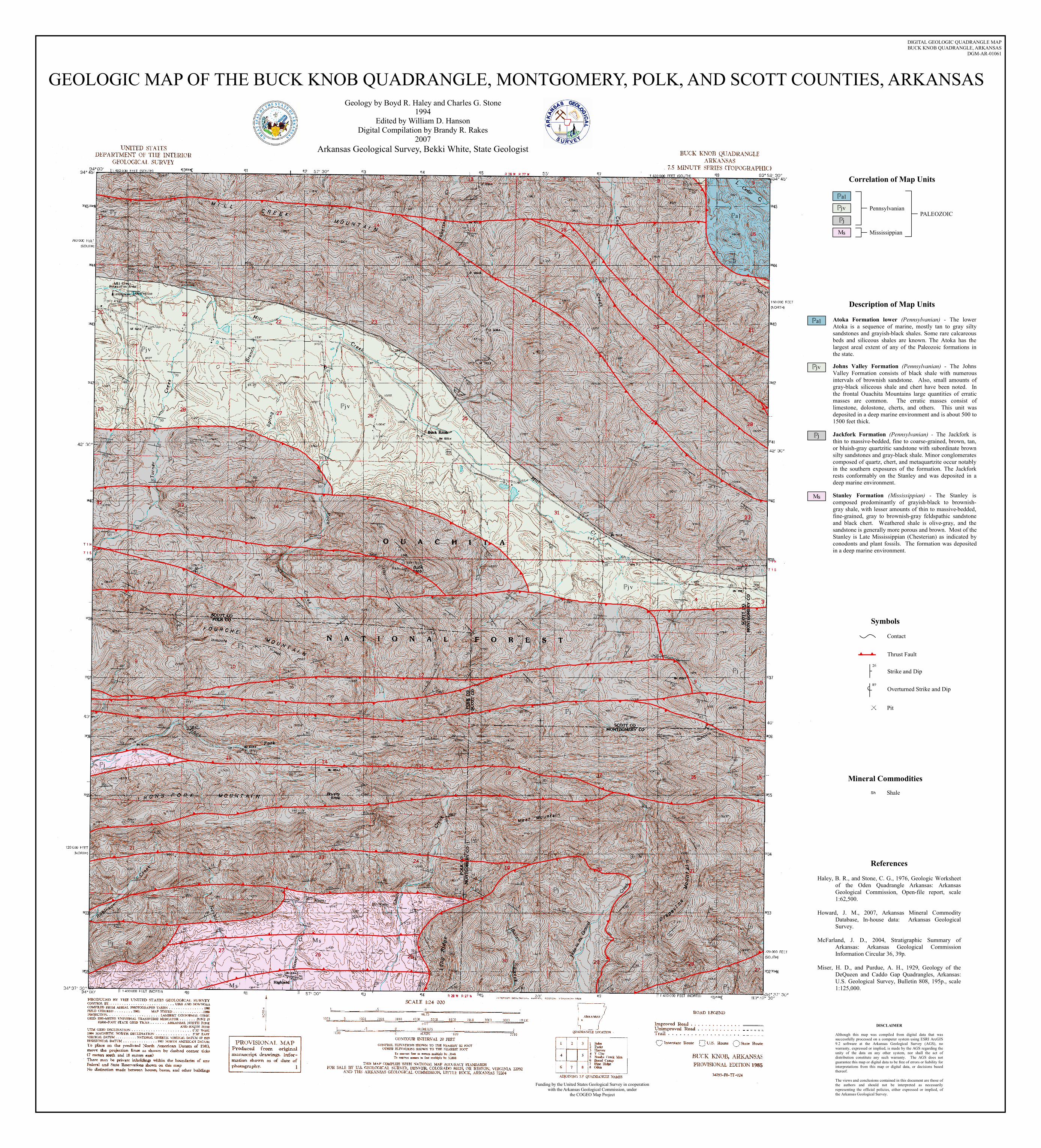
GEOLOGIC MAP OF THE BUCK KNOB QUADRANGLE, MONTGOMERY, POLK, AND SCOTT COUNTIES, ARKANSAS Geology by Boyd R. Haley and Charles G. Stone
1994Edited by William D. Hanson
Digital Compilation by Brandy R. Rakes2007
Arkansas Geological Survey, Bekki White, State Geologist
DIGITAL GEOLOGIC QUADRANGLE MAPBUCK KNOB QUADRANGLE, ARKANSAS
DGM-AR-01061
DISCLAIMER Although this map was compiled from digital data that was successfully processed on a computer system using ESRI ArcGIS 9.2 software at the Arkansas Geological Survey (AGS), no warranty, expressed or implied, is made by the AGS regarding the unity of the data on any other system, nor shall the act of distribution constitute any such warranty. The AGS does not guarantee this map or digital data to be free of errors or liability for interpretations from this map or digital data, or decisions based thereof. The views and conclusions contained in this document are those of the authors and should not be interpreted as necessarily representing the official policies, either expressed or implied, of the Arkansas Geological Survey.
Funding by the United States Geological Survey in cooperationwith the Arkansas Geological Commission, under
the COGEO Map Project
ReferencesHaley, B. R., and Stone, C. G., 1976, Geologic Worksheet
of the Oden Quadrangle Arkansas: Arkansas Geological Commission, Open-file report, scale 1:62,500.
Howard, J. M., 2007, Arkansas Mineral Commodity
Database, In-house data: Arkansas Geological Survey.
McFarland, J. D., 2004, Stratigraphic Summary of
Arkansas: Arkansas Geological Commission Information Circular 36, 39p.
Miser, H. D., and Purdue, A. H., 1929, Geology of the
DeQueen and Caddo Gap Quadrangles, Arkansas: U.S. Geological Survey, Bulletin 808, 195p., scale 1:125,000.
Mineral CommoditiesShale
Symbols
Pit
Contact
Thrust Fault
Strike and Dip
Overturned Strike and Dip
Correlation of Map Units
PennsylvanianPALEOZOIC
Mississippian
Description of Map UnitsAtoka Formation lower (Pennsylvanian) - The lower Atoka is a sequence of marine, mostly tan to gray silty sandstones and grayish-black shales. Some rare calcareous beds and siliceous shales are known. The Atoka has the largest areal extent of any of the Paleozoic formations in the state. Johns Valley Formation (Pennsylvanian) - The Johns Valley Formation consists of black shale with numerous intervals of brownish sandstone. Also, small amounts of gray-black siliceous shale and chert have been noted. In the frontal Ouachita Mountains large quantities of erratic masses are common. The erratic masses consist of limestone, dolostone, cherts, and others. This unit was deposited in a deep marine environment and is about 500 to 1500 feet thick. Jackfork Formation (Pennsylvanian) - The Jackfork is thin to massive-bedded, fine to coarse-grained, brown, tan, or bluish-gray quartzitic sandstone with subordinate brown silty sandstones and gray-black shale. Minor conglomerates composed of quartz, chert, and metaquartzite occur notably in the southern exposures of the formation. The Jackfork rests conformably on the Stanley and was deposited in a deep marine environment. Stanley Formation (Mississippian) - The Stanley is composed predominantly of grayish-black to brownish-gray shale, with lesser amounts of thin to massive-bedded, fine-grained, gray to brownish-gray feldspathic sandstone and black chert. Weathered shale is olive-gray, and the sandstone is generally more porous and brown. Most of the Stanley is Late Mississippian (Chesterian) as indicated by conodonts and plant fossils. The formation was deposited in a deep marine environment.