Geography Year 9 Home Learning Booklet Map Skills · PDF fileGeography Year 9 Home Learning...
13
Geography Year 9 Home Learning Booklet Map Skills Foundation Name Tutor Group Teacher Given out: Monday 19 October Hand in: Monday 2 November Parent/Carer Comment Staff Comment Target _________________________________________________
Transcript of Geography Year 9 Home Learning Booklet Map Skills · PDF fileGeography Year 9 Home Learning...

Geography
Year 9 Home Learning Booklet
Map Skills Foundation
Name
Tutor Group
Teacher
Given out: Monday 19 October Hand in: Monday 2 November
Parent/Carer Comment
Staff Comment
Target
_________________________________________________

The Importance of Map Skills
This booklet is aimed at helping you improve your map skills. These are very
important skills that you need to know, especially if you plan to take
Geography at GCSE as they count towards 25% of your final mark.
I have included some help pages within the booklet for things you may not
have seen before so read the coloured help sheets carefully before you begin
the tasks.
In addition to this I will be available after school at Homework Club
Tuesday, Wednesday and Thursday to support you, so if you are finding
this difficult please make sure you are there.
If you require further help with your map skills but cannot attend Homework
Club go to the internet and type in this link for further help:
http://mapzone.ordnancesurvey.co.uk/mapzone/PagesHomeworkHelp/ma
pability/
or Google: “Mapzones, Mapability” and click on the first link that comes up.
Good Luck with your map skills!
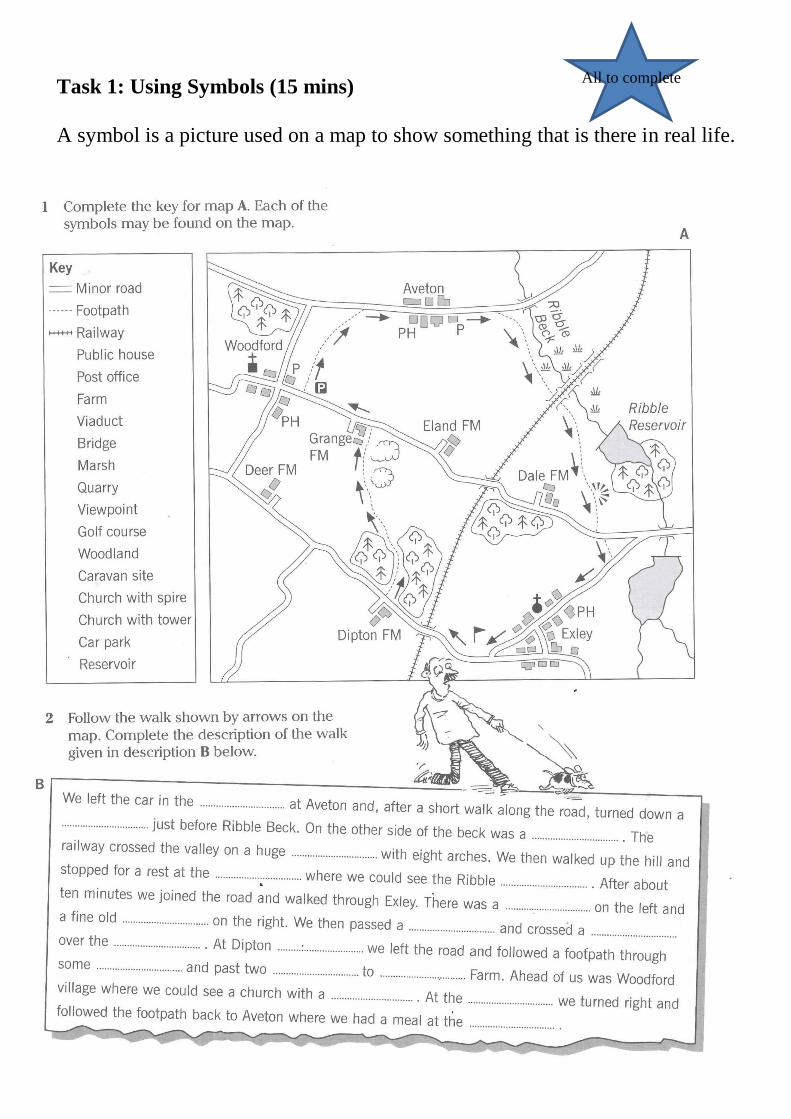
Task 1: Using Symbols (15 mins)
A symbol is a picture used on a map to show something that is there in real life.
All to complete

Task 2: Scale (20 mins)
We use a scale on maps so that when we look at a map we know how big the
things on the map are in real life.
All to complete

Task 3: Measuring Scale
All to complete

Here is a help sheet for how to measure distances on a map. Read through it
carefully and look at the pictures to help you understand before you attempt
Task 4.

Task 4: Measuring Distance
This continues on from the task looking at scale. We need to know what the
distances are in real life so we know how far we are travelling and how long it
is going to take us.
Silver
Gold

Here is a help sheet for how to tell if the land is high or low, flat or steep on
maps. This is called the relief of the land. Read through this carefully and look
at the pictures to help you understand before you complete tasks 5 and 6.

Task 5: Height on maps – colour and spot heights (20 mins)
All to complete

Task 6: Height on maps – contours (20 mins)
This task is a cut and stick exercise. You will need to carefully cut-off the
bottom of the page along the dotted line before cutting out the squares and then
stick them into the right places on the top half of the page.
Task 7: Four figure grid references
All to complete

Task 7: Four Figure Grid References (40 mins)
In this task you will learn how to use the letters along the bottom of the map
and the numbers up the side of the map to find where things are. Like
coordinates in Maths always go along the corridor and up the stairs to find the
correct box.
Silver
Gold

Task 8: Six Figure Grid References (30 mins)
Silver
Gold

Self Evaluation of my Homework
I am a R____________________ learner. I know this because:
______________________________________________________________
______________________________________________________________
______________________________________________________________
I believe that my effort and attitude to learning for this booklet is a:
1 2 3 4
I know this because:
______________________________________________________________
______________________________________________________________
______________________________________________________________


![2019 United States Geography Olympiad - Map Examination ... · 2019 United States Geography Olympiad - Map Examination Resource Booklet Section 1 [2 images] Section 2 [1 image] Dominant](https://static.fdocuments.net/doc/165x107/5e00ee7fad984915f6641daf/2019-united-states-geography-olympiad-map-examination-2019-united-states-geography.jpg)