GEO 1020 Geological Processes and Materialsfolk.uio.no/jamtveit/GEO1020/Forelesninger...
73
GEO 1020 Geological Processes and Materials Earthquake Processes and the Solid Earth Hilmar Bungum http://www.norsar.no
Transcript of GEO 1020 Geological Processes and Materialsfolk.uio.no/jamtveit/GEO1020/Forelesninger...

GEO 1020Geological Processes and Materials
Earthquake Processes and the Solid Earth
Hilmar Bungumhttp://www.norsar.no

What is seismology?
• A tool for investigating the Earth’s interior– Wave propagation– Composition and structure– Dynamics
• Understanding and explaining Earthquakes– As single sources– As ensembles
• Applications– Hazard mitigation– Earthquake engineering– Seismic exploration– etc., etc.
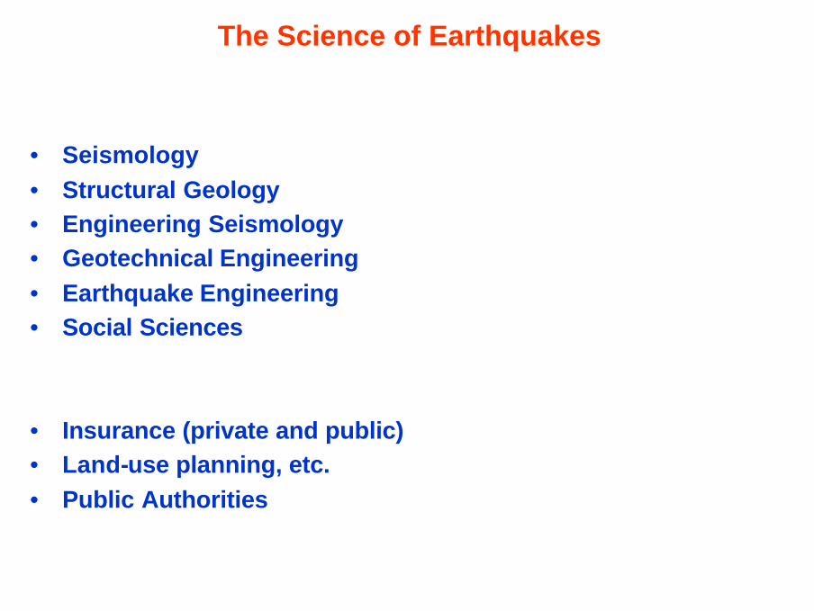
The Science of Earthquakes
• Seismology• Structural Geology• Engineering Seismology• Geotechnical Engineering• Earthquake Engineering• Social Sciences
• Insurance (private and public)• Land-use planning, etc.• Public Authorities

Faults and the generation of earthquakes
• Faults in the Crust• The Formation of Faults• Friction and Stick-Slip• How Faulting Generates Earthquakes• The Amount of Slip on Faults• Deformation without Earthquakes

Earthquake Faulting: basic principles

This is a diagram of the fault break for the 1989 Loma Prieta earthquake in the San Francisco Bay area. The plane of the fault is inclined to the vertical. The fault break is about 30 km long and 7 km high, centeredabout 4 km below the Earth’s surface. This break did not result in surface
faulting.

Modes (mechanisms) of faulting

Effects of erosional filtering on faults

Are Earthquakes and Faults connected?
Important case studies
• California– 1872 Owens Valley earthquake
• Gilbert (1884)
– 1906 San Francisco earthquake: • Reid (1910, elastic rebound theory)
• New Zealand– 1888 South Island earthquake
• McKay (1890)
• Japan– 1891 Nobi earthquake
• Koto (1893)

Famous 1893 photograph of the 1891 Nobi earthquake,establishing link between faults and earthquakes

Stages in fault development

Fault asperities

Stick-slip mechanism of earthquake faulting

Seismic waves
• Body waves (P, S)• Surface waves (R, L)

Types of seismic waves
P waves (primary; pressure)
S waves (secondary; shear)
R waves (Rayleigh; surface waves)
L waves (Love; surface waves)

Waves radiating from a fault break are of four main types. First to arrive is the P or Primary wave, a back-and-forth motion, that appears as a sharp jolt. It is followed by the S wave (secondary or shear ) that is more of a rolling motion. These are deep waves that travel through the Earth to the surface. The Love and Rayleigh waves travel along the Earth’s
surface.

This shows the back and forth motion of the P wave

This shows the S wave, that produces the horizontal sideways motion to the axis of the waves

Range in period of seismic phenomena, seismic waves and
magnitude scales
Amplitude response of some major seismometer systems; basis for magnitude scales

Scaling Law for Seismic Spectra (Aki, 1967)

Measuring and Locating Earthquakes
• Seismographs and the Record of an Earthquake• Finding the Epicenter• Defining the Size of an Earthquake

Locating earthquakes from S-P times

Magnitudes, effects, frequencies and energy release

The original Richter magnitude scale

Magnitudes, energy release and frequencies

Relative energy of various natural and man-made phenomena

Where and Why do Earthquakes Occur?
• Earthquakes at Plate Boundaries• Earthquake at Continental Rifts and Collision zones• Intraplate Earthquakes• Induced Seismicity

Earthquake locations and plate boundaries

Earthquakes along different types of plate boundaries

Continental tectonics and earthquakes

Slip vs. depth over the seismic cycle for a strike-slip fault

Strain rates in intraplate regions

New Madrid Seismic Zone Exceptionally large intraplate earthquakes
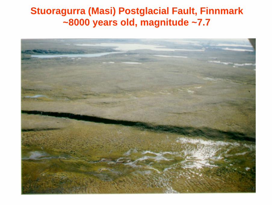
Stuoragurra (Masi) Postglacial Fault, Finnmark~8000 years old, magnitude ~7.7

The Storegga subaqueous slide
• Mega slide– Dated to ~8200 ybp– Run-out distance 850 km– Maximum thickness 430 m– Slide scar area 430 km2
– Influenced area 112,500 km2
– Major tsunami effects mapped
• Most likely earthquake triggered
– Which earthquake?– Which fault?
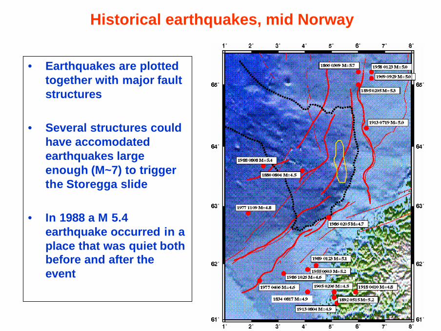
Historical earthquakes, mid Norway
• Earthquakes are plotted together with major fault structures
• Several structures couldhave accomodated earthquakes large enough (M~7) to triggerthe Storegga slide
• In 1988 a M 5.4earthquake occurred in aplace that was quiet both before and after the event

Large historical earthquakes in Stable Continental Regions
No. Earthquake Host Structure Magnitude
1812 New Madrid rift 8.3
1811 New Madrid rift 8.2
1812 New Madrid rift 8.1
2001 Kutch / Gujarat rift 7.9
1819 Kutch / Gujarat rift 7.8
1933 Baffin Bay margin 7.7
1604 Taiwan Straits margin 7.7
1886 South Carolina margin 7.6
1918 Nanai margin 7.4
1929 Grand Banks margin 7.4
1356 Basel rift 7.4
1605 Hainan Island rift 7.3
1906 Exmouth Plateau margin 7.2
1935 Libya margin 7.1
1958 Portugal margin 7.1
1951 So. Tasman rise margin 7.0

Damage from Earthquakes
• Ground Shaking and Displacement• Landslides and Avalanches• Sediment Liquefaction• Fire• Tsunamies• Disease

Surface waves: Rayleigh and Love waves

Rock falls and slides : Maximum distance vs. magnitude
• Rodriguez et al. (1999)
• Solid line: Keefer (1984)
• Lessons:– M~5 affecting ~15 km
– M~7 affecting ~200 km
– M~5 affecting ~100 km2
– M~7 affecting ~25,000 km2

Alaska 1964: Liquefaction in deeper clay layers

Sand boils: related to liquefaction

Development of a tsunami (don’t call them tidal waves!)

Predicting ”The Big One”
• Long-Term Predictions• Short-Term Predictions

Fault development and paleoseismic studies

San Andreas Fault System: Earthquake probabilities

Seismic gaps: nice in theory, not so good in practice

Short-term earthquake prediction: still a challenge

Earthquake Engineering and Zoning
• Zoning• Earthquake Engineering Principles• Example from Bam, December 2003

Earthquake Hazard Map from USGS2% probability of exceedance in 50 years

The initial ground motion is often amplified at a given site. The nature of the rock through which the waves pass may increase the motion, and the nature of the soils at the site has a large influence. Soft soil, such as that in alluvial plains, may amplify the motion several times.

Every object has a fundamental period at which it vibrates if it is set in motion. It cannot vibrate at another period unless it is dragged back and forth. The ground also has a fundamental period. If an object is set in motion by an external force such as ground shaking which is at the fundamental period of the object the result will be ‘resonance’ and the motion of the object will tend to increase.

This shows typical periods for structures. The main determinant of period is building height and proportion; thus, a tall slender object will have a long period and sway back and forth quite slowly. So the Citicorp building in New York will sway gently back and forth every seven seconds.

Ductility is a very important characteristic of building structures because a ductile structure can absorb much more force than a nonductile structure before it fails. Conversely, nonductile structures such as unreinforced masonry or inadequately
reinforced concrete are very dangerous because of the possibility of brittle failure.

Arg-e-Bam; Before and now....

Bam
Baravat
6 km


Rupture propagation on extended faults; directivity

Bam:Damage distribution
80-100%
50-80%
20-50%

Interlude: Seeing Inside the Earth
• The Movement of Seismic Waves through the Earth• The Reflection and Refraction of Wave Energy• Discovering the Crust-Mantle Boundary• Defining the Crust-Mantle Boundary• Defining the Structure of the Mantle• The Core-Mantle Boundary (P-wave Shadow Zone)• The Nature of the Core (S-wave shadow Zone)• Fine-Tuning our Image of the Earth’s Layers• An Integrated View of the Earth

Seismic waves are sent out from all points on the fault

Seismic waves and material properties

Crustal and upper mantle wave paths

P-wave velocities in the Earth’s crust and mantle
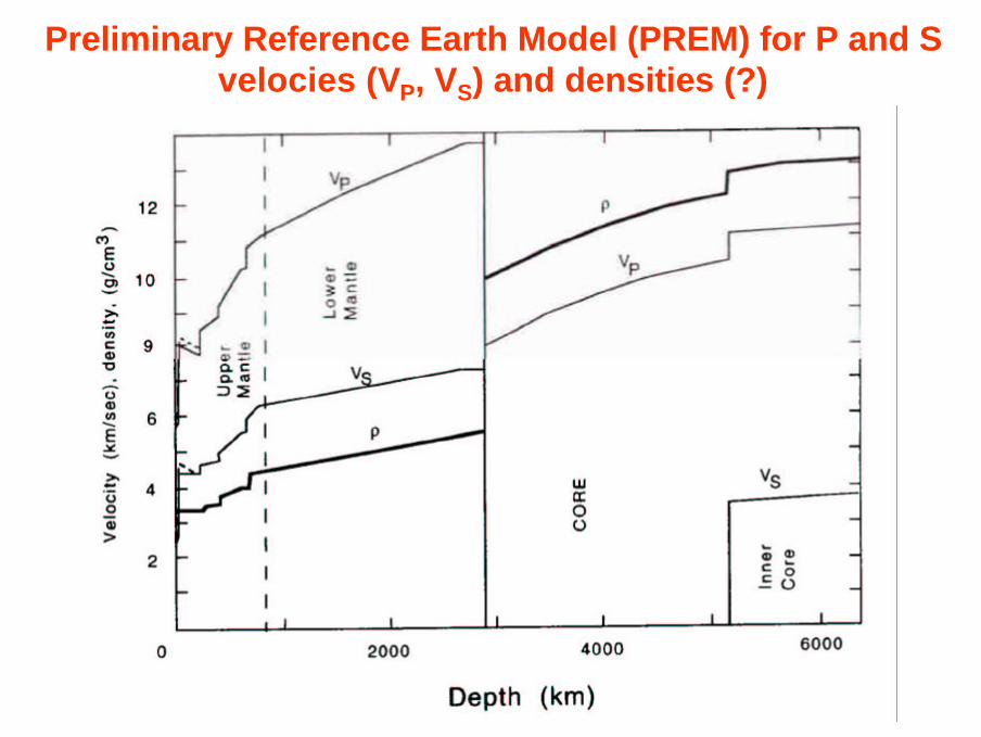
Preliminary Reference Earth Model (PREM) for P and S velocies (VP, VS) and densities (?)

Ray paths and material densities

Seismograms and seismic phases from a single quake

Average travel times for various seismic phases
Travel times vs. distance for a 5-year period using 2.5 million readings

P-wave shadow zone

S-wave shadow zone

Tomographic imaging of the Earth’s interior

Seismic wave velocities: reflecting density distribution

’The Living Earth’: a heat engine (boiling pot)