Frontiers in Earth Science 5 -...
14
Originally published as: Parolai, S., Boxberger, T., Pilz, M., Fleming, K., Haas, M., Pittore, M., Petrovic, B., Moldobekov, B., Zubovich, A., Lauterjung, J. (2017): Assessing Earthquake Early Warning Using Sparse Networks in Developing Countries: Case Study of the Kyrgyz Republic. ‐ Frontiers in Earth Science, 5. DOI: http://doi.org/10.3389/feart.2017.00074
Transcript of Frontiers in Earth Science 5 -...

Originally published as:
Parolai, S., Boxberger, T., Pilz, M., Fleming, K., Haas, M., Pittore, M., Petrovic, B., Moldobekov, B.,
Zubovich, A., Lauterjung, J. (2017): Assessing Earthquake Early Warning Using Sparse Networks in
Developing Countries: Case Study of the Kyrgyz Republic. ‐ Frontiers in Earth Science, 5.
DOI: http://doi.org/10.3389/feart.2017.00074

ORIGINAL RESEARCHpublished: 20 September 2017doi: 10.3389/feart.2017.00074
Frontiers in Earth Science | www.frontiersin.org 1 September 2017 | Volume 5 | Article 74
Edited by:
Mark Naylor,
University of Edinburgh,
United Kingdom
Reviewed by:
David Jay Wald,
United States Geological Survey,
United States
Carmine Galasso,
University College London,
United Kingdom
*Correspondence:
Marco Pilz
Specialty section:
This article was submitted to
Geohazards and Georisks,
a section of the journal
Frontiers in Earth Science
Received: 07 July 2017
Accepted: 04 September 2017
Published: 20 September 2017
Citation:
Parolai S, Boxberger T, Pilz M,
Fleming K, Haas M, Pittore M,
Petrovic B, Moldobekov B,
Zubovich A and Lauterjung J (2017)
Assessing Earthquake Early Warning
Using Sparse Networks in Developing
Countries: Case Study of the Kyrgyz
Republic. Front. Earth Sci. 5:74.
doi: 10.3389/feart.2017.00074
Assessing Earthquake Early WarningUsing Sparse Networks inDeveloping Countries: Case Study ofthe Kyrgyz Republic
Stefano Parolai 1, Tobias Boxberger 1, Marco Pilz 1*, Kevin Fleming 1, Michael Haas 1,
Massimiliano Pittore 1, Bojana Petrovic 1, Bolot Moldobekov 2, Alexander Zubovich 2 and
Joern Lauterjung 1, 2
1GFZ German Research Centre for Geosciences, Potsdam, Germany, 2Central Asian Institute for Applied Geosciences,
Bishkek, Kyrgyzstan
The first real-time digital strong-motion network in Central Asia has been installed in the
Kyrgyz Republic since 2014. Although this network consists of only 19 strong-motion
stations, they are located in near-optimal locations for earthquake early warning and
rapid response purposes. In fact, it is expected that this network, which utilizes the
GFZ-Sentry software, allowing decentralized event assessment calculations, not only
will provide useful strong motion data useful for improving future seismic hazard and
risk assessment, but will serve as the backbone for regional and on-site earthquake early
warning operations. Based on the location of these stations, and travel-time estimates for
P- and S-waves, we have determined potential lead times for several major urban areas
in Kyrgyzstan (i.e., Bishkek, Osh, and Karakol) and Kazakhstan (Almaty), where we find
the implementation of an efficient earthquake early warning system would provide lead
times outside the blind zone ranging from several seconds up to several tens of seconds.
This was confirmed by the simulation of the possible shaking (and intensity) that would
arise considering a series of scenarios based on historical and expected events, and
how they affect the major urban centers. Such lead times would allow the instigation
of automatic mitigation procedures, while the system as a whole would support prompt
and efficient actions to be undertaken over large areas.
Keywords: earthquake, early warning system, lead time, seismic risk mitigation, Central Asia
INTRODUCTION
The rapid growth of urban areas, especially in developing countries where seismic hazard issignificant, calls for improved seismic risk assessment, preparedness and mitigation, in particularin real or near real-time. For this reason, the development of Earthquake Early Warning Systems(EEWS) has been a focus of seismologists and engineers who have shown that the effectiveness ofthese systems could significantly contribute to seismic risk mitigation (Wenzel and Zschau, 2014;Clinton et al., 2016; Strauss and Allen, 2016; Wu et al., 2016).
However, the implementation of EEWS so far has taken place in high seismic hazard zoneswhere seismic monitoring is realized through dense, high-quality seismic and/or strong-motionnetworks (Allen et al., 2009). In particular, EEWS have been implemented, either operationally or

Parolai et al. Earthquake Early Warning Developing Countries
FIGURE 3 | The classification of each analyzed recording as a function of hypocentral distance and magnitude. The top plot represents the recordings for which a
false alarm was issued. The bottom plot shows the events for which no alarm was sent out. Note that the observed PGA is always <8.1 cm/s, although for one
recording (the lone yellow point in the lower panel), this was above the 3.4 cm/s threshold, and hence should have been denoted with an ORANGE status.
Bishkek in real-time via UMTS and DSL communicationprotocols.
The locations of the stations were chosen, given theirlimited number, so as to cover areas with high seismicityand the highest population density. However, logistical issuessuch as accessibility to potential sites (high altitudes or too-remote locations were not considered) and the proximity ofinfrastructure for real-time data communication were alsoconsidered. For choosing an optimal network design, severalsteps were taken.
First, ad-hoc optimization of the topology of thenetwork was undertaken by Stankiewicz et al. (2015),who demonstrated that regional warning systems aremost efficient when they are designed to protect a single,clearly defined target, such as a particular city. A large-scale system to protect multiple targets should thus ideallyconsist of individual single-target subsystems. Second, startingfrom the identified optimal station locations, a search forsuitable sites nearby (following the logistical considerationsmentioned above) was carried out in cooperation with the
Ministry of Emergency Situations (MES7) of the KyrgyzRepublic.
This close cooperation with a possible end user of the systemallowed the identification of the fire stations of MES (located inproximity of the proposed sites) as safe locations for permanentinstallations, with nearly continuous power supply and facilitateddata communication.
DataDuring the period over which the network has operated (whichstarted as non-permanent installations in May 2015), 464 eventsat local and regional distances have been recorded. Of theseevents, a total of 2,286 recordings were obtained, coveringhypocentral distances ranging from 20 (local) to nearly 1,000(regional) km, with magnitudes spanning between 3.6 and 7.5(Figure 2). Information (location, magnitude) about these eventswas dependent upon the network that provided it: for example,different magnitude scales are used by different networks (i.e.,
7http://mes.kg/en/
Frontiers in Earth Science | www.frontiersin.org 4 September 2017 | Volume 5 | Article 74

Parolai et al. Earthquake Early Warning Developing Countries
FIGURE 4 | The observed PGV of an event vs. the observed peak amplitude of vertical displacement Pd (circles) derived from the first 3 s of recordings after the event
trigger. The size of the symbols indicates the magnitude, while the color shows the hypocentral distance. The continuous and dashed gray lines denote the mean and
the standard deviation of the Zollo et al. (2010) relationship. The gray shaded area indicates the range of PGV/Pd over which the relationship was calibrated. The
horizontal green line indicates the threshold of PGV = 3.4 cm/s for which a GREEN status is expected (no Alarm), while the red line shows the values above which an
Alarm (RED status) should be issued.
of those used in this work, 94% were in Mb,5% MW and 1%ML). Most of this data are relevant to regional distances and formagnitudes ranging between 4 and 5. The majority of the eventswere located to the south of the ACROSS network in the Pamirregion (36◦–39◦ N, 69◦–75◦ E), as well as around the FerghanaValley (40◦–41◦ N, 70◦–74 E; Figure 2).
RESULTS
Decentralized Earthquake Early WarningPerformanceDuring the operation of the network, the signals generatedby the recorded earthquakes have been analyzed in real-timeby the GFZ-Sentry software (Parolai et al., 2015, 2017). Thissoftware, following the concept of Decentralized EarthquakeEarly Warning System (i.e., the computations are carried outon-site), detects a possible seismic event and, based on thefirst few seconds (with a maximum of 3 s) of recordings afterthe triggering of the event, forecasts the expected peak groundvelocity (PGV) at the recording site (Zollo et al., 2010; Parolaiet al., 2015, 2017). The software considers a combination of theexpected median plus/minus the standard deviation of the PGVvalues with respect to pre-selected thresholds for declaring acertain alarm status (Parolai et al., 2015). The alarm status is
defined as being either RED (i.e., the expected PGV is likelyto be >8.1 cm/s), meaning an Alarm will be issued since atleast light damage is to be expected, i.e., an intensity ≥VI,ORANGE (i.e., the expected PGV is likely to lie between 8.1cm/s and 3.4 cm/s), when only very light damage is expected,i.e., an intensity equal to V, and GREEN (i.e., the expectedPGV is likely to be <3.4 cm/s), when no damage is expected,i.e., an intensity ≤IV (see Figure 4 in Parolai et al., 2015,2017).
Figure 3 shows the results obtained during the analyzedperiod, where the software carried out the analysis correctlyfor 99.8% of the events. Only one event saw false alarmsbeing issued. This happened when a large (M = 6.6) regionalevent was recorded at hypocentral distances of around 750–800 km. In this case, large impulsive P-waves were registeredon the vertical component, leading to the declaration of a falsealarm by three stations (i.e., an ORANGE alert was issued,whereas a GREEN alert was the proper response) Therefore,although the performance of the followed procedure maybe considered to be extremely satisfactory, it needs to benoted that none of the analyzed recordings were characterizedby an observed PGV value >8.1 cm/s (a factor simplyof no events able to induce such ground motion havingoccurred during the relatively short operational time of thenetwork). Hence, additional analysis would be required to see
Frontiers in Earth Science | www.frontiersin.org 5 September 2017 | Volume 5 | Article 74

Parolai et al. Earthquake Early Warning Developing Countries
FIGURE 5 | The lead-times for Bishkek when using a regional approach as a function of the location of possible seismic events (i.e., a 0.1 by 0.1◦ grid). Also shown
are the main cities (gray squares) and a selection of historical or hypothetical earthquakes (red stars, see Figure 1 and text for explanation). The brown lines indicate
the main tectonic alignments and faults existing in the area.
how the software performs given the occurrence of largerevents.
Figure 4 shows the observed PGV values vs. the measuredpeak amplitude of vertical ground displacement (Pd) foundwithin the analyzed 3-s signal window after triggering. The figurealso depicts the relationship between PGV and Pd developed byZollo et al. (2010) which has been utilized in the system. Therelationship seems to perform reasonably well in the region lyingwithin the range of Pd and PGV values for which it was calibrated(gray-shaded area), although when it is applied outside of therange of PGV and Pd values for which it was calibrated, it tendsto overestimate the PGV for larger events, which were recordedat regional distances (i.e., for Pd values ranging between 0.05and 0.1 cm in Figure 4), and underestimate them (the majority)for smaller magnitude events. However, within the range of lowPd values relevant to this paper, the estimated PGV values arestill well below the thresholds proposed in Parolai et al. (2015)for a declaration of an ORANGE (3.4 cm/s) or RED (8.1 cm/s)status. Only one recording was observed to overstep the valuesthat would have led to an ORANGE status (note this was theyellow point in the lower panel in Figure 3), but it was classifiedincorrectly as a no Alarm. Please note that this is due to thefact that both the median and 16th percentile of the expectedPGV for a Pd at this level are below the 3.4 cm/s thresholdchosen by Parolai et al. (2015), hence a GREEN (No Alarm) status
was declared, although the subsequently observed was above thisthreshold.
Finally, note that during the network testing period, althoughthe GFZ-Sentry software tries to avoid as much as possible falsetriggering that may be generated by local sources of disturbance(Parolai et al., 2015), even in the absence of a seismic event, thestations were triggered several times. For example, consideringthe 5 months between January 2017 and May 2017, when thenetwork started working in its full configuration, nearly 140,000triggers on non-earthquake events were declared. This is dueto the installation of the stations in urban areas and insideoperational buildings of the MES. However, these triggers neverlead to a declaration of a RED status (False Alarm), confirmingthe appropriate separation of the triggering and the alarmingprocedure in the software.
Estimation of Lead Times from Regional,Decentralized and Combined EarlyWarning SchemesThe distribution of the ACROSS network stations can be usefulfor implementing a national EEWS which combined regionaland decentralized on-site procedures. In order to evaluate thepotential benefit coming from the implementation of such aEEWS procedure, we calculated the possible lead-time for three
Frontiers in Earth Science | www.frontiersin.org 6 September 2017 | Volume 5 | Article 74

Parolai et al. Earthquake Early Warning Developing Countries
FIGURE 6 | As in Figure 5, but for an on-site approach.
FIGURE 7 | As in Figure 5, but using a combined regional and on-site approach.
Frontiers in Earth Science | www.frontiersin.org 7 September 2017 | Volume 5 | Article 74
Parolai et al. Earthquake Early Warning Developing Countries
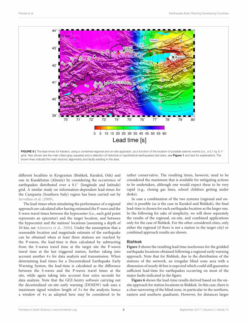
FIGURE 8 | The lead-times for Karakol, using a combined regional and on-site approach, as a function of the location of possible seismic events (i.e., a 0.1 by 0.1◦
grid). Also shown are the main cities (gray squares) and a selection of historical or hypothetical earthquakes (red stars, see Figure 1 and text for explanation). The
brown lines indicate the main tectonic alignments and faults existing in the area.
different localities in Kyrgyzstan (Bishkek, Karakol, Osh) andone in Kazakhstan (Almaty) by considering the occurrence ofearthquakes distributed over a 0.1◦ (longitude and latitude)grid. A similar study on information-dependent lead-times forthe Campania (Southern Italy) region has been carried out byIervolino et al. (2009).
The lead-times when simulating the performance of a regionalapproach are calculated after having estimated the P-wave and theS-wave travel times between the hypocenter (i.e., each grid pointrepresents an epicenter) and the target location, and betweenthe hypocenter and the stations’ locations (assuming a depth of10 km, see Adamova et al., 2006). Under the assumption that areasonable location and magnitude estimate of the earthquakecan be obtained when at least three stations are reached bythe P-waves, the lead-time is then calculated by subtractingfrom the S-waves travel time at the target site the P-wavestravel time at the last triggered station, further taking intoaccount another 4 s for data analysis and transmission. Whendetermining lead times for a Decentralized Earthquake EarlyWarning System, the lead-time is calculated as the differencebetween the S-waves and the P-waves travel times at thesite, while again taking into account four extra seconds fordata analysis. Note that the GFZ-Sentry software carrying outthe decentralized on-site early warning (DOSEW) task uses amaximum signal window length of 3 s for the analysis; hencea window of 4 s as adopted here may be considered to be
rather conservative. The resulting times, however, need to beconsidered the maximum that is available for mitigating actionsto be undertaken, although one would expect these to be veryrapid (e.g., closing gas lines, school children getting underdesks).
In case a combination of the two systems (regional and on-site) is possible (as is the case in Karakol and Bishkek), the finallead-time is chosen for each earthquake location as the larger one.In the following for sake of simplicity, we will show separatelythe results of the regional, on-site, and combined applicationsonly for the case of Bishkek. For the other considered cities, onlyeither the regional (if there is not a station in the target city) orcombined approach results are shown.
BishkekFigure 5 shows the resulting lead time isochrones for the griddedearthquake locations obtained following a regional early warningapproach. Note that for Bishkek, due to the distribution of thestations of the network, an irregular blind zone area with adimension of nearly 40 km is expected which could still guaranteesufficient lead-time for earthquakes occurring on most of themajor faults indicated in the figure.
Figure 6 shows the lead-time results derived based on the on-site approach for station locations in Bishkek. In this case, there isa clear narrowing of the blind zone, in particular in the northern,eastern and southern quadrants. However, for distances larger
Frontiers in Earth Science | www.frontiersin.org 8 September 2017 | Volume 5 | Article 74

Parolai et al. Earthquake Early Warning Developing Countries
FIGURE 9 | The lead-times for Osh, using a regional approach, as a function of the location of possible seismic events (i.e., a 0.1 by 0.1◦ grid). Also shown are the
main cities considered in this study (gray squares) and a selection of historical or hypothetical earthquakes (red stars, see Figure 1 and text for explanation). The
brown lines indicate the main tectonic alignments and faults existing in the area.
than around 60–70 km, the advantages of the regional approachappear obvious, with much smaller lead times resulting from theon-site scheme as opposed to those found following the regionalapproach (Figure 5).
In Figure 7, the results of combining the regional andDOSEW approaches are shown. The figure emphasizes that theuse of the DOSEW allows a reduction in the extent of theblind zone compared to the regional approach, while for moredistant events, the greater effectiveness of the regional systemdominates when compared to the on-site scheme. Interestingly,while Bishkek would be in the blind zone for the case of arepetition of the M = 6.8 1885 Belovodosk earthquake (seeFigure 1), nearly 25 s of lead-time would be possible given arepetition of theM = 7.8 1911 Kemin earthquake (Figure 1).
KarakolFigure 8 shows the results obtained for the expected lead timesfor the city of Karakol when using a combined regional andDOSEW approach. Similarly to what is observed for Bishkek,Figure 8 emphasizes how the use of the DOSEW allows areduction in the size of the blind zone (resulting in a morecircular lead-time isoline) while for more distant events, theeffectiveness of the regional system dominates. In particular, dueto the station distribution (which sees most stations located westof Karakol), the effectiveness of the regional system is obviouslymore evident for earthquakes occurring in the western quadrants
of Karakol. For example, in the case of the repetition of the M= 7.8 1911 Kemin earthquake, Karakol could benefit from about25 s of lead-time, while even for a repetition of the strongM = 8–8.3 1889 Chilik earthquake, a few seconds could still be availablefor starting automatic mitigation procedures (e.g., closure of gaslines).
OshAs currently no ACROSS station is installed within the city ofOsh, only the results derived by applying the regional approachare reported in Figure 9. Although the lead-times for seismicevents occurring on the fault structures around the FerghanaValley (and which could cause damage to the city) range between5 and 15 s, the blind zone is rather extended, particularly towardthe south-west. Nonetheless, tests that have been carried out (notreported here) that indicate that installing a station in the city ofOsh would dramatically decrease the size of the blind zone to aradius of around, 30 km, rather than a value of around 60 kmwhich is the case now.
AlmatyAlthough located in Kazakhstan, we show the lead-time resultsfor Almaty from following a regional early warning approach,since this city is of major interest, both in terms of its largepopulation (1.7 million inhabitants) and the fact that it wasdestroyed or suffered serious damage as a result of events that
Frontiers in Earth Science | www.frontiersin.org 9 September 2017 | Volume 5 | Article 74

Parolai et al. Earthquake Early Warning Developing Countries
FIGURE 10 | The lead-time for Almaty, using a regional approach, as a function of the location of possible seismic events i.e., a 0.1 by 0.1◦ grid. Also shown are the
main cities considered in this study (gray squares) and a selection of historical or hypothetical earthquakes (red stars, see Figure 1 and text for explanation). The
brown lines indicate the main tectonic alignments and faults existing in the area.
TABLE 1 | The historical (Chilik, Kemin) and expected (Ferghana Valley) events considered in this work and modeled using the OpenQuake suite of software tools (Pagani
et al., 2014, Silva et al., 2014).
Name of event Magnitude (Mw) Location (long./lat.) Depth (km) Strike Dip Rake Type of faulting Type of modeling
Chilika,b 8.3 78.150◦/42.969◦ 10 50◦, 100◦, 110◦, 90◦, 110◦ 60◦ 170◦ Strike-slip Multiple plane rupture
Keminc,d 7.8 76.572◦/42.829◦ 10 80◦, 83◦, 90◦, 95◦ 60◦ 50◦ Thrust Multiple plane rupture
Ferghana Valley 7.5 72.110◦/40.560◦ 10 250◦, 240◦, 230◦ 50◦ 100◦ Thrust Multiple plane rupture
The type of modeling refers to the process followed in running the programs. The outlines of the fault planes are shown in the figures presenting these results.aTibaldi et al. (1997), bWalker et al. (2015), cDelvaux et al. (2001), dAbdrakhmatov et al. (2007).
occurred during historical time (M= 7.3 1887 Verny earthquake,M = 8-8.3 1889 Chilik earthquake, M = 7.8 1911 Keminearthquake).
The results indicate (Figure 10) that Almaty would benefitfrom alarms issued in the event of earthquakes occurring onmany of the tectonic lineament surrounding the city, includingthe one that generated the M 8-8.3 Chilik earthquake, with lead-times of the order of 15 s, although not for the 1911 Kemin eventwhich is on the boundary of the blind zone. We see in fact thatthe blind zone when using only the ACROSS network is ratherlarge (around 60 km). Additional tests carried out showed thatby simply including one station in Almaty itself and by followingthe DOSEEW system would allow a reduction in the blind zoneto around 30 km. For example, a few seconds of lead-time wouldbe available even in the case of the repetition of theM = 7.8 1911Kemin earthquake that destroyed the town. Remarkably, up to
20 s of lead-time would be available in the case of a repetitionof the 1889 Chilik earthquake, which resulted in macroseismicintensity values of up to VII on the MSK-64 scale in the city(Mushketov, 1891; Korjenkov et al., 2003).
Modeling Historical Events and theResulting Lead TimesIn this section, we will present the resulting lead times thatwould be expected when considering the early warning schemespresented above and a selection of historical and expected events(see Table 1). The modeling is carried out using the OpenQuake(Pagani et al., 2014; Silva et al., 2014) suite of software tools.OpenQuake is a product of the Global Earthquake Model8,
8http://www.globalquakemodel.org/
Frontiers in Earth Science | www.frontiersin.org 10 September 2017 | Volume 5 | Article 74

Parolai et al. Earthquake Early Warning Developing Countries
FIGURE 11 | The lead-times available across the Kyrgyz Republic and surrounding area for a repetition of the M 7.8 1911 Kemin earthquake (red star, Table 1), using
the regional approach (black contour lines). The distribution of the calculated PGA (macroseismic intensity is found using the relationships of Wald et al., 1999) is
shown by the color scale. Also shown are the main cities (gray squares) of the country (see Figure 1). The brown lines indicate the main tectonic alignments and faults
existing in the region.
a public/private initiative that is setting out to develop toolsand standards for earthquake hazard, vulnerability and riskassessment. OpenQuake is a modular program written in thepython language, which allows the user not only to define theparameters of the seismic event they wish to model, but toalso choose the ground motion prediction equations (GMPEs)and site parameters. For this work, we have undertaken thecalculations to obtain peak ground acceleration (PGA), whichare then converted to intensity using the relationship of Waldet al. (1999). As there are no GMPEs specifically for CentralAsia, we have made use of three GMPEs derived from recordingsin similar tectonic environments, namely Akkar et al. (2014),Boore et al. (2014), and Cauzzi et al. (2015). We generated1,000 random realizations of the ground motion field foreach GMPE (leading to a total of 3,000 calculations), thensorted each locations values. The results we present in thefollowing are the median (50th percentile) values. We haveassumed bedrock conditions (Vs30 = 760 m/s) for the siteresponse. However, while this would affect the actual groundshaking, it would only very marginally influence the leadtimes.
M 7.8 1911 Kemin Earthquake ScenarioThe M 7.8 1911 Kemin earthquake (Figure 1, Table 1) occurredclose to the border between Kyrgyzstan and Kazakhstan.The city of Almaty, which at that time was populatedby nearly 30.000 inhabitants, was mostly destroyed andaround 300 persons were reported dead (Bogdanovic, 1911;Velitzky, 1911; Bogdanovich et al., 1914). At the time ofthe event, the town was mainly made up of adobe andstone buildings that were severely damaged or collapsed, andwooden houses that survived the shaking. Historical sources(Abdrakhmatov et al., 2003) also mention devastation inBishkek.
The distribution of ground shaking in terms of PGAand macroseismic intensities (Wald et al., 1999) is shownin Figure 11, together with the lead-times, which have beencalculated for each grid point (0.1◦ by 0.1◦) into which thearea has been subdivided. This lead-time is calculated bysubtracting from the S-wave arrival at each considered pointthe P-wave arrival time (augmented by 4 s) at the third station(in order of time) of the ACROSS network triggered by theevent.
Frontiers in Earth Science | www.frontiersin.org 11 September 2017 | Volume 5 | Article 74
Parolai et al. Earthquake Early Warning Developing Countries
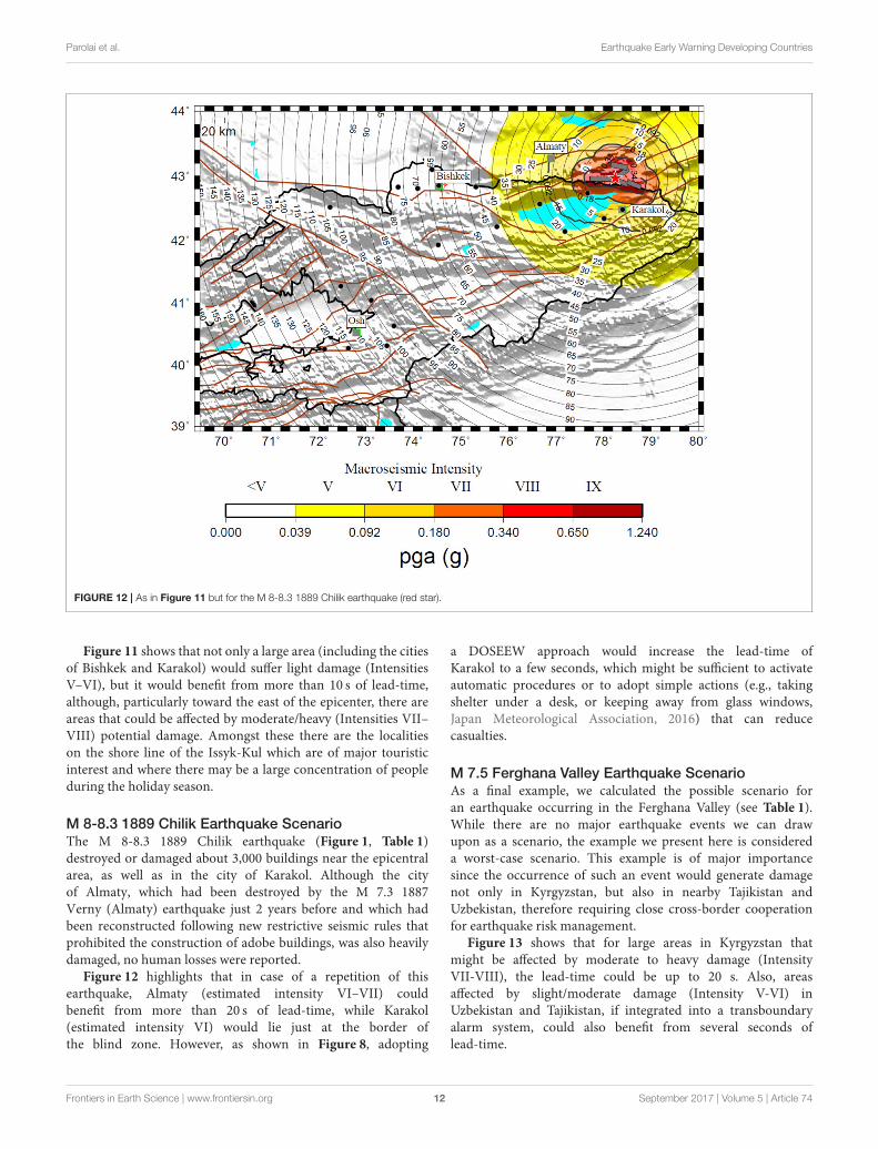
FIGURE 12 | As in Figure 11 but for the M 8-8.3 1889 Chilik earthquake (red star).
Figure 11 shows that not only a large area (including the citiesof Bishkek and Karakol) would suffer light damage (IntensitiesV–VI), but it would benefit from more than 10 s of lead-time,although, particularly toward the east of the epicenter, there areareas that could be affected by moderate/heavy (Intensities VII–VIII) potential damage. Amongst these there are the localitieson the shore line of the Issyk-Kul which are of major touristicinterest and where there may be a large concentration of peopleduring the holiday season.
M 8-8.3 1889 Chilik Earthquake ScenarioThe M 8-8.3 1889 Chilik earthquake (Figure 1, Table 1)destroyed or damaged about 3,000 buildings near the epicentralarea, as well as in the city of Karakol. Although the cityof Almaty, which had been destroyed by the M 7.3 1887Verny (Almaty) earthquake just 2 years before and which hadbeen reconstructed following new restrictive seismic rules thatprohibited the construction of adobe buildings, was also heavilydamaged, no human losses were reported.
Figure 12 highlights that in case of a repetition of thisearthquake, Almaty (estimated intensity VI–VII) couldbenefit from more than 20 s of lead-time, while Karakol(estimated intensity VI) would lie just at the border ofthe blind zone. However, as shown in Figure 8, adopting
a DOSEEW approach would increase the lead-time ofKarakol to a few seconds, which might be sufficient to activateautomatic procedures or to adopt simple actions (e.g., takingshelter under a desk, or keeping away from glass windows,Japan Meteorological Association, 2016) that can reducecasualties.
M 7.5 Ferghana Valley Earthquake ScenarioAs a final example, we calculated the possible scenario foran earthquake occurring in the Ferghana Valley (see Table 1).While there are no major earthquake events we can drawupon as a scenario, the example we present here is considereda worst-case scenario. This example is of major importancesince the occurrence of such an event would generate damagenot only in Kyrgyzstan, but also in nearby Tajikistan andUzbekistan, therefore requiring close cross-border cooperationfor earthquake risk management.
Figure 13 shows that for large areas in Kyrgyzstan thatmight be affected by moderate to heavy damage (IntensityVII-VIII), the lead-time could be up to 20 s. Also, areasaffected by slight/moderate damage (Intensity V-VI) inUzbekistan and Tajikistan, if integrated into a transboundaryalarm system, could also benefit from several seconds oflead-time.
Frontiers in Earth Science | www.frontiersin.org 12 September 2017 | Volume 5 | Article 74

Parolai et al. Earthquake Early Warning Developing Countries
FIGURE 13 | As in Figure 11, but for a scenario involving the Ferghana Valley fault system (M 7.5, red star).
DISCUSSION AND CONCLUSIONS
In this study we report on the installation of the first real-time digital strong-motion network in Central Asia (ACROSS),namely in the Kyrgyz Republic. The network, which is comprisedof 19 stations, has already recorded several minor to majorearthquakes at local and regional distances.
The real-time application of the GFZ-Sentry software whichallows a decentralized earthquake early warning procedure wasshown to perform very well in avoiding (at least for the datatested until now) false alarms. In particular, despite noisesignals due to the installation of the strong-motion stationsin fire stations of the MES triggering the system, none ofthese has led to an alarm, confirming the reliability of theprocedure in the GFZ-Sentry software in separating the eventdetection and alarming procedures. However, further testingis required and the performance of the software and theprocedures followed should be carefully evaluated when largerlocal events occur. The tests have been carried out using therelationship proposed by Zollo et al. (2010) based on a globaldata set. However, in the future new local relationships will bederived making use of the recordings collected by the ACROSSnetwork.
We further carried out scenario simulations to evaluate thepossible performance of the network when used for carrying
out regional or on-site early warning operations. The testsshowed a clear benefit for the major cities in Kyrgyzstan(Bishkek, Osh, and Karakol) if an EEW system would becalibrated and made available for mitigation purposes. Thecalculations of possible shaking (and intensity) scenarios relevantto historical earthquakes that affected the area highlight thatthe introduction of an EEWS, provided that proper actionsare taken, would allow prompt and efficient response in areaswhere damage could be moderate, as well as in those thatmay expect moderate to heavy damages. A similar test fora possible seismic event occurring in the Ferghana Valleyoutlined that, based on the existing coverage, neighboringcountries (Uzbekistan and Tajikistan) could benefit from theprovided EEW information. It is therefore recommended thatcooperation between these countries be strengthened and thereal-time data exchange of seismological networks is foreseen infuture.
Associated therewith, the software system CARAVAN(Central Asia Risk and Vulnerability Analysis Tool, Parolai et al.,2016) allows the estimation of the consequences of a seismicevent in a probabilistic sense (in the form of human losses)almost in real-time as the strong ground motion parameters arerecorded. In this sense, the integration of the real-time data of theACROSS network into CARAVAN will allow the development ofa loss-based earthquake early warning system for the region.
Frontiers in Earth Science | www.frontiersin.org 13 September 2017 | Volume 5 | Article 74

Parolai et al. Earthquake Early Warning Developing Countries
Obviously, while our study emphasizes that there is apotential significant benefit in introducing an earthquakeearly warning system to the region, without any appropriateinitiatives in terms of raising the awareness of the generalpopulation as to the value of such a system, and theorganizing of training for improving the required response,any action would ineffective. To this regard, we believethat having started the installation of the network in closecooperation with local authorities, who have already introducededucational projects into schools, represents an important steptoward a culture of earthquake awareness and sustainablerisk mitigation for the Kyrgyz Republic, and potentiallythe wider Central Asian region. Similarly, the need forenforcing appropriate building codes and sensible land planningschemes are essential for any comprehensive seismic mitigationoutlook.
Finally, we want to remark that the data of the ACROSSnetwork are automatically stored in the ITACA data base (Pacoret al., 2011) at the CAIAG institute. The data are automaticallyprocessed in order to immediately provide after an event not onlythe waveforms, but also the parameters of engineering interest.The data base will be publicly available when the project finishesat the end of 2018.
AUTHOR CONTRIBUTIONS
SP conceptualisation of the work and writing of the manuscript,calculation of lead time calculations and wrote the GFZ-sentry
software, TB carried out installations of the network, MarPcarried out calculations and data interpretation and helped ininstallation of the network, KF wrote parts of the manuscript andhelped in data interpretation, MH referencing and compilationof literature sources, wrote parts of the manuscript, MasP helpedin links to risk assessment, BP helped in data interpretation, BMhelped in network location and installation, AZ studied networksites, JL: conceptualisation of the work and final overview.
ACKNOWLEDGMENTS
The installation of the strong motion network has been financedby the ACROSS initiative of the Helmholtz association. Thenetwork installations have been supported by the Global ChangeObservatory Central Asia of GFZ. We thank the Ministry ofEmergency Situations of the Kyrgyz Republic for their permissionto install stations on their territory. We acknowledge AzamatSharshebaev and Ruslan Bolotov for their support in the fieldactivities.
REFERENCES
Abdrakhmatov, K. E., Thompson, S., andWeldon, R. (2007).Active Tectonics of the
Tien Shan (in Russian). Bishkek: ILIM.
Abdrakhmatov, K., Havenith, H.-B., Delvaux, D., Jongmans, D., and Trefois, P.
(2003). Probabilistic PGA and arias intensity maps of Kyrgyzstan (Central
Asia). J. Seismol. 7, 203–220. doi: 10.1023/A:1023559932255
Adamova, A. A., Sabitova, T. M., Mirkin, E. L., and Bagmanova, N. H. (2006).
“Approximation of distribution of seismic velocities,” in Crustal Parameters of
the Tien Shan in Connection with Geodynamics ad Seismicity, ed A. B. Bakirov
(Bishkek: ILIM), 9–18.
Akkar, S., Sandıkkaya, M. A., and Bommer, J. J. (2014). Empirical ground-
motion models for point- and extended-source crustal earthquake
scenarios in Europe and the Middle East. Bull. Earthq. Eng. 12, 359–387.
doi: 10.1007/s10518-013-9461-4
Alcik, H., Ozel, O., Apaydin, N., and Erdik, M. (2009). A study on warning
algorithms for Istanbul earthquake early warning system. Geophys. Res. Lett.
36. doi: 10.1029/2008GL036659
Allen, R. M., Gasparini, P., Kamigaichi, O., and Böse, M. (2009). The status of
earthquake early warning around the world: an introductory overview. Seismol.
Res. Lett. 80, 682–693. doi: 10.1785/gssrl.80.5.682
Arrowsmith, J. R., Crosby, C. J., Korzhenkov, A. M., Mamyrov, E., Povolotskaya,
I., Guralnik, B., et al. (2017). Surface rupture of the 1911 Kebin (Chon-Kemin)
earthquake, Northern Tien Shan, Kyrgyzstan.Geol. Soc. Lond. Special Publ. 432,
233–253. doi: 10.1144/SP432.10
Bindi, D., Boxberger, T., Orunbaev, S., Pilz, M., Stankiewicz, J., Pittore, M., et al.
(2015). On-site early-warning system for Bishkek (Kyrgyzstan). Ann. Geophys.
58. doi: 10.4401/ag-6664
Bindi, D., Iervolino, I., and Parolai, S. (2016). On-site structure-specific real-time
risk assessment: perspectives from the REAKT project. Bull. Earthq. Eng. 14,
2471–2493. doi: 10.1007/s10518-016-9889-4
Bogdanovic, K. I. (1911). An earthquake of December 22, 1910 (January 4, 1911)
in northern chains of the Tien Shan between Verny and Issyk-Kul. Proc. Geol.
Comm. 30, 329–419.
Bogdanovich, K. I., Kark, I. M., Korolkov, B. Y., and Muchketov, I. V. (1914).
Earthquake of the 4th January 1911 in the northern districts of the Tien Shan.
Trans. Geol. Comm. Ser. 89:270.
Boore, D. M., Stewart, J. P., Seyhan, E., and Atkinson, G. M. (2014). NGA-
West 2 equations for predicting PGA, PGV, and 5%-damped PSA for shallow
crustal earthquakes. Earthq. Spectra 30, 1057–1085. doi: 10.1193/070113EQ
S184M
Böse, M., Ionescu, C., and Wenzel, F. (2007). Earthquake early warning for
Bucharest, Romania: novel and revised scaling relations. Geophys. Res. Lett. 34.
doi: 10.1029/2007GL029396
Cauzzi, C., Faccioli, E., Vanini, M., and Bianchini, A. (2015). Updated predictive
equations for broadband (0.01–10 s) horizontal response spectra and peak
ground motions, based on a global dataset of digital acceleration records. Bull.
Earthq. Eng. 13, 1587–1612. doi: 10.1007/s10518-014-9685-y
Clinton, J., Zollo, A., Marmureanu, A., Zulfikar, C., and Parolai, S. (2016). State-
of-the art and future of earthquake early warning in the European region. Bull.
Earthq. Eng. 14, 2441–2458. doi: 10.1007/s10518-016-9922-7
Delvaux, D., Abdrakhmatov, K., Lemzin, N., and Strom, A. (2001). Landslide and
surface breaks of the 1911 M 8.2 Kemin Earthquake. Landslides 42, 1583–1592.
Espinosa-Aranda, J., Jimenez, A., Ibarrola, G., Alcantar, F., Aguilar, A., Inostroza,
M., et al. (1995). Mexico City seismic alert system. Seismol. Res. Letters 66,
42–53. doi: 10.1785/gssrl.66.6.42
Hoshiba, M., Kamigaichi, O., Saito, M., Tsukada, S., and Hamada, N. (2008).
Earthquake early warning starts nationwide in Japan. EOS Trans. Am. Geophys.
Union 89, 73–74. doi: 10.1029/2008EO080001
Hsiao, N.-C., Wu, Y.-M., Shin, T.-C., Zhao, L., and Teng, T.-L. (2009).
Development of earthquake early warning system in Taiwan.Geophys. Res. Lett.
36. doi: 10.1029/2008GL036596
Iervolino, I., Giorgio, M., Galasso, C., and Manfredi, G. (2009). Uncertainty
in early warning predictions of engineering ground motion parameters:
what really matters? Geophys. Rese. Lett. 36, L00B06. doi: 10.1029/2008GL0
36644
Japan Meteorological Association, P. (2016). Earthquakes and Tsunamis – Disaster
Prevention and Mitigation Efforts, Chiyoda-ku. Tokyo.
Korjenkov, A., Baipakov, K., Chang, C., Peshkov, Y., and Savelieva, T. (2003).
Traces of ancient earthquakes in medieval cities along the Silk Road, northern
Tien Shan and Dzhungaria. Turk. J. Earth Sci. 12, 241–261.
Mushketov, I. V. (1891). “Materials for investigation of earthquakes in Russia,” in
Annex to the 27th Volume of Tidings of the Imperial Russian Geographical Society
(St. Petersburg, FL).
Frontiers in Earth Science | www.frontiersin.org 14 September 2017 | Volume 5 | Article 74

Parolai et al. Earthquake Early Warning Developing Countries
Pacor, F., Paolucci, R., Luzi, L., Sabetta, F., Spinelli, A., Gorini, A., et al. (2011).
Overview of the Italian strong motion database ITACA 1.0. Bull. Earthq. Eng.
9, 1723–1739. doi: 10.1007/s10518-011-9327-6
Pagani, M., Monelli, D., Weatherill, G., Danciu, L., Crowley, H., Silva, V.,
et al. (2014). OpenQuake Engine: an open hazard (and risk) software
for the global earthquake model. Seismol. Res. Lett. 85. doi: 10.1785/0220
130087
Parolai, S., Bindi, D., Boxberger, T., Milkereit, C., Fleming, K., and Pittore, M.
(2015). On-Site early warning and rapid damage forecasting using single
stations: Outcomes from the REAKT project. Seismol. Res. Lett. 86, 1393–1404.
doi: 10.1785/0220140205
Parolai, S., Bindi, D., Ullah, S., Orunbaev, S., Usupaev, S., Moldobekov,
B., et al. (2013). The Bishkek vertical array (BIVA): acquiring strong
motion data in Kyrgyzstan and first results. J. Seismol. 17, 707–719.
doi: 10.1007/s10950-012-9347-y
Parolai, S., Boxberger, T., Pilz, M., Bindi, D., Pittore, M., Wieland, M., et al.
(2016). Auf demWeg zur Schadensabschätzung in Echtzeit. Syst. Erde 6, 32–37.
doi: 10.2312/GFZ.syserde.06.01.5
Parolai, S., Oth, A., and Boxberger, T. (2017). Performance of the GFZ
decentralized on site earthquake Early warning software (GFZ-Sentry):
application to K-NET and KiK-net recordings, Japan. Seismol. Res. Lett.
doi: 10.1785/0220170048
Pittore, M., Bindi, D., Stankiewicz, J., Oth, A., Wieland, M., Boxberger, T., et al.
(2014). Toward a loss-driven earthquake early warning and rapid response
system for Kyrgyzstan (Central Asia). Seismol. Res. Lett. 85, 1328–1340.
doi: 10.1785/0220140106
Satriano, C., Elia, L., Martino, C., Lancieri, M., Zollo, A., and Iannaccone, G.
(2011). PRESTo, the earthquake early warning system for Southern Italy:
concepts, capabilities and future perspectives. Soil Dyn. Earthq. Eng. 31,
137–153. doi: 10.1016/j.soildyn.2010.06.008
Silva, V., Crowley, H., Pagani, M., Monelli, D., and Pinho, R. (2014).
Development of the OpenQuake engine, the Global Earthquake Model’s open-
source software for seismic risk assessment. Nat. Hazards 72, 1409–1427.
doi: 10.1007/s11069-013-0618-x
Stankiewicz, J., Bindi, D., Oth, A., and Parolai, S. (2013). Designing efficient
earthquake early warning systems: case study of Almaty, Kazakhstan. J. Seismol.
17, 1125–1137. doi: 10.1007/s10950-013-9381-4
Stankiewicz, J., Bindi, D., Oth, A., and Parolai, S. (2015). Toward a cross-border
early-warning system for Central Asia. Ann. Geophy. 58. doi: 10.4401/ag-6667
Strauss, J. A., and Allen, R. M. (2016). Benefits and costs of earthquake early
warning. Seismol. Res. Lett. 87, 765–772. doi: 10.1785/0220150149
Tibaldi, A., Graziooto, E., Forcella, F., and Gapich, V. H. (1997).
Morphotectonic indicators of Holocene faulting in central Tien
Shan, Kazakstan, and geodynamic implications. J. Geodyn. 23, 23–45.
doi: 10.1016/S0264-3707(96)00021-X
Velitzky, S. N. (1911). “An earthquake in Verny town and Semirech’e Oblast
(Region) of December 22, 1910 and January 1, (1911),” in Proceedings of
Emperor Russian Geographical Society, 47(I/IV) (St. Petersburg, FL), 113–163.
Wald, D. J., Quitoriano, V., Heaton, T. H., and Kanamori, H. (1999).
Relationships between Peak Ground Acceleration, Peak Ground Velocity,
and Modified Mercalli Intensity in California. Earthq. Spectra 15, 557–564.
doi: 10.1193/1.1586058
Walker, R. T., Abdrakhmatov, K., Campbell, G. E., and Mukambayev, A. (2015).
“Historic and Prehistoric earthquake ruptures of central Asia,” in Miscellanea
INGV, 27, Abstracts Volume of the 6th International INQUA Meeting on
Palaeoseismology, Active Tectonics and Archaeoseimology, 19-24 April 2015,
Pescina.
Wenzel, F., and Zschau, J. (ed.). (2014). Early Warning for Geological Disasters:
Scientific Methods and Current Practice. Berlin: Springer.
Wu, Y., Liang, W., Mittal, H., Chao, W., Lin, C., Huang, B., et al. (2016).
Performance of a Low? Cost Earthquake Early Warning System (P-Alert)
during the 2016 M L=6.4 Meinong (Taiwan) Earthquake. Seismol. Res. Lett.
87, 1050–1059. doi: 10.1785/0220160058
Wu, Y.-M., Chen, D.-Y., Lin, T.-L., Hsieh, C.-Y., Chin, T.-L., Chang, W.-Y.,
et al. (2013). A high-density seismic network for earthquake early warning
in taiwan based on low cost sensors. Seismol. Res. Lett. 84, 1048–1054.
doi: 10.1785/0220130085
Zollo, A., Amoroso, O., Lancieri, M., Wu, Y.-M., and Kanamori, H. (2010). A
threshold-based earthquake early warning using dense accelerometer networks.
Geophys. J. Int. 183, 963–974. doi: 10.1111/j.1365-246X.2010.04765.x
Conflict of Interest Statement: The authors declare that the research was
conducted in the absence of any commercial or financial relationships that could
be construed as a potential conflict of interest.
Copyright © 2017 Parolai, Boxberger, Pilz, Fleming, Haas, Pittore, Petrovic,
Moldobekov, Zubovich and Lauterjung. This is an open-access article distributed
under the terms of the Creative Commons Attribution License (CC BY). The use,
distribution or reproduction in other forums is permitted, provided the original
author(s) or licensor are credited and that the original publication in this journal
is cited, in accordance with accepted academic practice. No use, distribution or
reproduction is permitted which does not comply with these terms.
Frontiers in Earth Science | www.frontiersin.org 15 September 2017 | Volume 5 | Article 74