FORM I GEOGRAPHY - magerezaacademy.sc.ke · 2 FORM I GEOGRAPHY Introduction to Geography The...
65
1 Magereza academy FORM ONE Geography TEACHER’S NOTES.
Transcript of FORM I GEOGRAPHY - magerezaacademy.sc.ke · 2 FORM I GEOGRAPHY Introduction to Geography The...

1
Magereza academy
FORM ONE
Geography
TEACHER’S
NOTES.

2
FORM I GEOGRAPHY
Introduction to Geography
The meaning of Geography Scientific study of the
earth as a home of man.
• Study of interrelationship on natural and human phenomena on the earth’s surface.
Environment
• The surroundings
• All external conditions surrounding an organism which has influence over its
behaviour.
Environment can be divided into two:
1. The Physical Environment
• Natural physical conditions of weather, climate, vegetation, animals, soil, landforms
and drainage.
2. The Human Environment
• Human activities such as farming, forestry, mining, tourism, settlement,
transportation, trade and industry.
Branches of Geography
There are two main branches of geography;
1. Physical Geography
• Deals with the study of natural physical environment of human kind.
The areas covered include:
a) The earth and the solar system..
b) The internal land forming processes.
c) The external land forming processes
d) weather and climate
e) Soils
2. Human and Economic Geography
-Study of people and their activities on the earth’s surface.
The areas covered include:
a) Mining
b) Forestry
c) Agriculture
d) Fishing
e) Wildlife and tourism
f) Industry
g) Energy etc.
Practical Geography
-A smaller branch which equips the learner with practical skills that enhance their understanding
and interpretation of physical geography, human and economic geography.
The areas under practical geography includes:
a) Statistical methods
b) Map work
c) Field work
d) Photograph work

3
Importance of Studying Geography
1. Facilitates good relationship among nations by studying geography of other
regions of the world.
2. it’s a career subject in that it enables one to go for advanced studies in
specialised fields e.g. geography teachers, meteorology, surveying etc.
3. Enables us to appreciate other people’s way of life by learning economic
activities of different communities within our country and other parts of the
world.
4. Enables us to conserve our environment when we learn negative and positive effects
of human activities on the environment.
5. Enables us to conserve our resources when we learn wise use of resources in
conservation and management of resources e.g. wildlife, forests, energy, etc.
6. Inculcates in us virtues of cooperation and patience as we work in groups.
7. Helps learners to develop skills of observing and interpreting maps,photographs,
charts etc.
8. Through the study of fieldwork, geography teaches one on how to manage time
properly by drawing a time schedule and follow in it.
9. It helps us to learn and explain the origin of the earth and the solar system.
Relationship between Geography and Other Subjects
1. Mathematics-mathematical techniques are used in drawing graphs and pie charts
and mathematical formulae are used in geography to calculate distances, areas,
population density, population densities, etc.
2. History-history uses geographical tools like maps, charts and graphs to show
where past events took place e.g. the movement of people in the past.
3. Biology-Geography explains the distribution of organisms and factors influencing
their distribution on the earth’s surface.
4. Physics-geography uses physics principles and formulae to calculate and describe
aspects such as magnetic field, gravity, vibrations of the earth etc.
5. Chemistry-geography applies chemistry in studying chemical composition and
chemical changes which take place in soils and rocks.
6. Agriculture-geography studies farming systems, their distribution and factors
affecting farming activities.
7. Meteorology-geography uses meteorological information in the study of weather
and in classifying climatic regions and mapping them.
8. Geology-geography studies rocks but geology goes into much details where it deal
with origin, structure and composition of the earth.

4
A model showing relationship between geography and other disciplines.
History Demography
Economics
S0CIAL SCIENCES
PHYSICAL AND BIOLOGICAL SCIENCES
Meteorology
Geology Biology
Medicine Mathematics
Centrality of Geography as a science
Geography relates well to the earth sciences which focuses on the different
components of the earth.
Its also links to the geometrical sciences because of its practical aspects.
Social sciences
Geography
Earth
Sciences
Geometrical
sciences

5
The Earth and the Solar System Solar system is the group of heavenly bodies comprising the sun and the nine planets.
The origin of the Solar System
Theories
A theory is a set of reasoned ideas intended to explain facts or events
1. Passing Star Theory
• A star with a greater gravitational pull passed near the sun
• It attracted large quantities of gaseous materials from the sun
• The materials split, cooled and condensed to form planets
• The planets were set in orbit by the passing star
Weaknesses
• Doesn’t explain the origin of the sun and star.
• Minimal chance of a star approaching another
• High temperature, gaseous material drawn from the sun would disperse than condense
• The gases should have followed the star since it had a greater gravitational pull
2s. Nebula Cloud Theory
• There was a slowly rotating cloud of dust and gas called Nebula
6
• As the nebula rotated it flattened into a disc with high concentration of materials at the centre
• The high concentration of material at the centre condences to form the sun.
• Gases such as ammonia and methane condense to form larger planets that is Jupiter, Saturn ,
uranius and Neptune
• Closer to the centre of Nebula, particles of dust and gas bumping into each other formed the
inner smaller planets.
• Weakness
The origin of nebular is not explained.
Cause of rotation is not mentioned.
All planet should rotate in the direction of the rotation of the nebula that is west to east but venus
and uranius rotates from west to east.
Composition of the Solar System
1. The Sun
It’s the centre of the universe.
Characteristics
• It’s a star.
A star is a heavenly possessing its own light which it transmits.
Nebula/galaxy is a cluster of stars.
The earth is in a galaxy called The Milky Way.
• It’s made of very hot gases mainly hydrogen (70%) and helium (30%). Has a diameter of
1392000km.
• Surrounded by a layer of gas which has boiled from its surface which is called corona.
• Rotates on its own axis in anticlockwise direction.
• Has gravitational pull which holds all the planets in orbit around it.
An orbit is a path which a planet or a satellite follows around a star or a planet. Temperature at its centre is the surface is 6000◦c.
• Radiates solar energy which is very important for all forms of life on the earth.
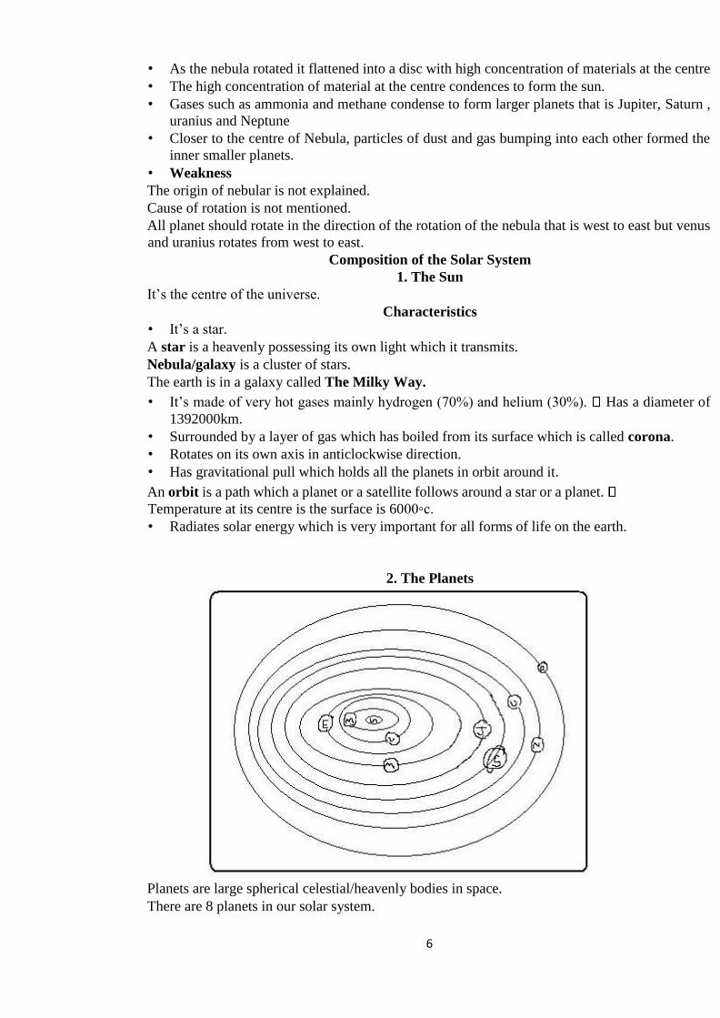
2. The Planets
Planets are large spherical celestial/heavenly bodies in space.
There are 8 planets in our solar system.
7
Characteristics
• Spherical in shape Don’t have their own light but reflect it from the sun. Revolve around
the sun in anticlockwise direction. Have their own force of gravity
• Only one is known to support life.
The following are the planets arranged in order from the one nearest to the sun.
Mercury
• Nearest from the sun
• Its 58m km from the sun
• Has no satellites
• Takes approximately 88 earth days to revolve around the sun
• Venus
• 2nd planet from the sun
• It’s 108m km from the sun
• One of the brightest planets
• Can be seen clearly with naked eyes
• Takes approximately 225 earth days to revolve around the sun
• Slightly smaller than the earth
• Has no satellites
• Together with the earth they are called twin planets due to having many similarities
Earth
• The 3rd planet from the sun
• The earth and the heavenly bodies make the universe
• The only planet that supports life
• The home of man
• Approximately 149m km from the sun
• Takes 365 ¼ days to revolve around the sun
• Has one satellite, the moon
Mars
• Also called The Red Planet because when it’s observed through a telescope it appears reddish.
• The 4th from the sun
• Slightly smaller than the earth
• Approximately 228m km from the sun
• Takes 687 earth days to revolve around the sun
• Between Mass and Jupiter there are small celestial bodies called planetoids.
• Has 2 satellites.
Jupiter
• 5th planet from the sun
• Approximately 778m km from the sun
• Largest in the universe
• Rotates on its own axis at very fast speed
• Has flattened poles due to its fast speed of rotation
• Has very thick layers of ice on its surface
• takes 12 earth years to revolve around the sun
• Has 13 satellites
Saturn
• 6th planet from the sun
• Second largest planet

8
• Approximately 1427m km from the sun
• Takes 29 ½ earth years to revolve around the sun
• Has 3 rings around it, a ring of clouds, a ring of fine dust and a ring of ice particles revolving
around it at different speed.
• Has 8 satellites
Uranus
• 7th planet from the sun
• About 4 times bigger than the earth
• Approximately 2870m km from the sun
• Also rotates very fast
• Also has flattened poles due to fast speed of rotation
• It appears greenish foe being surrounded by methane gas
• Has 5 satellites
• Takes 84 earth years to revolve around the sun
Neptune
• One of the farthest from the sun
• 8th planet from the sun
• Approximately 4497m km from the sun
• Has 2 satellites
• Takes 165 earth years to revolve around the sun
• Very similar in size, colour and character with Uranus
Other Celestial Bodies
Natural Satellites
• Any natural heavenly body that orbits around a planet e.g. moon for earth
Asteroids/Planetoids
• Also called minor planets.
• Are small fragments of rocks left going around the sun when the solar system was formed
• Found between Mass and Jupiter
• Are 1500 in number
• They sometimes collide with each other and planets due to Jupiter’s gravitational pull causing
them to move in erratic orbits.
Comets
• Heavenly bodies which appear to have a head and a long tail
• Made of ice, dust and frozen gas
• The head is made of many particles of dust, rock and frozen gases.
• Their tail is made of gases and points away from the sun.
• Move around the sun in extremely long and oval orbits
• Their orbits cross the earth’s orbits..
Meteoroid
• Small heavenly body which strays from its orbit in the solar system and enters the earth’s
atmosphere at very high speed.
Meteor
A meteoroid which is burning out due to friction after entering the earth’s atmosphere.

9
Meteorite
. Remains of a meteoroid which have reached the earth’s surface or incompletely
burnt up meteoroid.
• When they fall they sink into the ground forming craters
• They are rich in iron
The Moon
• A natural satellite
• Receives its light from the sun and reflects it onto the earth.
• It revolves around the earth
• Takes 29.5 days to complete one revolution around the earth
• Its orbit is almost circular
• As it revolves around the sun it appears in various shapes ranging from crescent/new moon,
half moon, gibbons moon and full moon.
• Has gravitational pull which causes the rising and falling of the ocean level
• As the moon orbits around the earth it creates an event called eclipse.
Eclipse
-Phenomenon occurring when the rays of the sun are blocked from reaching the earth
or the moon.
Solar/Sun Eclipse
• The moon comes between the earth and the sun
10
• The moon’s shadow is cast on the earth
• The earth appears to be covered by darkness
Lunar/moon Eclipse
• The earth comes between the moon and the sun
• The earth’s shadow is cast on the moon
• The moon appears to be covered by darkness
The Origin of the earth
• A star with a greater gravitational pull passed near the sun
• It attracted large quantities of gaseous materials from the sun
• The materials split, cooled and condensed
• Heavier materials collected at the Centre to form the core
• Less dense materials collected around the core to form the mantle
• The lightest materials formed the crust
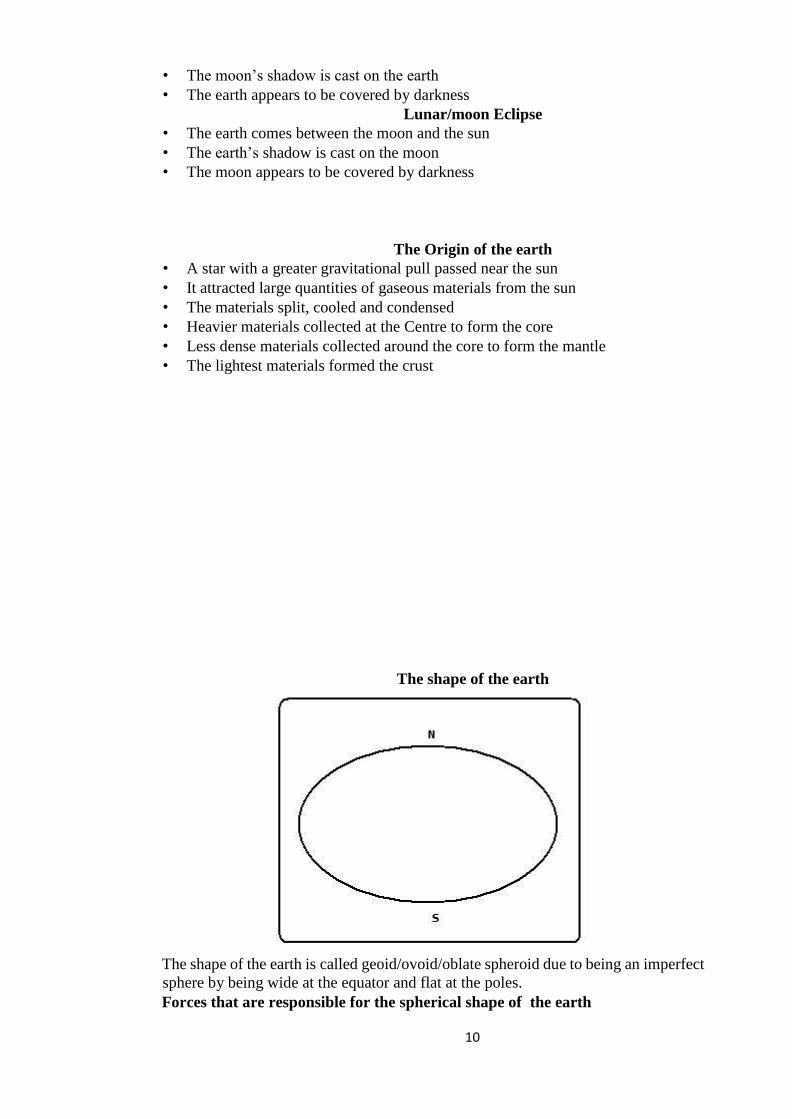
The shape of the earth
The shape of the earth is called geoid/ovoid/oblate spheroid due to being an imperfect
sphere by being wide at the equator and flat at the poles.
Forces that are responsible for the spherical shape of the earth
11
1. Force of gravity- pulls every part of the earth towards the centre giving it a
rounding effect.
2. Centrifugal force- causes the earth to bulge outwards
3. The centripetal force-causes the flattening at the poles
Proofs/Evidence That the Earth Is Spherical
1. If one moves towards the east in a straight line he will end up where he started; this is called
circumnavigation.
2. Satellite photographs taken from space show that the earth is like a sphere.
3. Places in the east see the sun earlier than those in the west.
4. When a ship is approaching the smoke is seen first, then the mast and finally the whole ship.
5. All the planets are spherical so the earth being one of them is also spherical.
6. During the moon eclipse the earth casts a spherical shadow on the moon.
7. The earth’s horizon appears curved when observed from a very high point like a tower.
The Movement of the Earth
There are 2 movements of the earth namely:
1. Rotation of the earth on its axis
2. Revolution of the earth around the sun
Rotation of the Earth
Movement/spinning of the earth on its own axis in an
anticlockwise direction (west to east).
Rotates through 360◦.
Takes 24 hours (day) to complete 1 rotation.
Effects of Rotation of the Earth
1. Causes day and night because at any one time one side of the earth faces the sun
(day) and the other remains in darkness (night).
2. Causes deflection of winds and ocean currents( in the north hemisphere to the
left and in the south hemisphere to the right).
3. It causes rising and falling of ocean tides.
4. It causes variation in the speed of air masses.
5. Causes time difference between
meridians 150
Calculation of Local Time
The time recorded in places within the same longitude.
A longitude is an imaginary line running from north to south which shows how far
east or west a place is from the prime meridian.
Greenwich Meridian (0◦) longitude is the point of reference when calculating time.
Time is gained towards the east and lost towards the west.
Examples
1. Suppose the time at GWM is 12 noon what is the local time at Watamu 40◦E?
Time gained=40×4=160min=2 hours

12
40min Local time at Watamu is 12.00+2.40=14.40-1200=2.40pm.
2. At Dar-es-Salaam 40◦E time is 12pm what is the time at Ecuador 40◦E?
40◦+20◦=60◦
60×4=240min=4hours
Ecuador is behind in time =12.00-4=8 am.
If the places are on the same side subtract the degrees to get the difference and add
or subtract from the reference time depending on which side the place is.
Calculation of Longitude
What is the longitude of place x whose local time is 8 am when local time at GWM is
noon?
Time difference =12.00-8=4 hours
Degrees=4×15=60◦
Since x is behind in time its then 60◦W.
Standard Time and Zones
• Standard time is time recorded by countries within the same time zone.
• Standard time was come up with due to confusion resulting from time changing at
every longitude.
• The world has 24 time zones.
The International Date Line
It’s the 180◦ longitude, its run from north to south but avoid areas with land masses
Effects of Crossing It
• One gains time when he crosses it from W to E and has to adjust the clock ahead by
24 hours.
• One loses time when he crosses it from E to W and has to adjust the clock backwards
by 24 hours.
Revolution of the Earth Movement of the earth in its orbit around the sun.
• It’s in anticlockwise direction.
• The orbit of the earth’s revolution is elliptical.
• Takes 365 ¼ days in a year or 366 days in a leap year (every 4 years).
• The sun moves from the tropic of cancer to the equator and then towards tropic of
Capricorn and back to the tropic of cancer.
• 21st march and 23rd September are called equinoxes because the length of day and
night is equal. The sun is vertically overhead at noon at the equator.
• 21st June is called summer solstice because its summer in the N hemisphere.
The sun is vertically overhead at noon at the tropic of cancer.
• 22nd December is called winter solstice because its winter in the northern
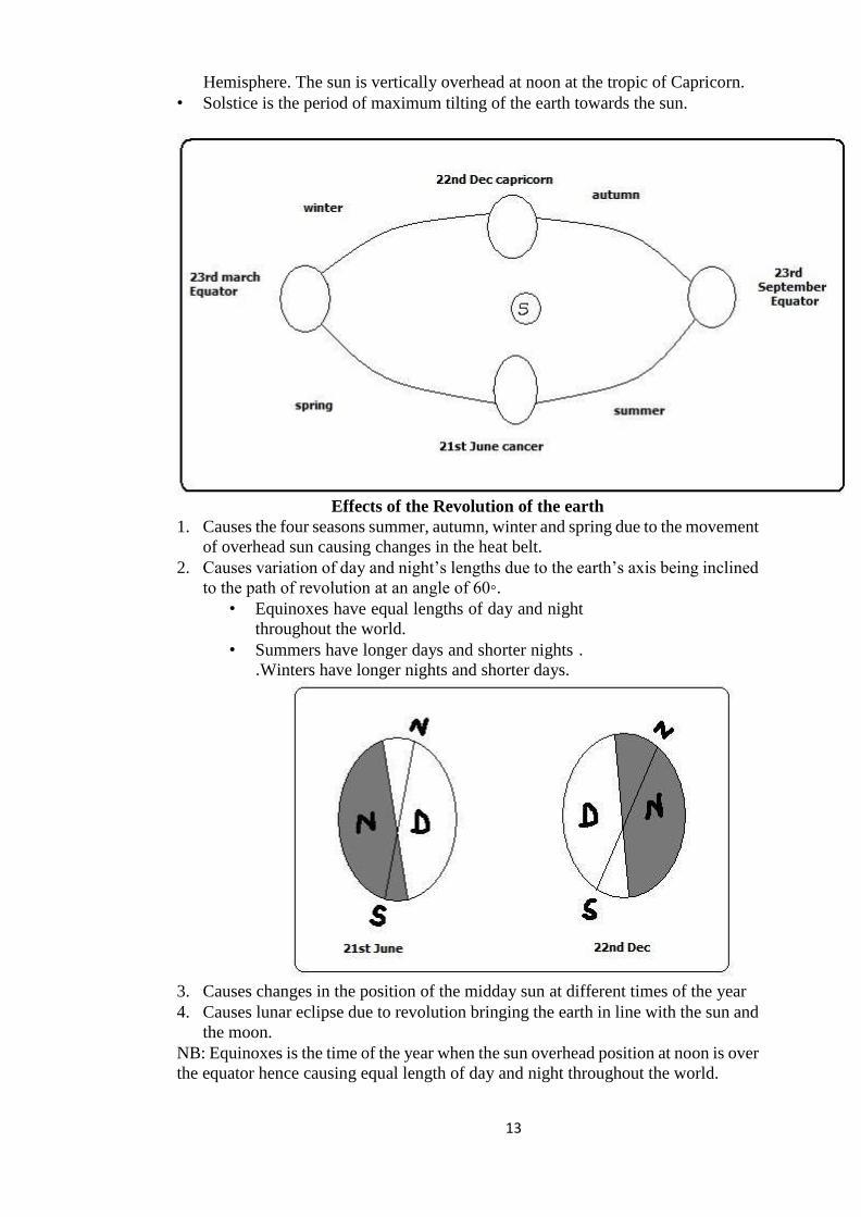
13
Hemisphere. The sun is vertically overhead at noon at the tropic of Capricorn.
• Solstice is the period of maximum tilting of the earth towards the sun.
Effects of the Revolution of the earth
1. Causes the four seasons summer, autumn, winter and spring due to the movement
of overhead sun causing changes in the heat belt.
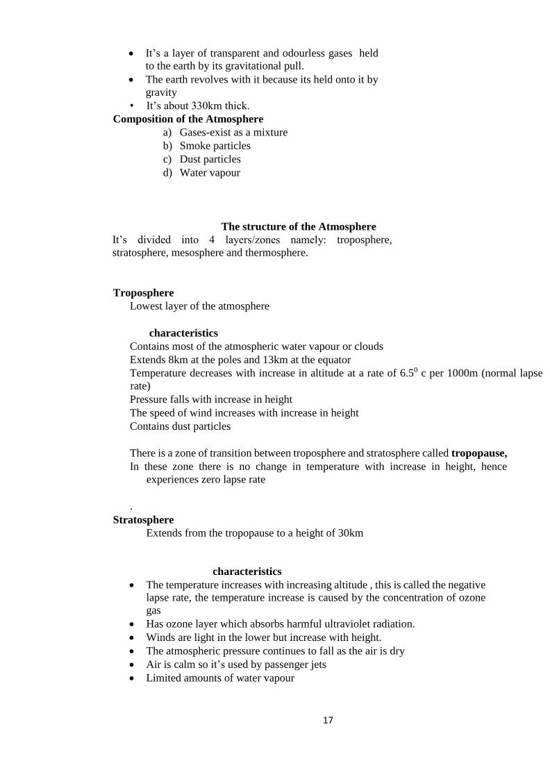
2. Causes variation of day and night’s lengths due to the earth’s axis being inclined
to the path of revolution at an angle of 60◦.
• Equinoxes have equal lengths of day and night
throughout the world.
• Summers have longer days and shorter nights . .Winters have longer nights and shorter days.
3. Causes changes in the position of the midday sun at different times of the year
4. Causes lunar eclipse due to revolution bringing the earth in line with the sun and
the moon.
NB: Equinoxes is the time of the year when the sun overhead position at noon is over
the equator hence causing equal length of day and night throughout the world.

14
LATITUDES AND LONGITUDES
Latitudes
Refers to an imaginary line which is drawn on a map running from west to east and
measured in degrees showing how north or south a place is from the equator.
Longitudes
Refers to an imaginary line which is drawn on a map running from north pole to
south pole and is measured in degrees east or west from the prime meridian
Differences between Latitudes and Longitudes
1. Latitudes run from west to east while longitudes run from north to south
2. Latitudes shows how far a place is from the equator while longitudes show
how far a place is from the prime meridian
3. Latitudes are parallel to one another while longitude meet at the poles
4. The distance between latitude is even around the globe while that between
longitudes is longest at the equator and decreases pole wards.
The Structure of the Earth
The structure of the earth consist of a series of layers both internal and external, these layers includes
1. Atmosphere external layers 2. Hydrosphere 3. Crust 4. Mantle internal layers
5. core

15
Internal Structure of the Earth
The evidence used to study the earth’s interior are
1. mining
2. drilling
3. quarrying/excavation
A. Crust/Lithosphere
• Outermost layer of the earth
• Made of soils and other loose deposits of sand
• The dominant rocks are granites.
• Extends from 16-24 km thick but where mountains occurs it can have a thickness of 70km.
• Has 2 layers; continental crust and oceanic crust.
1. Sial
• Also called continental crust
• Made of light colored rocks
• Called sial because it’s made up of silica and aluminum.
• It is lighter( having a density of 2.7 grams/cc) this makes it float on the oceanic crust.
2. Sima
• Also called oceanic crust
• Mainly made of basaltic rocks which are brittle.
• Called sima because it is made of silica and magnesium.
• It has a density of 2.8-3.0gm/cc
• It is thin ranging from 6km-10km in thickness.
Mohorovicic Discontinuity (Moho)
• A definite zone of discontinuity between the crust and the mantle.
• Was discovered by Dr. Andrija Mohorovicic in 1909.
B. The Mantle/Asthenosphere

16
On average its about 2900km thick
• Its composed of silicate rocks rich in iron and magnesium.(olivine)
• It has an average density of 3.0-3.3gm/cc
• Its divided into two layers namely; upper mantle and lower mantle
Upper mantle
Rocks are more elastic than those of sima.
Temperature is about 1000◦c.
Lower mantle
Rocks are like very viscous liquid.
• Temperature ranges between 1000◦c to 3000◦c.
Gutenberg Discontinuity
A definite zone of discontinuity between mantle and core.
C. Core/barysphere/Centrosphere
Its has a radius of 3470km
• Its divided into two layers namely; inner core and outer core.
Outer Core
Its has an average density of 12.0gm/cc
• Composed of hot molten rocks
• Made up of nickel and iron
• Temperatures are up to 3700◦c.
Inner Core
• A solid mass of iron
• Its has a density of 16 -17gm/cc.
• Temperatures are estimated to be 3700◦c to 5500◦c.
Why the Interior of Earth Is Very Hot
a) Due radio-active decay causing most of the heating. The decay of the radio-active material
causes explosion occasionally releasing a lot of heat through nuclear fission
b) Due to great pressure as a result of overlying crustal materials, this intense pressure
generates a lot of heat inside the earth.
c) The earth stills retains the original heat which it had before its started cooling, during
cooling the outer parts cool faster than the interior trapping the original heat inside it
External Structure of the Earth
a) The Atmosphere
17
It’s a layer of transparent and odourless gases held
to the earth by its gravitational pull.
The earth revolves with it because its held onto it by
gravity
• It’s about 330km thick.
Composition of the Atmosphere
a) Gases-exist as a mixture
b) Smoke particles
c) Dust particles
d) Water vapour
The structure of the Atmosphere
It’s divided into 4 layers/zones namely: troposphere,
stratosphere, mesosphere and thermosphere.
Troposphere
Lowest layer of the atmosphere
characteristics
Contains most of the atmospheric water vapour or clouds
Extends 8km at the poles and 13km at the equator
Temperature decreases with increase in altitude at a rate of 6.50 c per 1000m (normal lapse
rate)
Pressure falls with increase in height
The speed of wind increases with increase in height
Contains dust particles
There is a zone of transition between troposphere and stratosphere called tropopause,
In these zone there is no change in temperature with increase in height, hence
experiences zero lapse rate
.
Stratosphere
Extends from the tropopause to a height of 30km
characteristics
The temperature increases with increasing altitude , this is called the negative
lapse rate, the temperature increase is caused by the concentration of ozone
gas
Has ozone layer which absorbs harmful ultraviolet radiation.
Winds are light in the lower but increase with height.
The atmospheric pressure continues to fall as the air is dry
Air is calm so it’s used by passenger jets
Limited amounts of water vapour
18
There is a zone of transition between stratosphere and mesosphere called
stratopause.
Mesosphere
Extends from 50-80 km
Characteristics
Temperature decreases with increasing altitude, this is called positive lapse rate, the
decrease in temperature is because there is no water vapour or ozone gases to absorb
the incoming terrestrial radiation
Its has the lowest temperature ranging -900c
Has very strong winds that at times reaches 3000km/hr
There is a zone of transition between mesosphere and thermosphere called mesopause
which is an inversion layer.
Thermosphere
Extends from 90-120km
characteristcs
High radiation is present.
Temperature rapidly increases with height, this is
due to the over concentration of atomic oxygen
which absorb incoming ultra-violet radiation
Temperature reaches to a high of over 15000c
• The pressure is very low.
• Gases and molecules in this layer exist as ions due to high radiation.
NB
Thermosphere has no definite top but merges gradually into the outermost part of the
atmosphere called exosphere.
Exosphere consists of rare gases like hydrogen and helium.
Beyond the atmosphere there is the outer space.
• Outer space is the universe beyond the atmosphere in which other planets and stars exist.
Composition of the atmosphere
The atmosphere is composed of the following gases;
1. Nitrogen 78%
2. Oxygen 20%
3. Water vapour 1%
4. Argon 0.94%
5. Carbon dioxide 0.03%
6. Inert gases such as neon, krypton and xenon are found in traces (negligible
percentages)

19
Significance of Atmosphere
a) Animals and plants breathe in from it oxygen for respiration.
b) Plants use carbon dioxide from it for photosynthesis.
c) Water vapour in the atmosphere condenses to form clouds which give us rain.
d) Ozone layer in the stratosphere shields us from ultraviolet radiation which may
cause cancers.
e) Carbon dioxide and methane in the atmosphere cause global warming through
the green house effect.
b) The Hydrosphere
• Part of the earth’s surface covered by water masses e.g. oceans, seas, lakes, rivers and even
underground water. It comprises 73% of the earth’s surface area. .
• The lower atmosphere, hydrosphere and the upper part of the earths crust are called
biosphere meaning the sphere of the earth in which organic life exists.
20
WEATHER
-Daily atmospheric conditions of a place at a particular time.
Elements of Weather
1. Temperature
2. Humidity precipitation
3. Precipitation
4. Atmospheric pressure
5. Wind
6. Sunshine
7. Cloud cover
Factors Influencing Weather
Temperature
It is the degree of sensible heat within the atmosphere,the suns energy is transmitted inform of short waves rays in a process called insulation or solar radiation
Factors determining the amount of solar radiation reaching the earth surfaces
1. The intensity of the sun radiation in the space, and the average distance from the sun
2. The transparency of the atmosphere. If there are many particles in the atmosphere like dust,ice,crowns etc, they will absorb scatter and reflect the sun rays making less radiation to reach the earth surface
3. The position of the earth on its orbits which produces different seasons
4. The angle of the surface on which the sun rays fall 5. The area and nature of the surface on which the rays fall
Ways in which the atmosphere is heated
1. Radiation
2. Conduction
3. Convection
Radiation This is the way bodies emit heat in form of electro magnetic waves Radiation travels in waves that are very small and are transmitted from one place to another without the help of any medium. The earth emits heat by long wave radiation called terestial radiation while the sun through by short waves radiation called solar radiation Terrestrial radiation solar radiation
Waves invisible waves visible
Long waves radiation short waves radiation
21
Conduction
Is the transfer of heat energy through motion from one molecule to another
Air in the atmosphere is heated by direct contact with the earth, then its heat the one above
Convection
Air si heated by the earth and become less dense
The heated air then rises to higher level transferring heat with it
The colder dense air above the surface descends down to replace the warm rising air
The colder air on reaching the surface,in turn becomes heated and rises
The movement of lighter air upwards and dense air downward is called convectional currents
Factors influencing temperature
1. Altitude
Height above sea level.
• Temperature decreases with increase in height due to air at higher altitude being thinner
and hence there is less particles e.g. gases, dust, smoke and water vapour to store heat so
its rapidly lost to the outer space.
2. Latitude
-Distance from the equator.
Temperature decreases with increase in latitude.
• Places neat equator experience high temperature due to the rays of the sun travelling a
shorter distance facing less interference from atmospheric conditions hence more solar
energy reaches the earths surface. Also the rays of the sun strike the earth at right angles
hence solar energy is concentrated over a small area.
• At higher latitudes the rays of the sun travel a longer distance facing more interference
from atmospheric conditions hence less solar energy reaches the earth’s surface. Also the
rays of the sun strike the earth at an acute angle hence solar energy is spread over a large
area.
3. Aspect
-Direction of slope in relation to rain bearing winds or sunshine
• At higher latitudes slopes facing the equator have higher temperature because they face
the sun while those facing the poles have lower temperature have lower temperature
because they face away from the sun.
4. Winds
-Transfer heat from one place to another.
• When they blow from cool areas they take the cooling effect to the areas they blow over
and when they blow from warm areas they take warming influence to the places they blow
over.
5. Distance from a Large Water Body
• Areas near a large water body experience lower temperature during the hot season and
higher temperature during the cool season due to sea breezes, warm and cold ocean
currents and wind blowing over water which could be either warmer or cooler than the
adjacent land.
6. Cloud Cover
• Clouds reduce the amount of solar energy reaching the surface by absorbing, scattering
and reflecting solar radiation.

22
• When there are clear skies during the day the temperature is higher due to the earth
receiving maximum solar insolation.
• During clear nights there are very low temperatures due to a lot of terrestrial radiation
being lost to the outer space.
• Cloudy nights on the other hand are warmer due to clouds radiating to the earth heat
absorbed during the day.
7. Length of Day
• The longer the period of solar insolation the greater the quantity of radiation a place
receives and hence the more the heat that will be generated by the earth and vice versa.
Humidity
Is the condition of the atmosphere with references to its water vapour content
Absolute Humidity
-Actual amount of water vapour a given volume of air can hold. It’s expressed in g/m3.
Relative Humidity
-Ratio between the absolute humidity and the maximum amount of water the air can hold
expressed in a percentage.
Factors Influencing Humidity
1. Temperature
• Places with high temperature experience high humidity due to high evaporation and air
having high capacity to hold moisture.
• Places with low temperature have low humidity due to low evaporation and air having low
capacity to hold moisture.
2. Source of Moisture
• Areas near water bodies e.g. Kisumu and Mombasa experience high humidity due to
evaporation of water from the water body.
• Places near thick vegetation also have high humidity due to evapotranspiration.
• Areas far away from water bodies such as the middle of deserts have low humidity.
• Areas receiving heavy rainfall also have high humidity.
3. Air Pressure
• There is high humidity at low altitudes because high pressure compresses air warming it
increasing its capacity to hold moisture and also causes high evaporation.
• There is low pressure at high altitudes because air expands and cools thus reducing its
capacity to hold moisture.
4. Latitude
• Low latitudes experience high humidity due to high temperatures resulting into high rates
of evaporation and air having high capacity to hold moisture.
• High latitudes experience low humidity due to low temperatures resulting into low rates
of evaporation and air having low capacity to hold moisture.

23
Significance of Humidity/Moisture
1. Affects rain formation in such as way that places with high humidity are likely to experience
higher rainfall than those with low humidity.
2. Regulates the heat loss from the earth’s surface by absorbing terrestrial radiation (process
in which the earth gives off heat into the atmosphere).
3. It affects sensible temperature in that the higher the humidity the more we experience
sensible temperature.
Precipitation
-The forms in which the earth’s surface receives moisture.
Snow
Solid precipitation formed when tiny water droplets freeze and form ice crystals.
The crystals may fuse to form flakes.
Sleet
-Precipitation which is a mixture of rain and snow.
Hail
Roughly spherical lumps of ice formed when super cooled cloud droplets mould themselves
around ice crystals before cooling. It destroys crops life and house roofs.
Dew
-Precipitation consisting of water droplets formed on cold surfaces at night e.g. iron roofs and
glass blades.
How It’s Formed
• In a clear night there is a high ground radiation.
• Temperature of the earth’s surface fall below dew point (temperature at which air being
cooled becomes saturated).
• Excess water condenses on cold surfaces.
5. rain
-Precipitation consisting of water drops/droplets formed when tiny water droplets merge
around particles of matter and become heavy and fall down to the earth. Condensation
Turning of water vapour into tiny water droplets as cooling continues below dew point.
The droplets join to form clouds.
Causes of Condensation
1. Adiabatic cooling-cooling of moist air as it rises vertically.
2. Orographic cooling-cooling of moist air as it climbs a hill or mountain.
3. Frontal cooling-cooling of warm air mass when it blows towards a cold air mass.
4. Advection cooling-cooling as a result of moist air moving over a cool land or sea.
How Condensation Takes Place/Cloud Formation

24
• Moist air rises to the condensation level (altitude where temperature is below dew point.
• It’s cooled below dew point.
• Tiny water droplets condense around tiny particles such as dust, smoke particles and
pollen grains and salt particles (condensation nuclei). The droplets merge and
eventually become bigger and fall as rain. If moisture rises to an altitude where
temperature is below 0◦c the condensed water droplets freeze forming ice particles or
super cooled water (water which has remained in a liquid state at temperatures below
freezing point due to lack of sufficient condensation nuclei.
• Super cooled cloud droplets may mould themselves around ice crystals before freezing to
form hail.
Types of rainfall
1. Relief/Orographic/Mountain rainfall
Rain experienced on the windward slopes of mountains or hills formed when moist air is forced
to rise over a mountain or a hill.
How it Forms
• Moist air is forced to rise over a hill or mountain.
• The temperature and air pressure decreases making it to expand.
• Air cools due to decreased temperature and decreased pressure causing it to expand.
• Moisture condenses forming tiny water droplets (clouds).
• The tiny water droplets in clouds merge and become too heavy to be suspended in air and
fall as rain.
• Air proceeds to the leeward side with low moisture content.
• Since its heavier due to being cool it descends over that side and gets warmed making it
to hold onto the little moisture it had causing that side to receive low rainfall (rain
shadow).
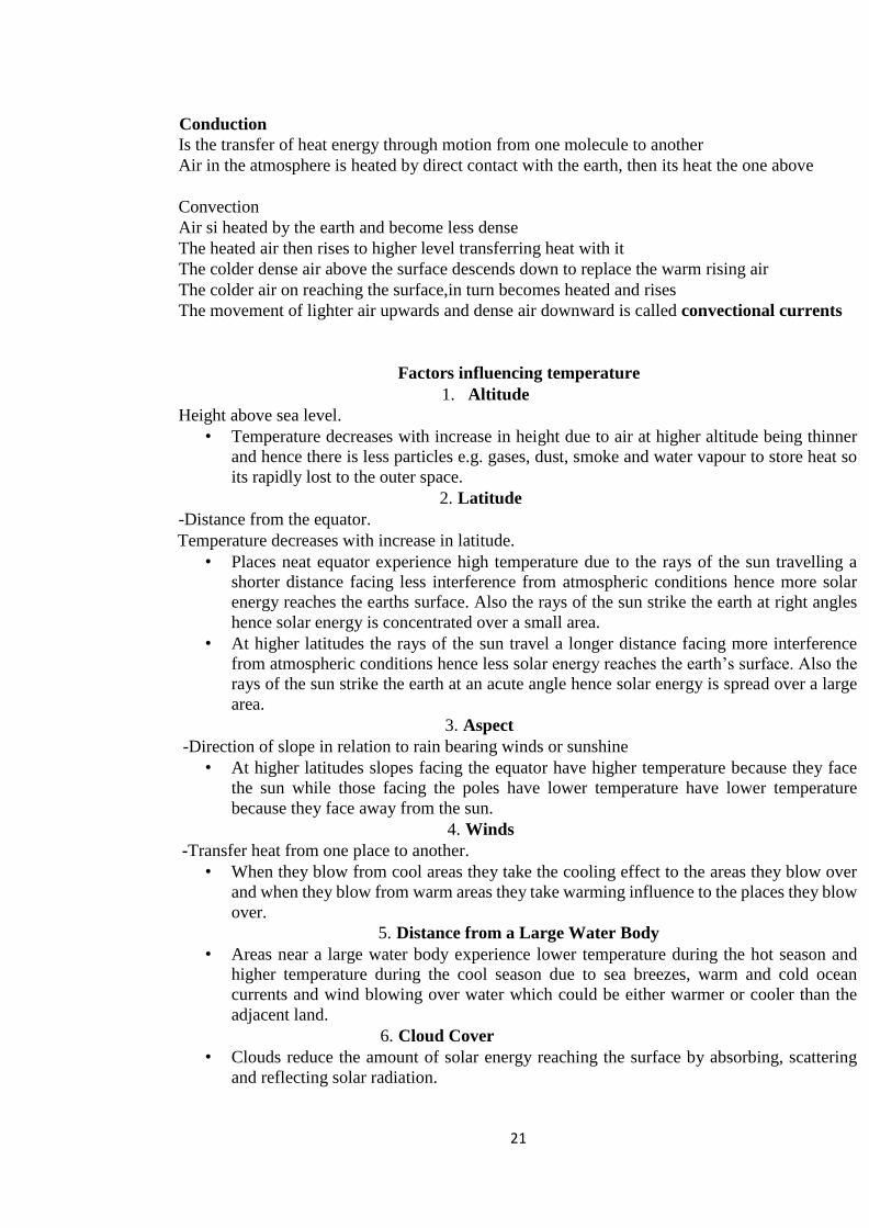
1. Convectional Rainfall
25
Type of rainfall common near large water bodies formed as a result of convective rising and
cooling of moist air. It’s accompanied by thunderstorms.
How it forms
• Ground or water body is heated causing evaporation.
• There is convective rising and cooling of moist air.
• Condensation takes place forming tiny water droplets (clouds).
• The droplets merge and fall as rain.
• The cooled dry air descends to the surface where its heated and its capacity to hold
moisture is increased.
• The process is repeated.
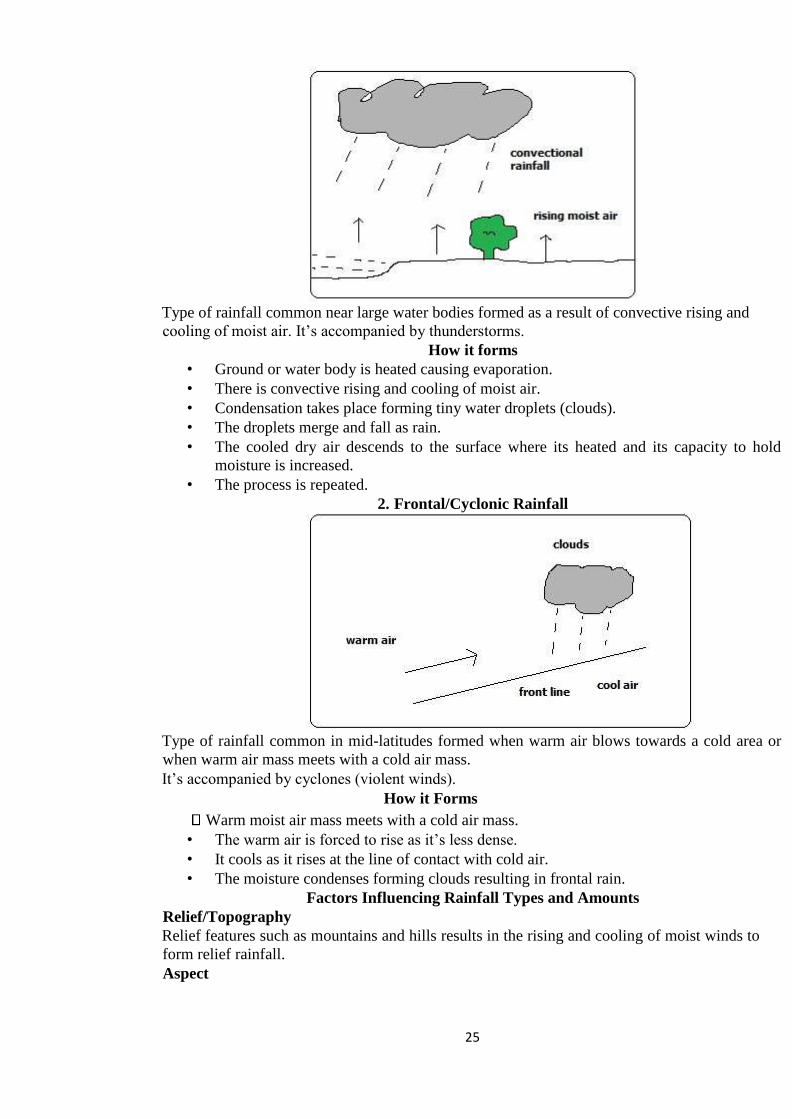
2. Frontal/Cyclonic Rainfall
Type of rainfall common in mid-latitudes formed when warm air blows towards a cold area or
when warm air mass meets with a cold air mass.
It’s accompanied by cyclones (violent winds).
How it Forms
Warm moist air mass meets with a cold air mass.
• The warm air is forced to rise as it’s less dense.
• It cools as it rises at the line of contact with cold air.
• The moisture condenses forming clouds resulting in frontal rain.
Factors Influencing Rainfall Types and Amounts
Relief/Topography
Relief features such as mountains and hills results in the rising and cooling of moist winds to
form relief rainfall.
Aspect

26
Windward slopes which are on the path of rain bearing winds receive heavier rainfall than
leeward slopes which face away.
Forests and Water Bodies
Areas near forests and large water bodies experience higher rainfall and more often due to high
rate of evaporation.
air pressure
High pressure areas receive low rainfall than low pressure areas due to pushing of air masses
from high pressure to low pressure. The high pressure areas have descending dry air.
air masses When warm and cold air masses meet frontal rainfall is formed.
Ocean Currents
• It influences rainfall whereby coasts washed by warm ocean currents experience heavy
rainfall when moist onshore winds are warmed by the current and made to hold on to
moisture which they release on reaching the land.
• The coasts washed by cold ocean currents on the other hand experience low rainfall as a
result of moist winds being cooled and moisture in them condensed resulting in rain
falling over the ocean thereby bringing little or
no rain to the coastal areas. This is the cause of western margin deserts e.g.
Kalahari and Namib deserts.
Atmospheric pressure
Factors Influencing Atmospheric Pressure
1. Altitude
• Pressure decreases with increase in altitude because the column of air becomes shorter
hence it exerts less weight.
1. Temperature
• When air is heated it expands and exerts pressure over a large area resulting in reduced
pressure.
• When it’s cooled it contracts and exerts pressure over a small area resulting in increased
pressure.
2. Rotation of the earth
• Rotation pushes air masses from poles towards the equator causing air to spread out and
occupy more space causing it to expand making pressure to decrease.
• When air from the equator moves towards the poles it occupies less space causing it to
contract resulting into high pressure.
Mist and Fog
Mist and fog are a mass of tiny water droplets suspended in the lower layers of the atmosphere.
Fog is denser than mist i.e. has more moisture.
Both hinder visibility although fog reduces visibility to less than a kilometre.
When fog mixes with smoke its called smog.
How They Form Moist air
cools below dew point.
• Condensation takes place.
• The resultant water droplets remain suspended in the air.
Types of Fog
1. Radiation Fog
• Type formed when moist air is cooled below dew point as a result of intense radiation on the
ground at night.
1. Advection Fog
• Type formed when moist air from the sea moves horizontally over a cold surface e.g. snow
covered ground.
2. Orographic/Hill/Upslope Fog
27
• Type formed when moist air is cooled after climbing a hill or mountain.
3. Evaporation Fog
• Type formed when water vapour is added to cold air that is already near saturation causing
excess water vapour to condense and form fog.
4. Frontal Fog
• Type formed when warm moist air is cooled from below as it rises over a cold air mass.
5. Steam Fog
• Type formed when moist air passes over the surface of a much warmer fresh water
body.
• The warm water is cooled from above and condensing water vapour forms fog.
It appears to be steaming.
6. Ice Fog
• Type formed when water vapour is converted directly into ice crystals when temperatures
are below freezing point.
Clouds
-Are a mass of tiny droplets or ice particles formed when water vapour condenses.
Three Cloud Forms 1. Cirroform -Thin and wispy clouds composed of ice crystals.
stratiform
-Appear as greyish sheets covering most of the sky and are rarely broken into units.
Cumuliform
-Are massive rounded with a flat base and limited horizontal extent and billow upwards to great
heights.
Basic Cloud Types
Stratus Clouds
-Are found in layers, are flat in shape and resemble fog.
Nimbus Clouds
-are dark at the base and sometimes white at the sides and cause rain and thunderstorms.
Cirro-cumulus -Are white clouds consisting of white ice crystals.
Nimbostratus
-A rain cloud which is dark grey and spreads over the sky in low uniform layers.
Cumulus Clouds
-Clouds with a flat horizontal base, massive, rounded and less horizontal extent.
Alto cumulus
-High clouds composed of ice crystals which indicate fair weather.
World distribution of Pressure Zones and the Planetary wind System/World
Prevailing Winds
The Equatorial Low pressure Zone (ITCZ-low)
• Found between 23 ½ ◦N and 23 ◦N Experiences high temperatures.
• A zone of low pressure and doldrums (light and intermediate winds).
• Zone where S.E and N.E Trade Winds converge.
• Associated with convectional rain and thunderstorms.
• Migrates to the N and with the apparent movement of the overhead sun. The Sub-tropical
High Pressure Zone
• Found within 30◦N and 30◦S.
• A zone of high pressure.
• A region of calm descending air.
• Source of Trade Winds and Westeries.
• Zone of divergence of T. Winds and Westeries.

28
The Temperate Low Pressure Zone
Found within 60◦N and 60◦S.
A low pressure zone.
• Zone of convergence of westeries and polar easteries.
The Polar High Pressure Zone Found
over the poles 90◦N and 90◦S.
• A high pressure Zone.
• Zone of descending calm air of low temperature.
• Source of polar easteries.
The Worlds Prevailing Winds
These are the major winds blowing over the earth frequently and consistently and which influence
the world weather.
1. Trade Winds
• Blow from sub-tropical high pressure zone and blow to the equatorial low pressure belt.
2. Westeries
• Originate from sub-tropical high pressure zone and blow to the temperate low pressure belt.
3. The Polar Easteries
• Originate from polar high pressure zone and blow to temperate low pressure zone.
Monsoon Winds
• Seasonal winds which reverse in the direction of flow.
• They blow towards the land during summer (onshore) and from the land during winter (off
shore).
• Bring heavy rains when onshore which can cause severe flooding.
• Well developed in the Indian Sun-continent, china, Japan and S.E Asia.
Air Masses
-Distinct large parcels of air moving in one direction
-Originate from areas of uniform weather and topography from where they derive their
characteristics e.g. flat areas, forests, deserts, and snow covered areas. Characteristics of Air
Masses
29
A large volume of air.
• Covers an extensive area.
• Has uniform temperature and humidity.
• Distinct from the surrounding air.
• Retains its characteristics when it moves away.
Types of air Masses 1. Equatorial
Air Mass Originate from equatorial oceans.
• It’s hot and unstable.
Sub-tropical Air Mass Forms near sub-tropical high pressure
belt.
Polar Air Mass Forms near the
poles or temperate low pressure zone.
• It’s cool.
3. Arctic and Antarctic air Masses
• Forms over the ice sheets of Greenland and Antarctica respectively.
4. Effect of air masses on Weather
• When warm moist air mass and cool air mass meet cyclonic rainfall is formed
e.g. tropical maritime and polar maritime.
• Cool air masses take cooling effect to the areas they move to e.g. polar continental.
• If they are warm they take warming influence to the area they move to e.g.
tropical continental.
Pressure Systems in the World 1. Cyclone
• It’s a low pressure system characterised by low pressure at the centre and increases outwards.
• Starts in areas where air ascends from the ground to the atmosphere and descends at high
altitude.
• It’s of two types. Tropical cyclones e.g. hurricane, typhoon and willy willies and depressions
which are characterised by temperate latitudes.
• The movement of wind is anticlockwise in the N. hemisphere and clockwise in the S.
hemisphere.
2. Anticyclone
• A high pressure system characterised by high pressure at the centre and decreases outwards.
•

30
• It starts in areas where air is descending from the atmosphere onto the ground and then blows
outwards on the ground.
• The movement of wind is clockwise in the N. hemisphere and anticlockwise in the S.
hemisphere.
Local Winds
-Which occur regularly for a short period of time affecting a limited area.
-Modify the weather of the area they blow to.
1. Sea Breeze
-A light and gentle wind which blows from the sea to the adjacent land. How it
Forms During the day land is heated faster than the sea.
• Air over the land is warmed and rises.
• Air from the sea moves to the land to replace the rising air.
• The rising air from the land cools and descends over the sea at high altitude.
• Circulation continues until the pressure difference is reversed at night.
Effects on weather It takes
cooling effect on land on a hot afternoon.
2. Land Breeze
-A light and gentle wind which blows from land to the sea during the night.
How it Forms
31
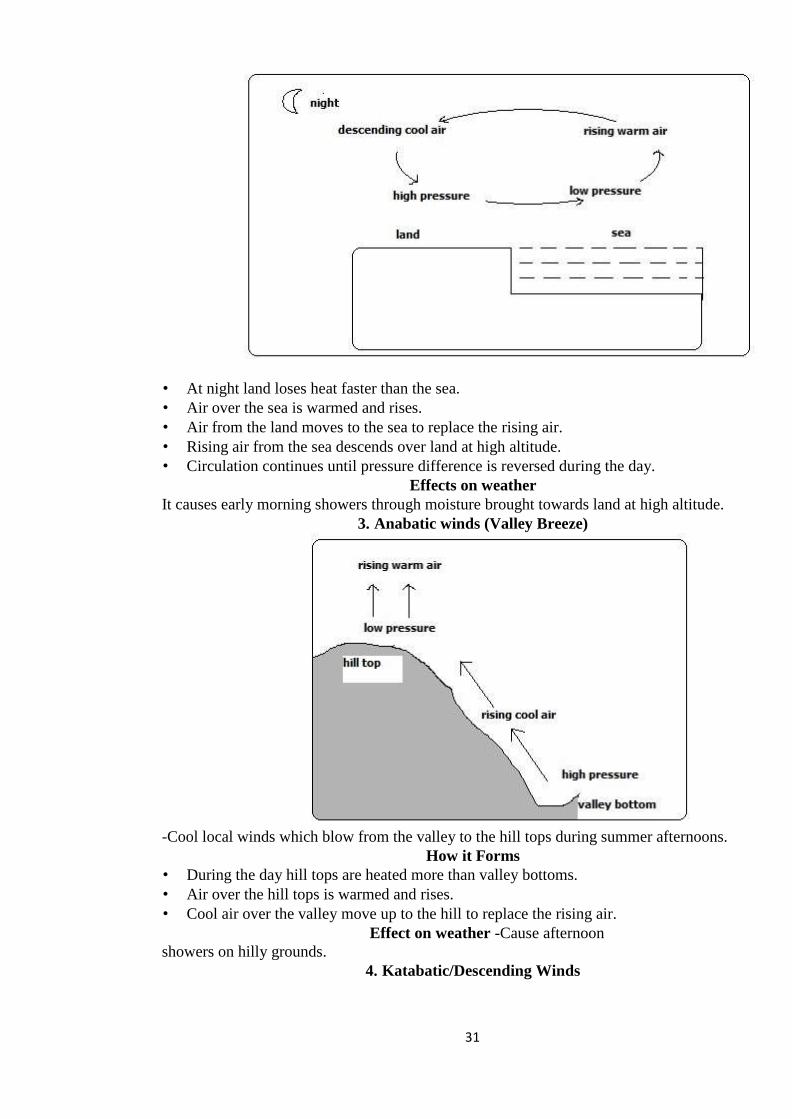
• At night land loses heat faster than the sea.
• Air over the sea is warmed and rises.
• Air from the land moves to the sea to replace the rising air.
• Rising air from the sea descends over land at high altitude.
• Circulation continues until pressure difference is reversed during the day.
Effects on weather
It causes early morning showers through moisture brought towards land at high altitude.
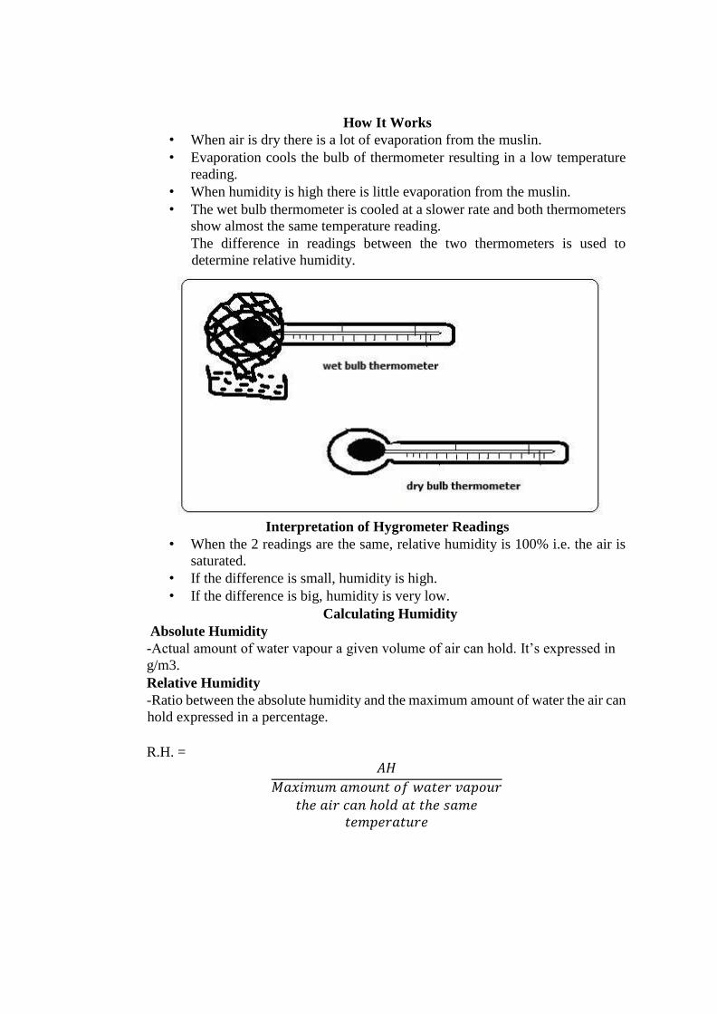
3. Anabatic winds (Valley Breeze)
-Cool local winds which blow from the valley to the hill tops during summer afternoons.
How it Forms
• During the day hill tops are heated more than valley bottoms.
• Air over the hill tops is warmed and rises.
• Cool air over the valley move up to the hill to replace the rising air.
Effect on weather -Cause afternoon
showers on hilly grounds.
4. Katabatic/Descending Winds

32
-Cold local winds which blow from hill tops to the valley during the night.
• During the night hill tops lose heat faster than the valley.
• Air over the valley is warmed and rises.
• Cool air over the hill tops move to the valley by gravity to replace the rising air.
Effect on Weather -Takes chilly
conditions on valley bottoms.
5. Harmattan Winds
-N.E winds which originate from Sahara and blow across W. Africa between November and
March taking dry conditions there.
6. Fohn Winds (Alps)
-Local cold winds which slide down the leeward side of the mountain at high speed and are
warmed producing a temperature rise.
Due to the high speed and temperature they are associated with wild fires. They are known
as Chinook in Rocky Mountains, Santa Anas in California and Mistral in France.
Factors influencing Wind Flow (Speed and direction)
1. Pressure Gradient
If the pressure difference between high and low pressure areas is high the winds blow at high
speed (strong) but if it’s low they blow at high speed (are gentle).
2. distance between Places of High and Low Pressure
if the high and low pressure areas are near each other winds blow at high speed but if distant
from each other winds blow at low speed.
3. Rotation of the earth
Rotation of the earth deflects winds to the right in the N. hemisphere and to the left in the S.
hemisphere.
4. Frictional Force
If the surface of the earth is rugged or has obstacles such as hills, mountains, valleys or
vegetation the wind is blocked causing speed reduction and its direction of flow is also
changed.
A Weather Station
-A place where observation, measuring and recording of weather elements is done

33
Factors to Be Taken Into Account When Sitting a Weather Station
1. An open place where there is free flow of air.
2. A fairly level or gently sloping ground so that it’s easy to position weather instruments.
3. The site should be free from flooding.
4. The place should have security.
Instruments for Measuring Elements of Weather
1. Thermometer-temperature
2. Hygrometer-humidity
3. Rain gauge-rainfall
4. Barometer-air pressure
5. Sunshine recorder-sunshine duration and intensity
6. Wind vane –wind direction
7. Anenometer-wind speed
8. Evaporimeter-rate and amount of evaporation

34
The Stevenson Screen
-A white wooden box mounted on 4 legs used to house thermometers and hygrometers.
The instruments which are found in it are:
1. Maximum thermometer
2. minimum thermometer
3. Six’s thermometer
4. hygrometer-wet bulb and dry bulb thermometer
Importance
1. Provide shade conditions for accurate temperature recording.
2. Ensure safety of thermometers because they are delicate.
Qualifications Which Make Stevenson Screen Suitable For Its Work
1. Painted white for little absorption of solar heat energy.
2. Made of wood which is a bad conductor of heat.
3. Well ventilated to allow easier flow of air inside it.
4. Raised to prevent contact with terrestrial radiation.
5. Has double roof which acts as an insulator to prevent direct heating from the sun.
Recording and Calculating Weather Conditions
Temperature
It is the degree of sensible heat within the atmosphere.
It’s measured using 3 types of thermometers namely:
1. Maximum thermometer
2. Minimum thermometer
3. Six’s thermometer
Maximum Thermometer

35
It’s used to measure the highest temperature reached in a day. It
uses mercury.
How It’s Used/Works
Temperature rises causing mercury to expand.
• Mercury pushes the index up.
• When temperature falls mercury contracts.
• The maximum temperature is read from the scale at the lower end of the metal index.
• Thermometer is reset by shaking it to force mercury back into the bulb.
Minimum Thermometer
It’s used to record the lowest temperature reached in a day. It
uses alcohol.
How it’s Used/Works
Temperature falls causing alcohol to contract.
• Alcohol pulls the index down.
• When temperature rises alcohol expands and rises in the tube.
• The index remains where it was pulled.

Minimum temperature reading is obtained from the scale at the lower end
of the index.
Calculating Temperature
Diurnal/daily Temperature range
-Difference between the maximum and minimum temperature for any one day.
Mean Daily Temperature
-Average of the maximum and the minimum daily temperatures.
Mean Monthly temperature
-Sum of mean daily temperatures in a month divided by the number of days in that
month.
Mean Annual Temperature
-Sum of mean monthly temperatures divided by 12.
Mean Annual Temperature Range
-Difference between the highest and the lowest mean monthly temperatures in a
year.
Rainfall
Rain gauge is the instrument used to measure the amount of rainfall in a day.
How It’s Used/Works
It’s taken to an open space to prevent water from dropping into the funnel.
• Its sunk into the ground to prevent evaporation
• The funnel top is left 30cm above the ground to prevent splashes of water
and run off.
• After 24 hours water is emptied into the measuring cylinder.
• The reading of the amount of rainfall is got from the measuring cylinder in
millimetres.
• The figure represents the millimetres of water falling on each square
millimetre of the ground.

Calculating Rainfall
1. Monthly Rainfall Total
-Sum of rainfall recorded in a month.
Annual Rainfall Total
Obtain by adding all the total monthly rainfall for a year.
Mean Annual Rainfall
-obtain by adding total annual rainfall usually for a period of 35 years and dividing
by 35.
Mean Annual Rainfall
-Sum of mean monthly rainfall for 12 months of the year.
Sunshine
Duration of sunshine is measured using Campbell stokes sunshine recorder.
How It Works
• Spherical lens focuses light on sensitized paper.
• The paper burns when the sun is shining.
• The total hours of sunshine is got by adding all the burnt sections from
calibrations on the side of sensitized paper.
• The sensitized paper is changed every day.
Humidity
Humidity is the condition of atmosphere with reference to its water content. It’s
measured with hygrometer or psychrometer which consists of wet and dry bulb
thermometers kept in Stevenson screen.
Dry bulb thermometer is a thermometer covered with muslin bag immersed in water
while dry bulb thermometer has no muslin.
How It Works
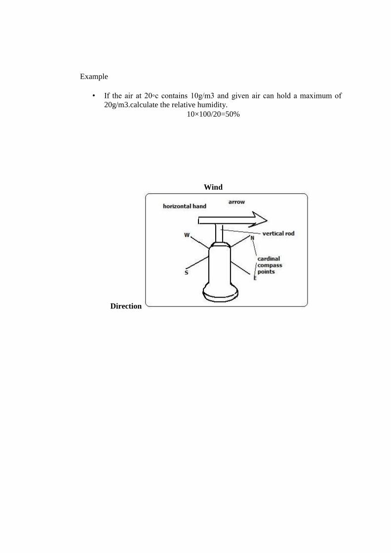
• When air is dry there is a lot of evaporation from the muslin.
• Evaporation cools the bulb of thermometer resulting in a low temperature
reading.
• When humidity is high there is little evaporation from the muslin.
• The wet bulb thermometer is cooled at a slower rate and both thermometers
show almost the same temperature reading.
The difference in readings between the two thermometers is used to
determine relative humidity.
Interpretation of Hygrometer Readings
• When the 2 readings are the same, relative humidity is 100% i.e. the air is
saturated.
• If the difference is small, humidity is high.
• If the difference is big, humidity is very low.
Calculating Humidity
Absolute Humidity
-Actual amount of water vapour a given volume of air can hold. It’s expressed in
g/m3.
Relative Humidity
-Ratio between the absolute humidity and the maximum amount of water the air can
hold expressed in a percentage.
R.H. = 𝐴𝐻
𝑀𝑎𝑥𝑖𝑚𝑢𝑚 𝑎𝑚𝑜𝑢𝑛𝑡 𝑜𝑓 𝑤𝑎𝑡𝑒𝑟 𝑣𝑎𝑝𝑜𝑢𝑟𝑡ℎ𝑒 𝑎𝑖𝑟 𝑐𝑎𝑛 ℎ𝑜𝑙𝑑 𝑎𝑡 𝑡ℎ𝑒 𝑠𝑎𝑚𝑒
𝑡𝑒𝑚𝑝𝑒𝑟𝑎𝑡𝑢𝑟𝑒
Example
• If the air at 20◦c contains 10g/m3 and given air can hold a maximum of
20g/m3.calculate the relative humidity.
10×100/20=50%
Wind
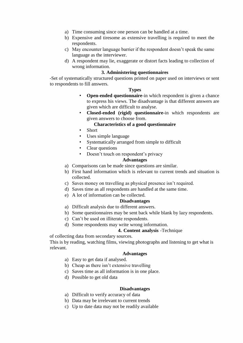
Direction

Wind direction is determined using wind vane.
How It Works
As the wind blows the arrow swings.
• The arrow points in the opposite direction of the wind flow.
• The direction is read from the cardinal compass points.
• The arrow will point in the direction from which the wind is blowing.
• For instance if it points S the wind is blowing from S towards N.
Wind Sock
-Used to indicate the general direction of wind flow.
-Not kept in a weather station because it doesn’t give the accurate direction of wind
flow.
-Seen near airstrips for the benefit of pilots.
How it Works
• When wind blows the bas stretches out in the direction that the wind is blowing.
Wind speed/Velocity
-Measured using anemometer.
How It Works
When wind bows hemispherical cups rotate.

• The number of rotations is obtained from the metre on the lower part of the
anemometer.
• The units for measuring wind are called knots.
Atmospheric Pressure
-The force exerted by gases in the atmosphere on some area or body on the earths
surface.
-Measured using barometers of three types namely mercury, aneroid and Fortin
Barometers.
Mercury Barometer
How It Works
• Air exerts pressure on the mercury in the beaker.
• The height of mercury in the tube is proportional to the atmospheric pressure.
• The readings are taken in mmHg.
• Its 760mmHg at sea level
Advantage
Quite accurate
Disadvantage
1. Cumbersome to carry around.
2. Can be damaged quite easily while being carried
around. Aneroid Barometer -Measures changes in
atmospheric pressure.
How It Works
• Has air tight compartment (vacuum).
• Compartment expands when pressure decreases.
• It collapses when pressure increases.
• The movement is transmitted by lever to a pointer on a dial.
• The readings are in kg/cm3.
Evaporation
The rate and amount of evaporation is measured using piche and tank evaporimeters.
Piche Evaporimeter

• When there is a lot of sunshine water evaporates from the blotting paper.
• The level of water in the glass tube reduces.
• The rate and amount of evaporation is got by looking at the scale on the outside
of the glass tube.
• The units are in mm.
Tank Evaporimeter
How It Works
The tank with water is put in the open.
• Water evaporates when there is a lot of sunshine.
• Water in the tank reduces.
• The rate and amount of evaporation is got from calibrations in the inner side of
the tank in mm.
Cloud Cover
The amount of cloud cover is observed using eyes.
It’s given in oktas.
Okta=approximately 1/8 of sky is covered with clouds.
Weather Forecasting
-Prediction of the conditions of the atmosphere for a given place for a certain period.
Methods of Weather Forecasting
Traditional Methods -Prediction
of weather based on traditional beliefs and facts.
• Plants shedding leaves indicates period of drought.
• Safari ants indicate it will rain.
• Migration of butterflies also indicates it will rain.

• Croaking of frogs during dry season indicate its going to rain. Flowering of
certain plants indicates the onset of rainfall.
• Changes in the intensity of sunshine indicate its going to rain. Modern
Methods
-Prediction of weather using modern instruments and new technology of collecting,
transmitting, processing and analysing weather data. Instruments Used
1. Satellites-electronic devices which orbit the earth which collect and transmit
weather data which is interpreted by computers.
2. Radar-an instrument used to see cloud formation.
3. Sensors/radiosodes-instrument fixed on a balloon used to measure atmospheric
pressure, temperature and humidity.
4. Computers-electronic device used to store, analyse and display weather
information.
Significance/Importance of Weather Forecasting
1. Helps us to be aware of natural calamities related to weather before they occur
so as to take precautionary measures.
2. Guiding tourists on when to visit national parks.
3. Helps farmers to plan their activities such as planting, harvesting, etc.
4. Ensures air and water transport is carried out safely.
5. Helps sporting people to plan their training and competition schedules.
6. Helps people to plan many other activities such as mining, electricity
generation, holiday events, etc.
7. Helps fishing communities to plan their activities.
Factors Hindering Weather Forecasting
1. Lack of skilled man power due to limited training facilities.
2. Lack of modern equipment leading to wrong forecasts.
3. Natural calamities such as storms and earthquakes.
4. Extreme weather conditions which may damage or displace instruments.
5. Use of faulty instruments.
6. Human error.
7. Poor sitting of instruments.

STATISTICS
Statistics-numerical figures collected systematically and arranged for a particular
purpose.
Statistical data-information presented inform of numbers e.g.
1. No. of students in a school
2. Mean daily temperature of a place
3. Amount of milk produced daily from a farm 4. Amount of money earned
from exports annually.
Statistical methods-techniques of collecting, recording, analysing, presenting and
interpreting statistical data.
Significance of Statistics
Illustrates relationship between 2 or more varying quantities e.g. beans
production and acreage under cultivation.
Summarises geographical information which saves time and space.
Makes comparison between components e.g. province with the highest
number of people.
Prediction of future trends of weather and climate.
Prediction of natural disasters e.g. droughts and floods.
Planning for provision of social amenities e.g. hospitals and schools.
Types of Statistical Data primary Data
-First hand or original information from the field e.g.
Mean daily temperature from a weather station
Enumeration/census
Secondary/Derived Data
-2nd hand information available in stored sources compiled by other researchers e.g.
• Textbooks
• Reference books
• Maps
• Video/audio tapes
• Textbooks
• Newspapers
• Magazines
• Census reports
• Slides
• Census reports
Nature of Statistical Data
1. Discrete Data -Which
is given in whole numbers e.g.
16 elephants
1093 tonnes of wheat
2. Continuous Data
-Facts and figures which can take any value e.g.
• Fractions e.g.23 ¼
• Decimals e.g. 6.20 mm
• Values within range e.g. 0-30◦c
3. Grouped Data

-Which is non precise/exact but values range in groups e.g.
Age group Number of boys
15-19 32
20-24 8
Sources of Statistical Data
1. Primary Sources
-People or places which have 1st hand or original information. The
information can be collected by observation, measuring, counting,
photographing etc.
Advantages
• Give first hand information
• The information cant be got from other sources
2. Secondary sources
-Materials in which information collected by others was stored e.g. text books,
reference books, etc.
Methods of Collecting Data (statistical Techniques)
1. Observation
-Use of eyes to observe features or weather then information is recorded immediately
e.g. cloud cover, rocks, soil, land forms, vegetation, etc.
Advantages
Gives 1st hand information which is reliable. Relevant material to the
study is collected. Time saving since one doesn’t have to look for
data in many places. Disadvantages
a) Data on past activities isn’t available.
b) May be hindered by weather conditions e.g. mist and dust storms.
c) Ineffective for people with visual disabilities.
d) Tiresome and expensive as it involves a lot of travelling because physical
presence is required.
2. interviewing
-Gathering information from people by direct discussions then answers are
recorded. It may be face to face or on a telephone. A questionnaire prepared in
advance is used.
Guidelines
One should be polite
Warm and friendly
Respondents/ interviewees should be assured information is
confidential.
Respondent should not be interrupted when answering questions.
They should not be given clues but answers should come from them.
Advantages
Reliable first hand information is collected.
Interviewer can seek clarification incase of ambiguity of answers.
Can be used on illiterate.
Interviewer can gauge the accuracy of responses.
Disadvantages
a) Time consuming since one person can be handled at a time.
b) Expensive and tiresome as extensive travelling is required to meet the
respondents.
c) May encounter language barrier if the respondent doesn’t speak the same
language as the interviewer.
d) A respondent may lie, exaggerate or distort facts leading to collection of
wrong information.
3. Administering questionnaires
-Set of systematically structured questions printed on paper used on interviews or sent
to respondents to fill answers.
Types
• Open-ended questionnaire-in which respondent is given a chance
to express his views. The disadvantage is that different answers are
given which are difficult to analyse.
• Closed-ended (rigid) questionnaire-in which respondents are
given answers to choose from.
Characteristics of a good questionnaire
• Short
• Uses simple language
• Systematically arranged from simple to difficult
• Clear questions
• Doesn’t touch on respondent’s privacy
Advantages
a) Comparisons can be made since questions are similar.
b) First hand information which is relevant to current trends and situation is
collected.
c) Saves money on travelling as physical presence isn’t required.
d) Saves time as all respondents are handled at the same time.
e) A lot of information can be collected.
Disadvantages
a) Difficult analysis due to different answers.
b) Some questionnaires may be sent back while blank by lazy respondents.
c) Can’t be used on illiterate respondents.
d) Some respondents may write wrong information.
4. Content analysis -Technique
of collecting data from secondary sources.
This is by reading, watching films, viewing photographs and listening to get what is
relevant.
Advantages
a) Easy to get data if analysed.
b) Cheap as there isn’t extensive travelling
c) Saves time as all information is in one place.
d) Possible to get old data
Disadvantages
a) Difficult to verify accuracy of data
b) Data may be irrelevant to current trends
c) Up to date data may not be readily available

5. Measuring
-Determining distances, areas, height or depth using instruments and recording.
Distance can be estimated by pacing or taking steps of equal and unknown length.
6. Collecting Samples
-Getting a small part e.g. of soil, rock or vegetation to represent the whole to be used
to carry out tests in the laboratory.
7. Counting/census taking -Arithmetical
counting and recording.
8. Photographing -Capturing on film or
video and still photographs.
9. Digging
-Using tools such as hoe pick axe, spade or soil auger to get samples of soil and rocks.
10. Feeling and touching
-Using fingers to feel the surfaces of soils and rocks to get their textures.
11. sampling
-Examining by taking a sample -a part representing the whole (population). Types
of Sampling
1. Random Sampling
-Selection of members of a group haphazardly where every item has an equal chance
of being selected e.g. to select 5 students to go for a tour from a class:
• Class members write their names on pieces of paper
• They are folded and put in a basket
• The basket is shaken and fives papers are taken out
2. Systematic Sampling
-Selection of members of a sample from an evenly distributed phenomena at regular
intervals e.g. after every 10 items/members.
3. Stratified sampling
-Selection of members of a sample by breaking the population into homogenous groups
e.g. to select 6 students to go for a tour:
• Break the class into boys and girls
• Select 3 student from each group by random or systematic sampling Combine
units from each group to form the required sample.
4. Cluster Sampling
-Selection of sample by dividing the sample into clusters with similar characteristics
then a sample is taken from each cluster and representative choices from each cluster
are combined to form a sample e.g. to sample the housing cost an estate is chosen to
represent each group and representative choices are chosen from each estate and
combined to form a sample.
Advantages
a) It’s less expensive
b) It saves time
c) It avoids bias
Disadvantages
a) A poor selected sample can lead to misleading information
b) Systematic sampling to an evenly distributed population
Experimentation
–Conducting a test or investigation to provide evidence for or against a theory e.g.
to determine the chemical composition of rocks and soils.

Advantages
a) First hand data is obtained
b) Gives accurate results if properly conducted.
c) It can lead to further discoveries
Disadvantages
a) May be expensive as it involves use of expensive equipment.
b) May be time consuming
c) Use of defective instruments may lead to inaccurate results
d) Improper handling of equipment and chemicals may lead to accidents
Methods of Recording Data -Methods off storing information to avoid losing it.
1. Note Taking
-Writing in a note book what is being observed, answers during interviews and
then notes are compiled in school or office when writing report. 2. Filling In
Questionnaires
-Filling answers in questionnaires which are responses from a respondent by an
interviewer or respondent himself which he/she then sends back. 3. Tallying
-Making 4 vertical or slanting strokes and the 5th across the 4 to record data obtained
by counting or measuring similar items.
4. Tabulation
-Drawing of tables and filling in data systematically e.g. weather recording sheets.
Month J F M A M J J A S O N D
Temp(◦c) 24 24 23 22 19 17 17 18 19 20 22 23
Rainfall(mm) 109 122 130 76 52 34 28 38 70 108 121 120
5. Field Sketching
-Summarising information observed in the field by making a rough drawing of
landscape and labelling the essential information.
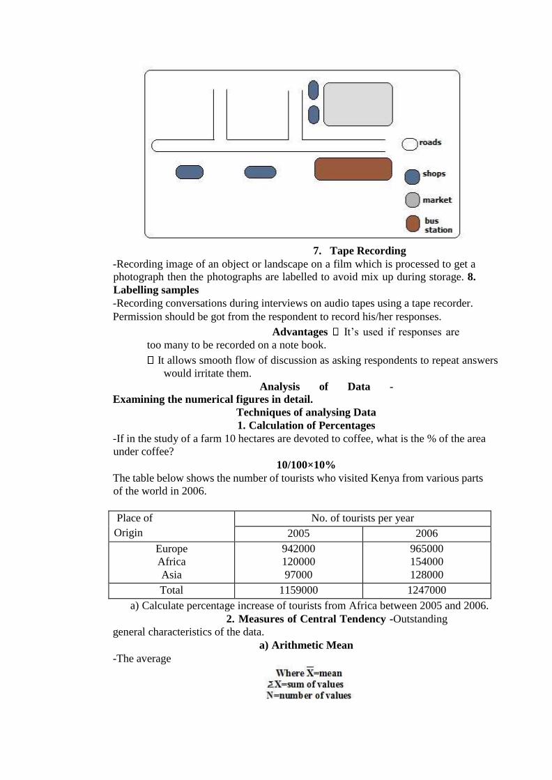
6. Mapping/Drawing Maps
-Drawing of a rough map of an area of study and labelling in words or symbols
accompanied by key.
7. Tape Recording
-Recording image of an object or landscape on a film which is processed to get a
photograph then the photographs are labelled to avoid mix up during storage. 8.
Labelling samples
-Recording conversations during interviews on audio tapes using a tape recorder.
Permission should be got from the respondent to record his/her responses.
Advantages It’s used if responses are
too many to be recorded on a note book.
It allows smooth flow of discussion as asking respondents to repeat answers
would irritate them.
Analysis of Data -
Examining the numerical figures in detail.
Techniques of analysing Data
1. Calculation of Percentages
-If in the study of a farm 10 hectares are devoted to coffee, what is the % of the area
under coffee?
10/100×10%
The table below shows the number of tourists who visited Kenya from various parts
of the world in 2006.
Place of
Origin
No. of tourists per year
2005 2006
Europe
Africa
Asia
942000
120000
97000
965000
154000
128000
Total 1159000 1247000
a) Calculate percentage increase of tourists from Africa between 2005 and 2006.
2. Measures of Central Tendency -Outstanding
general characteristics of the data.
a) Arithmetic Mean
-The average

Advantages
• Easy to calculate for a small data
• Summarises data using a single digit
• Easy to understand and interpret
Disadvantages
• Difficult to calculate for grouped data Affected
by extreme values
b) Median
-The middle value in a set of data arranged in order. M=
(N+1)/2
(I) 20, 50, 90, 100, 150, 180, 200, 220, 240, 300, 360.
(II) 20, 50, 90, 100, 150, 180, 200, 220, 240, 300.
Advantages
• Easy to calculate in a small data set Easy to
understand as it’s the value at the middle
Disadvantages
• Difficult to calculate in a large data set Doesn’t
show data distribution
b) Calculation of Ranges
-Difference between the largest and smallest values. Calculate the range of for the data
above.
c) Mode
-Most frequently recurring value in a set of data.
10, 2, 5, 9, 10, 11, 20, 15, 18, 10. The
mode is 10.
Advantages
• Easy to find as no calculation is involved Easy
to understand
Disadvantage
• Rarely used as a measure of central tendency
Statistical Presentation of Data
FIELD WORK
-Scientific study of geography using the environment as a laboratory or source of
information.
Types of Field Work
1. Field Excursion
-Visiting an area near or far from the school to see geographical phenomena then note
down and discuss later in class.
Aim
a) Reinforce what has been learnt in class
b) Gain more geographical knowledge
c) Identify and appreciate geographical features
d) Identify problems of geographical interest 2. Field Research
-Systematic problem solving done by experts in which scientific methods of collecting,
recording and analysing data are used.
3. Field Study
-Study conducted within a neighbourhood in which one theme is pursued e.g. ‘A study
of a local farm’.
Importance of Field Work
1. Reinforces what has been learnt in class.
2. Enables one to gain more geographical knowledge.
3. It breaks the monotony of classroom work.
4. It provides learner with practical skills of collecting, recording and analysing
data and report writing.
5. Gives students an opportunity to go out and practise what they have learnt in
class.
6. Enables students to familiarise themselves with the environment and develop a
positive attitude towards it.
7. Enables students to develop a positive attitude towards manual work.
8. Promotes development of virtues like cooperation by working in groups.
Field Work Procedure (Steps Followed)
1. Identification of
Topic/Theme
-Reason why you want to carry out field study e.g. ‘A study of rocks around the school’
2. Identification of the
Area of Study -Determining the area to be used for
study.
-Should be chosen carefully to ensure that the field study is successful.
Conditions It Should Meet
a) Should contain sufficient information
b) Should be within a convenience distance to reduce expenses
3. Statement of Objectives -Stating
aims of carrying the field study.
-Act as guidelines to activities to be undertaken during field work.
They should be simple, brief, testable and achievable. E.g. for the topic ‘A study of a
local farm’ objectives could be stated as follows:
• To find out methods of farming in a local farm To identify the cattle
breeds in the farm
• To investigate the problems facing the farm.
4. Formulation of Hypotheses
-Assumptions set before field work whose validity or acceptance is to be proved.
Types of Hypotheses
• Null Hypothesis (Ho)
-One stated in negative form e.g. ‘There is no relationship between rainfall and crop
yield’.
• Alternative/Substantive hypothesis (H1)
-One stated positively e.g. ‘most foodstuffs sold in the neighbourhood don’t come from
the immediate neighbourhood’.
Quantitative words should be used e.g. more, most, majority. It should not be obvious.
5. Preparation of the Field Study
It involves:
a) Seek Permission from Relevant Authorities -
Seeking permission from school and authority in the area you are visiting.
It is important to:
• To avoid being denied permission to enter there
• Enables individuals to set early the suitable date and time of visit
• Helps to arrange for a guide to conduct you around
b) Conduct Reconnaissance (Pre-Visit) -
A familiarisation tour of the intended area of study. It is important
to:
• To determine appropriate routes to be taken
• Enables to get documents from officials
• Helps one to identify the appropriate methods of data collection
• Helps to identify appropriate equipment to be used
c) Hold Discussion In Class -
Looking through formulated objectives and hypotheses. It’s
important to:
• Determine their suitability
• Make adjustments
• Decide upon data recording methods
d) Preparation of a Questionnaire
-Important where the interviewer is not able to be with respondents for a long time.
e) Dividing Into Groups
• To ease congestion in the area of study
• To create order during field work
• To reduce fatigue among participants
• To help participants collect data within the time given
f) Preparation for Documents
• Topographical maps to show the routes you will follow
• Tables for filling in information
• Permission documents
g) Reading Through Relevant Books
-Reading about the topic and the area of study
Important in that it helps participants to know:
• The kind of data they need to collect
• The techniques to be employed in the field.
h) Preparation of a Work Schedule -A
timetable to be followed on the day of field study.

It is important to:
• Indicate the specific time when each activity should take place
• Reduce time wastage by ensuring proper time management
• Ensure all important areas are covered and none is forgotten
• Provide an estimate of total time required for study
i) Selection of Important Tools and Equipment -Tape
measure and rulers for measuring, pencils for drawing sketch maps, notebooks for
writing notes, polythene bag for sorting and carrying samples, cameras for taking
photographs, geological hammer getting rock samples and hoe for digging to get
soil samples, etc.
6. Carrying Out the Field Study
-Setting off to go to the area of study to look for data where techniques of collecting
and recording data are applied.
Follow Up Activities -After data is collected
and recorded it’s summarised in the following ways:
• Discussing the findings in class giving reports through group leaders
• Writing reports in essay form
• Calculation of percentages, means, medians and modes
• Laboratory testing of samples
• Presentation of data using methods such as graphs, pie charts, etc. Problems
Encountered in Field work
1. Language Barrier
-Inability to communicate due to the interviewer and the respondent not sharing the
same language or respondents may be illiterate and thus unable to fill questionnaire.
The problems are:
• Data may not be collected
• Illiterate people may give wrong answers while attempting questionnaires
• An interpreter may have to be engages who would be paid which would
raise costs.
• Answers may be distorted by the interpreter
2. Hostility
Those being approached to give answers may become harsh due to feeling
that their time is being wasted which would cause the field study to be
unsuccessful.
3. Dishonest Respondents
-Respondents giving wrong information due to suspicion fear of shame or superstition.
4. Bad Weather
Raining heavily making it impossible to proceed with data collection and
difficulty in movement.
Becoming very hot making participants uncomfortable and thus unable to
proceed with data collection smoothly.
Becoming misty or foggy causing invisibility problems.
5. Accidents in the Field
One may fall and get inured when walking on rugged areas.
Injuries may result when using tools to get samples by cutting using pangas or
knives and digging using hoes.
6. Attacks by Wild Animals

-Participants may encounter wild animals when carrying out the study in bushy areas
e.g. snakes which may bite them, rhinos which may charge at them, etc.
7. Inaccessibility
-physical barriers such as swamps, rivers without bridges, steep slopes and thick
vegetation may hinder participants from reaching areas with vital information.
MINERALS AND ROCKS
Minerals
-Inorganic substances occurring naturally at or below the earth’s surface.
Characteristics of Minerals
1. Different degrees of hardness e.g. some are very hard e.g. diamond while others are
very soft e.g. talc.
2. Some have atoms arranged in an orderly manner to form crystals e.g. quartz form a
6- sided prism.
3. Varying number of elements e.g. gold has one (Av) while quartz has 2 (SiO2).
4. Different abilities to allow light to pass through e.g. some are transparent, opaque
or translucent.
5. Specific colours e.g. gold is shiny yellow while copper is brown.
6. Have specific surface appearance (lustre) when they reflect light i.e. metallic
(shiny) or non-metallic (glass like).
7. Definite chemical composition or constant ratio of elements e.g. quartz has one
atom of silicon and two atoms of oxygen.
8. Tendency to break along certain lines or cleavage) e.g. flint has cleavage like that
of glass.
9. Different densities e.g. some are very heavy e.g. lead while others are light e.g.
silicate minerals.
10. Some minerals conduct electricity while others don’t e.g. copper conducts while
diamond doesn’t.
11. Some can be pressed into different shapes while others can’t e.g. copper is
malleable while flint isn’t.
Types of Minerals
Metallic minerals
Ferrous Minerals-limonite, magnetite, siderite and haematite.
Non-ferrous Minerals-copper, aluminium, gold, lead, etc.
Non-metallic Minerals-graphite, diamond, asbestos, coal, etc.
Energy minerals-petroleum, coal and uranium.
Rocks
-A consolidated material composed of grains of one or more minerals.
Classification of Rocks

1. Igneous Rocks
-Rocks formed when molten material from the earth’s interior cools and solidifies on
or beneath the earth’s surface.
Types of Igneous Rocks
a) Intrusive Igneous Rocks -Rocks formed
when magma cools and solidifies below the earth’s surface e.g. granite, diorite,
gabbro, peridotite.
-Have coarse texture as a result of slow cooling giving minerals more time to form large
crystals.
-Are classified further into two:
(i) Hypabyssal rocks- intrusive igneous rocks which are near the earth’s surface.
(ii) Plutonic rocks-intrusive igneous rocks which are deep below the surface.
b) Extrusive Igneous Rocks -Rocks
formed when lava solidifies on the earth’s surface.
-Have fine texture due to fast cooling giving minerals less time to collect together
to form larger crystals. They are of two types namely:
(i) Volcanic Ejecta -Extrusive
igneous rocks formed in the following ways:
• When ash and lava ejected from underground as they fall on the earth’s surface
e.g. pumice.
• When dust and ash ejected settle on the ground and get compressed to form a
rock e.g. tuff.
(ii) Lava Flows
-Extrusive igneous rocks formed when basic lava flows over a considerable distance
then cools and solidifies e.g. basalt and obsidian.
2. Sedimentary Rocks
-Rocks formed when particles of other rocks are laid down and compressed into
layers or when plant and animal remains are buried and compressed and
compacted.
• When they are laid down a layer is formed.
• As deposition continues additional layers are formed which compress the lower
layers into a hard mass.
Types of Sedimentary Rocks
a) Mechanically Formed
Sedimentary Rocks -Sedimentary rocks formed when weathered
igneous or metamorphic rocks are deposited and compacted e.g.
sandstone and shale.
b) Organically formed
Sedimentary Rocks -Sedimentary rocks formed when animal and
plant or animal remains are buried, compressed and compacted.
Classification of Organically Formed Sedimentary Rocks (i)
Calcareous rocks-rich in calcium carbonate e.g. chalk and limestone. Coral rocks
are formed from remains of sea polyps which extract lime from the sea, build
shells for protection, attach themselves to each other and rocks to live in colonies,
then die and shells to form coral rocks.
(ii) Ferruginous Rocks-rich in iron e.g. ironstone.
(iii) Siliceous Rocks-rich in silica e.g. diatomite.
(iv) Carbonaceous Rocks-rich in carbon e.g. coal.

c) Chemically formed Sedimentary Rocks -
Sedimentary rocks formed when materials dissolved in water chemically react
forming new substances then water evaporated leaving layers of those salts.
Classification of Chemically Formed Sedimentary Rocks
(i) Carbonates e.g. trona and dolomite
(ii) Sulphates-sulphate compounds
(iii)Chlorides e.g. halite (iv) Silicates e.g. flint
(v) Iron stones e.g. haematite and limonite.
3. Metamorphic Rocks
-Rocks which have changed their physical appearance and chemical properties as a
result of subjection to great heat and pressure e.g. Gneiss from granite
• Slate from clay
• Marble from limestone
• Quartzite from sandstones
Distribution of Major Rocks in Kenya
Eastern Kenya region
• The major rocks are metamorphic rocks e.g. marble in parts of Machakos and
schist and gneiss in parts of Kitui.
• Volcanic rocks in Yatta plateau and Kapiti plans.
• Sedimentary rocks e.g. limestone rocks used in Bamburi for cement
manufacturing.
Coastal Region
• Major rocks are sedimentary rocks e.g. limestone used in Bamburi for cement
manufacture.
• There are volcanic rocks in Tsavo rich in ground water resources. Northern
and N.E Region Dominated by sedimentary sands.
• There are volcanic rocks in Mt. Marsabit and around Rift Valley. Rift Valley
and Kenya Highlands
• Dominated by volcanic rocks
• There are metamorphic rocks which have resulted from changing of igneous
rocks.
L. Victoria Basin
• Granite and gneiss dominate Western Kenya where they form high rocky hills
called granitic tors common in Kisii, Maragoli and Bunyore areas.
• Sedimentary rocks deposited by rivers e.g. Nyando, Nzoia, Yala and Sondu.
Significance of Rocks
1. Rocks weather to form soil which is important in agriculture.
2. Form aquifers which store ground water which forms springs which form rivers
and wells which provide water for domestic and industrial use.
3. Some rocks are sources of building materials e.g. igneous rocks are used to make
ballast and limestone rocks are used as building blocks and raw material in cement
manufacturing.
4. Phosphate and nitrate rocks are used to make fertiliser used in agriculture.
5. Granitic tors of W. Kenya and high volcanic peaks such as those of Mt.
Kenya are a tourist attraction which brings foreign exchange.
6. Pumice is used as a scrubbing stone.
7. A rock such as coal is used as fuel for heating, smelting of iron and thermal
electricity generation.
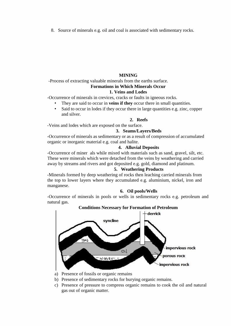
8. Source of minerals e.g. oil and coal is associated with sedimentary rocks.
MINING
-Process of extracting valuable minerals from the earths surface.
Formations in Which Minerals Occur
1. Veins and Lodes
-Occurrence of minerals in crevices, cracks or faults in igneous rocks.
• They are said to occur in veins if they occur there in small quantities.
• Said to occur in lodes if they occur there in large quantities e.g. zinc, copper
and silver.
2. Reefs
-Veins and lodes which are exposed on the surface.
3. Seams/Layers/Beds
-Occurrence of minerals as sedimentary or as a result of compression of accumulated
organic or inorganic material e.g. coal and halite.
4. Alluvial Deposits
-Occurrence of miner als while mixed with materials such as sand, gravel, silt, etc.
These were minerals which were detached from the veins by weathering and carried
away by streams and rivers and got deposited e.g. gold, diamond and platinum.
5. Weathering Products
-Minerals formed by deep weathering of rocks then leaching carried minerals from
the top to lower layers where they accumulated e.g. aluminium, nickel, iron and
manganese.
6. Oil pools/Wells
-Occurrence of minerals in pools or wells in sedimentary rocks e.g. petroleum and
natural gas.
Conditions Necessary for Formation of Petroleum
a) Presence of fossils or organic remains
b) Presence of sedimentary rocks for burying organic remains.
c) Presence of pressure to compress organic remains to cook the oil and natural
gas out of organic matter.
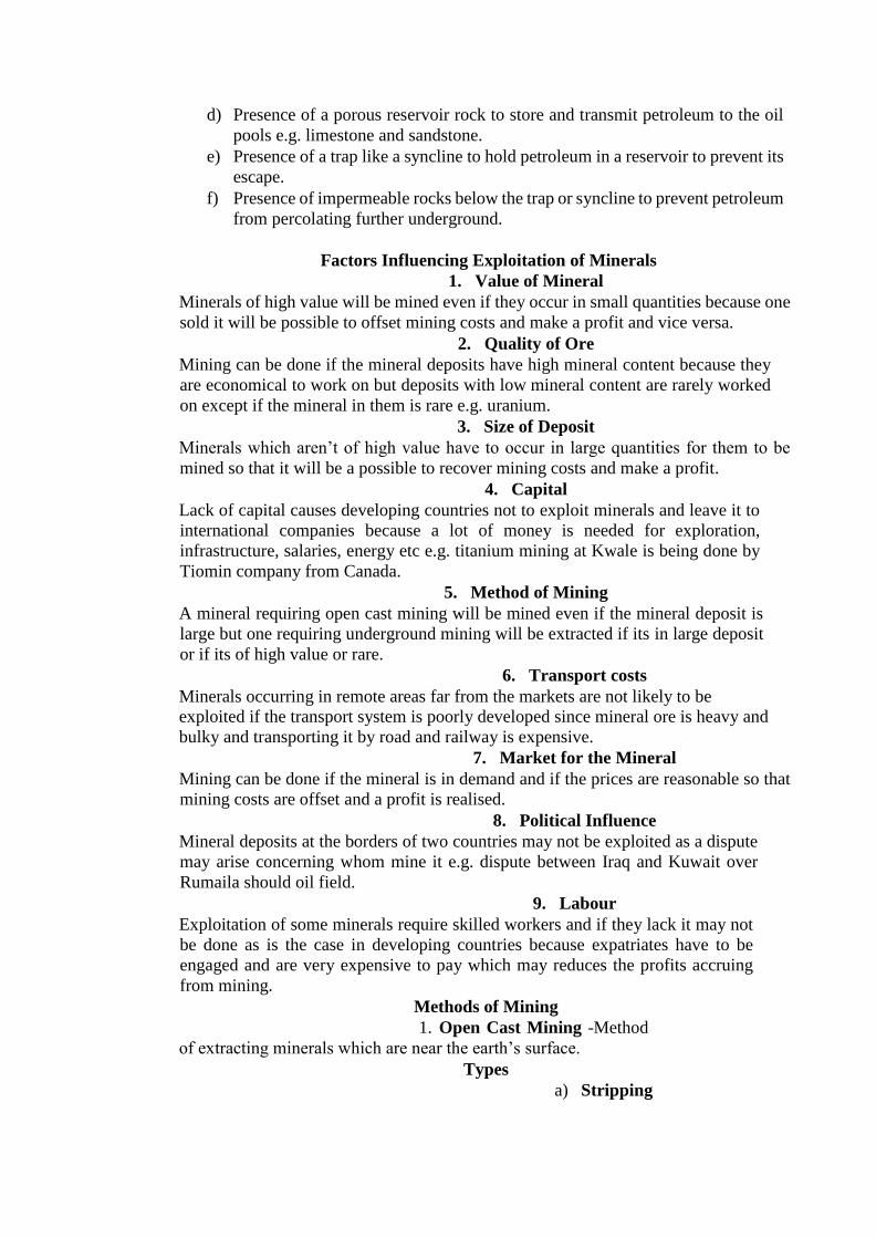
d) Presence of a porous reservoir rock to store and transmit petroleum to the oil
pools e.g. limestone and sandstone.
e) Presence of a trap like a syncline to hold petroleum in a reservoir to prevent its
escape.
f) Presence of impermeable rocks below the trap or syncline to prevent petroleum
from percolating further underground.
Factors Influencing Exploitation of Minerals
1. Value of Mineral
Minerals of high value will be mined even if they occur in small quantities because one
sold it will be possible to offset mining costs and make a profit and vice versa.
2. Quality of Ore
Mining can be done if the mineral deposits have high mineral content because they
are economical to work on but deposits with low mineral content are rarely worked
on except if the mineral in them is rare e.g. uranium.
3. Size of Deposit
Minerals which aren’t of high value have to occur in large quantities for them to be
mined so that it will be a possible to recover mining costs and make a profit.
4. Capital
Lack of capital causes developing countries not to exploit minerals and leave it to
international companies because a lot of money is needed for exploration,
infrastructure, salaries, energy etc e.g. titanium mining at Kwale is being done by
Tiomin company from Canada.
5. Method of Mining
A mineral requiring open cast mining will be mined even if the mineral deposit is
large but one requiring underground mining will be extracted if its in large deposit
or if its of high value or rare.
6. Transport costs
Minerals occurring in remote areas far from the markets are not likely to be
exploited if the transport system is poorly developed since mineral ore is heavy and
bulky and transporting it by road and railway is expensive.
7. Market for the Mineral
Mining can be done if the mineral is in demand and if the prices are reasonable so that
mining costs are offset and a profit is realised.
8. Political Influence
Mineral deposits at the borders of two countries may not be exploited as a dispute
may arise concerning whom mine it e.g. dispute between Iraq and Kuwait over
Rumaila should oil field.
9. Labour
Exploitation of some minerals require skilled workers and if they lack it may not
be done as is the case in developing countries because expatriates have to be
engaged and are very expensive to pay which may reduces the profits accruing
from mining.
Methods of Mining
1. Open Cast Mining -Method
of extracting minerals which are near the earth’s surface.
Types
a) Stripping
-Stripping off of the unwanted material lying on top of the mineral deposit and then
digging to remove the mineral bearing rock if it’s soft or if it’s hard explosives may
be used to loosen it and then huge power shovels are employed to dig up the mineral
deposits.
b) Hill-slope Boring
-Using boring instruments known as augers to drill out mineral deposit and bring it to
the surface.
2. underground Mining
-Method employed when the mineral lies very deep below the surface and the
overburden is too thick to be removed by mechanical means.
Types
a) Shaft Method
-Method employed when the mineral bearing rock doesn’t out crop.
How it’s carried Out Vertical shafts are sunk
into the earth’s crust to reach the layer with the mineral.
• Horizontal tunnels are dug from the vertical shaft to reach the mineral.
• Props are erected to support the roof to prevent it from collapsing.
• The mineral bearing rock is blasted loose by explosives.
• The deposit is transported on light rail or conveyor belt to the bottom of the
shaft.
• It is then brought to the surface in a crane or a lift called cage.
a) Drift/Adit Mining
-Method employed when the mineral deposit can be reached from the valley sides.
• Horizontal tunnels (adits) are constructed from the side of the hill.
• Railway line is constructed into the mine to bring out the mineral e.g.
mining of copper at Kilembe in Uganda.
b) Solution Method
-Method used in mining soluble minerals such as sulphur, salt, potash, etc.
• Superheated water is ejected into salt deposits.
• The mineral dissolves or melts.
• The solution is then pumped into the surface.
c) Drilling -Method
employed in exploitation of petroleum.
• Wells (oil derricks) are drilled.
• Oil and natural gas are brought to the surface under their own pressure or by
pumping.
3. Alluvial/Placer Mining
-Method used to extract minerals occurring in alluvial deposits e.g. gold, tin, diamonds
and platinum.
Types
a) Panning
It involves:
• Digging a mixture of sand, gravel and mineral from the river bed.
• Putting it in a pan and rotating the pan while tilted.
• The lighter sand or gravel is washed on the side leaving the heavier mineral at
the bottom of the pan e.g. gold mining in Migori and R. Morun Beds in W.
Pokot.
b) Dredging
• A dredger scoops water logged alluvium from the bed of a lake.
• The alluvium is passed over sloping channels with series of traps.
• Wastes are washed away and denser materials are left at the bottom of the trap
e.g. mining of soda ash at L. Magadi.
c) Hydraulic Mining -Method
used when alluvial deposit occurs on a valley side.
• A powerful jet of water is directed at the deposit.
• Gravel and mineral collect at the valley because of the great pressure.
• The mineral grains are recovered and washed out.
d) Sub-marine Mining
-Method employed in extracting minerals in alluvial deposits lying deep down the ocean
floor.
• A sub-marine dredger goes down the ocean floor.
• It scoops mineral deposit and rises to the surface.
• The alluvium is passed over sloping channels with series of traps.
• Wastes are washed away and denser materials are left at the bottom of the trap.
Significance of Minerals/Mining in Kenya
1. Kenya earns foreign exchange from exportation of minerals which is used to
import goods and services and fund development projects.
2. Mining is a source of employment to people such as those who work in mines,
in cement factories, in transport sector, etc.
3. Mining has led to development of industries by providing raw materials used in
those industries e.g. limestone used in cement factories, coal used in iron and
steel industries, soda ash used in glass industry, etc.
4. Mining has led to development of transport system to make mining areas
accessible e.g. Magadi soda mine is connected to the main Mombasa-Nairobi
railway line.
5. Mining has led to development of settlements e.g. Magadi town which originated
from the mining of soda ash.
6. Mining is a source of market for goods and services e.g. there are shops and
markets, banking and insurance services offered to people working in mines and
related industries.

7. Has led to development of social amenities by providing social facilities such as
housing, health, electricity, water and education alongside infrastructure.
Distribution of Minerals in E. Africa
Phosphates used in the manufacture of fertiliser-Tororo in Uganda and Majingu Hill
in Tanzania.
Limestone used in cement manufacturing-Hima in N.W Uganda, Tanga in Tanzania,
Athi River and Bamburi in Kenya.
Fluorspar a source of fluorine used in chemical industries-Kerio Valley in Kenya.
Common salt used for consumption-Kilifi and Magadi in Kenya and L. Kitwe in
Uganda.
Diatomite used in making insulators –Kariandusi near Gilgil and Gicheru in
Nyandarua.
Stones in Machakos, Mutonga and Mbeere.
Carbon dioxide used in making dry ice and in beer and soft drinks industry- Esagari
in Baringo and Kagwe in Kiambu.
Diamond used to make ornaments, glass cutters and drills-Mwadui in Tanzania.
Titanium used in the manufacture of insulators for aircraft- Kwale district.
Gemstones near Voi and Mwatate.
Soapstone used for sculpture-Tabaka in Kisii.
Copper used to make electrical wires and coins-Kilembe in Uganda.
Gold used to make medals and jewellery and as a basis of world currency-Musoma in
Tanzania, Kakamega and Migori in Kenya.
coal used in smelting of iron and generation of thermal electricity-in Ruvuma River
Basin and Kivira Songwe in Tanzania.
Problems Facing Mining Industry in Kenya 1. Inadequate
capital making Kenya not to benefit from mineral resources because mining is left
to multinational companies who pocket all the money to recover mining cost.
2. Areas where mineral deposits are inaccessible due to poor transport and
infrastructure which makes prospecting and mining difficult.
3. Insufficient skilled personnel causing dependence on expatriates who are expensive
to pay which reduces profits accruing from mining.
4. Most of mining is controlled by foreign companies so most of the mineral revenue
ends up to them as salaries and dividends.
5. Occurrence of minerals in very small deposits which are not economically viable.
6. Lack of power supply especially in remote areas with minerals.
7. Land use conflicts which affect mining e.g. in Kwale between Tiomin and the local
people due to inadequate compensation.
Effect of mining on the Environment
1. Renders land useless for other economic activities such as agriculture
(dereliction) due to open pits left on land and heaps of rock waste litter dumped
on land.
2. Pollutes the environment e.g. atmospheric pollution from dust and smoke from
tractors and trucks, water pollution from spilling of oil from offshore oil drilling
and soil pollution from chemicals and explosives used in mining.
3. Leads to loss of bio-diversity due to destruction vegetation which also destroys
habitats of various animals leading to their destruction also.
4. Causes soil degradation e.g. by loosening the soil which makes it vulnerable to
agents of erosion like wind and water, tractors and trucks compact the soil
making water infiltration difficult and chemicals used interfering with soil
chemical composition making it unsuitable for agriculture.
5. Causes mass wasting when explosives and heavy equipment used in mining
shake the ground making weathered materials to move faster down slope under
the influence of gravity.
Trona mining on L. Magadi
Location
L.Magadi is 120km S.W of Nairobi on the floor of the Great Rift Valley. Occurrence
Trona deposits occur as a solution of sodium salts the main ones being sodium
sequicarbonate and sodium chloride.
Mode of Formation
• Rain water dissolves soda salts in volcanic rocks.
• The solution percolates through the rocks and soil and gets beneath the basin.
• The accumulated solution is heated by the hot rocks beneath.
• Pressure builds up and the heated solution is pushed to the surface.
• It comes out of the ground inform of hot springs below or on the sides of the
lake.
• Due to high temperature water evaporates leaving behind crystals of trona.
Extraction and Processing A dredger scoops trona out of the lake.
• It crushes it into smaller pieces and separates it from rock debris.
• The material is mixed with water to form slurry and transported to factory on
the lake’s shore.
• In the factory the slurry is mixed with water to wash out impurities such as mud
and salt and dried.
• It is sent to desiccators and heated to remove moisture and hydrogen to form
soda ash.
• Soda ash is cooled and ground into powder and sieved.
• It’s packed into paper bags, weighed and transported to the market.
Uses of Soda ash Used
in the:
a) Glass industry in the manufacture of glasses and bottles.
b) Manufacture of soaps and detergents.
c) Softening water in paper making.
d) In textile industry.
e) In oil refining.
Benefits to the Economy
1. Has led to growth of Magadi town ship.
2. Has led to development of social amenities such as hospitals and schools and water
from Oloibortoto River which has benefited the local people.
3. Has led to development of infrastructure e.g. railway line from Konza to L. Magadi.
12. The Magadi Soda Company employs many Kenyans including the nomadic Maasai.
13. Exports of soda ash earn Kenya a substantial amount of foreign exchange.
Problems
1. Stiff competition from developed countries with large soda deposits e.g. U.S.A and
Israel.
2. Low value of salt is insufficient to meet its production cost.
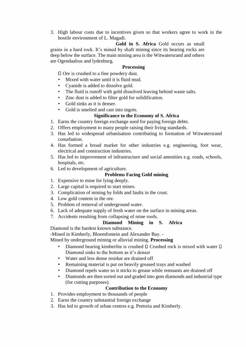
3. High labour costs due to incentives given so that workers agree to work in the
hostile environment of L. Magadi.
Gold in S. Africa Gold occurs as small
grains in a hard rock. It’s mined by shaft mining since its bearing rocks are
deep below the surface. The main mining area is the Witwatersrand and others
are Ogendaalrus and lydenburg.
Processing
Ore is crushed to a fine powdery dust.
• Mixed with water until it is fluid mud.
• Cyanide is added to dissolve gold.
• The fluid is runoff with gold dissolved leaving behind waste salts.
• Zinc dust is added to filter gold for solidification.
• Gold sinks as it is denser.
• Gold is smelted and cast into ingots.
Significance to the Economy of S. Africa
1. Earns the country foreign exchange used for paying foreign debts.
2. Offers employment to many people raising their living standards.
3. Has led to widespread urbanisation contributing to formation of Witwatersrand
conurbation.
4. Has formed a broad market for other industries e.g. engineering, foot wear,
electrical and construction industries.
5. Has led to improvement of infrastructure and social amenities e.g. roads, schools,
hospitals, etc.
6. Led to development of agriculture.
Problems Facing Gold mining
1. Expensive to mine for lying deeply.
2. Large capital is required to start mines.
3. Complication of mining by folds and faults in the crust.
4. Low gold content in the ore.
5. Problem of removal of underground water.
6. Lack of adequate supply of fresh water on the surface in mining areas.
7. Accidents resulting from collapsing of mine roofs.
Diamond Mining in S. Africa
Diamond is the hardest known substance.
-Mined in Kimberly, Bloemfontein and Alexander Bay. -
Mined by underground mining or alluvial mining. Processing
• Diamond bearing kimberlite is crushed Crushed rock is mixed with water
Diamond sinks to the bottom as it’s denser
• Water and less dense residue are drained off
• Remaining material is put on heavily greased trays and washed
• Diamond repels water so it sticks to grease while remnants are drained off
• Diamonds are then sorted out and graded into gem diamonds and industrial type
(for cutting purposes).
Contribution to the Economy
1. Provides employment to thousands of people
2. Earns the country substantial foreign exchange
3. Has led to growth of urban centres e.g. Pretoria and Kimberly.
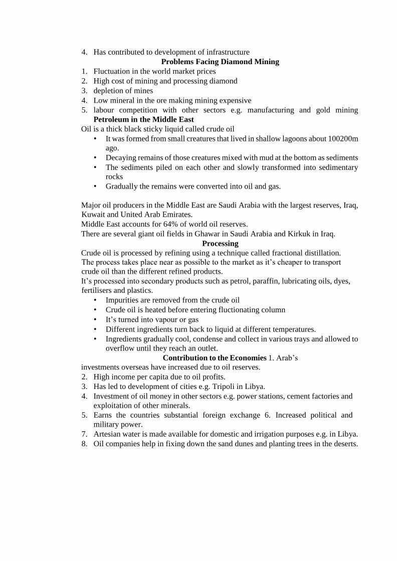
4. Has contributed to development of infrastructure
Problems Facing Diamond Mining
1. Fluctuation in the world market prices
2. High cost of mining and processing diamond
3. depletion of mines
4. Low mineral in the ore making mining expensive
5. labour competition with other sectors e.g. manufacturing and gold mining
Petroleum in the Middle East
Oil is a thick black sticky liquid called crude oil
• It was formed from small creatures that lived in shallow lagoons about 100200m
ago.
• Decaying remains of those creatures mixed with mud at the bottom as sediments
• The sediments piled on each other and slowly transformed into sedimentary
rocks
• Gradually the remains were converted into oil and gas.
Major oil producers in the Middle East are Saudi Arabia with the largest reserves, Iraq,
Kuwait and United Arab Emirates.
Middle East accounts for 64% of world oil reserves.
There are several giant oil fields in Ghawar in Saudi Arabia and Kirkuk in Iraq.
Processing
Crude oil is processed by refining using a technique called fractional distillation.
The process takes place near as possible to the market as it’s cheaper to transport
crude oil than the different refined products.
It’s processed into secondary products such as petrol, paraffin, lubricating oils, dyes,
fertilisers and plastics.
• Impurities are removed from the crude oil
• Crude oil is heated before entering fluctionating column
• It’s turned into vapour or gas
• Different ingredients turn back to liquid at different temperatures.
• Ingredients gradually cool, condense and collect in various trays and allowed to
overflow until they reach an outlet.
Contribution to the Economies 1. Arab’s
investments overseas have increased due to oil reserves.
2. High income per capita due to oil profits.
3. Has led to development of cities e.g. Tripoli in Libya.
4. Investment of oil money in other sectors e.g. power stations, cement factories and
exploitation of other minerals.
5. Earns the countries substantial foreign exchange 6. Increased political and
military power.
7. Artesian water is made available for domestic and irrigation purposes e.g. in Libya.
8. Oil companies help in fixing down the sand dunes and planting trees in the deserts.