FLUVIAL DYNAMICS AND WATERMILLS LOCATION IN … · Fluvial dynamics and water mills location in...
11
ABSTRACT: GRANO M.C., DEL MONTE M., LAZZARI M. & BISHOP P., Fluvial dynamics and water mills location in Basilicata (Southern Italy) . (IT ISSN 0391-9839, 2016) Watermills (grain mills, waulk mills, olive mills, sawmills and threshing machines) operated in the Basilicata Region from the Roman Period until the early decades of the twentieth century, representing an important feature of waterways that is today almost totally forgotten. Us- ing documentary sources, ancient maps and field survey it is possible to catalogue and identify the location of these ancient hydraulic structures. Watermills were usually placed far enough away from the river to avoid inundation during floods, and near natural knickpoints or artificial steps in the river long profile that were created by mill engineers. Mill con- struction often had significant impacts on a river morphology, because it was necessary to divert the river discharge towards the mill wheel, to drive the grain-grinding mechanism. Watermill typological variations have been examined in relation to variations in river pattern to assess the ways in which the hydrographic and hydrological settings of the Ba- silicata Region have affected mill siting and operation. Most Basilicata watermills were built with a horizontal water-wheel and a tower. The characteristics of the tower and the associated hydraulic structures var- ied according to the environmental setting. Finally, mill positions de- fine also the locations on the river system that have already been used to exploit hydraulic power and thus could be useful for future use in the micro-hydroelectric sector KEY WORDS: Fluvial Geomorphology, Water Power, Historical Car- tography, Floods, Basilicata, Southern Italy. RIASSUNTO: GRANO M.C., DEL MONTE M., LAZZARI M. & BISHOP P., Dinamica fluviale e ubicazione degli opifici idraulici in Basili- cata (Italia meridionale). (IT ISSN 0391-9839, 2016) Gli opifici idraulici (mulini per macinare il grano, gualchiere per fol- lare la lana, frantoi per pressare le olive, segherie e trebbiatrici ad acqua) sono stati attivi in Basilicata dall’età romana fino ai primi decenni del ventesimo secolo, rappresentando un‘importante caratteristica struttura- le di molti corsi d’acqua, oggi quasi completamente dimenticata. Attra- verso lo spoglio documentario, lo studio di antiche mappe e i sopralluo- ghi sul campo è possibile catalogare e localizzare queste antiche strutture idrauliche. Tutti gli opifici ad acqua erano generalmente posizionati ad una certa distanza dal corso d’acqua, tale da non essere colpiti da inon- dazioni, e vicino a knickpoint nel profilo longitudinale del fiume o a salti artificiali, realizzati dai costruttori dei mulini. La costruzione dei mulini ha avuto impatti significativi sulla morfologia fluviale, poiché era neces- sario deviare la portata del fiume verso la ruota idraulica, per mezzo di canali artificiali. Le variazioni tipologiche degli opifici idraulici della Basilicata sono state esaminate in relazione alle variazioni delle caratteristiche fluviali, per valutare i modi in cui l’assetto idrografico ed idrologico dei fiumi hanno condizionato l’attività e il posizionamento dei mulini sul territo- rio. La maggior parte dei mulini lucani era costruito con la ruota idrau- lica orizzontale ed una torre di altezza variabile. Le caratteristiche delle torre e delle strutture idrauliche associate al mulino variano in funzione del contesto ambientale. Infine, la posizione dei mulini definisce anche i possibili punti del sistema fluviale da utilizzare per lo sfruttamento della potenza idraulica e che potrebbero essere utili oggi per impostare nuove centrali micro-idroelettriche. TERMINI CHIAVE: Geomorfologia fluviale, Opifici idraulici, Carto- grafia storica, Alluvioni, Basilicata, Italia meridionale INTRODUCTION This work is part of a wider research project on Basil- icata Cultural Landscapes (Gabrielli & alii, 2014), defined as ‘‘an area, as perceived by people, whose character is the result of the action and interaction of natural and/or human factors [and which has evolved as] a result of be- ing acted upon by natural forces and human beings [and (*) Sapienza University of Rome, Earth Science Department, Italy (**) Consiglio Nazionale delle Ricerche, Istituto per i Beni Archeolo- gici e Monumentali (CNR-IBAM), Contrada Santa Loja, 85050 Tito Scalo (Potenza), Italy (***) University of Glasgow, Scotland. Corresponding authors: [email protected]; [email protected] We thank the architect Agnese Ricigliano for the drawings in figure 1 B-C. We are also grateful to the Restor-Hydro project manager for permis- sion to include the results of our research in the European dataset, published online on http://www.restor-hydro.eu/en/tools/mills-map/. The research has been supported by funds of CNR IBAM (Resp. Maurizio Lazzari). Paul Bishop’s visit to Basilicata was funded by the Erasmus scheme via the Uni- versity of Glasgow. Geogr. Fis. Dinam. Quat. DOI 10.4461/GFDQ.2016.39.14 39 (2016). 149-160, 11 figg. MARIA CARMELA GRANO (*) (**), MAURIZIO DEL MONTE (**), MAURIZIO LAZZARI (*) & P AUL BISHOP (***) FLUVIAL DYNAMICS AND WATERMILLS LOCATION IN BASILICATA (SOUTHERN ITALY)
Transcript of FLUVIAL DYNAMICS AND WATERMILLS LOCATION IN … · Fluvial dynamics and water mills location in...

AbstrAct: Grano M.C., Del Monte M., lazzari M. & Bishop p., Fluvial dynamics and water mills location in Basilicata (Southern Italy). (IT ISSN 0391-9839, 2016)
Watermills (grain mills, waulk mills, olive mills, sawmills and threshing machines) operated in the Basilicata Region from the Roman Period until the early decades of the twentieth century, representing an important feature of waterways that is today almost totally forgotten. Us-ing documentary sources, ancient maps and field survey it is possible to catalogue and identify the location of these ancient hydraulic structures. Watermills were usually placed far enough away from the river to avoid inundation during floods, and near natural knickpoints or artificial steps in the river long profile that were created by mill engineers. Mill con-struction often had significant impacts on a river morphology, because it was necessary to divert the river discharge towards the mill wheel, to drive the grain-grinding mechanism. Watermill typological variations have been examined in relation to variations in river pattern to assess the ways in which the hydrographic and hydrological settings of the Ba-silicata Region have affected mill siting and operation. Most Basilicata watermills were built with a horizontal water-wheel and a tower. The characteristics of the tower and the associated hydraulic structures var-ied according to the environmental setting. Finally, mill positions de-fine also the locations on the river system that have already been used to exploit hydraulic power and thus could be useful for future use in the micro-hydroelectric sector
Key words: Fluvial Geomorphology, Water Power, Historical Car-tography, Floods, Basilicata, Southern Italy.
riAssunto: GRANO M.C., DEL MONTE M., LAZZARI M. & BISHOP P., Dinamica fluviale e ubicazione degli opifici idraulici in Basili-cata (Italia meridionale). (IT ISSN 0391-9839, 2016)
Gli opifici idraulici (mulini per macinare il grano, gualchiere per fol-lare la lana, frantoi per pressare le olive, segherie e trebbiatrici ad acqua) sono stati attivi in Basilicata dall’età romana fino ai primi decenni del ventesimo secolo, rappresentando un‘importante caratteristica struttura-le di molti corsi d’acqua, oggi quasi completamente dimenticata. Attra-verso lo spoglio documentario, lo studio di antiche mappe e i sopralluo-ghi sul campo è possibile catalogare e localizzare queste antiche strutture idrauliche. Tutti gli opifici ad acqua erano generalmente posizionati ad una certa distanza dal corso d’acqua, tale da non essere colpiti da inon-dazioni, e vicino a knickpoint nel profilo longitudinale del fiume o a salti artificiali, realizzati dai costruttori dei mulini. La costruzione dei mulini ha avuto impatti significativi sulla morfologia fluviale, poiché era neces-sario deviare la portata del fiume verso la ruota idraulica, per mezzo di canali artificiali.
Le variazioni tipologiche degli opifici idraulici della Basilicata sono state esaminate in relazione alle variazioni delle caratteristiche fluviali, per valutare i modi in cui l’assetto idrografico ed idrologico dei fiumi hanno condizionato l’attività e il posizionamento dei mulini sul territo-rio. La maggior parte dei mulini lucani era costruito con la ruota idrau-lica orizzontale ed una torre di altezza variabile. Le caratteristiche delle torre e delle strutture idrauliche associate al mulino variano in funzione del contesto ambientale. Infine, la posizione dei mulini definisce anche i possibili punti del sistema fluviale da utilizzare per lo sfruttamento della potenza idraulica e che potrebbero essere utili oggi per impostare nuove centrali micro-idroelettriche.
termini chiAve: Geomorfologia fluviale, Opifici idraulici, Carto-grafia storica, Alluvioni, Basilicata, Italia meridionale
INTRODUCTION
This work is part of a wider research project on Basil-icata Cultural Landscapes (Gabrielli & alii, 2014), defined as ‘‘an area, as perceived by people, whose character is the result of the action and interaction of natural and/or human factors [and which has evolved as] a result of be-ing acted upon by natural forces and human beings [and
(*) Sapienza University of Rome, Earth Science Department, Italy(**) Consiglio Nazionale delle Ricerche, Istituto per i Beni Archeolo-
gici e Monumentali (CNR-IBAM), Contrada Santa Loja, 85050 Tito Scalo (Potenza), Italy
(***) University of Glasgow, Scotland.
Corresponding authors: [email protected]; [email protected]
We thank the architect Agnese Ricigliano for the drawings in figure 1 B-C. We are also grateful to the Restor-Hydro project manager for permis-sion to include the results of our research in the European dataset, published online on http://www.restor-hydro.eu/en/tools/mills-map/. The research has been supported by funds of CNR IBAM (Resp. Maurizio Lazzari). Paul Bishop’s visit to Basilicata was funded by the Erasmus scheme via the Uni-versity of Glasgow.
Geogr. Fis. Dinam. Quat. DOI 10.4461/GFDQ.2016.39.1439 (2016). 149-160, 11 figg.
Maria CarMela Grano (*) (**), Maurizio Del Monte (**), Maurizio lazzari (*)& paul Bishop (***)
FLUVIAL DYNAMICS AND WATERMILLS LOCATION IN BASILICATA(SOUTHERN ITALY)

150
that] landscape forms a whole when natural and cultural components are taken together not separately” (Europe-an Landscape Convention, 2000; Roe, 2007a; 2007b). The project is aimed at recovery of historical knowledge of the area through the analysis of the agricultural and rural his-toric landscape, the natural (geological/geomorphological) landscape, the structural components (architectural, his-torical, heritage, farms, mills, millstones etc.), and the ar-tistic, iconographic and literary elements. Among the rural historical structures, particular attention has been focused on watermills, developing the sub-project MuliLù (MULI-ni LUcani or Lucanian water mills).
This project aims at the creation of a census of historic hydraulic structures, verification of cartographic and docu-mentary sources, field checking of the status of watermills’ conservation, development of recovery proposals and en-hancement of historic hydraulic structures, development of economic policies through the re-use and conversion of hy-draulic structures to hydroelectric power plants, entry into the Restor-Hydro European network (www.restor-hydro.eu), the realization of cultural activities, and active involve-ment of the population.
During the last decade of 19th century in Basilicata (Lucania), there were 642 cereal grinding watermills, 57 waulking mills (Italian gualchiera), 3 olive presses (Italian frantoio), 15 threshing machines (Italian trebbiatrice), 1 saw-mill (Italian segheria) and 1 machine for copper processing (Italian ramiera) (Grano & Lazzari 2016). Hundreds of wa-termills in Basilicata, for the most part located in hill and mountain areas, have been catalogued and georeferenced using documentary sources, ancient maps, and field sur-veys. Watermills represent an anthropic component of the landscape, typifying the territorial use and transformation processes over centuries.
AIMS
A preliminary aim of the work presented here is to lo-cate watermills, and to study changes in mill location over centuries, assessing river process and analysing the ways in which river discharge and stream order might have figured in the siting and technology of mills. Achieving this aim is complicated by the fact that many archival documents describe watermills using the owner’s name, which could of course be changed over time. Unfortunately, archival documents do not contain coordinates or place names (toponyms) of mill location, which were introduced only in the 19th century maps. Moreover, each watermill may have been used over time for different purpose (such as for mill-ing grain or waulking). It is also common for the original mill building and channel structures to have been modi-fied and/or replaced several times, as is described in some ancient documents. The aim of locating watermills in space is supplemented by a study of changes in mill location over the centuries, especially in relation to the interaction be-tween mill siting and technology and river process, river discharge and stream order (Strahler, 1957). Other goals of this research are inherent in an examination of the geomor-phological features of mill location, assessing:
1) mill position within the drainage network; 2) channel steepness upstream and downstream of the
mill; 3) the relationships and interaction between the hydraulic
structures and fluvial hazard, often influenced by mill abandonment (Downward & Skinner, 2005);
4) the role of the mills’ associated hydraulic systems, such as dams, weirs, dykes, sluices, mill channels, in limiting flooding and erosional events along the valley bottom and protecting territory;
5) the various issues of mill management with reference to case examples of mill modifications, and with an em-phasis on contrasting rivers.
Finally, considering that water mill location defines localities in the drainage net that have been used in the past for the exploitation of hydraulic power, a map of Basilicata hydraulic structures represents preliminary data for planning investment in the micro-hydroelec-tric energy sector. The possibility and economic value of converting these structures to micro-hydroelectric gen-erating plants were evaluated during a European project called Restor Hydro and some data on Basilicata water-mills have already been catalogued into a digital database (www.restor-hydro.eu).
A water mill is based on the use of water as an energy source, through water wheels, be they vertical or horizon-tal. Most Basilicata grain-grinding watermills had a hor-izontal water wheel (fig. 1), with only a few of them (e.g., Satriano, Brienza and Sant’Angelo Le Fratte watermills, and Basilicata waulking mills (Italian gualchiera) having the vertical wheel that is generally more common in the north of Italy (Chierici, 1988) and Northern Europe (e.g., Reynolds, 1983). The technology of the horizontal water-mill is the most widespread in Central and Southern Italy for grinding grain (with examples in Toscana, Calabria and Abruzzo regions), being the most suitable to use the ener-gy of low-discharge rivers (Centofanti & alii, 2013; Genise, 2011). It is important to underline, however, that there are many horizontal watermills even where the geographical conditions give an abundant availability of perennial water (e.g. in Umbria and Lazio region) and vertical watermills could be built (Buonora 2010).
The vertical water wheel is most efficient when the wa-ter is delivered to the top of the wheel (Reynolds, 1983) and so Scottish watermills, for example, are generally pref-erentially located immediately downstream of knickpoints (a step in the river profile), which provide the elevation to bring water to the top of, or at least part way up, the vertical wheel (Bishop & Muñoz-Salinas, 2013).
Watermills with a horizontal wheel are developed over two floors: the wheel is in the lower level, resting with a punch (“punteruolo”) on a solid wood base (Cento-fanti & alii, 2013; Buonora, 2010) (fig. 1). The water pres-sure on the paddles produces the rotation of the wheel, which is transmitted to the millstone at the upper level by a connecting shaft through the ceiling of the basement level. The connecting shaft is connected directly to, and drives, an upper millstone that rotates on the fixed lower stone.

151
None of the Basilicata mills was located directly on the river, and so the mills operation is made possible by hy-draulic works necessary for the derivation of water from the river. The Basilicata mills’ intake works to divert wa-ter from the stream into the channel leading to the mill (also called the off-take sluice) consisted of stone, wood or soil sills or weirs across the river and are in most cases no longer extant. So a part of the river water, slightly elevat-
ed, flowed into a diversion channel, called a leat or a lade (Italian “gora”, “canale di derivazione” or locally “bodale” or “corsiere”), of variable length up to a few kilometres (fig. 2) which carried the water to the mill tower (Italian “tromba di carico” or locally “doccia”). A grill or grate was generally placed at the head of the lade to exclude sediment or oth-er detritus from the lade (in the Scots language a “heck”, which could also be placed in the lade itself closer to the
FiG. 1 - Diagrams showing the internal structure of a horizontal watermill with a high tower in developed over two floors. Diagram C highlights how the tower ends with a funnel (or jet) shape to minimize the head losses and to maximize the pressure on the paddles of the hydraulic wheel.
A B C
FiG. 2 - An 1888 plan showing a proposed mill (red square) in Castronuovo Sant’Andrea (PZ). Water was diverted from the stream called Fosso and carried to the wheel by a channel or lade (red line) to drive the mill machinery. Downstream of the mill the water returns to the stream via the restitu-tion (or return) lade (source: Archivio di Stato di Potenza, Prefettura di Potenza 1888-92 B.109).

152
mill for easier cleaning out of the sediment or other detri-tus). Some mills also incorporated a storage reservoir (in Italian “vasca”, “bottaccio” or “peschiera”), for regulating the water flow and ensuring a constant flow rate. The gen-erally small size of these reservoirs confirms that they could not have been intended to store water for dry periods, al-though the reservoir performed this function for mills that are located on non-perennial (seasonal) water courses.
The miller and some farmers who also used the lade to irrigate their lands maintained the lade and the reser-voir, at least twice a year, during spring and autumn. This maintenance notably involved cleaning stream sediment out of the lade and perhaps the reservoir. On the latter, it is noteworthy that the history of the mill, the reservoir and the surrounding landscape can be reconstructed using the stratigraphy of reservoir sediments (e.g., Bishop & alii, 2011).
OPEN PROBLEMS AND RELATIONSHIP BETWEEN WATERMILLS AND FLUVIAL DYNAMICS
After several centuries, with the general intensification of water power for milling purposes via the installation of hydraulic wheels and/or dams to harness the water, fluvial sedimentation can begin to show clear signs of instabili-ty. In fact, reaches with higher concentrations of mills can experience substantial reduction in river flow, leading to an increase in sediment deposition and, in extreme cases, spontaneous changes in the channel bed. Italian examples of such changes include to Marroggia River in Umbria, depleted in flow by milling and irrigation derivations, so that the river is unable to transport debris. In the case of the River Po in Ferrara, the presence of many floating mills that interrupted sediment transport (e.g., Bevilacqua, 2010) led to the replacement of floating mills with horizontal wheel systems, powered by a regular, suitably channelled water supply (Buonora, 1994).
In Basilicata, similar examples of accelerated sedimen-tation processes are located at the confluence of the Ca-mastra stream in the Basento River and the confluence of Frida and Rubbio streams in the Sinni River, in addition to other cases.
The use of river flow for milling introduces an artifi-cial condition that modifies river flow (discharge) and sed-iment transfers, thus modifying fluvial processes (Thoms & Walker, 1992). The morphology of many English rivers has been altered significantly over several centuries of hu-man control: upstream of the weir (Italian “sbarramento”), low energy conditions favoured sedimentation of the mill pond and diversion channels; downstream of the mill, high energy, low sediment concentration conditions favoured clear-water erosion (Downward & Skinner, 2005). The En-glish situation is very different from that in Basilicata: in England the reservoir is in the main river channel and has a high wall to raise the water level to the top of the vertical wheel (Bishop & Muñoz-Salinas, 2013), whereas in Basil-icata, if there is a reservoir, it is in the lade and will have little effect on sediment loads.
MATERIALS AND METHODS
Watermills analysis: census, cataloguing and field surveyThe first step in this research involved bibliographical
and documentary analyses, the study of current and histor-ical cartography and toponymy, and field survey, all aimed at identifying sites where there were mills that are no lon-ger extant or are in a state of poor preservation or ruin.
The second phase was focused on the collection of data, in particular using a GIS platform, considering:– Identification and general data on the building: mill
name, property, location, elevation above sea level; ter-ritorial mapping framework (1:25.000 or orthophotos or historical cartography of hydrographic map); other in-formation such as accessibility, context description and current use;
– Description of hydraulic works and structures, such as the height of the tower and lade characteristics;
– Description of the building: number of floors, height and area of the plans; age of first construction, main changes, age;
– Preliminary analysis of deterioration and damage level of walls, floors, vaults, stairs, roofs, etc.;
– Description of rivers’ and streams’ discharge.About fifty mills have been analysed in the field, many
of which are located in mountainous and hilly areas. Final-ly, preliminary in-depth analysis has involved the integrat-ed surveying of buildings and systems of particular histor-ical, architectural and environmental value.
The census of the hydraulic structures has been car-ried out also by the collection of archival documents, bib-liographic and cartographic researches and in field surveys. All documents collected were digitized and stored. An-cient cartographic documents have been stored in a digital cartographic archive called A.S.Ter Basilicatae (Historical and Territorial Atlas of Basilicata), that also includes infor-mation on land use, ancient roads, place names, settlements and rural buildings such as farms and water mills.
Among all the cartographic documents, the Hydro-graphic Map of the Italian Kingdom (Italian “Carta Idro-grafica del Regno d’Italia”, edited in 1895 and covering the entire Italian territory, at a 1:100000 scale) is the most com-plete and “recent” document concerning watermills. This 1895 map has never been studied, perhaps because of the complicated history of the Council that produced it. On the map, only rivers, areas to be irrigated and watermills are indicated. Each mill is represented as a red numbered point and is described in an accompanying schedule that includes data on mill name and state of conservation, river discharge (l/s), channel length (from the source to the off-take point, at the head of the lade), lade length (m), lade fall (m), and water fall (m) in the tower (fig. 3).
We georeferenced the 1895 Hydrographic Map of the Italian Kingdom by overlaying it on the 1954 I.G.M. Topo-graphic Map (Military Geographical Institute) at a 1:25000 scale in the GIS platform Geodatabase ArcGIS 9.3, and using rivers and roads on the 1954 map as control points to minimize errors (Grano & Lazzari, 2016). The rivers are bedrock channels that are stable in location and so we are confident that this georeferencing procedure is appropriate.

153
Each mill on the Hydrographic Map has been digi-talized in a point layer, which includes in the attribute table the following fields:– identification data: geographic information and mill
name; the name of the stream on which the mill is lo-cated;
– description of the structure: height of the tower, lade characteristics (name and the length of the water diver-sion channels), the presence of a storage reservoir for collecting water and observations on the mill state of conservation;
– description of the river: name and discharge; the length of the river in metres between the river’s source and
the lade off-take point; river discharge, in l/s; the values reported are the maximum, minimum and average dis-charges, with indications on flow persistence.Watermills present on 1954 - IGM Topographic Map,
were digitized in a point layer with the following attributes: the mill name (if given), its state of conservation (e.g. ruin) and the corresponding number on the Hydrographic Map.
At the end of the preliminary analysis, field survey was undertaken to identify the precise locations of the structures, their presence and/or whether their function had been changed. Data collected during fieldwork were digitized in a third GIS layer, for comparison with the bibliographic and cartographic data. The attribute tables
FiG. 3 - Sheet 221 Castrovillari of the Hydrographic Map of the Italian Kingdom.

154
of the watermills reported during field work includes mill name, state of conservation, current use and the corre-sponding number on the Hydrographic Map.
Inspections have so far been made in 50/130 munici-palities of Basilicata Region, identifying the location of hy-draulic structures and their conservation status. In most cases abandoned ruins were found, and some mills have been converted into houses and retain only the original ex-ternal structure and rarely the mill machinery. There are almost 20 watermills in a good conservation state, includ-ing hydraulic structures still present, documented by pho-tos and schedule. Some pictures have been archived and catalogued thanks to citizens involved in a photographic contest, organized by CNR IBAM during 2015 spring, for the International Water Day, AQUA2015.
Some positioning errors of the historical information from the Hydrographic Map on the I.G.M. Topographic Map and some other inaccuracies have been highlighted by overlapping different maps at different scales and by field checking. A georeferenced map, with more than 800 mills has been created, using data from Hydrographic Map of the Italian Kingdom and cross-referencing them with other cartographic sources in the RDB (relational database).
Various correlation and regression analysis on hydraulic data (from the dataset of Hydrographic Map) have been undertaken to understand the physical setting of water-mills and the role of hydraulic system associated with these structures (lade, towers, dams, sluices).
To assess mill characteristics in relation to stream pat-terns, rivers have been classified by name (according to Hy-drographic Map schedule), by stream order and by check-ing on modern aerial photographs whether today they are bedrock, braided or meandering.
As regards the definition of the hydrographic network and its hierarchy, it was decided to adopt Strahler’s method applied to a DEM of Basilicata using the ArcGIS hydrolo-gy tool “Stream Order”(in the Spatial Analisys tools). After this first processing, a check was also carried out against the detailed hydrographic network of the 1954 IGM map in scale 1: 25000. This procedure enabled the integration of the data into the GIS, recovering many river courses of first order, thereby improving the resolution of the hydro-graphic network.
DATA ANALYSIS AND RESULTS
The dataset shows a wide range in length of the lade (fig. 6), from 6 m (Castelluccio-PZ) to 10000 m (Policoro- MT). Figure 6 confirms that most lades have a very similar gradient, which we assume is the optimum lade gradient for bringing water from the river to the tower. We presume that this optimal lade gradient guaranteed a (low) flow ve-locity in the lade, sufficient to deliver the required water to the mill tower, but not so high as to damage the lade, the tower and/or the mill.
To obtain the optimal gradient, the longest lades are found in the plains, where channels are not steep (e.g., Stigliano mill, where the lade is 4300 m long). On steep-er channels, such as in mountain areas and/or near knick-points, the lade is shorter to obtain the optimal gradient (e.g., Castelluccio mill).
The kinetic energy at the mill wheel is dependent on discharge at the mill race, the head of the water with re-spect to the wheel, and the mechanism of mill construc-tion. Towers were built to increase the fall of water (the head). The water was directed through the jet at the base of the tower onto the cups or blades (vanes) of the horizontal wheels. The tower allowed significant heads, especially in mountain sites with steep slopes. The minimum height for a tower is 4 metres, and the maximum is 14 m. Our data show that mills powered by low discharge streams have the highest towers. Most grain grinding mills have a tower of 6-8 metres height, whereas waulking mills have lower tow-ers (fig. 7).
RIVERS SETTINGS AND FLUVIAL DYNAMICS
Fluvial dynamics in the Basilicata region are closely related to topographic, climatic, lithological and struc-tural characteristics, which control the extent and hierar-chy characteristics of the hydrographic network (Lazzari & alii, 2016). The classification of rivers (sensu Strahler) and sub-basins of the region allowed the identification of two main water courses (Sinni and Agri rivers) of or-der 8, and five rivers (Bradano, Basento, Cavone, part of Ofanto and Noce) of hierarchical order equal to 7 (fig. 8).
FiG. 4 - Map of watermills map in Basilicata derived from digital process-ing of the Hydrographic Map for landscape and fluvial dynamics. The colour base represents the topography, expressed in altitude bands of one hundred metres interval. Watermills recorded on the Hydrogaphic map of the Italian Kingdom are represented with blue circles, the ones surveyed and field-checked with red triangles.

155
The hierarchical order 8, deduced from the synthetic map shown in Figure 8, reflects the high drainage density of the Agri and Sinni basins, due to the widespread presence of clay-marly lithologies in the geological-structural context of the Apennines and associated piggyback basins charac-terized by several sub-basins of 4th, 5th and 6th order and four 7th order basins.
Basilicata watermills were powered by water diverted from both perennial and seasonal streams. As is common
in areas with many watermills, the same river could pow-er many watermills in succession downstream (e.g., Reyn-olds, 1983). The density of mills was high along the largest Basilicata rivers (e.g., the Bradano with 30 watemills, the Basento with 31 mills, the Agri with 23 mills and Sinni with 29 mills). Different kind of streams were diverted to drive watermills: we classified streams according to the different descriptive names used in the Hydrographic Map, includ-ing gullies, torrents, gorges, high energy streams, rivers,
FiG. 5 - Graph of length of lade versus the lade fall, clearly show-ing that the longer the lade,the greater its fall. The very tight lin-ear relationship between length and fall of lade indicates that there is an optimum lade gradient that the great majority of mills em-ploy (see fig. 6).
FiG. 6 - Graph of the relationship between lade gradient and the length of the lade.

156
fountains and springs (in table 1). There were 419 water-mills on perennial streams, all with a sufficient minimum flow rate for continuous working during all seasons. A further 385 mills operated only in winter and spring, be-ing powered by seasonal streams, with very low summer
discharges (figs. 9 and 10). For any mill with only seasonal flow, a large storage water reservoir was constructed up-stream of the mill (e.g., documentary source, ASPZ, Tri-bunale civile di Basilicata b.18). We found that 541 mills are on stable bedrock channels, 197 on braided streams, and 24 on meandering.
DISCUSSION
The kinetic energy at the mill wheel is dependent on the head of the water with respect to the wheel, on the mechanism of mill construction and on river discharge. Our data show that ancient millers modified at least one of these factors to enhance waterpower, in relation to environ-mental conditions.
Different kind of streams were diverted to drive wa-termills, with most mills exploiting torrents and rivers, but also a few deriving their water from springs and fountains. Most Basilicata watermills were built on 5°/6° order perennial streams, because perennial streams have the maximum discharge (more than 150 l/s), but there were a further 385 mills on seasonal streams, such as mountain streams with very low summer discharges. Most mills were built on bedrock channels, because bed-rock channels are stable over centuries and are generally steeper (thereby minimising the length of lade that had to be constructed), and were preferred by engineers for diversion. In the case of alluvial channels, lades have to be rebuilt frequently because of changing channel con-ditions over times. For example, an ancient document on a mill in Potenza town shows that the Basento river changed its channel over three years, and three different lades were built to drive the same mill (source: Archivio di Stato di Potenza, Tribunale civile di Basilicata, Perizie e atti istruttori, b.43, f.18 bis).
FiG. 7 - Height of tower versus minimum discharge of the river that powered the mill. The low-er the discharge, the higher is the mill tower, to enhance water power for driving the horizontal wheel.
FiG. 8 - Map of the Basilicata drainage network hierarchized from the 6th (orange) to the 8th (dark blue) stream order. The 4th and 5th order sub-ba-sins are represented with light and dark grey respectively.

157
Natural condition of flow were significantly improved by anthropogenic channel modification, including the con-struction of reservoirs where flow discharge was not high, the construction of different lengths of lade, and different heights of towers. Our data show differences in lade length at different altitudes, which were used to obtain the opti-mal lade gradient (0,07%) employed by the great majority of mills. We presume that this optimal lade gradient guar-anteed a (low) flow velocity in the lade, sufficient to deliver the required water to the mill tower, but not so high as to damage the mill and its infrastructure.
Tower height increases with altitude (table 2). At high
altitude, streams generally have lower discharge (because they are not fed by tributaries) and towers have to be high to increase the fall of water (the head) to drive the horizon-tal wheel. The tower allowed significant heads, especial-ly in mountain sites with steep slopes, where the stream discharge is lower than on the plains. The lower towers of waulking mills, compared to grinding mills at the same al-titudes, confirm that waulking mills required less power. To summarize, characteristics of watermills change at dif-ferent altitudes:
in the mountains, where there are low discharge bed-rock channel, with high steps (useful to provide the head
FiG. 9 - Discharge values for pe-rennial rivers (dark grey) and sea-sonal rivers (light grey). Perennial rivers have maximum discharges of more than 150 l/s. Perennial stream discharges are greater than seasonal stream discharges, for all the kind of streams. Peren-nial fountains do not exist.
FiG. 10 - Bar chart showing streams used by mills, classified by stream order, from the first order (springs streams) to the eighth (largest rivers with major tributary network). Values for pe-rennial rivers are shown in light grey, for seasonal rivers in blue, and in grey is shown their sum. The data show that the most wa-termills in Basilicata were built preferentially on 5°/6° order perennial streams, with higher discharge values due to tributary contribution.
158
of water) lades are shorter and towers are higher than on plain area.
on the plains, where generally streams have higher dis-charges, but channels are not steep, lades are longer and towers are lower than in mountain areas. In the case of un-stable alluvial channel, lades have to be rebuilt frequently, because of the change of channel conditions over time.
FINAL REMARKS
The progressive abandonment of mountain areas and the advent of electricity have led to the abandonment of watermills and the loss of the collective memory of these once-widespread structures. This research allows us to analyse such historical transformations in the context of landscape and fluvial dynamics. Ancient sources document watermills in Basilicata from the Roman period, but it is not possible to find watermill locations before the 19th cen-tury, because there are no maps that cover the entire region until the 1880s Hydrographic Map of the Italian Kingdom, the first and most complete document about watermills.
A GIS Map, resulting from digital processing of this Hydrographic Map and from field surveys has been cre-ated. We catalogued more than 800 watermills, which were usually placed preferentially near 5°/6° order peren-nial streams, but we also located many mills on seasonal streams that flow only in winter and spring.
The study of mills required specific analysis of the architectural aspects, of hydraulic works and of mech-anisms: by archive and unpublished data, we found that there was an optimum gradient for the lade to take water from the river to the tower. The role of the hydraulic sys-
tem associated with watermills (dams, sluices, lade etc.) in limiting the flooding and erosional events can also be as-sessed. Studying rivers transformation and understanding the impact of milling on the geomorphological behaviour of rivers is important to adopting appropriate manage-ment strategies for the remaining structures (Downward & Skinner, 2005; Bishop & Jansen, 2005). Our data show that watermills towers present characteristics and typolo-gies that change as a function of the landscape character-istics, notably, that the highest tower are associated with low discharge streams.
According to more than 200 historical maps and hun-dreds of archive sources, watermills changed location or were abandoned during the 19th century, because of flood-ing events or channel adjustments, and the histories of these mills will be explored in future work to understand the interactions between landscape histories and river pro-cess. A diachronic study based on ancient documents en-ables the evaluation of river-transformation that occurred during the last century.
Finally, this study is a useful starting point to develop an integrated project of cultural and touristic planning and to promote investments in the micro-hydro sector, as well as the aims of the Restor-hydro European project.
REFERENCES
BevilaCqua i. (2010) - Acque e mulini nella Roma del Seicento. Città e Storia, 1, 99-140.
Bishop p. & Muñoz-salinas e. (2013) - Tectonics, geomorphology and water mill location in Scotland and the potential impacts of mill dam failure. Applied Geography 42, 195-205.
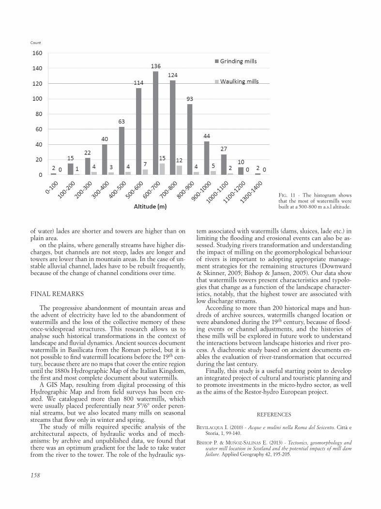
FiG. 11 - The histogram shows that the most of watermills were built at a 500-800 m a.s.l altitude.

159
Bishop p., Muñoz-salinas e., MaCkenzie a. B., pulForD i. & MCkiB-Bin J. (2011) - The character, volume and implications of sediment im-pounded in mill dams in Scotland: the case of the Baldernock Mill dam in East Dunbartonshire. Earth and Environmental Science Transac-tions of the Royal Society of Edinburgh, 101, 97-11.
Bishop, p. & Jansen, J.D. (2005) - The geomorphological setting of some of Scotland’s east coast freshwater mills: a comment on Downward and Skinner ‘Working rivers: the geomorphological legacy. Area 37, 443-445.
Buonora p. (1994) - La Valle Umbra. Genesi e trasformazione di un siste-ma idraulico (secoli XVI-XIX). Quaderni monografici di «Proposte e ricerche» n. 17, Tecnostampa, Ancona, 301pp.
CentoFanti M., BrusaporCi s., Di Donato a. & luCChese v. (2013) - Architectures and mechanisms. Water mills for cereal grinding and copper processing. In: IFToMM Workshop on History of MMS, Pal-ermo,1-10.
ChieriCi P. (1988) - Le strutture materiali dei mulini di Dora dal tardo Me-dioevo alle soglie dell’Ottocento. In: Bracco G., Acque, ruote e mulini a Torino, Archivio storico Città di Torino, vol. I, 273-300.
DownwarD s. & skinner k. (2005) - Working rivers: the geomorphologi-cal legacy of English freshwater mills. Area 37, 138-147.
european lanDsCape Convention, (2000). Florence.
GaBrielli G., lazzari M., saBia C. a. & Del lunGo s. (2014) - Cultural Landscapes Metodi, strumenti e analisi del paesaggio fra archeologia, geologia, e storia in contesti di studio del Lazio e della Basilicata (Ital-ia). BAR International Series 2629, Notebooks on Medieval Topog-raphy 9, Archaeopress, Oxford. 426 pp.
Genise G. (2011) - La via dei mulini ad acqua nell’alto Jonio. Nostra Italia onlus, Maria Pacini Fazzi, Lucca, 130 pp.
Grano M.C. & lazzari M. (2016) - Fonti cartografiche per l’analisi del paesaggio fluviale e dei mulini ad acqua in Basilicata: criticità e van-taggi della Carta Idrografica del Regno d’Italia. Bollettino AIC, 157, 15 pp.
lazzari M., Gioia D., piCCarreta M., Danese M. & lanorte a. (2015) - Sediment yield and erosion rate estimation in the mountain catchments of the Camastra artificial reservoir (Southern Italy): a com-parison between different empirical methods. Catena, 127, April 2015, 323–339. http://dx.doi.org/10.1016/j.catena.2014.11.021 + erratum on Catena Vol. 139, April 01, 2016, 272-273.
reynolDs t. s. (1983) - Stronger than a Hundred Men. A History of the Vertical Water Wheel. The Johns Hopkins University Press, Balti-more, 454 pp.
roe M. h. (2007a) - The European Landscape Convention: a revolution in thinking about ‘cultural landscapes’. Chinese Landscape Architecture, 23, 10-13.
roe M. h. (2007b) - Landscape and sustainability: an overview. In J. F. Benson & M. H. Roe (eds.): Landscape and Sustainability, Rout-ledge, London, 1-15.
strahler a. n. (1957) - Quantitative analysis of watershed geomorpholo-gy. Transactions of the American Geophysical Union, 38 (6), 913-920.
thoMs M. C. & walker k. F. (1992) - Channel changes related to low-lev-el weirs on River Murray, South Australia. In: Carling P.A. & Petts G.E. (Eds.): Lowland rivers: geomorphological perspectives. Wiley, Chichester, 235-50.
Archive sources
Archivio di Stato di Potenza, Intendenza di Basilicata, b. 986, b.1002, b.1011, b.1257.
Archivio di Stato di Potenza, Prefettura di Potenza (1888-92) b.109
Archivio di Stato di Potenza, Tribunale civile di Basilicata, Perizie e atti istruttori, b.18.
Archivio di Stato di Potenza, Tribunale civile di Basilicata, Perizie e atti istruttori, b.43, f.18 bis.
(Ms. received 1 June 2016; accepted 30 November 2016)