Flora and fauna report V7 Final - Lake Macquarie · Eco Logical Australi a Pty Ltd accepts no...
118
Wyee Local Environmental Study Appendix 3 Biodiversity Study
Transcript of Flora and fauna report V7 Final - Lake Macquarie · Eco Logical Australi a Pty Ltd accepts no...

Wyee Local Environmental Study
Appendix 3
Biodiversity Study
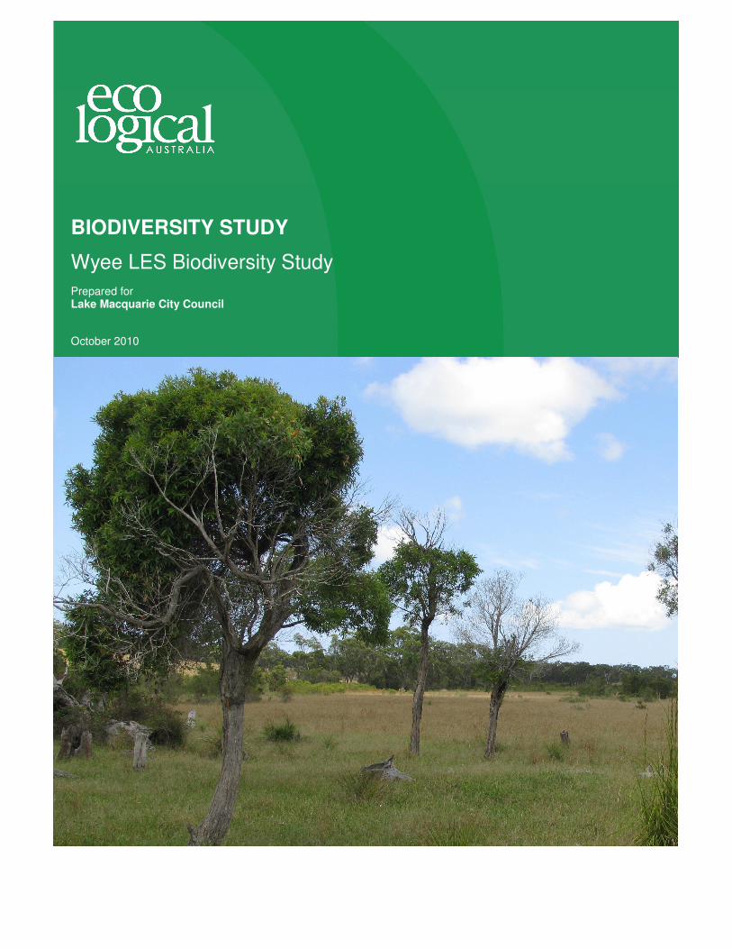
BIODIVERSITY STUDY
Wyee LES Biodiversity Study
Prepared for Lake Macquarie City Council
October 2010
© E C O LO G I C AL A U S T R AL I A P T Y LT D
Biodiversity StudyW y e e L E S B i o d i v e r s i t y S t u d y
PREPARED FOR Conics and Lake Macquarie City Council
PROJECT NO 0269-0001
DATE October 2010
W Y E E L E S B i o d i ve rs i t y S tu d y
Biodiversity Study W y e e L E S B i o d i v e r s i t y S t u d y
Lake Macquarie City Council
W Y E E L E S B io d i ve rs i t y S t u d y
ii
W Y E E L E S B io d i v e rs i t y S t u d y
© E C O L O G I C AL A U S T R AL I A P T Y LT D i
DOCUMENT TRACKING
ITEM DETAIL
Project Name Wyee LES Biodiversity Study
Project Number 269-0001
File location H:\Synergy\Projects\0269\0269-0001 Wyee LES environmental assessment\Reports
Prepared by MW
AvC
Approved by SP
Status Final
Version Number 7
Last saved on October 2010
This document has been printed on 100% recycled paper.
ACKNOWLEDGEMENTS
This document has been prepared by Eco Logical Australia Pty Ltd with support from Conics and Lake
Macquarie City Council.
Disclaimer
This document may only be used for the purpose for which it was commissioned and in accordance with the contract between
Eco Logical Australia Pty Ltd and Conics. The scope of services was defined in consultation with Conics, by time and budgetary
constraints imposed by the client, and the availability of reports and other data on the subject area. Changes to available
information, legislation and schedules are made on an ongoing basis and readers should obtain up to date information.
Eco Logical Australia Pty Ltd accepts no liability or responsibility whatsoever for or in respect of any use of or reliance upon this
report and its supporting material by any third party. Information provided is not intended to be a substitute for site specific
assessment or legal advice in relation to any matter. Unauthorised use of this report in any form is prohibited.
W Y E E L E S B io d i v e rs i t y S t u d y
© E C O L O G I C AL A U S T R AL I A P T Y LT D ii
Contents
DOCUMENT TRACKING ........................................................................................................................... i
Acknowledgements .................................................................................................................................... i
Contents .................................................................................................................................................... ii
1 Executive Summary ................................................................................................................. 1
2 Introduction .............................................................................................................................. 3
2.1 The Study Area ........................................................................................................................ 3
3 Identification of Biodiversity Context, Objectives and Strategic Principles .............................. 6
3.1 Regional Plans ......................................................................................................................... 6
3.1.1 Lower Hunter Regional Strategy 2006-2031 ..................................................................... 6
3.1.2 Lower Hunter Regional Conservation Plan (2006) ............................................................ 6
3.1.3 Hunter Central Rivers Catchment Action Plan .................................................................. 7
3.2 Local Plans and policies .......................................................................................................... 7
3.2.1 Lake Macquarie Local Environmental Plan 2004 .............................................................. 7
3.2.2 Lake Macquarie Lifestyle 2020 Strategy Objectives ......................................................... 7
3.2.3 Lake Macquarie City Council Biodiversity Planning Policy and Guidelines for LEP Rezoning Proposals (2009) ............................................................................................................. 7
3.2.4 Lake Macquarie City Council Tetratheca juncea Conservation Management Plan .......... 8
3.2.5 Lake Macquarie Corridors Mapping .................................................................................. 8
3.2.6 Draft Wyee Structure Plan ................................................................................................. 8
3.2.7 Ecological Attributes Review for Wyee .............................................................................. 9
3.2.8 Wyee Squirrel Glider Review ............................................................................................. 9
4 Identification of Biodiversity ................................................................................................... 11
4.1 Methods ................................................................................................................................. 11
4.1.1 Data Audit ........................................................................................................................ 11
4.1.2 Literature Review ............................................................................................................. 11
4.1.3 Field Survey ..................................................................................................................... 12
4.2 Results ................................................................................................................................... 19
4.2.1 Data Audit ........................................................................................................................ 19
4.2.2 Literature Review ............................................................................................................. 19
4.2.3 Field Survey ..................................................................................................................... 20
4.2.4 Compliance with Survey Guidelines and Survey Limitations .......................................... 33
5 Relevant Statutory Provisions................................................................................................ 34

W Y E E L E S B io d i v e rs i t y S t u d y
© E C O L O G I C AL A U S T R AL I A P T Y LT D iii
5.1 Federal ................................................................................................................................... 34
5.1.1 Environmental Protection and Biodiversity Conservation Act 1999 ................................ 34
5.2 State ....................................................................................................................................... 34
5.2.1 Environmental Planning and Assessment Act 1979........................................................ 34
State Environmental Planning Policy 44 Koala Habitat Protection ......................................................... 35
Potential Koala Habitat Assessment ................................................................................................... 35
Core Koala Habitat Assessment .......................................................................................................... 35
Section 62 Consultation - Biodiversity ..................................................................................................... 36
5.2.2 Threatened Species Conservation Act 1995 ................................................................... 37
5.2.3 Native Vegetation Act ...................................................................................................... 37
5.2.4 Water Management Act 2000 .......................................................................................... 37
6 Strategic Biodiversity Assessment ........................................................................................ 38
6.1 Biodiversity values ................................................................................................................. 38
6.2 Adjoining land uses and Landscape review .......................................................................... 46
6.3 Population viability review ...................................................................................................... 46
6.3.1 Population viability of immobile species .......................................................................... 46
6.3.2 Population viability of species with high site fidelity ........................................................ 46
6.3.3 Summary and response to population viability review .................................................... 47
6.4 Consideration of conservation and development options ...................................................... 47
6.4.1 Rational ............................................................................................................................ 47
6.4.2 Ecological Constraints Mapping ...................................................................................... 48
7 Related Land Use Issues ....................................................................................................... 52
7.1 Infrastructure provision .......................................................................................................... 52
7.2 Bush fire Management requirements .................................................................................... 52
8 Biodiversity Planning Recommendations .............................................................................. 52
8.1 Development Planning Principles and recommendations ..................................................... 53
8.2 Management of conservation areas ...................................................................................... 54
9 Conclusion ............................................................................................................................. 56
References .............................................................................................................................................. 58
Appendix A - Threatened Species, Populations and Ecological Communities .............................. 63
Appendix B - Species List........................................................................................................................ 79
W Y E E L E S B io d i v e rs i t y S t u d y
© E C O L O G I C AL A U S T R AL I A P T Y LT D iv
Appendix C - Threatened Flora Data ...................................................................................................... 85
Appendix D - Hollow-Bearing Tree Data ................................................................................................. 92
Appendix E - Bat species identified using Anabat recordings ............................................................... 102
Appendix F – Floristic Plot Data ............................................................................................................ 103
List of Figures
Figure 1: Locality Map ............................................................................................................................. 5
Figure 2: Wyee Squirrel Glider Conservation Priority Corridor Network .............................................. 10
Figure 3: Flora methods. ...................................................................................................................... 14
Figure 4: Fauna methods. .................................................................................................................... 18
Figure 5: Vegetation communities ........................................................................................................ 24
Figure 6: Threatened flora records and EEC’s. Note: Threatened plant data and finer scaled maps
provided in Appendix C. ........................................................................................................................ 25
Figure 7: Hollow bearing tree results. Note: Data and finer scaled maps provided in Appendix D. ..... 28
Figure 8: Fauna and habitat values ...................................................................................................... 32
Figure 9: Landscape context and connectivity ...................................................................................... 45
Figure 10: Ecological Constraints Map ................................................................................................. 51
Figure 11: Threatened Flora Part 1 ....................................................................................................... 86
Figure 12: Threatened Flora Part 2 ....................................................................................................... 87
Figure 13: Hollow Bearing Trees Part 1 ................................................................................................ 92
Figure 14: Hollow Bearing Trees Part 2 ................................................................................................ 93
Figure 15: Hollow Bearing Trees Part 3 ............................................................................................... 94
Figure 16: Hollow Bearing Trees Part 4 ................................................................................................ 95

W Y E E L E S B io d i v e rs i t y S t u d y
© E C O L O G I C AL A U S T R AL I A P T Y LT D v
Figure 17: Hollow Bearing Trees Part 5 ................................................................................................ 96
List of Tables
Table 1: Trapping effort undertaken between the 16th – 20
th March 2009. ........................................... 15
Table 2: Anabat results .......................................................................................................................... 29
Table 3: Section 62 Consultation .......................................................................................................... 36
Table 4: Summary of biodiversity values within the study area ............................................................ 40
Table 5: Tetratheca juncea data. ........................................................................................................... 88
Table 6: Angophora inopina data. ......................................................................................................... 88
Abbreviations
ABBREVIATION DESCRIPTION
DEC Department of Conservation DECC Department of Climate Change EEC Endangered Ecological Community ELA Eco Logical Australia EP&A Act Environmental Planning and Assessment Act 1979 EPBC Environment Protection and Biodiversity Conservation Act 1999 JANIS LEP Local Environmental Plan LES Local Environmental Study LMCC Lake Macquarie City Council MU Map Unit NES National Environmental Significance NV Act Native Vegetation Act 2003 SAT Spot Analysis Technique SEPP State Environmental Planning Policy TSC Act Threatened Species Conservation Act 1995 WM Act Water Management Act 2000
W Y E E L E S B io d i v e rs i t y S t u d y
1
Eco Logical Australia Pty Ltd Ph - (02) 4910 0125
Ecological Assessment, GIS, Environmental Management and Planning Fax - (02) 4910 0126
1 Executive Summary
Conics engaged Eco Logical Australia Pty Ltd to undertake a Biodiversity Study of an area of land at
Wyee. The study will be used to inform the preparation of a draft Local Environmental Study to
identify ecological values and inform subsequent land use planning and zoning. This study has
addressed the objectives set by Lake Macquarie City Council, as follows;
1. Review available information for the land and its vicinity (including regional context, databases
and studies undertaken for the site and land in the general area).
Information reviewed as part of this study included regional biodiversity strategies, local studies such
as the Wyee Ecological Attributes Study and Wyee Squirrel Glider Study, a previous ecological study
undertaken by Travers Environmental (2008) on Area A and routine flora and fauna databases such
as Atlas for Wildlife and BioNet.
2. Undertake field surveys to confirm biodiversity values of the site, targeting threatened species
and endangered ecological communities. Survey and reporting is required to meet the
requirements of the Lake Macquarie Flora and Fauna Survey Guidelines (LMCC 2001). This
would quantify as far as possible the quality, condition, extent, significance, and connectivity of
native vegetation and habitat on the site.
Survey methodology and effort in the Biodiversity Study was formulated to comply with the
requirements of the Lake Macquarie City Council Flora and Fauna Survey Guidelines (LMCC 2001).
Thorough field investigations, including vegetation community validation, vegetation surveys, targeted
threatened flora searches, hollow-bearing tree surveys, diurnal bird surveys, Elliot and cage trapping,
harp trapping, Anabat, call playback, spotlighting, koala scat searches, threatened bird surveys and
opportunistic observations, were employed in Area B of the study area.
A total of six vegetation communities were identified during field work including two EEC’s, 153 flora
species including 25 exotic species, and 68 fauna species including 6 exotic species.. A total of six
threatened species were recorded within the study area. A further six additional threatened species
are considered likely to occur based on local occurrence and known habitat requirements. The study
area contains a range of habitat resources for these threatened species including foraging, roosting
and nesting resources.
3. Summarise the ecological values of the land (at landscape and site scales), and identify
issues relating to the ecological requirements and viability of each significant species,
population and/or vegetation community occurring within the area.
The ecological values, such as the location and extent of threatened species or EEC’s, hollow bearing
trees and local and regional corridors, have been provided and mapped. Ecological or biodiversity
values have been summarised and the viability of significant species, populations and communities
have been discussed.

W Y E E L E S B io d i v e rs i t y S t u d y
2
Eco Logical Australia Pty Ltd Ph - (02) 4910 0125
Ecological Assessment, GIS, Environmental Management and Planning Fax - (02) 4910 0126
4. Identify the strategic biodiversity planning issues (e.g. key biodiversity values, population
viability and landscape context, fragmentation of native vegetation, connectivity requirements,
zoning requirements). This is to enable:
i. subsequent review of the ecological consequences of options for future urban
structure; and
ii. evaluation of the extent to which these options meet Lifestyle 2020 objectives.
Strategic biodiversity planning issues have been identified, based on survey findings of threatened
biodiversity, local and regional studies. This includes findings of key biodiversity values, consideration
and maintenance of population viability and landscape connectivity.
Based on these findings, a rationale of ecological constraints has been presented and mapped. High
Ecological Constraint areas encompass key biodiversity values, both local and regional corridors.
High Ecological Constraint areas should be the focus of conservation zoning. Conservation of these
areas would adequately address the Lake Macquarie City Council Biodiversity Planning Principles for
Local Environmental Plan Rezoning and the Lifestyle 2020 objectives.
Moderate Ecological Constraint areas constitute areas of slightly lesser biodiversity constraint, though
would provide valuable addition to any future conservation zoning. These areas should be retained
where possible though, if rezoned for development, would not result in significant implications.
Areas of Low Ecological Constraint should be the principle focus of development zoning.
5. Recommend principles for long-term conservation of important biodiversity values on the site.
Recommendations for long-term conservation of important biodiversity values have been presented in
the biodiversity planning recommendations. Recommendations have been aligned with the ecological
constraints mapping, whereby the conservation of High Ecological Constraint areas will provide for the
long-term conservation of the important biodiversity values.
W Y E E L E S B io d i v e rs i t y S t u d y
3
Eco Logical Australia Pty Ltd Ph - (02) 4910 0125
Ecological Assessment, GIS, Environmental Management and Planning Fax - (02) 4910 0126
2 Introduction Lake Macquarie City Council engaged Eco Logical Australia Pty Ltd (ELA) to undertake a Biodiversity
Study of an area of land within Wyee. The study will be used to inform in the preparation of a draft
Local Environmental Study (LES) to identify ecological values and inform subsequent land use
planning.
This report has given consideration to threatened flora, fauna, populations, migratory species and
endangered ecological communities (EEC) listed under the Threatened Species Conservation Act
1995 and the Environmental Protection and Biodiversity Conservation Act 1999. Consideration has
also been given to local government biodiversity planning considerations.
The objectives of the biodiversity study were to:
1. Review available information for the land and its vicinity (including regional context, databases
and studies undertaken for the site and land in the general area).
2. Undertake field surveys to confirm biodiversity values of the site, targeting threatened species
and EEC’s. Survey and reporting is required to meet the requirements of the Lake Macquarie
Flora and Fauna Survey Guidelines (2001). This would quantify the quality, condition, extent,
significance, and connectivity of native vegetation and habitat on the site.
3. Summarise the ecological values of the land (at landscape and site scales), and identify
issues relating to the ecological requirements and viability of each significant species,
population and/or vegetation community occurring within the area.
4. Identify the strategic biodiversity planning issues (e.g. key biodiversity values, population
viability and landscape context, fragmentation of native vegetation, connectivity requirements,
zoning requirements). This is to enable:
i. subsequent review of the ecological consequences of options for future urban
structure; and
ii. evaluation of the extent to which these options meet Lifestyle 2020 objectives.
6. Recommend principles for long-term conservation of important biodiversity values on the site.
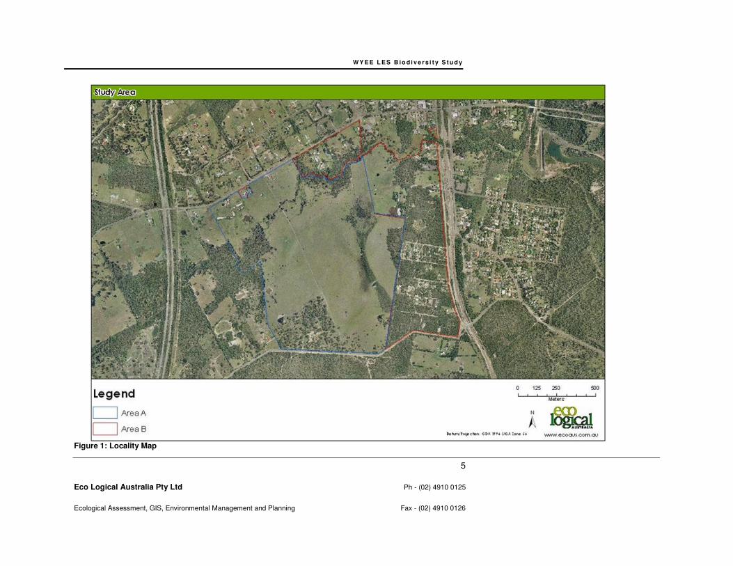
2.1 THE STUDY AREA
The study area is located southwest of Wyee in the Lake Macquarie LGA. The study locality is defined
as the area within 10km of the study area, as shown in Figure 1. The study area comprises
approximately 153 hectares of land, and is divided into the two portions identified by Council as Area
A and Area B, as shown in Figure 1. Mannering Creek and the associated riparian corridor occur in
the northern portion of the study area. Area A is zoned 1(1) Rural Production, except for the
Mannering Creek riparian corridor which is zoned 7(1) Conservation (Primary) and 7(2) Conservation
(Secondary). The northern section of Area B is zoned 7(5) Environmental (Living), the middle area is
zoned 6(1) Open Space with a small area of 5 Infrastructure, and the remainder of Area B is zoned
1(1) Rural Production. The study area is bounded by Hue Hue Road in the northwest and Mannering

W Y E E L E S B io d i v e rs i t y S t u d y
4
Eco Logical Australia Pty Ltd Ph - (02) 4910 0125
Ecological Assessment, GIS, Environmental Management and Planning Fax - (02) 4910 0126
Creek to the north, Gorokan Road to the east and Bushells Ridge Road to the south. The western
boundary of the study area adjoins remnant native vegetation and is partially bounded by Digary Road
(refer to Figure 1).
Area A lands have been the subject of previous flora and fauna investigations undertaken by Travers
Environmental (2008) and, although included in the overall study area, investigations have been
refined to validating the findings of this previous report.
Area B lands occupy the eastern portion of the overall study area and have been subject to detailed
flora and fauna investigations in this current study.
Much of the native vegetation within the study area has been subject to varying levels of past
disturbance, including clearing for paddocks, vehicle tracks and unauthorised residential development
in the way of sheds and small houses.
WY E E L E S B io d i v e r s i t y S t u d y
5
Eco Logical Australia Pty Ltd Ph - (02) 4910 0125
Ecological Assessment, GIS, Environmental Management and Planning Fax - (02) 4910 0126
Figure 1: Locality Map
W Y E E L E S B io d i v e rs i t y S t u d y
6
Eco Logical Australia Pty Ltd Ph - (02) 4910 0125
Ecological Assessment, GIS, Environmental Management and Planning Fax - (02) 4910 0126
3 Identification of Biodiversity Context, Objectives and Strategic Principles
3.1 REGIONAL PLANS
3.1.1 Lower Hunter Regional Strategy 2006-2031
Future rezoning proposals must be consistent with the Lower Hunter Regional Strategy under Section
117(2) of the Environmental Planning and Assessment Act 1979 (EP&A Act) Direction 5.1. The Lower
Hunter Regional Strategy identifies a vision for future development in the region in line with forecast
projections. It contains land use objectives and a set of planning principles that are to be applied to
subsequent planning in the area. Rezoning proposals in the study area will need to demonstrate a
‘maintain or improve principle’ as required by the Lower Hunter Regional Strategy.
3.1.2 Lower Hunter Regional Conservation Plan (2006)
The Lower Hunter Regional Conservation Plan’s objective is to guide local level planning with the aim
to maintain and improve the biodiversity conservation values including habitat connectivity for
threatened flora and fauna of the region.
The principles of biodiversity planning adopted in the draft Plan are:
• to maintain and improve ecological processes and the dynamics of terrestrial ecosystems in their landscape context
• to maintain and improve viable examples of terrestrial ecosystems throughout their natural ranges
• to maintain and improve viable populations of the various biological organisms throughout their natural ranges
• to maintain and improve the genetic diversity of the living components of terrestrial ecosystems.
The key priorities for biodiversity planning in relation to improving or maintaining biodiversity values
are:
• the first priority is– to avoid losses to biodiversity and promote protection of biodiversity values in situ
• the second priority, where first priority is unachievable is– to mitigate adverse impacts to biodiversity
• the last resort is to compensate for unavoidable losses to biodiversity.” Appendix 1 of the draft Plan contains offsetting principles for this purpose.
W Y E E L E S B io d i v e rs i t y S t u d y
7
Eco Logical Australia Pty Ltd Ph - (02) 4910 0125
Ecological Assessment, GIS, Environmental Management and Planning Fax - (02) 4910 0126
The draft Plan summarises the ecological attributes for the Western Lake Macquarie and Wyee area
to include the following:
• A diverse range of vegetation communities, most of which are not adequately represented in the reserve system including Swamp Sclerophyll Forest on Coastal Floodplain, (an EEC), Tetratheca juncea and Acacia bynoeana (threatened flora species);
• Habitat for a number of threatened species including a large number of threatened forest-dependent species such as forest bats, squirrel glider, yellow bellied glider, and forest owls;
• A range of wetland dependant threatened birds many of which are listed in international treaties such as the black bittern, Australasian bittern, blue billed duck, and comb crested jacana. Threatened woodland birds such as brown treecreeper are also present;
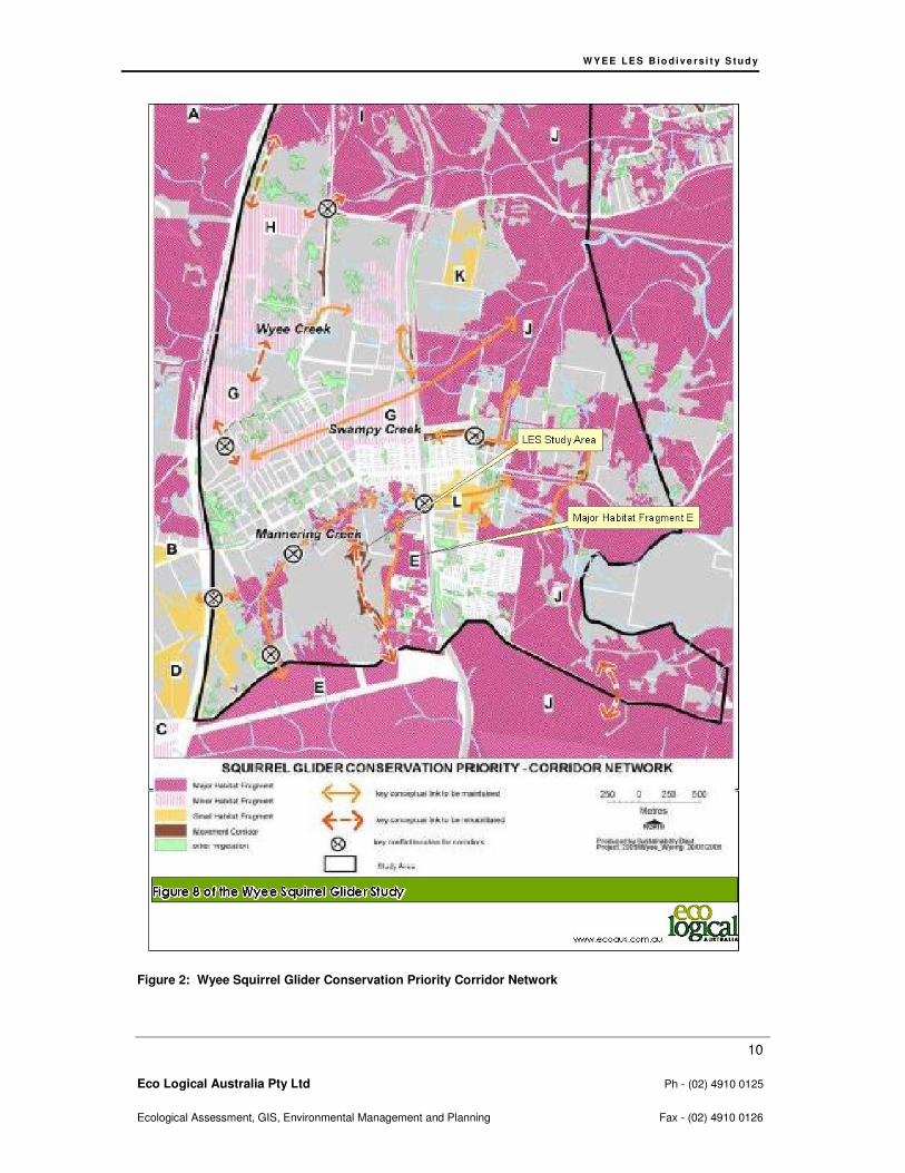
• An important linkage between the Watagan Mountains and Lake Macquarie, contributing to north - south conservation corridors. The native vegetation in the study area contributes to this regional corridor (refer to Figure 2).
3.1.3 Hunter Central Rivers Catchment Action Plan
The objective of the Hunter-Central Rivers Catchment Action Plan is to guide natural resource
management and future investments relating to natural resource issues in the catchment for the next
10 years. The Plan establishes goals, targets and actions to protect and improve the region’s natural
assets. The ecological planning principles underpinning the Plan are compatible with those
recommended in this Study.
3.2 LOCAL PLANS AND POLICIES
3.2.1 Lake Macquarie Local Environmental Plan 2004
The plan sets the framework for the land use structure within the LGA. It includes land use zones and
requirements for development. It also establishes what types of development may be permitted on a
particular parcel of land with the permission of Council. The study area is currently zoned 1(1) Rural
Production, 7(1) Conservation (Primary) and 7(2) Conservation (Secondary) under Lake Macquarie
LEP. Rezoning would be required to permit residential development within the study area.
3.2.2 Lake Macquarie Lifestyle 2020 Strategy Objectives
In recognition of the natural assets within the Lake Macquarie LGA, this strategy provides long-term
direction for land use within the LGA based on achieving the principles of ecological sustainable
development. The green system map provided within this document identifies the study area as a
combination of ‘High Value Habitat’, ‘Remnant Vegetation’, ‘Wetland’ and ‘Semi-Rural/ Open and
Agricultural Landscapes’. The Strategy objectives also include the protection of riparian habitat in
accordance with the Water Management Act.
3.2.3 Lake Macquarie City Council Biodiversity Planning Policy and Guidelines for LEP Rezoning Proposals (2009)
These principles provide consistent guidelines for Council’s approach to rezoning proposals, and for
the implementation of the biodiversity goal and strategic directions in the Lifestyle 2020 Strategy.
They were developed to guide future development within Lake Macquarie, and relate to:
• consideration of biodiversity in the planning process;
• identification of biodiversity values and natural ecosystems;
W Y E E L E S B io d i v e rs i t y S t u d y
8
Eco Logical Australia Pty Ltd Ph - (02) 4910 0125
Ecological Assessment, GIS, Environmental Management and Planning Fax - (02) 4910 0126
• protection of areas to be conserved;
• ongoing management of conservation areas.
The specific Biodiversity Planning Principles have guided the approach to mapping ecological
constraints and developing recommendations for this Biodiversity Study.
3.2.4 Lake Macquarie City Council Tetratheca juncea Conservation Management Plan
This study presents survey and mapping data for black-eyed S (Tetratheca juncea) sub-populations in
the Lake Macquarie LGA (Payne 2000). The objective is to identify large populations of this species to
enable planning decisions for the conservation of large populations. The plan maps local populations
and a number of these are in the Wyee area. The site has the potential to support black-eyed S
therefore objectives of the plan are addressed in this report.
The current study area falls within the south-west quadrat of the management plan. Sub-populations
within this quadrat were considered as the most important for conservation because none of them are
protected within the reserve system.
Management requirements include retaining stepping stone clumps, increasing conservation in
sectors of the City where inadequately conserved, conserving morphological variants and conserving
populations setting seed. At least 75% of local sub-population must be retained on site.
3.2.5 Lake Macquarie Corridors Mapping
Bushland both within the site and directly adjacent, has been identified within the Lake Macquarie
Bushland and Corridors Map (2007) as a “corridor of native vegetation that contributes significantly to
the movement and viability of flora and fauna in the Lake Macquarie city”. This would include both
habitat suitable for threatened fauna foraging and potential breeding and roosting habitat, specifically
hollow-bearing trees.
3.2.6 Draft Wyee Structure Plan
The purpose of this Draft Strategic Plan is to inform the detailed planning and future development of
Wyee. The plan divides the township into a number of planning precincts, and identifies the land
comprising the current study site as being part of Precinct 4: Wyee West. Specific recommendations
relevant biodiversity management within the study area includes:
Area A
• Retention and conservation zoning of EECs and areas of suitable squirrel glider habitat (Major
Fragment E as shown in Figure 2).
• The following rehabilitation is recommended:
− a buffer adjacent to the swamp mahogany – paperbark forest EEC;
− the riparian areas and EECs along Mannering Creek;
− the squirrel glider habitat- Major Fragment E, and
− the corridors between Mannering Creek and the Spring Creek area.
Area B
• Retain connectivity within and to Area B
• Some rehabilitation is required along the western boundary of this area.
W Y E E L E S B io d i v e rs i t y S t u d y
9
Eco Logical Australia Pty Ltd Ph - (02) 4910 0125
Ecological Assessment, GIS, Environmental Management and Planning Fax - (02) 4910 0126
• Some loss of squirrel glider habitat in this area could possibly be tolerated if other areas of
Coastal Plains Scribbly Gum woodland within Fragment E and corridors linking Fragment E
are retained and rehabilitated.
• Detailed site-specific flora and fauna surveys were considered required, particularly in the
areas where development potential has been identified. Such surveys have been
incorporated into this Biodiversity Study
The Ecological Constraints Mapping provided in Section 6.4.2 aims to address the objectives of the
structure plan.
3.2.7 Ecological Attributes Review for Wyee
The Ecological Attributes Review for Wyee was developed to inform the Wyee Structure Plan. In
general, the loss of high conservation value areas to urban development could be tolerated subject to
more detailed site investigation, as provided in this Biodiversity Study, and providing that other areas
are secured for conservation and rehabilitation.
The east-west arm of the Mannering Creek riparian corridor has been identified as an area in which
the vegetation should be retained, while the north-south arm requires restoration works of ‘important’
priority. An area along the western edge of Area B requires restoration works of ‘critical’ priority.
Subject to more detailed investigation including an analysis of habitat trees, some loss of squirrel
glider habitat in the Wyee West area could possibly be tolerated if other areas of Coastal Plains
Scribbly Gum woodland both within and linking to habitat fragments (i.e. Fragment E as shown in
Figure 2) are retained and rehabilitated.
These outcomes of this have been incorporated into the Ecological Constraints Mapping provided in
Section 6.4.2
3.2.8 Wyee Squirrel Glider Review
The major threat to the continuing presence of squirrel gliders within the study area is habitat clearing
and fragmentation, resulting in smaller habitat patches and increased isolation (MacDonald &
Economos-Shaw, 2008, p13).
Long term survival of the Wyee squirrel glider population depends on the retention and enhancement
of corridors within the township to allow for movement between habitat fragments and to maintain the
north-south regional corridor (LMCC 2008b, p34). Conceptual corridors detailed in the report included
retaining the east-west arm of the Mannering Creek riparian corridor and rehabilitating the north-south
arm (LMCC 2008b, p33). The Wyee Squirrel Glider report implies that the Wyee Structure Plan needs
to finalise conservation areas to be retained in the long term, plus corridor links between these areas.
The Ecological Constraints Mapping provided in Section 6.4.2 aims to address the objectives of this
review.
W Y E E L E S B io d i v e rs i t y S t u d y
10
Eco Logical Australia Pty Ltd Ph - (02) 4910 0125
Ecological Assessment, GIS, Environmental Management and Planning Fax - (02) 4910 0126
Figure 2: Wyee Squirrel Glider Conservation Priority Corridor Network
W Y E E L E S B io d i v e rs i t y S t u d y
11
Eco Logical Australia Pty Ltd Ph - (02) 4910 0125
Ecological Assessment, GIS, Environmental Management and Planning Fax - (02) 4910 0126
4 Identification of Biodiversity
4.1 METHODS
Survey methodology and effort in the Biodiversity Study was formulated to comply with the
requirements of the Lake Macquarie City Council Flora and Fauna Survey Guidelines (2001).
4.1.1 Data Audit
The data audit was based on analysis of environmental database searches including the Atlas of NSW
Wildlife, BioNet and the EPBC Act. Both searches included a 10 km radius around the site centred on
the study area (0358421E, 6327463N) to determine the local occurrence of threatened fauna and
listed migratory species, in accordance with State and Federal statutory requirements. These
searches were carried out on 24 February 2009.
An assessment of likelihood of occurrence was made for threatened and migratory species identified
from the database search. This assessment was based on database or other records, presence or
absence of suitable habitat within the study area, results of the field investigations and professional
judgement. Marine fauna species have been excluded from this assessment due to an absence of
available marine habitat.
The results of these searches and the likelihood of occurrence assessment can be found in Appendix
A.
4.1.2 Literature Review
Council have provided three relevant ecological reports that have been undertaken in the study area
and/or within the study locality. These reports have been reviewed, with results provided in Section
4.2, and include:
• Travers Environmental (2008): A flora and fauna assessment report undertaken in Area A of
the current study area. The results of this review detail the legislative requirements,
threatened species recorded or predicted within the site and the recommendations put
forward.
• Ecological Attributes Review for Wyee ( Lake Macquarie City Council, 2008a): The purpose of
this Ecological Attributes Review was to investigate the environmental values of the area on a
strategic level to guide future conservation areas and guide the retention and potential
improvement of bushland.
• Wyee Squirrel Glider Report (LMCC 2008b): This report focused on conservation significance
(primarily a function of population size and viability) and on identifying realistic land use
options and their implications for the future of the squirrel glider (Petaurus norfolcensis).
Minimum habitat sizes for maintaining population viability were calculated, as well as minimum
connectivity requirements. Likely barriers to connectivity have been identified to enable the
design of a land use pattern that maintains long-term connectivity.
W Y E E L E S B io d i v e rs i t y S t u d y
12
Eco Logical Australia Pty Ltd Ph - (02) 4910 0125
Ecological Assessment, GIS, Environmental Management and Planning Fax - (02) 4910 0126
4.1.3 Field Survey
Detailed field investigations were carried out on 2nd
March and from 16thth to 20
th March 2009. The
local weather was mild to warm and sunny with a temperature range between 15 to 26C. On 16th
March 7.6mm of rain was recorded at Norah Head of recorded, while 0.2mm was recorded on 20th
March. No additional rain was recorded during this period.
The flora and fauna surveys were based on the methods described below and targeted threatened
species considered likely to be present within the study area. Survey effort has been adapted from
requirements detailed in Lake Macquarie City Council Flora & Fauna Survey Guidelines (2001).
In line with the possibility of offset requirements, the floristic survey methods have incorporated
Biobanking guidelines within the study area to allow for their adaptation to Biobanking if Lake
Macquarie City Council were to consider this option as part of a conservation offset strategy at a later
stage.
Area A lands have been the subject of a recent flora and fauna investigation undertaken by Travers
Environmental (2008) Therefore investigations in this area have been limited to validating the findings
of this previous report and surveying hollow-bearing trees.
Area B lands occupy the eastern portion of the overall study area and have been subject to detailed
flora and fauna investigations in this current study.
Flora Surveys
Vegetation Community Validation
Aerial photography, LHCCREMS vegetation map units, previous investigations (i.e. Travers 2008) and
ground truthing of vegetation communities was used to distinguish and map vegetation associations
across both Area A and Area B of the study area using Geographical Information System (GIS)
techniques. Vegetation communities were defined based on LHCCREMS vegetation map units.
Vegetation Surveys
Floristic composition of native vegetation was sampled within Area B using five 20x20m quadrats, one
40x10m quadrat and seven transects. Spot assessments of flora were also completed throughout the
site and included a rapid inspection and recording of species, particularly where species were seen
that had not previously been encountered or recorded. Locations of these surveys are shown in Figure
3.
Targeted threatened flora searches
Targeted surveys for threatened plants were carried out on three separate occasions over a 12 month
period and conducted within the known optimum flowering period to maximise detection of the
following species that were considered potential occurrences:
• Tetratheca juncea (black-eyed susan )
• Angophora inopina (charmhaven apple)
• Acacia bynoeana (Bynoe’s wattle)

W Y E E L E S B io d i v e rs i t y S t u d y
13
Eco Logical Australia Pty Ltd Ph - (02) 4910 0125
Ecological Assessment, GIS, Environmental Management and Planning Fax - (02) 4910 0126
• Cryptostylis hunteriana (leafless tongue orchid)
• Caladenia tessellata (thick-lipped spider orchid)
• Diuris praecox (rough doubletail)
• Rutidosis heterogama (heath wrinklewort)
These surveys were carried out within Area B on 28 January 2009, 2nd
March and 16thth to 20
th March
2009, 8th October 2009 and 12th November 2009. This timing of survey effort was considered
adequate to maximise detection rates of the above species. The study area was traversed with search
efforts concentrated in preferred habitat for the species. GPS was used to record plant position and
number of plants was recorded together with area of occurrence to enable plant population density
estimates within the study site. Survey traverses were also logged to enable adequate site coverage.
In addition, the extent of Angophora inopina distribution mapped by Travers (2008) in Area A was also
validated.
Fauna Habitat
Fauna habitat assessments comprised an evaluation of forage and shelter resources within the study
area and per vegetation community. Attributes that were considered included:
• vegetation cover per strata;
• forage resources (i.e. Koala primary browse trees, sap feed trees, flowering trees and shrubs);
• availability of shelter sites
• number and extent of any standing or flowing water bodies; and
• disturbance history.
A hollow-bearing tree (HBT) survey was carried out on 17th March 2009. Both Area A and Area B was
traversed with all individual hollow-bearing trees being logged into a GPS for position and the following
information was recorded:
• Tree species
• Tree location
• Tree size (DBH)
• Hollow size class (<50mm; 50mm-150mm; >150mm) and position (Branch, Trunk, Basal, Trunk Fissure)
• Suitability for threatened species (i.e. evidence of use or general suitability)
• Comments.
Other information recorded included fauna species observed using hollows, and signs such as claw
scratch marks. Survey traverses were also logged to enable adequate site coverage.
WY E E L E S B io d i v e r s i t y S t u d y
14
Eco Logical Australia Pty Ltd Ph - (02) 4910 0125
Ecological Assessment, GIS, Environmental Management and Planning Fax - (02) 4910 0126
Figure 3: Flora methods.
W Y E E L E S B io d i v e rs i t y S t u d y
15
Eco Logical Australia Pty Ltd Ph - (02) 4910 0125
Ecological Assessment, GIS, Environmental Management and Planning Fax - (02) 4910 0126
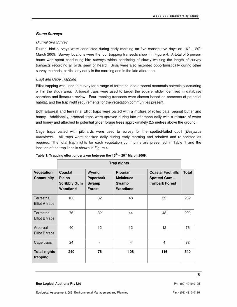
Fauna Surveys
Diurnal Bird Survey
Diurnal bird surveys were conducted during early morning on five consecutive days on 16th – 20
th
March 2009. Survey locations were the four trapping transects shown in Figure 4. A total of 5 person
hours was spent conducting bird surveys which consisting of slowly walking the length of survey
transects recording all birds seen or heard. Birds were also recorded opportunistically during other
survey methods, particularly early in the morning and in the late afternoon.
Elliot and Cage Trapping
Elliot trapping was used to survey for a range of terrestrial and arboreal mammals potentially occurring
within the study area. Arboreal traps were used to target the squirrel glider identified in database
searches and literature review. Four trapping transects were chosen based on presence of potential
habitat, and the trap night requirements for the vegetation communities present.
Both arboreal and terrestrial Elliot traps were baited with a mixture of rolled oats, peanut butter and
honey. Additionally, arboreal traps were sprayed during late afternoon daily with a mixture of water
and honey and attached to potential glider forage trees approximately 2.5 metres above the ground.
Cage traps baited with pilchards were used to survey for the spotted-tailed quoll (Dasyurus
maculatus). All traps were checked daily during early morning and rebaited and re-scented as
required. The total trap nights for each vegetation community are presented in Table 1 and the
location of the trap lines is shown in Figure 4.
Table 1: Trapping effort undertaken between the 16th
– 20th
March 2009.
Trap nights
Vegetation
Community
Coastal
Plains
Scribbly Gum
Woodland
Wyong
Paperbark
Swamp
Forest
Riparian
Melaleuca
Swamp
Woodland
Coastal Foothills
Spotted Gum –
Ironbark Forest
Total
Terrestrial
Elliot A traps
100 32 48 52 232
Terrestrial
Elliot B traps
76 32 44 48 200
Arboreal
Elliot B traps
40 12 12 12 76
Cage traps 24 - 4 4 32
Total nights
trapping
240 76 108 116 540
W Y E E L E S B io d i v e rs i t y S t u d y
16
Eco Logical Australia Pty Ltd Ph - (02) 4910 0125
Ecological Assessment, GIS, Environmental Management and Planning Fax - (02) 4910 0126
Call Playback
The powerful owl (Ninox strenua), masked owl (Tyto novaehollandiae), barking owl (Ninox connivens)
and the koala (Phascolarctos cinereus) were targeted during call playback and associated
spotlighting. Surveys consisted of each call being played for approximately 5 minutes followed by a 5
minute listening period. Spotlighting was then used to augment the call playback and potentially
detect cryptic species following each call being played. This method was employed on 16th, 18
th and
19th March 2009 between 20:30 and 22:30 hrs, and on 11
th June 2009 between 17:30 and 19:30 hrs,
with a total of eight person hours. Call playback was used at three different locations within the study
area, as shown in Figure 4.
Harp Trapping and Ultrasonic Microchiropteran Bat Call Identification
Micro-chiropteran bats were surveyed using harp traps set in areas considered to be suitable bat flight
paths including clearings and along tracks within woodland and forest habitat. Harp traps were set for
two trap nights per vegetation community in locations detailed in Figure 4.
Ultrasonic call recording using an Anabat detector were set over three consecutive nights between the
17th - 19
th March 2009 in locations deemed to be potentially within bat flight paths including a portion of
Mannering Creek and near the junctions of bush tracks. A total of 27 hours of Anabat recording was
undertaken with Anabat locations are provided in Figure 4. Data was sent to bat expert Anna Lloyd for
analysis.
Nocturnal Spotlighting
A survey for nocturnally active fauna was conducted and involved traversing the study area at night
with a 100 watt hand-held spot light designed to detect eye shine of nocturnal fauna. The search
effort targeted arboreal fauna and was concentrated in the canopy and mid–strata levels of vegetation.
Nocturnal surveys were conducted on 16th, 18
th and 19
th March. Additional nocturnal surveys were
conducted on the 11th June 2009, specifically targeting suitable habitat for threatened forest owls
within woodland areas and wallum froglet (Crinia tinnula) (i.e. quiet listening for calls) within areas of
freshwater wetland in Area A. A total of eight person hours of was spent spotlighting. The locations of
spotlight traverses are presented in Figure 4.
Koala Scat Searches
Targeted searches for koala scats were carried out within the study area in areas where koala feed
trees were present at densities considered to represent Potential Koala Habitat, according to SEPP44
definition (i.e. greater than 15% of trees in the upper and lower canopy components), primarily in
areas of scribbly gum woodland. The method was adapted from Phillips and Callaghan (2001) Spot
Analysis Technique (SAT). A 100m by 100m grid was applied to areas of Potential Koala Habitat and
at each grid intersection the closest tree representing, in order of preference, a tree observed to have
contained a koala, a tree with recognised koala scats or scratches, or a Primary Browse Species listed
under Schedule 2 of SEPP44. This selected tree represented the centre tree and this and the nearest
20 trees were inspected for koala scats and scratches. All opportunistic observations of other scats
were also recorded (refer to Figure 4 for SAT locations).

W Y E E L E S B io d i v e rs i t y S t u d y
17
Eco Logical Australia Pty Ltd Ph - (02) 4910 0125
Ecological Assessment, GIS, Environmental Management and Planning Fax - (02) 4910 0126
Threatened Bird Surveys
Targeted surveys for swift parrot (Lathamus discolor) and regent honeyeater (Xanthomyza phrygia)
were carried out during winter to coincide with the local seasonal occurrence of these species.
Surveys were carried on Thursday 11th June and Tuesday 21
st July 2009 in woodland areas having
winter-flowering tree species. Areas of vegetation containing spotted gum (Corymbia maculata) and
swamp mahogany (Eucalyptus robusta) were targeted as shown in Figure 4 below. The total survey
effort was 4 person hours.

WY E E L E S B io d i v e r s i t y S t u d y
18
Eco Logical Australia Pty Ltd Ph - (02) 4910 0125
Ecological Assessment, GIS, Environmental Management and Planning Fax - (02) 4910 0126
Figure 4: Fauna methods.
W Y E E L E S B io d i v e rs i t y S t u d y
19
Eco Logical Australia Pty Ltd Ph - (02) 4910 0125
Ecological Assessment, GIS, Environmental Management and Planning Fax - (02) 4910 0126
Opportunistic Observations and Secondary Evidence
Reptiles and frogs searches included hand searching below ground debris including leaf-litter, logs,
rocks and rubbish during cooler times during the day. In addition, birds were surveyed via
opportunistic observations, and other incidental recordings of indirect evidence of fauna were also y
recorded.
4.2 RESULTS
4.2.1 Data Audit
The results of data base searches for threatened flora and fauna and migratory species and ecological
communities that have been recorded within a 10km radius of the study area are presented in the
likelihood of occurrence table in Appendix A. All those species deemed likely to occur or confirmed as
occurring within the study area are presented in Section 6.
4.2.2 Literature Review
Ecological Assessment: Lots 16 & 17 DP 870597, Lot 215 860081, Lot 1 DP 785709 Hue Hue Road, Lot 212 DP 866437 Bushells Ridge Road, Lot 1 DP 244839 Digary Road, Wyee (Travers Environmental 2008)
A total of six vegetation communities were identified in Area A of the study area. Within these
communities two EEC’s were detected, swamp sclerophyll forest on coastal floodplains and river-flat
eucalypt forest on coastal floodplains.
A total of 6 threatened species were identified including black-eyed susan , Charmhaven apple,
greater broad-nosed bat (Scoteanax rueppellii), little bent wing-bat (Miniopterus australis), squirrel
glider and thick lip spider orchid (Caladenia tessellata). It was considered that an additional 8
threatened flora species and 27 threatened fauna species had potential to inhabit Area A.
The report concluded that if management recommendations were adhered to, the proposed
development will not have a significant impact on any threatened species, populations or EEC. These
recommendations included:
• Isolated clumps of A. inopina and T. juncea should be retained where possible, as should all areas
of fallen timber identified as habitat.
• Habitat trees should be retained where possible; else removal should be postponed until any
young present have matured. All suitable hollows should be salvaged and installed in the
proposed corridor areas.
• All fauna located in nests and roosts within the construction zone, or in dams to be drained and
filled should be relocated, as should fauna found utilising the creek-line for burrowing, nesting or
breeding.
• All conservation areas should be fenced prior to construction commencing. Where they adjoin
development areas they should be clearly marked.
• A Biodiversity Management Plan, including a water monitoring program, should be developed for
the site.
W Y E E L E S B io d i v e rs i t y S t u d y
20
Eco Logical Australia Pty Ltd Ph - (02) 4910 0125
Ecological Assessment, GIS, Environmental Management and Planning Fax - (02) 4910 0126
Ecological Attributes Review for Wyee (LMCC 2008a)
The Wyee Ecological Attributes Review (LMCC 2008a) indicated that a large proportion of the native
vegetation occurring within study area is comprised of several EECs, Sydney freshwater wetland,
swamp sclerophyll forest on coastal floodplain and river-flat eucalypt forest on coastal floodplain. A
total of 12 threatened flora and 9 threatened fauna records are listed for the current study area,
including 3 squirrel glider records.
Most of the remnant vegetation in the study area is listed as being ‘high conservation significance’.
Also a large section of Area B is identified as part of high quality squirrel glider habitat Fragment E
(see Figure 2). This area supports a number of habitat, food trees, and nectar producing species in
the understorey; however, has been progressively cleared and the squirrel glider habitat has become
fragmented.
Wyee Squirrel Glider Review (LMCC 2008b)
The Wyee Squirrel Glider Review (LMCC 2008b) details that the study area has previously had
squirrel gliders recorded within the study area and that all the native vegetation in the study area
represents potential squirrel glider habitat. This implies that the study area forms part of the habitat for
a population of the species occurring within the Wyong – Lake Macquarie area. The Wyee Squirrel
Glider Review (LMCC 2008b) has been considered in Section 6 of this report.
4.2.3 Field Survey
Flora Surveys
Vegetation Community Validation
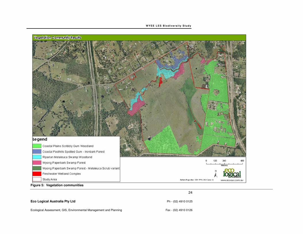
Vegetation communities within the study area are relatively consistent with the vegetation community
profiles and mapping of LHCCREMS (2000) and Travers (2008) for the Area A portion. Six vegetation
communities were identified within the study area, including two EEC’s freshwater wetland on coastal
floodplains and swamp sclerophyll forest on coastal floodplain.
Figure 5 and the following sections provide the vegetation types and a complete list of flora species is
presented in Appendix B. The entire plot data collected has been provided in Appendix F.
Coastal Foothills Spotted Gum - Ironbark Forest (MU15) – 2.97 hectares
This vegetation community occurs up-slope from areas of Riparian Melaleuca Swamp Forest (MU 42)
vegetation along the Mannering Creek in the northwest parcel of Area B.
This community is in moderate to poor condition, suffering from a range of issues such as refuse
dumping and under-scrubbing. There are also a number of large infestations of exotic flora such as
*blackberry (Rubus fruticosus), *green cestrum (Cestrum parqui), *Japanese honeysuckle (Lonicera
japonica), *lantana (Lantana camara) and *Madeira vine (Anredera cordifolia).
Canopy
Canopy species comprised spotted gum, smooth-barked apple (Angophora costata), turpentine
(Syncarpia glomulifera) and black she-oak (Allocasuarina littoralis).
Shrubs
W Y E E L E S B io d i v e rs i t y S t u d y
21
Eco Logical Australia Pty Ltd Ph - (02) 4910 0125
Ecological Assessment, GIS, Environmental Management and Planning Fax - (02) 4910 0126
Shrub species included ball honey myrtle (Melaleuca nodosa), coffee bush (Breynia oblongifolia),
elderberry panax (Polyscias sambucifolia), *green cestrum, gorse bitter pea (Daviesia ulicifolia) and
*lantana.
Ground covers
Ground cover species include bladey grass (Imperata cylindrica), blue flax lily (Dianella
caerulea),*Japanese honeysuckle, kangaroo grass (Themeda australis), pastel flower
(Pseuderanthemum variabile), weeping grass (Microlaena stipoides), whiteroot (Pratia purpurascens)
and wiry panic (Entolasia stricta).
Coastal Plains Scribbly Gum Woodland (MU 31) – 42.57 hectares
There are two parcels of this vegetation community in Area A, in the southeast corner and along the
eastern boundary. This community occupies the majority of the central and southeast portions of Area
B. These parcels are in moderate condition with a degree of disturbance from urban development,
trails and associated edge effects and weed invasion. A small area of this community in Area B and
adjacent to Mannering Creek has been under scrubbed.
Canopy
Canopy species comprise scribbly gum (Eucalyptus haemastoma), red bloodwood (Corymbia
gummifera), brown stringybark (Eucalyptus capitellata), black she-oak, and turpentine (Syncarpia
glomulifera).
Shrubs
Shrub species include fern-leaved banksia (Banksia oblongifolia), hairpin banksia (B. spinulosa),
Epacris pulchella, broad-leaved hakea (Hakea dactyloides), broad-leaf drumsticks (Isopogon
anemonifolius), mountain devil (Lambertia formosa) and slender tea-tree (Leptospermum trinervium).
Ground Covers
Ground covers included wiry panic, fish bones (Lomandra obliqua), two-colour panic (Panicum simile),
kangaroo grass, and grass tree (Xanthorrhoea sp).
Freshwater Wetland Complex (MU46) – 0.77 hectares
This vegetation community occurs within the water bodies situated in the Mannering Creek riparian corridor in Area A. The vegetation in the southwest arm of the corridor becomes degraded heading north as the buffer of surrounding vegetation becomes less dense and the drainage line is subject to trampling by stock. The east-west arm of the corridor is reasonably intact however a small oxbow is infested with *salvinia (Salvinia molesta), which is listed as a Class 3 aquatic noxious weed in Lake Macquarie. Based on the structure and floristic composition, the position in the landscape and on the assumption that the soils are alluvial, this community is considered to be freshwater wetland on coastal floodplains, which is listed an EEC under the Threatened Species Conservation Act (Figure 6). Due to the vegetation type, canopy and shrub layers are absent and strata are limited to the following ground covers.
W Y E E L E S B io d i v e rs i t y S t u d y
22
Eco Logical Australia Pty Ltd Ph - (02) 4910 0125
Ecological Assessment, GIS, Environmental Management and Planning Fax - (02) 4910 0126
Ground Covers
Tall spike rush (Eleocharis sphacelata), finger rush (Juncus subsecundus), Ludwigia peploides, water
couch (Paspalum distichum), spotted knotweed (Persicaria decipiens), frogmouth (Philydrum
lanuginosum), *salvinia, Triglochin microtuberosum and cambungi (Typha orientalis).
Riparian Melaleuca Swamp Forest (MU 42) – 4.81 hectares
This vegetation community occurs adjacent to freshwater wetland vegetation along the Mannering Creek riparian corridor. In the eastern stretch of the creek, in the parcel of remnant bushland, the vegetation is in good condition. Along the western stretch it is in moderate condition and infested by environmental weeds such as *Japanese honeysuckle and *blackberry. In the middle of Area A where the majority of the bushland has been cleared for paddocks, the riparian vegetation has been reduced to isolated clumps of spiny-headed mat-rush (Lomandra longifolia) and scattered trees and shrubs. Based on the structure and floristic composition, the position in the landscape and on the assumption that the soils are alluvial, this community is considered to be swamp sclerophyll forest on coastal floodplain, which is listed as an EEC under the Threatened Species Conservation Act (see Figure 6).
Canopy
Canopy species include lilly pilly (Acmena smithii), rough-barked Apple (Angophora floribunda), cabbage gum (Eucalyptus amplifolia) and swamp mahogany (E. robusta).
Shrubs
Shrub species include fern-leaved banksia, crimson bottlebrush (Callistemon citrinus), snow-in-summer (Melaleuca linariifolia) and prickly-leaved tea tree (Melaleuca styphelioides).
Ground Covers
Ground cover species include maiden hair fern (Adiantum aethiopicum), wiry panic, tall saw-sedge
(Gahnia clarkei), spiny-headed mat-rush, weeping grass and basket grass (Oplismenus aemulus).
Wyong Paperbark Swamp Forest (MU43) – 11.54 hectares
This community occurs adjacent to the riparian melaleuca swamp forest in areas of remnant vegetation within the Mannering Creek riparian corridor. It is in good condition with few infestations of environmental weeds. A melaleuca scrub variant of this community occurs along a drainage line running north-south through Area A and adjacent to two parcels of freshwater wetland complex along Mannering Creek, also in Area A. Based on the structure and floristic composition, the position in the landscape and on the assumption that the soils are alluvial, this community is considered to be swamp sclerophyll forest on coastal floodplain, which is listed as an EEC under the Threatened Species Conservation Act (see Figure 6).
Canopy
Canopy species included swamp mahogany and black she-oak
Shrubs
Shrub species comprised cheese tree (Glochidion ferdinandi), Sieber’s paperbark (Melaleuca sieberi),
snow-in-summer and ball honey myrtle.
W Y E E L E S B io d i v e rs i t y S t u d y
23
Eco Logical Australia Pty Ltd Ph - (02) 4910 0125
Ecological Assessment, GIS, Environmental Management and Planning Fax - (02) 4910 0126
Ground Covers
Species included tall sedge (Carex appressa), pennywort (Centella asiatica), blue flax lily, wiry panic,
tall saw-sedge, bladey grass, spiny-headed mat-rush, weeping grass, whiteroot (Pratia purpurascens)
and kangaroo grass.
Disturbed Grassland with Scattered Trees
This community is the remaining un-mapped area in Figure 5 and occurs throughout the majority of
Area A. Historically it has been cleared for agriculture. It comprises dense groundcovers of exotic and
native grasses and herbs with a few trees scattered across the area.
Canopy
Scattered canopy species occurred within this association and included smooth-barked apple, red
bloodwood and scribbly gum.
Ground Covers
Ground cover species comprised *Whisky grass (Andropogon virginicus), *narrow-leafed carpet grass
(Axonopus fissifolius), *quaking grass (Briza maxima), *shivery grass (Briza minor), whiteroot,
*fireweed (Senecio madagascariensis) and kangaroo grass.
Targeted Threatened Flora Searches
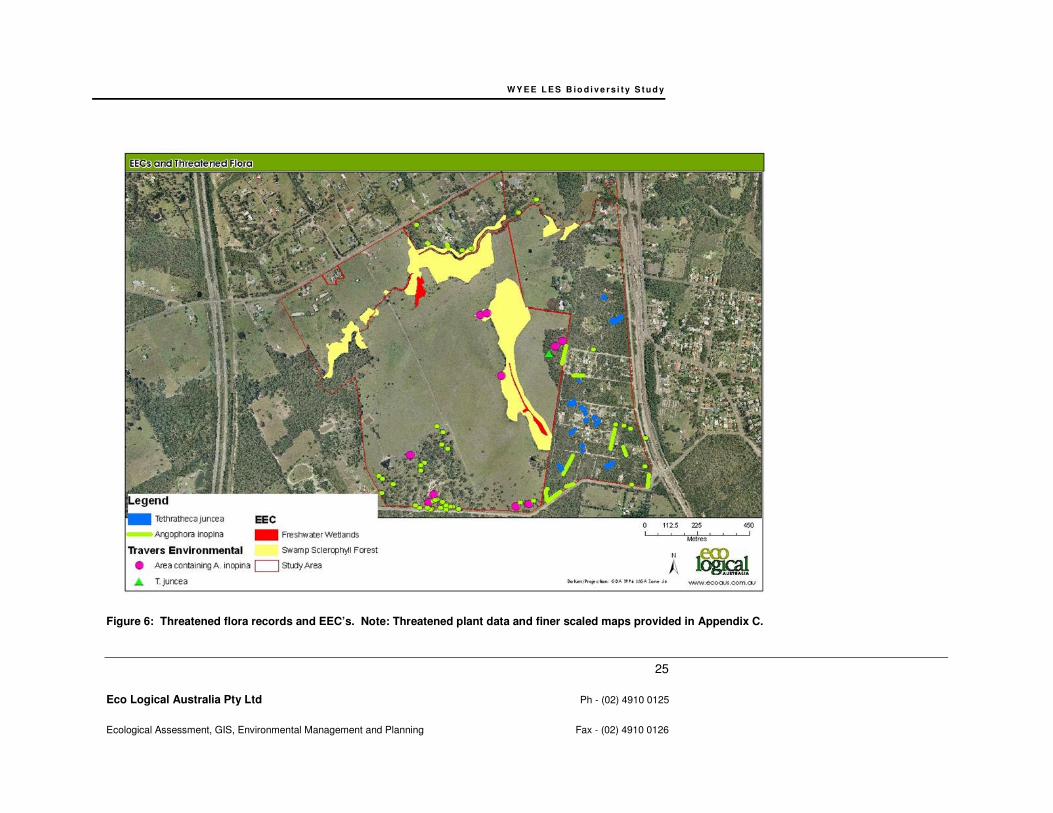
Of the species targeted during flora surveys, two threatened plant species were detected and mapped,
including Tetratheca juncea and Angophora inopina.
A total of 141 Tetratheca juncea individuals were detected during targeted surveys (Figure 6), as
shown in Appendix C which includes an appropriate scale map with labels and data recorded for each
point.
A total of 86 Angophoora inopina individuals were detected in Area A (Figure 6), with some addition to
those mapped in Travers (2008), while an additional 468 individuals were detected in Area B.
Appendix C includes an appropriate scale map with labels and data recorded for each point.
WY E E L E S B io d i v e r s i t y S t u d y
24
Eco Logical Australia Pty Ltd Ph - (02) 4910 0125
Ecological Assessment, GIS, Environmental Management and Planning Fax - (02) 4910 0126
Figure 5: Vegetation communities
WY E E L E S B io d i v e r s i t y S t u d y
25
Eco Logical Australia Pty Ltd Ph - (02) 4910 0125
Ecological Assessment, GIS, Environmental Management and Planning Fax - (02) 4910 0126
Figure 6: Threatened flora records and EEC’s. Note: Threatened plant data and finer scaled maps provided in Appendix C.
W Y E E L E S B io d i v e rs i t y S t u d y
26
Eco Logical Australia Pty Ltd Ph - (02) 4910 0125
Ecological Assessment, GIS, Environmental Management and Planning Fax - (02) 4910 0126
Fauna Habitat
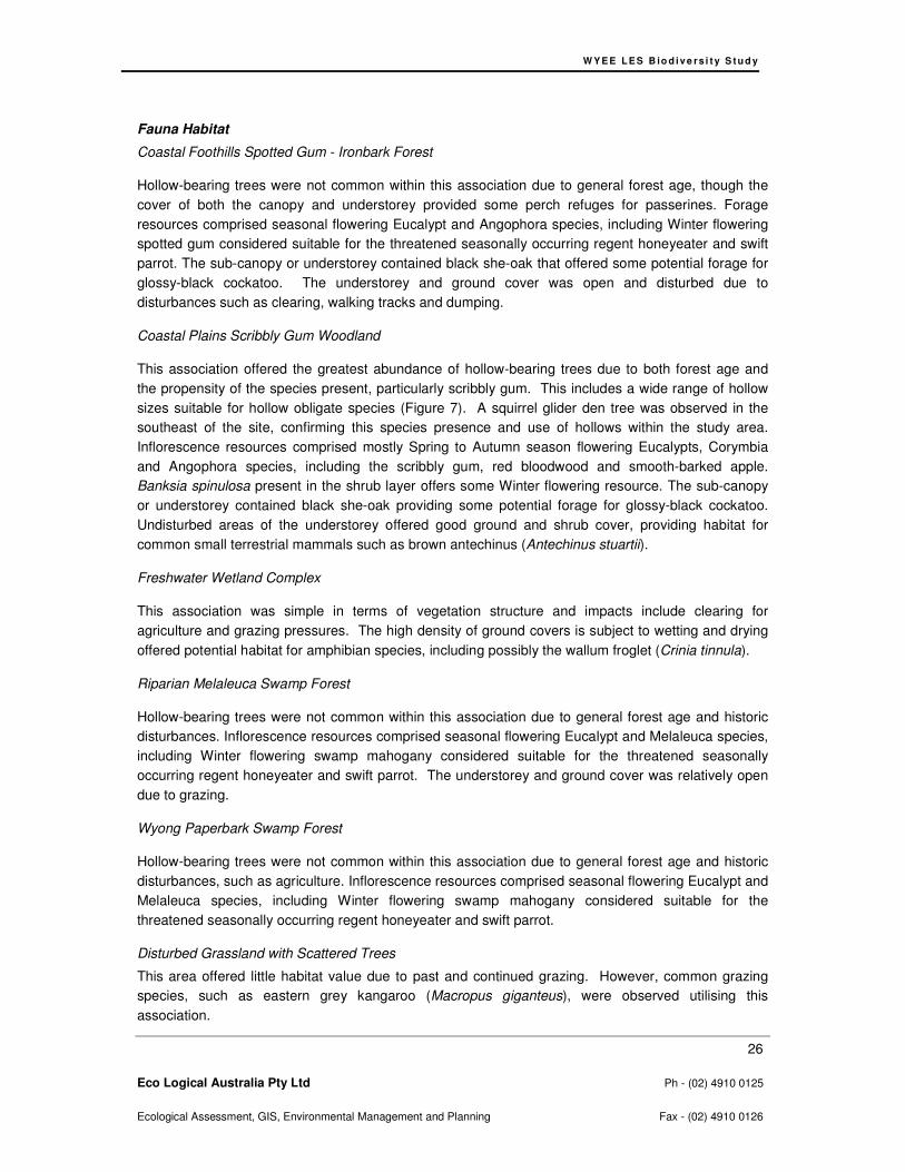
Coastal Foothills Spotted Gum - Ironbark Forest
Hollow-bearing trees were not common within this association due to general forest age, though the
cover of both the canopy and understorey provided some perch refuges for passerines. Forage
resources comprised seasonal flowering Eucalypt and Angophora species, including Winter flowering
spotted gum considered suitable for the threatened seasonally occurring regent honeyeater and swift
parrot. The sub-canopy or understorey contained black she-oak that offered some potential forage for
glossy-black cockatoo. The understorey and ground cover was open and disturbed due to
disturbances such as clearing, walking tracks and dumping.
Coastal Plains Scribbly Gum Woodland
This association offered the greatest abundance of hollow-bearing trees due to both forest age and
the propensity of the species present, particularly scribbly gum. This includes a wide range of hollow
sizes suitable for hollow obligate species (Figure 7). A squirrel glider den tree was observed in the
southeast of the site, confirming this species presence and use of hollows within the study area.
Inflorescence resources comprised mostly Spring to Autumn season flowering Eucalypts, Corymbia
and Angophora species, including the scribbly gum, red bloodwood and smooth-barked apple.
Banksia spinulosa present in the shrub layer offers some Winter flowering resource. The sub-canopy
or understorey contained black she-oak providing some potential forage for glossy-black cockatoo.
Undisturbed areas of the understorey offered good ground and shrub cover, providing habitat for
common small terrestrial mammals such as brown antechinus (Antechinus stuartii).
Freshwater Wetland Complex
This association was simple in terms of vegetation structure and impacts include clearing for
agriculture and grazing pressures. The high density of ground covers is subject to wetting and drying
offered potential habitat for amphibian species, including possibly the wallum froglet (Crinia tinnula).
Riparian Melaleuca Swamp Forest
Hollow-bearing trees were not common within this association due to general forest age and historic
disturbances. Inflorescence resources comprised seasonal flowering Eucalypt and Melaleuca species,
including Winter flowering swamp mahogany considered suitable for the threatened seasonally
occurring regent honeyeater and swift parrot. The understorey and ground cover was relatively open
due to grazing.
Wyong Paperbark Swamp Forest
Hollow-bearing trees were not common within this association due to general forest age and historic
disturbances, such as agriculture. Inflorescence resources comprised seasonal flowering Eucalypt and
Melaleuca species, including Winter flowering swamp mahogany considered suitable for the
threatened seasonally occurring regent honeyeater and swift parrot.
Disturbed Grassland with Scattered Trees
This area offered little habitat value due to past and continued grazing. However, common grazing
species, such as eastern grey kangaroo (Macropus giganteus), were observed utilising this
association.

W Y E E L E S B io d i v e rs i t y S t u d y
27
Eco Logical Australia Pty Ltd Ph - (02) 4910 0125
Ecological Assessment, GIS, Environmental Management and Planning Fax - (02) 4910 0126
Hollow-bearing trees
A total of 137 hollow-bearing trees were recorded within both Area A and Area B. The wide range of
hollow diameter recorded represents suitable roosting and breeding habitat for a range of fauna
including threatened micro-chiropteran bats, squirrel glider and possibly forest owl species. A map
showing the locations of all hollow bearing trees is presented in Figure 7, while full data collected and
labelled hollow-bearing tree locations at an appropriate scale is presented in Appendix D.

WY E E L E S B io d i v e r s i t y S t u d y
28
Eco Logical Australia Pty Ltd Ph - (02) 4910 0125
Ecological Assessment, GIS, Environmental Management and Planning Fax - (02) 4910 0126
Figure 7: Hollow bearing tree results. Note: Data and finer scaled maps provided in Appendix D.
W Y E E L E S B io d i v e rs i t y S t u d y
29
Eco Logical Australia Pty Ltd Ph - (02) 4910 0125
Ecological Assessment, GIS, Environmental Management and Planning Fax - (02) 4910 0126
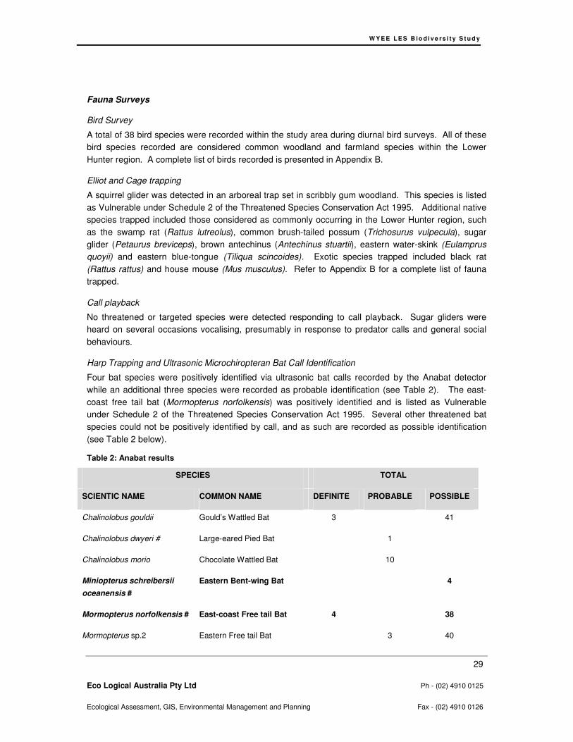
Fauna Surveys
Bird Survey
A total of 38 bird species were recorded within the study area during diurnal bird surveys. All of these
bird species recorded are considered common woodland and farmland species within the Lower
Hunter region. A complete list of birds recorded is presented in Appendix B.
Elliot and Cage trapping
A squirrel glider was detected in an arboreal trap set in scribbly gum woodland. This species is listed
as Vulnerable under Schedule 2 of the Threatened Species Conservation Act 1995. Additional native
species trapped included those considered as commonly occurring in the Lower Hunter region, such
as the swamp rat (Rattus lutreolus), common brush-tailed possum (Trichosurus vulpecula), sugar
glider (Petaurus breviceps), brown antechinus (Antechinus stuartii), eastern water-skink (Eulamprus
quoyii) and eastern blue-tongue (Tiliqua scincoides). Exotic species trapped included black rat
(Rattus rattus) and house mouse (Mus musculus). Refer to Appendix B for a complete list of fauna
trapped.
Call playback
No threatened or targeted species were detected responding to call playback. Sugar gliders were
heard on several occasions vocalising, presumably in response to predator calls and general social
behaviours.
Harp Trapping and Ultrasonic Microchiropteran Bat Call Identification
Four bat species were positively identified via ultrasonic bat calls recorded by the Anabat detector
while an additional three species were recorded as probable identification (see Table 2). The east-
coast free tail bat (Mormopterus norfolkensis) was positively identified and is listed as Vulnerable
under Schedule 2 of the Threatened Species Conservation Act 1995. Several other threatened bat
species could not be positively identified by call, and as such are recorded as possible identification
(see Table 2 below).
Table 2: Anabat results
SPECIES TOTAL
SCIENTIC NAME COMMON NAME DEFINITE PROBABLE POSSIBLE
Chalinolobus gouldii Gould’s Wattled Bat 3 41
Chalinolobus dwyeri # Large-eared Pied Bat 1
Chalinolobus morio Chocolate Wattled Bat 10
Miniopterus schreibersii
oceanensis #
Eastern Bent-wing Bat 4
Mormopterus norfolkensis # East-coast Free tail Bat 4 38
Mormopterus sp.2 Eastern Free tail Bat 3 40
W Y E E L E S B io d i v e rs i t y S t u d y
30
Eco Logical Australia Pty Ltd Ph - (02) 4910 0125
Ecological Assessment, GIS, Environmental Management and Planning Fax - (02) 4910 0126
Scoteanax rueppellii # Greater Broad nosed Bat 1
Scotorepens orion Eastern Broad nosed Bat 1
Tadarida australis White-striped Free tail Bat 5
Vespadelus darlingtoni
Vespadelus pumilus
Large Forest Bat
Eastern Forest Bat
20
8
3
10
Vespadelus regulus Southern Forest Bat 4
Vespadelus vulturnus Little Forest Bat 9
Harp trapping recorded an eastern forest bat (Vespadelus pumilus). No threatened bat species were
recorded using harp traps.
Nocturnal Spotlighting
Two threatened species were detected via spotlighting, including the squirrel glider and grey-headed
flying-fox (Pteropus poliocephalus). Squirrel gliders, listed as Vulnerable under Schedule 2 of the
Threatened Species Conservation Act 1995, were observed on two consecutive nights foraging
scribbly gum woodland within the study area. One male squirrel glider was recorded sheltering in a
hollow and this confirmed den tree has been mapped in Figure 8. Grey-headed flying-foxes, listed as
Vulnerable under both Schedule 2 of the TSC Act and the Environment Protection and Biodiversity
Conservation Act 1999, were recorded foraging within flowering red bloodwood in the scribbly gum
woodland within the study area. All other species observed are not listed as threatened, including the
common brush tail possum and common ringtail possum (Pseudocheirus peregrinus).
Koala Scat Searches
A total of 12 SAT were undertaken in a grid pattern across Area B, with a total of 240 trees searched
for the presence of koala scats, claw marks on tree trunks, and animal presence. No koalas or signs
their activity were recorded. Several scats from other species were encountered opportunistically,
including feral goat (Capra hircus), eastern grey kangaroo (Macropus giganteus) and red-necked
wallaby (Macropus rufogriseus).
Threatened Bird Surveys
Targeted threatened bird surveys were timed to coincide with winter-flowering eucalyptus species did
not record either the swift parrot or regent honeyeater.
Opportunistic Observations and Secondary Evidence
Glossy black-cockatoos (Calyptorhynchus lathami), listed as Vulnerable under Schedule 2 of the
Threatened Species Conservation Act 1995, were observed flying above coastal plains scribbly gum
woodland. Other species recorded incidentally were considered common species and are listed in
Appendix B. Some anecdotal evidence was also recorded, based on conversations with local
residence, and included observations of koala over 15 years prior to the current surveys and an
observation of a spotted-tail quoll raiding chicken coops 3 months prior to the current surveys. Both
records were reportedly observed adjacent to Mannering Creek in the central north of the site. Other

W Y E E L E S B io d i v e rs i t y S t u d y
31
Eco Logical Australia Pty Ltd Ph - (02) 4910 0125
Ecological Assessment, GIS, Environmental Management and Planning Fax - (02) 4910 0126
species recorded included birds, frogs and reptiles common and widespread within the Lower Hunter
and have been included in Appendix B.
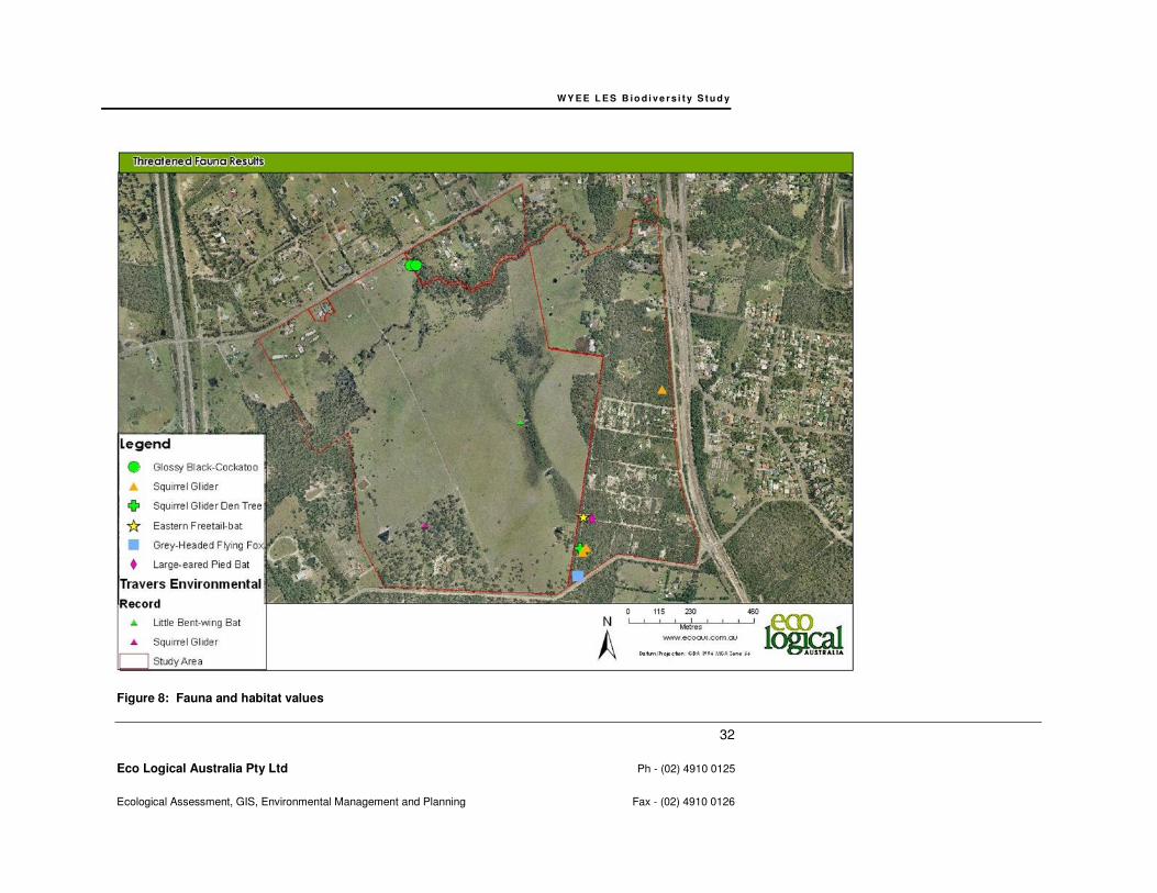
WY E E L E S B io d i v e r s i t y S t u d y
32
Eco Logical Australia Pty Ltd Ph - (02) 4910 0125
Ecological Assessment, GIS, Environmental Management and Planning Fax - (02) 4910 0126
Figure 8: Fauna and habitat values

W Y E E L E S B io d i v e rs i t y S t u d y
33
Eco Logical Australia Pty Ltd Ph - (02) 4910 0125
Ecological Assessment, GIS, Environmental Management and Planning Fax - (02) 4910 0126
4.2.4 Compliance with Survey Guidelines and Survey Limitations
The survey design and intensity undertaken for Area B has generally been aligned with Lake
Macquarie City Council Flora and Fauna Survey Guidelines (2001). However, there was some
exception to strict adherence to these guidelines. In the case of vegetation survey, where vegetation
type areas were limited in Area B, such as Coastal foothills spotted gum –ironbark, Wyong Paperbark
Swamp Forest, Riparian Melaleuca Swamp Forest, multiple vegetation transects were not possible.
This exception was augmented by rapid spot assessments. Similarly, vegetation types limited in area
prevented the full extent of the survey guidelines suggested trapping effort. Despite this, the survey
effort undertaken for the study area is considered adequate in sampling the study areas biodiversity.
The DEC Threatened Biodiversity Survey and Assessment Guidelines (2004) were also compared to
this studies survey intensity. Survey intensity for nocturnal birds, whilst not undertaken in accordance
with the DEC (2004) guidelines (five visits for powerful owl and eight visits for masked owl), was
considered adequate in sampling for the locally occurring and predicted nocturnal bird species. Trap
nights using large terrestrial B traps (60 and 84 trap nights per vegetation type used in this study) and
wire cage traps (8 and 12 trap nights per vegetation type used in this study) did not conform to DEC
(2004), requiring 100 trap nights for large terrestrial B traps and 24 trap nights for wire cage traps per
vegetation type. However, overall this was not considered to be a limitation in sampling the
biodiversity within the study area.
Every effort has been undertaken to reduce survey limitations by conducting survey methods in
compliance with State Government and Council requirements. However, the following factors are
acknowledged as limitations on ecological survey methodology:
• The effect of unpredictable climatic conditions on fauna activity and detectability and flowering phenology;
• Unpredictable seasonal effects on faunal dispersal and distribution;
• The cryptic habits of some threatened flora and fauna species, and
• Statistical and probability factors
These factors are taken into consideration in relation to likelihood of occurrence, assessment of
potential impacts and discussion regarding threatened species within the study area. Where
limitations are considered likely to affect assessment of impacts, adjustment such as additional survey
effort may be recommended.
W Y E E L E S B io d i v e rs i t y S t u d y
34
Eco Logical Australia Pty Ltd Ph - (02) 4910 0125
Ecological Assessment, GIS, Environmental Management and Planning Fax - (02) 4910 0126
5 Relevant Statutory Provisions
5.1 FEDERAL
5.1.1 Environmental Protection and Biodiversity Conservation Act 1999
The Commonwealth Environment Protection and Biodiversity Conservation Act 1999 (EPBC Act)
provides a national scheme for protecting the environment and conserving biodiversity values.
Approval from the Commonwealth Environment Minister is required under the EPBC Act if the action
(which can include a project, development, undertaking or activity) will, or is likely to, have a significant
impact on matters considered to be of national environmental significance (NES matters). NES
matters relevant to the proposal include species and ecological communities that are listed under the
Act. The EPBC Act does not define significant impact but identifies matters that are necessary to take
into consideration.
A total of 14 species listed under the EPBC Act were identified as either occurring or potentially
occurring on the study area based on known habitat preferences and local occurrence (see Section
6.1 and Appendix A). These species will require assessment under the EPBC Act following the
rezoning of the study area if a development application is to be submitted.
5.2 STATE
5.2.1 Environmental Planning and Assessment Act 1979
The Environmental Planning and Assessment Act 1979 (EP&A Act) is the principal planning legislation
for NSW, providing a framework for the overall environmental planning and assessment of
development proposals.
The EP&A Act places a duty on the determining authority to adequately address a range of
environmental matters including maintenance of biodiversity and the likely impact to threatened
species, populations or ecological communities (under the TSC Act – refer below).
There are 25 threatened species and 2 EECs listed under the TSC Act that have either been recorded
or are considered likely to occur within the study area (Appendix A). These species are likely to
require 7-Part Test assessments of significance under Section 5A of the EP&A Act with any
subsequent development application stage.
State Environmental Planning Policy 19 Bushland in Urban Areas
This policy relates to the conservation bushland within urban areas in NSW in relation to development
proposals. SEPP 19 applies to Lake Macquarie LGA and the bushland on the study area satisfies the
definition of bushland in the policy. Therefore Council is required to give priority to preserving
bushland and to have regard to the general and specific aims of the policy when preparing draft local
environmental plans. The objectives include
W Y E E L E S B io d i v e rs i t y S t u d y
35
Eco Logical Australia Pty Ltd Ph - (02) 4910 0125
Ecological Assessment, GIS, Environmental Management and Planning Fax - (02) 4910 0126
• to retain bushland in parcels of a size and configuration which will enable the existing plant and animal communities to survive in the long term,
• to protect rare and endangered flora and fauna species,
• to protect habitats for native flora and fauna, And to
• to promote the management of bushland in a manner which protects and enhances the quality of the bushland and facilitates public enjoyment of the bushland compatible with its conservation
State Environmental Planning Policy 44 Koala Habitat Protection
This policy relates to the conservation of the koala and its habitat in NSW in relation to development
proposals. SEPP 44 applies within the Lake Macquarie LGA.
Potential Koala Habitat Assessment
Scribbly gum and swamp mahogany are the only listed primary koala browse trees under Schedule 2
of SEPP 44 that occur within the study area, with some portions offering densities of primary browse
trees greater than 15 percent of the upper and lower strata. As such, these portions of the study area
qualify as Potential Koala Habitat by SEPP 44 definition and a Core Koala Habitat assessment is
required. Furthermore, observations of vegetation on adjacent land suggests the site is well
connected to what appears to be Potential Koala Habitat within a large remnant to the south of the
study area, suggesting that it is feasible that the site is connected to habitat that could be used as a
broader foraging range for a local population.
Core Koala Habitat Assessment
According to SEPP44 definition:
Core Koala Habitat means an area of land with a resident population of koalas, evidenced by
attributes such as breeding females (that is, females with young) and recent sightings of and
historical records of a population.
The following observations have been considered in relation to this assessment.
• koalas were not recorded during site investigations, despite spotlighting, call playback and
SAT scat searches;
• the nearest known koala locality to the study area is approximately 3km to the north;
• Whilst land holder communications suggest that koala have been sighted adjacent to
Mannering Creek in the northeast of the study area within the last 15-20 years, this is not
considered a recent sighting.
Based on this, the site is not considered to offer high value habitat for koala. It is suggested, based on
local records, anecdotal observations and available habitat, that a low density population of koala
inhabits the broader locality. However, whilst the study area can be considered Potential Koala

W Y E E L E S B io d i v e rs i t y S t u d y
36
Eco Logical Australia Pty Ltd Ph - (02) 4910 0125
Ecological Assessment, GIS, Environmental Management and Planning Fax - (02) 4910 0126
Habitat, the lack of evidence of koala in the study area suggests the site is not subject to regular use
by a resident koala population and that it does not support Core Koala Habitat according to SEPP 44
definition.
Section 62 Consultation - Biodiversity
Lake Macquarie City Council received Section 62 consultation from the Department of Environmental
and Climate Change (DECC) (now the Department of Environment Climate Change and Water)
regarding the management of biodiversity within the LES planning area. Issues relevant to biodiversity
identified by DECC have been discussed in the table below.
Table 3: Section 62 Consultation
DECC Section 62 Response Discussion
Regional Corridor – Extending from
the southern boundary of the subject
land and into Wyong Shire LGA. This
corridor is of significant conservation
value and is being considered for
inclusion in the Regional
Conservation Plan for the Central
Coast. There is a need to maintain
and enhance sub-regional corridors
through the subject site and linking to
the regional corridor.
The regional and sub-regional or local corridor values
are discussed in Section 6.1 and are displayed in
Figure 9. This has been informed by regional and
local corridors identified in the Lake Macquarie City
Council Vegetation and Corridor mapping, the Wyee
Ecological Attributes Study and the Wyee Squirrel
Glider Study. Both local and regional corridors have
been accounted for within the High Ecological
Constraint areas in Figure 10.
Where impacts are proposed on areas
of biodiversity value, the proponent
should clearly demonstrate how they
propose to offset any loss in
biodiversity value to meet the
‘improve or maintain’ threshold.
The development zoning has not been defined to allow
a determination of whether an improve or maintain
outcome can be met. However, it is expected that any
native vegetation removed within the site (i.e.
particularly vegetation within Moderate and High
Constraint areas in Figure 10) would require
conservation offsets either by negotiation with Council
and DECCW or through a recognised offset
mechanism, such as the Biobanking Methodology, in
order to achieve an improve or maintain outcome.
The proposed LEP must adequately
consider relevant threatened species
provisions of the EP&A Act, SEPP44
Koala Habitat Protection, SEPP71
Coastal Protection and the NV Act.
Provisions pursuant of the EP&A Act, SEPP44 Koala
Habitat Protection and the NV Act have been
discussed in Section 5.2.1 and 5.2.3. SEPP71
Coastal Protection is not considered relevant to the
subject site, as the site is greater than 1km from the
Coast, is not within 1km of a coastal lake (Mannering
Lake is 1.2km to the east) and no coastal rivers occur
within 1km of the site.

W Y E E L E S B io d i v e rs i t y S t u d y
37
Eco Logical Australia Pty Ltd Ph - (02) 4910 0125
Ecological Assessment, GIS, Environmental Management and Planning Fax - (02) 4910 0126
Potential direct and indirect impacts
on DECC estate, wilderness areas and
wild rivers and recognised areas of
high conservation value have been
adequately considered and avoided,
ameliorated or compensated as
appropriate.
No such area will be affected by rezoning or future
development proposals on the site.
Attention should be drawn to the
Commonwealth Environmental
Protection and Biodiversity
Conservation Act 1999.
The EPBC Act has been discussed in Section 5.1.1.
5.2.2 Threatened Species Conservation Act 1995
The Threatened Species Conservation Act 1995 (TSC Act) aims to protect and encourage the
recovery of threatened species, populations and ecological communities listed under the Act.
Obligations on Councils include consideration of threatened species, populations, ecological
communities and recovery plans in fulfilling their statutory responsibilities under the EP&A Act.
There are 25 threatened species and 2 EECs listed under the TSC Act that have either been recorded
or are considered likely to occur within the study area (Appendix A). These species are likely to
require 7-Part Test assessments of significance under Section 5A of the EP&A Act with any
subsequent development application stage.
5.2.3 Native Vegetation Act
The Native Vegetation Act 2003 (NV Act) aims to conserve and manage native vegetation through
regulation of native vegetation clearing. It provides for the encouragement and promotion of the
management of native vegetation on a regional basis in the social, economic and environmental
interests of the State. Management of native vegetation must have regard to its contribution to water
quality, biodiversity and land degradation. It also provides a mechanism to improve the condition of
existing native vegetation. Although the NV Act can provide guidance in regard to offsetting and the
requirements under the ‘improve or maintain’ principle, the Act does not apply at the rezoning stage.
5.2.4 Water Management Act 2000
The Rivers and Foreshores Improvement Act 1948 has recently been repealed and the controlled
activity provisions in the Water Management Act 2000 (WM Act) have now commenced. A controlled
W Y E E L E S B io d i v e rs i t y S t u d y
38
Eco Logical Australia Pty Ltd Ph - (02) 4910 0125
Ecological Assessment, GIS, Environmental Management and Planning Fax - (02) 4910 0126
activity approval under the WM Act is required for certain types of developments and activities that are
carried out in or within 40m of a river, lake or estuary.
The WM Act provides a number of mechanisms for protection of water sources via the water
management planning process. If a ‘controlled activity' is proposed on ‘waterfront land', an approval is
required under Section 91 (2) of the WM Act. ‘Controlled activities' include; the construction of
buildings or carrying out of works; the removal of material or vegetation from land by excavation or any
other means; the deposition of material on land by landfill or otherwise. ‘Waterfront land' is defined as
‘the bed of any river or lake, and any land lying between the river or lake and a line drawn parallel to
and 40 metres inland from either the highest bank or shore’.
Approvals for controlled activities are administered by the NSW Department of Water and Energy
(DWE). DWE have developed a set of guidelines to assist applicants who are considering carrying out
a controlled activity on waterfront land. The guidelines provide information on the design and
construction of a controlled activity, and other mechanisms for the protection of waterfront land and
include:
• In-stream works
• Laying pipes & cables in watercourses
• Outlet structures
• Riparian corridors
• Vegetation Management Plans
• Watercourse crossings
These guidelines are available from: http://www.dnr.nsw.gov.au/water/controlled_activity.shtml
The permit typically requires the preparation of a Vegetation Management Plan. The proponents’
responsibility under the WM Act is to assess impact and adjacency to ‘waterfront land’ i.e. within 40m
and to apply guidelines for permits required under s91 of the WM Act. The drainage line flowing north
through the centre and west of the study area are first order streams, requiring a buffer of at least 10m
from the top of bank plus an additional 10m vegetation buffer and approvals will be required under s91
of the WM Act for any works within 40m of these.
Mannering Creek is a second order stream and requires a 20m buffer from the top of bank plus an
additional 10m vegetation buffer. Appropriate riparian buffer width need to be applied in accordance
with the Water Management Act. These buffers have been applied to the ecological constraints map
(Figure 10), and have been incorporated into the High Constraint areas.
6 Strategic Biodiversity Assessment 6.1 BIODIVERSITY VALUES
The study area was found to provide a range of biodiversity values, including general provision of
habitat and connectivity; and threatened and migratory species, and EEC’s listed under the TSC Act

W Y E E L E S B io d i v e rs i t y S t u d y
39
Eco Logical Australia Pty Ltd Ph - (02) 4910 0125
Ecological Assessment, GIS, Environmental Management and Planning Fax - (02) 4910 0126
and/or EPBC Act recorded or considered likely to occur within the study area. Table 4 below provides
a summary of all biodiversity values within the study area.
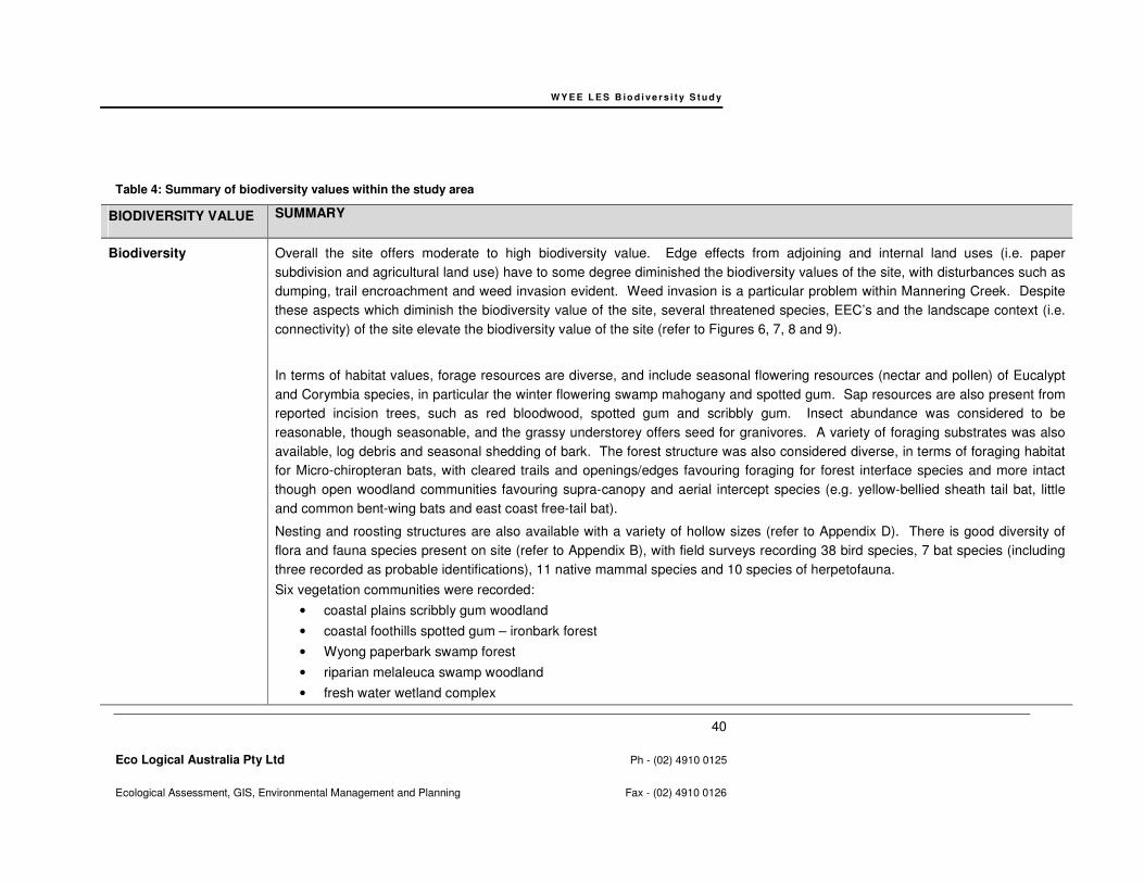
WY E E L E S B io d i v e r s i t y S t u d y
40
Eco Logical Australia Pty Ltd Ph - (02) 4910 0125
Ecological Assessment, GIS, Environmental Management and Planning Fax - (02) 4910 0126
Table 4: Summary of biodiversity values within the study area
BIODIVERSITY VALUE SUMMARY
Biodiversity Overall the site offers moderate to high biodiversity value. Edge effects from adjoining and internal land uses (i.e. paper
subdivision and agricultural land use) have to some degree diminished the biodiversity values of the site, with disturbances such as
dumping, trail encroachment and weed invasion evident. Weed invasion is a particular problem within Mannering Creek. Despite
these aspects which diminish the biodiversity value of the site, several threatened species, EEC’s and the landscape context (i.e.
connectivity) of the site elevate the biodiversity value of the site (refer to Figures 6, 7, 8 and 9).
In terms of habitat values, forage resources are diverse, and include seasonal flowering resources (nectar and pollen) of Eucalypt
and Corymbia species, in particular the winter flowering swamp mahogany and spotted gum. Sap resources are also present from
reported incision trees, such as red bloodwood, spotted gum and scribbly gum. Insect abundance was considered to be
reasonable, though seasonable, and the grassy understorey offers seed for granivores. A variety of foraging substrates was also
available, log debris and seasonal shedding of bark. The forest structure was also considered diverse, in terms of foraging habitat
for Micro-chiropteran bats, with cleared trails and openings/edges favouring foraging for forest interface species and more intact
though open woodland communities favouring supra-canopy and aerial intercept species (e.g. yellow-bellied sheath tail bat, little
and common bent-wing bats and east coast free-tail bat).
Nesting and roosting structures are also available with a variety of hollow sizes (refer to Appendix D). There is good diversity of
flora and fauna species present on site (refer to Appendix B), with field surveys recording 38 bird species, 7 bat species (including
three recorded as probable identifications), 11 native mammal species and 10 species of herpetofauna.
Six vegetation communities were recorded:
• coastal plains scribbly gum woodland
• coastal foothills spotted gum – ironbark forest
• Wyong paperbark swamp forest
• riparian melaleuca swamp woodland
• fresh water wetland complex

WY E E L E S B io d i v e r s i t y S t u d y
41
Eco Logical Australia Pty Ltd Ph - (02) 4910 0125
Ecological Assessment, GIS, Environmental Management and Planning Fax - (02) 4910 0126
• disturbed grassland with scattered trees
Habitat Condition The vegetation communities on site are largely in good condition with 59 large hollow bearing trees and 78 small to medium hollow bearing trees, including a confirmed squirrel glider den tree.
Natural regeneration was evident throughout the study area.
Several parcels of bushland are disturbed including the coastal plains scribbly gum woodland in Area B and vegetation adjacent to
Mannering Creek in the north-east of the study area. The vegetation in the former area is in moderate condition, suffering from
weed invasion, refuse dumping and edge effects. The vegetation in the latter area is in poor to moderate condition, and suffers
from serious weed infestation and refuse dumping.
Local and Regional
Significance
Several different corridor types have been identified in the Wyee Structure Plan (2009). With reference to Figure 9, these include:
• Mannering Creek Riparian Corridor
• Regional Wildlife Pathway – two arms extend into the study area from the south
• Several corridors of remnant native vegetation and partially cleared native vegetation occur across the study area.
The study area is well connected to vegetation to the south, which should be supported and improved in the context of connectivity through the site for any future rezoning of the study area.
The study area offers critical local significance and has the potential to provide improvements to the local conservation and corridor
matrix in the locality. Several studies have been conducted for the Wyee area by Lake Macquarie City Council, including the Wyee
Structure Plan (LMCC & Hunter Strategy, 2009), Wyee Ecological Attributes Study (LMCC 2008a) and Draft Wyee Squirrel Glider
Review (LMCC 2008b). These studies highlight the important biodiversity contributions within the study area, such as Major
Fragment E and important movement corridors through the study area (see Figure 2). These values should be retained and
improved through future rezoning of the study area and have been included in the ecological constraints mapping in Figure 10.
Vegetation Community
Significance
The Lower Hunter Regional Environmental Strategy has adopted the JANIS targets for conservation of vegetation communities.
Therefore:
• 15% reservation of the pre-1750 distribution of each forest ecosystem.
• Where forest ecosystems are recognised as vulnerable, then at least 60% of their remaining extent should be reserved.
Three of the vegetation communities within the study area are classed as vulnerable according to JANIS definition (i.e. >70%
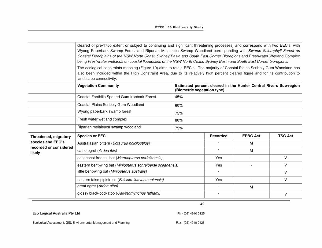
WY E E L E S B io d i v e r s i t y S t u d y
42
Eco Logical Australia Pty Ltd Ph - (02) 4910 0125
Ecological Assessment, GIS, Environmental Management and Planning Fax - (02) 4910 0126
cleared of pre-1750 extent or subject to continuing and significant threatening processes) and correspond with two EEC’s, with
Wyong Paperbark Swamp Forest and Riparian Melaleuca Swamp Woodland corresponding with Swamp Sclerophyll Forest on
Coastal Floodplains of the NSW North Coast, Sydney Basin and South East Corner Bioregions and Freshwater Wetland Complex
being Freshwater wetlands on coastal floodplains of the NSW North Coast, Sydney Basin and South East Corner bioregions.
The ecological constraints mapping (Figure 10) aims to retain EEC’s. The majority of Coastal Plains Scribbly Gum Woodland has
also been included within the High Constraint Area, due to its relatively high percent cleared figure and for its contribution to
landscape connectivity.
Vegetation Community Estimated percent cleared in the Hunter Central Rivers Sub-region (Biometric vegetation type).
Coastal Foothills Spotted Gum Ironbark Forest 45%
Coastal Plains Scribbly Gum Woodland 60%
Wyong paperbark swamp forest
75%
Fresh water wetland complex 80%
Riparian melaleuca swamp woodland 75%
Threatened, migratory
species and EEC’s
recorded or considered
likely
Species or EEC Recorded EPBC Act TSC Act
Australasian bittern (Botaurus poiciloptilus) - M
cattle egret (Ardea ibis) - M
east coast free tail bat (Mormopterus norfolkensis) Yes - V
eastern bent-wing bat (Miniopterus schreibersii oceanensis) Yes - V
little bent-wing bat (Miniopterus australis) - V
eastern false pipistrelle (Falsistrellus tasmaniensis) Yes - V
great egret (Ardea alba) - M
glossy black-cockatoo (Calyptorhynchus lathami) - V
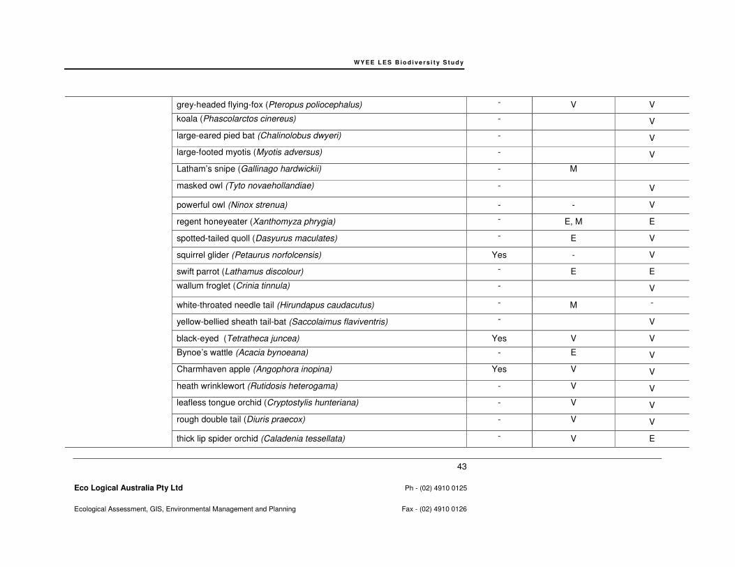
WY E E L E S B io d i v e r s i t y S t u d y
43
Eco Logical Australia Pty Ltd Ph - (02) 4910 0125
Ecological Assessment, GIS, Environmental Management and Planning Fax - (02) 4910 0126
grey-headed flying-fox (Pteropus poliocephalus) - V V
koala (Phascolarctos cinereus) - V
large-eared pied bat (Chalinolobus dwyeri) - V
large-footed myotis (Myotis adversus) - V
Latham’s snipe (Gallinago hardwickii) - M
masked owl (Tyto novaehollandiae) - V
powerful owl (Ninox strenua) - - V
regent honeyeater (Xanthomyza phrygia) - E, M E
spotted-tailed quoll (Dasyurus maculates) - E V
squirrel glider (Petaurus norfolcensis) Yes - V
swift parrot (Lathamus discolour) - E E
wallum froglet (Crinia tinnula) - V
white-throated needle tail (Hirundapus caudacutus) - M -
yellow-bellied sheath tail-bat (Saccolaimus flaviventris) - V
black-eyed (Tetratheca juncea) Yes V V
Bynoe’s wattle (Acacia bynoeana) - E V
Charmhaven apple (Angophora inopina) Yes V V
heath wrinklewort (Rutidosis heterogama) - V V
leafless tongue orchid (Cryptostylis hunteriana) - V V
rough double tail (Diuris praecox) - V V
thick lip spider orchid (Caladenia tessellata) - V E
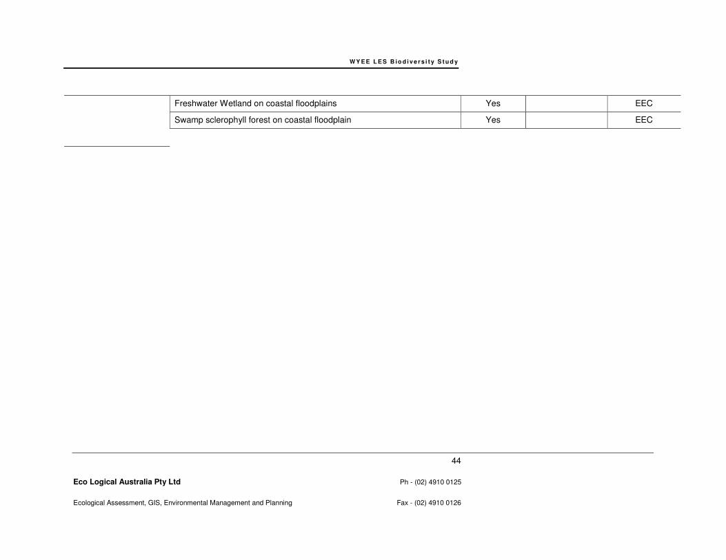
WY E E L E S B io d i v e r s i t y S t u d y
44
Eco Logical Australia Pty Ltd Ph - (02) 4910 0125
Ecological Assessment, GIS, Environmental Management and Planning Fax - (02) 4910 0126
Freshwater Wetland on coastal floodplains Yes EEC
Swamp sclerophyll forest on coastal floodplain Yes EEC
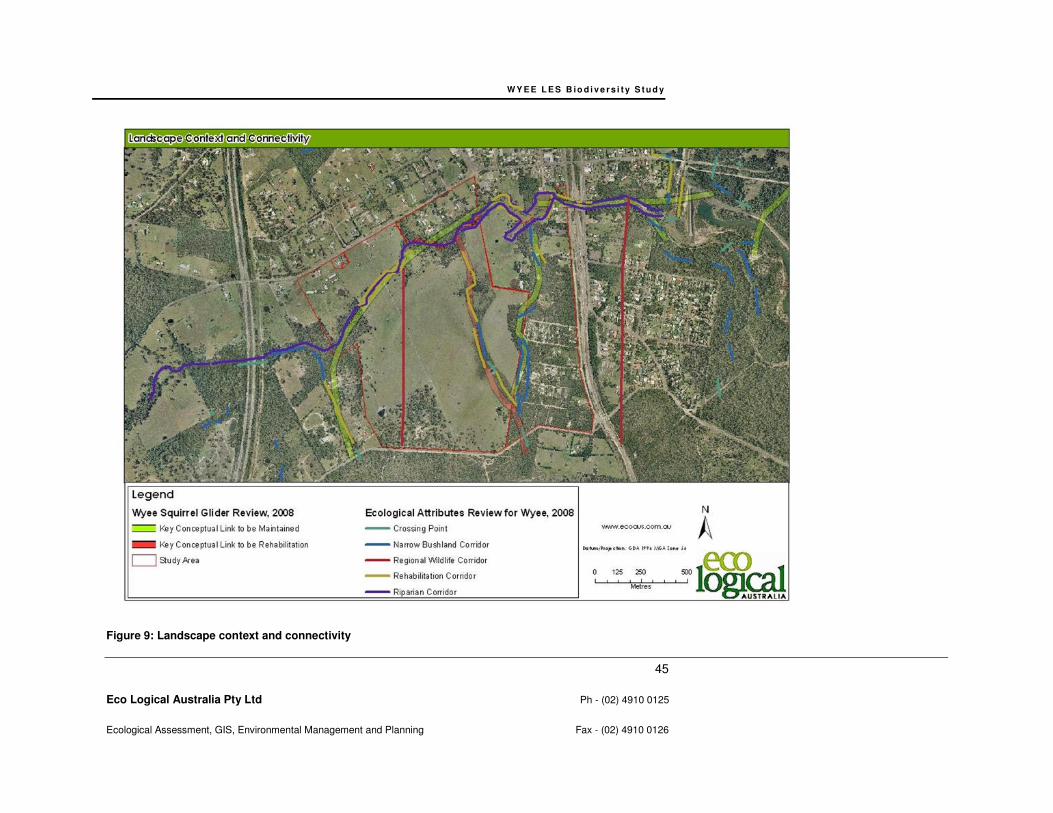
WY E E L E S B io d i v e r s i t y S t u d y
45
Eco Logical Australia Pty Ltd Ph - (02) 4910 0125
Ecological Assessment, GIS, Environmental Management and Planning Fax - (02) 4910 0126
Figure 9: Landscape context and connectivity

W Y E E L E S B io d i v e rs i t y S t u d y
46
Eco Logical Australia Pty Ltd Ph - (02) 4910 0125
Ecological Assessment, GIS, Environmental Management and Planning Fax - (02) 4910 0126
6.2 ADJOINING LAND USES AND LANDSCAPE REVIEW
The study area is situated within the Wyee township, with adjoining land uses including rail and road
corridors, urban matrix, rural residential development and agricultural land uses in the adjacent area.
Rural residential lands occur to the north of the study area. The northern railway line and adjacent
roads form the eastern boundary and urban matrix interspersed with scattered vegetation occurs
further to the east. Beyond Bushells Ridge Road to the south, a large contiguous patch of remnant
vegetation extends to the far south and into Wyong LGA. Fragmented remnant vegetation associated
with Mannering Creek extends to the west of the study area and is eventually bisected by the F3
Freeway.
6.3 POPULATION VIABILITY REVIEW
The biodiversity reported as occurring or likely to occur within this study area generally are considered
to form portions of viable populations utilising not only habitat within the site but also adjoining habitats
in the nearby locality, in particular within remnant vegetation to the south. This is particularly the case
for wide ranging species such as the powerful owl and masked owl, having home ranges of up to
4800ha and 1178ha, respectively (Kavanagh and Murray 1996; Kavanagh 1997; Soderquist and
Gibbons 2007). Similarly, the study area contributes marginal importance in supporting viable
populations of more mobile species, such as some birds. In order to maintain viable populations of
these groups of species it is important to retain areas of remnant vegetation, preferably large
remnants for forest owls, though these groups are less specific in the requirements for remnant
separation and corridor metrics due to their greater mobility.
In contrast, it is important to manage population viability for biodiversity with greater site fidelity
including immobile species (i.e. threatened plants), species with home ranges generally less than
10ha (e.g. gliders) and/or species utilising specific habitat features such as hollows within the study
area.
6.3.1 Population viability of immobile species
Tetratheca juncea is one threatened plant that has been recorded within the study area. According to
the Lake Macquarie City Council Tetratheca juncea Conservation Management Plan and Lake
Macquarie City Council – Biodiversity Planning Policy and Guidelines for LEP Rezoning Proposals
August 2009, key planning considerations to maintain viability of the species include retaining stepping
stone clumps (i.e. plants that are within 500m of other sub-populations) and at least 75% of the sites
sub-populations. There is also a need to conserve populations setting seed. Angophora inopina has
also been recorded and mapped within the study area and should be retained within conservation
zonings formed by contiguous remnant vegetation.
6.3.2 Population viability of species with high site fidelity
In the Wyee area, the squirrel glider has been used successfully as a surrogate species in order to
account for adequate conservation of forest habitats and the habitats of a range of fauna groups,
including species with high site fidelity (LMCC 2008; Smith 2002). In line with maintaining viable
squirrel glider populations, the Lake Macquarie City Council – Biodiversity Planning Policy and
Guidelines for LEP Rezoning Proposals (LMCC 2009) suggests maintaining habitat size and shape
W Y E E L E S B io d i v e rs i t y S t u d y
47
Eco Logical Australia Pty Ltd Ph - (02) 4910 0125
Ecological Assessment, GIS, Environmental Management and Planning Fax - (02) 4910 0126
(minimum 4 ha patches) not more than 1.0 km apart, with suitable vegetated links having gaps <35
metres wide.
The Wyee Squirrel Glider Review indicates that remnants greater than 250 ha or populations of more
than 90 individuals should have close to 100% probability of surviving in the short term (for a period of
about 40-60 years) (LMCC 2008; Smith 2002). Over the long term (>100 years), such populations may
require periodic renewal or genetic enrichment (LMCC 2008; Smith 2002).
The Wyee Squirrel Glider Review suggests that it is appropriate to consider the short term viability of
each habitat fragment within the Wyee locality as an isolated fragment and based on the area and
potential population of each individual fragment. Major Habitat Fragment E is the relevant habitat
fragment for the current LES study area (refer to Figure 2) and is at a minimum 250ha in area,
including adjacent remnant area, and is therefore viable in the short term. However, for the population
of squirrel gliders to be viable in the long term strong corridors connecting between remnants both in
the locality and broader region is of critical importance (LMCC 2008b; Smith 2002).
6.3.3 Summary and response to population viability review
The Ecological Constraints Mapping and Biodiversity Planning Recommendations provided in Section
6.4.2 and 8 have been designed to retain remnants of vegetation containing specific habitat elements
that are well connected to remnant vegetation outside of the study area. The Ecological Constraints
Mapping is the outcome of reviews of studies and policy for the locality and region and has been
designed to allow for the maintenance of viable populations of biodiversity.
6.4 CONSIDERATION OF CONSERVATION AND DEVELOPMENT OPTIONS
Developing conservation options for the study area is to be based on the information collected and
presented Section 4 and aim to conserve areas of high biodiversity value. Regionally significant
vegetation communities and EEC’s occur within the study area, several threatened flora and fauna
species have been recorded or are considered likely to occur (Table 4) and adequate conservation of
well connected habitats for these species is critical in order to maintain population viability and
ecosystem function.
The ecological constraints assessment that follows aims to provide direction for recommendations that
will prevent impacts of significance on the threatened biodiversity observed or likely to occur within the
study area.
6.4.1 Rational
This ecological constraints assessment has been undertaken by classifying the biodiversity value of
the land within the study area based on the threatened flora and fauna species, their habitat, EEC’s,
landscape connectivity and other biodiversity values identified in Section 6.1. In particular, constraints
are designed to address Lake Macquarie City Council – Biodiversity Planning Policy and Guidelines
for LEP Rezoning Proposals August 2009 and is guided by the outcomes of the Wyee Squirrel Glider
Review (LMCC 2008b) and Wyee Ecological Attributes Study (LMCC 2008a).
More specifically, in the mapping provided below, areas of High Ecological Constraint, including
Option – High Ecological Constraint, serve to achieve the requirements of Lake Macquarie City
Council – Biodiversity Planning Policy and Guidelines for LEP Rezoning Proposals August 2009. The
Option – High Ecological Constraint has been provided as an optional development zoning area, due
to the existing paper subdivision and residents and based on discussions with Council.

W Y E E L E S B io d i v e rs i t y S t u d y
48
Eco Logical Australia Pty Ltd Ph - (02) 4910 0125
Ecological Assessment, GIS, Environmental Management and Planning Fax - (02) 4910 0126
Areas of Moderate Ecological Constraint would provide a valuable addition to the conservation
footprint, though is in addition to the requirements of the Lake Macquarie City Council – Biodiversity
Planning Policy and Guidelines for LEP Rezoning Proposals August 2009.
In accordance with the principles of improve or maintain, the approach to development prospects in
areas of High and Moderate Ecological Constraint is to firstly avoid, then mitigate and as a last resort
offset the impacts of development through an appropriate offset strategy. Conservation offsets should
be developed through a conservation offset strategy and offsetting actions may include retaining and
rehabilitating areas of Moderate Ecological Constraint, such as the Regional Wildlife Pathway on the
western edge of the site, or through identifying appropriate land parcels for offsets as identified in the
Wyee Ecological Attributes Study (LMCC2008a).
Areas of Low Ecological Constraint are cleared or offer limited biodiversity contribution due to
degradation and edge effects. Low Ecological Constraint areas should be the focus of future
development zonings and can be cleared or developed with no conservation offsetting requirements.
6.4.2 Ecological Constraints Mapping
High Ecological Constraint Area
High Ecological Constraint areas are delineated in Figure 10 and should be the focus of conservation
zonings within the study area. This area provides for retention of threatened species habitat and
aligns with identified local and regional corridors. Based on the biodiversity information compiled, high
constraint areas have been designed to achieve the requirements of Lake Macquarie City Council –
Biodiversity Planning Policy and Guidelines for LEP Rezoning Proposals August 2009. High
Ecological Constraint areas also align with the Lake Macquarie Lifestyle 2020 Strategy Green System
Map and objective of retaining High Value Habitat and corridor values.
The high constraint areas serve a corridor function within the site, connects to the broader landscape
and aligns with or provides additions/buffers to local and regional corridors identified in the Wyee
Squirrel Glider Study and Ecological Attributes Study (refer to Figure 2 and 10).
In accordance with the principles of maintain of improve, the approach to development prospects in
areas of high constraint areas is to firstly avoid, then mitigate and as a last resort offset the impacts of
any proposed future development. Development or clearing within areas of high constraint is to be
avoided as a priority; however, any clearing or development within areas of high constraint should be
offset through an appropriate offset strategy.
These areas have been mapped as high constraint (refer to Figure 10) due to the following:
• Areas of EEC’s and a 20m buffer in accordance with the LMCC Biodiversity Planning Principles for Local Environmental Plan Rezoning.
• Riparian vegetation and associated statutory buffer requirements, i.e. the Water Management Act, with a 40m buffer from the centre line of 1
st order streams and a 40m from the top of bank
buffer around 2nd
order streams. This is to be done in accordance with the LMCC Biodiversity Planning Policy and Guidelines for LEP Rezoning Proposals and will also fulfil the requirements of the Water Management Act.

W Y E E L E S B io d i v e rs i t y S t u d y
49
Eco Logical Australia Pty Ltd Ph - (02) 4910 0125
Ecological Assessment, GIS, Environmental Management and Planning Fax - (02) 4910 0126
• Black-eyed Susan requirements include retaining stepping stone clumps and at least 75% of local sub-populations. Also populations setting seed are to be conserved. Populations should be adequately conserved across the LGA and across morphological variants.
• The majority of Charmhaven apple individuals in the population are to be retained and the age
structure conserved.
• Threatened flora and fauna species and their habitats that have been recorded or are considered likely to occur within the study area including micro-chiropteran bats, squirrel glider, Charmhaven apple and black-eyed Susan.
• The presence of local and regional corridors, in accordance with the Wyee Structure Plan, Wyee Squirrel Glider Study and the Wyee Ecological Attributes Study.
• Good condition vegetation.
• Known or suitable nesting and roosting habitat for threatened fauna known to occur or likely to occur within the study area. Retain 75% - 80% of habitat trees with small to medium hollows, and 95% of habitat trees with large hollows or spouts.
• Maintaining habitat size and shape (minimum 4 ha patches) not more than 1.0 km apart, with suitable vegetated links having gaps <35 metres wide, in accordance with addressing squirrel glider habitat requirements in the LMCC Biodiversity Planning Policy and Guidelines for LEP Rezoning Proposals.
• The likely occurrence of additional threatened fauna due to the presence of suitable habitat.
Option High Ecological Constraint
The area defined by Option High Ecological Constraint has been mapped based on discussions with
Council relating to management of the existing paper subdivision and residencies and in addressing
“Conservation Value Adjustments” identified in Figure 14 of the Wyee Ecological Attributes Study.
This area is considered to have high ecological value and should be retained in order to meet all the
requirements of the LMCC Biodiversity Planning Principles for Local Environmental Plan Rezoning. If
this area was developed, 90% of the large hollow-bearing trees would be retained within the remaining
High Ecological Constraint area and the target retention of 95% of large hollow bearing trees would
not be met. In addition, several black-eyed susan and Charmhaven apple would be cleared, as
detailed in the inset table of Figure 10.
Moderate Constraint Area
Moderate Ecological Constraint areas have relatively lower ecological value than high constraint
areas, though should be retained where possible and secured within conservation zonings, due to
high recoverability and resilience of these areas, contribution to habitat values for threatened species
or corridor connectivity. Moderate constraint areas still provide forage and refuge habitat and provide
valuable additions to corridor connectivity, though go over and above the Lake Macquarie City Council
– Biodiversity Planning Policy and Guidelines for LEP Rezoning Proposals August 2009. Within this
area, it is recommended that hollow bearing trees be retained where ever possible; however, some
development can occur without significant implications. In accordance with the principles of maintain
of improve, the approach to development prospects native vegetation within areas of moderate
constraint is to firstly avoid, then mitigate and as a last resort offset the impacts of development
Areas mapped in Figure 10 as Moderate Ecological Constraint are mapped as such due to the
following:
• Disturbance history of lower vegetation strata , particularly competition from weeds
• Edge effects due existing unauthorised urban development
• Additional contributions to connectivity and habitat

W Y E E L E S B io d i v e rs i t y S t u d y
50
Eco Logical Australia Pty Ltd Ph - (02) 4910 0125
Ecological Assessment, GIS, Environmental Management and Planning Fax - (02) 4910 0126
• Presence of hollow bearing trees
Low Constraint Area
The remaining areas within the study area are low constraint areas in poor condition.
These areas provide fewer opportunities for threatened fauna due to disturbance of vegetation
structure and comparatively fewer resources than adjacent bushland.
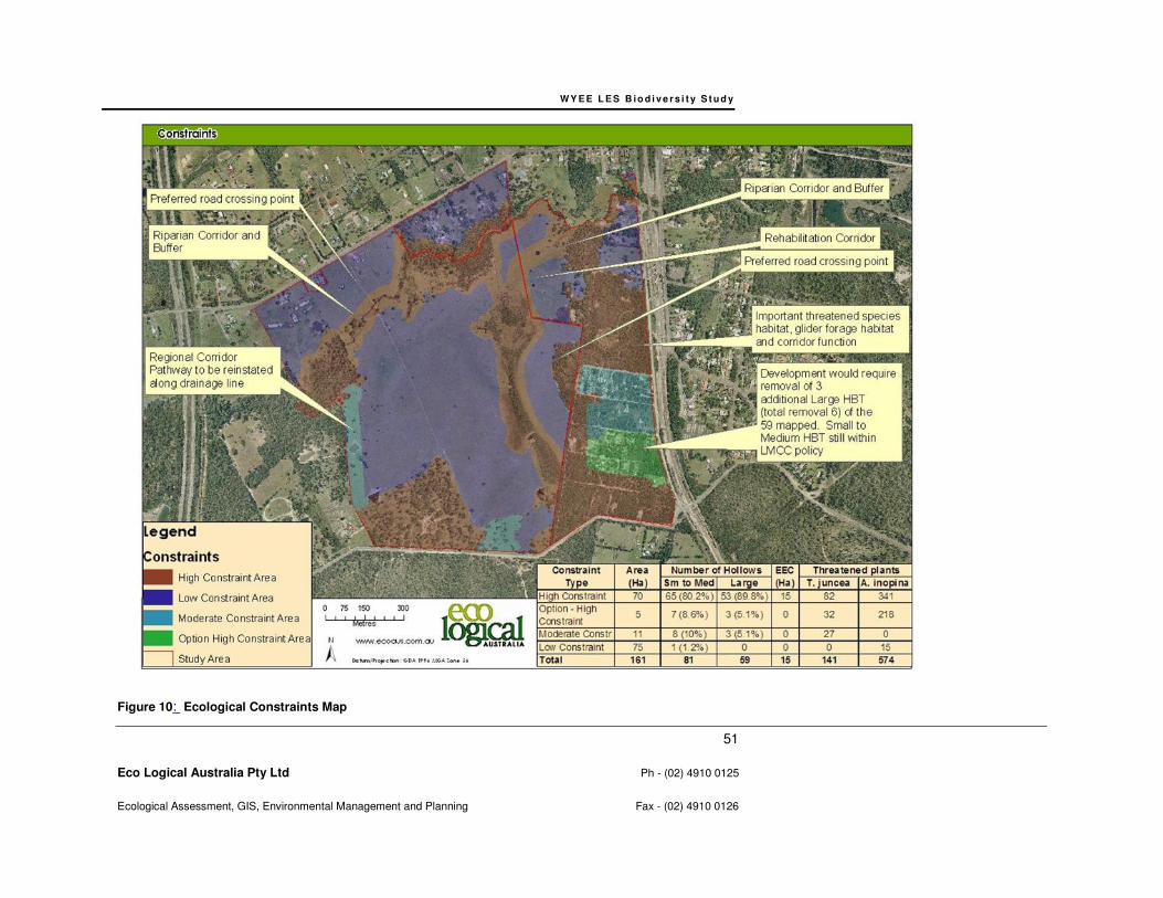
WY E E L E S B io d i v e r s i t y S t u d y
51
Eco Logical Australia Pty Ltd Ph - (02) 4910 0125
Ecological Assessment, GIS, Environmental Management and Planning Fax - (02) 4910 0126
Figure 10: Ecological Constraints Map
WY E E L E S B i o d i v e rs i t y S tu d y
52
Eco Logical Australia Pty Ltd Ph - (02) 4910 0125
Ecological Assessment, GIS, Environmental Management and Planning Fax - (02) 4910 0126
7 Related Land Use Issues
7.1 INFRASTRUCTURE PROVISION
Infrastructure footprints, such as roads, utility services and water reservoirs should be consolidated
within linear alignments and avoid areas of High Ecological Constraint. It is however understood that
this is not likely to be possible for all infrastructure.
In the case of roads, two road crossing points are expected to bisect High Ecological Constraint areas
in order to service development (refer to Figure 10). Utilities are to follow these alignments as much as
possible to avoid unnecessary fragmentation.
The provision of a water reservoir has also been discussed with the LES project team, whereby the
location of the subdivision water reservoir at the highest point in the south of the study area and within
an area of High Ecological Constraint is expected.
7.2 BUSH FIRE MANAGEMENT REQUIREMENTS
It is noted that in Spring 2009 a bushfire affected the southeast portion of the study area and road
widening was undertaken to alleviate bushfire threat to existing residences in the paper subdivision.
Areas of vegetation within the study area subject to the greatest bushfire risk include those areas in the
southeast and south which are connected to larger patches of contiguous vegetation to the south.
Development within the study area will require bushfire management and asset protection. All asset
protection zones are to be located outside of High Ecological Constraint areas. The study area contains
vegetation types that develops moderate to high fuel loads, which should be managed through
ecological burns that reduce fuel loading and manage biodiversity.
8 Biodiversity Planning Recommendations
This biodiversity study has assessed the ecological values on site and the statutory planning
requirements related to those ecological assets. This chapter recommends ecological planning
principles for consideration in future land use and zoning decision making.
Ecological planning principles and recommendations have been developed for this biodiversity study in
order to conserve significant biodiversity values, driven by the Ecological Constraints Mapping in Figure
10, to address Lake Macquarie City Council biodiversity planning policies, Lake Macquarie Lifestyle

WY E E L E S B i o d i v e rs i t y S tu d y
53
Eco Logical Australia Pty Ltd Ph - (02) 4910 0125
Ecological Assessment, GIS, Environmental Management and Planning Fax - (02) 4910 0126
2020 Strategy and align the objectives of the Wyee Structure Plan (LMCC 2009) and Wyee Ecological
Attributes Study (LMCC 2008a).
8.1 DEVELOPMENT PLANNING PRINCIPLES AND RECOMMENDATIONS
• Areas of land having Low Ecological Constraint should be the focus of any proposed
development zoning.
• Areas representing Moderate Ecological Constraint, although offering relatively lower ecological
value than High Ecological Constraint areas, should be retained where practicable, due to the
ability of these areas to regenerate, provide supplementary habitat for threatened fauna and to
secure regional corridors. In particular hollow bearing trees should be retained within these
areas.
• Areas of High Ecological Constraint are recommended to be zoned for conservation, due to the
provision of known and potential habitat for threatened and migratory fauna species, threatened
flora species and corridor values. These areas also depict local government policy constraints,
such as those required under Lake Macquarie City Council – Biodiversity Planning Policy and
Guidelines for LEP Rezoning Proposals August 2009. This constraint type also reflects the
direction of the Wyee Ecological Attributes Study and Wyee Squirrel Glider Review. Therefore
it is highly recommended that these areas are excluded from any development zoning. In
retaining areas of High Ecological Constraint, threatened species and their habitat will be
retained in situ in viable populations due to: the conservation of an appropriate patch size 4 ha
for threatened species with high site fidelity; provision of connectivity to adjacent vegetation to
the south; conservation of all threatened plant species; and retention of hollow bearing trees
(i.e. 76% of habitat trees with small to medium hollows and 95% of habitat trees with large
hollows or spouts are retained).
• Areas of Option – High Ecological Constraint are expected to be rezoned for development to
accommodate for the existing paper subdivision, based on discussions with Council and the
LES team. Mapping of this area generally reflects the “Conservation Value Adjustments”
identified in Figure 14 of the Wyee Ecological Attributes Study. However, this area is
considered to have high ecological value and would be required to be retained in order to meet
all the requirements of the LMCC Biodiversity Planning Principles for Local Environmental Plan
Rezoning. If this area was developed, 90% of the large hollow-bearing trees would be retained
within the remaining High Ecological Constraint area and the target retention of 95% of large
hollow bearing trees, under requirements of the LMCC Biodiversity Planning Principles for Local
Environmental Plan Rezoning, would not be met. In addition, approximately 32 black-eyed
susan and 218 Charmhaven apple individuals would be cleared, as detailed in the inset table of
Figure 10.
• Clearing of any native vegetation that represents habitat for threatened fauna within the study
area, primarily those areas mapped as Moderate and High Ecological Constraint are likely to
require conservation offsets.
• Offset strategies are a last resort and should only be considered where impacts cannot be
avoided or mitigated (DECC 2005). Biodiversity offsets are considered required for the removal
of High Ecological Constraint, Option – High Ecological Constraint and areas of native
vegetation within Moderate Ecological Constraint. Where clearing is required within these
WY E E L E S B i o d i v e rs i t y S tu d y
54
Eco Logical Australia Pty Ltd Ph - (02) 4910 0125
Ecological Assessment, GIS, Environmental Management and Planning Fax - (02) 4910 0126
constraint types, an offset strategy is recommended to be developed and could incorporate a
negotiated offset outcome or the use of an offset mechanism such as Biobanking. Figure 14 of
the Wyee Ecological Attributes Study (LMCC 2008a) should be referred to identify areas in the
locality suitable for supporting these offsets.
• 70-80% of hollow-bearing trees with small to medium hollows and 95% of habitat trees with
large hollows or spouts are retained within High Biodiversity Value areas, which should be up-
held in accordance with the Lake Macquarie City Council – Biodiversity Planning Policy and
Guidelines for LEP Rezoning Proposals August 2009.
• Hollow-bearing trees within areas that have been identified as within development zonings are
to be surveyed for fauna activity prior to removal and, if removal cannot be avoided, should be
compensated through the provision of nest boxes within the retained vegetation. Nest boxes
should be designed in accordance with recent literature (e.g. Beyer and Goldingay 2006) and a
suitably qualified ecologist, providing for a range of fauna groups and are to be monitored and
maintained.
• Where possible, situate all roads and services (such as gas, water and electricity) outside the
areas identified as High Ecological Constraint.
• Asset protection zones for bushfire protection should be located outside High Ecological
Constraint areas.
8.2 MANAGEMENT OF CONSERVATION AREAS
The High Ecological Constraint areas should be retained within conservation zones and will require
subsequent management, due to the encroachment of development and to maintain and improve the
biodiversity values. Management actions could be coordinated through a conservation management
plan, and include the following aspects.
• Habitat restoration works are recommended in the east-west arm of the Mannering Creek
riparian corridor. This has been identified as an area in which the vegetation should be
retained, while the north-south arm requires restoration works of ‘important’ priority, as
suggested in the Draft Wyee Structure Plan.
• Revegetation along the Regional Corridor Pathway along the western edge of the study area
(refer to Figure 10), while providing for stormwater control.
• Restrict trail access to areas zoned for conservation (i.e. those areas of High Constraint).
• Remove current dumping in areas zoned for conservation (i.e. those areas of High Constraint).
Dumping was particularly evident in the west of the Area B and prevent fire trail access for
future dumping.
• Control the removal of habitat in the form of firewood by restricting trail access.
• Address track erosion issue by reassessing the need for tracks, particularly those on slopes
within the site.
• Consider closure and revegetation of those tracks not required to manage the site.
WY E E L E S B i o d i v e rs i t y S tu d y
55
Eco Logical Australia Pty Ltd Ph - (02) 4910 0125
Ecological Assessment, GIS, Environmental Management and Planning Fax - (02) 4910 0126
• Resident education regarding domestic pets and there impacts on native fauna and consider
domestic pet restrictions and/or pet curfews.
• Management of fire fuels through ecological burns.
• Feral predators such as cats and foxes, which were observed in study area, present a difficult management issue, given the large tracts of adjacent bushland to the south. Pest control measures are recommended to be coordinated with pest management on adjoining lands. Resident education regarding the issue of cat predation on threatened fauna occurring within the site, and the conservation value of pet curfews on local threatened fauna might be considered.
• Resident education regarding garden escapees to avoid future weed management issues should be considered.
• Control the removal of habitat in the form of firewood by restricting trail access.
• Management of fire fuels through ecological burns.
W Y E E L E S B io d i v e rs i t y S t u d y
56
Eco Logical Australia Pty Ltd Ph - (02) 4910 0125
Ecological Assessment, GIS, Environmental Management and Planning Fax - (02) 4910 0126
9 Conclusion
Conics engaged Eco Logical Australia Pty Ltd to undertake a biodiversity study of an area of land at
Wyee. The study will be used to inform the preparation of a draft Local Environmental Study to
identify ecological values and inform subsequent land use planning and zoning. This study has
addressed the objectives set by Lake Macquarie City Council, as follows.
1. Review available information for the land and its vicinity (including regional context, databases
and studies undertaken for the site and land in the general area).
Information reviewed as part of this study included regional biodiversity strategies, local studies such
as the Wyee Ecological Attributes Study and Wyee Squirrel Glider Study, a previous ecological study
undertaken by Travers Environmental (2008) on Area A and routine flora and fauna databases such
as Atlas for Wildlife and BioNet.
2. Undertake field surveys to confirm biodiversity values of the site, targeting threatened species
and endangered ecological communities. Survey and reporting is required to meet the
requirements of the Lake Macquarie Flora and Fauna Survey Guidelines (2001). This would
quantify as far as possible the quality, condition, extent, significance, and connectivity of
native vegetation and habitat on the site.
Survey methodology and effort in the biodiversity study was formulated to comply with the
requirements of the Lake Macquarie City Council Flora and Fauna Survey Guidelines (2001).
Thorough field investigations, including vegetation community validation, vegetation surveys, targeted
threatened flora searches, hollow-bearing trees, diurnal bird surveys, Elliot and cage trapping, harp
trapping, Anabat, call playback, spotlighting, koala scat searches, threatened bird surveys and
opportunistic observations, were employed in Area B of the study area.
A total of six vegetation communities were identified during field work including two EEC’s, 153 flora
species including 25 exotic species, and 68 fauna species including 6 exotic species.. A total of six
threatened species were recorded within the study area and six additional threatened species are
considered likely to occur based on local occurrence and known habitat requirements. The study area
contains a range of habitat resources for these threatened species including foraging, roosting and
nesting resources.
3. Summarise the ecological values of the land (at landscape and site scales), and identify
issues relating to the ecological requirements and viability of each significant species,
population and/or vegetation community occurring within the area.
The ecological values, such as the location and extent of threatened species or EEC’s, hollow bearing
trees and local and regional corridors, have been provided and mapped. Ecological or biodiversity

W Y E E L E S B io d i v e rs i t y S t u d y
57
Eco Logical Australia Pty Ltd Ph - (02) 4910 0125
Ecological Assessment, GIS, Environmental Management and Planning Fax - (02) 4910 0126
values have been summarised and the viability of significant species, populations and communities
have been discussed.
4. Identify the strategic biodiversity planning issues (e.g. key biodiversity values, population
viability and landscape context, fragmentation of native vegetation, connectivity requirements,
zoning requirements). This is to enable:
i. subsequent review of the ecological consequences of options for future urban
structure; and
ii. evaluation of the extent to which these options meet Lifestyle 2020 objectives.
Strategic biodiversity planning issues have been identified, based on survey findings of threatened
biodiversity, local and regional studies. This includes findings of key biodiversity values, consideration
and maintenance of population viability and landscape connectivity.
Based on these findings, a rationale of ecological constraints has been presented and mapped. High
Ecological Constraint areas encompass key biodiversity values, both local and regional corridors.
High Ecological Constraint, including Option – High Ecological Constraint, areas should be the focus
of conservation zoning. Conservation of these areas would adequately address the Lake Macquarie
City Council Biodiversity Planning Principles for Local Environmental Plan Rezoning and the Lifestyle
2020 objectives. However, due to the existing paper subdivision, it is understood that Option – High
Ecological Constraint may be zoned for development. The impacts of this loss has been quantified,
including the area, amount of hollow-bearing trees, and number of threatened plant individuals, and
development of this area would require adequate biodiversity offsets.
Moderate Ecological Constraint areas constitute areas of slightly lesser biodiversity constraint, though
would provide valuable addition to any future conservation zoning. These areas should be retained
where possible though, if rezoned for development, would not result in significant implications.
However, the removal of native vegetation within this constraint type would also require a biodiversity
offset.
Areas of Low Ecological Constraint should be the principle focus of development zoning.
7. Recommend principles for long-term conservation of important biodiversity values on the site.
Recommendations for long-term conservation of important biodiversity values have been presented in
the biodiversity planning recommendations. Recommendations have been aligned with the ecological
constraints mapping, and is to be used as a guide to provide for the long-term conservation of the
important biodiversity values.

W Y E E L E S B io d i v e rs i t y S t u d y
58
Eco Logical Australia Pty Ltd Ph - (02) 4910 0125
Ecological Assessment, GIS, Environmental Management and Planning Fax - (02) 4910 0126
References Allison, F.R. and Hoye, G.A. (1998) ‘Eastern Free tail-bat’, In: Strahan, R. (Ed.) The Mammals of
Australia, pp. 484-485, Australian Museum/ Reed Publications, Sydney.
Anstis, M (2002) Tadpoles of South-eastern Australia, Reed New Holland Publishers.
Australian Museum Business Services (1995) Fauna impact statement for proposed forestry activities
in the Urbenville Management Area. Report prepared for State Forests of New South Wales.
Australian Museum Business Services, Sydney.
Bell, S. (2001) ‘Notes on population size and habitat of the vulnerable Cryptostylis hunteriana
(Orchidaceae) from the Central Coast of New South Wales’, Cunninghamia 7(2): 195-204.
Bell, S. (2004) ‘Distribution and habitat of the vulnerable tree species, Angophora inopina (Myrtaceae)
on the Central Coast of New South Wales’, Cunninghamia 8(4) 477-484.
Georgia L. Beyer A and Ross L. Goldingay A (2006) The value of nest boxes in the research and
management of Australian hollow-using arboreal marsupials. Wildlife Research, 2006, 33, 161–174.
Blakers, M., Davies, S., and Reilly, P.N (1984) The Atlas of Australian Birds. RAOU Melbourne
University Press.
Braithwaite, L.W. (1984). ‘The identification of conservation areas for possums and gliders within the
Eden wood pulp concession district’. In: Smith, A.P and Hume, I. D. (Eds.) Possums and Gliders,
Australian Mammal Society, Sydney.
Brendan A Wintle; Rodney P Kavanagh; Michael A McCarthy; Mark A Burgman (2005) Estimating and
dealing with detectability in occupancy surveys for Journal of Wildlife Management; Jul 2005; 69, 3;
Academic Research Library pg. 905
Churchill, S. (1998) Australian Bats, Reed New Holland, Sydney.
Clancy, G.P. (1991) The Biology and Management of the Osprey (Pandion haliaetus cristatus) in
NSW. Special Management Report, No. 6. NSW National parks and Wildlife Service, Sydney.
Cogger, H.G. (2000) Reptiles and Amphibians of Australia, 6th ed. Reed Books, Sydney.
Davey, S.M. (1984) ‘Habitat preference of arboreal marsupials within a coastal forest in southern New
South Wales’. Pp. 509-516 In: Smith, A.P. and Hume, I.D. (Eds.) Possums and Gliders. Australian
Mammal Society, Sydney.
Debus, S.J.S. (1997) ‘The Barking Owl in New South Wales’, Australian Birds, 30(3).
DECC (2004) Threatened Biodiversity Survey and Assessment: Guidelines for Developments and
Activities Working Draft
Department of Environment and Conservation NSW (2005a) Green and Golden Bell Frog (Litoria
aurea) Draft Recovery Plan, Department of Conservation and Environment NSW, Hurstville.
W Y E E L E S B io d i v e rs i t y S t u d y
59
Eco Logical Australia Pty Ltd Ph - (02) 4910 0125
Ecological Assessment, GIS, Environmental Management and Planning Fax - (02) 4910 0126
Department of Environment and Conservation NSW (2007) Threatened Species Profiles
http://www.threatenedspecies.environment.nsw.gov.au/index.aspx
Dwyer, P.D. (1981) ‘Common Bent-wing Bat, Miniopterus schreibersii’, ANH, 20(6):187-190.
Dwyer, P.D. (1995) ‘Common Bent-wing Bat (Miniopterus schreibersii)’, In: R. Strahan (Ed.) The
Australian Museum Complete Book of Australian Mammals, pp494-495, Angus and Robertson
Publishers, Sydney.
Eby, P. (1998) ‘An analysis of the diet specialisation in frugivorous Pteropus poliocephalus in
Australian subtropical rainforest’, Austral Ecology, 23:443-456
Ehmann, E. (1997) Threatened Frogs of New South Wales: Habitats, status and conservation, Frog
and Tadpole Study Group, Sydney.
Environment Australia (2000) Comprehensive and Regional Assessments for North-East NSW. Report
to National Parks and Wildlife Service.
Forest Fauna Surveys & Eastcoast Flora Surveys (2001) Flora and Fauna Survey Guidelines Version 2.0. Unpublished report prepared for LMCC.
HCRCMA (2007) Hunter-Central Rivers Catchment Action Plan. Unpublished report prepared for
HCRCMA.
Garnett, S. (Ed) (1993). Threatened and extinct birds of Australia. Royal Australian Ornithologists
Union and Australian NPWS, Royal Australian Ornithologists Union Report, No. 82.
Harden G. (ed) (1992) Flora of New South Wales, Volume 2, UNSW Press.
Henry, S.R. and Craig, S.A. (1984) ‘Diet, ranging behaviour and social organisation of the Yellow-
bellied Glider (Petaurus australis Shaw) in Victoria, in Smith, A.P. and Hume, I.D. (eds) Possums and
Gliders, Pp. 331-341, Australian Mammal Society, Sydney.
Hoye, G. and Richards, G. (1998) ‘Greater Broad-nosed Bat’, In: Strahan, R. (ed.) The Australian
Museum Complete Book of Australian Mammals, Angus and Robertson Publishers, Sydney.
Hyem, E.L. (1979) ‘Observation on Owls in the Upper Manning River District, New South Wales’,
Corella, 3(2):17-25.
James T. (1997) Urban Bushland Biodiversity Survey, Stage 1: Western Sydney, NPWS, Hurstville.
Jones, D.L. (2001) Six new species and a new combination in Genoplesium R.Br. (Orchidaceae) from
eastern Australia, The Orchadian, 13(7):293-307.
Kavanagh, R.P. (1984) ‘Seasonal changes in habitat use by gliders and possums in south-eastern
New South Wales’, Pp. 527-543 in A.P. Smith & I.D. Hume (eds) Possums and Gliders. Australian
Mammal Society, Sydney.
Kavanagh, R.P. and Peake, P. (1993) ‘Distribution and habitats of nocturnal forest birds in south-
eastern New South Wales’, In: Olsen, P. (Ed.). Proceedings of the 10th Anniversary Conference,
Canberra, pp 86-100, Australian Raptor Association, Royal Ornithologists Union, Sydney.
W Y E E L E S B io d i v e rs i t y S t u d y
60
Eco Logical Australia Pty Ltd Ph - (02) 4910 0125
Ecological Assessment, GIS, Environmental Management and Planning Fax - (02) 4910 0126
Kavanagh, R.P. & M. Murray (1996). Distribution of nocturnal forest birds and mammals in north-
eastern Newcastle, New South Wales. Emu. 96:250-257.
Kavanagh, R. P. 1997. Ecology and Management of Large Forest Owls in South-Eastern Australia.
Unpubl. PhD thesis, University of Sydney, Sydney.
LMCC (2001) Lake Macquarie City Council Lifestyle 2020 Strategy. Unpublished report prepared for
LMCC.
LMCC (2009) Lake Macquarie City Council – Biodiversity Planning Policy and Guidelines for LEP
Rezoning Proposals. Report prepared for LMCC.
LMCC (2007a) Lake Macquarie Native Vegetation and Corridors Map. Unpublished map prepared for
LMCC.
LMCC (2008a) Ecological Attributes Review for Wyee: A report to inform the Strategic Plan and the
Wyee Development Conservation and Servicing Plan. Unpublished report prepared for LMCC.
LMCC (2008b) Wyee Squirrel Glider Review. Unpublished report prepared by McDonald, A. &
Economos-Shaw, R. for Lake Macquarie City Council.
LMCC & Strategy Hunter (2009) Draft Wyee Strategic Plan Background Paper incorporating
Community Feedback. Unpublished report prepared for LMCC.
LMCC & Strategy Hunter (2009a) Early Draft Wyee Structure Plan. Unpublished report for LMCC.
Mahony, M. (1999) ‘Review of the declines and disappearances in the Bell frog species group (Litoria
aurea species group) in Australia’, In: Campbell, A. (Ed.) Declines and Disappearances of Australian
Frogs, pp 81-93, Biodiversity Group Environment Australia, Canberra.
Mansergh, I. M. (1984) ‘The status, distribution and abundance of Dasyurus maculatus (Tiger Quoll) in
Australia with particular reference to Victoria’, Australian Zoology, 21(2):109-22.
Marchant and Higgins (1993) Handbook of Australian, New Zealand and Antarctic Birds. Oxford
University Press, Melbourne.
McKilligan, N. (2005) Herons, Egrets and Bitterns, CSIRO Publishing.
Menkhorst, P., Weavers, B. and Alexander, J. (1988) ‘Distribution, habitat and conservation status of
the Squirrel Glider Petaurus norfolcensis in Victoria’, Aust. Wildl. Res. 15: 59 -71
Morcombe, M. (2004) Field Guide to Australian Birds, Steve Parish Publishing.
Morris, A.K. (1989) ‘The Birds of Botany Bay National Park’, Australian Birds, 23:7-21
NPWS (1995) Endangered Fauna of Western New South Wales, NSW National Parks and Wildlife
Service, Hurstville.
NPWS (1997) Urban Bushland Biodiversity Study - Western Sydney, National Parks and Wildlife
Service.

W Y E E L E S B io d i v e rs i t y S t u d y
61
Eco Logical Australia Pty Ltd Ph - (02) 4910 0125
Ecological Assessment, GIS, Environmental Management and Planning Fax - (02) 4910 0126
NSW Scientific Committee (1998, 2000, 2001) Final Determinations
http://www.nationalparks.nsw.gov.au/npws.nsf/Content/Final+determinations
Olsen, P. (1995) Australian Birds of Prey. University of New South Wales Press, Sydney.
Payne, R. (2000) Lake Macquarie Tetratheca juncea Conservation Management Plan: Final.
Unpublished report for LMCC.
Pyke, G.H and White, A.W. (1996) ‘Habitat requirements for the Green and Golden Bell Frog Litoria
aurea (Anura hylidae), Australian Zoologist, 30(2):177-189.
Quinn, D.G. (1995) ‘Population ecology of the Squirrel Glider and the Sugar Glider at Limeburners
Creek, on the Central North Coast of NSW’, Wildlife Research. 22: 471-505.
Reed, P.C., Lunney, D. and Walker, P. (1990) ‘A 1986-7 survey of the Koala Phascolarctos cinereus
in NSW and an ecological interpretation of its distribution’, In: Biology of the Koala, pp: 55-74.
Richards, G.C. (1988) ‘Large-footed Mouse-eared Bat (Myotis adversus)’, In: Strahan, R (Ed.) The
Australian Museum Complete Book of Australian Mammals, Angus and Robertson Publishers,
Sydney.
Robinson, M. (1993) A Field Guide to Frogs of Australia: from Port Augusta to Fraser Island including
Tasmania, Australian Museum/Reed New Holland, Chatswood.
Schodde, R. and Tidemann, S. (Eds) (1986). Readers Digest complete book of Australian Birds, 2nd
Edition., Reader's Digest Services Pty Ltd, Sydney.
Sheilds, J. and Chrome, F. (1992) Parrots and Pigeons of Australia, Angus and Robinson, Sydney.
Simpson, K. and Day, N. (1999). Field guide to the birds of Australia 6th edition., Penguin Books
Australia Ltd, Ringwood Victoria.
Simpson, K. and Day, N. (2004). Field guide to the birds of Australia 7th edition., Penguin Books
Australia Ltd, Ringwood Victoria.
Smith, P. (1990) The Biology and Management of the Little Tern in NSW, NSW National Parks and
Wildlife Service, Hurstville.
Smith A. P., (2002) Squirrel Glider (Petaurus norfolcensis) Conservation Management Plan: Wyong
Shire. Report prepared by Austeco Environmental Consultants for Wyong Shire Council.
Smith A. P., Watson G. & Murray M. (2002) Fauna Habitat Modelling and Wildlife Linkages in Wyong
Shire. Austeco Environmental Consultants, Armidale.
Smith A and Murray M, 2003, Habitat Requirements of the Squirrel Glider and Associated Possums
and Gliders on the New South Wales Central Coast. Wildlife Research 30, 291-301.
Smith A. P. (2005) Review of Squirrel Glider Impact Assessment: Proposed Residential Development
Jubilee Road, Glendale. Report prepared by Austeco Environmental Consultants for Lake Macquarie
City Council

W Y E E L E S B io d i v e rs i t y S t u d y
62
Eco Logical Australia Pty Ltd Ph - (02) 4910 0125
Ecological Assessment, GIS, Environmental Management and Planning Fax - (02) 4910 0126
Strahan, R. (Ed.) (1998) The Australian Museum Complete Book of Australian Mammals, Angus and
Robertson Publishers, Sydney.
Todd Soderquist A,C and Dale Gibbons B (2007) Home-range of the Powerful Owl (Ninox strenua) in
dry sclerophyll forest. Emu, 2007, 107, 177–184.
Travers Environmental, (2008) Ecological Assessment: Lots 16 & 17 DP 870597, Lot 215 860081, Lot
1 DP 785709 Hue Hue Road, Lot 212 DP 866437 Bushells Ridge Road, Lot 1 DP 244839 Digary
Road, Wyee. Report prepared for Lake Macquarie City Council.
Webb J.K. and Shine R. (1998) ‘Ecological characteristics of a threatened snake species
Hoplocephalus bungaroides (Serpentes: Elapidae)’, Animal Conservation, 1: 185-193.
Winning, H. (1992) Conservation status of rare plants in the Lake Macquarie area, A report prepared
for Lake Macquarie City Council.
WY E E L E S B io d i v e r s i t y S t u d y
63
Eco Logical Australia Pty Ltd Ph - (02) 4910 0125
Ecological Assessment, GIS, Environmental Management and Planning Fax - (02) 4910 0126
Appendix A - Threatened Species, Populations and
Ecological Communities
This Appendix contains the likelihood of occurrence of threatened species, populations and ecological communities in the proposal site.
An assessment of likelihood of occurrence was made for threatened and migratory species identified from the database search. Five
terms for the likelihood of occurrence of species are used in this report. This assessment was based on database or other records,
presence or absence of suitable habitat, features of the proposal site, results of the field survey and professional judgement. The terms for
likelihood of occurrence are defined below:
• “yes” = the species was or has been observed on the site
• “likely” = a medium to high probability that a species uses the site
• “potential” = suitable habitat for a species occurs on the site, but there is insufficient information to categorise the species as likely to
occur, or unlikely to occur
• “unlikely” = a very low to low probability that a species uses the site
• “no” = habitat on site and in the vicinity is unsuitable for the species.
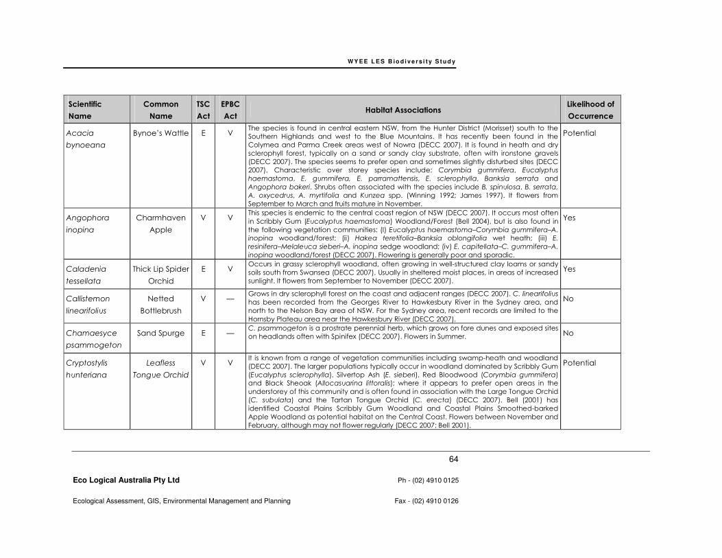
WY E E L E S B io d i v e r s i t y S t u d y
64
Eco Logical Australia Pty Ltd Ph - (02) 4910 0125
Ecological Assessment, GIS, Environmental Management and Planning Fax - (02) 4910 0126
Scientific
Name
Common
Name
TSC
Act
EPBC
Act Habitat Associations
Likelihood of
Occurrence
Acacia
bynoeana
Bynoe’s Wattle E V The species is found in central eastern NSW, from the Hunter District (Morisset) south to the
Southern Highlands and west to the Blue Mountains. It has recently been found in the
Colymea and Parma Creek areas west of Nowra (DECC 2007). It is found in heath and dry
sclerophyll forest, typically on a sand or sandy clay substrate, often with ironstone gravels
(DECC 2007). The species seems to prefer open and sometimes slightly disturbed sites (DECC
2007). Characteristic over storey species include: Corymbia gummifera, Eucalyptus
haemastoma, E. gummifera, E. parramattensis, E. sclerophylla, Banksia serrata and
Angophora bakeri. Shrubs often associated with the species include B. spinulosa, B. serrata,
A. oxycedrus, A. myrtifolia and Kunzea spp. (Winning 1992; James 1997). It flowers from
September to March and fruits mature in November.
Potential
Angophora
inopina
Charmhaven
Apple
V V This species is endemic to the central coast region of NSW (DECC 2007). It occurs most often
in Scribbly Gum (Eucalyptus haemastoma) Woodland/Forest (Bell 2004), but is also found in
the following vegetation communities: (I) Eucalyptus haemastoma–Corymbia gummifera–A.
inopina woodland/forest; (ii) Hakea teretifolia–Banksia oblongifolia wet heath; (iii) E.
resinifera–Melaleuca sieberi–A. inopina sedge woodland; (iv) E. capitellata–C. gummifera–A.
inopina woodland/forest (DECC 2007). Flowering is generally poor and sporadic.
Yes
Caladenia
tessellata
Thick Lip Spider
Orchid
E V Occurs in grassy sclerophyll woodland, often growing in well-structured clay loams or sandy
soils south from Swansea (DECC 2007). Usually in sheltered moist places, in areas of increased
sunlight. It flowers from September to November (DECC 2007).
Yes
Callistemon
linearifolius
Netted
Bottlebrush
V — Grows in dry sclerophyll forest on the coast and adjacent ranges (DECC 2007). C. linearifolius
has been recorded from the Georges River to Hawkesbury River in the Sydney area, and
north to the Nelson Bay area of NSW. For the Sydney area, recent records are limited to the
Hornsby Plateau area near the Hawkesbury River (DECC 2007).
No
Chamaesyce
psammogeton
Sand Spurge E — C. psammogeton is a prostrate perennial herb, which grows on fore dunes and exposed sites
on headlands often with Spinifex (DECC 2007). Flowers in Summer. No
Cryptostylis
hunteriana
Leafless
Tongue Orchid
V V It is known from a range of vegetation communities including swamp-heath and woodland
(DECC 2007). The larger populations typically occur in woodland dominated by Scribbly Gum
(Eucalyptus sclerophylla), Silvertop Ash (E. sieberi), Red Bloodwood (Corymbia gummifera)
and Black Sheoak (Allocasuarina littoralis); where it appears to prefer open areas in the
understorey of this community and is often found in association with the Large Tongue Orchid
(C. subulata) and the Tartan Tongue Orchid (C. erecta) (DECC 2007). Bell (2001) has
identified Coastal Plains Scribbly Gum Woodland and Coastal Plains Smoothed-barked
Apple Woodland as potential habitat on the Central Coast. Flowers between November and
February, although may not flower regularly (DECC 2007; Bell 2001).
Potential

WY E E L E S B io d i v e r s i t y S t u d y
65
Eco Logical Australia Pty Ltd Ph - (02) 4910 0125
Ecological Assessment, GIS, Environmental Management and Planning Fax - (02) 4910 0126
Scientific
Name
Common
Name
TSC
Act
EPBC
Act Habitat Associations
Likelihood of
Occurrence
Diuris praecox Rough
Doubletail
V V Hills and slopes of coastal and near coastal open dry sclerophyll forests which have a grassy
to fairly dense understorey (DECC 2007). Flowers July to early September (DECC 2007). Potential
Eucalyptus
camfieldii
Heart-leaved
Stringybark
V V Associated with shallow sandy soils bordering coastal heath with other stunted or mallee
eucalypts, often in areas with restricted drainage and in areas with laterite influenced soils,
thought to be associated with proximity to shale (DECC 2007). Flowering is irregular and has
been recorded throughout the year (DECC 2007).
Unlikely
Eucalyptus
parramattensis
subsp.
parramattensis
Eucalyptus
parramattensis
subsp.
parramattensis
in Wyong and
Lake
Macquarie
LGAs
E2 – This population is at the north-eastern limit of the species range and is quite separate from
other known populations. The majority of the population occurs within Wyong in the Porter's
Creek and the Wallarah Creek catchments. This species is associated with low moist areas
alongside drainage lines and adjacent to wetlands. It is often found in woodland on sandy
soils. The endangered population occurs on sandy alluvium within a floodplain community
which also supports Eucalyptus robusta (Swamp mahogany), E. tereticornis (Forest Red Gum),
E. gummifera (Sydney Bloodwood) as well as Melaleuca (Paperbark) species.
No
Genoplesium
insigmis
Variable
Midge Orchid
E – It grows in patches of Themeda australis amongst shrubs and sedges in heathland and forest
(Jones 2001). No
Grevillea
parviflora subsp.
parviflora
Small Flower
Grevillea
V V Occurs on sandy clay loam soils, often with lateritic ironstone gravels (DECC 2007). Soils are
mostly derived from Tertiary sands or alluvium and from the Mittagong Formation with
alternating bands of shale and fine-grained sandstones. Soil landscapes include Lucas
Heights and Berkshire Park (DECC 2007). Often occurs in open, slightly disturbed sites such as
along tracks. Flowering has been recorded between July to December as well as April-May
(DECC 2007).
Unlikely
Melaleuca
biconvexa
Biconvex
Paperbark
V V Associated with damp habitats, such as Coastal Narrabeen Moist Forest, Riparian Melaleuca
Swamp Woodland (LMCC 2001). This species may occur in dense stands forming a narrow
strip adjacent to watercourses, in association with other Melaleuca species or as an
understorey species in wet forest (NSW Scientific Committee 1998). Flowering occurs over just
3-4 weeks in September and October (DECC 2007).
Unlikely
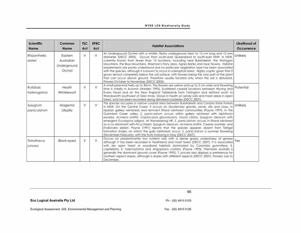
WY E E L E S B io d i v e r s i t y S t u d y
66
Eco Logical Australia Pty Ltd Ph - (02) 4910 0125
Ecological Assessment, GIS, Environmental Management and Planning Fax - (02) 4910 0126
Scientific
Name
Common
Name
TSC
Act
EPBC
Act Habitat Associations
Likelihood of
Occurrence
Rhizanthella
slateri
Eastern
Australian
Underground
Orchid
V V An Underground Orchid with a whitish, fleshy underground stem to 15 cm long and 15 mm
diameter (DECC 2005). Occurs from south-east Queensland to south-east NSW. In NSW,
currently known from fewer than 10 locations, including near Bulahdelah, the Watagan
Mountains, the Blue Mountains, Wiseman's Ferry area, Agnes Banks and near Nowra. Habitat
requirements are poorly understood and no particular vegetation type has been associated
with the species, although it is known to occur in sclerophyll forest. Highly cryptic given that it
grows almost completely below the soil surface, with flowers being the only part of the plant
that can occur above ground. Therefore usually located only when the soil is disturbed.
Flowers October to November (DECC 2005).
Unlikely
Rutidosis
heterogama
Heath
Wrinklewort
V V A small perennial herb up to 30cm. The flowers are yellow and up to 2 cm wide and flowering
time is chiefly in Autumn (Harden 1992). Scattered coastal locations between Wyong and
Evans Head and on the New England Tablelands from Torrington and Ashford south to
Wandsworth southwest of Glen Innes. Grows in heath on sandy soils and moist areas in open
forest, and has been recorded along disturbed roadsides (DECC 2007).
Potential
Syzygium
paniculatum
Magenta
Lillypilly
V V This species occupies a narrow coastal area between Bulahdelah and Conjola State Forests
in NSW. On the Central Coast, it occurs on Quaternary gravels, sands, silts and clays, in
riparian gallery rainforests and remnant littoral rainforest communities (Payne 1997). In the
Ourimbah Creek valley, S. paniculatum occurs within gallery rainforest with Alphitonia
excelsa, Acmena smithii, Cryptocarya glaucescens, Toona ciliata, Syzygium oleosum with
emergent Eucalyptus saligna. At Wyrrabalong NP, S. paniculatum occurs in littoral rainforest
as a co-dominant with Ficus fraseri, Syzygium oleosum, Acmena smithii, Cassine australe, and
Endiandra sieberi. Payne (1991) reports that the species appears absent from Terrigal
formation shales, on which the gully rainforests occur. S. paniculatum is summer flowering
(November-February), with the fruits maturing in May (DECC 2007).
Unlikely
Tetratheca
juncea
Black-eyed V V Occurs on predominantly low nutrient soils with a dense grassy understorey of grasses
although it has been recorded in heathland and moist forest (DECC 2007). It is associated
with dry open forest or woodland habitats dominated by Corymbia gummifera, E.
capitellata, E. haemastoma and Angophora costata (Payne 1993). Themeda australis is
generally the dominant ground cover (Payne 1993). T. juncea also displays a preference for
southern aspect slopes, although is slopes with different aspects (DECC 2007). Flowers July to
December.
Yes
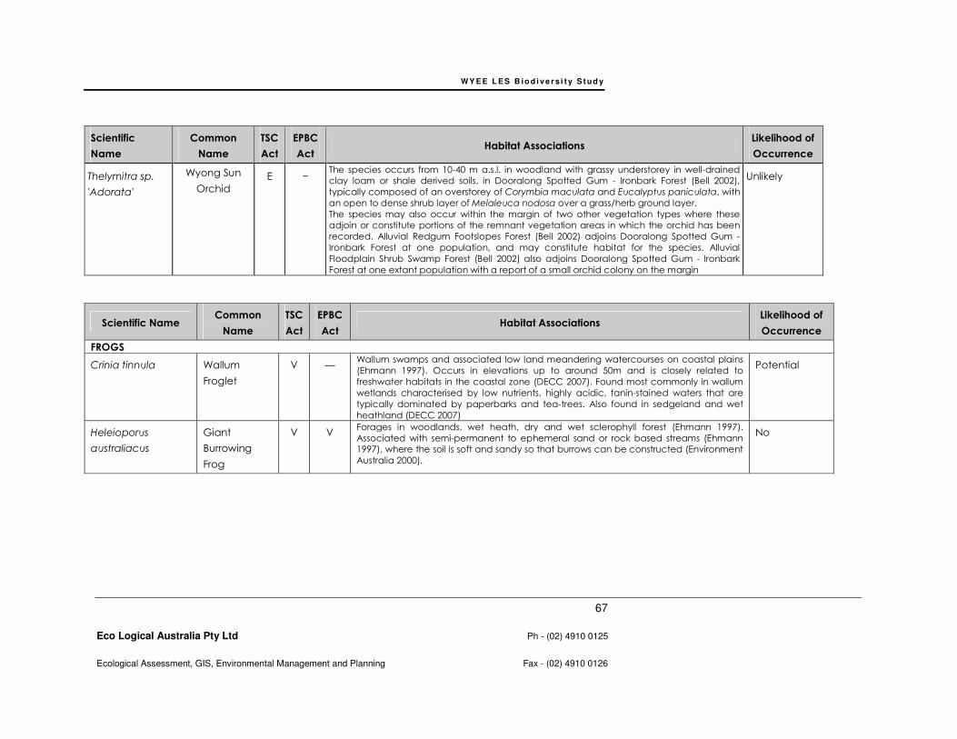
WY E E L E S B io d i v e r s i t y S t u d y
67
Eco Logical Australia Pty Ltd Ph - (02) 4910 0125
Ecological Assessment, GIS, Environmental Management and Planning Fax - (02) 4910 0126
Scientific
Name
Common
Name
TSC
Act
EPBC
Act Habitat Associations
Likelihood of
Occurrence
Thelymitra sp.
'Adorata'
Wyong Sun
Orchid
E − The species occurs from 10-40 m a.s.l. in woodland with grassy understorey in well-drained
clay loam or shale derived soils, in Dooralong Spotted Gum - Ironbark Forest (Bell 2002),
typically composed of an overstorey of Corymbia maculata and Eucalyptus paniculata, with
an open to dense shrub layer of Melaleuca nodosa over a grass/herb ground layer.
The species may also occur within the margin of two other vegetation types where these
adjoin or constitute portions of the remnant vegetation areas in which the orchid has been
recorded. Alluvial Redgum Footslopes Forest (Bell 2002) adjoins Dooralong Spotted Gum -
Ironbark Forest at one population, and may constitute habitat for the species. Alluvial
Floodplain Shrub Swamp Forest (Bell 2002) also adjoins Dooralong Spotted Gum - Ironbark
Forest at one extant population with a report of a small orchid colony on the margin
Unlikely
Scientific Name Common
Name
TSC
Act
EPBC
Act Habitat Associations
Likelihood of
Occurrence
FROGS
Crinia tinnula Wallum
Froglet
V — Wallum swamps and associated low land meandering watercourses on coastal plains
(Ehmann 1997). Occurs in elevations up to around 50m and is closely related to
freshwater habitats in the coastal zone (DECC 2007). Found most commonly in wallum
wetlands characterised by low nutrients, highly acidic, tanin-stained waters that are
typically dominated by paperbarks and tea-trees. Also found in sedgeland and wet
heathland (DECC 2007)
Potential
Heleioporus
australiacus
Giant
Burrowing
Frog
V V Forages in woodlands, wet heath, dry and wet sclerophyll forest (Ehmann 1997).
Associated with semi-permanent to ephemeral sand or rock based streams (Ehmann
1997), where the soil is soft and sandy so that burrows can be constructed (Environment
Australia 2000).
No
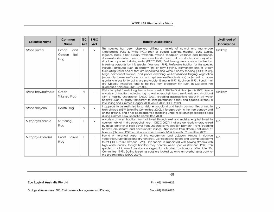
WY E E L E S B io d i v e r s i t y S t u d y
68
Eco Logical Australia Pty Ltd Ph - (02) 4910 0125
Ecological Assessment, GIS, Environmental Management and Planning Fax - (02) 4910 0126
Scientific Name Common
Name
TSC
Act
EPBC
Act Habitat Associations
Likelihood of
Occurrence
Litoria aurea Green and
Golden Bell
Frog
E V This species has been observed utilising a variety of natural and man-made
waterbodies (Pyke & White 1996) such as coastal swamps, marshes, dune swales,
lagoons, lakes, other estuary wetlands, riverine floodplain wetlands and billabongs,
stormwater detention basins, farm dams, bunded areas, drains, ditches and any other
structure capable of storing water (DECC 2007). Fast flowing streams are not utilised for
breeding purposes by this species (Mahony 1999). Preferable habitat for this species
includes attributes such as shallow, still or slow flowing, permanent and/or widely
fluctuating water bodies that are unpolluted and without heavy shading (DECC 2007).
Large permanent swamps and ponds exhibiting well-established fringing vegetation
(especially bulrushes–Typha sp. and spikerushes–Eleocharis sp.) adjacent to open
grassland areas for foraging are preferable (Ehmann 1997; Robinson 1993). Ponds that
are typically inhabited tend to be free from predatory fish such as Mosquito Fish
(Gambusia holbrooki) (DECC 2007).
Unlikely
Litoria brevipalmata Green
Thighed Frog
V — Wet sclerophyll forest along the northern coast of NSW to Ourimbah (Anstis 2002). Also in
a variety of habitats including dry to wet sclerophyll forest, rainforests and shrubland
with a healthy understorey (DECC 2007). Breeding aggregations occur in still water
habitats such as grassy temporary to semi-permanent ponds and flooded ditches in
late spring and summer (Cogger 2000; Anstis 2002; DECC 2007).
Unlikely
Litoria littlejohni Heath Frog V V It appears to be restricted to sandstone woodland and heath communities at mid to
high altitude (NSW Scientific Committee 2000). It forages both in the tree canopy and
on the ground, and it has been observed sheltering under rocks on high exposed ridges
during summer (NSW Scientific Committee 2000).
No
Mixophyes balbus Stuttering
Frog
E V A variety of forest habitats from rainforest through wet and moist sclerophyll forest to
riparian habitat in dry sclerophyll forest (DECC 2007) that are generally characterised
by deep leaf litter or thick cover from understorey vegetation (Ehmann 1997). Breeding
habitats are streams and occasionally springs. Not known from streams disturbed by
humans (Ehmann 1997) or still water environments (NSW Scientific Committee 2002).
No
Mixophyes iteratus Giant Barred
Frog
E E Found on forested slopes of the escarpment and adjacent ranges in riparian
vegetation, subtropical and dry rainforest, wet sclerophyll forests and swamp sclerophyll
forest (DECC 2007; Ehmann 1997). This species is associated with flowing streams with
high water quality, though habitats may contain weed species (Ehmann 1997). This
species is not known from riparian vegetation disturbed by humans (NSW Scientific
Committee 1999). During breeding eggs are kicked up onto an overhanging bank or
the streams edge (DECC 2007).
No
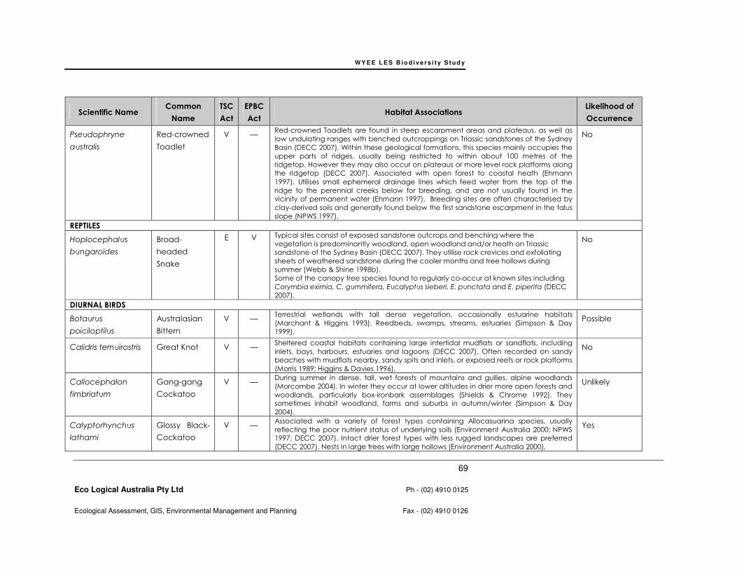
WY E E L E S B io d i v e r s i t y S t u d y
69
Eco Logical Australia Pty Ltd Ph - (02) 4910 0125
Ecological Assessment, GIS, Environmental Management and Planning Fax - (02) 4910 0126
Scientific Name Common
Name
TSC
Act
EPBC
Act Habitat Associations
Likelihood of
Occurrence
Pseudophryne
australis
Red-crowned
Toadlet
V — Red-crowned Toadlets are found in steep escarpment areas and plateaus, as well as
low undulating ranges with benched outcroppings on Triassic sandstones of the Sydney
Basin (DECC 2007). Within these geological formations, this species mainly occupies the
upper parts of ridges, usually being restricted to within about 100 metres of the
ridgetop. However they may also occur on plateaus or more level rock platforms along
the ridgetop (DECC 2007). Associated with open forest to coastal heath (Ehmann
1997). Utilises small ephemeral drainage lines which feed water from the top of the
ridge to the perennial creeks below for breeding, and are not usually found in the
vicinity of permanent water (Ehmann 1997). Breeding sites are often characterised by
clay-derived soils and generally found below the first sandstone escarpment in the talus
slope (NPWS 1997).
No
REPTILES
Hoplocephalus
bungaroides
Broad-
headed
Snake
E V Typical sites consist of exposed sandstone outcrops and benching where the
vegetation is predominantly woodland, open woodland and/or heath on Triassic
sandstone of the Sydney Basin (DECC 2007). They utilise rock crevices and exfoliating
sheets of weathered sandstone during the cooler months and tree hollows during
summer (Webb & Shine 1998b).
Some of the canopy tree species found to regularly co-occur at known sites including
Corymbia eximia, C. gummifera, Eucalyptus sieberi, E. punctata and E. piperita (DECC
2007).
No
DIURNAL BIRDS
Botaurus
poiciloptilus
Australasian
Bittern
V — Terrestrial wetlands with tall dense vegetation, occasionally estuarine habitats
(Marchant & Higgins 1993). Reedbeds, swamps, streams, estuaries (Simpson & Day
1999).
Possible
Calidris ternuirostris Great Knot V — Sheltered coastal habitats containing large intertidal mudflats or sandflats, including
inlets, bays, harbours, estuaries and lagoons (DECC 2007). Often recorded on sandy
beaches with mudflats nearby, sandy spits and inlets, or exposed reefs or rock platforms
(Morris 1989; Higgins & Davies 1996).
No
Callocephalon
fimbriatum
Gang-gang
Cockatoo
V — During summer in dense, tall, wet forests of mountains and gullies, alpine woodlands
(Morcombe 2004). In winter they occur at lower altitudes in drier more open forests and
woodlands, particularly box-ironbark assemblages (Shields & Chrome 1992). They
sometimes inhabit woodland, farms and suburbs in autumn/winter (Simpson & Day
2004).
Unlikely
Calyptorhynchus
lathami
Glossy Black-
Cockatoo
V — Associated with a variety of forest types containing Allocasuarina species, usually
reflecting the poor nutrient status of underlying soils (Environment Australia 2000; NPWS
1997; DECC 2007). Intact drier forest types with less rugged landscapes are preferred
(DECC 2007). Nests in large trees with large hollows (Environment Australia 2000).
Yes
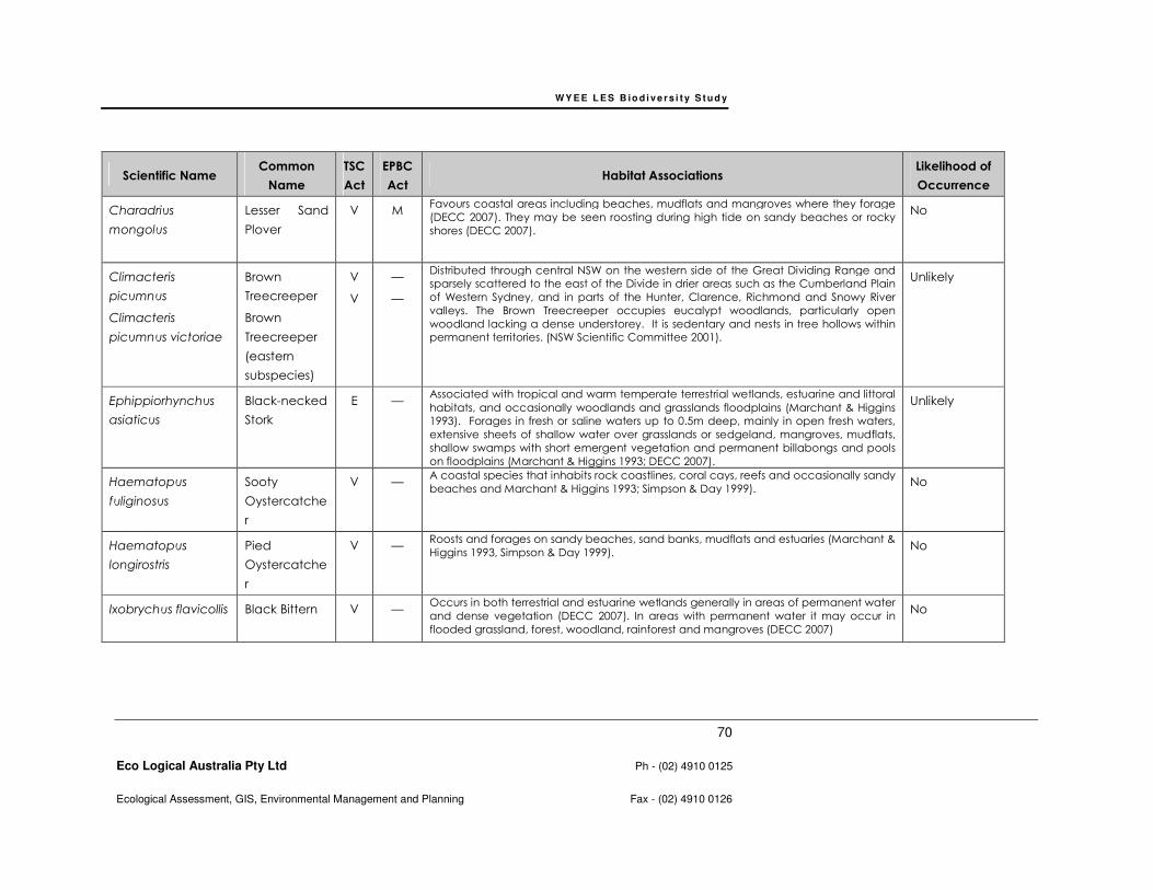
WY E E L E S B io d i v e r s i t y S t u d y
70
Eco Logical Australia Pty Ltd Ph - (02) 4910 0125
Ecological Assessment, GIS, Environmental Management and Planning Fax - (02) 4910 0126
Scientific Name Common
Name
TSC
Act
EPBC
Act Habitat Associations
Likelihood of
Occurrence
Charadrius
mongolus
Lesser Sand
Plover
V M Favours coastal areas including beaches, mudflats and mangroves where they forage
(DECC 2007). They may be seen roosting during high tide on sandy beaches or rocky
shores (DECC 2007).
No
Climacteris
picumnus
Climacteris
picumnus victoriae
Brown
Treecreeper
Brown
Treecreeper
(eastern
subspecies)
V
V
—
—
Distributed through central NSW on the western side of the Great Dividing Range and
sparsely scattered to the east of the Divide in drier areas such as the Cumberland Plain
of Western Sydney, and in parts of the Hunter, Clarence, Richmond and Snowy River
valleys. The Brown Treecreeper occupies eucalypt woodlands, particularly open
woodland lacking a dense understorey. It is sedentary and nests in tree hollows within
permanent territories. (NSW Scientific Committee 2001).
Unlikely
Ephippiorhynchus
asiaticus
Black-necked
Stork
E — Associated with tropical and warm temperate terrestrial wetlands, estuarine and littoral
habitats, and occasionally woodlands and grasslands floodplains (Marchant & Higgins
1993). Forages in fresh or saline waters up to 0.5m deep, mainly in open fresh waters,
extensive sheets of shallow water over grasslands or sedgeland, mangroves, mudflats,
shallow swamps with short emergent vegetation and permanent billabongs and pools
on floodplains (Marchant & Higgins 1993; DECC 2007).
Unlikely
Haematopus
fuliginosus
Sooty
Oystercatche
r
V — A coastal species that inhabits rock coastlines, coral cays, reefs and occasionally sandy
beaches and Marchant & Higgins 1993; Simpson & Day 1999). No
Haematopus
longirostris
Pied
Oystercatche
r
V — Roosts and forages on sandy beaches, sand banks, mudflats and estuaries (Marchant &
Higgins 1993, Simpson & Day 1999). No
Ixobrychus flavicollis Black Bittern
V — Occurs in both terrestrial and estuarine wetlands generally in areas of permanent water
and dense vegetation (DECC 2007). In areas with permanent water it may occur in
flooded grassland, forest, woodland, rainforest and mangroves (DECC 2007)
No
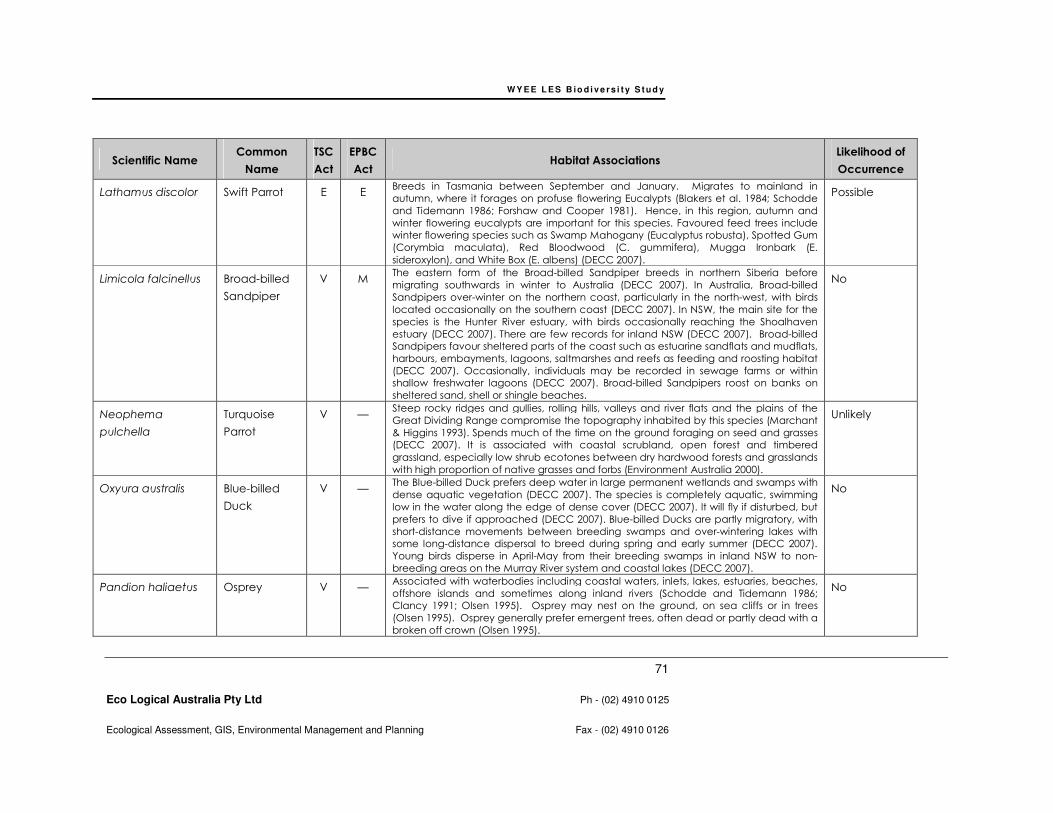
WY E E L E S B io d i v e r s i t y S t u d y
71
Eco Logical Australia Pty Ltd Ph - (02) 4910 0125
Ecological Assessment, GIS, Environmental Management and Planning Fax - (02) 4910 0126
Scientific Name Common
Name
TSC
Act
EPBC
Act Habitat Associations
Likelihood of
Occurrence
Lathamus discolor Swift Parrot E E Breeds in Tasmania between September and January. Migrates to mainland in
autumn, where it forages on profuse flowering Eucalypts (Blakers et al. 1984; Schodde
and Tidemann 1986; Forshaw and Cooper 1981). Hence, in this region, autumn and
winter flowering eucalypts are important for this species. Favoured feed trees include
winter flowering species such as Swamp Mahogany (Eucalyptus robusta), Spotted Gum
(Corymbia maculata), Red Bloodwood (C. gummifera), Mugga Ironbark (E.
sideroxylon), and White Box (E. albens) (DECC 2007).
Possible
Limicola falcinellus Broad-billed
Sandpiper
V M The eastern form of the Broad-billed Sandpiper breeds in northern Siberia before
migrating southwards in winter to Australia (DECC 2007). In Australia, Broad-billed
Sandpipers over-winter on the northern coast, particularly in the north-west, with birds
located occasionally on the southern coast (DECC 2007). In NSW, the main site for the
species is the Hunter River estuary, with birds occasionally reaching the Shoalhaven
estuary (DECC 2007). There are few records for inland NSW (DECC 2007). Broad-billed
Sandpipers favour sheltered parts of the coast such as estuarine sandflats and mudflats,
harbours, embayments, lagoons, saltmarshes and reefs as feeding and roosting habitat
(DECC 2007). Occasionally, individuals may be recorded in sewage farms or within
shallow freshwater lagoons (DECC 2007). Broad-billed Sandpipers roost on banks on
sheltered sand, shell or shingle beaches.
No
Neophema
pulchella
Turquoise
Parrot
V — Steep rocky ridges and gullies, rolling hills, valleys and river flats and the plains of the
Great Dividing Range compromise the topography inhabited by this species (Marchant
& Higgins 1993). Spends much of the time on the ground foraging on seed and grasses
(DECC 2007). It is associated with coastal scrubland, open forest and timbered
grassland, especially low shrub ecotones between dry hardwood forests and grasslands
with high proportion of native grasses and forbs (Environment Australia 2000).
Unlikely
Oxyura australis Blue-billed
Duck
V — The Blue-billed Duck prefers deep water in large permanent wetlands and swamps with
dense aquatic vegetation (DECC 2007). The species is completely aquatic, swimming
low in the water along the edge of dense cover (DECC 2007). It will fly if disturbed, but
prefers to dive if approached (DECC 2007). Blue-billed Ducks are partly migratory, with
short-distance movements between breeding swamps and over-wintering lakes with
some long-distance dispersal to breed during spring and early summer (DECC 2007).
Young birds disperse in April-May from their breeding swamps in inland NSW to non-
breeding areas on the Murray River system and coastal lakes (DECC 2007).
No
Pandion haliaetus Osprey
V — Associated with waterbodies including coastal waters, inlets, lakes, estuaries, beaches,
offshore islands and sometimes along inland rivers (Schodde and Tidemann 1986;
Clancy 1991; Olsen 1995). Osprey may nest on the ground, on sea cliffs or in trees
(Olsen 1995). Osprey generally prefer emergent trees, often dead or partly dead with a
broken off crown (Olsen 1995).
No

WY E E L E S B io d i v e r s i t y S t u d y
72
Eco Logical Australia Pty Ltd Ph - (02) 4910 0125
Ecological Assessment, GIS, Environmental Management and Planning Fax - (02) 4910 0126
Scientific Name Common
Name
TSC
Act
EPBC
Act Habitat Associations
Likelihood of
Occurrence
Pomatostomus
temporalis
temporalis
Grey-
crowned
Babbler
(eastern
subspecies)
V — Open woodlands dominated by mature eucalypts with regenerating trees, tall shrubs,
and an intact ground cover of grass and forbs (NSW Scientific Committee 2001). This
species avoids very wet areas (Blakers et al. 1984).
Unlikely
Pterodroma
leucoptera
leucoptera
Gould's Petrel E E Breeds on both Cabbage Tree Island, 1.4 km offshore from Port Stephens and
on nearby Boondelbah island. The range and feeding areas of non-breeding
Petrels are unknown.
No
Ptilinopus regina
Rose-
crowned
Fruit-Dove
V — Tall tropical and subtropical, evergreen or semi-deciduous rainforests, especially with a
dense growth of vines trees (Marchant and Higgins 1999). Also located in closed wet
sclerophyll forest, gallery forests or sclerophyll woodlands with abundant fruiting trees,
near or next to rainforest (DECC 2007). Is thought to prefer large areas of vegetation,
but has been located in patches and occasionally in parks and gardens with fruiting
trees (Marchant and Higgins 1999).
No
Pyrrholaemus
sagittatus
Speckled
Warbler
V — Occupies a wide range of eucalypt dominated communities with a grassy understorey,
often on rocky ridges or in gullies (DECC 2007). Typical habitat would include scattered
native tussock grasses, a sparse shrub layer, some eucalypt regrowth and an open
canopy (DECC 2007). Large, relatively undisturbed remnants are required for the
species to persist in an area (DECC 2007). Pairs are sedentary and occupy a breeding
territory of about ten hectares, with a slightly larger home-range when not breeding
(DECC 2007).
No
Stagonopleura
guttata
Diamond
Firetail
V — Typically found in grassy eucalypt woodlands, but also occurs in open forest, mallee,
Natural Temperate Grassland, and in secondary grassland derived from other
communities (DECC 2007). It is often found in riparian areas and sometimes in lightly
wooded farmland (DECC 2007). Appears to be sedentary, though some populations
move locally, especially those in the south (DECC 2007).
No
Sterna albifrons Little Tern E — Almost exclusively coastal, preferring sheltered areas (DECC 2007), however may occur
several kilometres inland in harbours, inlets and rivers (Smith 1990). Australian birds breed
on sandy beaches and sand spits (Simpson & Day 1999).
No
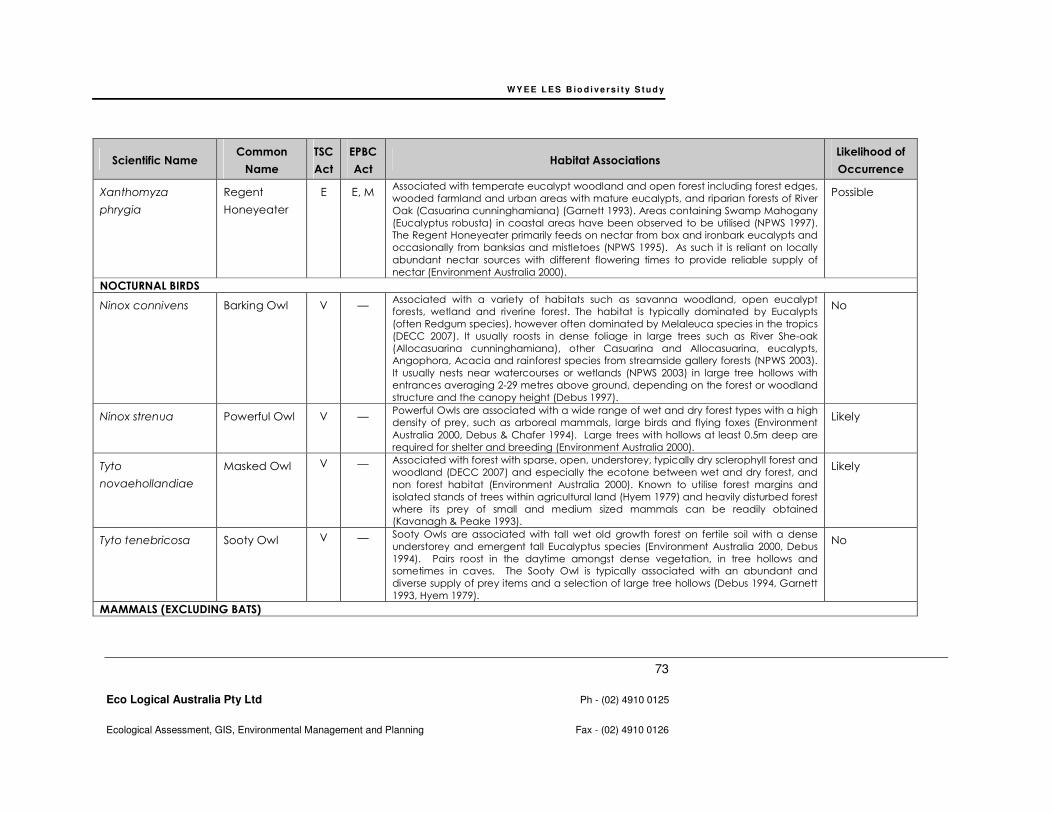
WY E E L E S B io d i v e r s i t y S t u d y
73
Eco Logical Australia Pty Ltd Ph - (02) 4910 0125
Ecological Assessment, GIS, Environmental Management and Planning Fax - (02) 4910 0126
Scientific Name Common
Name
TSC
Act
EPBC
Act Habitat Associations
Likelihood of
Occurrence
Xanthomyza
phrygia
Regent
Honeyeater
E E, M Associated with temperate eucalypt woodland and open forest including forest edges,
wooded farmland and urban areas with mature eucalypts, and riparian forests of River
Oak (Casuarina cunninghamiana) (Garnett 1993). Areas containing Swamp Mahogany
(Eucalyptus robusta) in coastal areas have been observed to be utilised (NPWS 1997).
The Regent Honeyeater primarily feeds on nectar from box and ironbark eucalypts and
occasionally from banksias and mistletoes (NPWS 1995). As such it is reliant on locally
abundant nectar sources with different flowering times to provide reliable supply of
nectar (Environment Australia 2000).
Possible
NOCTURNAL BIRDS
Ninox connivens
Barking Owl
V — Associated with a variety of habitats such as savanna woodland, open eucalypt
forests, wetland and riverine forest. The habitat is typically dominated by Eucalypts
(often Redgum species), however often dominated by Melaleuca species in the tropics
(DECC 2007). It usually roosts in dense foliage in large trees such as River She-oak
(Allocasuarina cunninghamiana), other Casuarina and Allocasuarina, eucalypts,
Angophora, Acacia and rainforest species from streamside gallery forests (NPWS 2003).
It usually nests near watercourses or wetlands (NPWS 2003) in large tree hollows with
entrances averaging 2-29 metres above ground, depending on the forest or woodland
structure and the canopy height (Debus 1997).
No
Ninox strenua
Powerful Owl
V — Powerful Owls are associated with a wide range of wet and dry forest types with a high
density of prey, such as arboreal mammals, large birds and flying foxes (Environment
Australia 2000, Debus & Chafer 1994). Large trees with hollows at least 0.5m deep are
required for shelter and breeding (Environment Australia 2000).
Likely
Tyto
novaehollandiae
Masked Owl
V — Associated with forest with sparse, open, understorey, typically dry sclerophyll forest and
woodland (DECC 2007) and especially the ecotone between wet and dry forest, and
non forest habitat (Environment Australia 2000). Known to utilise forest margins and
isolated stands of trees within agricultural land (Hyem 1979) and heavily disturbed forest
where its prey of small and medium sized mammals can be readily obtained
(Kavanagh & Peake 1993).
Likely
Tyto tenebricosa Sooty Owl V — Sooty Owls are associated with tall wet old growth forest on fertile soil with a dense
understorey and emergent tall Eucalyptus species (Environment Australia 2000, Debus
1994). Pairs roost in the daytime amongst dense vegetation, in tree hollows and
sometimes in caves. The Sooty Owl is typically associated with an abundant and
diverse supply of prey items and a selection of large tree hollows (Debus 1994, Garnett
1993, Hyem 1979).
No
MAMMALS (EXCLUDING BATS)

WY E E L E S B io d i v e r s i t y S t u d y
74
Eco Logical Australia Pty Ltd Ph - (02) 4910 0125
Ecological Assessment, GIS, Environmental Management and Planning Fax - (02) 4910 0126
Scientific Name Common
Name
TSC
Act
EPBC
Act Habitat Associations
Likelihood of
Occurrence
Dasyurus maculatus
Dasyurus maculatus
maculatus
Spotted-
tailed Quoll
Spotted-
tailed Quoll
(SE Mainland
Population)
V
—
—
E
The Spotted-tailed Quoll inhabits a range of forest communities including wet and dry
sclerophyll forests, coastal heathlands and rainforests (Mansergh 1984; DECC 2007j),
more frequently recorded near the ecotones of closed and open forest. This species
requires habitat features such as maternal den sites, an abundance of food (birds and
small mammals) and large areas of relatively intact vegetation to forage in (DECC
2007). Maternal den sites are logs with cryptic entrances; rock outcrops; windrows;
burrows (Environment Australia 2000).
Likely
Petaurus australis Yellow-bellied
Glider
V — This species is restricted to tall mature forests, preferring productive tall open sclerophyll
forests with a mosaic of tree species including some that flower in winter (Environment
Australia 2000, Braithwaite 1984, Davey 1984, Kavanagh 1984; DECC 2007). Large
hollows within mature trees are required for shelter, nesting and breeding (Henry and
Craig 1984; DECC 2007).
No
Petaurus
norfolcensis
Squirrel Glider V — Associated with dry hardwood forest and woodlands (Menkhorst et al. 1988; Quin 1995).
Habitats typically include gum barked and high nectar producing species, including
winter flower species (Menkhorst et al. 1988). The presence of hollow bearing eucalypts
is a critical habitat value (Quin 1995).
Yes
Petrogale
penicillata
Brush-tailed
Rock-wallaby
E V Rocky areas in a variety of habitats, typically north facing sites with numerous ledges,
caves and crevices (Strahan 1995). No
Phascolarctos
cinereus
Koala
V — Associated with both wet and dry Eucalypt forest and woodland that contains a
canopy cover of approximately 10 to 70% (Reed et al. 1990), with acceptable Eucalypt
food trees. Some preferred Eucalyptus species are: Eucalyptus tereticornis, E. punctata,
E. cypellocarpa, E. viminalis
Possible
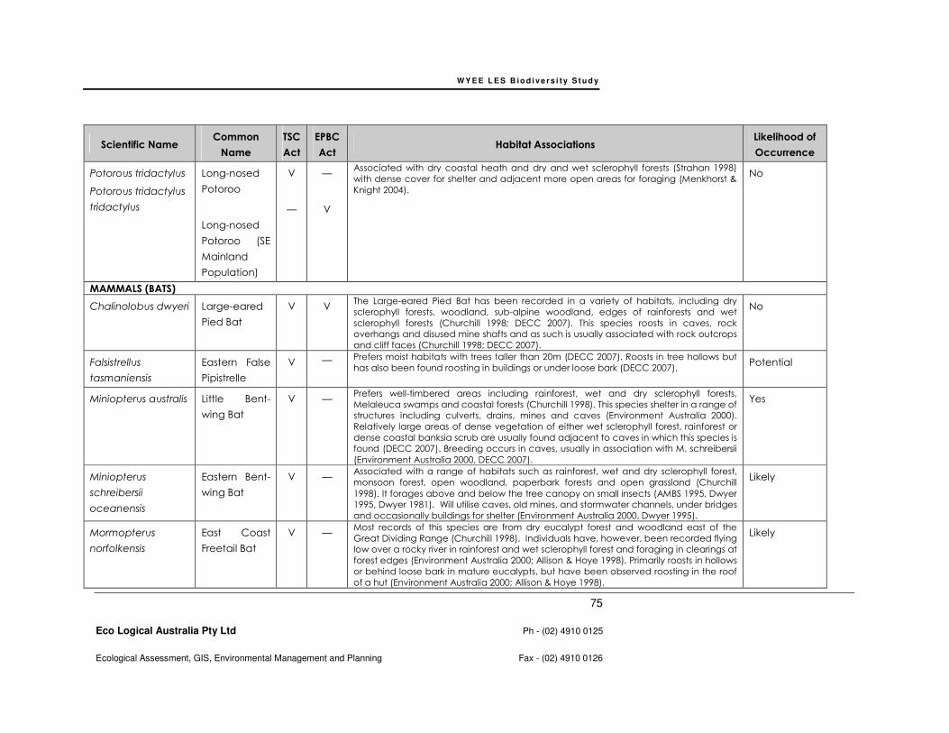
WY E E L E S B io d i v e r s i t y S t u d y
75
Eco Logical Australia Pty Ltd Ph - (02) 4910 0125
Ecological Assessment, GIS, Environmental Management and Planning Fax - (02) 4910 0126
Scientific Name Common
Name
TSC
Act
EPBC
Act Habitat Associations
Likelihood of
Occurrence
Potorous tridactylus
Potorous tridactylus
tridactylus
Long-nosed
Potoroo
Long-nosed
Potoroo (SE
Mainland
Population)
V
—
—
V
Associated with dry coastal heath and dry and wet sclerophyll forests (Strahan 1998)
with dense cover for shelter and adjacent more open areas for foraging (Menkhorst &
Knight 2004).
No
MAMMALS (BATS)
Chalinolobus dwyeri Large-eared
Pied Bat
V V The Large-eared Pied Bat has been recorded in a variety of habitats, including dry
sclerophyll forests, woodland, sub-alpine woodland, edges of rainforests and wet
sclerophyll forests (Churchill 1998; DECC 2007). This species roosts in caves, rock
overhangs and disused mine shafts and as such is usually associated with rock outcrops
and cliff faces (Churchill 1998; DECC 2007).
No
Falsistrellus
tasmaniensis
Eastern False
Pipistrelle
V — Prefers moist habitats with trees taller than 20m (DECC 2007). Roosts in tree hollows but
has also been found roosting in buildings or under loose bark (DECC 2007). Potential
Miniopterus australis
Little Bent-
wing Bat
V — Prefers well-timbered areas including rainforest, wet and dry sclerophyll forests,
Melaleuca swamps and coastal forests (Churchill 1998). This species shelter in a range of
structures including culverts, drains, mines and caves (Environment Australia 2000).
Relatively large areas of dense vegetation of either wet sclerophyll forest, rainforest or
dense coastal banksia scrub are usually found adjacent to caves in which this species is
found (DECC 2007). Breeding occurs in caves, usually in association with M. schreibersii
(Environment Australia 2000, DECC 2007).
Yes
Miniopterus
schreibersii
oceanensis
Eastern Bent-
wing Bat
V — Associated with a range of habitats such as rainforest, wet and dry sclerophyll forest,
monsoon forest, open woodland, paperbark forests and open grassland (Churchill
1998). It forages above and below the tree canopy on small insects (AMBS 1995, Dwyer
1995, Dwyer 1981). Will utilise caves, old mines, and stormwater channels, under bridges
and occasionally buildings for shelter (Environment Australia 2000, Dwyer 1995).
Likely
Mormopterus
norfolkensis
East Coast
Freetail Bat
V — Most records of this species are from dry eucalypt forest and woodland east of the
Great Dividing Range (Churchill 1998). Individuals have, however, been recorded flying
low over a rocky river in rainforest and wet sclerophyll forest and foraging in clearings at
forest edges (Environment Australia 2000; Allison & Hoye 1998). Primarily roosts in hollows
or behind loose bark in mature eucalypts, but have been observed roosting in the roof
of a hut (Environment Australia 2000; Allison & Hoye 1998).
Likely

WY E E L E S B io d i v e r s i t y S t u d y
76
Eco Logical Australia Pty Ltd Ph - (02) 4910 0125
Ecological Assessment, GIS, Environmental Management and Planning Fax - (02) 4910 0126
Scientific Name Common
Name
TSC
Act
EPBC
Act Habitat Associations
Likelihood of
Occurrence
Myotis adversus Large-footed
Myotis
V — Will occupy most habitat types such as mangroves, paperbark swamps, riverine
monsoon forest, rainforest, wet and dry sclerophyll forest, open woodland and River
Red Gum woodland, as long as they are close to water (Churchill 1998). While roosting
is most commonly associated with caves, this species has been observed to roost in tree
hollows, amongst vegetation, in clumps of Pandanus, under bridges, in mines, tunnels
and stormwater drains (Churchill 1998). However the species apparently has specific
roost requirements, and only a small percentage of available caves, mines, tunnels and
culverts are used (Richards 1998).
Potential
Pteropus
poliocephalus
Grey-headed
Flying-Fox
V V Inhabits a wide range of habitats including rainforest, mangroves, paperbark forests,
wet and dry sclerophyll forests and cultivated areas (Churchill 1998, Eby 1998). Camps
are often located in gullies, typically close to water, in vegetation with a dense canopy
(Churchill 1998).
Yes
Saccolaimus
flaviventris
Yellow-bellied
Sheathtail-
bat
V — Found in almost all habitats, from wet and dry sclerophyll forest, open woodland
(Churchill 1998), open country, mallee, rainforests, heathland and waterbodies (SFNSW
1995). Roosts in tree hollows; may also use caves; has also been recorded in a tree
hollow in a paddock (Environment Australia 2000) and in abandoned sugar glider nests
(Churchill 1998). The Yellow-bellied Sheathtail-bat is dependent on suitable hollow-
bearing trees to provide roost sites, which may be a limiting factor on populations in
cleared or fragmented habitats (Environment Australia 2000).
Potential
Scoteanax
rueppellii
Greater
Broad-nosed
Bat
V — Associated with moist gullies in mature coastal forest, or rainforest, east of the Great
Dividing Range (Churchill, 1998), tending to be more frequently located in more
productive forests (Hoye & Richards 1998). Within denser vegetation types use is made
of natural and man made openings such as roads, creeks and small rivers, where it
hawks backwards and forwards for prey (Hoye & Richards 1998).
Unlikely
Vespadelus
troughtoni
Eastern Cave
Bat
V — Inhabit tropical mixed woodland and wet sclerophyll forest on the coast and the
dividing range but extend into the drier forest of the western slopes and inland areas
(Churchill 1998). Has been found roosting in sandstone overhand caves, boulder piles,
mine tunnels and occasionally in buildings(Churchill 1998).
Unlikely
MIGRATORY WETLAND SPECIES LISTED UNDER EPBC ACT
Ardea alba Great Egret — M The Great Egret is common and widespread in Australia (McKilligan, 2005). It forages in
a wide range of wet and dry habitats including permanent and ephemeral freshwaters,
wet pasture and estuarine mangroves and mudflats (McKilligan, 2005).
Potential
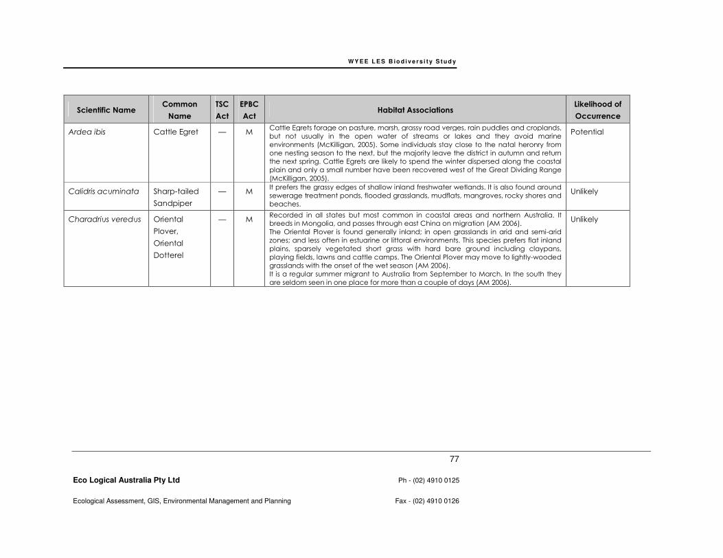
WY E E L E S B io d i v e r s i t y S t u d y
77
Eco Logical Australia Pty Ltd Ph - (02) 4910 0125
Ecological Assessment, GIS, Environmental Management and Planning Fax - (02) 4910 0126
Scientific Name Common
Name
TSC
Act
EPBC
Act Habitat Associations
Likelihood of
Occurrence
Ardea ibis Cattle Egret — M Cattle Egrets forage on pasture, marsh, grassy road verges, rain puddles and croplands,
but not usually in the open water of streams or lakes and they avoid marine
environments (McKilligan, 2005). Some individuals stay close to the natal heronry from
one nesting season to the next, but the majority leave the district in autumn and return
the next spring. Cattle Egrets are likely to spend the winter dispersed along the coastal
plain and only a small number have been recovered west of the Great Dividing Range
(McKilligan, 2005).
Potential
Calidris acuminata Sharp-tailed
Sandpiper
— M It prefers the grassy edges of shallow inland freshwater wetlands. It is also found around
sewerage treatment ponds, flooded grasslands, mudflats, mangroves, rocky shores and
beaches.
Unlikely
Charadrius veredus Oriental
Plover,
Oriental
Dotterel
— M Recorded in all states but most common in coastal areas and northern Australia. It
breeds in Mongolia, and passes through east China on migration (AM 2006).
The Oriental Plover is found generally inland; in open grasslands in arid and semi-arid
zones; and less often in estuarine or littoral environments. This species prefers flat inland
plains, sparsely vegetated short grass with hard bare ground including claypans,
playing fields, lawns and cattle camps. The Oriental Plover may move to lightly-wooded
grasslands with the onset of the wet season (AM 2006).
It is a regular summer migrant to Australia from September to March. In the south they
are seldom seen in one place for more than a couple of days (AM 2006).
Unlikely
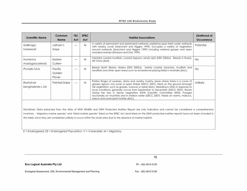
WY E E L E S B io d i v e r s i t y S t u d y
78
Eco Logical Australia Pty Ltd Ph - (02) 4910 0125
Ecological Assessment, GIS, Environmental Management and Planning Fax - (02) 4910 0126
Scientific Name Common
Name
TSC
Act
EPBC
Act Habitat Associations
Likelihood of
Occurrence
Gallinago
hardwickii
Latham’s
Snipe
— M A variety of permanent and ephemeral wetlands, preferring open fresh water wetlands
with nearby cover (Marchant and Higgins 1999). Occupies a variety of vegetation
around wetlands (Marchant and Higgins 1999) including wetland grasses and open
wooded swamps (Simpson and Day 1999).
Potential
Numenius
madagascariensis
Eastern
Curlew
— M Intertidal coastal mudflats, coastal lagoons, sandy spits (DEH 2005a). Breeds in Russia,
NE China (ibid). No
Pluvialis fulva Pacific
Golden
Plover
— M Breeds North Siberia, Alaska (DEH 2005a). Mainly coastal, beaches, mudflats and
sandflats and other open areas such as recreational playing fields in Australia (ibid.). No
Rostratula
benghalensis s. lat.
Painted Snipe
— M Prefers fringes of swamps, dams and nearby marshy areas where there is a cover of
grasses, lignum, low scrub or open timber (DECC 2007). Nests on the ground amongst
tall vegetation, such as grasses, tussocks or reeds (ibid.). Breeding is often in response to
local conditions; generally occurs from September to December (DECC 2007). Roosts
during the day in dense vegetation (NSW Scientific Committee 2004). Forages
nocturnally on mud-flats and in shallow water (DECC 2007). Feeds on worms, molluscs,
insects and some plant-matter (ibid.).
Unlikely
Disclaimer: Data extracted from the Atlas of NSW Wildlife and DEW Protected Matters Report are only indicative and cannot be considered a comprehensive
inventory. ‘Migratory marine species’ and ‘listed marine species’ listed on the EPBC Act (and listed on the DEW protected matters report) have not been included in
this table, since they are considered unlikely to occur within the study area due to the absence of marine habitat.
E = Endangered; E2 = Endangered Population; V = Vulnerable; M = Migratory.
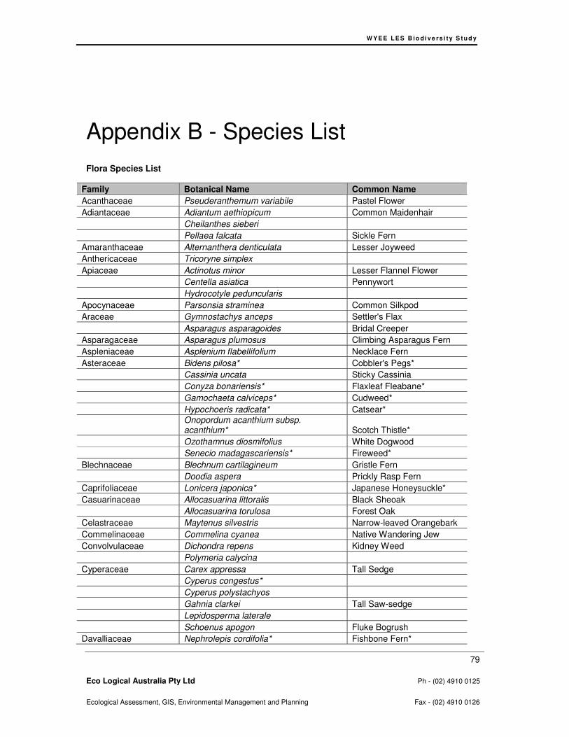
W Y E E L E S B io d i v e rs i t y S t u d y
79
Eco Logical Australia Pty Ltd Ph - (02) 4910 0125
Ecological Assessment, GIS, Environmental Management and Planning Fax - (02) 4910 0126
Appendix B - Species List
Flora Species List
Family Botanical Name Common Name
Acanthaceae Pseuderanthemum variabile Pastel Flower
Adiantaceae Adiantum aethiopicum Common Maidenhair
Cheilanthes sieberi
Pellaea falcata Sickle Fern
Amaranthaceae Alternanthera denticulata Lesser Joyweed
Anthericaceae Tricoryne simplex
Apiaceae Actinotus minor Lesser Flannel Flower
Centella asiatica Pennywort
Hydrocotyle peduncularis
Apocynaceae Parsonsia straminea Common Silkpod
Araceae Gymnostachys anceps Settler's Flax
Asparagus asparagoides Bridal Creeper
Asparagaceae Asparagus plumosus Climbing Asparagus Fern
Aspleniaceae Asplenium flabellifolium Necklace Fern
Asteraceae Bidens pilosa* Cobbler's Pegs*
Cassinia uncata Sticky Cassinia
Conyza bonariensis* Flaxleaf Fleabane*
Gamochaeta calviceps* Cudweed*
Hypochoeris radicata* Catsear*
Onopordum acanthium subsp. acanthium* Scotch Thistle*
Ozothamnus diosmifolius White Dogwood
Senecio madagascariensis* Fireweed*
Blechnaceae Blechnum cartilagineum Gristle Fern
Doodia aspera Prickly Rasp Fern
Caprifoliaceae Lonicera japonica* Japanese Honeysuckle*
Casuarinaceae Allocasuarina littoralis Black Sheoak
Allocasuarina torulosa Forest Oak
Celastraceae Maytenus silvestris Narrow-leaved Orangebark
Commelinaceae Commelina cyanea Native Wandering Jew
Convolvulaceae Dichondra repens Kidney Weed
Polymeria calycina
Cyperaceae Carex appressa Tall Sedge
Cyperus congestus*
Cyperus polystachyos
Gahnia clarkei Tall Saw-sedge
Lepidosperma laterale
Schoenus apogon Fluke Bogrush
Davalliaceae Nephrolepis cordifolia* Fishbone Fern*
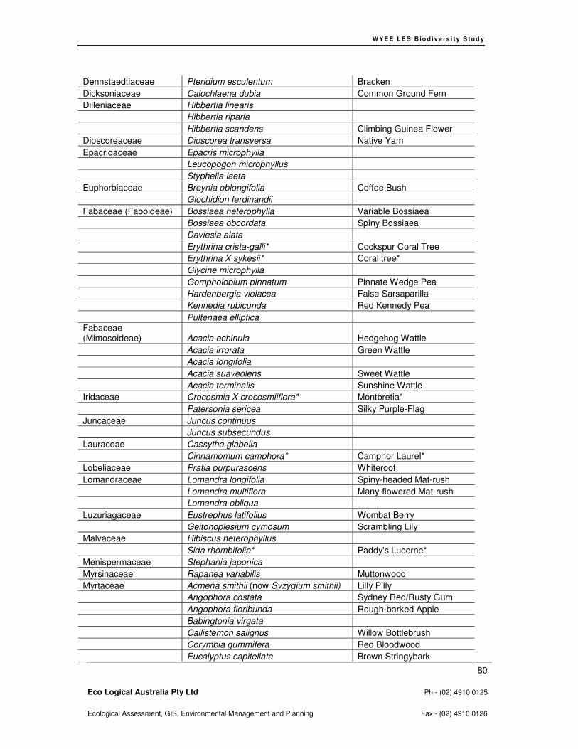
W Y E E L E S B io d i v e rs i t y S t u d y
80
Eco Logical Australia Pty Ltd Ph - (02) 4910 0125
Ecological Assessment, GIS, Environmental Management and Planning Fax - (02) 4910 0126
Dennstaedtiaceae Pteridium esculentum Bracken
Dicksoniaceae Calochlaena dubia Common Ground Fern
Dilleniaceae Hibbertia linearis
Hibbertia riparia
Hibbertia scandens Climbing Guinea Flower
Dioscoreaceae Dioscorea transversa Native Yam
Epacridaceae Epacris microphylla
Leucopogon microphyllus
Styphelia laeta
Euphorbiaceae Breynia oblongifolia Coffee Bush
Glochidion ferdinandii
Fabaceae (Faboideae) Bossiaea heterophylla Variable Bossiaea
Bossiaea obcordata Spiny Bossiaea
Daviesia alata
Erythrina crista-galli* Cockspur Coral Tree
Erythrina X sykesii* Coral tree*
Glycine microphylla
Gompholobium pinnatum Pinnate Wedge Pea
Hardenbergia violacea False Sarsaparilla
Kennedia rubicunda Red Kennedy Pea
Pultenaea elliptica
Fabaceae (Mimosoideae) Acacia echinula Hedgehog Wattle
Acacia irrorata Green Wattle
Acacia longifolia
Acacia suaveolens Sweet Wattle
Acacia terminalis Sunshine Wattle
Iridaceae Crocosmia X crocosmiiflora* Montbretia*
Patersonia sericea Silky Purple-Flag
Juncaceae Juncus continuus
Juncus subsecundus
Lauraceae Cassytha glabella
Cinnamomum camphora* Camphor Laurel*
Lobeliaceae Pratia purpurascens Whiteroot
Lomandraceae Lomandra longifolia Spiny-headed Mat-rush
Lomandra multiflora Many-flowered Mat-rush
Lomandra obliqua
Luzuriagaceae Eustrephus latifolius Wombat Berry
Geitonoplesium cymosum Scrambling Lily
Malvaceae Hibiscus heterophyllus
Sida rhombifolia* Paddy's Lucerne*
Menispermaceae Stephania japonica
Myrsinaceae Rapanea variabilis Muttonwood
Myrtaceae Acmena smithii (now Syzygium smithii) Lilly Pilly
Angophora costata Sydney Red/Rusty Gum
Angophora floribunda Rough-barked Apple
Babingtonia virgata
Callistemon salignus Willow Bottlebrush
Corymbia gummifera Red Bloodwood
Eucalyptus capitellata Brown Stringybark
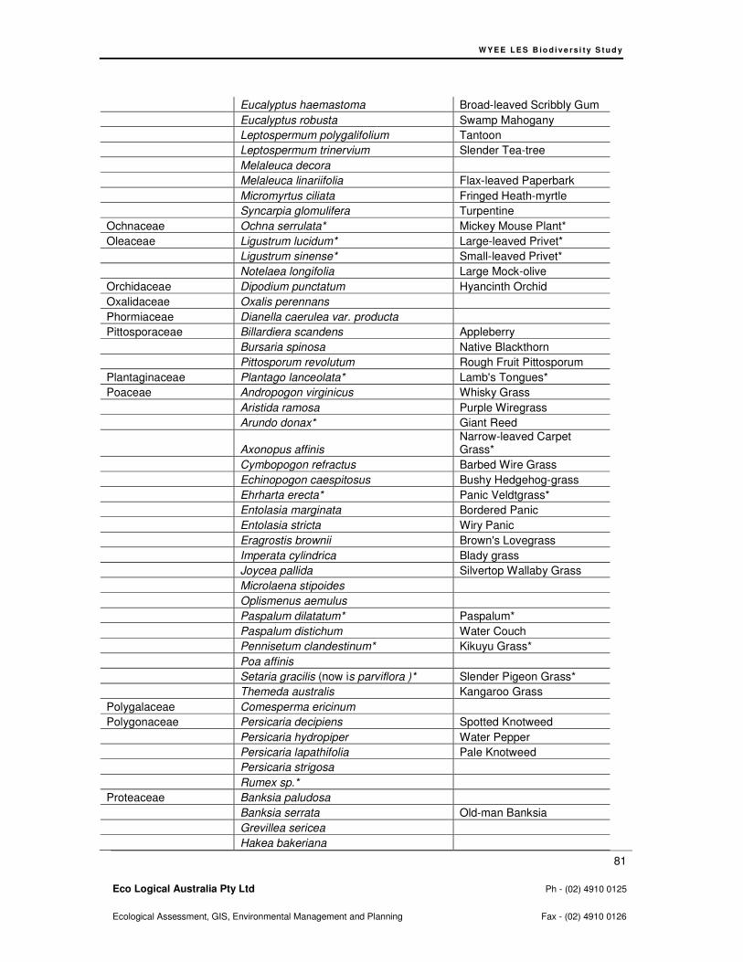
W Y E E L E S B io d i v e rs i t y S t u d y
81
Eco Logical Australia Pty Ltd Ph - (02) 4910 0125
Ecological Assessment, GIS, Environmental Management and Planning Fax - (02) 4910 0126
Eucalyptus haemastoma Broad-leaved Scribbly Gum
Eucalyptus robusta Swamp Mahogany
Leptospermum polygalifolium Tantoon
Leptospermum trinervium Slender Tea-tree
Melaleuca decora
Melaleuca linariifolia Flax-leaved Paperbark
Micromyrtus ciliata Fringed Heath-myrtle
Syncarpia glomulifera Turpentine
Ochnaceae Ochna serrulata* Mickey Mouse Plant*
Oleaceae Ligustrum lucidum* Large-leaved Privet*
Ligustrum sinense* Small-leaved Privet*
Notelaea longifolia Large Mock-olive
Orchidaceae Dipodium punctatum Hyancinth Orchid
Oxalidaceae Oxalis perennans
Phormiaceae Dianella caerulea var. producta
Pittosporaceae Billardiera scandens Appleberry
Bursaria spinosa Native Blackthorn
Pittosporum revolutum Rough Fruit Pittosporum
Plantaginaceae Plantago lanceolata* Lamb's Tongues*
Poaceae Andropogon virginicus Whisky Grass
Aristida ramosa Purple Wiregrass
Arundo donax* Giant Reed
Axonopus affinis Narrow-leaved Carpet Grass*
Cymbopogon refractus Barbed Wire Grass
Echinopogon caespitosus Bushy Hedgehog-grass
Ehrharta erecta* Panic Veldtgrass*
Entolasia marginata Bordered Panic
Entolasia stricta Wiry Panic
Eragrostis brownii Brown's Lovegrass
Imperata cylindrica Blady grass
Joycea pallida Silvertop Wallaby Grass
Microlaena stipoides
Oplismenus aemulus
Paspalum dilatatum* Paspalum*
Paspalum distichum Water Couch
Pennisetum clandestinum* Kikuyu Grass*
Poa affinis
Setaria gracilis (now is parviflora )* Slender Pigeon Grass*
Themeda australis Kangaroo Grass
Polygalaceae Comesperma ericinum
Polygonaceae Persicaria decipiens Spotted Knotweed
Persicaria hydropiper Water Pepper
Persicaria lapathifolia Pale Knotweed
Persicaria strigosa
Rumex sp.*
Proteaceae Banksia paludosa
Banksia serrata Old-man Banksia
Grevillea sericea
Hakea bakeriana
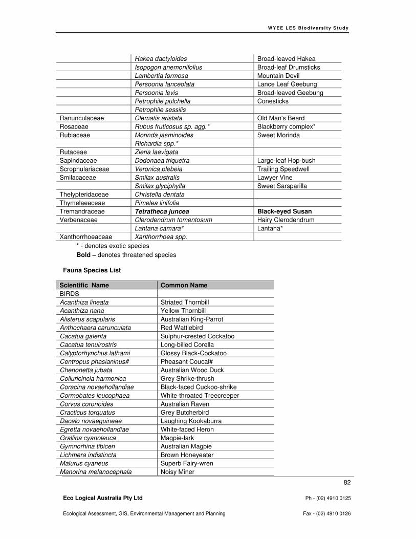
W Y E E L E S B io d i v e rs i t y S t u d y
82
Eco Logical Australia Pty Ltd Ph - (02) 4910 0125
Ecological Assessment, GIS, Environmental Management and Planning Fax - (02) 4910 0126
Hakea dactyloides Broad-leaved Hakea
Isopogon anemonifolius Broad-leaf Drumsticks
Lambertia formosa Mountain Devil
Persoonia lanceolata Lance Leaf Geebung
Persoonia levis Broad-leaved Geebung
Petrophile pulchella Conesticks
Petrophile sessilis
Ranunculaceae Clematis aristata Old Man's Beard
Rosaceae Rubus fruticosus sp. agg.* Blackberry complex*
Rubiaceae Morinda jasminoides Sweet Morinda
Richardia spp.*
Rutaceae Zieria laevigata
Sapindaceae Dodonaea triquetra Large-leaf Hop-bush
Scrophulariaceae Veronica plebeia Trailing Speedwell
Smilacaceae Smilax australis Lawyer Vine
Smilax glyciphylla Sweet Sarsparilla
Thelypteridaceae Christella dentata
Thymelaeaceae Pimelea linifolia
Tremandraceae Tetratheca juncea Black-eyed Susan
Verbenaceae Clerodendrum tomentosum Hairy Clerodendrum
Lantana camara* Lantana*
Xanthorrhoeaceae Xanthorrhoea spp.
* - denotes exotic species
Bold – denotes threatened species
Fauna Species List
Scientific Name Common Name
BIRDS
Acanthiza lineata Striated Thornbill
Acanthiza nana Yellow Thornbill
Alisterus scapularis Australian King-Parrot
Anthochaera carunculata Red Wattlebird
Cacatua galerita Sulphur-crested Cockatoo
Cacatua tenuirostris Long-billed Corella
Calyptorhynchus lathami Glossy Black-Cockatoo
Centropus phasianinus# Pheasant Coucal#
Chenonetta jubata Australian Wood Duck
Colluricincla harmonica Grey Shrike-thrush
Coracina novaehollandiae Black-faced Cuckoo-shrike
Cormobates leucophaea White-throated Treecreeper
Corvus coronoides Australian Raven
Cracticus torquatus Grey Butcherbird
Dacelo novaeguineae Laughing Kookaburra
Egretta novaehollandiae White-faced Heron
Grallina cyanoleuca Magpie-lark
Gymnorhina tibicen Australian Magpie
Lichmera indistincta Brown Honeyeater
Malurus cyaneus Superb Fairy-wren
Manorina melanocephala Noisy Miner
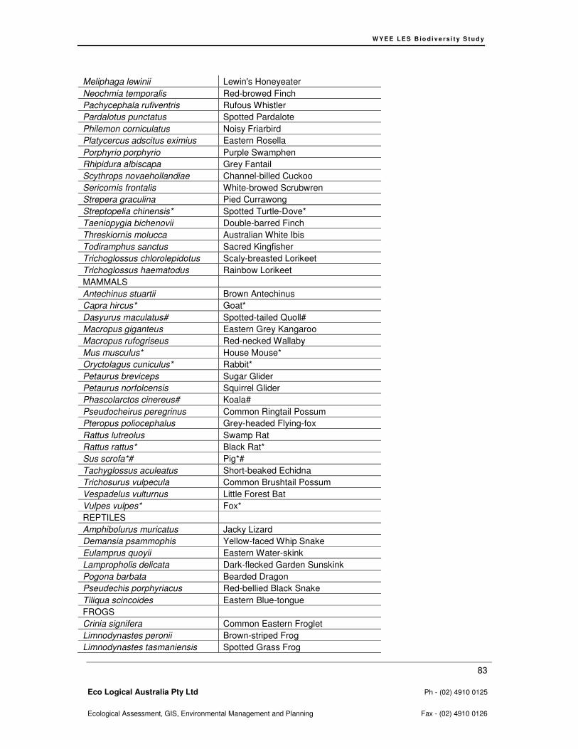
W Y E E L E S B io d i v e rs i t y S t u d y
83
Eco Logical Australia Pty Ltd Ph - (02) 4910 0125
Ecological Assessment, GIS, Environmental Management and Planning Fax - (02) 4910 0126
Meliphaga lewinii Lewin's Honeyeater
Neochmia temporalis Red-browed Finch
Pachycephala rufiventris Rufous Whistler
Pardalotus punctatus Spotted Pardalote
Philemon corniculatus Noisy Friarbird
Platycercus adscitus eximius Eastern Rosella
Porphyrio porphyrio Purple Swamphen
Rhipidura albiscapa Grey Fantail
Scythrops novaehollandiae Channel-billed Cuckoo
Sericornis frontalis White-browed Scrubwren
Strepera graculina Pied Currawong
Streptopelia chinensis* Spotted Turtle-Dove*
Taeniopygia bichenovii Double-barred Finch
Threskiornis molucca Australian White Ibis
Todiramphus sanctus Sacred Kingfisher
Trichoglossus chlorolepidotus Scaly-breasted Lorikeet
Trichoglossus haematodus Rainbow Lorikeet
MAMMALS
Antechinus stuartii Brown Antechinus
Capra hircus* Goat*
Dasyurus maculatus# Spotted-tailed Quoll#
Macropus giganteus Eastern Grey Kangaroo
Macropus rufogriseus Red-necked Wallaby
Mus musculus* House Mouse*
Oryctolagus cuniculus* Rabbit*
Petaurus breviceps Sugar Glider
Petaurus norfolcensis Squirrel Glider
Phascolarctos cinereus# Koala#
Pseudocheirus peregrinus Common Ringtail Possum
Pteropus poliocephalus Grey-headed Flying-fox
Rattus lutreolus Swamp Rat
Rattus rattus* Black Rat*
Sus scrofa*# Pig*#
Tachyglossus aculeatus Short-beaked Echidna
Trichosurus vulpecula Common Brushtail Possum
Vespadelus vulturnus Little Forest Bat
Vulpes vulpes* Fox*
REPTILES
Amphibolurus muricatus Jacky Lizard
Demansia psammophis Yellow-faced Whip Snake
Eulamprus quoyii Eastern Water-skink
Lampropholis delicata Dark-flecked Garden Sunskink
Pogona barbata Bearded Dragon
Pseudechis porphyriacus Red-bellied Black Snake
Tiliqua scincoides Eastern Blue-tongue
FROGS
Crinia signifera Common Eastern Froglet
Limnodynastes peronii Brown-striped Frog
Limnodynastes tasmaniensis Spotted Grass Frog

W Y E E L E S B io d i v e rs i t y S t u d y
84
Eco Logical Australia Pty Ltd Ph - (02) 4910 0125
Ecological Assessment, GIS, Environmental Management and Planning Fax - (02) 4910 0126
Litoria fallax Eastern Dwarf Tree Frog
* - denotes exotic species
# - denotes anecdotal records

W Y E E L E S B io d i v e rs i t y S t u d y
85
Eco Logical Australia Pty Ltd Ph - (02) 4910 0125
Ecological Assessment, GIS, Environmental Management and Planning Fax - (02) 4910 0126
Appendix C - Threatened Flora Data

WY E E L E S B io d i v e r s i t y S t u d y
86
Eco Logical Australia Pty Ltd Ph - (02) 4910 0125
Ecological Assessment, GIS, Environmental Management and Planning Fax - (02) 4910 0126
Figure 11: Threatened Flora Part 1
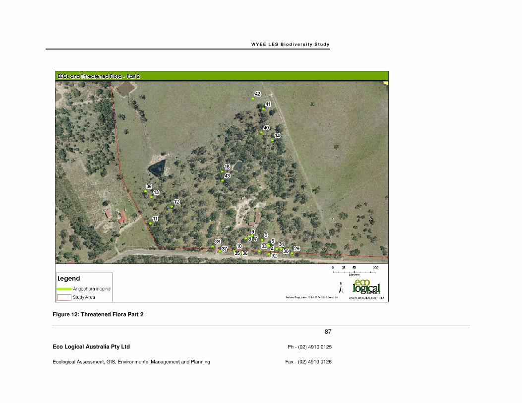
WY E E L E S B io d i v e r s i t y S t u d y
87
Eco Logical Australia Pty Ltd Ph - (02) 4910 0125
Ecological Assessment, GIS, Environmental Management and Planning Fax - (02) 4910 0126
Figure 12: Threatened Flora Part 2
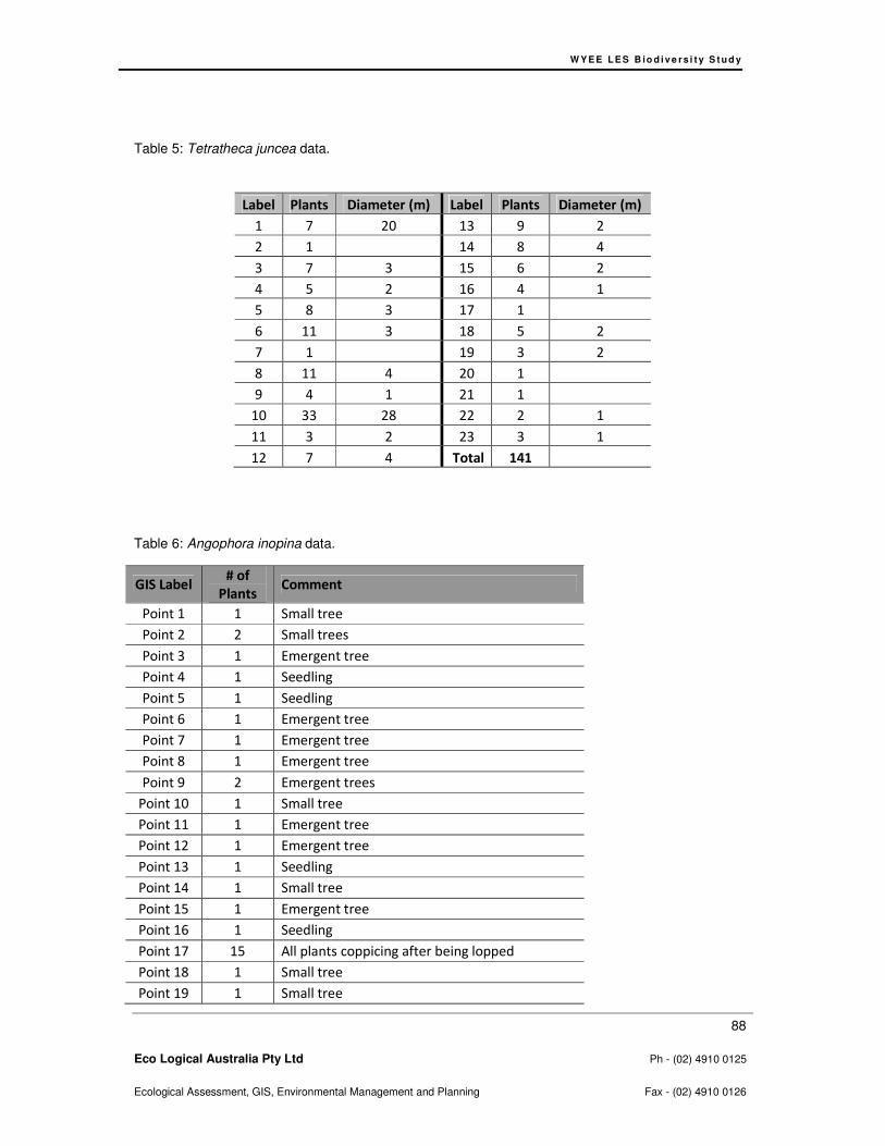
W Y E E L E S B io d i v e rs i t y S t u d y
88
Eco Logical Australia Pty Ltd Ph - (02) 4910 0125
Ecological Assessment, GIS, Environmental Management and Planning Fax - (02) 4910 0126
Table 5: Tetratheca juncea data.
Label Plants Diameter (m) Label Plants Diameter (m)
1 7 20 13 9 2
2 1 14 8 4
3 7 3 15 6 2
4 5 2 16 4 1
5 8 3 17 1
6 11 3 18 5 2
7 1 19 3 2
8 11 4 20 1
9 4 1 21 1
10 33 28 22 2 1
11 3 2 23 3 1
12 7 4 Total 141
Table 6: Angophora inopina data.
GIS Label # of
Plants Comment
Point 1 1 Small tree
Point 2 2 Small trees
Point 3 1 Emergent tree
Point 4 1 Seedling
Point 5 1 Seedling
Point 6 1 Emergent tree
Point 7 1 Emergent tree
Point 8 1 Emergent tree
Point 9 2 Emergent trees
Point 10 1 Small tree
Point 11 1 Emergent tree
Point 12 1 Emergent tree
Point 13 1 Seedling
Point 14 1 Small tree
Point 15 1 Emergent tree
Point 16 1 Seedling
Point 17 15 All plants coppicing after being lopped
Point 18 1 Small tree
Point 19 1 Small tree

W Y E E L E S B io d i v e rs i t y S t u d y
89
Eco Logical Australia Pty Ltd Ph - (02) 4910 0125
Ecological Assessment, GIS, Environmental Management and Planning Fax - (02) 4910 0126
Point 20 1 Small tree
Point 21 1 Small tree
Point 22 1 Small tree
Point 23 1 Small tree
Point 24 2 Small trees
Point 25 1 Small tree
Point 26 1 Small tree
Point 27 1 Small tree
Point 28 3 Small trees
Point 29 1 Seedling
Point 30 1 Seedling
Point 31 2 Small trees
Point 32 19 11 seedlings, 7 small trees, 1 emergent tree
Point 33 3 Seedlings
Point 34 1 Seedling
Point 35 1 Small tree
Point 36 1 Seedling
Point 37 21 15 seedlings, 5 small trees, 1 emergent tree
Point 38 1 Seedling
Point 39 1 Seedling
Point 40 1 Emergent tree
Point 41 1 Emergent tree
Point 42 11 All plants coppicing after being lopped
Point 43 1 Small tree
Point 44 1 tree
Point 45 1 tree
Point 45 1 tree
Point 46 1 tree
Point 47 1 tree
Point 48 1 tree
Point 49 1 tree
Point 50 1 tree
Point 51 1 tree
Polygon 1 250 Small trees
Polygon 2 37 Small trees
Polygon 3 20 Small trees
Polygon 4 13 Small trees
Polygon 5 10 Small trees
Polygon 6 13 Small trees
Polygon 7 17 Small trees
Polygon 8 26 Small trees

W Y E E L E S B io d i v e rs i t y S t u d y
90
Eco Logical Australia Pty Ltd Ph - (02) 4910 0125
Ecological Assessment, GIS, Environmental Management and Planning Fax - (02) 4910 0126
Polygon 9 4 Small trees
Polygon
10 56 Small trees
Polygon
11 13 Small trees
Total 581

W Y E E L E S B io d i v e rs i t y S t u d y
91
Eco Logical Australia Pty Ltd Ph - (02) 4910 0125
Ecological Assessment, GIS, Environmental Management and Planning Fax - (02) 4910 0126
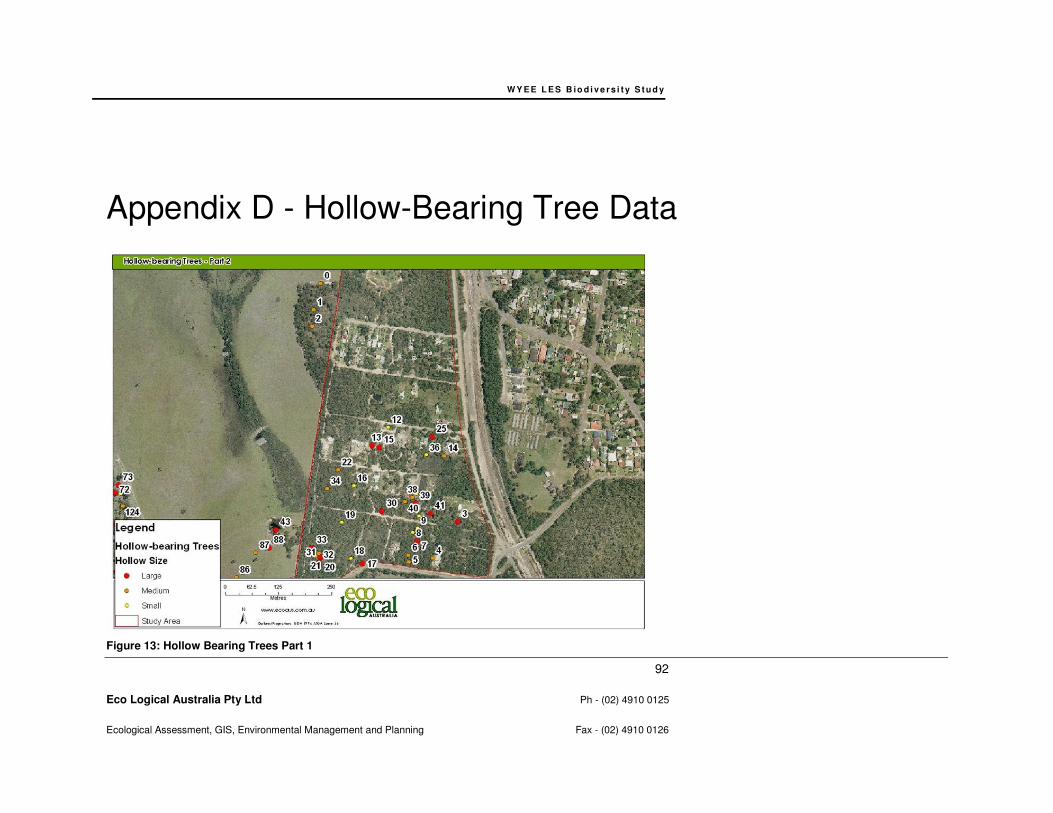
WY E E L E S B io d i v e r s i t y S t u d y
92
Eco Logical Australia Pty Ltd Ph - (02) 4910 0125
Ecological Assessment, GIS, Environmental Management and Planning Fax - (02) 4910 0126
Appendix D - Hollow-Bearing Tree Data
Figure 13: Hollow Bearing Trees Part 1

WY E E L E S B io d i v e r s i t y S t u d y
93
Eco Logical Australia Pty Ltd Ph - (02) 4910 0125
Ecological Assessment, GIS, Environmental Management and Planning Fax - (02) 4910 0126
Figure 14: Hollow Bearing Trees Part 2
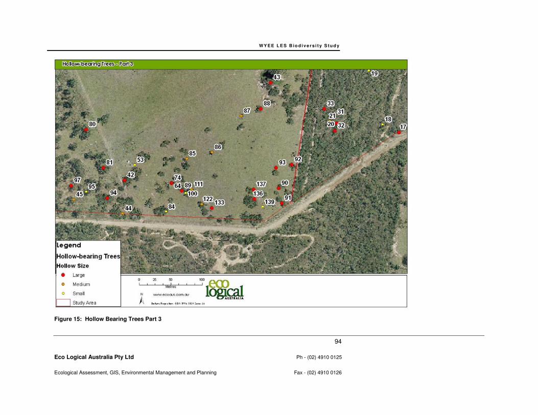
WY E E L E S B io d i v e r s i t y S t u d y
94
Eco Logical Australia Pty Ltd Ph - (02) 4910 0125
Ecological Assessment, GIS, Environmental Management and Planning Fax - (02) 4910 0126
Figure 15: Hollow Bearing Trees Part 3

WY E E L E S B io d i v e r s i t y S t u d y
95
Eco Logical Australia Pty Ltd Ph - (02) 4910 0125
Ecological Assessment, GIS, Environmental Management and Planning Fax - (02) 4910 0126
Figure 16: Hollow Bearing Trees Part 4
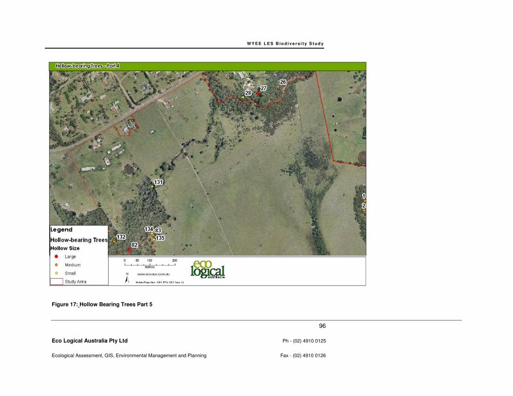
WY E E L E S B io d i v e r s i t y S t u d y
96
Eco Logical Australia Pty Ltd Ph - (02) 4910 0125
Ecological Assessment, GIS, Environmental Management and Planning Fax - (02) 4910 0126
Figure 17: Hollow Bearing Trees Part 5
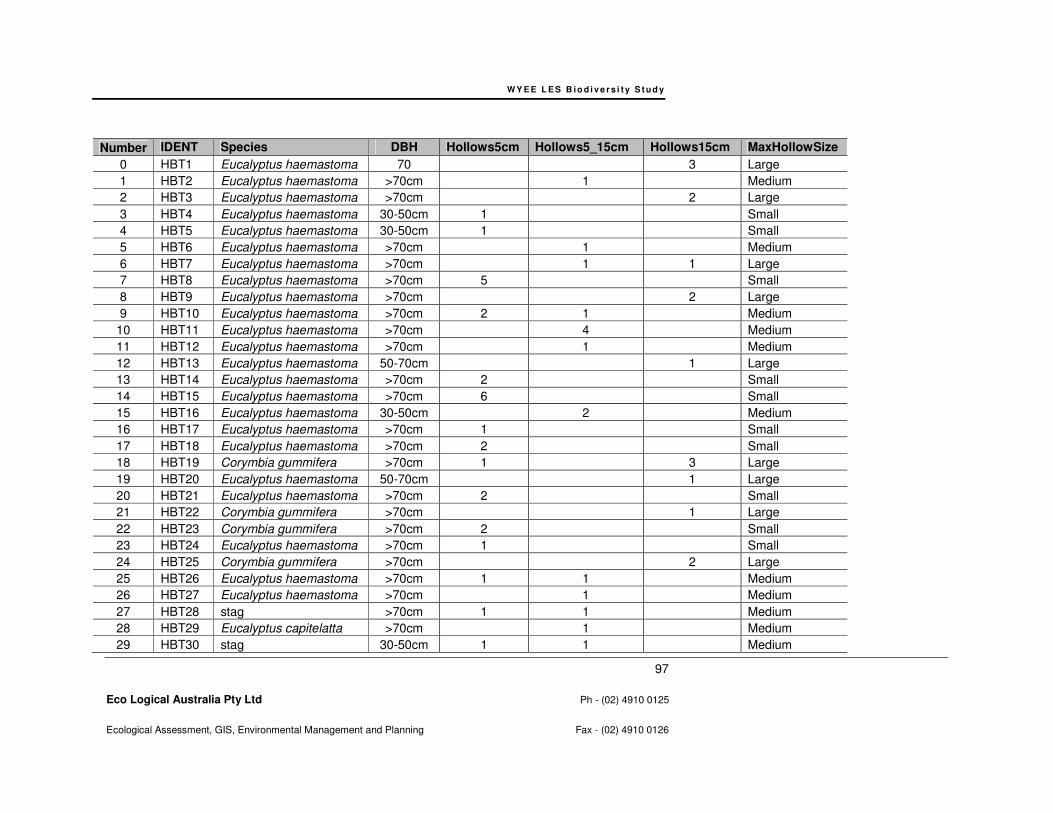
WY E E L E S B io d i v e r s i t y S t u d y
97
Eco Logical Australia Pty Ltd Ph - (02) 4910 0125
Ecological Assessment, GIS, Environmental Management and Planning Fax - (02) 4910 0126
Number IDENT Species DBH Hollows5cm Hollows5_15cm Hollows15cm MaxHollowSize
0 HBT1 Eucalyptus haemastoma 70 3 Large
1 HBT2 Eucalyptus haemastoma >70cm 1 Medium
2 HBT3 Eucalyptus haemastoma >70cm 2 Large
3 HBT4 Eucalyptus haemastoma 30-50cm 1 Small
4 HBT5 Eucalyptus haemastoma 30-50cm 1 Small
5 HBT6 Eucalyptus haemastoma >70cm 1 Medium
6 HBT7 Eucalyptus haemastoma >70cm 1 1 Large
7 HBT8 Eucalyptus haemastoma >70cm 5 Small
8 HBT9 Eucalyptus haemastoma >70cm 2 Large
9 HBT10 Eucalyptus haemastoma >70cm 2 1 Medium
10 HBT11 Eucalyptus haemastoma >70cm 4 Medium
11 HBT12 Eucalyptus haemastoma >70cm 1 Medium
12 HBT13 Eucalyptus haemastoma 50-70cm 1 Large
13 HBT14 Eucalyptus haemastoma >70cm 2 Small
14 HBT15 Eucalyptus haemastoma >70cm 6 Small
15 HBT16 Eucalyptus haemastoma 30-50cm 2 Medium
16 HBT17 Eucalyptus haemastoma >70cm 1 Small
17 HBT18 Eucalyptus haemastoma >70cm 2 Small
18 HBT19 Corymbia gummifera >70cm 1 3 Large
19 HBT20 Eucalyptus haemastoma 50-70cm 1 Large
20 HBT21 Eucalyptus haemastoma >70cm 2 Small
21 HBT22 Corymbia gummifera >70cm 1 Large
22 HBT23 Corymbia gummifera >70cm 2 Small
23 HBT24 Eucalyptus haemastoma >70cm 1 Small
24 HBT25 Corymbia gummifera >70cm 2 Large
25 HBT26 Eucalyptus haemastoma >70cm 1 1 Medium
26 HBT27 Eucalyptus haemastoma >70cm 1 Medium
27 HBT28 stag >70cm 1 1 Medium
28 HBT29 Eucalyptus capitelatta >70cm 1 Medium
29 HBT30 stag 30-50cm 1 1 Medium
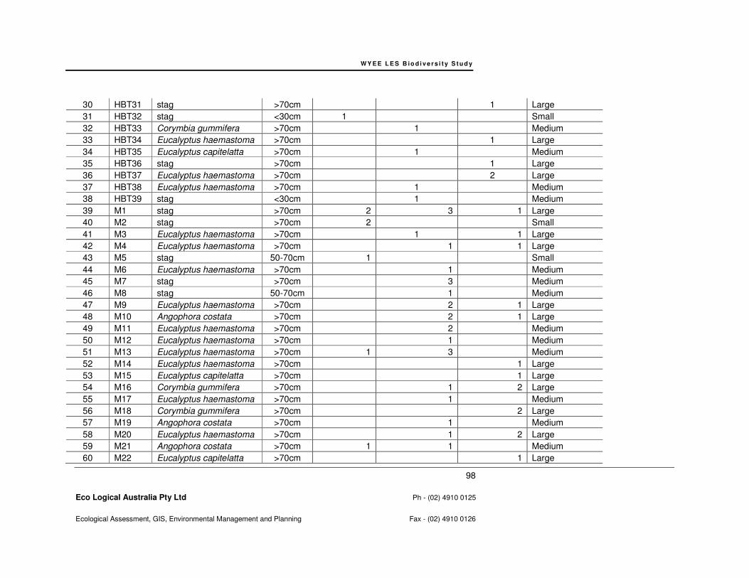
WY E E L E S B io d i v e r s i t y S t u d y
98
Eco Logical Australia Pty Ltd Ph - (02) 4910 0125
Ecological Assessment, GIS, Environmental Management and Planning Fax - (02) 4910 0126
30 HBT31 stag >70cm 1 Large
31 HBT32 stag <30cm 1 Small
32 HBT33 Corymbia gummifera >70cm 1 Medium
33 HBT34 Eucalyptus haemastoma >70cm 1 Large
34 HBT35 Eucalyptus capitelatta >70cm 1 Medium
35 HBT36 stag >70cm 1 Large
36 HBT37 Eucalyptus haemastoma >70cm 2 Large
37 HBT38 Eucalyptus haemastoma >70cm 1 Medium
38 HBT39 stag <30cm 1 Medium
39 M1 stag >70cm 2 3 1 Large
40 M2 stag >70cm 2 Small
41 M3 Eucalyptus haemastoma >70cm 1 1 Large
42 M4 Eucalyptus haemastoma >70cm 1 1 Large
43 M5 stag 50-70cm 1 Small
44 M6 Eucalyptus haemastoma >70cm 1 Medium
45 M7 stag >70cm 3 Medium
46 M8 stag 50-70cm 1 Medium
47 M9 Eucalyptus haemastoma >70cm 2 1 Large
48 M10 Angophora costata >70cm 2 1 Large
49 M11 Eucalyptus haemastoma >70cm 2 Medium
50 M12 Eucalyptus haemastoma >70cm 1 Medium
51 M13 Eucalyptus haemastoma >70cm 1 3 Medium
52 M14 Eucalyptus haemastoma >70cm 1 Large
53 M15 Eucalyptus capitelatta >70cm 1 Large
54 M16 Corymbia gummifera >70cm 1 2 Large
55 M17 Eucalyptus haemastoma >70cm 1 Medium
56 M18 Corymbia gummifera >70cm 2 Large
57 M19 Angophora costata >70cm 1 Medium
58 M20 Eucalyptus haemastoma >70cm 1 2 Large
59 M21 Angophora costata >70cm 1 1 Medium
60 M22 Eucalyptus capitelatta >70cm 1 Large
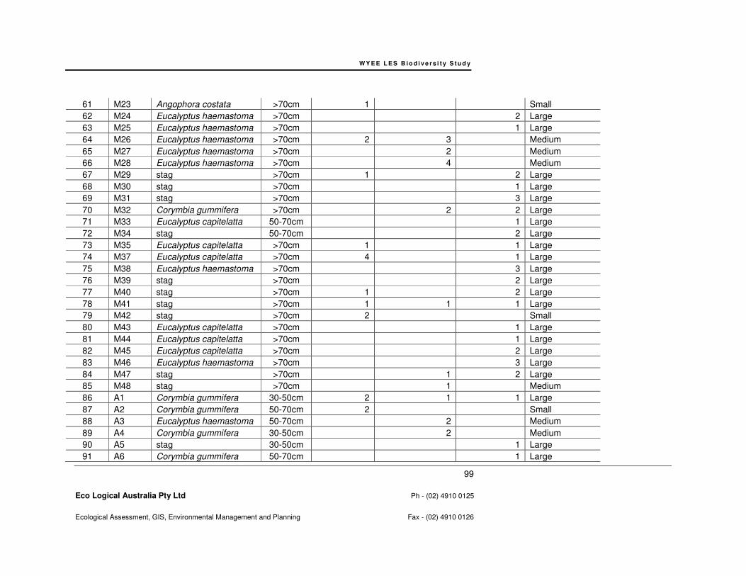
WY E E L E S B io d i v e r s i t y S t u d y
99
Eco Logical Australia Pty Ltd Ph - (02) 4910 0125
Ecological Assessment, GIS, Environmental Management and Planning Fax - (02) 4910 0126
61 M23 Angophora costata >70cm 1 Small
62 M24 Eucalyptus haemastoma >70cm 2 Large
63 M25 Eucalyptus haemastoma >70cm 1 Large
64 M26 Eucalyptus haemastoma >70cm 2 3 Medium
65 M27 Eucalyptus haemastoma >70cm 2 Medium
66 M28 Eucalyptus haemastoma >70cm 4 Medium
67 M29 stag >70cm 1 2 Large
68 M30 stag >70cm 1 Large
69 M31 stag >70cm 3 Large
70 M32 Corymbia gummifera >70cm 2 2 Large
71 M33 Eucalyptus capitelatta 50-70cm 1 Large
72 M34 stag 50-70cm 2 Large
73 M35 Eucalyptus capitelatta >70cm 1 1 Large
74 M37 Eucalyptus capitelatta >70cm 4 1 Large
75 M38 Eucalyptus haemastoma >70cm 3 Large
76 M39 stag >70cm 2 Large
77 M40 stag >70cm 1 2 Large
78 M41 stag >70cm 1 1 1 Large
79 M42 stag >70cm 2 Small
80 M43 Eucalyptus capitelatta >70cm 1 Large
81 M44 Eucalyptus capitelatta >70cm 1 Large
82 M45 Eucalyptus capitelatta >70cm 2 Large
83 M46 Eucalyptus haemastoma >70cm 3 Large
84 M47 stag >70cm 1 2 Large
85 M48 stag >70cm 1 Medium
86 A1 Corymbia gummifera 30-50cm 2 1 1 Large
87 A2 Corymbia gummifera 50-70cm 2 Small
88 A3 Eucalyptus haemastoma 50-70cm 2 Medium
89 A4 Corymbia gummifera 30-50cm 2 Medium
90 A5 stag 30-50cm 1 Large
91 A6 Corymbia gummifera 50-70cm 1 Large
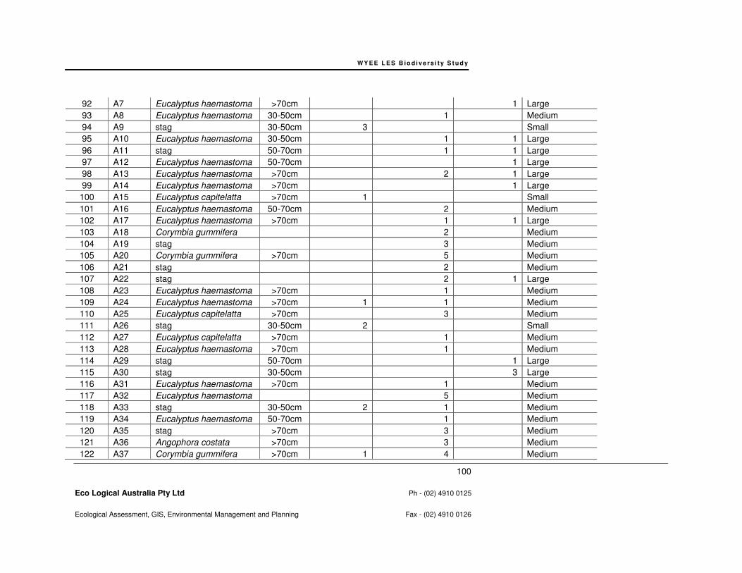
WY E E L E S B io d i v e r s i t y S t u d y
100
Eco Logical Australia Pty Ltd Ph - (02) 4910 0125
Ecological Assessment, GIS, Environmental Management and Planning Fax - (02) 4910 0126
92 A7 Eucalyptus haemastoma >70cm 1 Large
93 A8 Eucalyptus haemastoma 30-50cm 1 Medium
94 A9 stag 30-50cm 3 Small
95 A10 Eucalyptus haemastoma 30-50cm 1 1 Large
96 A11 stag 50-70cm 1 1 Large
97 A12 Eucalyptus haemastoma 50-70cm 1 Large
98 A13 Eucalyptus haemastoma >70cm 2 1 Large
99 A14 Eucalyptus haemastoma >70cm 1 Large
100 A15 Eucalyptus capitelatta >70cm 1 Small
101 A16 Eucalyptus haemastoma 50-70cm 2 Medium
102 A17 Eucalyptus haemastoma >70cm 1 1 Large
103 A18 Corymbia gummifera 2 Medium
104 A19 stag 3 Medium
105 A20 Corymbia gummifera >70cm 5 Medium
106 A21 stag 2 Medium
107 A22 stag 2 1 Large
108 A23 Eucalyptus haemastoma >70cm 1 Medium
109 A24 Eucalyptus haemastoma >70cm 1 1 Medium
110 A25 Eucalyptus capitelatta >70cm 3 Medium
111 A26 stag 30-50cm 2 Small
112 A27 Eucalyptus capitelatta >70cm 1 Medium
113 A28 Eucalyptus haemastoma >70cm 1 Medium
114 A29 stag 50-70cm 1 Large
115 A30 stag 30-50cm 3 Large
116 A31 Eucalyptus haemastoma >70cm 1 Medium
117 A32 Eucalyptus haemastoma 5 Medium
118 A33 stag 30-50cm 2 1 Medium
119 A34 Eucalyptus haemastoma 50-70cm 1 Medium
120 A35 stag >70cm 3 Medium
121 A36 Angophora costata >70cm 3 Medium
122 A37 Corymbia gummifera >70cm 1 4 Medium

WY E E L E S B io d i v e r s i t y S t u d y
101
Eco Logical Australia Pty Ltd Ph - (02) 4910 0125
Ecological Assessment, GIS, Environmental Management and Planning Fax - (02) 4910 0126
123 A38 Eucalyptus haemastoma >70cm 1 Medium
124 A39 stag <30cm 1 Small
125 A40 Eucalyptus capitelatta >70cm 1 Large
126 A41 Corymbia gummifera 50-70cm 1 1 Medium
127 A42 stag 30-50cm 1 Large
128 A43 Angophora costata >70cm 1 Medium
129 A44 Eucalyptus haemastoma >70cm 1 Medium
130 A45 Eucalyptus haemastoma 5 3 1 Large
131 A46 stag 2 3 Medium
132 A47 Corymbia gummifera 2 Medium
133 A48 Corymbia maculata 1 Small
134 A49 Corymbia maculata >70cm 2 2 Medium
135 A50 Angophora costata >70cm 2 Small
136 A51 stag >70cm 3 Small
137 HBT1M Eucalyptus haemostoma >70cm 1 2 Medium
138 HBT2M Eucalyptus haemostoma >70cm 4 Medium
139 HBT3M Eucalyptus haemostoma >70cm 3 Medium
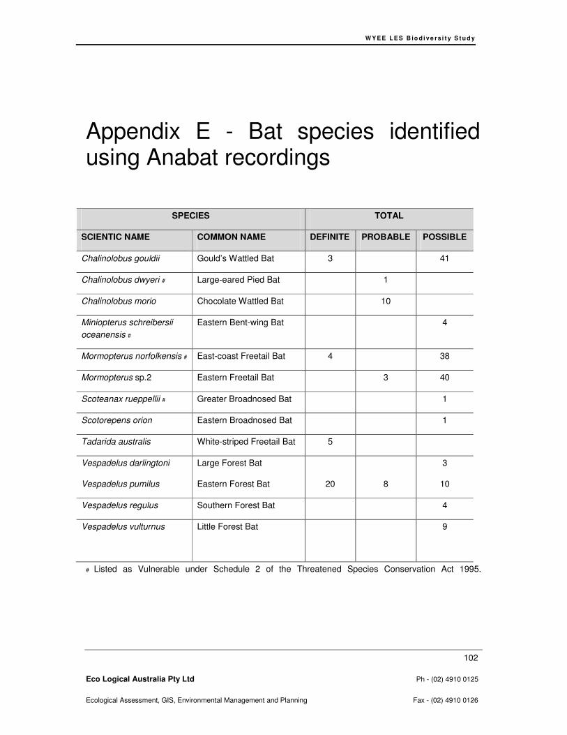
W Y E E L E S B io d i v e rs i t y S t u d y
102
Eco Logical Australia Pty Ltd Ph - (02) 4910 0125
Ecological Assessment, GIS, Environmental Management and Planning Fax - (02) 4910 0126
Appendix E - Bat species identified using Anabat recordings
SPECIES TOTAL
SCIENTIC NAME COMMON NAME DEFINITE PROBABLE POSSIBLE
Chalinolobus gouldii Gould’s Wattled Bat 3 41
Chalinolobus dwyeri # Large-eared Pied Bat 1
Chalinolobus morio Chocolate Wattled Bat 10
Miniopterus schreibersii
oceanensis #
Eastern Bent-wing Bat 4
Mormopterus norfolkensis # East-coast Freetail Bat 4 38
Mormopterus sp.2 Eastern Freetail Bat 3 40
Scoteanax rueppellii # Greater Broadnosed Bat 1
Scotorepens orion Eastern Broadnosed Bat 1
Tadarida australis White-striped Freetail Bat 5
Vespadelus darlingtoni
Vespadelus pumilus
Large Forest Bat
Eastern Forest Bat
20
8
3
10
Vespadelus regulus Southern Forest Bat 4
Vespadelus vulturnus Little Forest Bat 9
# Listed as Vulnerable under Schedule 2 of the Threatened Species Conservation Act 1995.

W Y E E L E S B io d i v e rs i t y S t u d y
103
Eco Logical Australia Pty Ltd Ph - (02) 4910 0125
Ecological Assessment, GIS, Environmental Management and Planning Fax - (02) 4910 0126
Appendix F – Floristic Plot Data


© E C O LO G I C AL AU S T R AL I A P T Y L T D 104
HEAD OFFICE
Suite 4, Level 1
2-4 Merton Street
Sutherland NSW
T 02 8536 8600
F 02 9542 5622
SYDNEY
Suite 604, Level 6
267 Castlereagh Street
Sydney NSW 2000
T 02 9993 0566
F 02 9993 0573
ST GEORGES BASIN
8/128 Island Point Road
St Georges Basin NSW 2540
T 02 4443 5555
F 02 4443 6655
CANBERRA
Level 14
11 London Court
Canberra ACT 2601
T 02 6103 0145
F 02 6103 0148
HUNTER
Suite 17, Level 4
19 Bolton Street
Newcastle NSW 2300
T 02 4910 0125
F 02 4910 0126
NAROOMA
5/20 Canty Street
Narooma NSW 2546
T 02 4476 1151
F 02 4476 1161
COFFS HARBOUR
35 Orlando Street
Coffs Harbour Jetty NSW 2450
T 02 6651 5484
F 02 6651 6890
ARMIDALE
92 Taylor Street
Armidale NSW 2350
T 02 8081 2681
F 02 6772 1279
BRISBANE
93 Boundary St
West End QLD 4101
T 0429 494 886
WESTERN AUSTRALIA
108 Stirling Street
Perth WA 6000
T 08 9227 1070
F 08 9227 1078