Flood-related change on the Squamish Delta Brucker et al ...Squamish Delta, Howe Sound, British...
16
Flood-related change on the Squamish Delta Brucker et al., 2007 U.S. Hydrographic Conference 2007 1 Norfolk, VA Monitoring flood-related change in bathymetry and sediment distribution over the Squamish Delta, Howe Sound, British Columbia. Steve Brucker (1) , John Hughes Clarke (1) , Jonathan Beaudoin (1) , Craig Lessels (2) , Kal Czotter (2) , Ralph Loschiavo (2) , Kashka Iwanowska (3) and Phil Hill (3) (1) Dept. Geodesy and Geomatics Engineering, University of New Brunswick (2) Canadian Hydrographic Service – Pacific (3) Geological Survey of Canada - Pacific [email protected] Abstract The Squamish Delta is a particularly rapidly growing wedge of sediment that is prograding into a > 200m deep fjord. Comparisons of historic surveys since the 1970’s clearly indicate annual accretion rates of over 1m per year for much of the upper delta. The first geomorphologic investigations in the early 1980’s using sidescan successfully revealed the morphology but lacked the positioning confidence to prove change. More recently in 2004 and 2005, two EM1002 multibeam surveys were conducted of the lower delta face which were able to resolve the detailed morphology and prove that over a year, major change was present including deepening of channels and the build up of a distributary lobe on the lower delta slope. In 2006 two precise multibeam surveys using EM3002 were conducted of the whole delta slope, for the first time imaging up to the 5m contour. PPK GPS supplemented by local tide gauges provided the vertical control and extensive MVP profiling was conducted to minimise water mass driven error sources. The surveys reveal the same gross morphological detail but had improved accuracy and resolution revealing smaller scale change. In addition to the bathymetric surveys, the multibeam backscatter was reduced for analysis (and groundtruthed with 20 grabs). Particular complications exist as the range of water depths extended to close to the extinction limit of the 300 kHz sonar. Adjustments to the attenuation coefficient to allow for the anomalous fresh water content were necessary. In addition, as the sonar was using narrow angular sectors (as little as +/-30° in depths greater than 180m), and there was considerable short-wavelength slope variation due to bedforms and rotational slumping features, there was a strong grazing angle dependence overprinted on the sediment signature. Algorithms were implemented to estimate the local 3D grazing angle to correctly predict the location and migration of the points of near-normal incidence. Only after correction for these effects, could the variation in sediment type be separated from the strong textural overprint of the changing imaging geometry. Overview of the Area The Squamish River delta is the modern site of the Port of Squamish and is located at the head of Howe Sound. Howe Sound is the unfilled section of a ~150km long glacial-carved, fault-oriented
Transcript of Flood-related change on the Squamish Delta Brucker et al ...Squamish Delta, Howe Sound, British...

Flood-related change on the Squamish Delta Brucker et al., 2007
U.S. Hydrographic Conference 2007 1 Norfolk, VA
Monitoring flood-related change in bathymetry and sediment distribution over the Squamish Delta, Howe Sound, British Columbia. Steve Brucker(1), John Hughes Clarke(1), Jonathan Beaudoin(1), Craig Lessels(2), Kal Czotter(2), Ralph Loschiavo(2), Kashka Iwanowska(3) and Phil Hill(3)
(1) Dept. Geodesy and Geomatics Engineering, University of New Brunswick (2) Canadian Hydrographic Service – Pacific (3) Geological Survey of Canada - Pacific
[email protected] Abstract The Squamish Delta is a particularly rapidly growing wedge of sediment that is prograding into a > 200m deep fjord. Comparisons of historic surveys since the 1970’s clearly indicate annual accretion rates of over 1m per year for much of the upper delta. The first geomorphologic investigations in the early 1980’s using sidescan successfully revealed the morphology but lacked the positioning confidence to prove change. More recently in 2004 and 2005, two EM1002 multibeam surveys were conducted of the lower delta face which were able to resolve the detailed morphology and prove that over a year, major change was present including deepening of channels and the build up of a distributary lobe on the lower delta slope.
In 2006 two precise multibeam surveys using EM3002 were conducted of the whole delta slope, for the first time imaging up to the 5m contour. PPK GPS supplemented by local tide gauges provided the vertical control and extensive MVP profiling was conducted to minimise water mass driven error sources. The surveys reveal the same gross morphological detail but had improved accuracy and resolution revealing smaller scale change.
In addition to the bathymetric surveys, the multibeam backscatter was reduced for analysis (and groundtruthed with 20 grabs). Particular complications exist as the range of water depths extended to close to the extinction limit of the 300 kHz sonar. Adjustments to the attenuation coefficient to allow for the anomalous fresh water content were necessary. In addition, as the sonar was using narrow angular sectors (as little as +/-30° in depths greater than 180m), and there was considerable short-wavelength slope variation due to bedforms and rotational slumping features, there was a strong grazing angle dependence overprinted on the sediment signature. Algorithms were implemented to estimate the local 3D grazing angle to correctly predict the location and migration of the points of near-normal incidence. Only after correction for these effects, could the variation in sediment type be separated from the strong textural overprint of the changing imaging geometry.
Overview of the Area
The Squamish River delta is the modern site of the Port of Squamish and is located at the head of Howe Sound. Howe Sound is the unfilled section of a ~150km long glacial-carved, fault-oriented

Flood-related change on the Squamish Delta Brucker et al., 2007
U.S. Hydrographic Conference 2007 2 Norfolk, VA
trough that runs almost north-south through the Coast Mountain Range of British Columbia (Fig. 1). The upper section of Howe Sound is cut off by a terminal moraine. The bathymetric gradients and sediment provenance along the axis of the Sound south of the terminal moraine indicate clearly that the outer section of the Sound is primarily being filled in by distal sedimentation derived from the Frazer River that discharges into the Georgia Basin to the South (Syvitski and MacDonald, 1982). Inland of the terminal moraine, however, the main source of sediment appears to be from the Squamish River. Minor sediment sources include the lateral deltas from WoodFibre (Prior, Wiseman and Gilbert, 1981) and Britannia Beach (Prior and Bornhold, 1986).
Analysis of the floodplain sediments upstream of the delta (Gibson and Hickin, 1997) and buried alluvial fans within the floodplain (Friele et al., 1999) indicate that, since the last glaciation, the delta has been prograding and has infilled a ~ 20 km section of the fjord. Gibson and Hickin (1997) suggest an average horizontal progradation rate of the delta of ~ 4m per year. The sediments of the delta range from muddy sands in the estuary and on the delta topset to sandy silt on the delta foreslope to silt and mud at the foot of the slope and along the basin floor (Syvitski and MacDonald, 1982). The bathymetry of the basin north of the terminal moraine increases to the south and reaches a maximum depth of 325m just north of the moraine (Fig. 1). The gradient and decrease in grain size indicate that the basin is primarily fed by gravity driven sedimentation from the Squamish River delta to the north. The first geophysical surveys of the delta slope were performed in the early 80’s (Bornhold, 1984) and indicate that the delta slope is the site of intense mass-wasting activity.
Figure 1: left: Location map showing Howe Sound and infilled Squamish floodplain. Right: detail of the depositional basin isolated from the rest of Howe Sound by a terminal moraine and

Flood-related change on the Squamish Delta Brucker et al., 2007
U.S. Hydrographic Conference 2007 3 Norfolk, VA
showing the axis of gravity-driven sediment transport away from Squamish delta with two smaller but significant lateral influxes (from WoodFibre and Britannia Beach).
The sedimentary activity on the delta is critically important as it controls the navigational access to the Port of Squamish and any catastrophic slope instability on the delta front could adversely affect the recent urban development of the inactive delta (the town of Squamish). Furthermore, the “sea to sky” highway runs along the edge of the Sound connecting Whistler resort to Vancouver and could be adversely affected by any catastrophic mass wasting events in the Sound.
Although geomorphically, the delta appears to extend across the full width of the fjord, the modern active delta has been altered by a training dyke that now constricts almost all the flow to the western side. The tides of the upper part of Howe sound range from 3.2 to 5.1m. The river discharge is at its maximum during the snowmelt freshet in the summer months when the discharge can increase from 100 to 600m3s-1 (Hickin, 1989).
This study examines the variations in the bathymetry and sediments of the modern active delta over the past 33 years, focussing particularly on the last 3 years during which multibeam surveys have been conducted.
Surveys from 1973 to 2005 As the Port of Squamish lies at the terminus of a rail line that reaches into the interior of British Columbia, access to the port for deep-draft vessels has always been critical. Today the wharves are actively dredged, but a continuing concern has been the encroachment of the prograding delta front past the mouth of the port. The Canadian Hydrographic Survey (CHS) has been conducting surveys there to monitor this. Two single beam surveys in 1973 and 1990 have been made available digitally to look at the long term trends. In addition, in the early 1980’s Natural Resources Canada (NRCan) undertook a geophysical survey of the delta head using sidescan and subbottom profilers (Bornhold, 1984). Before these surveys can be used to quantify temporal sediment volume changes, however, the instrumentation used and the resulting accuracy and resolution need to be taken into account.
In 1973 a single beam survey of the area was conducted by the Canadian Hydrographic Service. Position was determined by range/bearing using a radio positioning system and horizontal sextant angle measurement. The lines were run at a spacing of approximately 40m. Locally observed tides were used to reduce observations to chart datum (lower low water large tides). Positioning confidence is unlikely to be better than 20m, but more significantly, the broad beam (~10°) single beam echo sounders do not adequately resolve the short wavelength relief, particular the flanks of the fjord and the detailed channel edge structure on the submarine fan.
In about 1980 a deeply towed sidescan and a 3.5 kHz subbottom profiler were deployed by NRCan to look at the morphology of the delta slope and submarine fan area. The sidescan was capable of resolving the plan-view variations in detailed channel morphology (not bathymetrically through, strictly by variations in seabed backscatter strength). The vessel positioning method was apparently based on radar fixes and the towfish navigation was based

Flood-related change on the Squamish Delta Brucker et al., 2007
U.S. Hydrographic Conference 2007 4 Norfolk, VA
only on approximate layback estimates. As a result absolute positioning confidence of the manually interpreted sidescan mosaic is unlikely to be better than ~ 100m. The 3.5 kHz profiler was used to extract subbottom echo character and depth. The beam width is ~20° though resulting in defocusing of relief and it is not clear if tides were even applied. In short this survey provided the first opportunity to look at sediment facies but is unsuitable for quantitative change analysis.
The CHS repeated the bathymetric survey in 1990, again with a single beam sonar system. Range/bearing positioning was used, but this time with improved instruments. A Del Norte Trisponder 542 microwave system provided ranges and a Wild T1A theodolite was used for angle measurement. The line spacing was again 40m. Horizontal position confidence was probably at the 10m level and the single beam beamwidth was similar to the 1973 survey.
The two CHS analog sounding field sheets were digitized in 2006. Local observed tidal data was used for vertical reductions of both surveys. The resulting surfaces represent a faithful view of the bathymetry for wavelengths of about 2x the line spacing (80m). Thus they may be used to monitor regional accretion and appearance and disappearance of major channels. The limiting wavelength will result in an underestimation of steep slopes and thus when subtracted from multibeam data surfaces, apparent differences will show up on steeply sloping features such as the constraining fjord bedrock flanks even though nothing actually changed.
With the switch from single beam to multibeam sonars, the area was resurveyed as part of the Geoscience for Ocean Management program of NRCan. The CCGS Vector performed a reconnaissance multibeam survey in Howe Sound in March 2004. The Vector was equipped with a Kongsberg Simrad EM1002 multibeam system. Due to time constraints and a focus on subbottom profiling, sound speed measurements were not obtained in the upper fjord and thus refraction artefacts resulting from the local fresh water discharge are overprinted on the data.
In September 2005 the Vector returned to conduct a more complete survey for the CHS in the same area. Again the multibeam system used was the EM1002. In this case, the prime survey aim was bathymetry and denser sound speed information was obtained.
For both EM1002 surveys, tide records from the permanent station at Point Atkinson in West Vancouver (Fig. 1) were used to reduce soundings. There are not believed to be any significant phase or amplitude changes in the tide from Point Atkinson to the head of the Sound. Horizontal positioning was provided by GPS augmented with locally broadcast differential corrections. Horizontal accuracy is estimated to be ~ 2m. The size of the Vector (40m length, 3.5m draft) prevented it from surveying areas close to shore, and more importantly, the geologically active head of the sound at the mouth of the Squamish River.
Figure 2 (below): Bathymetric images showing the spatial extent of the 6 surveys of the Squamish Delta region. For all images the colour scale ranges from 0 to 200m.
Top –left: 1973 single beam survey –interpolated onto 5m grid Top-right: 1990 single beam survey – interpolated onto 5m grid Centre-left: March 2004 EM1002 survey. Centre-right: September 2005 EM1002 survey Bottom-left: March 2006 EM3002 survey Bottom right: November 2006 EM3002 survey.

Flood-related change on the Squamish Delta Brucker et al., 2007
U.S. Hydrographic Conference 2007 5 Norfolk, VA
Flood-related change on the Squamish Delta Brucker et al., 2007
U.S. Hydrographic Conference 2007 6 Norfolk, VA
2006 Surveys The two EM1002 surveys were compared at the end of 2005 wherein it became apparent that major alterations to the delta foreslope (locally > 5m depth change) were occurring within an annual time scale. Preliminary comparison with the 1980 geophysical survey suggested that over 20m of sediment had accreted in the 20 year period. The greatest change was noted at the shallowest extent of the EM1002 surveys (~50m depth) and therefore a need was recognised, to study the changes on the shallower sections of the delta front, not surveyed since 1990. The reasons were threefold: including a need to update the navigational chart (for CHS), a requirement to assess the geohazard potential of the delta (for NRCan) and an opportunity to test out achievable resurvey accuracy (the MScEng thesis of the 1st author at UNB).
Therefore in 2006 two further surveys were conducted of the Squamish delta foreslope and front. A high resolution Kongsberg Simrad EM3002 multibeam system installed on the CCGC Otter Bay provided detailed bathymetric and backscatter information. The Otter Bay, with a length of 13.4 m and draft of just over a metre, was able to survey to the 5 m contour along the sides of the sound and, with favourable tides, even over the top of the active delta front. The delta foreslope flattens out at the mouth of the river with a depth of about zero (sounding datum). The survey of this top edge of the slope was important for defining its edge.
The survey was designed to produce the most accurate survey to survey difference determinations possible, with vertical position being of particular value. A permanent monument was established at the marine terminal in Squamish, upon which sat a dual frequency Thales GPS receiver. A twin receiver was installed on the Otter Bay. GPS solutions were collected at each receiver at 1 second epochs. The attitude of the Otter Bay, provided by an Applanix POS M/V, was logged for the duration of survey activities. In addition, the delayed heave was logged to offer an improvement over the real-time heave that is applied to the multibeam solutions. Using the orientation of the vessel at each epoch, the position recorded at the antenna can be lever armed down to the location of the transducer. Raw GPS observables (phase measurements) were collected the entire time the Otter Bay was away from the wharf. This allows for the use of Post-Processed Kinematic (PPK) techniques to improve the positional accuracy (both horizontally and vertically).
PPK differs from real time kinematic (RTK) GPS in several ways. The first difference is apparent in the names of the respective techniques. Whereas RTK provides real time solutions, the benefits of PPK are not realized until the single epoch GPS baseline observations are post processed. RTK requires additional equipment to be setup both at the base station and at the rover station. The corrections must be broadcast by radio from the base station to the vessel. Not only does this extra equipment need to be setup and powered, but line of sight must be maintained between the two radio antennas. There is also the issue of possible latency with RTK, but this would likely not be a problem considering the modest speeds at which the survey was carried out (6 to 8 knots).
In addition to ellipsoid referenced heights, a traditional tide gauge was logging water levels at the same marine terminal. This gauge was temporarily installed at the time of the surveys. It was vertically referenced to several benchmarks in and around Squamish. The GPS benchmark was included in this survey, providing both a geoid to ellipsoid separation and an ellipsoid to chart

Flood-related change on the Squamish Delta Brucker et al., 2007
U.S. Hydrographic Conference 2007 7 Norfolk, VA
datum translation value.
A Brooke Ocean MVP 30 is shared between the Otter Bay and the Vector. It was aboard the Otter Bay during the 2006 surveys to ensure that quality sound speed profiles were available. This was doubly important for the fall survey which was done after several severe rainstorms brought the discharge of the Squamish River to above freshet levels (Environment Canada, 2007). Normally operated, the MVP dips continuously while the vessel is underway. A quick test during which the MVP was manually lowered showed that the structure at the top of the water column was being affected by the turbulence of the vessel moving through the water and the turning of the propeller. In order to capture this information properly, the position of the markers on the MVP cable were moved to allow static dips to be conducted. The vessel was stopped, and the MVP sensor was allowed to dip from a depth of about 30 cm to either the maximum allowable cable out, or depth off bottom. A small network of these static dips was constructed over the survey area.
The Otter Bay is also equipped with a pump-driven surface sound speed probe. Survey lines for a large portion of the area of interest crossed directly in front of the river mouth. Extremely variable surface sound speeds were seen as the vessel crossed from areas of salt water, to fresh, and back to salt water. These were both logged and utilized in real time by the multibeam system. Of note, the filter length for the surface sound speed that is usually set from 30 seconds to a minute, was brought down to 5 seconds, as changes in sound speed of several m/s were seen over just a few seconds.
The fall survey campaign was augmented by a day of sediment grabs. A video grab sampler was provided and operated by the Canadian Hydrographic Service – Pacific. Approximately two dozen samples were taken from just above the terminal moraine to the slope at the head of the sound. Due to high levels of sediment in the water from the extreme runoff, the visibility, even at the seafloor, was near zero. Samples ranged from sand at the head of the sound, to much finer deposits near the moraine. These samples will be analysed for grain size in the coming months.
Preliminary Comments on 2006 Survey Accuracy Issues
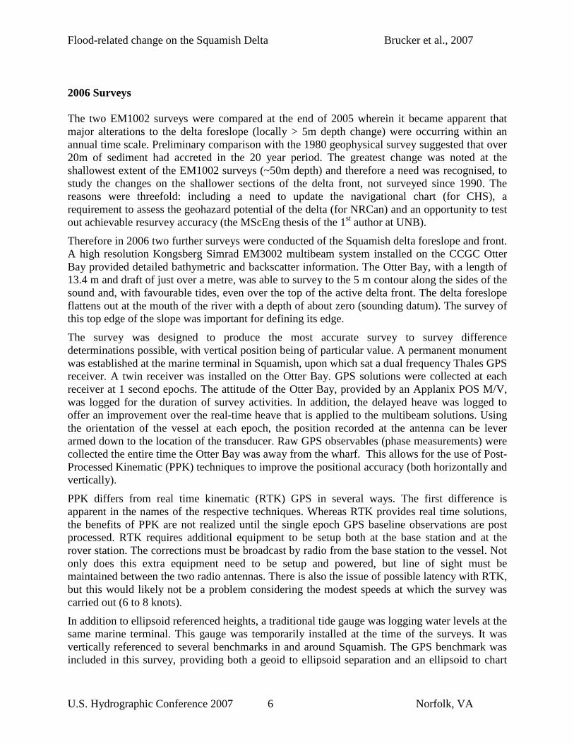
Figure 3 shows the GPS ellipsoidal height and the speed of the vessel plotted together. As the speed of the vessel increases, it is pulled down into the water. This lasts as long as the boat maintains its speed. The motion sensor aboard is limited to measuring changes in vertical position that take place over several seconds and would not be able to capture this signal which has a magnitude of 10 to 15 cm. The upward trend of the GPS ellipsoid height from left to right comes from the rising tide.
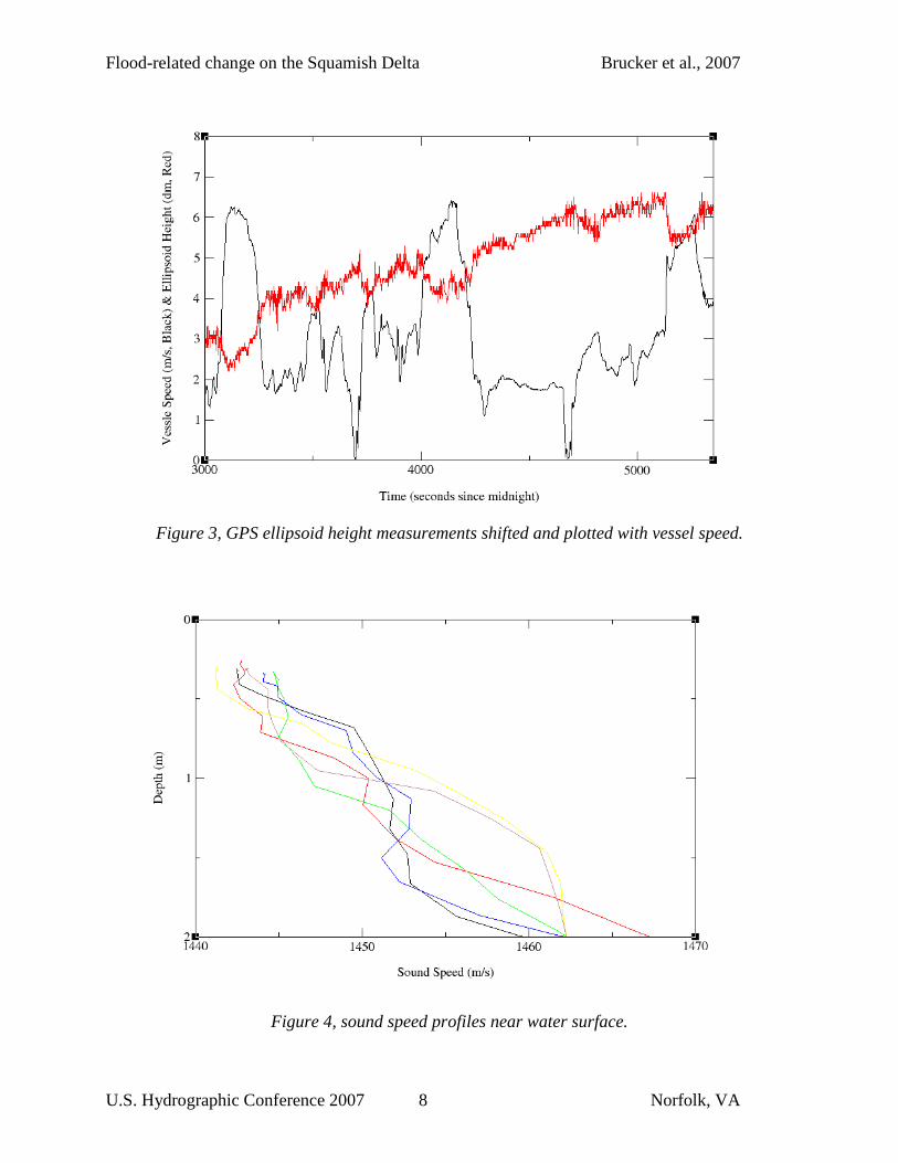
The water near the mouth of the river was highly stratified and the sound speed changed from 1444 m/s to 1477 m/s at only 5m depth, after which it slowly converged to 1484 m/s at 20m. With the large range of sound speeds, it’s difficult to see how much one profile varies from the next. Figure 4 shows the top 2 m of six profiles that were taken throughout the survey area. At the depth of the transducer face (1m) changes in sound speed of up to 10 m/s can be seen between profiles. This change could occur quickly when crossing directly in front of the river mouth. The sound speed probe on the Otter Bay proved to be very valuable for this application.
Flood-related change on the Squamish Delta Brucker et al., 2007
U.S. Hydrographic Conference 2007 8 Norfolk, VA
Figure 3, GPS ellipsoid height measurements shifted and plotted with vessel speed.
Figure 4, sound speed profiles near water surface.

Flood-related change on the Squamish Delta Brucker et al., 2007
U.S. Hydrographic Conference 2007 9 Norfolk, VA
Figure 5:
Top Left: 1973 to 1990 differences. – greyscale -5m to +30m Top Right: 1990 to 2006 differences – greyscale -5m to +30m Centre Left: 2004 to 2005 differences – greyscale -3m to +3m Centre Right: Sept. 2005 to <March 2006 differences. – greyscale -3m to +3m Bottom Left: March 2006 to November 2006 differences. – greyscale -3m to +3m

Flood-related change on the Squamish Delta Brucker et al., 2007
U.S. Hydrographic Conference 2007 10 Norfolk, VA
At this time, the main analysis has focused on the regional differences derived from the 6 bathymetric surfaces. The difference maps (5 presented in Figure 5 above) result from a combination of real sediment accretion or erosion, changes in resolution of the sonar type (particularly going from single to multi beam) and systematic biases in the sonar configurations (timing, sound speed, alignment and tidal biases).
Inter Survey Bathymetric Difference Analysis
1973 to 1990 difference
The top left image in Figure 5 represents resolvable change over the first 17 years of the study. Before examining real changes we need to identify the artefacts due to systematic biases. The main two visible are pseudorandom mismatches in areas of steep slopes (primarily the constraining rock walls, but to a lesser extent the flanks of the main channels) and radial artefacts linked to errors in running the range arcs necessary with the positioning system used at the time. The steep slope problem is a result both of the single beam failing to track the slopes (due to hyperbolic echo issues) and the discrete (40m line spacing) sampling and inter-line interpolation.
Despite these readily apparent artefacts, as the sedimentation rates are so high and the inter-survey duration so long, we can still see real sedimentary effects. The prime change seen is net accretion of the delta foreslope increasing in magnitude upslope (imply steepening of the delta foreslope gradient). The locus of deposition on the upper slope is entirely west of the training wall and primarily through infilling of the axis of the major feeder canyon that was present in 1973 (Figure 2 top left). The largest accretion (> 30m) has happened through the progradation of the delta front (which builds up to just below ordinary low water). Were it not for the continual dredging of the Squamish wharf area, the delta top would have prograded to the south and east cutting off the wharf.
1990 to 2006 difference
To see if the sedimentation pattern in the first 17 years continued for the following 16 years, the second difference map is between the 1990 and Spring 2006 survey (Figure 5 top-right). We are now comparing sonars of greatly varying resolution.
It is apparent that the style of sedimentation has shifted. Two large channel features have developed that have cut back into the delta foreslope. The main region of accretion is on an interchannel levee. The inactive channel that drains the Squamish harbour area has been clearly filled in (although presumably by overbank sedimentation from the active delta and not by sediments from immediately upslope.
2004 to 2005 differences
In order to understand how short term, inter-annual differences relate to the longer term trends, we now compare the two EM1002 surveys (Figure 5: centre left) that cover two years of summer-time freshet sedimentation. Neither of these surveys extended to the upper delta slope.

Flood-related change on the Squamish Delta Brucker et al., 2007
U.S. Hydrographic Conference 2007 11 Norfolk, VA
Note that we have now increased the resolution of the greyscale representation. Rather that black to white representing 35m of change, it now only represents 6m (+/-3m). Under this harsher stretch, one sees artefacts related to systematic biases in both of the EM1002 surveys. Over this short time period, the accretion on the lower foreslope is less than the multibeam biases.
Two trends of shiptrack parallel striping can be seen in the difference maps. The two trends match the slightly oblique survey patterns of the two surveys indicating that both have bias issues. It is important to note however, the scale of these biases. They are only about +/-50cm in 100 to 200m of water. Both surveys are thus clearly IHO Order 1 compliant. Nevertheless, we are seeking surface differences due to natural phenomena at a similar scale.
The natural processes that we can infer is a widening, but shoaling of the floor of the main channel and deposition of lobate sand sheets on the proximal lobe. The lobate deposition is modulated by bedforms (the difference map shows undulation normal to the direction of inferred sediment flow).
2005, Spring 2006 difference.
In order to extend this time series we now examine the changes over the winter months by comparing September 2005 and March 2006 (Figure 5 centre right). Even though the EM3002 survey extends up to the 5m contour, change can only be detected in the overlapping region.
Looking at the difference map we note a single grain of systematic biases. That grain follows the 2005 EM1002 survey line spacing. Significantly a grain is not apparent for the EM3002 data indicating the improvement in accuracy of the new surveys.
What is clear is that natural processes are subdued over the winter (non-freshet) months with just minor bedform migration along the main active channel and minor deposition (< 40cm) off the mouth of that channel.
Spring 2006 to Fall 2006 difference.
Finally we examine the two inshore EM3002 surveys (Figure 5, bottom left), both of which extend up to the 5m contour and both of which had the higher accuracy positioning and sound speed observations.
In terms of systematic biases, there is barely any remaining grain in the data indicating that those error sources are down at the < 20cm level. The data, as presented in this figure, however, only uses the real time differential GPS and thus one does see apparent change on the steep slope region and the edges of the abandoned meandering channel on the south side of the delta). Neither of these are really moving, but show apparent differences due to horizontal position uncertainty at the ~ 2m level.
The two surveys were taken before and after a summer freshet season and show far more change than the over-winter differences. Most apparent, is the disappearance of the extension of the delta front. From 1973 to 2005, the delta front had prograded out. During that time, the port had continually dredged the eastern flank of the delta front. As a result the southern side of the delta consisted of a pointed nose of sediment extending seaward. It is clear that over the 2006 summer, the outer edge of the delta has collapsed, perhaps catastrophically.

Flood-related change on the Squamish Delta Brucker et al., 2007
U.S. Hydrographic Conference 2007 12 Norfolk, VA
The main volume of the displaced sediment (over 20m of depth change in the landward limit of the survey) appears to have moved into the channel and infilled it. A smaller volume has made it out onto the proximal lobe.
Backscatter Processing – Separating Topographic from Textural Signatures
In the above analysis, we have focused on monitoring the change in sediment volume on the delta front. But we also need to know the type and distribution of the surficial sediments. If we are to estimate whether there has been any sediment type alterations on the delta foreslope, we need to be able to acoustically measure the seabed backscatter strength (an inherent property of the sediment that can be used to attempt sediment characterization). Kongsberg multibeam sonar backscatter data are reduced (to a first order) for gross geometric and radiometric effects and thus for benign (low relief) seafloors the real-time output backscatter strength estimates closely reflect spatial variations in seabed sediment type.
But in areas of strong topography, a number of the simplifying assumptions used in the real time TVG (Hammerstad, 2000) have to be compensated for. The most significant problem is properly accounting for the variation in grazing angle. This is most pronounced close to normal incidence where the roll off of backscatter strength with grazing angle is steepest. As the EM3002 surveys were unusually high aspect ratio (line spacing was typically ~ 1.5 xWD), the aspect ratio was high.
Backscatter processing is a two-step process:
1. Partial removal of EM3002 real-time time-varying gain (TVG) normalization scheme described by Hammerstad (2000).
2. Line-by-line angular response normalization, averaging the response based on common grazing angles.
In short, the first step removes the real-time TVG as it is occasionally fooled by strong topography. The second step renormalizes the data based on a more correct estimate of a sounding’s grazing angle on the seafloor.
The partial removal of the real-time TVG is described first. In addition to the standard corrections for spherical spreading and attenuation, the TVG used by Kongsberg attempts to account for the changing ensonified area across the swath and the backscattering strength of the seafloor, the latter of which can vary by several decibels across the imaged sector of the seafloor. The Kongsberg approach is then to model the seafloor's angular response as decaying linearly (by angle) from the point of normal incidence (usually near nadir) up to a crossover incidence angle, after which point the seafloor's response is assumed to follow Lambert's law. The variables that control the size and shape of the TVG curve are:
(1) Range to normal incidence
(2) Backscattering strength at normal incidence
(3) Backscattering strength at oblique incidence

Flood-related change on the Squamish Delta Brucker et al., 2007
U.S. Hydrographic Conference 2007 13 Norfolk, VA
(4) Crossover angle
Each of the four parameters listed above is estimated based upon information provided from the previous swaths. When constructing the real-time TVG, the incidence angle for a given sample is estimated based on the ratio of its associated range measurement to the range to normal incidence (based on a flat seafloor assumption). If the seafloor is not flat, this can introduce artefacts in the normalization of the backscatter strength, e.g. when surveying along canyon walls with portions of the swath reaching the canyon floor. Such artefacts are especially visible when transitioning from an area of flat seafloor to an area of significant topography within the same survey line, this being the principle reason for removal of the real-time TVG for this dataset.
Removal of the Kongsberg TVG brings the data much closer to what would have been physically measured by the transducers, i.e. the response near normal incidence is quite high relative to low grazing angle portions of the imaged sector. This leads to the second step of the process, that of the line-by-line angular response normalization. At this stage, the backscattered signal is averaged for common grazing angles over the survey line. For a given sounding, its grazing angle is computed as the angle between the ensonification vector and the surface normal at the point of ensonification which is determined by fitting a least-squares plane to the sounding point and its eight neighbouring soundings.
Further refinements to this method would be to (1) compute average response curves over several swaths, as opposed to using a single average curve for the entire line, and (2) to use a higher order surface to estimate the grazing angle.
The results of applying this process are illustrated in Figure 6 below. As can be seen from the top pair of images, the default backscatter imaging shows a strong correlation between the presence of bedforms seen in the bathymetry and striping in the raw backscatter data.
By taking advantage of the process described above, the data are sorted by real incident grazing angle after the Simrad TVG is removed and then adaptively normalised according to the average angular response curve for each line. The result (lower right in figure 6) clearly shows that the real backscatter strength (corrected for slope) does not significantly vary over the sand rotational slump features. This is an important observation for correct geological interpretation of the deltaic sedimentary processes.

Flood-related change on the Squamish Delta Brucker et al., 2007
U.S. Hydrographic Conference 2007 14 Norfolk, VA
Figure 6: Top-left: Sun-illuminated bathymetric image of upper delta face. Top-right: standard output 300 kHz backscatter map products assuming locally flat seafloor. Note that there appear to be significant seabed backscatter strength fluctuations that correlate with the bedforms developed on the foreslope. Bottom-right: modified image accounting for seabed- relative grazing angle. After correction one notes that the relief-correlated apparent backscatter strength modulations are gone. These modulations were thus driven by grazing angle and NOT variations in seabed type. Grab sample analysis confirms that there is no significant fluctuations on the sediment type over the bedform fields. Bottom Left: graphic illustrating the across track scattering signal resulting from the variations in seabed slope due to the bedform morphology present on the delta foreslope.
Processing to be completed
GPS data from past and future surveys needs to be processed to provide instantaneous positions of the antenna centre at each epoch. Once this position has been determined, it will be translated down to the transducer using the vessel's orientation at the time. Filtering will need to be done, bearing in mind that periodical changes in speed of the Otter Bay produce changes in its draft. These changes could be seen in either the delayed heave produced by the motion sensor, or the filtered GPS ellipsoid heights. A correction must only be applied from one source, not two, if both capture the signal of the change. The strong (and static) topography of the bedrock fjord flanks in the area will be beneficial in testing the ability to perform repeat surveys with high accuracy.
The MVP 30 sound speed profiles need to be looked at and, if warranted, the multibeam data may need to be post processed using some sort of geographically interpolated solution

Flood-related change on the Squamish Delta Brucker et al., 2007
U.S. Hydrographic Conference 2007 15 Norfolk, VA
representing the expected structure of the water column. Due to the real time application of surface sound speeds, beam pointing in not expected to be a major source of errors.
Summary & Future Plans
Analysis of historic single beam surveys and 4 modern multibeam surveys clearly indicate the dynamic sedimentary environment on the Squamish delta. On a time scale of decades, long term progradation of the delta is punctuated with reincision of canyon features. The delta topset has moved between 100 and 150 m down river over the last 30 years, although a potentially catastrophic collapse of a sub-section of that topset occurred in the summer of 2006. The presence of the training dyke has restricted modern input to the western edge of the delta. As a result the historic channel systems developed on the eastern side of the delta have been abandoned and are slowly being infilled with overbank sedimentation from the northwest.
Whilst the large scale changes are evident, even with the imperfections in survey methodology, it is clear that improvements in survey technology including narrower beams, better horizontal and vertical positioning and better monitoring of the water column are necessary to properly interpret the smaller scale changes. This is particularly important on the lower delta foreslope where less than ~ 50cm (in depths in excess of 150m) may be deposited in a single year.
Based on the surprisingly large changes in the morphology of the delta front over a single summer, two more surveys are planned for head of the sound in 2007. These surveys will hopefully be included in the detailed processing that is upcoming. This processing will give an indication of the volume of sediment that is deposited in the area near the mouth of the river, and the magnitude and frequency of mass wasting events.
Acknowledgements
This analysis and the EM3002 field program vessel costs were funded through the sponsors of the Industrial Research Chair in Ocean Mapping at UNB. Current sponsors include: the U.S. Geological Survey, Kongsberg Maritime, Royal (U.K.) Navy, Fugro Pelagos, Rijkswaterstaat and the Route Survey of Canadian Navy. The Canadian Hydrographic Service conducted the multibeams surveys and provided essential logistical and technical support including tide gauges, terrestrial control and PPK logging. Natural Resources Canada funded the EM1002 surveys, provided archived geological information and is processing the physical samples.
References Bornhold, D.B., 1984, Geomorphology of Slope Instability Features, Bathymetry Squamish Harbour, Howe Sound, British Columbia: Geological Survey of Canada, Open File 1095. – 2 Maps. 1-10,000.

Flood-related change on the Squamish Delta Brucker et al., 2007
U.S. Hydrographic Conference 2007 16 Norfolk, VA
Environment Canada, 2007, http://scitech.pyr.ec.gc.ca/waterweb/fullgraph.asp?stnid=08GA022
Friele,P.A., Ekes, C. and Hickin, E.J., 1999, Evolution of Cheekye fan, Squamish, British Columbia: Holocene sedimentation and implication for hazard assessment: Canadian Journal of Earth Sciences, v.36, p.2023-2031.
Gibson J.W. and Hickin, E.J., 1997, Inter- and supratidal sedimentology of a fjord-head estuary, south-western British Columbia: Sedimentology, v.44, p.1031-1051.
Hammerstad, E. (2000). "EM Technical Note: Backscattering and Seabed Image Reflectivity".
Hickin, E,J., 1989, Contemporary Squamish River sediment flux to Howe Sound, British Columbia: Canadian Journal of Earth Sciences, v.26, p.1953-1963.
Prior, D.B., Wiseman, WM.J. and Gilbert, R.T., 1981, Submarine slope processes on a fan delta, Howe Sound, British Columbia: Geo-Marine Letters, v.1, p.85-90.
Prior,D.B. and Bordhold, B.D., 1986, Sediment Transport on Subaqueous Fan Delta Slopes, Britannia Beach, British Columbia: Geo-Marine Letters, v.5, p.217-224.
Syvitski, J.P.M. and MacDonald R.D., 1982, Sediment character and provenance in a complex fjord: Howe Sound, British Columbia: Canadian Journal of Earth Sciences, v.19, p.1025-1044.