Flood discharge estimation from river channel dimensions: results of ...
16
Hydrological Sciences—Journal—des Sciences Hydrologiques, 44(1) February 1999 97 Flood discharge estimation from river channel dimensions: results of applications in Java, Burundi, Ghana and Tanzania G. WHARTON Department of Geography, Oueen Mary and Westfield College, University of London, London El 4NS, UK e-mail: [email protected] J. J. TOMLINSON 185 New Kent Road, London SE1 4AG, UK Abstract The channel-geometry method is an indirect method of flood estimation which relies on the development of relations between flood discharges, measured at gauging stations, and channel dimensions, measured from natural river reaches in the vicinity of the gauge. Channel-geometry equations enable flood discharges to be estimated at ungauged locations on natural streams from measurements of channel size and by combining the index flood estimate (usually the mean annual flood) with regional flood growth factors. This paper reports on channel-geometry equations which have been developed and applied in four developing, tropical countries as part of hydrological investigations for road design and flood risk assessment (Java), irrigation and hydropower development (Burundi), design of all-weather roads (Ghana), and rehabilitation of railway bridges (Tanzania). The applications demonstrate the benefits of the channel-geometry method in situations where data on catchment characteristics are limited or may not offer the most appropriate basis for flood discharge estimation. Estimation d'un débit de crue à partir de la géométrie du chenal d'écoulement: applications et résultats à Java, au Burundi, au Ghana et en Tanzanie Résumé Cette méthode est fondée sur une corrélation entre les débits et les dimensions du chenal naturel à proximité d'une station de jaugeage. Grâce à cette méthode on peut estimer une indice de crue—habituellement la crue annuelle moyenne—pour des sites où les cours d'eau ne sont pas jaugés. Ce résultat est obtenu en utilisant la géométrie des chenaux d'écoulement associée à des facteurs d'accroissement régionaux. Dans l'article nous présentons les résultats spécifiques des équations développées et utilisées dans quatre pays tropicaux où des investigations hydrologiques ont été menées en vue de divers projets: Java, en Indonésie: assainissement d'une grande route; Burundi: projets d'irrigation et d'hydroélectricité; Ghana: tracé d'un réseau routier; Tanzanie: projet de réhabilitation de ponts de chemin de fer. Ces références ont démontré les avantages liés à l'application de cette méthode sur des sites où les données sont généralement insuffisantes. INTRODUCTION Flood discharge estimates are required for a variety of purposes including the design and appraisal of reservoir and irrigation schemes, flood management projects and river rehabilitation and restoration initiatives. However, a major difficulty is that the Open for discussion until 1 August 1999
Transcript of Flood discharge estimation from river channel dimensions: results of ...
Hydrological Sciences—Journal—des Sciences Hydrologiques, 44(1) February 1999 97
Flood discharge estimation from river channel dimensions: results of applications in Java, Burundi, Ghana and Tanzania
G. WHARTON Department of Geography, Oueen Mary and Westfield College, University of London, London El 4NS, UK e-mail: [email protected]
J. J. TOMLINSON 185 New Kent Road, London SE1 4AG, UK
Abstract The channel-geometry method is an indirect method of flood estimation which relies on the development of relations between flood discharges, measured at gauging stations, and channel dimensions, measured from natural river reaches in the vicinity of the gauge. Channel-geometry equations enable flood discharges to be estimated at ungauged locations on natural streams from measurements of channel size and by combining the index flood estimate (usually the mean annual flood) with regional flood growth factors. This paper reports on channel-geometry equations which have been developed and applied in four developing, tropical countries as part of hydrological investigations for road design and flood risk assessment (Java), irrigation and hydropower development (Burundi), design of all-weather roads (Ghana), and rehabilitation of railway bridges (Tanzania). The applications demonstrate the benefits of the channel-geometry method in situations where data on catchment characteristics are limited or may not offer the most appropriate basis for flood discharge estimation.
Estimation d'un débit de crue à partir de la géométrie du chenal d'écoulement: applications et résultats à Java, au Burundi, au Ghana et en Tanzanie Résumé Cette méthode est fondée sur une corrélation entre les débits et les dimensions du chenal naturel à proximité d'une station de jaugeage. Grâce à cette méthode on peut estimer une indice de crue—habituellement la crue annuelle moyenne—pour des sites où les cours d'eau ne sont pas jaugés. Ce résultat est obtenu en utilisant la géométrie des chenaux d'écoulement associée à des facteurs d'accroissement régionaux. Dans l'article nous présentons les résultats spécifiques des équations développées et utilisées dans quatre pays tropicaux où des investigations hydrologiques ont été menées en vue de divers projets: Java, en Indonésie: assainissement d'une grande route; Burundi: projets d'irrigation et d'hydroélectricité; Ghana: tracé d'un réseau routier; Tanzanie: projet de réhabilitation de ponts de chemin de fer. Ces références ont démontré les avantages liés à l'application de cette méthode sur des sites où les données sont généralement insuffisantes.
INTRODUCTION
Flood discharge estimates are required for a variety of purposes including the design and appraisal of reservoir and irrigation schemes, flood management projects and river rehabilitation and restoration initiatives. However, a major difficulty is that the
Open for discussion until 1 August 1999

98 G. Wharton & J. J. Tomlinson
most reliable estimates are obtained from continuous streamflow records, at least 25 years in length, measured from instrumented gauging stations, and such records are only available for a relatively small number of river reaches. Developing countries suffer acutely from a lack of reliable streamflow data arising from sparse gauging networks and short flow records, but the problem is not confined to the developing world. Even in Great Britain, which has one of the densest networks of continuous gauging stations with over 1000 currently in operation, there are many unmonitored river reaches and there is a notable shortage of information for low discharge streams.
Faced with inadequate streamflow data for many river reaches, hydrologists have two main options for deriving flood discharge estimates. Although the direct measurement of flood discharge is sometimes possible, frequently there is insufficient warning of a flood event to raise the necessary personnel and to travel to the site, and furthermore the use of flow current meters is extremely difficult for large flood events, not least because of the dangers involved in gaining access to the stream. A range of indirect techniques offer a useful alternative and the development of reliable indirect methods has been, and continues to be, a major research focus in hydrology.
The variety of indirect techniques for flood discharge estimation which now exist (see Wharton, 1992, for a short review) include: the extrapolation of streamflow records from the nearest, similar gauged catchment; regression-based techniques (usually employing climatic and drainage basin explanatory variables as part of a Regional Flood Frequency Analysis); and more sophisticated, physically-based hydrological models. The choice of method for a flood study will depend upon the quality and range of available data, the nature and accuracy required of the discharge estimates, and the time and cost constraints of the exercise. For example, rapid, inexpensive flood discharge estimates for ungauged river sites can be provided by simple extrapolation of streamflow records if hydrologically similar gauged catchments are located nearby. On the other hand, physically-based hydrological models are needed to generate detailed estimates of the full range of flows but this may prove a lengthy and costly procedure, data requirements frequently cannot be met, and it is not always possible to justify the time and effort required to generate a flood hydrograph.
In situations where climatic and drainage basin information is limited, preventing a comprehensive catchment-based approach to index flood estimation, the channel-geometry method provides a useful complementary or alternative technique (Wharton et al., 1989). Channel-geometry analyses use relationships established between river channel dimensions and return period floods to determine the flood frequency characteristics at ungauged river sites. Channel-geometry equations have been developed in a variety of environments (arid, semiarid, humid temperate, sub-tropical and tropical) and have been employed over many years by a number of workers. The channel-geometry equations provide valuable site estimates of the mean annual flood which can be employed as the index flood in regional flood frequency analyses. The technique is especially useful for planning and pre-feasibility studies and the design of small schemes and small hydraulic structures. For larger engineering schemes, the channel-geometry method can provide helpful reconnaissance flood estimates prior to

Flood discharge estimation from river channel dimensions 99
the application of more costly and time-consuming hydraulic and hydrological models. This paper briefly reviews some of the important Regional Flood Frequency
Analyses which have been undertaken in a number of arid, semiarid and tropical countries to provide a context for the discussion of the channel-geometry method and the results of its application in four developing, tropical countries: Java, Burundi, Ghana and Tanzania. These applications demonstrate the benefits of the channel-geometry technique in situations where data on catchment characteristics are limited or may not offer the most appropriate basis for flood discharge estimation.
BACKGROUND
Catchment-based methods of flood estimation
Regional Flood Frequency Analysis (RFFA) is a widely employed method of flood discharge estimation typically making use of regression-based techniques to derive index flood values from a range of catchment and climatic characteristics. RFFA is described in detail in the UK Flood Studies Report (Natural Environment Research Council, 1975) as the statistical method of flood estimation and comprises three main stages. The first stage is selection of an homogeneous region for the flood study in which the flood frequency behaviour of the rivers in the same geographical region is similar (Cunnane, 1988). Stage two of a RFFA is the derivation of a method for determining index flood values (usually the mean annual flood) for the catchments. And the final stage is the derivation of the regional flood frequency curves so that floods of a given return period can be estimated from the index values {Meigh et al., 1997).
An important advantage of RFFA is that all the flow records in a region are used so that the total record length is the sum of the lengths of the individual records. This enables high return period floods to be estimated with greater confidence than when employing single site analysis, even when there is considerable intersite dependence in the flow records (Meigh et al, 1993). However, RFFA does suffer from the difficulty of establishing hydrological similarity between catchments in a region and addressing the concern that the assumption of similarity is not simply due to lack of data which could prove otherwise.
Most commonly, index flood values are estimated from a set of carefully selected catchment and climatic characteristics. This catchment-based approach developed from the idea of the rational formula and culminated in the UK with the production of the Flood Studies Report (Natural Environment Research Council, 1975). The equations presented in the Flood Studies Report employed measures of precipitation, drainage network and soil character, drainage basin size and extent of urban area that could be obtained as easily as possible to facilitate widespread use of the techniques (Newson, 1978). Many similar approaches have been devised for other countries, most notably research by Thomas & Benson (1970), which formulated a series of equations to estimate 71 flow indices, including low flows, flow duration, flood peaks, flood volumes, and annual and monthly mean flows for four areas of the

100 G. Wharton & J. J. Tomlinson
USA. Catchment characteristics should be chosen to represent the different factors relevant to flooding, and these may vary from region to region. For instance, in regions with wet rice cultivation, the proportion of the catchment covered by paddy fields could be considered, whereas in heavily urbanized areas the urbanized proportion will need to be taken into account. More recently, attempts have been made to provide catchment characteristics with improved explanatory powers by proposing measures of runoff-contributing areas and controls upon runoff production (Beven, 1987; Beven & Wood, 1983) but these indices are more time-consuming to derive and not feasible for most flood studies.
RFFAs employing climatic and catchment indices to estimate the mean annual flood (MAF) have now been undertaken in a large number of arid, semiarid, subtropical and tropical countries to provide a set of flood estimation methods which should be of immediate practical use (Farquharson et al, 1987, 1992; Meigh et al, 1993, 1997). These papers summarize all the MAF prediction equations and dimen-sionless flood frequency curves derived for the regions and countries of study, including a number of developing countries: Brazil, Rio Grande do Sul; India, Kerala; Indonesia, Java and Sumatra; Malawi; Namibia; Papua New Guinea; The Philippines; Sri Lanka; Swaziland; Thailand; Zimbabwe (Institute of Hydrology, 1986), and parts of Iran, Jordan, Kenya and Korea. Another study was also undertaken by Farquharson et al. (1993) for a much larger region than usual—West Africa—using much of the available data from Guinea in the west to Cameroon in the east. Within this region, sub-regions were developed based on geographical parts of the region and on groups defined by catchment area and mean annual rainfall.
For the RFFAs conducted in the arid and semiarid countries, data from gauged catchments were used to derive regression relationships between MAF and basin area (AREA) and mean annual rainfall (MAR) as the two independent variables (Farquharson et al., 1992). These equations provide a preliminary means of estimating the index flood (MAF) for ungauged rivers in Iran, Saudi Arabia and Yemen, Australia (Queensland), South Africa and Botswana. A combined regression equation and growth curve for all warm arid zones studied permits the flood magnitude with a known risk of exceedance to be derived within warm arid zones of the world (annual basin rainfall < 600 mm) even where local flow data are currently unavailable. Farquharson et al. (1992) also make the important observation that the 5-year flood may be a more appropriate scaling factor for the dimensionless growth curves in arid zones due to the problem of low or zero annual maxima in a number of years.
In the recent RFFAs of tropical and sub-tropical countries and regions (Meigh et ah, 1997) the index flood used was MAF, the principal catchment characteristic used in every case was the catchment area (AREA), and average annual catchment rainfall (AAR) was found to be a significant second variable in may instances. In some cases, other catchment characteristics similar to those used in the British flood study (Natural Environment Research Council, 1975) were measured and found to be significant but it is envisaged that, in many situations, lack of data will preclude their derivation and application. Thus, the minimum data needed are AREA and AAR (Meigh et al, 1993).

Flood discharge estimation from river channel dimensions \ o \
Comparison of the RFFA results from the arid and semiarid basins with those from tropical and sub-tropical basins by Meigh et al. (1997) reveals flood frequency curves of differing steepness which provide useful initial information in different climatic zones. Though not entirely universal, the essential difference is that for humid regions the "average flood" (the flood that occurs regularly every one or two years) is relatively large, but the flood frequency curve is not very steep so that rare floods (occurring once in every 100-1000 years) are not very much larger than the average flood. The converse has been noted for arid regions: the average flood is small, but rare floods can be extremely large multiples of the average giving a steep growth curve. Meigh et al. (1993) have also noted the tendency for small catchments to have steeper curves than larger catchments, although there are exceptions.
Flood estimation from river channel dimensions
In regions where information on catchment characteristics is limited the channel-geometry method offers an alternative or additional means of estimating flood discharge characteristics by yielding an index flood value (from a measure of channel size) for a RFFA. The channel-geometry method developed out of research on the interrelationship of stream channel geometry and river discharge and assumes that, other things being equal, there is a smoothly variant relationship (after appropriate transformation of variables) between river channel geometry and flow. No evidence exists to indicate thresholds in this relationship. The method characterizes the natural range of flows by a single dominant discharge of channel-forming significance (usually MAF in humid environments), a practice which has also been fundamental in the development of regime equations for natural rivers (Hey & Thorne, 1986; Wharton, 1995b).
Channel-geometry equations are developed by relating streamflow data from gauging stations and river channel dimensions measured from natural reaches in the vicinity of the gauge using regression analysis. The equations are expressed as power function relations (Osterkamp, 1978):
Q = gW
and
Q = iA"
where Q is a measure of streamflow, usually the mean annual flood, and Wand A are the channel width and cross-sectional area, respectively, measured at a specified reference level, usually bankfull (see Wharton, 1995a, for details on the geomorphic or channel-reference levels). The multipliers (g and z) are the antilogarithms of the regression constants and the power terms (h and n) are the regression coefficients. Nearly all channel-geometry equations are confined to relationships between discharge and channel width or channel cross-sectional area as the most reliable predictors, with channel width equations the most popular. Once channel-geometry equations have been defined for a region or country, a channel width or channel

102 G. Wharton & J. J. Tomlinson
cross-sectional area measurement is all that is needed to indicate the flood flow characteristics at ungauged river sites.
It is possible to derive a series of channel-geometry equations to estimate a range of return period floods (for example, Q5, QIO, Q20, Q50 and g 100) but only if the exponents of the channel-geometry equations are similar implying that the ratios between the floods are very consistent between sites in the region (Wharton, 1989). The recommended procedure, however, is to estimate MAF as the index flood and combine this estimate with an appropriate regional flood frequency curve. For British rivers the use of region curves presented in the Flood Studies Report (Natural Environment Research Council, 1975, vol. I, pp. 172-174) is recommended when estimating floods with return periods greater than five years because the extent to which river channel dimensions are indicative of less frequent floods is not known. For detailed guidelines on the derivation and application of channel-geometry equations for flood discharge estimation see Wharton (1992).
The channel-geometry method has particular merits as a reconnaissance technique in developing countries where the lack of hydrological and catchment information frequently prevent the application of traditional methods and in arid environments where discharge estimates based on rainfall-runoff models, drainage basin characteristics and, in particular drainage basin area, have proved less reliable because variations in precipitation and runoff are more significant and flow characteristics may differ greatly along and between streams in the same catchment (Wharton, 1995a). Indeed, the reduced reliability of catchment-based approaches in arid environments was the factor which originally prompted the development of an alternative technique based on channel dimensions. Subsequently, however, the channel-geometry method has yielded equally reliable flood discharge estimates in humid environments because river channels adjust to the prevailing flow regime within possibly three to five years with the result that a mean channel geometry can be more readily maintained (Wharton 1995a). Osterkamp & Hedman (1979) also argue that, as a reconnaissance technique, more confidence can be placed in the channel-geometry method than catchment-based approaches because river channel dimensions integrate the effects of a range of catchment variables (Knighton, 1987) and provide discharge estimates more closely related to the measured variables (Osterkamp & Hedman, 1982). In this way, simple channel-geometry equations represent one solution to the problem of assuring independence of multiple regression variables. For many streams, it is also anticipated (Osterkamp & Hedman, 1979) that channel-geometry estimates of Q5 and QIO are often as reliable as those based upon five to ten years of streamflow records.
Progress in the estimation of flood discharges from river channel dimensions was first achieved in the USA following the suggestion of Langbein (1960) after research in Nevada; and after a succession of studies, including Hedman (1970), Hedman et al. (1972, 1974), Scott & Kunkler (1976), Riggs (1978), Osterkamp & Hedman (1979, 1982), Webber & Roberts (1981), Hedman & Osterkamp (1982), Omang et al (1983a,b), and Wahl (1983, 1984), the method was accepted by the Water Resources Division of the US Geological Survey as an operational technique. Outside the USA, success has been reported for New Zealand (Mosley, 1979), northwest

Flood discharge estimation from river channel dimensions \ 03
Italy (Caroni, 1982), Great Britain (Wharton et al., 1989, 1995a) and details of the derivation and application of equations for Java, Burundi, Ghana and Tanzania are presented for the first time in this paper. Thus, analyses progressed by developing channel-geometry equations for a range of environments beyond the arid regions studied initially and, secondly, by developing relationships to estimate a variety of flood frequency characteristics so that channel-geometry equations now exist for a range of river channel types (perennial, intermittent and ephemeral, gravel-bed and alluvial) in a variety of environments (arid, semiarid, humid temperate, sub-tropical and tropical). These channel-geometry equations are reported in Wharton (1995a,b).
APPLICATIONS OF THE CHANNEL-GEOMETRY METHOD
Java
In April 1990, the UK Overseas Development Administration engaged Cementation International Ltd, in association with Rendel Palmer & Tritton under British aid arrangements, to provide services to the Government of the Republic of Indonesia relating to land acquisition, environmental, and design studies for the Cikampek to Padalarang Toll Road in West Java. A hydrological investigation was undertaken for Rendel Palmer & Tritton (1990) as part of the preliminary design for the proposed road which will provide a link between Jakarta and Bandung by connecting the Jakarta-Cikampek toll road to the Padalarang-Cileunyi toll road. Construction of the road commenced in autumn 1997.
The proposed 60 km long road traverses a total of 80 small waterways including various tributary streams of the Citarum River and, in the north, several streams flowing eastwards into the Cijalu River. The catchment sizes range upwards from less than 0.5 to 201 km2. Apart from numerous small irrigation ditches in the Kampung padi areas, the proposed alignment also crosses two principal irrigation channels: the SS Kamojing Lama secondary feeder near Sadang north of Purwakarta, and the Pasir Kuntul primary canal near Padalarang.
The climate of the region is characterized by a wet season (June-October) and a dry season (November-May), although no month passes without rainfall and even at the height of the dry season average monthly rainfall is at least 20 mm. Mean annual rainfall along the alignment varies between 1500 mm near Padalarang and over 3000 mm between Purwakarta and Cikalong Wetan. In the higher altitudes of the roadside catchments the mean annual rainfall is over 4000 mm (Rendel Palmer & Tritton, 1990).
The objective of the flood study was to produce flood frequency estimates as a basis for evaluating or designing the hydraulic structures (mainly culverts) and for assessing the risk of damage during any construction periods. Historical streamflow data were provided by Puslitbang Air (Institute of Water Resources Research and Development), formerly Direktorat Penyelidikan Masalah Air (DPMA), in Bandung. Other streamflow data were made available by Perum Otorita Jatiluhur (Jatiluhur Development Authority) and Perusahaan Listrik Negara (State Electricity

!04 G. Wharton & J. J. Tomlinson
Enterprise). However, due to the relatively recent establishment of their gauging networks, the duration of the data was insufficient for meaningful flood frequency analyses.
In 1983, the UK Institute of Hydrology (IH) and the DPMA published a Flood Design Manual for Java and Sumatra (IH & DPMA, 1983). From the available data this study established a correlation between the mean annual flood and various catchment parameters. The derived regression equation is recommended as a tool for the determination of flood flows in ungauged catchments but in general the formula should not be used for catchments less than 10 km2 in area. The IH & DPMA (1983) flood design method was not employed in the Cikampek-Padalarang toll road flood study because of its restrictions on catchment size which would have excluded the majority of catchments under consideration along the proposed road alignment. However, the channel-geometry method which was employed is a complementary technique and the Flood Design Manual was an important source of information for the hydrological study because the IH & DPMA (1983) flood study determined Regional Flood Growth Factors and these were employed to estimate various return period floods.
From the Flood Design Manual for Java and Sumatra (IH & DPMA, 1983), 24 catchments were selected for which the mean annual flood (MAF) had been estimated (Table 1). An initial trial using bankfull channel widths estimated from an inspection of the summary current meter measurements held on file at Puslitbang Air showed good correlation. This trial was extended through field visits to yield a channel-geometry equation for the estimation of MAF from active bankfull channel width (Wb) (Table 2).
The channel-geometry equation enabled the estimation of MAF for all small catchments of interest in Java where a natural channel could be discerned. Table 2 also presents the regression relation between catchment area (AREA) and MAF for all 24 sites as a comparison with the channel-geometry equation. The R1 and fsee (factorial standard error of estimate) values indicate that channel width provides a better basis for estimating MAF than catchment area, even though the AREA equation yields a much higher R2 than expected when compared with similar studies in the UK where R2 values were less than 0.5 (Wharton et al., 1989).
Regional flood growth factors, to estimate floods of various return periods from the mean annual flood, were derived from information given in the Flood Design Manual for Java and Sumatra (IH & DPMA, 1983). The growth factors (Table 3) give the ratio of the flood peak QT, which is equalled or exceeded once every T years, to the MAF. These regional flood growth factors are appropriate to those catchments with a relatively high coefficient of variation for the annual series. Since these same factors are used for every catchment, this has the effect of overestimating flood events in certain cases where the variability is much less, but this is an error on the safe side.
Comparison of flood discharge estimates for road crossing river sites in Java derived from channel width (Wb), catchment area (AREA) and the IH & DPMA (1983) flood design method shows the main disparity to be for the Cikao River (Table 4). Of the five rivers considered in Table 4, only the Cikao catchment lies

Flood discharge estimation from river channel dimensions 105
Table 1 Information on gauging station sites employed in the hydrological studies.
River
Java Cisaru at Pos D Ciwidey at Pos C Cipadarum at Pos B Cigulung at Maribaya Cikadueun at Cibogo Ciliman at Leuwikopo Cimanuk at Garut (Leuwidaun) Ciseel at Cilisung Cimanuk at Leuwigoong Ciletuh at Cipiring Citanduy at Cirahong Cidurian at Parigi Cidurian at Kopomaja Citarum at Nanjung Ciseel at Binangun Cimandiri at Tegal Datar Cilangia at Leuwineukteuk Cisanggarung at Cilengkrang Bengawan Solo at Juranggempal Bengawan Solo at Napel Ciujung at Kragilan Kali Serayu at Banyumas Kali Brantas at Mojokerto Bengawan Solo at Bojonegoro Burundi Ruzizi Kagunuzi Ruvyironza Ntahangawa Mpanda Muzazi Musenye Kikoma Ghana Ayensu at Kofi Pare Abuchen at Asamankese DS Nakwa at Ekotsi Ayensu at Winneba Road Bridge Ochiso at Ochi Nakwa Ayensu at Oketsew Ayensu at Ayensuaka Ayensu at Asukaw Akora at Swedru Ochi Amissa at Mankessim Densu at Nsawam Birim at Oda Tanzania Ruvu Morogoro Mkondoa Wami Kisangata Mkindu Wami Ngengere
Station no.
30 29 28
8 23 24 11 18 10 25 17 21 20
1 19 26 15 16 44 42 22 33 48 46
11000 11060 21120
-11082
-11083
-
-----------.
1H8 1HA8 1GD2 1GB 1G6 1GB2 1G1 1HA9A
MAF (m3 s"')
5.11 7.67 6.57
26.70 142.60 121.50 102.70 143.40 294.90 294.50 588.20 193.20 302.90 270.10 250.20 369.40 460.00 391.80 909.50
2 150.00 733.10
1 135.00 1 198.00 2 071.00
256.00 69.00 66.00 50.00 48.00 38.50 17.00 7.50
45.30 14.70 72.20 71.10 68.80 91.20 59.50 60.90 46.70
116.00 140.00 240.00
308.0 9.4
73.4 39.2 45.7 44.6
129.0 12.7
W6(m)
3.8 5.0 5.8
11.0 16.0 19.0 20.0 23.0 27.0 29.0 29.0 33.0 35.0 35.0 35.0 36.0 39.0 59.0 64.0 95.0 96.0
112.0 158.0 160.0
85.0 20.0 18.7 9.3 8.0
10.4 5.4 2.4
6.1 6.3
10.5 11.0 11.5 11.5 12.0 12.2 14.5 15.0 16.0 26.3
38.0 5.0
18.0 14.0 7.0
10.0 22.0 3.1
AREA (km2)
4.72 10.81 3.05
49.20 34.60
108.50 474.90 178.50 757.40
79.30 634.70 622.00 300.00
1 832.60 320.30 495.10 179.90 622.10
1 442.00 9 578.00 1 858.00 2 642.40 9 972.90
12 429.00
14 300.00 423.00
1 452.00 122.00 255.00 116.00 40.00 31.00
129.00 108.00
1 445.00 1 657.00
911.00 727.00 587.00 404.00 448.00
1 253.00 1 535.00 3 286.00
15 190.00 191.00
17 550.00 324.00 404.00 101.00
28 500.00 205.00
MAF: mean annual flood; Wb: active bankfull channel width; AREA: catchment area. (The MAF and AREA values presented here are from the original hydrological reports referenced below for each country; these values were employed in the development of the regression equations listed in Table 2.)
Sources: Java—gauging station numbers and names and MAF and AREA values: IH & DPMA, 1983. The values for Wb were obtained from site "visits and inspection of the summary of the current meter measurements held on file at DPMA (Direktorat Penyelidikan Masalah Air), now Puslitbang Air, Bandung. Burundi—from unpublished reports prepared by J. J. Tomlinson for Rendel Palmer & Tritton and for Hydroplan. Ghana—gauging station names and MAF and AREA values: Architectural & Engineering Services Corporation, 1991. The values for Wb were obtained from site visits by J. J. Tomlinson in 1992. Tanzania—gauging station names and numbers and MAF and AREA values: Hydrological Year Books for 1960-1970. The values for Wb were obtained from site visits by J. J. Tomlinson in September 1994.
106 G. Wharton & J. J. Tomlinson
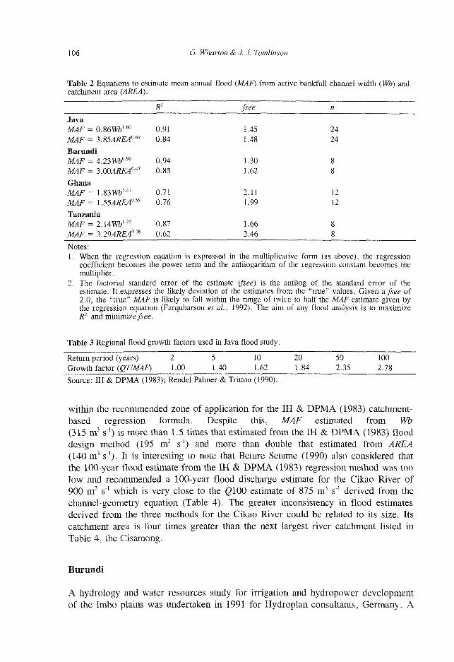
Table 2 Equations to estimate mean annual flood (MAF) from active bankfull channel width (Wb) and catchment area (AREA).
R1 fsee n
Java MAF = 0.86W&1-60 0.91 1.45 24
MAF = 3.854/ÎÊ40-69 0.84 1.48 24
Burundi M 4 F = 4.23W&096 0.94 1.30 8 MAF = 3.00AREA0" 0.85 1.62 8
Ghana M 4 F = 1.83W&147 0.71 2.11 12 MAF = l.55AREA°-s> 0.76 1.99 12
Tanzania MAF = 2.UWbL29 0.87 1.66 8 MAF = 3.29AREA03S 0.62 2A6 8
Notes: 1. When the regression equation is expressed in the multiplicative form (as above), the regression
coefficient becomes the power term and the antilogarithm of the regression constant becomes the multiplier.
2. The factorial standard error of the estimate (fsee) is the antilog of the standard error of the estimate. It expresses the likely deviation of the estimates from the "true" values. Given a. fsee of 2.0, the "true" MAF is likely to fall within the range of twice to half the MAF estimate given by the regression equation (Farquharson et al., 1992). The aim of any flood analysis is to maximize R2 and minimize fsee.
Table 3 Regional flood growth factors used in Java flood study.
Return period (years) 2 ~~5 ÏÔ 20 50 TOO Growth factor (QT/MAF) 1.00 1.40 1.62 1.84 2.35 2.78
Source: IH & DPMA (1983); Rendel Palmer & Tritton (1990).
within the recommended zone of application for the IH & DPMA (1983) catchment-based regression formula. Despite this, MAF estimated from Wb (315 m3 s"1) is more than 1.5 times that estimated from the IH & DPMA (1983) flood design method (195 m3 s"') and more than double that estimated from AREA (140 m3 s"1). It is interesting to note that Beture Setame (1990) also considered that the 100-year flood estimate from the IH & DPMA (1983) regression method was too low and recommended a 100-year flood discharge estimate for the Cikao River of 900 m3 s"1 which is very close to the (9100 estimate of 875 m3 s"1 derived from the channel-geometry equation (Table 4). The greater inconsistency in flood estimates derived from the three methods for the Cikao River could be related to its size. Its catchment area is four times greater than the next largest river catchment listed in Table 4, the Cisamong.
Burundi
A hydrology and water resources study for irrigation and hydropower development of the Imbo plains was undertaken in 1991 for Hydroplan consultants, Germany. A
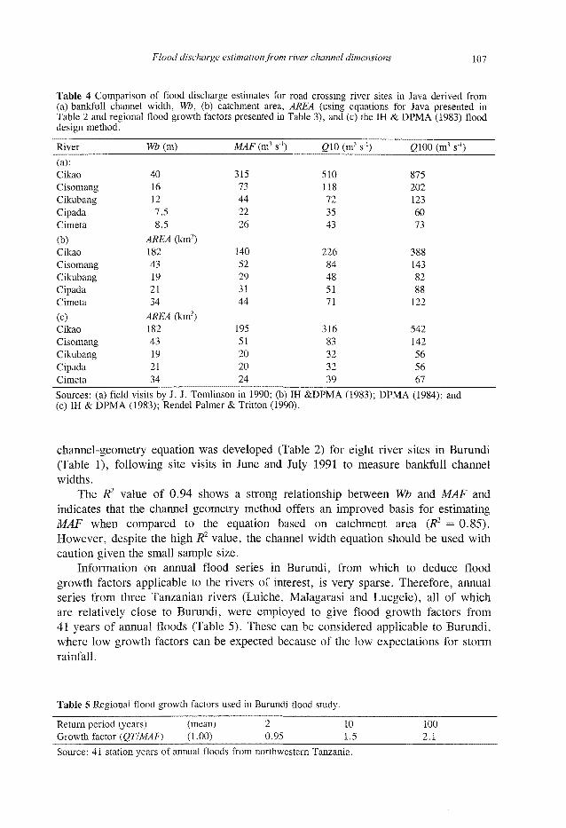
Flood discharge estimation from river channel dimensions 107
Table 4 Comparison of flood discharge estimates for road crossing river sites in Java derived from (a) bankfull channel width, Wb, (b) catchment area, AREA (using equations for Java presented in Table 2 and regional flood growth factors presented in Table 3), and (c) the IH & DPMA (1983) flood design method.
River
(a): Cikao
Cisomang
Cikubang
Cipada
Cimeta
(b) Cikao
Cisomang
Cikubang
Cipada
Cimeta
(c) Cikao
Cisomang
Cikubang
Cipada
Cimeta
Wb(m)
40 16 12 7.5 8.5
AREA (km2) 182 43 19 21 34
AREA (km2) 182 43 19 21 34
MAF (m3 s"1)
315 73 44 22 26
140 52 29 31 44
195 51 20 20 24
G10 (m3 s"')
510 118 72 35 43
226 84 48 51 71
316 83 32 32 39
2100 (m3 s1)
875 202 123 60 73
388 143 82 88 122
542 142 56 56 67
Sources: (a) field visits by J. J. Tomlinson in 1990; (b) IH &DPMA (1983); DPMA (1984); and (c) IH & DPMA (1983); Rendel Palmer & Tritton (1990).
channel-geometry equation was developed (Table 2) for eight river sites in Burundi (Table 1), following site visits in June and July 1991 to measure bankfull channel widths.
The R2 value of 0.94 shows a strong relationship between Wb and MAF and indicates that the channel geometry method offers an improved basis for estimating MAF when compared to the equation based on catchment area (R2 = 0.85). However, despite the high R1 value, the channel width equation should be used with caution given the small sample size.
Information on annual flood series in Burundi, from which to deduce flood growth factors applicable to the rivers of interest, is very sparse. Therefore, annual series from three Tanzanian rivers (Luiche, Malagarasi and Luegele), all of which are relatively close to Burundi, were employed to give flood growth factors from 41 years of annual floods (Table 5). These can be considered applicable to Burundi, where low growth factors can be expected because of the low expectations for storm rainfall.
Table 5 Regional flood growth factors used in Burundi flood study.
Return period (years) (mean) 2 10 100 Growth factor (QTIMAF) (1.00) 0.95 1.5 2.1
Source: 41 station years of annual floods from northwestern Tanzania.
108 G. Wharton & J. J. Tomlinson
Ghana
A hydrological study was undertaken in Ghana between December 1991 and February 1992 for the second phase of the Trunk Roads Rehabilitation Project (TRP2). The lead consultants for the World Bank-funded project in the southern part of Ghana were Twum Boafo & Partners, Accra, working with the Ghana Highway Authority and with assistance from Rendel Palmer & Tritton. The objective of TRP2 was to upgrade or redesign all rural district roads in the Volta region and Greater Accra from Lake Volta down to the coast (a total of 600 km of road) to produce all-weather roads through the elimination of flooding. A key part of the road drainage study was an assessment of culvert sizes for which flood discharge estimates were required.
Three approaches were used in the flood study. A rainfall-runoff model (US Soil Conservation Service Curve Number Method) was used to estimate the magnitude of the ten-year flood for catchments greater than 10 km2 and steep catchments with areas less than 10 km2. The model was restricted in its application following trials which indicated that peak flows for certain small catchments may be underestimated by about 50%. For smaller catchments (<10km2) and catchments which are not unusually steep, flood discharges were estimated from catchment area when there was no discernible natural channel for the measurement of active bankfull width. When a natural channel was discernible, allowing measurement of bankfull width, the channel-geometry method was applied.
A channel-geometry equation for the estimation of MAF from Wb was developed for 12 river sites from 80 catchments in Ghana for which there are flood records (Tables 1 and 2). Bankfull width measurements were obtained through field measurements. The R2 value of 0.71 for the channel width relation is much lower than the R2 values for the channel width relations developed for Java, Burundi and Tanzania and slightly lower than the R2 value of 0.76 obtained for the regression relationship between catchment area and mean annual flood (Table 2). Despite this, the channel-geometry equation provides a useful means of estimating the flood discharge characteristics in conjunction with the catchment area equation in the absence of more detailed information about the catchments and in situations where the use of the rainfall-runoff model is inappropriate. Wherever possible, design floods estimated by the different approaches should be compared. If estimates are similar this gives additional support to the values. If estimates do not agree, further research is needed and the uncertainty over the estimates should be explained in the hydrological report.
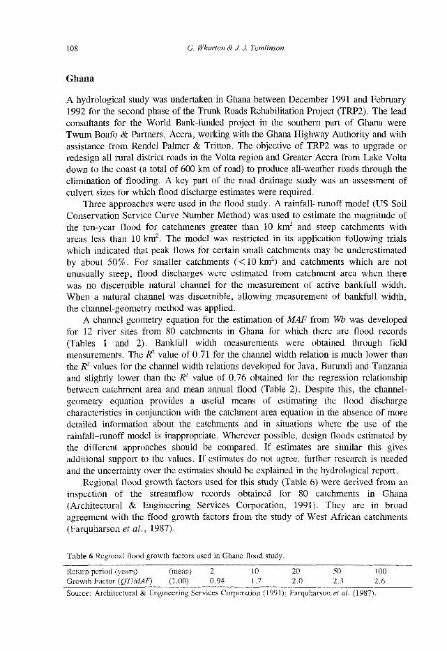
Regional flood growth factors used for this study (Table 6) were derived from an inspection of the streamflow records obtained for 80 catchments in Ghana (Architectural & Engineering Services Corporation, 1991). They are in broad agreement with the flood growth factors from the study of West African catchments (Farquharson et al., 1987).
Table 6 Regional flood growth factors used in Ghana flood study.
Return period (years) (mean) 2 10 20 50 100 Growth Factor (QTIMAF) (1.00) 0.94 1.7 2L0 2 3 2.6
Source: Architectural & Engineering Services Corporation (1991); Farquharson et al. (1987).

Flood discharge estimation from river channel dimensions 109
Tanzania
Flooding problems were investigated along the Central Line railway system as part of Phase V of a German KfW financed project for the rehabilitation of railway bridges. The lead consultants on the project (Rehabilitation of Railway Bridges, Tanzania Railways Corporation Design Phase V) were Gauff Ingenieure (1990).
Eight river sites with gauging station data were visited in September 1994 to establish a relationship between Wb and MAF (Table 1). The MAF at each of these sites was estimated from published records in the Hydrological Year Books. The channel-geometry equation (Table 2) provides a much better basis for MAF estimation than the catchment area relation and is recommended for cautious use (because of the small sample size) in estimating flood risk for the purposes of sizing bridges and culverts along the Central Line railway. It should be noted that all channels included in this study were cut in silty-clay materials. As with all empirically-derived equations, the application of this channel-geometry equation should be restricted to channel types similar to those used in the development of the equation. To obtain estimates of various return period floods the flood growth factors given in Table 7 were used.
Table 7 Regional flood growth factors used in Tanzania flood study.
Return period (years) (mean) 2 10 20 50 100 Growth factor (QTIMAF) (1.00) 0.82 1.89 2.40 3.13 3.74
Source: Gauff Ingenieure, 1990.
CONCLUSIONS
The channel-geometry equations presented in Table 2, when combined with the appropriate regional flood growth factors (Tables 3 ,5 ,6 and 7), can be employed as a basis for further (perhaps more detailed) hydrological studies in Java, Burundi, Ghana and Tanzania. Additionally, the applications of the channel-geometry method described in this paper illustrate how river channel dimensions might be employed to estimate flood frequency characteristics in similar situations when river gauging networks are sparse and flow records are short, and when a catchment-based approach is not possible because information on catchment characteristics is limited or catchment area is not the most appropriate basis for flood discharge estimation. Channel-geometry equations provide flood estimates which are sufficient for planning and pre-feasibility studies and the design of small schemes and structures, such as road culverts. This is provided they are used with care and caution, because of the often small sample size, and with an appreciation that, as empirical relations, they should not be employed beyond the range of characteristics for which they were developed.
Acknowledgements The authors are grateful to Twum Boafo & Partners and Ghana Highway Authority, Gauff Ingenieure, Hydroplan, and Rendel Palmer & Tritton for

110 G. Wharton & J. J. Tomlinson
permission to include information on the respective hydrological studies. The authors also wish to thank Roger Stevens (Rendel Palmer & Tritton) for providing information on the Java and Ghana studies.
REFERENCES
Architectural & Engineering Services Corporation (1991) Ghana floods review file, in manuscript, containing annual flood series and analyses for about 80 river catchments all over Ghana. This file was assembled in the mid-1970s, and is now archival material at the Corporation Office, Accra.
Beture Setame (1990) Quantitative effects on surface and ground water, environmental impact assessment study of Cikampek-Padalarang toll road project. Phase I Cikampek Padalarang Toll Road Report, Unpublished Draft Report, Rendel Palmer & Tritton.
Beven, K. (1987) Towards the use of catchment geomorphology in flood frequency predictions. Earth Surf. Processes Landf. 12, 69-82.
Beven, K. & Wood, E. F. (1983) Catchment geomorphology and the dynamics of runoff contributing areas. J. Hydrol. 65, 139-158.
Caroni, E. (1982) I metodi empirici per la valutazione della portate (in Italian). In: Valutazione dette Piene (ed. by E. Marchi). Publicazione 165, Consiglio Nationale dell Ricerche, Conservazione del Sulo, Dinamica Fluvial, Rome, Italy.
Cunnane, C. (1988) Methods and merits of regional flood frequency analysis. J. Hydrol. 100, 269-290. Farquharson, F. A. K., Green, C. S., Meigh, J. R. & Sutcliffe, J. V. (1987) Comparison of flood frequency curves for
many different regions of the world. In: Regional Flood Frequency Analysis (ed. by V. P. Singh), 223-256. Reidel, Dordrecht, The Netherlands.
Farquharson, F. A. K., Meigh, J. R. & Sutcliffe, J. V. (1992) Regional flood frequency analysis in arid and semiarid areas. / . Hydrol. 138, 487-501.
Farquharson, F. A. K., Sutcliffe, J. V. & Meigh, J. R. (1993) Caractéristiques statistiques de la crue régionale en Afrique de l'Ouest. Hydrologie Continentale 8(1), 3-16.
Gauff Ingenieure (1990) Appendix A to Report on hydrological investigations of railway bridges, design phase III. Tanzania Railway Corporation.
Hedman, E. R. (1970) Mean annual runoff as related to channel geometry of selected streams in California. US Geol. Survey Wat. Supply Paper 199-5, Washington, DC.
Hedman, E. R., Moore, P. O. & Livingstone, R. K. (1972) Selected streamflow characteristics as related to channel geometry of perennial streams in Colorado. US Geol. Survey Open-File Report (200), H358s, Washington, DC.
Hedman, E. R., Kastner, W. M. & Hejl, H. R. (1974) Selected streamflow characteristics as related to active channel geometry of streams in Kansas. Tech. Report no. 10, State of Kansas Water Resources Board, Kansas, USA.
Hedman, E. R. & Osterkamp, W. R. (1982) Streamflow characteristics related to channel geometry of streams in western United States. US Geol. Survey Wat. Supply Paper 2193, Washington, DC.
Hey, R. D. & Thorne, C. R. (1986) Stable channels with mobile gravel beds. J. Hydraul. Engng ASCE 112, 671-689. IH & DPMA (Institute of Hydrology & Direktorat Penyelidikan Masalah Air) (1983) Flood design manual for lava and
Sumatra. Report to Directorate General of Water Resources Development, Ministry of Public Works, Indonesia! Institute of Hydrology, Wallingford, UK.
Institute of Hydrology (1986) Flood estimates for Mazwikadei Dam, Zimbabwe. Report to C. M. C. di Ravenna, Italy. Institute of Hydrology, Wallingford, UK.
Knighton, A. D. (1987) River channel adjustment: the downstream dimension. In: River Channels: Environment and Process (ed. by K. S. Richards), 95-128. Blackwell, Oxford, UK.
Langbein, W. B. (1960) Hydrologie data networks and methods of extrapolating or extending available hydrologie data. Hydrologie Networks and Methods. Flood Control Series, no. 15, United Nations Economics Commission for Asia and the Far East, Bangkok, Thailand.
Meigh, J. R., Sutcliffe, J. V. & Farquharson, F. A. K. (1993) Prediction of risks in developing countries with sparse river flow data. In: Natural Disasters: Protecting Vulnerable Communities (ed. by P. A. Merriman & C. W. A. Browitt), 315-330. Thomas Telford, London.
Meigh, J. R., Farquharson, F. A. K. & Sutcliffe, J. V. (1997) A worldwide comparison of regional flood estimation methods and climate. Hydrol. Sci. J. 42(2), 225-244.
Mosley. M. P. (1979) Prediction of hydrologie variables from channel morphology, South Island rivers. J. Hydrol. (NZ) 18(2), 109-120.
Natural Environment Research Council (1975) Flood Studies Report, 5 volumes. HMSO, London. Newson, M. D. (1978) Drainage basin characteristics, their selection, derivation and analysis for a flood study of the
British Isles. Earth Surf. Processes 3, 277-293. Omang, R. J., Parrett, C. & Hull, J. A. (1983a) Mean annual runoff and peakflow estimates based on channel geometry
of streams in Southeastern Montana. US Geol. Survey Wat. Resour. Investigations 82-4092, Washington, DC. Omang, R. J., Parrett, C. & Hull, J. A. (1983b) Flood estimates for ungauged streams in Glacier and Yellowstone
National Parks, Montana. US Geol. Survey Wat. Resour. Investigations 83-4147, Washington, DC.

Flood discharge estimation from river channel dimensions 111
Osterkamp, W. R. (1978) Bed- and bank-material sampling procedures at channel-geometry sites. In: Nat. Conf. on Quality Assurance of Environmental Measurements. Univ. of Colorado, Denver, Colorado, USA.
Osterkamp, W. R. & Hedman, E. R. (1979) Discharge estimates in surface mine areas using channel-geometry techniques. In: Proc. Symp. on Surface Mining Hydrology, Sedimentology and Reclamation. Univ. of Kentucky, Lexington, Kentucky, USA.
Osterkamp, W. R. & Hedman, E. R. (1982) Perennial streamfiow characteristics related to channel geometry in Missouri River basin. US Geol. Survey Prof. Paper no. 1242, Washington, DC.
Rendel Palmer & Tritton (1990) Phase I Cikampek Padalarang Toll Road Part 2. Unpublished Report. Riggs, H. C. (1978) Streamfiow characteristics from channel size. J. Hydraul. Div. Proc. ASCE 104(HY1), 87-96. Scott, A. G. & Kunkler, J. L. (1976) Flood discharges of streams in New Mexico as related to channel geometry. US
Geol. Survey Open-File Report no. 76-414, Washington, DC. Thomas, D. M. & Benson, M. A. (1970) Generalization of streamfiow characteristics from drainage basin characteris
tics. US Geol. Survey Wat. Supply Paper no. 1975, Washington, DC. Wahl, K. L. (1983) Determining streamfiow characteristics based on channel cross section properties. Improving
Estimates from Flood Studies, Transportation Research Record no. 922, 1-10. Transportation Research Board, Washington, DC.
Wahl, K. L. (1984) Evolution of the use of channel cross section characteristics for estimating streamfiow characteristics. US Geol. Survey Wat. Supply Paper no. 2262, Washington, DC, 53-66.
Webber, E. E. & Roberts, J. W. (1981) Flood flow characteristics related to channel geometry in Ohio. US Geol. Survey Open-File Report no. 81-1105, Washington, DC.
Wharton, G. (1989) River discharge estimated from river channel dimensions in Britain. Unpublished PhD Thesis, University of Southampton, UK.
Wharton, G. (1992) Flood estimation from channel size: guidelines for using the channel-geometry method. Appl. Geogr. 12, 339-359.
Wharton, G. (1995a) The channel-geometry method: guidelines and applications. Earth Surf. Processes Landf. 20, 649-660.
Wharton, G. (1995b) Information from channel geometry-discharge relations. In: Changing River Channels (ed. by A. M. Gurnell & G. E. Petts), 325-346. John Wiley & Sons, Chichester, UK.
Wharton, G., Arnell, N. W., Gregory, K. J. & Gurnell, A. M. (1989) River discharge estimated from channel dimensions. J. Hydrol. 106, 365-376.
Received 22 December 1997; accepted 11 August 1998