FIVE MILE CREEK FLOOD MITIGATION PROJECT - PHASE II - fema.gov · FIVE MILE CREEK FLOOD MITIGATION...
28
i Draft Environmental Assessment FIVE MILE CREEK FLOOD MITIGATION PROJECT - PHASE II City of Tarrant, Jefferson County, Alabama September 2013 U.S. Department of Homeland Security Federal Emergency Management Agency - Region IV 3003 Chamblee Tucker Rd - Hollins Building Atlanta, Georgia 30341-4112
Transcript of FIVE MILE CREEK FLOOD MITIGATION PROJECT - PHASE II - fema.gov · FIVE MILE CREEK FLOOD MITIGATION...
i
Draft Environmental Assessment
FIVE MILE CREEK FLOOD MITIGATION PROJECT - PHASE II City of Tarrant, Jefferson County, Alabama
September 2013
U.S. Department of Homeland Security Federal Emergency Management Agency - Region IV
3003 Chamblee Tucker Rd - Hollins Building Atlanta, Georgia 30341-4112

i
TABLE OF CONTENTS
List of Acronyms ........................................................................................................................................... iii
1.0 INTRODUCTION ................................................................................................................................. 1
3.0 ALTERNATIVES ................................................................................................................................... 2
3.1 No Action Alternative .................................................................................................................... 2
3.2 Proposed Action - Flood Control Structure 1 ................................................................................ 2
3.3 Other Action Alternatives ............................................................................................................. 3
3.4 Alternatives Considered and Dismissed ........................................................................................ 3
3.5 ALTERNATIVES FURTHER STUDIED ................................................................................................ 3
4.0 AFFECTED ENVIRONMENT AND POTENTIAL IMPACTS ..................................................................... 4
4.1 Earth and Air Resources ................................................................................................................ 4
4.1.1 Geology, Soils, and Seismicity ............................................................................................... 7
4.1.2 Air Quality ............................................................................................................................. 8
4.1.3 Climate Change ..................................................................................................................... 9
4.2 Water Resources ........................................................................................................................... 9
4.2.1 Water Quality ........................................................................................................................ 9
4.2.2 Wetlands ............................................................................................................................. 11
4.2.3 Floodplains .......................................................................................................................... 13
4.4 Biological Resources .................................................................................................................... 13
4.4.1 Threatened and Endangered Species and Critical Habitat ................................................. 13
4.4.2. Fish and Wildlife .................................................................................................................. 13
4.5 Cultural Resources ...................................................................................................................... 14
4.5.1 Historic Properties .............................................................................................................. 15
4.5.2 American Indian/Native Hawaiian/Native Alaskan Cultural/Religious Sites ...................... 16
4.6 Socioeconomic Resources ........................................................................................................... 17
4.6.1 Environmental Justice ......................................................................................................... 18
4.6.3 Noise ................................................................................................................................... 18
4.6.4 Public Health and Safety ..................................................................................................... 19
4.6.5. Traffic and Circulation ......................................................................................................... 19
4.7 Cumulative Impacts .................................................................................................................... 19
ii
5.0 Agency Coordination, Public Involvement and Permits ................................................................. 19
6.0 Public Involvement.......................................................................................................................... 21
7.0 References ...................................................................................................................................... 21
8.0 List of Preparers and Reviewers ...................................................................................................... 22
9.0 Appendices ...................................................................................................................................... 23
9.1 Maps............................................................................................................................................ 23
9.1.1 – Proposed Project Site Plan ...................................................................................................... 23
9.1.2 – FIRM Panel Map ...................................................................................................................... 23
9.1.3 – USFWS Wetland Map .............................................................................................................. 23
9.2 Copies of Consultation Responses - Permits ..................................................................................... 23
9.2.1 – Alabama State Historic Preservation Office (SHPO) Letter ..................................................... 23
9.2.2 – U.S. Fish and Wildlife Service Concurrence Letter .................................................................. 23
9.2.3 – OWR Concurrence Letter ........................................................................................................ 23
9.2.4 – Water Quality Certification ..................................................................................................... 23
9.2.5 – Jefferson County Environmental Services Concurrence Letter............................................... 23
9.2.6 – Tribal Concurrence Letters ...................................................................................................... 23
9.2.7 – Department of Army Permit ................................................................................................... 23
9.2.8 – Joint Permit Application .......................................................................................................... 23
9.2.9 - Jurisdictional Permit ................................................................................................................ 23
9.3. Studies – Reports ............................................................................................................................. 23
9.3.1 – Phase I Cultural Resources Reconnaissance of the Proposed Fivemile Creek Flood Control Project near Tarrant, Jefferson County, Alabama, by Kareen L. Hawsey, The University of Alabama. ............................................................................................................................................................ 23
9.3.2. - Phase II Archaeological Testing and Evaluation of Site 1Je855 .............................................. 23
9.3.3. – Mitigation Plan ....................................................................................................................... 23

iii
List of Acronyms
ADEM Alabama Department of Environmental Management
AHC Alabama Historical Commission
APE Area of Potential Effect
BMP Best Management Practice
CAA Clean Air Act
CFR Code of Federal Regulations
CWA Clean Water Act
CZMA Coastal Zone Management Act
dB decibel
EA Environmental Assessment
EIS Environmental Impact Statement
EO Executive Order
EPA U.S. Environmental Protection Agency
ESA Endangered Species Act
FEMA Federal Emergency Management Agency
FIRM Flood Insurance Rate Map
FONSI Finding of No Significant Impact
FPPA Farmland Protection Policy Act
GMC Goodwyn, Mills & Cawood, Inc.
NAAQS National Ambient Air Quality Standards
NEPA National Environmental Policy Act
NGVD29 National Geodetic Vertical Datum of 1929
NHPA National Historic Preservation Act
NPDES National Pollutant Discharge Elimination System
NRCS Natural Resources Conservation Service

iv
NRHP National Register of Historic Places
NWI National Wetlands Inventory
SHPO State Historic Preservation Office
SOP Standard Operating Procedure
THPO Tribal Historic Preservation Officer
USACE U.S. Army Corps of Engineers
USCB U.S. Census Bureau
USDA U.S. Department of Agriculture
USFWS U.S. Fish & Wildlife Service
USGS U.S. Geological Survey
WOUS Waters of the United States

1
1.0 INTRODUCTION The City of Tarrant, Alabama has a long history of flooding from Five Mile Creek having experienced events as recently as 2008. The floods, while increasing in frequency over past years due to development, are similar in that the same streets and buildings continue to flood. Development in the upper Five-Mile Creek watershed near Center Point and along the Barton Branch portion of the watershed influences the magnitude of stormwater runoff in the upper portion of the watershed. The relatively low porosity of soils and the shallow depth to bedrock limit the infiltration capacity of this area. When combined with extensive development and little stormwater management construction, flooding has become a serious and frequent problem. The proposed Five Mile Creek flood mitigation project would attenuate flood waters on Five Mile Creek, to lessen the depth and extent of flooding downstream throughout the City of Tarrant. The project consists of an earthen berm constructed across Five Mile Creek at a location about 330 feet upstream of Lawson Road. The structure would retain flood waters during storm events, thereby lowering downstream water surface elevations during and after those events. The structure will be built with a trapezoidal concrete emergency spillway designed for the probable maximum flood. The flood mitigation project was submitted to FEMA as a two-phase project. Phase I of the project was approved by FEMA on December 24th, 2009 and entailed final engineering design, final hydraulic analysis, and regulatory coordination. The proposed project has been coordinated with several local, State, and Federal agencies including but not limited to Jefferson County Environmental Services, U.S. Fish and Wildlife Service, U.S. Army Corps of Engineers, Alabama Historical Commission, Alabama Department of Environmental Management, and Alabama Office of Water Resources. This Draft Environmental Assessment (EA) was prepared per the National Environmental Policy Act (NEPA) of 1969, President’s Council on Environmental Quality regulations to implement NEPA (40 Code of Federal Regulations Parts 1500-1508), and FEMA regulations implementing NEPA (44 CFR Part 10). FEMA is required to consider potential environmental impacts before funding or approving actions and projects. This EA’s purpose is to analyze the potential environmental impacts of the proposed flood mitigation project. FEMA will use the findings in this EA to determine whether to prepare an Environmental Impact Statement (EIS) or a Finding of No Significant Impact (FONSI). 2.0 PURPOSE AND NEED The City of Tarrant, through the Alabama Emergency Management Agency, has requested financial assistance from FEMA to implement mitigation measures to reduce the flood hazard associated with Five Mile Creek. The assistance would be provided under FEMA’s Hazard Mitigation Grant Program (HMGP). The HMGP’s purpose is to reduce the loss of life and property due to natural disasters and to enable mitigation measures to be implemented during immediate recovery from disasters. The HMGP is authorized under Section 404 of the Robert T.

2
Stafford Disaster Relief and Emergency Assistance Act. Based on the continuing risk of flooding, the City of Tarrant identified the need to mitigate future flood events associated with File Mile Creek by developing another 1,540 acre-feet of stormwater storage during events. It is estimated that the additional storage and peak discharge reduction would reduce water surface elevations by about 4.5 feet at some points along Five Mile Creek. This water surface elevation reduction would not only reduce repetitive flood damages to businesses and residences, but would also allow major transportation routes such as Alabama Highway 79 (AL 79) to remain passable during major storm events facilitating public, emergency, and public service traffic. 3.0 ALTERNATIVES A feasibility study was conducted for the Freshwater Land Trust by Entrix, Inc. to determine project alternatives on the Freshwater Land Trust property along Five Mile Creek just north of Lawson Road near AL 79 (Figure 1). The Land Trust Property is located in incorporated City of Birmingham in District 1 in Jefferson County. Flood control structures (FC) are designed to detain runoff during storm events and release the water downstream to reduce the peak discharge (maximum amount of water passing through a stream at a given time) and reduce the elevation of downstream flooding. The type of structure considered for each location was an earthen berm with principal spillway (opening in the berm to release floodwater) designed to slowly release the 100-year 6-hour storm event. Descriptions of all project Alternatives are below.
3.1 No Action Alternative A No Action Alternative was considered for this project. If no action is taken, traffic disturbance will continue on AL 79 and Springdale Road, both major access routes to the City of Tarrant, as well as other roadways in the city, such as Pine Hill Road and Lawson Road. Losses to personal and commercial property would continue. There is also a continued threat to public safety. This alternative does not meet the purpose and need for flood hazard reduction.
3.2 Proposed Action - Flood Control Structure 1 Flood Control 1 would be an earthen berm across Five Mile Creek about 330 feet upstream of Lawson Road with drainage of about 10,450 acres (16.3 square miles). The principal spillway is an arched steel pipe about 16 feet wide and 8 feet tall, and the existing streambed would be improved with larger rock material to withstand scouring effects. The berm would be about 1,000 feet wide, 300 feet long, and would have about 0.25 million cubic yards of soil. The emergency spillway, which would be designed for the probable maximum flood (PMF), would be about 400 feet wide and concrete lined.

3
3.3 Other Action Alternatives
Flood Control Structure 2 - Flood Control 2 would be an earthen berm structure spanning Five Mile Creek about 130 feet downstream of the confluence of Five Mile Creek and Tarrant Springs Branch with a drainage area of about 8,000 acres (Figure 3). The principal spillway would be an arched steel pipe about 16 feet wide and 8 feet tall, and the streambed would be left natural but would be improved with larger rock material to withstand scouring effects. The berm would be about 650 feet wide, 300 long, and have about 0.25 million cubic yards of soil. The emergency spillway, which would be designed for the probable maximum flood (PMF), would be about 500 feet wide and concrete lined.
Flood Control Structure 3 – Flood Control 3 would be an earthen berm structure spanning Five Mile Creek about 1600 feet upstream of the confluence of File Mile Creek and Tarrant Springs Branch with a drainage area of about 7,600 acres. It was not modeled, so dimensions and volume estimates were not calculated (see below on why this alternative was removed from further consideration).
Flood Control Structure 4 – Flood Control 4 would be an earthen berm structure spanning Tarrant Springs Branch about 1100 feet upstream of the confluence of File Mile Creek and Tarrant Springs Branch with a drainage area of about 2,800 acres. It was not modeled, so dimensions and volume estimates were not calculated (see below on why this alternative was removed from further consideration).
Flood Control Structure 5 – Flood Control 5 would be located at Lawson Road. This structure would involve rising and realigning Lawson Road and redesigning the box culverts under the road at Five Mile Creek to serve as a flood control structure (see below on why this alternative was removed from further consideration).
3.4 Alternatives Considered and Dismissed
Flood Control Structure (FC) 3 and FC 4 combined provide about 1 foot average flood reduction to downstream properties. FC 1 and FC 2 provide about 5 and 4 feet flood reduction, respectively. Because of the limited flood reduction benefits these structures would provide compared to other flood control structures, FC 3 and FC 4 were removed from further consideration. For FC 5 to be implemented, Lawson Road would have to be reconstructed, relocated and/or raised in order for the Lawson Road Bridge to serve as a flood control structure. These engineering difficulties would also require many state and local permits and special approvals as well as require shutting down this road for many months. Because of these design, permitting, and construction issues, FC 5 was removed from further consideration.
3.5 Alternatives Further Studied FC 1 and FC 2 were evaluated for peak flood discharge reduction and peak flood reduction to downstream properties. Even with the larger volume needing to be stored in FC 1 due to a larger watershed size, FC 1 provides more storage and better peak flood reduction. This can be attributed to the wide floodplain on Five Mile Creek below FC 2 that provides a substantial storage area per foot of elevation for FC 1. In addition, the flood damages would be reduced by about 95% for FC 1 and about 89% for FC 2. These reductions are based on the cumulative
4
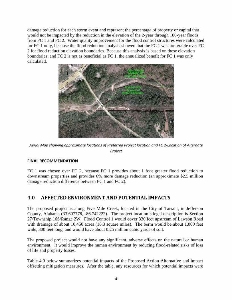
damage reduction for each storm event and represent the percentage of property or capital that would not be impacted by the reduction in the elevation of the 2-year through 100-year floods from FC 1 and FC 2. Water quality improvement for the flood control structures were calculated for FC 1 only, because the flood reduction analysis showed that the FC 1 was preferable over FC 2 for flood reduction elevation boundaries. Because this analysis is based on these elevation boundaries, and FC 2 is not as beneficial as FC 1, the annualized benefit for FC 1 was only calculated.
Aerial Map showing approximate locations of Preferred Project location and FC 2-Location of Alternate Project
FINAL RECOMMENDATION
FC 1 was chosen over FC 2, because FC 1 provides about 1 foot greater flood reduction to downstream properties and provides 6% more damage reduction (an approximate $2.5 million damage reduction difference between FC 1 and FC 2). 4.0 AFFECTED ENVIRONMENT AND POTENTIAL IMPACTS The proposed project is along Five Mile Creek, located in the City of Tarrant, in Jefferson County, Alabama (33.607778, -86.742222). The project location’s legal description is Section 27/Township 16S/Range 2W. Flood Control 1 would cover 330 feet upstream of Lawson Road with drainage of about 10,450 acres (16.3 square miles). The berm would be about 1,000 feet wide, 300 feet long, and would have about 0.25 million cubic yards of soil. The proposed project would not have any significant, adverse effects on the natural or human environment. It would improve the human environment by reducing flood-related risks of loss of life and property losses. Table 4.0 below summarizes potential impacts of the Proposed Action Alternative and impact offsetting mitigation measures. After the table, any resources for which potential impacts were

5
identified, and high priority resources, which must be considered in EAs (wetlands, floodplains, threatened and endangered species and critical habitat, cultural resources, and Environmental Justice), are discussed in greater detail.
Affected Environment / Resource Area
Impacts Agency Coordination / Approvals / Permits
Mitigation/BMPs
4.1.1 Physical Resources
4.1.2 Geology and Soils
No Action Alternative:
No geology or soil changes.
Proposed Action: No notable impact on geology. Typical minor, temporary construction impacts on soils. Details below.
ADEM
BMP’s implemented include but are not limited to sediment barriers, inlet protection, outlet protection, temporary vegetation, coir matting, erosion control blankets, and permanent vegetation. BMP’s will be inspected regularly to ensure that sediment is not being discharged offsite.
4.1.3 Air Quality No Action Alternative: No
air quality changes.
Proposed Action: Typical minor, temporary impacts on air quality from construction.
Project workers would be required to water down construction areas to reduce dust when needed. Fuel-burning equipment running times would be minimized and engines must be properly maintained.
4.1.4 Climate Change
No Action Alternative: No climate changes.
Proposed Action: No notable impact on Climate Change.
4.2.1 Water Quality
No Action Alternative: No water quality changes.
Proposed Action: Minor impact on water quality. Details below.
ADEM
The Applicant and their selected Contractors shall obtain and maintain compliance under and ADEM NPDES General Construction Stormwater Permit during construction.
4.2.2 Wetlands No Action Alternative: No wetland changes.
Proposed Action: Minor impact on wetlands. Details below.
USACE
Project workers would use BMP’s including, but are not limited to: sediment barriers, inlet protection, outlet protection, temporary vegetation, coir matting, erosion control blankets, and permanent vegetation. BMP’s will be inspected regularly to ensure that sediment is not being discharged offsite.

6
4.2.3 Floodplains No Action Alternative: No floodplain changes.
Proposed Action: Locally reduced flood elevations. Details below.
Erosion control measures shall be implemented.
4.3 Biological Resources
4.3.1 Threatened and Endangered Species and Critical Habitat
No Action Alternative: No changes for threatened and endangered species or critical habitat.
Proposed Action: No adverse impact to threatened and endangered species. Details below.
USFWS
4.3.2 Wildlife and Fish
No Action Alternative: No fish or wildlife changes.
Proposed Action: No adverse impact to State-protected species. Details below.
USFWS
4.4 Cultural Resources
4.4.1 Historic Properties
No Action Alternative: No impact on historic properties.
Proposed Action: No impact on historic properties. Details below.
SHPO
If finds/discoveries of artifacts or human remains are made during project work: work would immediately stop, FEMA and SHPO would be notified within 24 hours, and expedited contingency actions (per SHPO recommendations) would be taken.
4.4.2 American Indian/ Religious Sites
No Action Alternative: No impact on American Indian cultural or religious sites.
Proposed Action: May be potential impact on American Indian cultural or religious sites. Details below.
THPO
If finds/discoveries of artifacts or human remains are made during project work: work would immediately stop; THPO(s), FEMA, and SHPO would be notified within 24 hours; and expedited contingency actions (per SHPO recommendations) would be taken.
4.5 Socioeconomic Concerns
4.5.1 Environmental Justice
No Action Alternative: No impact on Environmental Justice.
Proposed Action: No adverse impact on Environmental Justice. Details below.
US Census Data

7
4.5.2 Noise No Action Alternative: No noise changes.
Proposed Action: Typical minor, temporary construction noise impacts.
Project work would be done during normal business hours and vehicles and equipment would meet local, State, and Federal noise requirements.
4.5.3 Traffic No Action Alternative: No traffic changes. Disruptions during floods.
Proposed Action: Minor, temporary traffic disruption during construction.
Traffic flow and control during construction would meet all local and State traffic safety requirements.
4.5.4 Public Service and Utilities
No Action Alternative: No change. Public water supply well and water treatment and distribution system would remain subject to damage and loss of service.
Proposed Action: Public water supply well and water and water treatment and distribution system would be protected from floods up to the 500-year flood event.
4.5.5 Public Health and Safety
No Action Alternative: No change. Present flood-related public health and safety risks would continue. Public water system and water supplies would have continued flood damage and contamination risks.
Proposed Action: Public health and safety would be improved with reduced flood elevations. Potential reduced loss of life and property damages, including reduced adverse impact risks on the public water system and water supplies.
4.1 Earth and Air Resources The project area is located within the Birmingham-Big Canoe Valley District of the Tennessee Valley and Ridge Physiographic Section of the Valley and Ridge Province (Sapp & Emplaincourt, 1975). The Birmingham-Big Canoe Valley District is the westernmost district of the Valley and Ridge in Alabama. Within the Birmingham area, the district is characterized by

8
the Jones Valley, which is eroded into folded and thrust-faulted Lower Paleozoic limestone and dolomite.
4.1.1 Geology, Soils, and Seismicity The property is forested and undeveloped consisting of a mixture of pine and hardwood species in the overstory vegetative layer. The midstory and understory is composed of a mixture of native and invasive species (Rubus spp., Smilax spp., Liquidambar styricflua, etc.). The project area is underlain by the Knox Group Undifferentiated of Upper Cambrian and Ordivician age (Szabo & Copeland, 1988). The Knox Group is characterized by light to medium gray, laminated, finely crystalline cherty dolomite and light-bluish gray to medium gray limestone and limy dolomite which produces abundant, primarily dense, chert residuum.
The region’s geology has influenced human activity. From prehistory into the late 19th century, the Jones Valley served as a transportation route between the Tennessee River Valley and the Black-Warrior River. Prehistoric populations in the area would have found abundant lithic resources along and in the streambeds and rock outcrops along ridges in the area. During the late 19th century lands, within the Jones Valley were settled by people seeking the coal and iron deposits associated with Red Mountain in the southern end of the valley. Today, the cultural landscape remains dominated by industrial development associated with the resource extraction of limestone and dolomite.
Soils within the subject property have been mapped by the U.S. Department of Agriculture (USDA), Natural Resources Conservation Service (NRCS) as the Bodine-Fullerton Urban land complex, steep and the Bodine-Fullerton association, steep. The Bodine-Fullerton Urban land complex, steep occurs along the shoulder and side slopes east of Five Mile Creek with slopes ranging from 25 to 45 percent. The typical pedon in this vicinity consists of a gravelly silt loam from 0 to 6 inches in depth underlain by a gravelly silty clay loam from 6 inches to 34 inches in depth. The Bodine-Fullerton Association, steep occurs on the backslope and mountainflanks to the west of Five Mile Creek with slopes that range from 15 to 45 percent. The typical pedon in this vicinity consists of a gravelly silt loam that extends to a depth of 6 inches underlain by a gravelly silty clay loam that extends from 6 inches in depth to 35 inches in depth. The Proposed Action would not result in notable impact on geology. There will only be typical minor, temporary construction impacts on the soils. Therefore, no mitigation measures are proposed.
4.1.2 Air Quality The National Ambient Air Quality Standards (NAAQS), established by the USEPA, set maximum allowable concentration limits for six criteria air pollutants to protect the public’s health, safety, and welfare as a result of the Federal Clean Air Act of 1970. The Clean Air Act Amendments of 1990 [42 USC 7401, et. seq.], mandated a reduction in the emissions of the following six criteria pollutants: nitrogen dioxide, sulfur dioxide, carbon monoxide, lead, ozone,

9
and particulate matter (microscopic solid or liquid particles suspended in air). Areas in which air pollution levels persistently exceed the NAAQS may be designated as “non-attainment.” areas; states in which a non-attainment area is located must develop and implement a State Implementation Plan containing policies and regulations that would bring about attainment of the NAAQS. No portion of this project is within a designated non-attainment area for any of the criteria air pollutants for which the USEPA established standards. The Proposed Action construction activities would have temporary impacts on air quality, with fugitive dust from construction activities and emissions from construction equipment. Project workers would be required to water down construction areas to reduce dust when needed. Fuel-burning equipment running times would be minimized and engines must be properly maintained. This would be temporary and not likely to cause significant impact to the air quality. Therefore, no mitigation measures are proposed.
4.1.3 Climate Change The project area is located in a non-attainment area for 8-hour ozone. During implementation and construction of the project components, the Proposed Action would cause low levels of particulate matter (dust generated during construction) and vehicle exhaust emissions from construction vehicles. Operation of the construction equipment would add to exhaust-related air pollutants, such as nitrogen oxide, carbon monoxide, and ozone, within the local area. Increased concentrations of these air pollutants would be localized, temporary, and have a minor effect on local air quality. Both types of emissions would have a temporary minor impact on air quality in the local area.
No permanent sources of increased air emissions would be associated with the Proposed Action. When necessary, the contractor would be required to water down work areas to reduce dust levels.
The Proposed Action would not result in a new point source or generate detectable levels of greenhouse gases; therefore, the project would not affect global climate change.
4.2 Water Resources
4.2.1 Water Quality As part of the USACE Individual Permit process, applicants are required to submit to the State for Water Quality Certification under Section 401 of the Clean Water Act. Goodwyn, Mills & Cawood, Inc. (GMC) submitted to the Alabama Department of Environmental Management (ADEM) a copy of the Individual Permit along with other requested information for Water Quality Certification for the proposed project. On September 23, 2011, ADEM issued Water Quality Certification for the proposed project. The conditions and requirements of this mitigation plan are generally as follows: • On CWA, Section 401 certification letter issued on September 23, 2011 and expires on
September 22, 2016.

10
• The applicant shall be required to obtain and maintain compliance under ADEM NPDES
General Construction Stormwater Permit for the duration of construction. This requirement shall be the responsibility of the selected contractor for the project.
The proposed project requires concurrence from Jefferson County Environmental Services as it affects a sanitary sewer easement and the Five Mile Creek sanitary sewer main trunk line. GMC has worked with Jefferson County since June 2010 to identify and engineer a solution to all possible concerns that the Environmental Services department had with the construction of the proposed project. As a result of these concerns, GMC modified the plans to protect the ratepayers of Jefferson County from any undue expenditures or potential damages as a result of the construction and continued use of this project. On February 8, 2012, GMC sent a letter to Jefferson County Environmental Services along with a detailed set of construction plans outlining the additions to the construction plans that were requested by Environmental Services. The additions to these plans are roughly as follows: • Clearing of Sewer Easement for Manhole Access to the extent of manholes to receive work. • Installation of Anti-Flotation Concrete Collars on 9 manholes. • Installation of Waterproof rings and covers on 41 manholes. • Waterproofing the interior of 41 manholes. • Installation of grout in the abandoned pipe under the flood control structure if not already
installed. • Installation of a 4,000psi concrete pipe bridge over the existing trunk line for 290’ below the
proposed structure. • TV inspection of the sewer mains and replacement of up to 75% of the 24” and 30” trunk
lines. On April 16, 2012, Jefferson County Environmental Services sent a letter to GMC concurring with the overall concept of the project. The letter outlines a few details that need to be resolved in order to finalize the approval process. Some of these details are currently being addressed and others will be addressed during the construction phase of the project. These details are roughly as follows:
• Access to the sewer main must remain in effect during all construction activities and
thereafter. • TV inspection of sewer lines must occur prior to final approval. • An easement agreement will need to be executed by all parties involved in the construction
and land ownership and will need to address future liability and indemnification. The proposed flood control structure will also require grading and placement of fill within an Alabama Power high voltage transmission easement. Originally four transmission towers were to be relocated as a result of the fill and grading operations for the proposed structure. GMC coordinated with Alabama Power to modify the civil construction plans and reduced the number of affected transmission towers to two.

11
4.2.2 Wetlands Activities disturbing Waters of the U.S. (WOUS) and jurisdictional wetlands require a permit from the U.S. Army Corps of Engineers (USACE) under Section 404 of the Clean Water Act of 1977 (33 U.S.C. § 1344). Executive Order (E.O.) 11990, Protection of Wetlands, requires Federal agencies to avoid construction or management practices which would adversely affect wetlands unless that agency finds (1) there is no practicable alternative to the Proposed Action, and (2) the Proposed Action includes measures to minimize the destruction, loss, or degradation of wetlands and preserve and enhance the natural beneficial values of wetlands. In accordance with the Section 404(b) (1) Guidelines, efforts have been made to avoid and minimize impacts to wetlands and waters of the United States on the property. Due to the nature and scope of this project, impacts to “waters of the U.S.”, specifically Five Mile Creek, are unavoidable in all of the action alternatives. However, in the preferred alternative, impacts to jurisdictional waters are limited to Five Mile Creek and a small linear wetland located east of Five Mile Creek. All other jurisdictional areas have been avoided. The principal spillway is an arched steel pipe approximately 16 feet wide and 8 feet tall. In order to minimize the impact that the structure will have on the stream bed, the pipe will be located at the base of the structure over the existing streambed and will allow the non-restricted passage of normal flows. The streambed will be armored near the inlet and outlet of the pipe to prevent any erosion or scouring of the existing channel. Impacts are limited to the area of Five Mile Creek within the footprint of the berm and outside the footprint of the proposed arched steel pipe structure. Implementation of the flood control structure will provide over 1,500 acres of storage during a high flow event to protect the businesses and residences in the City of Tarrant. • GMC conducted a wetland delineation within the footprint of the proposed action to
determine the impacts associated with the project. Jurisdictional areas that will be impacted include a portion of the channel along a 300 linear foot stretch of Five Mile Creek (totaling 0.35 acres). The structure itself is an arch steel bottomless culvert that will allow for normal stream flows of Five Mile Creek. In addition, there is a small linear wetland totaling 0.03 acres that will be impacted by this project. On November 2, 2010, GMC submitted an Application for Individual Permit to the USACE to comply with Section 404 of the Clean Water Act.
The figure below is the site plan showing all the jurisdictional areas and indicating the areas of impact that are necessary to meet the purpose and need for this project.

12
Aerial Photo with Impacts to Jurisdictional Areas • On July 25, 2011, GMC submitted an updated mitigation plan as requested by the USACE
based on conversations following a site visit on April 2, 2011. This updated mitigation plan proposed off-site in-kind stream buffer enhancement and wetland restoration to mitigate for the project impacts. This mitigation is to be performed at the planned Tarrant Environmental Education Center (EnviroPlex).
• On July 28, 2011, the USACE submitted an email to GMC requesting stream SOP sheets for
the impacts and the proposed mitigation areas and that GMC address the twelve required components of a mitigation plan. GMC responded to those requested with a revised mitigation plan in letter format dated August 19, 2011. In summary, the stream SOP sheets showed that 735 stream credits would be needed to compensate for the construction of the flood control structure and the proposed mitigation area would generate 750 stream credits. The conditions and requirements of this mitigation plan are generally as follows:
• The City of Tarrant will conduct stream buffer enhancement on approximately
500 linear feet of Five Mile Creek at the proposed Tarrant EnivroPlex facility.
• At a minimum, enhancement of this 500 foot reach will include invasive species control within the existing 200’ buffer and additional riparian buffer planting (>10%) on the southern side of Five Mile Creek.
• The City of Tarrant will also include the restoration of a wetland feature along Five Mile
Creek in the planned EnviroPlex.
• On September 26, 2011 the USACE issued a Department of the Army Permit under permit number SAM-2010-01569-CHE to the City of Tarrant for construction of the proposed project. The conditions and requirements of the permit are generally as follows:
• The permit shall expire on September 22, 2016.

13
• In the event of discovery of any previously unknown historic or archeological remains while accomplishing the activity authorized by this permit, the City must immediately notify the USACE office of the findings.
• The permittee shall implement and abide by the mitigation plan dated August 19, 2011.
• Mitigation monitoring reports are to be submitted to the USACE annually for 5 years from
the completion of the mitigation.
• A description of the mitigation area shall be recorded with the Registrar of Deeds or other appropriate official charged with maintaining records on real property.
4.2.3 Floodplains Because the proposed Five Mile Creek HMGP project will result in significant changes to the 100-year floodplain, the Base Flood Elevations, the regulatory Floodway along Five Mile Creek and its tributary Tarrant Springs Branch, FEMA regulations require that a Conditional Letter of Map Revision (CLOMR) and Letter of Map Revision (LOMR) be obtained for the project. On February 14, 2011, GMC submitted a standard FEMA MT-2 application for a CLOMR based on proposed conditions to the Alabama Office of Water Resources (OWR). GMC received a response regarding the CLOMR from FEMA dated June 26, 2012. Upon completion of construction, as-built surveying will be performed on the flood control structure and submitted to OWR in a new MT-2 application for a Letter of Map Revision to finalize the floodplain revision process. As a mitigation effort, erosion control measures shall be implemented.
4.4 Biological Resources 4.4.1 Threatened and Endangered Species and Critical Habitat In accordance with Section 7 of the Endangered Species Act of 1973 (ESA), any federal agency that funds, authorizes, or carries out an action must ensure their action is not likely to jeopardize the continued existence of any threatened or endangered species, or result in the destruction or adverse modification of designated critical habitats.
4.4.2. Fish and Wildlife In addition to bald eagles (Haliaeetus leucocephalus) and red-cockaded woodpeckers (Picoides borealis), which may occur in any county, the following species are listed on the federally protected list for Jefferson County, Alabama.
T - Flattened musk turtle Sternotherus depressus E - Watercress darter Etheostoma nuchale E - Cahaba shiner Notropis cahabae T - Goldline darter Percina aurolineata C - Rush darter Etheostoma phytophilum E - Vermilion darter Etheostoma chermocki

14
E - Upland combshell mussel Epioblasma metastriata T - Fine-lined pocketbook mussel Hamiota (=Lampsilis) altilis E - Triangular kidneyshell mussel Ptychobranchus greenii T - Orange-nacre mucket mussel Hamiota (=Lampsilis) perovalis E - Plicate rocksnail Leptoxis plicata E - Leafy prairie clover Dalea foliosa C - Black Warrior waterdog Necturus alabamensis Critical Habitat: • Species—southern acornshell, ovate clubshell, southern clubshell, upland combshell,
triangular kidneyshell, Alabama moccasinshell, orange-nacre mucket, fine-lined pocketbook, dark pigtoe
• Location—Cahaba River, Locust Fork
On May 20, 2010, GMC submitted a report in letter format to the U.S. Department of the Interior, Fish and Wildlife Service detailing a survey for Endangered and Threatened (E&T) species at the proposed project site. The recommendations of that report were as follows:
The protected species are not listed on the site due to the urban setting, habitat conditions, low water quality, and historical distribution of the listed species. On June 3, 2010 the USF&WS concurred with the findings via facsimile and signature by Mr. William J. Pearson.
4.5 Cultural Resources An initial Phase I Cultural Resource Study was performed by the University of Alabama, dated May 2010, on the limits of disturbance for the proposed flood control structure. The conclusions and recommendations of this study were as follows: • Four new archeological sites were located within the boundaries of the survey area.
• Sites 1Je853, 1Je854, and 1Je856 are not considered eligible for the NRHP as they were all
found to have low research potential due to the lack of intact cultural deposits, soil disturbances, light artifact recovery, and/or small site size.
• Site 1Je855 was considered potentially eligible for the NRHP and avoidance or further testing is recommended if avoidance cannot be achieved.
The Alabama Historical Commission (AHC) concurred with the findings of the report in a letter dated June 16, 2010, and reiterated that 1Je855 should be avoided or Phase II testing be conducted should avoidance not be feasible. The AHC requested a detailed Phase II testing proposal be submitted for review and comment prior to commencement of testing activities. Goodwyn, Mills & Cawood revised the original civil design plans in an effort to avoid site 1Je855, however, due to the elevation of the site and the elevation needed to be attained by the flood control structure, complete avoidance was not feasible.

15
Robert E. Perry and Associates, Inc. (REPA) was hired by GMC to review the initial Phase I and develop testing procedures for the proposed Phase II on site 1Je855. During the review, REPA noted that the initial Phase I focused solely on the area of construction and failed to study any areas that might be affected by the increased inundation from the proposed flood control structure. As a result, REPA was retained to provide a Phase I Cultural Resource Study on an expanded area that included the new 2-year floodplain which would be subject to increased inundation. The results of this Phase I Cultural Resource Study dated February 23, 2011 were as follows: • A single archaeological site, 1Je868 and three isolated finds were identified within a terrace
overlooking Five Mile Creek.
• Site 1Je868 represents a low intensity lithic scatter with a sparse amount of prehistoric ceramics present.
• While the subsurface stratigraphy of the site appears to be intact, the paucity of cultural
materials present, along with the absence of diagnostics indicate that Site 1Je868 holds little potential for yielding information important to the prehistory of the region. Therefore, site 1Je686 is recommended as ineligible for listing in the NRHP.
The AHC concurred with the findings of the report in a letter dated March 22, 2011.
On February 24, 2011, REPA submitted a Phase II testing proposal to the AHC for review and comment on site 1Je855 which could not be completely avoided through re-design of the civil engineering plans. On March 14, 2011, the AHC concurred with the testing procedures submitted by REPA for site 1Je855.
On May 10, 2011, REPA submitted a report titled “Phase II Archaeological Testing and Evaluation of Site 1Je855” to the AHC. The conclusions and recommendations of this report were as follows: • Based on the paucity of cultural materials recovered during the Phase II testing and
evaluation of Site 1Je855, along with the apparent lack of the presence of intact subsurface features or cultural deposits, it appears that Site 1Je855 holds little potential for providing information considered important to the prehistory of the region.
• It is recommended that Site 1Je855 is not eligible for listing in the NRHP. On October 6, 2011, the AHC concurred with the findings of the report titled “Phase II Archaeological Testing and Evaluation of Site 1Je855” and agreed that site 1Je855 is not eligible for the NRHP.
4.5.1 Historic Properties The effect of the proposed project on historic and archeological resources was considered in compliance with Section 106 of the National Historic Preservation Act (NHPA) of 1966, as
16
amended and 36 CFR Part 800: Protection of Historic Properties. Historic properties are properties that are included in the National Register of Historic Places or that meet the criteria for the National Register. In compliance with Section 106 of the National Historic Preservation Act (NHPA) required that Archaeological Site 1Je855 be evaluated to determine if it was eligible for listing in the National Register of Historic Places (NRHP).
As defined in 36 CFR §800.16(d), the area of potential effect (APE) is the geographic area or areas within which an undertaking may directly or indirectly cause changes in the character or use of historic properties, if any such properties exist. Based on this definition and the nature of the scope of work, FEMA has determined the APE is limited to the immediate area of construction including ground disturbance and the viewshed. No potential for additional direct or indirect impacts exist beyond these described.
Based on the results of historic property identification efforts and the SHPO determination, no properties listed in or considered eligible for listing in the National Register were located within the APE of the proposed project. Therefore, FEMA has determined a finding of “no historic properties affected” for the undertaking as defined and has no further Section 106 obligations.
The following conditions will be added to the approved scope of work:
Should human remains be encountered, excavation within that specific site area will be halted and the USACE and SHPO will be notified. The location of the remains will be recorded and soil overburden placed within the area surrounding the remains.
4.5.2 American Indian/Native Hawaiian/Native Alaskan Cultural/Religious Sites In compliance with Section 106 of the NHPA, a consult request of concurrence with FEMA’s determination of no historic properties affected was sent on June 7, 2013 to the following Tribal Historic Preservation Officers (THPO): Absentee Shawnee Tribe of Oklahoma, Alabama-Coushatta Tribal Town, Chickasaw Nation, Jena Band of Choctaw Indians, Kialegee Tribal Town, Mississippi Band Choctaw, Alabama-Quassarte Tribal Town, Muscogee (Creek) Nation, Poarch Band of Creek Indians, Seminole Tribe of Florida, Seminole Tribe of Oklahoma, Thlopthlocco Tribal Town. Within the 45 day tribal consultation period, a response was received from the Absentee Shawnee Tribe of Oklahoma in a letter dated 06/27/2013 and Seminole Tribe of Florida (STOF-THPO) in a letter on 07/11/13:
“The Shawnee Tribe’s Tribal Historic Preservation Department concurs that no known historic properties will be negatively impacted by this project. We have no issues or concerns at this time, but in the event that archaeological materials are encountered during construction, use, or maintenance of this location, please re-notify us at that time as we would like to resume consultation under such a circumstance.”

17
“The Seminole Tribe of Florida’s Tribal Historic Preservation Office (STOF-THPO) received the FEMA correspondence regarding the above mentioned project on June 6, 2013. The STOFTHPO has no objection to your proposal at this time. However, the STOF-THPO would like to be informed if cultural resources that are potentially ancestral or historically relevant to the Seminole Tribe of Florida are inadvertently discovered at any time during the construction process.”
Based on the results of historic property identification efforts and the THPO determination, no properties listed in or considered eligible for listing in the National Register were located within the APE of the proposed project. Therefore, FEMA has determined a finding of “no historic properties affected” for the undertaking, as defined. The agency has no further Section 106 obligations.
4.6 Socioeconomic Resources The City of Tarrant was incorporated in 1915 and covers approximately 6.4 square miles of land in Jefferson County. Historically, a contest was held to name the new town in 1915. Several people suggested Tarrant in honor of Benjamin Tarrant, who had lived in this community most of his life. Other sources claim the city was named for Felix I. Tarrant, President of National Cast Iron Pipe Company, which built the first major industrial plant in the area in 1912. On August 17, 1918, Tarrant became an incorporated city as industry as its center and reason for being. Its first mayor was George Washington Thomason. The first census was taken in 1920 and gave Tarrant a population of 734. Today, industry continues to be the lifeblood of the city, spawning numerous residential and commercial opportunities for its citizens. Because of its heritage, Tarrant has developed all the necessary ingredients for industry to thrive. Among those include easy rail access, close proximity to major interstates and highways, nearness to a major airport, a solid and experienced labor force, a wide range of housing, land availability, all major utilities, and progressive leadership. Though independent, Tarrant is an integral part of Alabama’s largest metropolitan area. Consequently, the over 6,000 people of Tarrant enjoy the many attributes of both a small city and larger cosmopolitan area. The area has a balanced economy providing a strong manufacturing base as well as an emergent service center. Medical research and healthcare are now the employment anchors of the metropolitan area. According to the U.S. Census Bureau (USCB), the population of Tarrant in 2012 was 6,401 people, with an average household size of 2.59 people. Approximately 43.7 percent of the population were men and 56.3 percent were women. Approximately 81.0 percent of the people over 25 years of age in Tarrant were high schools graduates, and approximately 12.7 percent were college graduates. In 2011, the per capita income for Tarrant residents was $14,652, and the median household income was $25,833. The per capita income and median incomes for Tarrant are lower than the State average (USCB 2012a).

18
4.6.1 Environmental Justice On February 11, 1994, President Clinton signed Executive Order (EO) 12898, “Federal Actions to Address Environmental Justice in Minority Populations and Low-Income Populations.” This EO directs federal agencies “to make achieving environmental justice part of its mission by identifying and addressing, as appropriate, disproportionately high and adverse human health or environmental effects of its programs, policies, and activities on minority populations and low income populations in the United States….” EO 12898’s goals are to achieve environmental justice, foster non-discrimination in federal programs, and give minority or low-income communities greater opportunities for public participation in and access to public information on matters relating to human health and the environment. The following table shows U.S. Census data for the State of Alabama, Jefferson County, and the City of Tarrant, Alabama. The data includes annual median household income, % of persons below poverty level, % minority population, % Hispanic, and % of population over 65. Table of U.S. Census Data
State of Alabama
Jefferson County
City of Tarrant
Total population (2012) 4,822,023 660,009 6,401 Annual median household income (2007-2011)
42,934
45,750
25,833
% Persons below poverty level 17.6 16.2 39.5 % Minority population 29.7 45.3 55.7 % Hispanic (may be of any race) 4.0 4.0 9.0 % of population over 65 14 13.3 13.2
The Proposed Alternative would have no disproportionate adverse impact on low-income or minority populations in the project area and nearby environs since the project purpose, reduction of flooding, would likely benefit any such sector of the population. The Proposed Action would have a positive impact on all segments of the population of Tarrant, Alabama by reducing the risk of flooding.
4.6.3 Noise Noise is federally regulated by the Noise Control Act enacted in 1972 (PL 92-574). The USEPA guidelines, and those of many federal agencies, state that outdoor sound level in excess of 65 dBA (decibels, “A-weighted” noise scale) are “normally unacceptable” for noise-sensitive residential land uses such as residences, schools, and hospitals. The potential impact on noise for the proposed development will likely consist of typical noises generated from construction equipment. The activities are expected to be minor, short-term, and would likely not cause significant noise impacts. Construction activities will be performed during normal business hours and vehicles and equipment would meet local, State, and Federal noise requirements. Therefore, no mitigation measures are proposed.
19
4.6.4 Public Health and Safety The Proposed Action would reduce flooding with the construction of the flood control structure, reducing flooding of residential properties and roadways. Therefore, emergency vehicle response times during future floods under the 100-year event. Flooding can also overload sanitary sewer and potable water systems, causing a potential for sewer backup, loss of potable water, and power outages in the flooded area. The Proposed Action would help protect public health during future storm events by reducing the risk of flooding to the residential properties and associated utilities.
4.6.5. Traffic and Circulation During the 100-year 6-hour storm event, it is estimated that the flood control structure would reduce peak flood discharge by as much as 60%, developing an additional 1,540 acre-feet of storage during that event. It is estimated that the additional storage and reduction in peak discharge would reduce water surface elevations by about 4.5’ at some points along Five Mile Creek. This reduction in water surface elevation would not only reduce repetitive flood damages to businesses and residences, but would also allow major transportation routes such as AL 79 to remain passable during major storm events facilitating public, emergency, and public service traffic.
4.7 Cumulative Impacts According to the President’s Council on Environmental Quality (CEQ) regulations, cumulative impacts represent the “impact on the environment which results from the incremental impact of the action when added to other past, present, and reasonably foreseeable future actions, regardless of what agency (Federal or non-Federal) or person undertakes such other actions. Cumulative impacts can result from individually minor but collectively significant actions taking place over a period of time (40 CFR 1508.7).” In accordance with NEPA, this EA considers the combined effect of the proposed action and other actions unknown at this time occurring or proposed in the vicinity of the project site to evaluate reasonable and practical cumulative impacts. If other construction does occur during the time of the proposed project, then there may be minor temporary cumulative impacts to noise, and air quality in the area. No other cumulative impacts are anticipated. 5.0 Agency Coordination, Public Involvement and Permits U.S. Department of the Interior, Fish and Wildlife Service, Daphne, AL William J. Pearson, Field Supervisor (251) 441-5181
U.S. Army Corps of Engineers, Homewood, AL Regulatory Division, Mobile District, 218 Summit Parkway, Suite 222
U.S. Fish and Wildlife Service. No additional coordination or permits are required regarding
U.S. Army Corps of Engineers. Application to the USACE for an Individual Section 404
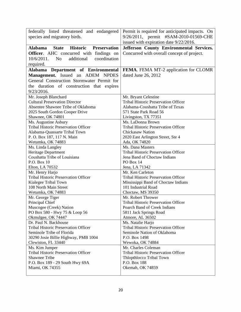
20
federally listed threatened and endangered species and migratory birds.
Permit is required for anticipated impacts. On 9/26/2011, permit #SAM-2010-01569-CHE issued with expiration date 9/22/2016.
Alabama State Historic Preservation Officer. AHC concurred with findings on 10/6/2011. No additional coordination required.
Jefferson County Environmental Services. Concurred with overall concept of project.
Alabama Department of Environmental Management. Issued an ADEM NPDES General Construction Stormwater Permit for the duration of construction that expires 9/23/2016.
FEMA. FEMA MT-2 application for CLOMR dated June 26, 2012
Mr. Joseph Blanchard Cultural Preservation Director Absentee Shawnee Tribe of Oklahoma 2025 South Gordon Cooper Drive Shawnee, OK 74801
Mr. Bryant Celestine Tribal Historic Preservation Officer Alabama-Coushatta Tribe of Texas 571 State Park Road 56 Livingston, TX 77351
Ms. Augustine Asbury Tribal Historic Preservation Officer Alabama-Quassarte Tribal Town P. O. Box 187, 117 N. Main Wetumka, OK 74883
Ms. LaDonna Brown Tribal Historic Preservation Officer Chickasaw Nation 2020 East Arlington Street, Ste 4 Ada, OK 74820
Ms. Linda Langley Heritage Department Coushatta Tribe of Louisiana P.O. Box 10 Elton, LA 70532
Ms. Dana Masters Tribal Historic Preservation Officer Jena Band of Choctaw Indians PO Box 14 Jena, LA 71342
Mr. Henry Harjo Tribal Historic Preservation Officer Kialegee Tribal Town 108 North Main Street Wetumka, OK 74883
Mr. Ken Carleton Tribal Historic Preservation Officer Mississippi Band of Choctaw Indians 101 Industrial Road Choctaw, MS 39350
Mr. George Tiger Principal Chief Muscogee (Creek) Nation PO Box 580 - Hwy 75 & Loop 56 Okmulgee, OK 74447
Mr. Robert Thrower Tribal Historic Preservation Officer Poarch Band of Creek Indians 5811 Jack Springs Road Atmore, AL 36502
Dr. Paul N. Backhouse Tribal Historic Preservation Officer Seminole Tribe of Florida 30290 Josie Billie Highway, PMB 1004 Clewiston, FL 33440
Ms. Natalie Harjo Tribal Historic Preservation Officer Seminole Nation of Oklahoma P.O. Box 1498 Wewoka, OK 74884
Ms. Kim Jumper Tribal Historic Preservation Officer Shawnee Tribe P.O. Box 189 - 29 South Hwy 69A Miami, OK 74355
Mr. Charles Coleman Tribal Historic Preservation Officer Thlopthlocco Tribal Town P.O. Box 188 Okemah, OK 74859
21
6.0 Public Involvement The purpose for involving the public in the development of an EA is to “encourage and facilitate public involvement in decisions which affect the quality of the human environment” (40 CFR 1500.2) and ensure “that the environmental information is available to public officials and citizens before decisions are made” (40 CFR 1500.1(b)).
Copies of the Draft EA have been placed at the following locations so that the public may access this document and provide comments:
Tarrant City Hall 1604 Pinson Valley Parkway
Tarrant, AL 35217-2349 A copy of the Draft EA has also been placed on the FEMA web site. It can be accessed at:
http://www.fema.gov/environmental-planning-and-historic-preservation-program/environmental-documents-public-notices-1
It there are any substantive, adverse public comments on this proposed project during the Public Comment period, then FEMA will revise this Draft EA accordingly and issue second Public Notice for additional public comments.
If these are no substantive, adverse public comments on this proposed project during the Public Comment period, then this Draft EA will become the Final EA and FEMA will issue a “Finding of No Significant Impact” (FONSI). 7.0 References
City of Tarrant. 2013. Official Website. The City of Tarrant, “Gateway to Progress”. Available at http://www.cityoftarrant.com/. Accessed March 22, 2013.
FEMA (Federal Emergency Management Agency). 2006. Flood Insurance Rate Map. Jefferson County Unincorporated Areas. Panel Number 01073C0381G. September 29, 2006.
FEMA (Federal Emergency Management Agency). 2006. Flood Insurance Rate Map. Jefferson County Unincorporated Areas. Panel Number 01073C0382G. September 29, 2006.
FEMA (Federal Emergency Management Agency). 2006. Flood Insurance Rate Map. Jefferson County Unincorporated Areas. Panel Number 01073C0383G. September 29, 2006.
22
FEMA (Federal Emergency Management Agency). 2006. Flood Insurance Rate Map. Jefferson County Unincorporated Areas. Panel Number 01073C0401G. September 29, 2006.
Goodwyn, Mills & Cawood, Inc., May 25, 2012, Project Application, Phase II of Five Mile Creek Phased, Flood Mitigation Project, City of Tarrant, Jefferson County, Alabama.
Goodwyn, Mills & Cawood, Inc., November 2, 2010, Application for Individual Permit, Proposed Five Mile Creek Flood Control Structure, Jefferson County, Alabama Cahaba Watershed (HUC 03150202).
NRCS (Natural Resources Conservation Service). 2012. Web Soil Survey. USDA Natural Resources Conservation Service. NRCS. (Last modified April 12, 2011). http://websoilsurvey.nrcs.usda.gov. Accessed February 28, 2012.
8.0 List of Preparers and Reviewers Angelika H. Phillips, MSPH Environmental Protection Specialist Federal Emergency Management Agency, Region IV 3003 Chamblee-Tucker Road, Hollins Bldg. Atlanta, GA 30341-4112 William R. Straw, Ph.D. Regional Environmental Officer Federal Emergency Management Agency, Region IV 3003 Chamblee-Tucker Road, Hollins Bldg. Atlanta, GA 30341-4112 April Cummings Acting Regional Environmental Officer Federal Emergency Management Agency, Region IV 3003 Chamblee-Tucker Road, Hollins Bldg. Atlanta, GA 30341-4112

23
9.0 Appendices
9.1 Maps 9.1.1 – Proposed Project Site Plan 9.1.2 – FIRM Panel Map 9.1.3 – USFWS Wetland Map
9.2 Copies of Consultation Responses - Permits 9.2.1 – Alabama State Historic Preservation Office (SHPO) Letter 9.2.2 – U.S. Fish and Wildlife Service Concurrence Letter 9.2.3 – OWR Concurrence Letter 9.2.4 – Water Quality Certification 9.2.5 – Jefferson County Environmental Services Concurrence Letter 9.2.6 – Tribal Concurrence Letters 9.2.7 – Department of Army Permit 9.2.8 – Joint Permit Application 9.2.9 - Jurisdictional Permit
9.3. Studies – Reports 9.3.1 – Phase I Cultural Resources Reconnaissance of the Proposed Fivemile Creek Flood Control Project near Tarrant, Jefferson County, Alabama, by Kareen L. Hawsey, The University of Alabama.
9.3.2 - Phase II Archaeological Testing and Evaluation of Site 1Je855
9.3.3 – Mitigation Plan