FINAL SUPPLEMENT TO THE TRANSIT CENTER … SUPPLEMENT TO THE . TRANSIT CENTER DISTRICT PLAN . San...
16
FINAL SUPPLEMENT TO THE TRANSIT CENTER DISTRICT PLAN San Francisco Planning Department April 2012
Transcript of FINAL SUPPLEMENT TO THE TRANSIT CENTER … SUPPLEMENT TO THE . TRANSIT CENTER DISTRICT PLAN . San...
FINAL SUPPLEMENT TO THE TRANSIT CENTER DISTRICT PLAN
San Francisco Planning Department April 2012

2
PROPOSED PLAN REFINEMENTS This document describes substantive revisions or important clarifications to the Transit Center District Plan: Draft for Public Review (November 2009). Taken together, they represent the “Draft Plan” that is the basis for the General Plan, Planning Code, Zoning Map, and Administrative Code Amendments and Program Implementation Document that will constitute the formal adoption of and regulatory framework for implementing the Plan. New text appears in underlined italics. Text to be removed is shown with a strikethrough. The complete document including these refinements will be reprinted following adoption of the Plan by the Board of Supervisors. Note that the Planning Commission and Board of Supervisors will not take action on the Draft Plan document (including these refinements). Rather, these bodies will adopt the Plan by adopting the proposed General Plan Amendments and implementing Planning Code, Zoning Map, and Administrative Code Amendments. This Draft Plan documents the full narrative context, illustrative intent, and process for the Plan and will live on as a full record of the background context of Plan, containing more full discussion and analysis than is appropriate for adoption into the General Plan. The key aspects of the Draft Plan are distilled into a proposed for adoption into the General Plan as “sub-area plan” of the Downtown Plan. That proposed sub-area plan contains the majority of the objectives, policies and supporting discussion from the Draft Plan document (as reflected here), but excludes some background discussion, specific Planning Code proposals, and graphics, and reflects minor non-substantive text edits. Note that the majority of the Funding Public Improvements chapter of the Draft Plan that discusses funding mechanisms and implementation has been relocated to a new document entitled the Transit Center District Plan Program Implementation Document. INTRODUCTION Plan Area Boundary Map (page 3) The Plan boundary has been amended to include the following parcels (block/lot #s): 3715/011 3715/013 (188 Embarcadero) 3735/039 (667 Howard St ) 3735/040 (663-665 Howard St)
These changes are proposed in order to include all adjoining parcels to the Plan area currently zoned C-3-O (SD).

3
CHAPTER 1: LAND USE Add the following Proposed Controls under Policy 1.1 (pg 18) Proposed Controls: Rezone block/lot number 3715/013 (188 Embarcadero from C-3-O(SD) to C-3-O This parcel should be rezoned to bring it into zoning conformity with the rest of the block. Rezone block/lot number 3715/011 (City property) from C-3-O(SD) to P. This parcel is a publicly owned parcel and should be rezoned to reflect its public use. Amend Planning Code to eliminate the conditional use (CU) requirement for residential densities greater than 1 unit per 125 sf lot area. This action is consistent with recent planning efforts that allow maximum residential densities in close proximity to high levels of transit service. Amend Proposed Control under Policy 1.3 (pg 19) Proposed Control: On development sites larger than 15,000 square feet within a proscribed sub-area of the C-3-O (SD) district, new construction greater than 6:1 FAR would be required to have at least three two square feet of commercial space for every one square foot of residential space. , hotel, or cultural space.
Add block/lots: 3735/039, 3735/040
Add block/lots: 3715/011, 3715/013

4
CHAPTER 2: URBAN FORM Existing & Proposed Building Height Limits Maps (pg 25) These maps have been amended with the changes described below. Existing Building Height Limits
Amend Map to reflect designated heights for Zone 1 buildings
5
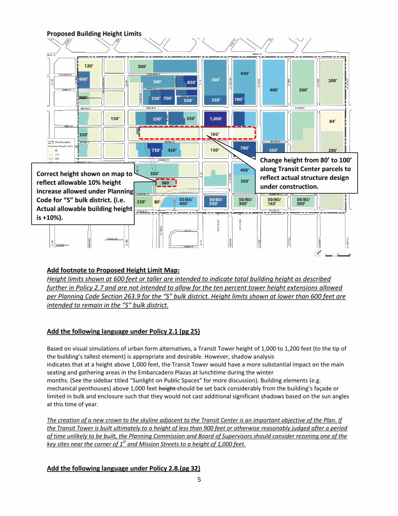
Proposed Building Height Limits
Add footnote to Proposed Height Limit Map: Height limits shown at 600 feet or taller are intended to indicate total building height as described further in Policy 2.7 and are not intended to allow for the ten percent tower height extensions allowed per Planning Code Section 263.9 for the “S” bulk district. Height limits shown at lower than 600 feet are intended to remain in the “S” bulk district. Add the following language under Policy 2.1 (pg 25) Based on visual simulations of urban form alternatives, a Transit Tower height of 1,000 to 1,200 feet (to the tip of the building’s tallest element) is appropriate and desirable. However, shadow analysis indicates that at a height above 1,000 feet, the Transit Tower would have a more substantial impact on the main seating and gathering areas in the Embarcadero Plazas at lunchtime during the winter months. (See the sidebar titled “Sunlight on Public Spaces” for more discussion). Building elements (e.g. mechanical penthouses) above 1,000 feet height should be set back considerably from the building’s façade or limited in bulk and enclosure such that they would not cast additional significant shadows based on the sun angles at this time of year. The creation of a new crown to the skyline adjacent to the Transit Center is an important objective of the Plan. If the Transit Tower is built ultimately to a height of less than 900 feet or otherwise reasonably judged after a period of time unlikely to be built, the Planning Commission and Board of Supervisors should consider rezoning one of the key sites near the corner of 1st and Mission Streets to a height of 1,000 feet. Add the following language under Policy 2.8.(pg 32)
Change height from 80’ to 100’ along Transit Center parcels to reflect actual structure design under construction.
Correct height shown on map to reflect allowable 10% height increase allowed under Planning Code for “S” bulk district. (i.e. Actual allowable building height is +10%).

6
For the purposes of this Plan, towers are divided vertically into two main components: the Lower Tower (generally defined as the lower 2/3 of the tower) and Upper Tower (the upper 1/3 of the tower). For buildings taller than 550 650 feet, no bulk controls are proposed for the Lower Tower. Buildings of 650 feet in height or less would follow the existing code requirements for height and the S-bulk district. The opportunity sites within the Plan Area are generally small and constrained, thus limiting floorplate sizes available for buildings in this District, making it unnecessary to establish a floorplate limit. However, adherence to tower separation rules is critical and exceptions to them must be limited to the instances outlined below. Since tenants today often desire flexible floorplates at lower levels, this policy will help to accommodate contemporary building needs, as well as to encourage potential employers to locate in the Transit District. To reduce bulk at the highest levels, a 25 percent floorplate reduction is required for the Upper Tower portion of tall buildings.
Add the following as Policy 2.7 with corresponding supporting language(renumber subsequent policies): Policy 2.7 Establish controls for building elements extending above maximum height limits to incorporate design considerations and reduce shadow impacts. The typical height limit rules that apply to buildings in the S bulk districts which allow tower extensions and that govern architectural elements at the tops of buildings should not apply to buildings taller than 550 feet. Instead, a new bulk district, S-2, with specific rules should be crafted to apply to such tall buildings to reflect their central and iconic positions on the skyline in order to enhance their appearance while minimizing potential visual and shadow impacts. Proposed Controls: In any S-2 Bulk District for any building which exceeds 550 feet in height, unoccupied building features including mechanical and elevator penthouses, enclosed and unenclosed rooftop screening, and unenclosed architectural features not containing occupied space that extend above the height limit, only as permitted by the Planning Commission according to the procedures of Section 309 and meeting all of the following criteria: (i) such elements are demonstrated to not add more than insignificant amounts of additional shadow compared to the same building without such additional elements on any public open spaces as deemed acceptable by the Planning Commission; and (ii) such elements are limited to a maximum additional height equivalent to 7.5% of the height of the building to the roof of the highest occupied floor, except that in the case of a building in the 1,000-foot height district such elements are not limited in height, and any building regardless of building height or height district may feature a single spire or flagpole with a diagonal in cross-section of less than 18 feet and up to 50 feet in height in addition to elements allowed according to this subsection (M); and (iii) such elements are designed as integral components of the building design, enhance both the overall silhouette of the building and the City skyline as viewed from distant public vantage points by producing an elegant and unique building top, and achieve overall design excellence. Add the following supporting language to Policy 2.12 (pg 36): In this unique circumstance, vacating Malden would aid in the positive transition of this block in light of the rail alignment. Consequently, at an appropriate point following completion of arrangements with the TJPA to secure the necessary property for the rail alignment and submittal of a building proposal, vacation of Malden should be

7
considered consistent with the General Plan vacation policies along with demolition of the subject buildings along Second Street. If the extent of the rail alignment necessitates taking more of the parcels along 2nd Street than is currently planned, a major development would be unlikely on these sites and the rationale for vacating Malden Alley may not be justifiable. Amend Policy 2.14 (pg 37) to read as follows: Require a building setback of ten 12.5 feet on the following frontage:
• South side of Mission Street between First and Fremont Streets (Transit Tower) to accommodate new roadway configuration for Mission Street on this block that includes a transit boarding island.
CHAPTER 3: PUBLIC REALM Add Policy 3.4 to read as follows (renumber subsequent policies to reflect this addition): Policy 3.4 Amend the Downtown Streetscape Plan to reflect sidewalk width and streetscape changes proposed in the Transit Center District Plan. Open Space Network Map (pg 56) This map have been corrected to reflect the full extent of Oscar Park.

8
CHAPTER 4: MOVING ABOUT Amend Policy 4.36 (pg 78) to read: Maintain flexibility on key streets in order to expand the Bike Network in the future. Expand the bike network in the Plan Area with dedicated bicycle facilities. Amend Policy 4.36 (pg 78) to read: Expand the Bicycle Network in the area. Maintain flexibility on key streets in order to expand the Bike Network in the future. The design of the following streets should maintain flexibility to consider bicycle improvements in the future: Create dedicated bicycle facilities on the following streets:
• Fremont Street (northbound) • Beale Street (southbound) • Main Street (northbound)
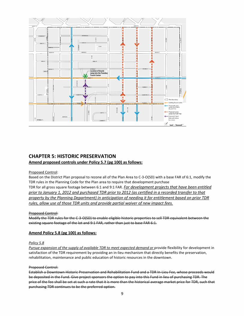
Amend Policy 4.62 Maintain off-street loading facility requirements for all major new development, but recognize that there are substantial efficiencies for large projects. Proposed Control: Amend Planning Code Section 155.2 to establish a maximum number of required loading spaces for large commercial buildings of six loading docks. Currently loading requirements infinitely scale upward with the size the project. Substantial experience in San Francisco and other major cities with large projects (i.e. larger than 600,000 gross square feet) has demonstrated that demand for loading docks does not increase proportionally with the size of the building. Experience has shown the maximum demand for loading docks for buildings well in excess of 1 million square feet to be six spaces, as substantial efficiencies are gained in servicing large buildings. Streets for Future Consideration of Bicycle Improvements Map (page 79) The map has been amended to identify Plan proposed bike lanes and identify the proposed Class I bike path under the bus ramps.
9
CHAPTER 5: HISTORIC PRESERVATION Amend proposed controls under Policy 5.7 (pg 100) as follows: Proposed Control: Based on the District Plan proposal to rezone all of the Plan Area to C-3-O(SD) with a base FAR of 6:1, modify the TDR rules in the Planning Code for the Plan area to require that development purchase TDR for all gross square footage between 6:1 and 9:1 FAR. For development projects that have been entitled prior to January 1, 2012 and purchased TDR prior to 2012 (as certified in a recorded transfer to that property by the Planning Department) in anticipation of needing it for entitlement based on prior TDR rules, allow use of those TDR units and provide partial waiver of new impact fees. Proposed Control: Modify the TDR rules for the C-3-O(SD) to enable eligible historic properties to sell TDR equivalent between the existing square footage of the lot and 9:1 FAR, rather than just to base FAR 6:1. Amend Policy 5.8 (pg 100) as follows: Policy 5.8 Pursue expansion of the supply of available TDR to meet expected demand or provide flexibility for development in satisfaction of the TDR requirement by providing an in-lieu mechanism that directly benefits the preservation, rehabilitation, maintenance and public education of historic resources in the downtown. Proposed Control: Establish a Downtown Historic Preservation and Rehabilitation Fund and a TDR In-Lieu Fee, whose proceeds would be deposited in the Fund. Give project sponsors the option to pay into this Fund in lieu of purchasing TDR. The price of the fee shall be set at such a rate that it is more than the historical average market price for TDR, such that purchasing TDR continues to be the preferred option.
10
In order to ensure sufficient TDR continue to be available and to achieve the goals of the TDR program, the City should continue to investigate opportunities to expand the potential supply of TDR through designation of eligible buildings within and outside of the C-3, including publicly-owned historic properties that require substantial rehabilitation. A secondary approach after, or in tandem with, pursuing the expansion of supply would be the creation of an in-lieu TDR credit where project sponsors pay into a historic preservation fund. In partnership with the Historic Preservation Commission, rules should be developed and established regarding the use and management of the Fund created by purchases of such credits. The rules should reinforce that the Fund program should be used by the Planning Department solely for the partial reimbursement of rehabilitation or restoration work completed by qualified property owners of historic resources within the City of San Francisco. The The uses for such a Fund should be established by the Planning Commission and Historic Preservation Commission. Potential uses could include should allow the City to reimburse financial support to eligible property owners for preservation and rehabilitation work (windows, exterior repairs, etc.) to buildings within the C-3 Districts and that have already sold their TDR (thus encouraging historic buildings to be preserved by selling TDR, thereby removing future development rights and pressure to demolish the buildings). Eligible buildings should deemed to be (1) a designated landmark building or a contributory building within a designated historic district per Article 10 of the Planning Code, (2) a Category I-IV building identified within Article 11 of the Planning Code, or (3) a building listed on the California Register of Historical Resources by the State Office of Historic Preservation within the City of San Francisco. The funds should be Board-appropriated in an interest earning account that carries forward its own balance. Eligible restoration or rehabilitation work should be limited only to the exterior of an historic resource, including: the reconstruction of a missing cornice; terra cotta repair and replacement, the reconstruction of missing features based on physical or documented evidence; façade cleaning, paint removal, the removal of incompatible non-historic alterations; the removal of incompatible non-historic windows with new windows that match the historic material, profile, and configuration. Additional projects eligible for use of the Fund should include public signage and similar informational programs related to historic preservation within the C-3, purchasing TDR or conservation easements from historic properties that have not yet sold TDR. Ineligible work should include new additions, new garage openings, loading docks, painting, all seismic retrofit work, roof repair or replacement. All work should comply with the Secretary of the Interior’s Standards for the Treatment of Historic Properties (36 C.F.R. § 67.7 (2001) and be subject to the review and approval requirements of Planning Code Articles 10 and 11. Potential Historic District Expansion Map (page 95) The map has been amended to reflect a revised boundary for the Proposed New Montgomery-Mission-Second Street Conservation District. The proposed Article 11 Category ratings as shown on the map on page 95 (and as listed in Appendix A) of the Draft Plan has been amended per the table shown at the end of this document.

11
CHAPTER 6: DISTRICT SUSTAINABILITY The District Sustainability chapter has been updated to reflect changes to the City’s sustainability regulations, goals and standards since publication of the 2009 draft Plan. Edits are contained in the updated Plan document. Specific policy changes to the chapter are identified below. Amend the following policies to read as follows: Policy 6.1 Create efficient, shared district-scale energy, heating and cooling systems in the district. Policy 6.5 Identify and protect either suitable public sites or major development sites within the Plan Area for locating renewable or CHP generation facilities. Policy 6.15 Pursue a variety of potential sources of non-potable water, including municipally-supplied recycled water and district-based greywater graywater, black water, stormwater, and building de-watering foundation drainage water. Delete Policy 6.13 and supporting text. Renumber policies accordingly:

12
Policy 6.13 All major buildings in the Plan Area should exceed the minimum credits required by the SF Green Building Ordinance under the Energy and Water categories of the LEED schemes. In order for new development within the Transit Center District to help achieve pivotal goals relating to carbon dioxide emission reduction, to help address California’s water shortages, and to position the Plan Area as an exemplar of sustainable development, it is important that energy and water effciency are prioritized when developers are considering how to achieve the required LEED certification. Policy 6.19 All new and large redevelopment projects in the city should adhere to the following hierarchical approach to maximize resources and minimize use of potable water:
• Reduce demands by installing efficient water fixtures and behaviors; • Design sites to reduce the total amounts of stormwater generated on site; through the use of
alternative surfaces and collection and treatment devicesgreen stormwater infrastructure (Low Impact Design techniques);
• Identify all on-site sources (rainwater, cooling tower blow down, fog, greywater graywater, blackwater, stormwater, and foundation drainage diverted sump water);
• Install appropriate on-site collection, treatment, storage and conveyance systems for non-potable needs toilet flushing and, irrigation and additional identified nonpotable applications;
• Meet all other unmet surplus non-potable demands using district non-potable water or municipal recycled water; and
• Meet all other unmet remaining demands using potable water. CHAPTER 7: FUNDING Update Table 7-1: Transit Center District Public Improvements and Implementation Costs (pg 121) with the following: Under “Transit and Other Transportation,” add the item for Muni and Golden Gate Transit Transit Delay Mitigation (Vehicle Purchase) ($3,000,000) Under “Transit and Other Transportation,” identify sub-project categories for Transit Center Project including Phase I: Transit Center including Train Box; Phase 2: Downtown Rail Extension (DTX). Under “Open Space,” change project title “Improvements to Portsmouth Square, St. Mary’s Squares” to “Improvements to other downtown open spaces.” Delete Policy 7.4 (pg 122) and renumber subsequent policies: Policy 7.4 Encourage the inclusion of a deed covenant in contractual development agreements for new development requiring the project sponsor to contribute to the cost of public improvements as properties are resold over time. Delete the following supporting text under Policy 7.8 (pg 122):

13
The adoption and implementation of these funding mechanisms will occur in the future. The analysis presented in this chapter is preliminary and solely for planning purposes. Any specific impact fee amounts suggested in this draft plan were selected merely for the purpose of demonstrating the potential revenue from such fees based on hypothetical fee levels and the levels of development in the Plan Area and for assessing feasibility. The nexus studies to provide a justification for any such fees and the amounts of the fees are currently in process. Any fees proposed for adoption in the future will be fully supported by appropriate nexus studies. Such fees will not exceed the amount shown in the studies to be the maximum cost of offsetting the impact on the demand for infrastructure and services attributable to the new development in the Plan Area that is assessed the fees. Add Policy 7.9: Policy 7.9 Create a Transit Center District Plan Program Implementation Document that outlines the Funding Program and guides future decision making in allocating revenues to public improvements. Remove Pages 123 -135 from the Transit Center District Plan to put into new Program Implementation Document. Create reference to “Program Implementation Document” in Funding chapter. Appendix B: Historic Resources Ratings Appendix B: Historic Resources Ratings (pages B-1 –B-3) The table has been updated to reflect properties proposed for reclassification and inclusion in the New Montgomery, 2nd Street and Mission Street Conservation District. The full table is included at the end of this document.
Block/Lot Address Street Article 10
Designation
Existing Article 11 Category
Proposed Article 11 Category
3708003 38 1ST
V V
3736006 234 1ST Proposed Article 10 Designation I I
3707002 20 2ND
IV IV 3707004 36 2ND
IV IV
3707005 42 2ND
IV IV 3707006 48 2ND
IV IV
3707007 52 2ND
IV IV 3708096 55 2ND
III III
3707008 60 2ND
IV IV 3707009 70 2ND
IV IV
3708019 71 2ND
I I 3707010 76 2ND
IV IV
3707011 84 2ND
V V
3707012 90 2ND Proposed Article 10 Designation IV IV

14
3721089 101 2ND
V V 3722002 120 2ND
IV IV
3721071 121 2ND
I I 3722003 132 2ND
I I
3721051 133 2ND
IV IV 3721050 141 2ND
I I
3722004 144 2ND
IV IV 3721049 149 2ND
IV IV
3722005 156 2ND
IV IV 3721048 163 2ND
IV IV
3722016 168 2ND
IV IV 3721025 171 2ND
IV IV
3721023 181 2ND
V V 3722019 182 2ND
IV IV
3735055 240 2ND Proposed Article 10 Designation
III
3706001 26 3RD
III III 3706002 28 3RD
V
3706003 32 3RD
V V 3706093 86 3RD
I
3722257 125 3RD
IV 3711019 77 BEALE
I I
3736023 566 FOLSOM
V 3736025 572 FOLSOM
III
3735008 606 FOLSOM Proposed Article 10 Designation
III
3735009 608 FOLSOM
III 3735015 690 FOLSOM
V
3736156 530-534 FOLSOM
V V 3719011 177 FREMONT
V V
3719010 183 FREMONT
V 3719009 193 FREMONT
V V
3740001 101 HOWARD
I I 3719018 324 HOWARD
III III
3736121 509 HOWARD
V V 3721013 524 HOWARD
V V
3736114 525 HOWARD
V 3736083 527 HOWARD
V III
3721014 530 HOWARD
V 3736112 531 HOWARD
V III
3721016 546 HOWARD
V V 3736110 547 HOWARD
V V
3736086 555 HOWARD
V 3736107 557 HOWARD
V
3721019 562 HOWARD
V 3721020 568 HOWARD
V V
3736102 571 HOWARD
V 3736100 577 HOWARD
V III
3736099 583 HOWARD
III III 3736098 589 HOWARD
V III
3722020 606 HOWARD
IV 3735005 625 HOWARD
II II

15
3735050 633 HOWARD
V V 3722023
HOWARD
V
3735047 645 HOWARD
V 3722024 648 HOWARD
V
3735042 651 HOWARD
V IV 3735041 657 HOWARD
III III
3722012 658 HOWARD
V V 3722026 660 HOWARD
V V
3735040 663 HOWARD
V V 3735039 667 HOWARD
III IV
3722027 15 HUNT
V V 3708022 16 JESSIE
I I
3708032 96 JESSIE
III III 3707032 163 JESSIE
IV
3713006 1 MARKET
I I 3708059 595 MARKET
V V
3707001 601 MARKET
IV IV 3707002A 609 MARKET
IV IV
3707061 625 MARKET
IV IV 3707051 685 MARKET
I I
3707057 691 MARKET
I I 3721052 83 MINNA
V V
3722058 142 MINNA
V 3710017 350 MISSION
V
3709008 440 MISSION
III 3708010 512 MISSION
V V
3708011 516 MISSION
V V 3721082 545 MISSION
III III
3721120 555 MISSION
V V 3722001 601 MISSION
IV IV
3707013 602 MISSION
V IV 3722076 611 MISSION
V IV
3722073 617 MISSION
IV IV 3722070 641 MISSION
V IV
3707018 646 MISSION
V V 3722069 647 MISSION
I I
3707019 652 MISSION
V V 3722068 657 MISSION
IV
3707020 658 MISSION
I I 3722067 663 MISSION
V IV
3707021 666 MISSION
V IV 3721122 531-535 MISSION
V V
3721015 55 NATOMA
V V 3721029 77 NATOMA
V V
3721108 83 NATOMA
V V 3721109 85 NATOMA
V V
3721047 90 NATOMA
V V 3722006 116 NATOMA
I I
3722014 145 NATOMA
I 3722013 147 NATOMA
I I
3722011 161 NATOMA
V IV

16
3707052 2 NEW MONTGOMERY 18 II II
3707062 33 NEW MONTGOMERY
V V
3707035 39 NEW MONTGOMERY 163 I I
3707033 74 NEW MONTGOMERY
I I
3707014 77 NEW MONTGOMERY
I I
3722071 100 NEW MONTGOMERY
I I
3722072 111 NEW MONTGOMERY 107 IV IV
3722007 137 NEW MONTGOMERY
IV IV
3722022 170 NEW MONTGOMERY
IV IV
3722080 134-140 NEW MONTGOMERY
I I
3708039 53 STEVENSON
V V 3708038 55 STEVENSON
V V
3708031 79 STEVENSON
III 3707044 111 STEVENSON
I I
3736079 19 TEHAMA
V 3736111 38 TEHAMA
V
3736091 72 TEHAMA
III III 3736092 74 TEHAMA
III
3736093 78 TEHAMA
V III 3736094 90 TEHAMA
III