Desert Sky Transit Center Study - City of Phoenix … · Desert Sky Transit Center Study ... needs...
27
March 2011 D D e e s s e e r r t t S S k k y y T T r r a a n n s s i i t t C C e e n n t t e e r r S S t t u u d d y y An Assessment of Existing Facility and Operational Conditions and Alternative Site Analysis
Transcript of Desert Sky Transit Center Study - City of Phoenix … · Desert Sky Transit Center Study ... needs...

March 2011
DDeesseerrtt SSkkyy TTrraannssiitt CCeenntteerr
SSttuuddyy
AAnn AAsssseessssmmeenntt ooff EExxiissttiinngg FFaacciilliittyy aanndd OOppeerraattiioonnaall CCoonnddiittiioonnss aanndd
AAlltteerrnnaattiivvee SSiittee AAnnaallyyssiiss

Desert Sky Transit Center Study City of Phoenix Public Transit Department March 2011
2
1. INTRODUCTION The Desert Sky Transit Center Study was initiated by the City of Phoenix Public Transit Department as part of the continuing efforts to improve public transit service and in support of the City’s revitalization goals for West Phoenix. The purpose of this study is to document current conditions at the existing transit center and assess how well the facility is meeting the City’s transit operation needs as well as transit system user, or passenger, needs. Finally, the study will serve as a major component of any future environmental assessment of impacts as required by the Federal Transit Administration (FTA). Organization of the Study The Desert Sky Transit Center Study provides an overview of existing conditions within the Maryvale Village and West Phoenix Revitalization Area, documents current site conditions at the transit center, assesses transit operation and passenger needs, evaluates nine potential new transit center sites, and recommends a preferred site. The report is organized into the following sections:
• Area Profile provides an overview of the population and socio-economic data for the study area. Additionally, it describes both the urban development and transportation network within the study area and its relationship to other plans and programmed activities in the West Phoenix area.
• Existing Conditions and Needs Assessment describes and documents the current site and operational conditions at the existing Desert Sky Mall Transit Center. Existing transit center features and level of amenities are evaluated and compared to those found at a typical transit center and at other transit centers throughout the City of Phoenix.
• Alternative Site Analysis and Recommendation identifies potential transit center sites and evaluates each in accordance with established criteria. A recommendation is made for the preferred site and alternative sites for a new Desert Sky Transit Center.
2. AREA PROFILE The Desert Sky Mall Transit Center is located with the Maryvale Village Core, in the north parking lot of the Desert Sky Mall, approximately 1,100 feet south and east of the southeast corner of 79th Avenue and Thomas Road.

Desert Sky Transit Center Study City of Phoenix Public Transit Department March 2011
3
The Phoenix City Council and Planning Commission have divided the city into fifteen planning areas called urban villages in order to work better with the community on planning issues (Figure 2.1). The urban villages are based on the Phoenix General Plan that was adopted to guide the urban form of the city while creating a sense of place. Three key principles of the General Plan are:
• Balance housing and employment • Concentrate intensity in village cores • Promote the unique character of each
village Each village has a core that serves as the community focal point by combining the most intense land uses with a great variety of uses. By providing a mix of employment, housing and retail opportunities, this village “downtown” creates a physical identity for the residents. It is designed to serve as a gathering place with pedestrian activity and a focus for the local transportation system. The Maryvale Village is located on the west side of Phoenix and is generally bounded by Interstate 17 (I-17) and Grand Avenue on the east, Interstate 10 (I-10) on the south, 99th Avenue and El Mirage Road on the west and Camelback Road on the north. The Village encompasses 32.5 square miles, approximately 6.3% of the land area in Phoenix. Demographics1 Maryvale is one of the most populous of the 15 urban villages, with approximately 14.1% of Phoenicians residing within the Village. The Village’s 2010 population is 204,560, up 7.6% from the 2000 Census, 189,996. Maryvale is expected to grow an additional 10.8% by 2030, accommodating 226,600 people. Maryvale has a population density of 6,296 persons per square mile which is more than double that of Phoenix, 2,785 persons per square mile. Maryvale boasts a young, diverse population, as shown in Table 2.1. When compared to Phoenix at large, the percent of households living in poverty is only 1 Demographic information reported is based on 2010 Census and 2006-2010 Census American Community Survey information unless noted otherwise. Specific information for the Maryvale Village has been calculated using Census Block Group data (to the best geographic fit with Census Block Groups).
Figure 2.1 The Maryvale Village, shown in purple, is located in West Phoenix.
Desert Sky Transit Center Study City of Phoenix Public Transit Department March 2011
4
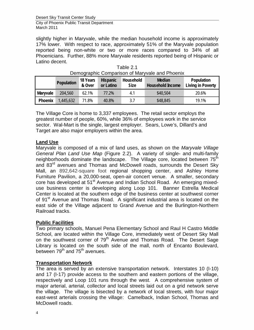
slightly higher in Maryvale, while the median household income is approximately 17% lower. With respect to race, approximately 51% of the Maryvale population reported being non-white or two or more races compared to 34% of all Phoenicians. Further, 88% more Maryvale residents reported being of Hispanic or Latino decent.
Table 2.1 Demographic Comparison of Maryvale and Phoenix
Population 18 Years & Over
Hispanic or Latino
Household Size
Median Household Income
Population Living in Poverty
Maryvale 204,560 62.1% 77.2% 4.1 $40,504 20.6% Phoenix 1,445,632 71.8% 40.8% 3.7 $48,845 19.1%
The Village Core is home to 3,337 employees. The retail sector employs the greatest number of people, 60%, while 36% of employees work in the service sector. Wal-Mart is the single, largest employer. Sears, Lowe’s, Dillard’s and Target are also major employers within the area. Land Use Maryvale is composed of a mix of land uses, as shown on the Maryvale Village General Plan Land Use Map (Figure 2.2). A variety of single- and multi-family neighborhoods dominate the landscape. The Village core, located between 75th and 83rd avenues and Thomas and McDowell roads, surrounds the Desert Sky Mall, an 892,642-square foot regional shopping center, and Ashley Home Furniture Pavilion, a 20,000-seat, open-air concert venue. A smaller, secondary core has developed at 51st Avenue and Indian School Road. An emerging mixed-use business center is developing along Loop 101. Banner Estrella Medical Center is located at the southern edge of the business center at southwest corner of 91st Avenue and Thomas Road. A significant industrial area is located on the east side of the Village adjacent to Grand Avenue and the Burlington-Northern Railroad tracks. Public Facilities Two primary schools, Manuel Pena Elementary School and Raul H Castro Middle School, are located within the Village Core, immediately west of Desert Sky Mall on the southwest corner of 79th Avenue and Thomas Road. The Desert Sage Library is located on the south side of the mall, north of Encanto Boulevard, between 79th and 75th avenues. Transportation Network The area is served by an extensive transportation network. Interstates 10 (I-10) and 17 (I-17) provide access to the southern and eastern portions of the village, respectively and Loop 101 runs through the west. A comprehensive system of major arterial, arterial, collector and local streets laid out on a grid network serve the village. The village is bisected by a network of local streets, with four major east-west arterials crossing the village: Camelback, Indian School, Thomas and McDowell roads.

Desert Sky Transit Center Study City of Phoenix Public Transit Department March 2011
5
Figure 2.2: Maryvale Village General Plan Land Use Map
Four of the City’s top 10 most productive local fixed routes serve the area: Route 29 (Thomas Road); Route 41 (Indian School Road); Route 50 (Camelback Road); Route 17 (McDowell Road). Additionally, two of the top city-wide High Capacity Transit corridors are located within the Village, I-10 West and Thomas Road. The City of Phoenix High Capacity Transit Corridor Study evaluated 21 potential corridors and identified nine upper tier corridors based on the following criteria:
• Population Concentrations
• Employment Concentrations
• Ridership Potential
• Economic Development Potential
• Transportation Connections
• Regional Serving Destinations Inside the City
• Potential for High Speed Operations
• Promotion of Regional Smart Growth Principles
• Regional Destinations Outside the City The I-10 West and Thomas Road corridors ranked second and fourth, respectively.
T
T Transit Center
Desert Sky Transit Center Study City of Phoenix Public Transit Department March 2011
6
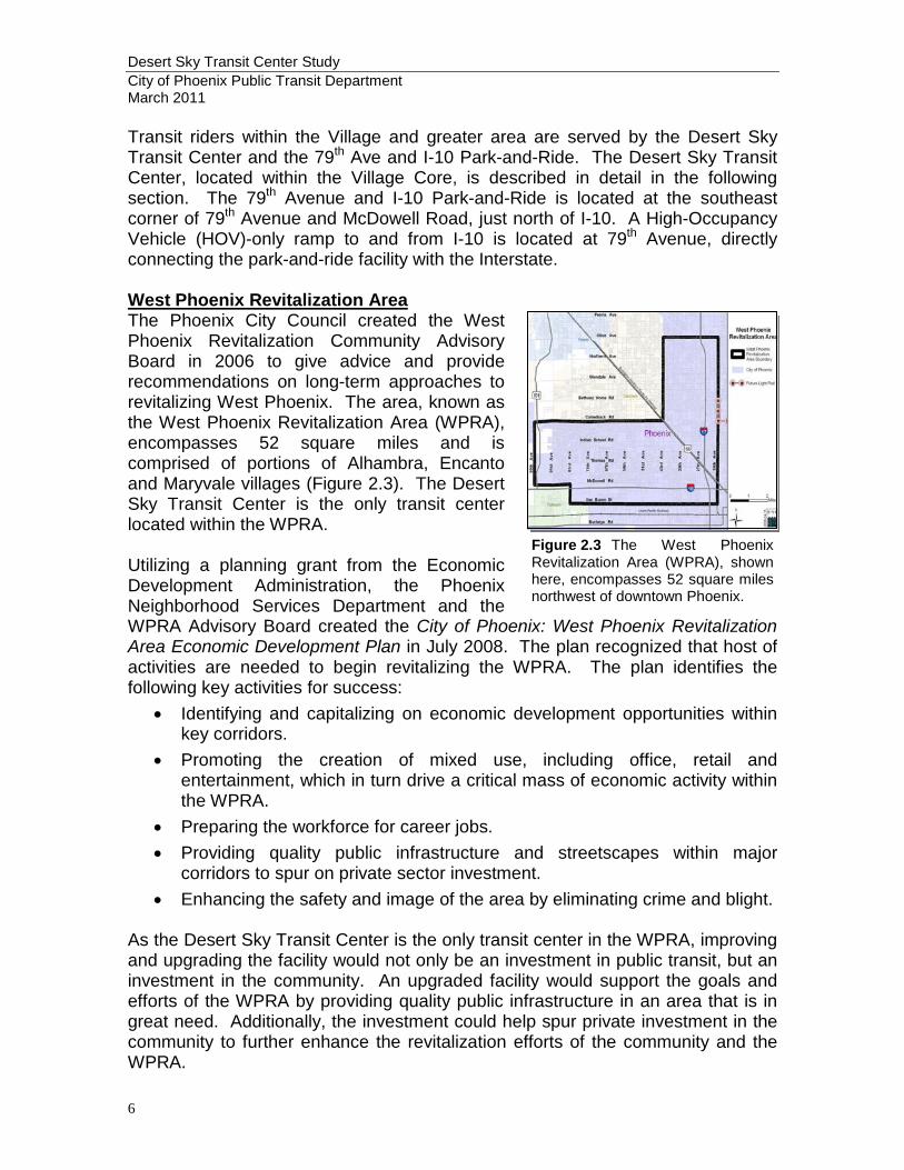
Transit riders within the Village and greater area are served by the Desert Sky Transit Center and the 79th Ave and I-10 Park-and-Ride. The Desert Sky Transit Center, located within the Village Core, is described in detail in the following section. The 79th Avenue and I-10 Park-and-Ride is located at the southeast corner of 79th Avenue and McDowell Road, just north of I-10. A High-Occupancy Vehicle (HOV)-only ramp to and from I-10 is located at 79th Avenue, directly connecting the park-and-ride facility with the Interstate. West Phoenix Revitalization Area The Phoenix City Council created the West Phoenix Revitalization Community Advisory Board in 2006 to give advice and provide recommendations on long-term approaches to revitalizing West Phoenix. The area, known as the West Phoenix Revitalization Area (WPRA), encompasses 52 square miles and is comprised of portions of Alhambra, Encanto and Maryvale villages (Figure 2.3). The Desert Sky Transit Center is the only transit center located within the WPRA. Utilizing a planning grant from the Economic Development Administration, the Phoenix Neighborhood Services Department and the WPRA Advisory Board created the City of Phoenix: West Phoenix Revitalization Area Economic Development Plan in July 2008. The plan recognized that host of activities are needed to begin revitalizing the WPRA. The plan identifies the following key activities for success:
• Identifying and capitalizing on economic development opportunities within key corridors.
• Promoting the creation of mixed use, including office, retail and entertainment, which in turn drive a critical mass of economic activity within the WPRA.
• Preparing the workforce for career jobs. • Providing quality public infrastructure and streetscapes within major
corridors to spur on private sector investment. • Enhancing the safety and image of the area by eliminating crime and blight.
As the Desert Sky Transit Center is the only transit center in the WPRA, improving and upgrading the facility would not only be an investment in public transit, but an investment in the community. An upgraded facility would support the goals and efforts of the WPRA by providing quality public infrastructure in an area that is in great need. Additionally, the investment could help spur private investment in the community to further enhance the revitalization efforts of the community and the WPRA.
Figure 2.3 The West Phoenix Revitalization Area (WPRA), shown here, encompasses 52 square miles northwest of downtown Phoenix.

Desert Sky Transit Center Study City of Phoenix Public Transit Department March 2011
7
Conclusions The Maryvale Village has a dense and diverse population. The area is of regional significance for current and future public transit service. Existing and potential transit usage is high as evidenced by the fact that four of the most productive local fixed transit routes within the City pass through the Village (Routes 17, 29, 41, and 50) as well as two of the top High Capacity Transit Corridors (I-10 West and Thomas Road). The Village Core has a concentration of commercial retail and office activity and serves as a focal point for the local transportation system.
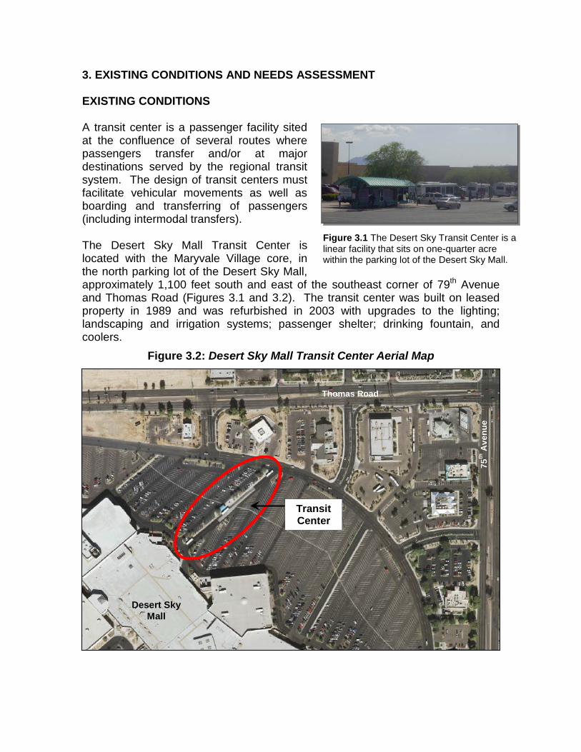
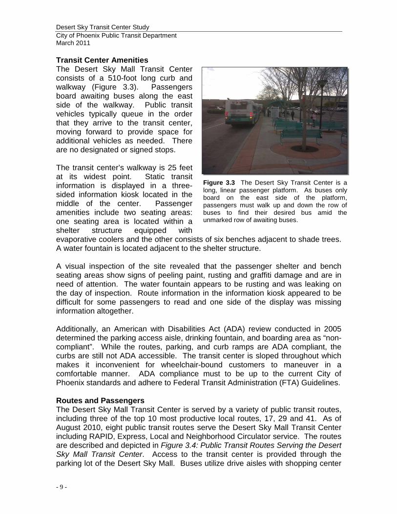
3. EXISTING CONDITIONS AND NEEDS ASSESSMENT EXISTING CONDITIONS A transit center is a passenger facility sited at the confluence of several routes where passengers transfer and/or at major destinations served by the regional transit system. The design of transit centers must facilitate vehicular movements as well as boarding and transferring of passengers (including intermodal transfers). The Desert Sky Mall Transit Center is located with the Maryvale Village core, in the north parking lot of the Desert Sky Mall, approximately 1,100 feet south and east of the southeast corner of 79th Avenue and Thomas Road (Figures 3.1 and 3.2). The transit center was built on leased property in 1989 and was refurbished in 2003 with upgrades to the lighting; landscaping and irrigation systems; passenger shelter; drinking fountain, and coolers.
Figure 3.2: Desert Sky Mall Transit Center Aerial Map
Figure 3.1 The Desert Sky Transit Center is a linear facility that sits on one-quarter acre within the parking lot of the Desert Sky Mall.
Thomas Road
75th
Ave
nue
Desert Sky Mall
Transit Center
Desert Sky Transit Center Study City of Phoenix Public Transit Department March 2011
- 9 -
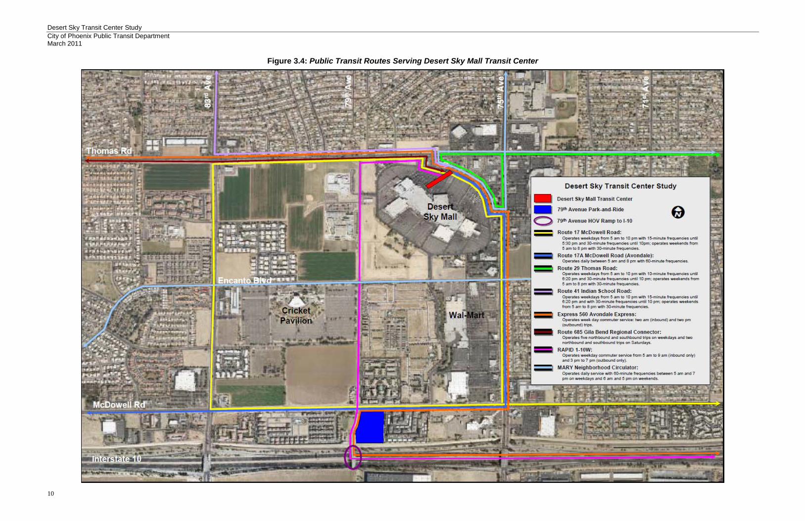
Transit Center Amenities The Desert Sky Mall Transit Center consists of a 510-foot long curb and walkway (Figure 3.3). Passengers board awaiting buses along the east side of the walkway. Public transit vehicles typically queue in the order that they arrive to the transit center, moving forward to provide space for additional vehicles as needed. There are no designated or signed stops. The transit center’s walkway is 25 feet at its widest point. Static transit information is displayed in a three-sided information kiosk located in the middle of the center. Passenger amenities include two seating areas: one seating area is located within a shelter structure equipped with evaporative coolers and the other consists of six benches adjacent to shade trees. A water fountain is located adjacent to the shelter structure. A visual inspection of the site revealed that the passenger shelter and bench seating areas show signs of peeling paint, rusting and graffiti damage and are in need of attention. The water fountain appears to be rusting and was leaking on the day of inspection. Route information in the information kiosk appeared to be difficult for some passengers to read and one side of the display was missing information altogether. Additionally, an American with Disabilities Act (ADA) review conducted in 2005 determined the parking access aisle, drinking fountain, and boarding area as “non-compliant”. While the routes, parking, and curb ramps are ADA compliant, the curbs are still not ADA accessible. The transit center is sloped throughout which makes it inconvenient for wheelchair-bound customers to maneuver in a comfortable manner. ADA compliance must to be up to the current City of Phoenix standards and adhere to Federal Transit Administration (FTA) Guidelines. Routes and Passengers The Desert Sky Mall Transit Center is served by a variety of public transit routes, including three of the top 10 most productive local routes, 17, 29 and 41. As of August 2010, eight public transit routes serve the Desert Sky Mall Transit Center including RAPID, Express, Local and Neighborhood Circulator service. The routes are described and depicted in Figure 3.4: Public Transit Routes Serving the Desert Sky Mall Transit Center. Access to the transit center is provided through the parking lot of the Desert Sky Mall. Buses utilize drive aisles with shopping center
Figure 3.3 The Desert Sky Transit Center is a long, linear passenger platform. As buses only board on the east side of the platform, passengers must walk up and down the row of buses to find their desired bus amid the unmarked row of awaiting buses.
Desert Sky Transit Center Study City of Phoenix Public Transit Department March 2011
10
Figure 3.4: Public Transit Routes Serving Desert Sky Mall Transit Center

Desert Sky Transit Center Study City of Phoenix Public Transit Department March 2011
11
patrons and a portion of the access route travels down a parking aisle, creating hazardous conditions during peak transit and shopping times. Staff analyzed passenger boardings at all Phoenix transit centers between January and June of 2010 (Table 3.1). Data shows that, on average, there are over 60,000 passenger boardings per month at the Desert Sky Transit Center, making it the City’s busiest transit center for bus boardings. Desert Sky falls behind Central Station when light rail boardings are added to the equation, as Central Station is the only Phoenix transit center along the light rail line.
Table 3.1 Passenger Bus Boardings
MONTH Ed Pastor PV Mall Sunnyslope Metro Center Central
Station* Desert
Sky January 9,894 12,597 26,755 43,146 40,646 68,187 February 6,251 13,656 22,912 41,061 39,872 72,322
March 7,484 14,687 28,418 45,370 45,858 75,824 April 8,501 14,276 26,952 44,125 44,563 78,298 May 6,987 13,469 25,034 43,146 45,214 60,862 June 6,223 13,394 24,115 41,963 51,084 60,161 Total 45,340 82,079 154,186 258,811 267,237 410,654
Ave/Month 7,557 13,680 25,698 43,135 44,540 68,442 * Each month there is an average of 47,975 weekday light rail passenger boardings at Central Station in addition to the bus boardings.
Desert Sky Transit Center Study City of Phoenix Public Transit Department March 2011
12
NEEDS ASSESSMENT This section provides an assessment of the current conditions and identifies improvements that may be needed to meet the City’s operational and passenger needs. Facility refurbishments were last completed in 2003, including passenger shelters, lighting fixtures, evaporation coolers, and other structural repairs. Located within the Maryvale Village Core, the Desert Sky Transit Center fits the definition of an Urban Transit Center:
Urban Transit Centers are typically located within an urban core and primarily serve as destination facilities of the regional transit system. They are designed to maximize pedestrian connections with major employment centers and activity centers, and will typically be served by local shuttle service in addition to regional and community bus routes.2
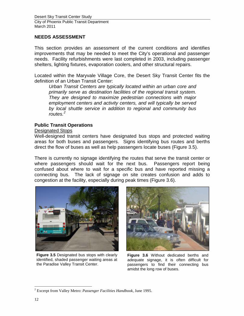
Public Transit Operations Designated Stops Well-designed transit centers have designated bus stops and protected waiting areas for both buses and passengers. Signs identifying bus routes and berths direct the flow of buses as well as help passengers locate buses (Figure 3.5). There is currently no signage identifying the routes that serve the transit center or where passengers should wait for the next bus. Passengers report being confused about where to wait for a specific bus and have reported missing a connecting bus. The lack of signage on site creates confusion and adds to congestion at the facility, especially during peak times (Figure 3.6).
2 Excerpt from Valley Metro: Passenger Facilities Handbook, June 1995.
Figure 3.5 Designated bus stops with clearly identified, shaded passenger waiting areas at the Paradise Valley Transit Center.
Figure 3.6 Without dedicated berths and adequate signage, it is often difficult for passengers to find their connecting bus amidst the long row of buses.
Desert Sky Transit Center Study City of Phoenix Public Transit Department March 2011
13
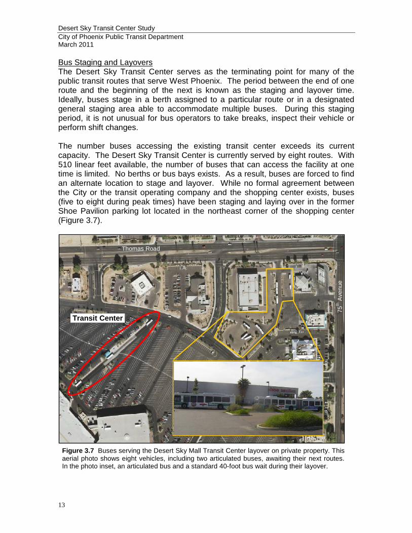
Bus Staging and Layovers The Desert Sky Transit Center serves as the terminating point for many of the public transit routes that serve West Phoenix. The period between the end of one route and the beginning of the next is known as the staging and layover time. Ideally, buses stage in a berth assigned to a particular route or in a designated general staging area able to accommodate multiple buses. During this staging period, it is not unusual for bus operators to take breaks, inspect their vehicle or perform shift changes. The number buses accessing the existing transit center exceeds its current capacity. The Desert Sky Transit Center is currently served by eight routes. With 510 linear feet available, the number of buses that can access the facility at one time is limited. No berths or bus bays exists. As a result, buses are forced to find an alternate location to stage and layover. While no formal agreement between the City or the transit operating company and the shopping center exists, buses (five to eight during peak times) have been staging and laying over in the former Shoe Pavilion parking lot located in the northeast corner of the shopping center (Figure 3.7).
Figure 3.7 Buses serving the Desert Sky Mall Transit Center layover on private property. This aerial photo shows eight vehicles, including two articulated buses, awaiting their next routes. In the photo inset, an articulated bus and a standard 40-foot bus wait during their layover.
Thomas Road
75th
Ave
nue
Transit Center
Desert Sky Transit Center Study City of Phoenix Public Transit Department March 2011
14
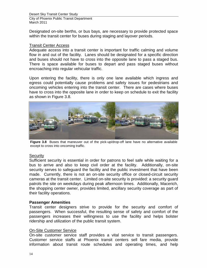
Designated on-site berths, or bus bays, are necessary to provide protected space within the transit center for buses during staging and layover periods. Transit Center Access Adequate access into a transit center is important for traffic calming and volume flow in and out of the facility. Lanes should be designated for a specific direction and buses should not have to cross into the opposite lane to pass a staged bus. There is space available for buses to depart and pass staged buses without encroaching into regular vehicular traffic. Upon entering the facility, there is only one lane available which ingress and egress could potentially cause problems and safety issues for pedestrians and oncoming vehicles entering into the transit center. There are cases where buses have to cross into the opposite lane in order to keep on schedule to exit the facility as shown in Figure 3.8.
Security Sufficient security is essential in order for patrons to feel safe while waiting for a bus to arrive and also to keep civil order at the facility. Additionally, on-site security serves to safeguard the facility and the public investment that have been made. Currently, there is not an on-site security office or closed-circuit security cameras at the transit center. Limited on-site security is provided: a security guard patrols the site on weekdays during peak afternoon times. Additionally, Macerich, the shopping center owner, provides limited, ancillary security coverage as part of their facility operations. Passenger Amenities Transit center designers strive to provide for the security and comfort of passengers. When successful, the resulting sense of safety and comfort of the passengers increases their willingness to use the facility and helps bolster ridership and utilization of the public transit system. On-Site Customer Service On-site customer service staff provides a vital service to transit passengers. Customer service staffs at Phoenix transit centers sell fare media, provide information about transit route schedules and operating times, and help
Figure 3.8 Buses that maneuver out of the pick-up/drop-off lane have no alternative available except to cross into oncoming traffic.

Desert Sky Transit Center Study City of Phoenix Public Transit Department March 2011
15
passengers navigate the public transit system. There is currently no on-site customer service provided at the Desert Sky Transit Center. Passengers are able to purchase fare media inside the Desert Sky Mall at the mall’s customer service desk. With more than 68,000 passenger boardings each month, the Desert Sky Transit Center is in need of on-site customer service to assist passengers. Information Kiosk Information kiosks provide static information about the public transit system including route maps and schedules as well as important customer notifications. There is a three-sided information kiosk located in the middle of the passenger boarding area at the Desert Sky Mall Transit Center. This kiosk is the only forum for public transit information available and suffers from occasional vandalism (Figure 3.9).
Passenger Comfort Amenities Access to drinking fountains is a frequent request and expectation of passengers at transit facilities, especially in the Phoenix area. The drinking fountain at the Desert Sky Mall Transit Center needs to be brought into compliance with ADA requirements (Figure 3.10). While the popularity of personal cellular telephones have reduced the demand for public pay phones in recent years, pay phones should be provided to meet all passenger needs as well as ensure passengers have the ability to make emergency calls should the need arise. Restrooms are one of the most-requested passenger amenities and public transit facilities, especially at transit centers where passengers may have extended layover times between connecting routes. However, they can have a significant impact on the annual operation and maintenance costs of the facility. As a result, the
Figure 3.9 As the only form of transit information at the Desert Sky Mall Transit Center, passengers rely on the schedules and notices posted in the information kiosk to help them navigate the public transit system throughout the day. Frequent vandalism reduces the effectiveness of the kiosk as the sole information source on site.
Figure 3.10 The drinking fountain at the Desert Sky Mall Transit Center lacks the ADA-required dual-height fountains.

Desert Sky Transit Center Study City of Phoenix Public Transit Department March 2011
16
decision to provide public restrooms at a transit center is often a policy decision, rather than a design consideration. There are currently six transit centers in the Phoenix transit system. Public restrooms are provided at two of the six, Central Station and Ed Pastor. Restrooms are provided for transit center staff and bus operators at the Sunnyslope and Paradise Valley Mall transit centers. No restrooms, for the public or staff, are available at the Desert Sky Mall or MetroCenter transit centers. Passenger Seating Passenger seating areas should be designed to provide relief from the elements. A combination of horizontal and vertical shade elements, including natural vegetation as well as man-made structures, can provide an effective and attractive passenger spaces that provide relief from the sun, wind and rain (Figure 3.11). While there are two passenger seating areas at the Desert Sky Transit Center – one cluster of benches set amidst a number of shade trees as well as one protected by a shade structure, they are not adequate to provide sufficient shade or seating for the volume of passengers. Bicycle Lockers or Rack and Parking Bicycle lockers or racks are needed at transit centers to accommodate and encourage multimodal use. Depending on the location and anticipated transit services provided, the addition of a park-and-ride component is warranted at a transit center. For example, if commuter service is provided, like RAPID service at the Desert Sky Mall Transit Center, weekday commuters will likely access the facility via their personal automobile and would need to be accommodated. While no parking spaces are included in the area leased for the Desert Sky Mall Transit Center, RAPID passengers do park in the mall parking lot adjacent to the facility. Conclusion Developing an independent transit facility located apart from the shopping center parking lot would alleviate the disorder, clutter, and confusion that transit riders experience at the existing facility. Further, while there are amenities available at the Desert Sky Transit Center, as shown in Table 3.3, the variety and quality of amenities, including security, customer service, fare sales, ticket vending machines, restrooms, and covered parking are not available at this facility. A new facility would allow for improvements to be made to the public transit infrastructure and level of amenities provided to transit riders in the West Phoenix area that are not currently possible due to the limitations of the current facility size and property lease agreement.
Figure 3.11 A mixture of nature shade (trees) and shade structures provides an abundance of shade options for patrons that are waiting for buses, especially during summer months, at the Paradise Valley Mall Transit Center.
Desert Sky Transit Center Study City of Phoenix Public Transit Department March 2011
17
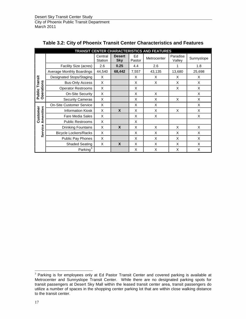
Table 3.2: City of Phoenix Transit Center Characteristics and Features
TRANSIT CENTER CHARACTERISTICS AND FEATURES
Central Station
Desert Sky
Ed Pastor Metrocenter Paradise
Valley Sunnyslope
Facility Size (acres) 2.6 0.25 4.4 2.6 1 1.8 Average Monthly Boardings 44,540 68,442 7,557 43,135 13,680 25,698
Designated Stops/Staging X X X X X Bus-Only Access X X X X X
Operator Restrooms X X X X On-Site Security X X X X
Security Cameras X X X X X On-Site Customer Service X X X X
Information Kiosk X X X X X X Fare Media Sales X X X X Public Restrooms X X
Drinking Fountains X X X X X X Bicycle Lockers/Racks X X X X X
Public Pay Phones X X X X X Shaded Seating X X X X X X
Parking3 X X X X
3 Parking is for employees only at Ed Pastor Transit Center and covered parking is available at Metrocenter and Sunnyslope Transit Center. While there are no designated parking spots for transit passengers at Desert Sky Mall within the leased transit center area, transit passengers do utilize a number of spaces in the shopping center parking lot that are within close walking distance to the transit center.
Publ
ic T
rans
it O
pera
tions
C
usto
mer
Se
rvic
e A
men
ities
Desert Sky Transit Center Study City of Phoenix Public Transit Department March 2011
18
4. SITE ALTERNATIVES ANALYSIS The documentation of existing conditions, City of Phoenix planning initiatives, input from City staff, and a visual survey performed by Public Transit Department staff all contributed to the identification of a series of sites for the potential development of a new Desert Sky Transit Center. These sites were put through an evaluation process to determine the two most appropriate sites for further consideration from the initial field of nine alternatives. Study Area To help identify a study area for a new transit center, staff identified the following site location considerations:
• Locate near the existing site to minimize disruptions to existing transit routes and transit users;
• Locate within one-half mile of Thomas Road, an identified High Capacity Transit Corridor;
• Locate within one-half mile of 79th Avenue, which provides direct access to the 79th Avenue and I-10 Park-and-Ride, the dedicated HOV access to I-10, and the West Transit Operations Facility;
• Locate within the Maryvale Village Core to support the General Plan goal of locating dense and intense land uses within Village Cores, thus creating a focal point for activity and the local transportation system;
• Locate near employment and commercial centers; and • Locate near existing or planned community facilities.
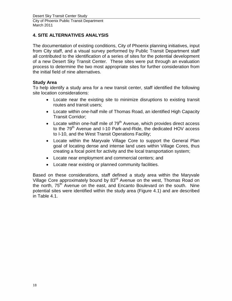
Based on these considerations, staff defined a study area within the Maryvale Village Core approximately bound by 83rd Avenue on the west, Thomas Road on the north, 75th Avenue on the east, and Encanto Boulevard on the south. Nine potential sites were identified within the study area (Figure 4.1) and are described in Table 4.1.
Figure 4.1: Desert Sky Transit Center Existing and Potential Sites

Table 4.1 Potential Transit Center Site Size and Location
Site # Size Location Primary Owner General Characteristics
1 4.2 ± acres
695 ft east of the northeast corner
of 79th Ave/ Thomas Rd
Thomas and Patricia Tait
• Vacant, linear site • Access to Thomas Rd and 79th Ave • Signal on Thomas at east property line • North of Desert Sky Mall • Adjacent to existing single-family residential
2 4.1 ± acres
Southeast corner of 79th Ave/ Thomas Rd
Westpen Associates
• Vacant, linear site • Access to Thomas Rd and 79th Ave • Signal at Thomas Rd and 79th Ave • On northwest corner of Desert Sky Mall
property
3 1.8 ± acres
695 ft east of the southeast corner
of 79th Ave/ Thomas Rd
Westpen Associates • Vacant, linear site • Access to Thomas Rd • On north side of Desert Sky Mall property
4 6.9 ± acres
990 ft south of the southeast corner
of 79th Ave/ Thomas Rd
Westpen Associates
• Vacant, irregularly shaped site • Access to 79th Ave • One-quarter mile south of Thomas Rd • On west side of Desert Sky Mall property
5 14.1 ± acres
Northwest corner of 79th Ave/
Encanto Blvd 79th & Encanto LLC
• Vacant, rectangular site • Access to 79th Ave and Encanto Blvd • Four-way stop at 79th Ave and Encanto Blvd • One-half mile south of Thomas Rd • West of Desert Sky Mall; North of Cricket
Pavilion • Adjacent to existing multi-family residential
6 13.4 ± acres
Northeast corner of 79th Ave/
Encanto Blvd Westpen Associates
• Vacant, irregularly shaped site • Access to 79th Ave and Encanto Blvd • Four-way stop at 79th Ave and Encanto Blvd • One-half mile south of Thomas Rd • On southwest corner of Desert Sky Mall
property; Northeast of Cricket Pavilion
7 4.7 ± acres
1,335 ft east of the northeast
corner of 79th Ave/
Encanto Blvd
Westpen Associates
• Vacant, irregularly shaped site • Access to Encanto Blvd • One-quarter mile east of 79th Ave and west of
75th Ave • On south side of Desert Sky Mall property
8 4.2 ± acres
675 ft west of the northwest corner
of 75th Ave/ Encanto Blvd
Westpen Associates
• Vacant, L-shaped site • Access to Encanto Blvd • One-quarter mile east of 79th Ave and west of
75th Ave • On south side of Desert Sky Mall property • Adjacent to the City of Phoenix Desert Sage
Library
9 12.6 ± acres
Northeast corner of 75th Ave/
Encanto Blvd
Westridge Park Investors LP
• Vacant, rectangular site • Access to Encanto Blvd and 75th Ave • Traffic signal at Encanto Blvd and 75th Ave • One-half mile south of Thomas Rd • Southeast of Desert Sky Mall • Adjacent to residential development
Desert Sky Transit Center Study City of Phoenix Public Transit Department March 2011
21
ANALYSIS The mix of land uses and urban design features in transit corridors contribute to transit’s attractiveness as a mode of travel. The characteristics of areas around stations strongly influence the way in which patrons travel to and from transit. Measures of “pedestrian friendliness” include the following attributes:
• Street connectivity • Sidewalk and bikepath connectivity • Use of street crossing on principle arterials • Absence of topographical constraints to pedestrian mobility
Urban design features (defined as “aesthetic urban settings”) have the greatest influence of any of the factors analyzed on transit mode choice. The presence of shade trees and sidewalks and the absence of graffiti and other factors contribute to the mode choice decisions. Studies have shown that neighborhood shopping and pedestrian access possess a strong correlation with vehicle miles traveled. Land use mix has special importance for people walking or bicycling to transit services. Also, businesses providing services to riders, such as personal services and retail attract more people to stations. As the Desert Sky Transit Center is one of the busiest transit centers in the City of Phoenix Public Transit system, particular care needs to be taken when developing a new expanded facility to ensure that the location, size, and proposed amenities at the facility meet the needs of existing and future transit users. Criteria for Preliminary Site Evaluation The needs assessment findings and project goals and objectives included in this study led to the identification of nine (9) preliminary sites designated for analysis as well as a set of evaluation criteria. Each of these standards was developed into a matrix that rated the initial set of transit center site alternatives. Proximity to Existing Transit Center and Routes – As the existing transit center currently serves an average of 60,000 transit riders per month, locating a new facility in close proximity to the existing facility will minimize the disruption for current passengers. Additionally, there are currently eight routes that serve the transit center. Sites were evaluated based on the ability to serve the existing routes with minimal disruption or rerouting. Proximity to Existing and Future Transportation Corridors – (Bus access/routing, freeway system, bikeways, major arterial streets). All planned transit facilities must consider the overall transportation network to determine whether the facilities make appropriate connections between existing and future transit routes, freeways, and pedestrian and bicycle corridors. All of these
Desert Sky Transit Center Study City of Phoenix Public Transit Department March 2011
22
transportation modes are important to ridership connections and ease of accessibility to a given system. Sites were evaluated based on their proximity to the identified Thomas Road and I-10 High Capacity Transit corridors, including the HOV connection to I-10 at 79th Avenue, as well as major arterials important to the provision of local service, Thomas Road and 75th Avenue. Site Size and Configuration – The size and configuration of a potential site is an important consideration. Enough acreage must be available to support planned operations and passenger amenities, with room for expansion if possible. However, Sites that are too large may cause problems during acquisition if lot splits are required or require future land disposition if too much land is purchased. The site configuration must allow the transit center facility to maximize the utilization of space. To accommodate planned transit operations, the Desert Sky Transit Center site should be at least four to five acres in size. Visibility and Rider Attractiveness – Area transit facilities should be very visible from highly utilized areas in as many directions as possible to foster a sense of security for the passenger. A well-defined and visible transit center should include convenient linkage to adjacent uses and use of existing surrounding architectural opportunities for ties with the proposed facility. The objective is to encourage flexibility and creativity while still meeting transit and community objectives. Adjacent street design must recognize the need for easy and safe pedestrian access and visibility and lend itself to appropriate changes for pedestrian crossings and access points. Sites were evaluated based on their proximity to highly trafficked automobile and pedestrian corridors. Safety Concerns – While the transit center will de design and developed to maximize safety, opportunities can be present to maximize the safety of the passenger and facility. Sites located adjacent to uses or businesses with extended hours of activity can provide valuable “eyes on the site” safety. Accessibility – Buses must be able to access the chosen transit center site safely with minimal passenger delay due to bus route diversion. Sites were evaluated based on the ability of buses to make safe left turns, direct access to arterial streets, minimal cross-access through private property, and convenient bus turn-around routes. Acquisition Issues – A host of issues arise when alternative sites area being studies for location and development of a transit center. The difficulty in acquiring a site may hinge upon cost, existing plans already submitted to the Planning and Development Services Department, questions of ownership and known legal problems or zoning conflicts. Pedestrian Connectivity to Desert Sky Mall – All of the proposed sites are located within the Maryvale Village Core, where higher concentrations of commercial and employment activity and higher density residential development is desired and supported by the Phoenix General Plan and existing zoning.
Desert Sky Transit Center Study City of Phoenix Public Transit Department March 2011
23
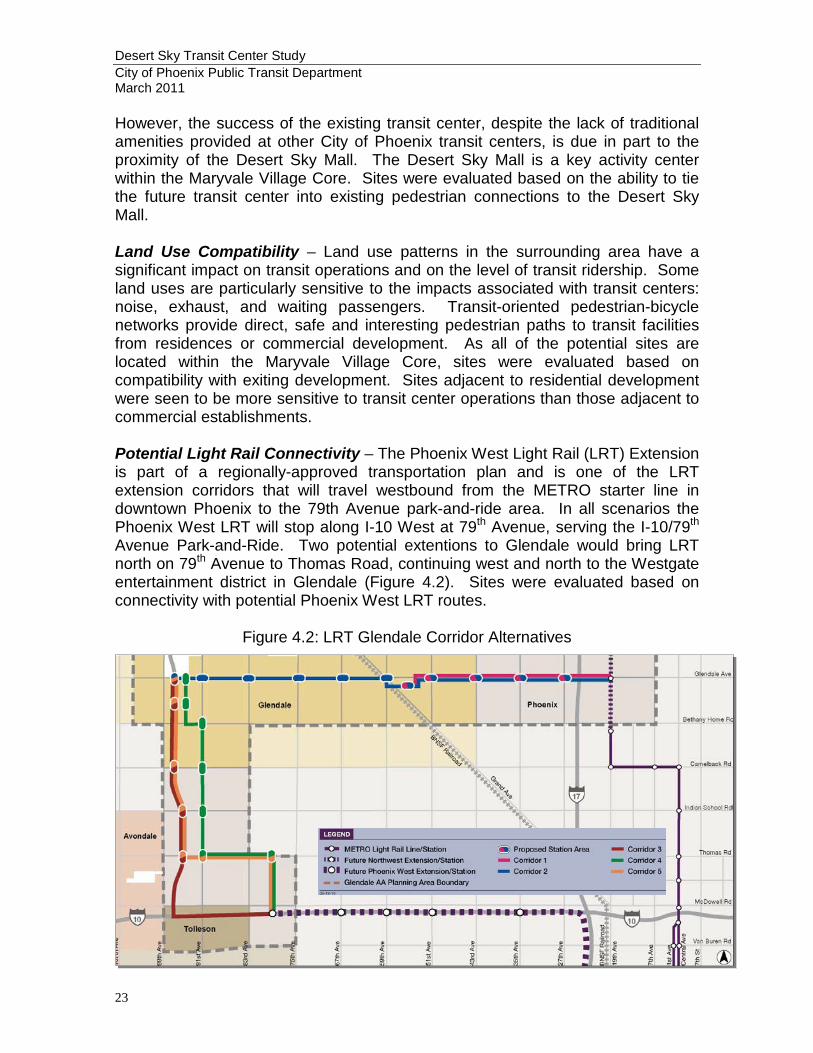
However, the success of the existing transit center, despite the lack of traditional amenities provided at other City of Phoenix transit centers, is due in part to the proximity of the Desert Sky Mall. The Desert Sky Mall is a key activity center within the Maryvale Village Core. Sites were evaluated based on the ability to tie the future transit center into existing pedestrian connections to the Desert Sky Mall. Land Use Compatibility – Land use patterns in the surrounding area have a significant impact on transit operations and on the level of transit ridership. Some land uses are particularly sensitive to the impacts associated with transit centers: noise, exhaust, and waiting passengers. Transit-oriented pedestrian-bicycle networks provide direct, safe and interesting pedestrian paths to transit facilities from residences or commercial development. As all of the potential sites are located within the Maryvale Village Core, sites were evaluated based on compatibility with exiting development. Sites adjacent to residential development were seen to be more sensitive to transit center operations than those adjacent to commercial establishments. Potential Light Rail Connectivity – The Phoenix West Light Rail (LRT) Extension is part of a regionally-approved transportation plan and is one of the LRT extension corridors that will travel westbound from the METRO starter line in downtown Phoenix to the 79th Avenue park-and-ride area. In all scenarios the Phoenix West LRT will stop along I-10 West at 79th Avenue, serving the I-10/79th Avenue Park-and-Ride. Two potential extentions to Glendale would bring LRT north on 79th Avenue to Thomas Road, continuing west and north to the Westgate entertainment district in Glendale (Figure 4.2). Sites were evaluated based on connectivity with potential Phoenix West LRT routes.
Figure 4.2: LRT Glendale Corridor Alternatives
Desert Sky Transit Center Study City of Phoenix Public Transit Department March 2011
24
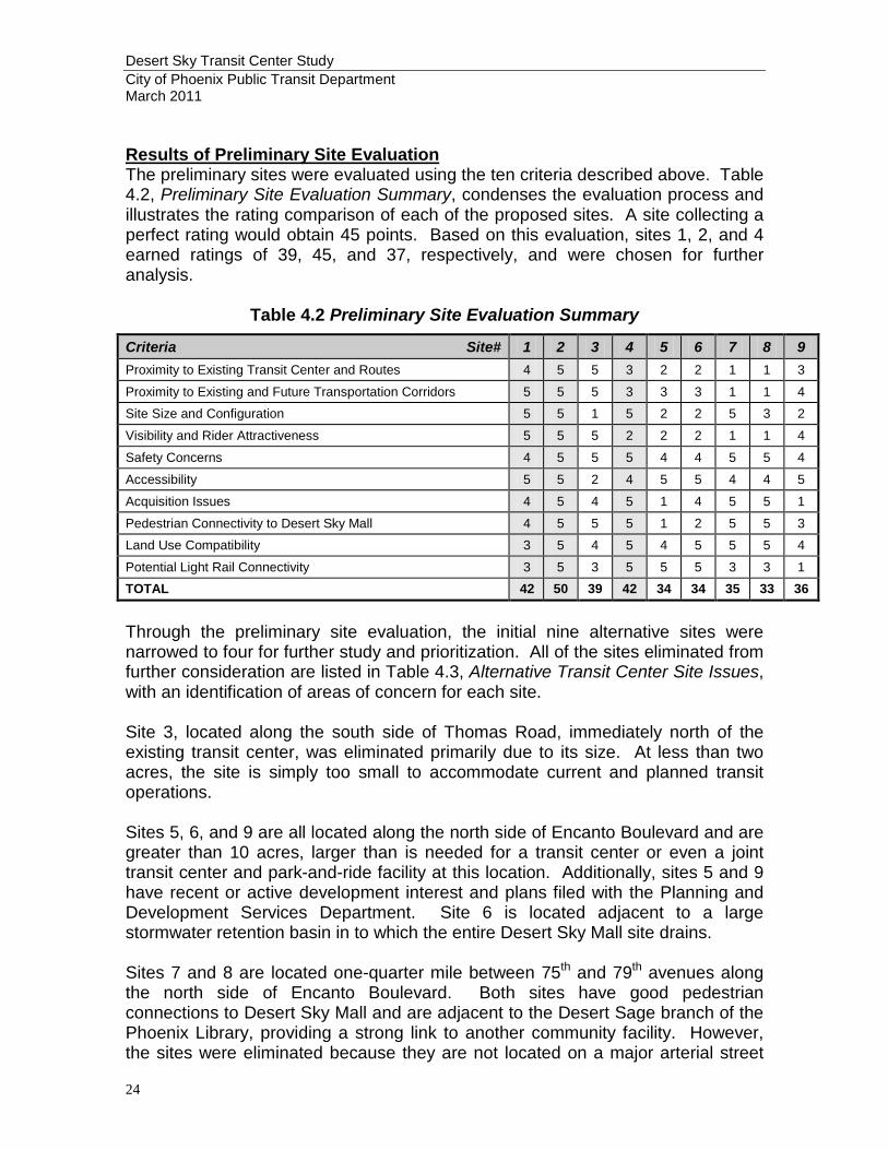
Results of Preliminary Site Evaluation The preliminary sites were evaluated using the ten criteria described above. Table 4.2, Preliminary Site Evaluation Summary, condenses the evaluation process and illustrates the rating comparison of each of the proposed sites. A site collecting a perfect rating would obtain 45 points. Based on this evaluation, sites 1, 2, and 4 earned ratings of 39, 45, and 37, respectively, and were chosen for further analysis.
Table 4.2 Preliminary Site Evaluation Summary
Criteria Site# 1 2 3 4 5 6 7 8 9 Proximity to Existing Transit Center and Routes 4 5 5 3 2 2 1 1 3
Proximity to Existing and Future Transportation Corridors 5 5 5 3 3 3 1 1 4
Site Size and Configuration 5 5 1 5 2 2 5 3 2
Visibility and Rider Attractiveness 5 5 5 2 2 2 1 1 4
Safety Concerns 4 5 5 5 4 4 5 5 4
Accessibility 5 5 2 4 5 5 4 4 5
Acquisition Issues 4 5 4 5 1 4 5 5 1
Pedestrian Connectivity to Desert Sky Mall 4 5 5 5 1 2 5 5 3
Land Use Compatibility 3 5 4 5 4 5 5 5 4
Potential Light Rail Connectivity 3 5 3 5 5 5 3 3 1 TOTAL 42 50 39 42 34 34 35 33 36
Through the preliminary site evaluation, the initial nine alternative sites were narrowed to four for further study and prioritization. All of the sites eliminated from further consideration are listed in Table 4.3, Alternative Transit Center Site Issues, with an identification of areas of concern for each site. Site 3, located along the south side of Thomas Road, immediately north of the existing transit center, was eliminated primarily due to its size. At less than two acres, the site is simply too small to accommodate current and planned transit operations. Sites 5, 6, and 9 are all located along the north side of Encanto Boulevard and are greater than 10 acres, larger than is needed for a transit center or even a joint transit center and park-and-ride facility at this location. Additionally, sites 5 and 9 have recent or active development interest and plans filed with the Planning and Development Services Department. Site 6 is located adjacent to a large stormwater retention basin in to which the entire Desert Sky Mall site drains. Sites 7 and 8 are located one-quarter mile between 75th and 79th avenues along the north side of Encanto Boulevard. Both sites have good pedestrian connections to Desert Sky Mall and are adjacent to the Desert Sage branch of the Phoenix Library, providing a strong link to another community facility. However, the sites were eliminated because they are not located on a major arterial street

Desert Sky Transit Center Study City of Phoenix Public Transit Department March 2011
25
and would require the rerouting of seven of eight transit routes to access the site. Additionally, neither site has a strong connection to existing or planned transit corridors and poor visibility from highly utilized areas.
Table 4.3 Alternative Transit Center Site Issues
Site # Acres Issues (Areas of Concern) Score 1 4.2 ± Selected for further analysis 42 2 4.1 ± Selected for further analysis 50
3 1.8 ±
Small linear station. Limited ability to develop adequate bus staging and layover areas. Little room for expansion or additional amenities. Mid-block location lacks opportunities for buses to make protected left-turn
movements onto Thomas Rd
39
4 6.9 ± Selected for further analysis 42
5 14.1 ±
Large site, more land than is needed for a joint transit center and park-and-ride facility at this location.
Property has increased zoning – C-2 with a height and density waiver; development interest in multi-family residential.
Not convenient for future high capacity transit on Thomas Rd. Two of eight routes currently serving the area pass by the site. Not at crossroads of major transit activity 79th Ave and Encanto Blvd are both half-mile streets, not major arterial streets.
34
6 13.4 ±
Large site, more land than is needed for a joint transit center and park-and-ride facility at this location.
Not convenient for future high capacity transit on Thomas Rd. Site is adjacent to large stormwater retention area to which the entire Desert
Sky Mall shopping center site drains. Size/location of the site may be better suited for a revenue-generating land use. Two of eight routes currently serving the area pass by the site. Not at crossroads of major transit activity. 79th Ave and Encanto Blvd are both half-mile streets, not major arterial streets.
34
7 4.7 ±
Not convenient for future high capacity transit on Thomas Rd. One of eight routes currently serving the area pass by the site. Not at crossroads of major transit activity. Encanto Blvd is half-mile street, not a major arterial street.
35
8 4.2 ±
L-shape site may be difficult to develop efficiently. Not convenient for future high capacity transit on Thomas Rd. One of eight routes currently serving the area pass by the site. Not at crossroads of major transit activity. Encanto Blvd is half-mile street, not a major arterial street.
33
9 12.6 ±
Large site, more land than is needed for a joint transit center and park-and-ride facility at this location.
Not convenient for future high capacity transit on Thomas Rd. Commercial establishments interested in developing the site. Potential impacts to adjacent residential development.
36
No-Build Alternative The No-Build alternative consists of the continued operation of the existing Desert Sky Transit Center without improvement. As discussed in the Needs Assessment
Desert Sky Transit Center Study City of Phoenix Public Transit Department March 2011
26
section, this alternative is undesirable as current transit operations have outgrown the existing leased 0.25-acre site. The transit center suffers from bus overcrowding and limited space for layovers during peak periods; a lack of transit operative support services, such as break areas and restrooms; on-site security; and minimal passenger amenities such as adequate wayfinding signage; on-site customer service and fare media sales. A larger site that can accommodate traditional transit center features and amenities is necessary. Site Selection Three sites were identified during the Preliminary Site Evaluation for further analysis: sites 1, 2, and 4. Site 2, a 4.1-acre parcel located at the southeast corner of 79th Avenue and Thomas Road, received the maximum score of 50/50 in the Preliminary Site Evaluation demonstrating that it meets all 10 evaluation criteria. Site 2 is the preferred site for the Desert Sky Transit Center as it offers the following:
• Convenient access to future high capacity transit on Thomas Rd. • Five of eight routes currently serving the area pass by the site and the
remaining three can be easily modified to serve the site. • Crossroads of major transit activity. • Adequate size for current and future transit needs. • Commercial properties surround the site; minimal impact to adjacent
properties. • Signalized intersection at 79th Avenue/Thomas Road. • Close proximity to commercial activity. • Close proximity to existing transit center; minimal disruption to passengers
and transit routes. • Compatible with the potential light rail corridor along 79th Avenue.
Sites 1 and 4 both scored 42/50 in the Preliminary Site Evaluation. Site 1 is located Thomas Road, midblock on the north side between 79th and 75th avenues and out scored Site 4 in two key areas: proximity to existing and future transit corridors and visibility and attractiveness to transit riders. Additionally, Site 1 is served by traffic signal which could help facilitate left-turns into the site. However, this site is located adjacent to an existing single-family residential neighborhood. As the site is long and narrow, opportunities to buffer neighborhood from the transit operations through site design would be limited. Additionally, the site is located approximately 1/8-mile east of 79th Avenue, a potential future light rail corridor, which could be problematic for future rail to bus connections. Site 4, a 6.9-acre parcel located on the east side of 79th Avenue between Thomas and Encanto roads, is the largest of the three sites selected for further analysis. The additional land could be reserved for future expansion, developed with a larger park-and-ride facility, or part of the land could be co-developed with METRO if 79th Avenue becomes a light rail corridor. As the site is surrounded by non-residential land uses, a transit center is more compatible on Site 4 than on Site 1.
Desert Sky Transit Center Study City of Phoenix Public Transit Department March 2011
27
Consequently, Site 4 is the recommended alternative site and Site 1, the second alternative. Recommendation Based on the data and analysis presented, Staff recommends initiating environmental studies, land acquisition and preliminary site design for a new Desert Sky Transit Center located on the 4.1-acre parcel at the southeast corner of 79th Avenue and Thomas Road.