Final Report: A Management Plan for Historic Bridges in ... · A MANAGEMENT PLAN FOR HISTORIC...
127
FINAL REPORT A MANAGEMENT PLAN FOR HISTORIC BRIDGES IN VIRGINIA Ann B. Miller Senior Research Scientist Kenneth M. Clark Research Associate Matthew C. Grimes Research Assistant (The opinions, findings, and conclusions expressed in this report are those of the authors and not necessarily those of the sponsoring agencies.) Virginia Transportation Research Council (A Cooperative Organization Sponsored Jointly by the Virginia Department of Transportation and the University of Virginia) Charlottesville, Virginia January 2001 VTRC 01-R11
-
Upload
nguyentuyen -
Category
Documents
-
view
221 -
download
1
Transcript of Final Report: A Management Plan for Historic Bridges in ... · A MANAGEMENT PLAN FOR HISTORIC...
FINAL REPORT
A MANAGEMENT PLAN FOR HISTORIC BRIDGES IN VIRGINIA
Ann B. Miller Senior Research Scientist
Kenneth M. Clark Research Associate
Matthew C. Grimes Research Assistant
(The opinions, findings, and conclusions expressed in this report are those of the authors and not necessarily
those of the sponsoring agencies.)
Virginia Transportation Research Council (A Cooperative Organization Sponsored Jointly by the
Virginia Department of Transportation and the University of Virginia)
Charlottesville, Virginia
January 2001
VTRC 01-R11
ii
Copyright 2001 by the Virginia Department of Transportation.
iii
VIRGINIA HISTORIC STRUCTURES TASK GROUP
ANN B. MILLER (CHAIR), Senior Research Scientist, Virginia Transportation Research Council WILLIAM H. BUSHMAN, Research Scientist, Virginia Transportation Research Council JOHN R. DEWELL, Assistant State Hydraulics Engineer, Virginia Department of Transportation G. MICHAEL FITCH, Senior Research Scientist, Virginia Transportation Research Council THOMAS F. LESTER, Structural Engineer Supervisor, Virginia Department of Transportation CLAUDE S. NAPIER, JR., Division Bridge Engineer, Federal Highway Administration ANTONY F. OPPERMAN, Cultural Resource Program Manager, Virginia Department of Transportation EDWARD S. SUNDRA, Environmental Engineer, Federal Highway Administration JOHN E. WELLS, Architectural Historian, Virginia Department of Historic Resources

iv

v
ABSTRACT
The Virginia Department of Transportation (VDOT) has been a leader in undertaking research into transportation history and historic structures. In particular, surveys and evaluations for historic significance have been undertaken for many types of older bridges in Virginia. (In this context, historic significance and historic are used to denote structures that are eligible for inclusion in the National Register of Historic Places.) VDOT, through the Virginia Transportation Research Council, has been proactive in identifying and determining the significance of its historic bridges: major thematic studies have been undertaken for non-arched concrete bridges, metal truss bridges, movable span bridges, and masonry/concrete arch bridges.
Once historic significance has been determined, the next logical step in dealing with these
historic structures is to develop a treatment/management plan. There is a significant need to formulate such a plan in Virginia. Such a plan would (1) provide for the management of both the physical structure and the preservation of the historic integrity of one of Virginia’s historic resource types, and (2) reduce delays and streamline planning and scheduling (with corresponding reduction of attendant costs) for projects relating to historic bridges.
This project identified the numerous issues (including legal, engineering, regulatory,
financial, preservation, and political issues) that arise concerning the management of historic bridges, evaluated treatment and management options for such bridges, and developed a management plan for each of the historic bridges under VDOT’s purview.
FINAL REPORT
A MANAGEMENT PLAN FOR HISTORIC BRIDGES IN VIRGINIA
Ann B. Miller Research Scientist
Kenneth M. Clark Research Associate
Matthew C. Grimes Research Assistant
INTRODUCTION For nearly three decades, the Virginia Transportation Research Council (VTRC) has been
a leader in research into transportation history and historic structures. In particular, surveys and evaluations for historic significance have been undertaken for many types of older bridges in Virginia. The Virginia Department of Transportation (VDOT), through VTRC, has been proactive in identifying and determining the significance of Virginia’s historic bridges (i.e., those that are eligible for or listed on the National Register of Historic Places). Thematic bridge studies completed by VTRC include those for non-arched concrete bridges (Miller, McGeehan, and Clark 1996), metal truss bridges (Deibler 1975a-c, 1976a & b; Miller and Clark 1997; Spero 1979, 1980, 1981, 1982), movable span bridges (Miller and Clark, 1998) and masonry/concrete arch bridges (Miller and Clark 2000; Spero 1984).
Once historic significance has been determined, the next logical step in dealing with
historic bridges is to develop a treatment/management plan. The management of historic bridges is complicated by two primary types of issues: structural and funding issues. The structural standards and capacities of many, if not most, historic bridges belong to an earlier day. Bridges constructed for light traffic consisting of horse-drawn vehicles or early automobiles frequently have structures and dimensions that are inadequate (and often grossly inadequate) for the demands of modern traffic. In particular, early masonry, wooden truss, and metal truss bridges represent obsolete technologies and were often constructed via empirical knowledge and imperfect estimates of strength. Structural assessment and analysis of these structures may be difficult, repairs and replacement of deteriorated elements are difficult and expensive, and competent practitioners of early technologies are often difficult to locate. Some typical early construction and maintenance practices, notably the lead paint once routinely used on metal truss bridges, are now known to pose environmental hazards, and correction of such problems involves special procedures and considerable expense.
In addition to the higher costs often associated with certain types of maintenance and repair work on historic bridges, necessary work on historic bridges must compete with many other projects for a limited amount of transportation funding. Rehabilitation costs for an historic
2
bridge can often approach or even exceed the cost of a new bridge. Even significant repairs to a single historic bridge can often make major inroads upon a district or county bridge budget. Particularly in cases of historic bridges located on secondary roads, it is often difficult for county officials to agree to spend the majority of the yearly budget on one bridge when the same money would repair, upgrade, or even replace a number of other bridges. Accordingly, a management plan for historic bridges should reflect the importance of preventive maintenance in addition to any necessary repairs or rehabilitation: ongoing preventive maintenance is important as an aspect of both responsible stewardship of an historic resource and responsible handling of public monies.
PURPOSE AND SCOPE
The purpose of this project was to develop a treatment/management plan for the historic
bridges under VDOT’s purview. Such management plans would allow VDOT to make the best-informed management decisions and provide the most responsible stewardship possible for Virginia’s historic bridges. The project had two objectives:
1. Identify the numerous issues that arise concerning the management of historic
bridges, and evaluate treatment and management options for such bridges.
2. Develop a management plan for each National Register–eligible bridge under VDOT’s purview.
The surveys and updated surveys of early bridges undertaken by VTRC between the
1970s and the 1990s listed various bridges that were eligible for the National Register. The majority of these bridges were rated and recommended as eligible by the interdisciplinary Historic Structures Task Group, and these recommendations were accepted by the Virginia Department of Historic Resources (VDHR). However, certain other National Register–eligible bridges were not rated by the task group but had been determined eligible as part of replacement projects and, accordingly, were documented prior to replacement. These latter bridges were noted in the survey reports in 1996 through 2000 cited previously, but they were not included in this study because they had generally been documented and replaced as part of the respective projects (although a few were salvaged for reuse). Appendix A provides a list of the historic bridges included in this study as well as a list of the historic bridges that were documented and demolished (or else programmed for removal) and, thus, were not part of this study. A total of 55 bridges were included in this study.
METHODOLOGY
The research methodology included the following tasks:
3
1. Identify the pertinent issues. In this step, the task group identified the issues essential to the development of a comprehensive Virginia historic bridge management plan. This project identified and examined the various legal, engineering, regulatory, financial, preservation, and political issues that affect projects involving historic bridges.
2. Collect background information. Information on the specific issues identified and
general background information, condition data, and other factors that might affect the structure were collected on each National Register–listed or National Register–eligible bridge under VDOT’s purview. The researchers used the survey data and evaluations for historic significance already gathered by VTRC and gathered additional information and viewpoints from other VDOT central office and district personnel.
3. Conduct a site visit for each bridge. Task group members made a site visit to each
National Register–listed or National Register–eligible bridge under VDOT’s purview in consultation with or in the company of the district bridge engineer or another member of the district structure and bridge office. Specific problems and issues relating to each bridge were identified, examined, and discussed. The following were examined and noted for each bridge: the physical condition and general context of the bridge, any potential problems or situation that might affect the structure or its surroundings, and factors that could influence the development of the management recommendations for the structure.
4. Develop the database and decision matrix. A relational database was developed that
contained general information on each structure and a decision matrix allowing consideration of the variables noted. This database was adopted by the task group and served to provide an electronic record of the structures and issues involved and a record of the deliberations.
5. Evaluate the data and finalize recommendations. The information gathered on each
bridge was discussed and analyzed, and final recommendations were developed (using the decision matrix) in a series of meetings of the task group held between February 1998 and September 2000. For each bridge, the task group considered the various types of information gathered during survey work, during background research, on site visits, and in discussion with district structure and bridge personnel as necessary. The applicable issues and options concerning each bridge were identified and discussed, and the relational database was used to compare and evaluate potential treatment plans.
IDENTIFICATION OF ISSUES
The following issues were identified as being necessary for consideration for each bridge to be included in the management plan:
4
• treatment options (including preventive maintenance, rehabilitation, relocation, recordation and demolition, reuse, storage, and salvage)
• the Secretary of the Interior’s Standards as applicable to bridges (Weeks and
Grimmer, 1995) (the Secretary’s Standards are the federal standards that provide for the preservation of architectural and historical integrity of properties being rehabilitated)
• current and potential funding sources (for rehabilitation of historic bridges) • liability and safety issues (including related issues ranging from liability/safety threats
arising from deteriorated bridge structures, bridges that do not meet modern standards, lead paint on bridges, bridges frequently subjected to overweight loads, etc.)
• right-of-way issues (including easements, various types of ownership, discontinuance,
and abandonment) • present and future use of bridge • interagency cooperation and dispute resolution (including procedures of state and
federal agencies, examination of conflicting requirements, and identification of procedures for resolving any disputes that may arise)
• history of data gathering (including notation of previous and current survey work) • explanation of previous and current rating and significance levels (deliberations
regarding historic bridge treatment and determination of National Register eligibility) • preliminary bridge decision matrix (comparison of various factors, including
condition, average daily traffic, sufficiency rating, required load capacity, posted load capacity, width and length, vertical clearance, available detours, and ability to carry school buses and emergency vehicles)
• vulnerability to natural or cultural disaster (including flood, fire/arson, major impact
damage, and vandalism) • citizen interests (including interest in preservation, rehabilitation, or replacement of
historic bridges emanating from individual citizens and from local, regional, state, and national organizations)
• political issues (including local, regional, and statewide planning, growth, and
transportation issues and local and statewide governmental willingness to commit funding to each bridge)
5
• emergency procedures (avoidance of damage, recommendations for emergency stabilization)
• current design standards (state and national).
COLLECTION OF BACKGROUND INFORMATION In addition to data regarding each historic bridge (see Appendixes A and B), background information was collected in essentially three areas:
1. engineering elements, including national and state design standards, national and state
funding, and right-of-way issues 2. historic preservation elements, including interagency dispute resolution relative to
cultural resources and the Secretary of the Interior’s Standards 3. documentation and evaluation elements, including background of data gathering and
explanation of the bridge rating system and significant levels.
Engineering Elements
Design Standards: The National Perspective
Before any reasoned action can be taken to improve or restore the condition of a bridge, its physical condition must be carefully evaluated. Often, the defects or deterioration and possible effects on safe load-carrying capacity and geometric safety are not readily apparent. The National Bridge Inspection Standards (23 CFR 650(C)) must be used to evaluate the bridge and to assign a federal sufficiency rating. Then, the requirements of the American Association of State Highway Transportation Officials’ (AASHTO) A Policy on Geometric Design of Highways and Streets (1994) must be used to determine the minimum structural capacities and minimum roadway widths for bridges to maintain in place. AASHTO’s Manual for Condition Evaluation of Bridges (2000) must be used to determine the load ratings of the bridges. The actual design of the structures for rehabilitation or replacement must be based on AASHTO’s Standard Specifications for Highway Bridges (1996) for the National Highway System (NHS) structures. State standards may be used for structures off the NHS. However, VDOT basically uses the AASHTO specifications. References to AASHTO guides and references are being removed from 23 CFR Part 625 but are included in the Federal-Aid Policy Guide (Federal Highway Administration [FHWA], n.d.)
Exceptions to minimum AASHTO standards for bridges must be documented and approved by the State Bridge Engineer, and exceptions to roadway standards must be approved by the State Location and Design Engineer. (For the NHS, exceptions to minimum AASHTO
6
standards require a written agreement with FHWA.) The following requirements should be addressed in the documentation for design exceptions:
1. type of project 2. amount and character of traffic 3. accident history 4. degree to which a standard is being reduced 5. whether the exception will affect other standards 6. effect of the exception on the safety and operation of the facility and its compatibility
with adjacent sections of roadway 7. cost of attaining full standards and any resultant environmental impacts 8. whether any additional features are being introduced that would mitigate the
deviation 9. whether future improvements are planned or programmed to correct the substandard
design feature.
It may not be necessary to look at all of these requirements. However, requirements 4, 5, and 8 should be considered in any analysis. Design Standards: A State Perspective
Bridges are generally designed in accordance with the current editions of AASHTO’s Standard Specifications for Highway Bridges (1996) and VDOT’s Road Design Manual (1998).
Bridges funded through the Virginia Transportation Development Plan (Construction Program) are generally part of a road design project with a larger scope. They are designed for all systems in accordance with HS-20 design specifications and geometric dimensions based on the traffic estimates and functional classification of roadway for the design year (approximately 20 years hence). These geometric dimensions are usually a prescribed width of shoulder and the pavement width of the approach roadway. Urban bridges match the roadway template for curb and gutter, with or without sidewalks. For bridge-only federal projects, a minimum approach of 0.1 mile on each end of the structure is allowed.
Bridges funded through VDOT’s Maintenance and Operations Program are generally part
of bridge-only projects with minimal, if any, roadway provisions. The actions are generally reparative or rehabilitative in nature and do not incorporate major improvements, though this provision was relaxed recently. In some cases, minimal improvement is funded to satisfy the
7
geometric dimensions of the existing roadway with the provision that no roadway improvements will be forthcoming in the foreseeable future.
When standards in the mitigation of preservation/enhancement of potentially significant structures are considered, the structure must be evaluated from the perspective of the proposed project. If the project is included in VDOT’s Construction Program project, overall improvement of the transportation corridor is the primary goal. Bringing the structure up to standards comparable to those of the roadway improvement is paramount in the comprehensive design effort. At the least, the structure must satisfy the minimum desirable level of service for the traveling public. If no improvement is anticipated or underway, the evaluation turns to the possibility of providing minimal impact on the integrity of the structure while maintaining its ability to serve the traveling public at the minimum allowable level of service. Funding: The National Perspective
Funding for historic structures needs to be addressed from the national, state, and local levels depending on the ownership and location of the bridge. From the national perspective, the funding depends on the highway system on which the bridge is located. It also depends on the evaluation of the bridges as candidates for maintenance, rehabilitation, and replacement. Many factors enter into this decision, including the results of the bridge management systems, current design standards, historic significance, funds available, and political realities.
National transportation legislation has placed significant emphasis on historic preservation. The Surface Transportation and Uniform Relocation Assistance Act of 1987 called for the “rehabilitation, reuse, and preservation of bridges significant in American history, architecture, engineering, or culture.” In 1991, the Intermodal Surface Transportation Efficiency Act (ISTEA) included several sections pertaining to historic preservation. A new section was added to Historic and Scenic Values that stated “if a proposed project . . . involves a historic facility or is located in an area of historic or scenic value, the Secretary may approve such project . . . if such project is designed to standards that allow for the preservation of such historic or scenic value and such project is designed with mitigation measures to allow preservation of such value and ensure safe use of the facility.” Further, ISTEA established the Transportation Enhancement Program, strengthened transportation planning requirements, and created the program for National Scenic Byways that provide opportunities for new and revitalized partnerships in historic preservation. The 1998 Transportation Equity Act for the 21st Century (TEA-21) retained the ISTEA programs for historic preservation. TEA-21 also created the National Historic Covered Bridge Preservation Program to assist the states in their efforts to rehabilitate or repair and to preserve the nation’s historic covered bridges.
Depending on the system on which the historic structures are located, NHS, Surface Transportation Program (STP), and Highway Bridge Replacement and Rehabilitation Program (HBRRP) (23 CFR 650 (D)) funding can be used. Normally, the federal share for projects funded by NHS, STP, and HBRRP is 80% and the state share is 20%. NHS funds can be used on the interstate and designated urban and rural principal arterial bridges. STP funds can be used for bridges on other federal-aid routes and bridges on other public roads (off-system). HBRRP
8
funding can be used to provide assistance for any deteriorated bridge on a public road. The Transportation Enhancement Program provides opportunities for funding historic preservation activities. Opportunities should be evaluated and pursued that preserve valuable historic resources without compromising the transportation needs of the 21st century.
The Transportation Enhancement Program provides funding for activities that go beyond the scope of conventional highway projects. The program is funded through a set-aside of 10% of Virginia’s STP funds. Those funds can be used only for enhancement projects that fall into 1 or more of 10 defined categories. Two of those categories apply to the rehabilitation of historic bridges: Category 5, “Historic Preservation,” and Category 6, “Rehabilitation and Operation of Historic Transportation Buildings, Structures or Facilities including Historic Railroad Facilities and Canals.” Enhancement funds from either category could be used for rehabilitation of a bridge for continued vehicular use or for the interpretation, rehabilitation, or stabilization of a structure for alternative uses.
VDOT administers Virginia’s Transportation Enhancement Program funds. However, the use of Transportation Enhancement Program funds directly by VDOT was prohibited by policy established by the former Virginia Secretary of Transportation Robert Martinez. Transportation Enhancement Program funds could be used to rehabilitate VDOT’s historic bridges only if an application were submitted by an outside party such as a local government. State funds, however, could be used for the 20% match required by the program. That policy, however, is discretionary, and the direct use of enhancement funds by state transportation agencies is not prohibited by federal law. The policy has been relaxed somewhat under Virginia’s Secretary of Transportation Shirley Ybarra. VDOT has attempted to fund rehabilitations of two state-owned historic bridges in Virginia: Loudoun County Structure No. 6051 and Rockbridge County Structure No. 6145. The application for the Loudoun County bridge was unsuccessful. Of $250,000 requested for the Rockbridge County bridge, $25,000 was received.
With regard to eligibility requirements for HBRRP funds, under current regulations, the states may replace or rehabilitate eligible highway bridges over waterways, other topographical barriers, other highways, or railroads when the bridge is significantly important and is unsafe because of structural deficiencies, physical deterioration, or functional obsolescence. Deficient highway bridges on all public roads may be eligible for replacement or rehabilitation. The following types of work are eligible for participation under HBRRP:
1. Replacement. This is defined as total replacement of a structurally deficient or
functionally obsolete bridge with a new facility constructed in the same general corridor. A nominal amount of approach work sufficient to connect the new facility to the existing roadway or to return the grade line to an attainable touchdown point in accordance with good design practice is also eligible.
2. Rehabilitation. This is defined as the project requirements necessary to perform the
major work required to restore the structural integrity of a bridge as well as work necessary to correct major safety defects.
9
Under HBRRP, whenever a deficient bridge is replaced or its deficiency alleviated by a new bridge, the deficient bridge must either be dismantled (or demolished) or its use limited to the type and volume of traffic the structure can safely service over its remaining life.
The National Bridge Inventory is used for preparing the HBRRP selection list of bridges
both on and off federal-aid highways. There are two types of deficient bridges: structurally deficient and functionally obsolete. The former, as defined by FHWA, is one that (1) has been restricted to light vehicles only, (2) is closed, or (3) requires immediate rehabilitation to remain open. The latter is one in which the deck geometry, load-carrying capacity (comparison of the original design load to the state legal load), clearance, or approach roadway alignment no longer meets the usual criteria for the system of which it is an integral part.
The sufficiency rating is the basis for establishing eligibility and priority for replacement and rehabilitation of bridges. In general, the lower the rating, the higher the priority. A sufficiency rating is a numerical rating of a bridge based on its structural adequacy and safety, essentiality for public use, and serviceability and functional obsolescence. Bridges considered structurally deficient or functionally obsolete are included on selection lists. Those bridges appearing on the list with a sufficiency rating less than 50 are eligible for replacement or rehabilitation, and those with a sufficiency rating of 80 or less are eligible for rehabilitation. A sufficiency rating of 100% would represent an entirely sufficient bridge, and a rating of 0% would represent an entirely insufficient or deficient bridge.
ISTEA allowed the funding of several maintenance activities with federal funds, such as bridge painting, seismic retrofit, and calcium magnesium applications. TEA-21 continued the funding of these maintenance activities and expanded eligibility to include application of anti-icing/de-icing compositions and installation of scour countermeasures. The National Highway System Designation Act of 1995 expanded the area of federal funding into the preventive maintenance area. A preventive maintenance activity is eligible for federal assistance if the state demonstrates that the activity is a cost-effective means of extending the useful life of a federal-aid highway.
The challenge for the next several decades will be to preserve historic structures where practicable and maintain the mobility, safety, and economic opportunities that the existing highway and bridge network provide. Federal funding in conjunction with state funding may be used to maintain and rehabilitate historic bridges. Replacement of historic bridges should be considered a last resort. State Funding
The Highway Trust Fund is under the stewardship of the Commonwealth Transportation Board in accordance with state law and VDOT’s Department Policy Memoranda Manual (n.d.)
The Virginia Transportation Development Plan (Construction Program), formerly the Six
Year Improvement Program, allocates funds to VDOT’s nine construction districts and numerous municipalities by highway system, e.g., interstate, primary, secondary, urban, in accordance with

10
formulae involving road miles, land area, and population. Construction funds are subject to the State Transportation Improvement Plan, which must be approved by several entities. These include the Commonwealth Transportation Board, respective county boards of supervisors, respective metropolitan planning organizations/planning district commissions, VDOT’s Secondary Roads Division or Urban Division (where applicable), and others, including FHWA. Federal funds are allocated through and as part of the Construction Program. Projects expending Construction Program funds are monitored within the Project/Program Monitoring System.
Numerous categories of state construction funding are not outlined here. The more stringent requirements of the federal HBRRP do not apply. Most of the funding categories are based on the percentage (or split) of funding responsibility between the entities involved. Of special note are urban construction projects. The municipality is required to fund 2% to 5% of the construction costs.
VDOT’s Maintenance and Operation Program funding is unencumbered by formulae
apportionment and is allocated in a lump sum to each of the nine construction districts for nine maintenance elements by the percentage of district needs in relation to the total needs. VDOT has more discretionary control over how and where the funds are expended than it does with funds associated with the Construction Program. The two categories of funding are restorative maintenance and preventive maintenance, the former funding actions of a nature to repair/rehabilitate structural members and the latter funding actions more entuned to slow/stop deterioration. Some forms of federal funding are related to system maintenance but are allocated through the Construction Program, such as interstate maintenance (ISTEA funding). Projects funded through the Maintenance Program are not monitored in the Project/Program Monitoring System at this time.
The bottom line is that significant structures may be eligible for funding based on the
scope of the work and the funding category applied. The overall transportation needs must be balanced with cultural enhancement. Long-range forecasting must be applied to determine how a bridge will provide the adequate level of service for the roadway and the most culturally beneficial solution to save and preserve significant structures. The impact of expending funds that will not be available for other structures is also a consideration. The trade-off of minimal maintenance to preserve in-place or until the structure may be dismantled and preserved off-site and the expenditure of larger sums to provide a suitable (or unsuitable), continuing in-service bridge must be weighed.
Right-of-Way Issues
Right-of-way issues are relevant to the treatment of VDOT’s historic bridges for
situations in which transfer of on-site ownership is the preferred disposition of the structure. The successful transfer of the structure is dependent on the ability to ensure that the new owner of the bridge has access to it and that access is controlled by the disposition of the right-of-way approaches. The statutory basis for highway right of way is described in the Code of Virginia, Parts 33.1-144 through 33.1-167. Highway right of way in Virginia is possessed by VDOT through fee simple ownership or prescriptive easement. Primary routes are generally held in fee
11
simple (absolute ownership, without limitation or condition). Most secondary roads are on prescriptive easement (the right, acquired through long-continued use, to use or control property owned, usually in fee simple, by another). The majority of Virginia’s secondary roads began as county roads, a system that dated from the days of earliest settlement and remained in place until the creation of the state secondary system in 1932. In Virginia, the prescriptive easement for secondary roads is usually a right of way of 30 feet, which was the statutory width for county roads constructed prior to the creation of the state secondary system. According to the Code, highway right of way is disposed through either abandonment or discontinuance, actions that have different results depending upon how the right of way is held.
Abandonment not only “extinguishes” the public right of way, it also returns the
underlying property to the full control or ownership by the private sector. If the right of way is a prescriptive easement, the property automatically reverts to the “owner of the fee,” usually the adjacent property owners, upon abandonment. Abandonment of right of way owned in fee simple, however, results in the formal transfer of ownership by deed. In contrast, discontinuance extinguishes the use of the property as a highway but the land remains a public right of way regardless of how it is owned. Procedures for abandonment and discontinuance of right of way by local governments and/or the Commonwealth Transportation Board are defined in the Code.
The transfer of ownership or responsibility for an historic bridge on its original location is
influenced by the manner by which the approach right of way is held and the method by which it is disposed. If the approaches to the bridge are owned by the Commonwealth in fee simple, the approach right of way can be transferred to a private owner by deed. For situations in which the access of other private property owners must be maintained along a fee-simple right of way, the approach could be retained by the Commonwealth and access to the bridge could be ensured by an agreement or land-use permit. Approach right of way used by prescriptive easement, however, could make transfer of bridge ownership difficult. Abandonment of prescriptive right of way would return use of the property to the “owner(s) of the fee,” and access to the bridge would be extinguished. Discontinuance of an approach used by prescriptive easement would ensure that the successor owner of the bridge has access to it. That access, however, could not be controlled or limited since the approach would remain a public way.
The transfer of ownership or responsibility for an historic bridge needs to be determined
on a bridge-by-bridge basis. The feasibility of such an action first needs to be determined on public transportation needs since ownership of a bridge on its original site would not be possible if the right of way is needed for a new structure. Once it has been determined to be feasible from a transportation perspective, the feasibility of ensuring a new owner’s access to the structure will have to be determined with regard to the specific right-of-way characteristics of the approaches.
Historic Preservation Elements
Dispute Resolution The Bridge Management Plan is prepared on the premise of cooperation among the participating state and federal government agencies. In the event of dispute over management
12
plans for historic bridges, state and federal regulations provide measures for resolution. It is in the best interest of the agencies involved to avoid using these avenues except in the extreme circumstances. The success of the interagency Historic Structures Task Group to date indicates that the system can work. Disputes may arise regarding procedure, eligibility of specific resources, or treatment of specific resources. The procedures used by the task force are authorized by a Memorandum of Agreement between VDOT and VDHR, enacted October 1997, and a Programmatic Agreement between VDOT and VDHR, enacted January 1999. The Memorandum of Agreement specifies how VDOT bridges are to be evaluated for eligibility for listing in the National Register of Historic Places. In the event that interagency consensus cannot be reached through this process, the Memorandum of Agreement specifies that the decisions shall be referred to the Keeper of the National Register. The National Park Service regulations identify the Keeper of the National Register as the final authority. U.S. Department of the Interior Regulations, 36 CFR Part 800, Protection of Historic Properties [Federal Register, May 18, 1999]), specify that if the Agency Official and the State Historic Preservation Office (VDHR) do not agree about National Register eligibility of properties that may be affected by a federal undertaking, or if the Advisory Council or the Secretary of the Interior so request, the Agency Official shall obtain a determination from the Secretary of the Interior pursuant to applicable National Park Service regulations. For projects with federal components, Section 106 of the National Historic Preservation Act of 1966 provides for resolution of disputes regarding treatment of historic properties. Section 106 as amended most recently in 1992 requires federal agencies to take into account the effect of their undertakings on historic properties in consultation with the State Historic Preservation Office and to provide the Advisory Council on Historic Preservation a reasonable opportunity to comment on such undertakings. The Advisory Council’s implementing regulations (36 CFR, Part 800, Protection of Historic Properties [Federal Register, May 18, 1999]), define the Section 106 procedures, including dispute resolution measures. Section 106 is applicable only when a project involves federal funding, licensing, or permits. For projects with no federal component, the State Environmental Review Process (SERP) provides for resolution of disputes regarding treatment of historic properties. The respective cabinet secretaries, and, if necessary, the governor, have the authority to resolve disputes between VDOT and VDHR. The 1990 Memorandum of Understanding and the 1991 Memorandum of Agreement, signed by the secretary of transportation and the secretary of natural resources, covers SERP, which specifies measures for review by VDHR of state-funded VDOT undertakings that are not subject to Section 106 or 4(f) review. The agreement states the following:
• The agencies participating in this process are responsible for recommending a mutually satisfactory resolution of issues.
• Where VDOT and VDHR fail to agree upon the eligibility of a resource, a
determination of eligibility shall be obtained from the Virginia State Review Board.

13
• In any instance where VDOT and VDHR are unable to agree upon an acceptable mitigation strategy, the failure to agree shall be reported by each agency to the secretary of transportation and the secretary of natural resources.
• VDHR, along with other environmental resource agencies, is directed to “elevate
unresolved environmental issues first to the agency head and subsequently to the Secretary of Natural Resources.”
The Secretary of the Interior’s Standards Overview
The Secretary of the Interior’s Standards (Weeks and Grimmer, 1995) were first codified in 1979 in response to a federal mandate requiring the establishment of policies for all programs under the authority of the U.S. Department of the Interior. The Secretary’s Standards are used in the review of federal projects involving historic properties listed or eligible for listing on the National Register of Historic Places. Compliance with the Secretary’s Standards provides for the preservation of the historic and architectural integrity of properties being rehabilitated. The Secretary’s Standards were most recently revised in 1992. The Department of the Interior regulations (36 CFR 67.7(b)) state that the Secretary’s Standards are to be applied in a reasonable manner, with economic and technical feasibility being considered.
The Secretary’s Standards With Regard to Repair, Rehabilitation, and Replacement Situations Since their identification, the Secretary’s Standards have been interpreted and applied in response overwhelmingly to one type of historic resource, i.e., buildings. Although the philosophy of the Secretary’s Standards can be applied to bridges, the fundamental differences between buildings and structures must be considered. Newlon (1985) argued that the purpose of buildings is the organization and control of space, providing for a wide and flexible range of functions. Engineering structures such as bridges are designed primarily to control loads and forces to accomplish more limited functions such as the transport of people and goods on roads and bridges, retention of water by dams, or support of cables by towers. The more restrictive function of engineering structures is reflected in their design and construction, and this imposes limitations on continued or alternative uses that do not apply in the same degree to buildings. The following wording of the Secretary’s Standards, endorsed by the task group, addresses the unique requirements of historic bridges and identifies specific instances of the application of the Secretary’s Standards to bridges: 1. Every reasonable effort shall be made to continue an historic bridge in useful transportation service. Primary consideration shall be given to rehabilitation of the bridge on site. Only when this option has been fully exhausted shall other alternatives be explored. Bridges are designed to carry roadways over obstructing conditions: ravines, waterways, and other roadways. Bridges are best suited for this type of use. The first priority should always be
14
retention of a bridge in its existing location and in its existing function. In many instances, contemporary vehicular traffic demands may exceed the capacity of an old bridge, and programmatic modifications, such as reduced transportation service, should be considered. Limiting the loads and types of vehicles that may use a bridge will require minimal change to the defining characteristics of the bridge. Under some circumstances, bridges may be suitable for adaptive re-use. Zuk et al. (1980) describe approaches for adapting metal truss bridges for alternative uses, including housing and commerce. Alternative uses may be considered for bridges left in their original locations and for bridges that are re-located. Some metal truss bridge types were designed so that relocation would be readily achievable, and many smaller trusses have served at several locations in Virginia. Masonry bridges are not well suited for relocation. Applications for this requirement include the following:
• Fink Truss Bridge, Lynchburg. This bridge, when taken out of service, was relocated to a park, where it is visible and accessible in context with a locomotive and other transportation resources.
• Humpback Bridge, Alleghany County. This historic bridge was taken out of vehicular
service and bypassed in 1929 because of a highway realignment; a new bridge was constructed. The historic bridge does not satisfy contemporary weight, height, or width requirements. It is preserved in place as a tourist attraction, and it carries pedestrian traffic.
2. The original character-defining qualities or elements of a bridge, its site, and its environment should be respected. The removal, concealment, or alteration of any historic material or distinctive engineering or architectural features must be avoided. The character-defining features of an historic bridge must be identified, so that they can be retained and preserved. The bridge surveys completed by VTRC are the primary means of identifying important bridges and their character-defining features. 3. All bridges shall be recognized as products of their own time. Alterations that have no historical basis and that seek to create a false historical appearance shall not be undertaken. 4. Most properties change over time; those changes that have acquired historic significance in their own right shall be retained and preserved. 5. Distinctive engineering and stylistic features, finishes, and construction techniques or examples of craftsmanship that characterize an historic property shall be preserved. Characteristic features, finishes, and construction techniques must be identified so that they can be preserved. In most bridges, the most important character-defining features will be the primary structural components: trusses, girders, T-beams, slabs, concrete arches, etc. Operating mechanisms for moveable spans should also be considered primary character-defining features.
15
Secondary characteristic features may include Phoenix columns, pinned truss connections, lattice beams, cork rails, and curbs. Abutments, piers, approaches, and other features of the crossing may be identified as primary or secondary character-defining features. In many cases, decking and roadbeds will not be considered significant character-defining features.
An application for this requirement includes the Appomattox County Bridge No. 1002. This T-beam bridge was built in 1930 near the Civil War Surrender Site at Appomattox Courthouse. The bridge was widened to allow more traffic lanes in 1971. The unique concrete rails, which incorporate Union and Confederate flag motifs, and the decorative obelisks were recognized as significant character-defining features of the bridge. The rails were, therefore, retained and incorporated in the repaired bridge. The north rail was relocated, allowing the wider roadway, and damaged elements replaced in kind. 6. Deteriorated structural members and architectural features shall be retained and repaired, rather than replaced. Where the severity of deterioration requires replacement of a distinctive element, the new element should match the old in design, texture, and other visual qualities and, where possible, materials. Replacement of missing features shall be substantiated by documentary, physical, or pictorial evidence. The Secretary’s Standards recommend retention and repair of existing historic features, rather than replacement. They also acknowledge the limited lifespan of most building materials. When bridge components are deteriorated beyond a reasonable prospect of retention and repair, replacement can be considered. Although replacement in kind is generally recommended, alternative materials can be considered. Modern metals with superior resistance to deterioration (e.g., stainless steel) may be used to replace missing or severely deteriorated historic members provided they are galvanically compatible with the surviving original members.
An application for this requirement is the Main Street (Route 29) Bridge in Danville, which is a Luten arch concrete bridge proposed for substantial repair and more traffic lanes. The historic substructure, including the concrete piers and arches, is in good condition and is to be retained and repaired. The deck is to be removed and rebuilt to accommodate more traffic lanes and revised alignment. The severely deteriorated concrete balustrade is beyond reasonable prospect of repair and is to be replaced. 7. Chemical or physical treatments that cause damage to historic materials shall not be used. The surface cleaning of structures, if appropriate, shall be undertaken using the gentlest means possible. Materials typically used in bridge construction are generally selected for their ability to resist harsh conditions. Aggressive chemical or physical treatments may be appropriate for cleaning of some common bridge materials and components. Waite, in Metals in America's Historic Buildings (Gayle, Look, and Waite, 1992), describes appropriate measures for proper surface preparation of iron and iron alloys, including flame cleaning, pickling, sandblasting, and other abrasive processes. Dismantling of truss bridges and galvanizing or metalizing the component chords is suggested as a sound means of preserving the historic features and configuration without damage.
16
8. Significant archaeological and cultural resources affected by a project shall be protected and preserved. If such resources must be disturbed, mitigation measures shall be undertaken. Associated resources may include fords, abutments, piers, and other features associated with earlier crossings. They may also include structures that are adjacent but not culturally related to the bridge: canals, sluices, mills, raceways, shipwrecks, fish-traps, and power plants. 9. New additions, exterior alterations, structural reinforcements, or related new construction shall not destroy historic materials that characterize the property. The new work shall be differentiated from the old and shall be compatible with the massing, size, scale, and architectural features to protect the historic integrity of the property and its environment. Structural reinforcement may be necessary to allow an historic bridge to continue in service. In extreme cases, new structural components that supersede the historic components may be necessary. Priority must be given, in all such cases, to retaining significant historic structural components, even if their load-carrying function is reduced or eliminated. New structural elements should be designed so that the historic components remain visible, and so that the historic structural configuration remains evident. At the Meems Bottom Bridge in Shenandoah County, structural reinforcements were designed to supersede the deteriorated wooden members, but not to be visible, to allow the visual and textural character of the old covered bridge to remain, even though the wooden members no longer function structurally. Another valid approach is the Kim and Kim et al. (1988) method of superimposing structural steel arches in truss bridges, which relieves the critical historical connections and members of much of the stresses imposed by modern traffic.
10. New additions and adjacent or related new construction shall be undertaken in such a manner that if removed in the future, the essential form and integrity of the historic property and its environment would be unimpaired.
Documentation and Evaluation Elements
Background of Data Gathering
Surveys of pre-1932 metal and wooden truss bridges and masonry and concrete arch bridges were undertaken and published through VTRC during the 1970s and early 1980s. Beginning in 1992, additional survey projects were initiated, with updating of the earlier surveys. These survey projects involved:
• non-arched concrete bridges (Miller et al., 1996) • metal truss bridges (update) (Miller and Clark, 1997) • movable span bridges (Miller and Clark, 1998) • arched bridges (update) (Miller and Clark, 2000).
17
In all surveys, a standardized survey/inventory form was used, as may be found in the respective reports. The earlier forms used in the initial truss and arch bridge surveys were updated for use in the later surveys: a supplementary form was used in cases where previous survey data existed; when no previous survey had been done, the new, updated form was used. Field trips were made to each bridge; the information gathered included:
• geographic location • engineering profile, including designer (if known), builder (if known), date of
construction, date of reconstruction, design and technological data, physical description, photographic documentation of bridge, etc.
• historic context, including photographs of associated buildings and surroundings and
documentation of historic relevance. In addition, other documentary evidence, including the corresponding VDOT bridge files
for each structure, was reviewed; construction and inspection data were identified and added to the field survey information. The information was organized by bridge type, date, and historic background by members of the survey teams and then presented to the task group for final evaluation. To facilitate comparison and evaluation of the bridges, these categories included:
• county/city code • bridge number • route • construction date • material • design type • total number of bridge spans • length • designer/builder information.
Explanation of Rating System and Significance Levels A numerical rating system to determine levels of historic significance for bridges was
formulated in the 1970s as part of the survey of pre-1932 truss bridges in Virginia undertaken by the Virginia Highways and Transportation Research Council (now VTRC). The maximum
18
number of points possible for this first truss rating system was 27. Based on their ratings, the bridges were divided into three categories:
1. Rating of 20 or higher: bridges considered historically significant 2. Rating of 10 or higher: bridges considered potentially historically significant 3. Rating lower than 10: bridges probably not historically significant. A slightly adapted system was used to evaluate Virginia’s pre-1932 masonry and
concrete arch bridges during the survey of these resources undertaken by VTRC during the early 1980s. The maximum number of points possible under this initial arch rating system was 35. Based on their ratings, the bridges were divided into three categories:
1. Rating of 22 or higher: bridges considered of the highest historic significance 2. Rating of 15 to 21: bridges to be considered on a case-by-case basis to determine
historic significance 3. Rating lower than 15: bridges considered of low historic significance. A number of metal truss bridges, in particular, were identified as eligible for the National
Register as a result of the 1970s metal truss bridge survey and evaluation under the rating system then in use. Evaluations were also done for the masonry and concrete arch bridges surveyed during the early 1980s, but these recommendations were not formalized.
Revised criteria and a revised rating system for determining historic significance/National
Register eligibility were formulated by the task group in late 1995. This system eliminated some of the subjectivity and complexity of the earlier system. Although based on similar criteria developed and used by VDHR for determining the historic significance of buildings, there were several adaptations specifically to accommodate bridges. Bridges identified as eligible for the National Register in and after 1995 were rated using this criteria and system. Under this system, the maximum possible score with a determination of national significance is 38; with statewide significance, 33; with regional significance, 30; and with local significance, 28. A score of 18 is the cut-off between eligible bridges (18 points or over) and those bridges deemed not eligible (less than 18 points).
The overall requirements for historic significance follow 36 CFR, Part 60 (1987),
National Register of Historic Places, sec. 60.4 Criteria for Evaluation: Generally a structure or property will be 50 years of age or older, it will be associated with events that have made a significant contribution to the broad patterns of our history; that are associated with the lives of persons significant in our past; or that are associated with the lives of persons significant in our past; or that embody the significant characteristics of a type, period, or method of construction, or that represent the work of a master, or that possess high artistic values, or that represent a significant and distinguishable entity whose components may lack individual distinction; or that have yielded or are likely to yield, information important in prehistory or history.
19
In brief, therefore, resources generally must be 50 years old or older and qualify as significant under one or more of the National Register Criteria (Criteria A, B, C, and D), as follows:
• Criteria A: association with historic events or activities
• Criteria B: association with important persons
• Criteria C: distinctive design or physical characteristics
• Criteria D: potential to provide important information about prehistory or history.
DEVELOPMENT OF THE DATABASE AND DECISION MATRIX
To compare the merits of the various preservation options and ultimately select the best plan, the task group needed a wealth of information at their disposal. This information ranged from engineering data concerning the ability of the structure to function under modern loads and resist flood damage, to environmental hazards such as lead paint, to social issues such as customer satisfaction.
Prior to the development of the relational database, the task group relied on traditional paper files to organize and store information. With approximately 20 parameters to consider when developing a preservation strategy and management recommendations for an historic bridge, and with more than 50 bridges that are considered historic, the amount of information to be collected and maintained far exceeded the capability of traditional paper files. Therefore, a database was developed not only to store and retrieve information on the bridges themselves but also to help streamline and document the task group’s decision process and recommendations for bridge management. Detailed information on the database and the process by which it was developed is provided in Grimes (1999). The database may be accessed on the VDOT network through Microsoft Access by entering the following file name in the open file dialog box: \\0501rcfiles\Bridges\Historic Bridge Data.mdb. Help files are built into the database to assist users in understanding and finding its features and the data it contains.
With the Microsoft Access program, the database allows for rapid retrieval and manipulation, filtering desired information into attractive and easy-to-read formats (either database or report formats can be selected). The database was designed so that it could be viewed on a screen via a LCD projector such that the task group could access, view, discuss, and fill in information collectively in real time during meetings.
The bridge information section of the database includes physical statistics and historic background information on each bridge. In addition, the database incorporates a matrix style worksheet (the Bridge Management Matrix/Treatment Plan) that helps the task group quickly
20
select a preservation option. The database engine then adds the selected option, along with any notes recorded by the task group to reports for quick reference later. The net effect is a standardized decision process that records not only the decision but also the process by which a particular treatment plan is selected. The database’s accessibility to anyone on the VDOT computer network allows VDOT district and residency personnel to view the task group recommendations for treatment of the bridges in their districts and residencies and compare them with bridges elsewhere in the state.
The database contains the following sections:
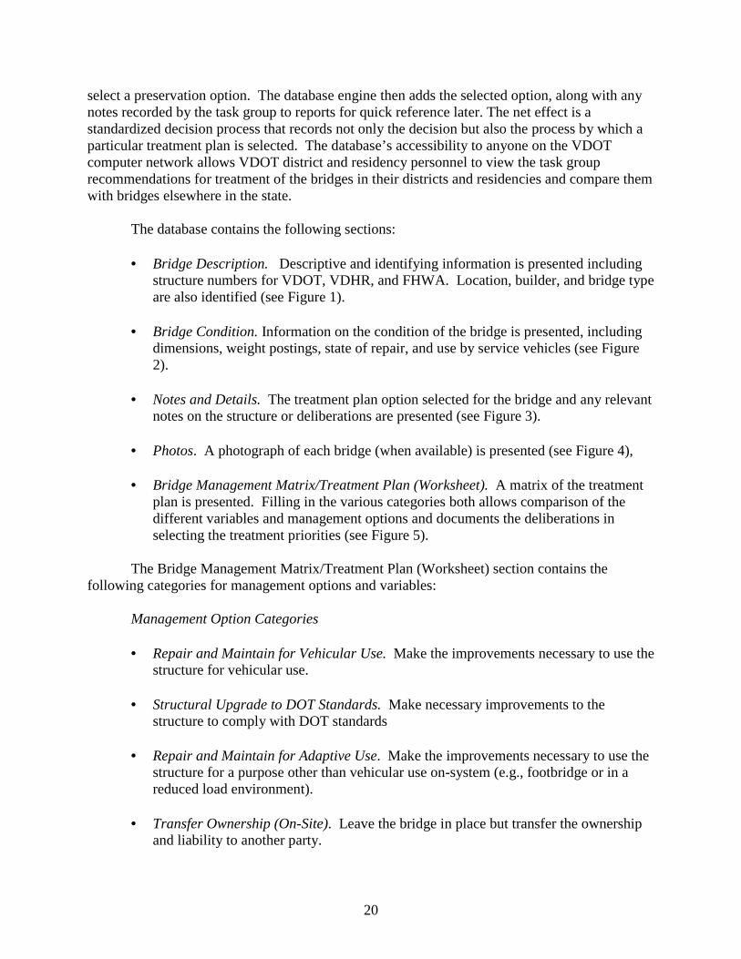
• Bridge Description. Descriptive and identifying information is presented including
structure numbers for VDOT, VDHR, and FHWA. Location, builder, and bridge type are also identified (see Figure 1).
• Bridge Condition. Information on the condition of the bridge is presented, including
dimensions, weight postings, state of repair, and use by service vehicles (see Figure 2).
• Notes and Details. The treatment plan option selected for the bridge and any relevant
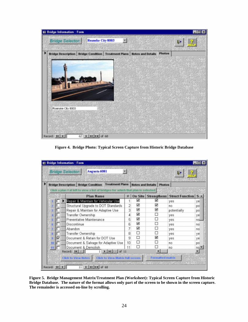
notes on the structure or deliberations are presented (see Figure 3). • Photos. A photograph of each bridge (when available) is presented (see Figure 4), • Bridge Management Matrix/Treatment Plan (Worksheet). A matrix of the treatment
plan is presented. Filling in the various categories both allows comparison of the different variables and management options and documents the deliberations in selecting the treatment priorities (see Figure 5).
The Bridge Management Matrix/Treatment Plan (Worksheet) section contains the following categories for management options and variables:
Management Option Categories • Repair and Maintain for Vehicular Use. Make the improvements necessary to use the
structure for vehicular use. • Structural Upgrade to DOT Standards. Make necessary improvements to the
structure to comply with DOT standards • Repair and Maintain for Adaptive Use. Make the improvements necessary to use the
structure for a purpose other than vehicular use on-system (e.g., footbridge or in a reduced load environment).
• Transfer Ownership (On-Site). Leave the bridge in place but transfer the ownership
and liability to another party.

21
• Preventive Maintenance. Do minor repairs and maintenance to keep the structure open and to avoid/minimize future deterioration.
• Discontinue. Take the structure off-system while maintaining the legal right of way. • Abandon. Take the structure off-system and end the legal right of way. • Transfer Ownership (Off-Site). Give the structure to an interested party who will
dismantle and relocate it. • Document and Retain for DOT Use. Document the structure, dismantle it, and save it
for future vehicular use by the DOT in another location. • Document and Retain for Adaptive Use. Document the structure, dismantle it, and
save it for future adaptive use. • Document and Demolish. Document the structure and demolish it.
Variable Categories • On Site. This checkbox indicates whether the structure would remain in its current
location if the treatment option were selected. • Strengthens. This checkbox indicates whether the treatment option would strengthen
the bridge (i.e., increase the load capacity). • Structural Function. This checkbox indicates if the structure will continue to function
as a bridge in the same way as it has historically if that treatment option is selected. • Sec. Standards. This checkbox indicates if this treatment option would be consistent
with the Secretary of the Interior’s Standards. • DOT Standards. This checkbox indicates whether the treatment option would either
maintain or bring the structure into compliance with DOT standards especially with regard to width of roadway and load capacity.
• Approaches. This checkbox indicates whether the treatment option would either
maintain or bring the roadway approaches to the bridge into compliance with current DOT standards for sight distance and safety.
• Hydraulic Opening. This checkbox indicates whether the treatment option would
either maintain or bring the hydraulic opening of the bridge to a size that would prevent damage in most flooding situations. This is, of course, not applicable where the bridge crosses a highway or a railroad.
22
• Customer Satisfaction. This checkbox indicates the level of satisfaction the treatment option would bring to the DOT, the preservation community, and local citizens.
• Lead. This checkbox indicates whether the treatment option will cause concerns for
lead paint issues either at the time the option is taken or in the future. • Initial Cost. This checkbox indicates a consensus on what the comparative costs of
the treatment option would be. These estimates do not include the costs of a potential replacement structure.
• Extended Cost. This checkbox indicates a consensus on what the comparative costs of
the future long-term cost of the treatment option would be. These estimates do not include the costs of a potential replacement structure.
• New Structure. This checkbox indicates whether a new structure would be necessary
at that location if the treatment option were undertaken. • Tort Risk. This checkbox indicates the comparative level of legal liability to the DOT
if the option were chosen. • Other. This provides space for miscellaneous notes. • Plan Priority. This indicates the level of priority for each treatment plan option.
Figure 1. Bridge Description. Typical Screen Capture from Historic Bridge Database

23
Figure 2. Bridge Condition: Typical Screen Capture from Historic Bridge Database
Figure 3. Bridge Notes and Details: Typical Screen Capture from Historic Bridge Database
24
Figure 4. Bridge Photo: Typical Screen Capture from Historic Bridge Database
Figure 5. Bridge Management Matrix/Treatment Plan (Worksheet): Typical Screen Capture from Historic Bridge Database. The nature of the format allows only part of the screen to be shown in the screen capture. The remainder is accessed on-line by scrolling.

25
EVALUATION OF THE DATA AND THE RESULTING MANAGEMENT PLAN
Using the database and management matrix, the task group discussed the various issues
and options for each bridge and evaluated and ranked management recommendation options. For some bridges, only one option was feasible; for other bridges, several options were possible, and these were ranked numerically in order of feasibility (as determined via use of the matrix, with 1 as the highest ranking). In some cases, two options were recommended equally; in keeping with the task group’s philosophy, “Preventive Maintenance” was frequently recommended equally with other options. If an option was “not applicable,” “not recommended,” or determined to be “not feasible” by the task group, this was stated in lieu of a numerical rating. Background information and management recommendation(s), including plan priorities, for each bridge appear in Appendix B.
CONCLUSIONS
This project produced an overall format for a statewide plan for managing historic bridges in Virginia. Using this format, which includes a relational database and decision matrix, allowed the development of a management plan for the historic bridges under VDOT’s purview. An unusual feature of this plan is that specific, individualized management recommendations were formulated for each of Virginia’s historic bridges.
This project also identified the numerous issues (including legal, engineering, regulatory,
financial, preservation, and political issues) that arise concerning the management of historic bridges. Different kinds of treatment and management options were also identified and evaluated.
The plans formulated by this study essentially eliminate the need for costly and time-
consuming bridge studies that can unnecessarily slow planning, construction, and rehabilitation projects. In addition, the management plan tailored for each bridge provides individualized both culturally and fiscally responsible stewardship for the historic bridges under VDOT’s purview.
RECOMMENDATIONS 1. The Historic Structures Task Group’s management recommendations for each historic
bridge, along with background information on each structure, are included in this report as Appendix B. Physical information on each bridge, and the relevant management recommendations and decision-making record, are available in the Historic Bridge Database and Matrix.
2. To ensure adequate funding for management (particularly maintenance, repair,
rehabilitation, adaptive use, and interpretative signage) of Virginia’s historic bridges, an

26
historic bridge management fund should be established. Annual funding needs should be reviewed and determined based on estimates of current and projected needs by district structure and bridge offices.
3. The historic bridge management plans for Virginia bridges should be reviewed and updated
as needed at least every 10 to 15 years. This timetable allows sufficient time to institute and monitor management recommendations and measure their efficacy, but not time enough for a bridge structure to deteriorate seriously. (This latter point is made with the assumption that regular inspections are made to the structure, that normal preventive maintenance and repairs are undertaken as needed, and that no major damage from natural or cultural factors occurs.) The time frame also permits identification and evaluation of changing technologies that may offer advantages (or disadvantages) for use on historic bridges. The changing societal parameters should also be taken into account. These can include such factors as an increase or decrease in population (and/or traffic) in an area, development pressures, and an increased desire by a community to acquire a specific structure for adaptive use. Each historic bridge management update should consist of (1) noting any rehabilitations, major repairs, or changes to the structure made since the last update and the current condition and needs as provided in the bridge inspection reports; (2) analyzing and evaluating these elements; and (3) recommending any necessary changes to the management plan.
ACKNOWLEDGMENTS
The authors express their gratitude to the many VDOT, VTRC, and FHWA employees who made this publication possible. Several groups and individuals deserve particular mention.
The input of the multidisciplinary Historic Structures Task Group was extremely useful.
Claude S. Napier, Jr., Thomas F. Lester, and Antony F. Opperman contributed the section on engineering elements, and John E. Wells contributed the section on historic preservation elements. District structure and bridge engineering personnel provided valuable insights and counsel on the bridges in their districts, and VDOT’s Structure & Bridge Division at the Central Office answered our numerous inquiries, helped locate file material, and provided encouragement. Michael A. Perfater, the Research Manager of VTRC’s Socioeconomic & Environmental Team, and Gary R. Allen, VDOT’s Acting Assistant Commissioner for Research & Technology, provided administrative and technical direction.
REFERENCES
American Association of State Highway Transportation Officials. 1994. A Policy on Geometric Design of Highways and Streets. Washington, DC: Author.
American Association of State Highway Transportation Officials. 1996. Standard
Specifications for Highway Bridges. Washington, DC: Author.
27
American Association of State Highway Transportation Officials. 2000. Manual for Condition Evaluation of Bridges. Washington, DC: Author.
Deibler, Dan Grove. 1975a. Metal Truss Bridges in Virginia: 1865-1932, Vol. I.
Charlottesville: Virginia Highway & Transportation Research Council. Diebler, Dan Grove. 1975b. A Survey and Photographic Inventory of Metal Truss Bridges in
Virginia, 1865-1932, Vol. II. Staunton District. Charlottesville: Virginia Highway & Transportation Research Council.
Diebler, Dan Grove. 1975c. A Survey and Photographic Inventory of Metal Truss Bridges in
Virginia, 1865-1932, Vol. III. Culpeper District. Charlottesville: Virginia Highway & Transportation Research Council.
Diebler, Dan Grove. 1976a. A Survey and Photographic Inventory of Metal Truss Bridges in
Virginia, 1865-1932, Vol. IV. Fredericksburg District. Charlottesville: Virginia Highway & Transportation Research Council.
Diebler, Dan Grove. 1976b. A Survey and Photographic Inventory of Metal Truss Bridges in
Virginia, 1865-1932, Vol. V. Richmond District. Charlottesville: Virginia Highway & Transportation Research Council.
Federal Highway Administration. n.d. Federal-Aid Policy Guide. Washington, DC: Author. Gayle, Margot; Look, David W.; and Waite, John G. 1992. Metals in America’s Historic
Buildings. Washington, DC: Preservation Press, National Trust for Historic Preservation. Grimes, Matthew C. 1999. Improving Historic Bridge Management with a Relational
Database. Bachelor’s thesis, University of Virginia, School of Engineering and Applied Science, Charlottesville.
Kim, Jai B.; Brungraber, Robert J.; and Kim, Robert H. 1988. Recycling Bridges. Civil
Engineering, November, pp. 58-59. Kim, Robert H., and Kim, Jai B. 1988. Preservation of Historic Metal Truss Bridges. Paper
presented at the Annual Meeting of the National Council on Public History, Denver, March.
Miller, Ann B., and Clark, Kenneth M. 1997. A Survey of Metal Truss Bridges in Virginia.
Charlottesville: Virginia Transportation Research Council. Miller, Ann B., and Clark, Kenneth M. 2000. A Survey of Masonry and Concrete Arch Bridges
in Virginia. Charlottesville: Virginia Transportation Research Council.
28
Miller, Ann B.; McGeehan, Daniel D.; and Clark, Kenneth M. 1996. A Survey of Non-Arched Historic Concrete Bridges in Virginia Constructed Prior to 1950. Charlottesville: Virginia Transportation Research Council.
Newlon, Howard H., Jr. 1985. Some Considerations Relating to the Need for and Development of Rehabilitation Standards and Guidelines for Historic Bridges. Typescript. Charlottesville: Virginia Transportation Research Council.
Spero, Paula A. C. 1979. A Survey and Photographic Inventory of Metal Truss Bridges in
Virginia, 1865-1932, Vol. VI. Lynchburg District. Charlottesville: Virginia Highway & Transportation Research Council.
Spero, Paula A. C. 1980. A Survey and Photographic Inventory of Metal Truss Bridges in
Virginia, 1865-1932, Vol. VII. Salem District. Charlottesville: Virginia Highway & Transportation Research Council.
Spero, Paula A. C. 1981. A Survey and Photographic Inventory of Metal Truss Bridges in
Virginia, 1865-1932, Vol. VIII. Suffolk District. Charlottesville: Virginia Highway & Transportation Research Council.
Spero, Paula A. C. 1982. A Survey and Photographic Inventory of Metal Truss Bridges in
Virginia, 1865-1932, Vol. IX. Bristol District. Charlottesville: Virginia Highway & Transportation Research Council.
Spero, Paula A. C. 1984. Criteria for Preservation and Adaptive Use of Historic Highway Structures. Charlottesville: Virginia Highway & Transportation Research Council.
Virginia Department of Transportation, Location & Design Division. n.d. Road Design Manual.
Richmond: Author. Virginia Department of Transportation, Management Services Division. n.d. Department Policy
Memoranda Manual. Richmond: Author. Weeks, Kay D., and Grimmer, Anne E. 1995. The Secretary of the Interior’s Standards for
Treatment of Historic Properties, with Guidelines for Preserving, Rehabilitating, Restoring, & Reconstructing Historic Buildings. Washington, DC: U.S. Department of the Interior.
Zuk, William; Newlon, Howard H., Jr.; and McKeel, Wallace T., Jr. 1980. Methods of
Modifying Historic Bridges for Contemporary Use. Charlottesville: Virginia Highway & Transportation Research Council.
29
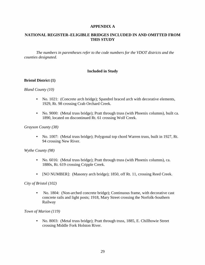
APPENDIX A NATIONAL REGISTER–ELIGIBLE BRIDGES INCLUDED IN AND OMITTED FROM
THIS STUDY The numbers in parentheses refer to the code numbers for the VDOT districts and the counties designated.
Included in Study Bristol District (1) Bland County (10)
• No. 1021: (Concrete arch bridge); Spandrel braced arch with decorative elements, 1929, Rt. 98 crossing Crab Orchard Creek.
• No. 9000: (Metal truss bridge); Pratt through truss (with Phoenix columns), built ca.
1890, located on discontinued Rt. 61 crossing Wolf Creek. Grayson County (38)
• No. 1007: (Metal truss bridge); Polygonal top chord Warren truss, built in 1927, Rt. 94 crossing New River.
Wythe County (98)
• No. 6016: (Metal truss bridge); Pratt through truss (with Phoenix columns), ca. 1880s, Rt. 619 crossing Cripple Creek.
• [NO NUMBER]: (Masonry arch bridge); 1850, off Rt. 11, crossing Reed Creek.
City of Bristol (102)
• No. 1804: (Non-arched concrete bridge); Continuous frame, with decorative cast concrete rails and light posts; 1918, Mary Street crossing the Norfolk-Southern Railway
Town of Marion (119)
• No. 8003: (Metal truss bridge); Pratt through truss, 1885, E. Chillhowie Street crossing Middle Fork Holston River.
30
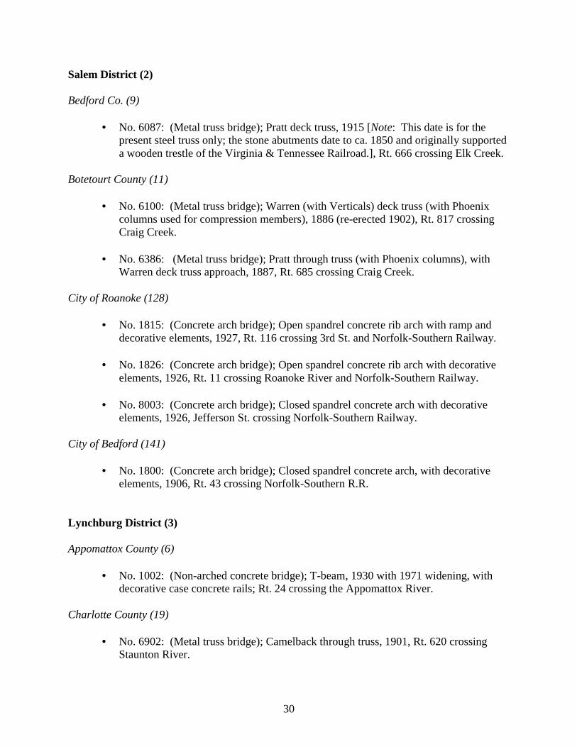
Salem District (2) Bedford Co. (9)
• No. 6087: (Metal truss bridge); Pratt deck truss, 1915 [Note: This date is for the present steel truss only; the stone abutments date to ca. 1850 and originally supported a wooden trestle of the Virginia & Tennessee Railroad.], Rt. 666 crossing Elk Creek.
Botetourt County (11)
• No. 6100: (Metal truss bridge); Warren (with Verticals) deck truss (with Phoenix columns used for compression members), 1886 (re-erected 1902), Rt. 817 crossing Craig Creek.
• No. 6386: (Metal truss bridge); Pratt through truss (with Phoenix columns), with
Warren deck truss approach, 1887, Rt. 685 crossing Craig Creek. City of Roanoke (128)
• No. 1815: (Concrete arch bridge); Open spandrel concrete rib arch with ramp and decorative elements, 1927, Rt. 116 crossing 3rd St. and Norfolk-Southern Railway.
• No. 1826: (Concrete arch bridge); Open spandrel concrete rib arch with decorative
elements, 1926, Rt. 11 crossing Roanoke River and Norfolk-Southern Railway.
• No. 8003: (Concrete arch bridge); Closed spandrel concrete arch with decorative elements, 1926, Jefferson St. crossing Norfolk-Southern Railway.
City of Bedford (141)
• No. 1800: (Concrete arch bridge); Closed spandrel concrete arch, with decorative elements, 1906, Rt. 43 crossing Norfolk-Southern R.R.
Lynchburg District (3) Appomattox County (6)
• No. 1002: (Non-arched concrete bridge); T-beam, 1930 with 1971 widening, with decorative case concrete rails; Rt. 24 crossing the Appomattox River.
Charlotte County (19)
• No. 6902: (Metal truss bridge); Camelback through truss, 1901, Rt. 620 crossing Staunton River.

31
Nelson County (62)
• No. 6052: (Metal truss bridge); Pratt through truss, 1882, Rt. 653 crossing Norfolk-Southern Railway.
• No. 6070: (Masonry arch bridge); ca. 1835, Rt. 606 crossing Owens Creek.
City of Danville (108)
• No. 1811: (Concrete arch bridge); Open spandrel concrete arch with decorative molded balusters on railing, 1927, Rt. 29/Main St. crossing Dan River.
• No. 8006: (Concrete arch bridge); Open spandrel concrete arch with decorative
molded balusters on railing, 1928, Worsham St. crossing Dan River. City of Lynchburg (118)
• No. 1849: (Non-arched concrete bridge); Coded as a slab, 1908, Bedford Avenue
crossing the Norfolk-Southern Railway.
• No. 8044: (Masonry arch bridge); 1839, 9th St. crossing old James River & Kanawha Canal.
Richmond District (4) Brunswick County (12)
• No. 6104: (Metal truss bridge); Pratt through truss, 1884, Rt. 715 crossing Meherrin River.
Chesterfield County (20)
• [NO NUMBER] (Masonry arch bridge); ca. 1823, at Falling Creek Wayside, off Rt. 1, crossing Falling Creek.
Dinwiddie County (26
• No. 1005: (Concrete arch bridge); Concrete through arch, 1926, Rt. 1 crossing Stony Creek.
Henrico County (43)
• No. 1001: (Non-arched concrete bridge); Continuous rigid-frame, with decorative cast concrete rails and fascia, 1938, Rt. 1 crossing Upham Brook
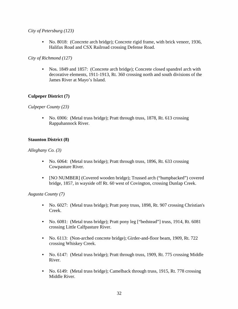
32
City of Petersburg (123)
• No. 8018: (Concrete arch bridge); Concrete rigid frame, with brick veneer, 1936, Halifax Road and CSX Railroad crossing Defense Road.
City of Richmond (127)
• Nos. 1849 and 1857: (Concrete arch bridge); Concrete closed spandrel arch with decorative elements, 1911-1913, Rt. 360 crossing north and south divisions of the James River at Mayo’s Island.
Culpeper District (7) Culpeper County (23)
• No. 6906: (Metal truss bridge); Pratt through truss, 1878, Rt. 613 crossing Rappahannock River.
Staunton District (8) Alleghany Co. (3)
• No. 6064: (Metal truss bridge); Pratt through truss, 1896, Rt. 633 crossing Cowpasture River.
• [NO NUMBER] (Covered wooden bridge); Trussed arch (“humpbacked”) covered
bridge, 1857, in wayside off Rt. 60 west of Covington, crossing Dunlap Creek. Augusta County (7)
• No. 6027: (Metal truss bridge); Pratt pony truss, 1898, Rt. 907 crossing Christian's Creek.
• No. 6081: (Metal truss bridge); Pratt pony leg [“bedstead”] truss, 1914, Rt. 6081
crossing Little Calfpasture River.
• No. 6113: (Non-arched concrete bridge); Girder-and-floor beam, 1909, Rt. 722 crossing Whiskey Creek.
• No. 6147: (Metal truss bridge); Pratt through truss, 1909, Rt. 775 crossing Middle
River.
• No. 6149: (Metal truss bridge); Camelback through truss, 1915, Rt. 778 crossing Middle River.
33
• No. 6165: (Concrete arch bridge); Spandrel braced arch, 1932, Rt. 835 crossing Jennings Branch.
• No. 6553: (Non-arched concrete bridge); Deck girder, 1925, Rt. 1205 crossing South
River.
• No. 6729: (Metal truss bridge); Pratt through truss, 1907, Rt. 769 crossing Middle River.
• [NO NUMBER] (Masonry arch bridge); 1874, crossing Folly Mills Creek just west of
I- 81, south of Staunton. Frederick County (39)
• No. 6903: (Concrete arch bridge); Concrete closed spandrel arch bridge, 1917, Rt. 672 crossing Opequon Creek.
Highland County (45)
• No. 6034: (Metal truss bridge); Lane Patent pony truss, 1896, Rt. 645 crossing Crab Run.
Page County (69)
• No. 1004: (Metal truss bridge); Pratt deck arch truss, 1936, Rt. 340 crossing Jeremiah's Run.
• No. 1990: (Metal truss bridge); Pratt deck arch truss, 1938, Rt. 340 crossing Overall
Creek. Rockbridge County (81)
• No. 1012: (Concrete arch bridge); Rigid frame with stone veneer, 1940, Rt. 39 crossing Laurel Run.
• No. 6145: (Metal truss bridge); Pratt through truss, 1890, Rt. 746 crossing
Calfpasture River. Rockingham County (82)
• No. 6154: (Metal truss bridge); Thacher through truss, 1898, Rt. 1421 crossing Linville Creek.
34
Shenandoah County (85)
• No. 6078: (Covered wooden bridge); Burr arch truss, built ca. 1893, Rt. 720 crossing North Fork of Shenandoah River.
City of Covington (107)
• No. 8002: (Metal truss bridge); Pratt through truss (with Phoenix columns), ca. 1885/ca. 1900, Hawthorne St. crossing CSX Railroad.
Northern Virginia District (A) Arlington County (0)
• No. 5020: (Non-arched concrete bridge); Rigid frame, with decorative stone veneer, 1945, Memorial Avenue, crossing Rt. 110, adjoining Arlington National Cemetery.
Loudoun County (53)
• No. 1025: (Masonry arch bridge); ca. 1810-1824, Rt. 50 crossing Little River.
• No. 6051: (Metal truss bridge); Pratt through truss, date uncertain (probably ca. 1889), Rt. 673 crossing N. Fork Catoctin Creek.
• No. 6088: (Masonry arch bridge); ca. 1829, Rt. 734 crossing Beaverdam Creek.
Prince William County (76)
• No. 6023: (Metal truss bridge); Pratt through truss, 1882, Rt. 646 crossing Norfolk-Southern Railway.
Programmed, Demolished, Dismantled, or Replaced Bridges (Including bridges no longer under VDOT ownership or purview)
Note: None of these structures was rated by the task group; the majority was determined eligible for the National Register as part of replacement projects. Management of these structures generally involved documentation and demolition; a portion of one bridge, and the whole of another were salvaged for re-erection elsewhere under new ownership. These structures have been recorded to standards agreed upon by VDOT, VDHR, FHWA and/or the Advisory Council on Historic Preservation. If other standards of recordation or treatment have been used, this is specified.
35
Bristol District (1) Wythe County (98)
• No. 1005: (Metal truss bridge); Pratt deck truss, 1931, Rt. 11 crossing Reed Creek. Not rated by the task group; previously determined eligible as part of a project; DOCUMENTED, DEMOLISHED, AND REPLACED.
• No. 1017: (Metal truss bridge); Warren (with Verticals) Cantilever / Continuous
through truss, with conventional Warren (with Verticals) through truss approach spans, 1931, Rt. 52 crossing New River. Not rated by the task group; previously determined eligible as part of a project; DOCUMENTED, DEMOLISHED, AND REPLACED. This structure was recorded to Historic American Engineering Record Standards (HAER No. VA-113).
Salem District (2) Giles Co. (35)
• No. 6019: (Metal truss bridge); Pennsylvania through/Camelback through/Pratt pony truss, 1916, crossing New River. Not rated by the task group; previously determined eligible; DOCUMENTED, (PART) DISMANTLED / (PART) DEMOLISHED, AND REPLACED. This structure was recorded to Historic American Engineering Record Standards (HAER No. VA-68); a portion of the structure was salvaged for re-erection as a park bridge.
Lynchburg District (3) Buckingham County (14)
• No. 1987: (Metal truss bridge); Warren (with Verticals) deck truss, 1934, Rt. 15 crossing James River/CSX Railroad/Rt. 656. Not rated by the task group; previously determined eligible as part of a project; DOCUMENTED AND BYPASSED; A NEW BRIDGE WAS OPENED TO TRAFFIC ON DECEMBER 1, 2000; DEMOLITION OF THE BYPASSED STRUCTURE IS PROGRAMMED.
Campbell County (15)
• No. 6904: (Metal truss bridge); Camelback through truss, 1903, Rt. 640 crossing Staunton River. Not rated by the task group; previously entered on National Register; a long-term effort by VDOT to find a willing recipient to assume ownership of this structure was not successful; DOCUMENTED, DEMOLISHED, AND REPLACED. This structure was recorded to Historic American Engineering Record Standards (HAER No. VA-106).
36
Richmond District (4) City of Petersburg (123)
• No. 1813: (Non-arched concrete bridge); Continuous concrete T-beam, 1925 (serves as access to No. 1912).
• No. 1912: (Non-arched concrete bridge); Continuous concrete T-beam, 1925, Rt. 1
crossing Appomattox River. Not rated by the task group; previously determined eligible as part of a project; DOCUMENTATION, DEMOLITION AND REPLACEMENT IS PROGRAMMED.
City of Richmond (127)
• No. 8066: (Non-arched concrete bridge); Continuous concrete girder, 1935, 1st Street crossing the CSX RR and Valley Road. Not rated by the task group; previously determined eligible as part of a project; DOCUMENTED, DEMOLISHED, AND REPLACED. This structure was recorded to Historic American Engineering Record Standards (HAER No. VA-67).
Culpeper District (7) Culpeper County (23)
• No. 6046: (Non-arched concrete bridge); Concrete girder-and-floor beam with slab approach spans, 1913, Rt. 669 crossing Mountain Run. Not rated by the task group; previously determined eligible as part of a project; DOCUMENTED, DEMOLISHED, AND REPLACED.
Staunton District (8) Alleghany Co. (3)
• No. 1923: (Concrete arch bridge); Open spandrel concrete arch, 1925, Rt. 60 crossing Jackson River. Not rated by the task group; previously determined eligible as part of a project; DOCUMENTED, DEMOLISHED, AND REPLACED.
Highland County (45)
• No. 6001: (Metal truss bridge); Pratt through truss, 1905, Rt. 603 crossing Back Creek. Not rated by the task group; previously determined eligible as part of a project; DOCUMENTED, DISMANTLED, AND REPLACED; THE DISMANTLED BRIDGE IS STORED AT THE COUNTY LANDFILL, PENDING

37
RE-ERECTION; OWNERSHIP WAS TRANSFERRED TO THE HIGHLAND COUNTY CHAMBER OF COMMERCE.

38

39
APPENDIX B
MANAGEMENT RECOMMENDATIONS FOR VIRGINIA’S HISTORIC BRIDGES UNDER VDOT’s PURVIEW
Terminology In addition to the terms defined in the section on the database, the following terms are used in the
recommendations:
• Right-of-Way Ownership: In the absence of other evidence, the approaches to bridges on primary routes are presumed to be held in fee simple. The approaches to bridges on secondary roads are presumed to be on prescriptive easement (usually a right of way of 30 feet, which was the statutory width for county roads constructed prior to the creation of the state secondary system in 1932). Known exceptions (i.e., in cases where the road postdates 1932, where a right of way has been purchased as part of a project, or where title searches have revealed a different ownership situation) are noted for each bridge.
• Overlays: Concrete overlays include such materials as latex, silica fume, or a thin-bonded
polymer.
• H & HA: Hydrologic and Hydraulic Analysis. The hydrologic portion is the act of estimating a quantity of water at a given point, using watershed characteristics and historic rainfall data. This quantity of water is usually shown as cubit feet per meters per second and is estimated for given return frequencies (Q10, Q25, Q50, Q100, etc.) The hydraulic portion is the performance/reaction of the structure, channel, or bridge when under flood at one or more specified return frequencies.
Listings
Bridges are listed by type, in the following order:
• non-arched concrete bridges • metal truss bridges • masonry arch/concrete arch bridges • covered bridges.
40
NON-ARCHED CONCRETE Bristol District (1)
City of Bristol (102) VDOT Structure No. 1804 VDHR Inventory No. 102-5008 Name: Mary Street Bridge Location: Mary Street crossing the Norfolk Southern Railway National Register Status: Eligible Description: City of Bristol Structure No. 1804 is a five-span continuous concrete bent (not rigid) frame bridge [207], built in 1918 by the Norfolk and Western Railroad, carrying Mary Street crossing the Norfolk Southern Railway. This structure is approximately 232 feet long and has decorative cast concrete rails and light posts. As originally designed, the structure had a provision for a central streetcar track. This is one of two pre-1920 continuous concrete frame bridges surviving in Virginia and is one of the most elaborate concrete railroad bridges surviving from that period. Evaluation: City of Bristol Structure No. 1804 was recommended as eligible for listing in the National Register of Historic Places by the Historic Structures Task Group in November 1995, a determination confirmed by the Virginia SHPO and VDOT’s Commissioner by agreement dated October 23, 1997. Documentation: City of Bristol Structure No. 1804 was included in the non-arched concrete bridge survey prepared by VTRC (Miller, McGeehan, and Clark 1996). Condition: The current inspection report indicates that this structure is in poor condition. It exhibits areas of cracking, spalling, and delamination. Moisture is seeping through the deck (expressed on the underside of the deck by efflorescence and stalactites). The drains are blocked. The substructure elements exhibit areas of deterioration with numerous cracks, delaminations, and spalled concrete. Posted Restrictions: The structure is posted at 15 tons. ADT: 7,624. Right-of-Way Ownership: This structure is within the limits of the City of Bristol. Fee simple ownership of the approaches is presumed. The railroad owns and maintains the structure. Recommended Treatment: Because the Norfolk Southern Railway owns and maintains this structure, recommendations for adaptive use, transferring ownership on-site, abandoning it, and demolition are not applicable. In addition, because of its concrete construction, moving the structure to another location or transferring ownership off-site is not an option. Recommended management options for this structure, in order of preference, are:
1. Repair and maintain for vehicular use, with subsequent preventive maintenance as needed. Immediate repair recommendations are to remove the asphalt overlay, evaluate and repair the deck, install a new concrete overlay, clear and extend the drains, and repair spalled and delaminated areas.
2. An upgrade to DOT standards is feasible and could be considered as a second option. With
an upgrade (such as use of external post-tensioning), the posting could be raised to 35 tons.
However, it should be noted that the task group, and VDOT, have no procedural control over this structure.
41
NON-ARCHED CONCRETE Lynchburg District (3)
Appomattox County (6) VDOT Structure No. 1002 VDHR Inventory No. 006-0048 Location: Route 24, crossing Appomattox River National Register Status: Eligible Description: Appomattox County Structure No. 1002 is a single-span T-beam structure [104], built in 1930 with a 1971 widening, carrying Rt. 24 crossing the Appomattox River. The structure is approximately 33 feet long. A commemorative bridge built in the vicinity of the Civil War surrender site at Appomattox Court House, this structure has unique cast concrete rails incorporating Union and Confederate motifs, with end posts topped with obelisks. (The bridge antedates the national park by 5 years and appears to have been intended as part of a memorial wayside or picnic area.) The rails were moved and reused, and the end posts and obelisks were replicated when the bridge was widened in 1971. Evaluation: Appomattox County Structure No. 1002 was recommended as eligible for listing in the National Register of Historic Places by the Historic Structures Task Group in November 1995, a determination confirmed by the Virginia SHPO and VDOT’s Commissioner by agreement dated October 23, 1997. Documentation: Appomattox County Structure No. 1002 was included in the non-arched concrete bridge survey prepared by VTRC (Miller, McGeehan, and Clark 1996). Condition: The current inspection report indicates that this structure is in fair condition. There is some spalling and moisture seepage in the bottom deck. Cracks are present in the breast wall and in the T-beams. There is a small amount of spalling on the railposts. There is scour in the channel and under the footing. Additionally, there is scaling of the breast wall and delamination in the endwall. The wearing surface is delaminated. Vegetation is encroaching on the bridge. Posted Restrictions: None. ADT: 4,423. Right-of-Way Ownership: This structure carries a primary route. Fee simple ownership is presumed. Recommended Treatment: Because of its concrete construction, location, and unique decorative design, moving the structure to another location or abandoning it is not an option. Demolition is not recommended. The structure has already been widened; an upgrade to DOT standards is not necessary. The recommended management options for this structure, in order of preference, are:
1. Repair and maintain for vehicular use, with subsequent preventive maintenance as needed. Immediate repair recommendations are to remove the asphalt overlay, evaluate and repair the deck, install a new concrete overlay, clean drains, remove vegetation, repair spalled and delaminated areas, and address the scour problem. H & HA is recommended.
2. Transfer of ownership is not considered a feasible option at present; however, were Rt. 24 to
be realigned, and in the event of interest in acquiring the bridge on the part of the National Park Service, this could be considered as a second option.

42
NON-ARCHED CONCRETE Lynchburg District (3)
City of Lynchburg (118) VDOT Structure No. 1849 VDHR Inventory No. 118-0213 Location: Bedford Avenue, crossing the Norfolk Southern Railway National Register Status: Eligible Description: City of Lynchburg Structure No. 1849 is a single-span structure coded as a slab [101], built in 1908, carrying Bedford Avenue crossing the Norfolk Southern Railway. The structure is approximately 104 feet long overall, including solid concrete approaches; the non-arched span is approximately 47 feet long. It is the oldest known surviving non-arched concrete bridge in Virginia. The exact construction technology is uncertain: the bridge was built by the Southern Railway; however, according to the Norfolk Southern archives, no plans survive. The 47-foot length far exceeds the maximum length (25 feet) recommended for slab spans at this time. The heavy (2 feet thick) parapets suggest a through-girder, but the width of the bridge (35 feet with an additional 5-foot sidewalk) is double the usual 20-foot maximum width for through-girders. Possibly, it is a slab with extremely heavy reinforcement or conventional reinforcement strengthened with encased I-beams. Evaluation: City of Lynchburg Structure No. 1849 was recommended as eligible for listing in the National Register of Historic Places by the Historic Structures Task Group in November 1995, a determination confirmed by the Virginia SHPO and VDOT’s Commissioner by agreement dated October 23, 1997. Documentation: City of Lynchburg Structure No. 1849 was included in the non-arched concrete bridge survey prepared by VTRC (Miller, McGeehan, and Clark 1996). Condition: The current inspection report indicates that this structure is in poor condition. There are various areas of concrete deterioration, spalling, and cracking throughout the bridge. Moisture seepage, efflorescence, spalling, and exposed rebar are apparent on the underside of the deck. There are stress cracks in both breast walls. The asphalt wearing surface is cracking and settling; the asphalt layer is heavy on this structure (approximately 8 inches thick). Erosion from stormwater is causing undermining of the footings. Posted Restrictions: None. ADT: 6,444. Right-of-Way Ownership: This structure is within the limits of the City of Lynchburg. The city owns and maintains the structure. Fee simple ownership of the approaches is presumed. Recommended Treatment: Because of its concrete construction and location, moving the structure to another location, adaptive use, abandoning it, or transferring ownership is not an option. An upgrade to DOT standards is not necessary. Demolition is not recommended at this point. The recommended management option for this structure is to repair and maintain for vehicular use, with subsequent preventive maintenance as needed. Immediate repair recommendations are to remove the asphalt overlay, evaluate and repair the deck, install a new concrete overlay, repair spalled and delaminated areas, address the stormwater erosion, and clear and monitor the drains. Concrete deterioration must be monitored. Note: New railroad height requirements may affect the future plans for this bridge. Should demolishing this structure eventually become necessary, a demolition study should be undertaken to determine the exact method of construction.

43
NON-ARCHED CONCRETE Richmond District (4)
Henrico County (43) VDOT Structure No. 1001 VDHR Inventory No. 043-0710 Location: Route 1 crossing Upham Brook National Register Status: Eligible Description: Henrico County Structure No. 1001 is a three-span continuous concrete rigid-frame bridge [207], with decorative cast concrete rails and fascia, built in 1938, carrying Rt. 1 crossing Upham Brook. This structure is approximately 85 feet long overall; each span is approximately 28 feet long. This is one of three pre-1950 continuous rigid frame bridges surviving in Virginia and is the only one of these not crossing a railroad. The Gothic-style decorative motifs, extending not only to the rails but also to the fascia, are unique in Virginia. Evaluation: Henrico County Structure No. 1001 was recommended as eligible for listing in the National Register of Historic Places by the Historic Structures Task Group in November 1995, a determination confirmed by the Virginia SHPO and VDOT’s Commissioner by agreement dated October 23, 1997. Documentation: Henrico County Structure No. 1001 was included in the non-arched concrete bridge survey prepared by VTRC (Miller, McGeehan, and Clark 1996). Condition: The current inspection report indicates that this structure is in fair condition. There are random hairline cracks with some efflorescence and areas of discolored concrete on the underside of the deck. In addition, the structure exhibits a small amount of spalling. There are popouts and abrasion on the abutments, and an impact crack on one endpost. The drains are blocked. Vegetation is encroaching on the bridge. One wingwall appears to be under stress. Posted Restrictions: None. ADT: 11,830. Right-of-Way Ownership: This structure carries a primary route. Fee simple ownership is presumed. Recommended Treatment: Because of its concrete construction and location, moving the structure to another location, abandoning it, adaptive use, or transferring ownership is not an option. Demolition is not recommended. A structural upgrade to DOT standards is not necessary. The recommended management option for this structure is to repair and maintain for vehicular use, with subsequent preventive maintenance as needed. Immediate repair recommendations are to cut back and remove vegetation from around the structure and open and extend the drains below the level of the beams. Evaluate the deck waterproofing system; if it is deficient, upgrade with a concrete overlay. Repair spalled areas as needed, and monitor the wingwall. H & HA is recommended.
44
NON-ARCHED CONCRETE Staunton District (8)
Augusta County (07) VDOT Structure No. 6113 VDHR Inventory No. 007-1304 Location: Route 722 crossing Whiskey Creek National Register Status: Eligible Description: Augusta County Structure No. 6113 is a single-span girder-and-floor beam [103] structure, built in 1909, carrying Rt. 722 crossing Whiskey Creek. The bridge is approximately 44 feet long. This bridge is the oldest girder-and-floor beam bridge in the state and is the first concrete bridge in Virginia built with state aid funds. Evaluation: Augusta County Structure No. 6113 was recommended as eligible for listing in the National Register of Historic Places by the Historic Structures Task Group in November 1995, a determination confirmed by the Virginia SHPO and VDOT’s Commissioner by agreement dated October 23, 1997. Documentation: Augusta County Structure No. 6113 was included in the non-arched concrete bridge survey prepared by VTRC (Miller, McGeehan, and Clark 1996). Condition: The current inspection report indicates that this structure is in poor condition. Both its exterior girders have deep spalling on the bottom sides that diminish on the vertical sides. The deck bottom and diaphragms are delaminated, with up to 3 inches of deep spalling and exposed rebar in scattered areas. The drains are blocked, and there are areas of vegetation on the bridge. There have been previous scour problems; riprap has been placed on the banks. Posted Restrictions: The structure is posted at 12 tons. ADT: 103. Right-of-Way Ownership: Because of the structure’s location on a portion of a secondary roadway that has undergone no substantial improvement projects since the creation of the secondary system in 1932, the approaches are presumed to be constructed on prescriptive easement. Recommended Treatment: Because of its through-girder concrete construction, moving the structure to another location or upgrading it to DOT standards is not an option. If traffic demands increase, the surrounding topography provides a logical route to bypass this structure; it could then be maintained for adaptive use or ownership transferred to a willing landowner. Recommended management options for this structure, in order of preference, are:
1. Repair and maintain for vehicular use, with subsequent preventive maintenance as needed. Immediate repair recommendations are to repair spalled and delaminated areas, clear the drains, monitor scour, and keep the bridge clear of vegetation. Additional recommendations are to remove the asphalt overlay; evaluate and repair the deck; and, if needed, install a new concrete overlay.
2. Repair and maintain for adaptive use. 3. Transfer ownership if a willing recipient can be identified.
45
NON-ARCHED CONCRETE Staunton District (8)
Augusta County (07) VDOT Structure No. 6553 VDHR Inventory No. 007-1319 Location: Route 1205 crossing South River National Register Status: Eligible Description: Augusta County Structure No. 6553 is a single-span deck girder structure [102], built in 1925, carrying Rt. 1205 crossing South River. The bridge is approximately 38 feet long. This is an excellent and well-preserved example of deck girder technology. The structure was built from standard plans. Evaluation: Augusta County Structure No. 6553 was recommended as eligible for listing in the National Register of Historic Places by the Historic Structures Task Group in November 1995, a determination confirmed by the Virginia SHPO and VDOT’s Commissioner by agreement dated October 23, 1997. Documentation: Augusta County Structure No. 6553 was included in the non-arched concrete bridge survey prepared by VTRC (Miller, McGeehan, and Clark 1996). Condition: The current inspection report indicates that this structure is in fair condition. There are relatively minor areas of delaminated, deteriorated, and spalled concrete throughout the structure. The drains are clogged with debris. There is vegetation and silt accumulation on and around the bridge. There are no known previous scour or hydrologic problems. Posted Restrictions: None. ADT: 893. Right-of-Way Ownership: This structure was built on the route of the old Valley Pike (subsequently Rt. 11) in 1925, seven years after the Valley Pike was acquired by the Commonwealth. Therefore, fee simple ownership is presumed. Rt. 11 was not moved to its present location until the 1930s. Recommended Treatment: Because of its concrete construction and location, moving the structure to another location, abandoning it, or transferring ownership is not an option. An upgrade to DOT standards is not feasible. The recommended management option for this structure is to repair and maintain for vehicular use, with subsequent preventive maintenance as needed. Immediate repair recommendations are to repair spalled and delaminated areas, open and extend the drains, and remove the accumulated silt and vegetation. Additional recommendations are to remove the asphalt overlay, evaluate and repair the deck, and install a new concrete overlay if needed.
46
NON-ARCHED CONCRETE Northern Virginia District (A)
Arlington County (0) VDOT Structure No. 5020 VDHR Inventory No. 000-2270 Location: Memorial Avenue, crossing Route 110 National Register Status: Eligible Description: Arlington County Structure No. 5020 is a two-span rigid frame structure [107] with decorative stone veneer. Built in 1945, it carries Memorial Avenue crossing Rt. 110, adjoining Arlington National Cemetery. In place of conventional concrete railings, the structure has sidewalks; broad, grassed verges; and a hedge concealing a simple pipe railing. The structure is approximately 60 feet long. This significance of this bridge derives from a combination of its rigid frame technology, decorative stonework, and relation to the landscape design of Arlington cemetery. Evaluation: Arlington County Structure No. 5020 was recommended as eligible for listing in the National Register of Historic Places by the Historic Structures Task Group in November 1995, a determination confirmed by the Virginia SHPO and VDOT’s Commissioner by agreement dated October 23, 1997. The structure also adjoins Arlington National Cemetery. Documentation: Arlington County Structure No. 5020 was included in the non-arched concrete bridge survey prepared by VTRC (Miller, McGeehan, and Clark 1996). Condition: The current inspection report indicates that this structure is in good condition, with no apparent condition problems. Posted Restrictions: None. ADT: 39,090. Right-of-Way Ownership: This structure carries a primary route. Fee simple ownership is presumed. Recommended Treatment: Arlington County Structure No. 5020 has no apparent condition problems and requires no immediate action. Because of its concrete construction and location, moving the structure to another location, abandoning it, or transferring ownership is not an option. Because of landscaping elements, an upgrade to DOT standards is not feasible. Management recommendations consist of normal preventive maintenance and repairing and maintaining for vehicular use at such time that this becomes necessary.
47
METAL TRUSS Bristol District (1)
Bland County (10) VDOT Structure No. 9000 VDHR Inventory No. 010-0166 Location: Discontinued Route 61, crossing Wolf Creek National Register Status: Eligible Description: Bland County Structure No. 9000 is a single-span Pratt through truss (with Phoenix columns), built ca. 1890, located on discontinued Rt. 61 crossing Wolf Creek. The structure is approximately 206 feet long. This plain, heavily configured former railroad bridge is one of Virginia’s five examples of a truss using the patented Phoenix column. Although no builder is documented, the presence of Phoenix columns suggests that it was probably built by the Phoenix Bridge Co. This structure may have been moved from elsewhere and re-erected on its present site to serve the New River, Holston, and Western Railroad (founded 1912). In 1919, the line was acquired by the Norfolk and Western Railroad; rail service was discontinued in 1946, and this portion of the route subsequently became a highway right of way. The bridge and attendant section of highway were bypassed when Rt. 61 was realigned. Evaluation: Bland County Structure No. 9000 was recommended as eligible for listing in the National Register of Historic Places by the Historic Structures Task Group in August 1996, a determination confirmed by the Virginia SHPO and VDOT’s Commissioner by agreement dated October 23, 1997. Documentation: Bland County Structure No. 9000 was included in the initial metal truss survey report prepared by VTRC (Deibler/Spero 1975-1982) and the more recent update (Miller and Clark 1997). Condition: Bland County Structure No. 9000 was closed in 1987 because of the realignment of Rt. 61. Barriers have been erected to prevent vehicular access to the structure; however, the bridge is accessible to foot traffic. The structure is still being inspected: the current inspection report rates this structure in poor condition. However, this is primarily because of corrosion and section loss on the floor stringers (the stringers are later additions to the structure). The floor beams exhibit medium to heavy rust. The truss members exhibit some areas of rust and spot rust. One deck board is partially deteriorated. There are hairline cracks and minor spalling on the abutments. Vegetation is encroaching on the structure and could eventually cause deterioration of the bridge. (The recent inspection report recommended removing vegetation and replacing deteriorated decking boards on the west approach.) Posted Restrictions: None. The structure is closed to vehicular traffic. Right-of-Way Ownership: As the result of the acquisition of the old railroad right of way, the approaches to Bland County Structure No. 9000 are presumed to be held in fee simple. Recommended Treatment: Because of the structure’s location and the fact that the realignment of Rt. 61 rendered the old bridge superfluous for vehicular use, repairing and maintaining the structure for vehicular use is not applicable. Recommended management options for the bridge, in order of preference, are:
1. Preventive maintenance with eventual transfer of ownership on-site. Preventive maintenance (in the form of removing vegetation and keeping the weepholes at the base of the Phoenix columns clear of debris) should be practiced until a potential owner can be identified. The paint appears to be in good condition, but this should be tested; if the paint is in good condition, the structure would benefit from a topcoat. [Note: On July 25, 2000, the Bland
48
County Board of Supervisors passed a resolution asking VDOT to abandon the bridge and associated roadway, thus passing ownership of the structure to the County. By resolution, the County stated its intention to transform the bridge and roadway into “a park in the Community of Rocky Gap,” for which they could seek transportation enhancement funds. The task group heartily endorses this proposed adaptive use.]
2. Repair and maintain for adaptive use on-site.
3. Document and salvage for adaptive use off-site.
4. Transfer ownership off-site (i.e., with the new owner agreeing to move the structure to another site). The size of this structure renders this option unlikely and problematic.
5. Abandon the structure if this would place the responsibility for the structure in the hands of
an unwilling recipient; the structure would likely not receive any maintenance and would be allowed to deteriorate or be demolished.
49
METAL TRUSS Bristol District (1)
Grayson County (38) VDOT Structure No. 1007 VDHR Inventory No. 038-0073 Location: Route 94, crossing New River National Register Status: Eligible Description: Grayson County Structure No. 1007 is a five-span polygonal top chord Warren truss, built in 1927 by the Roanoke Iron & Bridge Works, carrying Rt.. 94 crossing New River. Each span is 165 feet long; the total length of the structure is approximately 912 feet. This bridge was built from standard plans. Evaluation: Grayson County Structure No. 1007 was recommended as eligible for listing in the National Register of Historic Places as part of a project. This assessment was reiterated by the Historic Structures Task Group in August 1996, a determination confirmed by the Virginia SHPO and VDOT’s Commissioner by agreement dated October 23, 1997. Documentation: Grayson County Structure No. 1007 was included in the initial metal truss survey report prepared by VTRC (Deibler/Spero 1975-1982) and the more recent update (Miller and Clark 1997). Condition: Grayson County Structure No. 1007 is in poor condition; a replacement bridge is planned. There are cracks on the wearing surface, and the bottom of the deck is spalled with exposed steel. Additional cracking and spalling are present on the pier caps, walls, and stems. The June 1999 inspection found additional deterioration, and the posted weight limit was reduced. The bridge is slated for replacement with a July 2003 advertisement date. The new bridge will open on a new alignment. Posted Restrictions: The structure has a legal limit of 27 and 40 tons, respectively. ADT: 2,366. Right-of-Way Ownership: This structure carries a primary route. Fee simple ownership is presumed. Recommended Treatment: This is an extremely large structure, of standard design and construction. There is no demand for adaptive use, and no interested potential owner(s) for either the entire bridge or separate spans. Although theoretically the structure could be repaired and maintained for continued vehicular use, the construction of the replacement bridge will render the present bridge superfluous for vehicular use. For this reason, in the task group’s opinion, repairing and maintaining for continued vehicular use, with subsequent preventive maintenance, would not be a responsible use of public monies. In this case, the task group recommends documentation and demolition as the most feasible option.
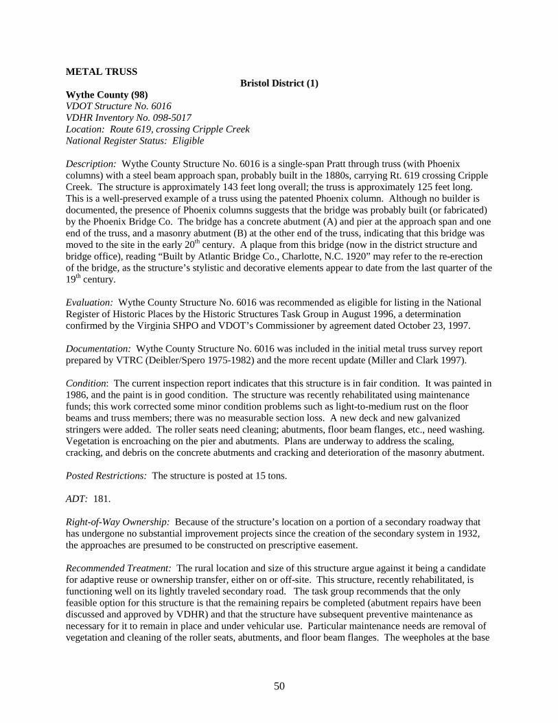
50
METAL TRUSS Bristol District (1)
Wythe County (98) VDOT Structure No. 6016 VDHR Inventory No. 098-5017 Location: Route 619, crossing Cripple Creek National Register Status: Eligible Description: Wythe County Structure No. 6016 is a single-span Pratt through truss (with Phoenix columns) with a steel beam approach span, probably built in the 1880s, carrying Rt. 619 crossing Cripple Creek. The structure is approximately 143 feet long overall; the truss is approximately 125 feet long. This is a well-preserved example of a truss using the patented Phoenix column. Although no builder is documented, the presence of Phoenix columns suggests that the bridge was probably built (or fabricated) by the Phoenix Bridge Co. The bridge has a concrete abutment (A) and pier at the approach span and one end of the truss, and a masonry abutment (B) at the other end of the truss, indicating that this bridge was moved to the site in the early 20th century. A plaque from this bridge (now in the district structure and bridge office), reading “Built by Atlantic Bridge Co., Charlotte, N.C. 1920” may refer to the re-erection of the bridge, as the structure’s stylistic and decorative elements appear to date from the last quarter of the 19th century. Evaluation: Wythe County Structure No. 6016 was recommended as eligible for listing in the National Register of Historic Places by the Historic Structures Task Group in August 1996, a determination confirmed by the Virginia SHPO and VDOT’s Commissioner by agreement dated October 23, 1997. Documentation: Wythe County Structure No. 6016 was included in the initial metal truss survey report prepared by VTRC (Deibler/Spero 1975-1982) and the more recent update (Miller and Clark 1997). Condition: The current inspection report indicates that this structure is in fair condition. It was painted in 1986, and the paint is in good condition. The structure was recently rehabilitated using maintenance funds; this work corrected some minor condition problems such as light-to-medium rust on the floor beams and truss members; there was no measurable section loss. A new deck and new galvanized stringers were added. The roller seats need cleaning; abutments, floor beam flanges, etc., need washing. Vegetation is encroaching on the pier and abutments. Plans are underway to address the scaling, cracking, and debris on the concrete abutments and cracking and deterioration of the masonry abutment. Posted Restrictions: The structure is posted at 15 tons. ADT: 181. Right-of-Way Ownership: Because of the structure’s location on a portion of a secondary roadway that has undergone no substantial improvement projects since the creation of the secondary system in 1932, the approaches are presumed to be constructed on prescriptive easement. Recommended Treatment: The rural location and size of this structure argue against it being a candidate for adaptive reuse or ownership transfer, either on or off-site. This structure, recently rehabilitated, is functioning well on its lightly traveled secondary road. The task group recommends that the only feasible option for this structure is that the remaining repairs be completed (abutment repairs have been discussed and approved by VDHR) and that the structure have subsequent preventive maintenance as necessary for it to remain in place and under vehicular use. Particular maintenance needs are removal of vegetation and cleaning of the roller seats, abutments, and floor beam flanges. The weepholes at the base

51
of the Phoenix columns should periodically be cleaned out. The new galvanized stringers should be painted after an appropriate weathering period.
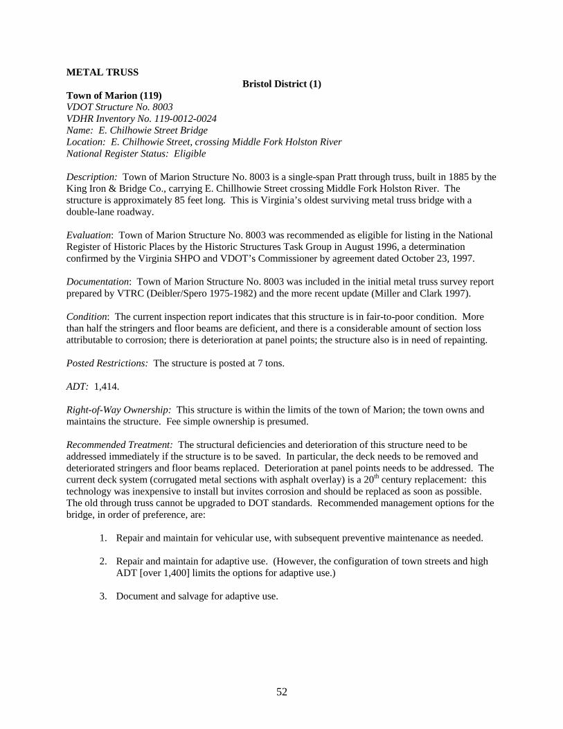
52
METAL TRUSS Bristol District (1)
Town of Marion (119) VDOT Structure No. 8003 VDHR Inventory No. 119-0012-0024 Name: E. Chilhowie Street Bridge Location: E. Chilhowie Street, crossing Middle Fork Holston River National Register Status: Eligible Description: Town of Marion Structure No. 8003 is a single-span Pratt through truss, built in 1885 by the King Iron & Bridge Co., carrying E. Chillhowie Street crossing Middle Fork Holston River. The structure is approximately 85 feet long. This is Virginia’s oldest surviving metal truss bridge with a double-lane roadway. Evaluation: Town of Marion Structure No. 8003 was recommended as eligible for listing in the National Register of Historic Places by the Historic Structures Task Group in August 1996, a determination confirmed by the Virginia SHPO and VDOT’s Commissioner by agreement dated October 23, 1997. Documentation: Town of Marion Structure No. 8003 was included in the initial metal truss survey report prepared by VTRC (Deibler/Spero 1975-1982) and the more recent update (Miller and Clark 1997). Condition: The current inspection report indicates that this structure is in fair-to-poor condition. More than half the stringers and floor beams are deficient, and there is a considerable amount of section loss attributable to corrosion; there is deterioration at panel points; the structure also is in need of repainting. Posted Restrictions: The structure is posted at 7 tons. ADT: 1,414. Right-of-Way Ownership: This structure is within the limits of the town of Marion; the town owns and maintains the structure. Fee simple ownership is presumed. Recommended Treatment: The structural deficiencies and deterioration of this structure need to be addressed immediately if the structure is to be saved. In particular, the deck needs to be removed and deteriorated stringers and floor beams replaced. Deterioration at panel points needs to be addressed. The current deck system (corrugated metal sections with asphalt overlay) is a 20th century replacement: this technology was inexpensive to install but invites corrosion and should be replaced as soon as possible. The old through truss cannot be upgraded to DOT standards. Recommended management options for the bridge, in order of preference, are:
1. Repair and maintain for vehicular use, with subsequent preventive maintenance as needed. 2. Repair and maintain for adaptive use. (However, the configuration of town streets and high
ADT [over 1,400] limits the options for adaptive use.) 3. Document and salvage for adaptive use.
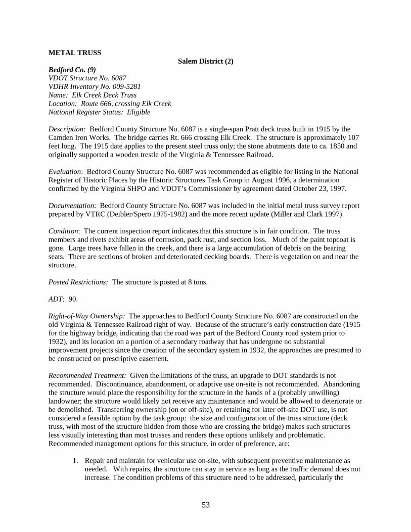
53
METAL TRUSS Salem District (2)
Bedford Co. (9) VDOT Structure No. 6087 VDHR Inventory No. 009-5281 Name: Elk Creek Deck Truss Location: Route 666, crossing Elk Creek National Register Status: Eligible Description: Bedford County Structure No. 6087 is a single-span Pratt deck truss built in 1915 by the Camden Iron Works. The bridge carries Rt. 666 crossing Elk Creek. The structure is approximately 107 feet long. The 1915 date applies to the present steel truss only; the stone abutments date to ca. 1850 and originally supported a wooden trestle of the Virginia & Tennessee Railroad. Evaluation: Bedford County Structure No. 6087 was recommended as eligible for listing in the National Register of Historic Places by the Historic Structures Task Group in August 1996, a determination confirmed by the Virginia SHPO and VDOT’s Commissioner by agreement dated October 23, 1997. Documentation: Bedford County Structure No. 6087 was included in the initial metal truss survey report prepared by VTRC (Deibler/Spero 1975-1982) and the more recent update (Miller and Clark 1997). Condition: The current inspection report indicates that this structure is in fair condition. The truss members and rivets exhibit areas of corrosion, pack rust, and section loss. Much of the paint topcoat is gone. Large trees have fallen in the creek, and there is a large accumulation of debris on the bearing seats. There are sections of broken and deteriorated decking boards. There is vegetation on and near the structure. Posted Restrictions: The structure is posted at 8 tons. ADT: 90. Right-of-Way Ownership: The approaches to Bedford County Structure No. 6087 are constructed on the old Virginia & Tennessee Railroad right of way. Because of the structure’s early construction date (1915 for the highway bridge, indicating that the road was part of the Bedford County road system prior to 1932), and its location on a portion of a secondary roadway that has undergone no substantial improvement projects since the creation of the secondary system in 1932, the approaches are presumed to be constructed on prescriptive easement. Recommended Treatment: Given the limitations of the truss, an upgrade to DOT standards is not recommended. Discontinuance, abandonment, or adaptive use on-site is not recommended. Abandoning the structure would place the responsibility for the structure in the hands of a (probably unwilling) landowner; the structure would likely not receive any maintenance and would be allowed to deteriorate or be demolished. Transferring ownership (on or off-site), or retaining for later off-site DOT use, is not considered a feasible option by the task group: the size and configuration of the truss structure (deck truss, with most of the structure hidden from those who are crossing the bridge) makes such structures less visually interesting than most trusses and renders these options unlikely and problematic. Recommended management options for this structure, in order of preference, are:
1. Repair and maintain for vehicular use on-site, with subsequent preventive maintenance as needed. With repairs, the structure can stay in service as long as the traffic demand does not increase. The condition problems of this structure need to be addressed, particularly the
54
deterioration of the gusset plates. The abutments should be cleaned off; debris should be cleaned from the bridge (via pressure washing). Much of the paint topcoat is gone, and the primer is lead-based. The primer should be tested; if it is in good condition, the structure would benefit from a topcoat, and this would extend the life of the truss; spot painting and zone painting could also be considered. A deck membrane and overlay should be considered. Vegetation should be removed from on and near the structure.
2. Document and salvage for adaptive use (in this case, document and salvage means reusing
the abutments for a new structure). 3. Document and demolish.
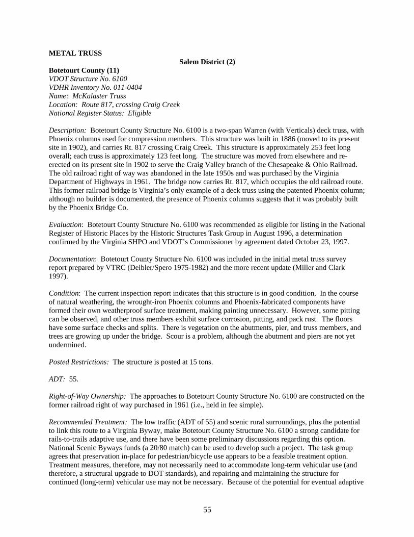
55
METAL TRUSS Salem District (2)
Botetourt County (11) VDOT Structure No. 6100 VDHR Inventory No. 011-0404 Name: McKalaster Truss Location: Route 817, crossing Craig Creek National Register Status: Eligible Description: Botetourt County Structure No. 6100 is a two-span Warren (with Verticals) deck truss, with Phoenix columns used for compression members. This structure was built in 1886 (moved to its present site in 1902), and carries Rt. 817 crossing Craig Creek. This structure is approximately 253 feet long overall; each truss is approximately 123 feet long. The structure was moved from elsewhere and re-erected on its present site in 1902 to serve the Craig Valley branch of the Chesapeake & Ohio Railroad. The old railroad right of way was abandoned in the late 1950s and was purchased by the Virginia Department of Highways in 1961. The bridge now carries Rt. 817, which occupies the old railroad route. This former railroad bridge is Virginia’s only example of a deck truss using the patented Phoenix column; although no builder is documented, the presence of Phoenix columns suggests that it was probably built by the Phoenix Bridge Co. Evaluation: Botetourt County Structure No. 6100 was recommended as eligible for listing in the National Register of Historic Places by the Historic Structures Task Group in August 1996, a determination confirmed by the Virginia SHPO and VDOT’s Commissioner by agreement dated October 23, 1997. Documentation: Botetourt County Structure No. 6100 was included in the initial metal truss survey report prepared by VTRC (Deibler/Spero 1975-1982) and the more recent update (Miller and Clark 1997). Condition: The current inspection report indicates that this structure is in good condition. In the course of natural weathering, the wrought-iron Phoenix columns and Phoenix-fabricated components have formed their own weatherproof surface treatment, making painting unnecessary. However, some pitting can be observed, and other truss members exhibit surface corrosion, pitting, and pack rust. The floors have some surface checks and splits. There is vegetation on the abutments, pier, and truss members, and trees are growing up under the bridge. Scour is a problem, although the abutment and piers are not yet undermined. Posted Restrictions: The structure is posted at 15 tons. ADT: 55. Right-of-Way Ownership: The approaches to Botetourt County Structure No. 6100 are constructed on the former railroad right of way purchased in 1961 (i.e., held in fee simple). Recommended Treatment: The low traffic (ADT of 55) and scenic rural surroundings, plus the potential to link this route to a Virginia Byway, make Botetourt County Structure No. 6100 a strong candidate for rails-to-trails adaptive use, and there have been some preliminary discussions regarding this option. National Scenic Byways funds (a 20/80 match) can be used to develop such a project. The task group agrees that preservation in-place for pedestrian/bicycle use appears to be a feasible treatment option. Treatment measures, therefore, may not necessarily need to accommodate long-term vehicular use (and therefore, a structural upgrade to DOT standards), and repairing and maintaining the structure for continued (long-term) vehicular use may not be necessary. Because of the potential for eventual adaptive

56
use, moving the structure or demolition is not considered a feasible option. Recommended management options for the bridge, in order of preference, are:
1. Preventive maintenance (particularly in the form of removing trees and vegetation from the abutments, pier, and truss members and addressing the scour problem) while structure continues under vehicular use. The weepholes at the base of the Phoenix columns need periodic cleaning out; these, and the seats, should be pressure washed. Where there is deterioration of the truss members, spot painting and applying penetrating sealer in areas of zone rust would be beneficial. A deck membrane and overlay should be considered.
2. At such time that plans for adaptive use are finalized, the structure should be closed to
vehicular traffic. Ownership should be transferred to the association that owns the trail, and this successor owner should then repair and maintain the structure for this adaptive use on-site.
[Note: Information received from the district at the time this report went to press indicates that no determinations are imminent regarding the conversion of this bridge to a walking trail component. The use of the bridge for access (vehicular and possibly pedestrian) would have to continue as long as the route was part of the secondary system. There may be requests in the future to extend Rts. 817 and 818. There are two other major structures built by the railroad that could be involved if a trail or road were extended in this area. If it is not feasible to close the bridge to vehicular traffic, there is the issue of how the road traffic and trail users would be handled on this narrow bridge. There is the potential that accommodations would have to be addressed for both vehicles and trail users: this could include improvements to the existing bridges, if possible, or other structures being built. There has been no determination made on who would be the owner of the trail facility or who would maintain it if a proposal was pursued. Currently, the right of way is owned and maintained by VDOT. If the district determines that the development of the trail is not feasible, treatment measures that will accommodate long-term vehicular use should be considered, including a possible structural upgrade to DOT standards and repairing and maintaining the structure as needed for continued long-term vehicular use.]
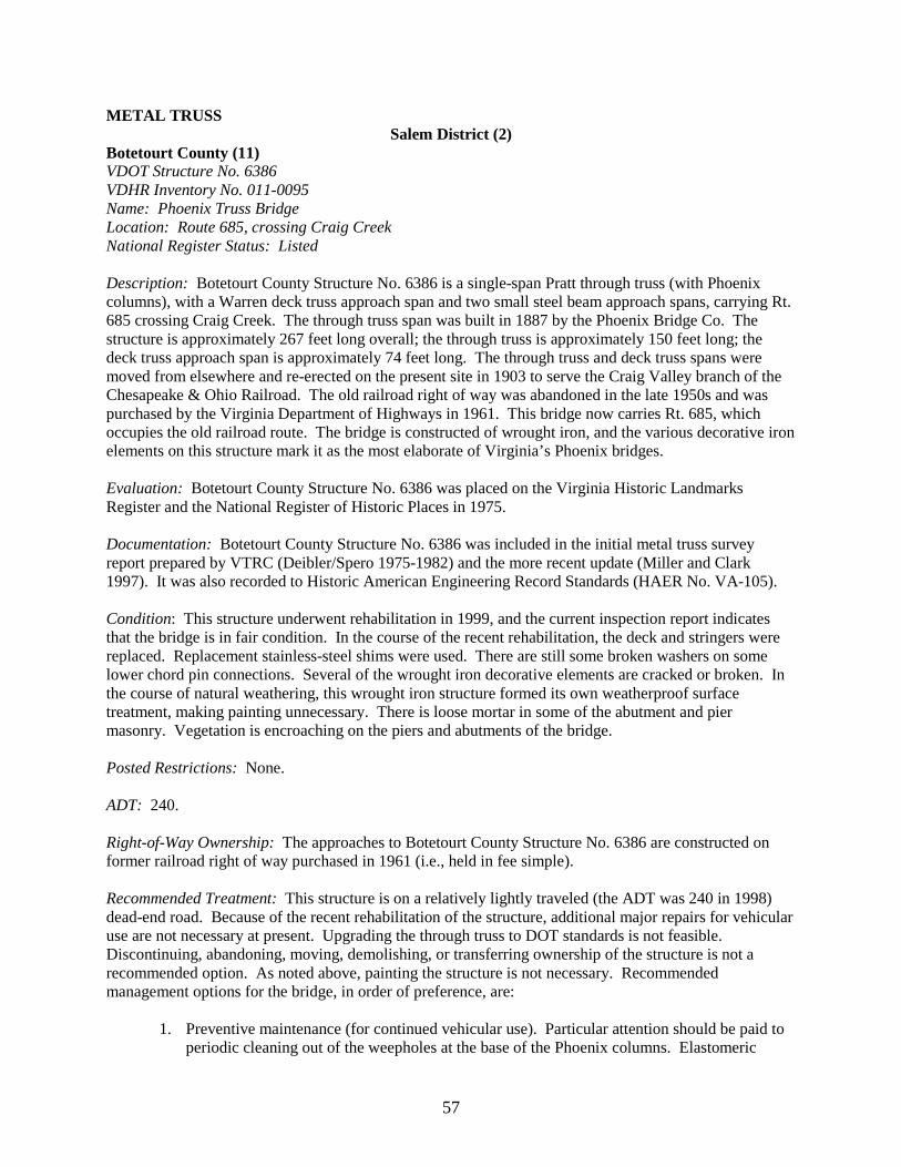
57
METAL TRUSS Salem District (2)
Botetourt County (11) VDOT Structure No. 6386 VDHR Inventory No. 011-0095 Name: Phoenix Truss Bridge Location: Route 685, crossing Craig Creek National Register Status: Listed Description: Botetourt County Structure No. 6386 is a single-span Pratt through truss (with Phoenix columns), with a Warren deck truss approach span and two small steel beam approach spans, carrying Rt. 685 crossing Craig Creek. The through truss span was built in 1887 by the Phoenix Bridge Co. The structure is approximately 267 feet long overall; the through truss is approximately 150 feet long; the deck truss approach span is approximately 74 feet long. The through truss and deck truss spans were moved from elsewhere and re-erected on the present site in 1903 to serve the Craig Valley branch of the Chesapeake & Ohio Railroad. The old railroad right of way was abandoned in the late 1950s and was purchased by the Virginia Department of Highways in 1961. This bridge now carries Rt. 685, which occupies the old railroad route. The bridge is constructed of wrought iron, and the various decorative iron elements on this structure mark it as the most elaborate of Virginia’s Phoenix bridges. Evaluation: Botetourt County Structure No. 6386 was placed on the Virginia Historic Landmarks Register and the National Register of Historic Places in 1975. Documentation: Botetourt County Structure No. 6386 was included in the initial metal truss survey report prepared by VTRC (Deibler/Spero 1975-1982) and the more recent update (Miller and Clark 1997). It was also recorded to Historic American Engineering Record Standards (HAER No. VA-105). Condition: This structure underwent rehabilitation in 1999, and the current inspection report indicates that the bridge is in fair condition. In the course of the recent rehabilitation, the deck and stringers were replaced. Replacement stainless-steel shims were used. There are still some broken washers on some lower chord pin connections. Several of the wrought iron decorative elements are cracked or broken. In the course of natural weathering, this wrought iron structure formed its own weatherproof surface treatment, making painting unnecessary. There is loose mortar in some of the abutment and pier masonry. Vegetation is encroaching on the piers and abutments of the bridge. Posted Restrictions: None. ADT: 240. Right-of-Way Ownership: The approaches to Botetourt County Structure No. 6386 are constructed on former railroad right of way purchased in 1961 (i.e., held in fee simple). Recommended Treatment: This structure is on a relatively lightly traveled (the ADT was 240 in 1998) dead-end road. Because of the recent rehabilitation of the structure, additional major repairs for vehicular use are not necessary at present. Upgrading the through truss to DOT standards is not feasible. Discontinuing, abandoning, moving, demolishing, or transferring ownership of the structure is not a recommended option. As noted above, painting the structure is not necessary. Recommended management options for the bridge, in order of preference, are:
1. Preventive maintenance (for continued vehicular use). Particular attention should be paid to periodic cleaning out of the weepholes at the base of the Phoenix columns. Elastomeric
58
shims should be considered for future replacement shims. Vegetation should be removed from around the bridge. A deck membrane and overlay should be considered for future application. The broken washers on the lower chord pin connections should be repaired. The deteriorated mortar in the piers and abutments should be repointed with a suitable (part-lime) mortar mix. The new galvanized stringers should be painted after an appropriate weathering period.
2. Repair and maintain for adaptive use on-site should this eventuality arise (no apparent
adaptive use for this structure and no alternative route for the road have yet been identified). However, if the bridge is no longer able to carry vehicular traffic, the adaptive-use option should be thoroughly explored, as this is preferable to any other option.
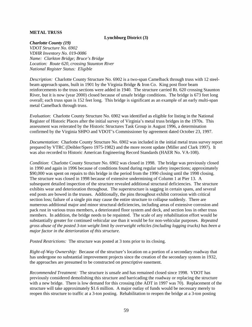
59
METAL TRUSS Lynchburg District (3)
Charlotte County (19) VDOT Structure No. 6902 VDHR Inventory No. 019-0086 Name: Clarkton Bridge; Bruce’s Bridge Location: Route 620, crossing Staunton River National Register Status: Eligible Description: Charlotte County Structure No. 6902 is a two-span Camelback through truss with 12 steel-beam approach spans, built in 1901 by the Virginia Bridge & Iron Co. King post floor beam reinforcements to the truss sections were added in 1940. The structure carried Rt. 620 crossing Staunton River, but it is now (year 2000) closed because of unsafe bridge conditions. The bridge is 673 feet long overall; each truss span is 152 feet long. This bridge is significant as an example of an early multi-span metal Camelback through truss. Evaluation: Charlotte County Structure No. 6902 was identified as eligible for listing in the National Register of Historic Places after the initial survey of Virginia’s metal truss bridges in the 1970s. This assessment was reiterated by the Historic Structures Task Group in August 1996, a determination confirmed by the Virginia SHPO and VDOT’s Commissioner by agreement dated October 23, 1997. Documentation: Charlotte County Structure No. 6902 was included in the initial metal truss survey report prepared by VTRC (Deibler/Spero 1975-1982) and the more recent update (Miller and Clark 1997). It was also recorded to Historic American Engineering Record Standards (HAER No. VA-108). Condition: Charlotte County Structure No. 6902 was closed in 1998. The bridge was previously closed in 1990 and again in 1996 because of conditions found during regular safety inspections; approximately $90,000 was spent on repairs to this bridge in the period from the 1990 closing until the 1998 closing. The structure was closed in 1998 because of extensive undermining of Column 1 at Pier 13. A subsequent detailed inspection of the structure revealed additional structural deficiencies. The structure exhibits wear and deterioration throughout. The superstructure is sagging in certain spans, and several end posts are bowed in the trusses. Additionally, the pins throughout exhibit corrosion with critical section loss; failure of a single pin may cause the entire structure to collapse suddenly. There are numerous additional major and minor structural deficiencies, including areas of extensive corrosion and pack rust in various truss members, a deteriorated floor system and deck, and section loss in other truss members. In addition, the bridge needs to be repainted. The scale of any rehabilitation effort would be substantially greater for continued vehicular use than it would be for non-vehicular purposes. Repeated gross abuse of the posted 3-ton weight limit by overweight vehicles (including logging trucks) has been a major factor in the deterioration of this structure. Posted Restrictions: The structure was posted at 3 tons prior to its closing. Right-of-Way Ownership: Because of the structure’s location on a portion of a secondary roadway that has undergone no substantial improvement projects since the creation of the secondary system in 1932, the approaches are presumed to be constructed on prescriptive easement. Recommended Treatment: The structure is unsafe and has remained closed since 1998. VDOT has previously considered demolishing this structure and barricading the roadway or replacing the structure with a new bridge. There is low demand for this crossing (the ADT in 1997 was 70). Replacement of the structure will take approximately $1.6 million. A major outlay of funds would be necessary merely to reopen this structure to traffic at a 3-ton posting. Rehabilitation to reopen the bridge at a 3-ton posting
60
($1.2 million) would cost approximately 75% of the cost of a new bridge and would probably allow 1 to 2 more years of life before additional major maintenance would have to be done. With the size, structural problems, aging, and deterioration of the structure, the bridge is far beyond any routine preventive maintenance, and a flood and scour hazard remains as well. If this structure were rehabilitated and reopened to vehicular traffic, abuse by overweight vehicles would almost certainly resume. In 1999, a local citizen’s group applied for and received a TEA-21 grant to cover minimal repairs to reopen the bridge to traffic (the federal allocation for this enhancement project is $160,000). This application was made without the knowledge of the Lynchburg District Structure & Bridge Office or the VDOT Central Office Structure & Bridge Office. The task group cannot support the enhancement project as currently proposed and recommends that the bridge remain closed to traffic, especially given the deteriorated condition and isolated location of the bridge. Spending a sizable amount of money to reopen a bridge that (1) will require extensive additional work in the near future, and (2) will almost certainly be subject to continued abuse from overweight vehicles is not a wise use of public funds. Use of enhancement money to stabilize the bridge for some sort of adaptive use (such as an eyecatcher or part of a walking trail) might be feasible provided that the county or a separate group was willing to assume ownership and liability for the bridge. Such transfer of ownership and its conditions, of course, would have to be acceptable to VDOT. Recommended management options for this structure, in order of preference, are:
1. Transfer ownership, if a suitable, willing recipient can be identified. 2. Document and demolish the structure. 3. Repair and maintain for adaptive use, if an appropriate adaptive use can be identified.
61
METAL TRUSS Lynchburg District (3)
Nelson County (62) VDOT Structure No. 6052 VDHR Inventory No. 062-0085 Name: Oak Ridge Railroad Overpass Location: Route 653, crossing Norfolk Southern Railway National Register Status: Listed Description: Nelson County Structure No. 6052 is a single-span Pratt through truss with a steel beam approach span, built in 1882 by the Keystone Bridge Co., carrying Rt. 653 crossing the Norfolk Southern Railway. This structure was apparently moved to its present site in the early 20th century. The bridge is approximately 138 feet long overall, with the truss span being approximately 100 feet long. This bridge is significant as an example of a late 19th century metal Pratt through truss. Evaluation: Nelson County Structure No. 6052 was listed on the Virginia Landmarks Register in 1977 and the National Register of Historic Places in 1978. Documentation: Nelson County Structure No. 6052 was included in the initial metal truss survey report prepared by VTRC (Deibler/Spero 1975-1982) and the more recent update (Miller and Clark 1997). It was also recorded to Historic American Engineering Record Standards (HAER No. VA-107). Condition: The current inspection report indicates that this structure is in poor condition. The majority of its timbers are decayed. The roller bearings are frozen and non-functioning. Rivets are missing. There is spalled concrete with severely rusted steel and cracks in the concrete piers. Additionally, the breast walls are delaminated and the truss members are moderately corroded. The structure needs painting (painting has been recommended in every inspection report since 1974). Posted Restrictions: The structure is posted at 12 tons. ADT: 56. Right-of-Way Ownership: Because of the structure’s location on a portion of a secondary roadway that has undergone no substantial improvement projects since the creation of the secondary system in 1932, the approaches are presumed to be constructed on prescriptive easement. Recommended Treatment: Because the Norfolk Southern Railway owns and maintains this structure, and VDOT inspects this structure and makes recommendations for repairs, recommendations for adaptive use (on or off-site), transferring ownership, and demolition are not applicable. Because the structure is a one-lane through truss, a structural upgrade to DOT standards is not feasible. The recommended management option for this structure is to repair and maintain for vehicular use, with subsequent preventive maintenance. However, it should be noted that the task group and VDOT have no procedural control over this structure.

62
METAL TRUSS Richmond District (4)
Brunswick County (12) VDOT Structure No. 6104 VDHR Inventory No. 012-0080 Name: Gholson’s Bridge Location: Route 715, crossing Meherrin River National Register Status: Listed Description: Brunswick County Structure No. 6104 is a two-span Pratt through truss, built in 1884 by the Wrought Iron Bridge Co., carrying Rt. 715 crossing Meherrin River. This structure has an overall length of approximately 192 feet; the south truss span is approximately 100 feet long; the north truss span is 86 feet long. The structure is significant as Virginia’s oldest surviving multi-span metal truss bridge. Evaluation: Brunswick County Structure No. 6104 was listed on the Virginia Landmarks Register in 1977 and on the National Register of Historic Places in 1978. Documentation: Brunswick County Structure No. 6104 was included in the initial metal truss survey report prepared by VTRC (Deibler/Spero 1975-1982) and the more recent update (Miller and Clark 1997). It was also recorded to Historic American Engineering Record Standards (HAER No. VA-111). Condition: The current inspection report indicates that this structure is in fair condition. Over the years, light erosion has occurred around abutment A, and there is dirt on the bridge seats and the bottom flanges of the stringers. Impact damage to the truss’s decorative portals has been repaired, and the replacement elements have been fabricated to match the originals. Extra counters were previously installed to strengthen the bridge. Vegetation is encroaching on the bridge. The masonry piers and abutments have been poorly repointed in the past. Posted Restrictions: The structure is posted at 11 tons. ADT: 1,011. Right-of-Way Ownership: Because of the structure’s location on a portion of a secondary roadway that has undergone no substantial improvement projects since the creation of the secondary system in 1932, the approaches are presumed to be constructed on prescriptive easement. Recommended Treatment: Brunswick County Structure No. 6104 is a single-lane through truss bridge; an upgrade to DOT standards is not feasible. Particularly given the topography and road locations in the region, adaptive use, discontinuance, or abandonment is not considered a feasible option. Transfer of ownership either on-site or off-site or demolition is not recommended. The recommended management option for this structure is to repair and maintain for vehicular use, with subsequent preventive maintenance as needed. Immediate repair recommendations are to stabilize and monitor the eroded area, remove vegetation, and clean the bridge seats. A parallel structure could be constructed if the road has to be widened. When the bridge is next painted, attention should be given to various options (such as sandblasting vs. stripping, painting vs. metalizing or galvanizing). Future repointing of the masonry should be done with more careful attention to historical practice and with a lime-content (not pure portland cement) mortar.
63
METAL TRUSS Culpeper District (7)
Culpeper County (23) VDOT Structure No. 6906 VVDHR Inventory No. 023-0073 Name: Waterloo Bridge Location: Route 613, crossing Rappahannock River National Register Status: Eligible Description: Culpeper County Structure No. 6906 consists of a single-span Pratt through truss with 15 steel beam approach spans carrying Rt. 613 crossing the Rappahannock River. The truss was built in 1878 by the Pittsburgh Iron Co. and retains its masonry piers. The current steel beam approach spans (with concrete bents) were completed in 1919 and were built by the Virginia Bridge & Iron Company, replacing earlier deteriorated and flood-damaged wooden approach spans. The bridge is approximately 387 feet long overall; the truss span is 100 feet long. This structure is significant as Virginia’s oldest surviving in-service metal truss bridge. Evaluation: Culpeper County Structure No. 6906 was identified as eligible for listing in the National Register of Historic Places after the initial survey of Virginia’s metal truss bridges in the 1970s. This assessment was reiterated by the Historic Structures Task Group in August 1996, a determination confirmed by the Virginia SHPO and VDOT’s Commissioner by agreement dated October 23, 1997. Documentation: Culpeper County Structure No. 6906 was included in the initial metal truss survey report prepared by VTRC (Deibler/Spero 1975-1982) and the more recent update (Miller and Clark 1997). It was also recorded to Historic American Engineering Record Standards (HAER No. VA-112). Condition: The current inspection report indicates that this structure is in poor condition. The structure has numerous deficiencies. Various deck timbers are broken, decayed, or rotted through. Among these, 50% are loose and are missing deck bolts. The structure is so rusted that it has critical section loss through some beams. There are various loose counters and diagonals. There is spalling, delaminations, and exposed rebar on the concrete piers and abutments of the approach spans. The ADT is relatively high for a rural area (over 500). Although the structure is posted at 3 tons, overweight vehicle abuse of this bridge is frequent. Posted Restrictions: The structure is posted at 3 tons. ADT: 541. Right-of-Way Ownership: Because of the structure’s location on a portion of a secondary roadway that has undergone no substantial improvement projects since the creation of the secondary system in 1932, the approaches are presumed to be constructed on prescriptive easement. Recommended Treatment: A sizable amount of development is zoned in the area, which suggests that the already high ADT and abuse of the bridge by overweight vehicles will increase. The immediate neighbors like the look and historicity of the bridge and would like it to remain on-site. However, questions of potential adaptive use are rendered problematic by the conflicting viewpoints among the area’s population on the issue of public access to the Rappahannock River. Several “No Boaters” signs are posted on the properties adjacent to the bridge, and there is local opposition to the proposed Rappahannock Scenic River designation. The district structure and bridge office advises that despite the relatively high ADT, plans are to keep it under traffic until it can no longer be used and then probably close it and leave it in place. If the structure is not maintained, there is always the danger of it washing

64
out or being left to collapse. There are no immediate plans to build a new bridge. The district structure and bridge office estimates that a decision on whether to close the bridge may have to be made in as little as 5 years. After making an independent assessment of the various issues concerning this structure, the task group notes that because this is a single-lane through truss, an upgrade to DOT standards is not feasible. Abandonment, transfer of ownership off-site, salvage, or other off-site options are also not considered feasible by the task group. Demolition is not a recommended option at present. The task group’s recommended management options for this structure, in order of preference, are:
1. Preventive maintenance. 2. Discontinue. 3. Transfer ownership if a suitable recipient can be identified. 4. Repair and maintain for adaptive use.

65
METAL TRUSS Staunton District (8)
Alleghany Co. (3) VDOT Structure No. 6064 VDHR Inventory No. 003-0020 Name: McKinney’s Hollow Bridge Location: Route 633, crossing Cowpasture River National Register Status: Eligible Description: Alleghany County Structure No. 6064 is a three-span Pratt through truss, carrying Rt. 633 crossing Cowpasture River, built in 1896 by the Nelson & Buchanan Co. The structure is approximately 318 feet long overall; each truss is approximately 104 feet long. It retains its original masonry piers. The structure is significant as an example of an early multi-span metal through truss. Evaluation: Alleghany County Structure No. 6064 was identified as eligible for listing in the National Register of Historic Places after the initial survey of Virginia’s metal truss bridges in the 1970s. This assessment was reiterated by the Historic Structures Task Group in August 1996, a determination confirmed by the Virginia SHPO and VDOT’s Commissioner by agreement dated October 23, 1997. Documentation: Alleghany County Structure No. 6064 was included in the initial metal truss survey report prepared by VTRC (Deibler/Spero 1975-1982) and the more recent update (Miller and Clark 1997). It was also recorded to Historic American Engineering Record Standards (HAER No. VA-104) Condition: The current inspection report indicates that this structure is in poor condition. The roller bearing devices are clogged and frozen, and there is section loss of steel in the stringers. In addition, there is mortar and rock missing at the abutments and piers. No scour problems are evident. Additionally, there is spalling on the bridge seat with overall heavy vegetation. Although the structure is posted at 9 tons, local residents report that logging trucks and other overweight vehicles use the bridge. Posted Restrictions: The structure is posted at 9 tons. ADT: 839. Right-of-Way Ownership: Because of the structure’s location on a portion of a secondary roadway that has undergone no substantial improvement projects since the creation of the secondary system in 1932, the approaches are presumed to be constructed on prescriptive easement. Recommended Treatment: Because of the structure’s large size and remote location, discontinuing or abandoning this structure is not recommended, and adaptive use or transferring ownership on or off-site is not considered feasible by the task group. Adaptive use would be difficult: because of the single-lane width of the bridge, it is not suitable for mixed vehicular and bicycle use and there does not appear to be demand for hiking trails at that crossing. The Staunton District Structure & Bridge Office is working on an upgrading/reinforcing/rehabilitation plan for this bridge. High current use creates a problem, and the bridge is a shortcut for heavy loads. Upgrading/reinforcing/rehabilitation would extend the life of the bridge; one possibility would be to take out the floor beams and stringers and replace with a load-carrying structure that would be hidden within the truss. Recommended management options for this structure, in order of preference, are:
1. Document and demolish. 2. Repair and maintain for vehicular use, with subsequent preventive maintenance as needed.
66
3. An upgrade through an auxiliary structure is feasible and could be considered as a third option. The width of the bridge limits the amount of possible upgrade; such an upgrade would not be to DOT standards and would not solve the width problem.
67
METAL TRUSS Staunton District (8)
Augusta County (7) VDOT Structure No. 6027 VDHR Inventory No. 007-0237 Name: Kerr’s Crossing Bridge Location: Route 907, crossing Christian’s Creek National Register Status: Eligible Description: Augusta County Structure No. 6027 is a single-span pin-connected Pratt pony truss carrying Rt. 907 crossing Christian’s Creek. The bridge is approximately 81 feet long. This structure was built in 1898 by the Brackett Bridge Co. It is significant as an example of a late 19th century metal pony truss. Evaluation: Augusta County Structure No. 6027 was identified as eligible for listing in the National Register of Historic Places after the initial survey of Virginia’s metal truss bridges in the 1970s. This assessment was reiterated by the Historic Structures Task Group in August 1996, a determination confirmed by the Virginia SHPO and VDOT’s Commissioner by agreement dated October 23, 1997. Documentation: Augusta County Structure No. 6027 was included in the initial metal truss survey report prepared by VTRC (Deibler/Spero 1975-1982) and the more recent update (Miller and Clark 1997). It was also recorded to Historic American Engineering Record Standards (HAER No. VA-101). Condition: The current inspection report indicates that this structure is in fair condition. There is section loss and pitting to the steel. The wearing surface is rough, and several deck planks are loose and deteriorating. Longitudinal timbers placed to restrain exterior channels are deteriorating throughout with sections missing. The bridge is heavily rusted and needs to be cleaned and repainted. Posted Restrictions: The structure is posted at 5 tons. ADT: 56. Right-of-Way Ownership: Because of the structure’s location on a portion of a secondary roadway that has undergone no substantial improvement projects since the creation of the secondary system in 1932, the approaches are presumed to be constructed on prescriptive easement. Recommended Treatment: Because this is a single-lane truss bridge, an upgrade to DOT standards is not feasible. Discontinuance and abandonment are not recommended by the task group. Beyond these factors, however, the small size, location, and condition of this bridge permit a number of management options. This structure is located on a loop road, which can easily be closed off or bypassed if non-vehicular or other adaptive use is desired. Recommended management options for this structure, in order of preference, are:
1. Repair and maintain for vehicular use, with subsequent preventive maintenance as needed. Condition issues and repair requirements for this structure are not pressing; priority will be given to the more urgent rehabilitation needs of Augusta County Structure No. 6147 and No. 6149 (q. v.). Eventual repair recommendations are to replace deteriorated decking and other timbers and to repaint the structure.
2. Repair and maintain for adaptive use and transfer ownership on-site if a suitable recipient
can be identified.
68
3. Transfer ownership off-site. The small size of this pony truss makes this and the following three options feasible.
4. Document and salvage for adaptive use off-site. 5. Document and retain for DOT use off-site. 6. Document and demolish (recommended only if the bridge can no longer carry traffic and
other options are exhausted).

69
METAL TRUSS Staunton District (8)
Augusta County (07) VDOT Structure No. 6081 VDHR Inventory No. 007-0507 Name: Wallace Mill Bridge; Bedstead Truss Location: Route 683, Little Calfpasture River National Register Status: Eligible Description: Augusta County Structure No. 6081 is a single-span pin-connected Pratt pony truss of leg-truss (“bedstead truss”) configuration carrying Rt. 683 crossing Little Calfpasture River. The bridge is approximately 83 feet long. The structure was built in 1914 by the Champion Bridge Co. The bridge is the only surviving bridge of leg-truss design in Virginia and is considered significant because of its engineering design. Evaluation: Augusta County Structure No. 6081 was identified as eligible for listing in the National Register of Historic Places after the initial survey of Virginia’s metal truss bridges in the 1970s. This assessment was reiterated by the Historic Structures Task Group in August 1996, a determination confirmed by the Virginia SHPO and VDOT’s Commissioner by agreement dated October 23, 1997. Documentation: Augusta County Structure No. 6081 was included in the initial metal truss survey report prepared by VTRC (Deibler/Spero 1975-1982) and the more recent survey update (Miller and Clark 1997). It was also recorded to Historic American Engineering Record Standards (HAER No. VA-103), and that documentation has been accepted by the National Park Service. Condition: Augusta County Structure No. 6081 was closed in 1996 after being damaged by flooding caused by Hurricane Fran. The struts are buckled, and there are numerous areas of spalled and deteriorated concrete and section loss of steel elements. Posted Restrictions: The structure was posted at 7 tons prior to its closing. Right-of-Way Ownership: Because of the structure’s location on a portion of a secondary roadway that has undergone no substantial improvement projects since the creation of the secondary system in 1932, the approaches are presumed to be constructed on prescriptive easement. Recommended Treatment: Because of the bridge’s narrow width, there have been previous instances of impact damage from farm vehicles; because this is a single-lane truss bridge, an upgrade to DOT standards is not feasible. In addition to the 1996 damage from Hurricane Fran, there have been previous instances of flood damage to this structure. Recent migration by the Little Calfpasture River renders continuing damage to, and destruction of, the bridge very likely in this location. Because of the present damage and poor condition of the structure and the continued threats to the structure in its present location, the task group does not recommend repairing and maintaining the structure for vehicular use or for any adaptive use on-site. In the interest of preserving the 1914 structure, demolition is not recommended. Rather, the recommended management options for this structure are to construct a replacement bridge structure that will carry farm traffic and emergency vehicles and to document, dismantle, repair, and relocate the old truss for adaptive use off-site, with corresponding transfer of ownership. A new bridge is planned on a different alignment. A suitable and willing recipient for the 1914 structure has been identified, and discussions to ensure the future of this bridge are proceeding. [Note: This bridge has been the focus of a well-organized and hard-fought campaign, mounted by a neighboring landowner, to keep the structure in place, repair it, and reopen it to vehicular traffic.
70
Although the task group admires this gentleman’s tenacity in attempting to preserve the bridge in place, we cannot support his efforts. The task group considered a plan advanced by this gentleman to construct a supporting structure around the old bridge, but in addition to not complying with the Secretary’s Standards, this strategy would not address the threat of flood damage and, indeed, would further reduce the hydraulic opening, thus rendering the bridge even more vulnerable to flood damage. Subsequent claims made by the same individual that the bridge had some sort of “trade secret” anchoring system that renders it invulnerable to flooding have not been supported by either the behavior of this structure, physical examination of other Champion Bridge Company bedstead trusses, or any documentation in the Champion Bridge Company records.]
71
METAL TRUSS Staunton District (8)
Augusta County (7) VDOT Structure No. 6147 VDHR Inventory No. 007-1077 Name: Carpenter’s Ford Bridge Location: Route 775, crossing Middle River National Register Status: Eligible Description: Augusta County Structure No. 6147 is a single-span pin-connected Pratt through truss carrying Rt. 775 crossing Middle River. The structure is approximately 142 feet long. The structure was built in 1903-1904 by the Brackett Bridge Co. This bridge is significant as an example of an early 20th century metal Pratt through truss. Evaluation: Augusta County Structure No. 6147 was identified as eligible for listing in the National Register of Historic Places after the initial survey of Virginia’s metal truss bridges in the 1970s. This assessment was reiterated by the Historic Structures Task Group in August 1996, a determination confirmed by the Virginia SHPO and VDOT’s Commissioner by agreement dated October 23, 1997.
Documentation: Augusta County Structure No. 6147 was included in the initial metal truss survey report prepared by VTRC (Deibler/Spero 1975-1982) and the more recent update (Miller and Clark 1997). It was also recorded to Historic American Engineering Record Standards (HAER No. VA-99). Condition: The current inspection report indicates that this structure is in fair-to-poor condition. In general, the substructure exhibits cracking, spalling, and deterioration. Additionally, the stringers are rusty with steel pitting over the seats. There is some section loss. The bridge’s wearing surface is coming off, and there are scattered loose deck planks. The east abutment is constructed of masonry capped with concrete; the masonry pointing is failing. Trees are overhanging the bridge. The structure needs painting. Riprap has recently been applied to the stream banks. Posted Restrictions: The structure is posted at 8 tons. ADT: 59. Right-of-Way Ownership: Because of the structure’s location on a portion of a secondary roadway that has undergone no substantial improvement projects since the creation of the secondary system in 1932, the approaches are presumed to be constructed on prescriptive easement. Recommended Treatment: Because this is a single-lane through truss, an upgrade to DOT standards is not feasible. In addition, due largely to the location and the size of the structure, adaptive use, discontinuance, abandonment, transferring ownership on or off-site, or other off-site options are not feasible. Recommended management options for this structure, in order of preference, are:
1. Repair and maintain for vehicular use, with subsequent preventive maintenance as needed. Immediate repair recommendations are to cut back the overhanging trees. Planned work is to replace the deck, stringers, and floor beams and to repaint the structure. This work has a projected advertisement date of early 2001. It is intended that these repairs will raise the capacity of the structure to 14 to 15 tons. The task group also recommends that the masonry be repointed within the next several years.

72
2. Documentation and demolition could be considered as a second option. In this case, the elaborate bridge plaque should be salvaged, for either preservation, display, or possible reuse on a replacement bridge.
73
METAL TRUSS Staunton District (8)
Augusta County (7) VDOT Structure No. 6149 VDHR Inventory No. 007-1055 Name: Knightly Bridge Location: Route 778, crossing Middle River National Register Status: Eligible Description: Augusta County Structure No. 6149 is a single-span pin-connected Camelback through truss, carrying Rt. 778 crossing Middle River. The structure is approximately 182 feet long. It was built in 1915 by the Champion Bridge Co. This bridge is significant as an example of an early 20th century metal Camelback through truss. Evaluation: Augusta County Structure No. 6149 was identified as eligible for listing in the National Register of Historic Places after the initial survey of Virginia’s metal truss bridges in the 1970s. This assessment was reiterated by the Historic Structures Task Group in August 1996, a determination confirmed by the Virginia SHPO and VDOT’s Commissioner by agreement dated October 23, 1997. Documentation: Augusta County Structure No. 6149 was included in the initial metal truss survey report prepared by VTRC (Deibler/Spero 1975-1982) and the more recent update (Miller and Clark 1997). It was also recorded to Historic American Engineering Record Standards (HAER No. VA-100). Condition: The current inspection report indicates that this structure is in fair-to-poor condition. There is section loss and pitting to the steel. Isolated cracking, delamination, and deterioration are present on the substructure. The streambed is eroding in front of one of the abutments; riprap has recently been applied to the stream banks. Posted Restrictions: The structure is posted at 6 tons.
ADT: 124. Right-of-Way Ownership: Because of the structure’s location on a portion of a secondary roadway that has undergone no substantial improvement projects since the creation of the secondary system in 1932, the approaches are presumed to be constructed on prescriptive easement. Recommended Treatment: Because this is a single-lane through truss, an upgrade to DOT standards is not feasible. The alignment of this structure will make replacement difficult. In addition, due largely to the location and the size of the structure, adaptive use, discontinuance, abandonment, transferring ownership on or off-site, or other off-site options are not feasible. Recommended management options for this structure, in order of preference, are:
1. Repair and maintain for vehicular use, with subsequent preventive maintenance as needed. Monitor the streambed and banks for erosion and scour. Planned work to be done is to replace the deck and stringers and to repaint the structure. This work is tentatively planned for implementation in late 2002 or 2003.
2. Documentation and demolition could be considered as a second option. In this case, the
elaborate bridge plaque should be salvaged, for either preservation, display, or possible reuse on a replacement bridge.

74
METAL TRUSS Staunton District (8)
Augusta County (07) VDOT Structure No. 6729 VDHR Inventory No. 007-1262 Name: Mount Meridian Bridge Location: Route 769, Middle River National Register Status: Eligible Description: Augusta County Structure No. 6729 is a three-span, pin-connected Pratt through truss carrying Rt. 769 crossing Middle River. The structure is approximately 360 feet long overall; the truss spans are approximately 132 feet, 127 feet, and 101 feet long. It was built in 1907 by the Champion Bridge Company. This bridge is significant as an example of an early 20th century multi-span metal Pratt through truss. Evaluation: Augusta County Structure No. 6729 was identified as eligible for listing in the National Register of Historic Places after the initial survey of Virginia’s metal truss bridges in the 1970s. This assessment was reiterated by the Historic Structures Task Group in August 1996, a determination confirmed by the Virginia SHPO and VDOT’s Commissioner by agreement dated October 23, 1997.
Documentation: Augusta County Structure No. 6729 was included in the initial metal truss survey report prepared by VTRC (Deibler/Spero 1975-1982) and the more recent update (Miller and Clark 1997). It was also recorded to Historic American Engineering Record Standards (HAER No. VA-98). Condition: Augusta County Structure No. 6729 was closed in 1997 because of structural deficiencies in the floor system, a deteriorated deck, and section loss in certain truss members. In addition, the stone masonry piers are deteriorating and the bridge needs to be repainted. Posted Restrictions: The structure was posted at 8 tons prior to its closing. Right-of-Way Ownership: Because of the structure’s location on a portion of a secondary roadway that has undergone no substantial improvement projects since the creation of the secondary system in 1932, the approaches are presumed to be constructed on prescriptive easement. Recommended Treatment: Construction of the nearby crossing of the Middle River on Route 256 during the 1960s resulted in a significant decrease in the use of Augusta County Structure No. 6729. The bridge had an ADT of 44 vehicles before it was closed in 1997. Because of the severe deterioration of the structure, repair and reopening it for vehicular use are not recommended. (In any event, because this is a single-lane through truss, an upgrade to DOT standards is not feasible.) The condition of the structure is so bad that preventive maintenance is not applicable. Abandoning the bridge would have the effect of putting portions of the bridge into the hands of (possibly unwilling) private hands and is not a recommended option. In addition, because of the location, size, and condition of the structure, adaptive use is not recommended. For the same reasons, transferring ownership off-site or other off-site options are not feasible. The large size of the structure also influences a treatment decision since it is unlikely that a new owner can be found that will desire to move the structure to another location for preservation purposes. Preservation in-place for pedestrian use may be a feasible treatment option for the Mount Meridian Bridge provided that funds for painting the structure and repairing the most deteriorated elements become available. The Rt. 769 approaches can be converted into cul-de-sacs, and the remaining prescriptive right of way up to the abutments can be discontinued. Rehabilitation of the Mount Meridian Bridge could be accomplished by a recipient willing to accept ownership and associated liability of the bridge on-site. Rehabilitation of the structure for pedestrian use is eligible for Transportation

75
Enhancement Program funding provided there is a match of at least 20% of the cost. Recommended management options for this structure, in order of preference, are:
1. Transfer ownership on-site if a suitable, willing recipient can be identified. 2. Discontinue. 3. Documentation and demolition could be considered as a third option. In this case, the
elaborate bridge plaque should be salvaged, for either preservation, display, or possible reuse on a replacement bridge.
76
METAL TRUSS Staunton District (8)
Highland County (45) VDOT Structure No. 6034 VDHR Inventory No. 045-0032 Name: Lane Truss Location: Route 645, crossing Crab Run National Register Status: Eligible Description: Highland County Structure No. 6034 is a single-span Lane Patent pony truss, carrying Rt. 645 crossing Crab Run. The structure was built in 1896 by the West Virginia Bridge Works. It is approximately 37 feet long. This bridge is a rare surviving example of a patented Lane truss; it is the only bridge of this type remaining in Virginia. Evaluation: Highland County Structure No. 6034 was determined eligible as part of a project; this assessment was reiterated by the Historic Structures Task Group in August 1996, a determination confirmed by the Virginia SHPO and VDOT’s Commissioner by agreement dated October 23, 1997. Documentation: Highland County Structure No. 6034 was included in the initial metal truss survey report prepared by VTRC (Deibler/Spero 1975-1982) and the more recent update (Miller and Clark 1997).
Condition: The current inspection report indicates that this structure is in fair-to-poor condition. Highland County Structure No. 6034 was closed to vehicular traffic in 1994, after which the structure was rehabilitated to serve as a foot and bicycle bridge (this use allows pedestrians and cyclists to avoid the primary traffic on Rt. 250). Preventive maintenance is undertaken on an as-needed basis. The bridge was cleaned, redecked, wire brushed, and painted at the time that it was closed to vehicular traffic. There are currently some areas of rust on the truss members. The abutments (masonry, faced with concrete) exhibit some areas of cracking and spalling and are periodically subject to slight, but repairable scour. A tree is growing against the upstream abutment. Some of the truss members are loose and require tightening. Posted Restrictions: None. The structure has been closed to vehicular traffic and converted into a pedestrian and bicycle bridge. Right-of-Way Ownership: Because of the structure’s location on a portion of a secondary roadway that has undergone no substantial improvement projects since the creation of the secondary system in 1932, the approaches are presumed to be constructed on prescriptive easement. Recommended Treatment: This structure now serves as a foot and bicycle bridge in the village of McDowell. The Historic Structures Task Group concurs with this bridge being closed to vehicular traffic and concurs with its current adaptive use. The recommended management option for this structure consists of normal preventive maintenance and repairing and maintaining for continued adaptive use when necessary. Immediate repair recommendations are to remove the tree growing against the abutment, address the scour problem, and repair or reinforce the deteriorated abutment. Loose truss members should be tightened.

77
METAL TRUSS Staunton District (8)
Page County (69) VDOT Structure No. 1004 VDHR Inventory No. 069-0236 Location: Route 340, crossing Jeremiah’s Run National Register Status: Eligible Description: Page County Structure No. 1004 is a single-span Pratt deck arch truss, with five T-beam concrete approach spans, built in 1936 by the Virginia Department of Highways, carrying Rt. 340 crossing Jeremiah’s Run. The structure is approximately 262 feet long overall; the truss is approximately 123 feet long. This bridge is one of two metal arch truss bridges in Virginia. Evaluation: Page County Structure No. 1004 was determined eligible for listing in the National Register of Historic Places as part of a project. This assessment was reiterated by the Historic Structures Task Group in August 1996, a determination confirmed by the Virginia SHPO and VDOT’s Commissioner by agreement dated October 23, 1997. Documentation: Page County Structure No. 1004 was included in the updated metal truss survey report prepared by VTRC (Miller and Clark 1997).
Condition: The current inspection report indicates that this structure is in poor condition. Most of the deck is delaminated, causing moisture seepage on the underside. The structural steel is also in poor condition. The piers and beam-ends show cracking, delaminations, and spalls with exposed re-bars throughout. The same is true of the concrete rail system except for the delaminations. Severe section loss, heavy rust, pitting, and swelling affect the structure’s floor beams and top chord connections. Posted Restrictions: The structure has a legal limit of 27 and 40 tons, respectively. ADT: 3,337. Right-of-Way Ownership: This structure carries a primary route and relates to a road improvement project undertaken during the late 1930s. Fee simple ownership is presumed. Recommended Treatment: A project to upgrade this section of Rt. 340 is currently in design phase. This structure and the similar Page County Structure No. 1990 were originally slated for replacement. However, a local citizens’ group, Scenic 340 Project, Inc., which supports keeping Rt. 340 a two-lane, rural road in its present configuration, has been waging an active, well-organized campaign against the expansion and the replacements of the deteriorated National Register–eligible bridges. Scenic 340 Project, Inc., has also made claims that Rt. 340 itself (which reached most of its present configuration in the mid- to late 1930s) is historically significant, apparently based on the presence of 18th, 19th, and early 20th century predecessor roads in the general corridor of present-day Rt. 340. The claims of historic significance for Rt. 340 are still under evaluation. The task group made an independent assessment of the issues regarding Page County Structure No. 1004; its general determinations are as follow: Because of site and condition restrictions, an upgrade to DOT standards is not feasible. Because of the site-specific nature of this kind of truss, transferring ownership off-site, off-site adaptive use, or salvage and reuse of elements off-site is not feasible. The deteriorated condition of this bridge is beyond preventive maintenance. The topography of the site would allow sufficient room to shift the alignment to the west, leaving the old bridge in place. The task group’s recommended management options for this structure, in order of preference, are:
78
1. Transfer ownership (on-site) if a suitable, willing recipient can be identified. 2. Discontinue/abandon the structure. 3. Repair and maintain for adaptive use (because of the deteriorated condition of the structure,
this would be extremely expensive). 4. Document and demolish. 5. Repair and maintain for vehicular use (because of the deteriorated condition of the structure,
this would be extremely expensive).

79
METAL TRUSS Staunton District (8)
Page County (69) VDOT Structure No. 1990 VDHR Inventory No. 069-0238 Location: Route 340, Overall Creek National Register Status: Eligible Description: Page County Structure No. 1990 is a single-span Pratt deck arch truss with four T-beam concrete approach spans, built in 1938 by the Virginia Department of Highways, carrying Rt. 340 crossing Overall Run. The bridge is approximately 245 feet long overall; the truss is approximately 123 feet long. This bridge is one of two metal arch truss bridges in Virginia. Evaluation: Page County Structure No. 1990 was determined eligible for listing in the National Register of Historic Places as part of a project. This assessment was reiterated by the Historic Structures Task Group in August 1996, a determination confirmed by the Virginia SHPO and VDOT’s Commissioner by agreement dated October 23, 1997. Documentation: Page County Structure No. 1990 was included in the updated initial metal truss survey report prepared by VTRC (Miller and Clark 1997).
Condition: The current inspection report indicates that this structure is in poor condition. The deck is delaminated and scaled with exposed rebar. Its concrete rail system and curbs are severely deteriorated and crumbling. There is spalling on the concrete beam-ends and pier caps, plus section loss on the stringers, floor beams, and braces in the truss span. Posted Restrictions: The structure has a legal limit of 27 and 40 tons, respectively. ADT: 3,337. Right-of-Way Ownership: This structure carries a primary route and relates to a road improvement project undertaken during the late 1930s. Fee simple ownership is presumed. Recommended Treatment: A project to upgrade this section of Rt. 340 is currently in design phase. This structure and the similar Page County Structure No. 1004 were originally slated for replacement. However, a local citizens’ group, Scenic 340 Project, Inc., which supports keeping Rt. 340 a two-lane, rural road in its present configuration, has been waging an active, well-organized campaign against the expansion and the replacements of the deteriorated National Register-eligible bridges. Scenic 340 Project, Inc., has also made claims that Rt. 340 itself (which reached most of its present configuration in the mid to late 1930s) is historically significant, apparently based on the presence of 18th, 19th, and early 20th century predecessor roads in the general corridor of present-day Rt. 340. The claims of historic significance for Rt. 340 are still under evaluation. The task group made an independent assessment of the issues regarding Page County Structure No. 1990; its general determinations are as follow: Because of the site-specific nature of this kind of truss, transferring ownership, adaptive use, or salvage and reuse of elements off-site is not feasible. There are significant topography and design issues with this location: there is insufficient room at this site to permit construction of a new road while leaving the old bridge in place. Adaptive use on-site, on-site transfer of ownership, discontinuance, or abandonment is not feasible. The deteriorated condition of this bridge is beyond preventive maintenance. Recommended management options for this structure, in order of preference, are:
1. Document and demolish.
80
2. Repair and maintain for vehicular use. 3. An upgrade to DOT standards is feasible and could be considered as a third option. This
would involve replacing the present deck with a lightweight, possibly wider, deck.
81
METAL TRUSS Staunton District (8)
Rockbridge County (81) VDOT Structure No. 6145 VDHR Inventory No. 226-5001 Name: Goshen Bridge Location: Route 746, crossing Calfpasture River National Register Status: Listed Description: Rockbridge County Structure No. 6145 is a two-span Pratt through truss, built in 1890 by the Groton Bridge Co, carrying Rt. 746 crossing Calfpasture River. This structure is approximately 261 feet long overall; the trusses are approximately 139 and 121 feet long. Constructed for the planned industrial community of Goshen, this bridge has a number of points of significance: it is one of Virginia’s earliest multi-span truss bridges; it is built on a skew; and it is an early multimodal bridge. As originally designed, the structure included a lane for vehicular traffic, a lane for streetcars, and a cantilevered sidewalk. Evaluation: Rockbridge County Structure No. 6145 was placed on the Virginia Landmarks Register in 1977 and on the National Register of Historic Places in 1978. Documentation: Rockbridge County Structure No. 6145 was included in the initial metal truss survey report prepared by VTRC (Deibler/Spero 1975-1982) and the more recent update (Miller and Clark 1997). It was also recorded to Historic American Engineering Record Standards (HAER No. VA-102). Condition: The current inspection report indicates that this structure is in poor condition. There are numerous areas of corrosion and section loss to steel members. The piers are missing mortar and substructure stones in various locations. The roller bearing devices are frozen, and some are displaced. In addition, debris is present on the bridge seats, on the connections, and between the stringers. Only one lane is open to vehicular traffic; the other lane, which was originally planned as a streetcar lane, has not had decking for at least 50 years; there is attendant corrosion of the exposed members. A rehabilitation of the structure is planned. Posted Restrictions: The structure is posted at 6 tons. ADT: 55. Right-of-Way Ownership: Because of the structure’s location on a portion of a secondary roadway that has undergone no substantial improvement projects since the creation of the secondary system in 1932, the approaches are presumed to be constructed on prescriptive easement. Recommended Treatment: A full rehabilitation of this structure has been in the planning stage by the Staunton District Structure & Bridge Office over the last several years. Planning is now complete. The stone piers will be repaired and repointed as needed, using compatible mortar. The truss will be disassembled, and the members repaired as needed and galvanized. The truss will then be reassembled and restored for two lanes of vehicular traffic. The task group concurs with this plan. Attempts to fund this rehabilitation substantively with enhancement grant monies were unsuccessful until the present (2000) grant cycle, when $25,000 was received in a TEA-21 grant ($250,000 was requested).
82
METAL TRUSS Staunton District (8)
Rockingham County (82) VDOT Structure No. 6154 VDHR Inventory No. 177-5001 Name: Linville Creek Bridge Location: Route 1421, crossing Linville Creek National Register Status: Listed Description: Rockingham County Structure No. 6154 is a single-span Thacher through truss, built in 1898 by the Wrought Iron Bridge Co., carrying Rt. 1421 crossing Linville Creek. It is approximately 136 feet long. This structure is significant as one of only two Thacher trusses surviving in the United States.
Evaluation: Rockingham County Structure No. 6154 was placed on the Virginia Landmarks Register in 1977 and on the National Register of Historic Places in 1978. Documentation: Rockingham County Structure No. 6154 was included in the initial metal truss survey report prepared by VTRC (Deibler/Spero 1975-1982) and the more recent update (Miller and Clark 1997). It was also recorded to Historic American Engineering Record Standards (HAER No. VA-97). Condition: The current inspection report indicates that this structure is in fair-to-poor condition. The bridge suffers from pitting, light rust, and section loss throughout the steel members (excepting the stringers). The wearing surface is gone in scattered areas of the deck top. Moreover, all angle and lattice verticals are loose. Supplementary strengthening elements were added to the Thacher configuration in 1968. Posted Restrictions: The structure is posted at 4 tons. ADT: 502. Right-of-Way Ownership: Because of the structure’s location on a portion of a secondary roadway that has undergone no substantial improvement projects since the creation of the secondary system in 1932, the approaches are presumed to be constructed on prescriptive easement. Recommended Treatment: The ADT is already high for this structure; additional development now starting to occur in the area will probably make Rt. 1421 a shortcut between Rts. 42 and 259. The Staunton District is currently upgrading a nearby bridge in an attempt to divert some of the vehicular traffic from the 1898 structure. As Rockingham County Structure No. 6154 is a one-lane through truss, an upgrade to DOT standards is not feasible. Reuse of the bridge for vehicular use off-site is also not feasible. Because of the condition of this structure, it should be closed to vehicular traffic. Demolition of the structure is not recommended because of its national significance. A realignment of the road and construction of a modern bridge would place the old structure in an advantageous location for a wayside/park to be developed around it. Discontinuance or abandonment is not recommended unless there is a suitable adaptive use and a suitable recipient for this structure. Recommended management options for this structure, in order of preference, are:
1. Repair and maintain for adaptive use, with subsequent preventive maintenance as needed. Because of this bridge’s national significance, a full rehabilitation should be considered if needed. If the bridge is closed to vehicular traffic, the supplementary strengthening elements can be removed and the bridge can be restored to its original appearance. An application for
83
a transportation enhancement grant to assist with the repairs/rehabilitation (and possibly with realignment of the road and construction of a new bridge) should be explored.
2. Transferring ownership on-site (if a suitable recipient can be found) can be considered as a
related option. 3. Repair and maintain for vehicular use. 4. Document and salvage for adaptive use (off-site). 5. Transfer ownership (off-site) for adaptive use.

84
METAL TRUSS Staunton District (8)
City of Covington (107) VDOT Structure No. 8002 VDHR Inventory No. 107-0007 Name: Hawthorne Street Bridge Location: Hawthorne Street, crossing CSX Railroad National Register Status: Eligible Description: City of Covington Structure No. 8002 is a single-span Pratt through truss (with Phoenix columns), built in the period ca. 1885/ca. 1900, carrying Hawthorne St. crossing CSX Railroad. The structure is 81 feet long. The remains of earlier stone abutments and brick piers, both narrower than the present bridge, indicate that there were several previous bridges at this crossing; the fact that the bridge now rests on concrete abutments indicates that it was moved to this site in the early 20th century. This bridge is one of Virginia’s few truss bridges to use the patented Phoenix column. Although no builder is documented, the presence of Phoenix columns suggests that it was probably built by the Phoenix Bridge Co. Evaluation: City of Covington Structure No. 8002 was recommended as eligible for listing in the National Register of Historic Places by the Historic Structures Task Group in August 1996, a determination confirmed by the Virginia SHPO and VDOT’s Commissioner by agreement dated October 23, 1997. Documentation: City of Covington Structure No. 8002 was included in the initial metal truss survey report prepared by VTRC (Deibler/Spero 1975-1982) and the more recent update (Miller and Clark 1997). Condition: The current inspection report indicates that this structure is in poor condition. The deck and sidewalk are badly deteriorated and need replacement. The weepholes are clogged. The structure needs cleaning. There is debris on the bearing seats. The lower chord moved under stress (the bearings appear to be frozen with rust, and this is putting strain on the bridge). The structure has shifted downhill. All pinned connections appear to be frozen with rust. One of the washers is missing. There is pack rust and section loss in various members. The stringers and bearing seats have deteriorated and exhibit areas of section loss. The abutments are cracked, spalled, delaminated, and undermined. The ADT (approximately 1,600) is high for a bridge of this age and condition. Posted Restrictions: The structure is posted at 7 tons. ADT: A current ADT for this bridge is not available. The ADT of the street nearest this structure is approximately 1600. Right-of-Way Ownership: This structure is within the limits of the City of Covington. Fee simple ownership of the approaches is presumed. The CSX Railroad owns the structure; the railroad is responsible for maintaining the majority of the structure, with the exception of the deck and sidewalk, which are maintained by the city. Recommended Treatment: Because the CSX Railroad currently owns this structure, recommendations for adaptive use (on or off-site), transferring ownership, discontinuance, or abandonment are not applicable. The structure is a two-lane through truss; a structural upgrade to DOT standards is not feasible. This bridge is the only way to cross the railroad during floods; however, the road alignment is problematic

85
(steep and sharp curves) and does not meet modern standards. Recommended management options for this structure, in order of preference, are:
1. Repair and maintain for vehicular use, with subsequent preventive maintenance as needed. In particular, the frozen bearings (which need replacement), frozen pin connections, various elements with section loss, clogged weepholes, and deteriorated deck and sidewalk need to be addressed. The city is currently planning to move ahead with a rehabilitation of the structure, with the objective of raising the capacity to 19 tons. This will allow emergency vehicles to use the bridge when surrounding underpasses are flooded. The anticipated advertisement date is February 2002. The city will assume ownership of the bridge after the rehabilitation is complete.
2. Because of the site issues, any proposals for replacement of this structure will need
extremely careful study.
86
METAL TRUSS NOVA District (A)
Loudoun County (53) VDOT Structure No. 6051 VDHR Inventory No. 053-0131 Name: Catoctin Creek Bridge Location: Route 673, crossing North Fork of Catoctin Creek National Register Status: Listed Description: Loudoun County Structure No. 6051 is a single-span Pratt through truss, date uncertain (probably ca. 1889), built by Variety Iron Works, carrying Rt. 673 crossing the North Fork of Catoctin Creek. This structure is approximately 159 feet long. It originally carried the Leesburg and Alexandria Turnpike (predecessor of Rt. 7) over Goose Creek some 3 miles east of Leesburg; it was moved to its present site in 1932. This bridge is significant as an example of an early metal Pratt through truss. Evaluation: Loudoun County Structure No. 6051 was placed on the Virginia Landmarks Register and the National Register of Historic Places in 1974. Documentation: Loudoun County Structure No. 6051 was included in the initial metal truss survey report prepared by VTRC (Deibler/Spero 1975-1982) and the more recent update (Miller and Clark 1997). It was also recorded to Historic American Engineering Record Standards (HAER No. VA-110). Condition: The current inspection report indicates that this structure is in poor condition. The structure has numerous areas of deterioration and damage to steel members. There is severe rust on almost all truss members; some members have corrosion and section loss of up to 25%. The bearings are frozen with severe rust and section loss. A rehabilitation of the structure is planned. Posted Restrictions: The structure is posted at 12 tons. ADT: 280. Right-of-Way Ownership: Because of the structure’s location on a portion of a secondary roadway that has undergone no substantial improvement projects since the creation of the secondary system in 1932, the approaches are presumed to be constructed on prescriptive easement. Recommended Treatment: Because the structure is a one-lane through truss; a structural upgrade to DOT standards is not feasible. However, a full rehabilitation of this structure has been planned by the Northern Virginia District Structure & Bridge Office over the last several years. Planning is currently being completed. The truss will be disassembled, and the members repaired or replaced as needed and then galvanized or metalized. The truss will then be reassembled and restored. Attempts to fund this rehabilitation with ISTEA and TEA-21 enhancement grant monies have been unsuccessful thus far. If necessary, rehabilitation will be pursued through maintenance funds. The task group made an independent assessment of the issues regarding this bridge and confirmed that the repair and maintenance for vehicular use, and subsequent preventive maintenance as needed, are the preferred treatment for this structure. In the event vehicular use is no longer possible, repairing and maintaining the structure for adaptive (non-vehicular) use is a less desirable, but still feasible, option.

87
METAL TRUSS NOVA District (A)
Prince William County (76) VDOT Structure No. 6023 VDHR Inventory No. 076-0081 Name: Nokesville Bridge Location: Route 646 crossing Norfolk Southern Railway National Register Status: Listed Description: Prince William County Structure No. 6023 is a single-span Pratt through truss, built in 1882 by the Keystone Bridge Co., carrying Rt. 646 crossing Norfolk Southern Railway. This structure was apparently moved to its present site in the early 20th century. It is approximately 74 feet long. This bridge is significant as an example of a late 19th century metal Pratt through truss. Evaluation: Prince William County Structure No. 6023 was placed on the Virginia Landmarks Register in 1977 and the National Register of Historic Places in 1978. Documentation: Prince William County Structure No. 6023 was included in the initial metal truss survey report prepared by VTRC (Deibler/Spero 1975-1982) and the more recent update (Miller and Clark 1997). It was also recorded to Historic American Engineering Record Standards (HAER No. VA-109). Condition: The current inspection report indicates that this structure is in poor condition. There are loose tension members on the truss, deck planks, and railing. There is severe rust with section loss or pitting on truss member and pins. In addition, severe rust is present on the steel stringers and bearing assemblies (which are rust packed and frozen). Much of the timber stringers, deck planks, mailers, bearing seats, and backwalls are decayed. Development is increasing in the area; the ADT (over 2,900) continues to rise; the bridge cannot continue to carry these vehicle demands. Posted Restrictions: The structure is posted at 15 tons. ADT: 2,974. Right-of-Way Ownership: The Norfolk-Southern Railway owns and maintains and VDOT inspects this structure. Because of the structure’s location on a portion of a secondary roadway that has undergone no substantial improvement projects since the creation of the secondary system in 1932, the approaches are presumed to be constructed on prescriptive easement. Recommended Treatment: Because the Norfolk-Southern Railway owns and maintains and VDOT only inspects this structure, recommendations for adaptive use (on or off-site), transferring ownership, and demolition are not applicable. Because the structure is a one-lane through truss, a structural upgrade to DOT standards is not feasible. Given the condition of the bridge and the high (and increasing) ADT, repairing and maintaining the structure for continued vehicular use is not recommended by the task group. Rather, the old bridge should be maintained for vehicular use until a new bridge can be built; then, the approach right of ways should be abandoned or discontinued, leaving the old bridge in place for action by the Norfolk-Southern Railway, the owner of the bridge. The task group’s recommended management options for this structure, in order of preference, are:
88
1. Abandon. 2. Discontinue. 3. Preventive maintenance as needed and feasible.
However, it should be noted that the task group and VDOT have no procedural control over this structure.
89
MASONRY ARCH/CONCRETE ARCH Bristol District (1)
Bland County (10) VDOT Structure No. 1021 VDHR Inventory No. 010-5005 Location: Route 98, crossing Crab Orchard Creek National Register Status: Eligible Description: Bland County Structure No. 1021 is a single-span concrete spandrel braced arch with decorative elements, built in 1929 by the Luten Bridge Co., carrying Rt. 98 crossing Crab Orchard Creek. The structure is approximately 43 feet long. This bridge, which was built as a WWI memorial, is significant as one of the most elaborate and highly decorated of Virginia’s concrete arch bridges, with bronze commemorative plaques and concrete decorative elements that include fluted street lamp columns and molded balustrade railings, produced by the Pettyjohn Art Concrete Co. of Terre Haute, Indiana. Evaluation: Bland County Structure No. 1021 was recommended as eligible for listing in the National Register of Historic Places by the Historic Structures Task Group in February 1998. This determination was confirmed by the September 5, 2000, attachment to the October 23, 1997, agreement between the Virginia SHPO and VDOT’s Commissioner regarding National Register–eligibility of bridges in Virginia. Documentation: Bland County Structure No. 1021 was included in the initial arch bridge survey report prepared by VTRC (Spero 1984) and the more recent update (Miller and Clark 2000). Condition: The current inspection report indicates that this structure is in poor condition. There is spalling (up to 2 inches deep) with exposed rebar showing section loss on the underside of the deck. Some of the arch members are cracked. The beams and breast wall show areas of scaling, as does the sidewalk. Additionally, the approach pavement is cracked and settled. Posted Restrictions: The structure has a legal limit of 20 and 29 tons, respectively. ADT: 299. Right-of-Way Ownership: This structure carries a primary route. Fee simple ownership is presumed. Recommended Treatment: Because of its concrete construction and location, moving the structure to another location, abandoning it, or transferring ownership is not an option. Recommended management options for this structure, in order of preference, are:
1. Repair and maintain for vehicular use, with subsequent preventive maintenance as needed. Immediate repair recommendations are to remove the asphalt overlay, evaluate and repair the deck, install a new concrete overlay, extend the drains, repair spalled and delaminated areas, seal joints, and evaluate for possible cathodic protection on the arches.
2. An upgrade to DOT standards is feasible, and could be considered as a second option.
Preservation, duplication, or adaptation of the decorative elements should be included in such a design.
3. Documentation and demolition and replacement with a new structure is a final option. If the
bridge requires replacement, the memorial function should be preserved, and the plaques and concrete decorative elements should be preserved/duplicated if/as possible.
90
MASONRY ARCH/CONCRETE ARCH Bristol District (1)
Wythe County (98) VDOT Structure No. NO NUMBER VDHR Inventory No. 098-5024 Name: Southwestern Turnpike Bridge Location: Off Route 11, crossing Reed Creek National Register Status: Eligible Description: The Southwestern Turnpike Bridge is a single-span masonry arch built ca. 1850 to serve the Southwestern Turnpike Company (the predecessor of Rt. 11 in this region). It carries the former turnpike (former Rt. 11) crossing Reed Creek. This structure is approximately 36 feet long. It is one of the few remaining masonry turnpike bridges in Virginia. The bridge currently is used by VDOT for access to materials storage. Evaluation: The Southwestern Turnpike Company Bridge was recommended as eligible for listing in the National Register of Historic Places by the Historic Structures Task Group in June 1998. This determination was confirmed by the September 5, 2000, attachment to the October 23, 1997, agreement between the Virginia SHPO and VDOT’s Commissioner regarding National Register–eligibility of bridges in Virginia. Documentation: The Southwestern Turnpike Company Bridge was included in the updated arch bridge survey report prepared by VTRC (Miller and Clark 2000). Condition: This structure appears to be in fair condition. However, the bridge has no structure number and is not on a formal inspection schedule. There are several trees growing out of the end walls, and there is general encroachment of vines and vegetation on the structure. The masonry of the arch shows some deterioration, notably some cracking and separation of the stones of the outside ring and the stones of the rest of the barrel, on the underside. The semicircular arch configuration is an extremely strong arch type, and this structure has carried considerable weights. Besides loaded materials (mostly gravel) trucks (many weighing 20 tons or more), a 40-ton crane recently used the structure to access a construction site. Posted Restrictions: None. The structure is not on-system. Right-of-Way Ownership: The Southwestern Turnpike was constructed on a 60-foot right of way. This route was later part of Rt. 11; subsequently, Rt. 11 in the vicinity of Reed Creek was realigned. The section of former Rt. 11 around the old Southwestern Turnpike Bridge became part of the secondary system and was renumbered to Rt. 662. Most of Rt. 662 was discontinued in 1964; however, the Bristol District Office advises that there is also fee right of way from another project. The old turnpike bridge is now closed to public vehicular traffic, but it is still used by VDOT vehicles on an as-needed basis to access a nearby materials storage area Recommended Treatment: A condition assessment in the near future would be helpful to identify current and potential problems and needs. A structure number should be assigned, and the structure should be placed on a regular inspection schedule. With the structure on the bridge inventory, VDOT can use federal transportation enhancement funds or state maintenance funds to work on a bridge asset, albeit out of active service. Because of its masonry construction and location, moving the structure to another location is not an option. Transfer of ownership or abandonment is not recommended, because of the bridge’s continuing use by VDOT. However, the use of the bridge by heavy vehicles should be limited. The task group’s recommended management option for this structure is to repair and maintain for adaptive use (i.e., the site access for which the bridge is currently used), with subsequent preventive
91
maintenance as needed. Of primary importance is the condition assessment mentioned previously. In particular, the vegetation and trees should be removed from the structure; any needed repairs should be made; and the cracks under the bridge should be assessed, monitored, and repaired if needed. Any masonry repair or repointing of masonry joints should be done with a compatible (lime-content, not pure portland cement) mortar mix. Because of the uncommon structural design of this bridge, an application for a transportation enhancement grant should be considered to aid in its rehabilitation.
92
MASONRY ARCH /CONCRETE ARCH Salem District (2)
City of Bedford (141) VDOT Structure No. 1800 VDHR Inventory No. 141-073-065 Location: Route 43, crossing Norfolk-Southern Railway National Register Status: Eligible, individually [Note: This bridge is listed as a contributing structure within a National Register Historic District.] Description: City of Bedford Structure No. 1800 is a single-span closed spandrel concrete arch, with decorative elements, including a molded solid parapet and molded horizontal shadow lines on the spandrels to suggest coursed masonry work. Built in 1906, it carries Rt. 43 crossing the Norfolk-Southern Railway. The structure is approximately 159 feet long overall. It is significant as an early concrete arch bridge with decorative elements. Evaluation: City of Bedford Structure No. 1800 was recommended as eligible for listing in the National Register of Historic Places by the Historic Structures Task Group in June 1998. This determination was confirmed by the September 5, 2000, attachment to the October 23, 1997, agreement between the Virginia SHPO and VDOT’s Commissioner regarding National Register eligibility of bridges in Virginia. [Note: This bridge is also a contributing structure within the Bedford Historic District, which was listed on the Virginia Landmarks Register and the National Register of Historic Places in 1984.] Documentation: City of Bedford Structure No. 1800 was included in the initial arch bridge survey report prepared by VTRC (Spero 1984) and the more recent update (Miller and Clark 2000). Condition: The current inspection report indicates that this structure is in fair condition. The curbs, sidewalk, and rail posts (showing signs of misalignment) exhibit cracking, delamination, and spalling of the concrete. Additionally, the spandrel arch exhibits cracking, scale, moisture seepage, efflorescence, and exposed steel. There is some vegetation encroaching on the structure. Posted Restrictions: None. ADT: 10,350. Right-of-Way Ownership: This structure is within the limits of the City of Bedford and carries a primary route. The railroad owns the bridge; the city maintains the structure. Fee simple ownership of the approaches is presumed. Recommended Treatment: Because of its concrete construction and location, and because the railroad owns and the city maintains this bridge, moving the structure to another location, abandoning it, or transferring ownership is not an option. Recommended management options for this structure, in order of preference, are:
1. Repair and maintain for vehicular use, with subsequent preventive maintenance as needed. Immediate repair recommendations are to remove vegetation, remove the asphalt overlay, evaluate and repair the deck, install a new concrete overlay, and repair spalled and delaminated areas.
2. An upgrade to DOT standards is feasible and could be considered as a second option. 3. Documentation and demolition and replacement with a new structure is a final option.

93
MASONRY ARCH/CONCRETE ARCH Salem District (2)
City of Roanoke (128) VDOT Structure No. 1815 VDHR Inventory No. 128-5433 Location: Route 116 (Walnut Avenue), crossing 3rd Street and Norfolk-Southern Railway National Register Status: Eligible Description: City of Roanoke Structure No. 1815 is a five-span open spandrel concrete rib arch with ramp and decorative elements, including a molded solid parapet, built in 1927, carrying Rt. 116 (Walnut Ave.) crossing 3rd St. and the Norfolk-Southern Railway. This structure is approximately 887 feet long overall; each span is approximately 177 feet long. This and the other two National Register–eligible concrete arch bridges in Roanoke are impressive urban bridges with interesting Art Deco design motifs. Evaluation: City of Roanoke Structure No. 1815 was recommended as eligible for listing in the National Register of Historic Places by the Historic Structures Task Group in June 1998. This determination was confirmed by the September 5, 2000, attachment to the October 23, 1997, agreement between the Virginia SHPO and VDOT’s Commissioner regarding National Register eligibility of bridges in Virginia. Documentation: City of Roanoke Structure No. 1815 was included in the initial arch bridge survey report prepared by VTRC (Spero 1984) and the more recent update (Miller and Clark 2000). Condition: The current inspection report indicates that this structure is in fair condition. There are various cracks on the asphalt pavement. In addition, the bottom deck is affected by hairline cracks, spalls with exposed rebar, and delamination. Moisture infiltration is apparent. The drains need to be extended. Vegetation is growing around the piers of the bridge. Some rehabilitation has recently been completed. Posted Restrictions: None. ADT: 6,428. Right-of-Way Ownership: This structure is within the limits of the City of Roanoke and carries a primary route. The city owns and maintains the structure. Fee simple ownership of the approaches is presumed. Recommended Treatment: Because of its concrete construction and location and because the city owns and maintains this bridge, moving the structure to another location, abandoning it, or transferring ownership is not an option. The recommended management option for this structure is to repair and maintain for vehicular use, with subsequent preventive maintenance as needed. Immediate repair recommendations are to remove the vegetation from around the structure, extend the drains, and repair spalled and delaminated areas.
94
MASONRY ARCH/CONCRETE ARCH Salem District (2)
City of Roanoke (128) VDOT Structure No. 1826 VDHR Inventory No. 128-5434 Location: Route 11 (Memorial Avenue), crossing Roanoke River and the Norfolk-Southern Railway National Register Status: Eligible Description: City of Roanoke Structure No. 1826 is a five-span open spandrel concrete rib arch with decorative elements, including a molded solid parapet, built in 1926, carrying Rt. 11 (Memorial Ave.) crossing Roanoke River and Norfolk-Southern Railway. The bridge is approximately 640 feet long overall; each span is approximately 128 feet long. This and the other two National Register–eligible concrete arch bridges in Roanoke are impressive urban bridges with interesting Art Deco design motifs. Evaluation: City of Roanoke Structure No. 1826 was recommended as eligible for listing in the National Register of Historic Places by the Historic Structures Task Group in June 1998. This determination was confirmed by the September 5, 2000, attachment to the October 23, 1997, agreement between the Virginia SHPO and VDOT’s Commissioner regarding National Register eligibility of bridges in Virginia. Documentation: City of Roanoke Structure No. 1826 was included in the initial arch bridge survey report prepared by VTRC (Spero 1984) and the more recent update (Miller and Clark 2000). Condition: The current inspection report indicates that this structure is in fair-to-poor condition. Its diaphragms are deteriorated because of severe leaking with efflorescence at the joints. In addition, spalled and delaminated concrete with exposed and corroded rebar are typical on this structure. Cracking is common throughout. Because of loss of bearing, the spandrel beam at Span 3, Pier 3 along the north arch was reinforced using a shelf beam. Trees have recently been cut away from the bridge, but vines and other vegetation are still encroaching on the structure. Posted Restrictions: None. ADT: 15,808. Right-of-Way Ownership: This structure is within the limits of the City of Roanoke and carries a primary route. The city owns and maintains the structure. Fee simple ownership of the approaches is presumed. Recommended Treatment: Because of its concrete construction and location and because the city owns and maintains this bridge, moving the structure to another location, abandoning it, or transferring ownership is not an option. The recommended management option for this structure is to repair and maintain for vehicular use, with subsequent preventive maintenance as needed. Immediate repair recommendations are to remove the vegetation, seal the joints, remove the asphalt overlay, evaluate and repair the deck, install a new concrete overlay, and repair spalled and delaminated areas.
95
MASONRY ARCH/CONCRETE ARCH Salem District (2)
City of Roanoke (128) VDOT Structure No. 8003 VDHR Inventory No. 128-5435 Location: Jefferson Street, crossing Norfolk-Southern Railway National Register Status: Eligible Description: City of Roanoke Structure No. 8003 is a three-span closed spandrel concrete arch with decorative elements, including a molded solid parapet, built in 1926, carrying Jefferson St. crossing the Norfolk-Southern Railway. The bridge is approximately 470 feet long overall; the center arch span is 180 feet long; each flanking arch span is 80 feet long. This and the other two National Register-eligible concrete arch bridges in Roanoke are impressive urban bridges with interesting Art Deco design motifs. Evaluation: City of Roanoke Structure No. 8003 was recommended as eligible for listing in the National Register of Historic Places by the Historic Structures Task Group in June 1998. This determination was confirmed by the September 5, 2000, attachment to the October 23, 1997, agreement between the Virginia SHPO and VDOT’s Commissioner regarding National Register eligibility of bridges in Virginia.
Documentation: City of Roanoke Structure No. 8003 was included in the initial arch bridge survey report prepared by VTRC (Spero 1984) and the more recent update (Miller and Clark 2000). Condition: The current inspection report indicates that this structure is in good condition. It exhibits some areas of minor concrete spalling and cracking. There is water leaking with efflorescence and rust stains through cracks near the outside faces. There have been some repairs. The drains need to be extended. Vegetation is growing around the base of the bridge. Posted Restrictions: None. ADT: 14,542. Right-of-Way Ownership: This structure is within the limits of the City of Roanoke. The city owns and maintains the structure. Fee simple ownership of the approaches is presumed. Recommended Treatment: Because of its concrete construction and location and because the city owns and maintains this bridge, moving the structure to another location, abandoning it, or transferring ownership is not an option. The recommended management option for this structure is repair and maintain for vehicular use, with subsequent preventive maintenance as needed. Immediate repair recommendations are to remove the vegetation from around the bridge, extend the drains, remove the asphalt overlay, evaluate and repair the deck, install a new concrete overlay, and repair spalled and delaminated areas.
96
MASONRY ARCH/CONCRETE ARCH Lynchburg District (3)
City of Danville (108) VDOT Structure No. 1811 VVDHR Inventory No. 108-5024 Name: Main Street Bridge Location: Route 29 Business (Main Street), crossing Dan River National Register Status: Eligible Description: City of Danville Structure No. 1811 is a seven-span open spandrel concrete arch with decorative molded balusters on its railing. Built in 1927 (designer: Daniel B. Luten; contractor: Concrete Steel Bridge Company), it carries Rt. 29/Main St. crossing Dan River. The bridge is approximately 829 feet long overall; the individual spans vary in length, from 114 feet 6 inches to 126 feet. The structure is significant as a good example of a large urban Luten bridge. Evaluation: City of Danville Structure No. 1811 was determined eligible for listing in the National Register of Historic Places as part of a project; this assessment was reiterated by the Historic Structures Task Group in September 1998. This determination was confirmed by the September 5, 2000, attachment to the October 23, 1997, agreement between the Virginia SHPO and VDOT’s Commissioner regarding National Register eligibility of bridges in Virginia.
Documentation: City of Danville Structure No. 1811 was included in the initial arch bridge survey report prepared by VTRC (Spero 1984) and the more recent update (Miller and Clark 2000). Condition: The current inspection report indicates that the piers, abutments, and arches of this bridge are in very good condition; the deck stringers and columns are in poor condition. There is a project underway to rehabilitate this bridge. Posted Restrictions: The structure has a legal limit of 25 and 36 tons, respectively. ADT: 12,158. Right-of-Way Ownership: This structure is within the limits of the City of Danville and carries a primary route. The city owns and maintains the structure. Fee simple ownership of the approaches is presumed. Recommended Treatment: The design phase is currently underway for a major project that will rehabilitate this structure for northbound traffic. A new concrete arch, which will complement the older bridge, will carry southbound traffic. This project is being planned in consultation with FHWA and VDHR. The task group supports this treatment plan.
97
MASONRY ARCH/CONCRETE ARCH Lynchburg District (3)
City of Danville (108) VDOT Structure No. 8006 VDHR Inventory No. 108-5025 Name: Worsham Street Bridge Location: Worsham Street, crossing Dan River National Register Status: Eligible Description: City of Danville Structure No. 8006 is a 10-span concrete arch bridge with decorative molded balusters on the railing. The six central spans are open spandrel arches; flanking these are spans that are half open spandrel and half closed spandrel; the end (approach) spans are closed spandrel arches. Built in 1928 (designer: Daniel B. Luten; contractor: Atlantic Bridge Company), it carries Worsham St. crossing Dan River. The bridge is approximately 1151 feet long; a number of the spans are asymmetrical, and spans are different lengths. This structure is significant as a good example of a large urban Luten bridge. Evaluation: City of Danville Structure No. 8006 was recommended as eligible for listing in the National Register of Historic Places by the Historic Structures Task Group in May 1998. This determination was confirmed by the September 5, 2000, attachment to the October 23, 1997, agreement between the Virginia SHPO and VDOT’s Commissioner regarding National Register eligibility of bridges in Virginia. Documentation: City of Danville Structure No. 8006 was included in the initial arch bridge survey report prepared by VTRC (Spero 1984) and the more recent update (Miller and Clark 2000). Condition: The current inspection report indicates that this bridge is in very poor condition. The deck, wearing surface, spandrel beams, floor beams, spandrel columns, and floor beam cantilevers are in bad shape. The arches, piers, and abutments are in fair shape. The east side of the bridge (approximately 4 feet 6 inches in width) remains closed to traffic. Posted Restrictions: The structure is posted at 5 tons. ADT: 8,289. Right-of-Way Ownership: This structure is within the limits of the City of Danville. The city owns and maintains the structure. Fee simple ownership of the approaches is presumed. Recommended Treatment: Because of its concrete construction and location and because the city owns and maintains this bridge, moving the structure to another location, abandoning it, or transferring ownership is not an option. Recommended management options for this structure, in order of preference, are:
1. Document and demolish. Because of the extreme degree of deterioration in this structure, the task group recommends this as the most feasible option. The following options, although possible, would be extremely expensive and would require extensive rebuilding and, in many cases, considerable alteration of the structure.
2. Repair and maintain for adaptive use. 3. Repair and maintain for vehicular use.
98
4. Upgrade to DOT standards. 5. Preventive maintenance: the degree of deterioration makes this difficult to justify as an
attractive option.
99
MASONRY ARCH/CONCRETE ARCH Lynchburg District (3)
City of Lynchburg (118) VDOT Structure No. 8044 VDHR Inventory No. 118-0088 Name: Ninth Street Bridge Location: Ninth Street, crossing old James River & Kanawha Canal bed National Register Status: Eligible for National Register (Listed on the Virginia Landmarks Register as part of a thematic nomination) Description: City of Lynchburg Structure No. 8044 is a single-span masonry arch, built in 1839 for the James River & Kanawha Canal, carrying 9th St. crossing the former bed of the canal. The structure is approximately 64 feet long overall; the arch is approximately 48 feet long. It is one of the best-preserved elements of the James River & Kanawha Canal system in Lynchburg. Set into the bridge wall above the arch is a stone inscribed “Built AD 1839 by J. S. King.” Evaluation: City of Lynchburg Structure No. 8044 was listed on the Virginia Landmarks Register in 1984 as part of a thematic nomination of James River & Kanawha Canal system sites in Lynchburg. [Note: The James River & Kanawha Canal system was also previously designated a Virginia Engineering Landmark by the American Society of Civil Engineers.] The individual bridge was recommended as eligible for listing on the National Register of Historic Places by the Historic Structures Task Group in May 1998. This determination was confirmed by the September 5, 2000, attachment to the October 23, 1997, agreement between the Virginia SHPO and VDOT’s Commissioner regarding National Register eligibility of bridges in Virginia. Documentation: City of Lynchburg Structure No. 8044 was included in the initial arch bridge survey report prepared by VTRC (Spero 1984) and the more recent update (Miller and Clark 2000). Condition: The current inspection report indicates that this bridge is in fair condition. However, the archway is in bad shape: large amounts of stones and mortar have fallen. Vertical stress cracks are evident for the entire wingwall, which has shifted slightly. Additionally, some stones are missing from the breast wall and the pavement is cracking. Posted Restrictions: None. ADT: 500. Right-of-Way Ownership: This structure is within the limits of the City of Lynchburg. The city owns and maintains the structure. Fee simple ownership of the approaches is presumed. Recommended Treatment: Because of its masonry construction and location and because the city owns and maintains this bridge moving the structure to another location, discontinuance, abandonment, or transferring ownership either on or off-site is not an option. Demolition is not recommended. An upgrade to DOT standards is not feasible. Recommended management options for this structure, in order of preference, are:
1. Repair and maintain for vehicular use, with subsequent preventive maintenance as needed. A 5-ton posting is recommended for the structure. Immediate repair recommendations are to replace the fallen stones, repair other damaged and shifted masonry, and repoint the masonry joints with a compatible (lime-content, not pure portland cement) mortar mix. A
100
Transportation enhancement grant should be considered as a potential funding source for needed masonry restoration.
2. Repair and maintain for adaptive use.
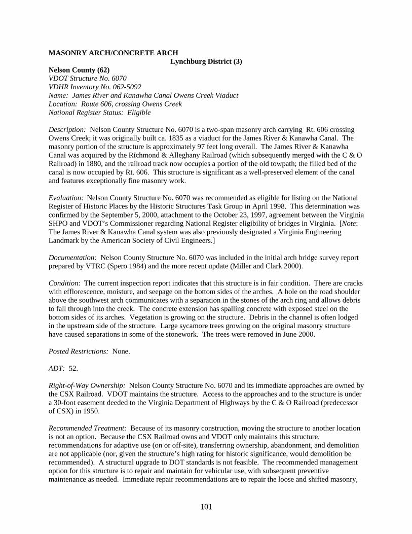
101
MASONRY ARCH/CONCRETE ARCH Lynchburg District (3)
Nelson County (62) VDOT Structure No. 6070 VDHR Inventory No. 062-5092 Name: James River and Kanawha Canal Owens Creek Viaduct Location: Route 606, crossing Owens Creek National Register Status: Eligible Description: Nelson County Structure No. 6070 is a two-span masonry arch carrying Rt. 606 crossing Owens Creek; it was originally built ca. 1835 as a viaduct for the James River & Kanawha Canal. The masonry portion of the structure is approximately 97 feet long overall. The James River & Kanawha Canal was acquired by the Richmond & Alleghany Railroad (which subsequently merged with the C & O Railroad) in 1880, and the railroad track now occupies a portion of the old towpath; the filled bed of the canal is now occupied by Rt. 606. This structure is significant as a well-preserved element of the canal and features exceptionally fine masonry work. Evaluation: Nelson County Structure No. 6070 was recommended as eligible for listing on the National Register of Historic Places by the Historic Structures Task Group in April 1998. This determination was confirmed by the September 5, 2000, attachment to the October 23, 1997, agreement between the Virginia SHPO and VDOT’s Commissioner regarding National Register eligibility of bridges in Virginia. [Note: The James River & Kanawha Canal system was also previously designated a Virginia Engineering Landmark by the American Society of Civil Engineers.] Documentation: Nelson County Structure No. 6070 was included in the initial arch bridge survey report prepared by VTRC (Spero 1984) and the more recent update (Miller and Clark 2000). Condition: The current inspection report indicates that this structure is in fair condition. There are cracks with efflorescence, moisture, and seepage on the bottom sides of the arches. A hole on the road shoulder above the southwest arch communicates with a separation in the stones of the arch ring and allows debris to fall through into the creek. The concrete extension has spalling concrete with exposed steel on the bottom sides of its arches. Vegetation is growing on the structure. Debris in the channel is often lodged in the upstream side of the structure. Large sycamore trees growing on the original masonry structure have caused separations in some of the stonework. The trees were removed in June 2000. Posted Restrictions: None. ADT: 52. Right-of-Way Ownership: Nelson County Structure No. 6070 and its immediate approaches are owned by the CSX Railroad. VDOT maintains the structure. Access to the approaches and to the structure is under a 30-foot easement deeded to the Virginia Department of Highways by the C & O Railroad (predecessor of CSX) in 1950. Recommended Treatment: Because of its masonry construction, moving the structure to another location is not an option. Because the CSX Railroad owns and VDOT only maintains this structure, recommendations for adaptive use (on or off-site), transferring ownership, abandonment, and demolition are not applicable (nor, given the structure’s high rating for historic significance, would demolition be recommended). A structural upgrade to DOT standards is not feasible. The recommended management option for this structure is to repair and maintain for vehicular use, with subsequent preventive maintenance as needed. Immediate repair recommendations are to repair the loose and shifted masonry,

102
and repoint the masonry joints with a compatible (lime-content, not pure portland cement) mortar mix. The channel should be cleared and monitored to prevent debris buildup. A transportation enhancement grant application should be considered as a potential funding source for needed masonry restoration.
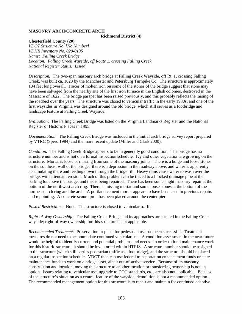
103
MASONRY ARCH/CONCRETE ARCH Richmond District (4)
Chesterfield County (20) VDOT Structure No. [No Number] VDHR Inventory No. 020-0135 Name: Falling Creek Bridge Location: Falling Creek Wayside, off Route 1, crossing Falling Creek National Register Status: Listed Description: The two-span masonry arch bridge at Falling Creek Wayside, off Rt. 1, crossing Falling Creek, was built ca. 1823 by the Manchester and Petersburg Turnpike Co. The structure is approximately 134 feet long overall. Traces of molten iron on some of the stones of the bridge suggest that stone may have been salvaged from the nearby site of the first iron furnace in the English colonies, destroyed in the Massacre of 1622. The bridge parapet has been raised previously, and this probably reflects the raising of the roadbed over the years. The structure was closed to vehicular traffic in the early 1930s, and one of the first waysides in Virginia was designed around the old bridge, which still serves as a footbridge and landscape feature at Falling Creek Wayside. Evaluation: The Falling Creek Bridge was listed on the Virginia Landmarks Register and the National Register of Historic Places in 1995. Documentation: The Falling Creek Bridge was included in the initial arch bridge survey report prepared by VTRC (Spero 1984) and the more recent update (Miller and Clark 2000). Condition: The Falling Creek Bridge appears to be in generally good condition. The bridge has no structure number and is not on a formal inspection schedule. Ivy and other vegetation are growing on the structure. Mortar is loose or missing from some of the masonry joints. There is a bulge and loose stones on the southeast wall of the bridge: there is a depression in the roadway above, and water is apparently accumulating there and feeding down through the bridge fill. Heavy rains cause water to wash over the bridge, with attendant erosion. Much of this problem can be traced to a blocked drainage pipe at the parking lot above the bridge, and this is being repaired. There has been some slight masonry repair at the bottom of the northwest arch ring. There is missing mortar and some loose stones at the bottom of the northeast arch ring and the arch. A portland cement mortar appears to have been used in previous repairs and repointing. A concrete scour apron has been placed around the center pier. Posted Restrictions: None. The structure is closed to vehicular traffic. Right-of-Way Ownership: The Falling Creek Bridge and its approaches are located in the Falling Creek wayside; right-of-way ownership for this structure is not applicable. Recommended Treatment: Preservation in-place for pedestrian use has been successful. Treatment measures do not need to accommodate continued vehicular use. A condition assessment in the near future would be helpful to identify current and potential problems and needs. In order to fund maintenance work for this historic structure, it should be inventoried within HTRIS. A structure number should be assigned to this structure (which still carries pedestrian traffic as a footbridge), and the structure should be placed on a regular inspection schedule. VDOT then can use federal transportation enhancement funds or state maintenance funds to work on a bridge asset, albeit out-of-active service. Because of its masonry construction and location, moving the structure to another location or transferring ownership is not an option. Issues relating to vehicular use, upgrade to DOT standards, etc., are also not applicable. Because of the structure’s situation as a central feature of the wayside, demolition is not a recommended option. The recommended management option for this structure is to repair and maintain for continued adaptive
104
use, with subsequent preventive maintenance as needed. Immediate repair recommendations are to address and monitor the drainage problems that cause water accumulation and washing around the bridge, to remove the vegetation from the bridge, and to repair and repoint the masonry as needed. A compatible (lime-content, not pure portland cement) mortar should be used. VDHR should be consulted to ensure a compatible mortar formula.

105
MASONRY ARCH/CONCRETE ARCH Richmond District (District 4)
Dinwiddie County (26) VDOT Structure No. 1005 VDHR Inventory No. 026-5002 Location: Route 1, crossing Stony Creek National Register Status: Eligible Description: Dinwiddie County Structure No. 1005 is a single-span concrete through arch with two concrete T-beam approach spans, built in 1926, carrying Rt. 1 crossing Stony Creek. The structure is approximately 167 feet long overall; the through arch is 90 feet long. This concrete through arch, a design also known as a Marsh arch or rainbow arch, is the only remaining structure of this type in Virginia. Evaluation: Dinwiddie County Structure No. 1005 was recommended as eligible for listing on the National Register of Historic Places by the Historic Structures Task Group in February 1998. This determination was confirmed by the September 5, 2000, attachment to the October 23, 1997, agreement between the Virginia SHPO and VDOT’s Commissioner regarding National Register eligibility of bridges in Virginia. Documentation: Dinwiddie County Structure No. 1005 was included in the initial arch bridge survey report prepared by VTRC (Spero 1984) and the more recent update (Miller and Clark 2000). Condition: The current inspection report indicates that this structure is in fair condition. The bridge is deteriorating, and there are various areas of efflorescence, chipping, spalling, and delamination, some of which are substantial. There are areas of exposed rebar. Portions of the rail have previously been replaced. The drains are blocked. The bridge rests on iron rockers, which show some areas of rusting and deterioration. There are areas of scour at the south pier. Posted Restrictions: None. ADT: 2,160. Right-of-Way Ownership: This structure is located on a primary route. Fee simple ownership is presumed. Recommended Treatment: Because of its concrete construction and its location on a major primary route, moving the structure to another location, abandoning it, or transferring ownership is not an option. The through-arch technology permanently limits height and does not permit widening. Because of this technology, an upgrade to DOT standards is not feasible. The deteriorating concrete of the structure and the height restrictions occasioned by its technology (particularly if there are future upgrade needs for Rt. 1) may eventually make it impossible for this bridge to stay under vehicular use. Long-term preservation of this structure will entail imaginative (and expensive) engineering solutions—probably either realigning Rt. 1 or moving the bridge slightly to remove it from the highway. Recommended management options for this structure, in order of preference, are:
1. Repair and maintain for vehicular use, with subsequent preventive maintenance as needed. Immediate repair recommendations are to repair spalled, cracked, and delaminated areas; seal the joints; keep the drains open; and address the scour problems.
106
2. Documenting and salvaging some elements of the bridge for adaptive use off-site could be considered as a second option. A new structure would be required.
3. Documentation and demolition and replacement with a new structure is a third option. 4. Repairing and maintaining the structure for adaptive use on-site, or nearly on-site, is a fourth
option. Realigning Rt. 1 and bypassing the through arch is one (complicated and expensive) possibility. The entire arch (approximately 110 tons) could also be moved to the side of the right of way if money is no object, but such an expedient would also be extremely expensive (the 1999 estimate for moving the through arch was in excess of $500,000). In either case, a new structure would be required.
107
MASONRY ARCH/CONCRETE ARCH Richmond District (4)
City of Petersburg (123) VDOT Structure No. 8018 VDHR Inventory No. 123-5013 Location: Halifax Road and CSX Railroad, crossing Defense Road National Register Status: Eligible Description: City of Petersburg Structure No. 8018 is a single-span concrete rigid frame, with brick veneer, carrying Halifax Road and CSX Railroad crossing Defense Road. The arch span is 36 feet long, and the entire structure is approximately 100 feet long. It was designed by the U.S. Department of Public Roads and was built in 1936 as a National Park Service project, part of a program of improved access to the Petersburg National Military Park. The use of red brick veneer in the design, which includes brick quoins and decorative brickwork representing voussoirs around the arch opening, is typical of one of the mid-20th century Park Service design standards calculated to give the structure a period appearance. Other examples of National Park Service design standards in Virginia can be seen in the bridges along the Colonial Parkway (red brick veneer over concrete) and the Blue Ridge Parkway (stone veneer over concrete); these latter projects were also begun in the 1930s. Evaluation: City of Petersburg Structure No. 8018 was recommended as eligible for listing in the National Register of Historic Places by the Historic Structures Task Group in August 1998. This determination was confirmed by the September 5, 2000, attachment to the October 23, 1997, agreement between the Virginia SHPO and VDOT’s Commissioner regarding National Register eligibility of bridges in Virginia. Documentation: City of Petersburg Structure No. 8018 was included in the updated arch bridge survey report prepared by VTRC (Miller and Clark 2000). Condition: The current inspection report indicates that overall, the structure is in good condition. There is a 1/8-in full height vertical crack along the north wall and some hairline cracking with water staining along the base of the south wall. The Defense Road brick retaining wall exhibits some cracking, and there is some cracking and settlement in the Halifax Road roadway. There is a small amount of spalling on the top of the parapet. Vegetation (including vines and small trees) is encroaching on the bridge. Posted Restrictions: None. ADT: 1,066. Right-of-Way Ownership: This structure was originally constructed as part of a federal project, and was a National Park Service structure. It is now owned and maintained by the City of Petersburg. Fee simple ownership is presumed. Recommended Treatment: Because of its concrete construction, multi-modal use, and location, moving the structure to another location, abandoning it, adaptive use, or transferring ownership is not an option. An upgrade to DOT standards is not feasible, and demolition is not recommended. Recommended management options for this structure, in order of preference, are:
1. Preventive maintenance would likely correct the bridge’s current condition problems. In particular, cracks should be monitored and vegetation removed and kept off the bridge.
2. Repair and maintain for vehicular use if subsequently needed.

108
MASONRY ARCH/CONCRETE ARCH Richmond District (4)
City of Richmond (127) VDOT Structures No. 1849 and 1857 VDHR Inventory No. 127-5808 Name: Mayo Bridge Location: Route 360, crossing James River National Register Status: Eligible Description: The Mayo Bridge consists of two structures with separate structure numbers. City of Richmond Structure No. 1849 is an 11-span concrete closed spandrel arch bridge, approximately 841 feet long. City of Richmond Structure No. 1857 is a 7-span concrete closed spandrel arch bridge, approximately 533 feet long. In concert, these structures carry Rt. 360 crossing the James River. The different numbers reflect the structure’s spanning of the north and south divisions of the James River at Mayo’s Island: Structure No. 1849 spans the south division of the James, and Structure No. 1857 the north division. The Mayo Bridge was built in 1911-1913 (designer, Concrete Steel Engineering Company, New York; builder: I. J. Smith & Co., Richmond). Decorative elements include a solid parapet with an intricate cast lattice motif and cast concrete obelisk lampposts. A large, early, and elaborate concrete arch bridge, this structure is also the latest of a series of bridges that have spanned the James at this site since the original structure was erected by John Mayo in 1788; the name “Mayo Bridge” has been attached to subsequent bridges at this crossing. Evaluation: City of Richmond Structure No. 1849 was recommended as eligible for listing in the National Register of Historic Places by the Historic Structures Task Group in June 1998. This determination was confirmed by the September 5, 2000, attachment to the October 23, 1997, agreement between the Virginia SHPO and VDOT’s Commissioner regarding National Register eligibility of bridges in Virginia. Documentation: This structure (noted as City of Richmond Structure No. 1849, but actually including structures Nos. 1849 and 1957) was included in the initial arch bridge survey report prepared by VTRC (Spero 1984) and the more recent update (Miller and Clark 2000). Condition: The current inspection report indicates that both sections of the Mayo Bridge are in fair condition. The bridge exhibits numerous areas of cracking and spalling, which are severe in places. Some shotcrete has been applied to the structure. The spandrel walls are moving outward. There are various scour problems. Posted Restrictions: None. ADT: 38,062. Right-of-Way Ownership: This structure is within the limits of the City of Richmond and carries a primary route. Fee simple ownership is presumed. The structure is owned and maintained by the City of Richmond. Recommended Treatment: Because of its concrete construction and location, moving the structure to another location, abandoning it, or transferring ownership is not an option. An upgrade to DOT standards is not feasible. Recommended management options for this structure, in order of preference, are:
109
1. Repair and maintain for vehicular use, with subsequent preventive maintenance as needed. Immediate repair recommendations are to remove the asphalt overlay, evaluate and repair the deck, install a new concrete overlay, and repair spalled and delaminated areas. The movement of the spandrel walls should be monitored.
2. Documentation and demolition and replacement with a new structure is a second option.
110
MASONRY ARCH/CONCRETE ARCH Staunton District (8)
Augusta County (7) VDOT Structure No. 6165 VDHR Inventory No. 007-5072 Location: Route 835, crossing Jennings Branch National Register Status: Eligible Description: Augusta County Structure No. 6165 is a single-span spandrel braced arch with two short concrete slab approach spans, carrying Rt. 835 crossing Jennings Branch. The structure was built in 1932 by the Luten Bridge Co. It is approximately 84 feet long overall; the arch is 60 feet long. This is an excellent example of Daniel B. Luten’s innovative designs. Evaluation: Augusta County Structure No. 6165 was recommended as eligible for listing in the National Register of Historic Places by the Historic Structures Task Group in February 1998. This determination was confirmed by the September 5, 2000, attachment to the October 23, 1997, agreement between the Virginia SHPO and VDOT’s Commissioner regarding National Register eligibility of bridges in Virginia. Documentation: Augusta County Structure No. 6165 was included in the updated arch bridge survey report prepared by VTRC (Miller and Clark 2000). Condition: The current inspection report indicates that this structure is in fair condition. There is scattered cracking, spalling, and discoloration on the pier caps. In addition, minor cracking appears on its arches and it shows discolorations and scale on the deck. The concrete is generally in good condition. The scour is unchanged since approximately 1985. The traffic count is steadily increasing because of development farther up Rt. 835 and the surrounding area. Posted Restrictions: None. ADT: 648. Right-of-Way Ownership: The bridge was constructed in 1932, at the time of the creation of the state secondary system, raising the question of the ownership of the right of way. In response to this question, the Staunton District Right-of-Way Office reported that the approaches to Augusta County Structure No. 6165 are apparently constructed on prescriptive easement Recommended Treatment: Because of its concrete construction and location, moving the structure to another location or transferring ownership off-site is not an option. Discontinuing, abandoning, demolishing the structure, or transferring ownership on-site are not recommended. Recommended management options for this structure, in order of preference, are:
1. Repair and maintain for vehicular use, with subsequent preventive maintenance as needed. Immediate repair recommendations are to repair the cracked and spalled concrete, remove the asphalt overlay, evaluate and repair the deck, install a new concrete overlay, clear and extend the drains, and clean the channel to divert water from the south end of the bridge.
2. An upgrade to DOT standards is feasible and could be considered as a second option. As
development and traffic continue to increase, there may be growing demands for an upgrade of this crossing. Houses and a church at the south end of the bridge limit the amount of possible realignment of Rt. 835, and there is not sufficient room for a parallel lane and bridge. If widening is needed, the best potential for widening the road would be to widen the existing
111
bridge as well by constructing a third arch and moving or duplicating the existing rail; such plans should be developed in consultation with VDHR.
112
MASONRY ARCH/CONCRETE ARCH Staunton District (8)
Augusta County (7) VDOT Structure No: [No Number] VDHR Inventory No. 007-0041 Name: Valley Railroad Bridge Location: West of I-81, crossing Folly Mills Creek, south of Staunton National Register Status: Listed Description: The Valley Railroad Bridge is a four-span masonry arch bridge crossing Folly Mills Creek just west of I- 81, south of Staunton. It structure is approximately 147 feet long. Built in 1874 to carry rail traffic on the Valley Railroad, this large multi-span masonry arch bridge is one of the largest and most visible 19th century masonry railroad bridge structures in Virginia. The railroad line was discontinued in 1942, and the bridge is now preserved as a landscape element adjacent to I-81. Evaluation: The Valley Railroad Bridge was listed on the Virginia Landmarks Register and the National Register of Historic Places in 1974. Documentation: The Valley Railroad Bridge was included in the initial arch bridge survey report prepared by VTRC (Spero 1984) and the more recent update (Miller and Clark 2000). Condition: This structure appears to be in generally fair condition. The bridge has no structure number and is not on a formal inspection schedule. There are grass, weeds, vines, bushes, and small trees growing on the old roadway and various other areas of the bridge. The bases of two piers along the creek have concrete aprons added as a stabilization measure. There are some areas of seepage through the arch and corresponding loss of mortar; some repointing has been done with portland cement. Posted Restrictions: None. The structure does not carry traffic of any sort. Right-of-Way Ownership: The Valley Railroad Bridge and its approaches carry no traffic of any kind; the structure is located within the right of way for I-81; right-of-way ownership for this structure is not applicable. Recommended Treatment: Although unsuitable for use as a vehicular or pedestrian bridge because of its location in the I-81 right of way, the Valley Railroad Bridge is one of the most visible, and popular, historic bridges in Virginia. Because of its location, material, and appearance, it is a striking landscape feature, and it is seen and remarked upon by thousands of drivers every day. A condition assessment in the near future would be helpful to identify fully current and potential problems and needs. A structure number should be assigned, and the structure should be placed on a regular inspection schedule. Once the structure is inventoried within HTRIS, VDOT can use state maintenance funds to work on a bridge asset, albeit out-of-active service. This attractive and highly visible historic bridge should be considered a candidate for a transportation enhancement grant. Because of its masonry construction and location, moving the structure to another location is not an option. Other usual options such as upgrade to DOT standards, transferring ownership, etc. are not applicable in the case of this structure, which will not carry either vehicular or foot traffic. The recommended management option for this structure is to repair and maintain for adaptive use (i.e., its continuing role as a landscape feature), with subsequent preventive maintenance as needed. Immediate maintenance recommendations are to remove the vegetation from the bridge. The grass on the roadbed is not a serious encroachment, but the vines, bushes and trees should be removed to prevent further damage to the structure. A structural assessment should be made of the cracks in the bridge, these should be repaired or monitored as necessary; an appropriate mortar mix (part-lime, not pure portland cement) should be used for repointing. Monitoring and maintenance of the streambed
113
should be continued. To minimize seepage through the structure, the roadway should be evaluated for the most effective sealing and drainage methods (possibly an impermeable clay liner and drainage pipe inserted into the roadway to promote runoff). Interpretive signage regarding the bridge should be placed at flanking rest areas. The feasibility of interesting an “Adopt-A-Highway” group in this bridge should be examined.
114
MASONRY ARCH/CONCRETE ARCH Staunton District (8)
Frederick County (34) VDOT Structure No. 6903 VDHR Inventory No. 034-5022 Location: Route 672, crossing Opequon Creek National Register Status: Eligible Description: Frederick County Structure No. 6903 is a two-span concrete closed spandrel arch, with each abutment forming a short approach span. The structure carries Rt. 672 crossing Opequon Creek. It was built for the Virginia State Highway Commission in 1917 by the Monongahela Valley Engineering Co. The structure is approximately 209 feet long overall; each span is approximately 82 feet long. This structure is significant for its use of the Thacher reinforcing system. A metal truss bridge was proposed for this site in 1915. However, after the patent on the Thacher bar reinforcing system was overturned in 1916, this concrete bridge was quickly designed and built instead using the Thacher system. Evaluation: Frederick County Structure No. 6903 was recommended as eligible for listing in the National Register of Historic Places by the Historic Structures Task Group in August 1998. This determination was confirmed by the September 5, 2000, attachment to the October 23, 1997, agreement between the Virginia SHPO and VDOT’s Commissioner regarding National Register eligibility of bridges in Virginia. Documentation: Frederick County Structure No. 6903 was included in the initial arch bridge survey report prepared by VTRC (Spero 1984) and the more recent update (Miller and Clark 2000). Condition: The current inspection report indicates that the overall condition of the bridge is fair. The superstructure is in generally good condition. However, there are areas of marked deterioration throughout the substructure. The piers and abutments exhibit areas of cracking, chipping, spalling (freeze thaw), and efflorescence. There are areas of efflorescence and deterioration at the joints of the formwork on the underside of the arch. There are trees growing close to the bridge. There is debris on the deck, and vegetation is growing on the deck and piers of bridge. There is a scour hole near one abutment. Debris lodges against the upstream piers. The drains, which are of unusual construction (the drains go through the piers and abutment), are partly blocked. Posted Restrictions: None. ADT: 582. Right-of-Way Ownership: Because of the structure’s location on a portion of a secondary roadway that has undergone no substantial improvement projects since the creation of the secondary system in 1932, the approaches are presumed to be constructed on prescriptive easement. Recommended Treatment: Because of its concrete construction and location, moving the structure to another location, off-site adaptive use, or transferring ownership off-site is not an option. Demolition is not recommended. Recommended management options for this structure, in order of preference, are:
1. Repair and maintain for vehicular use, with subsequent preventive maintenance as needed. Immediate repair recommendations are to open the drains, repair the scour hole, cut the trees back to allow air circulation and allow the concrete to dry off, remove vegetation from the deck and piers of the bridge, and remove debris from the deck. The cracking, chipping, spalling (freeze thaw), and efflorescence on the piers and the efflorescence on the joints of the formwork on the underside of the arch need to be addressed in the near future, and
115
adequate moisture protection needs to be provided. The curb line should be sealed to keep water out of the construction joints. Various sealing technologies should be evaluated for possible use on this bridge. Spalled and delaminated areas need to be repaired. [Note: This bridge needs major repairs within the next 5 years. Given the scale of a full rehabilitation, the cost will approach that of a new bridge. Application for a transportation enhancement grant to assist with rehabilitation should be considered.]
2. An upgrade to DOT standards is feasible and could be considered as a second option. 3. Repair and maintain for on-site adaptive use, with subsequent preventive maintenance as
needed. 4. Transfer ownership on-site if a willing and suitable recipient can be identified. 5. Discontinue. 6. Abandon.

116
MASONRY ARCH/CONCRETE ARCH Staunton District (8)
Rockbridge County (81) VDOT Structure No. 1012 VDHR Inventory No. 081-5052 Location: Route 39, crossing Laurel Run National Register Status: Eligible Description: Rockbridge County Structure No. 1012 is a single-span concrete rigid frame with stone veneer, built in 1940, carrying Rt. 39 crossing Laurel Run. The bridge is approximately 31 feet long. This bridge was designed as part of the improvements to Rt. 39 running Goshen Pass. This design was part of the Virginia Department of Highway’s overall landscaping for this project, which was carefully planned to complement scenic Goshen Pass. This project was the department’s first large-scale integration of highway design and landscaping to avoid or minimize highway impact to an historic/scenic area. Evaluation: Rockbridge County Structure No. 1012 was recommended as eligible for listing in the National Register of Historic Places by the Historic Structures Task Group in June 1998. This determination was confirmed by the September 5, 2000, attachment to the October 23, 1997, agreement between the Virginia SHPO and VDOT’s Commissioner regarding National Register eligibility of bridges in Virginia. Documentation: Rockbridge County Structure No. 1012 was included in the updated arch bridge survey report prepared by VTRC (Miller and Clark 2000). Condition: The current inspection report indicates that the structure is in good condition. There are some loose stones and breaks in the stone coping. A small amount of water is draining through the west abutment. There is some washout around the retaining/wing wall area on the upstream side. A scour footing has been added on the west side of the bridge. Posted Restrictions: None. ADT: 689. Right-of-Way Ownership: This structure carries a primary route and relates to a project undertaken in the 1930s and 1940s. Fee simple ownership is presumed. Recommended Treatment: Because of its concrete construction and location, moving the structure to another location, discontinuing it, abandoning it, adaptive use, or transferring ownership is not an option. A structural upgrade to DOT standards is not recommended. The recommended management option for this structure is to repair and maintain for vehicular use, with subsequent preventive maintenance as needed. The immediate repair recommendations are to stabilize the washout on the upstream retaining/wing wall; repoint the loose stones, and repair the broken coping. A scour footing should be added to the east side of the bridge. The asphalt should be excavated from on and around the bridge, and the structure should be evaluated to determine the best methods to stop water from draining through the west abutment and to repair and prevent washout and scour around the structure.
117
MASONRY ARCH/CONCRETE ARCH Northern Virginia District (A)
Loudoun County (53) VDOT Structure No. 1025 VDHR Inventory No. 053-0244 Name: Aldie Bridge (Little River Turnpike Bridge) Location: Route 50, crossing Little River National Register Status: Eligible [individually] [Note: Listed as a contributing structure within a National Register Historic District] Description: Loudoun County Structure No. 1025 is a two-span masonry arch bridge carrying Rt. 50 crossing Little River. It was built ca. 1810-1824 by the Little River Turnpike Company. The structure is approximately 108.5 feet long overall. This structure is one of the few remaining masonry turnpike bridges in Virginia. Evaluation: Loudoun County Structure No. 1025 was recommended as eligible for listing in the National Register of Historic Places by the Historic Structures Task Group in June 1998. This determination was confirmed by the September 5, 2000, attachment to the October 23, 1997, agreement between the Virginia SHPO and VDOT’s Commissioner regarding National Register eligibility of bridges in Virginia. Note: This bridge is also a contributing structure within the Aldie Mill Historic District, which was listed on the Virginia Landmarks Register and the National Register of Historic Places in 1970. Documentation: Loudoun County Structure No. 1025 was included in the initial arch bridge survey report prepared by VTRC (Spero 1984) and the more recent update (Miller and Clark 2000). Condition: The current inspection report indicates that this structure is in fair condition. Loudoun County Structure No. 1025 has suffered numerous occurrences of impact damage over the years because of vehicle impacts on the heavily traveled primary Rt. 50. In late 1998, 30 feet of the northeast parapet wall were destroyed by vehicle impact; after consultation with the task group and VDHR, the destroyed parapet section was rebuilt in kind using an historically compatible mortar. In 1999, outward movement of the spandrel walls caused a separation between the deck and spandrel walls. Water drains through the underside of the bridge. There are areas of missing mortar on the arch bottom, face, and parapets. Scour aprons have been placed on the pier and abutments. Posted Restrictions: The structure has a legal limit of 27 and 40 tons, respectively. ADT: 13,373. Right-of-Way Ownership: This structure carries a primary route. Fee simple ownership is presumed. As originally built, the Little River Turnpike had a 50-foot right of way. Recommended Treatment: Because of its masonry construction and location, moving the structure to another location, abandoning it, or transferring ownership is not an option. Because of the location of this structure and the proximity of other historic resources in the Aldie Mill Historic District, options are limited. There is, for example, insufficient space to realign Rt. 50 slightly at Little River so that the bridge structure could be bypassed, as this would affect numerous other buildings and sites. Adaptive use is, therefore, not feasible, nor is discontinuing or abandoning the bridge. An upgrade to DOT standards would necessitate alteration of the bridge’s historic form and dimensions. Accordingly, in the task group’s opinion, the most feasible management recommendation for this bridge is that it be repaired and maintained for vehicular use, with subsequent preventive maintenance. However, the ADT of approximately 13,000 vehicles, many of them trucks, poses a serious threat to the historic bridge; it is the
118
task group’s further recommendation that traffic load on this bridge should be reduced, preferably by a Rt. 50 bypass of Aldie, with the present section of Rt. 50 through Aldie becoming a village street. This would not only limit stress on the bridge itself, but would also reduce traffic vibration impact on other historic structures within the historic district. Note: Recent plans advanced by the Rt. 50 Corridor Coalition, a local citizens’ group, which is attempting to preserve the scenic character of their region, call for using this bridge as a traffic calming device. These traffic calming plans, which may be found in A Traffic Calming Plan for Virginia’s Rural Route 50 Corridor: Fauquier and Loudoun Counties, Including Aldie, Middleburg and Upperville, published for the Route 50 Corridor Coalition, Middleburg, Virginia, in 1996, also recommend “put the hump back in the stone bridge over Little River” (p. 44) (i.e., Loudoun County Structure No. 1025). However, there is no documentary or physical evidence that such a feature previously existed on this bridge: the likeliest explanation is that the belief in a previous “hump” is a misinterpretation of the previous raising of the approaches to the bridge. Raising the approaches would have lessened the effect of climbing from low approaches onto the bridge. It is the opinion of the task group that this is a unique historic structure with some serious structural problems and stresses from heavy traffic. These problems must be addressed—and soon—if the structure is to survive. This is 180-year-old masonry bridge, not a “traffic calming device.” The task group does not endorse the idea of bridges being used as traffic calming devices and evaluates structures solely on the basis of historical significance along with their use as infrastructure assets for conveyance of traffic over obstacles or obstructions.
119
MASONRY ARCH/CONCRETE ARCH Northern Virginia District (District A)
VDOT Structure No. 6088 VDHR Inventory No. 053-0243 Name: Hibbs Bridge Location: Route 734, crossing Beaverdam Creek National Register Status: Eligible Description: Loudoun County Structure No. 6088 is a two-span masonry arch bridge carrying Rt. 734 crossing Beaverdam Creek. It was built ca. 1829 by the Snickers Gap Turnpike Company. The structure is approximately 133 feet long overall. This structure is one of the few remaining masonry turnpike bridges in Virginia. Evaluation: Loudoun County Structure No. 6088 was recommended as eligible for listing in the National Register of Historic Places by the Historic Structures Task Group in June 1998. This determination was confirmed by the September 5, 2000, attachment to the October 23, 1997, agreement between the Virginia SHPO and VDOT’s Commissioner regarding National Register eligibility of bridges in Virginia. Documentation: Loudoun County Structure No. 6088 was included in the initial arch bridge survey report prepared by VTRC (Spero 1984) and the more recent update (Miller and Clark 2000). Condition: The current inspection report indicates that this structure is in poor condition. The rubble masonry parapets have large gaps because of missing stones and deteriorating mortar. Scour aprons have been placed on the pier and abutments, and the undersides of the arches have been shotcreted. Water leaks from the asphalt surface through the deck and discharges on the underside of the arch. Because of this, the arch has developed scattered hairline cracks and efflorescence. Much of the lime-and-sand mortar around the masonry fill has leached, and probing reveals voids within the spandrel walls. There is extensive vegetation, including bushes and small trees, growing on and around the bridge. Repeated gross abuse of the posted 6-ton weight limit by vehicles (including gravel trucks, heavy equipment trailers, building supply delivery vehicles, and horse vans) is a major factor in the deterioration of this structure. Posted Restrictions: The structure is posted at 6 tons. ADT: 1,225. Right-of-Way Ownership: Because of the structure’s location on a portion of a secondary roadway that has undergone no substantial improvement projects since the creation of the secondary system in 1932, the approaches are presumed to be constructed on prescriptive easement. The Snickers Gap Turnpike had a 45-foot right of way. Recommended Treatment: During the 1990s, VDOT proposed a plan to take the structure off-system, bypass it, and construct a new bridge; the old bridge would then become part of a wayside. There was intense citizen opposition to this plan, coupled with citizens’ and county supervisors’ demands that the ca. 1829 bridge be kept under vehicular use. The county subsequently rejected a second VDOT proposal (designed by VDOT in close consultation with VDHR and the National Park Service’s Williamsport Training Center and approved by VDHR) to rebuild the structure. This design included inserting a concrete arch to strengthen the structure and widening the structure, while rebuilding the spandrel walls, parapets, and other features to replicate the appearance of the historic masonry work. The masonry work would have been done by craftspersons from the Williamsport Training Center. After further discussion with VDOT, Loudoun County hired its own engineering consultant to recommend rehabilitation
120
techniques for the bridge. This report is pending. The task group members made an independent assessment of the issues regarding this bridge; their general determinations are as follows: Because of its masonry construction, moving of the structure to another location, transferring of ownership off-site, or another off-site use is not an option. Transferring ownership on-site, abandoning the structure, or demolishing the structure is not recommended. The task group’s recommended management options for this structure, in order of preference, are:
1. The preferable treatment for the structure from an historic preservation viewpoint is to repair and maintain it for adaptive (non-vehicular) use (such as a wayside, walking trail, or horse trail), with subsequent preventive maintenance as needed. A new vehicular bridge would likely be required. Immediate repair recommendations are to remove the vegetation and repair the areas of damaged masonry.
2. The second option is to repair and maintain the structure for vehicular use. This would
continue to subject the structure to modern traffic, and almost certainly to continued abuse of the weight limit.
3. The third option is a structural upgrade to DOT standards, which would require at least partial
rebuilding of the bridge and attendant loss of part of its historic dimensions, as well as loss of much of the evidence of its historic building practices. Widening, including reinforcement and extension of the arch ring, probable rebuilding of at least one spandrel wall, and rebuilding of the parapets would be required.
4. A fourth option is discontinuing the bridge and its approaches. This would place all
responsibility for the repair and maintenance of the historic structure on the county. It is doubtful whether the county has the resources to assume ownership of and maintain this bridge.
Note: In the task group’s opinion, the original VDOT plan to bypass the old bridge would have been the correct treatment. However, it appears that this option has little local support. Therefore, the most realistic management recommendations for this bridge are that it be repaired and maintained for vehicular use, with subsequent preventive maintenance. The task group still recommends repairing and maintaining the bridge for adaptive use (i.e., for non-vehicular use) as an option.

121
COVERED Staunton District (8)
Shenandoah County (85) VDOT Structure No. 6078 VDHR Inventory No. 085-0103 Name: Meems Bottom Bridge Location: Route 720 crossing North Fork of Shenandoah River National Register Status: Listed Description: Shenandoah County Structure No. 6078 is a single-span Burr arch truss, built ca. 1893, carrying Rt. 720 crossing the North Fork of Shenandoah River. The structure is approximately 207 feet long. Known familiarly as the Meems Bottom Bridge, this is the only covered bridge that still carries vehicles on the public road system in Virginia. It sustained heavy damage when arsonists burned it in October 1976. After restoration, the bridge was reopened in September 1979. It was subsequently strengthened by the addition of steel I-beams and concrete piers. Evaluation: Shenandoah County Structure No. 6078 was listed on the Virginia Landmarks Register and the National Register of Historic Places in 1975. Documentation: Shenandoah County Structure No. 6078 was included on the field survey of covered bridges prepared by VTRC in 1997. Condition: The current inspection report indicates that this structure is in good condition. After the 1976 fire, the truss of the Meems Bottom Bridge was restored using a innovative combination of in-kind replacement and epoxy consolidation. A state-of-the-art fire retardant and sealant was then applied to all four sides of the members. Over the years, some moisture and insect problems have developed because of trapping of moisture inside the members. It was subsequently established that to prevent buildup and trapping of moisture within the wood, one face of members should not be treated,. A supplementary steel beam/concrete pier supporting structure was later installed to strengthen the covered bridge. Posted Restrictions: The structure is posted at 13 tons. ADT: 527. Right-of-Way Ownership: Because of the structure’s location on a portion of a secondary roadway that has undergone no substantial improvement projects since the creation of the secondary system in 1932, the approaches are presumed to be constructed on prescriptive easement. Recommended Treatment: Repair and maintenance for vehicular use is considered to have already been implemented. Demolition is not recommended. Discontinuance or abandonment is not a recommended option at present. Structural upgrade to DOT standards, salvage, and other off-site options are not considered feasible by the task group. In 2000, VDOT submitted a successful application to the National Historic Covered Bridge Preservation Program for funds to design and construct a fire-suppression system for this structure. Recommended management options for this structure, in order of preference, are:
1. Preventive maintenance as needed. 2. Repair and maintain for adaptive use. 3. If a suitable, willing recipient can be identified, transfer of ownership on-site could be
considered as a future option. This would entail discontinuance or abandonment.
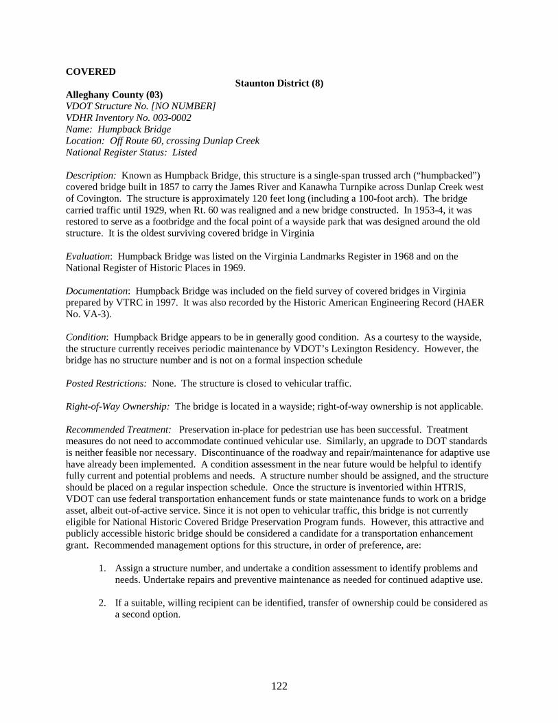
122
COVERED Staunton District (8)
Alleghany County (03) VDOT Structure No. [NO NUMBER] VDHR Inventory No. 003-0002 Name: Humpback Bridge Location: Off Route 60, crossing Dunlap Creek National Register Status: Listed Description: Known as Humpback Bridge, this structure is a single-span trussed arch (“humpbacked”) covered bridge built in 1857 to carry the James River and Kanawha Turnpike across Dunlap Creek west of Covington. The structure is approximately 120 feet long (including a 100-foot arch). The bridge carried traffic until 1929, when Rt. 60 was realigned and a new bridge constructed. In 1953-4, it was restored to serve as a footbridge and the focal point of a wayside park that was designed around the old structure. It is the oldest surviving covered bridge in Virginia Evaluation: Humpback Bridge was listed on the Virginia Landmarks Register in 1968 and on the National Register of Historic Places in 1969. Documentation: Humpback Bridge was included on the field survey of covered bridges in Virginia prepared by VTRC in 1997. It was also recorded by the Historic American Engineering Record (HAER No. VA-3). Condition: Humpback Bridge appears to be in generally good condition. As a courtesy to the wayside, the structure currently receives periodic maintenance by VDOT’s Lexington Residency. However, the bridge has no structure number and is not on a formal inspection schedule Posted Restrictions: None. The structure is closed to vehicular traffic. Right-of-Way Ownership: The bridge is located in a wayside; right-of-way ownership is not applicable. Recommended Treatment: Preservation in-place for pedestrian use has been successful. Treatment measures do not need to accommodate continued vehicular use. Similarly, an upgrade to DOT standards is neither feasible nor necessary. Discontinuance of the roadway and repair/maintenance for adaptive use have already been implemented. A condition assessment in the near future would be helpful to identify fully current and potential problems and needs. A structure number should be assigned, and the structure should be placed on a regular inspection schedule. Once the structure is inventoried within HTRIS, VDOT can use federal transportation enhancement funds or state maintenance funds to work on a bridge asset, albeit out-of-active service. Since it is not open to vehicular traffic, this bridge is not currently eligible for National Historic Covered Bridge Preservation Program funds. However, this attractive and publicly accessible historic bridge should be considered a candidate for a transportation enhancement grant. Recommended management options for this structure, in order of preference, are:
1. Assign a structure number, and undertake a condition assessment to identify problems and needs. Undertake repairs and preventive maintenance as needed for continued adaptive use.
2. If a suitable, willing recipient can be identified, transfer of ownership could be considered as
a second option.