Remedial Investigation/ Remedial Action Selection (RI/RAS ...
FINAL
REMEDIAL INVESTIGATION REPORT
For:
MUNITIONS RESPONSE SITE FORMER MAKANALUA BOMBING RANGE
FUDS PROJECT NO. H09HI020301
ISLAND OF MOLOKAI, HAWAII Contract No. W912PP-11-C-0035
prepared for U.S. Army Engineer District, Sacramento
U.S. Army Engineer District, Honolulu
Prepared by Malama Aina JV, LLC
FINAL December 2013
Robert Crownover
Director of Quality and Safety _____________________________ 12/05/13
(Signature) (Date)
Tess Rottero, PG, PMP
Project Manager: ___________________________ 12/05/13
(Signature) (Date)
Digitally signed by Robert D. Crownover DN: cn=Robert D. Crownover, o=USA Environmental, Inc., ou=DSQ, [email protected], c=US Date: 2013.12.05 09:15:19 -05'00'

Final Remedial Investigation Report
Makanalua Bombing Range
Island of Molokai, HI
Contract Number: W912PP-11-C-0035 Page i
December 2013
TABLE OF CONTENTS
EXECUTIVE SUMMARY .................................................................................................... ES-1
CHAPTER 1. INTRODUCTION ............................................................................................. 1-1
1.1 PURPOSE ........................................................................................................... 1-2
1.2 PROPERTY DESCRIPTION ........................................................................... 1-2
1.2.1 Topography ............................................................................................ 1-2
1.2.2 Geology and Soils ................................................................................... 1-3
1.2.3 Hydrology and Hydrogeology ............................................................... 1-3
1.2.4 Climate .................................................................................................... 1-3
1.2.5 Significant Structures ............................................................................ 1-4
1.2.6 Cultural and Archaeological Resources............................................... 1-4
1.2.7 Demographics ......................................................................................... 1-4
1.2.8 Current or Future Land Use ................................................................. 1-5
1.2.9 Biological Resources .............................................................................. 1-5
1.3 PROBLEM IDENTIFICATION ...................................................................... 1-5
1.4 HISTORICAL INFORMATION ..................................................................... 1-6
1.4.1 Site History/Military Activity ............................................................... 1-6
1.4.2 Property Ownership .............................................................................. 1-7
1.5 PREVIOUS INVESTIGATIONS ..................................................................... 1-7
1.5.1 1991 Inventory Project Report ............................................................. 1-7
1.5.2 2004 INPR Supplement ......................................................................... 1-7
1.5.3 2008 Site Inspection ............................................................................... 1-7
CHAPTER 2. PROJECTED REMEDIAL RESPONSE OBJECTIVES ............................. 2-1
2.1 CONCEPTUAL SITE MODEL ....................................................................... 2-1
2.2 PROJECT APPROACH ................................................................................... 2-4
2.2.1 MEC Transect Investigation ................................................................. 2-4
2.2.2 Demolition ............................................................................................... 2-6
2.2.3 Munitions Potentially Presenting an Explosive
Hazard Management ............................................................................. 2-6
2.2.4 MC Sampling .......................................................................................... 2-7
2.2.5 Environmental Protection Plan ............................................................ 2-7
2.3 PRELIMINARY REMEDIATION GOALS AND
OBJECTIVES .................................................................................................... 2-7
2.4 PRELIMINARY IDENTIFICATION OF APPLICABLE OR
RELEVANT AND APPROPRIATE REQUIREMENTS AND
TO BE CONSIDERED INFORMATION ....................................................... 2-8
2.4.1 Chemical-Specific ARARs..................................................................... 2-8

Final Remedial Investigation Report
Makanalua Bombing Range
Island of Molokai, HI
Contract Number: W912PP-11-C-0035 Page ii
December 2013
2.4.2 Location-Specific ARARs ...................................................................... 2-9
2.4.3 Action-Specific ARARS ......................................................................... 2-9
2.5 SUMMARY OF INSTITUTIONAL ANALYSIS ......................................... 2-10
2.6 DATA NEEDS AND DATA QUALITY OBJECTIVES .............................. 2-10
2.6.1 Step 1 Problem Statement ................................................................... 2-11
2.6.2 Step 2 Identify Decisions ..................................................................... 2-11
2.6.3 Step 3 Identify Information Inputs .................................................... 2-12
2.6.4 Step 4 Define the Boundaries of the Study ........................................ 2-13
2.6.5 MC ......................................................................................................... 2-14
2.6.6 Step 5 Develop the Approach (Decision Rules) ................................. 2-14
2.6.7 Step 6 Specify Performance or Acceptance
Criteria .................................................................................................. 2-15
2.6.8 Step 7 Develop the Plan for Obtaining Data ..................................... 2-16
CHAPTER 3. CHARACTERIZATION OF MEC AND MC ................................................ 3-1
3.1 MEC CHARACTERIZATION ........................................................................ 3-1
3.1.1 Area Investigated ................................................................................... 3-1
3.1.2 Positioning Transects ............................................................................. 3-2
3.1.3 Vegetation Clearance ............................................................................. 3-2
3.1.4 Transect Investigation ........................................................................... 3-2
3.1.5 Intrusive Investigation Results Sheet ................................................... 3-3
3.1.6 QC Instrument /Equipment Testing .................................................... 3-3
3.1.7 Disposition of UXO Items ...................................................................... 3-3
3.1.8 Disposition of Material Documented as Safe ....................................... 3-3
3.1.9 Photographic Log ................................................................................... 3-3
3.2 MC CHARACTERIZATION ........................................................................... 3-4
3.2.1 Purpose of MC Sampling Activities ..................................................... 3-4
3.2.2 Preliminary Screening Values .............................................................. 3-4
3.2.3 Field MC Sampling Activities Summary ............................................. 3-4
3.2.4 Sample Management ............................................................................. 3-5
3.2.5 Analytical Laboratory and Analyses .................................................... 3-6
3.2.6 QC/QA Samples ..................................................................................... 3-7
CHAPTER 4. REVISED CONCEPTUAL SITE MODEL AND REMEDIAL
INVESTIGATION RESULTS ...................................................................................... 4-1
4.1 RESULTS FOR MUNITIONS AND EXPLOSIVES OF
CONCERN ......................................................................................................... 4-1
4.1.1 Results of Intrusive Investigation ......................................................... 4-1
4.1.2 Source, Nature, and Extent of UXO ..................................................... 4-5
4.1.3 MEC Exposure Pathways on Land ...................................................... 4-6
Final Remedial Investigation Report
Makanalua Bombing Range
Island of Molokai, HI
Contract Number: W912PP-11-C-0035 Page iii
December 2013
4.1.4 Exposure Pathways in Tidal Water...................................................... 4-6
4.2 MUNITIONS CONSTITUENTS ...................................................................... 4-6
4.2.1 MC Results ............................................................................................. 4-8
4.2.2 Source Blank and Equipment Rinseate Results ................................ 4-12
4.2.3 Review of Analytical Data ................................................................... 4-12
4.2.4 Source, Nature and Extent of MC Contamination ........................... 4-14
4.3 DELINEATION OF MUNITIONS RESPONSE SITES ............................. 4-14
4.3.1 Background .......................................................................................... 4-15
4.3.2 Delineated Munitions Response Sites ................................................. 4-15
4.3.3 Revised Conceptual Site Models and Potentially
Complete Exposure Pathways for Delineated
Areas of Range Complex No. 1 MRS ................................................. 4-16
CHAPTER 5. CONTAMINANT FATE AND TRANSPORT FOR MEC/MC ................... 5-1
5.1 FATE AND TRANSPORT FOR MEC ............................................................ 5-1
5.1.1 Potential Sources of Contamination ..................................................... 5-1
5.1.2 Contaminant Persistence ....................................................................... 5-1
5.1.3 Contaminant Migration......................................................................... 5-1
5.2 FATE AND TRANSPORT OF MUNITIONS
CONSTITUENTS CONTAMINATION ......................................................... 5-1
5.2.1 MUNITIONS CONSTITUENTS
CONTAMINATION .............................................................................. 5-1
5.2.2 Potential Sources of MC Contamination ............................................. 5-2
5.2.3 Primary Contaminant Media................................................................ 5-2
5.2.4 Primary Transport Mechanism ............................................................ 5-2
5.2.5 Secondary Contaminant Media ............................................................ 5-2
5.3 POTENTIAL HUMAN RECEPTORS AND EXPOSURE
PATHWAYS ...................................................................................................... 5-2
5.3.1 Surface Soil ............................................................................................. 5-3
5.3.2 Groundwater .......................................................................................... 5-3
5.3.3 Surface Water......................................................................................... 5-3
CHAPTER 6. BASELINE HAZARD ASSESSMENT FOR MEC AND RISK
ASSESSMENT FOR MC .............................................................................................. 6-1
6.1 MUNITIONS RESPONSE SITE PRIORITIZATION
PROTOCOL ....................................................................................................... 6-1
6.2 BASELINE MEC HAZARD ASSESSMENT ................................................. 6-2
6.2.1 MEC HA Input Factors ......................................................................... 6-2
CHAPTER 7. BASELINE RISK ASSESSMENT FOR MC ................................................. 7-1
7.1 CONCEPTUAL SITE EXPOSURE MODEL................................................. 7-1

Final Remedial Investigation Report
Makanalua Bombing Range
Island of Molokai, HI
Contract Number: W912PP-11-C-0035 Page iv
December 2013
7.2 AFFECTED MEDIA ......................................................................................... 7-1
7.3 SCREENING VALUES .................................................................................... 7-2
7.4 MC RISK CHARACTERIZATION ................................................................ 7-2
7.5 MC HUMAN HEALTH RISK CHARACTERIZATION ............................. 7-2
7.6 MC ECOLOGICAL SCREENING LEVEL RISK
ASSESSMENT ................................................................................................... 7-3
CHAPTER 8. SUMMARY AND CONCLUSIONS ................................................................ 8-1
8.1 SUMMARY OF TRANSECT INVESTIGATION ......................................... 8-1
8.2 SUMMARY OF MC SAMPLING ................................................................... 8-2
8.3 MRSPP SCORING SUMMARY ...................................................................... 8-2
8.4 MUNITIONS AND EXPLOSIVES OF CONCERN HAZARD
ASSESSMENT (MEC HA) SCORING ........................................................... 8-3
8.5 RECOMMENDATIONS ................................................................................... 8-3
8.5.1 Range Complex No. 1 – Target Area ................................................... 8-4
8.5.2 Range Complex No. 1 – Remaining Lands .......................................... 8-4
CHAPTER 9. REFERENCES .................................................................................................. 9-1
This space is intentionally left blank.
Final Remedial Investigation Report
Makanalua Bombing Range
Island of Molokai, HI
Contract Number: W912PP-11-C-0035 Page v
December 2013
LIST OF TABLES
Table ES-1. Recommendation Summary ES-4
Table 1-1: MBR MEC Characteristics ......................................................................................... 1-6
Table 2-1: Preliminary MEC Conceptual Site Model for Makanalua Bombing Range Prior to RI
Fieldwork .............................................................................................................................. 2-2
Table 2-2: Makanalua Bombing Range RIFS ARARs ................................................................ 2-9
Table 2-3: Government Agencies: Potential Institutional Alternatives ..................................... 2-10
Table 4-1: Results of Intrusive Investigation ............................................................................... 4-2
Table 4-2: MBR Background MC Sample Results: Metals and Explosive Compounds in Soil
(mg/kg) ................................................................................................................................ 4-10
Table 4-3: MBR MC Sample Results: Metals and Explosive Compounds in Soil (mg/kg),
Decision Units 2, 3, and 5 ................................................................................................... 4-11
Table 4-4: Maximum Detected Metals Sample Results and 95% Upper Confidence Limit for
Triplicate Samples (mg/kg) ................................................................................................. 4-12
Table 4-5: Revised MEC Conceptual Site Model for Range Complex No. 1 MRS Target Area
and Remaining Lands .......................................................................................................... 4-17
Table 6-1: Results of MRSPP ...................................................................................................... 6-2
Table 6-2: Summary of Baseline MEC HA Scores for, Range Complex No. 1 – Target Area ... 6-6
Table 7-1: Maximum Metal and Explosive Compounds Concentrations Detected in Soil ......... 7-3
Table 8-1: Summary of Transect Investigation ........................................................................... 8-2
Table 8-2: MRSPP Summary....................................................................................................... 8-3
Table 8-3: Baseline Munitions and Explosives of Concern Hazard Assessment (MEC HA) ..... 8-3
Table 8-4: Recommendation Summary ....................................................................................... 8-5

Final Remedial Investigation Report
Makanalua Bombing Range
Island of Molokai, HI
Contract Number: W912PP-11-C-0035 Page vi
December 2013
LIST OF FIGURES
Figure ES-1. Proposed MRS Boundaries…..............................................................................ES-5
Figure 1-1: Project Location Map ................................................................................................ 1-2
Figure 2-1: Preliminary MC Conceptual Site Model for MBR ................................................... 2-3
Figure 2-2: Makanalua Bombing Range Transect Map ............................................................... 2-5
Figure 3-1: RI Intrusive Results ................................................................................................... 3-1
Figure 4-1: RI Intrusive Results and Density Map ...................................................................... 4-5
Figure 4-2: Sample Locations ...................................................................................................... 4-7
Figure 4-3: Decision Unit 3 Increment Locations ....................................................................... 4-8
Figure 4-4: Recommended MRS Re-delineation ....................................................................... 4-16
Figure 4-5: Revised MC Conceptual Site Model for MBR Range Complex No. 1 .................. 4-18
Figure 8-1: Proposed MRS Boundaries ....................................................................................... 8-6
LIST OF APPENDICES
Appendix A Field Logs
Appendix B UXOSO Safety Reports
Appendix C UXO QC Reports
Appendix D Photographic Log
Appendix E Munitions Debris Form 1348 and Disposal Certification
Appendix F Munitions and Explosives of Concern Hazard Assessment
Appendix G Munitions Response Site Prioritization Protocol Score Sheets
Appendix H Natural Resources Survey Report
Appendix I Laboratory Data
Appendix J MBR Intrusive Results
Appendix K VSP Reports
Appendix L Data Usability Report

Final Remedial Investigation Report
Makanalua Bombing Range
Island of Molokai, HI
Contract Number: W912PP-11-C-0035 Page vii
December 2013
ACRONYMS AND ABBREVIATIONS
AP Armor Piercing
asl Above Sea Level
bgs Beneath Ground Surface
ARAR Applicable or Relevant and Appropriate Requirement
BSI Blind Seed Item
CEPOH United States Army Corps of Engineers, Honolulu District
CESPK United States Army Corps of Engineers, Sacramento District
CERCLA Comprehensive Environmental Response, Compensation, and
Liability Act
CFR Code of Federal Regulations
CHE Chemical Warfare Materiel Hazard Evaluation
COC Chain of Custody
COPC Chemicals of Potential Concern
CSM Conceptual Site Model
CWM Chemical Warfare Materiel
DD Decision Document
DERP Defense Environmental Restoration Program
DFW Definable Feature of Work
DGPS Differential Global Positioning System
DID Data Item Description
DLNR Department of Land and Natural Resources
DMM Discarded Military Munitions
DoD Department of Defense
DQO Data Quality Objective
DU Decision Unit
E2 Element Environmental
EHE Explosive Hazard Evaluation
EM Engineering Manual
EP Engineering Pamphlet
EPA Environmental Protection Agency
EOD Explosive Ordnance Disposal
ESCQ Explosive Safety Quantity Distance
FFID Federal Facility Identifier
FFP Firm Fixed Price
FS Feasibility Study
FUDS Formerly Used Defense Sites

Final Remedial Investigation Report
Makanalua Bombing Range
Island of Molokai, HI
Contract Number: W912PP-11-C-0035 Page viii
December 2013
FUDSMIS Formerly Used Defense Sites Management Information System
FUP Fixed Unit Price
GANDA Garcia and Associates
GIS Geographical Information System
GP General Purpose
HA Hazard Assessment
HAR State of Hawaii Administrative Rules
HDOH Hawaii Department of Health
HE High Explosive
HFD Hazardous Fragment Distance
HHE Health Hazard Evaluation
INPR Inventory Project Report
IS Incremental Sampling
ITS Instrument Test Strip
LCS Laboratory Control Spike
LDC Laboratory Data Consultants
LOD Limit of Detection
MAJV Malama Aina Joint Venture LLC
MC Munitions Constituents
MD Munitions Debris
MDAS Material Documented as Safe
MDEH Material Documented as an Explosive Hazard
MDL Method Detection Limit
MEC Munitions and Explosives of Concern
MMRP Military Munitions Response Program
MPPEH Material Potentially Presenting an Explosive Hazard
MD Munitions Debris
MRS Munitions Response Site
MRSPP Munitions Response Site Prioritization Protocol
MS matrix spike
MSD matrix spike duplicate
NCP National Contingency Plan
ND Non-detect
NDAI No Department of Defense Action Indicated
NFA No Further Action
NHV Native Hawaiian Veterans, LLC
NOAA National Oceanic and Atmospheric Administration

Final Remedial Investigation Report
Makanalua Bombing Range
Island of Molokai, HI
Contract Number: W912PP-11-C-0035 Page ix
December 2013
NPS National Park Service
NRS Natural Resource Support
OSHA Occupational Safety and Health Administration
PDA Personal Digital Assistant
PDT Project Delivery Team
PIP Public Involvement Plan
PM Project Manager
PMP Project Management Plan
PWS Performance Work Statement
QA Quality Assurance
QAP Quality Assurance Program
QC Quality Control
QCP Quality Control Plan
RAC Risk Assessment Code
RI Remedial Investigation
RI/FS Remedial Investigation/Feasibility Study
RL Reporting Limit
ROD Record of Decision
ROV Remotely Operated Vehicle
RSD Relative Standard Deviation
SAP Sampling and Analysis Plan
SARA Superfund Amendments and Reauthorization Act
SDG Sample Delivery Group
SDTS Spatial Data Transfer Standard
SI Site Inspection
SOP Standard Operating Procedure
TBC To Be Considered
T&E Threatened and Endangered Species
T&S Threatened and Endangered Species
TCL Target Compound List
TES Timberline Environmental Services
TPP Technical Project Planning
TTU Thermal Treatment Unit
USACE United States Army Corps of Engineers
USC United States Code
US United States
USDA United States Department of Agriculture
UXO Unexploded Ordnance

Final Remedial Investigation Report
Makanalua Bombing Range
Island of Molokai, HI
Contract Number: W912PP-11-C-0035 Page x
December 2013
UXOQCS UXO Quality Control Specialist
UXOSO UXO Safety Officer
VSP Visual Sample Planning
WS Work Sheet
WP Work Plan
This space is intentionally left blank.

Final Remedial Investigation Report
Makanalua Bombing Range
Island of Molokai, HI
Contract Number: W912PP-11-C-0035 Page ES-1
December 2013
EXECUTIVE SUMMARY
ES.1 INTRODUCTION
This report describes the results of a Remedial Investigation (RI) conducted from February 2013
to April 2013 at the former Makanalua Bombing Range (MBR) site located at Kalaupapa,
Molokai, Hawaii, by Malama Aina Joint Venture (MAJV). Acquired by the Navy by permit in
1941 and used for bombing training until October 1946, the site is comprised of 937 acres (832
land acres and 105 tidal water acres) to include bombing range and rocket range buffers. (Note:
the preceding acreages represent what is reported in Formerly Used Defense Sites Management
Information System (FUDSMIS), the site acreage calculated with Geographic Information
System (GIS) software is 713.25 acres [552.95 land acres (including the 2.22 acres Heiau) and
160.30 water acres]. The acreages reported in the document and on maps use the GIS acreage for
this report. In 2008, the USACE conducted a land-based Site Inspection (SI) of the former MBR
confirming the historical findings and recommending that an RI should be conducted within the
Range Complex No. 1 MRS. This report is the result of the land-based RI conducted during
February 2013 to April 2013.
This RI report is prepared as a standalone document. The recommended feasibility study (FS)
report will be prepared separately.
ES.2 REMEDIAL INVESTIGATION ACTIVITIES AND RESULTS
From February 25 to April 17, 2013, RI field activities were conducted at the former MBR. Field
activities included vegetation removal, 100% transect anomaly investigation (surface and
subsurface), and MC sampling.
For Munitions and Explosives of Concern (MEC), 100% anomaly investigation of transects with
100% coverage of the land portion of site was conducted. As agreed by the Technical Project
Planning (TPP) Team, the water portions of the site were not investigated due to the dangerous
sea conditions caused by a rocky shoreline, constant high waves and strong tidal currents.
Incremental Sampling was conducted at five Decision Units (DUs) and soil samples analyzed for
MC metals and explosives. The amount and quality of data is considered sufficient to
characterize the site.
ES.3 SUMMARY OF TRANSECT INVESTIGATION
The MBR transect miles completed were 17.14 miles, equaling 8.31 total acres. Transect spacing
and locations established in Visual Sampling Planning software, were 4-ft wide and investigated
to depth of detection using a handheld metal detector (Minelab Explorer II). All transects were
100% investigated on the surface and in the subsurface for all anomalies identified. Quality
Control (QC) was conducted on 100 percent of transects as well.

Final Remedial Investigation Report
Makanalua Bombing Range
Island of Molokai, HI
Contract Number: W912PP-11-C-0035 Page ES-2
December 2013
The investigation of the anomalies within transects resulted in the discovery of 99 MEC items (in
the form of UXO) and 1,024 lbs of MD. UXO items found on the surface and to a depth of 18
inches during the RI included: 3 lb Practice Bombs, (AN-Mk 5; and AN-Mk 23); 4.5 lb Practice
Bomb, AN-Mk 43; and 13 lb Practice Bomb, AN-Mk 19. A total of 1,024 lbs of MD were
removed from the site from the surface and to a depth of 24 inches. The data collected correlates
with prior investigations findings and no unexpected munitions were encountered.
ES.4 SUMMARY OF MC SAMPLING
For evaluation of the presence of MC, incremental soil (IS) sampling was conducted in five DUs.
Three within the high UXO/MD density area; and two within the area of the site where only very
low densities of expended small arms ammunition were found and collected from soil where no
MD was found (for MC metals background comparison values). No other media (groundwater,
surface water, sediment, or air) were sampled at the site during the current investigation.
Groundwater beneath the site is not potable. No surface water other than the Pacific Ocean is
present onsite. MC metals (lead, copper, antimony, and zinc) and explosive compounds were
analyzed. No explosives were detected. Lead, copper, antimony, and zinc were detected in
samples collected within the target area, but did not exceed HDOH Tier 1 Environmental Action
Levels (EALs). There is no evidence explosives are present in the soil; and exposure to MC
metals (antimony, copper, lead, and zinc) present in surface soils at the former MBR site does
not pose an unacceptable risk to human or ecological health.
ES.5 MRSPP SCORING
Draft Munitions Response Site Prioritization Protocol (MRSPP) scoring tables were completed
for both the Target Area (high MEC/MD density target area) and the area where only very low
densities of expended small arms ammunition were found in the Remaining Lands of Range
Complex No. 1 MRS. Copies of the MRSPP Scoring Tables are appended to this RI Report. The
Range Complex No. 1-Target Area was evaluated with a MRSPP Rating of “5”. MRS priorities
range from 1 (highest priority) to 8 (lowest priority). A score of 1 can only be assigned to a site
with known Chemical Warfare Materials present onsite.
Range Complex No. 1-Remaining Lands was evaluated as “No Known or Suspected Hazard”.
ES.6 MUNITIONS AND EXPLOSIVES OF CONCERN HAZARD ASSESSMENT
(MEC HA) SCORING
Potential explosive hazards from UXO at the site were evaluated using the United States
Environmental Protection Agency’s (EPA) MEC Hazard Assessment (HA) methodology (EPA
2008). The results of the MEC HA baseline analysis for the target area of Range Complex No. 1
MRS are evaluated to be Hazard Level Category 2, based on a MEC HA score of 795.

Final Remedial Investigation Report
Makanalua Bombing Range
Island of Molokai, HI
Contract Number: W912PP-11-C-0035 Page ES-3
December 2013
ES.7 RECOMMENDATIONS
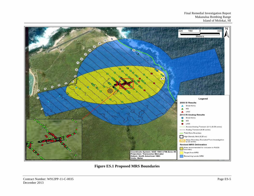
The Range Complex No. 1 MRS is recommended to be re-delineated into two areas as
summarized in Table ES-1 and shown in Figure ES.1. The new boundaries are recommended
based on level of potential explosive hazard present in each area determined by UXO/MD
findings encountered during historical site visits and the 2013 RI. Separating the MRS area into
two allows each area to be addressed in a cost-efficient and sensible manner appropriate to the
explosive hazard present within each area.
ES.7.1 Range Complex No. 1 – Target Area (232.84 acres)
The Target Area (230.08 acres, land within the current FUDS Property boundary, including the
2.22 ac Heiau) is recommended to proceed to the next step in the CERCLA process, evaluation
of remedial alternatives through a feasibility study (FS) for a remediation action of MEC
(explosive hazard from UXO present onsite).
This re-delineation of the Target Area extends 2.76 acres outside the currently defined FUDS
boundary. The extension of the target area outside the FUDS boundary is recommended due to
the close proximity of MD items found near the site boundary. It is recommended the newly
included acreage be processed for inclusion in the FUDS boundary. The inclusion of this area
would bring the total Target Area to 232.84 acres, and the total MRS acreage to 716.01 acres.
A classification of No Department of Defense (DoD) Action Indicated (NDAI) is recommended
for MC in Range Complex No. 1-Target Area. No suspected unacceptable risk to human or
ecological receptors from MC is present.
ES.7.2 Range Complex No. 1 - Remaining Lands (483.17 acres)
The Remaining Lands (483.17 acres: 322.87 land and 160.30 tidal water) is recommended to
proceed to a NDAI determination for both MEC and MC based on finding no evidence of
unacceptable hazards from MEC or risks from MC due to impacts from DoD activity.
The entire tidal water portion of the site is included in the Remaining Lands. Based on the MEC
investigation of the land and the location of the target area, and the fact the dangerous sea
conditions would not attract recreational boaters or divers, no further investigation of the tidal
water areas is recommended.

Final Remedial Investigation Report
Makanalua Bombing Range
Island of Molokai, HI
Contract Number: W912PP-11-C-0035 Page ES-4
December 2013
Table ES-1: Recommendation Summary
MRS Acreage Recommendation
Basis for Recommendation MRSPP Priority MEC/MD/MC
Range Complex No. 1
-Target Area
232.84(1)
(land)
MEC – FS
MEC: 99 UXO items in the form of
practice bombs with signals found during the 2013 RI.
MD: 1,024 lbs removed.
5
MC – NDAI
MC: Concentrations of MC metals
(antimony, copper, lead and zinc) below HDOH EALs. No detection of explosives. No surface water other than ocean located on site, Groundwater is not potable within the MRS. No unacceptable risk to human or ecological receptors is present from exposure to surface soils in this area.
No known or suspected hazards
Range Complex No. 1 -Remaining Lands
483.17
(322.87 land; 160.30 tidal water)
MEC – NDAI
MEC: No evidence of UXO, DMM, or
explosive soils.
MD: Only very low densities of
expended small arms ammunition were observed.
No known or suspected hazards
MC – NDAI
MC: Concentrations of MC metals
(antimony, copper, lead and zinc) below HDOH EALs. No detection of explosives. No surface water other than ocean located on site, Groundwater is not potable within the MRS. No unacceptable risk to human or ecological receptors is present from exposure to surface soils in this area.
No known or suspected hazards
(1) The delineated target area recommended for FS includes the heiau and.2.76 acres outside the FUDS property boundary.
Final Remedial Investigation Report
Makanalua Bombing Range
Island of Molokai, HI
Contract Number: W912PP-11-C-0035 Page ES-5
December 2013
Figure ES.1 Proposed MRS Boundaries

Final Remedial Investigation Report
Makanalua Bombing Range
Island of Molokai, HI
Contract Number: W912PP-11-C-0035 Page 1-1
December 2013
CHAPTER 1. INTRODUCTION
This RI report was prepared for the United States Army Corps of Engineers Honolulu District
(CEPOH) and the United States Army Corps of Engineers Sacramento District (CESPK) under
Contract No. W912PP-11-C-0035. The work conducted during the RI followed the general
procedures outlined in the Final RI Work Plan (WP) document dated January 2013 (Malama
Aina JV, January 2013).
As agreed to by the TPP Team, this RI covers the land portion of the site only. The tidal water
portions were not investigated due to dangerous sea conditions due to rocky shore line, constant
large waves and strong current.
Deviations from procedures described in the RI WP document that arose due to conditions
encountered in the field are described in the following sections. Malama Aina Joint Venture,
LLC (MAJV) and their subcontractors adhering to the project-specific Accident Prevention
Plan/Site Safety and Health Plan (APP/SSHP) completed all scheduled fieldwork.
The United States (US) Congress has established the Military Munitions Response Program
(MMRP) under the Defense Environmental Restoration Program (DERP) to address sites at
which Munitions and Explosives of Concern (MEC) [which includes unexploded ordnance
(UXO), discarded military munitions (DMM), and munitions constituents (MC)] that may
present a potential hazard to human health or the environment. Sites determined to be eligible for
the MMRP are hereafter referred to as Munitions Response Sites (MRSs).
The MBR project falls under the Defense Environmental Restoration Program/Formerly Used
Defense Sites (DERP/FUDS) and is identified as FUDS Project No. H09HI020301. DERP was
established by Congress in 1986 and directed by the Secretary of Defense to “…carry out a
program of environmental restoration at facilities under the jurisdiction of the Secretary.” Since
the beginning of this program, the US Army Corps of Engineers (USACE) has been the agency
responsible for environmental restoration of FUDS. The 1991 Inventory Project Report (INPR)
established MBR as a FUDS, established the preliminary site boundary, and recommended an
investigation to evaluate the presence of MEC. The 2004 INPR Supplement increased the
acreage from 160 acres to 937 acres (832 land acres and 105 tidal water acres).
This project is conducted in accordance with the Comprehensive Environmental Response,
Compensation, and Liability Act (CERCLA), Section 104, and the National Contingency Plan,
Sections 300.120(d)-300.400(e).
All activities during the phases of field work were conducted in full compliance with USACE,
Hawaii Department of Health (HDOH), and local requirements regarding personnel, equipment,
and procedures. Standard Operating Procedures (SOPs) for the project’s Definable Features of
Work (DFW) were used as described in the RI Work Plan. The provisions of the Occupational
Safety and Health Administration (OSHA) Standard 29 Code of Federal Regulations (CFR)
1910.120 and 29 CFR 1926.65 were applied to all MEC/Munitions Debris (MD)-related actions
taken at this site.

Final Remedial Investigation Report
Makanalua Bombing Range
Island of Molokai, HI
Contract Number: W912PP-11-C-0035 Page 1-2
December 2013
1.1 PURPOSE
This RI is intended to characterize the former Makanalua Bombing Range (MBR) (i.e.,
determine the nature and extent of contamination from MEC and MC) for the purpose of
developing and evaluating remedial alternatives for the land portion. The primary purpose of the
RI report is to present the results from the RI and provide information to assess the extent to
which a release poses a threat to human health, safety and the environment. If contamination is
confirmed or identified, the information from the RI report will be used to support the Feasibility
Study (FS) so a decision on a remedy can be made.
The results of this RI will be used for a recommendation to divide Range Complex No. 1 into
separate areas based on explosive hazards, and if present, risks from munitions constituents
(MC) if warranted.
1.2 PROPERTY DESCRIPTION
1.2.1 Topography
The former MBR is located on Kalaupapa Peninsula, Molokai, Hawaii (see Figure 1-1), which
has an elevation that varies from approximately 25 ft above sea level (asl) to sea level. The
terrain is generally flat or gently sloping to short steep gullies and rock formations.
Figure 1-1: Project Location Map

Final Remedial Investigation Report
Makanalua Bombing Range
Island of Molokai, HI
Contract Number: W912PP-11-C-0035 Page 1-3
December 2013
1.2.2 Geology and Soils
The Island of Molokai was formed principally by extrusive shield and post-shield stage lavas of
the older West Molokai Volcano and the younger East Molokai Volcano, and secondarily by
rejuvenated stage volcanic rocks at Kalaupapa Peninsula. Kalaupapa Volcanics are comprised of
the rejuvenated stage alkalic basalt and basanite that form the Kalaupapa Peninsula. Kalaupapa
Volcanics is estimated to be between 350,000-500,000 years in age (USGS, 1997).
Kalaupapa basalt composes the primary geologic substrate of the gently sloping (one to three
percent slopes) topography, which is interspersed with ‘a‘ā and pāhoehoe lava. The inactive
Kauhako volcanic vent is located in the southern portion of the study site. Kalaupapa’s very
rocky, silty clay loam is the major soil type throughout the remaining portions of the site, which
is bordered to the south by rough mountainous land (CEPOH, 1991).
Only a thin veneer of soil (typically 3 in. thick or less) exists atop the lava flows and is composed
of rocky, reddish-brown, silty clay.
1.2.3 Hydrology and Hydrogeology
The Island of Molokai is comprised of four hydrologic sectors. These four hydrologic sectors
(West, Central, Northeast, and Southeast) are subdivided into sixteen aquifer systems. The MBR
is underlain by the Kalaupapa aquifer system (40401) located in the Northeast sector. According
to the system developed by Mink and Lau to classify and assign codes to the principal aquifers
for the island of Molokai, the Kalaupapa Aquifer code is 40401111 (basal unconfined flank-
aquifer type) and the status code is 21211 (potential use, drinking, low salinity, irreplaceable,
with a vulnerability to contamination). The system is restricted to Kalaupapa Peninsula with a
total area of 4.5 square miles. Basal groundwater saturates the basalt to several feet above sea
level and the water is unpotable (Mink and Lau, 1992).
The 9-ft water level reported in a well at the northern margin of the dike complex near
Kalaupapa Peninsula possibly represents an upper limit for the water-table height above sea level
in the dike-free Kalaupapa Volcanics. Results from an electrical resistivity survey indicated that
the basal lens in the Kalaupapa Volcanics was thin. The horizontal hydraulic conductivity value
is calculated to be 500 ft/d per day.
There are no wells located within the MRS. There is one public water supply (municipal) well,
three domestic water wells, and five other water wells within a 4-mile radius of the MRS.
(Parsons, 2008).
The Pacific Ocean borders the northeast side of the Munitions Response Site (MRS). There is no
perennial surface water or sediment present on site.
1.2.4 Climate
The temperatures at the MBR vary from approximately 73ºF in March to approximately 81ºF in
September. There is a prevailing northeasterly trade wind throughout the year, and the term
“windward” always refers to the direction of the trade winds, not the existing wind at any

Final Remedial Investigation Report
Makanalua Bombing Range
Island of Molokai, HI
Contract Number: W912PP-11-C-0035 Page 1-4
December 2013
particular time. Rainfall over the open sea near Molokai averages 25 to 30 in. per year.
Mountains on the windward side of Molokai trigger rain showers from the trade winds. The site
is located windward of the spectacular cliff, which reaches a maximum height of 3,600 ft, and
forms the entire north coast of the mountain. Like all Hawaiian Islands, the windward side of
Molokai receives much more rainfall than the leeward side of the island. The MBR region
receives an average of 40 to 50 in. of rainfall annually (BTG, 2005).
1.2.5 Significant Structures
This site is currently uninhabited and undeveloped. No DoD related structures are within the
MRS.
1.2.6 Cultural and Archaeological Resources
The MBR is located within the Kalaupapa National Historical Park, which is both a National
Historical Park and a National Historic Landmark. According to the National Register
Information System (NRIS), National Register of Historic Places (NRHP), National Register of
Historic Districts (NRHD), and National Historic Landmark (NHL), the site is recorded as an
archaeological and cultural resource for Kalawao County. The site is considered a NHL for the
Kalaupapa Leprosy Settlement. The MBR site is currently owned by the State of Hawaii and
managed by both the HDOH and the National Park Service (NPS). According to the State
Historic Preservation Division (SHPD) website databases, there are archaeological/cultural
resources recorded in the Kaunakakai (03) quadrangle map where the site is located. Specific
locations of these areas are address-restricted due to the sensitive nature of these sites.
An archaeologist accompanying the 2013 RI field team confirmed there are numerous significant
archaeological structures located throughout the MBR site (GANDA, 2013).
1.2.7 Demographics
The regional demographics information for the MBR was obtained from the 2010 US Census
Bureau website: http://quickfacts.census.gov/qfd/. The Makanalua MBR is located in an
unpopulated area on the northeast tip of the Kalaupapa Peninsula on the Island of Molokai.
Kalawao County (located on the Kalaupapa Peninsula) is a separate county from the rest of
Molokai, which is part of Maui County. The county does not have a county government, with the
exception of a sheriff who is selected from local residents by the State Department of Health that
administers the county.
The US Census Bureau 2010 population of Kalawao County is 90. The population density of
Kalawao County is 7.5 persons per square mile. The median age is 55.3. The population consists
of 26.7% White, 0% Black or African American, 0% American Indian or Alaskan, 7.8% Asian,
48.9% Native Hawaiian and Other Pacific Islander, 1.1% Hispanic or Latino, 26.7% of some
other race, and 15.6% of two or more races. Over 26 inhabited structures are located within 2
miles of the FUDS boundary, all within the Kalaupapa settlement (U.S. Census Bureau, 2010).
Final Remedial Investigation Report
Makanalua Bombing Range
Island of Molokai, HI
Contract Number: W912PP-11-C-0035 Page 1-5
December 2013
1.2.8 Current or Future Land Use
The site currently lies within the Kalaupapa National Historical Park, owned by the State of
Hawaii and managed by the NPS, Hawaii Department of Land and Natural Resources (DLNR),
and HDOH. There is no recent development onsite. It is a significant historical and
archaeological place and numerous archaeological sites are located throughout the entire site. No
future development of the site is planned. Public access to the MRS is generally restricted;
however, via permit and escort, people can access the area.
1.2.9 Biological Resources
According to the USFWS, the Hawaiian Islands support 344 federally listed Threatened and
Endangered (T&E) species consisting of 71 animals and 273 plants. As stated by the Natural
Resources Conservation Service (NRCS), of the 344 federally listed species, approximately 14
animal species and 62 plant species are known to occupy or potentially occupy the Island of
Molokai; however, the habitat for most of these species is not present at the former MBR.
According to the Division of Forestry and Wildlife 2005 Hawaii’s Comprehensive Wildlife
Conservation Strategy, the animal species of most concern for the Island of Molokai that are
federally listed include: the Hawaiian hoary bat (Lasiurus cinereus semotus), Molokai thrush
(Myadestes lanaiensis), ‘o’u (Psittirostra psittacea), Maui parrot bill (Pseudonestor
xanthophrys), Molokai creeper (Paroreomyza flammea), crested honeycreeper (Palmeria dolei),
Hawaiian hawk (Buteo solitarius), Hawaiian goose (Branta sandvicensis), Hawaiian duck (Anas
wyvilliana), Laysan duck (Anas laysanensis), Hawaiian common moorhen (Gallinula chloropus
sandvicensis), Hawaiian stilt (Himantopus mexicanus knudseni), Hawaiian coot (Fulica
americana alai), Hawaiian petrel (Pterodroma sandwichensis), Newell’s shearwater (Puffinus
auricularis newelli), and the Blackburn’s sphinx moth (Manduca blackburni) (Parsons, 2008).
Two federally listed plant species, Centaurium sebaeoides and Tetramolopium rockii, are listed
as inhabiting the eastern coastline within the site boundaries. The coastline area is considered
critical habitat for these two plant species. Two zones of vegetation are present onsite. Near the
shoreline, vegetation is limited in the coastal spray zone due to wind and salt spray. Invasive
lantana (Lantana camara) and native naupaka kahakai (Scaevola taccada) grow abundantly.
Further inland, the vegetation transitions to lowland dry/mesic plant communities dominated by
invasive species which include Christmasberry (Schinus terebinthifolicus), lantana, and
sourgrass. The predominant native plants were ‘ilima and akia (Wikstroemia uva-ursi). Other
native species were observed in relatively low frequency or in restricted distributions. These
included the rare tree species, kolomana (Senna gaudichaudii), ohe kukuluāe o (Polyscias
sandwicensis), and wiliwili (Erythrina sandwicensis). Culturally important Polynesian-
introduced plants such as ti (Cordyline fruticosa) and auhuhu (Tephrosia purpurea) (Garcia,
2013).
1.3 PROBLEM IDENTIFICATION
Based on documentation, research, and the 2008 Site Inspection, the site is confirmed to have
been used for aerial bombing, rocket, and strafing training by the US Navy beginning after

Final Remedial Investigation Report
Makanalua Bombing Range
Island of Molokai, HI
Contract Number: W912PP-11-C-0035 Page 1-6
December 2013
acquisition of permit in 1941 and continuing through October 1946. Prior to RI fieldwork,
evidence of the target was identified in an area containing MEC (in the form of UXO (AN-Mk5
and AN-Mk19 practice bombs), and numerous expended practice bombs. Based on this
information, the USACE determined that past uses of the MBR site related to munitions training
may have resulted in an unacceptable explosive safety hazard or risk present at the site.
Land use controls (LUCs) require park visitors to obtain a permit and to be escorted by park
personnel, but allow full access to the site.
Table 1-1 lists the MEC items known or suspected to be present based on historical records and
findings previous site visits to MBR.
Table 1-1: MBR MEC Characteristics
Size Nomenclature Type
UXO found during 2008 SI at MBR
3 lb. AN-Mk5 Practice Bomb
13 lb. AN-Mk19 Practice Bomb
Additional UXO Suspected per INPR and INPR Supplement
3 lb. AN-Mk23 Practice Bomb
4 lb. AN-Mk43 Practice Bomb
5-inch HVAR Practice Rocket
3-inch AP Mk 29 Projectile
BLU 27 Fire Bomb
.30 and .50 caliber Small Arms Ammunition
1.4 Historical Information
1.4.1 Site History/Military Activity
The Makanalua Bombing Range as currently reported in FUDSMIS consists of one MRS
totaling 937 acres (832 land acres and 105 tidal water acres). (Note: Site acreage calculated with
GIS is 713.25 acres (552.95 land acres and 160.30 tidal water acres). The acreages reported in
the document and on maps use the GIS calculated acreage for this report. One bombing range
and one rocket range overlap to form Range Complex No.1 MRS as shown on Figure 1-1.
Starting in 1865, the Kingdom of Hawaii began a policy of forced segregation of persons
afflicted with Hansen’s disease, also known as leprosy. The government purchased lands on the
isolated Kalaupapa Peninsula and moved the Hawaiian residents to other homes. The village of
Kalawao became home to thousands of victims of Hansen’s disease. In the early 1900’s, the
Board of Health implemented a plan to provide high quality services, facilities, utilities, and
medical care for patients at Kalaupapa. A major construction program began with construction of
individual cottages, dormitories, hospital facilities, and other buildings. In 1946, improved drug
therapies brought almost immediate reductions of Hansen’s disease symptoms and vast

Final Remedial Investigation Report
Makanalua Bombing Range
Island of Molokai, HI
Contract Number: W912PP-11-C-0035 Page 1-7
December 2013
improvements in the quality of health and life for the people. Hansen’s disease patients were no
longer contagious and there was no further need for isolation. In 1969, the century-old laws were
abolished. Former Hansen’s disease patients living in Kalaupapa today have chosen to remain
there, most for the rest of their lives.
The U.S. Navy acquired the MBR by permit in 1941 and used the site for bombing training until
October 1946, when they abandoned the site and transferred the land permits back to the State of
Hawaii. There are no records of any UXO clearances by the military after 1946. The acreage
according to the original INPR consisted of approximately 160 acres. The 2004 INPR
Supplement increased the acreage to 937 acres (See previous note regarding FUDSMIS vs. GIS
calculated acreages) to include the bombing range and rocket range buffer areas. There is no
historical evidence that Chemical Warfare Materials (CWM) are present on the MRS.
1.4.2 Property Ownership
The site is currently owned by the State of Hawaii, and managed by the NPS, Hawaii DLNR, and
HDOH.
1.5 PREVIOUS INVESTIGATIONS
1.5.1 1991 Inventory Project Report
The INPR was completed by CEPOH in July 1991 (CEPOH, 1991). The INPR established the
MBR as a FUDS, established the preliminary site boundary, and recommended an investigation
to evaluate the presence of MEC. The Findings and Determination of Eligibility (FDE) for the
site concluded that the MBR was utilized for bombing, rocket, and strafing training. A site
survey was conducted in support of the INPR. The Trip Report for the 1991 INPR site survey
reported the presence of MD, Mk23 4-pound practice bombs, 5-inch practice rockets, .50 caliber
rounds, and napalm bomb fragments.
1.5.2 2004 INPR Supplement
The 2004 INPR Supplement summarizes the information from the 1991 INPR and other
associated investigations. The INPR Supplement provides a summary of the MRS, redefined the
boundary and increased the area of the MRS to 937 acres (718 land acres and 219 tidal water
acres) (Note: this is not the currently reported FUDSMIS acreage, nor the. GIS calculated
acreages), assigned the FUDS Project Number H09HI020301, and included other pertinent
information concerning the munitions possibly used at the site. The INPR Supplement also
provided a breakdown for the MRS with the standard range configuration based on the use of the
MRS. Historical munitions use identified included small arms, practice bombs (AN-Mk5, AN-
Mk23, AN-Mk43 with Mk4 or Mk5 signals), fire bombs (BLU 27), and rockets (5-inch HVAR).
(CEMVR, 2004).
1.5.3 2008 Site Inspection
The 2008 Site Inspection was conducted to determine whether the site warranted further MEC or
MC response action, or a determination of NDAI at the MBR site. Fieldwork conducted in July

Final Remedial Investigation Report
Makanalua Bombing Range
Island of Molokai, HI
Contract Number: W912PP-11-C-0035 Page 1-8
December 2013
2008 included 14.3 miles of qualitative reconnaissance and MC sampling of surface soil.
Munitions-related items observed included unexpended practice bombs (two AN-Mk5 3-lb
bombs and one AN-Mk19 13-lb bomb, all with explosive spotting signals) and other MD were
found on the surface of the MRS. The site visit team also observed an expended 3-in. armor
piercing naval projectile, possibly indicating that ship-to-shore artillery exercises were conducted
here as well. However, no impact craters or other signs of naval artillery were discovered.
Historical findings that the MBR was used as a practice bombing, rocket, and strafing target
were confirmed. The MEC Screening-Level Risk Assessment concluded that a potential
explosive safety risk is considered to be present at this MRS.
Soil sampling consisted of one incremental (IS) surface soil sample collected from a 160-acre
Decision Unit (DU), comprised of 100 soil increments. The sample was collected in triplicate
from a depth range of 0 to 2 in. bgs for analysis of potential MC (explosives, antimony, copper,
lead, mercury, and zinc). An ambient surface soil sample (30- x 30-ft DU, 30 increments) was
collected within the MRS in triplicate using the Incremental Sampling (IS) method. No
groundwater or surface water samples were collected because there is no access to groundwater
and no permanent surface water within the MRS. The IS surface soil samples were analyzed for
explosives and selected metals. No explosive compounds were detected in any IS surface soil
samples. Four MC metals (antimony, copper, lead and zinc) were detected in the surface soil
sample at concentrations above ambient levels. As a result, a human health screening level risk
assessment was conducted for the detected metals. The maximum concentrations of the metals
were below the HDOH EALs for soil used for screening purposes. The risk assessment
concluded that no unacceptable risks to human receptors are expected from exposure to the MC
metals at the site, (Parsons, 2008).
This space is intentionally left blank

Final Remedial Investigation Report
Makanalua Bombing Range
Island of Molokai, HI
Contract Number: W912PP-11-C-0035 Page 2-1
September 2013
CHAPTER 2. PROJECTED REMEDIAL RESPONSE OBJECTIVES
2.1 CONCEPTUAL SITE MODEL
Preliminary Conceptual Site Models (CSMs) representing both MEC and MC were developed
for the MBR site during the SI in accordance with Engineer Manual (EM) 200-1-12. The CSMs
were developed only for the land portion of the MRS. Those CSMs were updated prior to the RI
work plan and are presented below. The MEC CSM is presented as a summary table indicating
known or suspected MEC/MC contamination sources, potential/suspected locations and
distribution of contamination, related source or exposure media, current and future receptors, and
potentially complete exposure pathways, and planned fieldwork (Table 2-1). The CSM for MC is
presented as a flow chart that depicts the possible MC contaminant migration and exposure
pathways for the various receptors (Figure 2-1).
This space is intentionally left blank

Final Remedial Investigation Report
Makanalua Bombing Range
Island of Molokai, HI
Contract Number: W912PP-11-C-0035 Page 2-2
December 2013
Table 2-1: Preliminary MEC Conceptual Site Model for Makanalua Bombing Range Prior to RI Fieldwork
Munitions Response Site Details
PRELIMINARY CONCEPTUAL SITE MODEL SUMMARY REMEDIAL INVESTIGATION TECHNICAL APPROACH
Known or Suspected Contamination
Source(s)
Potential/Suspected Location and Distribution
Source or Exposure Medium
Current and Future Receptors
Potentially Complete Exposure
Pathway
Investigation Method
Investigation Location(s)
Planned Investigation Acreage/Number of
Samples Decision Rule(s)
NAME: Makanalua Bombing Range
RANGE COMPLEX 1
Acreage: 832 (land)
105 (tidal water)4
Suspected Past DoD Activities (release mechanisms):
Bombing and Rocket Range
Current and Future Land Use:
Recreational
MEC: Terrestrial
Small Arms; Practice Bombs (AN-Mk5, AN-Mk23, AN-Mk43); Fire Bombs (BLU 27); Rockets (5-inch HVAR)
Significant evidence of MEC hazards remaining; Heavy concentration at bombing target center.
Surface or subsurface soil
Site visitors
Anticipated Recreational Use: hiking.
No Intrusive activities are anticipated.
Handling of surface or subsurface MEC.
Physical inspection and intrusive investigation
Transects across MRS at approximately 250-foot spacing.
Survey 14.6 miles (8.4 acres) of transects and 1 acre of grids
Physical inspection: Investigate 4-foot wide swath through densest part of pile
If data concentrations depict a bombing target, investigate 8 transects radially from target center to establish outer boundary.
If major concentration of MEC suggest a bombing target, the project development team determines strategic locations for establishment of the equivalent of two 100-ft x 100-ft grids per target for determining MEC density.
MEC: Tidal Water
Small Arms; Practice Bombs (AN-Mk5, AN-Mk23, AN-Mk43); Fire Bombs (BLU 27); rockets (5-inch HVAR)
No evidence of MEC hazards, only a historic map showing extension of range into ocean.
Surface of ocean floor.
Divers Handling of surface MEC.
None None None If MEC found during terrestrial investigation suggests MEC presence in water, project development team will reconsider the need for underwater investigation. Surf along MRS boundary is dangerous for such an investigation.
Munitions Constituents:
Explosives and MC metals
Potentially present in soil.
Surface soil Site visitors, ecological receptors
Anticipated Recreational Use: hiking. No Intrusive activities are anticipated.
Exposure to MC in soil (incidental ingestion, dermal/root contact, inhalation of suspended particulates, and ingestion of biota).
Collect incremental soil samples and analyze for MC; conduct sampling at MEC-contaminated areas; if no MEC-contaminated areas, perform random sampling
Along transects Confirmed target areas: 3 sampling units
Background sampling: 2 sampling units placed in areas where no UXO/MD is found.
Additional incremental or discrete samples as necessary to delineate extent of contamination.
If target areas confirmed, then collect increment soil samples (1 primary plus 2 replicates per sampling unit) to evaluate presence/absence of MC contamination.
If MC metals concentration exceeds background concentration, then a comparison will be made to Preliminary Screening Values.
If MC concentrations are below Preliminary Screening Values, then soil not MC-contaminated and no further analysis required.
If MC concentrations exceed direct contact criteria, then collect subsurface samples to delineate vertical extent of MC contamination in soil, and additional surface samples to delineate horizontal extent; once delineation is complete, conduct MC risk assessment for soil pathway.
Groundwater (not expected but decision rules provided to address possibility).
Groundwater (via leaching from soil)
None None None None None
MC (pre- and post-detonation)
Explosives
At MEC detonation sites
Surface soil Site visitors, ecological receptors
Exposure to MC in soil (incidental ingestion, dermal/root contact, inhalation of suspended particulates, and ingestion of biota).
Collect discrete soil samples and analyze for MC
MEC disposal locations
One pre- and one post-detonation sample per disposal location; up to 5 samples.
If MC analytes are detected in post-detonation samples at concentrations above preliminary screening values, then collect additional samples to delineate extent of MC contamination; once delineation is complete, conduct MC risk assessment for soil pathway
Source
1 – INPR (1991)
2 – INPR Supplement (2004)
3 – Other Government Correspondence
BLU – Bomb Load Unit
DoD – Department of Defense
HVAR – High Velocity Aircraft Rocket
INPR – Inventory Project Report
MD – Munitions Debris
MC – Munitions Constituents
MEC – Munitions and Explosives of Concern
MRS – Munitions Response Site
4 – Note: Acreage division reported on original CSM (718 land and 297 tidal water) is not the acreage currently reported in FUDSMIS. Current acreage listed in table (832 land and 105 tidal water) is what is reported currently in FUDSMIS.

Final Remedial Investigation Report
Makanalua Bombing Range
Island of Molokai, HI
Contract Number: W912PP-11-C-0035 Page 2-3
December 2013
Figure 2-1: Preliminary MC Conceptual Site Model for MBR
Resid
ents
Constru
ctio
n
Work
ers
Com
merc
ial o
r
Indust. W
ork
ers
Vis
itors
, or
Rec. U
sers
Ecolo
gic
al
Recepto
rs
Resid
ents
Constru
ctio
n
Work
ers
Ingestion as DW -- -- X -- --
Incidental Ingestion -- -- X X X -- --
Dermal Contact -- -- X X X -- --
Ingestion of Biota -- -- X X V -- --
Incidental Ingestion -- -- V V V -- --
Dermal Contact -- -- V V V -- --
Inhalation (Dust) -- -- V V X -- --
Incidental Ingestion -- -- -- --
Dermal Contact -- -- -- --
Inhalation (Dust) -- -- -- --
Ingestion as DW -- -- -- --
Incidental Ingestion -- -- -- --
Dermal Contact -- -- -- --
-- Receptor Not Present
V Complete Pathw ay
Incomplete Pathw ay
X Potentially Complete Pathw ay ,
Not Quantitativ ely Assessed
RELEASE
MECHANISM
EXPOSURE
MEDIA
SOURCE INTERACTION
CURRENT/FUTURE FUTURE
RECEPTORS
HUMAN AND ECOLOGICAL
RECEPTORS
PRIMARY
SOURCE
SOURCE
MEDIA
EXPOSURE
ROUTES
X
X
Munitions Constituents
Surf. Water/ Sediments
Subsurface Soil (2-15 ft)
Uptake by Biota
Erosion / Runoff
Surf. Water/ Sediments
Surface Soil (0-2 ft)
Soil
Leaching Groundwater
No fresh surface water resources at the site
Marine surface water at the site. Not used for human consumption.
No GW wells at the MRS
Pathway not present (w/ reason)
MC>Background: - Antimony- Copper- Lead- Zinc(No explosives detected)
X

Final Remedial Investigation Report
Makanalua Bombing Range
Island of Molokai, HI
Contract Number: W912PP-11-C-0035 Page 2-4
December 2013
2.2 PROJECT APPROACH
This section describes the RI project design and rationale to characterize the nature and extent of
contamination from MEC and potential MC at the Range Complex No. 1 MRS. The approach
was based on the findings of the 2008 SI recommendations and was designed to evaluate
potentially complete MEC and MC exposure pathways as defined in the preliminary CSM. The
approach is designed to evaluate the nature and extent of any contamination identified.
The horizontal boundaries for the RI/FS included the 552.95 land acres. The 160.30 acres in the
tidal water area were not investigated do to rough sea conditions and the 2.22 acre Heiau was
excluded for archaeological preservation (see Figure 1-1). The site was planned to be
investigated with transects using analog metal detectors. Visual Sample Planning (VSP) software
was used to plan transect spacing.
Horizontal boundaries for the MEC investigation cover the extent of the land acreage. Any
potential target areas identified during the transect investigation, were planned to be investigated
further by placement of two 100 ft by 100 ft grids.
Since the sea-state at the 160.30-acre tidal water portion of the MRS is too dangerous for
physical investigation, no water investigation was planned or conducted.
Vertical extent of potential MEC contamination was established by the depth of anomaly
detection or bedrock, whichever was reached first.
2.2.1 MEC Transect Investigation
The MEC transect investigation was planned to provide information for assessing explosive
hazards, determining the need for additional evaluation or remedial action, obtaining data to
evaluate remedial action alternatives, and selecting a remedy.
Visual Sample Planning (VSP) software was used for the land portion of the site to design the
transect spacing sufficient to detect 500-ft-diameter target areas with 200 anomalies per acre
above a background density of 10 anomalies per acre, at a 95% confidence level. Approximately
14.6 miles (8.4 acres) of transect survey using handheld analog metal detectors were planned to
be conducted on nineteen 4-ft-wide transects that span the entire land portion of the MRS with a
with 250-ft spacing. Depth of investigation was relegated to depth of anomaly detection. Planned
transects are shown on Figure 2-2.
The following activities were planned:
Vegetation cleared to within 6 inches of ground surface on investigation transects.
Analog detection instruments to be used for detection and flagging of surface and
subsurface anomalies that are potential MEC.
Information from transect investigation were to be used to generate an anomaly density
map of the MRS. High density areas, above a background density of 10 anomalies per
acre, were to be further investigated with grids, using analog and flag & DGPS, and
intrusive operations to determine if the high density area is MEC contaminated. 100%

Final Remedial Investigation Report
Makanalua Bombing Range
Island of Molokai, HI
Contract Number: W912PP-11-C-0035 Page 2-5
December 2013
grid investigations provide MEC types, densities, vertical extent, and production values
necessary for the FS.
If a target area was confirmed, the target area boundary was to be refined with radial
analog and flag & DGPS, and intrusive operations to better define the extent of the target
area. Portions of the MRS not associated with a confirmed target area to be assessed for
low MEC densities using intrusive investigations of 10% of the reconnaissance transect
segments, randomly selected. Note: Prior to field work, the work plan was modified to
investigate 100% of all transect anomalies. The access transect provided investigation
perpendicular to the planed transects.
Data recorded would include locations of MEC and MD items discovered during the
fieldwork would be recorded, and the items destroyed by demolition at the end of the
fieldwork.
Past and present data would be processed through the MEC HA to score the MRS in order to
determine whether further action is warranted and is necessary, further evaluated in a feasibility
study.
Figure 2-2: Makanalua Bombing Range Transect Map

Final Remedial Investigation Report
Makanalua Bombing Range
Island of Molokai, HI
Contract Number: W912PP-11-C-0035 Page 2-6
December 2013
2.2.2 Demolition
Ordnance items discovered during the investigation were geo-referenced. If MEC was
encountered and determined by the Senior Unexploded Ordnance Supervisor (SUXOS) and
UXO Safety Officer (UXOSO) that it is unacceptable to move, it would be marked and guarded,
if necessary, until disposal could be accomplished. Consolidating multiple MEC was anticipated
for this project.
A MEC item would only be moved if the SUXOS and UXOSO determined that the item is
acceptable to move. Safety standards required that Unexploded Ordnance (UXO) deemed
unacceptable to move would be blown in place.
If an item that could not be moved was located near an archaeological feature, the project team
will refer to the Archaeological Monitoring Plan for a determination on how best to protect the
features.
On-call explosives delivery provided by a local vendor and delivered via helicopter was planned
for any MEC items recovered during operations.
A batch burner furnace, certified for burning Hazard Classification/Compatibility Group 1.4
material (NHES Batch Burner Furnace), was proposed as a secondary means of demilitarizing
recovered MEC.
2.2.3 Munitions Potentially Presenting an Explosive Hazard Management
For munitions-related items encountered that were either not immediately identified as MEC or
that could not be positively determined to contain explosives or other energetic materials, the
following procedures were developed.
During field operations, MAJV recovered, inspected, certified through visual and thermal
treatment, and disposed of Material Documented as Safe (MDAS). Details of the MD inspection
process are provided in SOP 4 found in the MBR Work Plan (MAJV, 2013).
All inspection, certification, and final disposition procedures meet the requirements of Chapter
14, EM 1110-1-4009 and Errata Sheet No. 2. Upon turn-in of the MD, the SUXOS completed a
DD Form 1348-1A. Both the SUXOS and the OE Safety Specialist (OESS) signed the DD Form
1348-1A to certify and verify inspection of the scrap. When the OESS was not on site to sign as
the verifier, MAJV’s UXOSO/UXOQCS verified the MD. Verified and certified MDAS items
were packaged, sealed and shipped to Timberline Environmental Services (TES) for final
disposal in July 2013 when the barge made its annual trip to the island. MAJV maintained the
chain of custody of the sealed package until shipment to TES. As an element of cradle-to-grave
documentation, TES will provide signed copies of receipt documents and the certificate of
destruction when the material is completely processed. This documentation is to be included in
the Final RI Report.

Final Remedial Investigation Report
Makanalua Bombing Range
Island of Molokai, HI
Contract Number: W912PP-11-C-0035 Page 2-7
December 2013
2.2.4 MC Sampling
MC sampling was planned to establish the presence or absence of MC contamination on the land
portion of the site. If such contamination was identified, a secondary goal for MC was to
determine the nature and extent of that MC contamination. Three IS sample DUs were to be
focused in those areas with the highest anomaly densities and in confirmed areas of MEC
contamination. Final sample locations were to be determined after the completion of the MEC
survey. Two background IS sampling DUs were planned in areas of no MEC/MD findings to
develop background comparison values for select MC metals concentrations in soil. Specific
details on the sampling plan are presented in Chapter 3, Characterization of MEC and MC.
There are no freshwater resources or wells within the MRS, therefore per PDT concurrence, no
surface water, sediment, or groundwater sampling was conducted.
2.2.5 Environmental Protection Plan
An Environmental Protection Plan was developed to establish general procedures for avoiding,
minimizing, and mitigating potential impacts to environmental and cultural resources during
field activities. The plan included both an Archaeological Monitoring Plan and a Natural
Resources Monitoring Plan, both included in the appendices of the MBR Work Plan (MAJV,
2013). The plans called for a biologist and an archaeologist to be in the field accompanying the
investigation teams to ensure protection of natural resources and archaeological features.
If protected species or archaeological features were identified, the field team was to evaluate the
surrounding area to recommend relocation of inspection activities.
2.3 PRELIMINARY REMEDIATION GOALS AND OBJECTIVES
Site characterization goals for this RI were established for both MEC and MC.
Since the presence of an explosive hazard was established in the 2008 SI, the goal for MEC was
to characterize the nature and extent of the MEC hazards. This goal was achieved by:
Conducting analog reconnaissance transects on the land portions of the site.
Developing an MRS anomaly density map.
Conducting grid-based analog surveys in high anomaly density areas.
Performing intrusive investigation of selected geophysical anomalies (100% grid
anomalies and 10% random selected transect segment anomalies outside target areas). If a
high-density area proves to be a target area, additional radial transects will be analog and
dug to refine the extent of each target area. (Note: prior to fieldwork, this was changed to
100% investigation of anomalies along transects).
No investigation was planned for the water portion of the site due to the dangerous sea
conditions. The data collected during this investigation is sufficient to conduct a hazard
assessment for MEC on the site.
The goal for MC is to establish the presence or absence of MC contamination on the land portion
of the site. If such contamination is identified, a secondary goal for MC is to determine the

Final Remedial Investigation Report
Makanalua Bombing Range
Island of Molokai, HI
Contract Number: W912PP-11-C-0035 Page 2-8
December 2013
nature and extent of that MC contamination. Initial sampling is focused in those areas with the
highest subsurface anomaly densities and in confirmed areas of MEC contamination. If it has
been determined that there is evidence that munitions activities at the site have resulted in a
release of MC, then a human health and ecological baseline risk assessment will be conducted.
The data collected during the sampling investigation will be sufficient to prepare a baseline risk
assessment for MC.
An overall goal of the site characterization effort conducted during the RI is to produce sufficient
data to facilitate future development and evaluation of any necessary remedial alternatives. The
field investigation was designed to support this effort by including sufficient analog surveys and
MC sampling. The RI/FS will be considered complete upon USACE acceptance of a Decision
Document that meets the requirements of ER 200-3-1, Formerly Used Defense Sites (FUDS)
Program Policy and EM-CX Interim Guidance Document 06-04.
2.4 PRELIMINARY IDENTIFICATION OF APPLICABLE OR RELEVANT AND
APPROPRIATE REQUIREMENTS AND TO BE CONSIDERED INFORMATION
Section 300.430 (f)(l)(ii)(B) of the National Oil and Hazardous Substance Contingency Plan
states that on-site remedial actions selected in a Record of Decision (ROD) must attain
substantive requirements that are identified as applicable or relevant and appropriate
requirements (ARARs) or must include a waiver of the identified ARARs under Section 300.430
(f)(l)(ii)(C). The ARARs are a compilation of the promulgated, substantive requirements of
federal and state environmental laws that are legally applicable or are relevant and appropriate
based upon the circumstances present at the project site as related to the release of MEC or MC
contamination to the environment. The final ARARs are selected and become enforceable when
the ROD or Decision Document for the site is signed. Non-promulgated criteria, advisories,
guidance, and proposed federal and state standards known as “To Be Considered” (TBC) criteria
are also considered. TBC criteria are not potential ARARs because they are neither promulgated
nor enforceable. However, it may be necessary to implement TBCs when no ARARs exist for
contaminants. In addition, it may become enforceable. There are three general types of ARARs:
chemical-specific, location-specific, and action-specific. These three types of ARARs are
discussed in the following three sections and Table 2-2Table 2-2 summarizes the ARARs and
TBC criteria relevant for the MBR site.
2.4.1 Chemical-Specific ARARs
Chemical-specific ARARs typically rely on risk-based concentrations developed for site-specific
conditions using generic contaminant exposure assumptions. The concentration levels developed
typically correspond to concentrations of MC in soil, sediment, and groundwater above which
these contaminants could pose a potential adverse threat to human health and the environment.
Typical examples of this type of ARAR include the ambient water quality criteria and drinking
water standards. There are no chemical-specific ARARs for MEC.

Final Remedial Investigation Report
Makanalua Bombing Range
Island of Molokai, HI
Contract Number: W912PP-11-C-0035 Page 2-9
December 2013
Groundwater, surface water, and sediments are not media of concern at the MBR site, so
chemical-specific ARARs, such as the EPA maximum contaminant levels promulgated under the
Safe Drinking Water Act, are neither applicable nor relevant and appropriate.
2.4.2 Location-Specific ARARs
Location-specific ARARs are restrictions on the types of activities that can be performed based
upon site-specific characteristics or location of the project site. Common examples of this type of
ARAR include site proximity to wetland or floodplains, or the presence of natural or cultural
resources. The MBR site is located within the Kalaupapa National Historic Park and is
considered a significant historical and archaeological place. Additionally, part of the site is
located in the ecologically sensitive coastal spray zone. Two federally and state listed
endangered animal species have habitats present onsite. The disposal of MEC could potentially
disturb or destroy wildlife species known to be present in the area. The requirements specified in
16 United States Code (USC) 1538 require that steps must be taken to mitigate the impacts to
endangered species that are substantive in nature.
2.4.3 Action-Specific ARARS
Action-specific ARARs are technology or activity-based requirements that are triggered by the
type of remedial action under consideration for the project site. These action-specific ARARs
need to be considered during design, operation, and management of work related to future
removal actions at the project site. CERCLA regulations can be used as the authority under
which a future munitions response action at the project site proceeds. Final action-specific
ARARs will be determined by the USACE after coordination with the appropriate Federal and
State agencies. Additional action-specific ARARs may be identified during preparation of the
follow-on Feasibility Study.
Table 2-2: Makanalua Bombing Range RIFS ARARs
Regulator Authority
Location Characteristic Regulation
ARAR or TBC Synopsis
Action to be Taken to Attain Applicable
Regulations to the Extent Practicable
Federal Threatened and Endangered (T&E) Species
16 USC 1538, (a)(1)(B)
Endangered Species Act of 1973
ARAR Location-specific
Requires protection of T&E species.
On-site Natural Resource Support (NRS) to accompany the field team for brush cutting and intrusive activities to identify sensitive species and assist in avoidance.
Federal Archaeological Resources
Archaeological Resources Protection Act 16 USC 470 ee (a)
ARAR Prohibits unauthorized excavation, removal, damage, alteration, or defacement of archaeological resources
Onsite archaeologist to accompany the field team for brush cutting and intrusive activities.

Final Remedial Investigation Report
Makanalua Bombing Range
Island of Molokai, HI
Contract Number: W912PP-11-C-0035 Page 2-10
December 2013
2.5 SUMMARY OF INSTITUTIONAL ANALYSIS
An institutional analysis was completed as part of the characterization effort based on the
requirements of EP 1110-1-24. This section identifies those government agencies having
jurisdiction over the waters and properties within the former MBR. The Institutional Analysis
assesses the identified authority of the institution, appropriateness, capability, and willingness to
participate in the remedial alternative selected for the site. Table 2-3 Table 2-3summarizes the
results of the institutional analysis.
Table 2-3: Government Agencies: Potential Institutional Alternatives
State of Hawaii Department of Land and Natural Resources
Origin State Government
Basis of Authority State Law
Geographic Jurisdiction State of Hawaii to include state waters (3 miles)
Public Safety Function The State of Hawaii Division of Conservation and Resource Enforcement (DOCARE) possesses State of Hawaii resource enforcement to include the coastal waters, reefs, and shorelines.
Land Use Control Division of Forestry and Wildlife: DOFOW is responsible for the management of State-owned forests, natural areas, public hunting areas, and plant and wildlife sanctuaries. Can limit access to target areas through signage and posting on website. Can participate in UXO awareness training for DOFOW employees.
Division of State Parks: Responsible for permits allowing the use of recreational areas and providing access.
Desire to Participate To be determined.
United States Coast Guard
Origin Federal Government
Basis of Authority Federal Law
Geographic Jurisdiction US Territorial Waters
Public Safety Function USCG possesses a public safety and law enforcement function over vessels transiting within US Territorial Waters, issues Notice to Mariners when a risk has been identified, and updates nautical charts with caution boundaries.
Land Use Control USCG can issue updates to Nautical Charts depicting the boundaries around the target islands that no anchoring or fishing should take place due to UXO presence.
Desire to Participate Preliminary discussions with the USCG indicate the USCG would likely participate.
2.6 DATA NEEDS AND DATA QUALITY OBJECTIVES
Data quality objectives (DQOs) are qualitative and quantitative statements that specify the
characteristics of the data necessary to support decisions and the required quality of the data
collected (EPA, 2006). The DQOs were developed through the Technical Project Planning (TPP)
process during which the project objectives were refined. The resulting DQOs produced by this
process meet the EPA definition of a DQO. The information below summarizes the final DQOs
developed during the TPP process and was organized to follow the seven steps of the EPA DQO
process.

Final Remedial Investigation Report
Makanalua Bombing Range
Island of Molokai, HI
Contract Number: W912PP-11-C-0035 Page 2-11
December 2013
The overall project DQOs, as developed in the initial TPP meeting held on March 13, 2012, were
to obtain data to sufficiently characterize the nature and extent of any MEC or MC
contamination present at the MBR, and to evaluate any potential MEC hazards or MC risks
related to any identified contamination. Data obtained must also be sufficient to assess human
health and ecological risks and to facilitate development of a future FS if risks must be addressed
further.
The following DQOs were established prior to planning the RI.
2.6.1 Step 1 Problem Statement
2.6.1.1 MEC
Based on documentation, research, personal interviews, and the previous Site Inspection, the site
is confirmed to have been used for aerial bombing, rocket, and strafing training. One bomb circle
target has been located, containing MEC in the form of AN-Mk5 and AN-Mk19 practice bombs,
and numerous expended practice bombs.
2.6.1.2 MC
The MC sampling conducted during the RI/FS is used to determine whether chemical releases to
the environment related to the former use of the site as a bombing range led to the release of MC
related contaminants at levels that exceed human and ecological environmental action levels
(EALs). Chemical analyses for antimony, copper, lead, zinc, and explosives was evaluated by
collection of IS samples from the project site to concentrations in surface soils (0-6 inches below
ground surface [bgs]) within the project site. Non-chemical analyses was used to identify the
extent of lead slugs in soil by visual identification and geophysical anomaly detection using
digital electromagnetic geophysical surveys or analog metal detectors. The chemical data
collected was evaluated to develop appropriate remedial response alternatives for the project site.
2.6.2 Step 2 Identify Decisions
2.6.2.1 MEC
Determine the desired future land use for the site.
Determine the appropriate investigation and cleanup criteria to support the desired future
land and water uses.
Determine if existing information is sufficient to support evaluation of cleanup
alternatives which support desired future land and water uses.
Determine if explosive hazard extends into the water portion of the site.
Determine the nature and extent of the explosive hazard (hazard assessment) to current
and future users.

Final Remedial Investigation Report
Makanalua Bombing Range
Island of Molokai, HI
Contract Number: W912PP-11-C-0035 Page 2-12
December 2013
2.6.2.2 MC
Determine whether COPC concentrations in surface soil exceed background
concentrations or risk-based screening criteria.
Determine whether COPCs in surface soil, if present in excess of screening criteria and
background concentrations, pose unacceptable risk to human health and/or the
environment.
2.6.3 Step 3 Identify Information Inputs
2.6.3.1 MEC
Earlier studies have concluded that MEC are present on the land portion of the MRS site and that
additional remedial action is necessary. No information exists as to whether MEC hazards extend
to the water portion of the site. Information necessary to allow decision makers to address the
decisions identified in Step 2 include:
Existing data from previous investigations to include:
• 1991 Inventory Project Report (USACE, 1991).
• 2004 Inventory Project Report Supplement (USACE, 2004).
• 2008 Site Inspection Report (Parsons, 2008).
Additional surface and subsurface data to establish the horizontal and vertical extent of
MEC within the MRS.
• Reconnaissance transect surface and subsurface anomaly locations.
• MRS anomaly density map with potential target areas identified and investigation
grids designed.
• Grid surface and subsurface intrusive results to establish the types, densities and
vertical extent of MEC within target areas.
• Confirmed target area boundary refining transect surface and subsurface intrusive
results.
• Randomly selected non-target area reconnaissance transect segment intrusive
results.
Data analysis which allows a determination as to whether MEC extends to the water
portion of the MRS.
Conceptual Site Model with desired future land uses defined.
Cleanup/clearance requirements applicable to each potential land use to be evaluated.
Limitations to data gathering such as topography, treacherous sea-state (unsafe for
snorkeling or diving operations), vegetation, historic preservation issues, and detection
technology.
MEC Hazard Assessment (MEC HA) data necessary to support evaluation of each site,
including the water portion.
Production data to support cost estimates for future remediation efforts.

Final Remedial Investigation Report
Makanalua Bombing Range
Island of Molokai, HI
Contract Number: W912PP-11-C-0035 Page 2-13
December 2013
2.6.3.2 MC
The following data and information will serve as the basis for making the decisions identified
above:
Chemical concentration data for surface soil samples collected from the former
Makanalua Bombing Range site.
Locations of all surface soil samples collected from the former Makanalua Bombing
Range site.
Triplicate surface soil increment samples collected from each of three sampling units
(along transects through confirmed target areas with an estimated size between 25 to 50
acres) located within the project site, for a total of nine increment samples.
Triplicate surface soil increment samples from two background sampling units located
adjacent to the identified target areas where MEC and/or MD are discovered during the
MEC surveys, for a total of six increment samples.
Screening levels based on:
DOH Tier 1 EALs selected for soil where the potentially impacted groundwater is not
a current or potential drinking water resource and a surface water body is located less
than 150 meters from the release site (DOH 2009a).
Results of human health and ecological risk screening assessments, if warranted.
Field observations and field-recorded Unified Soil Classification System soil
descriptions.
2.6.4 Step 4 Define the Boundaries of the Study
2.6.4.1 MEC
The horizontal boundaries for the RI/FS include the entire 937-acre site, of which 832 acres are
on land and 105 acres are in the water (Per FUDSMIS). Visual Sample Planning (VSP) software
used for the land portion of the site to design this transect spacing sufficient to detect 500-ft
diameter target areas with a 200 anomalies per acre above a background density of 10 anomalies
per acre, at a 95% confidence level. The PDT planned for at least two target areas within the
MRS. Horizontal boundaries for the MEC investigation cover the extent of the land acreage.
Any potential target areas identified during the MEC investigation, based on reconnaissance
transect surface and subsurface anomaly densities over the entire MRS were planned to be
investigated by grids. If the area is confirmed to be a target area, it was planned they would be
further investigated by radial transects to determine their horizontal extent. Horizontal
boundaries for subsurface investigations will be 100-foot by 100-foot grids (or equivalent area as
dictated by field conditions) established in the field based on anomaly density data, 2 grids to
each potential target area: 1 grid located at the highest density portion of the potential target area
and the remaining grid area spread within medium and low density portions of the potential
target area.

Final Remedial Investigation Report
Makanalua Bombing Range
Island of Molokai, HI
Contract Number: W912PP-11-C-0035 Page 2-14
December 2013
Since the sea-state at the 105-acre water portion of the MRS is too dangerous for physical
investigation, MEC density near the land/water boundary of the MRS was used to determine
whether the horizontal boundary for MEC extends into the water.
Vertical extent of MEC investigations extend from the surface to the maximum depth of
detection of the geophysical instruments or to bedrock, whichever is reached first.
2.6.5 MC
Sampling unit boundaries were established based on: the MEC/MD boundaries delineated during
the MEC survey, the presence of available media (i.e., surface soil), and consideration of
sensitive habitats. Increment samples were collected from the sampling units in accordance with
the HDOH Technical Guidance Manual (TGM) (HDOH, 2009b). Each IS sample to consist of
100 sub-increments collected along survey transects that run through identified target areas. Sub-
increments from IS samples were located in a systematic-random manner (e.g., equal spacing
along the MEC survey transects traversing the area with a random starting point).
Two background sampling units were established at the project site for determination of select
background metals concentrations in soil. The background sampling units were located in areas
not impacted by MEC or MD that contained soil similar in composition to the soil found within
the identified target areas.
The final MC sample locations were determined after the completion of the MEC survey.
2.6.6 Step 5 Develop the Approach (Decision Rules)
2.6.6.1 MEC
The project approach for assessing explosive hazard, determining the need for additional
evaluation or remedial action, obtaining data to evaluate remedial action alternatives, and
selecting a remedy was based on analog investigation.
Vegetation was to be cleared to within 6 inches of ground surface.
Analog detection instruments to be used for detection and flagging of surface and
subsurface anomalies that are potential MEC. Reconnaissance transect flag locations
(surface and subsurface) to be used to generate an anomaly density map of the MRS.
High density areas, above a background density of 10 anomalies per acre, to be further
investigated with grids, using analog and flag & DGPS, and dig operations to determine
if the high density area is MEC contaminated. 100% grid investigations provide MEC
types, densities, vertical extent, and production values necessary for the FS. If a target
area is confirmed, the target area boundary is refined with radial analog and flag &
DGPS, and dig operations to better define the extent of each target area. Portions of the
MRS not associated with a confirmed target area are assessed for low MEC densities
using intrusive investigations of 10% of the reconnaissance transect segments, randomly
selected.
Note: Per USACE request, the original plan was altered to 100% intrusive investigation of all
anomalies found identified using analog instruments. GPS coordinates of all MEC items to

Final Remedial Investigation Report
Makanalua Bombing Range
Island of Molokai, HI
Contract Number: W912PP-11-C-0035 Page 2-15
December 2013
be captured in the Personal Digital Assistant (PDA). This alleviated concern over the QA
process validating removal and provided more comprehensive investigatory data on which to
base future decisions.
Locations of MEC items discovered during the fieldwork were to be recorded, and the
items will be destroyed by demolition or thermal treatment if possible at the end of the
fieldwork.
If an item that cannot be moved is located near an archaeological feature, the project team
will refer to the Archaeological Monitoring Plan for a determination on how best to
protect the features.
All past and present data to be processed through the MEC HA to score sites in order to
determine whether they should receive no further action or be further evaluated in a
feasibility study.
2.6.6.2 MC
The following four decision rules will be applied relating to the MC sampling results in the RI
and to further action, if proposed for this project:
If individual MC metal concentration measured in the increment samples exceed
background concentration, then the analyte will be identified as a COPC, and a
comparison will be made to Preliminary Screening Values.
If COPC concentrations in the surface soil increment samples exceed risk-based
screening criteria, then human health and/or ecological risk screening assessments will be
conducted. Conversely, if COPC concentrations in surface soil do not exceed risk-based
screening criteria, then no human health or ecological risk screening assessments will be
necessary and NFA will be recommended for soil.
If the risk screening assessment results indicate that COPCs in soil pose unacceptable risk
to human health and/or the environment, then the need for further remedial action at the
site will be evaluated in the FS. Conversely, if the risk screening assessment results
indicate that COPCs in soil do not pose unacceptable risk to human health and/or the
environment, then NFA will be recommended for MC contamination for the former
Makanalua Bombing Range site.
2.6.7 Step 6 Specify Performance or Acceptance Criteria
2.6.7.1 MEC
Completion of RI MEC sampling in accordance with the MBR work plan or adjusted process
agreed to (in advance) by the Project Team.
Visual Sampling Plan software, UXO Estimator or other approved statistical method are used to
calculate the following statistical confidence levels:
Layouts of transects are designed to demonstrate that all target areas with elevated
anomaly density (200 anomalies per acre above a background of 10 anomalies per acre
and with a spatial extent of 500-ft diameter or greater) with the greatest potential to

Final Remedial Investigation Report
Makanalua Bombing Range
Island of Molokai, HI
Contract Number: W912PP-11-C-0035 Page 2-16
December 2013
contain MEC, will have been traversed at the completion of fieldwork and that there is a
95% chance of detecting these areas. Loading “as built” transects back into VSP will
confirm coverage.
There will be a 95% confidence level that areas classified as MEC-contaminated have
greater than or equal to 0.5 UXO per acre. Post intrusive results are used to generate
MEC and MD density maps.
There will be a 95% confidence level that these areas are delineated to an accuracy of at
least +/- half the transect spacing, maximum 250 ft using the grid intrusive results and the
refining radial transect intrusive results.
Analog metal detectors must be capable of detecting and locating anomalies to the depths
defined by the Instrument Test Strip (ITS) process and the results will be presented in an ITS
report.
Operators must be able to detect all ITS seed items within 1 ft of their known locations.
The DGPS must be capable of providing accurate location information. Daily checks at a known
location to be used to document DGPS is providing location data within 2 m.
Metal detectors and positioning equipment must be functional in rugged terrain and must remain
operational in inclement weather. Other factors used to evaluate equipment performance may
include the relative influence of magnetic geological features on the equipment performance,
ease of operation, and the use of blind seeds.
The MAJV field team will survey in transect points and grid corners to an accuracy of 3.28 feet.
Data collection must support application of the MEC HA in accordance with the project-specific
documentation developed for MBR.
2.6.7.2 MC
The performance and acceptance criteria for MC sampling and analysis area specified in the MC
Sampling and Analysis Plan QAPP appended to the MBR work plan.
2.6.8 Step 7 Develop the Plan for Obtaining Data
2.6.8.1 MEC
The MEC investigation design was developed to optimize resources and generate data to satisfy
the project DQOs. The sampling plan for investigating MEC and the quality and performance
standards were established in the MEC Sampling Plan appended to the MBR Work Plan. The
plan for data collection and the detailed description of how data will be obtained, processed, and
interpreted and the quality control measures are detailed in that document and summarized in the
preceding DQO steps.
2.6.8.2 MC
The MC sampling design was developed to optimize resources and generate data to satisfy the
project DQOs. The critical task was to identify areas of the site where COPC concentrations, if

Final Remedial Investigation Report
Makanalua Bombing Range
Island of Molokai, HI
Contract Number: W912PP-11-C-0035 Page 2-17
December 2013
present, exceed the PAL. The PALs were based on the current HDOH Tier 1 EALs (HDOH
2011). The collected data will be used by CESPK, CEPOH, and HDOH to identify COPC
concentrations that exceed the PALs, calculate human health and ecological risk, and determine
whether further action is necessary at the site.
The sampling design used for this RI is based on the DQOs, historical knowledge and sampling
results, estimates of variance, characteristics of the contaminant, and the primary modes of
contaminant transport.
The COPCs evaluated during the RI/FS included MC Metals (Antimony, Lead, Copper and
Zinc), and explosive compounds. These analytes were selected for analysis during the SI
(Parsons, 2008) based upon the chemical composition of the munitions reported to have been
used and observed at the Makanalua Bombing Range.
This space is intentionally left blank.
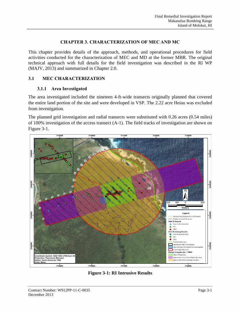
Final Remedial Investigation Report
Makanalua Bombing Range
Island of Molokai, HI
Contract Number: W912PP-11-C-0035 Page 3-1
December 2013
CHAPTER 3. CHARACTERIZATION OF MEC AND MC
This chapter provides details of the approach, methods, and operational procedures for field
activities conducted for the characterization of MEC and MD at the former MBR. The original
technical approach with full details for the field investigation was described in the RI WP
(MAJV, 2013) and summarized in Chapter 2.0.
3.1 MEC CHARACTERIZATION
3.1.1 Area Investigated
The area investigated included the nineteen 4-ft-wide transects originally planned that covered
the entire land portion of the site and were developed in VSP. The 2.22 acre Heiau was excluded
from investigation.
The planned grid investigation and radial transects were substituted with 0.26 acres (0.54 miles)
of 100% investigation of the access transect (A-1). The field tracks of investigation are shown on
Figure 3-1.
Figure 3-1: RI Intrusive Results

Final Remedial Investigation Report
Makanalua Bombing Range
Island of Molokai, HI
Contract Number: W912PP-11-C-0035 Page 3-2
December 2013
3.1.2 Positioning Transects
Transects were positioned using the Trimble GeoXT by qualified field personnel.
An archaeologist and field biologist from GANDA accompanied the team to assist in the
identification of significant archaeological structures and sensitive natural resources. Significant
items were flagged to avoid unintended disturbance.
3.1.3 Vegetation Clearance
Prior to transect investigation, brush was cut to a height of 6 in. Work on transects in the coastal
spray zone, a sensitive habitat, avoided cutting any Hawaii native plants. The area where no
vegetation was cut was approximately 650 feet from the shore line and included all of transects
18 and 19, and parts of transects 16 and 17. In non-coastal areas, Hawaii native plants not
considered endangered or part of critical habitat were cut. Critical cultural and natural resources
identified by GANDA personnel were avoided.
Due to the extreme terrain and thick vegetation encountered at inland areas of the site, vegetation
clearance production rates were less than expected.
3.1.4 Transect Investigation
The transect investigation was accomplished using the handheld Minelab Explorer II analog
metal detector. The transect survey was conducted as planned in the areas within the Target
Area; 100% of identified anomalies were investigated to depth of detection.
Per PDT approval, the following changes were made to the intrusive investigation.
The areas outside the Target Area were changed from intrusive investigation of 10% of
anomalies outside of the target area to investigation of 100% of anomalies. This was done
for accommodate QC considerations.
The originally planned grid acreage was revised to be conducted as 100% investigation of
the access transect (A1). The access transect traversed throughout the center of the target
area and beyond to assist in delineating extent perpendicular to the planned transects.
VSP was used to determine that 4 foot wide transects with a parallel pattern spaced 103 meters
between transects have an approximately 95% chance of traversing and detecting any 500 foot
diameter circular target with an average density of 200 anomalies per acre above the background
density of 10 anomalies per acre.
The transect miles completed were 17.14 miles, equaling 8.31 total acres. Transects were
relegated to a 4-ft width and depth of anomaly detection. All transects were 100% investigated
for surface and subsurface. The investigation resulted in the discovery and removal of 99 MEC
items (in the form of UXO) and 1,024 lbs of MD. In some instances, multiple items were found
at the same anomaly location.
The munitions items encountered match the information contained in prior investigation reports
with respect to both munitions type and location.

Final Remedial Investigation Report
Makanalua Bombing Range
Island of Molokai, HI
Contract Number: W912PP-11-C-0035 Page 3-3
December 2013
Vegetation and terrain conditions through the majority of the work were extreme. The daily
production rates of the Transect Anomaly Investigation were less than anticipated as shown in
the Production Log in Appendix A.
3.1.5 Intrusive Investigation Results Sheet
Results of the intrusive investigation were documented in the Intrusive Results Sheet, which
includes all required information. The Intrusive Results Sheet is located in Appendix J.
3.1.6 QC Instrument /Equipment Testing
An instrument verification strip was developed for the daily inspection of instruments prior to
daily operation and documented on the QC checklist found in Appendix C.
Quality Control of field procedures included:
Reacquisition of 46 seed items placed throughout the site. 100 % of all seed items were
recovered.
UXOQC documentation of anomaly clearance. 100 % of anomalies were successfully
cleared.
Daily Equipment Testing. The Trimble GeoXT used for positioning transects was tested
daily on a known point. The Minelab Explorer II analog metal detector was tested daily
on the ITS. Documentation is found in the Daily QC reports and in the Table of Intrusive
Results both appended to the report.
3.1.7 Disposition of UXO Items
The 99 UXO items encountered were destroyed thermally in the Batch Burner Furnace Thermal
Treatment Unit (TTU). Following thermal treatment, the items were inspected by qualified
personnel, and classified as Material Documented as Safe (MDAS). The MDAS was disposed of
according to the requirements of Chapter 14, EM 1110-1-4009 and Errata Sheet No. 2.
3.1.8 Disposition of Material Documented as Safe
The munitions-related items encountered that were not classified as MPPEH were recovered,
inspected, classified as MDAS and disposed of per the requirements of Chapter 14, EM 1110-1-
4009 and Errata Sheet No. 2.
Verified and certified MDAS items were packaged and sealed, and shipped to Timberline
Environmental Services (TES) for final disposal in July 2013. Documentation on DD Form
1348-1A is included in Appendix E.
As an element of cradle-to-grave documentation, TES provided signed copies of receipt
documents and the Certificate of Destruction. This documentation is included in Appendix E.
3.1.9 Photographic Log
Photographs documenting site conditions, munitions found, and site activities are located in
Appendix D.
Final Remedial Investigation Report
Makanalua Bombing Range
Island of Molokai, HI
Contract Number: W912PP-11-C-0035 Page 3-4
December 2013
3.2 MC CHARACTERIZATION
Environmental sampling was conducted at MBR to determine whether historic usage of the area
as a bombing and rocket range resulted in detectable levels of MC in site soils. MC may be
present in the shallow soils within the former MBR at historic impact areas (where detonations
occurred) and firing points. MC may occur in the form of leachate or fragments of the metals that
encased the explosives, and from release of the chemicals used for producing an explosion or
signal to the environment. IS soil sampling was conducted at MBR. The IS sample locations
were based on the MEC density map produced after RI transect investigation. Potential MC that
may be present in the shallow soils at MBR include four MEC-related metals [antimony (Sb),
copper (Cu), lead (Pb), and zinc (Zn)], as well as explosive and propellant compounds. These
metals and explosive compounds are the Chemicals of Potential Concern (COPCs) for the
Project Site.
3.2.1 Purpose of MC Sampling Activities
The overall objective of the MC sampling work was to determine whether MC contamination
exists at the site and, if present, whether the MC contamination poses an unacceptable risk to
human health and the environment. The MC data collected during this RI is a component of the
site-specific information used to select an appropriate response alternative for the site.
3.2.2 Preliminary Screening Values
The MC data obtained from the near-surface soils present at the former MBR was compared to
HDOH Tier 1 EALs. Tier 1 EALs are soil concentrations (of metals and explosives for this
Project Site) below which these compounds have been determined to not pose a significant threat
to human health or the environment (HDOH, 2008, 2011a). The EALs are dependent on the
environmental setting in which the sampled soils are located. For the former MBR Site, the
following environmental setting was assumed: “groundwater affected or potentially affected by
the release is not a current or potential drinking water resource and the site is located within 150
meters of a surface water body (EAL, Table B-2).” The groundwater beneath the former MBR is
not potable and the eastern half of the former bombing range is located within 150 meters of the
Pacific Ocean.
3.2.3 Field MC Sampling Activities Summary
The sampling guidance issued by the overseeing regulatory agency, HDOH, recommends the
collection of IS samples to determine representative contaminant concentrations at
environmental sites (HDOH 2009, 2011a). According to these guidance documents, increment
samples, consisting of a minimum of 100 sub-samples collected from DUs established within the
area being characterized, generates a more representative MC concentration of the sampled area,
compared to discrete sample data.
The IS sample collection followed current HDOH guidance for former maneuver area/bombing
range sites with a minimum of 10 percent of the total acreage being sampled using DUs of a
maximum size of 10 acres. Five DUs of 200-m by 200-m dimension (40,000 m2, or about 9.9

Final Remedial Investigation Report
Makanalua Bombing Range
Island of Molokai, HI
Contract Number: W912PP-11-C-0035 Page 3-5
December 2013
acres) were established at the former MBR site (Figure 4-2). The 200-m dimension of each DU
allowed the collection of sub-increment samples from along three MEC transects within each
DU. The final locations of the DUs were established after the initial MEC surveys were
completed and areas that contained sufficient near-surface soil to sample were delineated. Much
of the surface at the site consisted of volcanic rock that contained a very thin (typically 3 in.
thick or less) layer of hard, dry, reddish-brown silty clay.
Three of the DUs (DUs 2, 3 and 5) were established in areas containing surface soil where MEC
and MD were encountered during the visual and geophysical MEC surveys completed at the site.
DU-3 was centered in the portion of the site that was found to contain the highest amount of
MEC and MD while DUs 2 and 5 contained relatively minor amounts of MEC and MD. The
remaining two DUs (DUs 1 and 4) were established in the surrounding background areas where
no evidence of MEC or MD was encountered during the MEC surveys.
The soil sampling work was conducted on April 1 and 2, 2013. IS samples were collected from
the sampling units in accordance with the HDOH Technical Guidance Manual (TGM) (HDOH,
2009). Each increment sample consisted of a total of at least 100 sub-increments collected along
three MEC survey transects that ran through each delineated DU. The sub-increment samples
were collected in a systematic-random manner (i.e., equal spacing along the MEC survey
transects traversing the area with a random starting point). Triplicate increment samples were
collected from four of the five DUs established within the former MBR. The two replicate
increment samples were collected in the same manner as the primary increment sample, but from
a different starting point, and thus no sub-increment was collected from exactly the same spot.
The IS samples were collected from the shallow near-surface (0 to 3 in. bgs) soils present at the
site using a dedicated trowel to break-up the hard soil and to transfer equal volumes of soil per
increment into a dedicated, disposable polyvinyl chloride (PVC) end cap. The trowel was used
due to the rocky nature of the soil. The sampling interval corresponds to the entire depth of soil
present at the site and represents the material that site users may potentially be exposed to during
normal everyday activities. The size of the PVC cap was selected to hold approximately 15 g of
soil. Each 15-g increment, collected from more than 100 sub-increments present within each DU,
was placed into a pre-labeled, food-grade, re-sealable plastic bag, producing an approximately
1.5-kg increment sample that was submitted to the analytical laboratory for chemical analysis.
The PVC end cap and hand trowel were discarded after each increment sample was collected in
order to prevent cross-contamination, and to eliminate the need for decontaminating sampling
tools between sample collection points.
3.2.4 Sample Management
Upon collection in the field, the IS samples were assigned a unique Environmental Protection
Agency (EPA) identification (ID) number, and a label with the ID number, and the date and time
of sample collection was affixed to the food-grade, re-sealable plastic bag that was used to hold
the collected sample. Following sample collection, the samples were double-sealed and placed in
a refrigerator for temporary storage on Molokai, to allow the samples to be maintained as close
to 4 degrees Celsius (°C) as possible from the time of collection through sample transport.

Final Remedial Investigation Report
Makanalua Bombing Range
Island of Molokai, HI
Contract Number: W912PP-11-C-0035 Page 3-6
December 2013
After the samples arrived back on Oahu, the double-bagged, re-sealable bags were packed with
gel ice for shipment to the mainland laboratory. The original COC form and a copy of the current
laboratory’s United States Department of Agriculture (USDA) Soil Import Permit were placed in
a re-sealable bag and included in the cooler with the samples. Two custody seals were placed on
a hinge and front lid of the cooler. Custody seals were also placed on each sample bag to ensure
proper COC controls in the event that the cooler was opened for inspection.
Samples were collected from the former MBR on April 1 and 2, 2013 and were shipped to Test
America Sacramento by priority overnight express courier (FedEx). The laboratory received the
samples on April 5, 2013. A copy of the sample inventory log from the laboratory is provided in
Appendix I.1.
3.2.5 Analytical Laboratory and Analyses
The IS samples were submitted to the Test America-Sacramento office for chemical analysis.
The 1.5-kg samples were screened and split in the laboratory to produce representative samples
that were digested or extracted for analysis. The IS samples were prepared in accordance with
the HDOH TGM (HDOH, 2009) guidance for laboratory sub-sampling protocol for preparation
of IS samples.
The sample preparation steps specified below were followed for the IS samples analyzed for
metals content.
Place the entire sample on a tray covered with aluminum foil and air-dry for a minimum
of 24 hours in a fume hood.
Carefully sieve the entire air-dried sample using a 2-millimeter (mm) sieve.
Evenly distribute the sieved, air-dried sample onto another tray covered with aluminum
foil.
Form an imaginary 6 by 5 grid over the tray and take an aliquot composed of
approximately 1/30th of the desired target mass (10 g) from each imaginary grid square
in the tray.
Collect an approximately 10-g soil sample for digestion for metals analysis.
The sample preparation steps listed below were followed for the increment sample that was
analyzed for explosive compounds content.
Using a Pulverizing Mill (ring and puck), ESSA model LM2-P, powder the remaining
(roughly 1.5-kg) of air-dried sample from which the metals sample has been removed.
Evenly distribute the powdered sample onto a tray covered with aluminum foil.
Form an imaginary 6 by 5 grid over the tray and take an aliquot composed of
approximately 1/30th of the desired target mass (10 g) from each imaginary grid square
in the tray.

Final Remedial Investigation Report
Makanalua Bombing Range
Island of Molokai, HI
Contract Number: W912PP-11-C-0035 Page 3-7
December 2013
Collect approximately 10 g of the pulverized soil sample for extraction for determination
of explosives content.
The concentration of Cu, Pb, and Zn in the IS samples was determined using inductively coupled
plasma-atomic emission spectroscopy following preparation by EPA Method 3050B and analysis
by EPA Method 6010B. Antimony was analyzed by inductively coupled plasma-atomic
spectroscopy/mass spectrometry using EPA Method 6020A. The concentration of explosives in
the IS samples was determined using high-pressure liquid chromatography following EPA
Method 8330B.
3.2.6 QC/QA Samples
Quality Control/Quality Assurance (QC/QA) samples were collected and analyzed to assess
sampling precision and potential cross-contamination, which may occur between the time of
sample collection and laboratory analysis. The results from the QC samples also provided
information regarding the variability of the sampled population. QC samples for this site
investigation included field triplicates, matrix spike/matrix spike duplicate (MS/MSD) samples,
and temperature blanks.
3.2.6.1 Field Triplicates
For IS sampling, field triplicates were collected (Appendix A of EPA SW-846 8330B) in the
same manner as the original sample, with the same number of increments and volume. The
triplicates become additional IS samples. The triplicates were collected from DU-1, DU-2, DU-3,
and DU-4 in order to perform a statistical analysis on the collected data [i.e., Relative Standard
Deviation (RSD)] to assess the precision of analytical results.
3.2.6.2 MS/MSDs
MS/MSD samples are used to assess interferences in analytical results caused by the sampled
matrix. The analytical laboratory spikes the MS/MSDs with known concentrations of all the
target analytes and then analyzes the MS/MSDs. The percent recovery is calculated and is used
to evaluate interference effects.
One sample for MS and one sample for MSD were analyzed for every 5 percent of the total
number of samples; one MS/MSD sample pair was analyzed for every 20 field samples
collected. The MS/MSD analysis was performed on project-specific samples; a portion of field
sample MBR-01 was utilized as MS/MSD samples, and were identified as MBR-01MS and
MBR-01MSD. Since IS samples are significantly larger than discrete samples, enough soil was
available to perform all MS/MSD analyses.
3.2.6.3 Temperature Blanks
One temperature blank sample consisting of a plastic container filled with tap water supplied by
the laboratory was included in the cooler of samples shipped back to the laboratory. The
temperature of the blank was used by the laboratory as the representative temperature of the
samples within the cooler.

Final Remedial Investigation Report
Makanalua Bombing Range
Island of Molokai, HI
Contract Number: W912PP-11-C-0035 Page 4-1
December 2013
CHAPTER 4. REVISED CONCEPTUAL SITE MODEL AND REMEDIAL
INVESTIGATION RESULTS
The sections below discuss the results of the 2013 RI fieldwork. The source, nature, and extent
of MEC contamination, the identification of no MC contamination, and the potential exposure
pathways for each medium are presented. The rationale for delineation of the MRS based on the
intrusive results follows.
4.1 RESULTS FOR MUNITIONS AND EXPLOSIVES OF CONCERN
This section presents the results of the RI concerning MEC. The results are presented in a table
of findings from the transect survey, maps showing the lateral extent of the MEC and MD
findings, the density map of MEC and MD, and an evaluation of MEC exposure pathways.
4.1.1 Results of Intrusive Investigation
The results of the intrusive investigation of 19 planned transects (1-19) and the access transect
(A-1) are presented in Appendix J. The results are presented associated with the anomaly number
along each transect. No unexpected munitions were encountered. MEC was encountered in the
form of UXO, no DMM or explosive soils were encountered.
This space is intentionally left blank.

Final Remedial Investigation Report
Makanalua Bombing Range
Island of Molokai, HI
Contract Number: W912PP-11-C-0035 Page 4-2
December 2013
Table 4-1: Results of Intrusive Investigation
MEC (in form of UXO) MD
Transect Anomaly # UXO Items # of
Items Depth (in.) Items
1
Wt. (lb)
Depth (Range)
1-5 - None - - None - -
6 - None - - Unidentifiable Frag 0.25 0
7 - None - - None - -
8 - None - - 3 lb Practice Bomb, AN-Mk 23 (frag)
0.5 3
9 - None - - 3 lb Practice Bomb, AN-Mk 5 (intact)
3 0
10 - None - - 3 lb Practice Bomb, AN-Mk 5 (2 intact+frag), 3 lb Practice Bomb, AN-Mk 23 (frag), 4.5 lb Practice Bomb, AN-Mk 43 (1 intact+frag)
18.5 0-4
11 - None - - 3 lb Practice Bomb, AN-Mk 5 (frag), 4.5 lb Practice Bomb, AN-Mk 43 (frag)
1 1
12 - None - - 3 lb Practice Bomb, AN-Mk 5 (1 intact+frag), 3 lb Practice Bomb, AN-Mk 23 (frag), 4.5 lb Practice Bomb, AN-Mk 43 (1 intact+frag). 13 lb Practice Bomb, AN-Mk 19 (frag)
26.5 0-12
13 13-083 3 lb Practice Bomb, AN-Mk 5
1 6 3 lb Practice Bomb, AN-Mk 5 (3 intact+frag)
149 0-18
13-039 3 lb Practice Bomb, AN-Mk 23
1 1 3 lb Practice Bomb, AN-Mk 23 (9 intact+frag)
13-011 3 lb Practice Bomb, AN-Mk 5
1 18 4.5 lb Practice Bomb, AN-Mk 43 (frag)
13-020 3 lb Practice Bomb, AN-Mk 5
1 6 13 lb Practice Bomb, AN-Mk 19 (1 intact+frag)
13-001 3 lb Practice Bomb, AN-Mk 5
8 0
13-004 3 lb Practice Bomb, AN-Mk 23
2 0
14 14-108 3 lb Practice Bomb, AN-Mk 5
1 0 3 lb Practice Bomb, AN-Mk 5 (1 intact+frag)
252 0-18
14-056 3 lb Practice Bomb, AN-Mk 23
3 1 3 lb Practice Bomb, AN-Mk 23 (2 intact+frag)
14-077 13 lb Practice Bomb, AN-Mk 19
4 12 4.5 lb Practice Bomb, AN-Mk 43 (frag)
14-079 3 lb Practice Bomb, AN-Mk 23
1 0 13 lb Practice Bomb, AN-Mk 19 (frag)
14-084 3 lb Practice Bomb, AN-Mk 23
1 4 Unidentifiable Frag
14-101 3 lb Practice Bomb, AN-Mk 23
1 6
14-029 3 lb Practice Bomb, AN-Mk 23
1 6

Final Remedial Investigation Report
Makanalua Bombing Range
Island of Molokai, HI
Contract Number: W912PP-11-C-0035 Page 4-3
December 2013
MEC (in form of UXO) MD
14-033 3 lb Practice Bomb, AN-Mk 5
1 0
14-039 3 lb Practice Bomb, AN-Mk 23
1 0
14-040 3 lb Practice Bomb, AN-Mk 23
1 12
14-045 3 lb Practice Bomb, AN-Mk 23
1 1
14-047 3 lb Practice Bomb, AN-Mk 23
2 18
15 15-019 3 lb Practice Bomb, AN-Mk 23
1 0 3 lb Practice Bomb, AN-Mk 5 (1 intact+frag)
27 0-12
3 lb Practice Bomb, AN-Mk 23 (2 intact+frag)
Unidentifiable Frag
16 16-005 13 lb Practice Bomb, AN-Mk 19
1 10 3 lb Practice Bomb, AN-Mk 5 (frag)
28 0-18
3 lb Practice Bomb, AN-Mk 23 (frag)
13 lb Practice Bomb, AN-Mk 19 (frag)
Unidentifiable Frag
One Bomb Ejector Rack (intact)
17 17-001 13 lb Practice Bomb, AN-Mk 19
1 0 Unidentifiable Frag 1 3
18 18-002 3 lb Practice Bomb, AN-Mk 23
1 0 3 lb Practice Bomb, AN-Mk 23 (tail fin)
1 6
19 None Unidentifiable Frag 26.2 0-12
Expended Small Arms Ammunition (Cartridge; 30-06, 30-30, .22 caliber, .50 Caliber, 9mm, and 12 gauge)
A1 A1-171 3 lb Practice Bomb, AN-Mk 23
2 5 3 lb Practice Bomb, AN-Mk 5 (20 intact+frag)
490 0-24
A1-179 3 lb Practice Bomb, AN-Mk 23
1 9 3 lb Practice Bomb, AN-Mk 23 (25 intact+frag)
A1-199 3 lb Practice Bomb, AN-Mk 23
1 18 4.5 lb Practice Bomb, AN-Mk 43 (frag)
A1-200 3 lb Practice Bomb, AN-Mk 5
1 6 13 lb Practice Bomb, AN-Mk 19 (1 intact+frag)
A1-207 3 lb Practice Bomb, AN-Mk 23
1 5 Unidentifiable Frag
A1-208 3 lb Practice Bomb, AN-Mk 5
1 4 Expended Small Arms Ammunition
A1-210 3 lb Practice Bomb, AN-Mk 5
1 1 Bomb Ejector Rack
A1-213 4.5 lb Practice Bomb, AN-Mk 43
4 1
A1-217 3 lb Practice Bomb, AN-Mk 23
1 18

Final Remedial Investigation Report
Makanalua Bombing Range
Island of Molokai, HI
Contract Number: W912PP-11-C-0035 Page 4-4
December 2013
MEC (in form of UXO) MD
A1-222 3 lb Practice Bomb, AN-Mk 23
1 14
A1-135 3 lb Practice Bomb, AN-Mk 5
1 8
A1-138 13 lb Practice Bomb, AN-Mk 19
10 6
A1-141 3 lb Practice Bomb, AN-Mk 23
1 4
A1-145 13 lb Practice Bomb, AN-Mk 19
1 2
A1-163 3 lb Practice Bomb, AN-Mk 23
1 3
A1-164 3 lb Practice Bomb, AN-Mk 23
10 8
A1-167 3 lb Practice Bomb, AN-Mk 23
2 12
A1-121 4.5 lb Practice Bomb, AN-Mk 43
1 2
A1-074 3 lb Practice Bomb, AN-Mk 23
1 4
A1-039 3 lb Practice Bomb, AN-Mk 23
1 6
A1-068 3 lb Practice Bomb, AN-Mk 23
1 12
A1-005 3 lb Practice Bomb, AN-Mk 5
2 0
A1-006 3 lb Practice Bomb, AN-Mk 5
1 0
A1-010 3 lb Practice Bomb, AN-Mk 23
2 0
A1-012 13 lb Practice Bomb, AN-Mk 19/ 3 lb Practice Bomb, AN-Mk 23
4 0
A1-013 3 lb Practice Bomb, AN-Mk 23
3 0
A1-014 3 lb Practice Bomb, AN-Mk 5
1 0
A1-015 3 lb Practice Bomb, AN-Mk 5
1 0
A1-016 3 lb Practice Bomb, AN-Mk 23
2 0
A1-017 3 lb Practice Bomb, AN-Mk 5
1 0
A1-018 3 lb Practice Bomb, AN-Mk 5
1 0
A1-019 3 lb Practice Bomb, AN-Mk 5
1 0
TOTAL 99 1,024
1-Intact MD items are fully expended and not UXO.

Final Remedial Investigation Report
Makanalua Bombing Range
Island of Molokai, HI
Contract Number: W912PP-11-C-0035 Page 4-5
December 2013
4.1.2 Source, Nature, and Extent of UXO
The source of UXO and MD encountered onsite was from munitions used during practice at the
bomb and rocket range during from 1941 to 1946.
The nature and quantity of the items encountered during the 2013 RI are presented in Appendix J
associated with the anomaly identifier where found. Coordinates of the anomaly identifier are
provided in Appendix J in the Table of Intrusive Results. A total of 99 UXO items were
encountered, and over 1,024 lb of MD was removed. The vertical extent (depth) of the items as
shown on Table 4-1 ranged from surface (0 inches) to 18 inches bgs. Horizontal extent of items
found are shown on Figure 4-1 which presents the items found by type (UXO or MD). Figure 4-1
shows the density distribution of items found. The MC sampling locations were established from
the results presented on map.
To calculate the UXO/MD density the intrusive results are first analyzed and only UXO or MD
items are selected to be processed. Cultural debris findings were not included. The intrusive
results data was then run through the Density function inside Spatial Analyst, a module of
ESRI’s ArcGIS software. This Density function analyzes each point in the intrusive data,
searches for other data points within a pre-determined radius and uses the values associated with
those points to interpolate density contours for the entire area that was surveyed. The resulting
density data can then have colors assigned to density ranges and can be displayed visually on a
map. For this project, the data values used in the density module were the quantities of UXO/MD
found at each data point, a search radius of 50 meters, and density units of acres.
Figure 4-1: RI Intrusive Results and Density Map

Final Remedial Investigation Report
Makanalua Bombing Range
Island of Molokai, HI
Contract Number: W912PP-11-C-0035 Page 4-6
December 2013
4.1.3 MEC Exposure Pathways on Land
The site is located within the Kalaupapa National Historic Park, owned by the State of Hawaii
and managed by the National Park Service, State of Hawaii DLNR, and HDOH. Receptors
would include recreational users with a permit and escort.
It has been determined an explosive hazard is present on the land portion of the site. Exposure
pathways for MEC (in the form of UXO) are complete if a recreational user or escort were to
encounter, handle and detonate UXO on the surface. Intrusive activities are not anticipated due to
the historical nature and lack of development at site.
4.1.4 Exposure Pathways in Tidal Water
The Project Team agreed not to investigate the water portions of the site due to the dangerous sea
conditions caused by a rocky shoreline, constant high waves and strong tidal currents. Per the
DQOs, the RI report is to evaluate the likelihood of an explosive hazard present in the water
portions of the MRS, based on the land findings. The UXO findings during the investigation
were concentrated near the target center. The closest UXO item was found approximately 850
feet from the land/sea interface. The closest MD items were found approximately 200 ft from the
shoreline and were mainly in the form of small arms ammunition. The dangerous sea conditions
would not attract recreational divers, and the exposure pathway is incomplete. Exposure
pathways are considered incomplete in the tidal water since no receptors are likely to be in the
area.
4.2 MUNITIONS CONSTITUENTS
This section describes the MC results obtained from the five DUs sampled during the RI field
effort. Sample locations were determined by the results of the transect investigation findings.
Sample locations are shown in Figure 4-2Error! Reference source not found.. A close up of
the location of samples collected relative to UXO and MD findings is shown in Figure 4-3
This space is intentionally left blank

Final Remedial Investigation Report
Makanalua Bombing Range
Island of Molokai, HI
Contract Number: W912PP-11-C-0035 Page 4-7
December 2013
Figure 4-2: Sample Locations

Final Remedial Investigation Report
Makanalua Bombing Range
Island of Molokai, HI
Contract Number: W912PP-11-C-0035 Page 4-8
December 2013
Figure 4-3: Decision Unit 3 Increment Locations
4.2.1 MC Results
No explosive compounds were detected above the laboratory’s Limits of Detection (LODs) in
any of the 13 surface soil increment samples collected from the five DUs established within the
former MBR. Triplicate IS soil samples were collected from two of the three DUs (DU-2 and
DU-3) established in areas where MEC and MD was observed within the MBR. A single IS soil
sample was collected from one of the three DUs (DU-5) containing MEC and MD. Triplicate IS
soil samples were also collected from the two “background” DUs (DU-1 and DU-4) established
in areas within the MBR where MEC and MD were not observed.
Table 4-1 presents the analytical data for the metals and explosive compounds obtained in the six
IS near-surface soil samples collected from the two “background” DUs in which MEC and MC
were not observed. No explosive compounds were detected above the laboratory’s LOD in any
of these samples. However, three of the four metals were detected; antimony was not detected in
any of these samples above the laboratory’s LOD of 0.2 mg per kilogram (mg/kg). The lead
concentration measured in the background samples ranged from 6.7 to 12 mg/kg, with a lead
concentration maximum 95% Upper Confidence Limit (UCL) 14 mg/kg. The copper
concentration measured in the increment samples ranged from 49 to 52 mg/kg, with a copper

Final Remedial Investigation Report
Makanalua Bombing Range
Island of Molokai, HI
Contract Number: W912PP-11-C-0035 Page 4-9
December 2013
concentration 95% UCL of 53 mg/kg. The zinc concentration measured in the background
samples ranged from 110 to 150 mg/kg, with a zinc concentration 95% UCL of 162 mg/kg.
Table 4-2 presents the analytical data for the metals and explosive compounds obtained in the
three DUs in which MEC and MC were observed. No explosive compounds were detected above
the laboratory’s LOD in any of these seven near-surface increment soil samples (two triplicates
and one single sample).
The detected concentrations of lead, copper, and antimony were measured to be above the 95%
UCL of the background concentrations in the triplicate samples collected from DU-3, which was
centered over the portion of the site that was found to contain the highest amount of MEC and
MD. All zinc concentrations were below both the maximum detected background analyte
background concentrations and the maximum 95% UCL of the background DUs. The lead
concentrations measured in triplicate DU-3 increment samples ranged from 57 to 110 mg/kg,
with a 95% UCL of 126 mg/kg. The copper concentrations measured in the triplicate DU-3
increment samples ranged from 54 to 63 mg/kg, with a 95% UCL of 66 mg/kg. The zinc
concentrations measured in the triplicate DU-3 increment samples ranged from 120 to 140
mg/kg, with a 95% UCL of 147. The 95% UCL of Lead and copper did not exceed Tier 1 EAL.
The antimony concentrations measured in the triplicate DU-3 increment samples ranged from
0.43 to 2.1 mg/kg, with a 95% UCL of 2.61. The maximum onsite detected value for antimony
(2.1 mg/kg) did not exceed the HDOH Tier 1 EAL (2.4 mg/kg), however, the 95% UCL (2.61
mg/kg) for antimony in DU 3 did slightly exceed the PAL.
The metals concentrations measured in DUs 2 and 5 which contained relatively minor amounts
of MEC and MD were similar to the concentrations measured in the background samples. The
copper concentration measured in DU-5 was slightly higher than the copper concentrations
measured in the background samples collected from the former MBR, but well below the Tier 1
EAL of 626 mg/kg.
This space is intentionally left blank.

Final Remedial Investigation Report
Makanalua Bombing Range
Island of Molokai, HI
Contract Number: W912PP-11-C-0035 Page 4-10
December 2013
Table 4-2: MBR Background MC Sample Results: Metals and Explosive Compounds in Soil (mg/kg)
Analyte Tier 1 EAL
1
Decision Unit 1 Decision Unit 4
MBR-01 MBR-02 MBR-03 95% UCL
MBR-10 MBR-11 MBR-12 95% UCL
Metals/Inorganics (SW-846 6010B/6020) (mg/kg)
Lead (Pb) 200 7.8 6.7 12 14 8.3 7.2 7.4 9
Copper (Cu) 626 50 49 49 50 52 49 51 53
Antimony (Sb) 2.4 U (< 0.20) U (< 0.20) U (< 0.20) 0.16 U (< 0.20) U (< 0.20) U (< 0.20) 0.16
Zinc (Zn) 1,000 150 110 110 162 120 120 120 120
Explosives (SW-846 8330B) (mg/kg)
2-Amino-4,6-dinitrotoluene 0.70 U (< 0.05) U (< 0.048) U (< 0.051) 0.13 U (< 0.049) U (< 0.050) U (< 0.049) 0.13
4-Amino-2,6-dinitrotoluene 0.70 U (< 0.05) U (< 0.048) U (< 0.051) 0.13 U (< 0.049) U (< 0.050) U (< 0.049) 0.13
3,5-Dinitroaniline NS U (< 0.05) U (< 0.048) U (< 0.051) 0.13 U (< 0.049) U (< 0.050) U (< 0.049) 0.13
1,3-Dinitrobenzene 1.2 U (< 0.05) U (< 0.048) U (< 0.051) 0.13 U (< 0.049) U (< 0.050) U (< 0.049) 0.13
2,4-Dinitrotoluene 1.6 U (< 0.05) U (< 0.048) U (< 0.051) 0.13 U (< 0.049) U (< 0.050) U (< 0.049) 0.13
2,6-Dinitrotoluene 4.3 U (< 0.05) U (< 0.048) U (< 0.051) 0.13 U (< 0.049) U (< 0.050) U (< 0.049) 0.13
HMX 29.1 U (< 0.05) U (< 0.048) U (< 0.051) 0.13 U (< 0.049) U (< 0.050) U (< 0.049) 0.13
Nitrobenzene 2.3 U (< 0.05) U (< 0.048) U (< 0.051) 0.13 U (< 0.049) U (< 0.050) U (< 0.049) 0.13
Nitroglycerin 1.2 U (< 0.25) U (< 0.24) U (< 0.25) 0.26 U (< 0.25) U (< 0.25) U (< 0.25) 0.25
4-Nitrotoluene 30.3 U (< 0.05) U (< 0.048) U (< 0.051) 0.13 U (< 0.049) U (< 0.050) U (< 0.049) 0.13
2-Nitrotoluene 1.9 U (< 0.05) U (< 0.048) U (< 0.051) 0.13 U (< 0.049) U (< 0.050) U (< 0.049) 0.13
3-Nitrotoluene 22.7 U (< 0.05) U (< 0.048) U (< 0.051) 0.13 U (< 0.049) U (< 0.050) U (< 0.049) 0.13
(pentaerythrite tetranitrate) PETN 24.4 U (< 0.25) U (< 0.24) U (< 0.25) 0.26 U (< 0.25) U (< 0.25) U (< 0.25) 0.25
(cyclotrimethylene trinitramine) RDX 2.8 U (< 0.05) U (< 0.048) U (< 0.051) 0.13 U (< 0.049) U (< 0.050) U (< 0.049) 0.13
Tetryl 48.9 U (< 0.05) U (< 0.048) U (< 0.051) 0.13 U (< 0.049) U (< 0.050) U (< 0.049) 0.13
1,3,5-Trinitrobenzene 8.4 U (< 0.05) U (< 0.048) U (< 0.051) 0.13 U (< 0.049) U (< 0.050) U (< 0.049) 0.13
2,4,6-Trinitrotoluene 7.2 U (< 0.05) U (< 0.048) U (< 0.051) 0.13 U (< 0.049) U (< 0.050) U (< 0.049) 0.13 1Tier 1 EAL = Unrestricted land use at sites where surface water is located within 150 meters of the release site and where the site is underlain by a non-drinking water
resource (Table B-2, HDOH 2012).
U = Undetected at the Limit of Detection (Value in Parenthesis).

Final Remedial Investigation Report
Makanalua Bombing Range
Island of Molokai, HI
Contract Number: W912PP-11-C-0035 Page 4-11
December 2013
Table 4-3: MBR MC Sample Results: Metals and Explosive Compounds in Soil (mg/kg), Decision Units 2, 3, and 5
Analyte Tier 1 EAL
1
Decision Unit 2 Decision Unit 3 Decision
Unit 5
MBR-04 MBR-05 MBR-06 MBR-07 MBR-08 MBR-09 MBR-13
Metals/Inorganics (SW-846 6010B/6020) (mg/kg)
Lead (Pb) 200 6.9 5.4 7.2 57 73 110 8.2
Copper (Cu) 626 44 47 45 56 54 63 62
Antimony (Sb) 2.4 U (< 0.20) U (< 0.20) U (< 0.20) 0.47 2.1 0.43 U (< 0.20)
Zinc (Zn) 1,000 110 130 120 120 130 140 130
Explosives (SW-846 8330B) (mg/kg)
2-Amino-4,6-dinitrotoluene 0.70 U (< 0.049) U (< 0.048) U (< 0.046) U (< 0.05) U (< 0.047) U (< 0.048) U (< 0.049)
4-Amino-2,6-dinitrotoluene 0.70 U (< 0.049) U (< 0.048) U (< 0.046) U (< 0.05) U (< 0.047) U (< 0.048) U (< 0.049)
3,5-Dinitroaniline NS U (< 0.049) U (< 0.048) U (< 0.046) U (< 0.05) U (< 0.047) U (< 0.048) U (< 0.049)
1,3-Dinitrobenzene 1.2 U (< 0.049) U (< 0.048) U (< 0.046) U (< 0.05) U (< 0.047) U (< 0.048) U (< 0.049)
2,4-Dinitrotoluene 1.6 U (< 0.049) U (< 0.048) U (< 0.046) U (< 0.05) U (< 0.047) U (< 0.048) U (< 0.049)
2,6-Dinitrotoluene 4.3 U (< 0.049) U (< 0.048) U (< 0.046) U (< 0.05) U (< 0.047) U (< 0.048) U (< 0.049)
HMX 29.1 U (< 0.049) U (< 0.048) U (< 0.046) U (< 0.05) U (< 0.047) U (< 0.048) U (< 0.049)
Nitrobenzene 2.3 U (< 0.049) U (< 0.048) U (< 0.046) U (< 0.05) U (< 0.047) U (< 0.048) U (< 0.049)
Nitroglycerin 1.2 U (< 0.24) U (< 0.24) U (< 0.23) U (< 0.25) U (< 0.23) U (< 0.24) U (< 0.25)
4-Nitrotoluene 30.3 U (< 0.049) U (< 0.048) U (< 0.046) U (< 0.05) U (< 0.047) U (< 0.048) U (< 0.049)
2-Nitrotoluene 1.9 U (< 0.049) U (< 0.048) U (< 0.046) U (< 0.05) U (< 0.047) U (< 0.048) U (< 0.049)
3-Nitrotoluene 22.7 U (< 0.049) U (< 0.048) U (< 0.046) U (< 0.05) U (< 0.047) U (< 0.048) U (< 0.049)
(pentaerythrite tetranitrate) PETN 24.4 U (< 0.24) U (< 0.24) U (< 0.23) U (< 0.25) U (< 0.23) U (< 0.24) U (< 0.25)
(cyclotrimethylene trinitramine) RDX 2.8 U (< 0.049) U (< 0.048) U (< 0.046) U (< 0.05) U (< 0.047) U (< 0.048) U (< 0.049)
Tetryl 48.9 U (< 0.049) U (< 0.048) U (< 0.046) U (< 0.05) U (< 0.047) U (< 0.048) U (< 0.049)
1,3,5-Trinitrobenzene 8.4 U (< 0.049) U (< 0.048) U (< 0.046) U (< 0.05) U (< 0.047) U (< 0.048) U (< 0.049)
2,4,6-Trinitrotoluene 7.2 U (< 0.049) U (< 0.048) U (< 0.046) U (< 0.05) U (< 0.047) U (< 0.048) U (< 0.049) 1Tier 1 EAL = Unrestricted land use at sites where surface water is located within 150 meters of the release site and where the site is underlain by a non-drinking water resource
(Table B-2, HDOH 2012).
U = Undetected at the Limit of Detection (Value in Parenthesis).

Final Remedial Investigation Report
Makanalua Bombing Range
Island of Molokai, HI
Contract Number: W912PP-11-C-0035 Page 4-12
December 2013
The maximum detected value and the 95% UCL of the metals measured in the DUs containing
MEC and MD are compared with the maximum detected value and the 95% UCL of
concentrations measured in the background DUs in Table 4-4. The shaded values in the table
highlight concentrations in the DUs that exceed background concentrations. The former use of
the site as a bombing range has resulted in slightly higher concentration levels of lead, copper
and antimony in near-surface soils in DU-3 and slightly higher concentration levels of copper in
DU-5. The the 95% UCL of antimony slightly exceeded the PAL, despite all three increment
samples collected from DU-3 containing antimony concentrations below the PAL of 2.4 mg/kg.
Table 4-4: Maximum Detected Metals Sample Results and 95% Upper Confidence Limit
for Triplicate Samples (mg/kg)
Analyte Tier 1 EAL
1
Background Decision Unit 3 Decision Unit 2 Decision Unit 5
3
Max 95%
UCL(1)
Max
95% UCL
Max 95% UCL
Value
Lead (Pb) 200 12 14 110 126 7.2 8 8.2
Copper (Cu) 626 52 53 63 66 45 48 62
Antimony (Sb) 2.4 U (< 0.20) 0.16 2.1 2.61 U (< 0.20) 0.16 U (< 0.20)
Zinc (Zn) 1,000 150 162 140 147 120 137 130
1. Background values are determined from the concentrations measured in the six IS samples collected from DU 1 and DU 4
from areas where no MEC or MD were present. The maximum 95% UCL of the two background DUs was used for
comparison.
2. Yellow shaded cells indicate Metals Concentrations were Above the Range of Metals Concentrations Measured in the
Background Samples. Orange shaded cell indicates 95% UCL exceeded Tier 1 EAL.
3. DU 5 was not sampled in triplicate, therefore a 95% UCL was not calculated.
4.2.2 Source Blank and Equipment Rinseate Results
A source water sample and equipment rinseate sample were collected during the field sampling
work. The purpose of this sampling was to verify that the pre-cleaned sampling equipment did
not contain any residual contamination. The equipment rinseate sample was collected by pouring
the source water over an unused PVC sampling cap that was positioned above the sample jar. No
metals or explosive compounds were detected in the equipment rinseate or source blank samples
collected during this investigation.
4.2.3 Review of Analytical Data
The following QA/QC checks were employed during the collection of field data and sampling
activities.
Collection of samples and field measurements by qualified personnel. Element personnel
engaged in environmental investigations have extensive experience in site
characterization work, and are familiar with federal, state, and local requirements, as well
as with industry protocols concerning equipment decontamination, sample collection,
sample and project documentation, and QC procedures.
Use of new, clean, and dedicated sampling devices and sample bags.

Final Remedial Investigation Report
Makanalua Bombing Range
Island of Molokai, HI
Contract Number: W912PP-11-C-0035 Page 4-13
December 2013
Preservation of sample integrity by chilling samples in the field and maintaining proper
temperature until receipt at the laboratory.
4.2.3.1 TestAmerica Results
TestAmerica Laboratories, Inc. (Sacramento, California) received one shipment of 13 increment
soil samples for analysis on April 5, 2013 [Sample Delivery Groups (SDGs) 320-2217-1 for soil
samples and 320-2217-2 for water samples]. Samples were received intact and in good condition,
cold (1.6°C), and consistent with the accompanying COC form. All samples were stored in a
refrigerator at 4°C upon receipt at the laboratory. The Level 2 laboratory reports for the two
SDGs are included in Appendices J.2.1 and J.2.2.
4.2.3.2 LDC Review
The Data Usability Report prepared by LDC is appended to the report. As part of the QC for this
project, Element subcontracted Laboratory Data Consultants, Inc. (LDC) to complete an EPA
Level III & IV review of the data package received from TestAmerica. This effort included a
review of the hold times, blank spike recoveries, surrogate recoveries, relative percent
differences, and sample triplicates. The EPA Level IV review was performed on samples MBR-
01 and -04 (at least 10 percent of all data results). Results are provided in LDC Data Validation
Report 29797 (Appendix I.3). The following lists report the completion of requirements for EPA
methods Explosives (EPA SW8330B) and Metals (EPA 6010B/6020).
Explosives (EPA SW8330B)
Both extraction and analysis holding times were met.
The %RSD for the initial calibration for RDX was 16.0%, just outside the control limit of
15%. All associated data for all samples in the SDG were flagged as estimated with a “J”
if detected and “UJ” if non-detect (ND).
Tetryl was detected in a method blank at a level above the method detection limit (MDL),
but below the reporting limit (RL). The value should be considered an estimate (flagged
J).
All surrogate recoveries except for one sample was within QC limits. 3, 4-Dinitrotoluene
in sample MBR-09 had a %R of 116, just outside limits of 75-115%. All Target
Compound List (TCL) compound detects were qualified as estimated with a “J.”
All MS/MSD recoveries were within QC limits.
All laboratory Control Spike (LCS) recoveries met QC acceptance criteria.
Metals (EPA 6010B/6020)
Both extraction and analysis holding times were met.
Copper was detected in method blanks at levels above the MDL, but below the RL. The
values should be considered an estimate (flagged “J”).
The MS recovery was outside of the control limits for antimony. The MSD recovery was
outside of the control limits for lead and antimony. All associated data for all samples in

Final Remedial Investigation Report
Makanalua Bombing Range
Island of Molokai, HI
Contract Number: W912PP-11-C-0035 Page 4-14
December 2013
the SDG were qualified as estimated with a “J” if detected and “UJ” if ND.
All LCS recoveries met QC acceptance criteria.
The %RSD limit for Antimony for DU-3 triplicate set (samples MBR-07, -08, and -09)
was calculated to be 95%, which was outside the control limit of 35%. Results were 0.47,
2.1, and 0.43 mg/kg, respectively.
4.2.3.3 Evaluation of Replicate Increment Soil Samples
Triplicate samples were collected from four of the five DUs (DU-1 through DU-4) in order to
evaluate the field sampling, laboratory sub-sampling, and analytical precision. Field replicate
samples, like all project samples, were assigned unique ID numbers so that the sample could not
be identified by the laboratory as a field replicate. Replicate samples were analyzed for the same
parameters as regular project samples.
The RSDs of the triplicate soil samples were calculated to assess the precision of the analytical
results obtained from the increment sampling. The RSD indicates how precisely the three
replicates measure from the average value and the RSD describes the ratio of the standard
deviation to the average concentration of the contaminant(s) detected in the DU (expressed as a
percent). The lower the RSD, also called the “coefficient of variation,” the more precise the
replicates are as an estimate of the average contaminant concentration in the DU under
investigation.
The RSD values obtained for each analyte within each DU are summarized in a series of tables
included in Appendix I.4. For this project, all RSDs were less than 30%, with one exception. The
RSD value for Antimony (DU-3) was 95%; and antimony values ranged from 0.43 to 2.1 mg/kg,
all below the Tier 1 EAL. Based on this criterion, there is limited variability observed in the
triplicate samples collected. No other data discrepancies were noted between increment samples
collected during the course of this project.
4.2.4 Source, Nature and Extent of MC Contamination
No evidence of explosives contamination was detected in any of the 13 increment samples
collected from within the MBR. Slightly elevated levels of lead, copper, and antimony were
measured in DU-3, which contained the highest amount of MEC and MD within the former
MBR. Slightly elevated levels of copper were also detected in DU-5. None of the metals
concentrations measured in the increment samples collected from the five DUs within the MBR
exceeded their respective HDOH Tier 1 EALs.
4.3 DELINEATION OF MUNITIONS RESPONSE SITES
This section describes the process of delineating the Range Complex No. 1 MRS into two areas
based on explosive hazard.

Final Remedial Investigation Report
Makanalua Bombing Range
Island of Molokai, HI
Contract Number: W912PP-11-C-0035 Page 4-15
December 2013
4.3.1 Background
The 2008 SI and the 2013 RI both determined an explosive hazard exists within the Range
Complex No. 1 MRS. UXO items remaining from bombing and rocket training from 1941 to
1946 likely still remain onsite.
4.3.2 Delineated Munitions Response Sites
The revised target area was developed by using a combination of the intrusive results and MEC
(UXO)/MD anomaly density that was generated. Using these two pieces of data, a boundary was
drawn around the most heavily contaminated areas of the site that best represented as a target
area.
The new boundaries are recommended based on level of potential explosive hazard present in
each area determined by MEC (in the form of UXO) and MD findings/densities encountered
during historical site visits and the 2013 RI. Table 1-1 and Table 4-1 list the historical and 2013
RI UXO findings onsite. No UXO and only very low densities of expended small arms
ammunition have been found in the Remaining Lands area. Separating the MRS acreage into two
areas allows each to be addressed in a cost-efficient and sensible manner appropriate to the level
of explosive hazard present within each area.
No unacceptable risk to human or ecological receptors from MC contamination was identified
within either area and therefore the risk is not a consideration in the re-delineation. Both areas
have the same land use and are undeveloped.
Figure 4-4 shows the recommended re-delineated boundaries for Range Complex No. 1.
Based on the MEC anomaly map shown in Figure 4-1, it is not anticipated UXO are present
within the tidal waters within the MRS. Therefore, the tidal waters are entirely included in the
Remaining lands, and not included in the re-delineation of the target area of the MRS as shown
on Figure 4-4.
This Space is intentionally left blank.

Final Remedial Investigation Report
Makanalua Bombing Range
Island of Molokai, HI
Contract Number: W912PP-11-C-0035 Page 4-16
December 2013
Figure 4-4: Recommended MRS Re-delineation
4.3.3 Revised Conceptual Site Models and Potentially Complete Exposure Pathways
for Delineated Areas of Range Complex No. 1 MRS
The Preliminary MEC and MC CSMs presented in Chapter 2.0 have been updated to reflect the
recommended split of Range Complex No. 1 into two areas, the Target Area and the Remaining
Lands, based on the level of explosive hazard present within each area. The delineation is based
on findings from the 2008 SI and 2013 RI fieldwork. The MEC CSMs are presented in table
format and include both areas presented in the same table (Table 4-4). The MC CSM is prepared
in flowchart format, and since neither the target area nor the remaining lands has an unacceptable
risk to human or ecological receptors from MC, and both areas have the same receptors and site
conditions, both areas are represented by the same MC CSM (Figure 4-5).

Final Remedial Investigation Report
Makanalua Bombing Range
Island of Molokai, HI
Contract Number: W912PP-11-C-0035 Page 4-17
December 2013
Table 4-5: Revised MEC Conceptual Site Model for Range Complex No. 1 MRS Target Area and Remaining Lands
Munitions Response Site Details
REVISED CONCEPTUAL SITE MODEL SUMMARY REMEDIAL INVESTIGATION TECHNICAL APPROACH
Known or Suspected Contamination
Source(s)
Potential/
Suspected Location and Distribution
Source or Exposure Medium
Current and Future Receptors
Potentially Complete
Exposure Pathway
Investigation Method
Investigation Location(s)
Investigation Acreage/Number of
Samples Results
RANGE COMPLEX No. 1-
Target Area
Acreage 1: 232.84 (land)
Suspected Past DoD Activities (release mechanisms): Target Area for Bombing and Rocket Range
Current and Future Land Use: Recreational
Land Area
Practice Bombs (AN-Mk5, AN-Mk23, AN-Mk43, AN-Mk19) with signals; Small Arms Ammunition.
The Target Area does not extend into the Tidal Water Area.
Significant evidence of MEC hazards remaining from UXO; Heavy concentration at target center
UXO items found surface and subsurface.
Park personnel and recreational users.
Anticipated Recreational Use: hiking. No Intrusive activities are anticipated.
Yes, handling of surface or subsurface UXO
Physical inspection and intrusive investigation with hand-held analog metal detector. Intrusive investigation included 100% of all anomalies detected to depth of detection.
Transects across entire land portion of MRS at approximately 250-foot spacing; 4-foot wide swath, plus investigation of an access transect through the center of the MRS.
Survey and intrusive investigation of 5.51miles (2.67 acres) of transects.
The transect investigation identified a target center. The target was delineated by MPPEH findings and MEC density.
Note: Per PDT concurrence, 100% of all anomalies encountered on the planned transects plus the investigation of the access transect was deemed sufficient investigation. The access transect nearest ran from transect 19, the transect nearest the shoreline, through and past the target center. No grids or radial transects were necessary.
RANGE COMPLEX No. 1 - Remaining Lands
Acreage 1: 322.87 (land)
160.30 (tidal water)
Suspected Past DoD Activities (release mechanisms): Buffer Area for Bombing and Rocket Range
Current and Future Land Use: Recreational
Land Area
None. No UXO or MD was found during the 2008 SI. Only very low densities of expended small arms ammunition were found during the 2013 RI.
None. No UXO or MD was found during the 2008 SI. Only very low densities of expended small arms ammunition were found during the 2013 RI.
None Park personnel and recreational users.
Anticipated Recreational Use: hiking. No Intrusive activities are anticipated.
No Physical inspection and intrusive investigation with analog metal detector. 100% of all anomalies detected investigated to depth of detection.
Transects across entire land portions of MRS at approximately 250-foot spacing.
Survey and intrusive investigation of 11.63 miles (5.64 acres) of transects.
No MEC was found in this area. Only a few MD items found during the 2013 RI.
Tidal Water Area
None based on land investigation findings.
None based on land investigation findings.
None None due to dangerous sea conditions.
No, consistent dangerous sea conditions consisting of rocky shoreline, large waves and strong currents not an area for diving.
Not investigated due to dangerous sea conditions.
N/A N/A UXO items were found 850 ft from land/ocean interface during 2013 RI, MD items mainly in the form of expended small arms ammunition were found closer. A rocky shoreline and constant high waves and strong current create conditions too dangerous to attract recreational divers or allow safe investigation in this area.
Source:
1 – RI (2013)
DoD – Department of Defense
MD – Munitions Debris
MC – Munitions Constituents
MEC – Munitions and Explosives of Concern
MRS – Munitions Response Site
PDT – Project Development Team
RI – Remedial Investigation
Note: Includes Heiau and 2.76 acres of the Target Area located outside the currently defined MRS boundary.

Final Remedial Investigation Report
Makanalua Bombing Range
Island of Molokai, HI
Contract Number: W912PP-11-C-0035 Page 4-18
December 2013
Figure 4-5: Revised MC Conceptual Site Model for MBR Range Complex No. 1

Final Remedial Investigation Report
Makanalua Bombing Range
Island of Molokai, HI
Contract Number: W912PP-11-C-0035 Page 5-1
December 2013
CHAPTER 5. CONTAMINANT FATE AND TRANSPORT FOR MEC/MC
This section describes the fate and transport of MEC and MC contaminants detected at the MBR.
5.1 FATE AND TRANSPORT FOR MEC
This section describes the fate and transport for MEC in the form of UXO present at the former
MBR.
5.1.1 Potential Sources of Contamination
UXO present at the former MBR site would have originated from munitions that did not fully
function during bombing, rocket, and strafing practice exercises fired toward the target located at
the center of the site. Sections 1.3 and 4.1.1 identify the potential UXO items present on site to
include practice bombs with signals, rockets, and projectiles.
5.1.2 Contaminant Persistence
Due to the metallic nature of the UXO items present onsite, they may remain intact in the
environment for many years.
5.1.3 Contaminant Migration
The migration of UXO items can occur by natural processes or by the result of human activity.
Natural processes usually involve erosion over time by the wind or water (strong storm and surf
action) which can expose buried UXO by the removal of overlying soil and sand. In some cases,
if soil is unstable and the erosive force is sufficient, this process can also result in the movement
of UXO from its original position to another location. The proximity of the MBR to the Pacific
Ocean makes the site susceptible to soil and beach erosion from tropical storm activity.
In addition to erosion, buried objects have been known to migrate toward the surface during
freezing and thawing cycles in a process known as frost heave. Due to the tropical climate of
Hawaii, frost heave is not anticipated at the site.
Human activities at MBR that could affect the transport of MEC items would involve visitors
picking up items potentially as a souvenir.
5.2 FATE AND TRANSPORT OF MUNITIONS CONSTITUENTS
CONTAMINATION
5.2.1 MUNITIONS CONSTITUENTS CONTAMINATION
The following sections describe the type and source of MC contamination that may potentially
be present within the MBR.

Final Remedial Investigation Report
Makanalua Bombing Range
Island of Molokai, HI
Contract Number: W912PP-11-C-0035 Page 5-2
December 2013
5.2.2 Potential Sources of MC Contamination
The historic bombing exercises conducted at the MBR could potentially have released MC
COPCs into the soils at the former MBR.
5.2.3 Primary Contaminant Media
Surface soil is the primary contaminant medium in the onshore portions of the former MBR site.
However, only a thin veneer of soil (typically 3 in. thick or less) exists atop the fresh ‘a‘ā and
pāhoehoe lava flows that erupted from Kauhako Crater to produce the Kalaupapa Peninsula. The
thin layer of soil present at the site is composed of rocky, reddish-brown, silty clay.
5.2.4 Primary Transport Mechanism
The primary transport mechanism for MC in the shallow surface soils at the former MBR site is
airborne dust, due to the fine-grained nature of the silty clay at the site.
5.2.5 Secondary Contaminant Media
Groundwater can potentially serve as a contaminant transport mechanism that may affect nearby
surface water bodies, drinking water supplies, vegetation, and sensitive environments. The
likelihood of exposure is influenced by such factors as the volume and concentration of
contaminated soil at the ground surface that can be transported to the groundwater, site-specific
geology, climate, and the expected future land use.
Surface water can serve as a contaminant transport mechanism that may affect surface water
bodies, sediment, soil, drinking water supplies, vegetation, and sensitive environments such as
tide pools. The likelihood of exposure is influenced by such factors as the volume and
concentration of contaminated soil at the ground surface that can be transported via surface water
or suspended sediment through runoff.
For the former MBR site, the primary releases of MC during historic munitions activities would
be to surface soil. MC could then be potentially transported to nearby surface water bodies (i.e.
the Pacific Ocean) through runoff. However, there is little surface soil at the site and no fresh
water bodies or tide pools located down-slope and down-wind of the former MBR site.
5.3 POTENTIAL HUMAN RECEPTORS AND EXPOSURE PATHWAYS
The former MBR site is located within the Kalaupapa National Historic Park, owned by the State
of Hawaii and managed by the National Park Service (NPS), State of Hawaii DLNR, and
HDOH. It is a significant historical and archaeological place and no future development of the
site is planned. A total of 26 inhabited structures are located within 2 miles of the project
boundary, most within the Kalaupapa Settlement. The current population of the settlement is
around 100 individuals while the NPS reports that a total of 58,875 visitors visited the National
Historic Park in 2012. The former MBR is not located in a portion of Kalaupapa Peninsula that is
typically visited by visitors to the National Park.

Final Remedial Investigation Report
Makanalua Bombing Range
Island of Molokai, HI
Contract Number: W912PP-11-C-0035 Page 5-3
December 2013
The soil exposure pathway accounts for the primary potential risk to human receptors at the
former MBR that may come into contact with impacted soil. Based on the current and future land
use of the site, potential receptors include residents of the settlement, site visitors or recreational
users through dermal contact, incidental ingestion, and inhalation of re-suspended particulate
matter from the near surface soils present at the site.
5.3.1 Surface Soil
The former MBR site is covered by a thin (typically 0 to 3 in. thick) layer of silty clay near-
surface soil that rests atop relatively fresh ‘a‘ā and pāhoehoe basaltic lava that originated from
Kauhako Crater. MC may be present in areas covered by these shallow surface soils as a result of
the past disintegration of munitions over the past 70 years. Potentially complete human exposure
pathways to MC in surface soil at the former MBR include ingestion, dermal contact, and
inhalation of particulates.
5.3.2 Groundwater
The groundwater beneath the portion of Kalaupapa Peninsula on which the former MBR is
located is brackish and not currently used for potable purposes. A freshwater production well
was installed by the NPS in the 1980’s at the head of the Waihanau Valley located southeast of
the MBR, which provides freshwater for the Kalaupapa Settlement (CEPOH, 1991). However,
this well is hydraulically up-gradient of the Project Site and the potable water tapped by this well
was not impacted by bombing operations at the former MBR. As a result, there is no complete
human exposure pathway to MC in the groundwater that underlies the site.
5.3.3 Surface Water
A stream located in Waikolu Valley immediately east of Waihanau Valley was the former source
of water for Kalaupapa prior to installation of the NPS freshwater production well. This stream
was not impacted by bombing activities at the former MBR site. No intermittent or perennial
streams run across the former MBR due to the overall flat topography of the site and the
relatively high permeability of the lava flow units that underlie the shallow soil at the site. As a
result, the surface water exposure pathway at the former MBR site is incomplete.
This space is intentionally left blank.

Final Remedial Investigation Report
Makanalua Bombing Range
Island of Molokai, HI
Contract Number: W912PP-11-C-0035 Page 6-1
December 2013
CHAPTER 6. BASELINE HAZARD ASSESSMENT FOR MEC AND RISK
ASSESSMENT FOR MC
The explosive hazard posed by MEC present at the former MBR site was evaluated by
performing a baseline MEC HA on both the target area and the remaining lands. The two areas
were divided by presence of UXO and MD density as described in Chapter 4.0. The Munitions
Response Site Prioritization Protocol (MRSPP) prepared for the 2008 SI was updated to reflect
the recommended re-delineation of the MRS.
The MEC HA and MRSPP serve distinct purposes in the management of MRSs. The purpose of
the MRSPP is to prioritize MRS response actions on a national level. The purpose of the MEC
HA is to assist in the evaluation and selection of remedial alternatives, including the
implementation of LUCs, during the RI/FS stage of remedial actions. The MEC HA in this report
only addresses baseline conditions. Remedial alternatives will be addressed in the recommended
FS for the Target Area.
6.1 MUNITIONS RESPONSE SITE PRIORITIZATION PROTOCOL
In 2001, Congress directed that the DoD identify and then prioritize their MRSs. The protocol
was published as a rule on 5 October 2005 (35 CFR Part 179). The protocol was designed to: 1)
maximize use of the latest MRS-specific data, and 2) be applied early in the munitions response
process. The protocol assigns a relative priority to each location in the DoD’s inventory of
defense sites known or suspected of containing UXO, DMM, or MC, and prescribes procedures
for prioritizing the defense sites and general component responsibilities.
The site priority ranking is based on the risk posed by potential hazards captured in data entered
for three hazard evaluation modules of the MRSPP: explosive hazard evaluation (EHE) module,
chemical warfare materiel (CWM) hazard evaluation (CHE) module, and the health hazard
evaluation (HHE) module. Separate MRSPP tables (EHE Tables 1 through 10, CHE Tables 11
and 20, HHE Tables 21 through 28, MRS Priority Table 29, and MRS Background Information
Table A) were completed for the recommended re-delineated Target Area and Remaining Lands
of Range Complex No. 1 MRS. These MRSPP tables can be found in Appendix G, Munitions
Response Site Prioritization Protocol Score Sheets.
MRS priorities range from 1 (highest priority) to 8 (lowest priority). A score of 1 can only be
assigned to a CWM site. Alternative module scoring may include qualitative responses, such as
evaluation pending, no longer required, or no known or suspected hazard (explosive, CWM,
and/or MC) hazard, instead of numerical scoring. The results of the MRSPP for the two
recommended re-delineated areas of the MRS are presented in Table 6-1.

Final Remedial Investigation Report
Makanalua Bombing Range
Island of Molokai, HI
Contract Number: W912PP-11-C-0035 Page 6-2
December 2013
Table 6-1: Results of MRSPP
MRS Acreage EHE Module
Rating CHE Module
Rating HHE Module
Rating MRS Priority
Rating
Range Complex No. 1 - Target Area
232.84(1)
(land, Heiau included)
5 No Known or Suspected CHE Hazard
No Known or Suspected MC Hazard
5
Range Complex No. 1-Remaining Lands
483.17
(322.87 land, and 160.30 tidal water)
No Known or Suspected Explosive Hazard
No Known or Suspected CWM Hazard
No Known or Suspected MC Hazard
No Known or Suspected Hazard
(1) The target area extends 2.76 acres outside the FUDS property boundary, the area is recommended for future
inclusion and included here.
6.2 BASELINE MEC HAZARD ASSESSMENT
A baseline MEC Hazard Assessments (MEC HA) was performed for the recommended re-
delineated target area of the Range Complex No. 1 MRS. As described in Chapter 4.0, Range
Complex No. 1 MRS was recommended for re-delineation into a Target Area and Remaining
Lands based on level of potential explosive hazard identified through historical data and RI field
activities. The Range Complex No. 1 - Target Area is the subject of this MEC HA and is referred
to as the assessment area. Range Complex No. 1 – Remaining Lands is not evaluated by a MEC
HA since only very small densities of expended small arms ammunition have been found in the
area, and no explosive hazard is anticipated.
The MEC HA in this RI report establishes the baseline MEC HA for the target area using
historical data and 2013 RI field findings. If recommended for a FS, the MEC HA will then
evaluate potential alternatives to assist in evaluation of a remedial design.
The MEC HA qualitatively addresses the explosive hazards associated with MEC, i.e., the
likelihood that MEC might detonate and potentially cause harm as a result of human activities.
The MEC HA was designed to be used as the CERCLA hazard assessment methodology for a
MRS where there is an explosive hazard from the known or suspected presence of MEC (EPA,
2008). An explosive hazard exists at a site if there is a potentially complete MEC exposure
pathway. A potentially complete MEC exposure pathway is present any time a receptor can
come near or into contact with MEC and interact with the item in a manner that might result in
its detonation.
There are three elements of a potentially complete MEC exposure pathway: 1) a source of MEC,
2) a receptor, and 3) the potential for interaction between the MEC source and the receptor. All
three of these elements must be present for a potentially complete MEC exposure pathway to
exist.
6.2.1 MEC HA Input Factors
The MEC HA is structured around three components of potential explosive hazard incidents:

Final Remedial Investigation Report
Makanalua Bombing Range
Island of Molokai, HI
Contract Number: W912PP-11-C-0035 Page 6-3
December 2013
Severity, which is the potential consequences (e.g., death, severe injury, property damage,
etc.) of a MEC item detonating.
Accessibility, which is the likelihood that a receptor will be able to come in contact with
a MEC item.
Sensitivity, which is the likelihood that a receptor will be able to interact with a MEC
item such that it will detonate.
To complete the baseline MEC HA, various input factors are reviewed and suitable categories
are selected based on historical documentation and field observations made during previous site
visits and the 2013 RI field activities. These input factors include such details as energetic
material type, site accessibility, potential receptor contact hours, amount of MEC, MEC
classification, and MEC size, each of which has two or more possible categories. Each category
for each of the MEC HA input factors has an assigned score that relates to the relative
contributions of the different input factors to the overall MEC hazard. Scores for the categories
are in multiples of five, with a total maximum possible score for all factors of 1,000 and a
minimum possible score of 125. These MEC HA scores are qualitative references only and
should not be interpreted as quantitative measures of explosive hazard. The various input factors
for the MEC HA method are explained in detail in the MEC HA interim guidance document
(USEPA, 2008) and are summarized below.
Table 6-2 associates the MEC HA input factors with the corresponding Explosive Hazard
Components.
6.2.1.1 Energetic Material Type
This factor describes the general type of energetic material associated with the munition(s)
known or suspected to be present within the assessment area. The six possible categories for this
factor, ranging from the most to least potentially hazardous, are “high explosives and low
explosive fillers in fragmenting rounds,” “white phosphorus,” “pyrotechnics,” “propellants,”
“spotting charges,” and “incendiaries.” The selection of a category for each MRS or assessment
area is made using the energetic material with the greatest potential explosive hazard known or
suspected to be present.
The MEC items known or suspected to be present within the Range Complex No. 1-Target Area
based on 2013 RI findings include a variety of practice bombs. The low explosive filler in the
AN MK4 signal for the practice bombs is the most explosively configured munition known to be
present onsite. Based on this item the energetic filler type is assessed to be “high explosives and
low explosive filler in fragmenting rounds.”
6.2.1.2 Location of Additional Human Receptors
It is possible that human receptors other than the individual who causes a detonation may be
exposed to overpressure and/or fragmentation hazards from the detonation of MEC. This factor
describes whether there are additional human receptors located within the assessment area or
within the explosive safety quantity distance (ESQD) arc surrounding the assessment area. The
Final Remedial Investigation Report
Makanalua Bombing Range
Island of Molokai, HI
Contract Number: W912PP-11-C-0035 Page 6-4
December 2013
two possible categories for this factor are “inside the MRS or inside the ESQD arc surrounding
the MRS” and “outside the ESQD arc.”
The 3-in. AP Mk 29 projectile is the most hazardous of the explosively configured munitions
known or suspected to be present in the MRS. The ESQD for the assessment area is 114 ft and is
based on the hazardous fragment distance (HFD) of the projectile. There are no residences or
areas where people would congregate within the EQSD arc. Based on this information, the
location of additional human receptors is assessed to be “outside the ESQD arc” for the Target
Area.
6.2.1.3 Site Accessibility
The site accessibility factor describes how easily human receptors can gain access to the
assessment area and takes into account the various barriers to entry that might be present. The
four possible categories of site accessibility range from “full accessibility” (i.e., a site with no
barriers to entry) to “very limited accessibility” (i.e., a site with guarded chain link fences or
terrain that requires special skills and equipment to access). Note that this factor differs from the
potential contact hours factor (see below) and also does not include or account for LUCs that
might restrict site access. The effects of LUCs are assessed using the alternatives assessment
component of the MEC HA that is conducted during the FS.
Access is restricted; however visitors can access the entire area with a permit from the HDOH
and NPS with an escort. The site accessibility is assessed as “full accessibility” for the entire site.
6.2.1.4 Potential Contact Hours
This factor accounts for the amount of time receptors spend in the area during which they might
come into contact with MEC and intentionally or unintentionally cause a detonation. Both the
number of receptors and the amount of time each receptor spends in the assessment area are used
to calculate the total “receptor-hours/year.” This total is calculated for all activities that might
result in potential MEC interaction, and there are four possible categories, ranging from “many
hours” (≥ 1,000,000 receptor-hours/year) to “very few hours” (< 10,000 receptor-hours/year).
The site is undeveloped with no plans for future development. It is located within the Kalaupapa
National Historical Park. Access is restricted; however visitors can access the entire area via
permit from the HDOH and NPS with an escort.
The estimation of contact hours assumes that 52 visits will be made per year by 7 people (6
people per visit plus escort) for 6 hours. Total contact hours are estimated to be 2,184 hours (52
trips x 7 people x 6 hrs). The number of contact hours estimated corresponds to a classification
of “very few hours” (< 10,000 receptor-hours/year).
6.2.1.5 Amount of MEC
This input factor describes the relative quantity of MEC that is anticipated to remain within the
assessment area as a result of past munitions-related activities. For example, a greater quantity of
MEC would be expected to be present in a former target area than at a former firing point. The

Final Remedial Investigation Report
Makanalua Bombing Range
Island of Molokai, HI
Contract Number: W912PP-11-C-0035 Page 6-5
December 2013
nine possible categories for this factor, from the largest to the least anticipated amount of MEC,
range from “target area” and “OB/OD area,” through “burial pit” and “firing point,” to “storage”
and “explosives-related industrial facility.”
The category selected for the areas with MEC findings and high densities of MD based on the
2013 RI is assessed to be “target area.”
6.2.1.6 Minimum MEC Depth Relative to the Maximum Receptor Intrusive Depth
This factor indicates whether the MEC in the assessment area are at depths that might be reached
by the anticipated human receptor activities. For the baseline MEC HA, the four possible
categories concern whether MEC are at the surface and in the subsurface within the MRS or
assessment area, or whether MEC are present in the subsurface only, and whether the receptor
intrusive depth overlaps with this MEC location.
The minimum MEC depth based on RI findings is on the surface or 0 inches, and MEC was
discovered in the subsurface to a depth of 18 inches. The Maximum Receptor Intrusive depth is
anticipated to be surface or 0 in. The archaeological significance of the site limits future
development, and recreational use of the site would not involve intrusive activities. Therefore the
input factor for this category is “MEC located on surface and in subsurface: intrusive depth
overlaps with minimum MEC depth.”
6.2.1.7 Migration Potential
The migration potential factor addresses the likelihood that MEC in the assessment area might be
moved by natural processes (e.g., erosion or frost heave) that could increase the chance of
subsequent exposure to potential human receptors. The two possible categories for this factor are
“possible” and “unlikely.”
The close proximity of the former MBR to the Pacific Ocean makes the site susceptible to soil
and beach erosion from storm activity. Human activities at MBR that could affect the transport
of MEC items would involve visitors picking up items to potentially take as a souvenir. Based on
this information, the Migration Potential for the site is considered to be “possible.”
6.2.1.8 MEC Classification
This factor accounts for how easily a human receptor might cause a detonation of the MEC and
relates directly to the MEC sensitivity. The six possible categories for this factor, ranging from
the highest to lowest sensitivity (and explosive hazard) are “sensitive unexploded ordnance
[UXO],” “other UXO,” fuzed sensitive DMM,” “fuzed DMM,” “unfuzed DMM,” and “bulk
explosives.” The selection of category is made using the MEC with the highest potential
sensitivity known or suspected to be present, and where uncertainty exists, conservative
assumptions will be made and documented. For example, UXO is always assumed to be present
within a known target area, even if the investigation uncovers no UXO at the site.
Based on the low explosive filler in the AN MK4 signal for the practice bombs found onsite
(identified in the 2013 RI Investigation) the category is “other UXO.”

Final Remedial Investigation Report
Makanalua Bombing Range
Island of Molokai, HI
Contract Number: W912PP-11-C-0035 Page 6-6
December 2013
6.2.1.9 MEC Size
This factor indicates how easy it is for a typical human receptor to move the MEC item(s)
present within the assessment area. For example, an individual is considerably more likely to
pick up or accidentally kick a hand grenade than a 200-lb bomb. The basic assumption used in
this category is that MEC items weighing 90 lb or more are unlikely to be moved without the use
of special equipment. Based on this, the two possible categories for this factor are “small” (i.e.,
items weighing less than 90 lb) and “large” (items weighing 90 lb or more). The selection of
category is made using the MEC known or suspected to be present with the highest potential to
be moved (i.e., the smallest item).
Based on the the 3-lb (AN-MK23 and AN-MK 5) practice bombs found on site, the selection of
this category is “small.”
Table 6-2 summarizes the categories assessed for MEC HA input factors for the Range Complex
No. 1 MRS – Target Area. The corresponding score for each category chosen is reported. For
reference, the value in parentheses is the maximum possible MEC HA score for the category.
Table 6-2: Summary of Baseline MEC HA Scores for, Range Complex No. 1 – Target Area
Explosive Hazard Component Input Factors Category Score
Severity Energetic Material Type High explosives and low explosive filler in fragmenting rounds.
100 (100)
Location of Additional Human Receptors
Outside of the EQSD Arc 0 (30)
Accessibility Site Accessibility Full accessibility 80 (80)
Total Contact Hours Very few hours (< 10,000 receptor-hours/year)
15 (120)
Amount of MEC Target Area 180 (180)
Minimum MEC Depth vs. Maximum Intrusive Depth
MEC located on surface and in subsurface
240 (240)
Migration Potential Possible 30 (30)
Sensitivity MEC Classification Other UXO 110 (180)
MEC Size Small 40 (40)
Total MEC HA Score 795 (1,000)
MEC HA Hazard Level 2
Note: The value in parentheses is the maximum possible MEC HA score for the category.

Final Remedial Investigation Report
Makanalua Bombing Range
Island of Molokai, HI
Contract Number: W912PP-11-C-0035 Page 7-1
December 2013
CHAPTER 7. BASELINE RISK ASSESSMENT FOR MC
The following sections present an abbreviated baseline risk assessment for MC at the former
MBR Site.
7.1 CONCEPTUAL SITE EXPOSURE MODEL
The project Work Plan presented a Conceptual Site Model (CSM) for the former MBR site,
which is summarized in the following paragraphs (E2, 2012). There are currently no restrictions
to access to the former MBR site. Current and future human receptors at the former MBR site
consist of occupational workers (i.e., NPS workers), site visitors and the residents of Kalaupapa
Settlement. The three complete human health exposure pathways include: 1) inhalation of
chemical residuals adsorbed to airborne soil particulates; and 2) incidental ingestion and
3) dermal contact with chemical residuals in surface soil at the site. Although inhalation,
ingestion, and dermal absorption are potential exposure pathways for human receptors, none of
the three is considered significant due to minimal use of the site, and the low levels of MC
metals detected. In addition, no explosives were detected onsite. The MC CSM for the former
MBR site is shown in Figure 2-1.
Surface soil at the former MBR site is the primary exposure medium for ecological receptors.
Plants may be exposed to COPCs through direct root contact with the accessible soil. Herbivores
and omnivores can be exposed to bio-accumulative COPCs through the consumption of
contaminated plant material. These COPCs can be further transferred up the food chain by
successive consumption by predators (insectivores and carnivores). Ground-foraging species can
be directly exposed to COPCs in the surface soil through incidental soil ingestion. Because of the
near-absence and ephemeral nature of surface runoff at the site, exposure of ecological receptors
to sediments and surface water is considered unlikely. Although inhalation and dermal
absorption are potential exposure pathways for wildlife, neither is considered significant with
respect to the ingestion pathways.
7.2 AFFECTED MEDIA
Direct release of MC from munitions activities at the site would have been to surface soil. There
are no permanent surface water features within the site. Therefore, migration of MC from surface
soil to surface water or sediment is unlikely. It is also unlikely that significant amounts of MC
from surface soil would leach to the non-potable groundwater that underlies the site, due to the
limited thickness (i.e., typically less than 3 in. thick) and volume of soil present at the site.
A total of thirteen near-surface increment soil samples were collected from five DUs established
within the former MBR site. Three of the DUs were established in areas where MEC and MD
were encountered, while two of the DUs were established in surrounding “background” areas
where no MEC or MD was encountered. No other media (groundwater, surface water, sediment,
or air) were sampled at the site during the current investigation.
Final Remedial Investigation Report
Makanalua Bombing Range
Island of Molokai, HI
Contract Number: W912PP-11-C-0035 Page 7-2
December 2013
7.3 SCREENING VALUES
The screening levels adopted for the former MBR site are the HDOH Tier 1 EALs for soil where
the potentially impacted groundwater is not a current or potential drinking water resource and a
surface water body is located less than 150 m from the release site (HDOH 2011a).
7.4 MC RISK CHARACTERIZATION
The risk posed by the MC present in near-surface soils at the former MBR site was evaluated by
comparing the 95% UCL of each analyte in the thirteen increment samples to the Tier 1 EAL
screening levels. For a chemical to be considered as a possible health concern at the site, it would
be necessary for the chemical to be present above the screening level. Table 7-1 compares the
maximum concentration, and 95% UCL of metals detected and the highest LOD obtained for the
explosive compounds (since no explosive compounds were detected) in the thirteen increment
samples collected from the former MBR with the associated Tier 1 EAL for each analyte.
7.5 MC HUMAN HEALTH RISK CHARACTERIZATION
Thirteen increment samples were collected from the former MBR site during this investigation.
Table 4-3 compared the metals concentrations measured in the DUs established in areas where
UXO and MD were observed with the mean and range of concentrations of metals detected in
two background DUs established at the former MBR site. Slightly elevated concentrations of
lead, copper, and antimony were measured in the triplicate samples collected from DU-3, which
was centered over the portion of the site that was found to contain the highest amount of MPPEH
and MD. The metals concentrations measured in DUs 2 and 5, which contained relatively minor
amounts of UXO and MD, were similar to the concentrations measured in the background
samples, with the exception of a slightly higher concentration of copper measured in DU-5. Zinc
was not detected above background values in any of the DUs. No explosives were detected.
The maximum concentration of analytes detected at the former MBR site compiled in Table 7-1
shows that none of the metal concentrations detected within the thirteen increment samples
collected from the five DUs exceeded its associated HDOH Tier 1 EAL. The calculated 95%
UCL for antimony slightly exceeded the Tier 1 EAL of 2.4 mg/kg in DU-3. However, none of
the three increment samples collected from DU-3 contained antimony above the Tier 1 EAL of
2.4 mg/kg, which was established based upon the natural range of antimony found in Hawaiian
soils (HDOH, 2011a). The LOD obtained on the increment samples for the explosive compounds
were below their respective HDOH Tier 1 EALs for each explosive compound analyte. Based
upon these results, there is no evidence explosive compounds are present; and exposure to MC
metals, antimony, copper, lead and zinc present in surface soils at the former MBR site does
not pose an unacceptable risk to human health.

Final Remedial Investigation Report
Makanalua Bombing Range
Island of Molokai, HI
Contract Number: W912PP-11-C-0035 Page 7-3
December 2013
Table 7-1: Maximum Metal and Explosive Compounds Concentrations Detected in Soil
Analyte Tier 1 EAL
1
(mg/kg)
Maximum Concentration at Site (mg/kg)
95% UCL of DU with Maximum Concentration
Increment Sample Yielding the Highest
Concentration
Metals/Inorganics (SW-846 6010B/6020) (mg/kg)
Lead (Pb) 200 110 126 MBR-09
Copper (Cu) 626 63 66 MBR-09
Antimony (Sb) 2.4 2.1 2.61 MBR-08
Zinc (Zn) 1,000 140 147 MBR-09
Explosives (SW-846 8330B) (mg/kg)
2-Amino-4,6-dinitrotoluene 0.70 U (< 0.05) 0.13 MBR-07
4-Amino-2,6-dinitrotoluene 0.70 U (< 0.05) 0.13 MBR-07
3,5-Dinitroaniline NS U (< 0.05) 0.13 MBR-07
1,3-Dinitrobenzene 1.2 U (< 0.05) 0.13 MBR-07
2,4-Dinitrotoluene 1.6 U (< 0.05) 0.13 MBR-07
2,6-Dinitrotoluene 4.3 U (< 0.05) 0.13 MBR-07
HMX 29.1 U (< 0.05) 0.13 MBR-07
Nitrobenzene 2.3 U (< 0.05) 0.13 MBR-07
Nitroglycerin 1.2 U (< 0.25) 0.25 MBR-07
4-Nitrotoluene 30.3 U (< 0.05) 0.13 MBR-07
2-Nitrotoluene 1.9 U (< 0.05) 0.13 MBR-07
3-Nitrotoluene 22.7 U (< 0.05) 0.13 MBR-07
(pentaerythrite tetranitrate) PETN
24.4 U (< 0.25) 0.25
MBR-07
(cyclotrimethylene trinitramine) RDX
2.8 U (< 0.05) 0.13
MBR-07
Tetryl 48.9 U (< 0.05) 0.13 MBR-07
1,3,5-Trinitrobenzene 8.4 U (< 0.05) 0.13 MBR-07
2,4,6-Trinitrotoluene 7.2 U (< 0.05) 0.13 MBR-07
1Tier 1 EAL = Unrestricted land use at sites where surface water is located within 150 meters of the release
site and where the site is underlain by a non-drinking water resource (Table B-2, HDOH 2012).
U = Undetected at the Limit of Detection (Value in Parenthesis).
7.6 MC ECOLOGICAL SCREENING LEVEL RISK ASSESSMENT
On-site Natural Resource Support (NRS) was provided from February 25, 2013 to April 4, 2013
during the entire transect survey, vegetation clearing and MC sampling work (Appendix H). No
naturally occurring Threatened or Endangered Species (TES), including animals, birds, or
invertebrates, were observed within the former MBR during the field investigation (Garcia and
Associates, 2013). There was, however, one experimental out-planting population of federally
listed threatened Tetramolopium rockii planted by NPS personnel located on a MEC transect. It
was flagged and avoided during the course of fieldwork. The NRS biologists noted that the

Final Remedial Investigation Report
Makanalua Bombing Range
Island of Molokai, HI
Contract Number: W912PP-11-C-0035 Page 7-4
December 2013
portion of the former MBR that contained the highest MEC density was dominated by non-native
vegetation.
The HDOH guidance for Evaluation of Environmental Hazards at Sites with Contaminated Soil
and Groundwater (HDOH, 2011b) states that a site-specific, ecological risk assessment is only
required if sensitive, terrestrial or aquatic habitats are present within or near areas of
contaminated soil. No energetic compounds were detected in the thin soils present at the former
MBR site and the maximum levels of metals detected at the site were below HDOH Tier 1 EALs
and not significantly elevated above background levels. In addition, the area where UXO and
MD were discovered during the current investigation is dominated by non-native vegetation and
does not provide habitat for any TES. It is concluded that there is no evidence explosive
compounds are present in the soil; and exposure to MC metals antimony, copper, lead and
zinc present in surface soils at the former MBR site does not pose an unacceptable risk to
ecological health.
This space is intentionally left blank.

Final Remedial Investigation Report
Makanalua Bombing Range
Island of Molokai, HI
Contract Number: W912PP-11-C-0035 Page 8-1
December 2013
CHAPTER 8. SUMMARY AND CONCLUSIONS
The objective of this project was to characterize the nature and extent of MEC and MD. RI field
activities were conducted at MBR from February 25 to April 17, 2013. All activities during the
phases of fieldwork were conducted in full compliance with USACE, HDOH, and local
requirements regarding personnel, equipment, and procedures. Standard Operating Procedures
(SOPs) for the project’s Definable Features of Work (DFWs) were used as described in the RI
Work Plan. The provisions of the OSHA Standard 29 CFR 1910.120 and 29 CFR 1926.65 were
applied to all MEC/MD-related actions taken at this site. Field activities included vegetation
removal, 100% transect anomaly clearance (surface and subsurface) and MC sampling.
The MBR consists of 713.25 acres; 552.95land and 160.30 water as calculated in GIS (937 acres;
832 land and the remaining 105 tidal water reported as currently reported in FUDSMIS). The
goal of the RI was to characterize the nature and extent of the MEC and MC for the land portion
of the site. For MEC, 100% anomaly investigation of transects with 100% coverage of the land
portion of site was conducted. The water portion of the site was not investigated due to the
dangerous sea conditions caused by a rocky shoreline, constant high waves and strong currents.
The transect spacing was such that there is:
A 95% confidence level that target areas have been detected.
A 95% confidence that area of non-MEC contamination have < 0.5 UXO per acre , and
A 95% confidence level that MEC-contaminated areas have been to an accuracy of ± half
the transect spacing, maximum 250 ft.
The following subsections summarize the field activities conducted and their results.
8.1 SUMMARY OF TRANSECT INVESTIGATION
The MBR transect miles completed were 17.14 miles, equaling 8.31 total acres. All transects
were 100% investigated on surface and in subsurface. Quality Control of transects equaled 100
percent of the completed transects. MAJV investigated 100 percent of the anomalies identified
within transects.
Transects were relegated to a 4-ft width and depth of anomaly. The handheld analog metal
detector (Minelab Explorer II) was the instrument used for the transect investigation.
Vegetation and terrain conditions through the majority of the work were extreme. Vegetation
Removal and Transect Anomaly Investigation daily production rates were less than anticipated.
The investigation of the anomalies within transects resulted in the discovery of 99 MPPEH items
and 1,024 lbs of MD.
The data collected match prior investigations reports with respect to both munitions type and
location, no unexpected munitions were encountered.
Table 8-1 presents a summary of Transect Investigation UXO and MD findings by type, number
of each type, depth ranges, and pounds of MD observed during the RI fieldwork.

Final Remedial Investigation Report
Makanalua Bombing Range
Island of Molokai, HI
Contract Number: W912PP-11-C-0035 Page 8-2
December 2013
8.2 SUMMARY OF MC SAMPLING
For evaluation of the presence of MC, IS soil sampling was conducted in five (5) Decision Units
(DUs); three (3) within the high UXO/MD density area and two (2) within the areas where no
UXO or MD were found (for MC metals background comparison values). Groundwater beneath
the site is not potable. No surface water other than the Pacific Ocean is present onsite.
MC metals (lead, copper, antimony, and copper) and explosive compounds were analyzed. No
explosives were detected. Lead, copper, antimony, and zinc were detected in samples collected
within the target area, but did not exceed HDOH Tier 1 EALs.
It is concluded that there is no evidence explosive compounds are present in the soil; and
exposure to MC metals (antimony, copper, lead and zinc) present in surface soils at the former
MBR site does not pose an unacceptable risk to human or ecological health.
Table 8-1: Summary of Transect Investigation
UXO MD
Item # Depth
Range (in.) Items Wt. (lb) Depth
Range (in.)
3 lb Practice Bomb, AN-Mk 5
25 0-18 3 lb Practice Bomb, AN-Mk 5
(28 intact +frag)
1,024 0-24
3 lb Practice Bomb, AN-Mk 23
51 0-18 3 lb Practice Bomb, AN-Mk 23
(57 intact + frag, tail fin)
4.5 lb Practice Bomb, AN-Mk 43
5 1-2 4.5 lb Practice Bomb, AN-Mk 43 (2 intact + frag)
13 lb Practice Bomb, AN-Mk 19
18 0-12 13 lb Practice Bomb, AN-Mk 19 (2 intact + frag)
Unidentifiable Frag
Expended Small Arms Ammunition
Two Bomb Ejector Racks
Total Amount 99 1,024
No MEC types other than UXO, no target remnants, or materials other than the identified
UXO/MD were observed in the Range Complex No. 1 MRS during the RI conducted in February
and April 2013.
The amount and quality of data collected is considered sufficient to characterize the site.
8.3 MRSPP SCORING SUMMARY
Draft Munitions Response Site Prioritization Protocol (MRSPP) scoring tables were completed
for both the target area and the area where no UXO/MD were found in the Remaining Lands of
Range Complex No. 1 MRS. MRSPP Scoring Tables can be found in Appendix G. Table 8-2
summarizes the MRSPP scoring.

Final Remedial Investigation Report
Makanalua Bombing Range
Island of Molokai, HI
Contract Number: W912PP-11-C-0035 Page 8-3
December 2013
Table 8-2: MRSPP Summary
MRS
Acreage EHE Module
Rating CHE Module
Rating HHE Module
Rating
MRS Priority Rating
Range Complex No. 1 - Target Area 232.84
(1)
(land) 5
No Known or Suspected CHE Hazard
No Known or Suspected MC Hazard
5
Range Complex No. 1-Remaining Lands 483.17
(322.87 land, 160.30 tidal water)
No Known or Suspected Explosive Hazard
No Known or Suspected CWM Hazard
No Known or Suspected MC Hazard
No Known or Suspected Hazard
(1) The delineated target area recommended for FS includes the heiau and 2.76 acres outside the FUDS
property boundary recommended for future inclusion.
8.4 MUNITIONS AND EXPLOSIVES OF CONCERN HAZARD ASSESSMENT
(MEC HA) SCORING
Potential explosive hazards from UXO at the site were evaluated using the United States EPA’s
MEC HA methodology (EPA 2008). The results of the MEC HA analysis for the target area of
Range Complex No. 1 MRS are summarized in Table 8-3. An explosive hazard is not present in
the Remaining Lands and a MEC HA was not performed for that area.
The Range Complex No. 1 – Target Area is evaluated as Hazard Level 2. Sites with this hazard
level maintain a high potential explosive hazard with possible imminent threat to human health
from an interaction with MEC.
Table 8-3: Baseline Munitions and Explosives of Concern Hazard Assessment (MEC HA)
MRS Acreage
Status Hazard Level
Category Score Remarks
Range Complex No. 1 - Target Area
232.84 (1)
(land)
Baseline 2 795 UXO/MD present
As a result of UXO and MD findings, the interaction between park personnel/ recreational users and UXO was demonstrated.
(1) The delineated target area recommended for FS includes the heiau and 2.76 acres outside the FUDS property boundary recommended for future inclusion.
8.5 RECOMMENDATIONS
The Range Complex No. 1 MRS is recommended to be re-delineated into two areas as
summarized in Table 8-4 and shown on Figure 8-1. The new boundaries are recommended based
on level of explosive hazard present in each area determined by UXO/MD findings encountered
during historical site visits and the 2013 RI. Separating the MRS area into two areas allows each
area to be addressed in a cost-efficient and sensible manner appropriate to the explosive hazard
present within each area.

Final Remedial Investigation Report
Makanalua Bombing Range
Island of Molokai, HI
Contract Number: W912PP-11-C-0035 Page 8-4
December 2013
8.5.1 Range Complex No. 1 – Target Area
The Target Area (230.08 acres land within the FUDS property boundary, including the 2.22 acre
Heiau) is recommended to proceed to the next step in the CERCLA process, evaluation of
remedial alternatives through a FS for a remediation action of MEC (explosive hazard from
UXO present onsite).
The re-delineation of the Target Area extends 2.76 acres outside the FUDS boundary. The
extension outside the FUDS boundary is recommended due to the close proximity of MD to the
site boundary. It is recommended the newly included acreage be processed for inclusion in the
FUDS boundary. The inclusion of this area would bring the total Target Area acreage to 232.84
acres, and the total MBR FUDS acreage to 716.01 acres.
A classification of NDAI is recommended for MC in Range Complex No. 1-Target Area. No
suspected unacceptable risk to human or ecological receptors from MC is present related to DoD
activity.
8.5.2 Range Complex No. 1 – Remaining Lands
The Remaining Lands (483.17 acres: 322.87 land and 160.30 tidal water) is recommended to
proceed to a NDAI determination for both MEC and MC based on finding no evidence of
suspected unacceptable hazards from MEC or risks from MC related to DoD activity.
The entire tidal water portion of the site is included in the Remaining Lands. Based on the MEC
investigation of the land and the location of the target area, and the fact the dangerous sea
conditions would not attract recreational boaters or divers, no further investigation of the tidal
water areas is recommended.
Table 8-4 summarizes the Recommendations for each MRS.
This space is intentionally left blank.

Final Remedial Investigation Report
Makanalua Bombing Range
Island of Molokai, HI
Contract Number: W912PP-11-C-0035 Page 8-5
December 2013
Table 8-4: Recommendation Summary
MRS Acreage Recommendation
Basis for Recommendation MRSPP Priority MEC/MD/MC
Range Complex No. 1
-Target Area
232.84 (1)
(land)
MEC – FS
MEC: 99 UXO items in the form of practice
bombs with signals found during the 2013 RI.
MD: 1,024 lbs removed.
5
MC – NDAI
MC: Concentrations of MC metals
(antimony, copper, lead and zinc) below HDOH EALs. No detection of explosives. No surface water other than ocean located on site, Groundwater is not potable within the MRS. No unacceptable risk to human or ecological receptors is present from exposure to surface soils in this area.
No known or suspected hazards
Range Complex No. 1
-Remaining Lands
483.17
(322.87 land; 160.30 tidal water)
MEC – NDAI
MEC: No evidence of UXO, DMM, or
explosive soils.
MD: Only very low densities of expended
small arms ammunition were observed.
No known or suspected hazards
MC – NDAI
MC: Concentrations of MC metals
(antimony, copper, lead and zinc) below HDOH EALs. No detection of explosives. No surface water other than ocean located on site, Groundwater is not potable within the MRS. No unacceptable risk to human or ecological receptors is present from exposure to surface soils in this area.
No known or suspected hazards
(1) The target area recommended for FS includes the heiau and 2.76 acres outside the FUDS property boundary recommended for future inclusion.

Final Remedial Investigation Report
Makanalua Bombing Range
Island of Molokai, HI
Contract Number: W912PP-11-C-0035 Page 8-6
December 2013
Figure 8-1: Proposed MRS Boundaries

Final Remedial Investigation Report
Makanalua Bombing Range
Island of Molokai, HI
Contract Number: W912PP-11-C-0035 Page 9-1
December 2013
CHAPTER 9. REFERENCES
Biological Technical Group, 2005. Climate on Molokai, Hawaii. http://www.alternative-
hawaii.com/molokai1.htm. Accessed September 09, 2008.
Element Environmental, 2012. Munitions Constituents Sampling and Analysis Plan for the
Remedial Investigation/Feasibility Study, Munitions Response Site, Makanalua Bombing
Range, FUDS Project No. H09HI020301, November.
Garcia and Associates, 2013. End of Field Report. Natural Resources Monitoring of the Former
Makanalua Bombing Range Remedial Investigation and Feasibility Study, Molokai,
Hawaii. TMK 2-6-1:01 parcels 1, 2, 3, and 4. May.
Hawaii Department of Health (HDOH). 2008. Hawaii Department of Health, Office of Hazard
Evaluation and Emergency Response. Evaluation of Environmental Hazards at Sites with
Contaminated Soil and Groundwater. Website URL: http://hawaii.gov/health/
environmental/hazard/eal2005.html. Summer 2008, (Updated January 2009).
HDOH. 2009. Technical Guidance Manual for the Implementation of the Hawaii State
Contingency Plan. Guidance document developed by the Office of Hazard Evaluation
and Emergency Response, Interim Final, November 12.
HDOH. 2011a. Screening for Environmental Concerns at Sites with Contaminated Soil and
Groundwater Pacific Basin Edition. Office of Hazard Evaluation and Emergency
Response. Updated Fall 2011.
HDOH. 2011b. Evaluation of Environmental Hazards at Sites with Contaminated Soil and
Groundwater. Volume 1: User’s Guide Hawaii Edition. Fall 2011 (revised January 2012
to correct TPH toxicity factors & action levels).
Macdonald, Gordon A., Abbott, Agatin T., and Peterson, Frank L., 1983, Volcanoes in the Sea,
The Geology of Hawaii, University of Hawaii Press, Honolulu, HI.
Malama Aina Joint Venture, LLC (MAJV), 2013. Work Plan, Remedial Investigation/Feasibility
Study, Makanalua Bombing Range, FUDS Project No. H09HI020301, Island of Molokai,
Hawaii, January.
Miller, James A., Whitehead, R.L., Oki, Delwyn, Gingerich, Stephen B., Olcott, Perry G., 1999,
Ground Water Atlas of the United States. Segment 13, Alaska, Hawaii, Puerto Rico, and
the U.S. Virgin Islands, US Geological Survey Hydrologic Atlas 730-N.
National Park Service, 2008a. List of National Parks by State.
http://www.nps.gov/applications/parksearch/geosearch.cfm. Accessed February 22, 2008.
Mink, John F. and L. Stephen Lau, 1992. Aquifer Identification and Classification for Molokai:
Groundwater Protection Strategy for Hawaii. October 1992.

Final Remedial Investigation Report
Makanalua Bombing Range
Island of Molokai, HI
Contract Number: W912PP-11-C-0035 Page 9-2
December 2013
National Park Service, 2008b. National Register Information System, National Register of
Historic Places. http://www.nr.nps.gov/nr.research.nris.htm. Accessed February 22,
2008.
Parsons, 2008. Site Inspection Report, Makanalua Bombing Range, Island of Molokai, Hawaii
for U.S. Army Corps of Engineers, December.
USEPA, 2006. Guidance on Systematic Planning Using the Data Quality Objectives Process,
EPA QA/G-4, EPA/240/B-06/001. February 2006.
United States Army Corps of Engineers (USACE), 2004. Formerly Used Defense Sites (FUDS)
Program Policy. May 2004.
United States Army Corps of Engineers (USACE), 2005. Final Programmatic Sampling and
Analysis Plan. September 2005.USACE, 2006. Screening-Level Ecological Risk
Assessments for FUDS MMRP Site Inspections. Prepared by USACE HTRW CX. August
11, 2006.
U.S. Census Bureau, 2010. United States Census 2010, http://quickfacts.census.gov/
qfd/states/15/15005.html, accessed June 2013.
United States Army Corps of Engineers, Rock Island District (CEMVR), 2004. INPR
Supplement for Makanalua Bombing Range. November 26, 2004.
United States Army Corps of Engineers, Honolulu District (CEPOH), 1991. DERPFUDS
Inventory Project Report for Makanalua Bombing Range, Island of Molokai, Hawaii, Site
No. H09HI020301. July 1991.
United States Army Corps of Engineers (USACE), 2012. Conceptual Site Models Engineer
Manual (EM) 200-1-12. 28 December.
USACE, 2007. Military Munitions Response Actions, EM 1110-1-4009, June.
USACE, 2006. CX Interim Guidance Document (IGD) 06-04 (Draft Engineer Pamphlet (EP)
1110-1-18, Military Munitions Response). March.
USACE, 2000. Engineering and Design - Establishing and Maintaining Institutional Controls for
Ordnance and Explosives (OE) Projects ,EP 1110-1-24. December.
United States Environmental Protection Agency (USEPA), 1989. Risk Assessment Guidance for
Superfund: Volume I: Human Health Evaluation Manual (Part A), 89/002. December
1989.
USEPA, 2008. Munitions and Explosives of Concern Hazard Assessment Methodology. Interim.
October.
United States Geological Service (USGS), 1997. Geohydrology and Numerical Simulation of the
Ground-Water Flow System of Molokai, Hawaii. USGS Water