Final Environmental Pre-feasibility Scoping Study and … Resources SA_TM168_… · ·...
83
Final Environmental Pre-feasibility Scoping Study and Terms of Reference – January 2017 Coastal & Environmental Services i Suni Resources S.A, Montepeuz Project SUNI RESOURCES S.A. GRAPHITE PROJECT, MONTEPUEZ, MOZAMBIQUE VOLUME 1A: FINAL ENVIRONMENTAL PRE-FEASIBILITY SCOPING STUDY AND TERMS OF REFERENCE Prepared for: SUNI RESOURCES S.A. Edifício Solar das Acácias, Avenida Julius Nyerere 4000, Loja 05, Cidade de Maputo, Mozambique Prepared by: COASTAL & ENVIRONMENTAL SERVICES MOZAMBIQUE LDA Avenida da Mozal, Porta 2334 Beluluane Celula D. Quarteirao 02, Matola Cidade, Maputo. Moçambique With offices in Cape Town, East London, Johannesburg, Grahamstown and Port Elizabeth (South Africa) www.cesnet.co.za Original report drafted in English and translated to Portuguese January 2017
Transcript of Final Environmental Pre-feasibility Scoping Study and … Resources SA_TM168_… · ·...

Final Environmental Pre-feasibility Scoping Study and Terms of Reference – January 2017
Coastal & Environmental Services i Suni Resources S.A, Montepeuz Project
SUNI RESOURCES S.A. GRAPHITE PROJECT,
MONTEPUEZ, MOZAMBIQUE
VOLUME 1A: FINAL ENVIRONMENTAL PRE-FEASIBILITY SCOPING STUDY
AND TERMS OF REFERENCE
Prepared for:
SUNI RESOURCES S.A.
Edifício Solar das Acácias,
Avenida Julius Nyerere 4000, Loja 05,
Cidade de Maputo, Mozambique
Prepared by:
COASTAL & ENVIRONMENTAL SERVICES
MOZAMBIQUE LDA
Avenida da Mozal, Porta 2334 Beluluane Celula D. Quarteirao 02,
Matola Cidade, Maputo. Moçambique
With offices in Cape Town, East London, Johannesburg,
Grahamstown and Port Elizabeth (South Africa)
www.cesnet.co.za
Original report drafted in English and translated to Portuguese
January 2017

NON-TECHNICAL SUMMARY INTRODUCTION Suni Resources S.A. (referred to as “Suni Resources”), a Mozambican subsidiary company of Metals of Africa Limited (MTA), intend to develop a graphite mine in the district of Montepuez in Cabo Delgado Province, northern Mozambique. The Project Area that will be assessed as part of this Environmental and Social Impact Assessment (ESIA) is referred to as the Montepuez Project and is located approximately 60km north-west of the town of Montepuez. The license area (Exploration License 6216) covers approximately 12,500 ha within which there are three deposits referred Buffalo, Elephant and Lion. The exact dimensions of the three deposits is still to be determined and will depend on the outcome of economic analysis for each of the deposits currently be studied. Suni Resources have appointed Coastal and Environmental Services (CES) to undertake an ESIA in accordance with the Mozambican ESIA process regulated by Decree No. 54/2015. CES is a company registered in Mozambique, with the Ministério de Terra, Ambiente e Desenvolvimento Rural (MITADER) and has solid knowledge and multidisciplinary teams to conduct environmental impact assessments and environmental management programs. The project being considered here is a category A (Annexure II) project and is subject to a full ESIA as defined by the regulations, due to the nature, scale and location of the proposed project. In accordance with industry practice, this scoping report is being undertaken at the start of the decision making process. This will ensure that alternative economic mining scenarios can be considered during the scoping phase, so that the most environmentally and socially acceptable project can be developed whilst maintaining practical and realistic mine development. MONTEPUEZ PROJECT The company commenced with a drilling program at the Project Site in December 2014 and completed a Conceptual Study in February 2016. Initial results indicate good potential for graphite to be economically exploited from the project. Graphite is a critical component of lithium-ion batteries which are key components of green technologies and currently used to capture renewable energy and power electric vehicles. Since there is a global shift towards cleaner technology there is an increasingly higher demand for graphite of the quality found at the project site and this demand is expected to grow by 40% per annum. It is anticipated that the development of the graphite mine will benefit local communities living in the immediate vicinity of the mine through the creation of direct and indirect jobs. The proposed development will also increase the mining royalties paid to the Mozambican government and will result in the implementation of various Corporate Social Responsibility projects to uplift the project affected communities, the details of which will be determined in consultation with the communities. GENERALISED DESCRIPTION OF THE MINING PROCESS Prior to mining, vegetation will be cleared by mechanical means and the topsoil removed and carefully stored to assist with subsequent rehabilitation. The graphite will be extracted using conventional open pit mining methods which will include drill and blast, load and haul techniques to extract the ore. Initially the softer oxidised material near the surface (typically the top 5-10m of the deposit) will be ripped with a bulldozer and once hard rock is encountered, drill and blast techniques will be used. The extracted ore will be processed on site through a number of steps that includes crushing the ore, followed by milling which is a process used to recycle the oversize ore back to the primary mill and the undersize ore to the flotation circuit. This step is to ensure the ore meets the optimum particle size for beneficiation of graphite. Product from the milling circuit then passes through a series of flotation stages before the concentrate is deslimed to produce a graphite concentrate in solution. The concentrate is then filtered, dried and screened to produce a number of different graphite size products produced at the mine site. Each dry graphite product will be stored in dedicated storage bins before being packaged into 1 tonne bulka-bags ready for dispatch by road to port for shipment.

The tailings produced by the process are fed to the tailings thickener where flocculent1 is added to accelerate the settling and separation of solids from water. The thickened tailings are then pumped to the Tailings Storage Facility (TSF) for disposal. Thickener overflow water gravitates to the process water pond and is recycled within the processing plant. Overflow from the tailings thickener will gravitate to the process water dam which is then recycled in the process plant. Tailings dam return water will also be recovered via a decant system to be pumped directly to the process water dam for reuse in the process plant. Unprocessed storm water, plant run-off and a portion of the water used for general washing applications will be collected in a containment dam from where it will be pumped to the process water dam for recycling. It is anticipated that the total amount of ore to be treated by the process plant each year averages 1.25 million tonnes per annum over the life of the mine. The lifetime of the mine is anticipated to be 25 years. INFRASTRUCTURE The following infrastructure will be required as part of the development and each will be assessed during the ESIA and project economic studies:
Upgrade of main access road from town of Montepuez to the mine plant site.
Site roads providing access to the proposed mining camp, process plant, office buildings, maintenance yards, water storage, tailings storage, bore-field and other infrastructure;
Haul roads providing access from the mine pit(s) to waste dumps, ore stockpiles and other mine infrastructure
Temporary construction camp to accommodate approximately 300 persons including all facilities required for construction workforce;
Accommodation Village to accommodate approximately 100 persons including accommodation rooms, ablutions, recreation area, mess, laundry, administration building;
Site offices located adjacent to the process plant. The exact dimensions and location will be determined as the project advances and more details are known;
Mine workshop to service and maintain mining fleet and drilling equipment;
Sample preparation building and geochemical laboratory;
Diesel fuel storage and filling stations for mine fleet and light vehicles;
Site services and utilities including potable water treatment facility, sewage treatment facility, Mine explosive storage facility and magazine;
Communications network comprising phone, data and radio;
Process water storage dam;
Diesel fired power station including generator sets, ancillary systems, fuel storage and distribution, building and power station control room, switchgear;
A perimeter fence around the process plant and camp; and
An ore processing plant that includes a plant workshop and store, reagent and consumable storage, control rooms, change rooms and plant office, power switchyard and transformers and mobile plant.
A Tailings Storage Facility (TSF) with water recovery system to reuse water in process plant;
Waste rock dumps for each deposit;
Raw water storage dam;
Switchyards, transformers and overhead power lines to reticulate power to various loads on the site
Bore-field including bore pumps and pipelines to recover groundwater for use in the processing facilities and for potable water.
A dolerite borrow pit will be included as a source of construction material should insufficient rock be located within the tailings and water dam infrastructures.
1 Flocculent is used as a settling and filtration aid for concentrates and tailings.

A dolerite borrow pit will be included as a source of construction material should insufficient rock be located within the tailings and water dam infrastructures.
The position and exact size of this infrastructure is not currently defined and will need to take into account environmental sensitivities and economic engineering requirements which will become clearer as the EIA process proceeds. EXISTING BIOPHYSICAL ENVIRONMENT The vegetation type within the study site is intact natural vegetation with very little evidence of anthropogenic disturbance around the Elephant and Buffalo deposits and the areas to the north and west of these. There are a few farms (locally known as machambas) around the Lion deposit which, according to the farmers in the area, were planted about 5 years ago when the road was opened up for logging purposes. The vegetation within the site comprises tall closed woodland along the drainage lines and a mosaic of tall open woodland interspersed with dense patches of bamboo thicket and seasonal wetlands that resemble an Acacia savannah. Species diversity appears to be high within the site. Faunal species diversity is also expected to be relatively high for this site given that the available habitat is largely intact although it is expected that this diversity will be limited to herpetofauna, birds and small mammals. Large mammals such as antelope, elephant and rhinoceros are likely to have already been hunted out. EXISTING SOCIAL ENVIRONMENT The nearest village to the site is 4 km away, known as Nqueuene. The next nearest village, known as Pilane, is a small village of only a few households and is 8km from the site. The use of the Montepuez site for agriculture is very limited, and the area is mainly used for natural resource use (fuel wood, plant harvesting and hunting). There also appeared to be limited signs of harvesting for charcoal production. It is unlikely that physical displacement will occur although there might be some socio-economic displacement around the Lion deposit. RISK ASSESSMENT AND WAY FORWARD As part of this report, an environmental risk assessment was conducted to identify salient impacts and issues that will need to be addressed in the forthcoming ESIA. Environmental and social impacts were assessed at the broader issues level, and a risk assessment scale was used to identify significant project related risks. An environmental significance scale, which evaluates the importance of a particular impact, is applied to the identified project impacts. The difficulty of mitigating impacts (mitigation potential) was then assessed, and the relationship between impact significance and mitigation potential was used to assess the residual risk after mitigation measures are applied, based on the matrix in chapter 7 of the report. The implications of the four risk categories are as follows:
Risk Description
Extreme
Significant mitigatory actions would be required to reduce these risks. In some cases it may not be possible to reduce these extreme risks meaning they are likely to prevent the option from being used (raised as red flags in this assessment).
Major
These risks are of a serious nature, and without effective mitigation measures would be major hindrances to the project. These would need to be monitored and managed, and in combination with Major risks may necessitate the use of a different option to achieve the projects objectives.

Medium
These risks are of a less serious nature but still important, and need to be reduced to As Low As Reasonably Possible (ALARP) for the benefit of the environment or social network affected. In isolation these risks are generally insufficient to prevent the project from proceeding.
Minor
These risks are generally acceptable to the project and environment, and mitigation is desirable but not essential. Best industry practice, however, should be followed and the risks mitigated to prevent a cumulative effect of such impacts.
It is important to note that all risks will be assessed more comprehensively as part of the specialist studies and ESIA. The preliminary risk assessment simply allows for fatal flaws and major obstacles to be identified at an early stage of the project and ensure that sufficient resources are allocated to the mitigation of these issues. Similarly, potential positive impacts associated with the proposed developments were also identified and assessed using the same rating scale. The intention is that measures to enhance these as much as possible will be developed as part of the specialist studies. The biophysical (Table 1) and socio-economic risks (Table 2) for the proposed development are presented below. Table 1: A summary of the biophysical risks associated with the project
Table 2: A summary of the socio-economic risks associated with the project
Biophysical Risks associated with the project
Issue Significance Rating
Mitigation Measure
Risk
General Waste Moderate Easily Achievable MINOR
Hazardous Waste High Achievable MEDIUM
Storm water contamination
High Achievable MEDIUM
Surface water contamination High Achievable MEDIUM
Groundwater Quantity Moderate Difficult MEDIUM
Groundwater Quality High Achievable MEDIUM
Noise Low Achievable MINOR
Air Quality Moderate Achievable MINOR
Energy Use Moderate Achievable MINOR
Loss of biodiversity (fauna and flora) Moderate Difficult MEDIUM
Habitat fragmentation and loss of fauna and flora species
Moderate Difficult MEDIUM
Biodiversity and ecosystem functioning issues associated with mining activities.
High Achievable MEDIUM
Impacts of mining on soil and agricultural productivity
Low Difficult MINOR
Loss of Ecosystem goods and Services Low Difficult MINOR
Invasion of alien species High Easily Achievable MINOR

The target areas, specifically the deposits referred to as Buffalo and Elephant, occur within natural vegetation that is near intact and in relatively good condition. There is a high plant species diversity and it is suspected from initial observations that the faunal diversity is also relatively high for Mozambique. In contrast, the vegetation and species diversity around the Lion deposit has been impacted by the nearby communities and areas have been cleared to plant crops such as sesame seeds and maize. An assessment of the potential risks at this site found that with the implementation of sound mitigation measures there are no major biophysical risks for this project. Of the 15 biophysical risks identified, eight were identified as medium risks and seven as minor risks. A total of nine socio-economic risks are associated with the project. Of these nine, only two (the in-migration of jobseekers and community safety as a result of increased traffic) were considered to be major risks as they are difficult to mitigate. However the ESIA will investigate these risks further to determine how they can be managed so that their impact can be reduced. Although some economic displacement may be required, due to the small number of machambas in the area, this is expected to be limited. The remaining seven risks were all considered to be minor risks. In addition to these risks, two opportunities (positive impacts) were also identified. Employment generation in the area will be a significant benefit, as well as the economic development that might be stimulated by such opportunities. Employment will increase household income levels and buying power which, in turn, will result in an increase in informal trading stores and shops, as well as emerging businesses and service providers. There is also the opportunity for skills development in the training of local people to improve their skills in various areas that would serve the mining and agricultural sector. In addition, large projects such as this has the project life span and economic ability to establish long lasting social development programmes. The following specialist studies are proposed for the ESIA phase and the Terms of Reference for each specialist presented in Chapter 8.
1. Vegetation Assessment 2. Terrestrial Fauna Assessment 3. Land and Natural Resource Use Assessment 4. Surface Water and Aquatic Assessment 5. Socio-economic Impact Assessment 6. Waste Management Assessment 7. Traffic Assessment 8. Ground Water and Geochemical Assessment 9. Hydrological Assessment
Socio-economic risks associated with the project
Issue Significance Rating
Mitigation Measure Risk
Risks associated with employment Low Achievable MINOR
Working Conditions Low Achievable MINOR
Occupational Health & Safety Moderate Achievable MINOR
A reduction in community access to the site Moderate Achievable MINOR
Community Safety Moderate Achievable MINOR
Traffic impacts High Difficult MAJOR
Community health and communicable diseases Moderate Achievable MINOR
Employment opportunities and Economic Development
High (+ve) Easily achievable NO RISK
Social development and training opportunities High (+ve) Easily achievable NO RISK
In-migration Moderate Very difficult MAJOR
Resettlement Moderate Achievable MINOR

Final Environmental Pre-feasibility Scoping Study and Terms of Reference – January 2017
Coastal & Environmental Services vii Suni Resources S.A, Montepeuz Project
REVISIONS TRACKING TABLE This Report should be cited as follows: Coastal & Environmental Services, January 2017, Suni Resources S.A. Montepuez Graphite Project, Final Pre-feasibility and Environmental Scoping Report, CES, Cape Town.
Coastal and Environmental Services Report Title: Metals of Africa Montepuez Graphite Project, Final Pre-feasibility and
Environmental Scoping Report Report Version: Final 1 Project Number: 168
Name Responsibility Date
Ms Tarryn Martin Author January 2017
Ms Belinda Huddy Author January 2017
Dr Ted Avis Reviewer January 2017
Copyright This document contains intellectual property and propriety information that are protected by copyright in favour of Coastal & Environmental Services (CES) and the specialist consultants. The document may therefore not be reproduced, used or distributed to any third party without the prior written consent of CES. This document is prepared exclusively for submission to Metals of Africa Limited the parent company of Suni Resources SA, and is subject to all confidentiality, copyright and trade secrets, rules intellectual property law and practices of Mozambique and South Africa.

Final Environmental Pre-feasibility Scoping Study and Terms of Reference – January 2017
Coastal & Environmental Services viii Suni Resources S.A, Montepeuz Project
TABLE OF CONTENTS
1. INTRODUCTION ................................................................................................................... 13
1.1. Introduction ................................................................................................................. 13 1.2. The Proponent ............................................................................................................. 13 1.3. The Consultants .......................................................................................................... 14 1.4. Expertise of key team members ................................................................................. 14
1.4.1. Coastal & Environmental Services ......................................................................... 14 1.5. External Specialist team members ............................................................................. 17
2. ESIA PROCESS ................................................................................................................... 19
2.1. The Environmental Impact Assessment Process in Mozambique ........................... 19 2.2. Applicable Mozambican legislation ............................................................................ 22 2.3. International conventions ........................................................................................... 26
3. PROJECT DESCRIPTION .................................................................................................... 28
3.1. Introduction and Project Background ........................................................................ 28 3.2. Rationale for this development .................................................................................. 28 3.3. Location of the proposed Mining Operations ............................................................ 29 3.4. Generalised Description of the proposed mining process ....................................... 29
3.4.1. Vegetation clearing ................................................................................................ 29 3.4.2. Mining Method ....................................................................................................... 29 3.4.3. Reagents ............................................................................................................... 30 3.4.4. Infrastructure.......................................................................................................... 33 3.4.5. Water and Power Supplies..................................................................................... 35 3.4.6. Transport ............................................................................................................... 35
3.5. Employment Opportunities ......................................................................................... 36 3.5.1. Construction Phase................................................................................................ 36 3.5.2. Operational Phase ................................................................................................. 36
3.6. Project Alternatives ..................................................................................................... 36 3.6.1. Fundamental Alternatives ...................................................................................... 37 3.6.2. Incremental Alternatives ........................................................................................ 37
4. DESCRIPTION OF THE BIOPHYSICAL ENVIRONMENT.................................................... 38
4.1. Physical Environment ................................................................................................. 38 4.1.1. Climate .................................................................................................................. 38 4.1.2. Geology and Soils .................................................................................................. 38 4.1.3. Topography and Hydrology .................................................................................... 39 4.1.4. Land use ................................................................................................................ 41
4.2. Biological Environment ............................................................................................... 42 4.2.1. Vegetation ............................................................................................................. 42 4.2.2. Fauna .................................................................................................................... 45 4.2.3. Protected Areas ..................................................................................................... 45
5. DESCRIPTION OF THE SOCIO-ECONOMIC ENVIRONMENT ............................................ 47
5.1. Introduction ................................................................................................................. 47 5.2. Access and social infrastructure................................................................................ 47 5.3. Demographics ............................................................................................................. 47 5.4. Employment sectors ................................................................................................... 48 5.5. Agriculture and livelihood strategies ......................................................................... 48
Income and expenditure ............................................................................................. 49 5.7. SOCIOECoNOMIC SETTING ........................................................................................ 49
6. STAKEHOLDER AND COMMUNITY ENGAGEMENT PROCESS ....................................... 51
6.1. Introduction ................................................................................................................. 51 6.2. Mozambique legislation .............................................................................................. 51

6.3. Stakeholder engagement activities ............................................................................ 51 6.3.1. EPDA Public Participation Process ........................................................................ 51
7. PRELIMINARY ENVIRONMENTAL AND SOCIAL RISK ASSESSMENT ............................ 53
7.1. Risk Assessment Methodology .................................................................................. 53 7.2. Risk Assessment ......................................................................................................... 54
8. TERMS OF REFERENCE FOR SPECIALIST STUDIES ...................................................... 69
8.1. Study 1 - Vegetation Assessment .............................................................................. 69 8.2. study 2 - Terrestrial Fauna Assessment .................................................................... 70 8.3. study 3 - Land and natural resource use ................................................................... 70 8.4. Study 4 - Surface Water and Aquatic Assessment ................................................... 70 8.5. Study 5 - Socio-economic Impact Assessment ......................................................... 71 8.6. Study 6 - Waste Management Assessment ............................................................... 71 8.7. Study 7 – Traffic Assessment ..................................................................................... 71 8.8. Study 8 - Groundwater and Geochemical Assessment ............................................ 72 8.9. Study 9 – Hydrological Assessment .......................................................................... 73
9. CONCLUSIONS AND WAY FORWARD .............................................................................. 74
9.1. Conclusions ................................................................................................................. 74 9.1.1. Biophysical conclusions ......................................................................................... 74 9.1.2. Socio-economic conclusions .................................................................................. 75
9.2. Way forward ................................................................................................................. 75
10. REFERENCES...................................................................................................................... 79
LIST OF FIGURES
Figure 3-1: Locality map indicating the position of the proposed mine area relative to existing projects Gemfields and Syrah Resources. ............................................................................................................ 31
Figure 3-2: General process flow block diagram of graphite including ROM handling, crushing and milling, flotation, concentrate drying and sorting of variable graphite products. (Source: MTA Study team). ..... 32
Figure 4-1: Elevation profile of the Montepuez site from the northern boundary to just south of the “Lion” deposit ................................................................................................................................................................. 40
Figure 4-2: The location of the Montepuez Project site in relation to the surrounding protected areas. ......... 46
LIST OF TABLES Table 2-2: International conventions applicable to the project ........................................................................ 27 Table 5-1: Skilled, semi-skilled and unskilled labour estimated to be employed during the construction and
operational phases of the project. These numbers are estimates and represent the maximum number of individuals that will be employed. ............................................................................................................ 36
Table 7.1: Environmental significance rating scale ......................................................................................... 53 Table 7.2: Degree of mitigation difficulty rating scale ...................................................................................... 53 Table 7.3: Risk matrix derived from the pairing of the significance of the impact and the difficulty of mitigation
................................................................................................................................................................. 54 Table 7.4: Risk categories ............................................................................................................................... 54 Table 7.5: Summary of biological risks in the project area. ............................................................................. 55 Table 7.6: Summary of social risks in the Montepuez Project area. ............................................................... 61 Table 9.1: A summary of the biophysical risks associated with the project .................................................... 74 Table 9.2: A summary of the socio-economic risks associated with the project ............................................. 75
LIST OF PLATES Plate 4-1: Photograph illustrating the typical topography of the Montepuez site. ........................................... 40

Plate 4-2: Recently harvested sesame seed plants being dried out with the machambas in the background. ................................................................................................................................................................. 41
Plate 4-3: Typical tall woodland with emergent Sterculia appendiculata trees. .............................................. 44 Plate 4-4: Typical Acacia savannah. ............................................................................................................... 44 Plate 6-1: Recently harvested sesame seed plants being dried out with the machambas in the background.
................................................................................................................................................................. 49

Final Environmental Pre-feasibility Scoping Study and Terms of Reference – January 2017
Coastal & Environmental Services xi Suni Resources S.A, Montepeuz Project
LIST OF ACRONYMS AND ABBREVIATIONS ALARP As Low as Reasonably Possible
AMD Acid Mine Drainage
ARA Regional Water Administration
BID Background Information Document
CES Coastal and Environmental Services
CLO Community Liaison Officer
DFS Definitive Feasibility Study
DINAB National Directorate of Environment
DIPREME Direcção Provincial de Recursos Minerais e Energia/Provincial Directorate of Mineral Resources and Energy
EHS Environmental Health and Safety
EIB European Investment Bank
EIR Environmental Impact Report
EMP Environmental Management Programme
EPDA Environmental Pre-feasibility Scoping Study
ESIA Environmental and Social Impact Assessment
GDP Gross Domestic Product
GHG Green House Gas
GIS Geographical Information System
ha Hectare
HDI Human Development Index
HMC Heavy Mineral Concentrate
HR Human Resources
I&APs Interested and Affected Parties
IFC International Finance Corporation
ILO International Labour Organisation
INE National Statistics Institute
IUCN International Union for Conservation of Nature
KVa Kilo volt amps
MICOA Ministério para a Coordenação da Acção Ambiental
MIGA Multilateral Investment Guarantee Agency
MIREM Ministério de Recursos Minerais/Ministry of Mineral Resources.
MITADER Ministério de Terra, Ambiente e Desenvolvimento Rural
MSL Mean sea level
NGO Non-governmental Organisation
NPO Non-profit Organisation
OEMP Operation Environmental Management Plan
OH&S Occupational Health and Safety
PFS Pre-feasibility Study
PPP Public Participation Process
RAP Resettlement Action Plan
ROM Run-of-Mine
RPF Resettlement Policy Framework
SCC Species of Special Concern
SEMP Social and Environmental Management Plan
SEP Stakeholder Engagement Plan
STD Sexually Transmitted Disease
TSF Tailings Storage Facility

UNDP United Nations Development Programme
WCP Wet Concentrate Plant
WRD Waste Rock Dump
WWF World Wildlife Fund

Coastal & Environmental Services Suni Resources S.A, Montepeuz Project 13
1. INTRODUCTION 1.1. INTRODUCTION Suni Resources S.A. is a Mozambican subsidiary company of Metals of Africa Limited (MTA) and is focused mainly on the graphite mining industry. Suni Resources S.A. intend to develop a graphite mine at the Montepuez Project area (referred to as the “Project Site” or “site”) located in the district of Montepuez in Cabo Delgado Province, northern Mozambique. The Project Area is located approximately 60km north-west of the town of Montepuez and the license area (Exploration License 6216) covers approximately 12,500 ha within which there are three resources being studied for exploitation. The price of graphite is generally linked to flake size, the larger the flake, the more valuable the product. Initial test work completed at the Project Site indicates a higher proportion of large, jumbo and super jumbo flake size that account for over 50% of the resource distribution. The highly sought after large, jumbo and super jumbo flakes will likely be sold into the flake graphite market (primarily in the Asian region). Further scientific research is required to determine if the medium, fine and very fine flake sizes can be treated by a spheroidal processing plant to produce 50% spheroidal graphite and 50% carburizer product which will be sold into the American market for primary use in Lithium ion storage batteries. The scientific research of the project’s spheroidal graphite product is ongoing in conjunction with the project economic studies. Financial and market research has indicated that there is a market for flake graphite of the purity and flake size found at the Project Site. In accordance with industry practice, this scoping report is being undertaken at the start of the decision making process. This will ensure that alternative mining scenarios can be considered during the scoping phase, so that the most environmentally and socially acceptable project criteria can be applied to enable an economic mine development. 1.2. THE PROPONENT As mentioned above, Suni Resources S.A. is a subsidiary of Metals of Africa Limited which is an Australian company that is listed on the Australian Securities Exchange (ASX) and has their head office in Western Australia. Suni Resources S.A. has their offices in Maputo, Mozambique. The Company’s focus towards graphite mining commenced in December 2014 with a drilling programme at the Montepuez Central Graphite Project. Metals of Africa through Suni Resources S.A. aims to be one of the world’s best quality, low cost suppliers of high grade graphite for the Lithium-ion battery market. The proponent for this project is Suni Resources S.A: Ms Cherie Leeden (Managing Director)
Registered Office and Principle Place of Business: Metals of Africa Limited 945 Wellington Street, West Perth, Western Australia 6005, Australia. T +61 8 9322 7600 F +61 8 9322 7602 Email: [email protected]

Coastal & Environmental Services Suni Resources S.A, Montepeuz Project 14
Jackie Rose (Country Manager) Mozambique Office Edifício Solar das Acácias, Avenida Julius Nyerere 4000, Loja 05, Cidade de Maputo, Mozambique T +258 214 937 35 or +258 841 845 574 Email: [email protected]
1.3. THE CONSULTANTS This document has been prepared by Coastal & Environmental Services Limited Mozambique Lda (CES) to meet the National Environmental Laws, as well as various international standards. CES is a company registered in Mozambique, with the Ministério da Terra, Ambiente e Desenvolvimento Rural (MITADER) (Appendix 2) and has solid knowledge and multidisciplinary teams to conduct environmental impact assessments and environmental management programs. The contact address of CES is: Mr Marc Hardy Av. Francisco Orlando Magumbwe n.250 R/C, Maputo, Moçambique Email: [email protected] Website: www.cesnet.co.za In conjunction with: Ms Tarryn Martin Coastal and Environmental Services (CES) Suite 408, The Point 76 Regent Road Sea Point, 8005 South Africa. Telephone: +27 21 045 0900 Fax: +27 46 622 6564 Website: www.cesnet.co.za Email: [email protected] 1.4. EXPERTISE OF KEY TEAM MEMBERS 1.4.1. Coastal & Environmental Services Dr Ted Avis – Project Leader / Reviewer Ted Avis is a leading expert in the field of Environmental Impact Assessments, having project-managed numerous large-scale ESIAs to international standards (e.g. International Finance Corporation). Ted was principle consultant to Corridor Sands Limitada for the development of all environment aspects for the US$1billion Corridor Sands Project. Ted has also managed ESIA studies and related environmental assessments of similar scope in Kenya, Madagascar, Egypt, Malawi, Zambia and South Africa. He has also worked on large scale SEA’s in South Africa, and has been engaged by the International Finance Corporation (IFC) on a number of projects. Ted was instrumental in establishing the Environmental Science Department at Rhodes University whilst a Senior lecturer in Botany, based on his experience running honours

Coastal & Environmental Services Suni Resources S.A, Montepeuz Project 15
modules in ESIA practice and environment. He is an Honorary Visiting Fellow in the Department of Environmental Sciences at Rhodes. He was one of the first certified Environmental Assessment Practitioners in South Africa, gaining certification in April 2004. He has delivered papers and published in the field of ESIA, Strategic Environmental Assessment and Integrated Coastal Zone Management and has been a principal of CES since its inception in 1990, and Managing Director since 1998. Ted holds a PhD in Botany, and was awarded a bronze medal by the South African Association of Botanists for the best PhD adjudicated in that year, entitled “Coastal Dune Ecology and Management in the Eastern Cape”. Ms Tarryn Martin – Project Manager and Botanical Specialist Tarryn holds a BSc (Botany and Zoology), a BSc (Hons) in African Vertebrate Biodiversity and an MSc with distinction in Botany from Rhodes University. Tarryn’s Master’s thesis examined the impact of fire on the recovery of C3 and C4 Panicoid and non-Panicoid grasses within the context of climate change for which she won the Junior Captain Scott-Medal (Plant Science) for producing the top MSc of 2010 from the South African Academy of Science and Art as well as an Award for Outstanding Academic Achievement in Range and Forage Science from the Grassland Society of Southern Africa. She conducts vegetation assessments including vegetation and sensitivity mapping to guide developments and thereby minimise their impacts on sensitive vegetation. Tarryn has conducted a number of vegetation and impact assessments in Mozambique (to IFC standards) which include the Lurio Forestry Project in Nampula, the Syrah Graphite Mine in Cabo del Gado and the Baobab Iron Ore Mine in Tete, Mozambique. Tarryn has also co-designed and implemented the Terrestrial Monitoring Program for Kenmare, MOMA, a heavy minerals mine in Mozambique. This monitoring program includes an assessment of forest health. She has also worked on the Lesotho Highlands Development Authority botanical baseline survey for phase 2 of the Lesotho Highlands Water Project. Dr Kevin Whittington-Jones –Quality Assurance and Lead Waste Specialist Kevin holds a PhD in Environmental Biotechnology and an MSc in Zoology (marine ecology) and is an Executive at CES. His professional interests include environmental business risk, management systems, waste management and climate change. Prior to joining CES he held various academic posts at Rhodes University, including that of Senior Lecturer at the Rhodes Investec Business School. Kevin has undertaken environmental work at many of the ports in South Africa, including environmental risk assessments, a climate change risk assessment, strategic environmental assessments and an integrated waste management plan. Kevin has also been involved in a number of industrial ESIA projects within South Africa and internationally, both as Project Manager and as a waste management specialist. More specifically, he has conducted specialist waste management studies for the Port of Mossel Bay (South Africa), two heavy mineral mining projects (Egypt and Madagascar), manganese smelters (Kgalagadi and Exxaro, both in South Africa), biofuel projects (Sierra Leone and Mozambique), brewery projects (Mozambique) and the Rabai Power Station (Kenya). He is currently managing the ESIA for a large biofuel development in Mozambique and the ESIAs for numerous wind energy developments. Mr Bill Rowlston – Hydrological Assessment and Quality Assurance Bill holds a First Class Honours degree in civil engineering from the University of Salford, England (1971), after which he worked for 11 years for engineering consultants in England.
He worked for 25 years for the South African Department of Water Affairs and Forestry, where he contributed to the development of the National Water Policy and the National Water Act, and compiled and edited the National Water Resource Strategy, First Edition (2004), much of which he wrote.

Coastal & Environmental Services Suni Resources S.A, Montepeuz Project 16
Bill joined CES as a Director in 2007. He has worked as project manager on a number of large ESIAs and ESIAs in South Africa and in other African countries, and has undertaken environmental and social due diligence studies, compliance reviews and audits to international standards for a range of proposed and operational projects.
He has also prepared specialist reports on water resources, and has compiled traffic impact assessments for industrial, agri-industrial and mining projects, including a manganese smelter and an agri-industrial development in South Africa’s Eastern Cape Province, an iron ore mine (Baobab Iron Ore Mine) in Mozambique, forestry and agri-industrial projects in Mozambique, and a bulk water main in Kwa-Zulu Natal, South Africa.
Mr Marc Hardy – Lead Social Scientist Marc holds a M. Phil (Environmental Management) from the University of Stellenbosch’s School of Public Management and Planning. His professional interests include environmental impact reporting for linear, energy and bulk infrastructure projects, strategic environmental policy development and reporting – mostly relating to Environmental Management Frameworks (EMFs) - compliance monitoring and environmental auditing. Marc has been in the private consulting industry for two years prior to joining CES (previously with Royal Haskoning DHV, Johannesburg) and has, amongst others, been project manager for the Dinokeng EMF (Gauteng), the Milnerton Refinery to Ankerlig Power Station Liquid Fuels Transportation Infrastructure Project (on behalf of Eskom Generation – Cape Town), numerous Eskom Transmission and Distribution power line and substation ESIAs countrywide, mining EMPR compliance audits, the Return-To-Service compliance audits for Camden, Grootvlei and Komati Power Stations (Mpumalanga Province) and the new high hazard waste management facility for the Coega Development Corporation (Coega IDZ). Before entering the consulting field he gained extensive experience in the ESIA regulatory field whilst in the employ of the Gauteng Department of Agriculture, Conservation and Environment being responsible for the review of infrastructure projects such as the Gautrain Rapid Rail Link and representing the Department on various EMF, SDF and IDP project steering committees. He is currently managing the ESIA processes for numerous wind energy developments. Dr Eric E Igbinigie – Waste Specialist Eric holds a Ph.D in Environmental Biotechnology. His professional interest is in Sustainable Integrated Environmental Management with a keen interest in Waste Management and Valorization, Climate Change (mitigation and adaptation), Carbon Management Strategy and Hydrocarbon Bioremediation. Eric has conducted several environmental monitoring, implementations and compliance assessment as prescribed by international lenders including the IFC (Performance Standards & Sector Specific guidelines) and the AfDB and has conducted post ESIA monitoring trainings for multinational companies including Kenmare Moma mines, Mozambique and Addax BioEnergy, Sierra Leone. He has also served as specialist consultant and project managed several local and international environmental assessment studies including environmental due diligence, contaminated land risk assessment, and waste and wastewater management risk assessment. Before joining CES he served as a Senior Research Scientist at the Institute for Environmental Biotechnology, Rhodes University where he was involved in postgraduate lecturing and led a research group tasked with beneficiating coal spoils to facilitate the re-vegetation of coal mine dump sites.

Coastal & Environmental Services Suni Resources S.A, Montepeuz Project 17
Dr Cherie-Lynn Mack – Lead Water Quality Specialist and Reviewer Cherie-Lynn holds a PhD and MSc (with distinction) degrees in Environmental Biotechnology, with a BSc degree in Microbiology and Biochemistry. She has postgraduate research experience in industrial and domestic wastewater treatment technologies, with particular emphasis on the coal and platinum mining industries. Her interests lie in the water sector, with experience in ecological reserve determination and water quality monitoring and analysis. She has experience in water quality analysis and industrial wastewater treatment research. Dr Chantel Bezuidenhout – Reviewer and Quality Assurance Chantel holds MSc and PhD degrees in Botany (estuarine ecology) and a BSc degree in Botany and Geography from NMMU. Chantel’s main focus is estuarine ecology and she has done extensive work on 13 systems from the Orange River Mouth in the Northern Cape to the Mngazi Estuary in the Transkei. As a result she has been involved in a number of ecological reserve determination studies including the Kromme, Seekoei and Olifants systems. Chantel has been an Environmental Consultant for approximately 5 years and as such has been focused on environmental management and impact assessment. Chantel is well versed in environmental legislation and has been involved in number of environmental impact assessments and management plans in South Africa, Zambia and Madagascar. Mr Justin Green – Water Quality Specialist, GIS Specialist & Report Production Justin as been employed with CES for the last 3 years and has a BSc. degree in Zoology and Entomology as well as a Post Graduate Diploma in Enterprise Management from Rhodes University. Justin has been involved in extensive work in Renewable Energy and Mining Projects. Justin played an integral part in Environmental Impact Assessment as well as Basic Assessments in South Africa as well as numerous internationally based projects. Justin is also part of the Geographical Information Systems (GIS) team and is involved in the production of mapping data as well as tracking equipment for field work. Ms Amber Jackson – Faunal Specialist Amber is an Environmental Consultant and has been employed with CES for the last 3 years. She has an MPhil in Environmental Management and has a background in both Social and Ecological work. Her undergraduate degrees focused on Ecology, Conservation and Environment with particular reference to landscape effects on Herpetofauna, while her masters focused on the environmental management of social and ecological systems. With a dissertation in food security that investigated the complex food system of informal and formal distribution markets. During her time at CES Amber has worked extensively in Mozambique managing a number of Environmental and Social Impact Assessment. Amongst which she has conducted two large scale (> $100 000.00) ESIA for Green Resources (forestry Plantation Company based in Mozambique) to both MITADER standards and International lenders standards in fulfilment with lender requirements (AfDB, EIB and IFC). Her interests include, ecological studies dealing with indigenous fauna and flora, as well as land use and natural resource management. 1.5. EXTERNAL SPECIALIST TEAM MEMBERS Dr Koos Vivier – Lead Hydrogeologist Dr Vivier has is an environmental hydrogeologist with 19 years experience. He has a doctorate in environmental management and a master’s degree in hydrogeology. He is specialised in environmental decision-making, numerical and statistical groundwater flow and mass transport modelling, resource quantification, surface water – groundwater interaction, mine dewatering, mine water management and the development of water management strategies. He has international experience with projects and workshops in Europe, Botswana, Algeria, DRC, Mozambique and the USA. He acts as a reviewer for WaterSA scientific water publications.

Coastal & Environmental Services Suni Resources S.A, Montepeuz Project 18
Mr Stephan Meyer – Environmental Hydrogeologist Stephan Meyer is an environmental Hydrogeologist with 8 years’ experience. He holds a B.Sc. Honours degree in Geohydrology from the University of the Free State (UFS) and completed additional courses such as Advanced Feflow® Numerical Groundwater Modelling and hydrological modelling with MIKE SHE® by the Danish Hydraulic Institute (DHI). He is a specialist in numerical groundwater flow modelling, focussing on mine dewatering, water supply and contaminant transport modelling and has worked on projects in RSA, DRC, Namibia, Zimbabwe, Zambia, Kenya, Sierra Leone and Mozambique. His experience is not limited to the office, with vast knowledge of hydrocensus and geophysical surveys, borehole siting and as well as geological logging, aquifer testing (constant discharge; falling head tests and constant head). Mr George van Dyk - Hydrogeologist Mr George van Dyk, is a Hydrogeologist with 6 years’ experience. He has a B.Sc Honours degree in Geohydrology from the University of the Freestate and is recognized as a professional earth scientist by the South African Council for Natural Scientific Professions (SACNSP). Subsequent to the Honours degree he also completed his B.Sc Geology degree at the University of Pretoria. He is experienced in groundwater studies and assessments in most industries, which includes mining, environmental and geographical based projects. He has extensive experience in all aspects of the field work component (geophysics, aquifer testing, packer testing (SWiPS), geological assessments and sampling) analysis of field work data and processing GIS operations (Arc GIS functions and mapping), geophysical data interpretation, aquifer test analysis and packer test analysis and reporting on all aspects of the projects (EIA,s and groundwater related mining projects). In addition to projects in South Africa, he has international project experience in Tanzania, Sierra Leone, Zambia and the Democratic Republic of Congo.

Coastal & Environmental Services Suni Resources S.A, Montepeuz Project 19
2. ESIA PROCESS 2.1. THE ENVIRONMENTAL IMPACT ASSESSMENT PROCESS IN MOZAMBIQUE The ESIA Process, regulated by Decree No. 54/2015, is applicable to all public and private activities. The Ministério da Terra, Ambiente e Desenvolvimento Rural (MITADER), through the National Directorate of the Environmental (DINAB) is the authority responsible for environmental assessment. The first step in the ESIA process in Mozambique is environmental screening to define the extent and type of environmental assessment required for a given project. Factors that are considered during the screening include:
Scale and type of project;
Location and sensitivity of the site;
Nature and magnitude of potential impacts. The Mozambican ESIA Regulations (Article 4) define four project categories and these in turn define the level of environmental assessment required. The project being considered here is a category A (Annexure II) project and is subject to a full ESIA as defined by the regulations, due to the nature, scale and location of the proposed project. The Public Participation Process guidelines are set out in the Ministerial Decree No. 130/2006 and are compulsory for all Category A Projects. Article 15 of the Regulations on the Process of Environmental Impact Assessment defines the Public Participation Process as an activity that involves public hearings and consultation. The Public Participation Process implies delivery of timely information regarding projects to all directly and indirectly interested and affected parties, responding to public requests for explanations on the project and the formulation of suggestions. Public participation provides an opportunity for stakeholders to learn more about the proposed project and provide their opinions. These need to be incorporated into the ESIA process and should be used to guide further phases of the assessment and help mitigate potential conflict situations early on in the planning process. There are effectively six (6) main steps in the ESIA process: Step 1: Pre-Evaluation (Application and Screening) All activities must be screened against Annexure I, II, III and IV as defined in Article 4 of the Environmental Assessment Regulation in order to determine under which project Category (A+, A, B or C) the proposed activity is to be assessed. Annex VI to the Environmental Impact Assessment Regulation (the AIA Form) requires completion of a Preliminary Environmental Information Form before the ESIA process is started. This form is structured as follows, and includes the following details:
Name of Activity
Identity of Applicant
Address, contact details
Location – Street; Town; Locality; District; Province
Type of area
Zoning Information

Coastal & Environmental Services Suni Resources S.A, Montepeuz Project 20
Description of Activity – Infrastructure; Associated Activities; Brief description of technology required for construction and operation; Type origin and quantity of labour; Type, origin and quantity of raw materials; Chemical Products to be used; Type, quantity and origin of water and electricity to be used; Other resources required; Land holding (legal status of physical area required); Alternative locations (reason for choosing the proposed location and identification of at least two alternative locations); Brief environmental description of the area and region; Supplementary information in the form of maps and diagrams.
The AIA form was submitted to MITADER on 16 September 2016 and a copy is provided in Appendix 1. The Background Information Document (BID), which provides a more detailed preliminary description of the proposed development, is submitted as a separate document. Step 2: Environmental Pre-feasibility Scoping Study and Terms of Reference An Environmental Pre-feasibility Scoping Study (EPDA) (this report) is obligatory for all Annexure I and II activities as defined by Article 10 of the Environmental Assessment Regulations. The key objectives of the phase as defined by the ESIA regulations are to:
Determine any fatal flaws or environmental risks associated with the implementation of the activity.
Determine the scope of the ESIA process and develop a Terms of Reference for this phase should no fatal flaws be identified.
An EPDA report should be produced and should, at the minimum include the following:
i. A non-technical summary highlighting the key issues and conclusions ii. Details of the proponent and ESIA study team iii. Spatial extent of the proposed activity in terms of both direct and indirect influences as
well as the pre-development land use in this zone. iv. A description of the activity and the different actions to be undertaken, with respect to
possible alternatives at the planning, construction, exploration and decommissioning stages.
v. Identification of important biophysical and socio-economic characteristics of the affected environment.
vi. Identification of any potential fatal flaw vii. Identification of potential environmental issues or impacts viii. Identification of aspects that need to be addressed in the ESIA study phase. The Terms of Reference (ToR) describe in detail the issues to be investigated by each specialist study during the next phase of the ESIA (Environmental Impact Report and Environmental Management Programme). Step 3: Authority Review of the Environmental Pre-feasibility Scoping Study and Terms of Reference The EPDA and ToR report will be presented in Portuguese to MITADER for review. The authority may request additional information, and should provide comment and recommendations in terms of the ESIA study within 45 days of receiving the final report.

Coastal & Environmental Services Suni Resources S.A, Montepeuz Project 21
Step 4: The Public Participation Process The Public Participation Process (PPP) involves consultation with the wider public. The process facilitates the dissemination of information about the project and identification of indirectly and directly Interested and Affected Parties (I&APs). The proponent is required to undertake the PPP throughout the ESIA process. This includes providing sufficient advertising and allowing the opportunity for I&APs to participate in public meetings. The PPP will be undertaken based on any directives given by the relevant authority and the results of the process will be summarised in a final public participation report. A public meeting must be advertised at least 15 days in advance, to which all I&APs must be invited and the technical reports of the EIR must be made available for public comment. Public meetings were held for the disclosure of the draft EPDA at the villages (Nqueuene and Sinhojo) that will be directly affected by the project activities as well as at the District Administrator offices in Montepuez. Details of the meetings can be found in the PPP report that has been submitted with this final EPDA. Step 5: Environmental Impact Study and Environmental Management Programme (EMPr) The ESIA process is the responsibility of the proponent and the ESIA team, and will be undertaken in line with the Terms of Reference set out in the EPDA. The study will be summarised in an Environmental Impact Report (EIR). To address the issues raised during the EPDA process, the ESIA study will include specialist studies to provide a detailed and thorough examination of key environmental impacts. Once completed, these findings will be synthesized into the EIR and will be provided in full as a Specialist Study Volume. All specialist studies will include specific recommendations aimed at avoiding, or where this is not possible reducing negative impacts and maximizing positive impacts during the construction, operation and decommissioning phases of the proposed development. These recommendations will be synthesized into an Environmental Management Programme (EMPr). Step 6: Authority Review of the Environmental Impact Report and Environmental Management Programme The Environmental Impact Report, Specialist Studies Volume and Environmental Management Programme will be presented to MITADER for review. The review should be undertaken within 60 days of receiving the final reports. Upon completion of the review, MITADER will provide a final Record of Decision. Based on Article 19 of the Environmental Assessment Regulations this may be one of the following:
Positive record of decision
Total rejection of the activity based on the outcomes of the reports and the final environmental impact statement
Partial rejection of the activity based on the outcomes of the reports and the final environmental impact statement

Coastal & Environmental Services Suni Resources S.A, Montepeuz Project 22
In providing an environmental license, the relevant authority may seek to place conditions of approval that are legally binding on the proponent. Furthermore the authority may request changes to the project scope or additional ESIA studies. 2.2. APPLICABLE MOZAMBICAN LEGISLATION A summary of the ESIA process for a Category A project is presented in box 1 below and a summary of legislation applicable to the mining project is provided below in Table 2-1. It should be noted that the list provided below is not exhaustive, and has been restricted to documents that have direct relevance to either the environment and/or communities.
Box 1: Summary of ESIA process to be followed for a Category A project

Coastal & Environmental Services Suni Resources S.A, Montepeuz Project 23
Table 2-1: List of applicable legislation.
LEGISLATION DATE OF
ENACTMENT APPLICABILITY TO THE PROJECT
NATIONAL LEGISLATION
Constitution of the Republic of Mozambique
2004
Dictates the right to environment for each citizen in article 90 no. 1: “All citizens shall have the right live in a balanced environment and shall have the duty to defend it”.
INDUSTRIAL LICENSING AND LABOUR LAW
General Investment Act Law 3/1993 of June
24th Mining Corporations are required to abide by commercial laws of the operating country
Labour Act Law no. 23/2007 of
August 1st Mining Corporations are required to abide by labour regulation of the operating country
ENVIRONMENTAL FRAMEWORK LAW, EIA, INSPECTIONS AND AUDITS
Environment Act
Law 20/1997 of October 1st (As amended by the Decree 42/2008)
The project will have an environmental impact, and as such will require an Environmental Impact Assessment.
Environmental Impact Assessment Regulations
Decree 54/2015 of December 31
The process and rules to be followed when conducting an Environmental Impact Assessment.
Addendum to the EIA Process Regulations no.
45/2004
Ministerial Diploma 198/2005 of
September 28th The environmental authorization required prior to commencements of this project will be regulated by the EIA legislation
General Directive for EIA Ministerial Diploma
129/2006 of July 19th
General Directive for the Public Participation Process in the EIA
process
Ministerial Diploma 130/2006 of July 19th
Public participation forms a crucial part of the ESIA process and is mandatory for category A+, A and B projects. At least two public consultation rounds must take place and a final public participation process report that addresses all questions, concerns and comments raised by I&APs must be submitted with the EIR to the authorities.
Regulations for Environmental
Inspections
Ministerial Decree 11/2006 of June 15th
These regulations apply to both public and private activities influencing, directly or indirectly, environmental components. In particular, the regulation defines the types and contents of environmental audits, the related necessary competences and auditors’ profiles. Moreover, it regulates environmental audit reports and defines sanctions and penalties for non-compliance.
Auditing and monitoring form crucial parts of the ESHIA process, and as such this act directly impacts upon the regulatory requirements to which the proponent must adhere
Environmental Audit Process
Ministerial Decree 32/2003 of August
12th
Extracts from the Penal Code
16 September 1886
These regulations define the consequences of environmental non-compliance and infringement on the proponent
Norms of application of fines and other sanctions
prescribed in the Environmental legislation
Ministerial Diploma 1/2006 of January 4th
Law on Crimes against the Environment
Ministerial Diploma of 7/2005
SOCIAL
Protection of the Mozambican Cultural
Heritage Decree 10/1988
The purpose of this law is to protect the tangible and intangible assets of the Mozambican cultural heritage – e.g. monuments, buildings of historical, artistic and scientific sites and natural elements of scientific interest and particular aesthetic. This law extends to any cultural assets that may be discovered on Mozambican territory, in particular, in the soil, subsoil, beds of inland bodies of water or the continental shelf.

Coastal & Environmental Services Suni Resources S.A, Montepeuz Project 24
LEGISLATION DATE OF
ENACTMENT APPLICABILITY TO THE PROJECT
Heritage Resources may be disturbed and impacted by the mining activities, and as such fall under the ambit of these regulations
Archaeological Heritage Decree 27/1994 of
July 20th Heritage Resources may be disturbed and impacted by the mining activities, and as such fall under the ambit of these regulations
Regulation on the Protection of the
Archaeological Heritage,
Decree 27/97 of July 20th.
Regulation of Resettlement Process
Resulting from Economic Activities
Decree 31/2012 of August 8
These regulations establish the basic rules and principles to guide the process of resettlement resulting from economic activities for both public and private initiatives This is done in order to provide an opportunity for improving the quality of life of project affected households. Article 4 provides a list of principles that guide the resulting resettlement process. These include the principles of social cohesion; social equity; direct benefits; social equity; no change in the level of income; public participation; environmental responsibility; and social responsibility.
Land Act Law19/97 of October 1st
Land appropriation and ownership rights are pivotal to project implementation. This act aims at establishing the terms under which the creation, extension, modification, transfer and termination of the right of land use and benefit operates. It regulates ownership of the land and public domain, the right of use and benefit of land, and the powers and responsibilities of the concerned public bodies. In particular, it defines obligations to be fulfilled by foreign or national entities, as well as fees to be paid in order to obtain a license for land exploitation
Land Act Regulations Decree 66/1998 December 8th
(Amended by Decree 1/2003 of February
18th)
Land appropriation and ownership rights are pivotal to
the project implementation
Relevant aspects of the regulations include:
a) Where there is joint title, such title belongs to all the
titleholders equally. When one of the titleholders
dies, the other holders continue as the rightful
titleholders;
b) Consultations between the applicants for land and
the local community are mandatory before a decision
to grant title use is made by the provincial governor
or higher authority;
c) Good faith occupiers and local communities may
apply for demarcation and title; and
d) Titleholders are required to pay a tax for
authorisation of the right to use land, plus an annual
tax. Family businesses and local communities are
exempt from such taxes.
Land Planning Act Law 19/2007 of July
18th
The Act defines the mechanisms for preparation,
approval, implementation, monitoring and supervision of
land-use plans, as well as the responsibilities
associated with this.
Regulation of the Land Planning Act
Decree no. 23/2008
This Act sets out measures and regulatory procedures to ensure the occupation and rationale and sustainable use of natural resources, appreciation of the diverse potential of each region, the infrastructure, urban systems and promoting national cohesion and population safety.

Coastal & Environmental Services Suni Resources S.A, Montepeuz Project 25
LEGISLATION DATE OF
ENACTMENT APPLICABILITY TO THE PROJECT
WATER
Water Act Law 16/1991 of August 3rd
The statutory legal framework for water and sanitation
Water License and Concessions Regulations
Decree 43/2007 of October 30th A water use license or concession will be required for
the construction and operation of this project. Water Policy
Decree 46/2007 of August 21th
WASTE, EFFLUENT AND EMISSION
Regulation on Environmental Quality and Effluents Emission
Decree No. 67/2010
amending
Decree 18/2004 of June 2nd
(As amended by Decree 67/2010)
This decree defines air quality and emission standards, water classification according to the uses and related quality control standards and emission requirements with special regard to potable water. It also provides standards for soil quality and noise emissions.
Waste Management Regulations
Ministerial Decree
13/2006 of June 15th Labour and construction camps, as well as permanent
accommodation and lodgings installed during the lifetime
of this project will be subject to these waste regulations. Regulations on the
management of municipal solid waste
Decree 94/2014 of
December 31st
Regulation on management of
hazardous waste
Decree N.83/2014 of
December 31
This decree establishes the general rules for the
production, management and disposal of hazardous
waste in Mozambique. It applies to all entities involved in
the disposal, management, import or distribution of
hazardous waste and establishes fees and penalties for
non-compliance.
Regulations on the management and control
of plastic bags.
Decree 16/2015 of
August 5th
Management Regulations and Plastic Bag Control
applies to all public and private entities, natural and legal
persons involved in the production, import, sale and use
of plastic bags in the country.
BIODIVERSITY AND WILDLIFE, LAND
Wildlife and Forestry Act Law 10/1999 of July 7th
This Regulation applies to protection activities, storage, use, exploitation and production of forest and wildlife resources, and covers the marketing, transportation, storage and primary processing, trade or industrial applications of these resources.
Wildlife and Forestry Regulations
Decree 10/1999 of July 6th
Biodiversity and wildlife management will form part of
the mitigation measures for the project.
The law is divided into nine chapters. Of relevance to this ESIA are the following chapters:
Chapter 2 on the Protection of Forest and Wildlife Resources; and
Chapter 3 on Sustainable Forest Resources, Exploitation Regimes and Sustainable Wildlife Conservation Regimes.
The Regulations on the Law of Wildlife and
Forestry
Decree 12/2002 The Regulations on the Law on Forestry and Wildlife
(Decree No.12/2002) provide further guidance to The
Wildlife and Forest Act (1999).
National Strategy and Action Plan of Biological Diversity of Mozambique
(2015-2035)
The 2003 National Biodiversity Strategy Plan was updated by MITADER in 2015. The purpose of this report is to outline a
strategy to ensure the conservation of
biodiversity through integration, training,
financing and the
Biodiversity and wildlife management will form part of the mitigation measures for the project.

Coastal & Environmental Services Suni Resources S.A, Montepeuz Project 26
LEGISLATION DATE OF
ENACTMENT APPLICABILITY TO THE PROJECT
strengthening of partnerships between the different sectors of
society.
Control of Exotic Invasive Species Act
Law 25/2008 of 01 July
Weed control required throughout the construction and operation phases will be directly regulated by this act.
Conservation Law Law 16/2015
MINING ACTIVITIES
Technical Safety Regulations and Health
in Mining Geological Activities
Decree No. 61/2006 of 26 December
The purpose of these regulations is to define measures aimed at ensuring safety and health conditions of employees engaged in mining operations, including the application of technical measures that prevent accidents, lower professional risks and improve hygiene in the workplace in the mining sector.
Regulation of Foreign Nationality Citizens Hiring in Oil Sector and Mining
Decree n.º63 / 2011 of 7 December
Establishes the legal framework including the mechanisms and procedures for employing foreign nationals under the Petroleum and Mining Law, as long as those activities have been approved by the competent authority. Decree No. 63/2011 defines, that for short-term activities not exceeding 180 days, hiring of skilled foreign workers can be carried out without a permit from the Minister of Labour, provided the Ministry of Labour is notified within 15 days of the employee entering in the country.
The Mining Law 20/2014 of 18 August
The purpose of this law is to regulate the use and re-use of mineral resources to ensure that the best and safest mining and socio-environmental practices are adhered to, allow for transparency the sustainable long term development of the countries mineral resources and the raising of revenues in favour of Mozambique.
Mining Law Regulations Ministerial Decree 20/2014 of 18 August
The purpose of this law is to regulate the use and re-use of mineral resources to ensure that the best and safest mining and socio-environmental practices are adhered to, allow for transparency, the sustainable long term development of the countries mineral resources and the raising of revenues in favour of Mozambique.
Environmental Regulations for Mining
Activities
Ministerial Decree 26/2004 of August
20th
This law defines the norms for the prevention, control, mitigation and compensation of adverse effects that mining activities might cause to the environment. It also provides specific environmental protection measures, defines the required environmental management instruments (e.g. the EIA process) and the use of licenses.
Mining Working Regulations
Decree 13/2015 of 03 July
The new regulation of mining work addresses a major gap in the legislation on professional work in this area that has generated employment for Mozambican citizens, although there are also a significant number of foreign workers in the sector. To fill the gap in the legislation, the Mozambican Government has approved the Mining Work Regulation through Decree 13/2015 of 3 July. The new regulation governs labour relations between mining and oil sector employers, including subcontractor companies, and their employees, whether Mozambican or foreign. It also provides for supervision of employment conditions.
2.3. INTERNATIONAL CONVENTIONS Mozambique is a signatory to a number of international conventions. Those applicable to this project are summarised in Table 2-2 below.

Coastal & Environmental Services Suni Resources S.A, Montepeuz Project 27
Table 2-2: International conventions applicable to the project
INTERNATIONAL CONVENTIONS
Basel Convention on the Control of Transboundary Movements of Hazardous Wastes and their Disposal
1989
African Convention on the Conservation of Nature and Natural Resources 1968
(Amended)-Revised African Convention on the Conservation of Nature and Natural Resources (Amended Version) Not yet in force. Mozambique is a party and would be bound upon entry into force
2003
Constitutive Act of the African Union 2000
Bamako Convention on the Ban of the Import into Africa and the Control of Transboundary Movement and Management of Hazardous Wastes within Africa
1991
Convention on Biological Diversity 1992
Convention on International Trade in Endangered Species of Wild Fauna and Flora (Cites)
1973
UN Convention Concerning the Protection of World Cultural and Natural Heritage 1972
Kyoto Protocol to the UN Framework Convention on Climate Change 1998
Convention on Oil Pollution Preparedness, Response and Cooperation 1990
Convention on Wetlands of International Importance Especially as Waterfowl Habitat (RAMSAR)
1971
Stockholm Convention on Persistent Organic Pollutants 2001
UN Framework Convention on Climate Change (read with Kyoto Protocol) 1992
Vienna Convention for the Protection of the Ozone Layer 1985
International Convention on Civil Liability for Oil Pollution Damage 1992
Montreal Protocol on Substances that Deplete the Ozone Layer 1987
United Nations Convention on the Law of the Sea 1982
International Convention to Combat Desertification in Countries Experiencing Serious Drought and/or Desertification, Particularly in Africa
1994
Treaty Establishing the African Economic Community 1991
SADC Protocol on Mining 1997
African Charter on Human and Peoples’ Rights 1981
Convention on Safety of Life at Sea (SOLAS) 1974
Marpol 73/78, International Convention for the Prevention of Pollution From Ships, modified by the Protocol of 1978
1973, 1978
Convention on the Prevention of Marine Pollution by Dumping of Wastes and Other Matter and the 1996 Protocol Thereto
1972, 1996

Coastal & Environmental Services Suni Resources S.A, Montepeuz Project 28
3. PROJECT DESCRIPTION
3.1. INTRODUCTION AND PROJECT BACKGROUND Suni Resources S.A. aims to become the “world’s best quality, low cost supplier of high grade graphite for the Lithium-ion battery market”. Lithium-ion batteries are key components of green technologies and are currently used to capture renewable energy and power electric vehicles. Graphite is a critical majority component of lithium-ion batteries and with a global shift towards cleaner technology there is a growing demand for this resource which is expected to grow by approximately 40% per annum. The Montepuez Project Area is comprised of three resources (named Buffalo, Elephant and Lion). The company commenced with a drilling program in December 2014 and completed a Conceptual Study in February 2016. The exact dimensions of the three pits to be mined is still to be determined and will depend on the outcome of the resource surveys that are currently underway. However, initial results indicate a high proportion of high quality graphite can be produced from the Project. 3.2. RATIONALE FOR THIS DEVELOPMENT Mozambique is a developing country in southern Africa that has been steadily rebuilding its
economy and civic institutions since ending a 16‐year civil war in 1992. Despite the impressive economic growth over the past decade, and the forecasts for continued economic growth, Mozambique still faces some significant challenges. It ranks 184 out of 187 countries on the 2011 UNDP Human Development Index and approximately 60% of the population of 23.7 million lives on less than $USD1.25/day. Mozambique is experiencing a period of economic growth due to recent discoveries of predominantly gas, coal, rubies and now graphite. It is envisaged, and hoped by many, that this growth will be achieved in a manner which is beneficial to all of Mozambique's citizens, and will permanently elevate the country from being amongst the World’s poorest. The principal driver by which this growth is to be achieved is through foreign direct investment into the resources and mineral sector. The Metals of Africa Graphite Project, therefore, will fall directly within the ambit of this current debate in the country, and it will be important to contextualise the project within this setting to understand the environmental and social drivers which may be imposed on the project during its 25 year mine life. The development of the graphite mine is likely to provide significant direct and indirect jobs, many of which will be allocated to those living in the immediate vicinity of the mine. The proposed development will also increase the mining royalties paid to the Mozambican government and will result in implementation of various Corporate Social Responsibility projects designed to uplift the project affected communities, the details of which will be determined in consultation with the communities.

Coastal & Environmental Services Suni Resources S.A, Montepeuz Project 29
3.3. LOCATION OF THE PROPOSED MINING OPERATIONS The Montepuez Project located north-west of the city of Montepuez lies approximately 200 km west of the port town of Pemba along an asphalt highway suitable for 16 wheel trucks and a further 60km north-west along a degraded dirt road. The road passes through a number of small villages en-route to the site (Figure 3-1). Figure 3-2 provides a preliminary layout that shows the position of the pits and infrastructure. 3.4. GENERALISED DESCRIPTION OF THE PROPOSED MINING PROCESS The aim of this section is to provide the reader with a brief description of the mining process currently proposed for the Montepuez Project. To facilitate the readers understanding, Figure 3-2 presents a simplified process =flow sheet which needs to be referred to, and Figure 3-3 provides a preliminary layout that shows the position of the pits and infrastructure. 3.4.1. Vegetation clearing
Prior to mining, vegetation will be cleared by mechanical means, stockpiled and burnt. With the exception of the pit, all site vegetation will be removed simultaneously; however this will only occur in areas where structures will be located. The removal of vegetation at the pit will be progressive with vegetation being cleared as the pit extends. Topsoil will be removed and stored to assist in subsequent rehabilitation. Alternatively and preferably, topsoil can be deposited immediately over the surface of impacted areas that are not required during the operational phase to minimise losses and assist in rehabilitation of areas that have been impacted. 3.4.2. Mining Method It is planned that the graphite ore will be extracted using conventional open pit mining methods which will include drill and blast, load and haul techniques to extract the ore. Initially the softer oxidised material near the surface (typically the top 5-10m of the deposit) will be ripped with a bulldozer and once hard rock is encountered, drill and blast techniques will be used. The extracted ore will be processed on site through a number of steps which are described below and illustrated in Figure 3-2. The waste ore will be hauled to each pits Waste Rock Dump (WRD). Run-of-mine (ROM) handling and crushing: Ore will be delivered from the mine pit to the ore stockpiles at the ROM Pad using haul trucks. Front end loaders will then load the ore from the stockpiles and feed the plant via a ROM bin. The ore is then crushed in the primary crusher at a nominal rate of 168 tonnes per hour and transported via conveyor into the crushed ore bin. Milling: Ore is reclaimed from the crushed ore bin and fed by conveyor into the primary mill at a nominal feed rate of 168 tonnes per hour. After primary milling the ore (now in a slurry with water) is passed over classification screens with any oversize recycled back to the primary mill. The undersize material reports to the flotation circuit (Figure 3-2). The classification screens size the primary mill product so that feed to the flotation circuit meets the optimum particle size of 850 micron for beneficiation of the graphite. The flotation feed is designed to ensure that all material will be 850 microns.

Coastal & Environmental Services Suni Resources S.A, Montepeuz Project 30
Flotation: Product from the milling circuit is fed into the rougher conditioning tank and then passes through a series of flotation stages (rougher and cleaner stages including regrind). The concentrate is then deslimed by cyclones to produce a graphite concentrate in solution which reports to the concentrate storage tank. The by-product from the flotation circuit is pumped to the tailings thickener. Dewatering and drying: The concentrate stored in the concentrate storage tank is filtered and moved to a concentrate stockpile by front end loader (Figure 3-2_. The filtered concentrate is then dried and screened to produce a number of graphite size products produced at the mine site. Each dry graphite product will be stored in dedicated storage bins before being packaged into 1 tonne bulka-bags ready for dispatch by road to port for shipment. The mine economic study is presently investigating the various stages of plant processing for flotation and concentrate screening bins required to produce saleable graphite products which range in flake sizes +300µm, -300+180µm, -180+106µm, -106+38µm and -38µm. The final plant process flow chart will be known once these studies are completed. Tailings: The tailings produced by the rougher and cleaner flotation cells are fed to the tailings thickener where flocculent2 is added to accelerate the settling and separation of solids from water. The thickened tailings are then pumped via a pipeline and ring main3 to the Tailings Storage Facility (TSF) for disposal. Thickener overflow water gravitates to the process water pond and is recycled within the processing plant. Water Reticulation: Overflow from the tailings thickener will gravitate to the process water dam which is then recycled in the process plant. Tailings dam return water will also be recovered via a decant system to be pumped directly to the process water dam for reuse in the process plant. Unprocessed storm water, plant run-off and a portion of the water used for general washing applications will be collected in a containment dam from where it will be pumped to the process water dam for recycling. It is anticipated that the total amount of ore to be treated by the process plant each year averages 1.25 million tonnes per annum over the life of the mine. The lifetime of the mine is anticipated to be 25 years. 3.4.3. Reagents Reagents used in the process will include the following:
Flocculent used as a settling and filtration aid for concentrates and tailings
Kerosene (estimated quantity is small 100g/t)
Frother (light alcohol)
2 Flocculent is used as a settling and filtration aid for concentrates and tailings.
3 An arrangement of pipes forming a closed loop into which the thickened tailings will be fed and whose points of draw-off are supplied by flow from two directions.

Coastal & Environmental Services Suni Resources S.A, Montepeuz Project 31
Figure 3-1: Locality map indicating the position of the proposed mine area relative to existing projects Gemfields and Syrah Resources.

Coastal & Environmental Services Suni Resources S.A, Montepeuz Project 32
Figure 3-2: General process flow block diagram of graphite including ROM handling, crushing and milling, flotation, concentrate drying and sorting of variable graphite products. (Source: MTA Study team).

Coastal & Environmental Services Suni Resources S.A, Montepeuz Project 33
3.4.4. Infrastructure The following infrastructure will be required as part of the development and each will be assessed during the ESIA:
Upgrade of main access road from town of Montepuez to the mine plant site.
Site roads providing access to the proposed mining camp, process plant, office buildings, maintenance yards, water storage, tailings storage, bore-field and other infrastructure;
Haul roads providing access from the mine pit(s) to waste dumps, ore stockpiles and other mine infrastructure
Temporary construction camp to accommodate approximately 300 persons including all facilities required for construction workforce;
Accommodation Village to accommodate approximately 100 persons including accommodation rooms, ablutions, recreation area, mess, laundry, administration building;
Site offices located adjacent to the process plant. The exact dimensions and location will be determined as the project advances and more details are known;
Mine workshop to service and maintain mining fleet and drilling equipment;
Sample preparation building and geochemical laboratory;
Diesel fuel storage and filling stations for mine fleet and light vehicles;
Site services and utilities including potable water treatment facility, sewage treatment facility, Mine explosive storage facility and magazine;
Communications network comprising phone, data and radio;
Process water storage dam;
Diesel fired power station including generator sets, ancillary systems, fuel storage and distribution, building and power station control room, switchgear;
A perimeter fence around the process plant and camp;
An ore processing plant that includes a plant workshop and store, reagent and consumable storage, control rooms, change rooms and plant office, power switchyard and transformers and mobile plant.
Sand Quarry as a source of sand during the construction phase. Three alternatives will be assessed and one final site selected based on feedback from the specialists and engineers. It is estimated that approximately 3500 cubic metres of sand will be required.
A Tailings Storage Facility (TSF) with water recovery system to reuse water in process plant;
Waste rock dumps for each deposit;
Raw water storage dam;
Switchyards, transformers and overhead power lines to reticulate power to various loads on the site
Bore-field including bore pumps and pipelines to recover surface and groundwater for use in the processing facilities and for potable water.
A dolerite borrow pit will be included as a source of construction material should insufficient rock be located within the tailings and water dam infrastructures.
The position and exact size of this infrastructure is not currently defined and will need to take into account environmental sensitivities, economic and engineering requirements which will become clearer as the ESIA process proceeds.

Coastal & Environmental Services Suni Resources S.A, Montepeuz Project 34
Figure 3-3: Proposed infrastructure layout for the mine.

Coastal & Environmental Services Suni Resources S.A, Montepeuz Project 35
3.4.5. Water and Power Supplies Water It is estimated that the project will use approximately 1,752,000 cubic metres of water continuously for the first 12 months and will be reduced to 1,350,000 cubic metres per annum after a few years as a portion of the water requirement is reclaimed from the tailings storage facility At this stage there are two main water source options for the mine under consideration. Option 1 Option one is to source groundwater from a production bore field which will discharge to a raw water tank. A water exploration study is underway to determine if there is an aquifer that can be used as a water source. Discussions with nearby villages indicate that they source water from nearby rivers and streams. Option 2 The second option is to source water from the nearby Messalo River by installing a pipeline from the river to a raw water storage dam. Raw water will be pumped directly to plant services, potable water treatment plant and mine services. It will also be used for dust suppression for the crushing area, dry screening and product stockpiles. The potable water treatment plant and tank storage facility will supply the water needs for staff personnel and water for safety showers located around the site. Additional water sources include water from the mine pit dewatering, storage of surface water runoff and water reclaimed from the tailings storage. The exact source(s) of water will be determined as an outcome of the feasibility study investigations which are currently underway. Power It is estimated that the total annual plant demand for the mine will be 35GW. Power for the site will be obtained from a power station comprising diesel fuelled generator sets. The power station itself will have a nominal footprint of 50 x 20 metres and will be contained within a steel clad building which will include a switch and control room, radiator cooling systems and fuel and waste oil storage facilities. 3.4.6. Transport It is estimated that eleven 25 tonne trucks will be used to transport the product from the mine site to Pemba or Nacala Port each day. An additional five trucks will be required for spares and consumables (including diesel). Two buses would be used to transport labour to and from site. In addition light delivery vehicles will be used for the general running of the mine.

Coastal & Environmental Services Suni Resources S.A, Montepeuz Project 36
3.5. EMPLOYMENT OPPORTUNITIES 3.5.1. Construction Phase During the construction phase it is estimated that there will be ~300 workers on site at the peak of the construction period which is estimated to take approximately 18 months from start of construction to commissioning. All unskilled labour will be sourced from local villages near to the site. Skilled labour will comprise of 50% Mozambicans and 50% foreigners sourced mainly from South African contracting companies. Semi-skilled labour will comprise 80% Mozambicans and 20% foreigners. Mozambique workforce is preferred as it is more economical, however where suitably qualified and experienced skilled labour cannot be found in Mozambique, foreign skilled labour will need to be sourced internationally. Local staff will return home every night using locally serviced transport. Additional to the construction staff will be the support staff who will man security, assist with catering, site management, transport and laundry. Construction accommodation will likely be low impact transportable container housing. 3.5.2. Operational Phase During the operational phase approximately 100 people will work on the mine site. All unskilled labour will be sourced locally from nearby villages. All semi-skilled labour will be Mozambican and it is estimated skilled labour will eventually comprise 90% Mozambicans and 10% foreigners. Staff from local villages will be transported to and from the mine site each day from the local villages. Staff residing in the accommodation village will be rostered on a 6 week rotation, similar to the construction phase. A modular form of housing accommodation is expected for the permanent accommodation village comprising sandwich foam panel walls, clad roof, concrete floor pads and steel clad veranda’s. Table 5-1: Skilled, semi-skilled and unskilled labour estimated to be employed during the construction and operational phases of the project. These numbers are estimates and represent the maximum number of individuals that will be employed.
Type Construction Phase Operation Phase
Skilled 50% Mozambican, 50% foreign
90% Mozambican and 10% foreign
Semi-Skilled 80% Mozambican, 20% foreign
100% Mozambican
Unskilled 100% Mozambican from nearby villages
100% Mozambican from nearby villages
Total 300 100
3.6. PROJECT ALTERNATIVES One of the objectives of an ESIA is to investigate alternatives to the proposed project. There are two types of alternatives - Fundamental Alternatives and Incremental Alternatives. Alternatives are defined as: “different means of meeting the general purpose and requirements of the activity” which includes alternatives to the:
location - where the proposed activity will be;
type of activity to be undertaken;
Coastal & Environmental Services Suni Resources S.A, Montepeuz Project 37
design or layout of the activity;
technology to be used in the activity; and
operational aspects of the activity. 3.6.1. Fundamental Alternatives Fundamental alternatives are developments that are totally different from the proposed project and usually involve a different type of development on the proposed site, or a different location for the proposed development. A different type of development There is no alternative for this type of development, as the graphite found in the project area can only be used if it is mined as described above. There is no alternative that is practically or economically viable for Mozambique to export the graphite. Furthermore, the applicant wishes to develop a graphite mine, and are consequently not interested in any other type of development. A different location The applicant has identified economical graphite deposits within their concession area and can only develop a mining operation in areas with mineralisation. The “No-Go” Alternative According to the ESIA Regulations, the option of doing nothing - not proceeding with the proposed development (i.e. the No Go Option) must be assessed during the ESIA. 3.6.2. Incremental Alternatives
Incremental alternatives are modifications or variations to the design of a project that provide different options to reduce or minimise environmental impacts and maximise benefits. There are several incremental alternatives that can be considered, including –
The design or layout of the activity;
The technology to be used in the activity; and
The operational aspects of the activity. Design Design alternatives can include different types of infrastructure, which have not been finalised by the applicant at this stage. Layout of Plant Site As the project is at scoping level, the layout of the project is not fixed or entirely accurate at this time. A preliminary layout indicating the position of the resource, plant site and power and water corridors has been included (Figure 3-3). Potential layout alternatives will be further investigated during the ESIA.

Coastal & Environmental Services Suni Resources S.A, Montepeuz Project 38
4. DESCRIPTION OF THE BIOPHYSICAL ENVIRONMENT Mozambique is located along the eastern coast of southern Africa between 10o27’ and 26o52’’ South and 30o12’ and 40o51’ East. It covers a surface area of 799 380 km2 and is bordered by South Africa, Swaziland, Zimbabwe, Zambia, Malawi and Tanzania (Ribeiro and Chauque; 2010). The country is divided into eleven provinces; the study site occurs within the northern province of Cabo Delgado in the district of Montepuez in northern Mozambique. It is estimated that there is currently more graphite in the Cabo Delgado province of Mozambique than the rest of the world’s graphite resources combined. 4.1. PHYSICAL ENVIRONMENT 4.1.1. Climate The climate in northern Mozambique is classified as tropical humid. It has an average annual temperature of between 24°C and 26°C. The climate in the region has two distinct seasons. The wet season occurs from December to April when approximately 75% of the total annual rainfall occurs, and the dry season extends from May to November. The average temperature for the year in Montepuez is 24.4°C with the warmest month occurring in November with an average temperature of 26.7°C. The coolest month is July, with an average temperature of 21.1°C. The annual precipitation for Montepuez is 940 mm. January usually receives the most precipitation with an average of 240 mm. September is usually the driest month receiving little to no precipitation (Climate-Data, 2016). 4.1.2. Geology and Soils North-eastern Mozambique is predominantly underlain by Proterozoic rocks that form a number of gneiss complexes that range from Palaeo to Neoproterozoic in age (Boyd et.al., 2010). The Montepuez project is located within the Xixano Complex, in close proximity to the tectonic contacts of the Nairoto Complex to the north and Montepuez Complexe in the east. The Xixano Complex includes a variety of metasupracrustal rocks enveloping predominantly mafic igneous rocks and granulites that form the core of a regional north-northeast to south-southwest trending synform.. Local geology comprises dolerite, psammite, meta sediments, amphibolite with graphitic meta sediments. Graphite is hosted within graphitic schist and quartz-feldspar gneiss. Three deposits comprise the Montepuez project and are referred to as Buffalo, Elephant and Lion. The deposits contain disseminated graphite units dispersed within gneiss, psammite, dolerite and amphibolite units. The graphite forms as a result of high grade metamorphism of organic carbonaceous matter, the protolith in which the graphite is formed. It can form as globular carbon, composite flakes, homogenous flakes or crystalline graphite. The land-forms found within this region are classifies as 'LP', referring to soils with little to no development. The lithology for the study area indicates an igneous lithology (IB2), composed of Chromo-luvic Phaeozems, which are porous, fertile soils, making excellent farmland.

Coastal & Environmental Services Suni Resources S.A, Montepeuz Project 39
The weathering profile across the project is relatively consistent, comprising 2 – 4m of residual red brown soils and 13 – 15m of saprolite horizon. There is a joint oxidisation zone extending to 20-30m where fresh sulphide minerals are observed in association with the graphite flakes beyond 30m depth. 4.1.3. Topography and Hydrology The general landscape at the Montepuez exploration site consists of a flat to gently undulating topography in the southern region that becomes slightly steeper in the north, and is bisected by a number of drainage lines that open into dambos (seasonal wetlands) in the low lying areas (Plate 4-1). The altitude varies from 418m at the highest point to 381m at the lowest point, showing a small altitudinal variation of 37m (Figure 4-1). A number of tributaries in the study area drain towards the Messalo River located north west of the study area. The Messalo River, into which the tributaries on site flow, drains a catchment area of 24,000km2, and is the 8th largest river among the 18 major river basins that drain Mozambique, and the second largest in the Cabo Delgado Province.

Coastal & Environmental Services Suni Resources S.A, Montepeuz Project 40
Plate 4-1: Photograph illustrating the typical topography of the Montepuez site.
Figure 4-1: Elevation profile of the Montepuez site from the northern boundary to just south of the “Lion” deposit

Final Environmental Pre-feasibility Scoping Study and Terms of Reference – January 2017
Coastal & Environmental Services 41 Suni Resources S.A, Montepeuz Project
4.1.4. Land use Compared with other countries in the region, Mozambique has a rich natural resource base including untransformed indigenous forests, savannah, woodlands and coastal habitats. About 25% of the land has commercial forestry potential, 12.5% constitutes state-protected areas and a further 22% comprises potential wildlife habitat (GPZ, 2003). There was evidence of subsistence agriculture in the eastern portion of the study area, where some clearing has occurred for the establishment of machambas (Plate 4-2). The vegetation in this area is also secondary in nature, with few large trees remaining, and interviews with communities indicate that this area has been farmed for the last five years. The common tree crops in these areas are mango and cashew nut trees. Crops such as maize, cotton, sesame seeds and cassava are grown on the cleared areas. The project area’s natural resources are also used for subsistence purposes. This includes collecting wood, thatch grass and bamboo for construction, and also collecting wild fruits, vegetables and bulbs either for medicinal purposes or for food. However, since the natural vegetation was fairly intact it is anticipated that the use of natural resources in the immediate area is limited.
Plate 4-2: Recently harvested sesame seed plants being dried out with the machambas in the background.
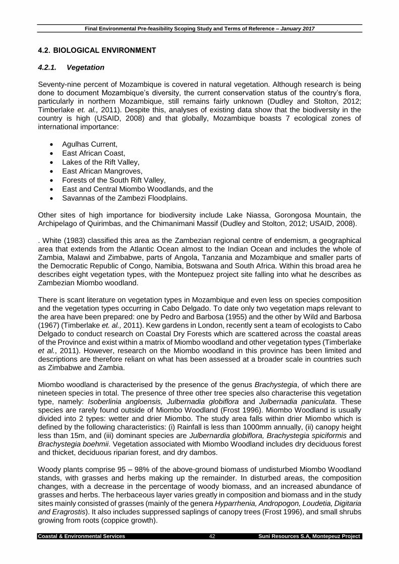
Final Environmental Pre-feasibility Scoping Study and Terms of Reference – January 2017
Coastal & Environmental Services 42 Suni Resources S.A, Montepeuz Project
4.2. BIOLOGICAL ENVIRONMENT 4.2.1. Vegetation Seventy-nine percent of Mozambique is covered in natural vegetation. Although research is being done to document Mozambique’s diversity, the current conservation status of the country’s flora, particularly in northern Mozambique, still remains fairly unknown (Dudley and Stolton, 2012; Timberlake et. al., 2011). Despite this, analyses of existing data show that the biodiversity in the country is high (USAID, 2008) and that globally, Mozambique boasts 7 ecological zones of international importance:
Agulhas Current,
East African Coast,
Lakes of the Rift Valley,
East African Mangroves,
Forests of the South Rift Valley,
East and Central Miombo Woodlands, and the
Savannas of the Zambezi Floodplains. Other sites of high importance for biodiversity include Lake Niassa, Gorongosa Mountain, the Archipelago of Quirimbas, and the Chimanimani Massif (Dudley and Stolton, 2012; USAID, 2008). . White (1983) classified this area as the Zambezian regional centre of endemism, a geographical area that extends from the Atlantic Ocean almost to the Indian Ocean and includes the whole of Zambia, Malawi and Zimbabwe, parts of Angola, Tanzania and Mozambique and smaller parts of the Democratic Republic of Congo, Namibia, Botswana and South Africa. Within this broad area he describes eight vegetation types, with the Montepuez project site falling into what he describes as Zambezian Miombo woodland. There is scant literature on vegetation types in Mozambique and even less on species composition and the vegetation types occurring in Cabo Delgado. To date only two vegetation maps relevant to the area have been prepared: one by Pedro and Barbosa (1955) and the other by Wild and Barbosa (1967) (Timberlake et. al., 2011). Kew gardens in London, recently sent a team of ecologists to Cabo Delgado to conduct research on Coastal Dry Forests which are scattered across the coastal areas of the Province and exist within a matrix of Miombo woodland and other vegetation types (Timberlake et al., 2011). However, research on the Miombo woodland in this province has been limited and descriptions are therefore reliant on what has been assessed at a broader scale in countries such as Zimbabwe and Zambia. Miombo woodland is characterised by the presence of the genus Brachystegia, of which there are nineteen species in total. The presence of three other tree species also characterise this vegetation type, namely: Isoberlinia angloensis, Julbernadia globiflora and Julbernadia paniculata. These species are rarely found outside of Miombo Woodland (Frost 1996). Miombo Woodland is usually divided into 2 types: wetter and drier Miombo. The study area falls within drier Miombo which is defined by the following characteristics: (i) Rainfall is less than 1000mm annually, (ii) canopy height less than 15m, and (iii) dominant species are Julbernardia globiflora, Brachystegia spiciformis and Brachystegia boehmii. Vegetation associated with Miombo Woodland includes dry deciduous forest and thicket, deciduous riparian forest, and dry dambos. Woody plants comprise 95 – 98% of the above-ground biomass of undisturbed Miombo Woodland stands, with grasses and herbs making up the remainder. In disturbed areas, the composition changes, with a decrease in the percentage of woody biomass, and an increased abundance of grasses and herbs. The herbaceous layer varies greatly in composition and biomass and in the study sites mainly consisted of grasses (mainly of the genera Hyparrhenia, Andropogon, Loudetia, Digitaria and Eragrostis). It also includes suppressed saplings of canopy trees (Frost 1996), and small shrubs growing from roots (coppice growth).

Coastal & Environmental Services 43 Suni Resources S.A, Montepeuz Project
The World Wildlife Fund (WWF) has defined global ecoregions based on geographically distinct assemblages of species, natural communities and environmental conditions. Information about each ecoregion and its conservation status is provided to assist with the continued conservation of these areas. Within keeping with White’s (1983) description, WWF have classified the study area as Miombo Woodland which covers three million square kilometres in southern, central and east Africa. Natural vegetation occurring in Mozambique is threatened by activities such as commercial logging and clearing of vegetation for subsistence agriculture. However, the severity of these impacts is difficult to predict due to a lack of information on the biota and sites in the vegetation type. Based on the current threats to the ecoregion and its high level of endemism (specifically in northern Mozambique and Tanzania) it has been classified as Vulnerable by WWF. The vegetation type within the study site is intact natural vegetation with very little evidence of anthropogenic disturbance around the Elephant and Buffalo deposits and the areas to the north and west of these. There are a few farms (locally known as machambas) around the Lion deposit which, according to the farmers in the area, were planted about 5 years ago when the road was opened up for logging purposes. The vegetation within the site is comprised of tall closed woodland along the drainage lines and a mosaic of tall open woodland interspersed with dense patches of bamboo thicket and seasonal wetlands that resemble an Acacia savannah. The Riparian Woodlands within the study area are characterised by a closed canopy of 75-100% cover with a tree canopy of up to 20m and emergents that reach up to 40m. The understorey is typically comprised of a herbaceous layer with some grass cover in areas where the canopy is more open. The tall open woodland is characterised by a canopy cover of 50% with an average tree height of 10m -15m (Plate 4-3). Emergent trees reach between 15 and 20m. The understorey is comprised of a grass layer with a cover of approximately 90%, indicating that there is sufficient light penetration through the sparse canopy for grasses to thrive. Interspersed between the woodland are dense clumps of indigenous bamboo (Oxytenanthera abyssinica) and thicket like shrubs that are near impenetrable in some sections. In these areas ground cover is low, due to competition for space and light. The Acacia savannah is characterised by open, hygrophilous grassland with scattered trees that occur on dark and expansive soils, suggesting that they are waterlogged during the wet season and that these areas are possibly seasonal wetlands or dambos (Plate 4-4). The average canopy height of the trees is 10m with a canopy cover of 20% and a groundcover, dominated by grasses, of 100%.

Coastal & Environmental Services 44 Suni Resources S.A, Montepeuz Project
Plate 4-3: Typical tall woodland with emergent Sterculia appendiculata trees.
Plate 4-4: Typical Acacia savannah.

Coastal & Environmental Services 45 Suni Resources S.A, Montepeuz Project
Floristic Diversity Various factors, including a long period of war and internal turmoil, resulted in Mozambique’s floristic diversity going without intensive study, especially in northern Mozambique. Since peace was declared in 1992, studies of specific areas have been undertaken. Recent surveys in Cabo Delgado have been conducted to document the regions biodiversity. Surveys conducted by a team of botanists from Kew Gardens in the coastal region of Cabo Delgado north of Pemba recorded a total of 738 plant taxa from 105 families, of which 36 species were either new to science or unknown previously from material too fragmentary to describe (Timberlake et al., 2011). Excluding new species, 68 species were new records for Mozambique. This diversity and exceptionally high number of new records discovered in a relatively small area indicates that the biodiversity in the area is still largely unknown and that there is the possibility that a number of undescribed species still exist in the region. An initial field survey indicates that the Montepuez site has a high species diversity as it is largely intact. 4.2.2. Fauna The fauna of northern Mozambique is one of the most poorly studied in Africa and there are limited conservation areas for the protection of fauna. Local subsistence hunting and habitat destruction has over a long period of time caused an almost total loss of large mammals and a substantial loss of overall mammalian diversity. Herpetofauna is generally diverse due to the variety of different habitat types available and the large area of the country. However, the lack of scientific study of northern Mozambique has led to widely disparate and inaccurate summaries for the country’s herpetofaunal diversity. As with herpetofauna, avifauna in this region is also diverse with more than 680 bird species recorded. Some of these species are commensal, rapidly and successfully adapting to modified environments, although most are sensitive to disturbance and either migrate away from or suffer greater mortality within degraded habitats. However, birds are able to rapidly recolonize rehabilitated areas as a result of their high mobility. Mammalian diversity in Mozambique was last reviewed by Smithers and Tello in 1976, with approximately 238 species reported to occur throughout the country (MICOA 2009, IUCN 2012). Given the variable population densities and localised environmental pressure it is likely that this number is significantly reduced due to habitat loss and fragmentation. Large mammals such as elephant, hippopotamus and rhino have been extirpated in many areas and nine of the 21 antelope species in the country are listed as threatened and one has become locally extinct. Mammalian diversity in densely populated areas is typically limited to small mammals such as rodents. Species diversity in the project area is expected to be relatively high given that the available habitat is largely intact, although restricted to small mammals for the reasons discussed above. 4.2.3. Protected Areas All protected areas, including National Parks, Forest Reserves and Trans-frontier Conservation Areas are the responsibility of MITADER. The Forest Reserves were created to safeguard timber reserves from advancing agriculture for future sustainable utilization. The possibility that these reserves can make a significant contribution towards biodiversity conservation has been recognized and studies are being conducted to gain an understanding of the vegetation and ecosystem condition within these reserves.

Coastal & Environmental Services 46 Suni Resources S.A, Montepeuz Project
According to Muller et al. (2005), of the 13 existing forest reserves, five (Licuáti, Derre, Moribane, Mecuburi, and Matibane) are co-managed as commonage between the Forest Service and local communities. Only two of the forest reserves (Inhamitanga and Nhampacue) are not currently inhabited. All the forest reserves (including those under management and the ones uninhabited) show different degrees of human disturbance, particularly clearing for agriculture, human induced fire, collection of firewood and charcoal, and logging. Among the causes of degradation of the forest reserves are abandonment of the forest reserves by the Forest Service during the civil war, use of forest reserves as hideouts by communities and guerrilla fighters, promotion of agriculture within the communities living inside the forest reserves, illegal logging, and poaching among others. Examination of these protected areas in relation to the project site shows that the Quirimbas National Park occurs north east of the Montepuez study area (~46km) (Figure 4-1). This reserve was established in 2002 to protect the regions natural resources and covers an area of approximately 7 507km2 that includes miombo woodland, coastal forest, mangroves and coral reefs (WWF, 2015). The Niassa Game Reserve (NGR) also lies approximately 46 km north-west of the Montepuez study area. The core area of the NGR is located between the Rovuma and Lugenda River and covers approximately 23 040km2 with a surrounding buffer zone of hunting blocks that make up an additional 19 239km2 (Branch et. al., 2005). The NGR is the largest conservation area in Mozambique.
Figure 4-2: The location of the Montepuez Project site in relation to the surrounding protected areas.

Final Environmental Pre-feasibility Scoping Study and Terms of Reference – January 2017
Coastal & Environmental Services 47 Suni Resources S.A, Montepeuz Project
5. DESCRIPTION OF THE SOCIO-ECONOMIC ENVIRONMENT 5.1. INTRODUCTION Montepuez township is located within the Cabo Delgado Province of Mozambique and is approximately 35 km (60km by road) south-east of the southernmost boundary of the Montepuez License 6216. There are several villages located in close proximity outside the License Area. It is anticipated that only economic resettlement (the loss of economic activity and livelihoods, such as loss of crop fields) will take place. No physical resettlement is anticipated, as no structures were noted in the project area. This chapter provides an overview of the socio-economic setting in the area within which the proposed project is located. 5.2. ACCESS AND SOCIAL INFRASTRUCTURE The Montepuez License Area is accessed by a single-track dirt road 60km north-west of the town of Montepuez. The road, which passes through several villages, is of relatively poor condition with numerous pot-holes, ditches and gully’s. The Lion deposit transects the access road, with the Elephant and Buffalo deposits located further north.
It appears that many of the larger villages have hand pumps for accessing groundwater, although rivers and streams are used for drinking water and washing. Most rural households normally have their own pit latrines with thatch and bamboo coverings, as there is no water borne sanitation systems. With limited energy in the area, most households are reliant on wood or charcoal as their primary source of energy. Occasional forms of electricity observed include generators and solar panels. Most villages in the area have a primary school teaching grades 1-7. However, the literacy rate of the province is low, and based on previous studies it appears that very few household members older than 18 years (often less than 10%) have completed primary school. The closest healthcare facility is situated in either Balama or Montepuez. Vector-related diseases, such as malaria, soil- and water-related diseases as well as HIV/AIDs and malnutrition are prevalent in this area. 5.3. DEMOGRAPHICS According to the latest Mozambique Census conducted in 2007, the population of the Cabo Delgado Province stands at around 1,605,649 (Club of Mozambique, 2007). This figure rose from 1,287,814 in 1997, which indicates a population growth of around 2.5% per year (ibid.). The Montepuez project falls within the Montepuez District, which is approximately 17,721km2 in size. The estimated population of the district is 186,476 with a population density of 10.5 inhabitants/km2, which is substantially less than the population density of the province estimated at around 20.64 inhabitants/km2. In terms of gender, according to the 2007 census, approximately 51.9% of the area’s population are female, with an estimated male-to-female ratio of 1:1.1 (Club of Mozambique, 2007). In the Cabo Delgado Province, females outnumber males slightly at 51.6% (Knoema, 2007). Most households are male-headed (at least more than 50% of the households). Households in the area are usually nuclear family units.

Coastal & Environmental Services 48 Suni Resources S.A, Montepeuz Project
The province’s population is also very young. For example, just under half of the population (44.6%) are under the age of 15 (Club of Mozambique, 2007), whereas around 52.1% are within the working-age of between 15 and 64. In Mozambique land is normally held by the Government, although the Government recognises the role of customary tenure. The land is still regulated and controlled by local chiefs and elders. The majority of structures in the villages are constructed with a combination of mud, sticks and poles. Thatch remains the predominant material for roof structures. 5.4. EMPLOYMENT SECTORS The unemployment rate is calculated by dividing the number of unemployed individuals by the labour force; the latter includes all members in the working-age group who are available or capable of working. In 2012, the unemployment rate in Mozambique was estimated at approximately 27%, with the majority of employed people living in urban areas (Macauhub, 2012). Employment opportunities are limited in the rural villages. Most households in villages proximate to the site are subsistence farmers (some of whom might sell some produce locally), and a few local traders. Within some of the districts, employment in mining and exploration has steadily increased with several mines being developed in the province. The mining sector is expanding in the region and will provide a range of employment opportunities in the future. It is likely that very few households have someone formally employed, and those employed are usually employed in local construction work (such as road upgrades), or with Government, such as working in the educational and/or health sectors. 5.5. AGRICULTURE AND LIVELIHOOD STRATEGIES This is the largest source of income and the backbone of the area’s informal economy. The 2010 Vaccine Coverage Survey estimated that 88.6% of families in the province are farmers (VillageReach, 2010). Most households use their land predominantly for subsistence purposes, as many are constrained by a lack of market access, unimproved agricultural technology and no capital `for investment. Yet money derived from the sale of agricultural produce is often a household’s only source of cash income. A study conducted by Strasberg and Kloeck-Jenson (2002) in the Cabo Delgado Province found that crops such as cotton and cashew nuts accounted for around 70% of all the income generated by households interviewed in the province throughout the year. Most households within villages have agricultural fields (or machambas as these are locally referred to), and some households have smaller food gardens around their homesteads. Most households have more than one machamba, on which the most popular crops are millet, cassava, pumpkin, ground nuts and maize. Crops are intercropped and fields are rain-fed. Most households also supplement their diets by planting fruit bearing trees (mostly around their homesteads), which include Cashew, Banana, Papaya, Mango and Orange trees. Income from fruit can be significant, with fruit sold in local markets or alongside the road, together with some of their other farming produce. Lastly, some households also practice animal husbandry. Common livestock kept usually for subsistence purposes are chickens, ducks, pigs, pigeons, goats and, to a lesser extent, cattle. Most households also use the area’s natural resources for subsistence purposes. This usually includes collecting wood, thatch and bamboo for construction, but also collecting wild fruits, vegetables and bulbs either for medicinal purposes or for food. Most of the households also make charcoal from felled wood, which many sell next to the road. Slightly fewer households are engaged in hunting, which is usually primarily a subsistence strategy.

Coastal & Environmental Services 49 Suni Resources S.A, Montepeuz Project
INCOME AND EXPENDITURE
The majority of the households in the study area receive some form of income from their household agricultural farming. This is a limited source of income, though, as it is mainly obtained by selling either some of the surplus crops, fruit, or livestock at markets or next to the roads. Many households also receive an income from selling charcoal, whilst some also receive remittances and land rent incomes. With such a limited cash economy, daily expenditures remain high. The most common expenditure sources in the region are food, clothes and school fees. 5.7. SOCIOECONOMIC SETTING The Montepuez site is characterised by limited human activity. The Elephant and Buffalo deposits are characterised by almost no agricultural activity, however a large portion of the Lion deposit consists of agricultural fields where more than half is planted with sesame plants for the production and sale of sesame seeds (Plate 9-1). Discussions with a local farmer indicate that he has been cropping in the area for 5 years, having cleared the area after a logging road was established in 2010. South of these planted areas disturbed woodland is present, with signs of previous cultivation, perhaps as far back as 2005.
Plate 6-1: Recently harvested sesame seed plants being dried out with the machambas in the background. The Buffalo and Elephant sites to the north currently do not have any machambas present. There were limited signs of cultivation (rice) in the seasonal wetlands, and based on site observations it was concluded that the Bamboo thicket is a naturally occurring vegetation type.

Coastal & Environmental Services 50 Suni Resources S.A, Montepeuz Project
The nearest village to the site is 4 km away, known as Nqueuene and is located outside license 6216L. The next nearest village, known as Pilane, is a small village of only a few households and is 8km from site. Overall, the use of the Montepuez site for agriculture appears to be very limited, and the area is mainly used for natural resource use (fuel wood, plant harvesting and hunting). There also appeared to be limited signs of harvesting for charcoal production. It is unlikely that physical displacement will occur although there might be some socio-economic displacement around the Lion deposit.

Coastal & Environmental Services 51 Suni Resources S.A, Montepeuz Project
6. STAKEHOLDER AND COMMUNITY ENGAGEMENT PROCESS 6.1. INTRODUCTION The Public Participation Process (PPP) involves consultation with the wider public. The process facilitates the dissemination of information about the project and identification of indirectly and directly Interested and Affected Parties (I&APs). The PPP will be outlined in detail in the PPP Report (Volume 1B) which provides accounts of all the meetings held during the EPDA phase of the ESIA. It is then expanded after the EIR public disclosure meetings have taken place to report on the entire PPP. The final PPP document with all the relevant minutes of the meetings is submitted to MITADER, together with the other full ESIA reports. In accordance with the Mozambican ESIA Regulation (Decree no. 45/2004 of 29 September and Decree no. 42/2008 of 4 November, which amends some articles of Decree no. 45/2004), the proposed project has been classified by MITADER as a Category A Project, which includes the implementation of a PPP. The PPP is crucial for any Category A project. It is vital that all I&APs are not only aware of the project and its possible negative implications, but also understand the project and its potential benefits to their communities and surrounding environment. Failure to ensure this could cause disputes and disagreements between communities, the developer and government authorities and lead to the disruption of established social structures. As part of this process, public consultation meetings are organized where all I&APs are invited and thus have an opportunity to express and record their concerns, expectations and comments relating to the proposed project and environmental authorization process. 6.2. MOZAMBIQUE LEGISLATION Both the Constitution and Environment Law establish the rights of citizens to have information about, and to participate in, decision-making about activities which may affect the environment. Stakeholder engagement is a legal requirement for Category A projects and MITADER have prepared a Directive for the Stakeholder Engagement process published as Ministerial Diploma 130/2006 of 19 July. The need for Stakeholders Engagement is further reinforced by the new Regulations on Resettlement Process resulting from Economic Activities (Decree 31/2012, of 8 August). Article 13 of this Regulation points out the need to ensure Public Participation throughout the entire process of development and implementation of Resettlement Action Plans for projects. The PPP phase of the ESIA is expected to:
Identify the stakeholders,
Disseminate information to stakeholders
Manage a dialogue with the proponent of the activity,
Assimilate and take into account public comments received and
Provide feedback in response to the outcomes of the dialogue and inputs so as to demonstrate how these have been taken into account in the design of the activity.
6.3. STAKEHOLDER ENGAGEMENT ACTIVITIES The PPP involves meetings with local communities and local authorities as well as meetings in Pemba and Montepuez to account for provincial stakeholders, in order to introduce the project and disclose the EPDA. 6.3.1. EPDA Public Participation Process Disclosure of the EPDA will comprise of open public meetings in communities and the cities of

Coastal & Environmental Services 52 Suni Resources S.A, Montepeuz Project
Montepuez and Pemba and will be conducted in five distinct stages:
Preparation of the list of stakeholders;
Preliminary consultations with communities and some government institutions and non-governmental organizations;
Submission of Environmental Scoping Report (EPDA) to the relevant institutions and made available for consultation before the public meetings.
Preparation and delivery of invitation letters to relevant stakeholders
Realisation of public consultation meetings in the affected communities, Montepuez and Pemba.
The main objective of the public consultation meetings are to disclose the main findings of the preliminary assessment, present the potential impacts and risks identified during the Pre-Feasibility Study and explain the EIA process and what specialist studies will be undertaken.

Final Environmental Pre-feasibility Scoping Study and Terms of Reference – January 2017
Coastal & Environmental Services 53 Suni Resources S.A, Montepeuz Project
7. PRELIMINARY ENVIRONMENTAL AND SOCIAL RISK ASSESSMENT 7.1. RISK ASSESSMENT METHODOLOGY To guide the development of the terms of reference for specialist studies and the ESIA, a structured risk assessment approach was applied. This EPDA was used to identify environmental and social (E & S) issues, and a preliminary assessment of the significance of the issues was undertaken. Risk was then assessed by combining significance with the potential difficulty to mitigate issues, with “degree of difficulty to mitigate” interpreted in terms of effectiveness, practicality and cost effectiveness. Thereafter a risk matrix was applied to arrive at a final risk rating. This methodology is described more fully below. It is important to note that the risk assessment, which is done at a high level, differs from the impact assessment which will be used by the specialists during the ESIA phase. The environmental significance scale evaluates the importance of a particular impact. This evaluation needs to be undertaken in the relevant context, as an impact can either be ecological or social, or both. The evaluation of the significance of an impact relies heavily on the values of the person making the judgement. For this reason, impacts of especially a social nature need to reflect the values of the affected society. A four-point impact significance scale was applied (Table 7.1). Table 7.1: Environmental significance rating scale
Significance rating
Description
Very High These impacts would constitute a major and usually permanent change to the (natural and/or social) environment, and usually result in severe or very severe effects, or beneficial or very beneficial effects.
High
These impacts will usually result in long term effects on the social and/or natural environment. Impacts rated as high will need to be considered by the project decision makers as constituting an important and usually long term change to the (natural and/or social) environment. These would have to be viewed in a serious light.
Moderate
These impacts will usually result in medium to long term effects on the social and/or natural environment. Impacts rated as moderate will need to be considered by the project decision makers as constituting a fairly important and usually medium term change to the (natural and/or social) environment. These impacts are real but not substantial.
Low
These impacts will usually result in medium to short term effects on the social and/or natural environment. Impacts rated as low are generally fairly unimportant and usually constitute a short term change to the (natural and/or social) environment. These impacts are not substantial and are likely to have little real effect.
The degree of difficulty of mitigating the various impacts ranges from very difficult to easily achievable. The four categories used are listed and explained in Table 7.2 below. The practical feasibility of the measures, financial feasibility of the measures and their potential effectiveness was taken into consideration in deciding on the appropriate degree of difficulty. Table 7.2: Degree of mitigation difficulty rating scale
Degree of Difficulty Description
Very difficult The impact could be mitigated but it would be very difficult to ensure effectiveness and/or to technically/financially achieve
Difficult The impact could be mitigated but there will be some difficulty in ensuring effectiveness and/or implementation
Achievable The impact can be effectively mitigated without much difficulty or cost
Easily achievable The impact can be easily and effectively mitigated

Coastal & Environmental Services 54 Suni Resources S.A, Montepeuz Project
The risk matrix determines the overall level of risk associated with an impact by comparing the significance of the impact with its difficulty of mitigation is shown in Table 7.3 below. Table 7.3: Risk matrix derived from the pairing of the significance of the impact and the difficulty of mitigation
Mitigation Potential
Impact Significance Low Moderate High Very High
Very difficult Medium Risk Major Risk Extreme Risk Extreme Risk Difficult Minor Risk Medium Risk Major Risk Extreme Risk Achievable Minor Risk Minor Risk Medium Risk Major Risk Easily achievable Minor Risk Minor Risk Minor Risk Medium Risk
Impacts that are of high to very high significance and difficult to very difficult to mitigate are considered to be ‘extreme’ environmental or social risks to the project. Those impacts that are less significant and easier to mitigate are rated as ‘major’ to ‘medium’ to ‘minor’ i.e. generally impacts of low to moderate significance for which mitigation is achievable to easily achievable. Impacts may potentially be of very high significance, but if the mitigation is easily achievable they are rated as ‘medium’ risks, as per Table 7.3. The implications of the risk categories are explained in Table 7.4. Table 7.4: Risk categories
Risk Description
Extreme
Significant mitigatory actions would be required to reduce these risks. In some cases it may not be possible to reduce these extreme risks meaning they are likely to prevent the option from being used (raised as red flags in this assessment).
Major
These risks are of a serious nature, and without effective mitigation measures would be major hindrances to the project. These would need to be monitored and managed, and in combination Major risks may necessitate the use of a different option to achieve the projects objectives.
Medium
These risks are of a less serious nature but still important, and need to be reduced to As Low As Reasonably Possible (ALARP) for the benefit of the environment or social network affected. In isolation these risks are generally insufficient to prevent the project from proceeding.
Minor
These risks are generally acceptable to the project and environment, and mitigation is desirable but not essential. Best industry practice, however, should be followed and the risks mitigated to prevent a cumulative effect of such impacts.
7.2. RISK ASSESSMENT Refer to tables 7-5 and 7-6 below for an assessment of biological and social risks associated with the Montepuez project. Article 10.1a of decree 54/2015 states that fatal flaws regarding the activity must be assessed. No fatal flaws were identified for this project and therefore none form part of this assessment.

Final Environmental Pre-feasibility Scoping Study and Terms of Reference – January 2017
Coastal & Environmental Services 55 Suni Resources S.A, Montepeuz Project
Table 7.5: Summary of biological risks in the project area.
Issue Significance Rating
Comment Mitigation Potential
Mitigation Challenges Risk
Waste and Pollution
General Waste
Moderate
The mining operations will generate general wastes (food, glass, paper, wood, metal, oils and lubricants) which will need to be disposed appropriately in designated waste sites. The impact of improper solid and liquid waste disposal is considered moderate. The implementation of a solid waste management plan as a mitigation measure is achievable. This issue is therefore considered a minor risk for general waste.
Easily Achievable
A collection and approved disposal system should be in place. The ESIA must include the preparation of an Integrated Waste Management Plan compliant with Mozambique legislation. An engineered and lined landfill site for solid waste disposal must be included in the projects design. The principles of reuse, recycle and reduce must be implemented.
MINOR
Hazardous Waste
High
Mining activities may cause the spillages of hazardous materials (diesel and oil), which will be limited if best practices are enforced. Sewage will need to be treated and disposed of correctly to avoid impacts on ground and surface water resources. The impact of improper solid and liquid waste disposal is considered high for hazardous waste. The implementation of a solid waste management plan as a mitigation measure is achievable. This issue is therefore considered a medium risk for hazardous waste.
Achievable
All areas where chemicals are stored must be adequately bunded. Vehicles and workshops must likewise be designed to collect hydrocarbon spills. An action plan to deal with emergency pollution issues related to hazardous waste should be in place. Sewage and other effluent from ablution facilities must be managed and disposed of in an acceptable manner that is in line with the Mozambican regulations.
MEDIUM
Storm water contamination
High
Storm water can become contaminated through contact with pollutants associated with mining activities such as oils and grease from workshops, hydrocarbons from leaking trucks and pumps, and runoff from refuelling areas for example. This is considered an impact of potentially high significance given that there are a number of rivers, streams and drainage lines close to all three of the deposit areas. Surface water bodies are presently uncontaminated and water quality is assumed to be of high quality. This, coupled with the hilly topography that allows storm water to flow rapidly from the site is therefore a medium risk.
Achievable
Surface water must be protected from coming into contact with any pollutants and any stormwater runoff that passes through potentially contaminated areas must be captured and treated appropriately prior to release. Erosion and sedimentation must be avoided.
MEDIUM

Coastal & Environmental Services 56 Suni Resources S.A, Montepeuz Project
Issue Significance Rating
Comment Mitigation Potential
Mitigation Challenges Risk
Surface water contamination
High
Surface water can potentially become contaminated from contaminated overflow from the TSF, flow from the WRD and water from the pit dewatering activities. This is considered an impact of potentially high significance given that there are surface water bodies and wetlands (dambos) close to the deposit areas, there is potential for acid mine drainage being generated (especially the TSF), and local communities rely on surface water for bathing, cooking and as drinking water. Surface water bodies are presently uncontaminated and water quality is assumed to be of high quality. Mitigating this impact is achievable and this is therefore a medium risk.
Achievable
A range of scientific hydrology and hydrogeology testwork will be undertaken as part of the EIA process to measure any potential negative impacts to surface water during the planned life of mine. Diversion channels and sedimentation ponds should be built around and downstream of the waste rock dump, TSF and possibly the pit to manage surface water contamination risks.
MEDIUM
Groundwater Quantity
Moderate
The mine pit could be deeper than the water table and as such groundwater will naturally percolate into the pit. Constant pit dewatering will be required. This could result in a decrease in the phreatic surface at a presently unknown distance from the pit. This impact will become increasingly significant over time, as the pit expands and is deepened. Mining activities at the Buffalo and Elephant resources could ultimately lower the water table, and especially if groundwater is used as process water. The impacts will mainly be ecological, as no communities are close enough to the proposed mine pit to be negatively affected. However, pit dewatering at the Lion resource could impact on the closest community 4km away although this is thought to be unlikely. Thus, this impact is of moderate significance, but mitigating this impact will be difficult, although some natural recharge will occur from the TSF and dewatering activities. This is currently considered a Medium risk however during the EIA process a range of hydrogeological testwork will be undertaken to assess potential negative impacts to groundwater during the planned life of the mine and will assess the actual impact once the required data is available.
Difficult
Careful monitoring of groundwater levels will be required to determine the extent of potential impacts on water table depth.
MEDIUM

Coastal & Environmental Services 57 Suni Resources S.A, Montepeuz Project
Issue Significance Rating
Comment Mitigation Potential
Mitigation Challenges Risk
Groundwater Quality
High
Mining activities may affect local groundwater quality due to the possibility of contaminated effluent, but more importantly due to the exposure of ground and surface water to sulphide bearing material. The risk of acid mine drainage is primarily dependent on the type of sulphur content in the ore and the waste rock. At this stage only the % sulphur content of the graphite mineralisation has been analysed and country rock (waste material) has not yet been assayed. Initial drilling has found evidence of sulphides mostly pyrrhotite associated with the graphite mineralisation. Although this impact will be addressed during the EIA project phase - at which time the impact rating will be reassessed and revised if required - the potential impact is currently regarded as high until results indicate otherwise, as it could result in long term effects on the natural environment and must be considered by the project decision makers as constituting a potentially important and usually long term change to the (natural and/or social) environment. Mitigation and management of waste streams and seepage with elevated levels of sulphur is easily achievable and should reduce the likelihood of AMD occurring. This is a medium risk.
Achievable
Groundwater issues must be fully assessed in the EIA, and the zone of influence and contaminant plume modelled. Although contamination of groundwater is considered unlikely due to the nature of the material being dealt with, dynamic geochemical tests will need to be done and hydrogeological models run to determine the impact of the TSF on the groundwater systems. Ongoing groundwater quality monitoring is required. Mitigation measures which need to be implemented might include the lining of the Tailings Storage Facility and installing cut off drains around the waste rock dumps. Implementing a waste management plan will also reduce the risk of contamination. Seepage interception boreholes downstream of the TSF may need to be drilled to intercept and capture any potential seepage that may enter the groundwater system. These mitigation measures are achievable through applying standard industry practice.
MEDIUM
Noise Low
The mining operation will cause an increase in ambient noise levels in the surrounding areas. There are no residents living adjacent to or even close to the project area, and noise is likely to be an impact of low significance that can be mitigated by using standard industry practice to reduce noise levels. This mitigation is considered achievable and thus this is a minor risk
Achievable
The client will need to ensure that the noise levels at the boundary of the facility fall within the limits of the Mozambique legislation for day and night to limit noise impacts. MINOR

Coastal & Environmental Services 58 Suni Resources S.A, Montepeuz Project
Issue Significance Rating
Comment Mitigation Potential
Mitigation Challenges Risk
Air Quality Moderate
Dust generation could potentially impact on the natural environment and worker health due to elevated concentrations of inhalable dust (PM10), along roads, cleared areas and conveyors, crushers and transfer areas. The impact of elevated levels of dust could result in an impact of moderate significance. In addition, dust could be generated once the tailings have dried out, since then they are susceptible to wind-blown dispersal. Mitigation is achievable and therefore this is a minor risk.
Achievable
To mitigate this impact, areas should be cleared only immediately in advance of construction activities. Rehabilitation should be done soon after the completion of mining. Soil stock piles should be stored appropriately. A reduction in the amount of dust generated through vehicles and during mining operation can be effectively mitigated by simply reducing the speed of vehicles, or by wetting road surfaces. Covering the dried tailings with topsoil and re-vegetating the area can successfully mitigate against wind-blown tailings mobilisation.
MINOR
Energy Use Moderate
The mining operation is likely to require power which could be generated on site using diesel powered gensets. This could have a moderate impact on GHG emissions. Vehicles and the plant also consume a large amount of energy. Mitigation is achievable and therefore this is considered a minor risk.
Achievable
This can be mitigated by correctly sizing motors and pumps used in the mining process where ever possible and possibly the use of solar energy in certain areas.
MINOR
Biological
Loss of biodiversity (fauna and flora)
Moderate
The mining process requires that all vegetation be cleared in the mine pit area, WRD, TSF, plant and accommodation areas. This will result in the loss of vegetation in the cleared areas and possibly the loss of some faunal species some plant and animal species of conservation concern (SCC). The mine pit area is well vegetated, with large trees and a woodland physiognomy and shows little signs of disturbance (other than some minimal harvesting of natural resources). However, this habitat type and vegetation is fairly widespread throughout the area and the footprint of this specific mine is anticipated to be relatively small. So although rehabilitation of indigenous vegetation on the post mining landscape would be difficult to achieve, if the company implements the proposed mitigation measures to reduce their impact on the natural environment, this impact is regarded as moderately significant and therefore a medium risk.
Difficult
The rehabilitation of indigenous vegetation on the post-mining landscape is difficult as the mining operations will leave an open pit that cannot be backfilled. However, it can be sloped or terraced to enable some rehabilitation. Mitigation to re-establish the original vegetation type on areas such as the waste rock dump and TSF is difficult as the rehabilitated areas are unlikely to resemble the vegetation that previously grew there. Only hardy, weedy plants are likely to succeed in these areas. There would therefore be a residual loss of biodiversity and species of conservation concern (fauna and flora), despite concerted efforts to rehabilitate.
MEDIUM

Coastal & Environmental Services 59 Suni Resources S.A, Montepeuz Project
Issue Significance Rating
Comment Mitigation Potential
Mitigation Challenges Risk
These ecological issues will be carefully assessed in the ESIA, and it is possible that direct ecological impacts can be mitigated through careful layout avoiding ecologically sensitive areas, which has been successful in similar projects ensuring that the impact would be moderate and the risk medium. If these mitigation measures are not implemented, the risk would be considered major.
Habitat fragmentation and loss of fauna and flora species
Moderate
Fragmentation of habitats can lead to the loss of viable populations, especially animals requiring large home ranges. Fragmentation has serious impacts on forest/woodland specialists and wetlands. There is very little habitat fragmentation at present within the proposed project area however the access roads to the site are highly fragmented, Mining will result in the fragmentation of an established ecosystem causing a break in floral communities and faunal habitats, however the footprint of this mine is relatively small and with the implementation of ecological corridors through the site will assist with mitigating this impact. In addition, the access roads to the site will use existing roads where feasible and these areas are already highly degraded and fragmented. This issue is therefore regarded as being of moderate significance and is considered a medium risk.
Difficult
Mitigation to replace viable populations that are lost would be difficult as these would be permanently lost. Mitigating habitat fragmentation and its impacts on fauna is more difficult to achieve than loss of biodiversity, as road access is a major contributing factor to habitat fragmentation. The ESIA will need to carefully assess road alignment to help reduce the impacts from habitat fragmentation.
MEDIUM

Coastal & Environmental Services 60 Suni Resources S.A, Montepeuz Project
Issue Significance Rating
Comment Mitigation Potential
Mitigation Challenges Risk
Biodiversity and ecosystem functioning issues associated with mining activities.
High
Mining activities may affect local groundwater quality due to contaminated effluent, AMD and contamination through contact with wastes. The deposit does contain sulphides in which acid mine drainage needs to be measured to determine the potential impact and design appropriate mitigation measures. Pollution of groundwater is also possible, as described earlier. Contamination of surface and groundwater results in concomitant negative impacts on the ecological functioning and biodiversity of wetland and stream habitats, and riparian areas, all common on site. Dust generated from mining activities impacts on terrestrial ecosystems, and clearing of vegetation affects terrestrial ecosystem functioning. This is therefore regarded as an impact of high significance but mitigation is achievable, resulting in a medium risk.
Achievable
With sound engineering design this risk can be mitigated. In addition to designing and locating the TSF and WRD so as to minimise contaminated water from percolating into the surface groundwater, it is also possible that the tailings storage facility will need to be lined in the event that studies indicate that Acid Mine Drainage (AMD) is likely to occur. Dust suppression, as recommended earlier is required.
MEDIUM
Impacts of mining on soil and agricultural productivity
Low
The mining process impacts on the physical and chemical properties of the soil and land surface as the soil profile is completely destroyed during mining over the areas in which the pits are proposed. Soil disturbance and handling can result in changes to the cation exchange capacity, the water holding capacity and the erodibility of the soils. Productivity of top soil is reduced due to stockpiling. These changes to soil fertility also impact on crop productivity and the agricultural potential of the land. However, the target area does not appear to have a high agricultural potential, as soils are shallow and there are few signs of cropping in the area. This impact is therefore of low significance, and although it is difficult to mitigate, it is a Minor risk.
Difficult
Top soil must be replaced and then rehabilitated properly, but the land surface is unlikely to return to its pre-mining productivity. Various strategies to mitigate soil quality will be required, including mulching, replanting important species; and seeding using indigenous species.
MINOR

Coastal & Environmental Services 61 Suni Resources S.A, Montepeuz Project
Issue Significance Rating
Comment Mitigation Potential
Mitigation Challenges Risk
Loss of Ecosystem goods and Services
Low
The clearing of natural vegetation for the pit and the placement of infrastructure will result in the loss of available ecosystem services such as the harvesting of construction materials, firewood, medicinal plants and food plants. The impact has many cumulative effects and is considered difficult to mitigate even with the careful management of the facility and provision of alternatives to the resources that are impacted. However, few communities utilise the area, and it is therefore of low significance and a minor risk.
Difficult
Mitigation measures that offer alternative livelihood strategies to communities that lose access to natural resources will need to be implemented.
MINOR
Invasion of alien species
High
The potential invasion of alien species into the area seems to be low. However, as with all disturbances, the introduction of alien and invader species is highly probable; with disturbance comes the influx of aliens. Alien invader species need to be consistently managed over the entire operational phase of the project. Since the project area currently shows no signs of alien infestations the significance rating is considered to be HIGH. However, mitigation is easily achievable and the overall risk is considered Minor.
Easily Achievable
Mitigation measures to reduce the impact of the introduction of alien invaders should be actively maintained throughout both the construction and operational phases. Removal of existing alien species should be consistently done. Also, rehabilitation of disturbed areas should be done soon after construction is completed in each section. An on-going monitoring program should be implemented to track whether alien species are becoming established and assist with the management of infestations.
MINOR
Table 7.6: Summary of social risks in the Montepuez Project area.
Issue Significance Rating
Comment Mitigation Potential
Mitigation Challenges Risk
Labour and Working Conditions
Risks associated with employment
Low
The construction and operation of the mine will increase employment opportunities at the local level. The proposed mining operation has the ability to improve and increase the skills base in the area, should appropriate training initiatives be implemented for the benefit of nearby communities. This is likely to have a high positive significance at local level and is considered a major opportunity associated with the project. However, due to the general lack of skills in the project area it is likely that positions requiring more than basic skills will be offered to more skilled “outsiders”.
Achievable
A Local Hiring and Local Purchasing Plan must be developed. Procedures and practices that maximize opportunities for hiring local workers, and to minimize social risks in the areas of influence must be developed. A hiring process that respects local cultural and social norms to facilitate local participation and avoid conflicts and other negative social impacts must be developed.
MINOR

Coastal & Environmental Services 62 Suni Resources S.A, Montepeuz Project
Issue Significance Rating
Comment Mitigation Potential
Mitigation Challenges Risk
The need for employment in the project area is great, and levels of expectation are likely to be high. These community expectations need to be carefully managed. If not, they could lead to tensions within communities, and between communities and the proponent. This impact will be of low significance, and mitigating these negative effects are considered achievable. The risk is therefore minor.
Working Conditions
Low
The workforce is a valuable asset, and therefore a sound worker-management relationship is a key ingredient for the sustainability and success of the project. Failure to establish and foster a sound worker-management relationship can undermine worker commitment and retention, and can jeopardize the project. Conversely, through a constructive worker-management relationship, by treating the workers fairly, and providing them with safe and healthy working conditions, tangible benefits, such as enhancement of the efficiency and productivity of the operations can be achieved. The impact from working conditions is considered low, and mitigation is achievable, and thus this is considered a minor risk.
Achievable
Human Resources (HR) policies in accordance with, and guided by, the requirements of Mozambican legislation must be developed and implemented. A labour policy and operational guidelines document must be developed and implemented.
MINOR
Occupational Health & Safety
Moderate
There are areas of high risk to personal safety, due to equipment within the plant, dust, significant vehicle movements, use of explosives for blasting and other hazards generally associated with mining activity and operation of an industrial plant. This is considered to be potentially of moderate significance and can be mitigated. As senior personnel will have significant mining experience under similar conditions, the appropriate personnel can be appointed and safety procedures adhered to. Hence mitigation through the development of an Occupational Health and Safety management plan for workers is achievable, and this is considered a minor risk.
Achievable
Hiring qualified and experienced supervisors and providing appropriate training on Occupational Health & Safety (OH&S) aspects for employees and contractors will mitigate this impact. Years of ongoing training is required to develop the necessary experience to prevent serious injury and fatalities to workers in the mine, operational plant and transport routes.
MINOR
Community health, safety and security
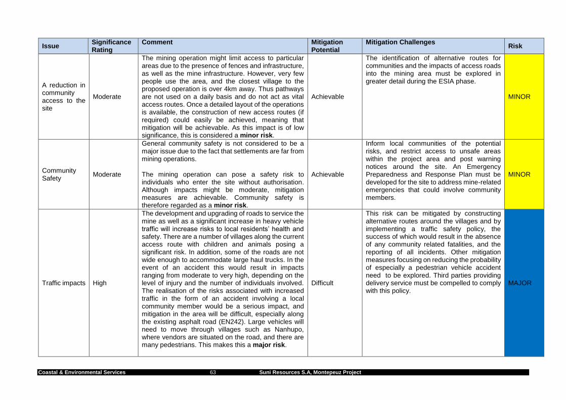
Coastal & Environmental Services 63 Suni Resources S.A, Montepeuz Project
Issue Significance Rating
Comment Mitigation Potential
Mitigation Challenges Risk
A reduction in community access to the site
Moderate
The mining operation might limit access to particular areas due to the presence of fences and infrastructure, as well as the mine infrastructure. However, very few people use the area, and the closest village to the proposed operation is over 4km away. Thus pathways are not used on a daily basis and do not act as vital access routes. Once a detailed layout of the operations is available, the construction of new access routes (if required) could easily be achieved, meaning that mitigation will be achievable. As this impact is of low significance, this is considered a minor risk.
Achievable
The identification of alternative routes for communities and the impacts of access roads into the mining area must be explored in greater detail during the ESIA phase.
MINOR
Community Safety
Moderate
General community safety is not considered to be a major issue due to the fact that settlements are far from mining operations. The mining operation can pose a safety risk to individuals who enter the site without authorisation. Although impacts might be moderate, mitigation measures are achievable. Community safety is therefore regarded as a minor risk.
Achievable
Inform local communities of the potential risks, and restrict access to unsafe areas within the project area and post warning notices around the site. An Emergency Preparedness and Response Plan must be developed for the site to address mine-related emergencies that could involve community members.
MINOR
Traffic impacts High
The development and upgrading of roads to service the mine as well as a significant increase in heavy vehicle traffic will increase risks to local residents’ health and safety. There are a number of villages along the current access route with children and animals posing a significant risk. In addition, some of the roads are not wide enough to accommodate large haul trucks. In the event of an accident this would result in impacts ranging from moderate to very high, depending on the level of injury and the number of individuals involved. The realisation of the risks associated with increased traffic in the form of an accident involving a local community member would be a serious impact, and mitigation in the area will be difficult, especially along the existing asphalt road (EN242). Large vehicles will need to move through villages such as Nanhupo, where vendors are situated on the road, and there are many pedestrians. This makes this a major risk.
Difficult
This risk can be mitigated by constructing alternative routes around the villages and by implementing a traffic safety policy, the success of which would result in the absence of any community related fatalities, and the reporting of all incidents. Other mitigation measures focusing on reducing the probability of especially a pedestrian vehicle accident need to be explored. Third parties providing delivery service must be compelled to comply with this policy.
MAJOR

Coastal & Environmental Services 64 Suni Resources S.A, Montepeuz Project
Issue Significance Rating
Comment Mitigation Potential
Mitigation Challenges Risk
Community health and communicable diseases
Moderate
Inward migration and increases in the labour force employed in the area may impact negatively on staff, but will not impact on the health standards of people in villages as they are too far from the site. This, however, needs to be understood within the context of a number of issues. Malaria rates are high in the area but it is unlikely that inward migration will increase these levels. An increase in levels of HIV/AIDS and other Sexually Transmitted Diseases (STD’s) is however a concern. Current infection rates for the villages in the project area are not known, but inward migration may increase rates of infection, as well an increase in labour from elsewhere. Because the site is fairly remote, this issue is of moderate significance, and can be mitigated, and is therefore a minor risk.
Achievable
A Community Health and Safety Management Plan will be required, and appropriate mitigation to deal with STD’s must be implemented.
MINOR
Economic benefits, land acquisition and resettlement
Employment opportunities and Economic Development
High (+ve)
Both indirect and direct economic opportunities will be created as a result of the project. The presence of the mine may indirectly increase the amount of cash inflow to the affected villages and smaller settlements, and may further create opportunities for the sale of goods and services to the mine and mine employees. There will be upgraded services and the expansion of road infrastructure around the proposed mining area, potentially improving access and basic service provision for residents in the project area. The project will result in direct economic benefits at both provincial and national levels and any income generated from the mining operation will significantly increase the tax base of Mozambique. The overall impact is considered to be of high positive significance. The overall impact is considered a major opportunity associated with the project, and is therefore not considered to be a risk.
Easily achievable
The mitigation measures to enhance these benefits are considered to be easily achievable at the national level and achievable at the local level.
NO RISK

Coastal & Environmental Services 65 Suni Resources S.A, Montepeuz Project
Issue Significance Rating
Comment Mitigation Potential
Mitigation Challenges Risk
Social development and training opportunities
High (+ve)
It is recommended that the project consider a social development project during the operations phase, for example an agricultural community development programme. The programme could entail a commercial agricultural production programme to ensure food security, linking this to agricultural market access. The project could also consider training apprenticeships to ensure that, as far as reasonably possible, the local labour force can be trained to be skilled in mining operations. This is likely to have a high positive significance at local level and is considered a major opportunity associated with the project, and is therefore not a risk.
Easily achievable
NO RISK
In-migration Moderate
The project could lead to the in-migration of job seekers into the project area. This could lead to increased pressure on local social services, such as schools and clinics, as well as on local land and resource requirements. As with most social impacts, in-migration may also have a positive impact in terms of providing villagers with small business opportunities due to an increased demand for local produce and other goods, as well as opportunities for cultural exchange. Although influx is considered outside the control of project developers, an influx can threaten ‘project security’ and should be managed as a project threat. The direct and indirect impacts associated with an influx of labourers and expatriate employees are likely to have significant impacts on villages, as it usually results in many social, cultural, economic and political changes. This could result in high negative impacts which are very difficult to mitigate, resulting in a major risk
Very difficult
This is an indirect impact that is difficult to mitigate, however, the impact can be reduced through a labour recruitment policy that only employs people from nearby villages. A grievance mechanism can also be set up and the issue monitored throughout the lifespan of the project.
MAJOR

Coastal & Environmental Services 66 Suni Resources S.A, Montepeuz Project
Issue Significance Rating
Comment Mitigation Potential
Mitigation Challenges Risk
Resettlement Moderate
Resettlement can include either the physical displacement of people due to the re-location of their homestead, or economic displacement through the loss of economic activities and livelihoods. Any resettlement would be involuntary4, and unless implemented correctly and managed through a resettlement action plan, can cause severe long term hardship, impoverishment and environmental damage. Mining is likely to result in a loss of agricultural fields and fruit trees around the Lion deposit as well as a loss of natural resources around Elephant and Buffalo. In addition, there are no apparent homesteads near the Montepuez project site and physical resettlement will not take place. This is considered to be a moderate impact with achievable mitigation, resulting in a minor risk.
Achievable
Through planning and community engagements, mitigation of the adverse effects of economic displacement is achievable. Still, general challenges always include how compensation will be paid and determining the appropriate amounts thereof. Additionally, finding replacement land to ensure food security is likely to be challenging.
MINOR
4 Although resettlement would be voluntary in so far as all resettlement associated with the mine will be freely negotiated with free prior and informed consent, Mozambican legislation regarding the rights to use land for mining
activities stipulates that if a concession is granted in respect of an area in which another person already has land rights, such a person’s rights will; be deemed extinguished once “fair and reasonable” compensation is paid by the licence or concession holder to the holder of such prior rights (Mining law Article 43, paragraph 4). This means the mining rights holder can implement an involuntary resettlement programme.

Final Environmental Pre-feasibility Scoping Study and Terms of Reference – January 2017
Coastal & Environmental Services 67 Suni Resources S.A, Montepeuz Project
Risks associated with waste and pollution centre around the potential effects of acid mine drainage contaminating groundwater at the site (Table 7-1). This medium risk is related to the potential for high sulphur content material to be exposed to the weathering forces of rain and oxygenation, and result in acid mine drainage (AMD). However, mitigation is achievable and the ESIA will include a comprehensive groundwater assessment, including numerical plume modelling and a thorough geochemical analysis. This work will assess and quantify this risk, and determine the need for the TSF to be lined. Other medium risks that were identified include:
Surface water contamination;
storm water contamination from AMD;
contamination from hazardous waste; and
the potential for reducing the water table depth and amount of groundwater in the aquifer as a result of pit dewatering activities.
Four other minor risks were identified. A total of seven biological risks associated with the project were identified (Table 7-1). Four were identified as medium risks since the site is covered in natural vegetation and is in a relatively undisturbed state. However, this vegetation is relatively widespread and the actual footprint of the mine is relatively small. With mitigation measures the removal of vegetation and habitat fragmentation can be limited to the impacted areas only. Impacts of mining on the loss of fauna and flora species and resultant impacts on biodiversity and ecosystem functioning are also classified as medium risks. Three other minor risks were identified. Risks associated with labour and working conditions, for both sites, were all rated as minor risks (Table 7-2):
Occupational health & safety risks associated with various construction and operational phase activities;
Risks associated with employment; and
Risks associated with working conditions. In terms of community health, safety and security the major risk to local communities will be from increased traffic in the mining area, and along the main routes to the mine and Pemba (Table 7-2). Three other minor risks were identified. In-migration of job seekers is considered to be a major risk for this site while resettlement is considered to be a minor risk as it is unlikely to occur. Two opportunities (positive impacts) were also identified. These will result in no risk but considerable benefit to the surrounding area. Employment generation in the area will be a significant benefit, as well as the economic development that might be stimulated by such opportunities. Employment will increase household income levels and buying power which, in turn, will result in an increase in informal trading stores and shops, as well as emerging businesses and service providers. There is also the opportunity for skills development in the training of local people to improve their skills in various areas that would serve the mining and agricultural sector. In addition, large projects such as this has the project life span and economic ability to establish social development programmes. These could include a commercial agricultural production programmes to improve food security, and linking this to agricultural market access.

Coastal & Environmental Services 68 Suni Resources S.A, Montepeuz Project
In summary, there are no extreme risks associated with the site that could be regarded as a fatal flaw, and from an environmental and social perspective the project should proceed to the EIA phase.

Final Environmental Pre-feasibility Scoping Study and Terms of Reference – January 2017
Coastal & Environmental Services 69 Suni Resources S.A, Montepeuz Project
8. TERMS OF REFERENCE FOR SPECIALIST STUDIES This chapter defines the terms of reference for all the specialist studies for the Montepuez ESIA in response to the risks identified in the previous chapter. The following specialist studies will be undertaken:
1. Vegetation Assessment 2. Terrestrial Fauna Assessment 3. Land and Natural Resource Use 4. Surface Water and Aquatic Assessment 5. Socio-economic Impact Assessment 6. Waste Management Assessment 7. Traffic Assessment 8. Ground Water and Geochemical Assessment 9. Hydrological Assessment
In addition, all studies must include the following Terms of Reference:
1. Address all issues and concerns raised by IAPs during the scoping phase 2. Identify and assess the significance of the impacts of the construction and operation and
closure of the mine. 3. Provide practical and realistic recommendations to mitigate impacts. 4. Work in consultation with other specialists to ensure that the linkages between the various
systems are understood. The following sections define the tasks that will be undertaken to assess the potential impacts the project would have within the particular field of expertise. It is the responsibility of the specialist to determine the best approach, methodologies, and analysis to ensure that all issues are adequately covered and assessed, including all issues raised by Interested and Affected Parties (I&APs). For each specialist study, a preliminary study area has been provided. The study area may change once further information relating to each specialist study is obtained. In light of this, each study area should be considered to be preliminary at this stage. In all cases specialists:
Assess the environmental significance of these impacts using the methodology prescribed by CES, as this methodology is compliant with international best practice.
Ensure that the study deals with all issues related to the specialist field that were raised as issues by stakeholders during scoping.
8.1. STUDY 1 - VEGETATION ASSESSMENT The following terms of reference for the Vegetation Assessment is as follows:
a) Describe and map different vegetation units and ecosystems (e.g. grassland, savannah, riverine etc.) in the mining area.
b) Describe the floral biodiversity and record the plant species that occur in each vegetation type.
c) Determine habitat units that perform critical ecosystem functions (e.g. erosion control, hydrological service etc.).
d) Utilise stratified random approach for plot based botanical surveys to describe biodiversity and ecological state of each vegetation unit.
e) Describe and map rare, endangered or threatened ecosystems. f) Establish and map sensitive vegetation areas and species of special concern (IUCN Red
Data list).

Coastal & Environmental Services 70 Suni Resources S.A, Montepeuz Project
g) Identify alien plant species, assess the invasive potential and recommend management procedures.
h) Identify and assess the impacts of the mining prospects and associated infrastructure on the natural vegetation in terms of habitat loss and fragmentation and degradation of key ecosystems.
8.2. STUDY 2 - TERRESTRIAL FAUNA ASSESSMENT The terms of reference for the Terrestrial Fauna Assessment will be as follows:
a) Identify and list all species of terrestrial vertebrates occurring in the mining area, based on the literature, published specimens or site records, and likely occurrences.
b) Record species of fauna identified in the mining area list by: active searching, opportunistic siting, faunal traps and specimen collection.
c) Describe any new species or occurrences. d) Assess the habitat preference of fauna and use these habitat preferences to assess the
presence and abundance of faunal species. e) Identify species of Special Concern using reference to the IUCN Red Data List. f) Define and map faunal habitats that are sensitive and require conservation. These may need
to be defined as No-Go or Restricted Development areas. g) Describe current land use impacts on faunal groups. h) Identify and assess the significance of impacts on the fauna that could result from the mining
operation. 8.3. STUDY 3 - LAND AND NATURAL RESOURCE USE The Natural Resource Use Assessment will have the following terms of reference:
a) Gain an understanding of community knowledge and dependence on natural resource usage, focussing on plants.
b) Determine the reliance of local communities on different vegetation types for harvesting natural resources.
c) Determine current levels of exploitation of birds, small mammals and reptiles, particularly endangered species and CITES Appendix-II species.
d) Obtain information from the community regarding their understanding of the ecological functioning of their environment.
e) Identify which plant/animal species are used for traditional healing. f) Discuss the effect of possible mining activities on the communities with regard to indigenous
plant use. g) Identify the most widely used natural resources in the project area and determine whether
any of these are spatially limited to certain locations where proposed mining areas will be located.
h) Identify the main fuelwood trees and assess their abundance and replaceability; i) Assess the significance of the potential impacts of mining on the natural resources and the
communities that utilise them. j) Identify suitable mitigatory actions that can reduce negative impacts and enhance positive
impacts, where possible. 8.4. STUDY 4 - SURFACE WATER AND AQUATIC ASSESSMENT The following are the terms of reference for the Surface Water and Aquatic Assessment:
a) Establish the baseline status of the ecological state and general health of the nearby rivers terms of:
Invertebrate indicator species;
Water chemistry (metals, nutrients, physical parameters and field measurements);

Coastal & Environmental Services 71 Suni Resources S.A, Montepeuz Project
b) Determine the ecological importance of any river systems potentially impacted on by the mining activity.
c) Identify upstream and downstream water users and comment on potential negative impacts. d) Assess the significance of the potential impacts of mining on the surface water aquatic
environment. e) Identify suitable mitigatory actions that can reduce negative impacts and enhance positive
impacts, where possible. 8.5. STUDY 5 - SOCIO-ECONOMIC IMPACT ASSESSMENT Research on the local social environment will focus on issues related to project impacts such as village resettlement, food security and social structures and interactions. The specific terms of reference to be used by CES are as follows:
a) Describe the local social environment, with particular reference to the communities that will be directly affected by the project.
b) Determine the number of households (and people) that may need to be resettled as a result of the project.
c) Determine the current land use within the development footprint and the areas outside of the development boundary that are likely to be indirectly affected.
d) Assess the significance of potential environmental and social impacts on the local populace and the district.
e) Evaluate how the project could contribute to community upliftment programmes. f) Establish a baseline understanding of the current state of livelihoods, income sources,
education levels and food security. g) Investigate possible effects on livelihoods, income levels, education levels, food security and
other factors relevant to the affected communities. h) Describe and investigate possible effects on traditional structures and cultural and religious
customs. i) Develop a monitoring programme to ensure effective implementation of the recommended
mitigation measures. 8.6. STUDY 6 - WASTE MANAGEMENT ASSESSMENT The Waste Management Assessment will focus on the environmental impacts that may arise from the handling, storage and disposal of solid and liquid wastes from the mining and mineral processing activities and ancillary facilities. The specific terms of reference are as follows:
a) Compile an inventory (identify, describe and, where possible, quantify) the various waste streams to be generated by sources. This will not require the analysis of solid waste samples.
b) Briefly describe the processes giving rise to the waste streams and the anticipated volumes and tonnages of waste streams.
c) Identify and describe the possible impacts of any solid and liquid wastes on the quality of surface and groundwater.
d) Assess the risks to the health and safety of workers on the mine and processing plants, and residents within the project’s area of influence.
e) Provide recommendations on the most feasible options for the disposal of solid and liquid wastes.
f) Describe the levels of hazardous waste on-site, and make recommendations for the disposal and/or recycling of these materials.
g) Relate levels of any potentially toxic waste to recognised international standards, and ensure that any waste management strategy is in line with these standards.
8.7. STUDY 7 – TRAFFIC ASSESSMENT The terms of reference for this study are as follows:

Coastal & Environmental Services 72 Suni Resources S.A, Montepeuz Project
a) Describe the mining process with particular reference to traffic and transport issues including a quantification of traffic expected to be generated.
b) Describe the road route from the mine site to Pemba and identify sensitive areas such as bridges, intersections, villages close to the road and potential bottleneck or dangerous areas. The road condition will also be described.
c) Describe the port with details on: current activities, infrastructure and layout, and ability of the port to accommodate product export.
d) Review Mozambican legislation pertaining to traffic and transport issues. 8.8. STUDY 8 - GROUNDWATER AND GEOCHEMICAL ASSESSMENT The proposed investigation will be based on a phased approach with the planned scope of work (SoW) set out below.
Phase A: Aquifer classification and baseline assessment - desk study, site visit and hydrocensus
Phase A will entail the following activities:
a) Undertake a desktop study and review of existing groundwater baseline information and historical reports.
b) Undertake a hydrocensus user survey to evaluate the existing surface and groundwater uses, community borehole locations and depths, regional water levels, abstraction volumes, local springs as well as environmental receptors in the vicinity of the proposed abstraction.
c) Sample existing boreholes and surface water bodies according to best practise guidelines and analyse twenty(20) water samples to determine the macro and micro inorganic chemistry and hydraulic connections based on hydrochemistry
d) Assess the structural geology and geometry of the aquifer systems with respect to hydraulic interactions in the vicinity of the mining operations.
e) Interpret data to aid in aquifer classification and vulnerability ratings, anddevelopment of a scientifically defensible hydro-chemical baseline.
Phase B: Aquifer characterisation - geophysical survey, percussion-drilling and aquifer testing
Phase B will entail the following activities:
a) Using remote sensing determine geophysical traverse positions in order to delineate potential sub-surface lineaments and position of drilling targets.
b) Undertake geophysical survey to delineate possible geological structures that act as preferential pathways for groundwater and locate these drilling targets
c) Undertake air-percussion drilling of monitoring and site characterisation boreholes. d) Perform short duration aquifer tests i.e. stepped drawdown calibration tests followed by
constant discharge tests including recovery readings to assess hydraulic parameters as input to the numerical groundwater flow model.
Phase C: Geochemical Modelling - waste classification, mine leach and acid mine drainage potential
Phase C will entail the following activities:
a) Sample mine waste material data for leach tests and waste classification. b) Undertake geochemical assessment of the waste material. c) Undertake laboratory analyses to obtain data to assess the potential Acid Mine Drainage
(AMD). The following tests will be required: i. Acid Neutralising Capacity (ANC)
ii. Net Acid Generation (NAG) iii. Total Acid Production Potential (TAPP) iv. Net Acid Production Potential (NAPP)
Phase D: Numerical groundwater flow and mass transport model
Phase D will entail the following activities:

Coastal & Environmental Services 73 Suni Resources S.A, Montepeuz Project
a) Formulate a conceptual hydrogeological model using the interpreted geology data and site characterisation information.
b) Develop a regional three-dimensional numerical groundwater flow model by applying the Finite Element FLOW (FEFLOW) modelling software. The model domain is to include proposed infrastructure footprint.
c) Calibrate the groundwater flow model using site specific time-series data. d) Develop of a numerical mass transport model utilizing the calibrated groundwater flow model
as the basis. e) Use the calibrated model to simulate management scenario’s as follows:
o Steady state groundwater flow directions, hydraulic gradient and flow velocities.
o Potential groundwater inflow volumes and mine dewatering rates.
o Seepage potential from tailings disposal facility and mass transport plume migration with time.
o Interactions between surface water and groundwater.
o Water management alternatives and best practise mitigation measures.
Phase E: Data interpretation and report writing
Phase E will entail the following activities:
a) Compile a detailed hydrogeological specialist report with conclusions and recommendations on the following aspects:
o Fatal flaw and gap analyses. o Site baseline characterisation. o Aquifer classification and vulnerability. o Field work summary and interpretation o Numerical groundwater flow and mass transport model. o Environmental impact assessment and risk matrix. o Mitigation and management measures. o Integrated surface and groundwater management.
8.9. STUDY 9 – HYDROLOGICAL ASSESSMENT The Hydrological Assessment will be included as a chapter of the EIR rather than a standalone specialist report. The terms of reference for this assessment are as follows:
a) Provide a basic characterization of the surface water resources, including seasonal variations, based on existing information.
b) Determine whether or not there will be significant net loss of water from the system due to the proposed development, and comment on the implications.
c) Comment on the risks of polluting surface water resources at the site. d) Provide feasible recommendations of the mitigation of impacts on surface water resources. e) Determine whether there will be any cumulative impact on the rivers. f) Assess the environmental significance of these impacts using the methodology prescribed
by CES. g) Provide feasible recommendations on the mitigation of impacts on the hydrology and fluvial
morphology of the rivers. h) Recommend actions to mitigate the hydrological impacts of evapotranspiration and reduction
of the flow. i) Provide a high-level estimate of the environmental flows that need to be released to ensure
downstream aquatic systems continue to function, and that human needs are not compromised downstream of the Tailings Storage Facility and Water Storage Dam. If not possible, prepare a scope of work that will be required to determine these parameters prior to construction.

Coastal & Environmental Services 74 Suni Resources S.A, Montepeuz Project
9. CONCLUSIONS AND WAY FORWARD 9.1. CONCLUSIONS 9.1.1. Biophysical conclusions The target areas, specifically the deposits referred to as Buffalo and Elephant, occur within natural vegetation that is near intact and in relatively good condition. There is a high plant species diversity and it is suspected from initial observations that the faunal diversity is also relatively high for Mozambique. In contrast, the vegetation and species diversity around the Lion deposit has been impacted on by the nearby communities and areas have been cleared to plant crops such as sesame seeds and maize. An assessment of the potential risks at this site found that with the implementation of sound mitigation measures there are no major biophysical risks for this project. Of the 15 biophysical risks identified, eight were identified as medium risks and seven as minor risks (Table 9-1). Table 9.1: A summary of the biophysical risks associated with the project
Issue Significance Rating
Mitigation Potential
RISK
General Waste Moderate Easily Achievable MINOR
Hazardous Waste High Achievable MEDIUM
Storm water contamination
High Achievable MEDIUM
Surface water contamination Moderate Difficult MEDIUM
Groundwater Quantity Moderate Difficult MEDIUM
Groundwater Quality High Achievable MEDIUM
Noise Low Achievable MINOR
Air Quality Moderate Achievable MINOR
Energy Use Moderate Achievable MINOR
Loss of biodiversity (fauna and flora) High Difficult MEDIUM
Habitat fragmentation and loss of fauna and flora species
High Difficult MEDIUM
Biodiversity and ecosystem functioning issues associated with mining activities.
Moderate Difficult MEDIUM
Impacts of mining on soil and agricultural productivity
Low Difficult MINOR
Loss of Ecosystem goods and Services
Low Difficult MINOR
Invasion of alien species High Easily Achievable MINOR

Coastal & Environmental Services 75 Suni Resources S.A, Montepeuz Project
9.1.2. Socio-economic conclusions A total of nine socio-economic risks are associated with the project. The two major risks identified are i) the in-migration of job seekers and ii) community safety as a result of increased traffic along the haul routes. Both of these are considered to be major risks as they are difficult to mitigate however the ESIA will investigate these risks further to determine how they can be managed effectively to reduce the impact they will have. Although some economic displacement may be required, this is expected to be limited due to the small number of machambas in the area. The remaining seven risks were all considered to be minor risks. In addition to these risks, two opportunities (positive impacts) were also identified. These will result in no risk but considerable benefit, namely national and regional benefits and social development. Table 9.2: A summary of the socio-economic risks associated with the project
Issue Significance Rating Mitigation Potential
RISK
Risks associated with employment Low Achievable MINOR
Working Conditions Low Achievable MINOR
Occupational Health & Safety Moderate Achievable MINOR
A reduction in community access to the site
Moderate Achievable MINOR
Community Safety Moderate Achievable MINOR
Traffic impacts High Difficult MAJOR
Community health and communicable diseases
Moderate Achievable MINOR
National and regional benefits High (+ve) Easily achievable NO RISK
Social development High (+ve) Easily achievable NO RISK
In-migration Moderate Very difficult MAJOR
Resettlement Moderate Achievable MINOR
9.2. WAY FORWARD This environmental pre-feasibility scoping study and terms of reference has described the potential risks associated with the project and has provided detailed terms of reference for a number of specialist studies that will be required during the ESIA phase. These studies will most likely be carried out towards the end of 2016 and into early 2017. The report prepared for the ESIA will be divided into a number of volumes to cover the information as stipulated by Mozambican requirements. The volumes will be as follows: Volume 1: Scoping Report (This Volume) Volume 2: Specialist Studies This volume will be a compilation of all the specialist studies described in Chapter 8. Volume 3: Environmental and Social Impact Report (ESIA) This volume is likely to include the following (but please note that the Table of Contents presented below is indicative and may change): 1 INTRODUCTION
1.1 Project rationale 1.2 Overview 1.3 Mozambique country overview

Coastal & Environmental Services 76 Suni Resources S.A, Montepeuz Project
2 ESIA PROCESS 2.1 The project team 2.2 The pre-feasibility and scoping phases 2.3 The Environmental and Social Impact Assessment (ESIA) 2.4 The Stakeholder Engagement Plan 2.5 Environmental and Social Management Programme 2.6 Relationship between ESIA and IFC Standards
3 LEGAL FRAMEWORK
3.1 International legislation 3.2 National legislation 3.3 International conventions to which Mozambique is a signatory 3.4 International guidelines, standards and policies applicable to the mining
4 PROJECT DESCRIPTION
4.1 Location 4.2 Mining process 4.3 Land clearing and preparation 4.4 Water abstraction 4.5 Haulage 4.6 Processing 4.7 Shipping 4.8 Additional infrastructure and housing 4.9 Labour and workforce requirements 4.10 Human resources policies and management 4.11 Project execution - organisation and project management 4.12 Security arrangements 4.13 Project alternatives
5 DESCRIPTION OF THE BIOPHYSICAL ENVIRONMENT
5.1 Physical environment 5.1.1 Climate 5.1.2 Geology and landform 5.1.3 Groundwater 5.1.4 River and surface water
5.2 Flora and vegetation 5.2.1 Description of vegetation types 5.2.2 Sensitivity analysis
5.3 Fauna 5.4 Biodiversity and conservation
6 DESCRIPTION OF THE SOCIO-ECONOMIC ENVIRONMENT
6.1 Introduction 6.2 Levels of governance
6.2.1 Provincial level 6.2.2 District 6.2.3 Chiefdom, Sections and Villages
6.3 Districts in the study area 6.4 Demographics 6.5 Livelihood strategies
6.5.1 Agriculture 6.5.2 Livestock 6.5.3 Natural resource use 6.5.4 Access to land
6.6 Standard of living 6.6.1 Income 6.6.2 Expenditure

Coastal & Environmental Services 77 Suni Resources S.A, Montepeuz Project
6.6.3 Food security 6.6.4 Habitation
6.7 Historical, political and socio-cultural situation 6.7.1 Regional history 6.7.2 Village histories 6.7.3 Religion and traditional cultural beliefs and practices 6.7.4 Contemporary social system, practices and social problems
6.8 Gender 6.9 Youth 6.10 Seasonal calendar 6.11 Social infrastructure
6.11.1 Health 6.11.2 Education
6.12 Transport, communication and interactions between villages and towns 6.13 Development needs and programmes 6.14 Community Perceptions of the Project 6.15 Determination of the population in the study area and project affected people
7 DESCRIPTION OF THE LANDUSE PRACTICES
7.1 Current land uses in Mozambique 7.2 Current land use practises in the study area 7.3 Levels of agriculture in the study area
7.3.1 Cultivation 7.3.2 Livestock land-use practices 7.3.3 Limitations to current agricultural practices 7.3.4 Impacts of land use
7.4 Determination of type and extent of land use 8 ASSESSMENT OF BIOPHYSICAL IMPACTS
8.1 Introduction 8.2 Terrestrial flora and fauna
8.2.1 Issue 1: Loss of habitat and species diversity etc 8.3 Aquatic Environment 8.3.1 Impact on aquatic biodiversity etc 8.3 Monitoring and management
9 ASSESSMENT OF SOCIO ECONOMIC IMPACTS
9.1 Introduction 9.2 Socio economic impacts
9.2.1 Issue 1: Job creation and stimulation of economic growth etc 9.3 Land use impacts
9.3.1 Issue 1: Reduced crop yields etc 9.4 Resettlement 9.5 Monitoring and management .
10 ASSESSMENT OF INFRASTRUCTURE AND WASTE IMPACTS
10.1 Transportation 10.2 Infrastructure 10.3 Waste assessment 10.4 Air quality 10.6 Visual assessment 10.7 Monitoring and management
11 NATIONAL & REGIONAL SOCIAL AND ENVIRONMENTAL PROJECT BENEFITS 11.1 Context 11.2 Project alignment with Mozambique Policy

Coastal & Environmental Services 78 Suni Resources S.A, Montepeuz Project
12 RECOMMENDATIONS 13 CONCLUSIONS Volume 4 : Public Participation Report Public consultation concludes with the preparation of a public consultation report, which will be submitted as part of the ESIA. Volume 5: Social and Environnemental Management Programmes All recommendations cited in the ESIA report (resulting from the ESIA process) will be described in the Social and Environmental Management Programme (SEMP), which will provide details on the Environmental and Social Management Plans (ESMPs) that will be required to be implemented during the construction and operation phases of the project. The development of many of these ESMPs will only be undertaken once all the issues relating to the project’s design and layout have been resolved and determined. Non-technical Summary document This document will provide a short summary of the ESIA.

Coastal & Environmental Services 79 Suni Resources S.A, Montepeuz Project
10. REFERENCES Burgess, N.D., G.P. Clarke, and W.A. Rodgers. 1998. Coastal forests of eastern Africa: status, species endemism and its possible causes. Biological Journal of the Linnean Society 64: 337-367 Boyd, R, 2010. The Geology and Geochemistry of the East African Orogen in Northeast Mozambique. South African Journal of Geology, 2010, Volume 113.1, Page 87-129. Club of Mozambique. 2007. Census: Definitive Results. [Online]. Available: http://www.clubofmozambique.com/solutions1/faq.php?cat_id=27 [2014, February 11]. Esterhuizen, I. 2012. Gemfields Completes Mozambique Ruby Acquisition. [Online]. Available: http://www.miningweekly.com/article/gemfields-completes-mozambique-ruby-acquisition-2012-02-27 [2013, 22 April]. Fischer, B. 2012. Discovering Wildlife in Potone Sacred Forest. Available online at: http://primeirasesegundas.net/2012/07/02/discovering-wildlife-in-potone-sacred-forest/. Site accessed: 23/07/2012 Frost, Peter. In: The Miombo in Transition: Woodlands and Welfare in Africa, 1996. Bruce Morgan Campbell (Editor). CIFOR. Gillespie R.G. and Clague D.A. (Eds.), 2009. Encyclopaedia of Islands. University of California Press. International Council on Mining and Metals. (2009). Good Practice on Occupational Health Risk Assessment. ICMM publishing, London, UK. 68pp. International Finance Corporation. 2006. Policy and Performance Standards on Social & Environmental Sustainability. The Environment and Social Development Department, International Finance Corporation. Washington. Available at http://www.ifc.org/ifcext/enviro.nsf/Content/EnvironmentalGuidelines International Finance Corporation. 2007. Stakeholder Engagement. A Good Practice Handbook for Doing Better Business in Emerging Markets. The Environment and Social Development Department, International Finance Corporation. Washington. Available at http://www.ifc.org/ifcext/enviro.nsf/Content/EnvironmentalGuidelines International Finance Corporation. 2007. Environmental, Health and Safety Guidelines for Mining. The Environment and Social Development Department, International Finance Corporation. Washington. Available at http://www.ifc.org/ifcext/enviro.nsf/Content/EnvironmentalGuidelines International Finance Corporation. 2009. Good practice guidance: Introduction of Health Impact Assessment. The Environment and Social Development Department, International Finance Corporation. Washington. Available at http://www.ifc.org/ifcext/enviro.nsf/Content/EnvironmentalGuidelines International Finance Corporation. 2011. Update of IFC’s Policy and Performance Standards on Environmental and Social Sustainability, and Access to Information Policy. The Environment and Social Development Department, International Finance Corporation. Washington. 14 April 2011. Knoema. 2007. Cabo Delgado ProvÍncia. [Online]. Available: http://knoema.com/atlas/Mozambique/Cabo-Delgado-prov%C3%ADncia [2015, February 11].
Leak, M. 2014. Triton Minerals Limited, Balama North Scoping Study, November 2014. Optiro.

Coastal & Environmental Services 80 Suni Resources S.A, Montepeuz Project
Macauhub. 2012. Nominal unemployment rate in Mozambique estimated at 27 pct. [Online] Available: http://www.macauhub.com.mo/en/2012/12/19/nominal-unemployment-rate-in-mozambique-estimated-at-27-pct/ [2013, May 31].
Meneses, M.P and de Sousa Santos, B. (2009) Mozambique: The Rise of a Micro Dual State Africa Development, Vol. XXXIV, Nos 3 & 4, pp. 129–166.
Mozambique. 2015. Cabo Delgado Province. [Online]. Available: http://www.visitmozambique.net/uk/General-Description/Northern-Region/Cabo-Delgado-Province [2015, February 11].
Nicholson, S.E. 1994. Recent rainfall fluctuations in Africa and their relationships to past conditions over the continent. The Holocene 4: 121-131. Porembski, S. and Barthlott, W., (Date Unknown). Plant species diversity of West African inselbergs. In: L.J.G. van der Maesen et al. (eds.), The Biodiversity of African Plants, 180 – 187. 1996, Kluwer Academic Publishers. Republic of Mozambique. 2007. Mozambique 2007 Census. Unpublished and confidential census data spread sheets of the Balama District.
Rodrigues, M.J.; Motta, H.; Whittington, M.W.; Schleyer, M. 2000. "Coral Reefs of Mozambique" in McClanahan, T. R.; Charles R. C. Sheppard; David O. Obura; eds. Coral Reefs of the Indian Ocean: Their Ecology and Conservation. New York, New York: Oxford University Press, pp. ISBN 0-19-512596-7 Strasberg and Kloeck-Jenson. 2002. Challenging Conventional Wisdom: Small Holder Perceptions and Experience of Land Access and Tenure Security in the Cotton Belt of Northern Mozambique. [Online]. Available: http://www.mokoro.co.uk/files/13/file/lria/challenging_conventional_wisdom_mozambique.pdf [2013, May 20]. Taylor M, Ravilious C, Green EP. 2003.Mangroves of East Africa. UNEO-WCMC Report. Web access: http://www.ourplanet.com/wcmc/pdfs/mangroves.pdf Site accessed: 10/08/2011 VillageReach. 2010. Vaccine Coverage and Vaccine and Rapid Diagnosis Tests Logistics Study Cabo Delgado: Baseline Survey. [Online]. Available: http://files.givewell.org/files/DWDA%202009/VillageReach/Final-Vaccine-CovrageReport-Cabo-Delgado_FINAL.pdf [2014, February 11[.
Wild, H. and L.A. Grandvaux Barbosa. 1967. Vegetation Map of the Flora Zambesiaca area. Flora Zambesiaca Supplement 1-71. Collins, Salisbury.
White, F. (1983). The vegetation of Africa: a descriptive memoir to accompany the Unesco/AETFAT/UNSO vegetation map of Africa. (Natural Resources Research: 20). Paris: United Nations Educational, Scientific and Cultural Organization 356p. World Wildlife Fund. http://worldwildlife.org/ecoregions/at0725, Accessed: 20/04/2013

Final Environmental Pre-feasibility Scoping Study and Terms of Reference – January 2017
Coastal & Environmental Services 81 Suni Resources S.A, Montepeuz Project
APPENDIX 1 – CATEGORIZATION LETTER
Coastal & Environmental Services 82 Suni Resources S.A, Montepeuz Project

Final Environmental Pre-feasibility Scoping Study and Terms of Reference – January 2017
Coastal & Environmental Services 83 Suni Resources S.A, Montepeuz Project
APPENDIX 2 – CES MITADER CERTIFICATE