
FINAL CEC DFG Comments on BLM Solar PEIS September...
103
STATE OF CALIFORNIA ENERGY RESOURCES CONSERVATION AND DEVELOPMENT COMMISSION In the Matter of: ) ) Docket No.: 09-AFC-10 Application for Certification for the ) Rice Solar Energy Power ) Plant Project ) ) ENERGY COMMISSION STAFF COMMENTS ON PRESIDING MEMBER’S PROPOSED DECISION Date: November 30, 2010 Deborah Dyer, Senior Staff Counsel California Energy Commission 1516 9 th Street, MS-14 Sacramento, CA 95814 Phone No.: (916) 654-3870 E-mail: [email protected] DATE NOV 30 2010 RECD. NOV 30 2010 DOCKET 09-AFC-10
-
Upload
nguyennhan -
Category
Documents
-
view
214 -
download
1
Transcript of FINAL CEC DFG Comments on BLM Solar PEIS September...

STATE OF CALIFORNIA ENERGY RESOURCES CONSERVATION
AND DEVELOPMENT COMMISSION
In the Matter of: ) ) Docket No.: 09-AFC-10 Application for Certification for the ) Rice Solar Energy Power ) Plant Project ) )
ENERGY COMMISSION STAFF COMMENTS
ON PRESIDING MEMBER’S PROPOSED DECISION Date: November 30, 2010 Deborah Dyer,
Senior Staff Counsel California Energy Commission 1516 9th Street, MS-14 Sacramento, CA 95814 Phone No.: (916) 654-3870 E-mail: [email protected]
DATE NOV 30 2010
RECD. NOV 30 2010
DOCKET09-AFC-10

1 Visual
STATE OF CALIFORNIA ENERGY RESOURCES CONSERVATION
AND DEVELOPMENT COMMISSION
In the Matter of: ) ) Docket No.: 09-AFC-10 Application for Certification for the ) Rice Solar Energy Power ) Plant Project ) November 30, 2010 )
ENERGY COMMISSION STAFF COMMENTS ON PRESIDING MEMBER’S PROPOSED DECISION
Energy Commission Staff (Staff) has reviewed the Presiding Member’s Proposed Decision (PMPD), and provides these comments in the various subject areas. Because the staff has concerns with the findings and conclusions in the PMPD in the area of Visual Resources, we begin with a detailed discussion of that issue.
VISUAL
INTRODUCTION
Staff urges the Committee to carefully review this discussion and the evidentiary record, and reconsider its conclusion that a project with a glowing tower that can be seen throughout approximately 737 square miles of California desert, much of it wilderness, does not create significant impacts (PMPD, Visual Resources Figure 2). This conclusion, and the similar conclusion regarding cumulative visual impacts, fails to recognize the importance of wilderness designations and the equally important scenic values inherent in many remote areas, is inconsistent with most other Commission decisions on the visual impacts of large solar facilities, and creates an incentive for developers to target remote and pristine areas for renewable energy development. Staff urges the Committee to re-draft the Visual Resources section concluding that the project creates significant impacts in both a direct and cumulative context. If the Committee believes the project has overriding merit, it should propose such findings, consistent with CEQA and Commission regulations.
The PMPD Visual Resource conclusion is regrettable for several reasons. Most significantly, it will create significant confusion about how the Commission considers Visual Resource analysis in its siting decisions. The solar projects recently and currently under review are large land use developments, often in relatively undeveloped areas, and generally introduce significant visual change into such areas. It is thus unsurprising that in most recent prior solar facility licensing decisions (and particularly the decision for the Ivanpah project, which uses similar concentrated solar power

Visual 2
technology), the Commission has concluded that the Visual Resource impacts of such facilities are significantly adverse, frequently in both a direct and cumulative impact context.
Staff acknowledges that each solar project and its aesthetic impacts differ according to both the technology used (affecting the extent of visual change from a project) and the sensitivity of the location, and further acknowledges that Visual Resource analyses involve a certain degree of subjectivity. Nonetheless, staff finds the conclusion that RSEP has no significant adverse impact to visual resources startling and disappointing. The RSEP involves a 653 foot structure, exceeding the height of any Sacramento skyscraper. Near its top will be a 100-foot high cylindrical solar receiver reflecting luminous light from all sides that, as the PMPD itself states, “represents a very bright, intrusive, and distracting object in the field of view.” PMPD, Visual Resources, p. 25. This brilliant light, described by testimony from visual lighting experts in prior proceedings as a visual “nuisance,” will be visible to travelers on SR 62 for as much as a 50-mile stretch of a highway in an undeveloped area surrounded by BLM-designated wilderness areas. Whether one is a traveler on SR 62 or a visitor to an adjacent wilderness, the project will comprise a dominating visual change to a landscape that has been described as a largely pristine, intact, and scenic desert landscape. It is hard to imagine an impact more significantly adverse than that caused by the RSEP. Staff also notes that the applicant did not disagree with staff’s conclusion of the project’s significant, unmitigable visual impacts, at any workshop or discussion.
PMPD Methodology
The underlying basis for the PMPD’s unexpected conclusion appears to be the following questionable assumptions:
1. The PMPD discounts the distractingly powerful glare from the glowing solar receiver at the top of the RSEP. The PMPD states that the evidence supports staff conclusions that the tower will not be a hazard, but a “nuisance.” PMPD, Visual resources, page 25. The PMPD cites to the Staff Assessment (which herein is cited as “Exhibit 200”) to support the conclusion that “given that motorists on SR 62 are the viewer of concern, the exposure would be of such limited and minimal duration the adverse impact would not be significant. (Ex. 200. P. 6.12-22.).” (PMPD, Visual resources, page 25, citation in original.) This statement creates the unfortunate implication that staff concluded anything that is not a hazard is therefore not a significant impact. To the contrary, staff concluded that heliostat brightness would substantially increase its area of potentially significant adverse visual effects, and that project glare, particularly from the solar receiver, is a significant and unmitigable impact. While the Committee may choose to conclude that only visual impacts that are hazards can be deemed significant, it should not attribute such an analytical approach to staff. Furthermore, staff acknowledges the lack of data available to characterize the brightness of the solar tower receiver. In particular we note that visual simulations typically used in visual resources analysis are not calibrated for

3 Visual
2. potential luminance. Staff’s glare specialist, Mr. Alan Lindsley, just returned from Europe, where he observed the 11 MW Solucar solar power towers associated with the PS10 and PS20 solar energy developments near Seville, Spain. He found that the solar receiver luminance is orders of magnitude greater than previously assumed, and is approximately equivalent to ¼ to ½ the brightness of the sun. Staff offers two of Mr. Lindsley’s photos to more accurately illustrate the actual potential luminance of an operating project. (See Staff’s PMPD Comments – Visual Resources Figures 1 and 2.) Staff also notes that RSEP uses a cylindrical receiver having heliostat reflection and exhibiting luminance on the entire cylindrical surface area of the receiver, which would be more visibly noticeable than the single rectangular face of the PS10 and PS20 receivers.
3. The PMPD assumes that a remote area with fewer viewers is less sensitive to a similar impact in an area with more viewers, leading to an illogical conclusion that no project can have a significant aesthetic impact in remote areas. In fact, the number of viewers is only one of five criteria used in staff’s method to evaluate the sensitivity of an area to potential visual impacts. The other four criteria are visual quality, viewer concern, visibility, and duration of view. Using this visual method of analysis, the evidence shows that a low number of viewers does not mean the impacts are insignificant when the other criteria are included. (Transcript, page 86, line 15, and page 92, line 14.) Furthermore, the PMPD’s discussion of KOP 1 (PMPD, Visual Resources, p.14) characterizes viewer concern as moderately low to moderate, based on Caltrans data of average daily traffic of 2,200 vehicles (6 – 21 percent estimated to consist of trucks). Staff notes that under BLM’s Visual Resource Management (VRM) Handbook (H-8410-1, Illustration 8, page 2), BLM classifies 45,000 trips per year (123 trips per day) or more as a ‘High’ level of use in determining viewer sensitivity. In this case, 2,200 trips daily is 803,000 trips per year, classifying this section of SR 62 as having high use under BLM’s methodology.
4. The PMPD assumes that viewer concern of travelers on less traveled roads is lower than elsewhere. The PMPD states that there is no evidence to support staff’s conclusion that viewer concern is high, ignoring the very evidence that staff did present: that the road is designated as a County scenic highway and is eligible for State scenic highway status. (Exhibit 200, Vis 6.12-9; Visual Resources Table 2, 6.12-46; San Bernadino County GP Open Space Element OS 5.3.) The evidence presented does in fact support the staff’s position and conflicts with the PMPD’s conclusion that the people travelling on SR 62 are unconcerned about the impacts of a large industrial project with a 653 foot glowing tower on vast scenic expanses. The PMPD simply chooses to attribute less concern to drivers on less-traveled roads without evidence of such. It is worth noting that there are large numbers of individuals throughout the West, including California, who purposely seek out remote and less-traveled roads (the Blue Highways of William Least Heat Moon) for their scenic vistas. To contend that these recreationists and others drawn to the open spaces of the American West will be indifferent to the visual impacts of a large industrial facility in the Rice Valley is to misunderstand the allure and harmony of an empty horizon.
Visual 4
5. The PMPD fails to acknowledge or discuss the combined impact of the RSEP with other very large, high impact cumulative projects. Regarding cumulative visual impacts, the PMPD acknowledges the foreseeable likelihood of additional large developments in the project area (including solar developments up to 13,000 acres in size) which may have similarly great impacts, but concludes: “However, the evidence does not establish that the potentially significant visual impacts of the RSEP in combination with past and foreseeable future projects in the local viewshed of Rice Valley and of SR 62 cannot be mitigated to less than significant levels. (Exh. 200, pp. 6.12-38, 6.12-39.)” The citation is telling – it is to staff’s testimony, which contains the conclusion that, “the potential visual impacts of renewable energy projects are thus considered to be cumulative considerable, potentially significant, and unmitigable.” Without an explanation of how this testimony supports a conclusion contradicted by the testimony itself, the PMPD conclusion appears to be illogical. The PMPD does not reference what kind of mitigation would effectively avoid cumulative significance from these five foreseeable, very large and visually obtrusive projects in this relatively undeveloped area which could include up to five additional concentrated solar power technology projects situated within 5 miles of RSEP in the Ward Valley north of SR62. In fact, the only evidence presented on this subject clearly shows that the cumulative visual impacts cannot be mitigated to less than significant levels. (Exh. 200, Vis 6.12-40.)
Substantial Evidence Supports a Finding of Significance
Staff’s expert witness testimony describes RSEP’s substantially adverse visual impact, and why such constitutes a significant direct impact in a CEQA context. (Transcript, p 84, line 1.) By any measure, the project would represent a highly-dominant intrusive presence of highly disparate and incompatible visual character and huge scale in the foreground views from SR 62 and the middle ground or near middle ground distances of the Turtle Mountain Wilderness Area. (Transcript, p 15, line 18.) The project could hardly be more visually dominant and would command the attention of viewers on SR 62 for miles with very strong levels of visual contrast and visual change. The Staff methodology, used in all of the solar cases, would here require a finding that the impact is significant. For a distance of roughly four miles as viewed from SR62, the project will largely obliterate southward panoramic views of the Rice Valley and its background mountain ranges. (Transcript, p 85:25 – p 86:9.) The receiver tower would potentially be visible as a source of nuisance glare for roughly 50 miles along SR 62, and to a distance of several miles beyond SR 95 to the east. (Exh. 200, Vis 6.12-7.) The solar tower would remain visible at great distances. (Transcript, p 83:5.) Furthermore, the solar receiver will represent an extremely bright source of illumination that will be highly prominent and intrusive to a distance of many miles. (Transcript, page 87:5.)

5 Visual
Viewer Sensitivity
In both the BLM and Energy Commission staff methods for analyzing visual resource impacts, which are similar, the number of viewers is one among several measures of viewer sensitivity/concern. Both methodologies base sensitivity/concern on other factors as well: the BLM’s Visual Resource Management (VRM) system, similar to those used in professional practice in general, include type of users, level of public interest, adjacent land uses, and importance of visual quality to management objectives of Special Areas. Number of viewers is thus not itself determinant of impact significance. For the criterion “level of public interest,” staff considers it important to account for statements of public policy in evaluating overall viewer sensitivity on all projects under its review. In this case, staff noted numerous statements of local and state public policy assigning high viewer concern to motorists on scenic routes, in the desert, or on SR 62 in particular. As cited in the Staff Assessment, San Bernardino County General Plan Open Space Policy OS 5.3 states that “the County desires to retain the scenic character of visually important roadways throughout the County” and specifically identifies State Route 62 from the Riverside County line northeast to the state line - i.e., the section of the highway on which the RSEP and several foreseeable future renewable energy projects to the west are located - as one of these visually important roadways. This policy is one of many policies of Riverside and San Bernardino counties emphasizing the importance of preserving and protecting the quality of scenic routes and corridors, particularly in the desert areas, as noted in the Staff Assessment.
For the criterion “adjacent land uses,” the most obvious fact is that the project site is on scenically intact land surround by federally designated wilderness areas, and adjacent to a county-designated scenic highway that leads to a national park entrance. In fact, the Staff Assessment explains that all of SR 62 from the vicinity of Palm Springs far to the west (to the state border) is identified by Caltrans and the California Legislature as either a designated or eligible State Scenic Highway, in recognition of its unusual scenic value.
The criterion of “public interest and management objectives” similarly leads to a conclusion of high viewer sensitivity and significant impact. BLM states that all of the California Desert Conservation Area (CDCA) is considered to have a high level of viewer sensitivity for purposes of applying its VRM system of visual assessment, because preservation of scenic values is among the plan’s primary objectives (Federal Land Management and Policy Act, section 601(a), creating CDCA Plan). Thus, in applying VRM analysis within the CDCA, BLM would typically assign high viewer sensitivity to viewers, including those in the vicinity of the RSEP project, not moderately low sensitivity as the PMPD concluded. Staff has consistently tried to maintain a general consistency between its analyses and BLM’s VRM system in its joint documents of fast-track solar projects in the CDCA. Although only the generation tie line for this project is located on federal land, there is no reason to abandon that consistency here. Staff has
Visual 6
discussed the project with BLM management, which agrees the project will adversely impact visual resources.
Finally, SR 62 serves as the primary access route to Joshua Tree National Park, which lies only 25 miles to the west of the RSEP site. (Exh. 200, Vis. 6-26.) The PMPD’s assumption that motorists on SR 62 would be relatively unconcerned with scenic quality is mistaken. A substantial proportion of annual motorists on SR 62 are visitors to Joshua Tree National Park; such visitors are typically interested in the scenic quality of the desert landscape, a factor reflected in both staff and BLM visual methodologies. The number of annual visitors to the park in 2008 was over 1,300,000. Page: 6 http://www.nationalparked.com/US/Joshua_Tree/; http://www.joshua.tree.national-park.com/info.htm#size; Page: 5. One visitor survey estimates that roughly 78% enter the park from entrances on SR 62. Joshua Tree Visitor Study, USDI 2004, Report # 152, by University of Idaho. Staff believes that visitors who are on SR 62 specifically to visit a national park should not be assumed to be unconcerned with scenic quality.
LORS
The PMPD concludes that RSEP would comply with all applicable LORS. This conclusion is not reconciled with SR 62’s designation as a scenic highway, as well as the numerous policies of the San Bernardino and Riverside County General Plans concerned with visual quality of scenic roadways. (See Staff Assessment. Exh. 200, Vis. 6.12-42 to 6.12.46.)
Wilderness Areas
The PMPD analysis disregards the significance of the designation of much of the surrounding area as wilderness, and seems to discount the values that government seeks to protect with wilderness designations. There are four BLM wilderness areas (WAs) within 10 miles of the project site: the Rice Valley, Turtle Mountain, Riverside Mountains and Palen/McCoy wilderness areas. The PMPD discussion differs from the SA in finding middle-ground distance views from the Turtle Mountain Wilderness (KOP 5A, approximately 2 miles distance); the PMPD finds the impact to be less than significant due to low visual exposure as a result of low viewer numbers, and thus, low overall viewer sensitivity. Staff agrees that the likely number of viewers in the various locations represented by this KOP would be low. However, if the number of viewers is taken as the sole or overriding measure of viewer concern and sensitivity, the corollary conclusion would be that no impact to wilderness areas is possible under any circumstance, because viewer numbers in wilderness areas are almost always low. However, such a conclusion is at odds with the intent of both the Wilderness Act and the California Desert Conservation Act.

7 Visual
In calling for the preservation of wilderness areas under the Wilderness Act (Public Law 88-577 (16 U.S. C. 1131-1136)), Congress defined wilderness in the following way (Section 2(c)):
“A wilderness, in contrast with those areas where man and his own works dominate the landscape, is hereby recognized as an area where the earth and its community of life are untrammeled by man . . . . (and) which is protected and managed so as to preserve its natural conditions and which (1) generally appears to have been affected primarily by the forces of nature, with the imprint of man's work substantially unnoticeable . . . . (italics added).”
Thus, wherever a prominent, highly intrusive project feature such as the RSEP solar receiver is visible within a wilderness area, it is difficult to imagine that viewshed meeting the above definition of wilderness any longer. In effect, the viewshed of the solar receiver exerts a de facto redefinition of the boundaries of the wilderness by compromising its basic wilderness quality over a substantial area. Similarly, the goal of the California Desert Conservation Area Plan (CDCA Plan) is stated as:
“ . . . to provide for the use of the public lands, and resources of the California Desert Conservation Area, including economic, educational, scientific, and recreational uses, in a manner which enhances wherever possible—and which does not diminish, on balance—the environmental, cultural, and aesthetic values of the Desert and its productivity.”
The purpose of wilderness management in the CDCA is to:
“(1) Maintain an enduring system of high-quality wilderness;
(2) Perpetuate the wilderness resource;
(3) Provide, to the extent consistent with items 1 and 2, opportunities for public use, enjoyment, and understanding of wilderness, and the unique experiences dependent upon a wilderness setting; . . . .”
Again, it is difficult to imagine that a viewshed affected by a highly intrusive light source with brightness similar to the sun would continue to meet these purposes. The new solar tower technology of RSEP, because of its unique potential for adversely affecting very large areas of the desert landscape, presents a new type of visual impact to wilderness areas not encountered or foreseen previously but which, in staff’s opinion, merits careful consideration by the Commission and others responsible for environmental review of this technology. Although the full degree of impact of this
Visual 8
technology is still not yet well known, because no commercial projects yet exist in the United States, in the course of these proceedings staff members have had the opportunity to view the one commercial scale project of this type, located near Seville, Spain. Those experiences of the Seville project have strongly reinforced staff’s initial, theoretical concern with the potential intensity and reach of solar tower glare effects.
Prior Commission Statements
Staff disagrees with the PMPD’s conclusions on visual resources. If the decision stands, it will undermine the goal staff has been pursuing since staff filed comments in November, 2008, in the Renewable Energy Transmission Initiative (RETI). In those comments, staff emphasized that it is important to “protect the unique visual resources of the desert and to preserve the special qualities of remoteness and isolation that are inherent in the appeal of desert landscapes.”
Furthermore, the PMPD’s conclusion and analysis is at variance with the Energy Commission’s September, 2009, comments to BLM on the BLM’s Solar Programmatic Environmental Impact Statement (PEIS). The comments state that the Solar PEIS should “recognize the importance of focusing development in preferred areas that have already been impacted and avoiding, whenever possible, undisturbed and remote areas.” (Energy Commission PEIS comments, Attachment 1, page 7.) The PMPD’s conclusion that development of the type proposed in the RSEP would not have significant unmitigated visual impacts in a remote area that has not been heavily impacted, creates confusion as to the Energy Commission’s policies. Finally, the PMPD analysis also differs from staff’s in concluding that local and regional cumulative impacts for foreseeable future project are not significant. The PMPD’s conclusion appears to be based on the absence of evidence that those cumulative impacts are not mitigable. Staff notes, however, that of the many fast-track solar projects reviewed by the Commission to date, very few have been found to create impacts that can be mitigated to less than significant levels. This is due largely to the inherent nature of impacts caused by large scale development in the desert environment, and is particularly true of solar tower technology, whose area of effect is potentially far-reaching. Effective mitigation for these types of impacts typically consists of the use of brownfield sites with compromised scenic quality, and sufficient distance from sensitive receptors. Neither of these conditions would apply within the local SR 62 corridor viewshed, nor would they apply to the majority of planned regional cumulative projects.
Comments on Specific Citations to Staff’s Analysis
In several sections of the PMPD, the Staff Assessment is erroneously cited to support the PMPD’s conclusions. Staff respectfully takes this opportunity to offer corrections to these citations.

Visual 9
1. The PMPD states that the evidence supports staff conclusions that the tower will not be a hazard, but a “nuisance.” PMPD, Visual resources, page 25. The PMPD also states that “given that motorists on SR 62 are the viewer of concern, the exposure would be of such limited and minimal duration the adverse impact would not be significant. (Ex. 200. P. 6.12-22.)” (Citation in original.) This statement creates the unfortunate implication that staff concluded that anything that is not a hazard is therefore is not a significant impact. Staff did not. Staff’s evidence states on that page that “[p]roject glare, particularly from the solar receiver, is thus considered to be a significant and unmitigable impact.” (Exh. 200, Vis 6.12.22.)
2. The PMPD states that the evidence suggests that viewer concern along SR 62 is “moderate at best.” (PMPD, Visual Resources, page 14.) However, the evidence actually states that the overall sensitivity of SR 62 motorists is “moderately high.” (Exh. 200, Visual, 6.12-9, 10, 11.) Specifically, the PMPD finds that the visual sensitivity of motorists from KOP-1 is moderately low to moderate, and cites to the Staff Assessment. (Ex. 200, pp. 6.12-9 – 6.12-10.) At that citation, the staff concluded that the sensitivity of viewers at KOP-1 is “moderately high.”
3. Regarding KOP-5, the PMPD cites staff’s statements to support its finding that “in the context of the setting’s low visual exposure and sensitivity, these are potentially adverse but not significant impacts. (Ex. 200. p. 6-12-20.)” (PMPD, Visual Resources, page 24 [citation in original].) In fact, staff found that the solar receiver would have high contrast under bright reflective conditions, and would “strongly attract attention,” tending to dominate viewer’s attention. The solar receiver tower would “intrude into background views of the valley and mountains to a moderately high degree due to the continuous brightness of the receiver.” Finally, staff concluded that in the context of the setting’s visual sensitivity, these impacts are potentially significant. (Exh. 200, Vis 6.12-20.)
4. The PMPD states that the project’s visual impacts can be mitigated to less than significant levels. However, the evidence shows that the direct visual impacts cannot be mitigated to less than significant levels. (Exh. 200, Vis 6.12-33, 34, 41; Transcript, page 89:14, and page 94:24.) The PMPD does not discuss how that conclusion was reached in contradiction to the strong evidence submitted by staff.
5. Finally, we note that, although the PMPD states that there is “no evidence” that the impacts are unmitigable, citing the SA, the cited SA passage actually states that “the anticipated operational visual impacts of the RESP in combination with past and foreseeable future projects in the local viewshed of Rice Valley and of SR 62 in the project vicinity are considered potentially significant and unmitigable.” (Exh. 200, Vis. 6.12-39.)

Visual 10
CONCLUSION
Staff urges the Committee to re-draft the Visual Resources section consistent with the Staff analysis, concluding that the project creates significant impacts in both a direct and cumulative context. If the Committee believes the project has overriding merit, it should propose such findings, consistent with CEQA and Commission regulations. It should not short-cut the issue by simply stating that the impact of the project is less than significant. Not only is such an approach inconsistent with recent Commission decisions on other large-scale solar projects, it will also no doubt be exploited by future project proponents as a rationale for discounting project visual impacts associated with large solar projects, particularly those in remote and pristine locations. Such an outcome would cut against Commission policy disfavoring hodgepodge development of large solar energy projects and could encourage developers to target renewable energy development in remote and pristine areas. Careful decision-making can – and should – avoid this unfortunate outcome.

Visual Resources
Attachment 1

STATE OF CALIFORNIA — THE RESOURCES AGENCY ARNOLD SCHWARZENEGGER, Governor
CALIFORNIA ENERGY COMMISSION 1516 Ninth Street Sacramento, California 95814
Main website: www.energy.ca.gov
DEPARTMENT OF FISH AND GAME 1416 Ninth Street Sacramento, California 95814
Main website: www.dfg.ca.gov
September 14, 2009
Ms. Linda Resseguie, Project Manager, BLM Solar Energy PEIS Scoping Argonne National Laboratory 9700 S. Cass Avenue – EVS/900 Argonne, Illinois 60439 Dear Ms. Resseguie: The California Energy Commission (Energy Commission) and the California Department of Fish and Game (Fish and Game) appreciate this opportunity to comment on the solar energy study areas announced in the June 30, 2009 Federal Register Notice of Availability. In the solar programmatic environmental impact statement (Solar PEIS), these study areas will be analyzed in depth for significant environmental impacts and economic viability. The results of this analysis will then be used to designate solar energy zones in which large-scale solar energy generating facilities would receive priority for accelerated siting and permit processing. California has also initiated planning efforts to accelerate the permitting and development of new renewable energy projects, while protecting sensitive wildlife habitat. We offer these comments to improve the synergies between state and federal efforts. In November 2008, Governor Schwarzenegger issued a renewable energy executive order1 directing the California Natural Resources Agency to lead state-agency efforts to facilitate environmental permitting of Renewable Portfolio Standard-eligible energy projects located in the Mojave and Colorado Desert regions of California. The Energy Commission and Fish and Game have been working closely with the Bureau of Land Management (BLM) California Office and U.S. Fish and Wildlife Service (USFWS) Region 8 to implement this executive order.
1 Executive Order S-14-08, See http://gov.ca.gov/executive-order/11072/.

Ms. Linda Resseguie, Project Manager, BLM September 14, 2009 Page 2 One implementation activity will be to prepare a Desert Renewable Energy Conservation Plan (DRECP), which will identify areas where renewable energy development should be directed and where habitat conservation would occur to offset the environmental impacts from development of utility-scale renewable energy generating facilities. A program-level Environmental Impact Report will be prepared to comply with the California Environmental Quality Act (CEQA) and which will accompany the DRECP as it undergoes final public review and moves toward formal adoption. Similar to Secretary of Interior Salazar’s Order2 to identify and prioritize acceptable sites for renewable energy development on BLM-managed lands, the Governor’s Executive Order is focused on renewable energy development in California’s desert regions. All four solar energy study areas were proposed within the geographic boundaries of the DRECP. As shown in the list below and enclosed maps, the proposed study areas in California have been co-located with selected competitive renewable energy zones (CREZs) from the Renewable Energy Transmission Initiative (RETI):3
• Imperial East Solar Energy Study Area: CREZ 30, Imperial South • Iron Mountain Solar Energy Study Area: CREZ 37, Iron Mountain • Pisgah Solar Energy Study Area: CREZ 43, Pisgah and CREZ 45, Barstow • Riverside East Solar Energy Study Area: CREZ 36, Riverside East
We appreciate BLM’s inclusion of these CREZs in the solar energy study areas and the linkage this creates between our state and federal efforts. Differences between a CREZ area and the solar energy study area are due, in part, to land ownership/management responsibility; only BLM-managed lands were included in the proposed solar energy study areas. As a result, blocks of land within a solar energy study area have been excluded because they are privately owned or managed by the California State Lands Commission. We believe this fact will reduce the effectiveness of the Solar PEIS in facilitating renewable energy development in California since projects located on adjoining private land may not be able to tier-off the document to assist with CEQA compliance. We also believe that limiting the scope of the review solely to federal land raises issues regarding the usefulness of the cumulative impacts analysis. In addition, the CREZ conceptual transmission line routes, which are necessary to move power from generation facilities to the load centers, may have been excluded.
2 Order 3285, See http://www.doi.gov/news/09_News_Releases/SOenergy.pdf.
3 http://www.energy.ca.gov/2009publications/RETI-1000-2009-001/RETI-1000-2009-001-F-REV.PDF

Ms. Linda Resseguie, Project Manager, BLM September 14, 2009 Page 3 Comments Pursuant to the Governor’s Executive Order, California currently has a goal of obtaining 33 percent of its electricity from renewable generation by 2020. To meet this ambitious RPS goal will require extensive development of solar, wind, geothermal and other renewable resources. Limiting the Solar PEIS in California to four study areas, and excluding private land, results in a project scope that is overly narrow and which will not facilitate the most economic and environmentally preferred development outcome. For example, none of the solar study areas are located in the western Mojave Desert which is more developed than other California desert areas, is closer to existing transmission infrastructure and load centers, and has more previously disturbed land that can be developed without the magnitude of environmental impacts that can occur when undisturbed land is developed. The Renewable Energy Action Team (REAT) agencies will soon be working with a comprehensive group of stakeholders to create a DRECP that will identify areas for renewable development and areas to conserve, and will ultimately result in a California Endangered Species Act (CESA) permit for renewable energy projects within the DRECP planning area. The DRECP will also likely provide the basis for one or more large-scale Habitat Conservation Plans (HCPs) pursuant to Section 10 of the Federal Endangered Species Act (FESA). We believe that expanding the number of solar study areas in the Solar PEIS will serve to better coordinate the work of the Solar PEIS with the DRECP and lead to improved development and conservation plans for the Mojave and Colorado Deserts in California. We request that the California solar energy study areas be expanded to include the following as study areas, with the following caveats. First, we recognize that further study may determine that some of the areas we are proposing for review may not be appropriate for development for a variety of reasons, e.g., potential impact to biological resources – the suitability of these areas will be further evaluated through the DRECP planning process. Second, in recommending these areas for further study we have not had the benefit of input from the broad range of stakeholders who will be participating in the DRECP’s development. Based upon this additional analysis and input, we may reach a conclusion that some of the areas we are asking to be studied should be removed from further consideration, and we may also determine that areas not identified would be good candidates for development.
Ms. Linda Resseguie, Project Manager, BLM September 14, 2009 Page 4 Regardless, we believe it is important to perform a more robust analysis in the Solar PEIS and as a consequence, recommend the following be added to the current solar study areas. The individual areas that we are requesting be examined in the Solar PEIS possess some or all of the following attributes, which indicate they could be suitable for development: 1) have been previously identified in the RETI process as possessing significant renewable resource development potential; 2) have proximity to existing transmission line infrastructure; 3) have proximity to load centers; and 4) are located in areas that have been more heavily impacted by development and possess greater amounts of previously disturbed land. These areas are numbered and shown on the enclosed maps. The boundaries shown are approximate but correspond closely to the general area the Energy Commission and Fish and Game believe warrants further joint study by BLM and the State.
1. Pisgah Expansion -- We recommend that the BLM extend the boundary of the Pisgah solar study area to the west and to the north. This expanded area would encompass private land immediately to the west and adjacent to the Pisgah CREZ; some of this land is highly disturbed due to former agricultural activities. The area is crossed by Interstate 15 and several high voltage transmission lines. The area north of Interstate 15 includes a mixture of BLM and private land with minimal slope that could accommodate a large amount of generating capacity and is adjacent to the Barstow CREZ.
2. Searles Valley -- We recommend that BLM add the area south of Searles Lake and
State Highway 178 within the Searles Valley to the solar energy study areas. This area would be located to the north, west, and east of the Trona Pinnacles National Natural Landmark Area of Critical Environmental Concern (ACEC) so an appropriate buffer area would have to be established. The Searles Valley is one of the most highly impacted and industrialized areas of the Mojave Desert. There is a power plant in the community of Trona with an existing transmission line that runs to the west. The area is bounded on three sides by the China Lake Naval Air Weapons Station. The area recommended for further study is almost entirely managed by BLM. It is also located close to the Inyokern CREZ and a proposed solar thermal project, solar photovoltaic, and wind lease applications on BLM land, and RETI solar proxy projects.

Ms. Linda Resseguie, Project Manager, BLM September 14, 2009 Page 5
3. Harper Lake Area Expansion -- The area shown on the map significantly expands the area around Harper Dry Lake but would exclude any ACECs. It is part of the area covered by the Kramer CREZ. We recognize there may be issues regarding significant impacts to Mojave ground squirrel, including connectivity issues between core population areas. Consequently, after further study, parts of the recommended study area could be determined to be inappropriate for development. However, given the current and proposed solar development adjacent to Harper Lake and the proximity of existing transmission lines, this area warrants further study. BLM is the majority land owner in the area and the region is served by two major highways. There is some previously disturbed land and the slope aspect of much of the land appears suitable for solar development.
4. Imperial South – For this proposed BLM solar energy study area, we recommend
expanding the area to be studied to the northwest which would effectively double its size. BLM manages more than 90 percent of the land in this northwest expansion area. This area is being recommended, because it has been identified as having low biological resource potential, and the area has excellent access to existing transmission line infrastructure.
5. Eastern Shore of the Salton Sea -- This area is a mixture of BLM, private, and State-managed land with BLM and private land predominating. It borders the southeastern shore of the Salton Sea and extends south toward the Imperial Sand Dunes, which is a protected area. It is recommended for study, because it has been identified as having low biological resource value. This is also an area that has the potential for geothermal resource development. If it can be determined that solar development would not inhibit geothermal development in this area, this area merits review in the Solar PEIS.
6. Southwestern Shore of the Salton Sea -- This is part of the Imperial North CREZ. State Highway 86 bisects the area. The land is predominantly privately owned with several BLM parcels, and it appears to be highly disturbed. There is good transmission access, and as with the Eastern Shore of the Salton Sea, if this area can be developed without inhibiting geothermal development it appears to warrant further review.

Ms. Linda Resseguie, Project Manager, BLM September 14, 2009 Page 6
7. Western Mojave (areas not yet mapped) -- The State is evaluating large areas of the Western Mojave for its suitability for renewable energy development. The proposed areas are not shown on the enclosed maps. The areas under consideration overlap several CREZs including the Fairmont, Tehachapi, Kramer, and Victorville CREZs. Obviously, there are areas within the Western Mojave that should be excluded from development due to factors such as zoning incompatibility and significant impacts to biological resources. However, this area possesses several distinct advantages for potential solar projects such as high solar insolation, proximity to load centers and transmission infrastructure, large tracts of previously disturbed land, and greater general development. Much of this area is also privately owned, which results in BLM being reluctant to include it for study, but which also means less public land is used for development if projects are located on private land. If private land ownership is problematic for BLM regarding including this large region as a solar study area, then BLM should consider including a smaller portion of the region, specifically the area where BLM ownership is significant, specifically the area north and west of Kramer Junction, bounded on the south by State Highway 58 and on the east by US Highway 395. If it is found that this area does not support high value habitat for the State Threatened Mojave ground squirrel, or that it is not critical for maintaining connectivity between Mojave ground squirrel core population areas, it would be an area where development could take advantage of proximity to existing transmission line infrastructure. The State proposes to work jointly with the BLM to designate additional solar study areas within the Western Mojave.
General comments
• Solar energy projects which straddle both BLM-managed and private/state-managed land have been proposed by several developers. By excluding non-BLM-managed lands, BLM will not be able to accelerate permitting of these projects, because state and local agencies would not be able to tier-off of the Solar PEIS for their environmental analyses, nor would BLM be able to use the Solar PEIS for projects on which BLM would be providing a Section 7 Federal Endangered Species Act nexus for the entirety of a project with mixed land ownership, a common scenario in the California desert. Instead, local lead agencies will need to prepare their own CEQA analysis and environmental document, and BLM would have to prepare a focused NEPA document that could not tier-off of the Solar PEIS. Similarly, state and local agencies would need to prepare their own environmental studies of solar energy projects that are inside a solar energy study area, but

Ms. Linda Resseguie, Project Manager, BLM September 14, 2009 Page 7
located on private or State Lands Commission-managed land. If the California portion of the Solar PEIS was developed as a CEQA-equivalent document, all solar energy projects within the final, designated solar energy zones could benefit from accelerated approvals and permit processing. In areas where the Energy Commission and Fish and Game have proposed incorporating significant amounts of private lands into the proposed BLM solar study areas, the State will participate in the joint environmental analyses of these areas through the DRECP planning process, as a cooperating agency on the Solar PEIS effort, and as lead for the purposes of achieving CEQA equivalence.
• Riverside East Study Area – The Riverside East Study Area includes McCoy Wash in Eastern Riverside County. Although not identified in the BLM Northern and Eastern Colorado Desert Plan as an area of high biological diversity, this area contains an exceptional example of Desert Dry Wash Woodland. Desert Dry Wash Woodland provides habitat for numerous resident and migratory sensitive bird species, such as southwestern willow flycatcher, summer tanager, LeConte’s thrasher, and gila woodpecker. In addition, it provides habitat for desert mule deer, and mountain lions. We are not recommending that this area be removed from the study area but that the analysis and any ranking of areas that occurs in the Solar PEIS should recognize the importance of focusing development in preferred areas that have already been impacted and avoiding, whenever possible, undisturbed areas and areas of high biological value.
• Iron Mountain -- The Energy Commission staff provided comments in November
2008 on the proposed RETI CREZs, including Iron Mountain. In those comments the staff expressed concern over the development of this and other CREZs based upon their remote location in the eastern Mojave. In these comments staff indicated a preference for development to occur in the Western Mojave, to the extent feasible, where there has been more development and which is located closer to load centers, and often in closer proximity to transmission line infrastructure. We agree that it is desirable to avoid development in pristine areas. While we do not recommend that Iron Mountain be eliminated as a solar energy study area, the analysis and any ranking of areas that occurs in the Solar PEIS should recognize the importance of focusing development in preferred areas that have already been impacted and avoiding, whenever possible, undisturbed and remote areas.


Legend for Maps Recommending Additional Solar Energy Study Areas in Southern California
Transmission Lines(Colorized according to Utility Ownership)
220 kV - 287 kV345 kV - 500 kV345 kV - 500 kV DC
12 kV - 59 kV60 kV - 92 kV110 kV - 161 kV
Land Ownership
Private Land
CA State Parks
US Fish and Wildlife ServiceDepartment of Defense (DOD)
Bureau of Reclamation (BOR)
Bureau of Land Management (BLM)and US Forest Service (USFS)
Bureau of Indian Affairs (BIA)State Owned Lands
Substations
Western Area Power AdministrationSouthern California Edison (SCE)Los Angeles Dept. of Water & Power (LADWP)Imperial Irrigation District
Metropolitan Water DistrictAll Others
Other FeaturesCommunityRoadHistoric Route 66County BoundaryWater Body
The Wildlands Conservancy(Catellus)
Area of Critical Environmental Concern
Dry Lake Bed
Draft Conceptual RETI Competitive Renewable Energy Zone Boundary
CEC/DFG Proposed Study Area ExpansionRenewable Project Data SourcesBureau of Land Management solar and wind right of wayapplications at http://www.blm.gov/pgdata/content/ca/en/fo/cdd/alternative_energy/SolarEnergy.html Renewable Energy Transmission Initiative Phase 1b Final Report at http://http://www.energy.ca.gov/reti/documents/index.html
Renewable Energy Transmission Initiative (RETI)Draft Conceptual RETI Wind Projects
Draft Conceptual RETI Solar Projects
BLM Wind Lease Application
BLM Solar Lease Application
Draft Conceptual RETI Transmission Trunk Lines to connect a Competive Renewable Energy Zone to the Transmission Grid Draft Conceptual RETI Substation to collect energy from projects in a Competive Renewable Energy Zone
BLM Solar Energy Study Areas
Prohibited, Restricted & Limited LandsCategory I Lands - Energy DevelopmentProhibited or Restricted by Policy including National Park Service (NPS),and Bureau of Land Managementand US Forest Service Wilderness Areas.

39515
58
58
IsabellaReservoir
Death Valley National Park
Oak Creek EnergyCACA 048537
Debenham Energy, LLCCACA 050319
Renewergy, LLCCACA 048948
OptiSolar, Inc.CACA 048941
Verde Resources, Inc(Western Wind).CACA 049202
EC&R West LLC (Airtricity, Inc.)CACA 049255
BP Alternative EnergyCACA 045097
West Fry WindCACA 048902
OptiSolar, Inc.CACA 049357
OptisolarCACA 049361
OptisolarCACA 048819
Oak CreekCACA 048667
SterlingCACA 049539
SterlingCACA 049537
SterlingCACA 047702
BullfrogCACA 049587
CogentrixCACA 048758
Caithness Soda MtnsCACA 049584
Solar Investments IVCACA 048741
Power Parters SW CACA 048742
Power PartnersCACA 049585
Pacific Wind Development CACA 047455
OptisolarCACA 048819
Chevron Energy Solutions Co.CACA 049561
FPL EnergyCACA 047043
CREZ 41San Bernardino - Baker
CREZ 45Barstow
CREZ 46Victorville
CREZ 44San Bernardino - Lucerne
Fort Irwin
CREZ 43APisgah - A
CREZ 38Twentynine Palms
Mountain View Acres
395
15
40
5
2) Searless Valley
3) Harper Lake Area
1) PisgahExpansion
CREZ 52Tehachapi
CREZ 47Fairmont
CREZ 50Kramer
CREZ 51Inyokern
China Lake NavalWeapons Station
Edwards Air Force Base
Twentynine PalmsMarine Corps Base
China Lake NavalWeapons Station
Competitive Power Ventures LLCCACA 049547
Brewer Energy Co. CACA 050020
CACA 049112
Opti-solar, Inc.CACA 049511
CACA 047848
CACA 048820
CACA 048536
CACA 049577
CACA 049960
CACA 044611
CACA 047847
Solar Millennium, LLCCACA 049016
Sierra Renewables LLCCACA 049581
CACA 050171
CACA 046978
CACA 013528
Piru
Onyx
Yermo
Trona
Lebec
Keene
Hodge
Boron
Afton
Acton
Sylmar
Weldon
Summit
Saugus
Mojave
Ludlow
Lamont
Edison
Cantil Atolia
Westend
Searles
Oildale
Newhall
Lenwood
Hinkley
Garlock
Daggett
Crucero
Bodfish
Barstow
Saltdale
Rosamond
Palmdale
Moorpark
Monolith
Inyokern
Hesperia
Caliente
Adelanto
Val Verde
Tehachapi
Lancaster
Kernville
Helendale
Wrightwood
South LakeRidgecrest
Oro Grande
Victorville
Quartz Hill
Pearblossom
Lake Hughes
Bakersfield
Santa Susana San Fernando
Red Mountain
Johannesburg
Golden Hills
Frazier Park
Balance Rock
Apple Valley
Wheeler Ridge
Santa Clarita
North Edwards
Mountain MesaLake Isabella
Big Bear Lake
Big Bear City
Searles Valley
Lucerne Valley
Elizabeth Lake
Cajon Junction
Wofford Heights
Kramer Junction
California City
Newberry Springs
Lake Los Angeles
Green Valley Lake
Miracle Hot Springs
Bear Valley Springs
Desert View Highlands
Littlerock
Additional Solar Study Areas
Western San Bernardino County0 10 205
Miles

SaltonSea
8
Anza - BorregoState Park
Ocotillo Wells SVRA
5) Eastern Shore
6) Southwestern Shore
4) Imperial South
CREZ 31Imperial North
CREZ 30Imperial South
CREZ 29Imperial East
CREZ 27San Diego
South
Chocolate MountainsAerial Gunnery Range
OptiSolar, Inc. (Quartzite)CACA 049397
Bullfrog Green Energy, LLCCACA 049097
CACA 049615
CACA 045248
CACA 047751
CACA 050113
CACA 049698
CACA 049613
CACA 047518CACA 047740
CACA 049150
CACA 048004
CACA 045248
CACA 050174
CACA 049573
CACA 050013
CACA 048136
Seeley
Ripley
Niland
GlamisBrawley
Andrade
Calexico
HoltvilleEl Centro
Palo Verde
Calipatria
Westmorland
Plaster City
Coyote Wells
Ogilby
Additional Solar Study Areas
Imperial County0 10 205
Miles

Visual Resources
Figures 1 and 2

Staff’s PMPD Comments - Visual Resources Figure 1 Image taken from a location approximately 3.5 km (2.2 miles) northeast of the Solucar solar thermal power generation facility near
Seville, Spain looking at the north side of the power tower collectors. (Image by Alan Lindsley, Staff’s Luminance and Light ing expert)
CALIFORNIA ENERGY COMMISSION - SITING, TRANSMISSION AND ENVIRONMENTAL PROTECTION DIVISIONSOURCE: Alan Lindsley, Staff’s Luminance and Lighting expert, November 4, 2010
VIS
UA
L RE
SO
UR
CE
S
Rice Solar Energy Project - Staff’s PMPD Comments - VISUAL RESOURCES FIGURE 1 Example of Solar Power Tower Receiver Luminance - Image taken from a location approximately 3.5 km (2.2 miles) northeast of the Solucar solar thermal
power generation facility near Seville, Spain looking at the north side of the power tower collectors.

CALIFORNIA ENERGY COMMISSION - SITING, TRANSMISSION AND ENVIRONMENTAL PROTECTION DIVISIONSOURCE: Alan Lindsley, Staff’s Luminance and Lighting expert, November 4, 2010
VIS
UA
L RE
SO
UR
CE
S
Rice Solar Energy Project - Staff’s PMPD Comments - VISUAL RESOURCES FIGURE 2Example of Solar Power Tower Receiver Luminance - Image taken using a zoom lens from a location approximately 3.5 km (2.2 miles) northeast of the
Solucar solar thermal power generation facility near Seville, Spain looking at the north side of the power tower collectors.

1 Visual Resources Figures 1 and 2
Rice Solar Energy Project (09-AFC-10) Staff’s PMPD Comments – Visual Resources Figures 1 and 2
Description of Photographs The images in Staff’s PMPD Comments - Visual Resources Figures 1 and 2 were taken by Mr. Alan Lindsley, staff’s Luminance and Lighting expert, from a location approximately 3.5 km (2.2 miles) northeast of the Solucar solar thermal power generation facility near Seville, Spain looking at the north side of the power tower collectors. The images were taken on November 4, 2010 shortly after 2:00 PM Seville time. The residential area from where the image was taken appears to be of a medium density development of approximately 180 homes, with a number of undeveloped home sites remaining. Visual Resources Figure 1 Visual Resources Figure 1 utilizes High Dynamic Range (HDR) imaging, a technique that allow a greater dynamic range of luminance between the lightest and darkest areas of an image than current standard digital imaging techniques or photographic methods. This wide dynamic range allows HDR images to more accurately represent the range of intensity levels found in real scenes, ranging from direct sunlight to deep shadows, as would be seen by the human eye. The Visual Resources Figure 1 image was generated by compositing three images of the same subject matter using Photomatix Pro 3.5.2 software. In this case the only difference between the images was the exposure (EV) setting. The base image settings were: Format: Canon Camera Raw Date: 4 Nov 2010; 2:06pm Seville local time File Size: ±11.5 mb each Bit Depth: 16 Color Mode: RGB Focal Length: 16.8mm Color Temperature: 5200°K ISO: 80 Speed: 1/1600 Ƒ stop: 8.0 Exposures: -2EV, 0 EV, +2EV Visual Resources Figure 2 The image in Staff’s PMPD Comments - Visual Resources Figure 2 was also taken by Mr. Alan Lindsley from a location approximately 3.5 km (2.2 miles) northeast of the Solucar solar thermal power generation facility near Seville, Spain looking at the north side of the power tower collectors. A zoom lens was used to take this image. No exposure adjustments were made in the reproduction of this image.

Visual Resources Figures 1 and 2 2
The base image settings were: Format: Canon Camera Raw Date: 4 Nov 2010; 2:09pm Seville local time File Size: 13.4 mb Bit Depth: 16 Color Mode: RGB Focal Length: 44.4 mm Color Temperature: 5200°K ISO: 80 Speed: 1/500 Ƒ stop: 8.0 Exposure: 0 EV Comparison of Physical Features and Relative Brightness of Solucar and RSEP The Solucar facility is distinguished from the proposed RSEP according to the following characteristics:
Characteristic Solucar1 RSEP
Generating Capacity 11 MW 150 MW Height of Solar Receiver Tower 377 feet 653 feet
Receiver Shape Single Rectangular Panel Facing North
Cylindrical Facing all directions
Number of Heliostats 624 17,500 Surface Area of Each Heliostat 1,292 sq. ft. 672 sq. ft.
Total Heliostat Surface Area 806,208 sq. ft. 11,760,000 sq. ft. Lateral Surface Area of Receiver 1378 sq. ft. 9047 sq. ft.
Relative Brightness per Area 585 1300 Receiver Viewing Angle ±160° 360°
Overall, RSEP would use a solar power tower that would be 276 feet taller, would have a cylindrical receiver from which it could be viewed from all sides rather from only the north side as does Solucar. After comparing the approximate surface area of each receiver to the total collection area of the heliostats, the relative brightness per area of the RSEP receiver is over twice as much. All other variables considered, the existing Solucar receivers are approximately ½ the brightness of the Sun. If the RSEP receiver has over twice as much surface area of heliostats per area of receiver, then the RSEP receiver will be significantly brighter. This coupled with a height almost twice as high as the Solucar receiver would suggest the receiver radiant re-emission would be visible for a much greater distance (maybe over twenty miles) from all viewing angles, not just one side.
1 http://en.wikipedia.org/wiki/PS10_solar_power_tower

Project Description and Purpose

1 Project Description and Purpose
Project Description and Purpose
Page 1, Project Setting, 2nd Paragraph
The project footprint would include approximately 1,410-acres of privately owned property for the site containing the generation facility’s centralized components. The site would be encompassed within a larger 2,560-acre parcel. If Western approves the interconnection request, Tthe generating facility would be connected via a new 10-mile generation tie line to Western Area Power Administration’s (Western) existing Parker-Blythe #2 161-kilovolt (kV) transmission line. The proposed gen tie line would connect to Western’s line at a proposed new substation to be located southeast of the power plant.
Page 3, Figure 1
Please change “Black Point Substation” to “Black Point Telecommunication Site”.
Pages 5 and 6, Key Project Components and Features Staff Comment: Please list the 5th project component consisting of the 10-mile, 230-kV generator tie line as a bullet, and consider the clarification per Western
3. Key Project Components and Features RSEP is designed to produce electricity at a capacity of 150 megawatts (MW) and annual energy of 450,000 megawatt-hours per year during periods of peak energy demands, including after sunset and when there is cloud cover. The primary components of the 1,410-acre power plant site include:
• A heliostat filed with up to 17,500 tracking heliostats arranged in a circular array that will reflect and concentrate the sun’s energy onto a tower- mounted receiver;
• A concrete central tower on which the receiver and maintenance crane will be mounted;
• A liquid salt storage system featuring hot and cold storage tanks; and
• Dry cooling technology for the steam turbine cycle using an air-cooled condenser.

Project Description and Purpose 2
• A 10-mile, 230-kV generator tie line that will connect the RSEP with the existing Western Parker-Blythe transmission line.
A 10-mile, 230-kV generator tie line that will connect the RSEP with the existing Western Parker-Blythe transmission line. If Western approves the interconnection request, Western will construct and own a new interconnection substation for the project’s tie-in to Western’s system. (Ex. 1, pp. 2-4 – 2-5.)
Page 12, Transmission System Interconnection and Downstream Transmission Facilities
5. Transmission System Interconnection and Downstream Transmission Facilities
Power will be generated by the steam turbine generator (STG) at 13.8 kV and increased to transmission voltage by a fan-cooled generator step-up transformer to 161/230 kV for output to the grid. The STG will tie into a 230-kV-capable onsite switchyard. The RSEP will be operated at 161-kV but is designed to 230-kV standards in anticipation of a possible decision by Western to operate the line at 230-kV. (Ex. 1, pp. 2-18 – 2-21.)
All of the net power produced by RSEP is expected to be delivered to Western’s transmission grid through the project’s interconnection with a proposed new substation to be constructed and owned by Western. (Ex. 1, p. 2-17.) If Western approves the interconnection request, Tthe new RSEP 10-mile long 161-kV transmission generation tie line will interconnect to Western’s Parker-Blythe #2 transmission line southeast of the RSEP.
Page 13, 2ndParagraph
6. Downstream Telecommunications Facilities
From the new substation, telecommunications would likely be established in one of the following ways: (1) microwave (radio-frequency) transmission from either RSEP or the new substation to terminate at either Western’s Blythe, or Headgate Rock, or Black Point substations or to an existing telecommunications site at either Cunningham Mountain or Black Point; and or (2) power line carrier/Broadband-over-Power-Line (BPL). (Ex. 200, pp. 3-10 – 3-11.)

Project Alternatives
1 Project Alternative
Project Alternatives
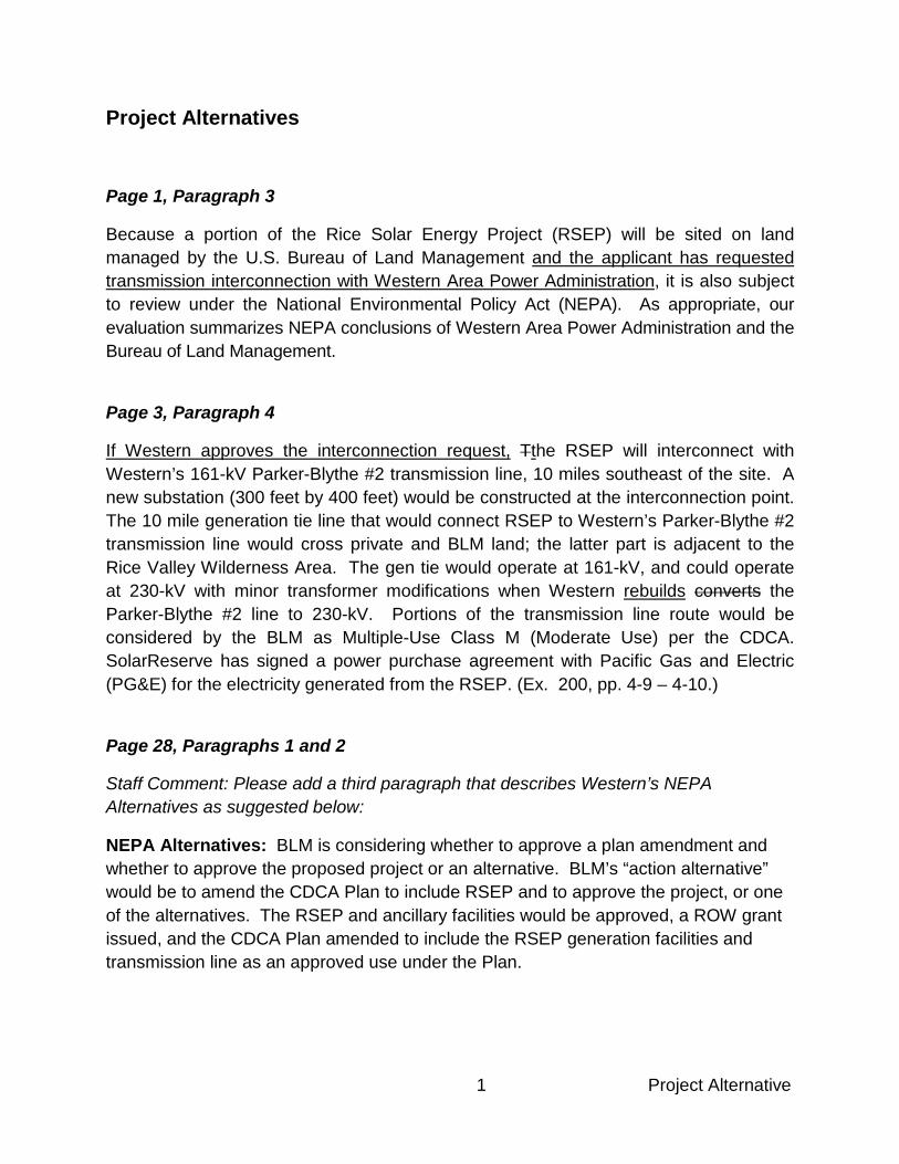
Page 1, Paragraph 3
Because a portion of the Rice Solar Energy Project (RSEP) will be sited on land managed by the U.S. Bureau of Land Management and the applicant has requested transmission interconnection with Western Area Power Administration, it is also subject to review under the National Environmental Policy Act (NEPA). As appropriate, our evaluation summarizes NEPA conclusions of Western Area Power Administration and the Bureau of Land Management.
Page 3, Paragraph 4
If Western approves the interconnection request, Tthe RSEP will interconnect with Western’s 161-kV Parker-Blythe #2 transmission line, 10 miles southeast of the site. A new substation (300 feet by 400 feet) would be constructed at the interconnection point. The 10 mile generation tie line that would connect RSEP to Western’s Parker-Blythe #2 transmission line would cross private and BLM land; the latter part is adjacent to the Rice Valley Wilderness Area. The gen tie would operate at 161-kV, and could operate at 230-kV with minor transformer modifications when Western rebuilds converts the Parker-Blythe #2 line to 230-kV. Portions of the transmission line route would be considered by the BLM as Multiple-Use Class M (Moderate Use) per the CDCA. SolarReserve has signed a power purchase agreement with Pacific Gas and Electric (PG&E) for the electricity generated from the RSEP. (Ex. 200, pp. 4-9 – 4-10.)
Page 28, Paragraphs 1 and 2
Staff Comment: Please add a third paragraph that describes Western’s NEPA Alternatives as suggested below:
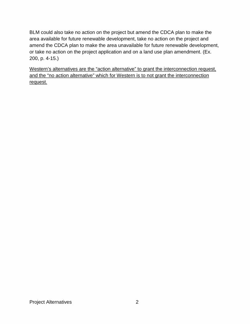
NEPA Alternatives: BLM is considering whether to approve a plan amendment and whether to approve the proposed project or an alternative. BLM’s “action alternative” would be to amend the CDCA Plan to include RSEP and to approve the project, or one of the alternatives. The RSEP and ancillary facilities would be approved, a ROW grant issued, and the CDCA Plan amended to include the RSEP generation facilities and transmission line as an approved use under the Plan.
Project Alternatives 2
BLM could also take no action on the project but amend the CDCA plan to make the area available for future renewable development, take no action on the project and amend the CDCA plan to make the area unavailable for future renewable development, or take no action on the project application and on a land use plan amendment. (Ex. 200, p. 4-15.)
Western’s alternatives are the “action alternative” to grant the interconnection request, and the “no action alternative” which for Western is to not grant the interconnection request.

Compliance and Closure

1 Compliance
Compliance and Closure
Page 2, 2nd Paragraph
In addition to meeting the Energy Commission’s Conditions of Certification, the project owner will be required to comply with all terms and conditions required by the Bureau of Land Management (BLM), as will be described in the BLM’s Record of Decision and Right-of-Way Grant documents for this project. The project owner will also be required to comply with all terms and conditions required by Western Area Power Administration in Western’s Record of Decision including the requirements of the Biological Opinion in accordance with Section 7 of The Endangered Species Act and the Memorandum of Agreement in accordance with Section 106 of the Historic Preservation Act.

TRANSMISSION SYSTEM ENGINEERING

1 Transmission Engineering
Transmission System Engineering
Page 1, Paragraph 3 – Comment from Western
Because the Rice Solar Energy Project (RSEP) will interconnect to the Western Area Power Administration (Western) system and the new RSEP generation tie line will terminate at a proposed new Western 161/230-kV substation, Western is responsible for ensuring electric system reliability for RSEP interconnection.
Page 2, Paragraph 2 – Comment from Western
The 161-kV high voltage terminal of the GSU transformer will connected to the new on-site RSEP 161/230-kV switchyard dead-end structure through short overhead 1,272 Kcmil steel-reinforced aluminum conductors (ACSR) conductors and a 2,000-ampere, 230-kV breaker with two associated 2,000-ampere disconnect switches.
Page 2, Paragraph 3 – Comment from Western
The Parker-Blythe No. 2 line in its present form cannot accommodate 230-kV operation.
Therefore, staff recommends the following edits:
The switchyard will interconnect to the existing Western Parker-Blythe 161/230-kV No. 2 line by way of a new approximately 10-mile long 230-kV single circuit overhead transmission line on 75 to 115-foot high tubular steel poles. Western’s Parker-Blythe line currently operates at 161-kV but it is designed and built to operate at 230-kV.
Page 2, Paragraph 5 – Comment from Western
The new generator tie line will terminate at a take-off structure within the fence line of the proposed new Western 161/230-kV substation bus (hereinafter referred to as “Rice substation”) to be located adjacent to Western’s Parker-Blythe No. 2 230/161-kV No. 2 transmission line. The Rice substation would be a will have a 2,000-ampere ring bus configuration with three four 2,000-ampere, 230-kV circuit breakers. Structural steel and bus work for a future fourth line bay would be includes in the work as well, to be utilized by Western in the future if needed. and associated Other major electrical

Transmission Engineering 2
equipment will include six, 2,000-ampere disconnect switches, nine metering transformers and nine coupling capacitor voltage transformers. A control building (with batteries and chargers, control boards, telecommunications equipment, etc.) and microwave tower complete the major features. The existing Parker-Blythe 230/161-kV No. 2 line would be looped into the new substation, occupying the remaining two line bays. bus through two 2,000-ampere disconnect switches. Western would construct, operate and maintain the station and its facilities within the fence line. (Exs. 1, §§ 2; 3; 45, p. 7.4-5.)
Page 4, Paragraph 4
Conditions TSE-2 and TSE- 3 collectively require the project owner to assign specified engineers to perform design and review functions regarding the transmission system engineering facilities, and provides a resolution mechanism for design/construction discrepancies. Condition TSE-4 provides that the project owner shall not begin construction on power plant switchyard, outlet line, and termination until plans for each increment received CBO approval.
Page 5, Transmission System Impacts Analysis, Paragraphs 2 and 3 – Comments from Western and staff
The studies must analyze the impact of the project for the proposed first year of operation and thus are based on a forecast of loads, generation and transmission. Load forecasts are developed by each load serving entity embedded within Western's transmission system Western as the interconnected utility. Generation and transmission forecasts are established by an interconnection queue. The studies are focused on thermal overloads, voltage deviations, system stability (excessive oscillations in generators and transmission system, voltage collapse, loss of loads or cascading outages), and short circuit duties. (Exs. 22, 200, p. 7.4-6.)
The SIS, dated May 14, 2010, was prepared by Western to evaluate the system impacts of the proposed RSEP on the Western transmission system in the Desert Southwest region and the adjacent Southern California Edison (SCE) and Imperial Irrigation District (IID) transmission systems. The SIS was supplemented by additional studies and information (diagrams) dated August 9, 2010, which were conducted by Utility System

3 Transmission Engineering
Efficiencies, Inc., a consulting firm in coordination with Western, and used the Western base cases. (Ex. 1, p. 3-12, 22, 48.)
Page 10, Telecommunication Impacts, Paragraphs 1, 2 and 3 – Comments from Western
Dual-path communications. is required between Western’s interconnecting substation
(“Rice”) and Phoenix Operations Center. However, only single-path communication is
required between Western and RSEP for breaker control, relaying, etc. The metering
and SCADA data coming from Western’s station requires “physically-separate” and
“diversely-routed” dual paths to Phoenix Operations Center. The two paths selected will
be microwave (primary path) and digital power line carrier (redundant path). The
microwave (primary) signal will be sent to either Headgate Rock Sub or Black Point
Communications Site using an intermediate reflector, to gain access to Western’s
microwave backbone. The digital power line carrier signal will be sent to Parker Dam
Substation to gain access to Western’s fiber-optic backbone.
The evidence establishes that a dual-path telecommunications interconnection between the RSEP and an existing Western substation is necessary for breaker control, protective relaying, metering, and other data control needs. The specific requirements for RSEP will be determined by Western as part of its large Generator Interconnection Procedures. However, the evidence indicates that two physically separate paths of communication will likely be required for compliance with applicable LORS.
Common communications systems used for this purpose include the fiber optic cable link, microwave (radio-frequency) transmission, and the power line carrier/broadband-over-power-line. (Ex. 23.) From the new substation interconnecting the RSEP to Western’s system, telecommunications would be established in one of the following ways:
(1) microwave (radio-frequency) transmission from either RSEP or the new substation to terminate at either Western’s Blythe, or Headgate Rock, or Black Point substations or to an existing telecommunications site at either Cunningham Mountain or Black Point; or

Transmission Engineering 4
(2) power line carrier/broadband-over-power-Line. (Exs. 23, 200, § 7.4, Appendix to TSE.)
Pages 12 and 13, Findings of Fact #s 1 - 4
1. The record includes a System Impact Study (SIS) and a supplementary report which analyzes potential reliability and downstream transmission congestion impacts that could occur when the RSEP project interconnects to the grid.
2. The System Impact Study performed by Western and the supplementary report Facility Study demonstrate that the addition of the 150 MW RSEP would not cause any adverse impacts on the Western transmission system including the Parker-Davis (P-D) transmission system in the Desert Southwest region under 2013 heavy summer and 2013 heavy winter system conditions during normal operation (N-0), and emergency Category B and Category C contingencies.
3. The System Impact Study performed by Western and the supplementary report Facility Study identify that the project could have impacts on the adjacent Southern California Edison (SCE) and Imperial Irrigation District (IID) transmission systems. The addition of the RSEP would cause a new normal (N-0) and a new Category C contingency overload on the SCE Julian Hinds-Mirage 230-kV line, and a new Category B contingency overload on the IID Drop 4-Pilot Knob 92-kV line. The project would also exacerbate pre-project overloads on the SCE Julian Hinds-Mirage 230-kV line and on six transmission elements in the IID system under certain contingency conditions. Sensitivity studies which included the RSEP and another Western queue project, the proposed 110 MW Quartzsite plant (QP), identified similar impacts in the SCE and IID systems.
4. With the concurrence of the Applicant, Western California ISO, SCE, MWD and IID, Western will develop and implement a viable mitigation plan that will eliminate the identified overloads in the SCE and IID systems and be agreed to by the Applicant.

GREENHOUSE GASES

1 Greenhouse Gases
GREENHOUSE GASES The bulk of staff’s recommended changes to the GHG section of the PMPD for
the Rice Solar Energy Project are changes to correct typographical errors and
provide clarifying language. Where appropriate, background information is
provided in Comments preceding the text with the recommended changes.
V. PUBLIC HEALTH AND SAFETY PMPD GHG p.2, para. 2 et seq. The regulated greenhouse gases are carbon dioxide (CO2), nitrous oxide (N2O), methane (CH4), sulfur hexafluoride (SF6), hydrofluorocarbons (HFC), and perflurocarbons (PFC). CO2 emissions are far and away the most common of these emissions; as a result, GHG emissions are often expressed in terms of “metric tons of CO2-equivalent” (MTCO2E2e) for simplicity.
Since the impact of the GHG emissions from a power plant’s operation has both global effects, those impacts should be assessed not only by analysis of the plant’s emissions, but also in the context of the operation of the entire electricity system of which the plant is an integrated part. Furthermore, the impact of the GHG emissions from a power plant’s operation should be analyzed in the context of applicable GHG laws and policies, such as AB 32. In this part of the Decision we determine that:
• RSEP’s construction and operation GHG emissions will be insignificant.
PMPD GHG p.4, para. 4
c. Emissions Performance Standard
Senate Bill (SB) 1368 of 2006, and regulations adopted by the Energy Commission and the Public Utilities Commission pursuant to the bill, prohibit utilities from entering into long-term commitments with any base load facilities that exceed an Emission Performance Standard (EPS) of 0.500 metric tonnes of CO2 per megawatt-hour (this is the equivalent of 1100 pounds CO2/MWh). (Pub.
Greenhouse Gases 2
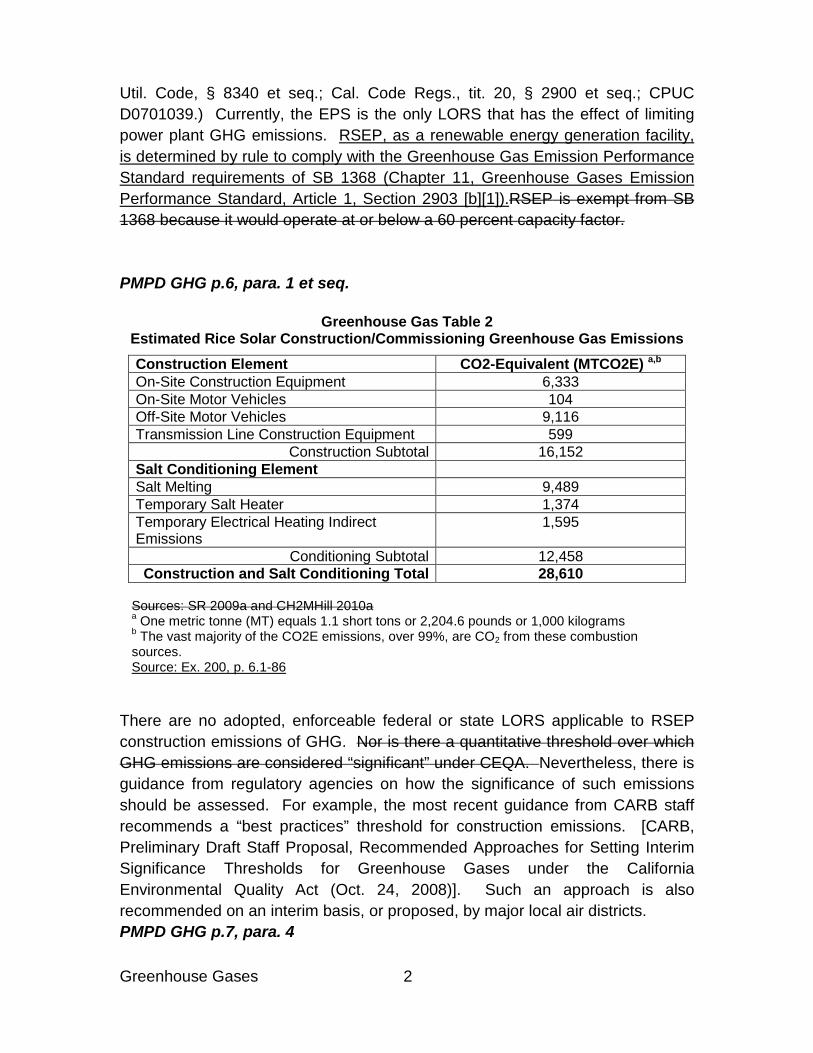
Util. Code, § 8340 et seq.; Cal. Code Regs., tit. 20, § 2900 et seq.; CPUC D0701039.) Currently, the EPS is the only LORS that has the effect of limiting power plant GHG emissions. RSEP, as a renewable energy generation facility, is determined by rule to comply with the Greenhouse Gas Emission Performance Standard requirements of SB 1368 (Chapter 11, Greenhouse Gases Emission Performance Standard, Article 1, Section 2903 [b][1]).RSEP is exempt from SB 1368 because it would operate at or below a 60 percent capacity factor. PMPD GHG p.6, para. 1 et seq.
Greenhouse Gas Table 2 Estimated Rice Solar Construction/Commissioning Greenhouse Gas Emissions Construction Element CO2-Equivalent (MTCO2E) a,b On-Site Construction Equipment 6,333 On-Site Motor Vehicles 104 Off-Site Motor Vehicles 9,116 Transmission Line Construction Equipment 599
Construction Subtotal 16,152 Salt Conditioning Element Salt Melting 9,489 Temporary Salt Heater 1,374 Temporary Electrical Heating Indirect Emissions
1,595
Conditioning Subtotal 12,458 Construction and Salt Conditioning Total 28,610
Sources: SR 2009a and CH2MHill 2010a a One metric tonne (MT) equals 1.1 short tons or 2,204.6 pounds or 1,000 kilograms b The vast majority of the CO2E emissions, over 99%, are CO2 from these combustion sources. Source: Ex. 200, p. 6.1-86
There are no adopted, enforceable federal or state LORS applicable to RSEP construction emissions of GHG. Nor is there a quantitative threshold over which GHG emissions are considered “significant” under CEQA. Nevertheless, there is guidance from regulatory agencies on how the significance of such emissions should be assessed. For example, the most recent guidance from CARB staff recommends a “best practices” threshold for construction emissions. [CARB, Preliminary Draft Staff Proposal, Recommended Approaches for Setting Interim Significance Thresholds for Greenhouse Gases under the California Environmental Quality Act (Oct. 24, 2008)]. Such an approach is also recommended on an interim basis, or proposed, by major local air districts. PMPD GHG p.7, para. 4

3 Greenhouse Gases
a. Anticipated Emissions Solar energy is the primary fuel for the RSEP project, which is greenhouse gas free. Although RSEP’s solar power generation will not consume fossil fuels, the project will include the limited use of two- diesel-powered emergency generators and two diesel-powered emergency fire pumps as well as gasoline and diesel fuel in the maintenance vehicles, off-site delivery vehicles, and staff and employee vehicles, the two fire water pump engines, and the two emergency generator engines. Additional GHG emission sources for this proposed project are SF6 from electrical equipment leakage and leakage of hydro fluorocarbons and perfluorocarbons from refrigeration and fire suppression equipment, respectively. (Exs. 1, pp. 5.1-14 – 5.1-16, 200, Appendix Air Quality AIR-1, p. 6.1-87.)
PMPD GHG p.8, para. 1 et seq.
Greenhouse Gas Table 3
Estimated Rice Solar Operating Greenhouse Gas Emissions
Annual CO2-Equivalent (MTCO2E)a
On-site Stationary Equipment Combustion b 129 Heliostat Washing Trucks b 16 Employee Commute b 640 Material Deliveries b 172 Equipment Leakage (SF6) 30 Equipment Leakage (HFC -134a) 4 Equipment Leakage (PFC-14) 3 Total Project GHG Emissions – MTCO2E b 994 Facility Net MWh per year c 450,000 Facility GHG Performance (MTCO2E/MWh) 0.0022 Sources: SR 2009a; CH2MHill 2010a; CH2M-Hill 2010e; and CH2M-Hill 2010l a One metric tonne (MT) equals 1.1 short tons or 2,204.6 pounds or 1,000 kilograms. b The vast majority of the CO2E emissions, over 99%, are CO2 from these emission sources. c This represents net MWh including the reduction in total net generation from direct parasitic load and the use of grid power, where the net GHG emissions for grid power use is also assumed to the netted out by the reduction in gross facility MWh generation needed to cover the grid power use. Source: Ex. 200, p. 6.1-87
RSEP is estimated to emit 994 metric tonnes of CO2-equivalent GHG emissions per year directly from primary and secondary emission sources. RSEP, as a renewable energy generation facility, is determined by rule to comply with the
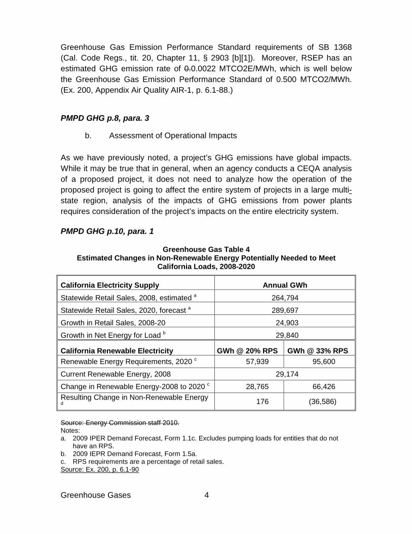
Greenhouse Gases 4
Greenhouse Gas Emission Performance Standard requirements of SB 1368 (Cal. Code Regs., tit. 20, Chapter 11, § 2903 [b][1]). Moreover, RSEP has an estimated GHG emission rate of 0.0.0022 MTCO2E/MWh, which is well below the Greenhouse Gas Emission Performance Standard of 0.500 MTCO2/MWh. (Ex. 200, Appendix Air Quality AIR-1, p. 6.1-88.)
PMPD GHG p.8, para. 3
b. Assessment of Operational Impacts As we have previously noted, a project’s GHG emissions have global impacts. While it may be true that in general, when an agency conducts a CEQA analysis of a proposed project, it does not need to analyze how the operation of the proposed project is going to affect the entire system of projects in a large multi-state region, analysis of the impacts of GHG emissions from power plants requires consideration of the project’s impacts on the entire electricity system. PMPD GHG p.10, para. 1
Greenhouse Gas Table 4 Estimated Changes in Non-Renewable Energy Potentially Needed to Meet
California Loads, 2008-2020
California Electricity Supply Annual GWh Statewide Retail Sales, 2008, estimated a 264,794
Statewide Retail Sales, 2020, forecast a 289,697
Growth in Retail Sales, 2008-20 24,903
Growth in Net Energy for Load b 29,840
California Renewable Electricity GWh @ 20% RPS GWh @ 33% RPS Renewable Energy Requirements, 2020 c 57,939 95,600
Current Renewable Energy, 2008 29,174
Change in Renewable Energy-2008 to 2020 c 28,765 66,426 Resulting Change in Non-Renewable Energy d 176 (36,586)
Source: Energy Commission staff 2010. Notes: a. 2009 IPER Demand Forecast, Form 1.1c. Excludes pumping loads for entities that do not
have an RPS. b. 2009 IEPR Demand Forecast, Form 1.5a. c. RPS requirements are a percentage of retail sales. Source: Ex. 200, p. 6.1-90
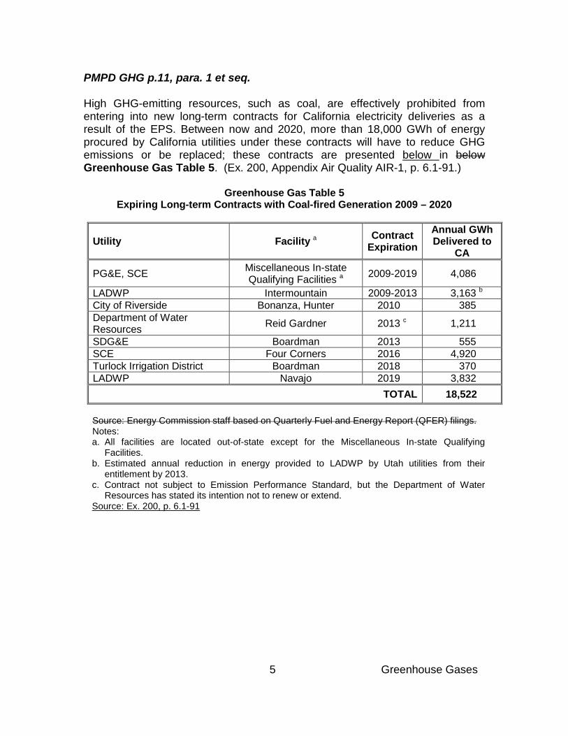
5 Greenhouse Gases
PMPD GHG p.11, para. 1 et seq. High GHG-emitting resources, such as coal, are effectively prohibited from entering into new long-term contracts for California electricity deliveries as a result of the EPS. Between now and 2020, more than 18,000 GWh of energy procured by California utilities under these contracts will have to reduce GHG emissions or be replaced; these contracts are presented below in below Greenhouse Gas Table 5. (Ex. 200, Appendix Air Quality AIR-1, p. 6.1-91.)
Greenhouse Gas Table 5 Expiring Long-term Contracts with Coal-fired Generation 2009 – 2020
Utility Facility a Contract Expiration
Annual GWh Delivered to
CA
PG&E, SCE Miscellaneous In-state Qualifying Facilities a 2009-2019 4,086
LADWP Intermountain 2009-2013 3,163 b City of Riverside Bonanza, Hunter 2010 385 Department of Water Resources Reid Gardner 2013 c 1,211
SDG&E Boardman 2013 555 SCE Four Corners 2016 4,920 Turlock Irrigation District Boardman 2018 370 LADWP Navajo 2019 3,832
TOTAL 18,522 Source: Energy Commission staff based on Quarterly Fuel and Energy Report (QFER) filings. Notes: a. All facilities are located out-of-state except for the Miscellaneous In-state Qualifying
Facilities. b. Estimated annual reduction in energy provided to LADWP by Utah utilities from their
entitlement by 2013. c. Contract not subject to Emission Performance Standard, but the Department of Water
Resources has stated its intention not to renew or extend. Source: Ex. 200, p. 6.1-91

Greenhouse Gases 6
PMPD GHG p.13, para. 2
Greenhouse Gas Table 6 Aging and Once-Through Cooling Units: 2008 Capacity and Energy Output a
Plant, Unit Name Owner Local
Reliability Area
Aging Plant?
Capacity (MW)
2008 Energy Output (GWh)
GHG Emission Rate(MTCO2/M
Wh)
Diablo Canyon 1, 2 Utility None No 2,232 17,091 Nuclear San Onofre 2, 3 Utility L.A. Basin No 2,246 15,392 Nuclear Broadway 3 b Utility L.A. Basin Yes 75 90 0.648 El Centro 3, 4 b Utility None Yes 132 238 0.814 Grayson 3-5 b Utility LADWP Yes 108 150 0.799 Grayson CC b Utility LADWP Yes 130 27 0.896 Harbor CC Utility LADWP No 227 203 0.509 Haynes 1, 2, 5, 6 Utility LADWP Yes 1,046 1,529 0.578 Haynes CC Utility LADWP No 560 3,423 0.376 Humboldt Bay 1, 2 a Utility Humboldt Yes 107 507 0.683 Olive 1, 2 b Utility LADWP Yes 110 11 1.008 Scattergood 1-3 Utility LADWP Yes 803 1,327 0.618 Utility-Owned 7,776 39,988 0.693 Alamitos 1-6 Merchant L.A. Basin Yes 1,970 2,533 0.661 Contra Costa 6, 7 Merchant S.F. Bay Yes 680 160 0.615 Coolwater 1-4 b Merchant None Yes 727 576 0.633 El Segundo 3, 4 Merchant L.A. Basin Yes 670 508 0.576 Encina 1-5 Merchant San Diego Yes 951 997 0.674 Etiwanda 3, 4 b Merchant L.A. Basin Yes 666 848 0.631 Huntington Beach 1, 2 Merchant L.A. Basin Yes 430 916 0.591
Huntington Beach 3, 4 Merchant L.A. Basin No 450 620 0.563
Mandalay 1, 2 Merchant Ventura Yes 436 597 0.528 Morro Bay 3, 4 Merchant None Yes 600 83 0.524 Moss Landing 6, 7 Merchant None Yes 1,404 1,375 0.661 Moss Landing 1, 2 Merchant None No 1,080 5,791 0.378 Ormond Beach 1, 2 Merchant Ventura Yes 1,612 783 0.573 Pittsburg 5-7 Merchant S.F. Bay Yes 1,332 180 0.673 Potrero 3 Merchant S.F. Bay Yes 207 530 0.587 Redondo Beach 5-8 Merchant L.A. Basin Yes 1,343 317 0.810 South Bay 1-4 Merchant San Diego Yes 696 1,015 0.611 Merchant-Owned 15,254 17,828 0.605 Total In-State OTC 23,030 57,817
Source: Energy Commission staff based on Quarterly Fuel and Energy Report (QFER) filings. a. OTC Humboldt Bay Units 1 and 2 are included in this list. They must retire in 2010 when the new Humboldt
Bay Generating Station (not ocean-cooled), currently under construction, enters commercial operation. b. Units are aging but are not OTC. Source: Ex. 200, p. 6.1-93

7 Greenhouse Gases
PMPD GHG p.15, para. 3 FINDINGS OF FACT 1. The GHG emissions from the RSEP project construction are likely to be
28,610 MTCO2 equivalent (“MTCO2E2E”) during the 30-month construction and commissioning period.
PMPD GHG p.16, para. 2 and 7 Comment - Alternatively, if presenting units of CO2 is desired rather than CO2E, then the values would need to be revised to 960 and 0.0021, respectively, which subtracts out the non-CO2 GHG emission sources. 7. The maximum annual equivalent CO2 emissions from RSEP operation will
be nearly 1,000 MTCO2E2, which constitutes an emissions performance factor of 0.0022 MTCO2E2 / MWh.
12. When it operates, RSEP will displace generation from less-efficient (i.e.,
higher-heat-rate and therefore higher-GHG-emitting) power plants.
PMPD GHG p.17, para 1 et seq. CONCLUSIONS OF LAW Comment – The original second and eighth conclusions are redundant. Staff recommends that the second conclusion be deleted. 2. The GHG emissions from a power plant’s operation should be assessed in
the context of the operation of the entire electricity system of which the plant is an integrated part.
23. RSEP operational GHG emissions will not cause a significant
environmental impact. 34. As a renewable electricity generating facility, RSEP is determined by rule
to be compliant with SB 1368. 45. RSEP operation will help California utilities meet their RPS obligations.

Greenhouse Gases 8
56. RSEP operation will be consistent with California’s loading order for power supplies.
67. RSEP operation will foster the achievement of the GHG goals of AB 32
and Executive Order S-3-05. 78. The GHG emissions of any power plant must be assessed within the
context of the entire electricity system on a case-by-case basis to ensure that the project will be consistent with applicablethe goals and policies enunciated above.
89. RSEP willAny new power plant that we certify must:
a) not increase the overall system heat rate;
b) not interfere with generation from existing renewables or with the integration of new renewable generation; and
c) have the ability to reduce system-wide GHG emissions.

AIR QUALITY

1 Air Quality
AIR QUALITY The bulk of staff’s recommended changes to the Air Quality section of the PMPD
for the Rice Solar Energy Project are changes to correct typographical errors and
provide clarifying language. Where appropriate, background information is
provided in Comments immediately preceding the text with the recommended
changes.
PMPD Air Quality p. 2, para. 2 and 3 S UMMARY AND DISCUSSION OF THE EVIDENCE The federal Clean Air Act and the California Clean Air Act both require the establishment of standards for ambient concentrations of air pollutants, called ambient air quality standards (AAQS) for the maximum allowable concentrations of “criteria air pollutants.” The state AAQS, established by the California Air Resources Board (CARB), are typically more protective than the federal AAQS, which are established by the U.S. Environmental Protection Agency (EPA). (Ex. 200, pp. 6.1-5, 6.1-8.) The criteria pollutants analyzed in this section include nitrogen dioxide (NO2), sulfur dioxide (SO2), carbon monoxide (CO), ozone (O3), and particulate matter (PM). Two subsets of particulate matter are (1) inhalable particulate matter (less than or equal to 10 microns in diameter, or (PM10) and (2) fine particulate matter (less than or equal to 2.5 microns in diameter, or (PM2.5). PMPD Air Quality p. 6, para. 3 and 4
4. Modeling Methodology Our analysis is guided by the dispersion modeling analyses and data provided by the Applicant and Staff. (Exs. 1, pp. 5.1-17 - 5.1-27; 200, pp. 6.1-24 -6.1-37.) Dispersion models allow for complex, repeated calculations that consider emissions in the context of various ambient meteorological conditions, local terrain, and nearby structures that affect airflow.

Air Quality 2
The evidence establishes that the Applicant performed the air dispersion modeling analysis using the U.S. EPA Guideline on Air Quality Models and the Industrial Source Complex, Short-Term Model (ISCST3) (version 02035) and the SCREEN3 meteorological set (version 07026) to evaluate potential impacts on ambient air quality. To assess 1-hour NO2 impacts, the Applicant used the AERMOD dispersion model (version 09292) and the ozone limiting method (OLM).(Exs. 1, p. 5.1-18; 200, p. 6.1-24.) PMPD Air Quality p. 7, para. 2 Comment - As stated on page 29 of the PMPD, the proposed project is located in an area that is in attainment or unclassified for all federal ambient air quality standards and is therefore not subject to the general conformity regulations (40 CFR Part 93). Staff recommends that reference to the emission thresholds for the General Conformity Rule be deleted. Alternatively, add text to this paragraph similar to the text on page 29 stating that the project is not subject to the General Conformity Rule. As shown, the maximum annual emissions are below the General Conformity Rule applicability thresholds for PM10 (70 tons) and ozone precursors NOX ([100 tons] and VOC [100 tons]). PMPD Air Quality p. 7, para. 3 Comment – Daily and annual emissions were not directly modeled for the Rice project. The Applicant used EPA persistence factors, not air quality models, to calculate estimated impacts for longer-term averaging periods. Using estimated peak hourly, daily, and annual construction equipment exhaust emissions, tThe Applicant modeled RSEP’s construction emissions to determine impacts. The Applicant’s modeling analysis includes onsite fugitive dust and vehicle tailpipe emissions sources and control measures proposed by the Applicant. The predicted off-site impacts were added to Staff’s conservatively estimated background concentration levels as shown above in Air Quality Table 34. (Exs. 200, pp. 6.1-26 -6.1-29.)

3 Air Quality
PMPD Air Quality p. 9, para.1 As shown, with the exception of 24-hour PM10 impacts, the project will not create new exceedances or contribute to existing exceedances for any of the modeled air pollutants. The conditions that would create worst-case project modeled PM10 impacts (i.e. low wind speeds), are not the same conditions when worst-case background PM10 is expected. (Ex. 200, p. 6.1-27.) Furthermore, the worst-case PM10 impacts would occur at the fence line and attenuate quickly with distance from the fence line. Therefore, the evidence shows that the mitigated construction impacts as shown above will not contribute significantly to exceedances of PM10. (Id.) PMPD Air Quality p. 9, para. 4 AQ-SC1 requires the project owner to designate an on-site Air Quality Construction Mitigation Manager who shall be responsible for directing and ensuring compliance with AQ-SC3 through AQ-SC5. Under AQ-SC-2, the project owner must prepare an Air Quality Construction Mitigation Plan that details the steps that will be taken to ensure compliance with AQ-SC3 through AQ-SC-5, which collectively impose mitigation requirements for monitoring and controlling fugitive dust and visible dust plumes. PMPD Air Quality p. 11, para. 2 The Applicant estimated the potential 1-hour air quality impacts resulting from simultaneous construction and salt commissioning activities by modeling the maximum predicted emissions from both sets of activities. To determine the salt commissioning impacts relative to the ambient air quality standards except for the 1-hour NO2 standards, the predicted project impacts were added to Staff’s conservatively estimated background concentration levels as shown above in Air Quality Table 34. PMPD Air Quality p. 13, para. 4 Comment - As stated on page 29 of the PMPD, the proposed project is located in an area that is in attainment or unclassified for all federal ambient air quality standards and is therefore not subject to the general conformity regulations (40

Air Quality 4
CFR Part 93). Staff recommends that reference to the emission thresholds for the General Conformity Rule be deleted. Alternatively, add text to this paragraph similar to the text on page 29 stating that the project is not subject to the General Conformity Rule. The results of the Applicant’s modeling analysis of maximum annual operation emissions are well below the General Conformity Rule applicability thresholds for PM10 (70) and ozone precursors (NOX [100 tons] and VOC [100 tons]). These estimates are shown below in Air Quality Table 8. PMPD Air Quality p. 14, para. 2 The Applicant’s analysismodeling took the molten salt system into consideration. Typical plant operations will involve the daily transfer of molten salt from the “cold” storage tank (nominal temperature 550° F) through the solar receiver to the “hot” storage tank (nominal temperature 1050° F). The hot salt will be routed through a heat exchanger to generate steam and then returned to the “cold” storage tank. As the volume of the molten salt in a storage tank increases, the space above the salt is exhausted through vents to the atmosphere. Thus, the Applicant analyzed the potential for emissions to the atmosphere. The venting operations are not expected to result in salt loss or fumes. (Ex. 200, pp. 6.1-22 – 6.1-23.) PMPD Air Quality p. 16, para. 2 In light of the existing PM10 and ozone non-attainment status for the project area, Staff determined that the operating emissions of nonattainment pollutants and their precursors NOX, VOC, and PM emissions are potentially CEQA significant and mitigation is required for the stationary equipment, the off-road maintenance equipment, and fugitive dust emissions. (Ex. 200, p. 6.1-34.) PMPD Air Quality p. 16, para. 4 Although project operations will not cause new violations of any NO2, SO2, PM2.5 or CO) ambient air quality standards, the direct and secondary emissions contributions to existing violations of the ozone and PM10 ambient air quality

5 Air Quality
standards are significant and require mitigation. Both the Applicant and Staff proposed mitigation measures. (Ex. 200, pp. 6.1-34 – 6.1-35.) The Applicant proposed specified Best Available Control Technology emission controls on the stationary equipment that are formalized in the District’s Conditions. These District Conditions and measures, as incorporated into Staff–proposed, more particularly, Conditions AQ-SC6 and AQ-SC7 proposed by Staff incorporate Applicant’s and Staff’s proposed mitigation measures, will adequately mitigate the project’s stationary source, mobile equipment, and fugitive dust emissions from operations. PMPD Air Quality p. 17-18, para 5 et seq. Comment – The second and fourth paragraphs in the following section are duplicative. Staff recommends that the fourth paragraph be deleted. 5. Cumulative Impacts Cumulative impacts result from the proposed project’s incremental effect, together with other closely related past, present and reasonably foreseeable future projects whose impacts may compound or increase the incremental effect of the proposed project. (Pub. Res. Code § 21083; Cal. Code Regs., tit. 14, §§ 15064(h), 15130, 15355.) The air quality analysis discussed herein is concerned with criteria air pollutants, which have impacts that are usually (though not always) cumulative by nature. Although a project by itself would rarely cause a violation of a federal or state criteria pollutant standard, a new source of pollution may contribute to violations of criteria pollutant standards because of the existing background sources or foreseeable future projects. The record contains extensive analyses of cumulative impacts to air quality during project construction and operation, including a description of the air quality background in the Riverside County portion of the Mojave Desert Air Basin, and discusses historical ambient levels for each of the assessed criteria pollutants. (Exs., 1, p. 5.1-26; 200, pp. 6.1-45 – 6.1- 48.) Much of the preceding discussion is concerned with cumulative impacts as it is focused on criteria air pollutants. Such pollutants have impacts that are usually (though not always) cumulative by nature. Rarely would a project by itself cause

Air Quality 6
a violation of a federal or state criteria pollutant standard. However, a new source of pollution may contribute to violations of criteria pollutant standards because of the existing background sources or foreseeable future projects. PMPD Air Quality p. 28, para. 1 and 2 The other proposed energy facilities in the region surrounding the RSEP include three thermal solar projects, the Blythe Solar Power Project, the Palen Solar Power Project, and the Genesis Solar Energy Project siting cases, which are either approved or currently being evaluated by the Energy Commission and BLM. Additionally there are a few other proposed projects including transmission projects and private developer projects (residential/landfill/racetrack) located in the general project area. According to the evidence, this potential for significant additional development within the air basin and corresponding increase in air basin emissions is a major part of Staff’s rationale for recommending Conditions of Certification AQ-SC6 and AQ-SC7, which are designed to mitigate the proposed project’s cumulative impacts by reducing the dedicated on-site vehicle emissions and fugitive dust emissions during site operation. Regarding localized impacts, the evidence also shows that the Applicant, in consultation with MDAQMD, confirmed that there are no projects within a six-mile radius from the Rice Solar Project site that are under construction or have received permits to be built or operate in the foreseeable future. Therefore, it appears that no stationary sources requiring a cumulative modeling analysis exist within a six-mile radius of the proposed project site. However, as noted previously there is the potential for the development of several solar and wind projects within or surrounding the Rice Valley or within the eastern MDAB that could eventually create cumulative air quality impacts if these projects are not adequately mitigated. This potential for significant additional development within the air basin and corresponding increase in air basin emissions will be addresseds through implementation of Staff-proposed Conditions of Certification AQ-SC6 and AQ-SC7. As shown below, we have adopted these Conditions. PMPD Air Quality p. 31, para. 2 and 3 Rule 406 - Specific Contaminants The rule prohibits sulfur emissions, calculated as SO2, in excess of 500 ppmv. Compliance with this rule is assured with the required use of pipeline quality

7 Air Quality
natural gas for the boilers and heaters and California low sulfur diesel fuel for the emergency generator and fire pump engines. Rule 407 – Liquid and Gaseous Air Contaminants The rule prohibits carbon monoxide emissions in excess of 2,000 ppmv. The emergency generators and fire pump engines would have CO emissions well below this concentration limit. Compliance with this rule is expected. PMPD Air Quality p. 31, para. 5 Rule 431 - Sulfur Content of Fuels
The rule prohibits the burning of gaseous fuel with a sulfur content of more than 800 ppm and liquid fuel with a sulfur content of more than 0.5 percent sulfur by weight. Compliance with this rule is assured with the required use of pipeline quality natural gas and California low sulfur diesel fuel for the emergency engines. PMPD Air Quality p. 32, para. 5, 6 and 7
FINDINGS OF FACT 3. The project will not cause new violations of any NO2, SO2, PM2.5 or CO
ambient air quality standards. Therefore, the NOX, SOX, PM2.5 and CO emission impacts are not significant.
4. The project’s NOX and VOC emissions can contribute to the existing
violations of the state ozone standards. However, the required mitigation will reduce the project’s impact to a level that is less than significant.
5. The project’s PM10 emissions can contribute to the existing violations of the
stateozone 24-hour and annual PM10 air quality standards. However, the required mitigation will mitigate the project’s impacts to a level that is less than significant.

Air Quality 8
PMPD AQ p. 34, para. 5, AQ-SC3, Condition B Please consider the recommended change to only Part B of Condition of Certification AQ-SC3. AQ-SC3 …
B. All unpaved construction roads and unpaved operation and maintenance site roads, as they are being constructed, shall be stabilized with a non-toxic soil stabilizer or soil weighting agent that can be determined to be both as efficient or more efficient for fugitive dust control as ARB approved soil stabilizers, and shall not increase any other environmental impacts including loss of vegetation to areas beyond where the soil stabilizers are being applied for dust control. All other disturbed areas in the project and linear construction sites shall be watered as frequently as necessary during grading (consistent with Biology Conditions of Certification that address the minimization of standing water) (consistent with BIO-7); and after active construction activities shall be stabilized with a non-toxic soil stabilizer or soil weighting agent, or alternative approved soil stabilizing methods, in order to comply with the dust mitigation objectives of Condition of Certification AQ-SC4. The frequency of watering can be reduced or eliminated during periods of precipitation.
WORKER SAFETY/FIRE PROTECTION

1 Worker Safety / Fire Protection
Worker Safety / Fire Protection PMPD Page 8, Paragraph 1 Should RCFD and the Applicant reach agreement such To the extent that the RCFD and REMS determine that the RSEP may lawfully provide on-site emergency medical and rescue services, we would require the project owner to comply with Conditions of Certification WORKER-SAFETY-9 and -10. These Conditions are based on the Applicant’s submitted Revised Fire Needs Assessment (Ex. 50). Implementation of these conditions will shorten the crucial time-to-treatment and reduce the time-to-hospital for injured workers, while at the same time reducing potential demands on and impacts to RCFD resources, benefitting both workers and the community. PMPD Page 9, Paragraph 4 Notwithstanding these evidentiary deficiencies, we find that the project’s potential incremental impact on the identified cumulative impacts could be significant. RSEP must therefore make a monetary contribution to be applied to RCFD’s mitigation efforts. Based on the limited cost figures submitted by Staff by way of Staff-proposed Condition of Certification Worker WORKER SAFETY-7, the County’s development fee impact program1, and project’s expected payment of property taxes, we find that RSEP’s onetime payment of the development impact fee, property taxes, and a onetime payment of $570,000 will reduce the incremental impact to less than significant levels. These requirements are set forth in Condition of Certification WORKER SAFETY-7. PMPD Conditions of Certification Pages 15-16 Conditions of Certification WORKER-SAFETY-9 and -10 would apply if RCFD and REMS determine that the RSEP may lawfully provide on-site emergency medical and rescue services. WORKER SAFETY-9 During any construction activities, the project owner shall provide
on-site: a) an EMT-P (Paramedic) who is certified by Riverside Emergency Services
(REMS) along with the appropriate equipment and supplies, either directly provided or provided through contract with a RCEMS-certified company; and
1 We imposed this requirement by way of Condition of Certification LAND-6 in the Land Use section of this Decision.

Worker Safety / Fire Protection 2
b) a Advance Basic Life Support Ambulance with a California certified driver for use during medical emergency events; and
c) a contract with an REMS-certified air medical service to respond to a request from an onsite EMT-P; and
d) a rescue team with NFPA 1670 (Standard on Operations and Training for Technical Search and Rescue Incidents) level of training and appropriate equipment and supplies
At least 30 days prior to the commencement of site mobilization, the project owner shall be provide to the CPM for review and approval: a) the name and contact information for the EMT-P. The contact information of any
replacement EMT-P shall be submitted to the CPM within one business day, and provide evidence in each Monthly Compliance Report during commercial operation construction; and
b) a letter to the CPM confirming that the Basic Life Support Ambulance is available and will be onsite during any construction activities and provide evidence in each January Monthly Compliance Report during construction; and
c) proof of its contract for air medical service to the CPM for review and approval and provide evidence in each January Monthly Compliance Report during construction.
d) a letter to the CPM confirming that a rescue team with NFPA 1670 (Standard on Operations and Training for Technical Search and Rescue Incidents) level of training and appropriate equipment and supplies will be available during any construction activities
WORKER SAFETY-10 Beginning with commercial operation, the project owner shall provide onsite:
a) an EMT-P who is certified by Riverside Emergency Services (REMS) along with the appropriate equipment and supplies; and
b) a contract with an REMS-certified air medical service to respond to a request from an onsite EMT-P.
At least 30 days prior to the commencement of commercial operation, the project owner shall be provide to the CPM for review and approval:
a) the name and contact information for the EMT-P(s) to be working on each shift. The contact information of any replacement EMT-P shall be submitted to the CPM within one business day, and provide evidence in each Monthly Compliance Report during commercial operation; and
3 Worker Safety / Fire Protection
b) annually thereafter in the Annual Compliance Report, proof of its contract for air medical service to the CPM for review and approval.

BIOLOGICAL RESOURCES

1 Biological Resources
BIOLOGICAL RESOURCES PMPD: pages 6 – 9, Sections 3.b. and 3.c., Project Disturbance Areas and Transmission Line Interconnection Staff recommends revising project acreages in text and in Biological Resources Table 1 to reflect the applicant’s revised acreage calculations, docketed on October 15, 2010.
b. Project Disturbance Areas Electrical power generated by the project will be delivered to the transmission grid through an interconnection with the existing Western Parker-Blythe #2 transmission line, southwest of the project site. The facility would consist of a roughly circular solar heliostat field, administrative facilities, and stream channel diversions on approximately 1,470 1,411.6 acres of private land owned by the applicant; a 10-mile generator tie-line crossing public and private land; and an interconnection substation (identified as a “switchyard” in Western documents) on approximately three acres at the tie-in point with Western’s existing transmission line, on public land. BLM manages public land on the tie-line alignment and substation site and throughout the area. [skip one paragraph] The Applicant owns 3,324-acres in Rice Valley, consisting of six parcels. Within this holding, the RSEP solar field site would be located on a new 2,560-acre square-shaped parcel that would be created by merging four existing assessor’s parcels. The heliostat field and most other permanent facilities would be located in a circular area encompassing 1,410 1,362 acres of the property, to be enclosed within a permanent boundary fence. During operation, most project facilities, including parking areas, administration buildings, water treatment system, a 230-kV switchyard, the approximately 1,316-acre 1,329-acre heliostat field and associated power generation structures, and evaporation ponds would be contained within this fenced boundary. The entire solar generator site would be permanently disturbed by project construction and operation. [skip one paragraph] The proposed logistics and lay-down areas is are on 60 25.7 acres, immediately south of SR-62 and outside the proposed heliostat field. During construction, all logistics, laydown, and parking would be contained within theseis temporarily fenced areas.
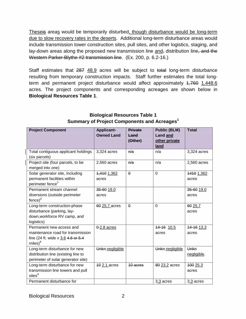
Biological Resources 2
Theseis areas would be temporarily disturbed, though disturbance would be long-term due to slow recovery rates in the deserts. Additional long-term disturbance areas would include transmission tower construction sites, pull sites, and other logistics, staging, and lay-down areas along the proposed new transmission line and, distribution line, and the Western Parker-Blythe #2 transmission line. (Ex. 200, p. 6.2-16.) Staff estimates that 287 48.9 acres will be subject to total long-term disturbance resulting from temporary construction impacts. Staff further estimates the total long-term and permanent project disturbance would affect approximately 1,760 1,448.6 acres. The project components and corresponding acreages are shown below in Biological Resources Table 1.
Biological Resources Table 1 Summary of Project Components and Acreages1
Project Component Applicant-Owned Land
Private Land (Other)
Public (BLM) Land and other private land
Total
Total contiguous applicant holdings (six parcels)
3,324 acres n/a n/a 3,324 acres
Project site (four parcels, to be merged into one)
2,560 acres n/a n/a 2,560 acres
Solar generator site, including permanent facilities within perimeter fence2
1,410 1,362 acres
0 0 1410 1,362 acres
Permanent stream channel diversions (outside perimeter fence)2
35-60 19.0 acres
35-60 19.0 acres
Long-term construction-phase disturbance (parking, lay-down,workforce RV camp, and logistics)
60 25.7 acres 0 0 60 25.7 acres
Permanent new access and maintenance road for transmission line (24 ft. wide x 3.6 4.6 or 5.4 miles)3
0 2.8 acres 14-16 10.5 acres
14-16 13.3 acres
Long-term disturbance for new distribution line (existing line to perimeter of solar generator site)
Unkn.negligible Unkn.negligible Unkn negligible.
Long-term disturbance for new transmission line towers and pull sites4
10 2.1 acres 10 acres 80 23.2 acres 100 25.3 acres
Permanent disturbance for 3.3 acres 3.3 acres

3 Biological Resources
interconnector substation Long-term disturbance for ground line construction on existing Western 161 kV Transmission Line5
Unkn. Unkn. 127 acres
Total Project disturbance area 1,515-1,540 1,411.6 acres
10 acres + 97-99 acres + 37 acres
1,749-1,776 1,448.6 acres
1. Data from the Application for Certification (SR 2009a) the Applicant’s Supplementary Information Item #9, Biological Resources Mitigation Acreage Table and Map (tn 58793, Oct. 15, 2010) unless otherwise noted. 2. Excludes 6.0 acre existing concrete pad. 2. Staff estimate based on CH2MHill 2010g. 3. Total generator tie- line right of way = 150 acres (Rice Solar Energy 2010). Staff estimates road disturbance as 24-foot width x length of road; length is reported as 4.6 miles in SR 2009a, and as 5.4 miles in CH2MHill 2010d. 4. Staff estimates 90 towers and 10 pull sites, each site approximately one acre; approximately 80% of tower and pull sites would be on BLM land. 5. Estimate provided by Western (pers. comm. W. Werner). [skip one paragraph]
c. Transmission Line Interconnection A new 230-kV generator tie-line will interconnect to Western’s 161-kV/230-kV Parker-Blythe #2 transmission line. The generator tie-line would extend for 10.0 miles from the RSEP fenceline southeast to a new interconnection substation. The new generator tie-line would be located primarily on BLM land and would include the establishment of approximately 5.4 3.6 miles of new dirt service roadway and a new 300 by 400 foot substation at the point of interconnection. The remaining 4.6 5.6 miles of generator tie-line would be located adjacent to an existing dirt road (Rice Valley Road), which would serve as its access road. PMPD page 10 Staff recommends revising Biological Resources Table 2 to reflect the applicant’s revised acreage calculations, docketed on October 15, 2010.

Biological Resources 4
Biological Resources Table 2 Summary of Project Disturbance Acreage by Vegetation Type1
Vegetation Type Solar Generator Site and Contiguous Facilities
Transmission lines and Interconnector Substation
Total
Creosote bush scrub 1,422-1,447 1,324.6 acres
107-109 37 acres 1,529-1,556 1,361.6 acres
White bursage scrub 87 acres 0 87 acres Smoke tree woodland 0 0 0 Unvegetated (concrete pad) 6 acres 0 6 acres Unmapped disturbance (existing 161-kv Parker-Blythe #2 transmission line)
0 127 acres 127 acres
Total Project disturbance area1
1,515-1,540 1,411.6 acres
234-236 37 acres 1,749-1,776 1,448.6 acres
1. Does not include Distribution Line or Fiber Optic OPGW PMPD page 13 Staff recommends revising the Cynanchum utahense row in Biological Resources Table 3 to reflect results of the applicant’s late-season botanical field surveys, docketed on October 13, 2010.
Biological Resources Table 3
Cynanchum utahense Utah cynanchum, Utah vine milkweed
CNPS: 4.2 S 3.2
Moderate. Reported in desert tortoise survey, perhaps from tortoise zone of influence transects; not reported on-site by botanical survey; suitable habitat present. Present. Reported at substation site in late-season botanical surveys (Applicant’s Fall 2010 Supplemental Botanical Inventory, tn 58773, Oct. 13, 2010)
PMPD page 18 Staff recommends striking the second paragraph in the section, which refers to potential occurrence of jurisdictional waters along Western’s existing 161-kV Parker-Blythe #2

5 Biological Resources
transmission line alignment. Due to the exclusion of the formerly-proposed OPGW telecommunication line along this alignment, this paragraph is no longer relevant to project analysis. 5. Jurisdictional Waters
The evidence describes the jurisdictional streambeds on the proposed solar generator site and associated generator tie-line alignment and substation. As previously discussed, no field surveys or streambed delineation of the Western Parker-Blythe #2 transmission line have been provided for Staff’s review. However, based on a review of online Google Earth aerial images, Staff believes that the transmission line crosses numerous desert washes. Thus, project activities such as road widening, pole access, and that may occur within those washes may be subject to regulation under Section 1600 of the California Fish and Game Code or Section 404 of the Federal Clean Water Act. PMPD page 19, 2nd paragraph Staff recommends revising acreage of the solar generator site to reflect the applicant’s revised calculations, docketed on October 15, 2010. In addition to the above-described ephemeral blue-line channels, there are many additional other desert washes that originate on-site and drain southward across the site. All of these channels are ephemeral. In total, there are 75.4 acres of state-jurisdictional streambeds (i.e., ephemeral washes) within the 1,410 1,362 acre solar generator site. Staff concludes all of this streambed acreage would be directly or indirectly affected by project construction and operation. In addition, there are 2.1 acres of state-jurisdictional streambeds outside the perimeter fence that would be directly affected by permanent or long-term project components (i.e., channel diversions, access road, and temporary logistics/laydown area). PMPD page 20, 3rd paragraph Staff recommends revising acreage of impacts to native vegetation and habitat to reflect the applicant’s revised calculations, docketed on October 15, 2010.

Biological Resources 6
More particularly, project construction would result in permanent and long-term impacts to approximately 1,743 to 1,770 1,448.6 acres of desert shrubland (excluding the 6-acre unvegetated concrete pad). This will result in both direct and indirect impacts to native vegetation, including introduction or spread of invasive weeds and increased dust. Weeds include species of non-native plants identified on the weed lists of the California Department of Food and Agriculture, the California Invasive Plant Council, or those weeds of special concern identified by BLM. The spread of invasive plants is a major threat to biological resources in the California desert because non-native plants can displace native plants, increase the threat of wildfire, supplant wildlife foods that are important to herbivorous species, alter the habitat structure and ecological function of wetland, riparian, and desert wash communities, and invade threaten special-status plant occurrences and habitat.
PMPD page 24, 3rd paragraph Staff recommends revising the paragraph regarding Utah cynanchum to reflect results of the applicant’s late-season botanical field surveys, docketed on October 13, 2010. One CNPS List 4 species, Utah cynanchum, is reported on the project site, at the interconnector substation location. It appears though that the plant may have been misidentified or may have been recorded off-site, on desert tortoise zone of influence transects. Utah cynanchum has not been observed or reported on the site by the Applicant’s botanical consultant but the site is within its geographic range. Furthermore, suitable desert wash habitat may be present in desert washes on the proposed generator tie-line alignment. Even so, b Based on this plant’s known geographic range and abundance, absence of any reported unusual morphology among local populations, and local occurrence in typical habitat, we conclude that project impacts to Utah cynanchum potentially occurring on the generator tie-line alignment would not reach the level of significance under the Energy Commission’s adopted significance criteria. PMPD page 27, 3rd paragraph Staff recommends deleting text as shown to reflect exclusion of the formerly-proposed OPGW telecom. line from the proposed project description. About half of these birds are found in wetland or riparian habitats and are not likely to be on the proposed RSEP solar generator site or the generator tie-line alignment. However, these species may occur in portions of the Western’s existing 161-kV Parker-

7 Biological Resources
Blythe #2 transmission line and may also migrate seasonally through the Rice Valley where they may be subject to project-related construction disturbance. PMPD page 28, 2nd paragraph For clarity, staff recommends revising the first line of the paragraph as shown. Cheesewood Owlfly, Gila Monster and Rosy Boa This species The cheeseweed owlfly has a conservation ranking with the CDFG Natural Diversity Database of S1S3, indicating uncertain status ranging between “critically imperiled” and “vulnerable.” Given this species’ historic occurrence in the gen tie-line alignment and the nature of the construction activities, project impacts would likely be significant. Conditions of Certification BIO-1 through BIO-10, and BIO-16 will reduce any impacts to less than significant levels. (Ex. 200, p. 6.2-80.) PMPD page 30, 1st paragraph following Table 4 Staff recommends revising acreage as shown to reflect the applicant’s revised calculations, docketed on October 15, 2010. Construction of the proposed project would result in the permanent loss of approximately 1,770 1,448.6 acres of occupied desert tortoise habitat. One desert tortoise was located on the solar generator site during field surveys, and Staff estimates that about four tortoises (two adults and one or two juveniles) may live on the site. In addition, about ten tortoise eggs may be expected on the site in a typical year. The transmission line corridors and interconnector substation also are in occupied desert tortoise habitat. PMPD page 31, 5th paragraph Staff recommends the following revision to indicate length of the new access road to reflect the applicant’s revised calculations, docketed on October 15, 2010.
Direct Impacts. The greatest impacts to desert tortoise will arise from the habitat loss at the solar field site. The land will be converted to a use incompatible with desert tortoise habitat and fenced to prevent desert tortoises from accessing the site. The primary threat related to the transmission line is risk of injury or mortality during construction or,

Biological Resources 8
after construction is complete, vehicle strikes on the approximately 5.4 3.6-mile new, unpaved access road. PMPD pages 35 – 36, 3rd and 4th paragraphs, and Biological Resources Table 5 Staff recommends revising acreage estimates in Biological Resources Table 5 and the text preceding the table to reflect the applicant’s revised calculations, docketed on October 15, 2010. Staff - in consultation with USFWS, BLM, and CDFG biologists – determined that a mitigation ratio of 1:1 (i.e., acquisition and preservation of one acre of compensation lands for each acre of project disturbance) would reduce permanent and long-term impacts to approximately 1,661 1,411.6 acres of lower quality habitat at the solar generator site to less than significant. For permanent and long-term impacts to approximately 109 37 acres of higher-quality habitat along the generator tie-line, access road, and at the interconnector substation, a mitigation ratio of 3:1 would reduce impacts to less than significant. We find that these ratios are appropriately tailored to address the RSEP construction impacts. Guided by CDFG’s approach, the higher ratio for the impacts along the generator tie-line and related disturbance is reasonable given the following factors: (1) the absence of soil compaction, pavement, or oiling found at the former airfield site; (2) the geographic nature of the disturbance, which would create multiple new, localized disturbed sites which can become sources of weed infestations or other disturbances into surrounding undisturbed desert lands; (3) the 5.4 3.6 miles of new roadway, which could lead to increased noise and other human disturbances as recreational motorists make use of the new access route; and (4) the generator tie-line alignment’s location at the boundary of a BLM Wilderness Area, which has higher conservation priority than most other desert lands. For impacts on public (BLM) lands, compensation may consist of land dedication and protection at a 2:1 mitigation ratio and an additional assessed financial contribution at a 1:1 ratio, so that total compensation is at a 3:1 ratio for impacts to BLM lands. (Id.) Biological Resources Table 5 below summarizes Staff’s impact estimates and compensation ratios.
Biological Resources Table 5 Summary of Impact Estimates and Compensation Ratios for Desert Tortoise Habitat1
Project Component Disturbance Acreage
Compensation Ratio
Compensation Acreage
Solar generator site, including permanent 1,661 1,411.6 1:1 1,661 1,411.6

9 Biological Resources
and long-term disturbance within and outside perimeter fence; all applicant-owned land; and 127 acres estimated disturbance on Parker-Blythe #2 transmission line.
acres acres
Total permanent and long-term disturbance for generator tie-line, access road, and interconnector substation (includes approx. 20 acres private land and 97-99 acres BLM land).
109 37 acres 3:1 327 111 acres2
Acreage Totals 1,770 1,448.6 acres
1,988 1,522.6 acres
1. For the purpose of estimating project impacts, staff includes all impacts except the 6-acre concrete pad and uses the higher acreage for each project component where an acreage range is indicated. See Biological Resources Tables 2 and 3. 2. Compensation for impacts to BLM land may consist of 2:1 habitat compensation and 1:1 habitat enhancement (financial contribution to be based on estimated cost of acquisition). PMPD page 40 – last paragraph and Page 41- 1st, 2nd and 3rd paragraphs Staff recommends revising acreage estimates in the following text, describing availability of applicant-owned lands for desert tortoise habitat compensation, to reflect the applicant’s revised calculations, docketed on October 15, 2010. Finally, there is the issue of the location of habitat compensation lands. As discussed above, the Applicant already owns land suitable for desert tortoise compensation lands. This land, which is near but outside the RSEP footprint area, is largely suitable as compensation for project impacts to desert tortoise habitat. (Ex. 200, pp. 6.2-97- 6.2-98.) However, according to the evidence, habitat values within a 250-foot buffer area surrounding the project footprint would be reduced due to indirect and off-site project impacts such as noise, lighting, ground vibration, human disturbance, weed introductions, and other construction and operation effects. Therefore, this 250-foot buffer area surrounding the perimeter fence (estimated as 165 155 acres), if included as desert tortoise compensation land, should be credited at the reduced mitigation value of 0.5:1 rather than 1:1. Stated otherwise, an approximately 165 155-acre area would be credited as only 82.5 77.2 acres of mitigation land. For similar reasons, Applicant-owned lands between SR-62 and the project footprint (i.e., north of the heliostat perimeter and administrative area, estimated as 230 217 acres) should also be credited at the reduced mitigation value of 0.5:1 rather than 1:1. This area would be credited as only 115 108.6 acres of mitigation land.

Biological Resources 10
Based on these approximations, we estimate that Applicant-owned land contiguous to the project area could account for approximately 1,486 acres all of the required 1,522 acres of desert tortoise compensation habitat, with a “surplus” of approximately 168.5 acres. (See Condition of Certification BIO-16.) If the Applicant chooses not to use these lands for mitigation, then alternate lands should be identified and acquired offsite. These lands should be within the Colorado Desert Recovery Unit. PMPD page 42, 2nd paragraph Staff recommends deleting text to reflect exclusion of the formerly-proposed OPGW telecom. line from the project. Mojave Fringe-Toed Lizard: The Mojave fringe-toed lizard is a BLM sensitive species and California Species of Special Concern. Its primary habitat is fine wind-blown (aeolian) sand deposits such as dunes and sandy patches within scrubby vegetation. It is not expected to occur on the solar generator site, but may occur on the generator tie-line alignment or interconnector substation site, and probably occurs on portions of the Parker-Blythe #2 transmission line alignment. Construction impacts to habitat along the transmission lines would be temporary because aeolian habitat is only sparsely vegetated and post-construction habitat recovery would occur naturally in only a short time.
PMPD page 43, 2nd paragraph Staff recommends revising text to reflect exclusion of the formerly-proposed OPGW telecom. line from the proposed project description. Suitable aeolian sand habitat or fine sandy desert wash habitat that may be occupied by Mojave fringe-toed lizards may occur in patches along the proposed generator tie-line alignment, or at the interconnector substation site, or on Western’s existing 161-kV Parker-Blythe transmission line. Project-related transmission line construction and upgrades would temporarily disturb habitat, and could crush individual Mojave fringe-toed lizards. But habitat for these animals, consisting of open sand, is expected to recover quickly following disturbance because vegetation recovery is not required. Thus, habitat impacts would be short-term. We conclude that without avoidance or mitigation, potential take of individual Mojave fringe-toed lizards for transmission line work could be significant under CEQA, but habitat impacts would not be significant. (Ex. 200, pp. 6.2-82 – 6.2-83.)

11 Biological Resources
PMPD page 44, 4th paragraph Staff recommends revising habitat acreage estimate to reflect the applicant’s revised calculations, docketed on October 15, 2010. Condition of Certification BIO-18 imposes on the project owner the duty to perform an annual inventory during construction, make a determination of unoccupied territory only after completing two aerial surveys in a single breeding season, engage in monitoring, and implement an adaptive management plan. And because, project construction would eliminate or degrade approximately 1,770 1,448.6 acres of foraging habitat in the region, this loss could interfere with normal behavior, causing golden eagles to forage more widely and therefore spend less time at or near their nests. This effect could be considered “take,” pursuant to the Bald and Golden Eagle Protection Act. To address these impacts, Condition of Certification BIO-16 requires acquisition, protection, and enhancement of compensation desert tortoise habitat; this habitat also would serve as golden eagle foraging habitat. (Ex. 200, p. 6.2-100 -6.2-101.) PMPD page 46, 3rd paragraph Staff recommends revising distance of new transmission line access road to reflect the applicant’s revised calculations, docketed on October 15, 2010. Design constraints may require some transmission towers to be sited within ephemeral drainages. In addition, the proposed new access road that would extend for approximately 5.4 3.4 miles along the transmission line would cross numerous drainages. Therefore, quantification of impacts to drainages along the transmission line is not possible at this time, but Staff includes streambed acreage along the generator tie-line alignment in the total streambed acreage. PMPD page 51, 2nd and 4th paragraphs Staff recommends revising the habitat acreage estimate to reflect the applicant’s revised calculations, docketed on October 15, 2010, and deletion of a phrase to reflect exclusion of the formerly-proposed OPGW telecom. line from the project description. BIO-17 also requires the Applicant to participate in the Regional Raven Management Program developed by USFWS, in cooperation with BLM, National Park Service, Department of Defense, and Department of Agriculture. This Program implements

Biological Resources 12
recommendations in the USFWS Environmental Assessment to Implement a Desert Tortoise Recovery Plan Task: Reduce Common Raven Predation on the Desert Tortoise. “Participation” means making a onetime monetary contribution in the amount of $105.00 per acre to the REAT Account held by NFWF, for the 1,776 1,448.6-acre total project footprint area (excluding the 6-acre existing concrete pad). This payment of $190,209.60 $152,040.00 would support the regional raven management plan activities focused within the Colorado Desert Recovery Unit. The fees contributed by the Applicant would fund raven removal actions, education and outreach efforts, and surveying and monitoring activities identified in the federal Environmental Assessment. [skip one paragraph] Increased Risk from Roads/Traffic. Vehicle traffic would increase as a result of construction and improvement of access roads, increasing the risk of injuring or killing desert tortoise and other wildlife. Vehicle access by project personnel during operations, as well as by the public along the new generator tie-line access road and improved access along the existing 161-kV Parker-Blythe transmission line, could result in mortality of desert tortoises by vehicle strikes. PMPD page 53, 2nd paragraph Staff recommends adding the phrase for clarity. To reduce off-site lighting impacts, lighting at the RSEP facility would be restricted to areas required for safety, security, and operation. Exterior lights would be hooded, and lights would be directed on site so that light or glare would be minimized. Low-pressure sodium lamps and fixtures of a non-glare type would be specified. Switched lighting would be provided for areas where continuous lighting is not required for normal operation, safety, or security; this would allow these areas to remain un-illuminated (dark) most of the time, thereby minimizing the amount of lighting potentially visible off site. These measures are described in Condition of Certification VIS-2. With implementation of this measure, we find that lighting impacts to wildlife at the RSEP would be reduced below a level of significance. (Ex. 200, pp. 6.2-117 – 6.2-118.)
PMPD page 55, 4th paragraph Staff recommends the text revisions for clarity and consistency with USFWS guidance.

13 Biological Resources
The record describes the particular nature of each of these hazards. The evidence indicates that collisions with heliostat mirrors is a real threat. Additional factors that may lead to mortality of migratory birds and special-status birds are nighttime project lighting, evaporation ponds, and perhaps a “mirage” effect that may be caused by the proposed heliostat field. Thus, potential for bird mortality through collision with the proposed power line project components would be significant without mitigation. Condition of Certification BIO-8 requires the Applicant to construct the transmission line according to the standards in the Avian Power Line Interaction Committee’s (APLIC’s) Mitigating Bird Collisions with Power Lines (APLIC 1994) to minimize risk of collision. BIO-8 includes specifications that the lighting atop the towers use flashing strobe lights rather than steady burning, and recommendations for other project lighting to be shielded downward and turned off when not needed. Furthermore, Condition of Certification BIO-25 requires the project owner to prepare and implement an Avian and Bat Protection Plan (which also expressly protects bats) to minimize death and injury of birds and bats from collisions with facility features and focused heat and light at and near the central tower and at “standby points”; and to identify adaptive management measures to minimize such impacts. With the implementation of this mitigation, impacts to birds and bats from collisions with the proposed transmission line project components would be less than significant. PMPD page 65, 2nd paragraph Staff recommends revising the text as shown to reflect results of the applicant’s late-season botanical field surveys, docketed on October 13, 2010. Special Status Plants. The RSEP’s incremental contribution to cumulative impacts to special-status plants would be minor. Two Three special-status species would be impacted by the RSEP: chaparral sand-verbena, Utah cynanchum, and Harwood’s milk-vetch. Chaparral sand-verbena is widespread in the Colorado Desert, and is not rare in this region. Utah cynanchum is on the CNPS Watch List (List 4), but adverse impacts would not be significant under CEQA. Impacts to Harwood’s milk-vetch and any other special-status plants found on the project site would be avoided or minimized through implementation of Condition of Certification BIO-12. Given the relatively low abundance of these plants in the RSEP and generator tie-line footprints, the occurrence of Harwood’s milk-vetch in areas to be avoided due to other resource concerns (sandy washes and similar habitats); the relatively low local conservation concern for chaparral sand verbena and Utah cynanchum, and the anticipated compliance with Condition of Certification BIO-12, the RSEP would not make a considerable contribution to the

Biological Resources 14
cumulative regional impacts to special-status plants, and its cumulative impact would be less than significant. PMPD page 66, 3rd paragraph Staff recommends revising the habitat acreage estimate to reflect the applicant’s revised calculations, docketed on October 15, 2010. As discussed above, the The RSEP would have permanent and long-term impacts to about 1,600 1,448.6 acres of tortoise habitat. This would amount to less than 0.06 percent of the total medium quality habitat mapped within the NECO planning area in the habitat model (2,797,866 acres). PMPD page 66, 5th paragraph Staff recommends the text deletion to reflect exclusion of the formerly-proposed OPGW telecom line from the project description. Mojave Fringe-Toed Lizard. The RSEP’s impacts to Mojave fringe-toed lizard would largely be limited to construction-related impacts during construction or upgrade work on the generator tie-line alignment and the Parker-Blythe #2 transmission line alignment. Potential habitat on the solar generator site is marginal, patchy, and not extensive. Compliance with Condition of Certification BIO-8 would minimize potential adverse impacts to the species and its habitat during transmission line work. Mojave fringe-toed lizard occurs in the Danby Dunes, less than one mile south of the project site. PMPD page 67 Staff recommends the text deletion to reflect exclusion of the formerly-proposed OPGW telecom line from the project description. Golden Eagle. The RSEP would contribute incrementally to the cumulative loss of golden eagle foraging habitat. The RSEP solar generator site does not provide suitable golden eagle nesting habitat, but there are inactive recent golden eagle nest sites known within 10 miles of the proposed project site, and these sites could be used again in the future. The entire RSEP site, including the proposed generator tie-line alignment
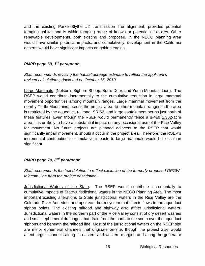
15 Biological Resources
and the existing Parker-Blythe #2 transmission line alignment, provides potential foraging habitat and is within foraging range of known or potential nest sites. Other renewable developments, both existing and proposed, in the NECO planning area would have similar potential impacts, and cumulatively, development in the California deserts would have significant impacts on golden eagles. PMPD page 69, 1st paragraph Staff recommends revising the habitat acreage estimate to reflect the applicant’s revised calculations, docketed on October 15, 2010. Large Mammals (Nelson’s Bighorn Sheep, Burro Deer, and Yuma Mountain Lion). The RSEP would contribute incrementally to the cumulative reduction in large mammal movement opportunities among mountain ranges. Large mammal movement from the nearby Turtle Mountains, across the project area, to other mountain ranges in the area is restricted by the aqueduct, railroad, SR-62, and large containment berms just north of these features. Even though the RSEP would permanently fence a 1,410 1,362-acre area, it is unlikely to have a substantial impact on any occasional use of the Rice Valley for movement. No future projects are planned adjacent to the RSEP that would significantly impair movement, should it occur in the project area. Therefore, the RSEP’s incremental contribution to cumulative impacts to large mammals would be less than significant. PMPD page 70, 2nd paragraph Staff recommends the text deletion to reflect exclusion of the formerly-proposed OPGW telecom. line from the project description. Jurisdictional Waters of the State. The RSEP would contribute incrementally to cumulative impacts of State-jurisdictional waters in the NECO Planning Area. The most important existing alterations to State jurisdictional waters in the Rice Valley are the Colorado River Aqueduct and upstream berm system that directs flows to the aqueduct siphon points. The existing railroad and highway also affect jurisdictional waters. Jurisdictional waters in the northern part of the Rice Valley consist of dry desert washes and small, ephemeral drainages that drain from the north to the south over the aqueduct siphons and beneath the railroad line. Most of the jurisdictional waters on the RSEP site are minor ephemeral channels that originate on-site, though the project also would affect larger channels along its eastern and western margins and along the generator

Biological Resources 16
tie-line alignment. Further, with few exceptions, jurisdictional waters on the site do not support specialized riparian or desert wash vegetation or other special habitat values. The RSEP solar generator and generator tie-line would impact 82.8 acres of State jurisdictional waters. Additional jurisdictional waters may be impacts along the Parker-Blythe #2 transmission line alignment. This loss would be offset by the implementation Condition of Certification BIO-22, which requires that the applicant provide compensatory mitigation at a 1:1 ratio for all impacts to State jurisdictional waters, and also requires a number of impact avoidance and minimization measures, including the elimination of the applicant’s proposed stormwater detention basin. The Applicant would likely fulfill the large majority of this compensatory mitigation requirement through the conservation and management of jurisdictional drainages on the desert tortoise compensatory mitigation lands (see Condition of Certification BIO-16). Due to the relative lack of riparian habitat and the small, ephemeral character of most of these channels, the incremental contribution of the solar generator, generator tie-line, and interconnector substation to cumulative impacts to State jurisdictional waters would be less than significant with mitigation incorporated. PMPD page 77, Findings of Fact Staff recommends revising the habitat acreage estimate to reflect the applicant’s revised calculations, docketed on October 15, 2010. Based on the evidence, we find the following: 1. Construction and operation of RSEP will result in the permanent loss of 1,770
1,448.6 acres of habitat. PMPD page 106, BIO-14, 1st bullet of Condition Staff recommends revising acreages and naming of work sites and project components to reflect the applicant’s revised terminology and acreage calculations, docketed on October 15, 2010.
1. Desert Tortoise Exclusion Fence Installation. To avoid impacts to desert tortoises, permanent desert tortoise exclusion fencing shall be installed at the solar generator site along the permanent perimeter security fence and permanent access road from the security gate southward. Temporary exclusion fencing shall be installed along any additional construction site associated with the project, including the 60 25.7-acre construction
17 Biological Resources
laydown logistics/staging areas, 19-acre stormwater diversion channels, and proposed generator tie-line alignment work sites. Permanent desert tortoise exclusion fencing shall also be installed at the interconnector substation site prior to construction activities at that site. The only exception to the requirement for exclusion fencing shall be for temporary construction sites where a qualified desert tortoise monitor is on-site throughout all construction activities (e.g., transmission line construction sites). The proposed alignments for all desert tortoise exclusion fencing shall be flagged and surveyed for desert tortoise within 24 hours prior to the initiation of fence construction. Clearance surveys of the perimeter fence and utility rights-of-way alignments shall be conducted by the Designated Biologist(s) using techniques approved by the USFWS and CDFG and may be conducted in any season with USFWS and CDFG approval. Biological Monitors may assist the Designated Biologist under his or her supervision with the approval of the CPM, USFWS, and CDFG. These fence clearance surveys shall provide 100 percent coverage of all areas to be disturbed and an additional buffer approximately 90 feet wide centered on the fence alignment (i.e., 45 feet along each side of the fence line). Survey transects shall be no greater than 15 feet apart. All desert tortoise burrows, and burrows constructed by other species that might be used by desert tortoises, shall be examined to assess occupancy of each burrow by desert tortoises and handled in accordance with the USFWS’ 2009 Desert Tortoise Field Manual. Any desert tortoise located during fence clearance surveys shall be handled only by the Designated Biologist(s) in accordance with the USFWS’ 2009 Desert Tortoise Field Manual.

CULTURAL
1 Cultural Resources
Cultural Resources Staff’s recommended changes to the Cultural Resources section of the PMPD consist of updates to previously-agreed to changes in Conditions of Certification between staff and applicant, clarifications, and corrections of typographical errors. Page 19, 1st Paragraph To reduce potential impacts to these resources to less than significant levels, we adopt Conditions of Certification CUL-2 through CUL-1214. Each condition is provided below; but the pertinent aspects of each are summarized as follows. Pages 20 – 21, Paragraphs 3 and 4 Staff Comment: Staff and Applicant came to an agreement that the Historic Interpretive Area concept would be reduced to a Roadside Stop in exchange for the addition of CUL-13 (Documentary). Therefore, mention of the Historic Interpretive Area and associated items, such as the interpretive path, water fountain, picnic tables, and bathrooms, is no longer applicable and has been deleted (shown as strike-out in the referenced text). Specifically regarding impacts to the Rice Army Airfield (Rice AAF), Camp Rice, and the surrounding DTC/C-AMA cultural landscape, we adopt CUL-11, -12, -13, and -14. Condition CUL-11 requires the project owner to construct and maintain a Historic Interpretive Area Roadside Stop, with visitor services, including parking, water, restrooms, and shaded information kiosk, and trash receptacle. , appropriate to a desert environment. Although not specifically related to the interpretive value of the site, requirements for restrooms, drinking fountain, garbage cans, and shaded areas have been included to address relevant sanitary concerns and acknowledge the area’s unique desert conditions. Providing self-closing containers and collection of refuse would minimize litter that could attract wildlife and invite increased predation on desert tortoise and other at-risk species. There are no existing restrooms or source of drinking water along SR 62 for many miles in either direction. Restrooms would prevent the inappropriate use of the land surrounding the interpretive area and provide a means to property contain and dispose of human waste. A properly maintained drinking fountain would provide public access to potable water in an environment where outside activities could contribute to dehydration and heat-related illness. Shaded areas would also reduce heat-related impacts.

Cultural Resources 2
The Historic Interpretive Area would be located along the west side of the project’s secondary access (fire access road), adjacent to several remaining artifacts of the Rice AAF (e.g., stem wall foundations and rock-lined paths), which would become part of an interpretive path. All sensitive site information related to the Rice AAF would be documented (and curated, if appropriate) prior to completion of the interpretive area and public access. Location of the Historic Interpretive Area at a considerable distance from the remaining Camp Rice would help limited additional public impacts to the Camp’s remaining features. Page 24, Findings of Fact
7. We adopt Conditions of Certification CUL-1 through CUL-12 14 to reduce impacts to cultural resources to less than significant. (Ex. 200, pp. 6.3-1, 6.3-56, 6.3-57.)
Page 31, Condition of Certification CUL-4, number 8, first paragraph Staff Comment: Native American monitors will not be necessary, as the proposed project will not be impacting known prehistoric resources. For this reason, the original CUL-1, related to the Prehistoric Trails Network Cultural Landscape, was also dropped from the Conditions of Certification for this project. If the Committee agrees to delete Number 8, then the following provision numbers 9 – 13 should become numbers 8 – 12. 8. The manner in which Native American observers or monitors will be included, in addition to their roles in the activities required under CUL-1; the procedures to be used to select them; and their roles and responsibilities shall be described. Page 32, Condition of Certification CUL-5, second paragraph Staff Comment: The following insert is to correct an inadvertent omission. If the project owner requests a suspension of ground disturbance and/or construction activities, then a draft CRR that covers all cultural resources activities associated with the project shall be prepared by the CRS and submitted to the CPM, and to BLM Palm Springs archaeologist, and Western’s archaeologist for review and approval on the same day as the suspension/extension request. The draft CRR shall be retained at the project site in a secure facility until ground disturbance and/or construction resumes or the project is withdrawn. If the project is withdrawn, then a final CRR shall be submitted to the CPM for review and approval at the same time as the withdrawal request.

3 Cultural Resources
Page 32, Condition of Certification CUL-5, Verification # 3 3. Within 10 days after the CPM, BLM’s archaeologist, and Western’s archaeologist approve the CRR, the project owner shall provide documentation to the CPM confirming that copies of the final CRR have been provided to the SHPO, the CHRIS, the curating institution, if archaeological materials were collected, and to the Tribal Chairpersons of any Native American groups requesting copies of project-related reports. Page36, Condition of Certification CUL-8, Paragraphs 1 - 3 Staff Comment: The paragraph on responding to discovery of human remains was inadvertently omitted. Minor clarifications and specifications also omitted. This wording must be included for the project to be consistent with state and local LORS. The balance of CUL-8 would remain the same starting with Provision 1. The project owner shall grant authority to halt ground disturbance to the CRS, alternate CRS, PHA, and the CRMs in the event of a discovery. Redirection of ground disturbance shall be accomplished under the direction of the construction supervisor in consultation with the CRS. If human remains are found, the project owner shall follow the requirements of the State Health and Safety Code Section 7050.5 and Public Resources Code Section 5097.98(b). The Riverside County Coroner shall be notified and remains shall be left in place and free from disturbance until the final decision as to the treatment and their disposition has been made. If the remains are determined to Native American, the Native American Heritage Commission (NAHC) shall be contacted within the period specified by law. Subsequently, the NAHC shall identify the “Most Likely Descendant.” The Most Likely Descendant shall then make recommendations and engage in consultation concerning the treatment of the remains. Human remains from other ethnic/cultural groups with recognized historic associations to the project area shall also be subject to consultation among appropriate interested parties, CPM, Riverside County, and federal agency representatives (if the find occurs on federal public lands). In the event that For unanticipated finds, excluding human remains, if a cultural resource over 50 years of age is found (or if younger, determined exceptionally significant by the CPM), or impacts to such a resource can be anticipated, ground disturbance shall be halted within a minimum of 100 feet of the find or redirected in the immediate vicinity of the discovery sufficient to ensure that the resource is protected from further impacts. Monitoring and daily reporting, as provided in other conditions, shall continue during the project’s ground-disturbing activities elsewhere. The halting or redirection of ground disturbance shall remain in effect until the CRS has visited the discovery, and all of the following have occurred:

Cultural Resources 4
Pages 38 – 39, Condition of Certification CUL-9 Staff Comment: Changes/clarifications have been made so that the PMPD will be consistent with staff’s assessment, testimony, and wording agreed to by staff and the applicant. Staff recommends replacing CUL-9 in entirety with the following:
CUL-9 DATA RECOVERY FOR RICE ARMY AIR FIELD AND CAMP RICE FEATURES Prior to the start of ground disturbance, the project owner shall ensure that records feature forms for all 298 historic-period features at the Rice Army Air Field and Camp Rice are completed to the satisfaction of the CPM. be upgraded. The focus of the recordation upgrade is to recover any additional data associated with these features before they are destroyed during construction. A plan shall specify in detail the location recordation equipment and methods to be used and describe any anticipated post-processing of the data. The project owner shall then ensure that the CRS, the PHA, and/or archaeological team members implement the plan, if allowed by the CPM, which shall include, but is not limited to the following tasks: 1. The project owner shall hire a PHA with the qualifications described
in CUL-2 to supervise the field work.
2. The project owner shall ensure that, prior to beginning the field work, the PHA and all field crew members are trained by the DTCCL Historical Archaeologist, or equivalent qualified person approved by the CPM and hired by the project owner should the DTCCL Historical Archaeologist not be available, to identify the specific landform for each site;
3. The project owner shall ensure that, prior to beginning the field work, the field crew members are also trained in the consistent and accurate identification of the full range of late nineteenth and early-to-mid-twentieth-century can, bottle, and ceramic diagnostic traits.
4. The project owner shall ensure that the original site map shall be updated to include at minimum: landform features such as small drainages, any man-made features, the limits of any artifact concentrations and features (previously known and newly found in the metal detector geophysical survey), using geographic positioning system location recordation equipment that has the latest technology with sub-meter accuracy capable of recording locational data in a standard geo-reference grid coordinate system (such as UTM 11 North or California Teale Albers).
5 Cultural Resources
5. The project owner shall ensure that a detailed in-field analysis of all a representative sample of diagnostic artifacts shall be completed, documenting the measurements and the types of seams and closures for each bottle, and the measurements, seams, closure, and opening method for all cans. Photographs shall be taken of maker’s marks on bottles, any text or designs on bottles and cans, and of decorative patterns and maker’s marks on ceramics. Artifacts shall not be collected.
6. The project owner shall ensure a systematic metal detector geophysical survey of portions of the airfield is be completed, with inclusive coverage of the northern end of the site where most of the military activities occurred, to identify and map the distribution of near-surface and buried materials/features. at each site, and that each “hit” is investigated. All artifacts and features thus found must be mapped, measured, photographed, and fully described in writing.This survey shall be conducted with a mobile electromagnetic instrument and high-resolution GPS unit, measuring both conductivity and magnetic susceptibility (metal detection).
7. The project owner shall ensure that all structures are mapped, measured, photographed, and fully described in writing, and that all associated features having subsurface elements, including those identified in the geophysical survey, are excavated by a qualified historical archaeologist. All features and contents must be mapped, measured, photographed, and fully described in writing.
8. The project owner shall ensure that the details of what is found at each site Rice Army Air Field/Camp Rice feature or new site shall be presented in a letter report from the CRS or PHA which shall serve as a preliminary report, that details what was found at each site feature, as follows:
a. Letter reports may address one feature site or multiple features, sites depending on the needs of the CRS; and
b. The letter report shall be a concise document thethat provides a description of the schedule and methods used in the field effort, a preliminary tally of the numbers and types of features and deposits that were found, a discussion of the potential range of error for that tally, and a map showing the location of collection and/or excavation units, including topographic contours and the site land forms.

Cultural Resources 6
c. The letter report shall make a recommendation on whether each one feature site is a contributor to the DTTCCL.
9. The project owner shall ensure that the data collected from the field work shall be provided to the DTCCL Historical Archaeologist to assist in the determination of which, if any, of the historic-period sites are contributing elements to the DTCCL.
10. The project owner shall ensure that the PHA analyzes all recovered data and writes or supervisorses the writing of a comprehensive final report. This report shall be included in the CRR (CUL-5). Relevant portions of the information gathered may shall be included in the possible NRHP nomination for the DTCCL (funded by CUL-1).
Verification: 1. At least 90 days prior to ground disturbance, the project owner shall notify the
CPM that mapping and upgraded in-field artifact analysis has ensued.
2. At least 60 days prior to ground disturbance, Within one week of completing data recovery at a site, the project owner shall submit to the CPM for review and approval feature records and a letter report written by the CRS, evidencing that the field portion of data recovery at each particular feature site has been completed, evaluating whether the feature contributes to the overall eligibility of the property consistent with the requirements of the CRMMP. When the CPM approves the letter report, ground disturbance may begin at the site location(s) that are the subject of the letter report.
Pages 40 – 41, Condition of Certification CUL-11 Staff Comment: Changes/clarifications are recommended so that the PMPD will be consistent with staff’s assessment, testimony, and wording agreed to by staff and the applicant. Staff and Applicant came to an agreement that the Historic Interpretive Area concept would be reduced to a Roadside Stop in exchange for the addition of CUL-13 (Documentary). Staff recommends replacing CUL-11 in entirety with the following: CUL-11 HISTORIC INTERPRETIVE ROADSIDE STOP PUBLIC ACCESS TO HISTORIC FEATURES
Prior to the start of construction, the project owner shall provide conceptual plans for the Historic Interpretive Area Roadside Stop (HIRS or roadside stop) to the CPM for review and approval. The plans shall also identify existing historic features of Rice AAF and Camp Rice that would be protected from disturbance during construction and preserved in accordance with the MOA. Prior to commercial operation of RSEP, the project owner shall provide the final plans for the Historic

7 Cultural Resources
Interpretive Area Roadside Stop to Western, BLM, and Riverside County for review and comment, and to the CPM, for review and approval. that would illustrate and interpret Rice AAF and Camp Rice as components of the larger DTC/C-AMA. Construction of the Historic Interpretive AreaRoadside Stop shall be completed prior to the start of commercial operations. The project owner’s plans for the Historic Interpretive Area Roadside Stop may shall be coordinated with Caltrans and Riverside County, and shall be developed in a manner that does not compromise site or public safety or security.
The Historic Interpretive Area Roadside Stop shall include and make accessible to the public the following features: 1. An encroachment off SR 62 (proposed Fire Access road
encroachment) to the Historic Interpretive Area Roadside Stop and vehicle parking area, consistent with Caltrans, Riverside County, and the Americans with Disabilities Act (ADA) access and requirements parking requirements. The vehicle parking area shall include:
a. Four (4) parking spaces, including one van-accessible ADA-compliant parking space.
b. The parking spaces and encroachment shall provide a level, all-weather surface, preferably of compacted rock, decomposed granite, or similar permeable material, or as required by Caltrans.
2. An interpretive kiosk, protected by a shade structure that displays a minimum of five (5) panels of text and graphics illustrations (e.g. photographs, maps, and diagrams) that illustrate and interpret Rice AAF and Camp Rice as individual historic features and as components of the larger DTC/C-AMA. Access to the kiosk shall be handicap-accessible, over a level, all-weather surface, preferably of compacted rock, decomposed granite, or similar permeable material, or paved with asphalt concrete, consistent with Riverside County paving requirements and Caltrans encroachment requirements.
3. Identification of existing historic features of Rice AAF, adjacent to the kiosk, with signage and interpretive information along an ADA-accessible walking trail;
4. A shade-covered area, with minimum of two picnic tables and benches
3. 5. Self-closing, wildlife-resistant trash cans;
6. A two-stall, ADA-accessible, contained restroom facility; and

Cultural Resources 8
7. A drinking fountain. Verification: 1. At least 30 days prior to the start of construction, the project owner shall
submit conceptual plans for the Historic Interpretive Area Roadside Stop to Western, BLM, and Riverside County for review and comment, and to the CPM for review and approval. The plan shall identify existing historic features of Rice AAF and Camp Rice that would be protected from disturbance during construction and preserved in accordance with the MOA.
2. No later than one year following commencement of RSEP start of construction, the project owner shall submit final plans for the Historic Interpretive Area Roadside Stop to Western, BLM, and Riverside County for review and comment, and to the CPM for review and approval.
3. At least 30 days prior to RSEP the start of commercial operation, the project owner shall complete construction of the Historic Interpretive Area Roadside Stop and submit photographic proof of completion to the CPM for review and approval. obtain approval from the CPM that the Historic Interpretive Area meets the requirements of this condition. The Historic Interpretive Area Roadside Stop shall be open made accessible to the public within 10 days from the start of commercial operations and shall be maintained by the project owner for the life of the project.
4. In each Annual Compliance Report, the project owner shall provide a
summary of the following: a. Estimated public visitation to the Historic Interpretive Area Roadside Stop;
b. Any issues associated with operating and maintenance;
c. Proposed maintenance and improvements, and a schedule for completion; and
d. A log of all completed maintenance and improvements to the Historic Interpretive Area Roadside Stop from the start of RSEP commercial operation to the present day.
Page.42, Condition of Certification CUL-12, 1st paragraph Staff Comment: Changes/clarifications are recommended to be consistent with staff’s assessment. CUL-12 FLAG AND AVOID Resources within the Warren-Alquist Public Use Area (in just outside the northwestern portion corner of the main facility circular footprint would will be

9 Cultural Resources
preserved through avoidance. Previously recorded resources along Western’s Parker Dam-Blythe Transmission Line No. 2, subject to possible project impacts associated with installation of the fiber optical cable (if this telecommunication option is implemented), shall be revisited prior to construction. In the event that new resources are discovered during construction or previously recorded resources would be additionally affected, where impacts can be reduced or avoided, the project owner shall: Page 43, Condition of Certification CUL-13, Conditions 1 and 3 Staff Comment: Staff retracted the requirement in Condition 1 at the applicant’s request, and recommends correction of typos in Condition 3.
1. Prior to the start of filming, the project owner shall provide the qualifications of the proposed production company to the Executive Director of the General Patton Memorial Museum for review and comment, and to the CPM for review and approval. The production company shall have experience in the creation of historic documentary-style videos and shall provide evidence of the successful completion of at least three videos of similar quality from project development to release. A copy of any contract including the scope of work related to the production of the documentary shall be submitted to the CPM within 10 days of execution.
3. Prior to the start of site mobilization, the production company shall
take the initial aerial footage of the remains of the Rice AAF and Camp Rice facilities along with representative features and training fields surrounding the the project area, as necessary to convey the context of the Rice AAF and Camp Rice within the DTC/C-AMA. Aerial footage may also document the remains of other facilities and features in the project vicinity that are integral or contributing to the DTC/C-AMA cultural landscape, including airfields, camps, bombing ranges, and the King’s Throne (where Patton sat to observe maneuvers). Historic film; still photos; re-creations; interview footage and audio tracks; and compatible, high-quality video footage of the subject areas taken prior to current filming may also be integrated into the final product. The original acquisition format shall be high definition, 16X9, 1080p digital format, using broadcast-level cameras and lenses. The aerial documentation shall be photographed using a television motion picture, industry-accepted camera stabilization system, mounted to a helicopter.

Cultural Resources 10
Page 47, Condition of Certification CUL-14, Conditions 1 and 2 Staff Comment: Staff recommends updating CUL-14 with the actual name of the General Patton Memorial Museum.
1. The project owner shall provide the design of at least one single page, double-sided tri-fold brochure and an initial production run of at least 1,000 copies to the General Patton Memorial Museum for public distribution, interpreting the significance of Rice AAF and Camp Rice as individual historical features and as contributing features within the DTC/C-AMA cultural landscape.
Prior to the final phase of plant construction, the project owner shall submit a draft design proof of the brochure to the Executive Director of the General Patton Memorial Museum for review and comment, and to the CPM for review and approval. Prior to the start of commercial plant operations, the project owner shall submit final design proofs of the brochure to the Executive Director of the General Patton Memorial Museum for review and comment, and to the CPM for review and approval. Prior to, or concurrent with the start of commercial plant operations, the project owner shall submit a digital/electronic template of the brochure design, along with 1,000 copies, suitable for public distribution, to the Executive Director of the General Patton Memorial Museum. The project owner shall also submit the final digital/electronic template of the brochure to the CPM, BLM Palm Springs-South Coast Field Office, and Western. The project owner, Museum, Energy Commission, BLM, and Western shall have authorized use of the initial (and any revised) templates for future production runs for distribution to the public or display on any of the parties’ informational websites.
2. Prior to the start of commercial plant operations, the project owner shall
provide a donation in the amount of $25,000 to the General Patton Memorial Museum. The funds from this donation shall be earmarked for development and installation of displays and signage interpreting contributions of the Rice AAF and Camp Rice to the mission of the DTC/C-AMA at the General Patton Memorial Museum. The resulting interpretive display shall also incorporate a way for the public to view the 10-minute abbreviated documentary excerpt identified in CUL-13 above. Historical information acquired during the DTC Cultural Landscape study, identified in CUL-1 above, shall also be made available to the Museum as a basis for development of the Rice AAF/Camp Rice displays.

LAND USE

1 Land Use
Land Use Staff’s recommended changes are clarifications, corrections of typographical errors, corrections to Exhibit references, and deletions of inappropriate text not caught and corrected previously. Page 1, paragraph 2, first sentence. The land use analysis focuses on twothree main issues: (1) whether the Rice Solar Energy Project (RSEP) is consistent with local land use plans, ordinances, and policies; (2) whether the project is compatible with existing and planned uses, and (3) potential project-related direct, indirect, and cumulative environmental effects. Page 2, Project Site and Setting, Paragraph 1, citation.
1. Project Site and Setting The project site is immediately south of and adjacent to State Route (SR) 62, in unincorporated Riverside County. The project footprint will include approximately 1,410 acres of privately owned property and 99 acres of federal lands managed by the U.S. Bureau of Land Management (BLM). (Ex. 200, p. 6.5-17.) Page 3, Project Site and Setting, paragraph 3 (1st paragraph on page 3)
Staff Comment: The site consists of four parcels of property. The Assessor parcel numbers identify the parcels for tax purposes. The remaining two parcels adjoin the project site, but are not part of the official description. The revisions offered here more accurately describe the project site and adjoining properties. The RSEP power block and solar arrays will cover approximately 1,410 acres of a 2,560-acre project site, consisting of four parcels. The project is sitedThese parcels are located withinpart of a larger, 3,324 acre-parcel area, comprised of six Assessor parcel numbers owned by the applicant. The generating facility would be constructed on privately owned land and connected to the Western’s Parker-Blythe transmission line by a 10.0-mile-long generation tie line. The proposed transmission line corridor will extend southeast for approximately 10 miles, across BLM-managed public lands and two privately owned parcels, connecting with the Western Parker-Blythe transmission line within the existing Western/BLM right-of-way (ROW). (Exs. 1, p. 5.6-1; 200, p. 6.5-8.)

Land Use 2
Page 3, paragraph 4, citation, (2nd paragraph on page 3). The project’s power block and solar arrays will be located on the site of the Rice Army Air Field (Rice AAF) and a portion of Camp Rice, a World War II desert training base that was part of the infantry and artillery Desert Training Center, California-Arizona Maneuver Area used by General George S. Patton, Jr., from 1942-1944 to prepare American soldiers for combat in the North African desert. The airport was used by the public and private sector, respectively and was abandoned between 1955 and 1958. To the east, Camp Rice (Rice Divisional Camp) housed the 5th Armored Division during its training at the maneuvers area and maintained a large quartermaster depot at that location. The area was also used for Joint Exercise Desert Strike in 1964. Little remains of Camp Rice or the Rice Army Airfield, aside a few foundations, concrete pads, and defunct runways. (Ex. 200, p. 6.5-78.) Page 5, Applicable Land Use Plans and Land Designations, Bullets 1, 2, 5, and 7 of Paragraph 1. Staff Comment: Bullets 1 and 2 contain a typo (plant vs plan). Bullet 5 has been added because these ordinances also govern physical development in the project study area and are the basis for two of the Land Use Conditions of Certification (LAND 5 and 9). Citation for Ex. 200, pp 6.5-6 – 6.5-7 was added as the location of information on the additional ordinances.
3. Applicable Land Use Plans and Land Designations Plans and policies governing physical development in the project study area include:
• BLM’s California Desert Conservation Area (CDCA) Plant; • BLM’s Northern and Eastern Colorado Desert Coordinated Management
Plant (NECO); • Riverside County General Plan; • Riverside County Land Use Ordinance; • Riverside County Ordinances 457.102 (Building Code) and 859-859.2
(Landscape Requirements) • San Bernardino County General Plan; and • San Bernardino County Development Code. (Exs. 1, p.5.6-5; 200, pp.
6.5-6 – 6.5-7.) Page 5, Applicable Land Use Plans and Land Designations, Paragraph 2 Staff Comment: Typographical error at the end of sentence 1; there is more than one ordinance. The information presented in sentences 2 and 3 does not
3 Land Use
reflect staff’s testimony. As clarification, the final draft of the General Plan Update has not been completed or released as a public document. Therefore, it would have been inappropriate for staff to consider any version of the General Plan Update in its analysis. Staff’s analysis only determined the project’s consistency with the 2003 General Plan, amended through December 2008. There is no analysis or reference to the ongoing General Plan update in staff’s testimony. Because the RSEP is within an unincorporated area of Riverside County, our evaluation focuses on the County’s current General Plan and Land Use Ordinances. The evidence indicates that the County is currently updating its current General Plan dated 2003. As a result, this evaluation considers both the current and proposed amended General Plan. (Id.) Page 5, Applicable Land Use Plans and Land Designations, Paragraph 3 Staff Comment: There is a typo in sentence 3 (the vs. that). In sentence 4, the legal wording of the zoning designation should read “Controlled Development Area, 10-acre minimum”. Staff has also deleted reference to N-A zoning on private lands and the citation referencing Ex. 1, p. 5.6-6 as the source of that information. There are no private lands zoned N-A within or adjacent to the project site. The RSEP site, interconnection substation site, and generator tie line route, and surrounding lands are designated in the Riverside County General Plan as Open-Space/Rural. The County’s Land Use Ordinance is a regulatory tool that implements the goals and policies specified in the General Plan. It defines zones thethat dictate allowed uses and design requirements that include setbacks and height limits. Under this Ordinance, the RSEP site is zoned Controlled- Development Area,–minimum 10-acre minimum (W-2-10). The tie line route and interconnection substation are zoned Natural Assets (N-A). The neighboring private lands are also zoned W-2-10 and N-A. (Ex. 1, p. 5.6-6200, pp. 6.5-40, 6.5-46 – 6.5-47.) Pages 8 and 9, Potential Impacts – CEQA, last paragraph of page 8 and first paragraph of page 9 Staff Comment: Typographical error in sentence 2. Staff recommends adding wording at the end of the last sentence to clarify that open trenches and construction material are only a concern during the grazing seasons. Thus, the evidence establishes that use of or access to a portion of the Allotment area could be disrupted during the construction period (i.e., up to three grazing seasons). These temporary impacts will be mitigated to less than significant levels with implementation of Staff-proposed Condition of Certification LAND-4. LAND-4 provides that activities blocking or limiting access to Rice vValley Road,

Land Use 4
or construction within the boundaries of the Allotment shall not occur during the established seasonal grazing period. Moreover, no open trenches or construction materials that could endanger livestock shall be accessible within the Allotment boundaries during the grazing seasons. Page 11, Local LORS, Paragraph 1 (3rd paragraph on page 11) Staff Comment: Wording has been added to clarify, as all of the RSEP project would not be sited on privately owned lands, lands designated OS-RUR, or lands zoned W-2. Correction of zoning designation in the last sentence is consistent with change as noted on Page 5), paragraph 3 above. As noted above, the RSEP site is generating facilities would be sited on privately-owned land designated Open-Space Rural (OS-RUR) by the Riverside County General Plan. The site is zoned Controlled- Development Area (W-2) by the County’s Land Use Ordinance.
Page 19, Condition of Certification LAND-3 – Verification, last numbered bullet Staff Comment: Staff recommends deleting Verification Bullet 4, which is a number without any text. Page 23, Condition of Certification LAND-9 Staff Comment: There is an omission in sentence 1; The Landscaping Plan is required for the northern fenceline, not entire northern area. References to the Historic Interpretive Area have been changed to Historic Interpretive Roadside Stop throughout the SA/DEIS, consistent with cultural staff’s testimony and language agreed to by both staff and applicant. LAND-9: The project owner shall submit a Landscaping Plan for the
entrance, northern fenceline, and Historic Interpretive Area Roadside Stop (see condition of certification CULT-11) of the plant site to the CPM for review and approval prior to the start of commercial operations. The Plan shall also incorporate avoidance and minimization measures consistent with the Revegetation, Weed Management, and Special-Status Plant Remedial Action Plans (see conditions of certification BIO-10-12); and the restoration and revegetation plan for the staging and buffer areas (see condition of certification VIS-3).
Traffic and Transportation

1 Traffic and Transportation (Aviation)
Traffic and Transportation Rice Solar Energy Project Traffic and Transportation (Aviation) Comments on the PMPD, November 21, 2010 Shaelyn Strattan Staff’s recommended changes are corrections of typographical errors. Page VII-B, paragraph 5, sentence 2. Finally, regarding aviation impacts, the evidence establishes that frequencies used during normal power plant construction and operations have the potential to interfere with military transmissions and equipment operation. Condition of Certification LAND-910 addresses the issue of frequency interference and would require coordination with the military to ensure that no frequencies used at the project site or in conjunction with plant construction or operation would interfere with frequencies used for communication or other military operations. Staff Comment: Typographical error.

SOCIOECONOMICS
1 Socioeconomics
SOCIOECONOMICS PMPD Page 8, Section 4. Public Benefits, First 3 sentences The construction materials and supplies are estimated to be $241.5 million (Page 5.10-20, AFC). Please replace $251.5 with $241.5. In addition, the total sales tax expected to be generated in the MSA (San Bernardino and Riverside Counties) during the 30-month construction period is $16,905,000. The total local sales tax expected to be generated in La Paz County during the 30-month construction period is $3,187,800 (Page 5.10-20, AFC). The total sales tax estimated for both all counties would be $20,092,800 (Page 6.8-2, SA/DEIS). Please replace $2 million with $21 million. The capital costs for the RSEP are approximately $750 to 850 million. Of this, construction materials and supplies are estimated at approximately $251.5 $241.5 million, with the total construction payroll estimated at $102 million. (Ex. 200, p. 6.8-24.) The total sales tax estimated during construction is expected to be approximately $21 million. … Date: November 30, 2010 Respectfully submitted, /S/ DEBORAH DYER Senior Staff Counsel
California Energy Commission 1516 9th Street, MS-14 Sacramento, CA 95814 Phone No.: (916) 654-3870 E-mail: [email protected]
1
BEFORE THE ENERGY RESOURCES CONSERVATION AND DEVELOPMENT
COMMISSION OF THE STATE OF CALIFORNIA 1516 NINTH STREET, SACRAMENTO, CA 95814
1-800-822-6228 – HUWWW.ENERGY.CA.GOV UH
1BAPPLICATION FOR CERTIFICATION Docket No. 09-AFC-10 FOR THE RICE SOLAR ENERGY POWER PLANT PROJECT PROOF OF SERVICE (Revised 8/5/2010)
U
APPLICANT U Jeffrey Benoit Project Manager Solar Reserve 2425 Olympic Boulevard, Ste. 500 East Santa Monica, CA 90404 [email protected] UAPPLICANT’S CONSULTANTS Andrea Grenier Grenier and Associates 1420 East Roseville Parkway, Ste. 140-377 Roseville, CA 95661 [email protected] Douglas Davy CH2MHILL 2485 Natomas Park Drive, Ste. 600 Sacramento, CA 95833 [email protected] UCOUNSEL FOR APPLICANT Scott Galati Marie Mills Galati & Blek, LLP 455 Capitol Mall, Suite 350 Sacramento, CA 95814 [email protected] [email protected] INTERESTED AGENCIES California ISO E-mail Preferred [email protected]
Liana Reilly Western Area Power Administration PO Box 281213 Lakewood CO 80228-8213 [email protected] Allison Shaffer Bureau of Land Management Palm Springs/South Coast Field Office 1201 Bird Center Drive Palm Springs, Ca 92262 [email protected]
U
INTERVENORS ENERGY COMMISSION ROBERT WEISENMILLER Commissioner and Presiding Member [email protected] KAREN DOUGLAS Chairman and Associate Member [email protected] HUU H Kourtney Vaccaro Hearing Officer HU
[email protected] John Kessler Siting Project Manager [email protected] HU Deborah Dyer Staff Counsel [email protected] Jennifer Jennings Public Adviser’s Office E-mail preferred [email protected]

2
DECLARATION OF SERVICE
I, Chester Hong, declare that on November 29, 2010, I served both by electronic mail and U.S Mail, “ENERGY COMMISSION STAFF COMMENTS ON PRESIDING MEMBER’S PROPOSED DECISION” dated 11/30/10. The original document, filed with the Docket Unit, is accompanied by a copy of the most recent Proof of Service list, located on the web page for this project at: [http://www.energy.ca.gov/sitingcases/ricesolar]. The documents have been sent to both the other parties in this proceeding (as shown on the Proof of Service list) and to the Commission’s Docket Unit, in the following manner: (Check all that Apply)
FOR SERVICE TO ALL OTHER PARTIES:
x sent electronically to all email addresses on the Proof of Service list; _____ by personal delivery; __x___ by delivering on this date, for mailing with the United States Postal Service with first-class postage thereon
fully prepaid, to the name and address of the person served, for mailing that same day in the ordinary course of business; that the envelope was sealed and placed for collection and mailing on that date to those addresses NOT marked “email preferred.”
AND
FOR FILING WITH THE ENERGY COMMISSION:
x sending an original paper copy and one electronic copy, mailed and emailed respectively, to the address below (preferred method);
OR depositing in the mail an original and 12 paper copies, as follows:
CALIFORNIA ENERGY COMMISSION Attn: Docket No. 09-AFC-10 1516 Ninth Street, MS-4 Sacramento, CA 95814-5512
[email protected] I declare under penalty of perjury that the foregoing is true and correct, that I am employed in the county where this mailing occurred, and that I am over the age of 18 years and not a party to the proceeding. Original Signed By: /S/ CHESTER HONG Chief Counsel’s Office