Final Basic Assessment Report - ERM · Transnet SOC Ltd Final Basic Assessment Report Proposed...
105
Delivering sustainable solutions in a more competitive world Final Basic Assessment Report Proposed Expansion of Transnet’s Existing Manganese Ore Export Railway Line and Associated Infrastructure, Northern and Eastern Cape DEA Ref no.: 14/12/16/3/3/2/405 Transnet SOC Ltd 1RYHPEHU www.erm.com
Transcript of Final Basic Assessment Report - ERM · Transnet SOC Ltd Final Basic Assessment Report Proposed...
Delivering sustainable solutions in a more competitive world
Final Basic Assessment Report Proposed Expansion of Transnet’s Existing Manganese Ore Export Railway Line and Associated Infrastructure, Northern and Eastern CapeDEA Ref no.: 14/12/16/3/3/2/405
Transnet SOC Ltd
www.erm.com
Transnet SOC Ltd
Final Basic Assessment Report
Proposed Expansion of Transnet’s Existing Manganese Ore Export Railway Line and Associated Infrastructure, Northern and Eastern Cape
DEA Ref no.: 14/12/16/3/3/2/405
2013
Prepared by: Tania Swanepoel
ERM Reference- 0172056
www.erm.com/transnet-expansion
For and on behalf of Environmental Resources Management Approved by: Stuart Heather-Clark
Signed: Position: Partner Date: 2013
Business
1
(For official use only) File Reference Number: Application Number: Date Received: Basic assessment report in terms of the Environmental Impact Assessment Regulations, 2010, promulgated in terms of the National Environmental Management Act, 1998 (Act No. 107 of 1998), as amended. Kindly note that: 1. This basic assessment report is a standard report that may be required by a competent authority
in terms of the EIA Regulations, 2010 and is meant to streamline applications. Please make sure that it is the report used by the particular competent authority for the activity that is being applied for.
2. This report format is current as of 1 September 2012. It is the responsibility of the applicant to ascertain whether subsequent versions of the form have been published or produced by the competent authority
3. The report must be typed within the spaces provided in the form. The size of the spaces provided is not necessarily indicative of the amount of information to be provided. The report is in the form of a table that can extend itself as each space is filled with typing.
4. Where applicable tick the boxes that are applicable in the report. 5. An incomplete report may be returned to the applicant for revision. 6. The use of “not applicable” in the report must be done with circumspection because if it is used in
respect of material information that is required by the competent authority for assessing the application, it may result in the rejection of the application as provided for in the regulations.
7. This report must be handed in at offices of the relevant competent authority as determined by each authority.
8. No faxed or e-mailed reports will be accepted. 9. The signature of the EAP on the report must be an original signature. 10. The report must be compiled by an independent environmental assessment practitioner. 11. Unless protected by law, all information in the report will become public information on receipt by
the competent authority. Any interested and affected party should be provided with the information contained in this report on request, during any stage of the application process.
12. A competent authority may require that for specified types of activities in defined situations only parts of this report need to be completed.
13. Should a specialist report or report on a specialised process be submitted at any stage for any part of this application, the terms of reference for such report must also be submitted.

2
14. Two (2) colour hard copies and one (1) electronic copy of the report must be submitted to the competent authority.
15. Shape files (.shp) for maps must be included on the electronic copy of the report submitted to the competent authority.
3
SECTION A: ACTIVITY INFORMATION Has a specialist been consulted to assist with the completion of this section? YES NO If YES, please complete the form entitled “Details of specialist and declaration of interest” for the specialist appointed and attach in Appendix I. 1. PROJECT DESCRIPTION a) Describe the project associated with the listed activities applied for
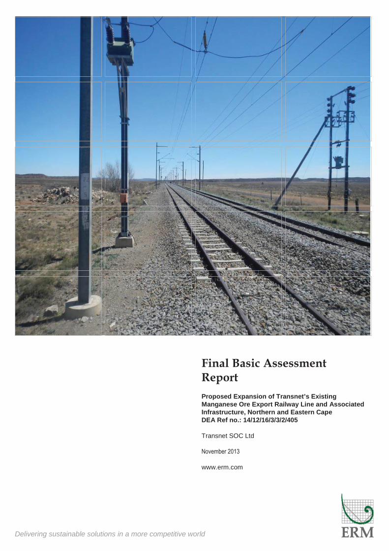
INTRODUCTION Transnet SOC (State Owned Company) Limited (hereafter referred to as Transnet) is proposing to expand the existing manganese ore railway line from Hotazel in the Northern Cape to the Port of Ngqura in the Eastern Cape. The growing demand for manganese ore, which forms part of Transnet’s Market Demand Strategy has resulted in the need to expand the capacity of the export corridor to 16 million tons per annum (Mtpa). The proposed expansion includes the following:
Extension of several existing rail loops in the Northern and Eastern Cape; and The installation of two new rail loops in the Northern Cape.
Please note, the construction of a new compilation yard (Mamathwane Compilation Yard), near Hotazel in the Northern Cape is also being proposed however a separate Scoping/EIA application process is being undertaken (DEA Ref. 14/12/16/3/3/2/688). In addition, an amendment process is required for proposed changes to upgrades that were already authorised in 2009 (DEA Ref no. 12/12/20/1240 and 12/12/20/1241). This includes two loops and a separation yard in the Northern Cape and four loops in the Eastern Cape. The previous authorisation allowed for these applications. However, these six loop extensions and the separation yard require longer lines than previously anticipated to accommodate the 16 Mtpa export capacity. PROJECT APPLICANT Transnet is a wholly state owned company in South Africa, which strives to enable competitiveness, growth and development of the South African economy by delivering reliable freight transport and handling services that satisfy customer demand. Transnet’s mandate is to assist in lowering the cost of doing business in South Africa, enabling economic growth and ensuring security of supply through providing appropriate port, rail and pipeline infrastructure in a cost-effective and efficient manner, within acceptable benchmarks (Transnet Sustainability Report, 2012). Transnet, operating as an integrated freight transport company, contains five operating divisions as follows:
4
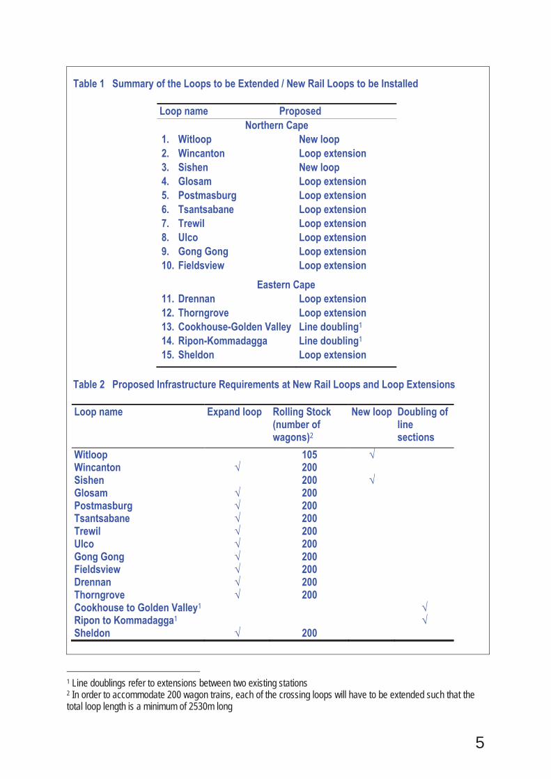
• Transnet Freight Rail (TFR), • Transnet Rail Engineering (TRE), • Transnet National Ports Authority (TNPA), • Transnet Port Terminals (TPT), and • Transnet Pipelines (TPL). The above divisions focus on the operational aspects of Transnet’s business and are supplemented by three specialist units including: Transnet Property; Transnet Foundation and Transnet Capital Projects. BACKGROUND TO THE PROJECT In South Africa the main concentration of manganese mines producing predominantly higher grade ores are in the Kalahari Manganese basin, around Hotazel in the Northern Cape. It is anticipated that the manganese industry will experience strong export demand in the coming years. Given the quality of the manganese ore reserves, South Africa is in a position to benefit from the projected growth in the manganese industry if constraints on the current transport logistics are addressed. In 2008 Transnet, in association with the manganese ore mining industry identified the need to increase the capacity of the export corridor beyond the current capacity of 5.5 Mtpa. An environmental authorisation process commenced in this regard and the project was authorised to proceed with construction in 2009. The project proposal on which this authorisation was issued was based on achieving an export capacity of 12 Mtpa. Subsequently Transnet, in conjunction with the manganese mining industry, has identified an export requirement of more than 12 Mtpa for long term growth. This growth will be primarily driven by increasing global steel manufacturing and a changing steel product mix to produce a greater percentage of higher grade steels, which in turn use higher grades of manganese ore. In addition, global supply of lower grade manganese ore by marginal producers, which are high on the cost curve, cannot profitably sustain the exports of their low grade ore. Based on the increased demand of manganese ore the mining industry has indicated the need for an increased export capacity of 16 Mtpa. As such, changes to the original development proposal necessitate additional environmental authorisation processes including this Basic Assessment (BA) process. PROPOSED PROJECT DESCRIPTION A BA process is required for the extension of existing rail loops / installation of new rail loops that were not part of the authorisation received in 2009. This includes ten rail loops in the Northern Cape and five in the Eastern Cape (see Table 1, Table 2 and Figure 1 below).
5
Table 1 Summary of the Loops to be Extended / New Rail Loops to be Installed
Loop name Proposed Northern Cape
1. Witloop New loop 2. Wincanton Loop extension 3. Sishen New loop 4. Glosam Loop extension 5. Postmasburg Loop extension 6. Tsantsabane Loop extension 7. Trewil Loop extension 8. Ulco Loop extension 9. Gong Gong Loop extension 10. Fieldsview Loop extension
Eastern Cape 11. Drennan Loop extension 12. Thorngrove Loop extension 13. Cookhouse-Golden Valley Line doubling1 14. Ripon-Kommadagga Line doubling1 15. Sheldon Loop extension
Table 2 Proposed Infrastructure Requirements at New Rail Loops and Loop Extensions
Loop name Expand loop Rolling Stock (number of wagons)2
New loop Doubling of line sections
Witloop 105 √ Wincanton √ 200 Sishen 200 √ Glosam √ 200 Postmasburg √ 200 Tsantsabane √ 200 Trewil √ 200 Ulco √ 200 Gong Gong √ 200 Fieldsview √ 200 Drennan √ 200 Thorngrove √ 200 Cookhouse to Golden Valley1 √ Ripon to Kommadagga1 √ Sheldon √ 200
1 Line doublings refer to extensions between two existing stations 2 In order to accommodate 200 wagon trains, each of the crossing loops will have to be extended such that the total loop length is a minimum of 2530m long
6
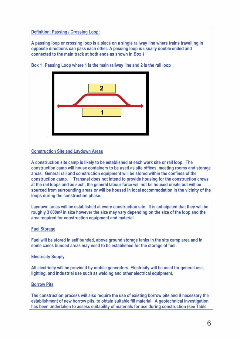
Definition: Passing / Crossing Loop:
A passing loop or crossing loop is a place on a single railway line where trains travelling in opposite directions can pass each other. A passing loop is usually double ended and connected to the main track at both ends as shown in Box 1. Box 1 Passing Loop where 1 is the main railway line and 2 is the rail loop
Construction Site and Laydown Areas A construction site camp is likely to be established at each work site or rail loop. The construction camp will house containers to be used as site offices, meeting rooms and storage areas. General rail and construction equipment will be stored within the confines of the construction camp. Transnet does not intend to provide housing for the construction crews at the rail loops and as such, the general labour force will not be housed onsite but will be sourced from surrounding areas or will be housed in local accommodation in the vicinity of the loops during the construction phase. Laydown areas will be established at every construction site. It is anticipated that they will be roughly 3 000m2 in size however the size may vary depending on the size of the loop and the area required for construction equipment and material. Fuel Storage Fuel will be stored in self bunded, above ground storage tanks in the site camp area and in some cases bunded areas may need to be established for the storage of fuel. Electricity Supply All electricity will be provided by mobile generators. Electricity will be used for general use, lighting, and industrial use such as welding and other electrical equipment. Borrow Pits The construction process will also require the use of existing borrow pits and if necessary the establishment of new borrow pits, to obtain suitable fill material. A geotechnical investigation has been undertaken to assess suitability of materials for use during construction (see Table
7
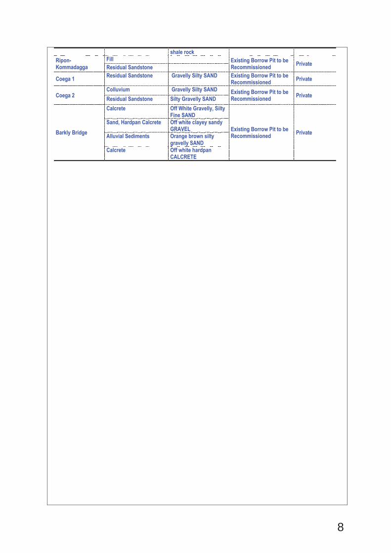
3, below). As an organ of state, Transnet is exempt from undertaking the full application process and is required to submit an EMP for the borrow pits. The EMP is currently being prepared for submission in terms of the Mineral and Petroleum Resources and Development Act, Act No. 28 of 2002 (MPRDA). A number of existing and new borrow pits will be utilised for both ballast and sub-base material during the construction period. An explanation of the different material types is presented in Table 3 below which also shows which borrow pits are new and which will be recommissioned. Table 3 List of Borrow Pits and Available Materials
Borrow Sites Material Type Description Status of Borrow Pit Land Owner
Witloop 1 Residual Calcrete Silty Sandy GRAVEL or Silty Gravelly SAND
Existing Borrow Pit to be Recommissioned Transnet
Witloop 2 Residual Calcrete (Depth 0.00 - 0.70 m)
Silty Gravelly SAND Existing Borrow Pit to be Recommissioned Private Residual Calcrete
(Depth 0.70 - 1.40 m) Silty Gravelly SAND
Wincanton 1 Residual Calcrete Silty Sandy GRAVEL New Borrow Pit Transnet
Wincanton 2 Residual Calcrete GRAVEL in a Silty Sandy Matrix New Borrow Pit Transnet
Postmasburg 1 Ferruginised Residual Dolomite
Silty Sandy GRAVEL or Silty Gravelly SAND New Borrow Pit Private
Postmasburg 2 Residual Dolomite Silty Sandy GRAVEL New Borrow Pit Private
Trewil 1 Residual Calcrete Silty Sandy GRAVEL or Silty Gravelly SAND
Existing Borrow Pit to be Recommissioned Transnet
Burgervilleweg Residual Mudstone Silty Gravelly SAND Existing Borrow Pit to be
Recommissioned Private Mudstone Very Soft Rock MUDSTONE
Linde Residual Mudstone Silty Clayey Sandy GRAVEL
Existing Borrow Pit to be Recommissioned Private
Rosmead
Residual Mudstone Silty Clayey Sandy GRAVEL Existing Borrow Pit to be
Recommissioned Private Residual Sandstone Silty Clayey Gravelly SAND or Silty Sandy GRAVEL
Knutsford
Residual Mudstone Clayey Gravely SAND
Existing Borrow Pit to be Recommissioned Private
Mudstone Very Soft Rock Mudstone (generally excavated as clayey sandy GRAVEL)
Drennan Residual Mudstone Silty Clayey Sandy GRAVEL
Existing Borrow Pit to be Recommissioned Private
Cookhouse - Golden Valley
Colluvium Silty Clayey SAND
Existing Borrow Pit to be Recommissioned Private
Residual Sandstone Silty Clayey SAND with Gravel
Residual Mudstone Silty Clayey Sandy GRAVEL
Mudstone Very Soft Rock Mudstone (generally excavated as clayey sandy GRAVEL)
Golden Valley
Residual Mudstone Bluish grey soft to at least medium hard rock MUDSTONE
Existing Borrow Pit to be Recommissioned Private Residual Mudstone Medium brown silty fine
sandy GRAVEL Residual Mudstone Bluish grey sandy fine
to coarse GRAVEL with fragments and lumps of
8
shale rock Ripon-Kommadagga
Fill Existing Borrow Pit to be Recommissioned Private Residual Sandstone
Coega 1 Residual Sandstone Gravelly Silty SAND Existing Borrow Pit to be Recommissioned Private
Coega 2 Colluvium Gravelly Silty SAND Existing Borrow Pit to be
Recommissioned Private Residual Sandstone Silty Gravelly SAND
Barkly Bridge
Calcrete Off White Gravelly, Silty Fine SAND
Existing Borrow Pit to be Recommissioned Private
Sand, Hardpan Calcrete Off white clayey sandy GRAVEL
Alluvial Sediments Orange brown silty gravelly SAND
Calcrete Off white hardpan CALCRETE
9
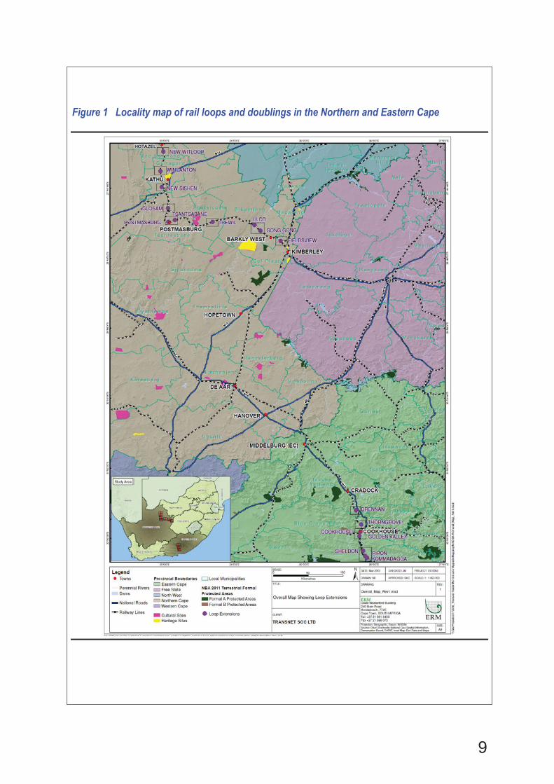
Figure 1 Locality map of rail loops and doublings in the Northern and Eastern Cape
10
Construction Phase Employment It is expected that the construction phase of all the loops will result in direct employment of approximately 12 170 employees with an estimated indirect employment figure of 9 120 people. This would include both skilled and unskilled workers. Skilled labourers will be required to operate machinery and equipment on site. Skilled artisans and supervisors will also be required. Unskilled workers will be used for manual labour tasks on-site. As far as possible, workers will be sourced locally to avoid the need for construction camps. However, it is recognised that skilled labour may need to be sourced further afield if skills are not available locally.
Operation Phase Employment The following types of personnel may be recruited for the operational phase of the project, as the capacity of the railway line is increased over time: administrators, yard masters, yard officials, yard foreman, sundry workers, section managers, chief shedmen, shed assistants, shedmen, train assistants, train control officers, service drivers, train drivers and general workers including unskilled labour. It is estimated that the proposed expansion of the railway line will result in approximately 570 employment opportunities. Associated Infrastructure Table 3 below provides a summary of the associated infrastructure anticipated at each site. In addition to the infrastructure included below, feeder lines will be installed within the rail reserve and substations upgraded to ensure electrification along the loop extensions and new loops. In addition, two new substations will be installed at Vlermuislaagte and Witloop along the railway line on Transnet owned land.
11
Table 3 Project components at each rail loop construction area Service
/Maintenance Road
Fencing Temporary Laydown Area
Level Crossing Crossing Loop Relay Room Expand single substation to double substation (3kV DC Upgrade)
Site Office
Postmasburg 1360m (South Side) 1050m (North Side)
Existing fence to be repositioned.
6000m2 *Level crossing to be relocated *New level crossing extension
2 x new lines parallel to existing main railway line.
2 x new relay rooms Upgrade not required Small site office (container) located near laydown area
Sishen 4m wide (+/- 2600m long)
Existing fence to be repositioned.
160m x 40m *Existing level crossing extension
New loop +/- 2700m long 2 x new relay rooms Upgrade required Small site office (container) located near laydown area
Drennan New public access roads (520m & 1348m long)
Existing fence to be repositioned.
158m x 15m & 200m x 18.5m
1 New level crossing Crossing loop extension (+/- 1450m long)
2 x new relay rooms Upgrade required Small site office (container) located near laydown area
Glosam Existing fence to be repositioned.
90m x 30m Crossing loop extension (+/- 1600m long)
2 x new relay room Upgrade required Small site office (container) located near laydown area
Wincanton New access and maintenance road
Existing fence to be repositioned.
100m x 25m 100m x 25m 80m x 40m
Crossing loop extension (+/- 1900m long)
1 x new relay room Upgrade required 50 x 25m
Witloop New service road 475m long
Existing fence to be repositioned.
100m x 50m
New loop +/- 1500m long 1 x new relay room Upgrade not required 50 x 25m
Tsantsabane New service road 1170m long
Existing fence to be repositioned.
6000m2 1 New level crossing Crossing loop extension (+/- 1200m long)
1 x new relay room Upgrade required Small site office (container) located near laydown area
Trewil Existing fence to be repositioned.
6000m2 1 New level crossing Crossing loop extension (+/- 1200m long)
1 x new relay room Upgrade not required Small site office (container) located near laydown area
Thorngrove 725m long gravel road extension 4m wide
Existing fence to be repositioned.
30m x 100m
1 New level crossing Crossing loop extension (+/- 1800m long)
2 x new relay rooms Upgrade not required Small site office (container) located near laydown area
Ulco New service road 1944m long
Existing fence to be repositioned.
200m x 30m 300m x 60m
Crossing loop extension (+/- 2400m long)
2 x new relay rooms Upgrade not required Small site office (container) located near laydown area
Gong Gong Existing fence to be repositioned.
150m x 35m Extend existing level crossing
Crossing loop extension (+/- 2600m long)
Upgrade not required Small site office (container) located near laydown area
Fieldsview Existing fence to be repositioned.
3000m2 (x2) New railway parallel to existing main line +/- 5000m long
2 x new relay rooms Upgrade required Small site office (container) located near laydown area
Ripon-Kommadagga
New service roads & deviated service roads
Existing fence to be repositioned.
30m x 100m (x3)
Extend 2 x existing level crossings
Doubling Line between Ripon & Kommadagga (+/- 5500m long)
1 x new relay room Upgrade not required Small site office (container) located near laydown area
Cookhouse –Golden Valley
Existing fence to be repositioned.
30m x 100m (x3)
Extend 3 x existing level crossings
Line extension between two stations ie between Cookhouse & Golden Valley (+/- 6600m long)
2 x new relay rooms Upgrade required Small site office (container) located near laydown area
Sheldon New service Road 1400m long
Existing fence to be repositioned.
3 hectares 4 new level crossings
Crossing loop extension (+/- 1500 m long)
Upgrade required Small site office (container) located near laydown area
12
b) Provide a detailed description of the listed activities associated with the project as
applied for Listed activity as described in GN R.544, 545 and 546
Description of project activity
GN544, 2010 - 11 (xi): The construction of infrastructure or structures covering 50 square metres or more within 32 metres of a watercourse.
The dimensions and location of rail loop extensions / rail doublings and their potential proximity to watercourses has been determined and assessed. The total area of infrastructure construction for the proposed expansion of existing rail loops / installation of new rail loops covers over 32km of railway line, in excess of 50 square metres. The Thorngrove loop extension will cross a drainage line which has ceased to flow. The Cookhouse-Golden Valley line doubling, Gong gong, Postmasburg and Sishen loop extensions cross drainage lines with a low ecological importance and sensitivity. The Sheldon, Trewil loop extensions cross drainage lines which will require an extension of culverts and the Ripon-Kommadagga line doubling also crosses drainage lines. Also see Appendix D7
GN544, 2010 - 13: The construction of facilities or infrastructure for the storage, or for the storage and handling, of a dangerous good, where such storage occurs in containers with a combined capacity of 80 but not exceeding 500 cubic metres.
Diesel storage with a combined capacity of 80 but not exceeding 500 cubic metres will be required. The combined total diesel storage required for the proposed project is anticipated to be approximately 375 cubic metres or roughly 25 cubic metres per loop.
GN544, 2010 - 18: Dredging, excavation, removal or moving of soil, sand, shells, shell grit, pebbles or rock from (i) a watercourse; (ii) the sea; (iii) the seashore; (iv) the littoral active zone, an estuary or a distance of 100 metres inland of the high-water mark of the sea or an estuary, whichever distance is the greater, but
The proposed railway line upgrades may require excavation and removal of soil within a watercourse and a Water Use Licence Application (WULA) is being undertaken for the proposed upgrades. The proposed rail upgrade is anticipated to result in moving of soil within watercourses associated with culvert extensions and construction at the following loops: Thorngrove, Cookhouse-Golden Valley, Gong
13
excluding where such infilling, depositing, dredging, excavation, removal or moving (i) is for maintenance purposes undertaken in accordance with a management plan agreed to by the relevant environmental authority; or (ii) occurs behind the development setback.
gong, Postmasburg, Sishen, Sheldon, Trewil and Ripon-Kommadagga. Also see Appendix D7
GN544, 2010 - 23ii: The transformation of undeveloped land to industrial use, outside an urban area bigger than 1 hectare.
Proposed railway line extensions are outside of urban areas and the areas affected will be incorporated into the railway reserve (the dimensions of the affected areas are outlined in this BA report). Approximately 25 ha of land will be incorporated into the existing rail reserve along the ore line between Hotazel and Kimberley and also between Cradock and Ngqura.
GN544, 2010 – 53: The expansion of railway lines, stations or shunting yards where there will be an increased development footprint excluding: (i) railway lines, shunting yards and railway stations in industrial complexes or zones; (ii) underground railway lines in mines; and (iii) additional railway lines within the reserve of an existing railway line.
The proposed activities comprise the extension of rail loops at various locations along the railway line from Hotazel to Port of Ngqura. The extensions will result in an increased development footprint outside of the existing rail reserve of approximately 53ha along the length of the line from Hotazel to Kimberley and Cradock to Ngqura.
GN546, 2010 – 12 (b): The clearance of an area of 300 square metres or more of vegetation where 75% or more of the vegetative cover constitutes indigenous vegetation.
a. Within any critically endangered or endangered ecosystem listed in terms of section 52 of the NEMBA or prior to the publication of such a list, within an area that has been identified as critically endangered in the National Spatial Biodiversity Assessment 2004;
b. Within critical biodiversity areas identified in bioregional plans.
Sites within the Eastern Cape are mostly within Critical Biodiversity Areas (CBAs), however, the CBAs are all designed as broad-scale corridors and not as a result of the known presence of significant biodiversity. Given the proximity of the development to the existing line, the project components would not contribute significantly to the disruption of landscape connectivity and ecological functioning of the CBAs. Overall, there are no highly sensitive features present at any of the sites which would pose a significant obstacle to the development of the project. The affected loops include Drennan, Thorngrove, Sheldon and Ripon-Kommadagga and the anticipated clearance is less than 2 ha of currently intact vegetation at the loops. Given that the existing railway line is already
14
present, the limited extent of the clearance would result in a minimal additional impact on the ecological functioning of the CBAs (see Appendix D1).
2. FEASIBLE AND REASONABLE ALTERNATIVES “alternatives”, in relation to a proposed activity, means different means of meeting the general purpose and requirements of the activity, which may include alternatives to— (a) the property on which or location where it is proposed to undertake the activity; (b) the type of activity to be undertaken; (c) the design or layout of the activity; (d) the technology to be used in the activity; (e) the operational aspects of the activity; and (f) the option of not implementing the activity. Describe alternatives that are considered in this application as required by Regulation 22(2)(h) of GN R.543. Alternatives should include a consideration of all possible means by which the purpose and need of the proposed activity (NOT PROJECT) could be accomplished in the specific instance taking account of the interest of the applicant in the activity. The no-go alternative must in all cases be included in the assessment phase as the baseline against which the impacts of the other alternatives are assessed. The determination of whether site or activity (including different processes, etc.) or both is appropriate needs to be informed by the specific circumstances of the activity and its environment. After receipt of this report the, competent authority may also request the applicant to assess additional alternatives that could possibly accomplish the purpose and need of the proposed activity if it is clear that realistic alternatives have not been considered to a reasonable extent. The identification of alternatives should be in line with the Integrated Environmental Assessment Guideline Series 11, published by the DEA in 2004. Should the alternatives include different locations and lay-outs, the co-ordinates of the different alternatives must be provided. The co-ordinates should be in degrees, minutes and seconds. The projection that must be used in all cases is the WGS84 spheroid in a national or local projection. a) Alternatives Strategic Alternatives The following strategic alternatives were originally considered by Transnet as part of their logistics studies for various export corridors:
The Port of Saldanha and the Port of Ngqura were investigated as alternative ports of export of manganese ore. The existing ore line to the Port of Saldanha is used extensively for iron ore transport and strategically it is considered preferable for manganese ore to be transported to the Port of Ngqura via the existing railway line.
The alternative to relocate the entire railway line from Sishen to De Aar, bypassing Kimberley, was also investigated and found to be unfeasible due to cost and environmental implications and risks.
15
A new second railway line was considered for the entire length of the line however, this option was not considered feasible at present due to cost, environmental considerations as well as significant geographic constraints such as deep or narrow valleys and numerous river crossings.
Process Alternatives Process alternatives are dictated by various aspects including but not limited to the operating conditions, throughput needs and design requirements and/or restrictions. The most optimal solution is found by limiting the extent of infrastructure and rolling stock investments required. This is achieved by optimising the processes i.e. streamlining activities and using an optimal train length. Shorter trains would result in increased train frequency and fleet size, with the latter carrying a significant capital cost. An increase in train frequency would require additional train slots in the overall schedule. The schedule would then slowly get more and more congested which would require additional loops to be extended or built to alleviate the problem, and the compilation yard would need to be of sufficient size to cope with the required consolidation and deconsolidation. This construction would carry a cost burden and potential environmental and social risks. The locations of loop extensions / rail loop doublings were therefore determined in the context of the whole rail system. In this, the configuration of the current system (length and location of the current loops) and the required future capacity are taken into account. In optimising the system solution for minimal total impact, the first consideration for location of loops was to extend where current loops are available. Extending current loops has a much lesser impact than constructing a full new loop. The second consideration was to optimise the total mainline system, thus understanding what the minimum number and length of lines are that will accommodate the required volume and train specification required, as discussed above.
16
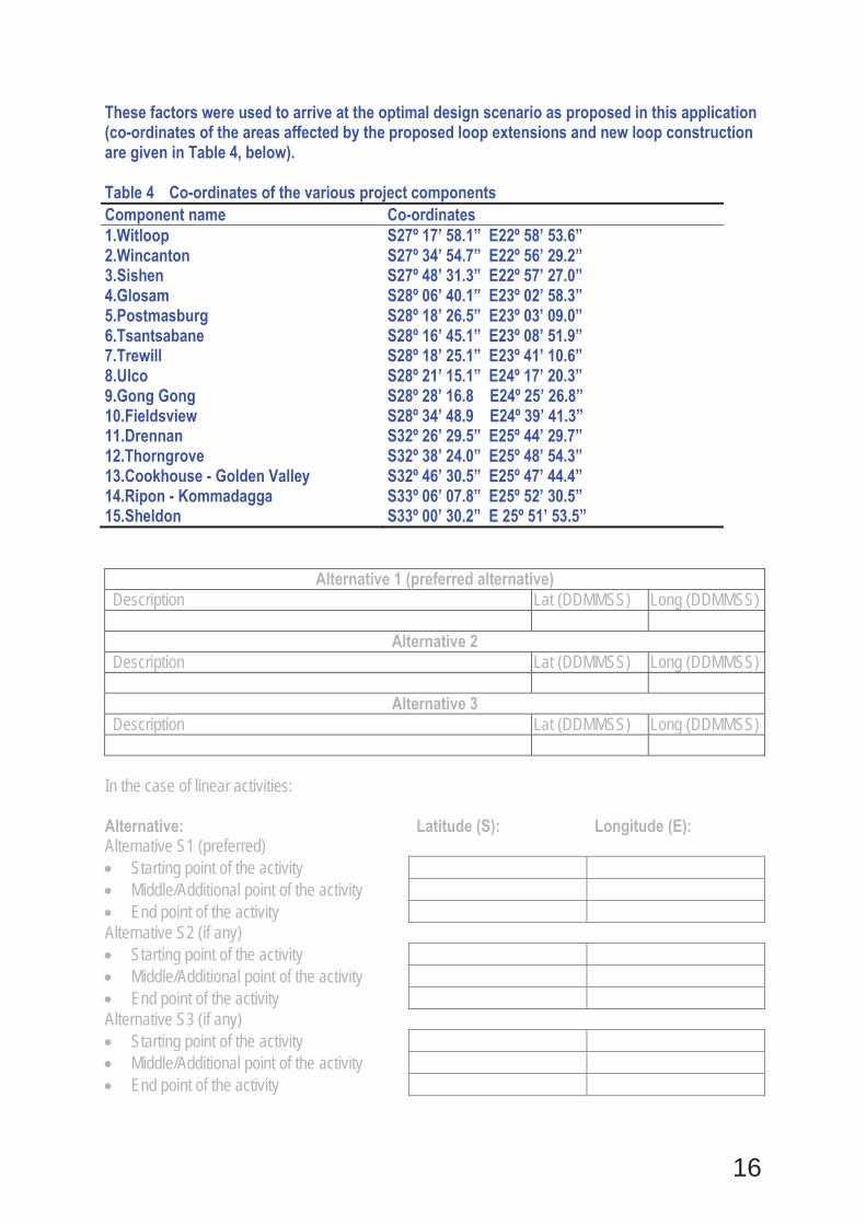
These factors were used to arrive at the optimal design scenario as proposed in this application (co-ordinates of the areas affected by the proposed loop extensions and new loop construction are given in Table 4, below). Table 4 Co-ordinates of the various project components Component name Co-ordinates 1.Witloop S27º 17’ 58.1” E22º 58’ 53.6” 2.Wincanton S27º 34’ 54.7” E22º 56’ 29.2” 3.Sishen S27º 48’ 31.3” E22º 57’ 27.0” 4.Glosam S28º 06’ 40.1” E23º 02’ 58.3” 5.Postmasburg S28º 18’ 26.5” E23º 03’ 09.0” 6.Tsantsabane S28º 16’ 45.1” E23º 08’ 51.9” 7.Trewill S28º 18’ 25.1” E23º 41’ 10.6” 8.Ulco S28º 21’ 15.1” E24º 17’ 20.3” 9.Gong Gong S28º 28’ 16.8 E24º 25’ 26.8” 10.Fieldsview S28º 34’ 48.9 E24º 39’ 41.3” 11.Drennan S32º 26’ 29.5” E25º 44’ 29.7” 12.Thorngrove S32º 38’ 24.0” E25º 48’ 54.3” 13.Cookhouse - Golden Valley S32º 46’ 30.5” E25º 47’ 44.4” 14.Ripon - Kommadagga S33º 06’ 07.8” E25º 52’ 30.5” 15.Sheldon S33º 00’ 30.2” E 25º 51’ 53.5”
Alternative 1 (preferred alternative) Description Lat (DDMMSS) Long (DDMMSS)
Alternative 2 Description Lat (DDMMSS) Long (DDMMSS)
Alternative 3 Description Lat (DDMMSS) Long (DDMMSS)
In the case of linear activities: Alternative: Latitude (S): Longitude (E): Alternative S1 (preferred)
Starting point of the activity Middle/Additional point of the activity End point of the activity
Alternative S2 (if any) Starting point of the activity Middle/Additional point of the activity End point of the activity
Alternative S3 (if any) Starting point of the activity Middle/Additional point of the activity End point of the activity

17
For route alternatives that are longer than 500m, please provide an addendum with co-ordinates taken every 250 meters along the route for each alternative alignment. In the case of an area being under application, please provide the co-ordinates of the corners of the site as indicated on the lay-out map provided in Appendix A. b) Lay-out alternatives
Alternative 1 (preferred alternative) Description Lat (DDMMSS) Long (DDMMSS)
Alternative 2 Description Lat (DDMMSS) Long (DDMMSS)
Alternative 3 Description Lat (DDMMSS) Long (DDMMSS)
c) Technology alternatives
Alternative 1 (preferred alternative)
Alternative 2
Alternative 3 d) Other alternatives (e.g. scheduling, demand, input, scale and design alternatives) Demand Alternatives Demand is driven by the international and local markets. As such the latest forecasted demand data was evaluated. This was done for an increase in demand for manganese ore from the current two trains per day to six trains per day. Following this evaluation, various scenarios for capacity increases over time were developed. These are subject to change as markets change. The current predicted demand growth requires an upgrade of the existing railway line to accommodate an export capacity of 16 Mtpa which requires the extension of 12 loops and installation of 2 new loops. The combination of loops was chosen such that minimal additional loops would be required as capacity demands increase. Activity Alternatives Activity alternatives relate to providing alternative ways of achieving the same objectives. In this project, the objective is to increase the export capacity. An activity alternative would, therefore, relate to transportation of goods by road, rather than rail. Assessing the potential for road transport would need to involve other role players and government and would require considerable input and investigation, owing to the large geographic scale of the study area and the volumes of goods that need to be transported. There are a number of advantages and disadvantages to road transport which include the following:
18
Advantages - include opportunities for small entrepreneurs / road transport contractors to benefit from the associated employment and economic opportunities Disadvantages - include the impact on the public in terms of road infrastructure maintenance, vehicle congestion, vehicle emissions and road safety; accessibility and extent of major road networks; and the cost of transport by road.
It is generally recognised that rail is the preferred mode of transport for bulk export of ore given the bulk volumes requiring transport. Material Alternatives Due to the specialised nature of the material required for a project of this nature there are limited opportunities for considering material alternatives. Material requirements are dictated by axle loads and design requirements so as to safely operate a railway service of this nature.
Alternative 1 (preferred alternative)
Alternative 2
Alternative 3 e) No-go alternative Should the proposed rail loops and associated infrastructure not be constructed then an increase in container and commodity capacity on the railway line between the Port of Ngqura and Hotazel will not be possible. This would have serious implications for South Africa’s manganese mining and container handling sectors and would affect the country’s export capabilities. This suggests direct negative consequences for the provincial and national economy associated with no additional revenue generation, no increase in export tax generation or economic stimulation. Local effects would be related to a lack of stimulation in terms of employment and opportunities for small and medium enterprises, which would benefit from the proposed development.
Paragraphs 3 – 13 below should be completed for each alternative. 3. PHYSICAL SIZE OF THE ACTIVITY
a) Indicate the physical size of the preferred activity/technology as well as alternative activities/technologies (footprints):
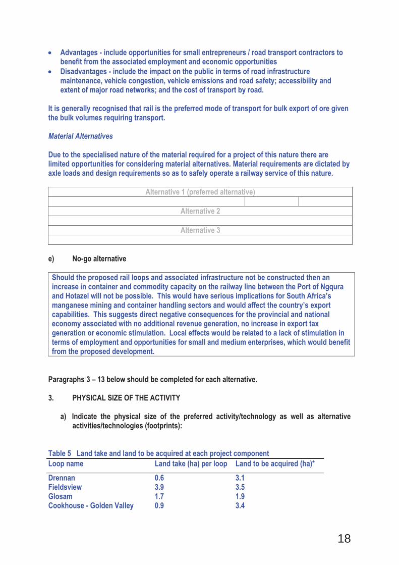
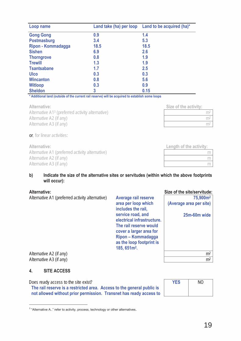
Table 5 Land take and land to be acquired at each project component Loop name Land take (ha) per loop Land to be acquired (ha)*
Drennan 0.6 3.1 Fieldsview 3.9 3.5 Glosam 1.7 1.9 Cookhouse - Golden Valley 0.9 3.4
19
Loop name Land take (ha) per loop Land to be acquired (ha)*
Gong Gong 0.9 1.4 Postmasburg 3.4 5.3 Ripon - Kommadagga 18.5 18.5 Sishen 6.9 2.6 Thorngrove 0.8 1.9 Trewill 1.3 1.9 Tsantsabane 1.7 2.5 Ulco 0.3 0.3 Wincanton 0.8 5.6 Witloop 0.3 0.9 Sheldon 3 0.15 * Additional land (outside of the current rail reserve) will be acquired to establish some loops Alternative: Size of the activity: Alternative A13 (preferred activity alternative) m2 Alternative A2 (if any) m2 Alternative A3 (if any) m2 or, for linear activities: Alternative: Length of the activity: Alternative A1 (preferred activity alternative) m Alternative A2 (if any) m Alternative A3 (if any) m b) Indicate the size of the alternative sites or servitudes (within which the above footprints
will occur): Alternative: Size of the site/servitude: Alternative A1 (preferred activity alternative) Average rail reserve
area per loop which includes the rail, service road, and electrical infrastructure. The rail reserve would cover a larger area for Ripon – Kommadagga as the loop footprint is 185, 651m2.
75,900m2
(Average area per site)
25m-60m wide
Alternative A2 (if any) m2 Alternative A3 (if any) m2 4. SITE ACCESS Does ready access to the site exist?
The rail reserve is a restricted area. Access to the general public is not allowed without prior permission. Transnet has ready access to
YES NO
3 “Alternative A..” refer to activity, process, technology or other alternatives.
20
the rail reserve including site offices, operational and maintenance buildings and stations. Construction teams may need to cross private land to undertake some construction activities. This access will be agreed to with the relevant landowner prior to access. New maintenance and service roads are proposed to cater for the general upgrading of the railway line. Access roads will be encompassed into the rail reserve.
If NO, what is the distance over which a new access road will be built m Describe the type of access road planned:
Include the position of the access road on the site plan and required map, as well as an indication of the road in relation to the site. 5. LOCALITY MAP An A3 locality map must be attached to the back of this document, as Appendix A. The scale of the locality map must be relevant to the size of the development (at least 1:50 000. For linear activities of more than 25 kilometres, a smaller scale e.g. 1:250 000 can be used. The scale must be indicated on the map.). The map must indicate the following:
an accurate indication of the project site position as well as the positions of the alternative sites, if any; indication of all the alternatives identified; closest town(s;) road access from all major roads in the area; road names or numbers of all major roads as well as the roads that provide access to the site(s); all roads within a 1km radius of the site or alternative sites; and a north arrow; a legend; and locality GPS co-ordinates (Indicate the position of the activity using the latitude and longitude of the centre point of the site for each alternative site. The co-ordinates should be in degrees and decimal minutes. The minutes should have at least three decimals to ensure adequate accuracy. The projection that must be used in all cases is the WGS84 spheroid in a national or local projection).
6. LAYOUT/ROUTE PLAN A detailed site or route plan(s) must be prepared for each alternative site or alternative activity. It must be attached as Appendix A to this document. The site or route plans must indicate the following:
the property boundaries and numbers of all the properties within 50 metres of the site; the current land use as well as the land use zoning of the site; the current land use as well as the land use zoning each of the properties adjoining the site or sites; the exact position of each listed activity applied for (including alternatives); servitude(s) indicating the purpose of the servitude; a legend; and
21
a north arrow. 7. SENSITIVITY MAP The layout/route plan as indicated above must be overlain with a sensitivity map that indicates all the sensitive areas associated with the site, including, but not limited to:
watercourses; the 1:100 year flood line (where available or where it is required by DWA); ridges; cultural and historical features; areas with indigenous vegetation (even if it is degraded or infested with alien species); and critical biodiversity areas.
The sensitivity map must also cover areas within 100m of the site and must be attached in Appendix A. 8. SITE PHOTOGRAPHS Colour photographs from the centre of the site must be taken in at least the eight major compass directions with a description of each photograph. Photographs must be attached under Appendix B to this report. It must be supplemented with additional photographs of relevant features on the site, if applicable. 9. FACILITY ILLUSTRATION A detailed illustration of the activity must be provided at a scale of at least 1:200 as Appendix C for activities that include structures. The illustrations must be to scale and must represent a realistic image of the planned activity. The illustration must give a representative view of the activity. 10. ACTIVITY MOTIVATION Motivate and explain the need and desirability of the activity (including demand for the activity): 1. Is the activity permitted in terms of the property’s existing
land use rights? YES NO Please explain
The site is currently zoned for industrial use therefore the activity is permitted. However, where additional land is to be acquired for the proposed new loops, loop extensions and rail doublings the relevant land acquisition processes will be undertaken and Transnet will be engaging with landowners in this regard.
22
2. Will the activity be in line with the following? (a) Provincial Spatial Development Framework (PSDF) YES NO Please explain
Eastern Cape: Strategic Rail Infrastructure The upgrading of the Hotazel to Port of Ngqura railway line is being undertaken by Transnet to increase rail capacity and this would, amongst others, ensure the effective use of the Coega IDZ development. This and other dedicated lines are also essential for developing good linkages between Ngqura and the main mineral producing areas of South Africa in the Northern Cape and the Free State. The improvement of rail links will reinforce the important role the region’s harbours play as a transit point for mineral exports. Northern Cape: The bulk of the Northern Cape’s primary agricultural and mineral produce is generated in localities distant from markets and points of export. The province’s ability to effectively and efficiently convey goods by both road and rail is crucial for the further economic development of the province. There is, therefore, a need for a clear freight strategy that will ensure that goods are efficiently transported to the various markets (PGDS, July 2011). The cost and availability of suitable transport systems remains one of the major factors inhibiting the further development of the Northern Cape mining industry. It affects both the expansion of the iron and manganese mines as well as the development of new mines. It is proposed that the Provincial Government take the responsibility to ensure that all stakeholders continue to work together to enhance logistics for minerals development, for example, through the upgrading of the iron ore and manganese export railway lines. Provincial Government should also ensure that its regional development plans take cognisance of the potential demand for transport infrastructure to facilitate the development of new mineral operations (Northern Cape PSDF, July 2012).
(b) Urban edge / Edge of Built environment for the area YES NO Please explain Most of the railway line and the loops are outside of the urban edge, save for Postmasburg and Cookhouse and Golden Valley loops, however the new loops and loop extensions are within and adjacent to the existing manganese ore line rail reserve (or within the rail corridor).

23
(c) Integrated Development Plan (IDP) and Spatial Development Framework (SDF) of the Local Municipality (e.g. would the approval of this application compromise the integrity of the existing approved and credible municipal IDP and SDF?).
YES NO Please explain
The proposed new loops, loop extensions and rail loop doublings (and associated infrastructure including feeder lines and substations) would not compromise the integrity of the IDPs in the various local municipalities as the rail infrastructure is an important infrastructural component in terms of job creation (rail operations and mining) which is key in both the Northern and Eastern Cape. The proposed new loops and expansions will contribute toward job creation both in the construction and the operational phases of the development. The challenge will be in sourcing sufficiently skilled workers locally. In terms of the spatial development framework, the rail way line which has been in existence for decades is deemed to be part and parcel of the landscape and planning of new developments would consider the railway line as such.
(d) Approved Structure Plan of the Municipality YES NO Please explain The relevant municipalities do not have Structure Plans in place.
(e) An Environmental Management Framework (EMF) adopted by the Department (e.g. Would the approval of this application compromise the integrity of the existing environmental management priorities for the area and if so, can it be justified in terms of sustainability considerations?)
YES NO Please explain
EMFs have not been adopted for the municipalities under consideration. In terms of compromising any other environmental management priorities, this is not anticipated as the proposed loop extensions are adjacent to the existing railway line and will be undertaken in consultation with an ecological specialist, landowners, relevant commenting authorities and other stakeholders and should any environmental resource conflicts arise, this will be addressed timeously.
(f) Any other Plans (e.g. Guide Plan) YES NO Please explain Not applicable as the scale of the project falls outside the ambit of any Guide Plans. 3. Is the land use (associated with the activity being applied for)
considered within the timeframe intended by the existing approved SDF agreed to by the relevant environmental authority (i.e. is the proposed development in line with the projects and programmes identified as priorities within the credible IDP)?
YES NO Please explain
The land use is currently zoned mainly for agricultural use and the project aims to acquire land which is currently zoned for agricultural use. In terms of Section 7 of the Legal Succession to the South African Transport Services Act, 1989 read with the Sub-Division of Agricultural Land Act, 1970, Transnet would not need to follow a process of rezoning. A change in land use would then be required for relatively small tracts of land along the existing railway line.
24
4. Does the community/area need the activity and the associated land use concerned (is it a societal priority)? (This refers to the strategic as well as local level (e.g. development is a national priority, but within a specific local context it could be inappropriate.)
YES NO Please explain
The proposed loop extensions, new loops and rail loop doublings are considered to be a national priority as they will accommodate the increased export of manganese ore. Given that the railway line is existing and that the existing infrastructure will merely be expanded it is not deemed to be inappropriate within the local context. 5. Are the necessary services with adequate capacity currently
available (at the time of application), or must additional capacity be created to cater for the development? (Confirmation by the relevant Municipality in this regard must be attached to the final Basic Assessment Report as Appendix I.)
YES NO Please explain
Transnet will cater for most of the services required for the proposed expansion, which includes water, electricity and roads. Effluent, solid waste disposal and some of the water requirements will be accommodated by various municipalities. Service confirmation request letters are attached in Appendix J. 6. Is this development provided for in the infrastructure
planning of the municipality, and if not what will the implication be on the infrastructure planning of the municipality (priority and placement of services and opportunity costs)? (Comment by the relevant Municipality in this regard must be attached to the final Basic Assessment Report as Appendix I.)
YES NO Please explain
The existing manganese ore railway line is provided for in the infrastructure planning of the municipalities and the proposed upgrade will feed into the relevant plans of the various municipalities. The existing railway line is therefore mentioned and depicted in the relevant planning documents and then these documents. It should also be noted that the project is in line with the Provincial Growth Strategy in terms of its contribution to the provincial economy. 7. Is this project part of a national programme to address an
issue of national concern or importance? YES NO Please explain
The National Planning Commission’s vision states “one way to reduce these [logistics] costs is to invest in inter-linked rail and port infrastructure, supported by road.” The proposed upgrade fits with this strategy and is aimed at ensuring that the manganese industry is not constrained by transport logistics and costs associated with transporting manganese ore from the mines to port. This project and similar projects are incorporated into ‘the Transnet Long Term Planning Framework, which forms an important part of a national planning process.” http://www.npconline.co.za/pebble.asp?relid=23
25
8. Do location factors favour this land use (associated with the activity applied for) at this place? (This relates to the contextualisation of the proposed land use on this site within its broader context.)
YES NO Please explain
The proposed new rail loops, loop extensions and rail doublings are in line with the current land use and context of the sites as the proposed project is an extension of the existing railway line. 9. Is the development the best practicable environmental option
for this land/site? YES NO Please explain
The bulk of the activities will be undertaken within the existing rail reserve with an additional 45ha to be acquired along the existing railway line for the proposed new loops and loop extensions. Although potential impacts are envisaged, as discussed in this BA these do not pose any fatal flaws and can reasonably be managed by the mitigation measures outlined in this report. 10. Will the benefits of the proposed land use/development
outweigh the negative impacts of it? YES NO Please explain
The economic and socio-economic benefits outweigh the negative impacts thereof, particularly as the project is largely an expansion of an existing development. 11. Will the proposed land use/development set a precedent for
similar activities in the area (local municipality)? YES NO Please explain
The Transnet manganese ore line is a well-established railway line that has been operational for a number of years and provides a service which Transnet has the mandate to fulfil. 12. Will any person’s rights be negatively affected by the
proposed activity/ies? YES NO Please explain
A thorough stakeholder engagement process will be undertaken to ensure that no person’s rights are negatively affected by the process. Directly affected landowners will specifically be consulted in this regard in addition to surrounding communities and local authorities. 13. Will the proposed activity/ies compromise the “urban edge”
as defined by the local municipality? YES NO Please explain
The proposed project is confined to the immediate vicinity of the existing railway corridor and therefore will not compromise the “urban edge”.
26
14. Will the proposed activity/ies contribute to any of the 17 Strategic Integrated Projects (SIPS)? YES NO Please explain
The upgrade of transport infrastructure including freight rail is regarded as a key enabler to contribute toward the realisation of some of the 17 Strategic Integrated Projects. The Manganese Ore Freight line is one of many corridors which can “support economic development and trade whilst simultaneously addressing the needs of the poor”. This project forms part of SIP 3: South Eastern node and corridor development. Summary of the SiP is as follows: Promote rural development through a new dam at Umzimvubu with irrigation systems and the N2- Wildcoast Highway which improves access into KZN and national supply chains; strengthen economic development in PE through a manganese rail capacity from N Cape, a manganese sinter (NC) and smelter (EC); possible Mthombo refinery (Coega) and trans-shipment hub at Ngqura and port and rail upgrades to improve industrial capacity and performance of the automotive sector.
(Provincial and Local Government Conference A summary of the Infrastructure Plan (April 2012), Presidential Infrastructure Coordinating Commission) 15. What will the benefits be to society in general and to the local
communities? Please explain
Benefits in terms of job creation and training can be realised through the project for local communities. However, the majority of new jobs will be temporary during the construction phase. 16. Any other need and desirability considerations related to the proposed
activity? Please explain
The overall need and desirability is that of a national and provincial one to ensure that mining companies are able to export their commodities thereby ensuring economic growth. 17. How does the project fit into the National Development Plan for 2030? Please explain
One of the key policy and planning priorities according to the National Development Plan for 2030 is the strengthening and optimisation of freight corridors. The greater part of South Africa’s bulk freight moves on the existing national road and rail networks:
From mines to ports or processing plants: From farms to cities; and From the coast to the Highveld.
Planning should prioritise improving the capacity, efficiency and sustainability of these corridors. South Africa is a transport-intensive economy, with comparative advantages in resources rapidly eroded by high transport costs. Increasing the capacity of the main corridors and simultaneously improving the performance of the ports and inland terminals is a priority. In the short term, South Africa’s mineral sector has a greater ability to drive higher rates of growth than other sectors in the economy, provided that infrastructure bottlenecks and regulatory uncertainties are removed. Limited capacity on existing rail lines moving mineral commodities, particularly coal, manganese and iron ore is stifling growth.
27
18. Please describe how the general objectives of Integrated Environmental Management as set out in section 23 of NEMA have been taken into account.
An Integrated Environmental Management (IEM) approach has been adopted for the BA including the compilation of this report, which includes:
Adequate consideration of the effects of the activity on the environment. Procedures for the investigation, assessment and communication of the potential impact of activities were followed with specialist input, as required. An adequate public participation process will be followed including notification through newspaper adverts, written notification, focus group meeting and public meetings. Actual and potential impacts on the environment, socio-economic conditions and cultural heritage have been assessed and associated mitigation measures have been outlined in this BA Report. These mitigation measures are aimed at enhancing benefits of the projects, and decreasing negative impacts of the project.
Other objectives of IEM that have been taken into account include the consideration of risk, consequences and alternatives.
28
19. Please describe how the principles of environmental management as set out in section 2 of NEMA have been taken into account.
The approach to the BA process has been structured to ensure the principles as set out in Section 2 of NEMA are taken in account including: Environmental resources must serve the public interest
The proposed project would serve to expand the existing manganese ore export railway line to ensure Transnet provides the necessary infrastructure capacity to support the manganese industry in meeting strong export demand in the coming years in a cost effective manner.
Sustainable development
Integration of environmental, social and economic components has been taken into account throughout this report.
Pollution and degradation of the environment The pollution and degradation of the environment will be avoided as far as possible, or, where this cannot be altogether avoided, minimised and remedied. Transnet has strict environmental management policies which will be implemented throughout the construction and operational phases of the development. Applicable mitigation measures are outlined in this report.
Environmental management must be integrated
An integrated environmental approach has been applied throughout the application, by assessing any potential negative impacts such as biological, cultural and socio-economic impacts. The environment was considered holistically in the assessment of the impacts (i.e. social, environmental and economic considerations were considered throughout the impact assessment). Public participation and stakeholder engagement processes have and will continue to be conducted throughout the process including placements of adverts in local/regional newspapers, placement of site notices and distribution of a background information document (BID) and this report. Public and focus group meetings (with directly affected landowners) are proposed in order to provide stakeholders an opportunity to be involved in the process. These meetings will be facilitated in English and Afrikaans and will be translated into Tswana/Xhosa.
29
11. APPLICABLE LEGISLATION, POLICIES AND/OR GUIDELINES List all legislation, policies and/or guidelines of any sphere of government that are applicable to the application as contemplated in the EIA regulations, if applicable: Title of legislation, policy or guideline
Applicability to the project Administering authority
Date
National Environmental Management Act (Act No. 107 of 1998), as amended
This is applicable for any potential environmental impacts and principles to be taken into account.
Department of Environmental Affairs
1998
NEMA EIA Regulations 2010
This is applicable for any potential environmental impacts and the associated listed activities that are relevant to the proposed development.
Department of Environmental Affairs
2010
National Environmental Management: Biodiversity Act (Act 10 of 2004)
Rare or protected species may be affected during construction. Chapter 4, Part 2 of the Act lists species that are threatened or require protection to ensure their survival in the wild, while regulating the activities, , which may involve such listed threatened or protected species and activities which may have a potential impact on their long-term survival. The Act has listed flora and fauna species. Disturbance/restricted activities as defined by the Act, requires approval from DEA as specified in Chapter 7. The Act also lists ecosystems that have a bearing on proposed developments.
Department of Environmental Affairs
2004
Conservation of Agricultural Resources Act (Act No. 43 of 1983)
Potential impact on agricultural resources through loop construction or expansion. In terms of the amendments to the regulations under CARA, landowners are legally responsible for the control of alien species on their properties. This has relevance to the project as Transnet will
Department of Agriculture
1983
30
have to ensure that weeds and alien invasive species are removed from the rail reserve during construction and that the spread of these species is controlled and managed during construction and operations.
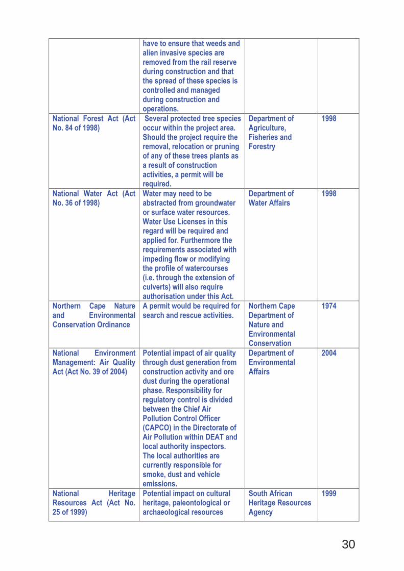
National Forest Act (Act No. 84 of 1998)
Several protected tree species occur within the project area. Should the project require the removal, relocation or pruning of any of these trees plants as a result of construction activities, a permit will be required.
Department of Agriculture, Fisheries and Forestry
1998
National Water Act (Act No. 36 of 1998)
Water may need to be abstracted from groundwater or surface water resources. Water Use Licenses in this regard will be required and applied for. Furthermore the requirements associated with impeding flow or modifying the profile of watercourses (i.e. through the extension of culverts) will also require authorisation under this Act.
Department of Water Affairs
1998
Northern Cape Nature and Environmental Conservation Ordinance
A permit would be required for search and rescue activities.
Northern Cape Department of Nature and Environmental Conservation
1974
National Environment Management: Air Quality Act (Act No. 39 of 2004)
Potential impact of air quality through dust generation from construction activity and ore dust during the operational phase. Responsibility for regulatory control is divided between the Chief Air Pollution Control Officer (CAPCO) in the Directorate of Air Pollution within DEAT and local authority inspectors. The local authorities are currently responsible for smoke, dust and vehicle emissions.
Department of Environmental Affairs
2004
National Heritage Resources Act (Act No. 25 of 1999)
Potential impact on cultural heritage, paleontological or archaeological resources
South African Heritage Resources Agency
1999
31
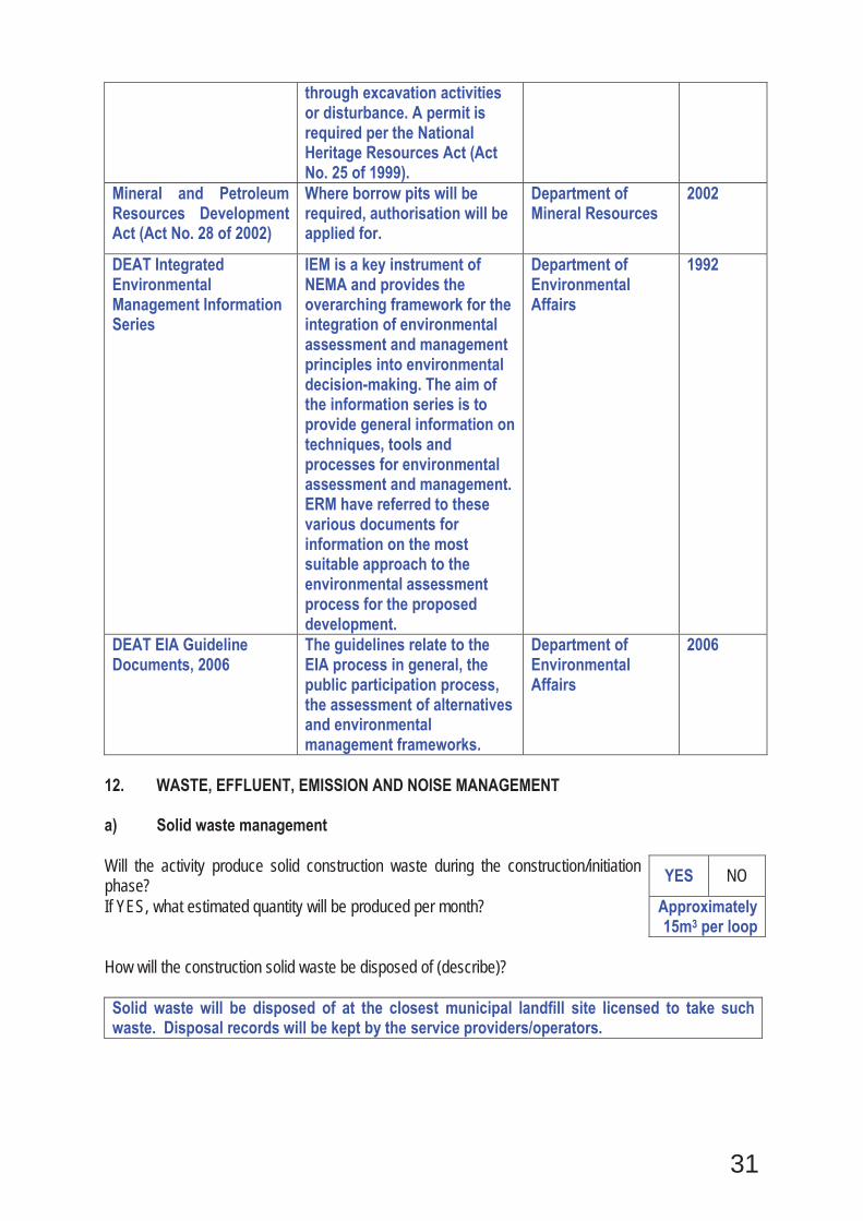
through excavation activities or disturbance. A permit is required per the National Heritage Resources Act (Act No. 25 of 1999).
Mineral and Petroleum Resources Development Act (Act No. 28 of 2002)
Where borrow pits will be required, authorisation will be applied for.
Department of Mineral Resources
2002
DEAT Integrated Environmental Management Information Series
IEM is a key instrument of NEMA and provides the overarching framework for the integration of environmental assessment and management principles into environmental decision-making. The aim of the information series is to provide general information on techniques, tools and processes for environmental assessment and management. ERM have referred to these various documents for information on the most suitable approach to the environmental assessment process for the proposed development.
Department of Environmental Affairs
1992
DEAT EIA Guideline Documents, 2006
The guidelines relate to the EIA process in general, the public participation process, the assessment of alternatives and environmental management frameworks.
Department of Environmental Affairs
2006
12. WASTE, EFFLUENT, EMISSION AND NOISE MANAGEMENT a) Solid waste management Will the activity produce solid construction waste during the construction/initiation phase? YES NO
If YES, what estimated quantity will be produced per month? Approximately 15m3 per loop
How will the construction solid waste be disposed of (describe)? Solid waste will be disposed of at the closest municipal landfill site licensed to take such waste. Disposal records will be kept by the service providers/operators.
32
Where will the construction solid waste be disposed of (describe)? Construction solid waste will be disposed of at licensed landfill sites. The local and district municipalities were approached during the Draft BAR commenting period to determine capacity levels and permission at the appropriate waste disposal sites in the vicinity of the various loops and given the limited extent of solid waste, capacity constraints have not been encountered.
Will the activity produce solid waste during its operational phase? YES NO If YES, what estimated quantity will be produced per month? m3 How will the solid waste be disposed of (describe)?
If the solid waste will be disposed of into a municipal waste stream, indicate which registered landfill site will be used.
Where will the solid waste be disposed of if it does not feed into a municipal waste stream (describe)?
If the solid waste (construction or operational phases) will not be disposed of in a registered landfill site or be taken up in a municipal waste stream, then the applicant should consult with the competent authority to determine whether it is necessary to change to an application for scoping and EIA. Can any part of the solid waste be classified as hazardous in terms of the NEM:WA? YES NO If YES, inform the competent authority and request a change to an application for scoping and EIA. An application for a waste permit in terms of the NEM:WA must also be submitted with this application. Is the activity that is being applied for a solid waste handling or treatment facility? YES NO If YES, then the applicant should consult with the competent authority to determine whether it is necessary to change to an application for scoping and EIA. An application for a waste permit in terms of the NEM:WA must also be submitted with this application. b) Liquid effluent Will the activity produce effluent, other than normal sewage, that will be disposed of in a municipal sewage system? YES NO
If YES, what estimated quantity will be produced per month? The volume of effluent specified will originate from the chemical toilets during the construction phase only. No effluent will be generated during the operational phase.
+/-10 m3
Will the activity produce any effluent that will be treated and/or disposed of on site? YES NO If YES, the applicant should consult with the competent authority to determine whether it is necessary to change to an application for scoping and EIA.
Will the activity produce effluent that will be treated and/or disposed of at another facility? The operation of the railway line will not produce effluent.
YES NO
If YES, provide the particulars of the facility: Facility name: Contact person:

33
Postal address:
Postal code: Telephone: Cell: E-mail: Fax: Describe the measures that will be taken to ensure the optimal reuse or recycling of waste water, if any: Not applicable
c) Emissions into the atmosphere Will the activity release emissions into the atmosphere other than exhaust emissions and dust associated with construction phase activities? The manganese ore is transported in open freight carts. The ore is sprayed with water before leaving the mines to suppress dust. As the ore dries on route and agitation between ore chunks occurs the potential exists for manganese dust to be generated and result in potential impacts in the ambient environment. However, previous studies have shown that the effect of manganese ore dust deposition is limited to the area immediately adjacent to the railway line only and that within 50m the concentrations of manganese ore in the soil are within natural limits. Generally the areas immediately alongside the freight line are uninhabited or very sparsely populated. Considering this and the localised nature of the deposition, the significance of the impact associated with manganese ore dust being liberated from the freight cars was considered to be negligible.
YES NO
If YES, is it controlled by any legislation of any sphere of government? South African ambient air quality standards (DEAT, 2007) for particulate matter and the World Health Organisation ambient air quality guidelines for manganese (WHO, 2000) are used as benchmarks to assess whether ambient concentrations of particulates and manganese pose a risk to human health. Information on background concentrations of manganese in soil (ASTDR, 2000) are also used are used to inform the assessment of any deviation from typical conditions. The proposed activity will not require an air emissions licence application however the potential impact has been assessed in the impact assessment section.
YES NO
If YES, the applicant must consult with the competent authority to determine whether it is necessary to change to an application for scoping and EIA. If NO, describe the emissions in terms of type and concentration:
d) Waste permit Will any aspect of the activity produce waste that will require a waste permit in terms of the NEM:WA? YES NO If YES, please submit evidence that an application for a waste permit has been submitted to the competent authority
34
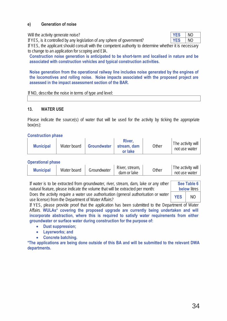
e) Generation of noise Will the activity generate noise? YES NO If YES, is it controlled by any legislation of any sphere of government? YES NO If YES, the applicant should consult with the competent authority to determine whether it is necessary to change to an application for scoping and EIA. Construction noise generation is anticipated to be short-term and localised in nature and be associated with construction vehicles and typical construction activities. Noise generation from the operational railway line includes noise generated by the engines of the locomotives and rolling noise. Noise impacts associated with the proposed project are assessed in the impact assessment section of the BAR.
If NO, describe the noise in terms of type and level:
13. WATER USE Please indicate the source(s) of water that will be used for the activity by ticking the appropriate box(es): Construction phase
Municipal Water board Groundwater River,
stream, dam or lake
Other The activity will not use water
Operational phase
Municipal Water board Groundwater River, stream, dam or lake Other The activity will
not use water If water is to be extracted from groundwater, river, stream, dam, lake or any other natural feature, please indicate the volume that will be extracted per month:
See Table 6 below litres
Does the activity require a water use authorisation (general authorisation or water use license) from the Department of Water Affairs? YES NO
If YES, please provide proof that the application has been submitted to the Department of Water Affairs. WULAs* covering the proposed upgrade are currently being undertaken and will incorporate abstraction, where this is required to satisfy water requirements from either groundwater or surface water during construction for the purpose of:
Dust suppression; Layerworks; and Concrete batching.
*The applications are being done outside of this BA and will be submitted to the relevant DWA departments.
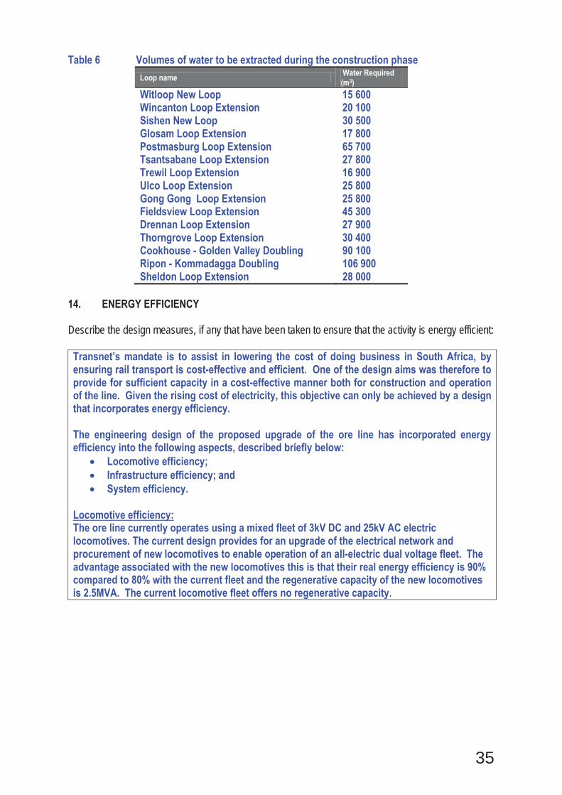
35
Table 6 Volumes of water to be extracted during the construction phase Loop name Water Required
(m3) Witloop New Loop 15 600 Wincanton Loop Extension 20 100 Sishen New Loop 30 500 Glosam Loop Extension 17 800 Postmasburg Loop Extension 65 700 Tsantsabane Loop Extension 27 800 Trewil Loop Extension 16 900 Ulco Loop Extension 25 800 Gong Gong Loop Extension 25 800 Fieldsview Loop Extension 45 300 Drennan Loop Extension 27 900 Thorngrove Loop Extension 30 400 Cookhouse - Golden Valley Doubling 90 100 Ripon - Kommadagga Doubling 106 900 Sheldon Loop Extension 28 000
14. ENERGY EFFICIENCY Describe the design measures, if any that have been taken to ensure that the activity is energy efficient: Transnet’s mandate is to assist in lowering the cost of doing business in South Africa, by ensuring rail transport is cost-effective and efficient. One of the design aims was therefore to provide for sufficient capacity in a cost-effective manner both for construction and operation of the line. Given the rising cost of electricity, this objective can only be achieved by a design that incorporates energy efficiency. The engineering design of the proposed upgrade of the ore line has incorporated energy efficiency into the following aspects, described briefly below:
Locomotive efficiency; Infrastructure efficiency; and System efficiency.
Locomotive efficiency: The ore line currently operates using a mixed fleet of 3kV DC and 25kV AC electric locomotives. The current design provides for an upgrade of the electrical network and procurement of new locomotives to enable operation of an all-electric dual voltage fleet. The advantage associated with the new locomotives this is that their real energy efficiency is 90% compared to 80% with the current fleet and the regenerative capacity of the new locomotives is 2.5MVA. The current locomotive fleet offers no regenerative capacity.

36
Infrastructure efficiency: The design of the upgraded traction power supply system to accommodate the operation of 200 wagon trains consist of the installation of additional positive and negative feeders, the introduction of parallel feeding, installing additional transformers at existing substations and rectifiers at selected locations. The electrical infrastructural improvements or upgrades will result in:
Improved voltage regulation; Reduction in resistivity losses; 100% increase in installed capacity per kilometre (ie 20MVA to 40MVA per 30km).
System efficiency: The specific energy consumption (Wh/tkm) of the system is calculated by using the actual measured or simulated energy consumption over a specific period (kWh) to haul the traffic for the same period over the section (tkm). It must be noted that the hauled load is calculated as gross tons (weight of wagons and locomotives included). The specific energy consumption for 104 and 200 wagon loaded trains were simulated to determine the specific energy consumption. The results are depicted in the table below:
SECTION Number of wagons
Loaded (Wh/tonkm)
Empty (Wh/tonkm)
Kimberley-De Aar 200 12.36 23.39 104 12.7 22.54 De Aar-Port Elizabeth 200 9.01 33.95 104 10.26 33.75 Hotazel-Postmasburg 200 15.03 17.68 104 16.58 18.04 Postmasburg-Kimberley 200 10.7 26.9 104 12.46 24.91
The simulated results suggest that the specific energy consumption (Wh/tonkm) decreases appreciably as train size increase. It has been verified in practice that drivers of longs trains can utilize the momentum gained by the train on downgrades to traverse the shorter upgrades and so save energy consumption. The increase in train length for the project therefore also improves the energy efficiency.
Describe how alternative energy sources have been taken into account or been built into the design of the activity, if any: Not applicable
37
SECTION B: SITE/AREA/PROPERTY DESCRIPTION Important notes: 1. For linear activities (pipelines, etc) as well as activities that cover very large sites, it may be
necessary to complete this section for each part of the site that has a significantly different environment. In such cases please complete copies of Section B and indicate the area, which is covered by each copy No. on the Site Plan.
Section B Copy No. (e.g. A): 2. Paragraphs 1 - 6 below must be completed for each alternative. 3. Has a specialist been consulted to assist with the completion of this section? YES NO If YES, please complete the form entitled “Details of specialist and declaration of interest” for each specialist thus appointed and attach it in Appendix I. All specialist reports must be contained in Appendix D.

38
Property description/physical address:
Province Eastern Cape and Northern Cape District Municipality
Province District Loop/s and Rail Doublings Eastern Cape
Cacadu Ripon- Kommadagga Golden Valley-Cookhouse Thorngrove Sheldon
Chris Hani Drennan Northern Cape
Frances Baard Fieldsview Gong-Gong Ulco
Siyanda Trewil Postmasburg Tsantsabane Glosam
John Taolo Gaetsewe
Sishen Wincanton Witloop
Local Municipality
Province Local Loop/s and Rail Doublings Eastern Cape Blue Crane Ripon- Kommadagga
Golden Valley-Cookhouse Sheldon Thorngrove
Inxuba Yethemba
Drennan
Northern Cape
Sol Plaatje Fieldsview Dikgatlong Gong-Gong
Ulco Kgatelopele Trewil Tsantsabane Postmasburg
Tsantsabane Glosam
Gamagara Sishen Wincanton
Joe Morolong
Witloop
Ward Number(s)
Ripon-Kommadagga Ward- 6 Postmasburg Ward- 5 Tsantsabane Ward- 1 Glosam Ward- 6 New Sishen Ward- 3 Witloop Ward- 4 Wincanton Ward- 5
Gong Gong Ward- 5 Ulco Ward- 6 Trewil Ward- 4 Fieldsview Ward- 1 Drennan Ward- 6 Thorngrove Ward- 1 Cookhouse- Golden Valley Ward- 6 Sheldon Ward 6
Where a large number of properties are involved (e.g. linear activities), please attach a full list to this application including the same information as indicated above.
SG Code See list attached in Appendix C2

39
Current land-use zoning as per local municipality IDP/records:
Industrial
In instances where there is more than one current land-use zoning, please attach a list of current land use zonings that also indicate which portions each use pertains to, to this application.
Is a change of land-use or a consent use application required? In cases where additional land is to be acquired, Transnet’s land acquisition process will be undertaken including land-use applications, where required.
YES NO
1. GRADIENT OF THE SITE Indicate the general gradient of the site. All loops Alternative S1: Flat 1:50 – 1:20 1:20 – 1:15 1:15 – 1:10 1:10 – 1:7,5 1:7,5 – 1:5 Steeper
than 1:5 Alternative S2 (if any): Flat 1:50 – 1:20 1:20 – 1:15 1:15 – 1:10 1:10 – 1:7,5 1:7,5 – 1:5 Steeper
than 1:5 Alternative S3 (if any): Flat 1:50 – 1:20 1:20 – 1:15 1:15 – 1:10 1:10 – 1:7,5 1:7,5 – 1:5 Steeper
than 1:5 2. LOCATION IN LANDSCAPE Indicate the landform(s) that best describes the site: 2.1 Ridgeline 2.4 Closed valley 2.7 Undulating plain / low hills
Ripon-Kommadagga, Sheldon
2.2 Plateau 2.5 Open valley Cookhouse-Golden Valley, Thorngrove
2.8 Dune
2.3 Side slope of hill/mountain 2.6 Plain Drennan, Fieldsview,Glosam, Sishen, Postmasburg, Tsantsabane, Trewil, Ulco, Gong Gong, Wincanton
2.9 Seafront
3. GROUNDWATER, SOIL AND GEOLOGICAL STABILITY OF THE SITE Is the site(s) located on any of the following?
Farm name and Portion number
See list attached in Appendix C2
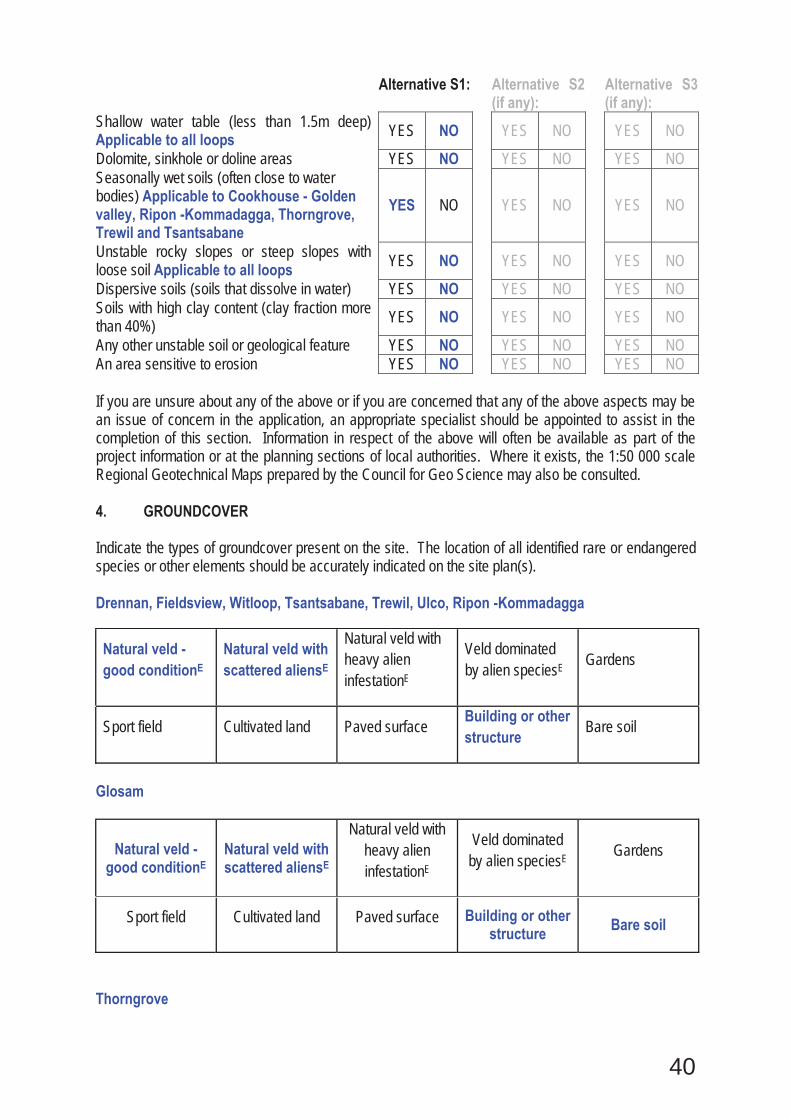
40
Alternative S1: Alternative S2 (if any):
Alternative S3 (if any):
Shallow water table (less than 1.5m deep) Applicable to all loops YES NO YES NO YES NO
Dolomite, sinkhole or doline areas YES NO YES NO YES NO Seasonally wet soils (often close to water bodies) Applicable to Cookhouse - Golden valley, Ripon -Kommadagga, Thorngrove, Trewil and Tsantsabane
YES NO
YES NO
YES NO
Unstable rocky slopes or steep slopes with loose soil Applicable to all loops YES NO YES NO YES NO
Dispersive soils (soils that dissolve in water) YES NO YES NO YES NO Soils with high clay content (clay fraction more than 40%) YES NO YES NO YES NO
Any other unstable soil or geological feature YES NO YES NO YES NO An area sensitive to erosion YES NO YES NO YES NO If you are unsure about any of the above or if you are concerned that any of the above aspects may be an issue of concern in the application, an appropriate specialist should be appointed to assist in the completion of this section. Information in respect of the above will often be available as part of the project information or at the planning sections of local authorities. Where it exists, the 1:50 000 scale Regional Geotechnical Maps prepared by the Council for Geo Science may also be consulted. 4. GROUNDCOVER Indicate the types of groundcover present on the site. The location of all identified rare or endangered species or other elements should be accurately indicated on the site plan(s). Drennan, Fieldsview, Witloop, Tsantsabane, Trewil, Ulco, Ripon -Kommadagga
Natural veld - good conditionE
Natural veld with scattered aliensE
Natural veld with heavy alien infestationE
Veld dominated by alien speciesE Gardens
Sport field Cultivated land Paved surface Building or other structure Bare soil
Glosam
Natural veld - good conditionE
Natural veld with scattered aliensE
Natural veld with heavy alien infestationE
Veld dominated by alien speciesE Gardens
Sport field Cultivated land Paved surface Building or other structure Bare soil
Thorngrove
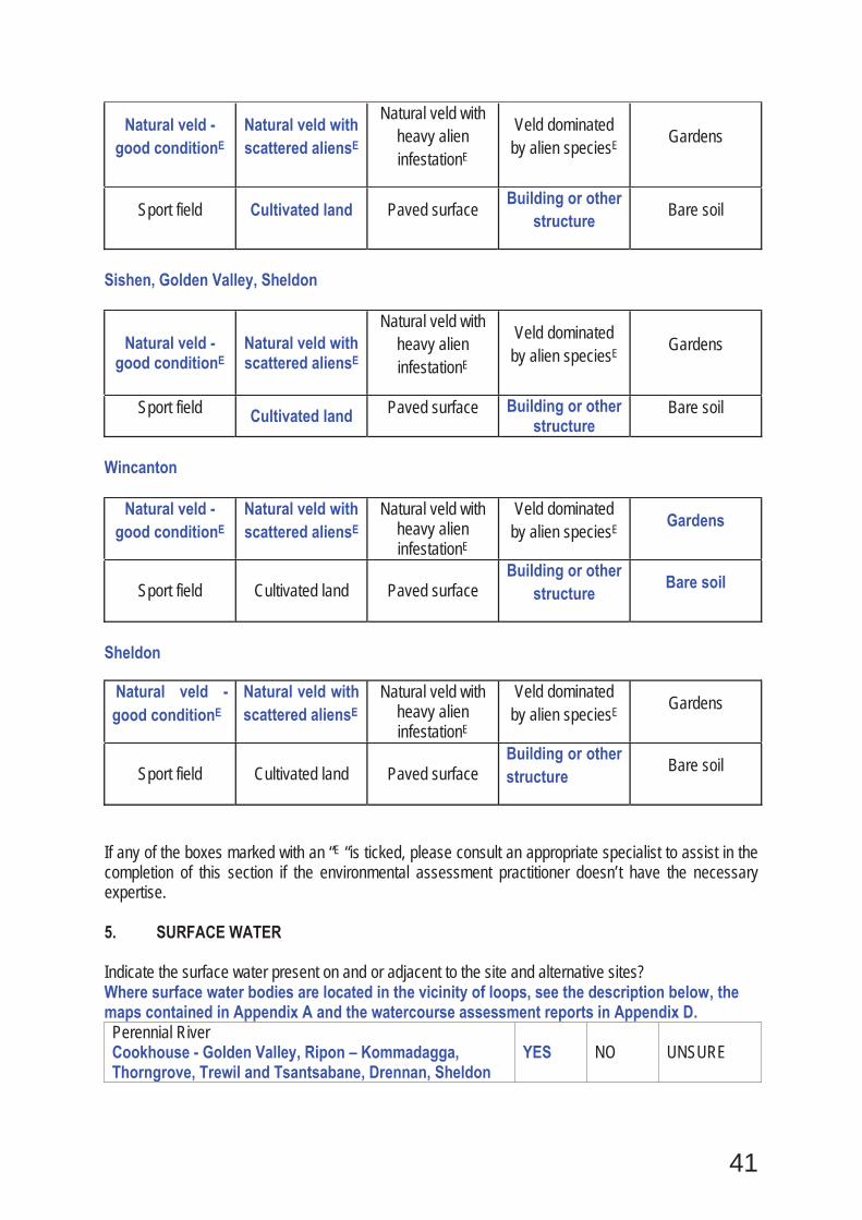
41
Natural veld - good conditionE
Natural veld with scattered aliensE
Natural veld with heavy alien infestationE
Veld dominated by alien speciesE Gardens
Sport field Cultivated land Paved surface Building or other structure
Bare soil
Sishen, Golden Valley, Sheldon
Natural veld - good conditionE
Natural veld with scattered aliensE
Natural veld with heavy alien infestationE
Veld dominated by alien speciesE Gardens
Sport field Cultivated land Paved surface Building or other structure
Bare soil
Wincanton
Natural veld - good conditionE
Natural veld with scattered aliensE
Natural veld with heavy alien infestationE
Veld dominated by alien speciesE Gardens
Sport field Cultivated land Paved surface Building or other
structure Bare soil
Sheldon
Natural veld - good conditionE
Natural veld with scattered aliensE
Natural veld with heavy alien infestationE
Veld dominated by alien speciesE Gardens
Sport field Cultivated land Paved surface Building or other structure
Bare soil
If any of the boxes marked with an “E “is ticked, please consult an appropriate specialist to assist in the completion of this section if the environmental assessment practitioner doesn’t have the necessary expertise. 5. SURFACE WATER Indicate the surface water present on and or adjacent to the site and alternative sites? Where surface water bodies are located in the vicinity of loops, see the description below, the maps contained in Appendix A and the watercourse assessment reports in Appendix D. Perennial River Cookhouse - Golden Valley, Ripon – Kommadagga, Thorngrove, Trewil and Tsantsabane, Drennan, Sheldon
YES NO UNSURE
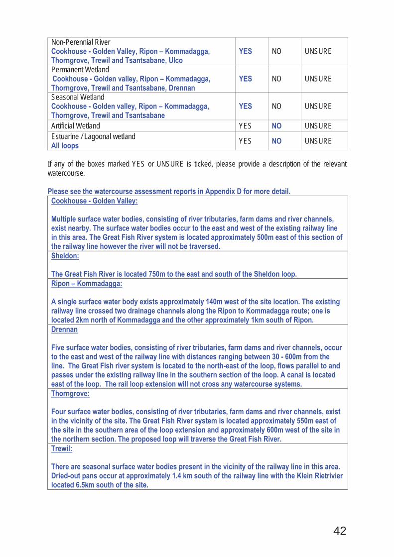
42
Non-Perennial River Cookhouse - Golden Valley, Ripon – Kommadagga, Thorngrove, Trewil and Tsantsabane, Ulco
YES NO UNSURE
Permanent Wetland Cookhouse - Golden valley, Ripon – Kommadagga, Thorngrove, Trewil and Tsantsabane, Drennan
YES NO UNSURE
Seasonal Wetland Cookhouse - Golden valley, Ripon – Kommadagga, Thorngrove, Trewil and Tsantsabane
YES NO UNSURE
Artificial Wetland YES NO UNSURE Estuarine / Lagoonal wetland All loops YES NO UNSURE
If any of the boxes marked YES or UNSURE is ticked, please provide a description of the relevant watercourse. Please see the watercourse assessment reports in Appendix D for more detail. Cookhouse - Golden Valley: Multiple surface water bodies, consisting of river tributaries, farm dams and river channels, exist nearby. The surface water bodies occur to the east and west of the existing railway line in this area. The Great Fish River system is located approximately 500m east of this section of the railway line however the river will not be traversed. Sheldon: The Great Fish River is located 750m to the east and south of the Sheldon loop. Ripon – Kommadagga: A single surface water body exists approximately 140m west of the site location. The existing railway line crossed two drainage channels along the Ripon to Kommadagga route; one is located 2km north of Kommadagga and the other approximately 1km south of Ripon. Drennan Five surface water bodies, consisting of river tributaries, farm dams and river channels, occur to the east and west of the railway line with distances ranging between 30 - 600m from the line. The Great Fish river system is located to the north-east of the loop, flows parallel to and passes under the existing railway line in the southern section of the loop. A canal is located east of the loop. The rail loop extension will not cross any watercourse systems. Thorngrove: Four surface water bodies, consisting of river tributaries, farm dams and river channels, exist in the vicinity of the site. The Great Fish River system is located approximately 550m east of the site in the southern area of the loop extension and approximately 600m west of the site in the northern section. The proposed loop will traverse the Great Fish River. Trewil: There are seasonal surface water bodies present in the vicinity of the railway line in this area. Dried-out pans occur at approximately 1.4 km south of the railway line with the Klein Rietrivier located 6.5km south of the site.
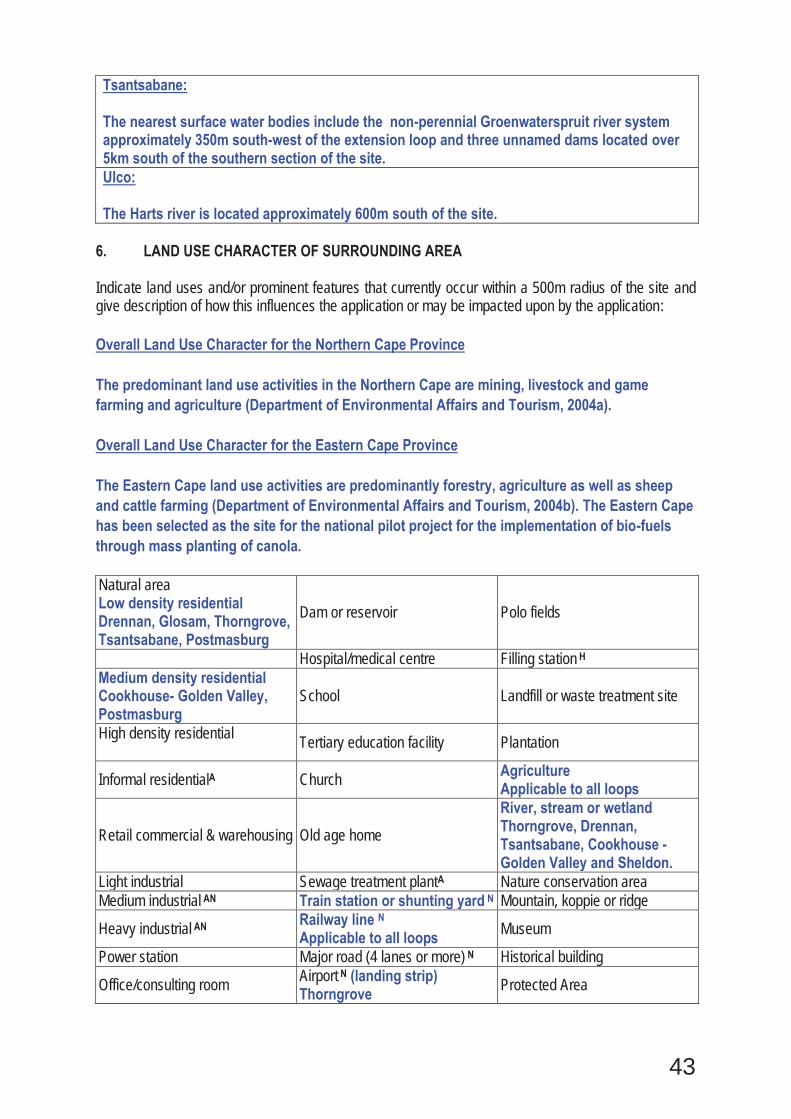
43
Tsantsabane: The nearest surface water bodies include the non-perennial Groenwaterspruit river system approximately 350m south-west of the extension loop and three unnamed dams located over 5km south of the southern section of the site. Ulco: The Harts river is located approximately 600m south of the site.
6. LAND USE CHARACTER OF SURROUNDING AREA Indicate land uses and/or prominent features that currently occur within a 500m radius of the site and give description of how this influences the application or may be impacted upon by the application: Overall Land Use Character for the Northern Cape Province The predominant land use activities in the Northern Cape are mining, livestock and game farming and agriculture (Department of Environmental Affairs and Tourism, 2004a). Overall Land Use Character for the Eastern Cape Province The Eastern Cape land use activities are predominantly forestry, agriculture as well as sheep and cattle farming (Department of Environmental Affairs and Tourism, 2004b). The Eastern Cape has been selected as the site for the national pilot project for the implementation of bio-fuels through mass planting of canola. Natural area Low density residential Drennan, Glosam, Thorngrove, Tsantsabane, Postmasburg
Dam or reservoir Polo fields
Hospital/medical centre Filling station H Medium density residential Cookhouse- Golden Valley, Postmasburg
School Landfill or waste treatment site
High density residential Tertiary education facility Plantation
Informal residentialA Church Agriculture Applicable to all loops
Retail commercial & warehousing Old age home River, stream or wetland Thorngrove, Drennan, Tsantsabane, Cookhouse - Golden Valley and Sheldon.
Light industrial Sewage treatment plantA Nature conservation area Medium industrial AN Train station or shunting yard N Mountain, koppie or ridge
Heavy industrial AN Railway line N Applicable to all loops Museum
Power station Major road (4 lanes or more) N Historical building
Office/consulting room Airport N (landing strip) Thorngrove Protected Area

44
Military or police base/station/compound Harbour Graveyard
Spoil heap or slimes damA Sport facilities Archaeological site Quarry, sand or borrow pit Thorngrove, Glosam Golf course Other land uses (describe)
If any of the boxes marked with an “N “are ticked, how will this impact / be impacted upon by the proposed activity? With respect to the landing strip, no impacts are anticipated to occur as a result of the proposed loop expansion at Thorngrove. Furthermore the presence of the landing strip is not expected to impact the proposed loop extension. The loop upgrades are related to the existing railway line and are intended to increase the overall capacity and efficiency of the railway line.
If any of the boxes marked with an "An" are ticked, how will this impact / be impacted upon by the proposed activity? Specify and explain:
If any of the boxes marked with an "H" are ticked, how will this impact / be impacted upon by the proposed activity? Specify and explain:
Does the proposed site (including any alternative sites) fall within any of the following: Thorngrove, Drennan, Ripon-Kommadagga and Golden Valley-Cookhouse Critical Biodiversity Area (as per provincial conservation plan) YES
Core area of a protected area? NO
Buffer area of a protected area? NO
Planned expansion area of an existing protected area? NO
Existing offset area associated with a previous Environmental Authorisation? NO
Buffer area of the SKA? NO

45
Witloop, Wincanton, Sishen, Glosam, Tsantsabane, Trewil, Ulco and Fieldsview
Critical Biodiversity Area (as per provincial conservation plan) NO
Core area of a protected area? NO
Buffer area of a protected area? NO
Planned expansion area of an existing protected area? NO
Existing offset area associated with a previous Environmental Authorisation? NO
Buffer area of the SKA? NO
If the answer to any of these questions was YES, a map indicating the affected area must be included. See attached sensitivity maps in Appendix A.
7. CULTURAL/HISTORICAL FEATURES
Are there any signs of culturally or historically significant elements, as defined in section 2 of the National Heritage Resources Act, 1999, (Act No. 25 of 1999), including Archaeological or paleontological sites, on or close (within 20m) to the site? If YES, explain:
YES NO
Uncertain
If uncertain, conduct a specialist investigation by a recognised specialist in the field (archaeology or palaeontology) to establish whether there is such a feature(s) present on or close to the site. Briefly explain the findings of the specialist: See Heritage Impact Studies in Appendix D. The following tables have been extracted from the aforementioned studies and list the paleontological sensitivities and cultural heritage features at each of the loops.
Table 6.1 Paleontological sensitivity at each loop Loop Project Paleontological Sensitivity 1. Witloop New loop Low 2. Wincanton Loop extension Low 3. Sishen New loop Low 4. Glosam Loop extension Medium 5. Postmasburg Loop extension Medium 6. Tsantsabane Loop extension Medium 7. Trewil Loop extension Medium 8. Ulco Loop extension Low 9. Gong Gong Loop extension Zero 10. Fieldsview Loop extension Low 11. Drennan Loop extension High 12. Thorngrove Loop extension High 13. Cookhouse – Golden Valley Rail doubling Low 14. Ripon – Kommadagga Rail doubling High
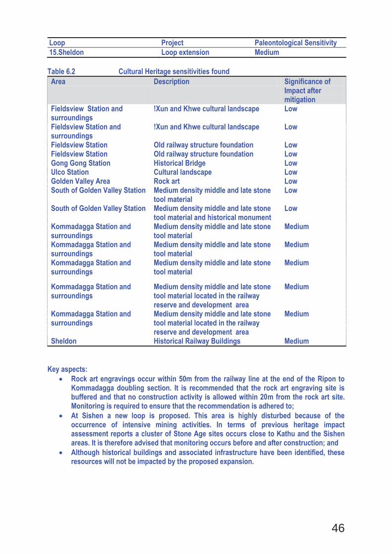
46
Loop Project Paleontological Sensitivity 15.Sheldon Loop extension Medium
Table 6.2 Cultural Heritage sensitivities found Area Description Significance of
Impact after mitigation
Fieldsview Station and surroundings
!Xun and Khwe cultural landscape Low
Fieldsview Station and surroundings
!Xun and Khwe cultural landscape Low
Fieldsview Station Old railway structure foundation Low Fieldsview Station Old railway structure foundation Low Gong Gong Station Historical Bridge Low Ulco Station Cultural landscape Low Golden Valley Area Rock art Low South of Golden Valley Station Medium density middle and late stone
tool material Low
South of Golden Valley Station Medium density middle and late stone tool material and historical monument
Low
Kommadagga Station and surroundings
Medium density middle and late stone tool material
Medium
Kommadagga Station and surroundings
Medium density middle and late stone tool material
Medium
Kommadagga Station and surroundings
Medium density middle and late stone tool material
Medium
Kommadagga Station and surroundings
Medium density middle and late stone tool material located in the railway reserve and development area
Medium
Kommadagga Station and surroundings
Medium density middle and late stone tool material located in the railway reserve and development area
Medium
Sheldon Historical Railway Buildings Medium Key aspects:
Rock art engravings occur within 50m from the railway line at the end of the Ripon to Kommadagga doubling section. It is recommended that the rock art engraving site is buffered and that no construction activity is allowed within 20m from the rock art site. Monitoring is required to ensure that the recommendation is adhered to; At Sishen a new loop is proposed. This area is highly disturbed because of the occurrence of intensive mining activities. In terms of previous heritage impact assessment reports a cluster of Stone Age sites occurs close to Kathu and the Sishen areas. It is therefore advised that monitoring occurs before and after construction; and Although historical buildings and associated infrastructure have been identified, these resources will not be impacted by the proposed expansion.
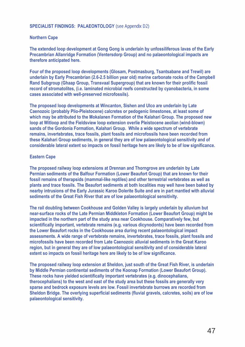
47
SPECIALIST FINDINGS: PALAEONTOLOGY (see Appendix D2) Northern Cape The extended loop development at Gong Gong is underlain by unfossiliferous lavas of the Early Precambrian Allanridge Formation (Ventersdorp Group) and no palaeontological impacts are therefore anticipated here. Four of the proposed loop developments (Glosam, Postmasburg, Tsantsabane and Trewil) are underlain by Early Precambrian (2.6-2.5 billion year old) marine carbonate rocks of the Campbell Rand Subgroup (Ghaap Group, Transvaal Supergroup) that are known for their prolific fossil record of stromatolites, (i.e. laminated microbial reefs constructed by cyanobacteria, in some cases associated with well-preserved microfossils). The proposed loop developments at Wincanton, Sishen and Ulco are underlain by Late Caenozoic (probably Plio-Pleistocene) calcretes or pedogenic limestones, at least some of which may be attributed to the Mokalanen Formation of the Kalahari Group. The proposed new loop at Witloop and the Fieldsview loop extension overlie Pleistocene aeolian (wind-blown) sands of the Gordonia Formation, Kalahari Group. While a wide spectrum of vertebrate remains, invertebrates, trace fossils, plant fossils and microfossils have been recorded from these Kalahari Group sediments, in general they are of low palaeontological sensitivity and of considerable lateral extent so impacts on fossil heritage here are likely to be of low significance. Eastern Cape The proposed railway loop extensions at Drennan and Thorngrove are underlain by Late Permian sediments of the Balfour Formation (Lower Beaufort Group) that are known for their fossil remains of therapsids (mammal-like reptiles) and other terrestrial vertebrates as well as plants and trace fossils. The Beaufort sediments at both localities may well have been baked by nearby intrusions of the Early Jurassic Karoo Dolerite Suite and are in part mantled with alluvial sediments of the Great Fish River that are of low palaeontological sensitivity. The rail doubling between Cookhouse and Golden Valley is largely underlain by alluvium but near-surface rocks of the Late Permian Middkleton Formation (Lower Beaufort Group) might be impacted in the northern part of the study area near Cookhouse. Comparatively few, but scientifically important, vertebrate remains (e.g. various dicynodonts) have been recorded from the Lower Beaufort rocks in the Cookhouse area during recent palaeontological impact assessments. A wide range of vertebrate remains, invertebrates, trace fossils, plant fossils and microfossils have been recorded from Late Caenozoic alluvial sediments in the Great Karoo region, but in general they are of low palaeontological sensitivity and of considerable lateral extent so impacts on fossil heritage here are likely to be of low significance. The proposed railway loop extension at Sheldon, just south of the Great Fish River, is underlain by Middle Permian continental sediments of the Koonap Formation (Lower Beaufort Group). These rocks have yielded scientifically important vertebrates (e.g. dinocephalians, therocephalians) to the west and east of the study area but these fossils are generally very sparse and bedrock exposure levels are low. Fossil invertebrate burrows are recorded from Sheldon Bridge. The overlying superficial sediments (fluvial gravels, calcretes, soils) are of low palaeontological sensitivity.
48
The rail doubling between Ripon and Kommadagga traverses a range of Carboniferous to Middle Permian sedimentary rock units including the Kommadagga Subgroup (Witteberg Group), Elandsvlei Formation (Dwyka Group), as well as the Prince Albert, Whitehill, Collingham and Ripon Formations of the Ecca Group. All of these units, especially the Whitehill Formation that is known for its well-preserved fossil fish, insects, crustaceans and aquatic mesosaurud reptiles, are potentially fossiliferous. SPECIALIST FINDINGS: HERITAGE (see Appendix D3) Most of the heritage resources are positioned outside of the railway reserve areas. The Northern Cape specifically has evidence of the South African War events, the origins of the diamond digging time period, the movement of the San peoples, the conflict years (Mfecane or Difaqane) as well as the contact period between the San and the Iron Age people. A variety of grave sites are located at Groenwater, but no works are proposed to take place in this area. The Eastern Cape is a well-defined Stone Age Archaeology area and rock art sites have been identified within 50 m from the railway line. Kommadagga to Ripon has displayed extensive traces related to various types of stone tool material. A Phase 2 Heritage Impact Assessment is recommended to remove the Stone Age material that is positioned within the railway reserve areas. The current design for the rail loop extensions does not impact any historical structures. The assumption is that the no heritage structures will have to be demolished or disturbed. In the event that a historical structure could be in the way of the proposed development, a heritage built environment permit application process will be followed. The section at Golden Valley and Kommadagga is of high significance as Middle and Late Stone Age material has been identified within the railway reserve area. The mitigation will be to undertake a Phase 2 Heritage Impact Assessment that includes the application of a sampling and monitoring permit. At the end of the doubling of the line between Ripon and Kommadagga, a rock engraving site occurs that is positioned within 50m of the railway line. Will any building or structure older than 60 years be affected in any way? YES NO Is it necessary to apply for a permit in terms of the National Heritage Resources Act, 1999 (Act 25 of 1999)? YES NO
If YES, please provide proof that this permit application has been submitted to SAHRA or the relevant provincial authority. 8. SOCIO-ECONOMIC CHARACTER
a) Local Municipality Please provide details on the socio-economic character of the local municipality in which the proposed site(s) are situated.
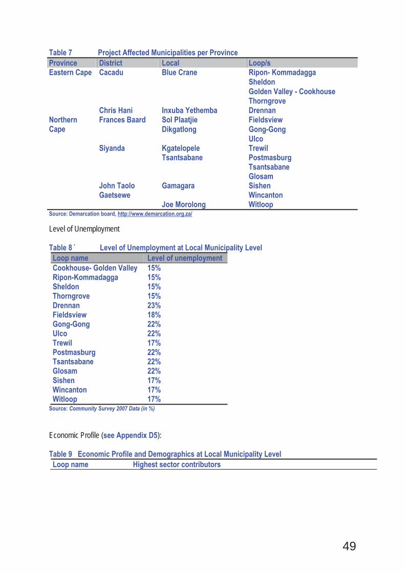
49
Table 7 Project Affected Municipalities per Province Province District Local Loop/s Eastern Cape Cacadu Blue Crane Ripon- Kommadagga
Sheldon Golden Valley - Cookhouse Thorngrove
Chris Hani Inxuba Yethemba Drennan Northern Cape
Frances Baard Sol Plaatjie Fieldsview Dikgatlong Gong-Gong
Ulco Siyanda Kgatelopele Trewil
Tsantsabane Postmasburg Tsantsabane Glosam
John Taolo Gaetsewe
Gamagara Sishen Wincanton
Joe Morolong Witloop Source: Demarcation board, http://www.demarcation.org.za/ Level of Unemployment Table 8 ̀ Level of Unemployment at Local Municipality Level Loop name Level of unemployment Cookhouse- Golden Valley 15% Ripon-Kommadagga 15% Sheldon 15% Thorngrove 15% Drennan 23% Fieldsview 18% Gong-Gong 22% Ulco 22% Trewil 17% Postmasburg 22% Tsantsabane 22% Glosam 22% Sishen 17% Wincanton 17% Witloop 17%
Source: Community Survey 2007 Data (in %) Economic Profile (see Appendix D5): Table 9 Economic Profile and Demographics at Local Municipality Level Loop name Highest sector contributors
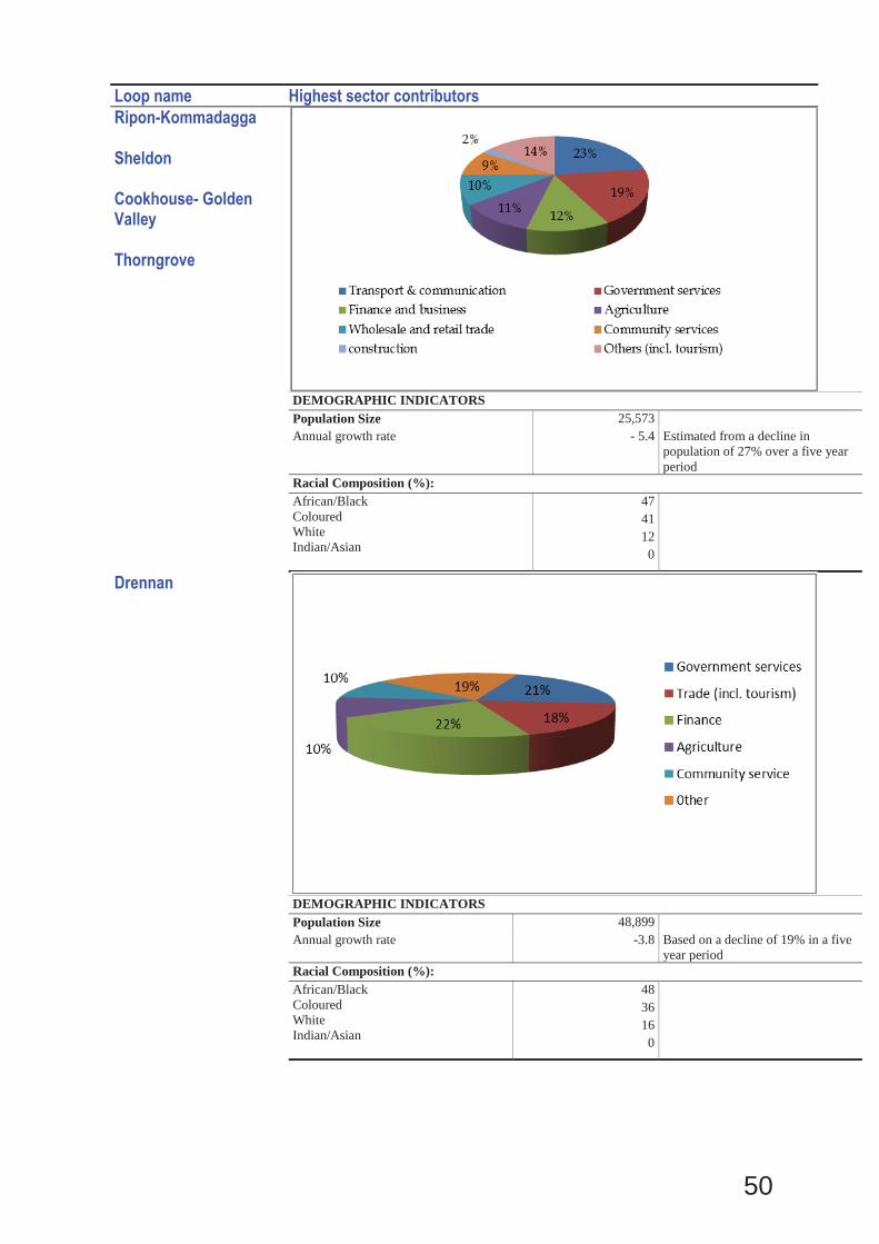
50
Loop name Highest sector contributors Ripon-Kommadagga Sheldon Cookhouse- Golden Valley Thorngrove
DEMOGRAPHIC INDICATORS
Population Size 25,573Annual growth rate - 5.4 Estimated from a decline in
population of 27% over a five year period
Racial Composition (%):African/BlackColouredWhite Indian/Asian
4741120
Drennan
DEMOGRAPHIC INDICATORS
Population Size 48,899Annual growth rate -3.8 Based on a decline of 19% in a five
year periodRacial Composition (%):African/BlackColouredWhite Indian/Asian
4836160
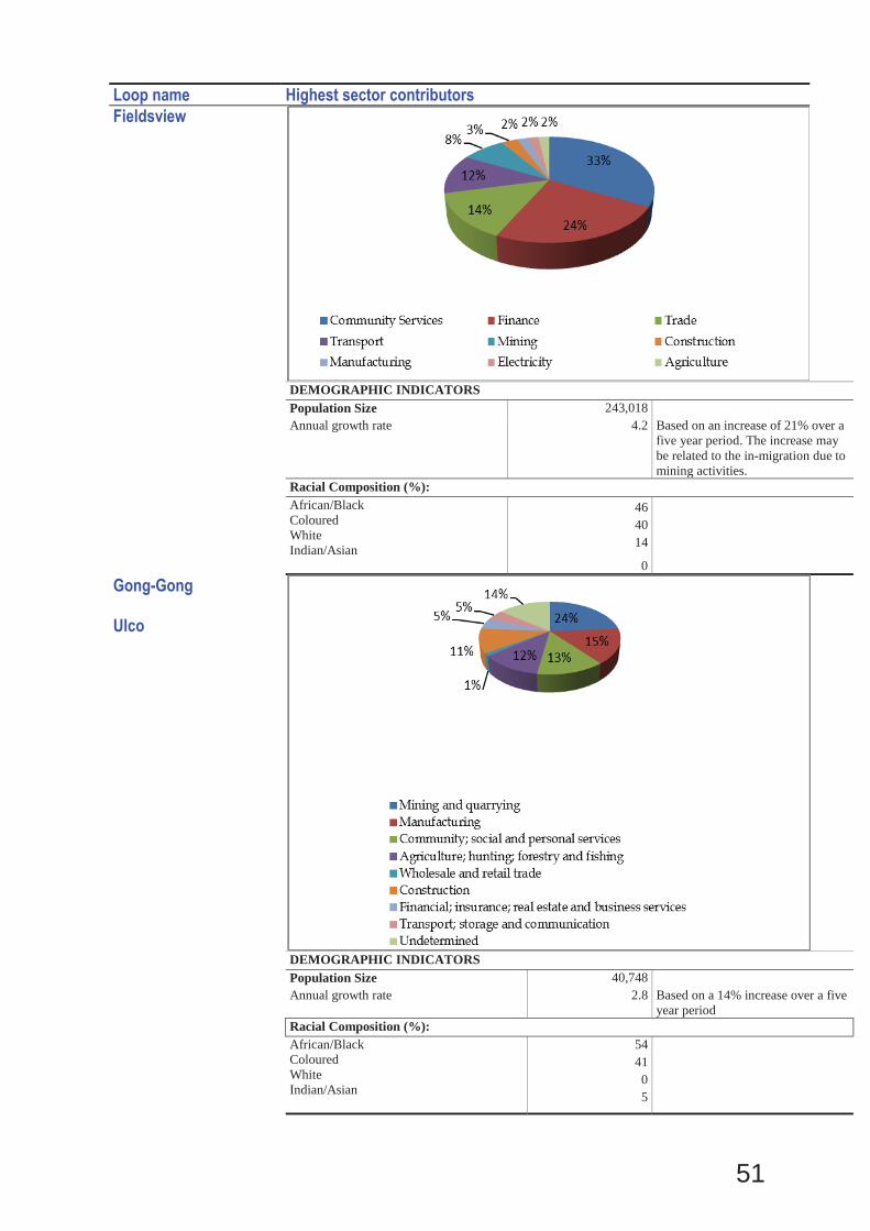
51
Loop name Highest sector contributors Fieldsview
DEMOGRAPHIC INDICATORSPopulation Size 243,018Annual growth rate 4.2 Based on an increase of 21% over a
five year period. The increase may be related to the in-migration due to mining activities.
Racial Composition (%):African/BlackColouredWhite Indian/Asian
464014
0
Gong-Gong Ulco
DEMOGRAPHIC INDICATORSPopulation Size 40,748Annual growth rate 2.8 Based on a 14% increase over a five
year period Racial Composition (%):African/BlackColouredWhite Indian/Asian
544105
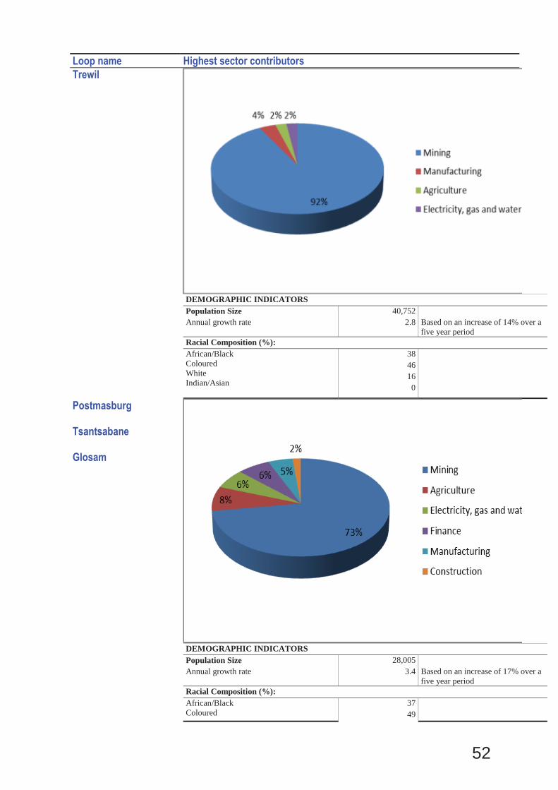
52
Loop name Highest sector contributors Trewil
DEMOGRAPHIC INDICATORSPopulation Size 40,752Annual growth rate 2.8 Based on an increase of 14% over a
five year periodRacial Composition (%):African/BlackColouredWhite Indian/Asian
3846160
Postmasburg Tsantsabane Glosam
DEMOGRAPHIC INDICATORSPopulation Size 28,005Annual growth rate 3.4 Based on an increase of 17% over a
five year periodRacial Composition (%):African/BlackColoured
3749
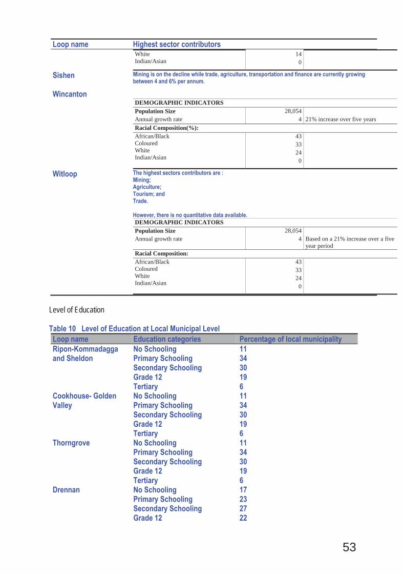
53
Loop name Highest sector contributors White Indian/Asian
140
Sishen Wincanton
Mining is on the decline while trade, agriculture, transportation and finance are currently growing between 4 and 6% per annum.
DEMOGRAPHIC INDICATORSPopulation Size 28,054Annual growth rate 4 21% increase over five yearsRacial Composition(%):African/BlackColouredWhite Indian/Asian
4333240
Witloop The highest sectors contributors are : Mining; Agriculture; Tourism; and Trade. However, there is no quantitative data available.
DEMOGRAPHIC INDICATORSPopulation Size 28,054Annual growth rate 4 Based on a 21% increase over a five
year periodRacial Composition:African/BlackColouredWhite Indian/Asian
4333240
Level of Education Table 10 Level of Education at Local Municipal Level Loop name Education categories Percentage of local municipality Ripon-Kommadagga and Sheldon
No Schooling Primary Schooling Secondary Schooling Grade 12 Tertiary
11 34 30 19 6
Cookhouse- Golden Valley
No Schooling Primary Schooling Secondary Schooling Grade 12 Tertiary
11 34 30 19 6
Thorngrove No Schooling Primary Schooling Secondary Schooling Grade 12 Tertiary
11 34 30 19 6
Drennan No Schooling Primary Schooling Secondary Schooling Grade 12
17 23 27 22
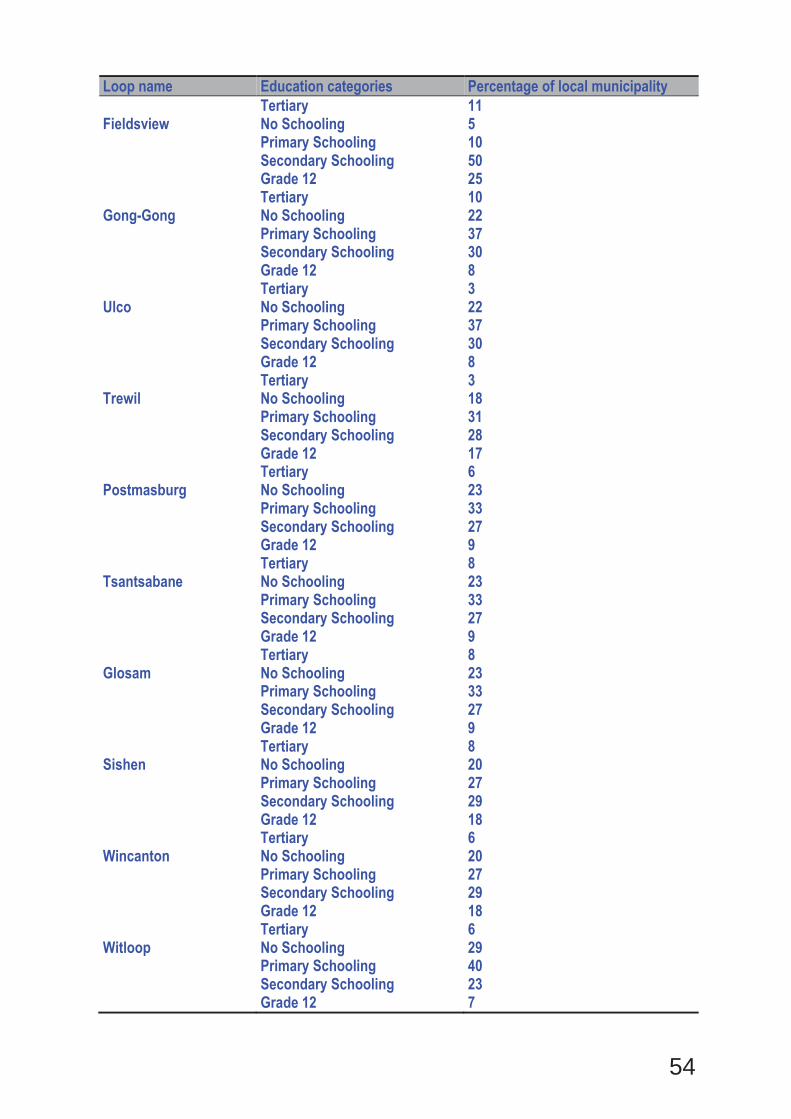
54
Loop name Education categories Percentage of local municipality Tertiary 11
Fieldsview No Schooling Primary Schooling Secondary Schooling Grade 12 Tertiary
5 10 50 25 10
Gong-Gong No Schooling Primary Schooling Secondary Schooling Grade 12 Tertiary
22 37 30 8 3
Ulco No Schooling Primary Schooling Secondary Schooling Grade 12 Tertiary
22 37 30 8 3
Trewil No Schooling Primary Schooling Secondary Schooling Grade 12 Tertiary
18 31 28 17 6
Postmasburg No Schooling Primary Schooling Secondary Schooling Grade 12 Tertiary
23 33 27 9 8
Tsantsabane No Schooling Primary Schooling Secondary Schooling Grade 12 Tertiary
23 33 27 9 8
Glosam No Schooling Primary Schooling Secondary Schooling Grade 12 Tertiary
23 33 27 9 8
Sishen No Schooling Primary Schooling Secondary Schooling Grade 12 Tertiary
20 27 29 18 6
Wincanton No Schooling Primary Schooling Secondary Schooling Grade 12 Tertiary
20 27 29 18 6
Witloop No Schooling Primary Schooling Secondary Schooling Grade 12
29 40 23 7

55
Loop name Education categories Percentage of local municipality Tertiary 1
Source: Community Survey 2007 Data (in %) b) Socio-economic value of the activity What is the expected capital value of the activity on completion? R 19.2bn (Rail
infrastructure and rolling stock)
What is the expected yearly income that will be generated by or as a result of the activity?
Total income for mines, rail and port = R23.04 billion per year (Assumptions: total throughput = 16 Mtpa, total FOB price = R1440/t)
Will the activity contribute to service infrastructure? YES NO Is the activity a public amenity? YES NO How many new employment opportunities will be created in the development and construction phase of the activity/ies?
Direct – 12171, Indirect – 9128
What is the expected value of the employment opportunities during the development and construction phase?
Uncertain
What percentage of this will accrue to previously disadvantaged individuals? 3.1% (R600million)
How many permanent new employment opportunities will be created during the operational phase of the activity?
572
What is the expected current value of the employment opportunities during the first 10 years?
Uncertain
What percentage of this will accrue to previously disadvantaged individuals? Uncertain
9. BIODIVERSITY
Please note: The Department may request specialist input/studies depending on the nature of the biodiversity occurring on the site and potential impact(s) of the proposed activity/ies. To assist with the identification of the biodiversity occurring on site and the ecosystem status consult http://bgis.sanbi.org or [email protected]. Information is also available on compact disc (cd) from the Biodiversity-GIS Unit, Ph (021) 799 8698. This information may be updated from time to time and it is the applicant/ EAP’s responsibility to ensure that the latest version is used. A map of the relevant biodiversity information (including an indication of the habitat conditions as per (b) below) and must be provided as an overlay map to the property/site plan as Appendix D to this report. Drennan Indicate the applicable biodiversity planning categories of all areas on site and indicate the reason(s) provided in the biodiversity plan for the selection of the specific area as part of the specific category)
Systematic Biodiversity Planning Category If CBA or ESA, indicate the reason(s) for its selection in biodiversity plan

56
Critical Biodiversity Area (CBA) Entire site falls within a Tier 2 CBA. No specific reason provided for the site as such, but larger area required as part of a broad-scale corridor
b) Indicate and describe the habitat condition on site
Habitat Condition
Percentage of habitat condition class (adding up to 100%)
Description and additional Comments and Observations (including additional insight into condition, e.g. poor land management practises, presence of quarries, grazing, harvesting regimes etc).
Natural 30% Those areas outside of the railway reserve consist of natural vegetation in good condition.
Near Natural (includes areas with low to moderate level of alien invasive plants)
15% Those areas within the railway reserve outside of previously cleared areas are largely in a natural to near natural condition with some alien plant species present.
Degraded (includes areas heavily invaded by alien plants)
15% The areas along the embankment of the railway line are dominated largely by alien species and are considered degraded.
Transformed (includes cultivation, dams, urban, plantation, roads, etc)
40% The service road, railway line as well as the area around the station platform are all transformed and retain very little natural vegetation.
c) Complete the table to indicate:
(i) the type of vegetation, including its ecosystem status, present on the site; and (ii) whether an aquatic ecosystem is present on site. Terrestrial Ecosystems Aquatic Ecosystems Ecosystem threat status as per the National Environmental Management: Biodiversity Act (Act No. 10 of 2004)
Wetland (including rivers, depressions, channelled and unchanneled wetlands, flats, seeps pans, and artificial wetlands)
Estuary Coastline
Least Threatened
YES
NO
NO
d) Please provide a description of the vegetation type and/or aquatic ecosystem present on site, including any important biodiversity features/information identified on site (e.g. threatened species and special habitats) The vegetation of the Drennan site consists of Eastern Upper Karoo which is an extensive vegetation type which occupies more than 49 000km2, making it the most extensive vegetation type in South Africa, forming a large proportion of the central and eastern Nama Karoo Biome. This vegetation type is classified as Least Threatened and about 2% of the original extent has
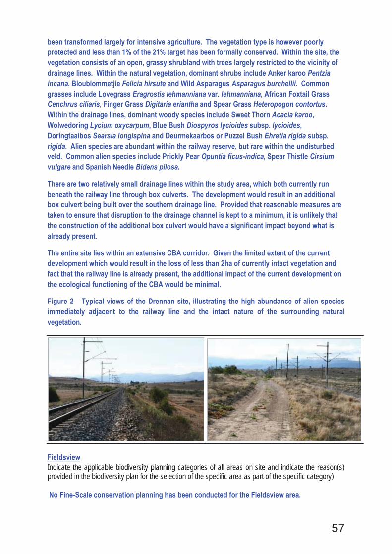
57
been transformed largely for intensive agriculture. The vegetation type is however poorly protected and less than 1% of the 21% target has been formally conserved. Within the site, the vegetation consists of an open, grassy shrubland with trees largely restricted to the vicinity of drainage lines. Within the natural vegetation, dominant shrubs include Anker karoo Pentzia incana, Bloublommetjie Felicia hirsute and Wild Asparagus Asparagus burchellii. Common grasses include Lovegrass Eragrostis lehmanniana var. lehmanniana, African Foxtail Grass Cenchrus ciliaris, Finger Grass Digitaria eriantha and Spear Grass Heteropogon contortus. Within the drainage lines, dominant woody species include Sweet Thorn Acacia karoo, Wolwedoring Lycium oxycarpum, Blue Bush Diospyros lycioides subsp. lycioides, Doringtaaibos Searsia longispina and Deurmekaarbos or Puzzel Bush Ehretia rigida subsp. rigida. Alien species are abundant within the railway reserve, but rare within the undisturbed veld. Common alien species include Prickly Pear Opuntia ficus-indica, Spear Thistle Cirsium vulgare and Spanish Needle Bidens pilosa.
There are two relatively small drainage lines within the study area, which both currently run beneath the railway line through box culverts. The development would result in an additional box culvert being built over the southern drainage line. Provided that reasonable measures are taken to ensure that disruption to the drainage channel is kept to a minimum, it is unlikely that the construction of the additional box culvert would have a significant impact beyond what is already present.
The entire site lies within an extensive CBA corridor. Given the limited extent of the current development which would result in the loss of less than 2ha of currently intact vegetation and fact that the railway line is already present, the additional impact of the current development on the ecological functioning of the CBA would be minimal.
Figure 2 Typical views of the Drennan site, illustrating the high abundance of alien species immediately adjacent to the railway line and the intact nature of the surrounding natural vegetation.
Fieldsview Indicate the applicable biodiversity planning categories of all areas on site and indicate the reason(s) provided in the biodiversity plan for the selection of the specific area as part of the specific category) No Fine-Scale conservation planning has been conducted for the Fieldsview area.
58
Systematic Biodiversity Planning Category If CBA or ESA, indicate the reason(s) for its selection in biodiversity plan
Critical Biodiversity Area (CBA)
Ecological Support Area (ESA)
Other Natural Area (ONA)
No Natural Area Remaining (NNR)
N/A
b) Indicate and describe the habitat condition on site
Habitat Condition Percentage of habitat condition class (adding up to 100%)
Description and additional Comments and Observations (including additional insight into condition, e.g. poor land management practises, presence of quarries, grazing, harvesting regimes etc).
Natural 60% A large proportion of the site consists of natural vegetation in good condition with few alien species.
Near Natural
(includes areas with low to moderate level of alien invasive plants)
20%
Within the railway reserve the majority of trees have been cleared and only the grass layer remains. This layer has been disturbed in many places or has recolonised previously cleared areas or topsoil dumps.
Degraded
(includes areas heavily invaded by alien plants)
Transformed
(includes cultivation, dams, urban, plantation, roads, etc)
20%
The railway line and service road have resulted in some vegetation transformation.
c) Complete the table to indicate: (i) the type of vegetation, including its ecosystem status, present on the site; and (ii) whether an aquatic ecosystem is present on site. Terrestrial Ecosystems Aquatic Ecosystems Ecosystem threat status as per the National Environmental Management: Biodiversity Act (Act No. 10 of 2004)
Wetland (including rivers, depressions, channelled and unchanneled wetlands, flats, seeps pans, and artificial wetlands)
Estuary Coastline
Least Threatened
NO
NO
NO

59
d) Please provide a description of the vegetation type and/or aquatic ecosystem present on site, including any important biodiversity features/information identified on site (e.g. threatened species and special habitats) The Fieldsview site falls within the Kimberley Thornveld vegetation type which is classified as Least Threatened with 82.3% of the original extent still intact, however only 2% is formally conserved. Within the site the vegetation consists of an open savannah with a varying density of trees. The grass layer is dominated by species such as Gemsbok Grass Aristida meridionalis, Gemsbok-tail grass Stipagrostis hochstetteriana, African Foxtail Grass Cenchrus ciliaris and Red Grass Themeda triandra. Shrubs and forbs within the grass layer include January Bush Gnidia polycephala, Bitter Bush Chrysocoma obtusata and Dwarf Elephant-Root Elephantorrhiza elephantina. The tree layer consists of scattered Camel Thorn Acacia erioloba trees as well as occasional Umbrella Thorn Acacia Acacia tortilis, Buffalo Thorn Ziziphus mucronata subsp. mucronata, Black Karee Searsia lancea and Kriedoring Lycium hirsutum. Although the site is generally free of alien species, there were some noted along the railway line including Prickly Pear Opuntia ficus-indica. There are no drainage lines or other wetland features within the development footprint.
Figure 3 View of the railway line itself, left and right, the vegetation in the area where the loop will be developed. The vegetation in this area is dominated by Camel Thorn Acacia erioloba and Umbrella Thorn Acacia tortilis with an understorey of grasses.
Glosam Indicate the applicable biodiversity planning categories of all areas on site and indicate the reason(s) provided in the biodiversity plan for the selection of the specific area as part of the specific category) No Fine-Scale Conservation Planning/CBA mapping has been conducted for the area.
Systematic Biodiversity Planning Category If CBA or ESA, indicate the reason(s) for its selection in biodiversity plan
Critical Biodiversity Area (CBA)
Ecological Support Area (ESA)
Other Natural Area (ONA)
No Natural Area Remaining (NNR)
N/A
60
b) Indicate and describe the habitat condition on site
Habitat Condition Percentage of habitat condition class (adding up to 100%)
Description and additional Comments and Observations (including additional insight into condition, e.g. poor land management practises, presence of quarries, grazing, harvesting regimes etc).
Natural 60%
Within the railway reserve a large proportion of the vegetation is still intact, with few alien species present or other major disturbance indicators.
Near Natural
(includes areas with low to moderate level of alien invasive plants)
18%
Closer to the railway line, the larger woody species had been cleared in some areas and the vegetation is quite disturbed in many places with several alien species present.
Degraded
(includes areas heavily invaded by alien plants)
2%
Transformed
(includes cultivation, dams, urban, plantation, roads, etc)
20%
The railway line itself and the service road have transformed the natural vegetation and no natural vegetation remains within the footprint of these areas.
c) Complete the table to indicate: (i) the type of vegetation, including its ecosystem status, present on the site; and (ii) whether an aquatic ecosystem is present on site. Terrestrial Ecosystems Aquatic Ecosystems Ecosystem threat status as per the National Environmental Management: Biodiversity Act (Act No. 10 of 2004)
Wetland (including rivers, depressions, channelled and unchanneled wetlands, flats, seeps pans, and artificial wetlands)
Estuary Coastline
Least Threatened
NO
NO
NO
61
d) Please provide a description of the vegetation type and/or aquatic ecosystem present on site, including any important biodiversity features/information identified on site (e.g. threatened species and special habitats) The Glosam site lies within the Kuruman Thornveld vegetation type which occupies 5794km2 of the Northern Cape and is classified as Least Threatened. The vegetation type has not been heavily impacted by transformation and 98.10% of the original extent is still intact. Within the site, the vegetation was dominated by low trees such as Camphor Bush Tarchonanthus camphoratus, Velvet Brandybush Grewia flava and Black Thorn Acacia mellifera. The grass layer is fairly dense and is composed of species such as Kangaroo Grass Themeda triandra, Lovegrass Eragrostis lehmanniana var. lehmanniana, Thimble Grass Fingerhuthia africana, and African Foxtail Grass Cenchrus ciliaris. There were also a number of shrub species present including January Bush Gnidia polycephala, Kapokbos Eriocephalus ericoides subsp. Ericoides and Wild Asparagus Asparagus suaveolens. The vegetation within the railway reserve was reasonably intact and only the disturbed area immediately adjacent to the railway line was dominated by alien species such as Mexican Poppy Argemone ochroleuca subsp. ochroleuca, Saltbush Atriplex suberecta and Wildemosterd Sisymbrium burchellii. The site is flat and there are no drainage lines or other aquatic features present within the study area.
Figure 4 Two views of the Glosam site. The left image illustrates the relatively intact nature of the vegetation in the railway reserve which was a lot less impacted than at the majority of other sites. The right image illustrates the natural vegetation adjacent to the reserve.
Witloop Indicate the applicable biodiversity planning categories of all areas on site and indicate the reason(s) provided in the biodiversity plan for the selection of the specific area as part of the specific category) No fine-scale conservation planning has been conducted for the area
Systematic Biodiversity Planning Category If CBA or ESA, indicate the reason(s) for its selection in biodiversity plan
Critical Biodiversity Area (CBA)
Ecological Support Area (ESA)
Other Natural Area (ONA)
No Natural Area Remaining (NNR)
N/A
b) Indicate and describe the habitat condition on site

62
Habitat Condition
Percentage of habitat condition class (adding up to 100%)
Description and additional Comments and Observations (including additional insight into condition, e.g. poor land management practises, presence of quarries, grazing, harvesting regimes etc).
Natural 60% The majority of the site is natural vegetation in good condition with few alien species or other indicators of disturbance present.
Near Natural
(includes areas with low to moderate level of alien invasive plants)
30%
The areas within the railway reserve are largely natural, but some clearing of woody species near the line has taken place and towards the Witloop platform there are also some trees of the alien invader.
Honey Mesquite Prosopis glandulosa present, at a low density of invasion.
Degraded
(includes areas heavily invaded by alien plants)
Transformed
(includes cultivation, dams, urban, plantation, roads, etc)
10% The railway line and areas immediately adjacent to it have been transformed and contain little indigenous vegetation.
c) Complete the table to indicate: (i) the type of vegetation, including its ecosystem status, present on the site; and (ii) whether an aquatic ecosystem is present on site. Terrestrial Ecosystems Aquatic Ecosystems Ecosystem threat status as per the National Environmental Management: Biodiversity Act (Act No. 10 of 2004)
Wetland (including rivers, depressions, channelled and unchanneled wetlands, flats, seeps pans, and artificial wetlands)
Estuary Coastline
Least Threatened
NO
NO
NO
d) Please provide a description of the vegetation type and/or aquatic ecosystem present on site, including any important biodiversity features/information identified on site (e.g. threatened species and special habitats) The Witloop site occurs on deep pale Kalahari sands and is dominated Grey Camel Thorn Acacia haematoxylon and Velvet Brandybush Grewia flava with occasional Camel Thorn Acacia erioloba and Black Thorn Acacia mellifera. The grass layer is dominated by Black Seed Grass Schmidtia pappophoroides, Red Rhodes grass Eustachys paspaloides, Lovegrass Eragrostis lehmanniana var. lehmanniana, African Foxtail Grass Cenchrus ciliaris and Gemsbok Grass
63
Aristida meridionalis. Occasional shrubs are also present including January Bush Gnidia polycephala and Dummer Melolobium macrocalyx, Bitter Bush Chrysocoma obtusata, Dwarf Elephant-Root Elephantorrhiza elephantina and Port Royal Senna Senna italica subsp. arachoides. The vegetation is generally in a good condition and alien species were largely restricted to immediate vicinity of the railway line itself. There were however some of the alien invasive tree, Honey Mesquite Prosopis glandulosa present around the Witloop platform area. There are no drainage features or other mesic habitats present within the site. Along the railway line, alien species present include Mexican Poppy Argemone ochroleuca subsp. ochroleuca, Hairy Horseweed Conyza bonariensis as well as indigenous disturbance-adapted species such as Kalahari String Heliotropium ciliatum and Grassleaf Hirpicium echinus.
Figure 5 Two views of the Witloop site, towards the southern extent of the site on the left and towards the north on the right. The vegetation is dominated by Grey Camel Thorn Acacia haematoxylon and Velvet Brandybush Grewia flava with occasional Camel Thorn Acacia erioloba.
Postmasburg and Tsantsabane Indicate the applicable biodiversity planning categories of all areas on site and indicate the reason(s) provided in the biodiversity plan for the selection of the specific area as part of the specific category) No Fine-Scale conservation planning has been conducted in the area
Systematic Biodiversity Planning Category If CBA or ESA, indicate the reason(s) for its selection in biodiversity plan
Critical Biodiversity Area (CBA)
Ecological Support Area (ESA)
Other Natural Area (ONA)
No Natural Area Remaining (NNR)
N/A
64
b) Indicate and describe the habitat condition on site
Habitat Condition
Percentage of habitat condition class (adding up to 100%)
Description and additional Comments and Observations (including additional insight into condition, e.g. poor land management practises, presence of quarries, grazing, harvesting regimes etc).
Natural 60% The areas away from the railway line are in a relatively good condition with few aliens species present.
Near Natural
(includes areas with low to moderate level of alien invasive plants)
20% The areas near to the railway line have been cleared or large woody species and are disturbed in many places.
Degraded
(includes areas heavily invaded by alien plants)
5% There are some degraded areas immediate adjacent to the railway line which are composed largely of alien species.
Transformed
(includes cultivation, dams, urban, plantation, roads, etc)
15%
Maintenance and previous clearing activities along the railway line has transformed the vegetation within the existing development footprint. This area is largely devoid of vegetation or dominated by alien species.
c) Complete the table to indicate: (i) the type of vegetation, including its ecosystem status, present on the site; and (ii) whether an aquatic ecosystem is present on site. Terrestrial Ecosystems Aquatic Ecosystems Ecosystem threat status as per the National Environmental Management: Biodiversity Act (Act No. 10 of 2004)
Wetland (including rivers, depressions, channelled and unchanneled wetlands, flats, seeps pans, and artificial wetlands)
Estuary Coastline
Least Threatened
NO
NO
NO
d) Please provide a description of the vegetation type and/or aquatic ecosystem present on site, including any important biodiversity features/information identified on site (e.g. threatened species and special habitats) The Tsantsabane site lies within the Kuruman Thornveld vegetation type which occupies 5794km2 of the Northern Cape and is classified as Least Threatened. The vegetation type has not been heavily impacted by transformation and 98.10% of the original extent is still intact. Within the site, the vegetation was quite dense and dominated by low trees especially Camphor
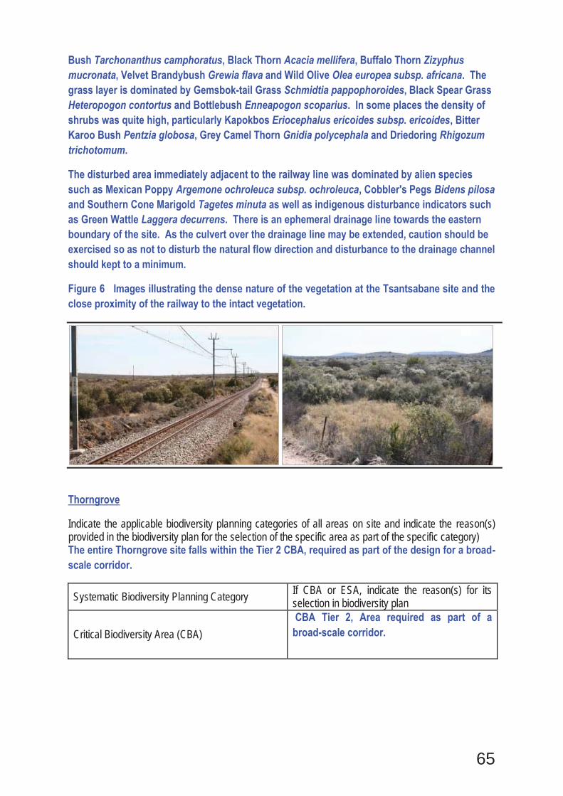
65
Bush Tarchonanthus camphoratus, Black Thorn Acacia mellifera, Buffalo Thorn Zizyphus mucronata, Velvet Brandybush Grewia flava and Wild Olive Olea europea subsp. africana. The grass layer is dominated by Gemsbok-tail Grass Schmidtia pappophoroides, Black Spear Grass Heteropogon contortus and Bottlebush Enneapogon scoparius. In some places the density of shrubs was quite high, particularly Kapokbos Eriocephalus ericoides subsp. ericoides, Bitter Karoo Bush Pentzia globosa, Grey Camel Thorn Gnidia polycephala and Driedoring Rhigozum trichotomum.
The disturbed area immediately adjacent to the railway line was dominated by alien species such as Mexican Poppy Argemone ochroleuca subsp. ochroleuca, Cobbler's Pegs Bidens pilosa and Southern Cone Marigold Tagetes minuta as well as indigenous disturbance indicators such as Green Wattle Laggera decurrens. There is an ephemeral drainage line towards the eastern boundary of the site. As the culvert over the drainage line may be extended, caution should be exercised so as not to disturb the natural flow direction and disturbance to the drainage channel should kept to a minimum.
Figure 6 Images illustrating the dense nature of the vegetation at the Tsantsabane site and the close proximity of the railway to the intact vegetation.
Thorngrove
Indicate the applicable biodiversity planning categories of all areas on site and indicate the reason(s) provided in the biodiversity plan for the selection of the specific area as part of the specific category) The entire Thorngrove site falls within the Tier 2 CBA, required as part of the design for a broad-scale corridor.
Systematic Biodiversity Planning Category If CBA or ESA, indicate the reason(s) for its selection in biodiversity plan
Critical Biodiversity Area (CBA) CBA Tier 2, Area required as part of a broad-scale corridor.
66
b) Indicate and describe the habitat condition on site
Habitat Condition Percentage of habitat condition class (adding up to 100%)
Description and additional Comments and Observations (including additional insight into condition, e.g. poor land management practises, presence of quarries, grazing, harvesting regimes etc).
Natural 50% Within the northern section of the site, the majority of vegetation away from the actual railway line is in an intact condition.
Near Natural
(includes areas with low to moderate level of alien invasive plants)
20%
Those areas around the station platform as well as many other areas within the railway reserve are in a near natural condition having been cleared of woody species.
Degraded
(includes areas heavily invaded by alien plants)
10%
Some areas around the platform have been heavily disturbed in the past and there are also a number of alien woody species such as Eucalyptus present.
Transformed
(includes cultivation, dams, urban, plantation, roads, etc)
20%
The area around the line itself has been transformed and there is also an adjacent area in the south where irrigated fields are present.
c) Complete the table to indicate: (i) the type of vegetation, including its ecosystem status, present on the site; and (ii) whether an aquatic ecosystem is present on site. Terrestrial Ecosystems Aquatic Ecosystems Ecosystem threat status as per the National Environmental Management: Biodiversity Act (Act No. 10 of 2004)
Wetland (including rivers, depressions, channelled and unchanneled wetlands, flats, seeps pans, and artificial wetlands)
Estuary Coastline
Least Threatened
NO
NO
NO
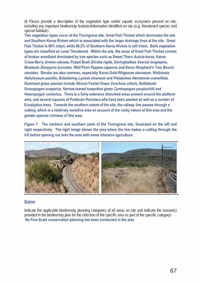
67
d) Please provide a description of the vegetation type and/or aquatic ecosystem present on site, including any important biodiversity features/information identified on site (e.g. threatened species and special habitats) Two vegetation types occur at the Thorngrove site, Great Fish Thicket which dominates the site and Southern Karoo Riviere which is associated with the larger drainage lines at the site. Great Fish Thicket is 96% intact, while 88.2% of Southern Karoo Riviere is still intact. Both vegetation types are classified as Least Threatened. Within the site, the areas of Great Fish Thicket consist of broken woodland dominated by tree species such as Sweet Thorn Acacia karoo, Karoo Cross-Berry Grewia robusta, Puzzel Bush Ehretia rigida, Doringtaaibos Searsia longispina, Bluebush Diospyros lycioides, Wild Plum Pappea capensis and Karoo Shephard’s Tree Boscia oleoides. Shrubs are also common, especially Karoo Gold Rhigozum obovatum, Wolbossie Helichrysum pumilio, Boksdoring Lycium cinereum and Pleisterbos Hermannia cueneifolia. Dominant grass species include African Foxtail Grass Cenchrus ciliaris, Bottlebush Enneapogon scoparius, Narrow-leaved turpentine grass Cymbopogon pospischilii and Heteropogon contortus. There is a fairly extensive disturbed areas present around the platform area, and several squares of Portbush Portulaca afra have been planted as well as a number of Eucalyptus trees. Towards the southern extent of the site, the railway line passes through a cutting, which is a relatively sensitive area on account of the rocky nature of this area and the greater species richness of this area.
Figure 7 The northern and southern parts of the Thorngrove site, illustrated on the left and right respectively. The right image shows the area where the line makes a cutting through the hill before opening out onto the area with some intensive agriculture.
Sishen
Indicate the applicable biodiversity planning categories of all areas on site and indicate the reason(s) provided in the biodiversity plan for the selection of the specific area as part of the specific category) No Fine-Scale conservation planning has been conducted in the area
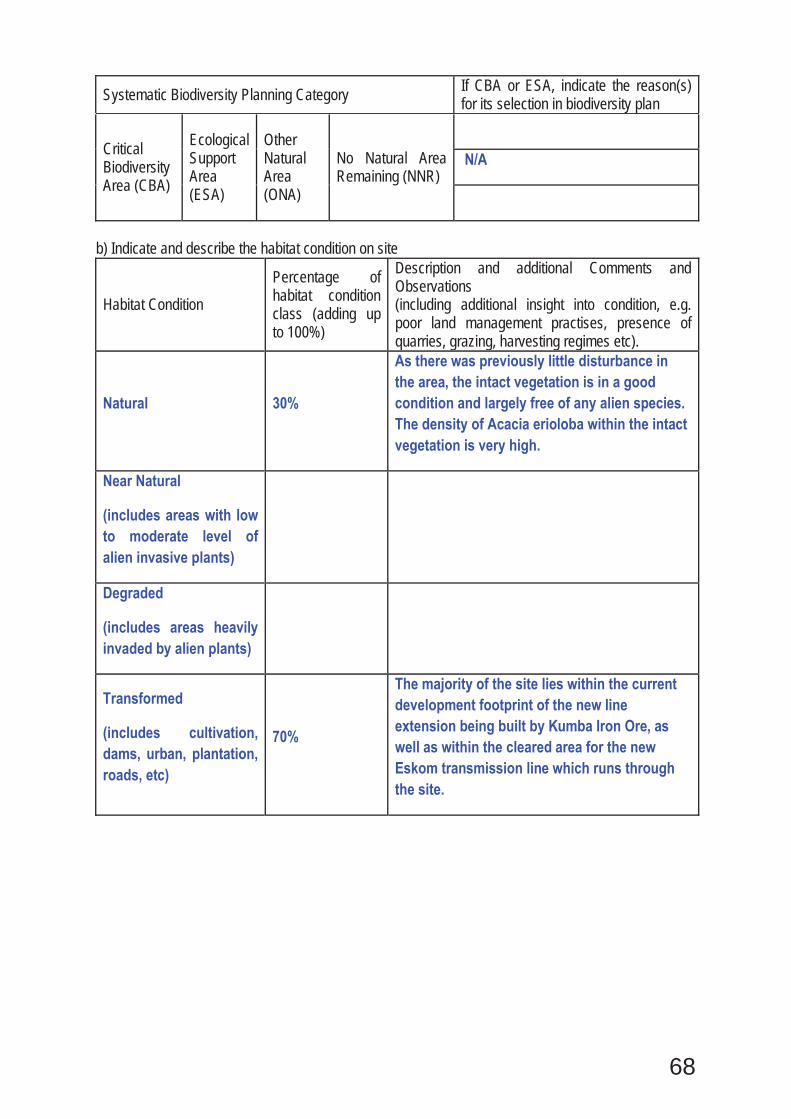
68
Systematic Biodiversity Planning Category If CBA or ESA, indicate the reason(s) for its selection in biodiversity plan
Critical Biodiversity Area (CBA)
Ecological Support Area (ESA)
Other Natural Area (ONA)
No Natural Area Remaining (NNR)
N/A
b) Indicate and describe the habitat condition on site
Habitat Condition Percentage of habitat condition class (adding up to 100%)
Description and additional Comments and Observations (including additional insight into condition, e.g. poor land management practises, presence of quarries, grazing, harvesting regimes etc).
Natural 30%
As there was previously little disturbance in the area, the intact vegetation is in a good condition and largely free of any alien species. The density of Acacia erioloba within the intact vegetation is very high.
Near Natural
(includes areas with low to moderate level of alien invasive plants)
Degraded
(includes areas heavily invaded by alien plants)
Transformed
(includes cultivation, dams, urban, plantation, roads, etc)
70%
The majority of the site lies within the current development footprint of the new line extension being built by Kumba Iron Ore, as well as within the cleared area for the new Eskom transmission line which runs through the site.
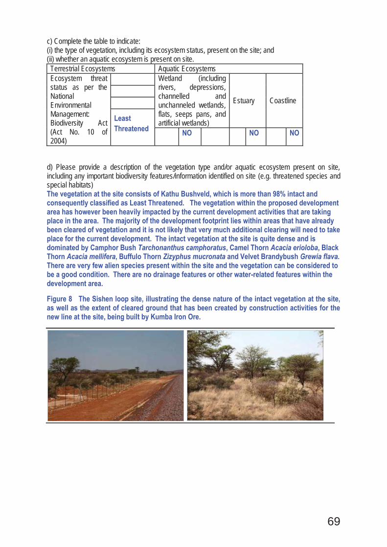
69
c) Complete the table to indicate: (i) the type of vegetation, including its ecosystem status, present on the site; and (ii) whether an aquatic ecosystem is present on site. Terrestrial Ecosystems Aquatic Ecosystems Ecosystem threat status as per the National Environmental Management: Biodiversity Act (Act No. 10 of 2004)
Wetland (including rivers, depressions, channelled and unchanneled wetlands, flats, seeps pans, and artificial wetlands)
Estuary Coastline
Least Threatened
NO
NO
NO
d) Please provide a description of the vegetation type and/or aquatic ecosystem present on site, including any important biodiversity features/information identified on site (e.g. threatened species and special habitats) The vegetation at the site consists of Kathu Bushveld, which is more than 98% intact and consequently classified as Least Threatened. The vegetation within the proposed development area has however been heavily impacted by the current development activities that are taking place in the area. The majority of the development footprint lies within areas that have already been cleared of vegetation and it is not likely that very much additional clearing will need to take place for the current development. The intact vegetation at the site is quite dense and is dominated by Camphor Bush Tarchonanthus camphoratus, Camel Thorn Acacia erioloba, Black Thorn Acacia mellifera, Buffulo Thorn Zizyphus mucronata and Velvet Brandybush Grewia flava. There are very few alien species present within the site and the vegetation can be considered to be a good condition. There are no drainage features or other water-related features within the development area.
Figure 8 The Sishen loop site, illustrating the dense nature of the intact vegetation at the site, as well as the extent of cleared ground that has been created by construction activities for the new line at the site, being built by Kumba Iron Ore.
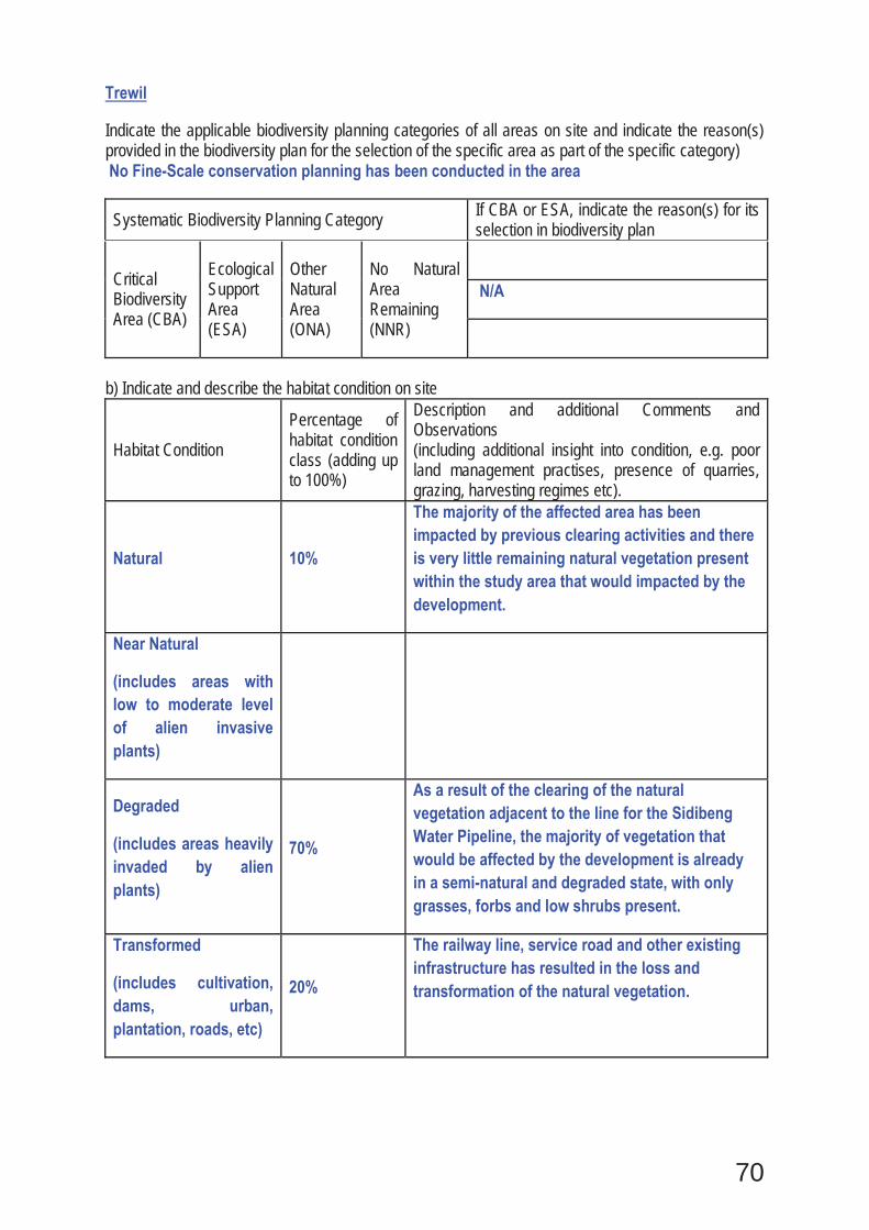
70
Trewil
Indicate the applicable biodiversity planning categories of all areas on site and indicate the reason(s) provided in the biodiversity plan for the selection of the specific area as part of the specific category) No Fine-Scale conservation planning has been conducted in the area
Systematic Biodiversity Planning Category If CBA or ESA, indicate the reason(s) for its selection in biodiversity plan
Critical Biodiversity Area (CBA)
Ecological Support Area (ESA)
Other Natural Area (ONA)
No Natural Area Remaining (NNR)
N/A
b) Indicate and describe the habitat condition on site
Habitat Condition Percentage of habitat condition class (adding up to 100%)
Description and additional Comments and Observations (including additional insight into condition, e.g. poor land management practises, presence of quarries, grazing, harvesting regimes etc).
Natural 10%
The majority of the affected area has been impacted by previous clearing activities and there is very little remaining natural vegetation present within the study area that would impacted by the development.
Near Natural
(includes areas with low to moderate level of alien invasive plants)
Degraded
(includes areas heavily invaded by alien plants)
70%
As a result of the clearing of the natural vegetation adjacent to the line for the Sidibeng Water Pipeline, the majority of vegetation that would be affected by the development is already in a semi-natural and degraded state, with only grasses, forbs and low shrubs present.
Transformed
(includes cultivation, dams, urban, plantation, roads, etc)
20%
The railway line, service road and other existing infrastructure has resulted in the loss and transformation of the natural vegetation.
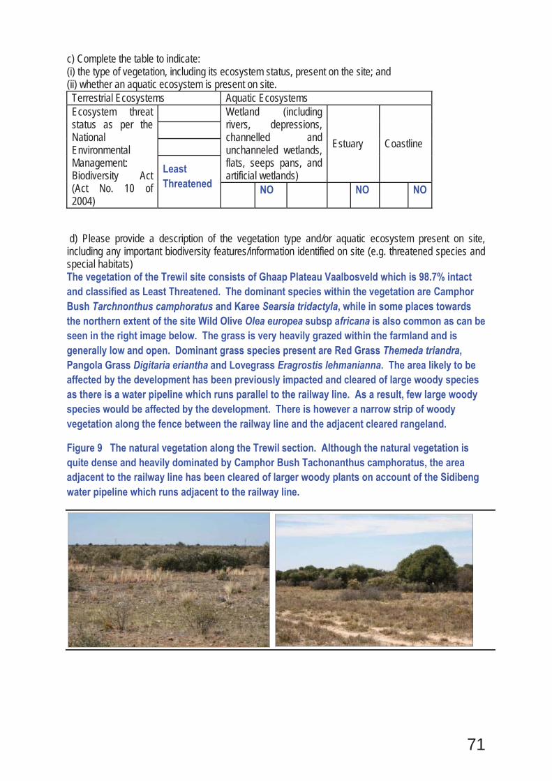
71
c) Complete the table to indicate: (i) the type of vegetation, including its ecosystem status, present on the site; and (ii) whether an aquatic ecosystem is present on site. Terrestrial Ecosystems Aquatic Ecosystems Ecosystem threat status as per the National Environmental Management: Biodiversity Act (Act No. 10 of 2004)
Wetland (including rivers, depressions, channelled and unchanneled wetlands, flats, seeps pans, and artificial wetlands)
Estuary Coastline
Least Threatened
NO
NO
NO
d) Please provide a description of the vegetation type and/or aquatic ecosystem present on site, including any important biodiversity features/information identified on site (e.g. threatened species and special habitats) The vegetation of the Trewil site consists of Ghaap Plateau Vaalbosveld which is 98.7% intact and classified as Least Threatened. The dominant species within the vegetation are Camphor Bush Tarchnonthus camphoratus and Karee Searsia tridactyla, while in some places towards the northern extent of the site Wild Olive Olea europea subsp africana is also common as can be seen in the right image below. The grass is very heavily grazed within the farmland and is generally low and open. Dominant grass species present are Red Grass Themeda triandra, Pangola Grass Digitaria eriantha and Lovegrass Eragrostis lehmanianna. The area likely to be affected by the development has been previously impacted and cleared of large woody species as there is a water pipeline which runs parallel to the railway line. As a result, few large woody species would be affected by the development. There is however a narrow strip of woody vegetation along the fence between the railway line and the adjacent cleared rangeland.
Figure 9 The natural vegetation along the Trewil section. Although the natural vegetation is quite dense and heavily dominated by Camphor Bush Tachonanthus camphoratus, the area adjacent to the railway line has been cleared of larger woody plants on account of the Sidibeng water pipeline which runs adjacent to the railway line.
72
Ulco and Gong Gong
Indicate the applicable biodiversity planning categories of all areas on site and indicate the reason(s) provided in the biodiversity plan for the selection of the specific area as part of the specific category) No Fine-Scale conservation planning has been conducted in the area
Systematic Biodiversity Planning Category If CBA or ESA, indicate the reason(s) for its selection in biodiversity plan
Critical Biodiversity Area (CBA)
Ecological Support Area (ESA)
Other Natural Area (ONA)
No Natural Area Remaining (NNR)
N/A
b) Indicate and describe the habitat condition on site
Habitat Condition Percentage of habitat condition class (adding up to 100%)
Description and additional Comments and Observations (including additional insight into condition, e.g. poor land management practises, presence of quarries, grazing, harvesting regimes etc).
Natural 30%
Some areas within the railway reserve have been little impacted by previous disturbance and can be considered natural. These areas are not heavily invaded by alien species and can be considered in good condition.
Near Natural
(includes areas with low to moderate level of alien invasive plants)
40%
A large proportion of the vegetation within the site can be considered in a near natural condition on account of the presence of some alien species such as Opuntia and Prosopis as well as past disturbance.
Degraded
(includes areas heavily invaded by alien plants)
Transformed
(includes cultivation, dams, urban, plantation, roads, etc)
30%
The railway line, platform area and service road have resulted in the transformation of the natural vegetation.
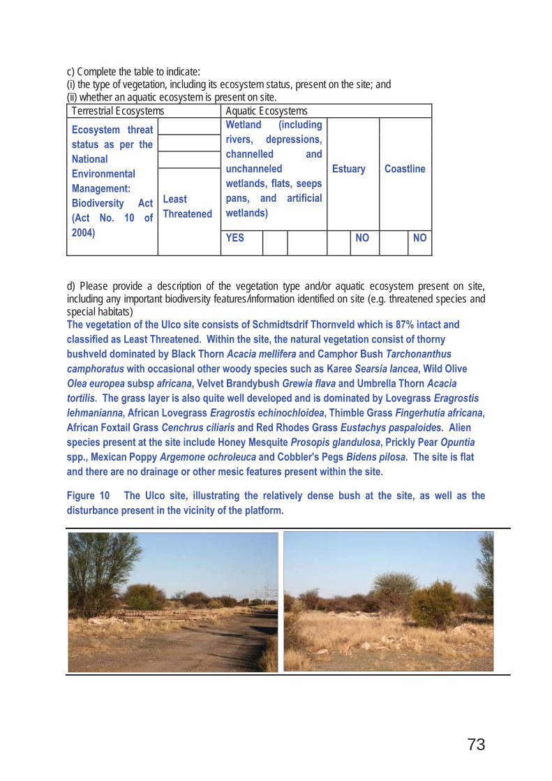
73
c) Complete the table to indicate: (i) the type of vegetation, including its ecosystem status, present on the site; and (ii) whether an aquatic ecosystem is present on site. Terrestrial Ecosystems Aquatic Ecosystems Ecosystem threat status as per the National Environmental Management: Biodiversity Act (Act No. 10 of 2004)
Wetland (including rivers, depressions, channelled and unchanneled wetlands, flats, seeps pans, and artificial wetlands)
Estuary Coastline
Least Threatened
YES
NO
NO
d) Please provide a description of the vegetation type and/or aquatic ecosystem present on site, including any important biodiversity features/information identified on site (e.g. threatened species and special habitats) The vegetation of the Ulco site consists of Schmidtsdrif Thornveld which is 87% intact and classified as Least Threatened. Within the site, the natural vegetation consist of thorny bushveld dominated by Black Thorn Acacia mellifera and Camphor Bush Tarchonanthus camphoratus with occasional other woody species such as Karee Searsia lancea, Wild Olive Olea europea subsp africana, Velvet Brandybush Grewia flava and Umbrella Thorn Acacia tortilis. The grass layer is also quite well developed and is dominated by Lovegrass Eragrostis lehmanianna, African Lovegrass Eragrostis echinochloidea, Thimble Grass Fingerhutia africana, African Foxtail Grass Cenchrus ciliaris and Red Rhodes Grass Eustachys paspaloides. Alien species present at the site include Honey Mesquite Prosopis glandulosa, Prickly Pear Opuntia spp., Mexican Poppy Argemone ochroleuca and Cobbler's Pegs Bidens pilosa. The site is flat and there are no drainage or other mesic features present within the site.
Figure 10 The Ulco site, illustrating the relatively dense bush at the site, as well as the disturbance present in the vicinity of the platform.
74
Wincanton
Indicate the applicable biodiversity planning categories of all areas on site and indicate the reason(s) provided in the biodiversity plan for the selection of the specific area as part of the specific category) No Fine-Scale conservation planning has been conducted in the area
Systematic Biodiversity Planning Category If CBA or ESA, indicate the reason(s) for its selection in biodiversity plan
Critical Biodiversity Area (CBA)
Ecological Support Area (ESA)
Other Natural Area (ONA)
No Natural Area Remaining (NNR)
N/A
b) Indicate and describe the habitat condition on site c) Complete the table to indicate: (i) the type of vegetation, including its ecosystem status, present on the site; and (ii) whether an aquatic ecosystem is present on site. Terrestrial Ecosystems Aquatic Ecosystems Ecosystem threat status as per the National Environmental Management: Biodiversity Act (Act No. 10 of 2004)
Wetland (including rivers, depressions, channelled and unchanneled wetlands, flats, seeps pans, and artificial wetlands)
Estuary Coastline
Least Threatened
NO
NO
NO
b) Indicate and describe the habitat condition on site
Habitat Condition Percentage of habitat condition class (adding up to 100%)
Description and additional Comments and Observations (including additional insight into condition, e.g. poor land management practises, presence of quarries, grazing, harvesting regimes etc).
Natural 30% A few areas within the railway reserve are still in a natural condition and dominated by Acacia mellifera and Tachonanthus camphoratus
Near Natural
(includes areas with low to moderate level of alien invasive plants)
40%
The majority of area within the railway reserve has been impacted to some extent and most woody species have been cleared from the reserve area. Only the grass layer remains intact.
Degraded
(includes areas heavily invaded by
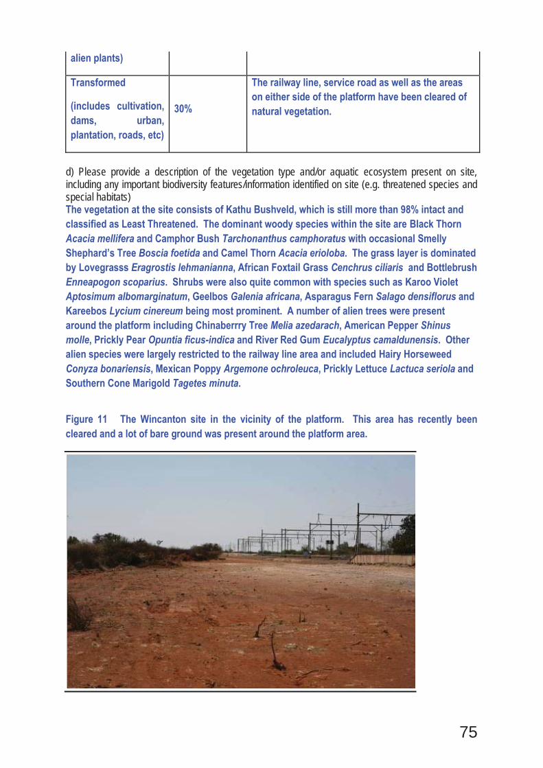
75
alien plants)
Transformed
(includes cultivation, dams, urban, plantation, roads, etc)
30%
The railway line, service road as well as the areas on either side of the platform have been cleared of natural vegetation.
d) Please provide a description of the vegetation type and/or aquatic ecosystem present on site, including any important biodiversity features/information identified on site (e.g. threatened species and special habitats) The vegetation at the site consists of Kathu Bushveld, which is still more than 98% intact and classified as Least Threatened. The dominant woody species within the site are Black Thorn Acacia mellifera and Camphor Bush Tarchonanthus camphoratus with occasional Smelly Shephard’s Tree Boscia foetida and Camel Thorn Acacia erioloba. The grass layer is dominated by Lovegrasss Eragrostis lehmanianna, African Foxtail Grass Cenchrus ciliaris and Bottlebrush Enneapogon scoparius. Shrubs were also quite common with species such as Karoo Violet Aptosimum albomarginatum, Geelbos Galenia africana, Asparagus Fern Salago densiflorus and Kareebos Lycium cinereum being most prominent. A number of alien trees were present around the platform including Chinaberrry Tree Melia azedarach, American Pepper Shinus molle, Prickly Pear Opuntia ficus-indica and River Red Gum Eucalyptus camaldunensis. Other alien species were largely restricted to the railway line area and included Hairy Horseweed Conyza bonariensis, Mexican Poppy Argemone ochroleuca, Prickly Lettuce Lactuca seriola and Southern Cone Marigold Tagetes minuta.
Figure 11 The Wincanton site in the vicinity of the platform. This area has recently been cleared and a lot of bare ground was present around the platform area.
76
Cookhouse and Golden Valley
Indicate the applicable biodiversity planning categories of all areas on site and indicate the reason(s) provided in the biodiversity plan for the selection of the specific area as part of the specific category) The southern third of the site abuts onto a CBA area to the west of the line which has been mapped as having the railway line as its boundary. Therefore, expansion of the line in this area to the west can be considered to be within a CBA, but areas to the east of the line are not within a CBA. Only those areas consisting of natural vegetation are however considered part of the CBA and transformed areas are not subject to the regulations pertaining to development within CBAs. As the majority of the development will be within transformed areas, the impact on the CBA would be minimal. The majority of the site is however not within a CBA.
Systematic Biodiversity Planning Category If CBA or ESA, indicate the reason(s) for its selection in biodiversity plan
Critical Biodiversity Area (CBA)
The lower third of the site and only to the west of line is a CBA Tier 2, Area required as part of a broad-scale corridor.
b) Indicate and describe the habitat condition on site
Habitat Condition Percentage of habitat condition class (adding up to 100%)
Description and additional Comments and Observations (including additional insight into condition, e.g. poor land management practises, presence of quarries, grazing, harvesting regimes etc).
Natural 25% The areas outside the railway reserve are largely natural and in good condition.
Near Natural
(includes areas with low to moderate level of alien invasive plants)
40%
The areas within the railway reserve are largely in a near natural condition, having been disturbed in the past and having since recovered.
Degraded
(includes areas heavily invaded by alien plants)
25% Some areas within the railway reserve have been extensively disturbed and consist largely of alien species and disturbance indicators.
Transformed
(includes cultivation, dams, urban, plantation, roads, etc)
10%
The railway line itself and the service road have resulted in the transformation of the natural vegetation. There are also some areas of intensive agriculture towards the Golden Valley side of the study area.
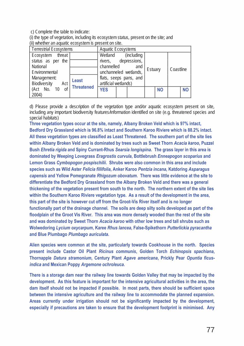
77
c) Complete the table to indicate: (i) the type of vegetation, including its ecosystem status, present on the site; and (ii) whether an aquatic ecosystem is present on site. Terrestrial Ecosystems Aquatic Ecosystems Ecosystem threat status as per the National Environmental Management: Biodiversity Act (Act No. 10 of 2004)
Wetland (including rivers, depressions, channelled and unchanneled wetlands, flats, seeps pans, and artificial wetlands)
Estuary Coastline
Least Threatened
YES
NO
NO
d) Please provide a description of the vegetation type and/or aquatic ecosystem present on site, including any important biodiversity features/information identified on site (e.g. threatened species and special habitats) Three vegetation types occur at the site, namely, Albany Broken Veld which is 97% intact, Bedford Dry Grassland which is 96.8% intact and Southern Karoo Riviere which is 88.2% intact. All these vegetation types are classified as Least Threatened. The southern part of the site lies within Albany Broken Veld and is dominated by trees such as Sweet Thorn Acacia karoo, Puzzel Bush Ehretia rigida and Spiny Currant-Rhus Searsia longispina. The grass layer in this area is dominated by Weeping Lovegrass Eragrostis curvula, Bottlebrush Enneapogon scoparius and Lemon Grass Cymbopogon pospischilii. Shrubs were also common in this area and include species such as Wild Aster Felicia fillifolia, Anker Karoo Pentzia incana, Katdoring Asparagus capensis and Yellow Pomegranate Rhigozum obovatum. There was little evidence at the site to differentiate the Bedford Dry Grassland from the Albany Broken Veld and there was a general thickening of the vegetation present from south to the north. The northern extent of the site lies within the Southern Karoo Riviere vegetation type. As a result of the development in the area, this part of the site is however cut off from the Groot-Vis River itself and is no longer functionally part of the drainage channel. The soils are deep silty soils developed as part of the floodplain of the Groot Vis River. This area was more densely wooded than the rest of the site and was dominated by Sweet Thorn Acacia karoo with other low trees and tall shrubs such as Wolwedoring Lycium oxycarpum, Karee Rhus lancea, False-Spikethorn Putterlickia pyracantha and Blue Plumbago Plumbago auriculata.
Alien species were common at the site, particularly towards Cookhouse in the north. Species present include Castor Oil Plant Ricinus communis, Golden Torch Echinopsis spachiana, Thornapple Datura stramonium, Century Plant Agave americana, Prickly Pear Opuntia ficus-indica and Mexican Poppy Argemone ochroleuca.
There is a storage dam near the railway line towards Golden Valley that may be impacted by the development. As this feature is important for the intensive agricultural activities in the area, the dam itself should not be impacted if possible. In most parts, there should be sufficient space between the intensive agriculture and the railway line to accommodate the planned expansion. Areas currently under irrigation should not be significantly impacted by the development, especially if precautions are taken to ensure that the development footprint is minimised. Any
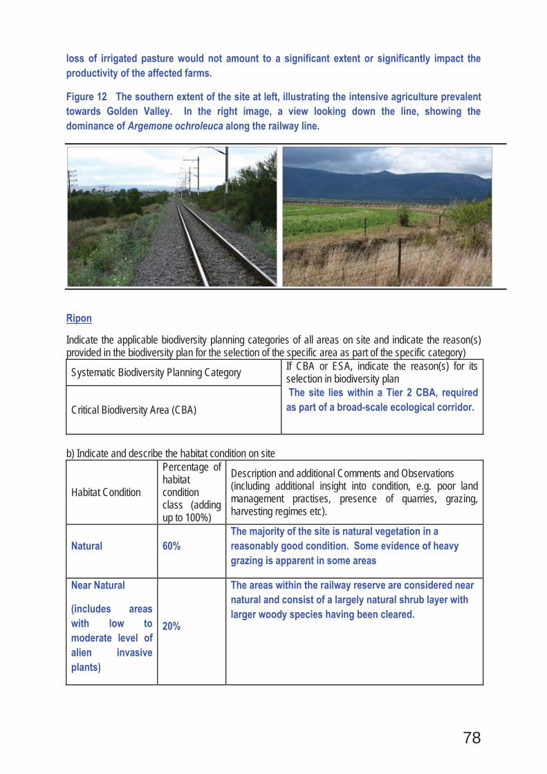
78
loss of irrigated pasture would not amount to a significant extent or significantly impact the productivity of the affected farms.
Figure 12 The southern extent of the site at left, illustrating the intensive agriculture prevalent towards Golden Valley. In the right image, a view looking down the line, showing the dominance of Argemone ochroleuca along the railway line.
Ripon
Indicate the applicable biodiversity planning categories of all areas on site and indicate the reason(s) provided in the biodiversity plan for the selection of the specific area as part of the specific category)
Systematic Biodiversity Planning Category If CBA or ESA, indicate the reason(s) for its selection in biodiversity plan
Critical Biodiversity Area (CBA) The site lies within a Tier 2 CBA, required as part of a broad-scale ecological corridor.
b) Indicate and describe the habitat condition on site
Habitat Condition
Percentage of habitat condition class (adding up to 100%)
Description and additional Comments and Observations (including additional insight into condition, e.g. poor land management practises, presence of quarries, grazing, harvesting regimes etc).
Natural 60% The majority of the site is natural vegetation in a reasonably good condition. Some evidence of heavy grazing is apparent in some areas
Near Natural
(includes areas with low to moderate level of alien invasive plants)
20%
The areas within the railway reserve are considered near natural and consist of a largely natural shrub layer with larger woody species having been cleared.

79
Degraded
(includes areas heavily invaded by alien plants)
Transformed
(includes cultivation, dams, urban, plantation, roads, etc)
20%
The areas around the station platform and buildings have been transformed as well as the line itself and the service road.
c) Complete the table to indicate: (i) the type of vegetation, including its ecosystem status, present on the site; and (ii) whether an aquatic ecosystem is present on site. Terrestrial Ecosystems Aquatic Ecosystems Ecosystem threat status as per the National Environmental Management: Biodiversity Act (Act No. 10 of 2004)
Wetland (including rivers, depressions, channelled and unchanneled wetlands, flats, seeps pans, and artificial wetlands)
Estuary Coastline
Least Threatened
YES NO
NO NO
d) Please provide a description of the vegetation type and/or aquatic ecosystem present on site, including any important biodiversity features/information identified on site (e.g. threatened species and special habitats) Three vegetation types occur in the vicinity of the site, Albany Broken Veld, which is 97% intact, Kowie Thicket which is 91.7% intact and Southern Karoo Riviere which is 88.2% intact. All these vegetation types are classified as Least Threatened. The northern extent of the site lies largely within the Albany Broken Veld vegetation type. This is an open shrubland with scattered trees. Dominant shrubs include African Sheepbush Pentzia incana, Bergappel Asparagus striatus, White Felicia Felicia muricata and Kapokbos Eriocephalus microphyllus. Scattered trees include Wild Plum Pappea capensis, White Karee Searsia burchellii and Puzzel Bush Ehretia rigida. Within the southern extent of the site, the vegetation is Kowie Thicket and is denser than in the northern extent of the site. Common species in this area include Sweet Thorn Acacia karoo, Karoo Num-num Carissa haematocarpa, Common Guarri Euclea undulata, Pork Bush Portulacaria afra, False-spikethorn Putterlickia pyracantha and Wolwedoring Lycium oxycarpum. Alien species present include Century Plant Agave americana, Prickly Pear Opuntia ficus-indica, Russian Thistle Salsola kali, Hairy horseweed Conyza bonariensis and Mexican Poppy Argemone ochroleuca. The alien species present were restricted to the disturbed area along the sides of the railway line as well as the area around the Kommadagga station platform.
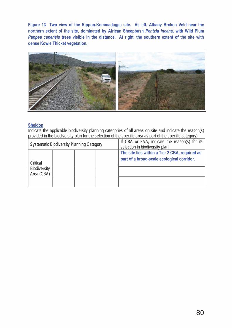
80
Figure 13 Two view of the Rippon-Kommadagga site. At left, Albany Broken Veld near the northern extent of the site, dominated by African Sheepbush Pentzia incana, with Wild Plum Pappea capensis trees visible in the distance. At right, the southern extent of the site with dense Kowie Thicket vegetation.
Sheldon Indicate the applicable biodiversity planning categories of all areas on site and indicate the reason(s) provided in the biodiversity plan for the selection of the specific area as part of the specific category)
Systematic Biodiversity Planning Category If CBA or ESA, indicate the reason(s) for its selection in biodiversity plan
Critical Biodiversity Area (CBA)
The site lies within a Tier 2 CBA, required as part of a broad-scale ecological corridor.
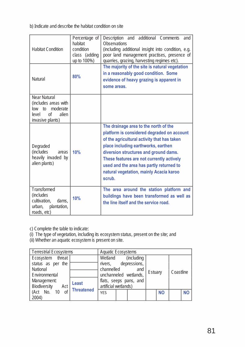
81
b) Indicate and describe the habitat condition on site
Habitat Condition
Percentage of habitat condition class (adding up to 100%)
Description and additional Comments and Observations (including additional insight into condition, e.g. poor land management practises, presence of quarries, grazing, harvesting regimes etc).
Natural 80%
The majority of the site is natural vegetation in a reasonably good condition. Some evidence of heavy grazing is apparent in some areas.
Near Natural (includes areas with low to moderate level of alien invasive plants)
Degraded (includes areas heavily invaded by alien plants)
10%
The drainage area to the north of the platform is considered degraded on account of the agricultural activity that has taken place including earthworks, earthen diversion structures and ground dams. These features are not currently actively used and the area has partly returned to natural vegetation, mainly Acacia karoo scrub.
Transformed (includes cultivation, dams, urban, plantation, roads, etc)
10%
The area around the station platform and buildings have been transformed as well as the line itself and the service road.
c) Complete the table to indicate: (i) The type of vegetation, including its ecosystem status, present on the site; and (ii) Whether an aquatic ecosystem is present on site. Terrestrial Ecosystems Aquatic Ecosystems Ecosystem threat status as per the National Environmental Management: Biodiversity Act (Act No. 10 of 2004)
Wetland (including rivers, depressions, channelled and unchanneled wetlands, flats, seeps pans, and artificial wetlands)
Estuary Coastline
Least Threatened
YES
NO
NO

82
d) Please provide a description of the vegetation type and/or aquatic ecosystem present on site, including any important biodiversity features/information identified on site (e.g. threatened species and special habitats) The Sheldon loop site lies entirely within the Great Fish Thicket vegetation type. This is a thicket vegetation type usually consisting of dense vegetation associated with the valleys of the Great Fish and Keiskamma River valleys. Within the site, the vegetation is however mostly not very dense and consists of an open low shrubland with scattered Pappea capensis trees. Dense bush clumps and patches of taller vegetation are scattered in the landscape within areas of favourable moisture locations or on termitaria. Species associated with the bush clumps include Acacia karoo, Grewia robusta, Ehretia rigida, Searsia longispina, Diospyros lycioides, Pappea capensis and Boscia oleoides. The open vegetation is dominated by typical karoo species such as Pentzia incana, Rosenia humilis, Rhigozum obovatum, Helichrysum pumilio, Lycium cinereum and Hermannia cueneifolia, while dominant grass species include Eragrostis lehmanniana, Cenchrus ciliaris, Enneapogon scoparius, Cymbopogon pospischilii and Heteropogon contortus. Aloe striata also forms some very dense stands between the railway line and the N10. In terms of sensitive features within the site, there is a fairly large drainage area from the platform northwards to the gravel access road. This area have however been heavily impacted by agricultural activities and as the loop extension lies from the platform southwards, this area is not likely to be affected by the extension of the loop.

81
SECTION C: PUBLIC PARTICIPATION
The initial public notification period which preceded the release of this BAR included the following: Site notices and notices placed in nearby towns; Newspaper adverts; Distribution of a Background Information Document (BID); and One-on-one interviews with stakeholders (landowners and Local Municipality Community Development Workers, mainly).
The public participation activities during the BAR comment period included newspaper adverts, written notification to I&APs as well as public and focus group meetings. As well as a re-release of the Draft BAR in July – August 2013. The public participation captured in Appendix E includes the following:
E1 – Public Participation Process E2 – Initial Notification E3 – Draft Basic Assessment Report Release E4 – Proof of Adverts for Re-release of BAR E5 – Database E6 - Comments Received E7 – Minutes of Meetings E8 – Comments and Responses Report
1. ADVERTISEMENT AND NOTICESee Appendix E2 and 4
Publication name and Date published
Somerset Budget – 4 October 2012Volksblad – 4 October 2012 Kathu Gazette – 5 October 2012 Die Burger- 15 October 2012
Site notice position Latitude LongitudeS 30° 49’ 15.79” E 24° 17’ 18.77”
Date placed 29 September 2012 (Burgervilleweg)Site notice position Latitude Longitude
S 33° 5’ 17.23” E 25° 51’ 35.00”Date placed 26 September 2012 (Ripon)Site notice position Latitude Longitude
S 32° 44’ 55.69” E 25° 48’ 23.18”Date placed 26 September 2012 (Road Runner – Cookhouse)Site notice position Latitude Longitude
S 32° 44' 40'' E 25° 48' 27''Date placed 27 September 2012 (Cookhouse Station)Site notice position Latitude Longitude
S 32° 44' 44.68" E 25° 48' 27.11"Date placed 26 September 2012 (Cookhouse Town Hall)Site notice position Latitude Longitude
S 32°44' 45.66" E 25°48'26.76"Date placed 26 September 2012 (Cookhouse Library)Site notice position Latitude Longitude
S 32° 26' 28.37" E 25° 44' 29.03"Date placed 27 September 2012 (Drennan)Site notice position Latitude Longitude
S 32° 48’ 43.16” E 25° 47’ 19.48”Date placed 26 September 2012 (Golden Valley Siding)Site notice position Latitude Longitude
S 32° 48' 45.21" E 25° 47' 23.98"Date placed 26 September 2012 (Golden Valley BKB)Site notice position Latitude Longitude
S 32° 48’ 32.25” E 25° 47’ 20.96”Date placed 26 September 2012 (Golden Valley Station)Site notice position Latitude Longitude
31° 3'52.99"S 24°26'33.76"EDate placed 29 September 2012 (Hanover Police Station)Site notice position Latitude Longitude
82
S 31° 4’ 4.13” E 24° 26’ 32.22”Date placed 29 September 2012 (Hanover Library)Site notice position Latitude Longitude
S 31° 57’ 18.21” E 25° 30’ 24.66”Date placed 28 September 2012 (Knutsford Station)Site notice position Latitude Longitude
S 31° 57’ 6.61” E 25° 30’ 7.73”Date placed 28 September 2012 (Knutsford Siding)Site notice position Latitude Longitude
S 33° 7’ 3.97” E 25° 53’ 43.78”Date placed 26 September 2012 (Kommadagga)Site notice position Latitude Longitude
S 30° 59’ 24.48” E 24° 38’ 16.09”Date placed 29 September 2012 (Linde)Site notice position Latitude Longitude
S 31° 29’ 44.08” E 25° 0’ 15.05”Date placed 28 September 2012 (Middleburg Municipality)Site notice position Latitude Longitude
S 31° 29’ 24.70” E 25° 7’ 6.10”Date placed 28 September 2012 (Rosmead Station)Site notice position Latitude Longitude
S 31° 37’ 3.79” E 25° 14’ 24.53”Date placed 28 September 2012 (Tafelburg Station)Site notice position Latitude Longitude
S 31° 36’ 47.59” E 25° 14’ 16.96”Date placed 28 September 2012 (Tafelburg Siding)Site notice position Latitude Longitude
S 32° 39’ 52.67” E 25° 49’ 49.48”Date placed 27 September 2012 (Thorngrove)Site notice position Latitude Longitude
S 33° 26’ 44.98” E 25° 58’ 20.97”Date placed 26 September 2012 (Paterson Town Hall)Site notice position Latitude Longitude
S 33° 26’ 27.87” E 26° 0’ 29.47”Date placed 27 September 2012 (Verby Station)Site notice position Latitude Longitude
S 33° 26’ 14.53” E 25° 57’ 38.35”Date placed 27 September 2012 (Paterson Municipality)
Include proof of the placement of the relevant advertisements and notices in Appendix E2 and 4.
2. DETERMINATION OF APPROPRIATE MEASURES
Provide details of the measures taken to include all potential I&APs as required by Regulation 54(2)(e) and 54(7) of GN R.543.
Key stakeholders (other than organs of state) identified in terms of Regulation 54(2)(b) of GN R.543:
Title, Name and Surname Affiliation/ key stakeholder status Contact details (tel number or e-mail address)
See Appendix E5
Include proof that the key stakeholder received written notification of the proposed activities as Appendix E2,3,4. This proof may include any of the following:
e-mail delivery reports;
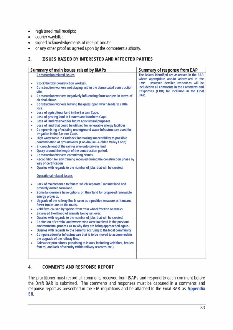
83
registered mail receipts; courier waybills; signed acknowledgements of receipt; and/or or any other proof as agreed upon by the competent authority.
3. ISSUES RAISED BY INTERESTED AND AFFECTED PARTIES
Summary of main issues raised by I&APs Summary of response from EAP Construction related issues
Stock theft by construction workers. Construction workers not staying within the demarcated construction site. Construction workers negatively influencing farm workers in terms of alcohol abuse. Construction workers leaving the gates open which leads to cattle loss. Loss of agricultural land in the Eastern Cape. Loss of grazing land in Eastern and Northern Cape. Loss of land reserved for future agricultural purposes. Loss of land that could be utilised for renewable energy facilities. Compromising of existing underground water infrastructure used for irrigation in the Eastern Cape. High water table in Craddock increasing susceptibility to possible contamination of groundwater (Cookhouse - Golden Valley Loop). Encroachment of the rail reserve onto private land Query around the length of the construction period. Construction workers committing crimes. Recognition for any training received during the construction phase by way of certification Queries with regards to the number of jobs that will be created.
Operational related issues
Lack of maintenance to fences which separate Transnet land and privately owned farm land. Some landowners have options on their land for proposed renewable energy projects. Upgrade of the railway line is seen as a positive measure as it means fewer trucks are on the roads. Veld fires caused by sparks from train wheel fraction on tracks. Increased likelihood of animals being run over. Queries with regards to the number of jobs that will be created. Confusion of certain landowners who were involved in the previous environmental process as to why they are being approached again. Queries with regards to the benefits accruing to the local community Compensation\for infrastructure that is to be moved to accommodate the upgrade of the railway line. Grievance procedures pertaining to issues including veld fires, broken fences, and lack of security within railway reserves etc.)
The issues identified are assessed in the BAR where appropriate and/or addressed in the EMP. However, detailed responses will be included to all comments in the Comments and Responses (CRR) for inclusion in the Final BAR.
4. COMMENTS AND RESPONSE REPORT
The practitioner must record all comments received from I&APs and respond to each comment before the Draft BAR is submitted. The comments and responses must be captured in a comments and response report as prescribed in the EIA regulations and be attached to the Final BAR as AppendixE8.
84
5. AUTHORITY PARTICIPATION Authorities and organs of state identified as key stakeholders:
Authority/Organ of State
Contact person (Title, Name and Surname)
Tel No Fax No e-mail Postal address
See list in Appendix E1
Include proof that the Authorities and Organs of State received written notification of the proposed activities as Appendix E4. In the case of renewable energy projects, Eskom and the SKA Project Office must be included in the list of Organs of State. 6. CONSULTATION WITH OTHER STAKEHOLDERS Note that, for any activities (linear or other) where deviation from the public participation requirements may be appropriate, the person conducting the public participation process may deviate from the requirements of that sub-regulation to the extent and in the manner as may be agreed to by the competent authority. Proof of any such agreement must be provided, where applicable. Application for any deviation from the regulations relating to the public participation process must be submitted prior to the commencement of the public participation process. A list of registered I&APs must be included as Appendix E5. Copies of any correspondence and minutes of any meetings held must be included in Appendix E6.
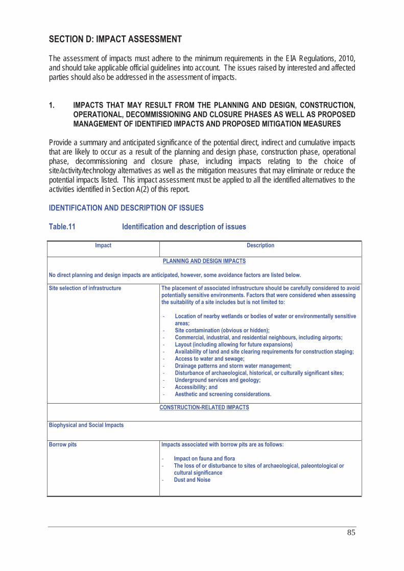
85
SECTION D: IMPACT ASSESSMENT The assessment of impacts must adhere to the minimum requirements in the EIA Regulations, 2010, and should take applicable official guidelines into account. The issues raised by interested and affected parties should also be addressed in the assessment of impacts. 1. IMPACTS THAT MAY RESULT FROM THE PLANNING AND DESIGN, CONSTRUCTION,
OPERATIONAL, DECOMMISSIONING AND CLOSURE PHASES AS WELL AS PROPOSED MANAGEMENT OF IDENTIFIED IMPACTS AND PROPOSED MITIGATION MEASURES
Provide a summary and anticipated significance of the potential direct, indirect and cumulative impacts that are likely to occur as a result of the planning and design phase, construction phase, operational phase, decommissioning and closure phase, including impacts relating to the choice of site/activity/technology alternatives as well as the mitigation measures that may eliminate or reduce the potential impacts listed. This impact assessment must be applied to all the identified alternatives to the activities identified in Section A(2) of this report. IDENTIFICATION AND DESCRIPTION OF ISSUES Table.11 Identification and description of issues
Impact Description
PLANNING AND DESIGN IMPACTS
No direct planning and design impacts are anticipated, however, some avoidance factors are listed below.
Site selection of infrastructure
The placement of associated infrastructure should be carefully considered to avoid potentially sensitive environments. Factors that were considered when assessing the suitability of a site includes but is not limited to: - Location of nearby wetlands or bodies of water or environmentally sensitive
areas; - Site contamination (obvious or hidden); - Commercial, industrial, and residential neighbours, including airports; - Layout (including allowing for future expansions) - Availability of land and site clearing requirements for construction staging; - Access to water and sewage; - Drainage patterns and storm water management; - Disturbance of archaeological, historical, or culturally significant sites; - Underground services and geology; - Accessibility; and - Aesthetic and screening considerations.
CONSTRUCTION-RELATED IMPACTS
Biophysical and Social Impacts
Borrow pits Impacts associated with borrow pits are as follows: - Impact on fauna and flora - The loss of or disturbance to sites of archaeological, paleontological or
cultural significance - Dust and Noise
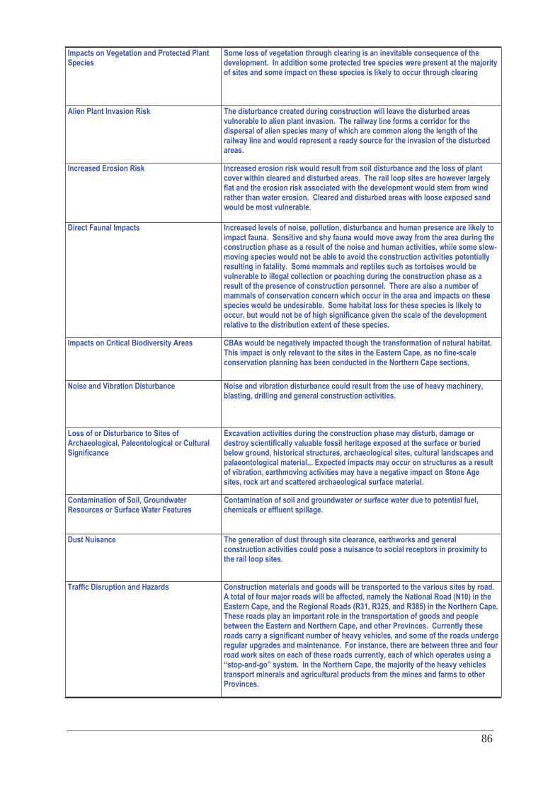
86
Impacts on Vegetation and Protected Plant Species
Some loss of vegetation through clearing is an inevitable consequence of the development. In addition some protected tree species were present at the majority of sites and some impact on these species is likely to occur through clearing
Alien Plant Invasion Risk The disturbance created during construction will leave the disturbed areas vulnerable to alien plant invasion. The railway line forms a corridor for the dispersal of alien species many of which are common along the length of the railway line and would represent a ready source for the invasion of the disturbed areas.
Increased Erosion Risk Increased erosion risk would result from soil disturbance and the loss of plant cover within cleared and disturbed areas. The rail loop sites are however largely flat and the erosion risk associated with the development would stem from wind rather than water erosion. Cleared and disturbed areas with loose exposed sand would be most vulnerable.
Direct Faunal Impacts Increased levels of noise, pollution, disturbance and human presence are likely to impact fauna. Sensitive and shy fauna would move away from the area during the construction phase as a result of the noise and human activities, while some slow-moving species would not be able to avoid the construction activities potentially resulting in fatality. Some mammals and reptiles such as tortoises would be vulnerable to illegal collection or poaching during the construction phase as a result of the presence of construction personnel. There are also a number of mammals of conservation concern which occur in the area and impacts on these species would be undesirable. Some habitat loss for these species is likely to occur, but would not be of high significance given the scale of the development relative to the distribution extent of these species.
Impacts on Critical Biodiversity Areas CBAs would be negatively impacted though the transformation of natural habitat. This impact is only relevant to the sites in the Eastern Cape, as no fine-scale conservation planning has been conducted in the Northern Cape sections.
Noise and Vibration Disturbance
Noise and vibration disturbance could result from the use of heavy machinery, blasting, drilling and general construction activities.
Loss of or Disturbance to Sites of Archaeological, Paleontological or Cultural Significance
Excavation activities during the construction phase may disturb, damage or destroy scientifically valuable fossil heritage exposed at the surface or buried below ground, historical structures, archaeological sites, cultural landscapes and palaeontological material... Expected impacts may occur on structures as a result of vibration, earthmoving activities may have a negative impact on Stone Age sites, rock art and scattered archaeological surface material.
Contamination of Soil, Groundwater Resources or Surface Water Features
Contamination of soil and groundwater or surface water due to potential fuel, chemicals or effluent spillage.
Dust Nuisance
The generation of dust through site clearance, earthworks and general construction activities could pose a nuisance to social receptors in proximity to the rail loop sites.
Traffic Disruption and Hazards Construction materials and goods will be transported to the various sites by road. A total of four major roads will be affected, namely the National Road (N10) in the Eastern Cape, and the Regional Roads (R31, R325, and R385) in the Northern Cape. These roads play an important role in the transportation of goods and people between the Eastern and Northern Cape, and other Provinces. Currently these roads carry a significant number of heavy vehicles, and some of the roads undergo regular upgrades and maintenance. For instance, there are between three and four road work sites on each of these roads currently, each of which operates using a “stop-and-go” system. In the Northern Cape, the majority of the heavy vehicles transport minerals and agricultural products from the mines and farms to other Provinces.
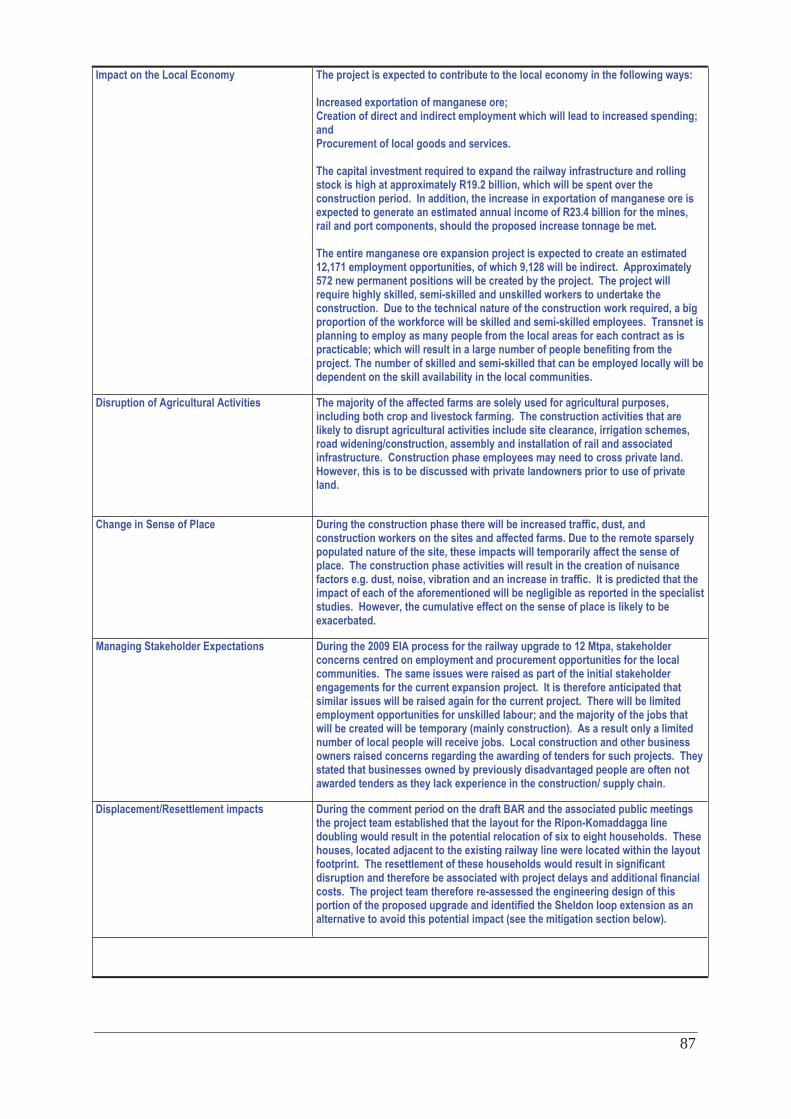
87
Impact on the Local Economy
The project is expected to contribute to the local economy in the following ways: Increased exportation of manganese ore; Creation of direct and indirect employment which will lead to increased spending; and Procurement of local goods and services. The capital investment required to expand the railway infrastructure and rolling stock is high at approximately R19.2 billion, which will be spent over the construction period. In addition, the increase in exportation of manganese ore is expected to generate an estimated annual income of R23.4 billion for the mines, rail and port components, should the proposed increase tonnage be met. The entire manganese ore expansion project is expected to create an estimated 12,171 employment opportunities, of which 9,128 will be indirect. Approximately 572 new permanent positions will be created by the project. The project will require highly skilled, semi-skilled and unskilled workers to undertake the construction. Due to the technical nature of the construction work required, a big proportion of the workforce will be skilled and semi-skilled employees. Transnet is planning to employ as many people from the local areas for each contract as is practicable; which will result in a large number of people benefiting from the project. The number of skilled and semi-skilled that can be employed locally will be dependent on the skill availability in the local communities.
Disruption of Agricultural Activities The majority of the affected farms are solely used for agricultural purposes, including both crop and livestock farming. The construction activities that are likely to disrupt agricultural activities include site clearance, irrigation schemes, road widening/construction, assembly and installation of rail and associated infrastructure. Construction phase employees may need to cross private land. However, this is to be discussed with private landowners prior to use of private land.
Change in Sense of Place
During the construction phase there will be increased traffic, dust, and construction workers on the sites and affected farms. Due to the remote sparsely populated nature of the site, these impacts will temporarily affect the sense of place. The construction phase activities will result in the creation of nuisance factors e.g. dust, noise, vibration and an increase in traffic. It is predicted that the impact of each of the aforementioned will be negligible as reported in the specialist studies. However, the cumulative effect on the sense of place is likely to be exacerbated.
Managing Stakeholder Expectations
During the 2009 EIA process for the railway upgrade to 12 Mtpa, stakeholder concerns centred on employment and procurement opportunities for the local communities. The same issues were raised as part of the initial stakeholder engagements for the current expansion project. It is therefore anticipated that similar issues will be raised again for the current project. There will be limited employment opportunities for unskilled labour; and the majority of the jobs that will be created will be temporary (mainly construction). As a result only a limited number of local people will receive jobs. Local construction and other business owners raised concerns regarding the awarding of tenders for such projects. They stated that businesses owned by previously disadvantaged people are often not awarded tenders as they lack experience in the construction/ supply chain.
Displacement/Resettlement impacts During the comment period on the draft BAR and the associated public meetings the project team established that the layout for the Ripon-Komaddagga line doubling would result in the potential relocation of six to eight households. These houses, located adjacent to the existing railway line were located within the layout footprint. The resettlement of these households would result in significant disruption and therefore be associated with project delays and additional financial costs. The project team therefore re-assessed the engineering design of this portion of the proposed upgrade and identified the Sheldon loop extension as an alternative to avoid this potential impact (see the mitigation section below).
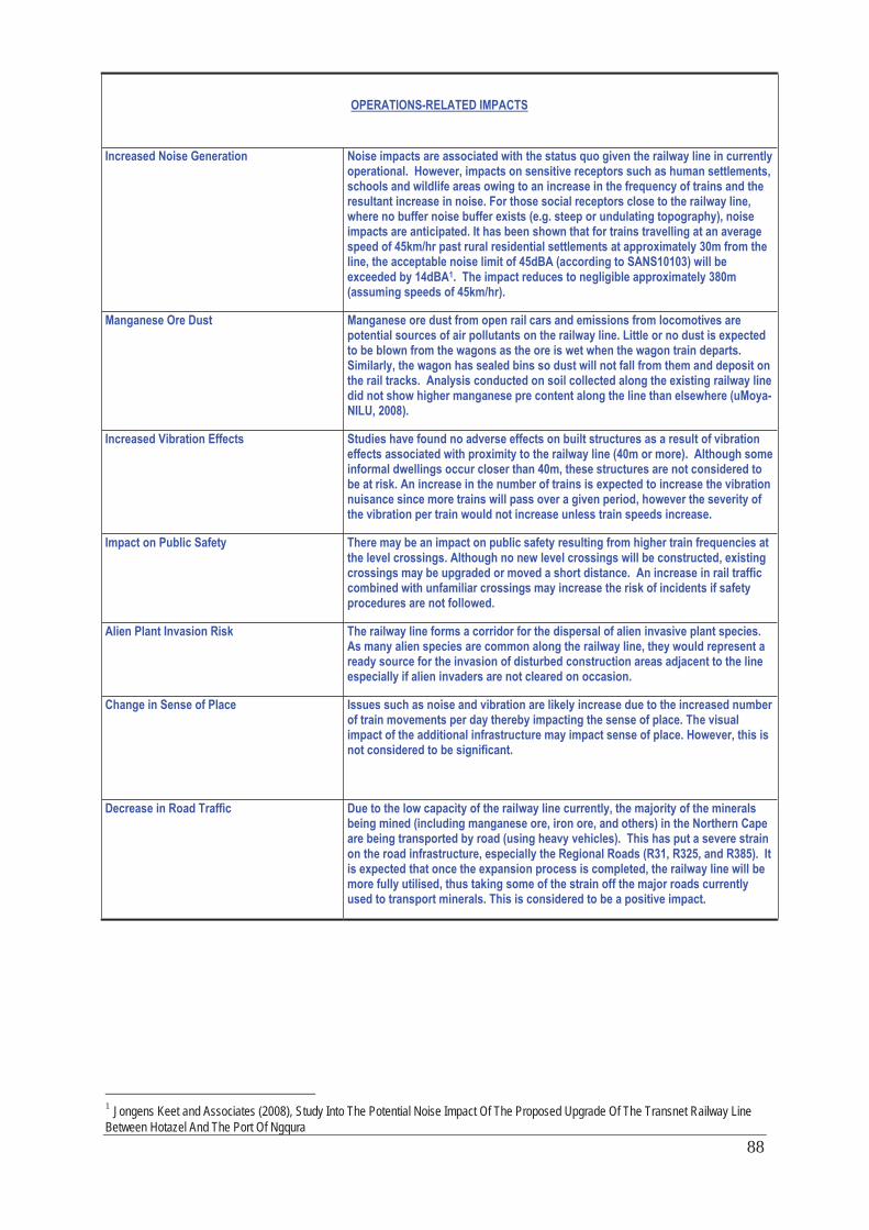
88
OPERATIONS-RELATED IMPACTS
Increased Noise Generation
Noise impacts are associated with the status quo given the railway line in currently operational. However, impacts on sensitive receptors such as human settlements, schools and wildlife areas owing to an increase in the frequency of trains and the resultant increase in noise. For those social receptors close to the railway line, where no buffer noise buffer exists (e.g. steep or undulating topography), noise impacts are anticipated. It has been shown that for trains travelling at an average speed of 45km/hr past rural residential settlements at approximately 30m from the line, the acceptable noise limit of 45dBA (according to SANS10103) will be exceeded by 14dBA1. The impact reduces to negligible approximately 380m (assuming speeds of 45km/hr).
Manganese Ore Dust
Manganese ore dust from open rail cars and emissions from locomotives are potential sources of air pollutants on the railway line. Little or no dust is expected to be blown from the wagons as the ore is wet when the wagon train departs. Similarly, the wagon has sealed bins so dust will not fall from them and deposit on the rail tracks. Analysis conducted on soil collected along the existing railway line did not show higher manganese pre content along the line than elsewhere (uMoya-NILU, 2008).
Increased Vibration Effects
Studies have found no adverse effects on built structures as a result of vibration effects associated with proximity to the railway line (40m or more). Although some informal dwellings occur closer than 40m, these structures are not considered to be at risk. An increase in the number of trains is expected to increase the vibration nuisance since more trains will pass over a given period, however the severity of the vibration per train would not increase unless train speeds increase.
Impact on Public Safety There may be an impact on public safety resulting from higher train frequencies at the level crossings. Although no new level crossings will be constructed, existing crossings may be upgraded or moved a short distance. An increase in rail traffic combined with unfamiliar crossings may increase the risk of incidents if safety procedures are not followed.
Alien Plant Invasion Risk The railway line forms a corridor for the dispersal of alien invasive plant species. As many alien species are common along the railway line, they would represent a ready source for the invasion of disturbed construction areas adjacent to the line especially if alien invaders are not cleared on occasion.
Change in Sense of Place
Issues such as noise and vibration are likely increase due to the increased number of train movements per day thereby impacting the sense of place. The visual impact of the additional infrastructure may impact sense of place. However, this is not considered to be significant.
Decrease in Road Traffic Due to the low capacity of the railway line currently, the majority of the minerals being mined (including manganese ore, iron ore, and others) in the Northern Cape are being transported by road (using heavy vehicles). This has put a severe strain on the road infrastructure, especially the Regional Roads (R31, R325, and R385). It is expected that once the expansion process is completed, the railway line will be more fully utilised, thus taking some of the strain off the major roads currently used to transport minerals. This is considered to be a positive impact.
1 Jongens Keet and Associates (2008), Study Into The Potential Noise Impact Of The Proposed Upgrade Of The Transnet Railway Line Between Hotazel And The Port Of Ngqura
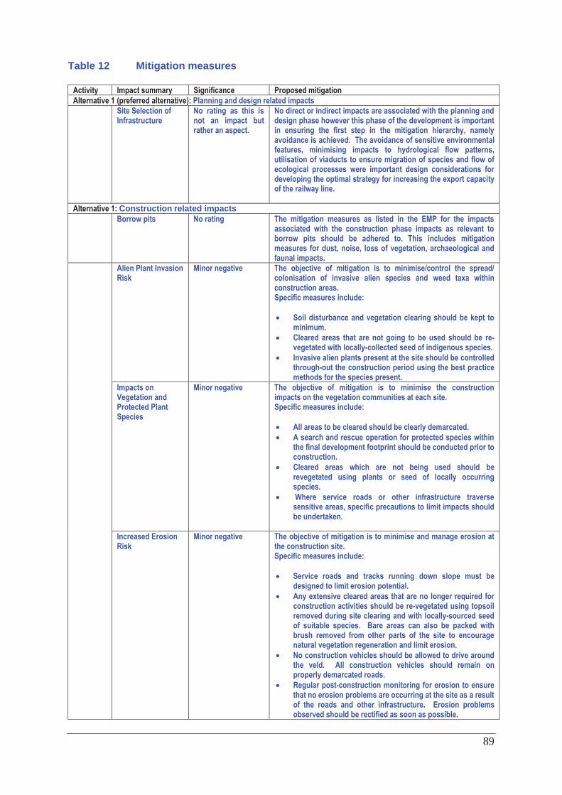
89
Table 12 Mitigation measures
Activity Impact summary Significance Proposed mitigation Alternative 1 (preferred alternative): Planning and design related impacts Site Selection of
Infrastructure No rating as this is not an impact but rather an aspect.
No direct or indirect impacts are associated with the planning and design phase however this phase of the development is important in ensuring the first step in the mitigation hierarchy, namely avoidance is achieved. The avoidance of sensitive environmental features, minimising impacts to hydrological flow patterns, utilisation of viaducts to ensure migration of species and flow of ecological processes were important design considerations for developing the optimal strategy for increasing the export capacity of the railway line.
Alternative 1: Construction related impacts Borrow pits No rating The mitigation measures as listed in the EMP for the impacts
associated with the construction phase impacts as relevant to borrow pits should be adhered to. This includes mitigation measures for dust, noise, loss of vegetation, archaeological and faunal impacts.
Alien Plant Invasion Risk
Minor negative The objective of mitigation is to minimise/control the spread/ colonisation of invasive alien species and weed taxa within construction areas. Specific measures include:
Soil disturbance and vegetation clearing should be kept to minimum. Cleared areas that are not going to be used should be re-vegetated with locally-collected seed of indigenous species. Invasive alien plants present at the site should be controlled through-out the construction period using the best practice methods for the species present.
Impacts on Vegetation and Protected Plant Species
Minor negative The objective of mitigation is to minimise the construction impacts on the vegetation communities at each site. Specific measures include:
All areas to be cleared should be clearly demarcated. A search and rescue operation for protected species within the final development footprint should be conducted prior to construction. Cleared areas which are not being used should be revegetated using plants or seed of locally occurring species. Where service roads or other infrastructure traverse sensitive areas, specific precautions to limit impacts should be undertaken.
Increased Erosion Risk
Minor negative The objective of mitigation is to minimise and manage erosion at the construction site. Specific measures include:
Service roads and tracks running down slope must be designed to limit erosion potential. Any extensive cleared areas that are no longer required for construction activities should be re-vegetated using topsoil removed during site clearing and with locally-sourced seed of suitable species. Bare areas can also be packed with brush removed from other parts of the site to encourage natural vegetation regeneration and limit erosion. No construction vehicles should be allowed to drive around the veld. All construction vehicles should remain on properly demarcated roads. Regular post-construction monitoring for erosion to ensure that no erosion problems are occurring at the site as a result of the roads and other infrastructure. Erosion problems observed should be rectified as soon as possible.
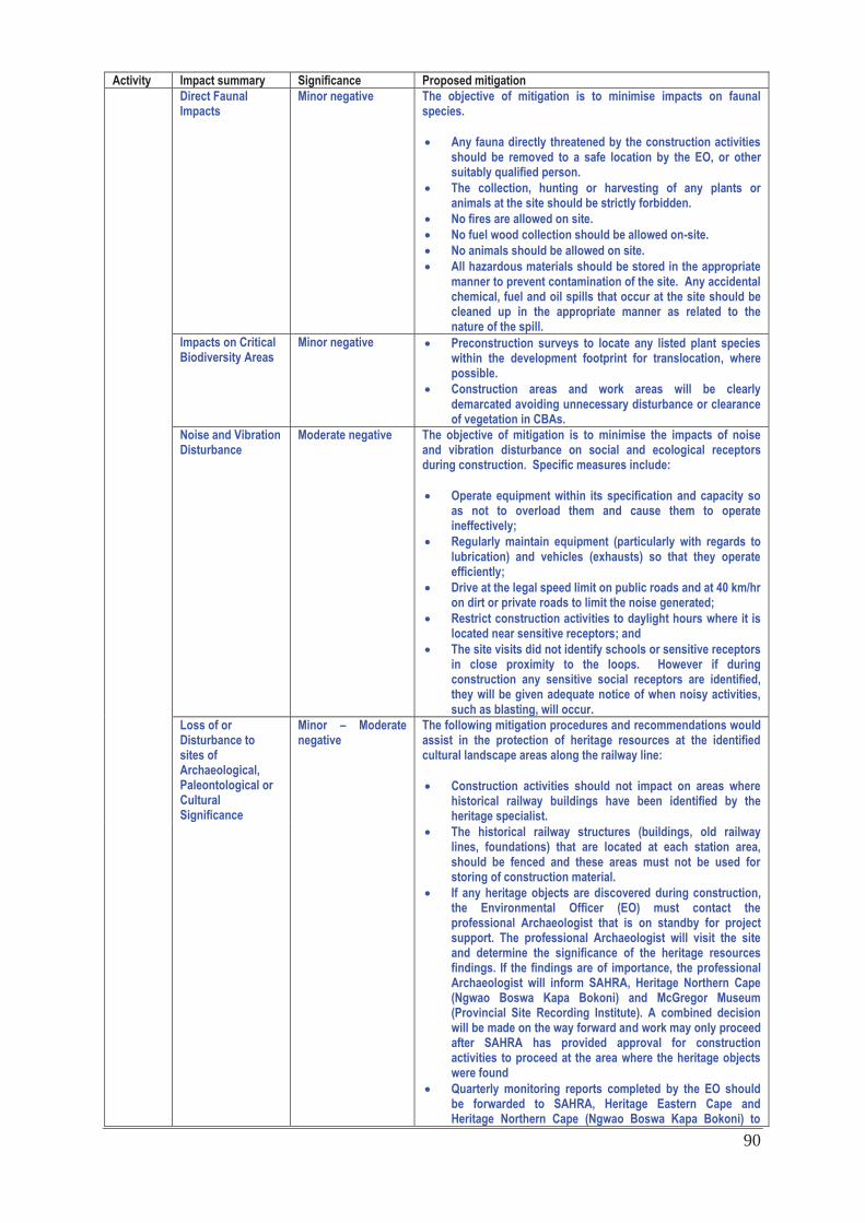
90
Activity Impact summary Significance Proposed mitigation Direct Faunal Impacts
Minor negative The objective of mitigation is to minimise impacts on faunal species.
Any fauna directly threatened by the construction activities should be removed to a safe location by the EO, or other suitably qualified person. The collection, hunting or harvesting of any plants or animals at the site should be strictly forbidden. No fires are allowed on site. No fuel wood collection should be allowed on-site. No animals should be allowed on site. All hazardous materials should be stored in the appropriate manner to prevent contamination of the site. Any accidental chemical, fuel and oil spills that occur at the site should be cleaned up in the appropriate manner as related to the nature of the spill.
Impacts on Critical Biodiversity Areas
Minor negative Preconstruction surveys to locate any listed plant species within the development footprint for translocation, where possible. Construction areas and work areas will be clearly demarcated avoiding unnecessary disturbance or clearance of vegetation in CBAs.
Noise and Vibration Disturbance
Moderate negative The objective of mitigation is to minimise the impacts of noise and vibration disturbance on social and ecological receptors during construction. Specific measures include:
Operate equipment within its specification and capacity so as not to overload them and cause them to operate ineffectively; Regularly maintain equipment (particularly with regards to lubrication) and vehicles (exhausts) so that they operate efficiently; Drive at the legal speed limit on public roads and at 40 km/hr on dirt or private roads to limit the noise generated; Restrict construction activities to daylight hours where it is located near sensitive receptors; and The site visits did not identify schools or sensitive receptors in close proximity to the loops. However if during construction any sensitive social receptors are identified, they will be given adequate notice of when noisy activities, such as blasting, will occur.
Loss of or Disturbance to sites of Archaeological, Paleontological or Cultural Significance
Minor – Moderate negative
The following mitigation procedures and recommendations would assist in the protection of heritage resources at the identified cultural landscape areas along the railway line:
Construction activities should not impact on areas where historical railway buildings have been identified by the heritage specialist. The historical railway structures (buildings, old railway lines, foundations) that are located at each station area, should be fenced and these areas must not be used for storing of construction material. If any heritage objects are discovered during construction, the Environmental Officer (EO) must contact the professional Archaeologist that is on standby for project support. The professional Archaeologist will visit the site and determine the significance of the heritage resources findings. If the findings are of importance, the professional Archaeologist will inform SAHRA, Heritage Northern Cape (Ngwao Boswa Kapa Bokoni) and McGregor Museum (Provincial Site Recording Institute). A combined decision will be made on the way forward and work may only proceed after SAHRA has provided approval for construction activities to proceed at the area where the heritage objects were found Quarterly monitoring reports completed by the EO should be forwarded to SAHRA, Heritage Eastern Cape and Heritage Northern Cape (Ngwao Boswa Kapa Bokoni) to
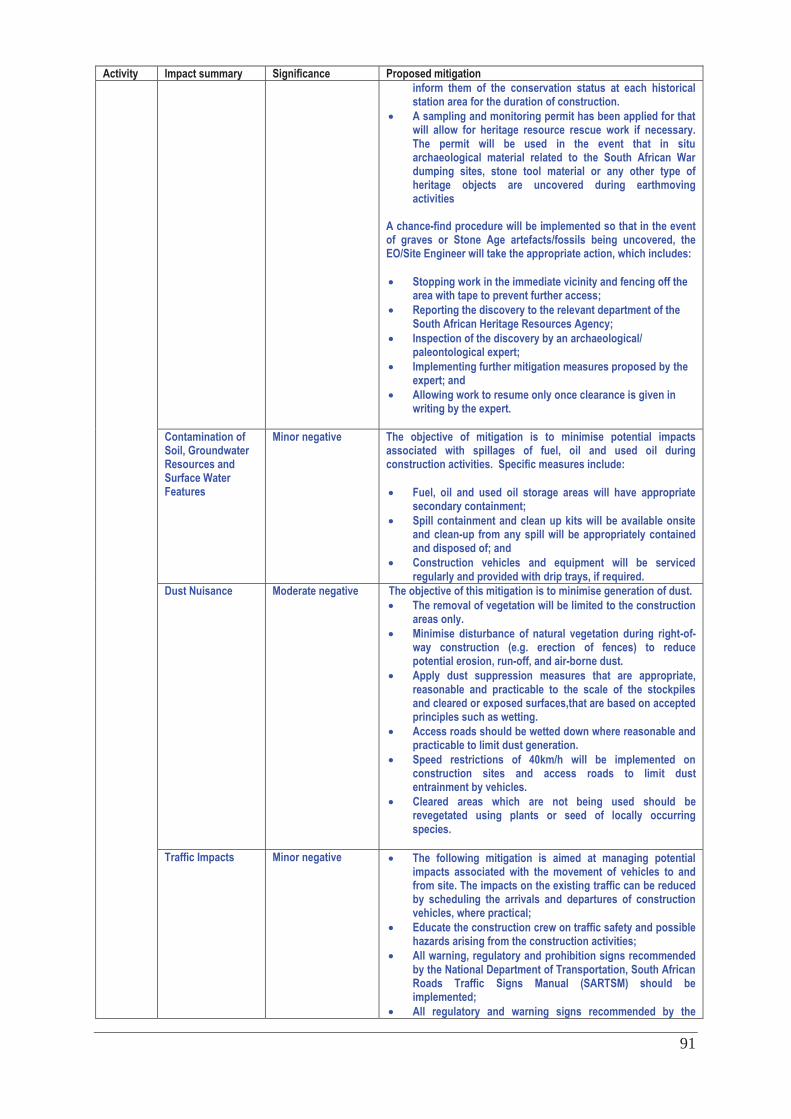
91
Activity Impact summary Significance Proposed mitigation inform them of the conservation status at each historical station area for the duration of construction. A sampling and monitoring permit has been applied for that will allow for heritage resource rescue work if necessary. The permit will be used in the event that in situ archaeological material related to the South African War dumping sites, stone tool material or any other type of heritage objects are uncovered during earthmoving activities
A chance-find procedure will be implemented so that in the event of graves or Stone Age artefacts/fossils being uncovered, the EO/Site Engineer will take the appropriate action, which includes:
Stopping work in the immediate vicinity and fencing off the area with tape to prevent further access; Reporting the discovery to the relevant department of the South African Heritage Resources Agency; Inspection of the discovery by an archaeological/ paleontological expert; Implementing further mitigation measures proposed by the expert; and Allowing work to resume only once clearance is given in writing by the expert.
Contamination of Soil, Groundwater Resources and Surface Water Features
Minor negative The objective of mitigation is to minimise potential impacts associated with spillages of fuel, oil and used oil during construction activities. Specific measures include:
Fuel, oil and used oil storage areas will have appropriate secondary containment; Spill containment and clean up kits will be available onsite and clean-up from any spill will be appropriately contained and disposed of; and Construction vehicles and equipment will be serviced regularly and provided with drip trays, if required.
Dust Nuisance Moderate negative The objective of this mitigation is to minimise generation of dust. The removal of vegetation will be limited to the construction areas only. Minimise disturbance of natural vegetation during right-of-way construction (e.g. erection of fences) to reduce potential erosion, run-off, and air-borne dust. Apply dust suppression measures that are appropriate, reasonable and practicable to the scale of the stockpiles and cleared or exposed surfaces,that are based on accepted principles such as wetting. Access roads should be wetted down where reasonable and practicable to limit dust generation. Speed restrictions of 40km/h will be implemented on construction sites and access roads to limit dust entrainment by vehicles. Cleared areas which are not being used should be revegetated using plants or seed of locally occurring species.
Traffic Impacts Minor negative The following mitigation is aimed at managing potential impacts associated with the movement of vehicles to and from site. The impacts on the existing traffic can be reduced by scheduling the arrivals and departures of construction vehicles, where practical; Educate the construction crew on traffic safety and possible hazards arising from the construction activities; All warning, regulatory and prohibition signs recommended by the National Department of Transportation, South African Roads Traffic Signs Manual (SARTSM) should be implemented; All regulatory and warning signs recommended by the
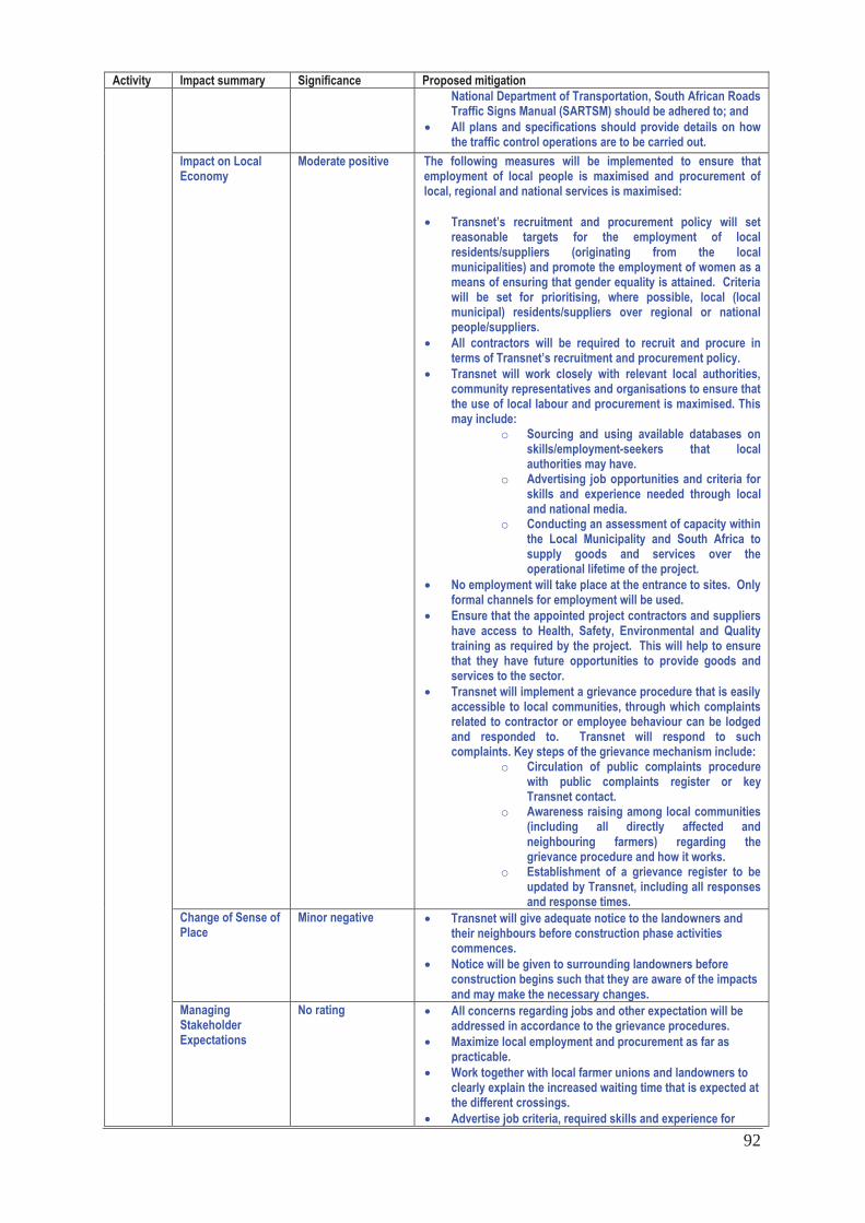
92
Activity Impact summary Significance Proposed mitigation National Department of Transportation, South African Roads Traffic Signs Manual (SARTSM) should be adhered to; and All plans and specifications should provide details on how the traffic control operations are to be carried out.
Impact on Local Economy
Moderate positive The following measures will be implemented to ensure that employment of local people is maximised and procurement of local, regional and national services is maximised:
Transnet’s recruitment and procurement policy will set reasonable targets for the employment of local residents/suppliers (originating from the local municipalities) and promote the employment of women as a means of ensuring that gender equality is attained. Criteria will be set for prioritising, where possible, local (local municipal) residents/suppliers over regional or national people/suppliers. All contractors will be required to recruit and procure in terms of Transnet’s recruitment and procurement policy. Transnet will work closely with relevant local authorities, community representatives and organisations to ensure that the use of local labour and procurement is maximised. This may include:
o Sourcing and using available databases on skills/employment-seekers that local authorities may have.
o Advertising job opportunities and criteria for skills and experience needed through local and national media.
o Conducting an assessment of capacity within the Local Municipality and South Africa to supply goods and services over the operational lifetime of the project.
No employment will take place at the entrance to sites. Only formal channels for employment will be used. Ensure that the appointed project contractors and suppliers have access to Health, Safety, Environmental and Quality training as required by the project. This will help to ensure that they have future opportunities to provide goods and services to the sector. Transnet will implement a grievance procedure that is easily accessible to local communities, through which complaints related to contractor or employee behaviour can be lodged and responded to. Transnet will respond to such complaints. Key steps of the grievance mechanism include:
o Circulation of public complaints procedure with public complaints register or key Transnet contact.
o Awareness raising among local communities (including all directly affected and neighbouring farmers) regarding the grievance procedure and how it works.
o Establishment of a grievance register to be updated by Transnet, including all responses and response times.
Change of Sense of Place
Minor negative Transnet will give adequate notice to the landowners and their neighbours before construction phase activities commences. Notice will be given to surrounding landowners before construction begins such that they are aware of the impacts and may make the necessary changes.
Managing Stakeholder Expectations
No rating All concerns regarding jobs and other expectation will be addressed in accordance to the grievance procedures. Maximize local employment and procurement as far as practicable. Work together with local farmer unions and landowners to clearly explain the increased waiting time that is expected at the different crossings. Advertise job criteria, required skills and experience for
93
Activity Impact summary Significance Proposed mitigation available jobs through local and national media and local communication channels. Advertise experience, quality and volume requirements for the supply chain needs. Local residents’ expectations of Transnet will continue to grow over time. It will not be possible for Transnet to deliver on all community and stakeholder expectations; hence a CSI Programme should be developed that clearly outlines the anticipated initiatives. These initiatives will need to be identified in consultation with the local communities. The plan should outline what the nature of the assistance will be and how the investment projects will be distributed through the project area. This strategy will be communicated to stakeholders/ local residents to ensure that their expectations remain realistic and are well-managed. Examples of potentially relevant programmes could include community policing, financial management, and drilling of boreholes.
Displacement/ Resettlement Impacts
No rating An additional loop i.e. the Sheldon Loop has been included in the basic assessment process as an alternative to the Ripon-Kommadagga line doubling to avoid displacement/resettlement impacts.
Cumulative Impacts:
See description below.
Alternative 1: Operational related impacts Direct impacts:
Impact from Increased Noise Generation
Major negative The objective of mitigation is to minimise the impacts of noise disturbance on sensitive social and ecological receptors (i.e. residents near Postmasburg and Cookhouse-Golden Valley) during operations. Amongst others, some specific measures include:
A noise monitoring program will be established at sensitive social receptors during the operational phase. The purpose of this program will be to establish a base level of the noise caused by the existing rail traffic; and Should significant incremental increases in the noise levels be observed after operation has started, appropriate measures will be implemented to mitigate these using, amongst others, appropriate noise attenuation strategies which may include noise barriers (in the form of walls or earth berms) at sites where the acceptable noise limits (45dBA according to SANS 10103) are exceeded at sensitive social receptors (such as human settlements or schools in close proximity to the railway line), with the aim of reducing the noise impact caused by the additional trains. Barriers are usually erected as close to the railway line as possible and are a minimum of 3 m in height (generally 5-7 m) and they need to extend at least 100 m beyond the receptor (see sensitive receptors in Appendix F).
Impact of Manganese Ore Dust
Negligible No additional mitigation measures are required.
Impacts from Increased Vibration Effects
Negligible No additional mitigation measures are required.
Impact on Public Safety
Negligible Rail crossings are to be clearly marked and existing signage and safety procedures are to be maintained.
Alien Plant Invasion Risk
Low negative The aim of the mitigation measures outlined below is to minimise and manage the spread of invasive alien species.
Monitoring to ensure alien plants are not increasing as a result of the disturbance caused during the construction phase. Alien plants at the sites should be controlled according to
94
Activity Impact summary Significance Proposed mitigation the management plan using the best practice methods for the species present. Any vegetation clearing that needs to take place as part of maintenance activities, should be done in an environmentally friendly manner, including avoiding the use of herbicides and using manual clearing methods wherever possible.
Change in Sense of Place
Low negative Work together with local farmer associationss and landowners to clearly explain the increased waiting time that is expected at the different crossings.
Decrease in Traffic Moderate positive None required
Indirect Impacts: Economic Opportunities
Moderate positive Positive impacts of the proposed line related to the beneficiation of valuable raw products, transportation of these products in-land and general assistance with the growth of the Eastern Cape, Metro, Industrial Development Zone and the South African economy. Increased rail capacity and transport efficiency is likely to result in reduction in long distance bulk commodity and container movements by road, which has a high negative impact on roads.
No-go option Direct impacts:
The no-go alternative (i.e. the maintenance of the status quo) involves not extending/constructing existing loops or installing new loops and therefore not refurbishing the railway line to allow for an increase in capacity up to 16Mtpa. The impact of not implementing the project can be viewed as both positive and negative. The positive consequences include not causing impacts to the biophysical and social environment, particularly to sensitive receptors, whereas the negative implications are associated with the direct loss of opportunities for employment and procurement of goods and services at a local level but also resulting in decreased growth potential, given the importance of the manganese ore industry, on a provincial and national scale. The key negative consequence would therefore be lost opportunities and revenue associated with reduced manganese export as well as increased heavy vehicle traffic on provincial roads. If the railway line and associated structures is not upgraded to handle the additional capacity, this would result in a negative, direct impact on generation of foreign income, which would affect the provincial and national economy. Negative, indirect impacts would also be experienced on the supply chain that services this sector of the economy.
Cumulative impacts in terms of the overall project:
Cumulative impacts are regarded as the combined effects (whether positive or negative) of more than one development (past, present or in the foreseeable future) within the same geographical area or on the same receptor/resource. Other developments which may, therefore, be influenced by this project, include possible new mines or mining related developments in the Northern Cape which would place additional pressure on the railway line should the capacity needs exceed 16Mtpa. Increases in the frequency of trains along the line, would exacerbate the operational impacts, such as noise disturbance, vibration nuisance and potentially aspects of public safety. Although the additional land required at each loop is relatively small, especially in relation to the size of the farms, a number of farmers indicated that they had signed options with renewable energy developers (mainly for solar PV projects). The cumulative effects of loss of agricultural land, loss of or disturbance to sites of archaeological, palaeontological or cultural significance, faunal impacts etc would be high. The uncertainty around these developments must be highlighted, since the renewable energy project bidding process and the signing of power purchaser agreements has not been concluded.
A complete impact assessment in terms of Regulation 22(2)(i) of GN R.543 must be included as Appendix F.
95
2. ENVIRONMENTAL IMPACT STATEMENT Taking the assessment of potential impacts into account, please provide an environmental impact statement that summarises the impact that the proposed activity and its alternatives may have on the environment after the management and mitigation of impacts have been taken into account, with specific reference to types of impact, duration of impacts, likelihood of potential impacts actually occurring and the significance of impacts. Alternative 1 (preferred alternative)
Construction Phase The identified impacts and ratings are summarized in the Table below (see also abbreviations for duration and likelihood):
Duration T – Temporary S – Short-term L – Long term P - Permanent
Likelihood N – Negligible L – Low M – Medium H - High
Impact Alternative 1 (Preferred) Impacts on Vegetation and Protected Plant Species
Duration: L: Invasive alien vegetation is highly likely to remain beyond the life of the project once established. Likelihood: L-M: It is highly likely that alien invasive vegetation will establish itself as a result of suitable conditions generated by construction activities. Pre-mitigation: Minor Post mitigation: Minor
Alien Plant Invasion Risk Duration: S: With respect to the loops where habitat can re-establish itself. Likelihood: L: Some faunal loss/ disturbance will definitely occur. Pre-mitigation: Minor Post mitigation: Minor
Increased Erosion Risk Duration: S: Any loss of endangered invertebrate species will be permanent. Likelihood: L: Some protected invertebrates will definitely be impacted upon. Pre-mitigation: Minor Post mitigation : Minor
Direct Faunal impacts Duration: S: Invasive alien vegetation is highly likely to remain beyond the life of the project once established. Likelihood: M: It is highly likely that alien invasive vegetation will establish itself as a result of suitable conditions generated by construction activities. Pre-mitigation: Minor Post mitigation: Minor
Impacts on Critical Biodiversity Areas Duration: L: Invasive alien vegetation is highly likely to remain beyond the life of the project once established. Likelihood: L: It is highly likely that alien invasive vegetation will establish itself as a result of suitable conditions generated by construction activities. Pre-mitigation: Minor Post mitigation: Minor
Noise and Vibration Disturbance Duration: S: - Impact expected during the construction phase only. Likelihood: H: Owing to the remoteness of project area and topography, noise impacts will definitely be experienced, even though this will be over a short duration (3-5mth period) and affect few receptors. Pre-mitigation: Moderate (Medium magnitude, high likelihood) Post mitigation: Minor
Loss of or Disturbance to Sites of Archaeological, Paleontological or Cultural Significance
Duration :P: Loss of paleontological of vandalism of cultural heritage resources is expected to be permanent Likelihood: L: It is possible that archaeological, paleontological or cultural resources may be impacted during construction. Pre-mitigation: Minor (Medium magnitude, medium likelihood) Post mitigation: Negligible
Increased potential for Soil Erosion Duration: S: Erosion may occur during the construction phase only. Likelihood: L: Soil erosion at loop sites is possible. Pre-mitigation: Minor (Medium magnitude, low likelihood) Post mitigation: Negligible
Contamination of Soil, Groundwater and Surface Water Resources
Duration: S to L: Soil can be remediated in the short-term, however, groundwater may take longer to naturally remediate or may require treatment. Likelihood: L: Contamination impacts are possible, especially at fuel/chemical handling and storage areas. Pre-mitigation: Minor (Medium magnitude, low likelihood)
96
Post mitigation: Negligible Dust Nuisance Duration: S: - Impact expected during the construction phase only.
Likelihood: M: Dust impacts are very likely to occur at all development sites, although in very small measures. Pre-mitigation: Minor (Low magnitude, medium likelihood) Negligible
Traffic Disruption and Hazards Duration: S: Impact expected during the construction phase only. Likelihood: L: Impact possible where site is close to communities or high use public roads. For example Golden Valley, is located alongside national roads. Pre-mitigation: Negligible (Low magnitude, low likelihood) Post mitigation: Negligible
Impact on the Local Economy
Duration: positive impacts will be short-term as it relates to construction jobs, and some of the procurement, but it will be long-term for those permanently employed by Transnet. Likelihood: H Construction- Pre-mitigation: Moderate; post mitigation: Moderate (+ve) Operation: Pre-mitigation :Minor (+ve); post mitigation: Minor (+ve)
Disrupted Agricultural Activities Duration: S: The impact is limited to the construction phase only. Likelihood: M: Some agricultural activities would be impacted. Pre-mitigation: Major negative Post mitigation: Minor negative
Change in Sense of Place Duration: L: Once developed the sense of place will be impacted long term. Likelihood: H: This is likely to occur Pre-mitigation: Minor Post mitigation: Negligible
Managing Stakeholder Expectations No impact ratings Displacement/resettlement Duration: L: Once developed the impact will be long term.
Likelihood: H: This is likely to occur Pre-mitigation: High Post mitigation: Negligible (if the houses along the Ripon-Kommadagga section of the railway line are avoided)
Operation Phase The identified impacts and ratings are summarized in the Table below:
Impact Alternative 1 (Preferred) Impact from Increased Noise Generation Duration: L: Increased noise generation is associated with additional volumes of trains on the
line, which will increase over time. Likelihood: M: Noise disturbance, above acceptable levels, will very likely be experienced at locations with settlements in close proximity to the line (30m – 100m). Pre-mitigation: Major (High magnitude, medium likelihood) Post mitigation: Major
Impact of Manganese Dust Duration: L: It is expected that manganese ore will be transported on the line for the duration of its lifespan Likelihood: L: Although the manganese is transported as chunks of ore, some dust may possibly be dispersed off the open wagons, even though the quantities will be negligible. Pre-mitigation: Negligible (Low magnitude, low likelihood) Post mitigation: Negligible
Impacts from Increased Vibration Effects Duration: L: Increased vibration effects are associated with additional volumes of trains on the line, which will increase over time. Likelihood: L: The effect of the vibration caused by one train is expected to be similar to the current situation, even though the frequency of the vibration disturbance will increase. Pre-mitigation: Negligible (Low magnitude, low likelihood) Post mitigation: Negligible
Impact on Public Safety Duration: L: Risk will exist for the duration of the lines operation. Likelihood: L: The likelihood of level crossing incidents is considered to be negligible; it is possible that incidents may occur due to human error. Pre-mitigation: Negligible (Low magnitude, low likelihood) Post mitigation: Negligible
Change in Sense of Place Duration: L: The impact may be experienced at various stages during the project lifetime Likelihood: M: It is very likely that the sense of place will be impacted on for some people/communities. Pre-mitigation: Moderate (Medium magnitude, medium likelihood) Post mitigation: Negligible
Decrease in Heavy Vehicle Traffic Duration: L: Impact expected for the life span of the project. Likelihood: H: heavy vehicle traffic will decrease for the duration of the operation phase. Pre-mitigation: Moderate positive Post mitigation: Moderate positive
It can be seen from the Table above that although a number of impacts have been identified, the post-mitigation significance of these is not considered to be major. It is therefore recommended that the proposed expansions of new loops, loop extensions and doublings be authorized provided that the recommended mitigation measures are implemented.
No-go alternative (compulsory)
The no-go or do nothing alternative (i.e. the maintenance of the status quo) involves not extending/constructing the proposed
97
loops. The impact of not implementing the Project can be viewed as both positive and negative. The positive consequences include not causing impacts to the biophysical and social environment, particularly to sensitive ecological or social receptors, whereas the negative implications are associated with the direct loss of opportunities for local employment and procurement of goods and services at a provincial and national scale. The key negative consequence would, however, be lost opportunities and revenue associated with reduced manganese export and container handing. If the railway line and associated structures is not upgraded to handle the additional capacity, this would result in a negative, direct impact on generation of foreign income, which would affect the provincial and national economy. Negative, indirect impacts would also be experienced on the supply chain that services this sector of the economy. Impact of not implementing the project: • Extent: National • Duration: Long term • Likelihood: High • Intensity: High • Significance rating: Major (negative) The no-go alternative is therefore not recommended.
Alternative A (preferred alternative)
Alternative B
Alternative C
No-go alternative (compulsory)
98
SECTION E. RECOMMENDATION OF PRACTITIONER Is the information contained in this report and the documentation attached hereto sufficient to make a decision in respect of the activity applied for (in the view of the environmental assessment practitioner)?
YES NO
If “NO”, indicate the aspects that should be assessed further as part of a Scoping and EIA process before a decision can be made (list the aspects that require further assessment).
If “YES”, please list any recommended conditions, including mitigation measures that should be considered for inclusion in any authorisation that may be granted by the competent authority in respect of the application. The EMP must be implemented and an ECO must be appointed during the construction phase of the project to monitor compliance with the EA and EMP. Key mitigation measures are highlighted below for inclusion in the environmental authorisation. General Ecology
A search and rescue operation for protected species within the final development footprint should be conducted prior to construction and the necessary permits for removal obtained. Cleared areas which are no longer being used should be revegetated using plants or seed of locally occurring species. Any vegetation clearing that needs to take place as part of maintenance activities, should be done in an environmentally friendly manner, including avoiding the use of herbicides and using manual clearing methods wherever possible.
Alien Plant Invasion Risk
Soil disturbance and vegetation clearing should be kept to minimum. Biannual monitoring and clearing of alien vegetation during operational phase.
Increased Erosion Risk Service roads and tracks running down the slope must be designed to limit erosion, as far as possible. Any extensive cleared areas that are not required after construction activities are complete should be re-seeded with locally-sourced seed of suitable species. Bare areas can also be packed with brush removed from other parts of the site to encourage natural vegetation regeneration and limit erosion. All construction vehicles should remain on properly demarcated roads. Biannual post-construction monitoring for erosion to ensure that no erosion problems are occurring at the site as a result of the roads and other infrastructure should take place for one year after construction and then as often as deemed necessary by the EO. Erosion problems observed should be rectified as soon as possible.
Loss of or Disturbance to Sites of Archaeological, Paleontological or Cultural Significance
Construction activities should not impact on areas where historical railway buildings have been identified by the heritage specialist. The historical railway structures (buildings, old railway lines, foundations) that are located at each station area, should be fenced and these areas must not be used for storing of construction material. If any heritage objects are discovered during construction, the Environmental Officer (EO) must contact the professional Archaeologist that is on standby for project support. The professional Archaeologist will visit the site and determine the significance of the heritage resources findings. If the findings are of importance, the professional Archaeologist will inform SAHRA, Heritage Northern Cape (Ngwao Boswa Kapa Bokoni) and McGregor Museum (Provincial Site Recording Institute). A combined decision will be made on the way forward and work may only proceed after SAHRA has provided approval for construction activities to proceed at the area where the heritage objects were found. Quarterly monitoring reports completed by the EO should be forwarded to SAHRA, Heritage Eastern Cape and Heritage Northern Cape (Ngwao Boswa Kapa Bokoni) to inform them of the conservation status at each historical station area.
99
A sampling and monitoring permit has been applied for that will allow for heritage resource rescue work if necessary. The permit will be used in the event that in situ archaeological material related to the South African War dumping sites, stone tool material or any other type of heritage objects are uncovered during earthmoving activities. A chance-find procedure will be implemented so that in the event of graves or Stone Age artefacts/fossils being uncovered, the EO/Site Engineer will take the appropriate action.
Impact on Local Economy Transnet’s recruitment and procurement policy will set reasonable targets for the employment of local residents/suppliers (originating from the local municipalities) and promote the employment of women as a means of ensuring that gender equality is attained. Criteria will be set for prioritising, where possible, local (local municipal) residents/suppliers over regional or national people/suppliers. All contractors will be required to recruit and procure in terms of Transnet’s recruitment and procurement policy. Transnet will work closely with relevant local authorities, community representatives and organisations to ensure that the use of local labour and procurement is maximised. No employment will take place at the entrance to sites. Only formal channels for employment will be used. Ensure that the appointed project contractors and suppliers have access to Health, Safety, Environmental and Quality training as required by the Project. This will help to ensure that they have future opportunities to provide goods and services to the sector. Transnet will implement a public complaints procedure that is easily accessible to local communities, through which complaints related to contractor or employee behaviour can be lodged and responded to.
Increased Noise Generation A noise monitoring program will be established at sensitive social receptors during the operational phase. The purpose of this program will be to establish a base level of the noise caused by the existing rail traffic; and
Should significant incremental increases in the noise levels be observed after operation has started, appropriate measures will be implemented to mitigate these using, amongst others, appropriate noise attenuation strategies which may include noise barriers (in the form of walls or earth berms) at sites where the acceptable noise limits (45dBA according to SANS 10103) are exceeded at sensitive social receptors (such as human settlements or schools in close proximity to the railway line), with the aim of reducing the noise impact caused by the additional trains. Barriers are usually erected as close to the railway line as possible and are a minimum of 3 m in height (generally 5-7 m) and they need to extend at least 100 m beyond the receptor (see sensitive receptors in Appendix F).
Displacement/Resettlement
It recommended that the Sheldon loop be implemented to avoid displacement/resettlement of the households located within the initially proposed layout footprint between Ripon- Kommadagga.
Borrow Pits
It is Transnet’s responsibility to ensure that it only makes use of licensed borrow pits. We recommend that this be made a condition of the environmental authorisation. It is noted that as an organ of state, Transnet is exempt from undertaking the full application process for borrow pit establishment and is required to submit an EMP for new borrow pits which may be required.
Is an EMPr attached? YES NO The EMPr must be attached as Appendix G. The details of the EAP who compiled the BAR and the expertise of the EAP to perform the Basic Assessment process must be included as Appendix H. If any specialist reports were used during the compilation of this BAR, please attach the declaration of interest for each specialist in Appendix I. Any other information relevant to this application and not previously included must be attached in Appendix J.

100
Tania Swanepoel of Environmental Resources Management (Pty) Ltd ________________________________________ NAME OF EAP ________________________________________ _________________ SIGNATURE OF EAP DATE
101
SECTION F: APPENDIXES The following appendixes must be attached: APPENDIX A LOCALITY MAP APPENDIX B PHOTOGRAPHS APPENDIX C FACILITY AND PROPERTY DESCRIPTIONS C1 Facility Illustrations C2 Property Descriptions C3 SG21 Digit Codes C4 Farm and Ward Numbers APPENDIX D SPECIALIST STUDIES D1 Ecological Specialist Study D2 Paleontological Specialist Study D3 Heritage Study- Phase 1 D4 Noise Specialist Study D5 Social Specialist Study D6 Air Quality Baseline D7 Surface Water Assessment APPENDIX E PUBLIC PARTICIPATION E1 I&AP Database and Registrations E2 Proof of Notification E3 Proof of Authority Notification E4 Comments and Response Report E5 Comments Received APPENDIX F IMPACT ASSESSMENT APPENDIX G ENVIRONMENTAL MANAGEMENT PROGRAMME APPENDIX H DETAILS AND EXPERTISE OF EAP APPENDIX I SPECIALIST DECLARATIONS