BASIC ASSESSMENT REPORT (AUGUST 2010) Basic...
43
1 BASIC ASSESSMENT REPORT (AUGUST 2010) Basic Assessment Report in terms of the NEMA Environmental Impact Assessment Regulations, 2010 AUGUST 2010 Kindly note that: 1. This Basic Assessment Report is the standard report required by DEA&DP in terms of the EIA Regulations, 2010 and must be completed for all Basic Assessment applications. 2. This report must be used in all instances for Basic Assessment applications for an environmental authorisation in terms of the National Environmental Management Act, 1998 (Act No. 107 of 1998) (NEMA), as amended, and the Environmental Impact Assessment Regulations, 2010, and/or a waste management licence in terms of the National Environmental Management: Waste Act, 2008 (Act 59 of 2008) (NEM: WA), and/or an atmospheric emission licence in terms of the National Environmental Management: Air Quality Act, 2004 (Act No. 39 of 2004) (NEM: AQA). 3. This report is current as of 2 August 2010. It is the responsibility of the Applicant / EAP to ascertain whether subsequent versions of the report have been published or produced by the competent authority. 4. The required information must be typed within the spaces provided in the report. The sizes of the spaces provided are not necessarily indicative of the amount of information to be provided. It is in the form of a table that will expand as each space is filled with typing. 5. Incomplete reports will be rejected. A rejected report may be amended and resubmitted. 6. The use of “not applicable” in the report must be done with circumspection. Where it is used in respect of material information that is required by the Department for assessing the application, this may result in the rejection of the report as provided for in the regulations. 7. While the different sections of the report only provide space for provision of information related to one alternative, if more than one feasible and reasonable alternative is considered, the relevant section must be copied and completed for each alternative . 8. Unless protected by law all information contained in, and attached to this report, will become public information on receipt by the competent authority. If information is not submitted with this report due to such information being protected by law, the applicant and/or EAP must declare such non-disclosure and provide the reasons for the belief that the information is protected. 9. This report must be submitted to the Department at the postal address given below or by delivery thereof to the Registry Office of the Department. No faxed or e-mailed reports will be accepted. Please note that for waste management licence applications, this report must be submitted for the attention of the Department’s Waste Management Directorate (tel: 021-483-2756 and fax: 021-483-4425) at the same postal address as the Cape Town Office Region A. 10. Unless indicated otherwise, two electronic copies (CD/DVD) and three hard copies of this report must be submitted to the Department. DEPARTMENTAL DETAILS CAPE TOWN OFFICE REGION A (Cape Winelands, City of Cape Town: Tygerberg and Oostenberg Administrations) CAPE TOWN OFFICE REGION B (West Coast, Overberg, City of Cape Town: Helderberg, South Peninsula, Cape Town and Blaauwberg Administrations GEORGE OFFICE (Eden and Central Karoo) Department of Environmental Affairs and Development Planning Attention: Directorate: Integrated Environmental Management (Region A2) Private Bag X 9086 Cape Town, 8000 Registry Office 1 st Floor Utilitas Building 1 Dorp Street, Cape Town Queries should be directed to the Directorate: Integrated Environmental Management (Region A2) at: Tel: (021) 483-4793 Fax: (021) 483-3633 Department of Environmental Affairs and Development Planning Attention: Directorate: Integrated Environmental Management (Region B) Private Bag X 9086 Cape Town, 8000 Registry Office 1 st Floor Utilitas Building 1 Dorp Street, Cape Town Queries should be directed to the Directorate: Integrated Environmental Management (Region B) at: Tel: (021) 483-4094 Fax: (021) 483-4372 Department of Environmental Affairs and Development Planning Attention: Directorate: Integrated Environmental Management (Region A1) Private Bag X 6509 George, 6530 Registry Office 4 th Floor, York Park Building 93 York Street George Queries should be directed to the Directorate: Integrated Environmental Management (Region A1) at: Tel: (044) 805 8600 Fax: (044) 874-2423 View the Department’s website at http://www.capegateway.gov.za/eadp for the latest version of this document.
Transcript of BASIC ASSESSMENT REPORT (AUGUST 2010) Basic...

1
BASIC ASSESSMENT REPORT
(AUGUST 2010)
Basic Assessment Report in terms of the NEMA Environmental Impact Assessment
Regulations, 2010
AUGUST 2010
Kindly note that:
1. This Basic Assessment Report is the standard report required by DEA&DP in terms of the EIA Regulations, 2010 and must be
completed for all Basic Assessment applications. 2. This report must be used in all instances for Basic Assessment applications for an environmental authorisation in terms of the
National Environmental Management Act, 1998 (Act No. 107 of 1998) (NEMA), as amended, and the Environmental Impact Assessment Regulations, 2010, and/or a waste management licence in terms of the National Environmental Management: Waste Act, 2008 (Act 59 of 2008) (NEM: WA), and/or an atmospheric emission licence in terms of the National Environmental Management: Air Quality Act, 2004 (Act No. 39 of 2004) (NEM: AQA).
3. This report is current as of 2 August 2010. It is the responsibility of the Applicant / EAP to ascertain whether subsequent
versions of the report have been published or produced by the competent authority.
4. The required information must be typed within the spaces provided in the report. The sizes of the spaces provided are not necessarily indicative of the amount of information to be provided. It is in the form of a table that will expand as each space is filled with typing.
5. Incomplete reports will be rejected. A rejected report may be amended and resubmitted. 6. The use of “not applicable” in the report must be done with circumspection. Where it is used in respect of material
information that is required by the Department for assessing the application, this may result in the rejection of the report as provided for in the regulations.
7. While the different sections of the report only provide space for provision of information related to one alternative, if more
than one feasible and reasonable alternative is considered, the relevant section must be copied and completed for each alternative.
8. Unless protected by law all information contained in, and attached to this report, will become public information on
receipt by the competent authority. If information is not submitted with this report due to such information being protected by law, the applicant and/or EAP must declare such non-disclosure and provide the reasons for the belief that the information is protected.
9. This report must be submitted to the Department at the postal address given below or by delivery thereof to the Registry
Office of the Department. No faxed or e-mailed reports will be accepted. Please note that for waste management licence applications, this report must be submitted for the attention of the Department’s Waste Management Directorate (tel: 021-483-2756 and fax: 021-483-4425) at the same postal address as the Cape Town Office Region A.
10. Unless indicated otherwise, two electronic copies (CD/DVD) and three hard copies of this report must be submitted to the
Department.
DEPARTMENTAL DETAILS
CAPE TOWN OFFICE REGION A
(Cape Winelands, City of Cape Town:
Tygerberg and Oostenberg
Administrations)
CAPE TOWN OFFICE REGION B
(West Coast, Overberg, City of Cape Town:
Helderberg, South Peninsula, Cape Town
and Blaauwberg Administrations
GEORGE OFFICE
(Eden and Central Karoo)
Department of Environmental Affairs
and Development Planning
Attention: Directorate: Integrated
Environmental Management (Region
A2)
Private Bag X 9086
Cape Town,
8000
Registry Office
1st Floor Utilitas Building
1 Dorp Street,
Cape Town
Queries should be directed to the
Directorate: Integrated Environmental
Management (Region A2) at:
Tel: (021) 483-4793 Fax: (021) 483-3633
Department of Environmental Affairs and
Development Planning
Attention: Directorate: Integrated
Environmental Management (Region B)
Private Bag X 9086
Cape Town,
8000
Registry Office
1st Floor Utilitas Building
1 Dorp Street,
Cape Town
Queries should be directed to the
Directorate: Integrated Environmental
Management (Region B) at:
Tel: (021) 483-4094 Fax: (021) 483-4372
Department of Environmental Affairs
and Development Planning
Attention: Directorate: Integrated
Environmental Management (Region
A1)
Private Bag X 6509
George,
6530
Registry Office
4th Floor, York Park Building
93 York Street
George
Queries should be directed to the
Directorate: Integrated Environmental
Management (Region A1) at:
Tel: (044) 805 8600 Fax: (044) 874-2423
View the Department’s website at http://www.capegateway.gov.za/eadp for the latest version of this document.

2
DEPARTMENTAL REFERENCE NUMBER(S) File reference number (EIA): 16/3/3/6/7/1/B2/21/1299/16
File reference number (Waste): File reference number (Other):
PROJECT TITLE Expansion of tourism facilities, Slanghoek Mountain Resort, Farm 58 of 406
DETAILS OF THE ENVIRONMENTAL ASSESSMENT PRACTITIONER (EAP)
Environmental Assessment
Practitioner (EAP): PHS Consulting
Contact person: Amanda Fritz-Whyte
Postal address: Postbox 1752, Hermanus
Postal code: 7200
Telephone: (028) 312 1734 Cell: 082 327 2100
E-mail: [email protected] Fax: (086) 508 3249
EAP Qualifications MSc Water Resource Management
EAP Registrations/Associations Member WISA
Details of the EAP’s expertise to carry out Basic Assessment procedures
PHS Consulting – Amanda Fritz-Whyte MSc Water Resource Management Fynbosland 323 Reg: 2005/081216/23
EXECUTIVE SUMMARY OF THE CONTENT OF THE BASIC ASSESSMENT REPORT: The expansion of the existing Slanghoek Mountain Resort with 36 additional units of 120m
2 each. 13 existing tented units inside the
existing report will also be formalised to cottages. 29 new units are placed on current agricultural land, and the remainder 7 new units are proposed to be placed in a fynbos area with an estimated 936.25 m
2 of indigenous vegetation to be removed.
Existing internal roads will be used as access for all sites. Water will be provided from the existing borehole on site, through an ELU, and sewage from the units will be contained in conservancy tanks for removal to the Worcester WWTP. Electricity supply to the units will be ESKOM with solar geysers. Recycling will be implemented
in the units, with all waste taken offsite to the Worcester Landfill site for recycling or disposal. In terms of the overall project proposal the following alternatives apply:
Alternative 1 (Preferred Alternative) The proposal relates to the upgrade of the existing resort Node 1 and the development of 5 new resort nodes (refer SDP Appendix B). The nodes consist of:
Node 1: Existing tourist facilities will remain with possible upgrade of the 13 tented units to cottages within the existing resort. No new footprint.
Node 2: 26 footprints of 120 m², single storey each for farm holiday accommodation purposes. One parking bay of 13.75m2 per
unit. Placed on agricultural land. Node 3: 2 footprints for cottages to be used for farm holiday accommodation purposes, maximum footprint of 120 m² each,
single storey. One parking bay of 13.75m2 per unit. Placed on natural veldt.
Node 4: 3 footprints for cottages to be used for farm holiday accommodation purposes, maximum footprint of 120 m² each, single storey. One parking bay of 13.75m
2 per unit. Placed on agricultural land.
Node 5: 2 footprints for cottages to be used for farm holiday accommodation purposes, maximum footprint of 120 m² each,
single storey. One parking bay of 13.75m2 per unit. Placed on natural veldt.
Node 6: 3 footprints for cottages to be used for farm holiday accommodation purposes, maximum footprint of 120 m² each, single storey. One parking bay of 13.75m
2 per unit. Placed on natural veldt.
Total estimated natural vegetation to be removed for placement of 7 units is 936.25m2.
Potable water supply will be from Exiting Lawful Use registered for the resort. Electricity for all units to be from ESKOM direct supply with additional solar geysers to be installed.
Conservancy tanks at all new units as with existing resort units, and service by Breede Valley Local Municipality. Grey water from units to be used for garden irrigation. No new roads will be constructed as existing farm roads and jeep tracks will be upgraded and used.
Alternative 2 The proposal relates to the upgrade of the existing resort Node 1 and the development of 5 new resort nodes (refer SDP Appendix B).
The nodes consist of: Node 1: Existing tourist facilities will remain with possible upgrade of the 13 tented units to cottages within the existing resort. No
new footprint.
Node 2: 26 footprints of 120 m², single storey each for farm holiday accommodation purposes. One parking bay of 13.75m2 per
unit. Placed on agricultural land. Node 3: 2 footprints for cottages to be used for farm holiday accommodation purposes, maximum footprint of 120 m² each,
single storey. One parking bay of 13.75m2 per unit. Placed on natural veldt.
Node 4: 3 footprints for cottages to be used for farm holiday accommodation purposes, maximum footprint of 120 m² each, single storey. One parking bay of 13.75m
2 per unit. Placed on agricultural land.
Node 5: 2 footprints for cottages to be used for farm holiday accommodation purposes, maximum footprint of 120 m² each, single storey. One parking bay of 13.75m
2 per unit. Placed on natural veldt.

3
Node 6: 5 footprints for cottages to be used for farm holiday accommodation purposes, maximum footprint of 120 m² each, single storey. One parking bay of 13.75m
2 per unit. Placed on natural veldt.
Total estimated natural vegetation to be removed for placement of 9 units is 1 176.25m2.
Potable water supply will be from Exiting Lawful Use registered for the resort. Electricity for all units to be from ESKOM direct supply with additional solar geysers to be installed.
Conservancy tanks at all new units as with existing resort units, and service by Breede Valley Local Municipality. Grey water from units to be used for garden irrigation. No new roads will be constructed as existing farm roads and jeep tracks will be upgraded and used.
Alternative 3 (no-go) Existing Resort will continue without expansion.
Upgrade of Node 1: Existing tourist facilities will remain with possible upgrade of the 13 tent Potable water supply will be from Exiting Lawful Use registered for the resort. Electricity for all units to be from ESKOM direct supply with additional solar geysers to be installed.
No new roads constructed for access and no removal if indigenous vegetation. Potable water supply will be from Exiting Lawful Use registered for the resort.
4
SECTION A: ACTIVITY INFORMATION 1. PROJECT DESCRIPTION
(a) Is the project a new development? YES X NO X
(b) Provide a detailed description of the development project and associated infrastructure.
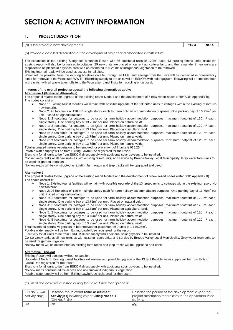
The expansion of the existing Slanghoek Mountain Resort with 36 additional units of 120m2 each. 13 existing tented units inside the
existing report will also be formalised to cottages. 29 new units are placed on current agricultural land, and the remainder 7 new units are proposed to be placed in a fynbos area with an estimated 936.25 m
2 of indigenous vegetation to be removed.
Existing internal roads will be used as access for all sites. Water will be provided from the existing borehole on site, through an ELU, and sewage from the units will be contained in conservancy tanks for removal to the Worcester WWTP. Electricity supply to the units will be ESKOM with solar geysers. Recycling will be implemented
in the units, with all waste taken offsite to the Worcester Landfill site for recycling or disposal. In terms of the overall project proposal the following alternatives apply:
Alternative 1 (Preferred Alternative) The proposal relates to the upgrade of the existing resort Node 1 and the development of 5 new resort nodes (refer SDP Appendix B). The nodes consist of:
Node 1: Existing tourist facilities will remain with possible upgrade of the 13 tented units to cottages within the existing resort. No new footprint.
Node 2: 26 footprints of 120 m², single storey each for farm holiday accommodation purposes. One parking bay of 13.75m2 per
unit. Placed on agricultural land. Node 3: 2 footprints for cottages to be used for farm holiday accommodation purposes, maximum footprint of 120 m² each,
single storey. One parking bay of 13.75m2 per unit. Placed on natural veldt.
Node 4: 3 footprints for cottages to be used for farm holiday accommodation purposes, maximum footprint of 120 m² each, single storey. One parking bay of 13.75m
2 per unit. Placed on agricultural land.
Node 5: 2 footprints for cottages to be used for farm holiday accommodation purposes, maximum footprint of 120 m² each,
single storey. One parking bay of 13.75m2 per unit. Placed on natural veldt.
Node 6: 3 footprints for cottages to be used for farm holiday accommodation purposes, maximum footprint of 120 m² each, single storey. One parking bay of 13.75m
2 per unit. Placed on natural veldt.
Total estimated natural vegetation to be removed for placement of 7 units is 936.25m2.
Potable water supply will be from Exiting Lawful Use registered for the resort. Electricity for all units to be from ESKOM direct supply with additional solar geysers to be installed.
Conservancy tanks at all new units as with existing resort units, and service by Breede Valley Local Municipality. Grey water from units to be used for garden irrigation. No new roads will be constructed as existing farm roads and jeep tracks will be upgraded and used.
Alternative 2 The proposal relates to the upgrade of the existing resort Node 1 and the development of 5 new resort nodes (refer SDP Appendix B).
The nodes consist of: Node 1: Existing tourist facilities will remain with possible upgrade of the 13 tented units to cottages within the existing resort. No
new footprint.
Node 2: 26 footprints of 120 m², single storey each for farm holiday accommodation purposes. One parking bay of 13.75m2 per
unit. Placed on agricultural land. Node 3: 2 footprints for cottages to be used for farm holiday accommodation purposes, maximum footprint of 120 m² each,
single storey. One parking bay of 13.75m2 per unit. Placed on natural veldt.
Node 4: 3 footprints for cottages to be used for farm holiday accommodation purposes, maximum footprint of 120 m² each, single storey. One parking bay of 13.75m
2 per unit. Placed on agricultural land.
Node 5: 2 footprints for cottages to be used for farm holiday accommodation purposes, maximum footprint of 120 m² each, single storey. One parking bay of 13.75m
2 per unit. Placed on natural veldt.
Node 6: 5 footprints for cottages to be used for farm holiday accommodation purposes, maximum footprint of 120 m² each,
single storey. One parking bay of 13.75m2 per unit. Placed on natural veldt.
Total estimated natural vegetation to be removed for placement of 9 units is 1 176.25m2.
Potable water supply will be from Exiting Lawful Use registered for the resort.
Electricity for all units to be from ESKOM direct supply with additional solar geysers to be installed. Conservancy tanks at all new units as with existing resort units, and service by Breede Valley Local Municipality. Grey water from units to be used for garden irrigation.
No new roads will be constructed as existing farm roads and jeep tracks will be upgraded and used. Alternative 3 (no-go)
Existing Resort will continue without expansion. Upgrade of Node 1: Existing tourist facilities will remain with possible upgrade of the 13 tent Potable water supply will be from Exiting Lawful Use registered for the resort.
Electricity for all units to be from ESKOM direct supply with additional solar geysers to be installed. No new roads constructed for access and no removal if indigenous vegetation. Potable water supply will be from Exiting Lawful Use registered for the resort.
(c) List all the activities assessed during the Basic Assessment process:
GN No. R. 544
Activity No(s):
Describe the relevant Basic Assessment
Activity(ies) in writing as per Listing Notice 1
(GN No. R. 544)
Describe the portion of the development as per the
project description that relates to the applicable listed
activity.
n/a n/a n/a

5
GN No. R. 546
Activity No(s):
Describe the relevant Basic Assessment
Activity(ies) in writing as per Listing Notice 3
(GN No. R. 546)
Describe the portion of the development as per the
project description that relates to the applicable listed
activity.
GN No. R985
Activity 12
The clearance of an area of 300 square metres or more
of indigenous vegetation except where such clearance of indigenous vegetation is required for maintenance purposes undertaken in accordance with a
maintenance management plan. In the Western Cape:
i. Within any critically endangered or
endangered ecosystem listed in terms of Section 52 of NEMBA or prior to the publication of such a list, within an area
that has been identified as critically endangered in the National Biodiversity Assessment 2004;
ii. Within critical biodiversity areas identified in bioregional plans;
29 new units are placed on current agricultural land, and the remainder 7 new units are proposed to be placed in a fynbos
area with an estimated 936.25 m2 of indigenous vegetation to
be removed.
Activity 14 The development of –
(x) buildings exceeding 10m2 in size;
(xii) infrastructure or structures with a physical footprint of 10m
2 or more;
Where such development occurs – (c) if no development setback has been adopted, within 32m of a watercourse, measured from the edge of the
watercourse (f) in Western Cape: I Outside Urban area, in:
(ff) Critical Biodiversity areas or ecosystem service areas as identified in systematic biodiversity plans adopted by the competent authority or in bioregional
plans; (gg) Core areas in Biosphere Reserves;
Three proposed units within Node 4 will be placed on existing
agricultural land within 32m of a drainage line.
Activity 17 The expansion of a resort, lodge, hotel and tourism or
hospitality facilities where the development footprint will be expanded. Areas in the Western Cape:
(i) A protected area identified in terms of the NEMPAA;
(ii) Critical biodiversity areas as identified in
systematic biodiversity plans adopted by the competent authority or in bioregional plans; or
(iii) All areas outside urban areas.
The existing Slanghoek Mountain resort will be expanded by
29 new units on current agricultural land, and the remainder 7 new units in a fynbos area with an estimated 936.25 m
2 of
indigenous vegetation to be removed.
If the application is also for activities as per Listing Notice 2 and permission was granted to subject the application to Basic
Assessment, also indicate the applicable Listing Notice 2 activities:
GN No. R. 545
Activity No(s):
If permission was granted in terms of Regulation 20,
describe the relevant Scoping and EIA Activity(ies)
in writing as per Listing Notice 2 (GN No. R. 545)
Describe the portion of the development as per the
project description that relates to the applicable listed
activity.
N/A N/A N/A
Waste management activities in terms of the NEM: WA (Government Gazette No. 32368):
GN No. 718 - Category A
Activity No(s): Describe the relevant Category A waste management activity in writing.
N/A N/A
Please note: If any waste management activities are applicable, the Listed Waste Management Activities Additional
Information Annexure must be completed and attached to this Basic Assessment Report as Appendix I.
If the application is also for waste management activities as per Category B and permission was granted to subject the
application to Basic Assessment, also indicate the applicable Category B activities:
GN No. 718 – Category B
Activity No(s): Describe the relevant Category B waste management activity in writing.
N/A N/A
Atmospheric emission activities in terms of the NEM: AQA (Government Gazette No. 33064):
GN No. 248
Activity No(s): Describe the relevant atmospheric emission activity in writing.
N/A N/A

6
(d) Please provide details of all components of the proposed project and attach diagrams (e.g. architectural drawings or
perspectives, engineering drawings, process flow charts etc.).
Buildings YES X NO
The expansion of the existing Slanghoek Mountain Resort with 36 additional units of 120m2 each. 13 existing tented units inside the
existing report will also be formalised to cottages. 29 new units will be placed on current agricultural land, and the remainder 7 new units are proposed to be placed in a fynbos area with an estimated 936.25 m
2 of indigenous vegetation to be removed.
Each new unit to have a parking bay of 13.75m2. See SDP Appendix B and Townplanning Application Appendix J.
Infrastructure (e.g. roads, power and water supply/ storage) YES X NO
Provide brief description: Potable water supply will be from Exiting Lawful Use registered for the resort.
Electricity for all units to be from ESKOM direct supply with additional solar geysers to be installed. Conservancy tanks at all new units as with existing resort units, and serviced by Breede Valley Local Municipality. Grey water from units to be used for garden irrigation.
No new roads will be constructed as existing farm roads and jeep tracks will be upgraded and used.
Processing activities (e.g. manufacturing, storage, distribution) YES NO X
Provide brief description:
Storage facilities for raw materials and products (e.g. volume and substances to be stored)
Provide brief description:
YES NO X
Storage and treatment facilities for solid waste and effluent generated by the project Yes NO X
Provide brief description:
Other activities (e.g. water abstraction activities, crop planting activities) Yes X No
Provide brief description:
Potable water supply will be from Exiting Lawful Use registered for the resort. Confirmation Letter from BGCMA in Appendix J still outstanding.
2. PHYSICAL SIZE OF THE ACTIVITY
Size of the property:
(a) Indicate the size of the property (cadastral unit) on which the activity is to be undertaken. 64.72 ha
Size of the facility:
(b) Indicate the size of the facility (development area) on which the activity is to be
undertaken.
Existing resort ± 22 455m2
New ± 4815m2
Size of the activity:
(c) Indicate the physical size (footprint) of the activity together with its associated infrastructure: Existing ± 31821m
2
New ± 4815m2
(d) Indicate the physical size (footprint) of the activity:
Existing tented units to be
upgraded ± 1560m2
New units ± 4815m2
(e) Indicate the physical size (footprint) of the associated infrastructure: Existing roads ± 9366m2
and, for linear activities:
Length of the activity:
(f) Indicate the length of the activity: ±m
3. SITE ACCESS
(a) Is there an existing access road? YES X NO
(b) If no, what is the distance over which a new access road will be built? m
(c) Describe the type of access road planned:
Please Note: indicate the position of the proposed access road on the site plan.
4. DESCRIPTION OF THE PROPERTY ON WHICH THE ACTIVITY IS TO BE UNDERTAKEN AND THE
LOCATION OF THE ACTIVITY ON THE PROPERTY
(a) Provide a description of the property on which the activity is to be undertaken and the location of the activity on the
property.

7
Farm 58/406 is located approximately 10km North-West of Rawsonville, on Divisional Road 1398 at the foot of the Badsberg Mountains. The farm is 64.72ha in size. Slanghoek Mountain resort is an existing holiday accommodation facility. The proposed activity is spread over
6 Nodes (see SDP Appendix B).
(b) Please provide a location map (see below) as Appendix A to this report which shows the location of the property and the
location of the activity on the property; as well as a site map (see below) as Appendix B to this report; and if applicable all
alternative properties and locations.
Locality map:
The scale of the locality map must be at least 1:50 000. For linear activities of more than 25 kilometres, a
smaller scale e.g. 1:250 000 can be used. The scale must be indicated on the map. The map must indicate
the following:
an accurate indication of the project site position as well as the positions of the alternative sites, if any;
road names or numbers of all the major roads as well as the roads that provide access to the site(s)
a north arrow;
a legend; the prevailing wind direction (during November to April and during May to October); and
GPS co-ordinates (Indicate the position of the activity using the latitude and longitude of the centre
point of the site for each alternative site. The co-ordinates should be in degrees and decimal minutes.
The minutes should have at least three decimals to ensure adequate accuracy. The projection that
must be used in all cases is the WGS84 spheroid in a national or local projection).
Site Plan:
Detailed site plan(s) must be prepared for each alternative site or alternative activity. The site plan must
contain or conform to the following:
The detailed site plan must be at a scale preferably at a scale of 1:500 or at an appropriate scale. The
scale must be indicated on the plan.
The property boundaries and numbers of all the properties within 50m of the site must be indicated on
the site plan.
The current land use (not zoning) as well as the land use zoning of each of the adjoining properties must
be indicated on the site plan.
The position of each element of the application as well as any other structures on the si te must be
indicated on the site plan.
Services, including electricity supply cables (indicate above or underground), water supply pipelines,
boreholes, sewage pipelines, storm water infrastructure and access roads that will form part of the
development must be indicated on the site plan.
Servitudes indicating the purpose of the servitude must be indicated on the site plan.
Sensitive environmental elements within 100m of the site must be included on the site plan, including (but
not limited to):
o Rivers.
o Flood lines (i.e. 1:10, 1:50, year and 32 meter set back line from the banks of a river/stream).
o Ridges.
o Cultural and historical features.
o Areas with indigenous vegetation (even if it is degraded or infested with alien species).
Whenever the slope of the site exceeds 1:10, then a contour map of the site must be submitted.
(c) For a linear activity, please also provide a description of the route.
N/A
Indicate the position of the activity using the latitude and
longitude of the centre point of the site. The co-ordinates
must be in degrees, minutes and seconds. The minutes should
be given to at least three decimals to ensure adequate
accuracy. The projection that must be used in all cases is the
WGS84 spheroid in a national or local projection.
Latitude (S): Longitude (E):
33°
37‘ 50.97“ 19° 13‘ 49.26“
(d) or:
For linear activities: Latitude (S): Longitude (E):
Starting point of the activity
Middle point of the activity
End point of the activity
Please Note: For linear activities that are longer than 500m, please provide and addendum with co-ordinates taken every 100
meters along the route.
5. SITE PHOTOGRAPHS

8
Colour photographs of the site and its surroundings (taken of the site and from the site) with a description of each photograph.
The vantage points from which the photographs were taken must be indicated on the site plan, or locality plan as applicable. If
available, please also provide a recent aerial photograph. Photographs must be attached as Appendix C to this report. It
should be supplemented with additional photographs of relevant features on the site. Date of photographs must be included.
Please note that the above requirements must be duplicated for all alternative sites.

9
SECTION B: DESCRIPTION OF RECEIVING ENVIRONMENT
Site/Area Description
For linear activities (pipelines, etc.) as well as activities that cover very large sites, it may be necessary to complete copies of this
section for each part of the site that has a significantly different environment. In such cases please complete copies of Section
B and indicate the area which is covered by each copy No. on the Site Plan.
1. GRADIENT OF THE SITE
Indicate the general gradient of the sites (highlight the appropriate box).
Flat Flatter than 1:10 X 1:10 – 1:4 X Steeper than 1:4
2. LOCATION IN LANDSCAPE
(a) Indicate the landform(s) that best describes the site (highlight the appropriate box(es).
Ridgeline
Plateau
Side slope of
hill/mountain
X
Closed
valley
Open
valley
Plain
Undulating
plain/low
hills
Dune Sea-front
(b) Please provide a description of the location in the landscape.
The proposed site is located on the western slopes of the Badsberg Mountain (highest peak 977m) in the Slanghoek Valley flanked by the
Slanghoek Mountains on the south, west and north (highest peak 1695 m). It is located within an area characterised by high mountain
ranges with steep slopes and open cultivated valleys with primarily agricultural and tourism activities. Slanghoek Mountain resort is an
existing holiday accommodation venue.
3. GROUNDWATER, SOIL AND GEOLOGICAL STABILITY OF THE SITE
(a) Is the site(s) located on or near any of the following (highlight the appropriate boxes)?
Shallow water table (less than 1.5m deep) YES NO X UNSURE
Seasonally wet soils (often close to water bodies) YES NO X UNSURE Unstable rocky slopes or steep slopes with loose soil YES NO X UNSURE Dispersive soils (soils that dissolve in water) YES NO X UNSURE Soils with high clay content YES NO X UNSURE Any other unstable soil or geological feature YES NO X UNSURE An area sensitive to erosion YES NO X UNSURE An area adjacent to or above an aquifer. YES NO X UNSURE An area within 100m of the source of surface water YES NO X UNSURE
(b) If any of the answers to the above are “YES” or “unsure”, specialist input may be requested by the Department.
(Information in respect of the above will often be available at the planning sections of local authorities. Where it exists, the
1:50 000 scale Regional Geotechnical Maps prepared by Geological Survey may also be used).
(c) Please indicate the type of geological formation underlying the site.
Granite Shale Sandstone X Quartzite Dolomite Dolorite Other
(describe)

10
4. SURFACE WATER
(a) Indicate the surface water present on and or adjacent to the site and alternative sites (highlight the appropriate boxes)
Perennial River YES NO X UNSURE
Non-Perennial Stream YES X NO UNSURE
Permanent Wetland YES NO X UNSURE
Seasonal Wetland YES NO X UNSURE
Artificial Wetland YES NO X UNSURE
Estuarine / Lagoonal wetland YES NO X UNSURE
(b) Please provide a description.
There are two drainage lines from the Badsberg Mountain in the East towards a tributary of the Slanghoekriver in the West.
They have both been historically altered by farming activities and do not follow their original drainage paths. Three of the
proposed units are within 32m of either of these drainage lines.
5. BIODIVERSITY:
Please note: The Department may request specialist input/studies depending on the nature of the biodiversity occurring on the
site and potential impact(s) of the proposed activity/ies. To assist with the identification of the biodiversity occurring on site and
the ecosystem status consult http://bgis.sanbi.org or [email protected]. Information is also available on compact disc (cd)
from the Biodiversity-GIS Unit, Ph (021) 799 8698. This information may be updated from time to time and it is the applicant/ EAP’s
responsibility to ensure that the latest version is used. A map of the relevant biodiversity information (including an indication of
the habitat conditions as per (b) below) and must be provided as an overlay map to the property/site plan as Appendix D to
this report.
(a) Highlight the applicable biodiversity planning categories of all areas on site and indicate the reason(s) provided in the
biodiversity plan for the selection of the specific area as part of the specific category).
Systematic Biodiversity Planning Category If CBA or ESA, indicate the reason(s) for its selection in biodiversity
plan
Critical
Biodiversity
Area
(CBA) X
Ecological
Support
Area (ESA)
X
Other
Natural
Area (ONA)
No Natural
Area
Remaining
(NNR)
The occurrence of endangered vegetation on site. The vegetation types on
site are mapped as Breede Alluvium Fynbos (endangered) and Breede Shale Fynbos (see Appendix J for CapeNature communication explaining on site verification of vegetation and need for botanical study).
None of the proposed units are in the CBA mapped area. The ESA mapped area covers existing agricultural land that will remain intact (see Appendix
D).
(b) Highlight and describe the habitat condition on site.
Habitat Condition
Percentage of
habitat condition
class (adding up
to 100%)
Description and additional Comments and Observations
(including additional insight into condition, e.g. poor land management
practises, presence of quarries, grazing/harvesting regimes etc).
Natural 52.92ha
The vegetation types on site are mapped as Breede Alluvium Fynbos (endangered) and Breede Shale Fynbos (see also Capenature comment Appendix J).
Near Natural
(includes areas with low
to moderate level of alien
invasive plants)
Degraded
(includes areas heavily
invaded by alien plants)
Transformed
(includes cultivation,
dams, urban, plantation,
roads, etc)
11.8ha
Crops vary from grapes for wine to olive trees. Existing Slanghoek Mountain resort.
(c) Complete the table to indicate:
(i) the type of vegetation, including its ecosystem status, present on the site; and
11
(ii) whether an aquatic ecosystem is present on site.
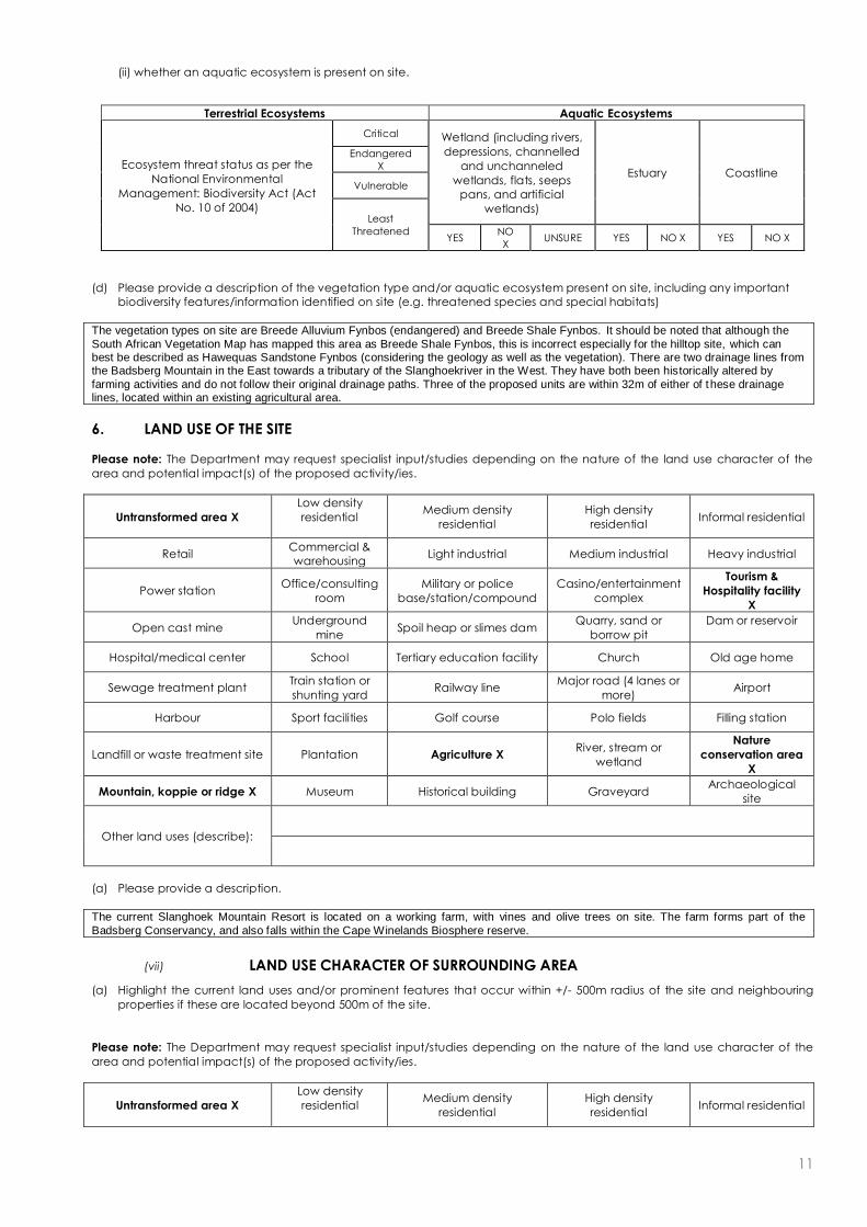
(d) Please provide a description of the vegetation type and/or aquatic ecosystem present on site, including any important
biodiversity features/information identified on site (e.g. threatened species and special habitats)
The vegetation types on site are Breede Alluvium Fynbos (endangered) and Breede Shale Fynbos. It should be noted that although the
South African Vegetation Map has mapped this area as Breede Shale Fynbos, this is incorrect especially for the hilltop site, which can best be described as Hawequas Sandstone Fynbos (considering the geology as well as the vegetation). There are two drainage lines from the Badsberg Mountain in the East towards a tributary of the Slanghoekriver in the West. They have both been historically altered by
farming activities and do not follow their original drainage paths. Three of the proposed units are within 32m of either of these drainage lines, located within an existing agricultural area.
6. LAND USE OF THE SITE
Please note: The Department may request specialist input/studies depending on the nature of the land use character of the
area and potential impact(s) of the proposed activity/ies.
Untransformed area X
Low density
residential
Medium density
residential
High density
residential Informal residential
Retail Commercial &
warehousing Light industrial Medium industrial Heavy industrial
Power station Office/consulting
room
Military or police
base/station/compound
Casino/entertainment
complex
Tourism &
Hospitality facility
X
Open cast mine Underground
mine Spoil heap or slimes dam
Quarry, sand or
borrow pit
Dam or reservoir
Hospital/medical center School Tertiary education facility Church Old age home
Sewage treatment plant Train station or
shunting yard Railway line
Major road (4 lanes or
more) Airport
Harbour Sport facilities Golf course Polo fields Filling station
Landfill or waste treatment site Plantation Agriculture X River, stream or
wetland
Nature
conservation area
X
Mountain, koppie or ridge X Museum Historical building Graveyard Archaeological
site
Other land uses (describe):
(a) Please provide a description.
The current Slanghoek Mountain Resort is located on a working farm, with vines and olive trees on site. The farm forms part of the
Badsberg Conservancy, and also falls within the Cape Winelands Biosphere reserve.
(vii) LAND USE CHARACTER OF SURROUNDING AREA
(a) Highlight the current land uses and/or prominent features that occur within +/- 500m radius of the site and neighbouring
properties if these are located beyond 500m of the site.
Please note: The Department may request specialist input/studies depending on the nature of the land use character of the
area and potential impact(s) of the proposed activity/ies.
Untransformed area X
Low density
residential
Medium density
residential
High density
residential Informal residential
Terrestrial Ecosystems Aquatic Ecosystems
Ecosystem threat status as per the
National Environmental
Management: Biodiversity Act (Act
No. 10 of 2004)
Critical Wetland (including rivers,
depressions, channelled
and unchanneled
wetlands, flats, seeps
pans, and artificial
wetlands)
Estuary Coastline
Endangered
X
Vulnerable
Least
Threatened YES
NO
X UNSURE YES NO X YES NO X

12
Retail Commercial &
warehousing Light industrial Medium industrial Heavy industrial
Power station Office/consulting
room
Military or police
base/station/compound
Casino/entertainment
complex
Tourism &
Hospitality facility
X
Open cast mine Underground
mine Spoil heap or slimes dam
Quarry, sand or
borrow pit
Dam or reservoir
X
Hospital/medical center School Tertiary education facility Church Old age home
Sewage treatment plant Train station or
shunting yard Railway line
Major road (4 lanes or
more) Airport
Harbour Sport facilities Golf course Polo fields Filling station
Landfill or waste treatment site Plantation Agriculture X River, stream or
wetland X
Nature
conservation area
X
Mountain, koppie or ridge
X Museum Historical building Graveyard Archeological site
Other land uses (describe):
(b) Please provide a description, including the distance and direction to the nearest residential area and industrial area.
The property is located in a typical rural setting. Agricultural land use is the dominant land use in the area with viticulture being the most common activity. Various agri-tourism operations have also been identified in the landscape. The Slanghoek Valley is well-known for its destination weddings, wine tasting, and hiking and mountain biking activities. The closest residential town is Rawsonville approximately
10km SE of the site, with Worcester being the closest town with industrial activities.
8. SOCIO-ECONOMIC ASPECTS
Describe the existing social and economic characteristics of the community in order to provide baseline information.
The majority of people living in the landscape are farm labourers and farmers. Job opportunities are limited to mostly unskilled farming
activities with a small number of managerial opportunities present. The area is also active i.t.o. tourism with restaurants, overnight establishments wine farms and destination wedding facilities, which create job opportunities.
13
(VII) HISTORICAL AND CULTURAL ASPECTS
(a) Please be advised that if section 38 of the National Heritage Resources Act, 1999 (Act No. 25 of 1999), is applicable to your
proposed development, then you are requested to furnish this Department with written comment from Heritage Western
Cape as part of your public participation process. Section 38 of the Act states as follows: “38. (1) Subject to the provisions
of subsections (7), (8) and (9), any person who intends to undertake a development categorised as-
(a) the construction of a road, wall, power line, pipeline, canal or other similar form of linear development or barrier
exceeding 300m in length;
(b) the construction of a bridge or similar structure exceeding 50m in length;
I any development or other activity which will change the character of a site-
(vii) exceeding 5 000 m2 in extent; or
(ii) involving three or more existing erven or subdivisions thereof; or
(vii) involving three or more erven or divisions thereof which have been consolidated within the past five
years; or
(vii) the costs of which will exceed a sum set in terms of regulations by SAHRA or a provincial heritage resources
authority;
(d) the re-zoning of a site exceeding 10 000 m2 in extent; or
(e) any other category of development provided for in regulations by SAHRA or a provincial heritage resources
authority,
must at the very earliest stages of initiating such a development, notify the responsible heritage resources authority
and furnish it with details regarding the location, nature and extent of the proposed development.”
(b) The impact on any national estate referred to in section 3(2), excluding the national estate contemplated in section
3(2)(i)(vi) and (vii), of the National Heritage Resources Act, 1999 (Act No. 25 of 1999), must also be investigated, assessed
and evaluated. Section 3(2) states as follows: “3(2) Without limiting the generality of subsection (1), the national estate may
include—
(a) places, buildings, structures and equipment of cultural significance;
(b) places to which oral traditions are attached or which are associated with living heritage;
I historical settlements and townscapes;
(d) landscapes and natural features of cultural significance;
(e) geological sites of scientific or cultural importance;
(f) archaeological and palaeontological sites;
(g) graves and burial grounds, including—
(i) ancestral graves;
(ii) royal graves and graves of traditional leaders;
(vii) graves of victims of conflict;
(iv) graves of individuals designated by the Minister by notice in the Gazette;
(v) historical graves and cemeteries; and
(vi) other human remains which are not covered in terms of the Human Tissue Act, 1983 (Act No. 65 of 1983);
(h) sites of significance relating to the history of slavery in South Africa;
(i) movable objects, including—
(i) objects recovered from the soil or waters of South Africa, including archaeological and palaeontological objects
and material, meteorites and rare geological specimens;
(ii) objects to which oral traditions are attached or which are associated with living heritage;
(vii) ethnographic art and objects;
(iv) military objects;
(v) objects of decorative or fine art;
(vi) objects of scientific or technological interest; and
(vii) books, records, documents, photographic positives and negatives, graphic, film or video material or sound
recordings, excluding those that are public records as defined in section 1(xiv) of the National Archives of South Africa
Act, 1996 (Act No. 43 of 1996).”
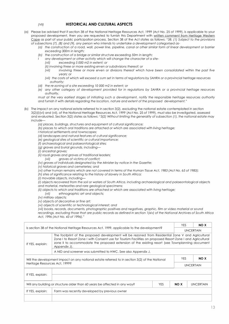
Is section 38 of the National Heritage Resources Act, 1999, applicable to the development? YES NO X
UNCERTAIN
If YES, explain:
The footprint of the proposed development will be rezoned from Residential Zone V and Agricultural
Zone I to Resort Zone I with Consent use for Tourism Facilities on proposed Resort Zone I and Agricultural
zone II to accommodate the proposed extension of the existing resort (see Townplanning document
Appendix J).
A NID and screener was submitted to HWC. See also Appendix J.
Will the development impact on any national estate referred to in section 3(2) of the National
Heritage Resources Act, 1999?
YES NO X
UNCERTAIN
If YES, explain:
Will any building or structure older than 60 years be affected in any way? YES NO X UNCERTAIN
If YES, explain: Farm was recently developed by previous owner

14
Please Note: If uncertain, the Department may request that specialist input be provided.
10. APPLICABLE LEGISLATION, POLICIES AND/OR GUIDELINES
(a) Please list all legislation, policies and/or guidelines that have been considered in the preparation of this Basic Assessment
Report.
LEGISLATION ADMINISTERING AUTHORITY
TYPE
Permit/ license/
authorisation/comment / relevant
consideration (e.g. rezoning or
consent use, building plan approval)
DATE
(if already
obtained):
National Environmental Management
Act No 107 of 1998
The Department of Environmental
Affairs and Development Planning Authorization Pending
National Water Act, Act 36 of 1998 BGCMA Letter re ELU and comment Pending
Bylaw on Municipal Landuse Planning Breede Valley Local Municipality Rezoning and Consent use application Pending
NHRA, Act 25 of 1999 HWC NID application and Screener Pending
POLICY/ GUIDELINES ADMINISTERING AUTHORITY
DEA&DP guidelines on Public Participation DEA&DP
Guidelines for EMP’s DEA&DP
NEMA; EIA Regs 2014 DEA&DP
Guidelines on Alternatives DEA&DP
BGIS SANBI
CapeFarmMapper Western Cape Department of Agriculture
(b) Please describe how the legislation, policies and/or guidelines were taken into account in the preparation of this Basic
Assessment Report.
LEGISLATION / POLICY / GUIDELINE DESCRIBE HOW THE LEGISLATION / POLICY / GUIDELINE WERE TAKEN INTO ACCOUNT
(e.g. describe the extent to which it was adhered to, or deviated from, etc).
National Environmental Management Act (Act 107 of 1998)
Listed Activities which trigger a Basic Assessment (BA), currently being undertaken here.
DEA&DP guidelines on Public Participation
Public Participation Process must take place during the BA process in order for the process to
be transparent and allow for I&AP comments and concerns to be raised and subsequently addressed. Proof of PPP will need to be included in final reports.
Guidelines for EMP’s Ensures that construction and operational activities, should a positive ROD be received, are environmentally friendly and comply with all restrictions or guidelines stipulated in the BA/ROD.
Guidelines for Alternatives Ensures alternative chosen are reasonable and feasible as far as possible.
NWA, Act 36 of 1998 Water use authorization requirements on site – GA granted
NHRA, Act 25 of 1999 NID submitted in terms of S38, and screener.
Please note: Copies of any permit(s) or licences received from any other organ of state must be attached this report as
Appendix E.

15
SECTION C: PUBLIC PARTICIPATION
The public participation process must fulfil the requirements outlined in NEMA, the EIA Regulations, and if applicable the NEM:
WA and/or the NEM: AQA. This Department’s Guideline on Public Participation (August 2010) and Guideline on Exemption
Applications (August 2010), both of which are available on the Department’s website (http://www.capegateway.gov.za/eadp),
must also be taken into account.
Please highlight the appropriate box to indicate whether the specific requirement was undertaken or whether there was a
deviation that was agreed to by the Department.
1. Were all potential interested and affected parties notified of the application by –
(a) fixing a notice board at a place conspicuous to the public at the boundary or on the fence of -
(i) the site where the activity to which the application relates is to be undertaken; and YES X DEVIATED
(ii) any alternative site mentioned in the application; N/A YES DEVIATED
(b) giving written notice to –
(i) the owner or person in control of that land if the applicant is not the owner or person in
control of the land; YES N/A X
(ii) the occupiers of the site where the activity is to be undertaken and to any alternative
site where the activity is to be undertaken; N/A YES DEVIATED
(iii) owners and occupiers of land adjacent to the site where the activity is to be
undertaken and to any alternative site where the activity is to be undertaken; YES X DEVIATED
(iv) the municipal councillor of the ward in which the site and alternative site is situated
and any organisation of ratepayers that represent the community in the area; YES X DEVIATED
(v) the municipality which has jurisdiction in the area; YES X DEVIATED
(vi) any organ of state having jurisdiction in respect of any aspect of the activity; and YES X DEVIATED
(vii) any other party as required by the competent authority; YES X DEVIATED
I placing an advertisement in -
(i) one* local newspaper; and YES X DEVIATED
(ii) any official Gazette that is published specifically for the purpose of providing public
notice of applications or other submissions made in terms of these Regulations; YE S DEVIATED
N/A
X
(d) placing an advertisement in at least one* provincial newspaper or national newspaper,
if the activity has or may have an impact that extends beyond the boundaries of the
metropolitan or local municipality in which it is or will be undertaken.
YE S DEVIATED N/A
X
* Please note: In terms of the NEM: WA and NEM: AQA a notice must be placed in at least two newspapers circulating in the
area in which the activity applied for is to be carried out.
3. Please provide an overall summary of the Public Participation Process that was followed. (The detailed outcomes of
this process must be included in a comments and response report to be attached to the final Basic Assessment Report
(see note below) as Appendix F).
The Draft BAR will be circulated to all Interested and Affected Parties (I&AP’s) as per DEA&DP guidelines and applicable Organs of State for 30 days. An English advert will be placed in the local newspaper, the Worcester Standard, informing all possible I&AP’s of the Basic Assessment, with contact details of the EAP in order to register as an I&AP. Notices will be sent to all I&AP’s
within 100m of the proposed development area. All people requesting to become I&AP’s for the project will be included in the register for I&AP’s. A site notice will be placed at the entrance to the site. All comments received from I&AP’s will be captured in a Comments and Response Report and addressed accordingly. A second draft BAR will be circulated to registered I&AP’s for a
30 day comment period, with the Comments and Response Report updated to reflect feedback.
2. Provide a list of all the state departments that were consulted:
DEA&DP (Western-Cape)
Breede Gouritz Catchment Management Agency (BGCMA)
Department of Agriculture, Forestry and Fisheries (Western-Cape)
CapeNature
Cape Winelands District Municipality
Breede Local Municipality
Department of Public Works and Transport
Heritage Western Cape
National DAFF
DEA&DP Directorate : Waste Management

16
Please note:
Should any of the responses be “No” and no deviation or exemption from that requirement was
requested and agreed to /granted by the Department, the Basic Assessment Report will be rejected.
A list of all the potential interested and affected parties, including the organs of State, notified and a list
of all the register of interested and affected parties, must be submitted with the final Basic Assessment
Report. The list of registered interested and affected parties must be opened, maintained and made
available to any person requesting access to the register in writing.
The draft Basic Assessment Report must be submitted to the Department before it is made available to
interested and affected parties, including the relevant organs of State and State departments which
have jurisdiction with regard to any aspect of the activity, for a 40-day commenting period. With regard
to State departments, the 40-day period commences the day after the date on which the Department
as the competent/licensing authority requests such State department in writing to submit comment. The
applicant/EAP is therefore required to inform this Department in writing when the draft Basic Assessment
Report will be made available to the relevant State departments for comment. Upon receipt of the Draft
Basic Assessment Report and this confirmation, this Department will in accordance with Section 24O(2)
and (3) of the NEMA request the relevant State departments to comment on the draft report within 40
days.
All comments of interested and affected parties on the draft Basic Assessment Report must be recorded,
responded to and included in the Comments and Responses Report included as Appendix F to the final
Basic Assessment Report. If necessary, any amendments in response to comments received must be
effected in the Basic Assessment Report itself. The Comments and Responses Report must also include a
description of the public participation process followed.
The final Basic Assessment Report must be made available to registered interested and affected parties
for comment before submitting it to the Department for consideration. Unless otherwise indicated by the
Department, a final Basic Assessment Report must be made available to the registered interested and
affected parties for comment for a minimum of 21-days. Comments on the final Basic Assessment Report
does not have to be responded to, but the comments must be attached to the final Basic Assessment
Report.
The minutes of any meetings held by the EAP with interested and affected parties and other role players
which record the views of the participants must also be submitted as part of the public participation
information to be attached to the final Basic Assessment Report as Appendix F.
Proof of all the notices given as indicated, as well as of notice to the interested and affected parties of
the availability of the draft Basic Assessment Report and final Basic Assessment Report must be submitted

17
as part of the public participation information to be attached to the final Basic Assessment Report as
Appendix F.
SECTION D: NEED AND DESIRABILITY
Please Note: Before completing this section, first consult this Department’s Guideline on Need and Desirability (August 2010)
available on the Department’s website (http://www.capegateway.gov.za/eadp).
1. Is the activity permitted in terms of the property’s existing land use rights? YES NO X Please explain
The footprint of the proposed development will be rezoned from Residential Zone V and Agricultural Zone I to Resort Zone I with
Consent use for Tourism Facilities on proposed Resort Zone I and Agricultural zone II to accommodate the proposed extension
of the existing resort ( see Townplanning document Appendix J).
2. Will the activity be in line with the following?
(a) Provincial Spatial Development Framework (PSDF) YES X NO Please explain
The Cape Winelands District Municipality SDP Recognises the Cape Winelands Biosphere Reserve as a core area for tourism
and thus economic development.( see Townplanning document Appendix J page 24).
(b) Urban edge / Edge of Built environment for the area YES NO Please explain
N/A
(c) Integrated Development Plan and Spatial Development Framework of the
Local Municipality (e.g. would the approval of this application compromise the
integrity of the existing approved and credible municipal IDP and SDF?).
YES X NO Please explain
The IDP recognises the importance of economic development and upliftment for the Breede Valley area along with rural node
development. The IDP recognises the importance of the tourism sector and its importance to stimulate the local economy in
addition to job creation. (see Townplanning document Appendix J page 24).
(d) Approved Structure Plan of the Municipality YES NO X Please explain
There is no structure plan for the area, except for the Provincial Spatial Development Framework.
(e) An Environmental Management Framework (EMF) adopted by the Department
(e.g. Would the approval of this application compromise the integrity of the existing
environmental management priorities for the area and if so, can it be justified in
terms of sustainability considerations?)
YES
X NO Please explain
The EMF aims to develop agri-environmental partnerships that allow for productive use of farmland while supporting
biodiversity conservation. Slanghoek Mountain Resort lies adjacent to the Badsberg Conservancy and forms part of the Cape
Winelands Biosphere reserve, whilst also located on a working farm.
(f) Any other Plans (e.g. Guide Plan) YES NO X Please explain
3. Is the land use (associated with the activity being applied for) considered
within the timeframe intended by the existing approved Spatial Development
Framework (SDF) agreed to by the relevant environmental authority (i.e. is the
proposed development in line with the projects and programmes identified as
priorities within the credible IDP)?
YES
X
NO Please explain
The IDP recognises the importance of economic development and upliftment for the Breede Valley area along with rural node
development. The IDP recognises the importance of the tourism sector and its importance to stimulate the local economy in
addition to job creation. 4. Should development, or if applicable, expansion of the town/area concerned
in terms of this land use (associated with the activity being applied for) occur
here at this point in time?
YES X NO Please explain
The proposal is in keeping with the existing planning frameworks for the area, and allows Slanghoek Mountain Resort to
expand to meet the growing need for overnight facilities in the area.
5. Does the community/area need the activity and the associated land use
concerned (is it a societal priority)? (This refers to the strategic as well as local
level (e.g. development is a national priority, but within a specific local context
it could be inappropriate.)
YES X NO Please explain
A number of temporary and long term job opportunities will be created with the construction of the proposed development. More tourists coming to the area would also benefit the greater community in terms of trade and exposure. The existing accommodation offered by the resort is insufficient and the expansion will allow the resort to meet the growing need in the area.
6. Are the necessary services with adequate capacity currently available (at the
time of application), or must additional capacity be created to cater for the
development? (Confirmation by the relevant Municipality in this regard must
be attached to the final Basic Assessment Report as Appendix E.)
YES X NO Please explain
Electricity from ESKOM and solar panels; Water from existing ELU as authorised by BGCMA; Waste to landfill; Conservancy tanks to be
emptied to the Worcester WWTP. See communications in Appendix E.
7. Is this development provided for in the infrastructure planning of the
municipality, and if not what will the implication be on the infrastructure
planning of the municipality (priority and placement of services and
opportunity costs)? (Comment by the relevant Municipality in this regard must
YES NO Please explain

18
(17) Please describe how the general objectives of Integrated Environmental Management as set out in section 23 of NEMA
have been taken into account:
This Basic Assessment Report aims to investigate, assess and communicate all potential impacts of the proposed development. All
potential impacts will be identified and any suitable alternatives to mitigate or eliminate these impacts will be explored. Impacts to the environment as well as socio-economic impacts and cultural / heritage impacts will be explored. The No Go option will also be put forward as an alternative along with any other reasonable and feasible alternatives. The Slanghoek Mountain Resort is an existing tourism facility
with existing impacts. The potential impacts from the proposed expansion were considered and mitigation measures were proposed. Principles such as solar energy, water conservation, waste management, biodiversity conservation were considered and integrated with the proposed plan of works. The BAR process allows for public participation to incorporate additional needs of the immediate community.
(18) Please describe how the principles of environmental management as set out in section 2 of NEMA have been taken into
account:
be attached to the final Basic Assessment Report as Appendix E.)
N/A.
8. Is this project part of a national programme to address an issue of national
concern or importance? YES NO X Please explain
9. Do location factors favour this land use (associated with the activity applied
for) at this place? (This relates to the contextualisation of the proposed land
use on this site within its broader context.)
YES X NO Please explain
It is well placed for the use of hiking trails and birding, and other eco-tourism and agri-tourism activities in the area. The scenic view,
tranquillity of the surroundings and proximity to conference and wedding facilities makes the location very favourable.
10. How will the activity or the land use associated with the activity applied for,
impact on sensitive natural and cultural areas (built and rural/natural
environment)?
YES NO X Please explain
The Slanghoek Mountain Resort already exists and this application is for an expansion of the facilities. The site falls within the Badsberg Conservancy and the Cape Winelands Biosphere Reserve. The operational impacts associated with the activity will be addressed in the OEMP. The SEA Botanical study conducted in the area in 2014 (see Appendix J) highlighted Farm 58/406 with development potential
based on a low biodiversity score, but with specialist input needed. That input was supplied by CapeNature during a site verification visit and formal feedback (see also Appendix J) negating the need for a specialist botanical report for the proposed Nodes (3,5,and 6) placed in natural veld areas.
A NID and Screener were submitted to HWC (see Appendix J).
11. How will the development impact on people’s health and wellbeing (e.g. in
terms of noise, odours, visual character and sense of place, etc)? YES NO X Please explain
There will be no negative health impacts due to the proposed activity. The positive health benefits for hikers and birders and tourists
enjoying the area will be significant. The Visual Statement (Appendix G page 21) found the Resort development is compatible with scenic
areas and viniculture, and due to the good screening and VAC the visual impacts are expected to be low if mitigation is applied.
12. Will the proposed activity or the land use associated with the activity applied
for, result in unacceptable opportunity costs? YES NO X Please explain
13. What will the cumulative impacts (positive and negative) of the proposed
land use associated with the activity applied for, be? YES NO Please explain
Positive: Creation of job opportunities and increased tourism to the area with a knock-on effect on other tourism activities in the area.
Negative: The proposed removal of approximately 936.25m2 indigenous vegetation for establishment of the facilities associated with the
project. Decrease in natural water resources due to increased use on site. Increased waste (solid and sewage) from the site and resultant use of storage and treatment facilities in the Worcester area.
14. Is the development the best practicable environmental option for this
land/site? YES X NO Please explain
The Slanghoek Mountain Resort already exists, and will remain part of the Badsberg Conservancy after implementation of the project.
15. What will the benefits be to society in general and to the local communities? Please explain
Temporary construction and permanent operational job opportunities will be created for the local community. Society will benefit from the
availability of the facility in the area from which to enjoy the agri-tourism and eco-tourism opportunities. The Social Status Quo report as part of the SEA conducted for the area in 2014 highlighted the need to address seasonal unemployment with year long employment opportunities and in light of the economic challenges with regards to conventional crops, alternative economic / agricultural ventures
should be considered. Job creation, especially for female employees, should be one of the priorities taken into consideration when alternatives are investigated.
16. Any other need and desirability considerations related to the proposed activity? Please explain
No.

19
The aim of these principles is to guide stakeholders in order to ensure a holistic evaluation is achieved, with the precautionary principle used as a focus in order to encourage development which is sustainable and which retains the sense of place as far as possible whilst
exploring feasible and reasonable alternatives to achieve such objectives. It is anticipated that no cultural / heritage aspects will be disturbed as a result of the proposed development. Furthermore a cautious approach will be used during all stages of the development with the best possible environmental option being explored. The Environmental Management Plan (EMP) for Operation will guide an eco
oriented approach. The Slanghoek Mountain Resort is an existing tourism facility with existing impacts. The potential impacts from the proposed expansion were considered and mitigation measures were proposed. The aim of the project is to create an expansion to an already existing and successful tourism facility, working with the natural resources of the area (mountainous view, available water
resource, sun energy) and minimising the potential impacts associated with the expansion project.
SECTION E: ALTERNATIVES
Please Note: Before completing this section, first consult this Department’s Guideline on Alternatives (August 2010) available on
the Department’s website (http://www.capegateway.gov.za/eadp).
“Alternatives”, in relation to a proposed activity, means different means of meeting the general purposes and requirements of
the activity, which may include alternatives to –
(a) the property on which, or location where, it is proposed to undertake the activity;
(b) the type of activity to be undertaken;
I the design or layout of the activity;
(d) the technology to be used in the activity;
(e) the operational aspects of the activity; and
(f) the option of not implementing the activity.
The NEMA prescribes that the procedures for the investigation, assessment and communication of the potential consequences
or impacts of activities on the environment must, inter alia, with respect to every application for environmental authorisation –
ensure that the general objectives of integrated environmental management laid down in NEMA and the National
Environmental Management Principles set out in NEMA are taken into account; and
include an investigation of the potential consequences or impacts of the alternatives to the activity on the environment
and assessment of the significance of those potential consequences or impacts, including the option of not implementing
the activity.
The general objective of integrated environmental management is, inter alia, to “identify, predict and evaluate the actual and
potential impact on the environment, socio-economic conditions and cultural heritage, the risks and consequences and
alternatives and options for mitigation of activities, with a view to minimising negative impacts, maximising benefits, and
promoting compliance with the principles of environmental management” set out in NEMA.
1. In the sections below, please provide a description of any indentified and considered alternatives and alternatives that
were found to be feasible and reasonable.
Please note: Detailed written proof the investigation of alternatives must be provided and motivation if no reasonable
or feasible alternatives exist.
(a) Property and location/site alternatives to avoid negative impacts, mitigate unavoidable negative impacts and maximise
positive impacts, or detailed motivation if no reasonable or feasible alternatives exist:
No property alternative has been put forward as this is an expansion of an existing resort. The site also has topographical, geological and agricultural constraints within which the optimal layout for the nodes was developed.
(b) Activity alternatives to avoid negative impacts, mitigate unavoidable negative impacts and maximise positive impacts, or
detailed motivation if no reasonable or feasible alternatives exist:
20
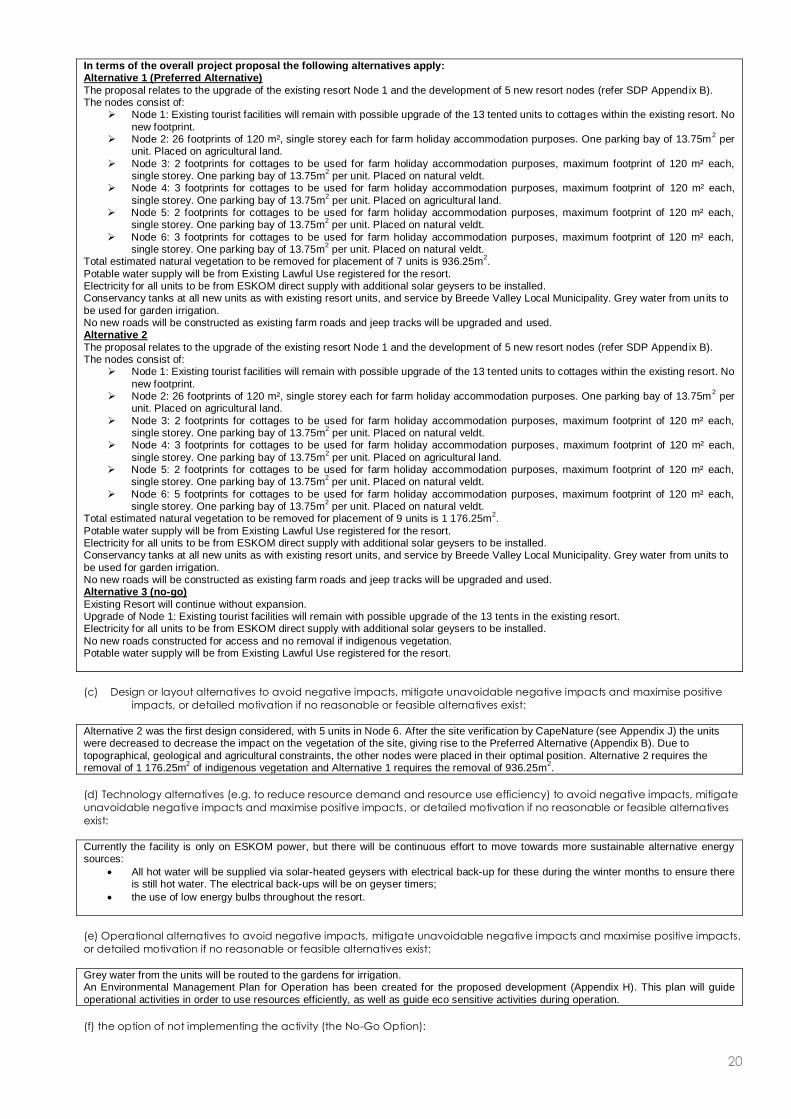
In terms of the overall project proposal the following alternatives apply: Alternative 1 (Preferred Alternative)
The proposal relates to the upgrade of the existing resort Node 1 and the development of 5 new resort nodes (refer SDP Appendix B). The nodes consist of:
Node 1: Existing tourist facilities will remain with possible upgrade of the 13 tented units to cottages within the existing resort. No
new footprint. Node 2: 26 footprints of 120 m², single storey each for farm holiday accommodation purposes. One parking bay of 13.75m
2 per
unit. Placed on agricultural land.
Node 3: 2 footprints for cottages to be used for farm holiday accommodation purposes, maximum footprint of 120 m² each, single storey. One parking bay of 13.75m
2 per unit. Placed on natural veldt.
Node 4: 3 footprints for cottages to be used for farm holiday accommodation purposes, maximum footprint of 120 m² each,
single storey. One parking bay of 13.75m2 per unit. Placed on agricultural land.
Node 5: 2 footprints for cottages to be used for farm holiday accommodation purposes, maximum footprint of 120 m² each, single storey. One parking bay of 13.75m
2 per unit. Placed on natural veldt.
Node 6: 3 footprints for cottages to be used for farm holiday accommodation purposes, maximum footprint of 120 m² each, single storey. One parking bay of 13.75m
2 per unit. Placed on natural veldt.
Total estimated natural vegetation to be removed for placement of 7 units is 936.25m2.
Potable water supply will be from Existing Lawful Use registered for the resort. Electricity for all units to be from ESKOM direct supply with additional solar geysers to be installed. Conservancy tanks at all new units as with existing resort units, and service by Breede Valley Local Municipality. Grey water from units to
be used for garden irrigation. No new roads will be constructed as existing farm roads and jeep tracks will be upgraded and used. Alternative 2
The proposal relates to the upgrade of the existing resort Node 1 and the development of 5 new resort nodes (refer SDP Appendix B). The nodes consist of:
Node 1: Existing tourist facilities will remain with possible upgrade of the 13 tented units to cottages within the existing resort. No
new footprint. Node 2: 26 footprints of 120 m², single storey each for farm holiday accommodation purposes. One parking bay of 13.75m
2 per
unit. Placed on agricultural land.
Node 3: 2 footprints for cottages to be used for farm holiday accommodation purposes, maximum footprint of 120 m² each, single storey. One parking bay of 13.75m
2 per unit. Placed on natural veldt.
Node 4: 3 footprints for cottages to be used for farm holiday accommodation purposes, maximum footprint of 120 m² each,
single storey. One parking bay of 13.75m2 per unit. Placed on agricultural land.
Node 5: 2 footprints for cottages to be used for farm holiday accommodation purposes, maximum footprint of 120 m² each, single storey. One parking bay of 13.75m
2 per unit. Placed on natural veldt.
Node 6: 5 footprints for cottages to be used for farm holiday accommodation purposes, maximum footprint of 120 m² each, single storey. One parking bay of 13.75m
2 per unit. Placed on natural veldt.
Total estimated natural vegetation to be removed for placement of 9 units is 1 176.25m2.
Potable water supply will be from Existing Lawful Use registered for the resort. Electricity for all units to be from ESKOM direct supply with additional solar geysers to be installed. Conservancy tanks at all new units as with existing resort units, and service by Breede Valley Local Municipality. Grey water from units to
be used for garden irrigation. No new roads will be constructed as existing farm roads and jeep tracks will be upgraded and used. Alternative 3 (no-go)
Existing Resort will continue without expansion. Upgrade of Node 1: Existing tourist facilities will remain with possible upgrade of the 13 tents in the existing resort. Electricity for all units to be from ESKOM direct supply with additional solar geysers to be installed.
No new roads constructed for access and no removal if indigenous vegetation. Potable water supply will be from Existing Lawful Use registered for the resort.
(c) Design or layout alternatives to avoid negative impacts, mitigate unavoidable negative impacts and maximise positive
impacts, or detailed motivation if no reasonable or feasible alternatives exist:
Alternative 2 was the first design considered, with 5 units in Node 6. After the site verification by CapeNature (see Appendix J) the units were decreased to decrease the impact on the vegetation of the site, giving rise to the Preferred Alternative (Appendix B). Due to
topographical, geological and agricultural constraints, the other nodes were placed in their optimal position. Alternative 2 requires the removal of 1 176.25m
2 of indigenous vegetation and Alternative 1 requires the removal of 936.25m
2.
(d) Technology alternatives (e.g. to reduce resource demand and resource use efficiency) to avoid negative impacts, mitigate
unavoidable negative impacts and maximise positive impacts, or detailed motivation if no reasonable or feasible alternatives
exist:
Currently the facility is only on ESKOM power, but there will be continuous effort to move towards more sustainable alternative energy sources:
All hot water will be supplied via solar-heated geysers with electrical back-up for these during the winter months to ensure there is still hot water. The electrical back-ups will be on geyser timers;
the use of low energy bulbs throughout the resort.
(e) Operational alternatives to avoid negative impacts, mitigate unavoidable negative impacts and maximise positive impacts,
or detailed motivation if no reasonable or feasible alternatives exist:
Grey water from the units will be routed to the gardens for irrigation. An Environmental Management Plan for Operation has been created for the proposed development (Appendix H). This plan will guide
operational activities in order to use resources efficiently, as well as guide eco sensitive activities during operation.
(f) the option of not implementing the activity (the No-Go Option):

21
Should the expansion of the Slanghoek Mountain Resort not be granted:
Upgrade of Node 1: Existing tourist facilities will remain with possible upgrade of the 13 tents in the existing resort.
Electricity for all units to be from ESKOM direct supply with additional solar geysers to be installed.
No new roads constructed for access and no removal if indigenous vegetation.
Potable water supply will be from Existing Lawful Use registered for the resort.
(g) Other alternatives to avoid negative impacts, mitigate unavoidable negative impacts and maximise positive impacts, or
detailed motivation if no reasonable or feasible alternatives exist:
No new roads will be developed to gain access to the nodes for development, thus decreasing the need for additional natural vegetation removal. An Environmental Management Plan (EMP) for Construction and Operational phases (Appendix H) have been developed specifically for
the proposed activity. These EMP’s will ensure that all sensitive areas are well demarcated and that construction and operational activities are guided in order to achieve a low impact approach.
(h) Please provide a summary of the alternatives investigated and the outcomes of such investigation: In terms of the overall project proposal the following alternatives apply: Alternative 1 (Preferred Alternative)
The proposal relates to the upgrade of the existing resort Node 1 and the development of 5 new resort nodes (refer SDP Appendix B). The nodes consist of:
Node 1: Existing tourist facilities will remain with possible upgrade of the 13 tented units to cottages within the existing resort. No
new footprint. Node 2: 26 footprints of 120 m², single storey each for farm holiday accommodation purposes. One parking bay of 13.75m
2 per
unit. Placed on agricultural land.
Node 3: 2 footprints for cottages to be used for farm holiday accommodation purposes, maximum footprint of 120 m² each, single storey. One parking bay of 13.75m
2 per unit. Placed on natural veldt.
Node 4: 3 footprints for cottages to be used for farm holiday accommodation purposes, maximum footprint of 120 m² each, single
storey. One parking bay of 13.75m2 per unit. Placed on agricultural land.
Node 5: 2 footprints for cottages to be used for farm holiday accommodation purposes, maximum footprint of 120 m² each, single storey. One parking bay of 13.75m
2 per unit. Placed on natural veldt.
Node 6: 3 footprints for cottages to be used for farm holiday accommodation purposes, maximum footprint of 120 m² each, single storey. One parking bay of 13.75m
2 per unit. Placed on natural veldt.
Total estimated natural vegetation to be removed for placement of 7 units is 936.25m2.
Potable water supply will be from Existing Lawful Use registered for the resort. Electricity for all units to be from ESKOM direct supply with additional solar geysers to be installed. Conservancy tanks at all new units as with existing resort units, and service by Breede Valley Local Municipality. Grey water from units to
be used for garden irrigation. No new roads will be constructed as existing farm roads and jeep tracks will be upgraded and used. Alternative 2
The proposal relates to the upgrade of the existing resort Node 1 and the development of 5 new resort nodes (refer SDP Appendix B). The nodes consist of:
Node 1: Existing tourist facilities will remain with possible upgrade of the 13 tented units to cottages within the existing resort. No
new footprint. Node 2: 26 footprints of 120 m², single storey each for farm holiday accommodation purposes. One parking bay of 13.75m
2 per
unit. Placed on agricultural land.
Node 3: 2 footprints for cottages to be used for farm holiday accommodation purposes, maximum footprint of 120 m² each, single storey. One parking bay of 13.75m
2 per unit. Placed on natural veldt.
Node 4: 3 footprints for cottages to be used for farm holiday accommodation purposes, maximum footprint of 120 m² each, single
storey. One parking bay of 13.75m2 per unit. Placed on agricultural land.
Node 5: 2 footprints for cottages to be used for farm holiday accommodation purposes, maximum footprint of 120 m² each, single storey. One parking bay of 13.75m
2 per unit. Placed on natural veldt.
Node 6: 5 footprints for cottages to be used for farm holiday accommodation purposes, maximum footprint of 120 m² each, single storey. One parking bay of 13.75m
2 per unit. Placed on natural veldt.
Total estimated natural vegetation to be removed for placement of 9 units is 1 176.25m2.
Potable water supply will be from Existing Lawful Use registered for the resort. Electricity for all units to be from ESKOM direct supply with additional solar geysers to be installed. Conservancy tanks at all new units as with existing resort units, and service by Breede Valley Local Municipality. Grey water from units to
be used for garden irrigation. No new roads will be constructed as existing farm roads and jeep tracks will be upgraded and used. Alternative 3 (no-go)
Existing Resort will continue without expansion. Upgrade of Node 1: Existing tourist facilities will remain with possible upgrade of the 13 tents in the existing resort. Electricity for all units to be from ESKOM direct supply with additional solar geysers to be installed.
No new roads constructed for access and no removal if indigenous vegetation. Potable water supply will be from Existing Lawful Use registered for the resort.
Please note: If no feasible and reasonable alternatives exist, the description and proof of the investigation of alternatives,
together with motivation of why no feasible or reasonable alternatives exist, must be provided.
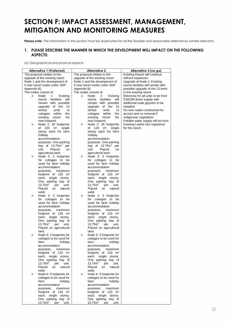
22
SECTION F: IMPACT ASSESSMENT, MANAGEMENT,
MITIGATION AND MONITORING MEASURES
Please note: The information in this section must be duplicated for all the feasible and reasonable alternatives (where relevant).
1. PLEASE DESCRIBE THE MANNER IN WHICH THE DEVELOPMENT WILL IMPACT ON THE FOLLOWING
ASPECTS:
(a) Geographical and physical aspects:
Alternative 1 (Preferred) Alternative 2 Alternative 3 (no go)
The proposal relates to the upgrade of the existing resort Node 1 and the development of
5 new resort nodes (refer SDP Appendix B). The nodes consist of:
Node 1: Existing tourist facilities will remain with possible
upgrade of the 13 tented units to cottages within the
existing resort. No new footprint.
Node 2: 26 footprints
of 120 m², single storey each for farm holiday
accommodation purposes. One parking bay of 13.75m
2 per
unit. Placed on agricultural land.
Node 3: 2 footprints
for cottages to be used for farm holiday accommodation
purposes, maximum footprint of 120 m² each, single storey.
One parking bay of 13.75m
2 per unit.
Placed on natural
veldt. Node 4: 3 footprints
for cottages to be
used for farm holiday accommodation purposes, maximum
footprint of 120 m² each, single storey. One parking bay of
13.75m2 per unit.
Placed on agricultural land.
Node 5: 2 footprints for cottages to be used for farm holiday
accommodation purposes, maximum footprint of 120 m²
each, single storey. One parking bay of 13.75m
2 per unit.
Placed on natural veldt.
Node 6: 3 footprints for
cottages to be used for farm holiday accommodation purposes, maximum
footprint of 120 m² each, single storey. One parking bay of
13.75m2 per unit.
The proposal relates to the upgrade of the existing resort Node 1 and the development of
5 new resort nodes (refer SDP Appendix B). The nodes consist of:
Node 1: Existing tourist facilities will remain with possible
upgrade of the 13 tented units to cottages within the
existing resort. No new footprint.
Node 2: 26 footprints
of 120 m², single storey each for farm holiday
accommodation purposes. One parking bay of 13.75m
2 per
unit. Placed on agricultural land.
Node 3: 2 footprints
for cottages to be used for farm holiday accommodation
purposes, maximum footprint of 120 m² each, single storey.
One parking bay of 13.75m
2 per unit.
Placed on natural
veldt. Node 4: 3 footprints
for cottages to be
used for farm holiday accommodation purposes, maximum
footprint of 120 m² each, single storey. One parking bay of
13.75m2 per unit.
Placed on agricultural land.
Node 5: 2 footprints for cottages to be used for farm holiday
accommodation purposes, maximum footprint of 120 m²
each, single storey. One parking bay of 13.75m
2 per unit.
Placed on natural veldt.
Node 6: 5 footprints for
cottages to be used for farm holiday accommodation purposes, maximum
footprint of 120 m² each, single storey. One parking bay of
13.75m2 per unit.
Existing Resort will continue without expansion. Upgrade of Node 1: Existing
tourist facilities will remain with possible upgrade of the 13 tents in the existing resort.
Electricity for all units to be from ESKOM direct supply with additional solar geysers to be
installed. No new roads constructed for access and no removal if
indigenous vegetation. Potable water supply will be from Existing Lawful Use registered
for the resort.
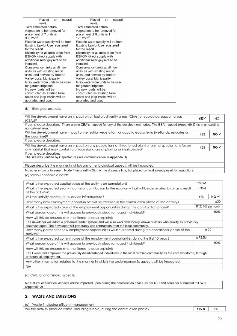
23
Placed on natural veldt.
Total estimated natural vegetation to be removed for placement of 7 units is
936.25m2.
Potable water supply will be from Existing Lawful Use registered
for the resort. Electricity for all units to be from ESKOM direct supply with
additional solar geysers to be installed. Conservancy tanks at all new
units as with existing resort units, and service by Breede Valley Local Municipality.
Grey water from units to be used for garden irrigation. No new roads will be
constructed as existing farm roads and jeep tracks will be upgraded and used.
Placed on natural veldt.
Total estimated natural vegetation to be removed for placement of 9 units is 1
176.25m2.
Potable water supply will be from Existing Lawful Use registered
for the resort. Electricity for all units to be from ESKOM direct supply with
additional solar geysers to be installed. Conservancy tanks at all new
units as with existing resort units, and service by Breede Valley Local Municipality.
Grey water from units to be used for garden irrigation. No new roads will be
constructed as existing farm roads and jeep tracks will be upgraded and used.
(b) Biological aspects:
Will the development have an impact on critical biodiversity areas (CBAs) or ecological support areas
(CSAs)? YES NO
If yes, please describe: There are no CBA’s mapped for any of the development nodes. The ESA mapped (Appendix D) is in an existing
agricultural area.
Will the development have impact on terrestrial vegetation, or aquatic ecosystems (wetlands, estuaries or
the coastline)? YES NO
If yes, please describe:
Will the development have an impact on any populations of threatened plant or animal species, and/or on
any habitat that may contain a unique signature of plant or animal species? YES NO
If yes, please describe: The site was verified by CapeNature (see communication in Appendix J).
Please describe the manner in which any other biological aspects will be impacted:
No other impacts foreseen. Node 4 units within 32m of the drainage line, but placed on land already used for agriculture.
(c) Socio-Economic aspects:
What is the expected capital value of the activity on completion? ±R45M
What is the expected yearly income or contribution to the economy that will be generated by or as a result
of the activity?
± R15M
Will the activity contribute to service infrastructure? YES NO
How many new employment opportunities will be created in the construction phase of the activity? ±30
What is the expected value of the employment opportunities during the construction phase? R120 000 per month
What percentage of this will accrue to previously disadvantaged individuals? 90%
How will this be ensured and monitored (please explain):
The developer will adopt a preferred tender system and will also work with locally known builders who qualify as previously
disadvantaged. The developer will preferably use contractors from the local community.
How many permanent new employment opportunities will be created during the operational phase of the
activity?
± 20
What is the expected current value of the employment opportunities during the first 10 years? ± R8.5M
What percentage of this will accrue to previously disadvantaged individuals? 90%
How will this be ensured and monitored (please explain):
The Owner will empower the previously disadvantaged individuals in the local farming community as the core workforce, through preferential employment.
Any other information related to the manner in which the socio-economic aspects will be impacted:
N/A
(d) Cultural and historic aspects:
No cultural or historical aspects will be impacted upon during the construction phase as per NID and screener submitted to HWC
(Appendix J)
2. WASTE AND EMISSIONS
(a) Waste (including effluent) management
Will the activity produce waste (including rubble) during the construction phase? YES X NO

24
If yes, indicate the types of waste (actual type of waste, e.g. oil, and whether hazardous or not) and
estimated quantity per type?
At this stage the actual quantity that
will be produced during the construction
phase, cannot be estimated. However, due to
building methods and limited cement works, building
waste can be reduced.
Will the activity produce waste during its operational phase? YES X NO
If yes, indicate the types of waste (actual type of waste, e.g. oil, and whether hazardous or not) and
estimated quantity per type?
1) The units will produce domestic
waste – estimated 1 bag per unit per week. 2) Recycled
waste – estimated 1 bag per unit per week. 3)
Composting in place on site. 4) Sewage to be
taken to Worcester WWTP – estimated additional 40 500l
to WWTP per annum from the three additional
conservancy tanks (one 10 000l tank, one 2000l tank and
one 1500l tank).
Where and how will the waste be treated / disposed of (describe)? Disposed of to municipal landfill site in Worcester (see also letter
in Appendix E).
If yes, indicate the types of waste (actual type of waste, e.g. oil, and whether hazardous or not) and estimated quantity per
type per phase of the development? The proposed additional 36 units will generate 2 bags of solid waste per month and 2 bags of recyclables per month each (thus 72 bags
solid waste and 72 bags recyclables). Composting implemented on site.
Has the municipality or relevant authority confirmed that sufficient capacity exist for treating / disposing of
the waste to be generated by this activity(ies)? If yes, provide written confirmation from Municipality or
relevant authority.
YES NO
Will the activity produce waste that will be treated and/or disposed of at another facility other than into a
municipal waste stream? YES NO
If yes, has this facility confirmed that sufficient capacity exist for treating / disposing of the waste to be
generated by this activity(ies)? Provide written confirmation from the facility and provide the following
particulars of the facility: N/A
YES NO
Does the facility have an operating license? (If yes, please attach a copy of the license.) YES NO
Facility name: N/A
Contact person: N/A
Postal address: N/A
Postal code: N/A
Telephone: N/A Cell: N/A
E-mail: N/A Fax: N/A
Describe the measures that will be taken to reduce, reuse or recycle waste:
Recycling on site will be encouraged and implemented in all units. Recyclables will be taken to landfill site Worcester for processing. An Environmental Management Plan (EMP) has been drafted for both the Construction and Operational Phases.
These plans will guide activities in order to encourage reduction, reuse or recycling. Dual flush toilets and low flow shower heads will be put in place for new units.
(b) Emissions into the atmosphere
Will the activity produce emissions that will be disposed of into the atmosphere? YES NO
If yes, does it require approval in terms of relevant legislation? YES NO
Describe the emissions in terms of type and concentration and how it will be treated/mitigated: N/A
3. WATER USE

25
Please indicate the source(s) of water for the activity by ticking the appropriate box(es)
Municipal Water board Groundwater River, Stream,
Dam or Lake Other The activity will not use water
If water is to be extracted from a groundwater source, river, stream, dam, lake or any other natural feature, please indicate
the volume that will be extracted per month: 600m3
Please provide proof of assurance of water supply (eg. Letter of confirmation from municipality / water user associations, yield
of borehole) See Appendix E for ELU confirmation
Does the activity require a water use permit / license from DWAF? YES NO
If yes, please submit the necessary application to Department of Water Affairs and attach proof thereof to this application. Permissible Existing Lawful Use use is applicable to the site. See BGCMA communication Appendix E.
Describe the measures that will be taken to reduce water demand, and measures to reuse or recycle water:
Water tanks for the grey water from the units will reroute this grey water to the gardens for irrigation;
Washbasin and shower taps to be fitted with flow reduction devices;
Toilets should be fitted with reduce flow or preferably a duel flush system;
All hoses on site to be fitted with trigger gun spray nozzles to limit wastage;
Preference should be given to planting only endemic/indigenous gardens and using such for landscaping to minimise water
demand;
Timed irrigation systems with the focus on the hours when the least evaporation occurs;
Irrigation systems to be fitted with a rain sensor to prevent excessive use of water;
Water meter to be installed on retention tanks prior to distribution to units;
Only plants adapted to the local climate used in landscaping to reduce the need for excessive watering;
Irrigation during the evenings and not during daylight hours;
Taps around the property fitted with locks to prevent unauthorised use and included on a maintenance schedule to detect and
repair leaks;
High pressure hoses used wherever possible to reduce water consumption;
Physical brushing or sweeping used in preference to water cleansing wherever possible (e.g. cleaning pathways).
4. POWER SUPPLY
Please indicate the source of power supply eg. Municipality / Eskom / Renewable energy source
Eskom
If power supply is not available, where will power be sourced from?
Solar geysers and panels. Gas geysers also in use already.
5. ENERGY EFFICIENCY
Describe the design measures, if any, that have been taken to ensure that the activity is energy efficient:
Currently the facility is only on ESKOM power, but there will be continuous effort to move towards more sustainable alternati ve energy
sources:
All hot water will be supplied via solar-heated geysers with electrical back-up for these during the winter months to ensure there
is still hot water. The electrical back-ups will be on geyser timers;
Energy saving bulbs in all structures, alternatively use low voltage or compact fluorescent lights;
Natural light used wherever possible during the day in preference to artificial light
Describe how alternative energy sources have been taken into account or been built into the design of the activity, if any:
Alternative energy sources (gas, solar, etc) will be used where possible. Eskom electricity will still be the main supply.
6. DESCRIPTION AND ASSESSMENT OF THE SIGNIFICANCE OF IMPACTS PRIOR TO AND AFTER
MITIGATION
Please note: While sections are provided for impacts on certain aspects of the environment and certain impacts,
the sections should also be copied and completed for all other impacts.
(a) Impacts that may result from the planning, design and construction phase (briefly describe and compare the potential
impacts (as appropriate), significance rating of impacts, proposed mitigation and significance rating of impacts after
mitigation that are likely to occur as a result of the planning, design and construction phase.
Potential impacts on
geographical and
physical aspects:
Alternative 1
(Preferred)
Alternative 2
Alternative 3
(no go)
Nature of impact: The construction of 36 new units and upgrade of
The construction of 38 new units and upgrade of
Upgrade of Node 1 only - Existing tourist facilities
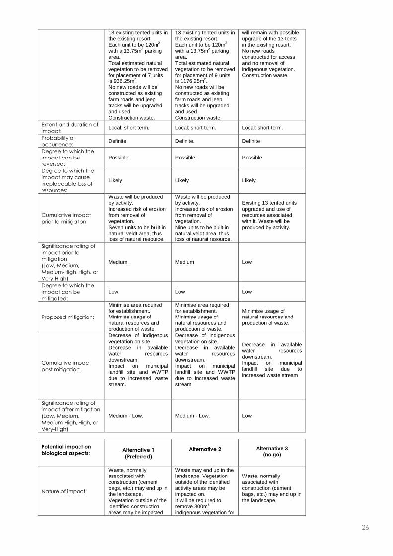
26
13 existing tented units in the existing resort.
Each unit to be 120m2
with a 13.75m2 parking
area.
Total estimated natural vegetation to be removed for placement of 7 units
is 936.25m2.
No new roads will be constructed as existing
farm roads and jeep tracks will be upgraded and used.
Construction waste.
13 existing tented units in the existing resort.
Each unit to be 120m2
with a 13.75m2 parking
area.
Total estimated natural vegetation to be removed for placement of 9 units
is 1176.25m2.
No new roads will be constructed as existing
farm roads and jeep tracks will be upgraded and used.
Construction waste.
will remain with possible upgrade of the 13 tents
in the existing resort. No new roads constructed for access
and no removal of indigenous vegetation. Construction waste.
Extent and duration of
impact: Local: short term. Local: short term. Local: short term.
Probability of
occurrence: Definite. Definite. Definite
Degree to which the
impact can be
reversed:
Possible. Possible. Possible
Degree to which the
impact may cause
irreplaceable loss of
resources:
Likely Likely Likely
Cumulative impact
prior to mitigation:
Waste will be produced by activity.
Increased risk of erosion from removal of vegetation.
Seven units to be built in natural veldt area, thus loss of natural resource.
Waste will be produced by activity.
Increased risk of erosion from removal of vegetation.
Nine units to be built in natural veldt area, thus loss of natural resource.
Existing 13 tented units
upgraded and use of resources associated with it. Waste will be
produced by activity.
Significance rating of
impact prior to
mitigation
(Low, Medium,
Medium-High, High, or
Very-High)
Medium. Medium Low
Degree to which the
impact can be
mitigated:
Low Low Low
Proposed mitigation:
Minimise area required for establishment. Minimise usage of
natural resources and production of waste.
Minimise area required for establishment. Minimise usage of
natural resources and production of waste.
Minimise usage of natural resources and
production of waste.
Cumulative impact
post mitigation:
Decrease of indigenous
vegetation on site. Decrease in available water resources
downstream. Impact on municipal landfill site and WWTP
due to increased waste stream.
Decrease of indigenous
vegetation on site. Decrease in available water resources
downstream. Impact on municipal landfill site and WWTP
due to increased waste stream
Decrease in available water resources
downstream. Impact on municipal landfill site due to
increased waste stream
Significance rating of
impact after mitigation
(Low, Medium,
Medium-High, High, or
Very-High)
Medium - Low. Medium - Low. Low
Potential impact on
biological aspects:
Alternative 1
(Preferred)
Alternative 2
Alternative 3 (no go)
Nature of impact:
Waste, normally associated with
construction (cement bags, etc.) may end up in the landscape.
Vegetation outside of the identified construction areas may be impacted
Waste may end up in the landscape. Vegetation
outside of the identified activity areas may be impacted on.
It will be required to remove 300m
2
indigenous vegetation for
Waste, normally
associated with construction (cement bags, etc.) may end up in
the landscape.

27
on by construction activities. Total estimated
natural vegetation to be removed for placement of 7 units is 936.25m
2.
the vegetable garden. Total estimated natural
vegetation to be removed for placement of 9 units is 1176.25m
2.
Extent and duration of
impact: Local: short term. Local: short term. Local: short term.
Probability of
occurrence:
With the strict implementation of the
EMP’s it is unlikely that construction waste will end up in the
surrounding environment. If the construction sites are
properly fenced off as recommended within the construction EMP, no
vegetation near the construction sites will be impacted on. The
removal of indigenous vegetation for establishment of the activity is unavoidable.
Strict implementation of waste handling procedures on site
should prevent waste from reaching the surrounding
environment.
Degree to which the
impact can be
reversed:
Low Low. Low
Degree to which the
impact may cause
irreplaceable loss of
resources:
Probable. Probable. Improbable.
Cumulative impact
prior to mitigation:
Loss of indigenous vegetation localised to
unit footprint areas. If proper construction and erosion controls are not
adopted, erosion can become a problem, resulting in further
vegetation loss.
Loss of indigenous vegetation localised to
unit footprint areas.
Windblown waste and degradation of
surrounding environment
Significance rating of
impact prior to
mitigation
(Low, Medium,
Medium-High, High, or
Very-High)
Medium Low Low
Degree to which the
impact can be
mitigated:
Possible Possible. Possible
Proposed mitigation:
Only clear vegetation as
required and leave no open areas until construction required, in
order to minimise chance of erosion. Institute no-go areas.
Ongoing alien vegetation management.
Only clear vegetation as
required and leave no open areas until construction required, in
order to minimise chance of erosion. Institute no-go areas.
Ongoing alien vegetation management.
Strict implementation of waste handling procedures on site
should prevent waste from reaching the surrounding
environment.
Cumulative impact
post mitigation:
Minimum erosion and
further vegetation loss as areas are cleared of vegetation.
Minimum erosion and
further vegetation loss as areas are cleared of vegetation.
No impact foreseen
Significance rating of
impact after mitigation
(Low, Medium,
Medium-High, High, or
Very-High)
Medium to Low Medium to Low Low
Potential impacts on
socio-economic
aspects:
Alternative 1
(Preferred)
Alternative 2
Alternative 3
(no go)
Nature of impact:
Positive:The construction of the project facility will result in approximately
30 temporary
Positive:The construction of the project facility will result in approximately
30 temporary
Positive:The construction of the project facility will result in approximately 8
temporary employment

28
employment opportunities.
employment opportunities.
opportunities
Extent and duration of
impact: Local: short term. Local: short term. Local: short term.
Probability of
occurrence: High. High. High.
Degree to which the
impact can be
reversed:
Possible. Possible. Possible.
Degree to which the
impact may cause
irreplaceable loss of
resources:
Likely. Likely. Likely.
Cumulative impact
prior to mitigation:
Job creation during the construction phase as well as the possibility of
skills transfer.
Job creation during the construction phase as well as the possibility of
skills transfer.
Job creation during the construction phase as well as the possibility of
skills transfer.
Significance rating of
impact prior to
mitigation
(Low, Medium,
Medium-High, High, or
Very-High)
Medium (positive) Low (positive) Low (positive)
Degree to which the
impact can be
mitigated:
Mitigation not required. Mitigation not required. Mitigation not required.
Proposed mitigation: Not required. Not required. Not required.
Cumulative impact
post mitigation:
Small scale job creation and transfer of skills.
Knock-on effect on local small scale economy.
Small scale job creation and transfer of skills.
Knock-on effect on local small scale economy.
Small scale job creation and transfer of skills.
Knock-on effect on local small scale economy.
Significance rating of
impact after mitigation
(Low, Medium,
Medium-High, High, or
Very-High)
Medium (positive) Medium (positive) Medium (positive)
Potential noise
impacts: Alternative 1
Alternative 2
Alternative 3
(no go)
Nature of impact:
Noise may occur during the construction of the project.
Noise may occur during the construction of the project.
Noise may occur during the construction of the project.
Extent and duration of
impact: Local: short term. Local: short term. Local: short term.
Probability of
occurrence: Definite. Definite. Definite.
Degree to which the
impact can be
reversed:
Low
Low Low
Degree to which the
impact may cause
irreplaceable loss of
resources:
Not likely. Not likely. Not likely.
Cumulative impact
prior to mitigation:
Noise typical of a small
construction site.
Noise typical of a small
construction site.
Noise typical of a small
construction site.
Significance rating of
impact prior to
mitigation
(Low, Medium,
Medium-High, High, or
Very-High)
Low. Low. Low.
Degree to which the
impact can be
mitigated:
Possible. Possible. Possible.
Proposed mitigation:
Ensure normal working hours are adhered to. Ensure that all noisy machinery is fitted with
silencers. Ensure all noise levels adhere to predetermined
standards.
Ensure normal working hours are adhered to. Ensure that all noisy machinery is fitted with
silencers. Ensure all noise levels adhere to predetermined
standards.
Ensure normal working hours are adhered to. Ensure that all noisy machinery is fitted with
silencers. Ensure all noise levels adhere to predetermined
standards.

29
Cumulative impact
post mitigation:
Typical noise impact associated with a
construction phase, with possible methods to limit and reduce these
impacts taken.
Typical noise impact associated with a
construction phase, with possible methods to limit and reduce these
impacts taken.
Typical noise impact associated with a
construction phase, with possible methods to limit and reduce these
impacts taken.
Significance rating of
impact after mitigation
(Low, Medium,
Medium-High, High, or
Very-High)
Low. Low. Low.
Potential visual
impacts:
Alternative 1
(Preferred)
Alternative 2
Alternative 3
(no go)
Nature of impact:
The expansion in Node 2 will be visible. The units in Node 5 & 6 will not be
visible if not located on the ridgeline.
The expansion in Node 2 will be visible. The units in Node 5 & 6 will not be
visible if not located on the ridgeline.
Existing 13 tented units
construction visible
Extent and duration of
impact: Local: short term. Local: long term. Local: long term.
Probability of
occurrence: Probable. Probable. Probable.
Degree to which the
impact can be
reversed:
Not Possible. Not Possible.
Degree to which the
impact may cause
irreplaceable loss of
resources:
Likely. Likely. -
Cumulative impact
prior to mitigation:
Construction site nodes 2, 5 and 6 will be visible.
Construction site nodes 2, 5 and 6 will be visible.
Existing 13 tented units not visible
Significance rating of
impact prior to
mitigation
(Low, Medium,
Medium-High, High, or
Very-High)
Medium Medium. Low
Degree to which the
impact can be
mitigated:
Low Low Low
Proposed mitigation:
Make use of natural
materials and colours to ensure that cottages blend in with their
surroundings. Nodes 5 and 6 not to be on ridgeline.
Make use of natural
materials and colours to ensure that cottages blend in with their
surroundings. Nodes 5 and 6 not to be on ridgeline.
Mitigation not needed
Cumulative impact
post mitigation:
Units in nodes 2, 5, and
6 less visible.
Units in nodes 2, 5, and
6 less visible. No impact anticipated.
Significance rating of
impact after mitigation
(Low, Medium,
Medium-High, High, or
Very-High)
Low. Low. Low
(b) Impacts that may result from the operational phase (briefly describe and compare the potential impacts (as appropriate),
significance rating of impacts, proposed mitigation and significance rating of impacts after mitigation that are likely to
occur as a result of the operational phase.
Potential impacts on
the geographical and
physical aspects:
Alternative 1
(Preferred)
Alternative 2
Alternative 3
(no go)
Nature of impact:
Erosion of internal roads may take place should it not be regularly
maintained and proper erosion control measures are not in place.
Erosion of internal roads may take place should it not be regularly
maintained and proper erosion control measures are not in place.
No internal roads with
possible erosion
Extent and duration of
impact: Local: long term. Local: long term. No impact anticipated
Probability of
occurrence: Possible. Possible. -

30
Degree to which the
impact can be
reversed:
Low. Low. -
Degree to which the
impact may cause
irreplaceable loss of
resources:
Low. Low. -
Cumulative impact
prior to mitigation:
Erosion of internal roads
may take place should it not be regularly maintained and proper
erosion control measures are not in place.
Erosion of internal roads
may take place should it not be regularly maintained and proper
erosion control measures are not in place.
No internal roads with possible erosion
Significance rating of
impact prior to
mitigation
(Low, Medium,
Medium-High, High, or
Very-High)
Low Low No impact anticipated
Degree to which the
impact can be
mitigated:
Possible. Possible. -
Proposed mitigation: Ongoing maintenance of
existing roads.
Ongoing maintenance of
existing roads. No mitigation required
Cumulative impact
post mitigation:
Possible erosion of existing roads
Possible erosion of existing roads
-
Significance rating of
impact after mitigation
(Low, Medium,
Medium-High, High, or
Very-High)
Low. Low. Low
Potential impact
biological aspects:
Alternative 1
(Preferred)
Alternative 2
Alternative 3
(no go)
Nature of impact:
Tourists may have an impact on the following:
Vegetation (fires,
unauthorised removal of vegetation, introduction of alien
vegetation);
Animals.
Tourists may have an impact on the following:
Vegetation (fires,
unauthorised removal of vegetation, introduction of alien
vegetation);
Animals.
Tourists may have an impact on the following:
Vegetation (fires,
unauthorised removal of vegetation, introduction of alien
vegetation);
Animals.
Extent and duration of
impact: Local: long term. Local: long term. Local: long term.
Probability of
occurrence: Possible. Possible. Possible
Degree to which the
impact can be
reversed:
Low to medium.
Low to medium.
Low to medium.
Degree to which the
impact may cause
irreplaceable loss of
resources:
Medium. Medium. Medium.
Cumulative impact
prior to mitigation:
Users of the units may have a negative impact on fauna and flora.
Users of the units may have a negative impact on fauna and flora.
Users of the units may have a negative impact on fauna and flora.
Significance rating of
impact prior to
mitigation
(Low, Medium,
Medium-High, High, or
Very-High)
Medium. Medium. Medium.
Degree to which the
impact can be
mitigated:
Possible. Possible. Possible.
Proposed mitigation: Strict implementation of operational EMP’s.
Strict implementation of operational EMP’s.
Strict implementation of operational EMP’s.
Cumulative impact
post mitigation:
Possible negative impact of users on fauna and flora.
Possible negative impact of users on fauna and flora.
Possible negative impact of users on fauna and flora.
Significance rating of
impact after mitigation
(Low, Medium,
Low-medium. Low-medium. Low-medium.

31
Medium-High, High, or
Very-High)
Potential impacts on
the socio-economic
aspects:
Alternative 1
(Preferred)
Alternative 2
Alternative 3
(no go)
Nature of impact:
Positive: job creation. Positive: skills development. Twenty
permanent employment positions created.
Positive: job creation. Positive: skills
development. Twenty
permanent employment positions created.
Positive: job creation.
Positive: skills development. Only 2
permanent employment
opportunities will be generated from this.
Extent and duration of
impact: Local: long term. Local: long term. Local: long term.
Probability of
occurrence: Possible. Possible. Probable.
Degree to which the
impact can be
reversed:
Possible. Possible. Possible.
Degree to which the
impact may cause
irreplaceable loss of
resources:
Unlikely. Unlikely. Unlikely.
Cumulative impact
prior to mitigation:
Job creation and skills
development.
Job creation and skills development.
Job creation and skills development.
Significance rating of
impact prior to
mitigation
(Low, Medium,
Medium-High, High, or
Very-High)
Low to medium. Low to medium. Low to medium.
Degree to which the
impact can be
mitigated:
Possible. Possible. Possible.
Proposed mitigation: Not required. Not required. Not required.
Cumulative impact
post mitigation:
Small scale job creation and skills development.
Small scale job creation and skills development.
Small scale job creation and skills development.
Significance rating of
impact after mitigation
(Low, Medium,
Medium-High, High, or
Very-High)
Low positive Low positive Low positive
Potential impacts on
the cultural-historical
aspects:
Alternative 1
(Preferred)
Alternative 2
Alternative 3
(no go)
Nature of impact: No impact anticipated
(see NID in Appendix J)
No impact anticipated
(see NID in Appendix J)
No impact anticipated
(see NID in Appendix J)
Extent and duration of
impact: -
- -
Probability of
occurrence: -
- -
Degree to which the
impact can be
reversed:
-
- -
Degree to which the
impact may cause
irreplaceable loss of
resources:
-
- -
Cumulative impact
prior to mitigation: -
- -
Significance rating of
impact prior to
mitigation
(Low, Medium,
Medium-High, High, or
Very-High)
-
- -
Degree to which the
impact can be
mitigated:
-
- -
Proposed mitigation: - - -
Cumulative impact - - -

32
post mitigation:
Significance rating of
impact after mitigation
(Low, Medium,
Medium-High, High, or
Very-High)
-
- -
Potential noise
impacts:
Alternative 1
(Preferred) Alternative 2
Alternative 3
(no go)
Nature of impact: Noise created due to occupancy of units.
Noise created due to occupancy of units.
Noise created due to occupancy of units.
Extent and duration of
impact: Local: long term. Local: long term. Local: long term.
Probability of
occurrence: Possible. Possible. Possible.
Degree to which the
impact can be
reversed:
Medium. Medium. Medium.
Degree to which the
impact may cause
irreplaceable loss of
resources:
Unlikely. Unlikely. Unlikely.
Cumulative impact
prior to mitigation:
Potential noise impact due to occupancy of cottages.
Potential noise impact due to occupancy of cottages.
Potential noise impact due to occupancy of cottages.
Significance rating of
impact prior to
mitigation
(Low, Medium,
Medium-High, High, or
Very-High)
Medium. Medium. Medium.
Degree to which the
impact can be
mitigated:
Medium. Medium. Medium
Proposed mitigation:
Strict regulation with regard to noise created
(no loud music, etc.).
Strict regulation with regard to noise created
(no loud music, etc.).
Strict regulation with regard to noise created
(no loud music, etc.).
Cumulative impact
post mitigation:
Potential noise impact due to occupancy of
cottages.
Potential noise impact due to occupancy of
cottages.
Potential noise impact due to occupancy of
cottages.
Significance rating of
impact after mitigation
(Low, Medium,
Medium-High, High, or
Very-High)
Low. Low. Low.
Potential visual
impacts:
Alternative 1
(Preferred) Alternative 2
Alternative 3
(no go)
Nature of impact:
The units in Node 2 will be visible. The units in
Node 5 & 6 will not be visible if not located on the ridgeline, and with
use of natural colours the visibility is greatly reduced.
The units in Node 2 will be visible. The units in
Node 5 & 6 will not be visible if not located on the ridgeline, and with
use of natural colours the visibility is greatly reduced
Existing 13 tented units not visible outside of resort due to trees
screening.
Extent and duration of
impact: Local: long term. Local: long term. Local: long term.
Probability of
occurrence: Probable. Probable. Probable.
Degree to which the
impact can be
reversed:
Medium. Medium. Low
Degree to which the
impact may cause
irreplaceable loss of
resources:
Low Low Low
Cumulative impact
prior to mitigation:
Units visible in nodes 2, 5 and 6.
Units visible in nodes 2, 5 and 6.
Existing 13 tented units not visible outside of resort due to trees
screening
Significance rating of
impact prior to Medium. Medium. Low

33
mitigation
(Low, Medium,
Medium-High, High, or
Very-High)
Degree to which the
impact can be
mitigated:
Medium. Medium. Low
Proposed mitigation:
Make sure that units
blend in with natural landscape by using natural materials as well
as colours that are not distinguishable from the natural landscape.
Nodes 5 and 6 should not protrude outside ridgeline.
Low level lighting outside at cottages.
Make sure that units
blend in with natural landscape by using natural materials as well
as colours that are not distinguishable from the natural landscape.
Nodes 5 and 6 should not protrude outside ridgeline.
Low level lighting outside at cottages.
Mitigation not required.
Cumulative impact
post mitigation:
Units might still be visible.
Units might still be visible.
Existing 13 tented units
not visible outside of resort due to trees screening.
Significance rating of
impact after mitigation
(Low, Medium,
Medium-High, High, or
Very-High)
Low. Low. Low
(c) Impacts that may result from the decommissioning and closure phase (briefly describe and compare the potential impacts
(as appropriate), significance rating of impacts, proposed mitigation and significance rating of impacts after mitigation that
are likely to occur as a result of the decommissioning and closure phase.
Potential impacts on
the geographical and
physical aspects:
Alternative 1
(Preferred)
Alternative 2
Alternative 3
(no go)
Nature of impact:
Units are left derelict after use.
Possible erosion of roads.
Units are left derelict after use.
Possible erosion of roads.
Units are left derelict after use.
Possible erosion of roads.
Extent and duration of
impact: Local: long term. Local: long term. Local: long term.
Probability of
occurrence: Unlikely. Unlikely. Unlikely.
Degree to which the
impact can be
reversed:
Possible. Possible. Possible.
Degree to which the
impact may cause
irreplaceable loss of
resources:
Unlikely. Unlikely. Unlikely.
Cumulative impact
prior to mitigation:
Units are left derelict after use. Possible erosion of
roads.
Units are left derelict after use. Possible erosion of
roads.
Units are left derelict after use. Possible erosion of
roads.
Significance rating of
impact prior to
mitigation
(Low, Medium,
Medium-High, High, or
Very-High)
Medium. Medium. Medium
Degree to which the
impact can be
mitigated:
Possible. Possible. Possible
Proposed mitigation:
Deconstruct buildings
should operations close down.
Ongoing maintenance of road surface.
Deconstruct buildings
should operations close down.
Ongoing maintenance of road surface.
Deconstruct buildings
should operations close down.
Ongoing maintenance of road surface.
Cumulative impact
post mitigation:
Ongoing maintenance
and monitoring to ensure that no erosion takes place.
Ongoing maintenance
and monitoring to ensure that no erosion takes place.
Ongoing maintenance
and monitoring to ensure that no erosion takes place.

34
Significance rating of
impact after mitigation
(Low, Medium,
Medium-High, High, or
Very-High)
Low. Low. Low
Potential impact
biological aspects:
Alternative 1
(Preferred)
Alternative 2
Alternative 3
(no go)
Nature of impact: No impact anticipated. No impact anticipated. No impact anticipated.
Extent and duration of
impact:
- - -
Probability of
occurrence:
- - -
Degree to which the
impact can be
reversed:
- - -
Degree to which the
impact may cause
irreplaceable loss of
resources:
- - -
Cumulative impact
prior to mitigation:
- - -
Significance rating of
impact prior to
mitigation
(Low, Medium,
Medium-High, High, or
Very-High)
- - -
Degree to which the
impact can be
mitigated:
- - -
Proposed mitigation: - - -
Cumulative impact
post mitigation:
- - -
Significance rating of
impact after mitigation
(Low, Medium,
Medium-High, High, or
Very-High)
- - -
Potential impacts on
the socio-economic
aspects:
Alternative 1
(Preferred)
Alternative 2
Alternative 3
(no go)
Nature of impact:
The loss of jobs will occur- 20 permanent positions.
The loss of jobs will occur- 20 permanent positions.
The loss of jobs will occur- 2 permanent positions.
Extent and duration of
impact:
Local: medium to long
term.
Local: medium to long term.
Local: medium to long term.
Probability of
occurrence: Possible.
Possible. Possible.
Degree to which the
impact can be
reversed:
Possible. Possible. Possible.
Degree to which the
impact may cause
irreplaceable loss of
resources:
Unlikely. Unlikely. Unlikely.
Cumulative impact
prior to mitigation: Job loss. Job loss. Job loss.
Significance rating of
impact prior to
mitigation
(Low, Medium,
Medium-High, High, or
Very-High)
Medium to low. Medium to low. Medium to low.
Degree to which the
impact can be
mitigated:
Possible. Possible. Possible.
Proposed mitigation: Ensure job security of former employees.
Ensure job security of former employees.
Ensure job security of former employees.
Cumulative impact
post mitigation: Temporary job loss. Temporary job loss. Temporary job loss.

35
Significance rating of
impact after mitigation
(Low, Medium,
Medium-High, High, or
Very-High)
Low. Low. Low.
Potential impacts on
the cultural-historical
aspects:
Alternative 1
(Preferred)
Alternative 2
Alternative 3
(no go)
Nature of impact: No impact anticipated. No impact anticipated. No impact anticipated.
Extent and duration of
impact: -
- -
Probability of
occurrence: -
- -
Degree to which the
impact can be
reversed:
-
- -
Degree to which the
impact may cause
irreplaceable loss of
resources:
-
- -
Cumulative impact
prior to mitigation: -
- -
Significance rating of
impact prior to
mitigation
(Low, Medium,
Medium-High, High, or
Very-High)
-
- -
Degree to which the
impact can be
mitigated:
-
- -
Proposed mitigation: - - -
Cumulative impact
post mitigation: -
- -
Significance rating of
impact after mitigation
(Low, Medium,
Medium-High, High, or
Very-High)
-
- -
Potential noise
impacts:
Alternative 1
(Preferred)
Alternative 2
Alternative 3
(no go)
Nature of impact:
Typical noise impacts
associated with the closure and
decommissioning of the
activity.
Typical noise impacts associated with the
closure and
decommissioning of the activity.
Typical noise impacts associated with the
closure and
decommissioning of the activity.
Extent and duration of
impact: Local: short term. Local: short term. Local: short term.
Probability of
occurrence: Not likely. Not likely. Not likely.
Degree to which the
impact can be
reversed:
Impact can be mitigated
should decommissioning take place.
Impact can be mitigated
should decommissioning take place.
Impact can be mitigated
should decommissioning take place.
Degree to which the
impact may cause
irreplaceable loss of
resources:
Zero. Zero. Zero.
Cumulative impact
prior to mitigation:
Typical noise impacts associated with the closure and
decommissioning of the activity.
Typical noise impacts associated with the
closure and decommissioning of the activity.
Typical noise impacts associated with the
closure and decommissioning of the activity.
Significance rating of
impact prior to
mitigation
(Low, Medium,
Medium-High, High, or
Very-High)
Low. Low. Low.

36
Degree to which the
impact can be
mitigated:
Possible, if necessary. Possible, if necessary. Possible, if necessary.
Proposed mitigation:
Implement hours for closure and possible decommissioning.
Implement hours for closure and possible decommissioning.
Implement hours for closure and possible decommissioning.
Cumulative impact
post mitigation:
Possible noise impacts associated with the closure and
decommissioning of the proposed activity.
Possible noise impacts associated with the closure and
decommissioning of the proposed activity.
Possible noise impacts associated with the closure and
decommissioning of the proposed activity.
Significance rating of
impact after mitigation
(Low, Medium,
Medium-High, High, or
Very-High)
Low. Low. Low.
Potential visual
impacts:
Alternative 1
(Preferred)
Alternative 2
Alternative 3
(no go)
Nature of impact: Derelict infrastructure visible
Derelict infrastructure visible
Derelict infrastructure visible
Extent and duration of
impact:
Local: long term. Local: long term. Local: long term.
Probability of
occurrence:
Unlikely. Unlikely. Unlikely.
Degree to which the
impact can be
reversed:
Possible. Possible. Possible.
Degree to which the
impact may cause
irreplaceable loss of
resources:
Zero. Zero. Zero.
Cumulative impact
prior to mitigation:
Derelict infrastructure
visible Derelict infrastructure
visible Derelict infrastructure
visible Significance rating of
impact prior to
mitigation
(Low, Medium,
Medium-High, High, or
Very-High)
Low. Low. Low.
Degree to which the
impact can be
mitigated:
Possible, if necessary. Possible, if necessary. Possible, if necessary.
Proposed mitigation:
Decommissioning of dwelling units to be
completed and all infrastructure removed with rehabilitation of
footprint.
Decommissioning of dwelling units to be
completed and all infrastructure removed with rehabilitation of
footprint.
Decommissioning of dwelling units to be
completed and all infrastructure removed with rehabilitation of
footprint. Cumulative impact
post mitigation:
No impact anticipated. No impact anticipated. No impact anticipated.
Significance rating of
impact after mitigation
(Low, Medium,
Medium-High, High, or
Very-High)
Low. Low. Low.
(d) Any other impacts:
Potential impact: Alternative 1
(Preferred)
Alternative 2
Alternative 3
(no go)
Nature of impact: No impact anticipated. No impact anticipated. No impact anticipated.
Extent and duration of
impact: -
- -
Probability of
occurrence: -
- -
Degree to which the
impact can be
reversed:
-
- -
Degree to which the
impact may cause
irreplaceable loss of
resources:
-
- -

37
Cumulative impact
prior to mitigation: -
- -
Significance rating of
impact prior to
mitigation
(Low, Medium,
Medium-High, High, or
Very-High)
-
- -
Degree to which the
impact can be
mitigated:
-
- -
Proposed mitigation: - - -
Cumulative impact
post mitigation: -
- -
Significance rating of
impact after mitigation
(Low, Medium,
Medium-High, High, or
Very-High)
-
- -
7. SPECIALIST INPUTS/STUDIES AND RECOMMENDATIONS
Please note: Specialist inputs/studies must be attached to this report as Appendix G. Also take into account the
Department’s Guidelines on the Involvement of Specialists in EIA Processes available on the Department’s website
(http://www.capegateway.gov.za/eadp).
Specialist inputs/studies and recommendations:
Visual Impact Statement by P Slabbert – PHS Consulting:
1) The development Nodes 2, 5 & 6 only become visible from immediately adjacent to it, by potential scenic drive road users with in
a 60m view window. These users will see the expansion in Node 2, but if charcoal roofs and earthy exterior colours are used
coupled with tree planting amongst the units the impact will be very localised for a few seconds, therefore low.
2) The 5 units in Node 5 & 6 will not be visible if not located on the ridgeline. By making use of charcoal roofs and natural exterior
colours and materials like stone these units will blend into their surroundings.
8. IMPACT SUMMARY
Please provide a summary of all the above impacts.
Alternative 1: (Preferred alternative) Should the expansion of the existing Slanghoek Mountain Resort by 36 units be granted the following will be implemented:
The construction of 36 new units and upgrade of 13 existing tented units in the existing resort.
Each unit to be 120m2 with a 13.75m
2 parking area.
Total estimated natural vegetation to be removed for placement of 7 units is 936.25m2.
Potable water supply will be from Existing Lawful Use registered for the resort.
Electricity for all units to be from ESKOM direct supply with additional solar geysers to be installed.
Conservancy tanks at all new units as with existing resort units, and service by Breede Valley Local Municipality. Grey water
from units to be used for garden irrigation.
No new roads will be constructed as existing farm roads and jeep tracks will be upgraded and used.
Construction phase: On Geographical impacts this alternative has a medium to low rating and on Biological aspects a medium to low rating due to
the required removal of indigenous vegetation for establishment. The socio-economic impact rating is medium positive, while Noise and Visual impact both rate low after mitigation. Operational phase: On Geographical impacts this alternative has a low rating and on Biological aspects a low to medium rating.
The socio-economic impact rating is low positive, while Noise and Visual impact both rate low after mitigation. Closure phase: On Geographical impacts this alternative has a low rating. The socio-economic impact rating is low, while Noise and Visual impact both rate low after mitigation.
Alternative 2: Should the expansion of the existing Slanghoek Mountain Resort by 38 units be granted the following will be implemented:
The construction of 38 new units and upgrade of 13 existing tented units in the existing resort.
Each unit to be 120m2 with a 13.75m
2 parking area.
Total estimated natural vegetation to be removed for placement of 9 units is 1 176.25m2.
Potable water supply will be from Existing Lawful Use registered for the resort.
Electricity for all units to be from ESKOM direct supply with additional solar geysers to be installed.
Conservancy tanks at all new units as with existing resort units, and service by Breede Valley Local Municipality. Grey water
from units to be used for garden irrigation.
No new roads will be constructed as existing farm roads and jeep tracks will be upgraded and used.

38
. Construction phase:
On Geographical impacts this alternative has a medium to low rating and on Biological aspects a medium to low rating. The socio-economic impact rating is medium positive, while Noise and Visual impact both rate low after mitigation. Operational phase: On Geographical impacts this alternative has a low rating and on Biological aspects a low to medium rating .
The socio-economic impact rating is low positive, while Noise and Visual impact both rate low after mitigation. Closure phase: On Geographical impacts this alternative has a low rating. The socio-economic impact rating is low, while Noise and Visual impact both rate low after mitigation.
Alternative 3: (No-go)
Existing Resort will continue without expansion.
Upgrade of Node 1 only - Existing tourist facilities will remain with possible upgrade of the 13 tents in the existing resort.
Electricity for all units to be from ESKOM direct supply with additional solar geysers to be installed where possible.
No new roads constructed for access and no removal of indigenous vegetation.
Potable water supply will be from Existing Lawful Use registered for the resort. Construction phase:
On Geographical impacts this alternative has a low rating and on Biological aspects a low rating. The socio-economic impact rating is medium positive, while Noise and Visual impact both rate low after mitigation. Operational phase: On Geographical impacts this alternative has a low rating and on Biological aspects a low to medium rating.
The socio-economic impact rating is low positive, while Noise and Visual impact both rate low after mitigation. Closure phase: On Geographical impacts this alternative has a low rating. The socio-economic impact rating is low, while Noise and Visual impact both rate low after mitigation.
9. OTHER MANAGEMENT, MITIGATION AND MONITORING MEASURES
(a) Over and above the mitigation measures described in Section 6 above, please indicate any additional management,
mitigation and monitoring measures.
Construction and Operational Environmental Management Plans (EMP’s) have been drafted to include additional measures for the respective phases.
(b) Describe the ability of the applicant to implement the management, mitigation and monitoring measures.
Construction and Operational Environmental Management Plans (EMP’s) have been drafted. Mitigation and monitoring measures are straight forward with easily obtainable objectives therefore the applicant is capable of achieving these management and mitigation measures.
Please note: A draft ENVIRONMENTAL MANAGEMENT PROGRAMME must be attached this report as Appendix H.
SECTION G: ASSESSMENT METHODOLOGIES AND
CRITERIA, GAPS IN KNOWLEDGE, UNDERLAYING
ASSUMPTIONS AND UNCERTAINTIES
(a) Please describe adequacy of the assessment methods used.
The Basic Assessment process is informed and conducted in an open and transparent manner. If any specialist studies are required, they
will be added to the report. From the current baseline further specialist studies are not required. The initial request for a botanical assessment was negated by CapeNature after an on-site verification visit.
(b) Please describe the assessment criteria used.
A site visit was conducted to determine the ecological significance of the site; this knowledge was then weighed up against the identified and possible impacts.
(c) Please describe the gaps in knowledge.
No gaps in knowledge currently exist at this stage; however should any be identified they will be communicated in an open and transparent manner and documented in the Basic Assessment Report (BAR) or where appropriate.
(d) Please describe the underlying assumptions.
No assumptions have been considered necessary at this stage in the process. Should any assumptions be required they will be identified appropriately.
(e) Please describe the uncertainties.

39
No uncertainties exist at this stage in the process.
SECTION H: RECOMMENDATION OF THE EAP
In my view (EAP), the information contained in this application form and the documentation attached
hereto is sufficient to make a decision in respect of the activity applied for. YES NO
If “NO”, list the aspects that should be further assessed through additional specialist input/assessment or whether this
application must be subjected to a Scoping & EIR process before a decision can be made:
If “YES”, please indicate below whether in your opinion the activity should or should not be authorised:
Activity should be authorised: YES NO
Please provide reasons for your opinion
The need for additional holiday accommodation in the area has given rise to the proposed project. Not only will the proposed Preferred Alternative 1create 36 additional units with scenic views in a rural landscape, but the project will also bring tourists into the area to spend
on other small scale industries. The permanent and temporary jobs created during the operational and construction phases of the project are in line with the need for year long employment outside of seasonal agricultural opportunities . The The Preferred Alternative provided, with the guidance of the EMP’s for construction and operation, will allow for a development that has an
overall low negative ecological impact associated with it.
If you are of the opinion that the activity should be authorised, then please provide any conditions, including mitigation
measures that should in your view be considered for inclusion in an authorisation.
Waste: - All waste generated during the construction phase to be removed. - No dumping of building rubble on the farm allowed.
- Removal of building rubble & waste to occur at least once a week - Contractor to be responsible for waste generated during the construction phase. - Domestic waste must be transferred by the owners to the nearest municipal transfer station.
- The water provided for domestic use must comply with the SANS 241: 2011 guidelines for drinking water (edition 1). Regular monitoring must be done to ensure compliance. lf the quality of the water is of such a nature that it is a threat to human health, then this Office and the Provincial Department of Health must be informed of the procedures to rectify the problem.
- No pollution of surface water or ground water resources may occur.
- Storm water management must be addressed both in terms of flooding and pollution potential. - A water meter should be installed on the distribution system.
Earthmoving/erosion:
- Avoid existing drainage channels. - Ensure that stormwater is regularly and properly channelled away from roads to avoid erosion. - Regular inspections of roads should take place to detect any signs of erosion. Should such signs be located, proper erosion
control measures should be implemented. Visual:
- Use natural materials where possible for construction.
- Use colours that complement the surrounding landscape and that blends in with the natural surroundings. - Nodes 5 and 6 should not be constructed in such a way as to be visible above the ridgeline.
Light: - All lights must be down lights limited with low voltage energy saving bulbs. - Time and motion switches are essential.
Water:
- Monitor water to ensure that no pollution is taking place.
- Install water meter - Grey water systems to be installed at units to use for irrigation of landscaping and lessen the need for potable water use.
General: - The development footprints must be clearly demarcated; all areas outside of this must be considered no go areas. - All areas outside of the development footprints that are disturbed during construction must be rehabilitated.
- A search and rescue of plant species of conservation concern must be conducted under the guidance of a specialist prior to any land clearance. Rescued material should be used on site for the rehabilitation of disturbed areas
- Any re-vegetation should use locally indigenous species.
Duration and Validity:
Environmental authorisations are usually granted for a period of three years from the date of issue. Should a longer period be
required, the applicant/EAP is requested to provide a detailed motivation on what the period of validity should be.
N/A
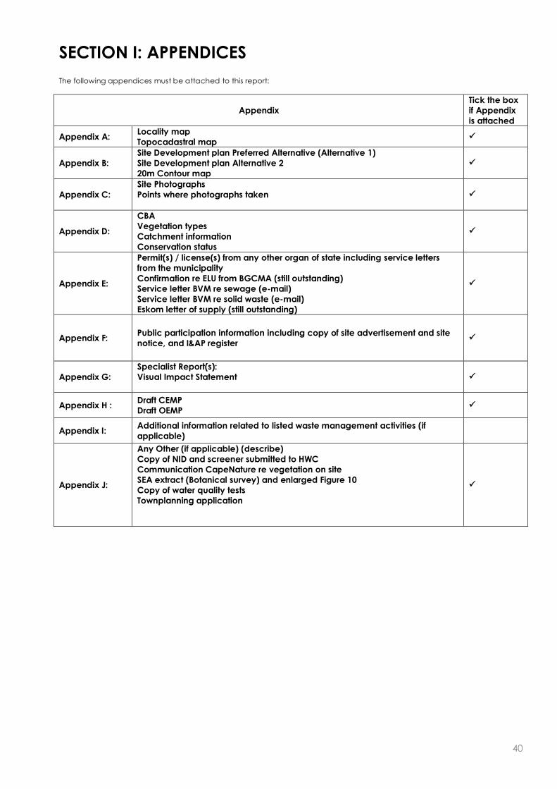
40
SECTION I: APPENDICES
The following appendices must be attached to this report:
Appendix
Tick the box
if Appendix
is attached
Appendix A: Locality map
Topocadastral map
Appendix B:
Site Development plan Preferred Alternative (Alternative 1)
Site Development plan Alternative 2
20m Contour map
Appendix C:
Site Photographs
Points where photographs taken
Appendix D:
CBA
Vegetation types
Catchment information
Conservation status
Appendix E:
Permit(s) / license(s) from any other organ of state including service letters
from the municipality
Confirmation re ELU from BGCMA (still outstanding)
Service letter BVM re sewage (e-mail)
Service letter BVM re solid waste (e-mail)
Eskom letter of supply (still outstanding)
Appendix F: Public participation information including copy of site advertisement and site
notice, and I&AP register
Appendix G:
Specialist Report(s):
Visual Impact Statement
Appendix H : Draft CEMP
Draft OEMP
Appendix I: Additional information related to listed waste management activities (if
applicable)
Appendix J:
Any Other (if applicable) (describe)
Copy of NID and screener submitted to HWC
Communication CapeNature re vegetation on site
SEA extract (Botanical survey) and enlarged Figure 10
Copy of water quality tests
Townplanning application

41
DECLARATIONS
THE APPLICANT
I .............................................................................., in my personal capacity thereto hereby that I:
regard the information contained in this report to be true and correct, and
am fully aware of my responsibilities in terms of the National Environmental Management Act of
1998 (“NEMA”) (Act No. 107 of 1998), the Environmental Impact Assessment Regulations (“EIA
Regulations”) in terms of NEMA (Government Notice No. R. 543 refers), and the relevant specific
environmental management Act, and that failure to comply with these requirements may
constitute an offence in terms of the environmental legislation;
appointed the environmental assessment practitioner as indicated above, which meet all the
requirements in terms of regulation 17 of GN No. R. 543, to act as the independent environmental
assessment practitioner for this application;
have provided the environmental assessment practitioner and the competent authority with
access to all information at my disposal that is relevant to the application;
will be responsible for the costs incurred in complying with the environmental legislation including
but not limited to –
o costs incurred in connection with the appointment of the environmental assessment
practitioner or any person contracted by the environmental assessment practitioner;
o costs incurred in respect of the undertaking of any process required in terms of the regulations;
o costs in respect of any fee prescribed by the Minister or MEC in respect of the regulations;
o costs in respect of specialist reviews, if the competent authority decides to recover costs; and
o the provision of security to ensure compliance with the applicable management and
mitigation measures;
am responsible for complying with the conditions that might be attached to any decision(s) issued
by the competent authority;
have the ability to implement the applicable management, mitigation and monitoring measures;
hereby indemnify, the government of the Republic, the competent authority and all its officers,
agents and employees, from any liability arising out of, inter alia, the content of any report, any
procedure or any action for which the applicant or environmental assessment practitioner is
responsible; and
am aware that a false declaration is an offence in terms of regulation 71 of GN No. R. 543.
Please Note: If acting in a representative capacity, a certified copy of the resolution or power
of attorney must be attached.
Signature of the applicant:
Name of company:
Date:

42
THE INDEPENDENT ENVIRONMENTAL ASSESSMENT PRACTITIONER (EAP)
I Amanda Fritz-Whyte, as the appointed independent environmental practitioner (“EAP”) hereby
declare that I:
act/ed as the independent EAP in this application;
regard the information contained in this report to be true and correct, and
do not have and will not have any financial interest in the undertaking of the activity, other than
remuneration for work performed in terms of the NEMA, the Environmental Impact Assessment
Regulations, 2010 and any specific environmental management Act;
have and will not have no vested interest in the proposed activity proceeding;
have disclosed, to the applicant and competent authority, any material information that have or
may have the potential to influence the decision of the competent authority or the objectivity of
any report, plan or document required in terms of the NEMA, the Environmental Impact
Assessment Regulations, 2010 and any specific environmental management Act;
am fully aware of and meet the responsibilities in terms of NEMA, the Environmental Impact
Assessment Regulations, 2010 (specifically in terms of regulation 17 of GN No. R. 543) and any
specific environmental management Act, and that failure to comply with these requirements may
constitute and result in disqualification;
have ensured that information containing all relevant facts in respect of the application was
distributed or made available to interested and affected parties and the public and that
participation by interested and affected parties was facilitated in such a manner that all
interested and affected parties were provided with a reasonable opportunity to participate and
to provide comments;
have ensured that the comments of all interested and affected parties were considered,
recorded and submitted to the competent authority in respect of the application;
have kept a register of all interested and affected parties that participated in the public
participation process;
have provided the competent authority with access to all information at my disposal regarding
the application, whether such information is favourable to the applicant or not; and
am aware that a false declaration is an offence in terms of regulation 71 of GN No. R. 543.
Note: The terms of reference must be attached.
Signature of the environmental assessment practitioner:
PHS Consulting
Name of company:
Date:

43
THE PERSON WHO COMPILED A SPECIALIST REPORT OR UNDERTOOK A SPECIALIST PROCESS
I ………………………, as the appointed specialist hereby declare that I:
act/ed as the specialist in this application due to my unequalled knowledge of the flora of the
property. I have studied the flora of the farm and surrounding area for a period of 16 months. This
has enabled me to observe the flora at all seasons on the property, not just at a limited point in
time. I have over 20 years experience as a plant taxonomist, including a PhD in the taxonomy of
the Cape Flora.
regard the information contained in this report as it relates to my specialist input/study to be true
and correct, and
have disclosed, to the applicant, EAP and competent authority, any material information that
have or may have the potential to influence the decision of the competent authority or the
objectivity of any report, plan or document required in terms of the NEMA, the Environmental
Impact Assessment Regulations, 2010 and any specific environmental management Act;
am fully aware of and meet the responsibilities in terms of NEMA, the Environmental Impact
Assessment Regulations, 2010 (specifically in terms of regulation 17 of GN No. R. 543) and any
specific environmental management Act, and that failure to comply with these requirements may
constitute and result in disqualification;
have ensured that information containing all relevant facts in respect of the specialist input/study
was distributed or made available to interested and affected parties and the public and that
participation by interested and affected parties was facilitated in such a manner that all
interested and affected parties were provided with a reasonable opportunity to participate and
to provide comments on the specialist input/study;
have ensured that the comments of all interested and affected parties on the specialist
input/study were considered, recorded and submitted to the competent authority in respect of
the application;
have ensured that the names of all interested and affected parties that participated in terms of
the specialist input/study were recorded in the register of interested and affected parties who
participated in the public participation process;
have provided the competent authority with access to all information at my disposal regarding
the application, whether such information is favourable to the applicant or not; and
am aware that a false declaration is an offence in terms of regulation 71 of GN No. R. 543.
Note: The terms of reference must be attached.
Signature of the specialist:
Name of company:
Date: