Exploring Using Artificial Intelligence (AI) for NWP and...
15
Exploring Using Artificial Intelligence (AI) for Remote Sensing, NWP and Situational Awareness (SA) S. Boukabara*, E. Maddy + , A. Neiss + , K. Garrett + , E. Jones + , K. Ide~, N. Shahroudi~ and K. Kumar + *NOAA/NESDIS Center for Satellite Applications and Research (STAR) , College park, MD, USA + Riverside Technology Inc. (RTI) @ NOAA/STAR, College park, MD, USA ~ University of Maryland (UMD), College Park, MD, USA ITSC-XXI Conference, Darmstadt, Germany, Nov 29 th – Dec 5 th 2017
Transcript of Exploring Using Artificial Intelligence (AI) for NWP and...
Exploring Using Artificial Intelligence (AI) for Remote Sensing, NWP and Situational Awareness (SA)
S. Boukabara*, E. Maddy+, A. Neiss+, K. Garrett+, E. Jones+, K. Ide~, N. Shahroudi~ and K. Kumar+
*NOAA/NESDIS Center for Satellite Applications and Research (STAR) , College park, MD, USA+ Riverside Technology Inc. (RTI) @ NOAA/STAR, College park, MD, USA
~ University of Maryland (UMD), College Park, MD, USA
ITSC-XXI Conference, Darmstadt, Germany, Nov 29th – Dec 5th 2017
Agenda
1 Why Artificial Intelligence (AI) ? Background and Motivations
Methodology & Description
AI for Remote Sensing and Data Assimilation/Fusion/NowCasting
Conclusions
2
3
4
3
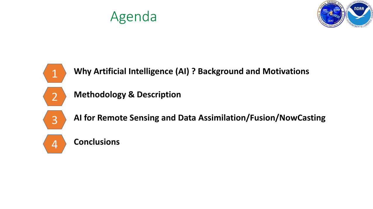
Ensemble
Single
Expected Increase in HPC requirements and Data Volume(for ECMWF NWP center: using currently 5-10% of satellite data)
2015/6 2025
[ECMWF, Bauer et al. 2015]
affordable power limit
160 PB
2010 2020 2030
NOAA Data Volume graph, Courtesy Steve Del Greco & Ken Casey, NOAA/ NCEI (via Jeff de La Beaujardiere)
GOS Trends:- New Players in GOS (international, private, ..)- New Sensors (higher resolutions,..)- New technologies (small sats, etc)- Emergence of New GOS (IoT, etc)- Significant Increase in data volume/diversity- Budget and HPC Constraints

Why AI? • AI applied successfully in fields with similar traits as
Environmental data & NWP/SA: (1) # obs. systems to analyze/assimilate/fuse and (2) predict behavior
• Medical field (Watson Project): Scan Image Analysis, Cancer detection, heart Sound analysis
• In finance: Algorithmic Trading, market data analysis, portfolio management
• In Music: Composing any style by learning from huge database & analyzing unique combinations.
• Self-Driving Transportation Devices: Fusion of Multiple Observing Systems for situational awareness
• …..• We believe Environmental data exploitation (remote
sensing, data assimilation and perhaps forecasting), presents a viable candidate for AI application.
• This presentation is meant to present a few examples to convey that the potential is significant.
Neural Network vs Deep Learning (AI)
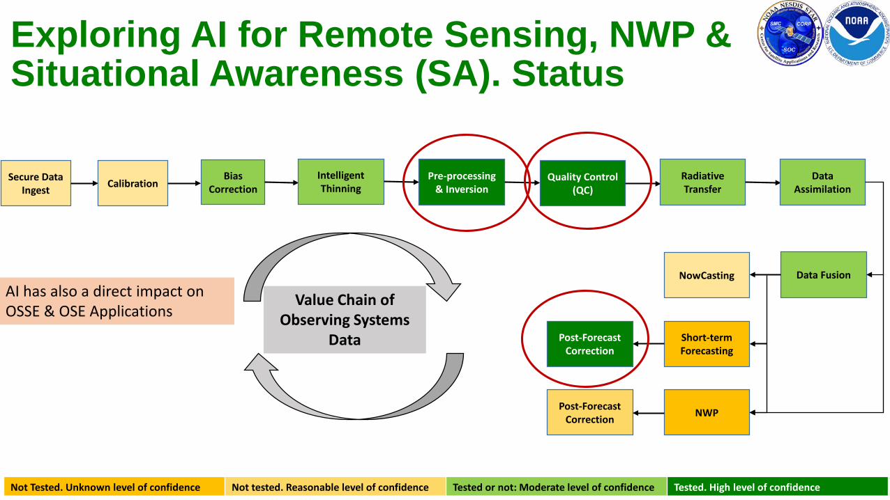
Exploring AI for Remote Sensing, NWP & Situational Awareness (SA). Status
Secure Data Ingest Calibration
Bias Correction
Pre-processing & Inversion
Quality Control (QC)
Radiative Transfer
Data Assimilation
Data FusionNowCasting
Short-term Forecasting
NWP
Post-Forecast Correction
Post-Forecast Correction
Not Tested. Unknown level of confidence Not tested. Reasonable level of confidence Tested or not: Moderate level of confidence Tested. High level of confidence
Value Chain of Observing Systems
Data
Intelligent Thinning
AI has also a direct impact on OSSE & OSE Applications
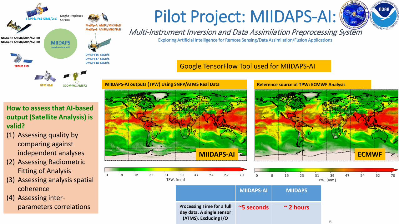
Pilot Project: MIIDAPS-AI: Multi-Instrument Inversion and Data Assimilation Preprocessing System
Exploring Artificial Intelligence for Remote Sensing/Data Assimilation/Fusion Applications
6
Reference source of TPW: ECMWF Analysis
MIIDAPS-AI MIIDAPS
Processing Time for a full day data. A single sensor
(ATMS). Excluding I/O
~5 seconds ~ 2 hours
ECMWFMIIDAPS-AI
MIIDAPS-AI outputs (TPW) Using SNPP/ATMS Real Data
Google TensorFlow Tool used for MIIDAPS-AI
How to assess that AI-based output (Satellite Analysis) is valid?(1) Assessing quality by
comparing against independent analyses
(2) Assessing Radiometric Fitting of Analysis
(3) Assessing analysis spatial coherence
(4) Assessing inter-parameters correlations
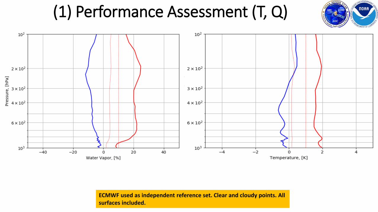
(1) Performance Assessment (T, Q)
ECMWF used as independent reference set. Clear and cloudy points. All surfaces included.
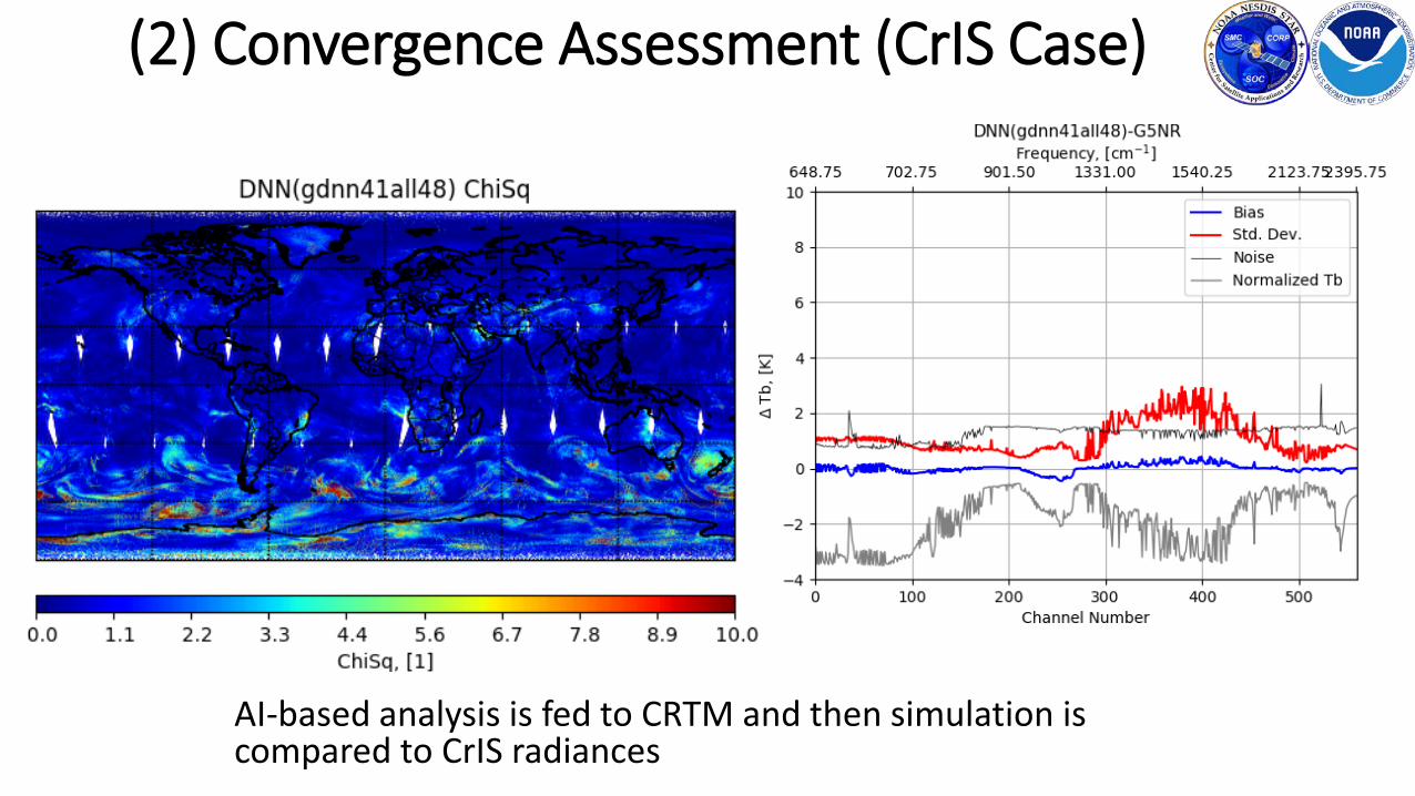
AI-based analysis is fed to CRTM and then simulation is compared to CrIS radiances
(2) Convergence Assessment (CrIS Case)
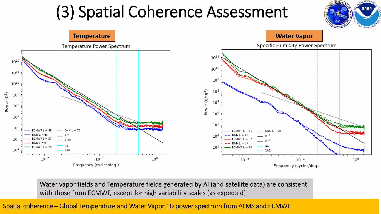
Spatial coherence – Global Temperature and Water Vapor 1D power spectrum from ATMS and ECMWF
Temperature Water Vapor
(3) Spatial Coherence Assessment
Water vapor fields and Temperature fields generated by AI (and satellite data) are consistent with those from ECMWF, except for high variability scales (as expected)
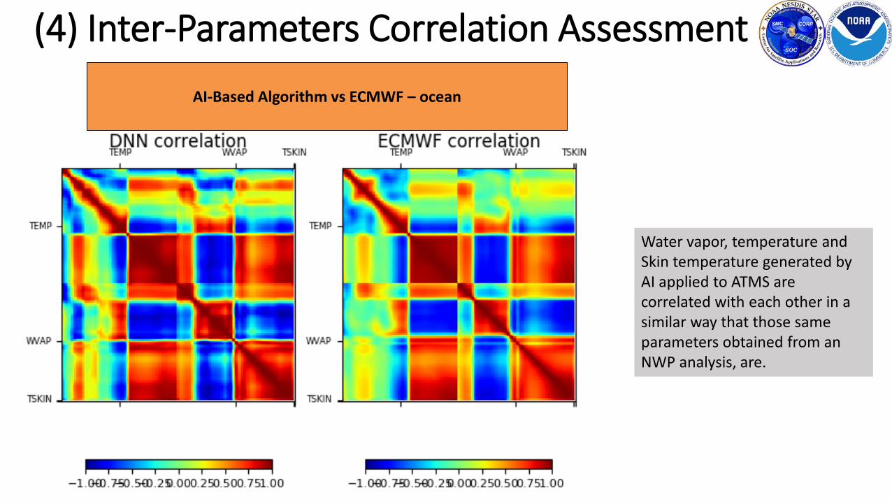
AI-Based Algorithm vs ECMWF – ocean
(4) Inter-Parameters Correlation Assessment
Water vapor, temperature and Skin temperature generated by AI applied to ATMS are correlated with each other in a similar way that those same parameters obtained from an NWP analysis, are.
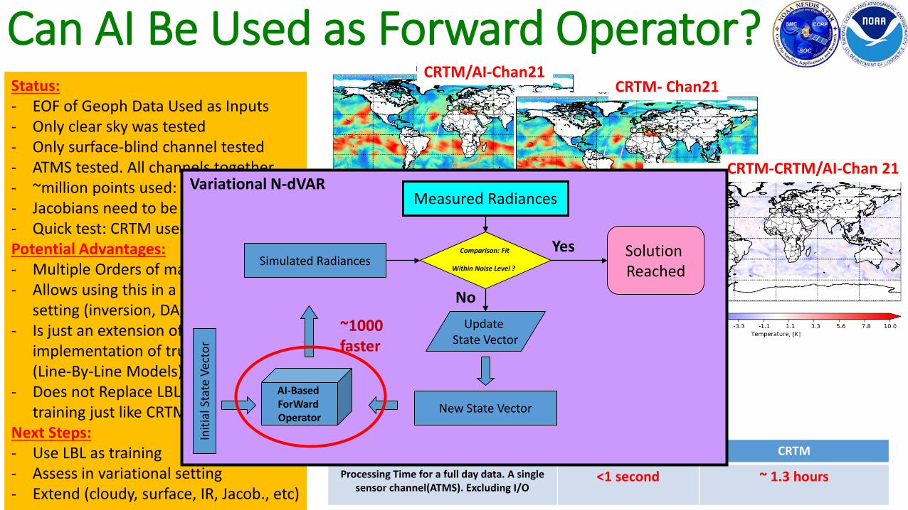
Can AI Be Used as Forward Operator?
CRTM-AI CRTM
Processing Time for a full day data. A single sensor channel(ATMS). Excluding I/O
<1 second ~ 1.3 hours
Status:- EOF of Geoph Data Used as Inputs- Only clear sky was tested- Only surface-blind channel tested- ATMS tested. All channels together- ~million points used: training/testing- Jacobians need to be trained (TBD)- Quick test: CRTM used as trainingPotential Advantages: - Multiple Orders of magnitude faster- Allows using this in a Variational
setting (inversion, DA/DF)- Is just an extension of the faster
implementation of true RT models (Line-By-Line Models)
- Does not Replace LBL: Uses them for training just like CRTM, RTTOV, etc
Next Steps:- Use LBL as training- Assess in variational setting- Extend (cloudy, surface, IR, Jacob., etc)
CRTM/AI-Chan21CRTM- Chan21
CRTM-CRTM/AI-Chan 21
AI vs CRTM
Chan21
Chan6
Variational N-dVARMeasured Radiances
AI-Based ForWardOperator
Initi
al S
tate
Vec
tor
Simulated RadiancesComparison: Fit
Within Noise Level ?
NoUpdate
State Vector
New State Vector
Solution Reached
Yes
~1000 faster

3x3x3x2xN box of parameters: Vertical x Spatial x Temporal dimensions x Nparameters
•• •
•• •
Timestep T=-1 (past) Timestep T=0 (present) Timestep T=1 (future)
WaterCloudTemper.
WindUV
Does AI Have Predictive Applications?
This simple model has potential to:
(1) Compute AMV from tracers ( at t=0) based on spatial AND vertical tracing
(2) Correcting short-term forecast to adjust systematic errors and displacements (t=1 or 2, 3,…)
(3) NWP (t=N)
Questions:
Can we predict AMV center of box at T=0 timestep using the ~ 100
inputs parameters?
Can we improve prediction at Time step 1 if we set a target to match?

ECMWF vs 6 hr frcst valid @ECMWF analysis time.ECMWF vs AI-corrected 6h fcst valid @ECMWF analysis time
One day - all 4 cycles concatenated together.
Correcting TPW Forecasting with AI?
AI Increment AI Increment – N. America
AI increment shows some dipoles indicating that the correction is adjusting the position of some features – Most notably the position
of Harvey (Texas) and off the Eastern coast of N.America
Conclusions Increase in number, diversity and sources of global observing systems (GOS) including private sector. This presents unprecedented (and
welcome) added resiliency and quality of the GOS. However this presents challenges: Cost and infrastructure to leverage/exploit them.
Computing constraints, perhaps require us to explore new approaches for the future (not so distant). AI-Based Analyses (satellite-exlusive) are found to be radiometrically, spatially and geophysically consistent with traditional analyses.
Goal of this study is not to show AI can do better, but that it can provide at least similar quality, much faster. It appears to be doing that.
Different components can benefit from AI (Inversion, Data Assimilation, RT, QC, Data Fusion,.. ) for NWP and Situational Awareness SA.
Encouraging results so far were found when assessing derivation of AMV using AI (not shown) and when assessing the feasibility of correcting GFS forecasts (using ECMWF as a target). Pointing to the potential for using AI for actual forecasting (at least short-term).
Training is key for AI. Nature Run Datasets presents a good source for this.
Pursuing AI applications, we believe, will allow us to : • (1) Reduce pressure on Infrastructure (ground systems), HPC and cost• (2) benefit from new environmental data (and face increased volume), including satellite data from all partners, including IoT• (3) Improve Latency• (4) Reduce cost of running legacy systems (remote sensing and data assimilation/fusion systems)• (5) Increase percentage of satellite data being assimilated (improved thinning, QC-ing, faster processing, etc)• (6) Reduce time to run OSE/OSSE and in general data assimilation/fusion systems, for decision making purposes• (7) Perhaps Improve forecast as a result of above and because AI can be exploited for forecast improvement
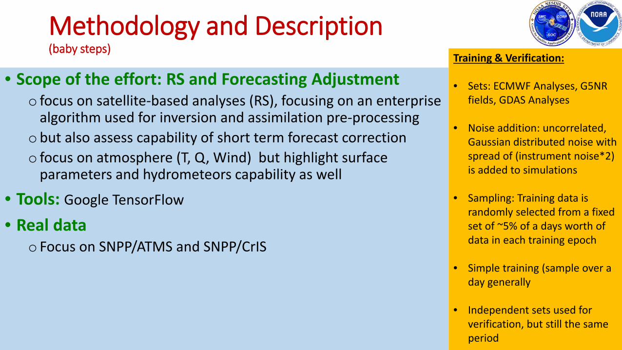
Methodology and Description (baby steps)
• Scope of the effort: RS and Forecasting Adjustmento focus on satellite-based analyses (RS), focusing on an enterprise
algorithm used for inversion and assimilation pre-processingobut also assess capability of short term forecast correctiono focus on atmosphere (T, Q, Wind) but highlight surface
parameters and hydrometeors capability as well
• Tools: Google TensorFlow
• Real data o Focus on SNPP/ATMS and SNPP/CrIS
Training & Verification:
• Sets: ECMWF Analyses, G5NR fields, GDAS Analyses
• Noise addition: uncorrelated, Gaussian distributed noise with spread of (instrument noise*2) is added to simulations
• Sampling: Training data is randomly selected from a fixed set of ~5% of a days worth of data in each training epoch
• Simple training (sample over a day generally
• Independent sets used for verification, but still the same period