Exploring Using Artificial Intelligence (AI) to Exploit ... · Exploring Using Artificial...
17
Exploring Using Artificial Intelligence (AI) to Exploit Big Satellite Data for NowCasting and NWP - Focus on JPSS-related Applications/Sensors- S. Boukabara*, E. Maddy + , N. Shahroudi + , R. Hoffman~, C. Sprague # , J. Conran + , S. Upton ^ , T. Connor ^ , K. Ide and A. Karpovich & *NOAA/NESDIS Center for Satellite Applications and Research (STAR) , College park, MD + Riverside Technology Inc. (RTI) @ NOAA/STAR, College park, MD ~ University of Miami, Miami, FL, USA # Aerospace Co, Arlington, VA ^ Atmospheric and Environmental research (AER Inc.) & University of Maryland, College Park, MD JPSS Meeting, College Park, MD, August 27-30 th 2018
Transcript of Exploring Using Artificial Intelligence (AI) to Exploit ... · Exploring Using Artificial...
Exploring Using Artificial Intelligence (AI) to Exploit Big Satellite Data for NowCasting and NWP
- Focus on JPSS-related Applications/Sensors-
S. Boukabara*, E. Maddy+, N. Shahroudi +, R. Hoffman~, C. Sprague#, J. Conran +, S. Upton^, T. Connor^ , K. Ide and A. Karpovich&
*NOAA/NESDIS Center for Satellite Applications and Research (STAR) , College park, MD
+ Riverside Technology Inc. (RTI) @ NOAA/STAR, College park, MD
~ University of Miami, Miami, FL, USA
#Aerospace Co, Arlington, VA
^ Atmospheric and Environmental research (AER Inc.)
& University of Maryland, College Park, MD
JPSS Meeting, College Park, MD, August 27-30th 2018

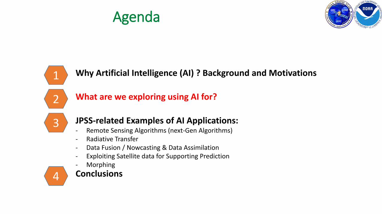
Agenda
2
1 Why Artificial Intelligence (AI) ? Background and Motivations
What are we exploring using AI for?
JPSS-related Examples of AI Applications:- Remote Sensing Algorithms (next-Gen Algorithms)- Radiative Transfer - Data Fusion / Nowcasting & Data Assimilation- Exploiting Satellite data for Supporting Prediction- Morphing
Conclusions
2
3
4
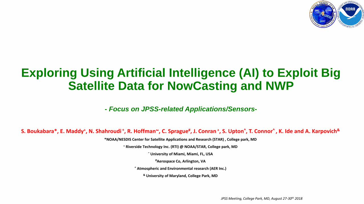
Trends in Global Earth Observation Systems
• GOS Trends:• New Players in GOS (international,
commercial, etc)• New Sensors (higher resolutions, etc)• New technologies (small sats, etc)• Emergence of New GOS (IoT, etc)• Significant Increase in volume and
diversity of data
• Parallel Trends• Budget, HPC Constraints• Higher societal impact and
expectations• Higher users expectations • Demand for Increase in quantity of
data assimilated (5% currently assimilated) 3
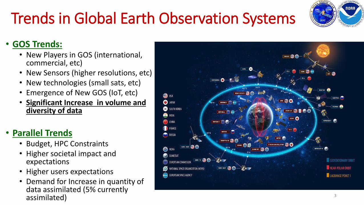
Why Consider AI to address these Challenges?
• AI applied successfully in fields with similar traits as Environmental data & NWP/SA: (1) # obs. systems to analyze/assimilate/fuse and (2) predict behavior• Medical field (Watson Project): Scan Image Analysis, Cancer detection, heart Sound
analysis• In finance: Algorithmic Trading, market data analysis, portfolio management• In Music: Composing any style by learning from huge database & analyzing unique
combinations.• Self-Driving Transportation Devices: Fusion of Multiple Observing Systems for situational
awareness• …..
• Based on this pilot AI project, We believe Environmental data exploitation (remote sensing, data assimilation and perhaps forecasting), presents a viable candidate for AI application.
• This presentation is meant to present a few examples to convey that the potential is significant.

Evolution of Environmental Data Exploitation
Tabulating Systems Era(1800-1940s)Manual Measurement and analysis
Credit: Materials adapted for Environmental Observations specifically, inspired from an IBM presentation by Dr John Kelly, senior vice president, cognitive solutions, to the NOAA Science Advisory Board (SAB) on November 2016
Programmable Intelligence Era(1950-Now)Transformational efficiency in Applying Human Intelligence
Cognitive Computing –AI Era(2011- Foreseeable Future)Enhancement/Augmentation of Human Intelligence
This evolution applies to all areas of computing.
It has led several major companies to adapt their business models to take advantage of AI
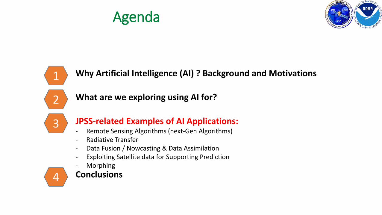
Agenda
6
1 Why Artificial Intelligence (AI) ? Background and Motivations
What are we exploring using AI for?
JPSS-related Examples of AI Applications:- Remote Sensing Algorithms (next-Gen Algorithms)- Radiative Transfer - Data Fusion / Nowcasting & Data Assimilation- Exploiting Satellite data for Supporting Prediction- Morphing
Conclusions
2
3
4
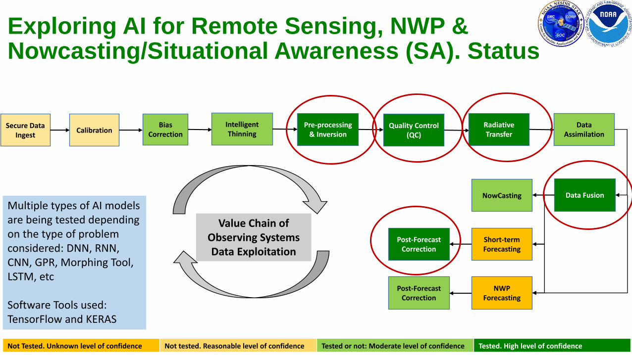
Exploring AI for Remote Sensing, NWP & Nowcasting/Situational Awareness (SA). Status
Secure Data Ingest
CalibrationBias
CorrectionPre-processing
& InversionQuality Control
(QC)
Radiative Transfer
Data Assimilation
Data FusionNowCasting
Short-term Forecasting
NWP Forecasting
Post-Forecast Correction
Post-Forecast Correction
Not Tested. Unknown level of confidence Not tested. Reasonable level of confidence Tested or not: Moderate level of confidence Tested. High level of confidence
Value Chain of Observing Systems Data Exploitation
Intelligent Thinning
Multiple types of AI models are being tested depending on the type of problem considered: DNN, RNN, CNN, GPR, Morphing Tool, LSTM, etc
Software Tools used: TensorFlow and KERAS
Agenda
8
1 Why Artificial Intelligence (AI) ? Background and Motivations
What are we exploring using AI for?
JPSS-related Examples of AI Applications:- Remote Sensing Algorithms (next-Gen Algorithms)- Radiative Transfer - Data Fusion / Nowcasting & Data Assimilation- Exploiting Satellite data for Supporting Prediction- Morphing
Conclusions
2
3
4
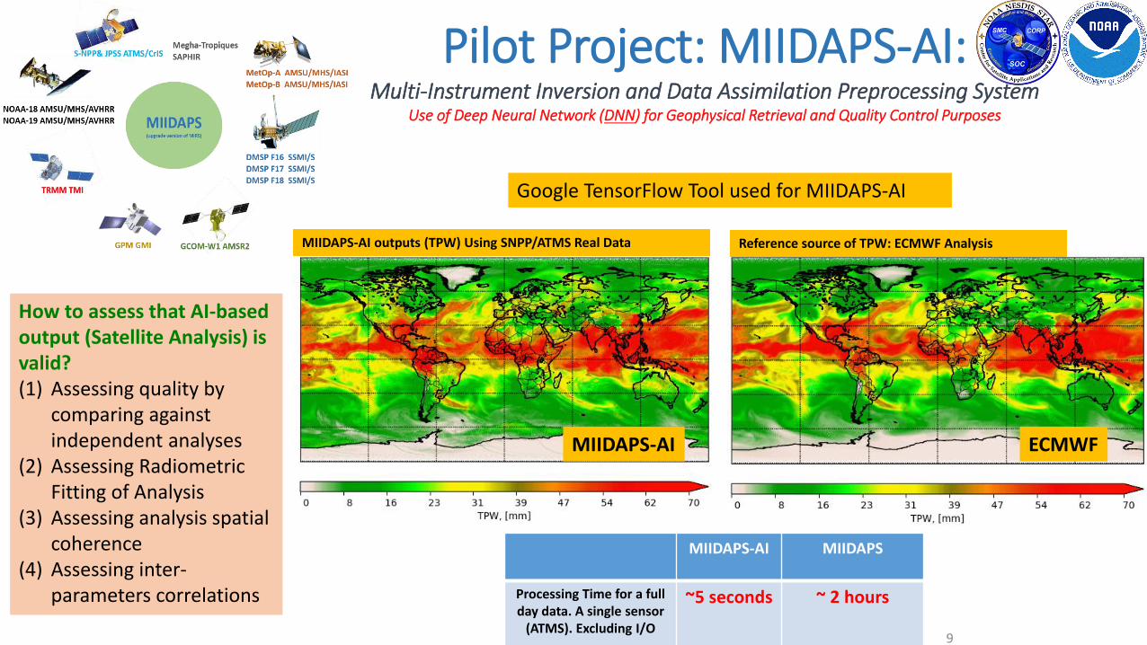
Pilot Project: MIIDAPS-AI: Multi-Instrument Inversion and Data Assimilation Preprocessing System
Use of Deep Neural Network (DNN) for Geophysical Retrieval and Quality Control Purposes
9
Reference source of TPW: ECMWF Analysis
MIIDAPS-AI MIIDAPS
Processing Time for a full day data. A single sensor
(ATMS). Excluding I/O
~5 seconds ~ 2 hours
ECMWFMIIDAPS-AI
MIIDAPS-AI outputs (TPW) Using SNPP/ATMS Real Data
Google TensorFlow Tool used for MIIDAPS-AI
How to assess that AI-based output (Satellite Analysis) is valid?(1) Assessing quality by
comparing against independent analyses
(2) Assessing Radiometric Fitting of Analysis
(3) Assessing analysis spatial coherence
(4) Assessing inter-parameters correlations
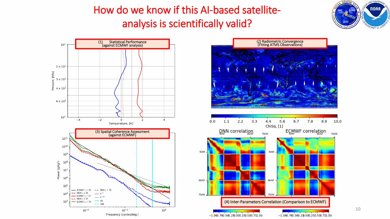
10
(3) Spatial Coherence Assessment(against ECMWF)
(2) Radiometric Convergence (Fitting ATMS Observations)
(1) Statistical Performance(against ECMWF analysis)
(4) Inter-Parameters Correlation (Comparison to ECMWF)
How do we know if this AI-based satellite-analysis is scientifically valid?

Can AI Be Used as Forward Operator?Use of Deep Neural Network (DNN) for Radiative Transfer Modeling Purposes
CRTM-AI CRTM
Processing Time for a full day data. A single sensor channel(ATMS). Excluding I/O
<1 second ~ 1.3 hours
CRTM/AI-Chan21CRTM- Chan21
AI vs CRTM
Chan21
Chan6
N-dVAR Assimilation/RetrievalMeasured Radiances
AI-Based ForWardOperator
Init
ial S
tate
Vec
tor
Simulated RadiancesComparison: Fit
Within Noise Level ?
No
Update State Vector
New State Vector
Solution Reached
Yes
~1000 faster
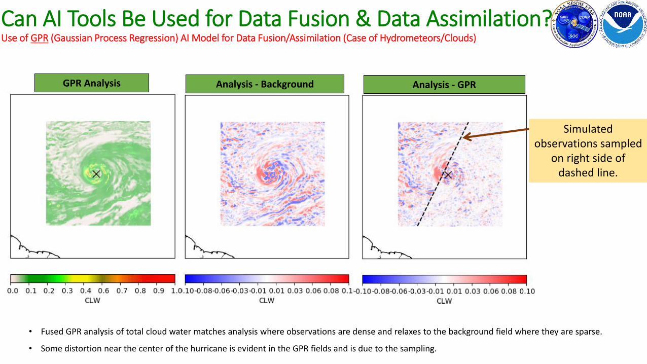
Can AI Tools Be Used for Data Fusion & Data Assimilation?Use of GPR (Gaussian Process Regression) AI Model for Data Fusion/Assimilation (Case of Hydrometeors/Clouds)
GPR Analysis Analysis - Background Analysis - GPR
Simulated observations sampled
on right side of dashed line.
• Fused GPR analysis of total cloud water matches analysis where observations are dense and relaxes to the background field where they are sparse.
• Some distortion near the center of the hurricane is evident in the GPR fields and is due to the sampling.
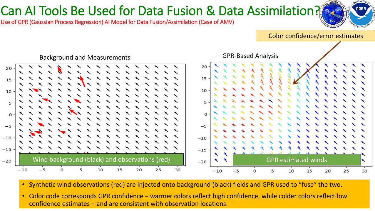
Wind background (black) and observations (red) GPR estimated winds
• Synthetic wind observations (red) are injected onto background (black) fields and GPR used to “fuse” the two.
• Color code corresponds GPR confidence – warmer colors reflect high confidence, while colder colors reflect low confidence estimates – and are consistent with observation locations.
Can AI Tools Be Used for Data Fusion & Data Assimilation?Use of GPR (Gaussian Process Regression) AI Model for Data Fusion/Assimilation (Case of AMV)
Color confidence/error estimates
Background and Measurements GPR-Based Analysis
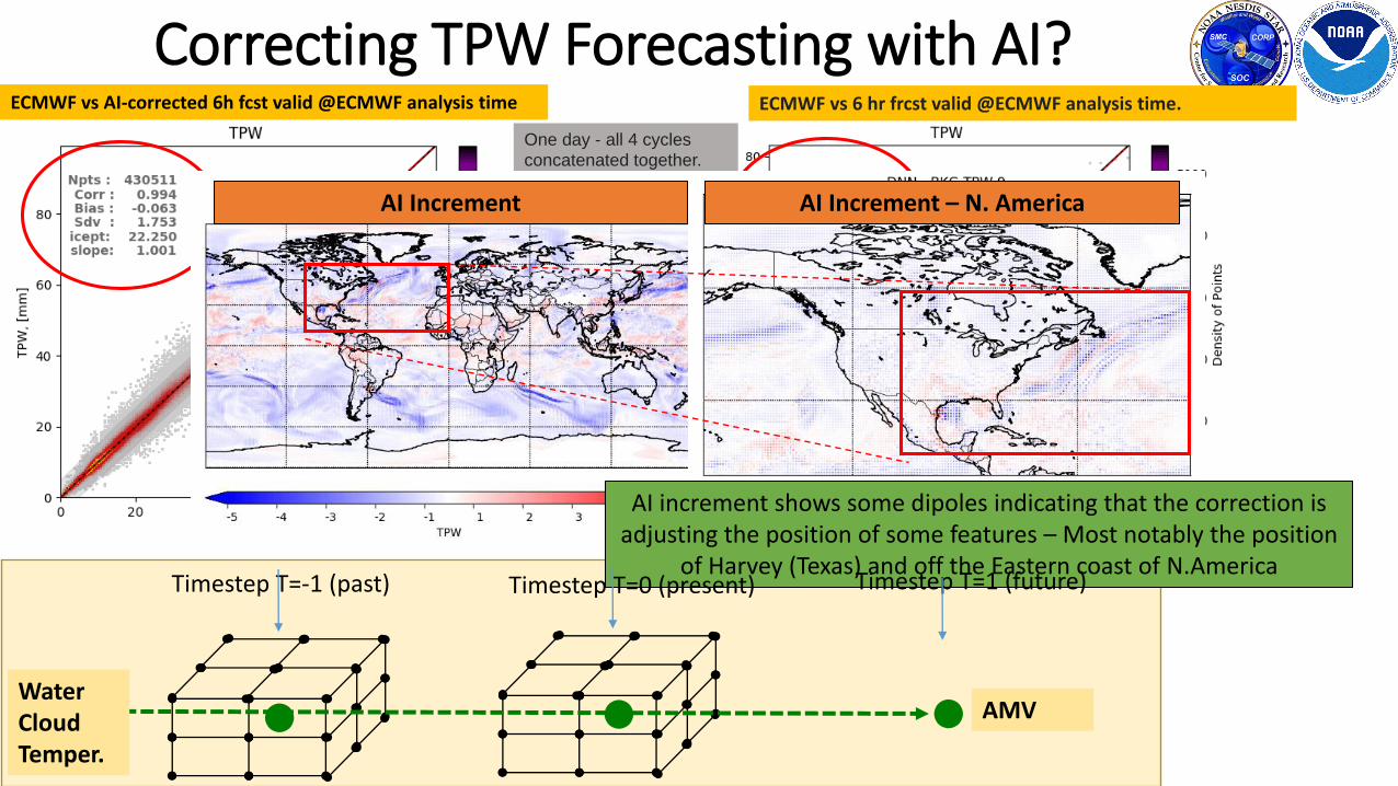
ECMWF vs 6 hr frcst valid @ECMWF analysis time.ECMWF vs AI-corrected 6h fcst valid @ECMWF analysis time
One day - all 4 cycles
concatenated together.
Correcting TPW Forecasting with AI?
AI Increment AI Increment – N. America
AI increment shows some dipoles indicating that the correction is adjusting the position of some features – Most notably the position
of Harvey (Texas) and off the Eastern coast of N.America
•• •
Timestep T=-1 (past) Timestep T=0 (present) Timestep T=1 (future)
WaterCloudTemper.
AMV
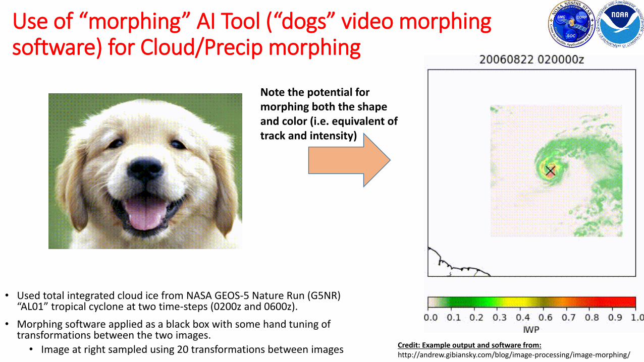
Use of “morphing” AI Tool (“dogs” video morphing software) for Cloud/Precip morphing
• Used total integrated cloud ice from NASA GEOS-5 Nature Run (G5NR) “AL01” tropical cyclone at two time-steps (0200z and 0600z).
• Morphing software applied as a black box with some hand tuning of transformations between the two images.
• Image at right sampled using 20 transformations between images Credit: Example output and software from: http://andrew.gibiansky.com/blog/image-processing/image-morphing/
Note the potential for morphing both the shape and color (i.e. equivalent of track and intensity)

ConclusionsBig Data Challenge already here
AI/ML approach is a natural evolution of how to exploit data (think evolution of Programming languages: Assembler, Basic, Pascal, F66, C++, F00, Java, Python, …to TensorFlow, Keras, ….)
Goal of this study is not to show AI/ML approach can do better, but that it can provide at least similar quality, much faster, therefore it can process more data.
Significant potential to leverage AI tools and models developed in other fields, to our field: for remote sensing, radiative transfer, data fusion, morphing, etc.
AI has the potential to be a transformational new approach in our exploitation of Big Environmental data
For More Information….
MIIDAPS-AI Website
Upcoming Workshop on use of AI in Earth Observation and NWP