
EXISTING BHE 115KV SECTION 66 · Notice of Proposed Construction or Alteration - Off Airport...
102
NSH DPE 1"=100' 10/20/2010 NRM NRM HANCOCK COUNTY, MAINE - - 18 Meadow Road P.O. Box 722 Augusta, ME 04332 Phone 207-621-1077 LEGEND: UNDERGROUND ELECTRIC PHASE 1 SEE TRENCH DETAILS 31001-SK_E1-E4 6" SCH 40 PVC (FUTURE USE) UNDERGROUND ELECTRIC PHASE 2 JUNCTION BOX SEE DETAIL DRAWING 31001-SK_E5 HIGH LINE PRODUCTS PULL BOX CATALOG NUMBER CHA243630 (LOCATE EVERY 1000' MAXIMUM) 4" SCH 40 PVC REINFORCED ROAD CROSSINGS 6" SCH 40 PVC REINFORCED ROAD CROSSINGS REMOVE OR RELOCATE STRUCTURE AS NECESSARY PROPOSED SUBSTATION EXISTING BHE 115KV SECTION 66 EXISTING BHE 115KV SECTION 66
Transcript of EXISTING BHE 115KV SECTION 66 · Notice of Proposed Construction or Alteration - Off Airport...

NS
HD
PE
1"=
10
0'
10
/20
/20
10
NR
MN
RM
HA
NC
OC
K C
OU
NTY
, M
AIN
E
--
18 M
eado
w R
oad
P.O
. Box
722
Aug
usta
, ME
0433
2Ph
one
207-
621-
1077
LEGEND:UNDERGROUND ELECTRIC PHASE 1SEE TRENCH DETAILS 31001-SK_E1-E4
6" SCH 40 PVC (FUTURE USE)UNDERGROUND ELECTRIC PHASE 2
JUNCTION BOX SEE DETAILDRAWING 31001-SK_E5
HIGH LINE PRODUCTS PULL BOXCATALOG NUMBER CHA243630(LOCATE EVERY 1000' MAXIMUM)
4" SCH 40 PVC REINFORCED ROADCROSSINGS
6" SCH 40 PVC REINFORCED ROADCROSSINGS
REMOVE ORRELOCATE STRUCTURE
AS NECESSARY
PROPOSED SUBSTATION
EXISTING BHE 115KV SECTION 66
EXISTING BHE 115KV SECTION 66


Notice of Proposed Construction or Alteration - Off Airport
Details for Case : T01 0532.MA.013 Show Project Summary
Project Name: BLUE -000160520-10 Sponsor: Blue Sky East, LLC
Case Status
ASN: 2010-WTE-15366-OE
Status: Accepted
Date Accepted: 11/19/2010
Date Determined:
Letters: None
Documents: 11/19/2010 1
11/19/2010 1
Construction / Alteration Information Structure Summary
Notice Of: Construction
Duration: Permanent
if Temporary : Months: Days:
Work Schedule - Start:
Work Schedule - End:
State Filing: Not filed with State
Structure Type: Wind Turbine
Structure Name: T01 0532.MA.013
NOTAM Number:
FCC Number:
Prior ASN:
Structure Details Common Frequency Bands
Latitude: 44° 41' 34.06'' N
Longitude: 68° 10' 1.52'' W
Horizontal Datum: NAD83
Site Elevation (SE): 570 (nearest foot)
Structure Height (AGL): * If the entered AGL is a proposed change to an existing structure's height include the current AGL in the Description of Proposal.
476 (nearest foot)
Requested Marking/Lighting: White Paint/Synchronized Red Lights
Other :
Recommended Marking/Lighting:
Current Marking/Lighting: N/A New Structure
Other :
Nearest City: Mixed Forest
Nearest State: Maine
Description of Location: On the Project Summary page upload any certified survey.
Turbine 1 of 19 wind turbines and 4 Met Towers. ALl structures are White
Description of Proposal: Please refer to uploaded lighting plan and map.
Low Freq High Freq Freq Un Specific Frequencies
Page 1 of 2Notice of Proposed Construction or Alteration - Off Airport
11/19/2010https://oeaaa.faa.gov/oeaaa/external/eFiling/locationAction.jsp?action=showLocationForm&locationID=2...

« OE/AAA
Notice of Proposed Construction or Alteration - Off Airport
Details for Case : T02 Show Project Summary
Project Name: BLUE -000160520-10 Sponsor: Blue Sky East, LLC
Case Status
ASN: 2010-WTE-15367-OE
Status: Accepted
Date Accepted: 11/19/2010
Date Determined:
Letters: None
Documents: None
Construction / Alteration Information Structure Summary
Notice Of: Construction
Duration: Permanent
if Temporary : Months: Days:
Work Schedule - Start:
Work Schedule - End:
State Filing: Not filed with State
Structure Type: Wind Turbine
Structure Name: T02
NOTAM Number:
FCC Number:
Prior ASN:
Structure Details Common Frequency Bands
Latitude: 44° 41' 38.17'' N
Longitude: 68° 9' 50.37'' W
Horizontal Datum: NAD83
Site Elevation (SE): 572 (nearest foot)
Structure Height (AGL): * If the entered AGL is a proposed change to an existing structure's height include the current AGL in the Description of Proposal.
476 (nearest foot)
Requested Marking/Lighting: White Paint Only
Other :
Recommended Marking/Lighting:
Current Marking/Lighting: N/A New Structure
Other :
Nearest City: Mixed Forest
Nearest State: Maine
Description of Location: On the Project Summary page upload any certified survey.
Turbine 2 of 19 wind turbines and 4 Met Towers. ALl structures are White
Description of Proposal: Please refer to uploaded lighting plan and map.
Low Freq High Freq Freq Unit ERP ERP Unit Specific Frequencies
Page 1 of 2Notice of Proposed Construction or Alteration - Off Airport
11/19/2010https://oeaaa.faa.gov/oeaaa/external/eFiling/locationAction.jsp?action=showLocationForm&locationID=2...

« OE/AAA
Notice of Proposed Construction or Alteration - Off Airport
Details for Case : T03 Show Project Summary
Project Name: BLUE -000160520-10 Sponsor: Blue Sky East, LLC
Case Status
ASN: 2010-WTE-15368-OE
Status: Accepted
Date Accepted: 11/19/2010
Date Determined:
Letters: None
Documents: None
Construction / Alteration Information Structure Summary
Notice Of: Construction
Duration: Permanent
if Temporary : Months: Days:
Work Schedule - Start:
Work Schedule - End:
State Filing: Not filed with State
Structure Type: Wind Turbine
Structure Name: T03
NOTAM Number:
FCC Number:
Prior ASN:
Structure Details Common Frequency Bands
Latitude: 44° 41' 42.20'' N
Longitude: 68° 9' 39.15'' W
Horizontal Datum: NAD83
Site Elevation (SE): 574 (nearest foot)
Structure Height (AGL): * If the entered AGL is a proposed change to an existing structure's height include the current AGL in the Description of Proposal.
476 (nearest foot)
Requested Marking/Lighting: White Paint/Synchronized Red Lights
Other :
Recommended Marking/Lighting:
Current Marking/Lighting: N/A New Structure
Other :
Nearest City: Mixed Forest
Nearest State: Maine
Description of Location: On the Project Summary page upload any certified survey.
Turbine 3 of 19 wind turbines and 4 Met Towers. ALl structures are White
Description of Proposal: Please refer to uploaded lighting plan and map.
Low Freq
High Freq
Freq Unit
ERPERP Unit
Specific Frequencies
Page 1 of 2Notice of Proposed Construction or Alteration - Off Airport
11/19/2010https://oeaaa.faa.gov/oeaaa/external/eFiling/locationAction.jsp?action=showLocationForm&locationID=2...

« OE/AAA
Notice of Proposed Construction or Alteration - Off Airport
Details for Case : T04 Show Project Summary
Project Name: BLUE -000160520-10 Sponsor: Blue Sky East, LLC
Case Status
ASN: 2010-WTE-15369-OE
Status: Accepted
Date Accepted: 11/19/2010
Date Determined:
Letters: None
Documents: None
Construction / Alteration Information Structure Summary
Notice Of: Construction
Duration: Permanent
if Temporary : Months: Days:
Work Schedule - Start:
Work Schedule - End:
State Filing: Not filed with State
Structure Type: Wind Turbine
Structure Name: T04
NOTAM Number:
FCC Number:
Prior ASN:
Structure Details Common Frequency Bands
Latitude: 44° 41' 45.91'' N
Longitude: 68° 9' 28.89'' W
Horizontal Datum: NAD83
Site Elevation (SE): 576 (nearest foot)
Structure Height (AGL): * If the entered AGL is a proposed change to an existing structure's height include the current AGL in the Description of Proposal.
476 (nearest foot)
Requested Marking/Lighting: White Paint Only
Other :
Recommended Marking/Lighting:
Current Marking/Lighting: N/A New Structure
Other :
Nearest City: Mixed Forest
Nearest State: Maine
Description of Location: On the Project Summary page upload any certified survey.
Turbine 4 of 19 wind turbines and 4 Met Towers. ALl structures are White
Description of Proposal: Please refer to uploaded lighting plan and map.
Low Freq High Freq Freq Unit ERP ERP Unit Specific Frequencies
Page 1 of 2Notice of Proposed Construction or Alteration - Off Airport
11/19/2010https://oeaaa.faa.gov/oeaaa/external/eFiling/locationAction.jsp?action=showLocationForm&locationID=2...

« OE/AAA
Notice of Proposed Construction or Alteration - Off Airport
Details for Case : T05 Show Project Summary
Project Name: BLUE -000160520-10 Sponsor: Blue Sky East, LLC
Case Status
ASN: 2010-WTE-15370-OE
Status: Accepted
Date Accepted: 11/19/2010
Date Determined:
Letters: None
Documents: None
Construction / Alteration Information Structure Summary
Notice Of: Construction
Duration: Permanent
if Temporary : Months: Days:
Work Schedule - Start:
Work Schedule - End:
State Filing: Not filed with State
Structure Type: Wind Turbine
Structure Name: T05
NOTAM Number:
FCC Number:
Prior ASN:
Structure Details Common Frequency Bands
Latitude: 44° 41' 51.00'' N
Longitude: 68° 9' 14.02'' W
Horizontal Datum: NAD83
Site Elevation (SE): 578 (nearest foot)
Structure Height (AGL): * If the entered AGL is a proposed change to an existing structure's height include the current AGL in the Description of Proposal.
476 (nearest foot)
Requested Marking/Lighting: White Paint/Synchronized Red Lights
Other :
Recommended Marking/Lighting:
Current Marking/Lighting: N/A New Structure
Other :
Nearest City: Mixed Forest
Nearest State: Maine
Description of Location: On the Project Summary page upload any certified survey.
Turbine 5 of 19 wind turbines and 4 Met Towers. ALl structures are White
Description of Proposal: Please refer to uploaded lighting plan and map.
Low Freq
High Freq
Freq Unit
ERPERP Unit
Specific Frequencies
Page 1 of 2Notice of Proposed Construction or Alteration - Off Airport
11/19/2010https://oeaaa.faa.gov/oeaaa/external/eFiling/locationAction.jsp?action=showLocationForm&locationID=2...

« OE/AAA
Notice of Proposed Construction or Alteration - Off Airport
Details for Case : T06 Show Project Summary
Project Name: BLUE -000160520-10 Sponsor: Blue Sky East, LLC
Case Status
ASN: 2010-WTE-15371-OE
Status: Accepted
Date Accepted: 11/19/2010
Date Determined:
Letters: None
Documents: None
Construction / Alteration Information Structure Summary
Notice Of: Construction
Duration: Permanent
if Temporary : Months: Days:
Work Schedule - Start:
Work Schedule - End:
State Filing: Not filed with State
Structure Type: Wind Turbine
Structure Name: T06
NOTAM Number:
FCC Number:
Prior ASN:
Structure Details Common Frequency Bands
Latitude: 44° 42' 6.62'' N
Longitude: 68° 9' 13.42'' W
Horizontal Datum: NAD83
Site Elevation (SE): 580 (nearest foot)
Structure Height (AGL): * If the entered AGL is a proposed change to an existing structure's height include the current AGL in the Description of Proposal.
476 (nearest foot)
Requested Marking/Lighting: White Paint/Synchronized Red Lights
Other :
Recommended Marking/Lighting:
Current Marking/Lighting: N/A New Structure
Other :
Nearest City: Mixed Forest
Nearest State: Maine
Description of Location: On the Project Summary page upload any certified survey.
Turbine 6 of 19 wind turbines and 4 Met Towers. ALl structures are White
Description of Proposal: Please refer to uploaded lighting plan and map.
Low Freq
High Freq
Freq Unit
ERPERP Unit
Specific Frequencies
Page 1 of 2Notice of Proposed Construction or Alteration - Off Airport
11/19/2010https://oeaaa.faa.gov/oeaaa/external/eFiling/locationAction.jsp?action=showLocationForm&locationID=2...

« OE/AAA
Notice of Proposed Construction or Alteration - Off Airport
Details for Case : T07 Show Project Summary
Project Name: BLUE -000160520-10 Sponsor: Blue Sky East, LLC
Case Status
ASN: 2010-WTE-15372-OE
Status: Accepted
Date Accepted: 11/19/2010
Date Determined:
Letters: None
Documents: None
Construction / Alteration Information Structure Summary
Notice Of: Construction
Duration: Permanent
if Temporary : Months: Days:
Work Schedule - Start:
Work Schedule - End:
State Filing: Not filed with State
Structure Type: Wind Turbine
Structure Name: T07
NOTAM Number:
FCC Number:
Prior ASN:
Structure Details Common Frequency Bands
Latitude: 44° 42' 23.83'' N
Longitude: 68° 9' 10.76'' W
Horizontal Datum: NAD83
Site Elevation (SE): 582 (nearest foot)
Structure Height (AGL): * If the entered AGL is a proposed change to an existing structure's height include the current AGL in the Description of Proposal.
476 (nearest foot)
Requested Marking/Lighting: White Paint/Synchronized Red Lights
Other :
Recommended Marking/Lighting:
Current Marking/Lighting: N/A New Structure
Other :
Nearest City: Mixed Forest
Nearest State: Maine
Description of Location: On the Project Summary page upload any certified survey.
Turbine 7 of 19 wind turbines and 4 Met Towers. ALl structures are White
Description of Proposal: Please refer to uploaded lighting plan and map.
Low Freq
High Freq
Freq Unit
ERPERP Unit
Specific Frequencies
Page 1 of 2Notice of Proposed Construction or Alteration - Off Airport
11/19/2010https://oeaaa.faa.gov/oeaaa/external/eFiling/locationAction.jsp?action=showLocationForm&locationID=2...
« OE/AAA
Notice of Proposed Construction or Alteration - Off Airport
Details for Case : T08 Show Project Summary
Project Name: BLUE -000160520-10 Sponsor: Blue Sky East, LLC
Case Status
ASN: 2010-WTE-15373-OE
Status: Accepted
Date Accepted: 11/19/2010
Date Determined:
Letters: None
Documents: None
Construction / Alteration Information Structure Summary
Notice Of: Construction
Duration: Permanent
if Temporary : Months: Days:
Work Schedule - Start:
Work Schedule - End:
State Filing: Not filed with State
Structure Type: Wind Turbine
Structure Name: T08
NOTAM Number:
FCC Number:
Prior ASN:
Structure Details Common Frequency Bands
Latitude: 44° 42' 40.11'' N
Longitude: 68° 9' 6.15'' W
Horizontal Datum: NAD83
Site Elevation (SE): 584 (nearest foot)
Structure Height (AGL): * If the entered AGL is a proposed change to an existing structure's height include the current AGL in the Description of Proposal.
476 (nearest foot)
Requested Marking/Lighting: White Paint/Synchronized Red Lights
Other :
Recommended Marking/Lighting:
Current Marking/Lighting: N/A New Structure
Other :
Nearest City: Mixed Forest
Nearest State: Maine
Description of Location: On the Project Summary page upload any certified survey.
Turbine 8 of 19 wind turbines and 4 Met Towers. ALl structures are White
Description of Proposal: Please refer to uploaded lighting plan and map.
Low Freq
High Freq
Freq Unit
ERPERP Unit
Specific Frequencies
Page 1 of 2Notice of Proposed Construction or Alteration - Off Airport
11/19/2010https://oeaaa.faa.gov/oeaaa/external/eFiling/locationAction.jsp?action=showLocationForm&locationID=2...
« OE/AAA
Notice of Proposed Construction or Alteration - Off Airport
Details for Case : T09 Show Project Summary
Project Name: BLUE -000160520-10 Sponsor: Blue Sky East, LLC
Case Status
ASN: 2010-WTE-15374-OE
Status: Accepted
Date Accepted: 11/19/2010
Date Determined:
Letters: None
Documents: None
Construction / Alteration Information Structure Summary
Notice Of: Construction
Duration: Permanent
if Temporary : Months: Days:
Work Schedule - Start:
Work Schedule - End:
State Filing: Not filed with State
Structure Type: Wind Turbine
Structure Name: T09
NOTAM Number:
FCC Number:
Prior ASN:
Structure Details Common Frequency Bands
Latitude: 44° 42' 57.95'' N
Longitude: 68° 9' 4.95'' W
Horizontal Datum: NAD83
Site Elevation (SE): 586 (nearest foot)
Structure Height (AGL): * If the entered AGL is a proposed change to an existing structure's height include the current AGL in the Description of Proposal.
476 (nearest foot)
Requested Marking/Lighting: White Paint/Synchronized Red Lights
Other :
Recommended Marking/Lighting:
Current Marking/Lighting: N/A New Structure
Other :
Nearest City: Mixed Forest
Nearest State: Maine
Description of Location: On the Project Summary page upload any certified survey.
Turbine 9 of 19 wind turbines and 4 Met Towers. ALl structures are White
Description of Proposal: Please refer to uploaded lighting plan and map.
Low Freq
High Freq
Freq Unit
ERPERP Unit
Specific Frequencies
Page 1 of 2Notice of Proposed Construction or Alteration - Off Airport
11/19/2010https://oeaaa.faa.gov/oeaaa/external/eFiling/locationAction.jsp?action=showLocationForm&locationID=2...

« OE/AAA
Notice of Proposed Construction or Alteration - Off Airport
Details for Case : T10 Show Project Summary
Project Name: BLUE -000160520-10 Sponsor: Blue Sky East, LLC
Case Status
ASN: 2010-WTE-15375-OE
Status: Accepted
Date Accepted: 11/19/2010
Date Determined:
Letters: None
Documents: None
Construction / Alteration Information Structure Summary
Notice Of: Construction
Duration: Permanent
if Temporary : Months: Days:
Work Schedule - Start:
Work Schedule - End:
State Filing: Not filed with State
Structure Type: Wind Turbine
Structure Name: T10
NOTAM Number:
FCC Number:
Prior ASN:
Structure Details Common Frequency Bands
Latitude: 44° 43' 32.42'' N
Longitude: 68° 10' 28.81'' W
Horizontal Datum: NAD83
Site Elevation (SE): 588 (nearest foot)
Structure Height (AGL): * If the entered AGL is a proposed change to an existing structure's height include the current AGL in the Description of Proposal.
476 (nearest foot)
Requested Marking/Lighting: White Paint/Synchronized Red Lights
Other :
Recommended Marking/Lighting:
Current Marking/Lighting: N/A New Structure
Other :
Nearest City: Mixed Forest
Nearest State: Maine
Description of Location: On the Project Summary page upload any certified survey.
Turbine 10 of 19 wind turbines and 4 Met Towers. ALl structures are White
Description of Proposal: Please refer to uploaded lighting plan and map.
Low Freq
High Freq
Freq Unit
ERPERP Unit
Specific Frequencies
Page 1 of 2Notice of Proposed Construction or Alteration - Off Airport
11/19/2010https://oeaaa.faa.gov/oeaaa/external/eFiling/locationAction.jsp?action=showLocationForm&locationID=2...

« OE/AAA
Notice of Proposed Construction or Alteration - Off Airport
Details for Case : T11 Show Project Summary
Project Name: BLUE -000160520-10 Sponsor: Blue Sky East, LLC
Case Status
ASN: 2010-WTE-15376-OE
Status: Accepted
Date Accepted: 11/19/2010
Date Determined:
Letters: None
Documents: None
Construction / Alteration Information Structure Summary
Notice Of: Construction
Duration: Permanent
if Temporary : Months: Days:
Work Schedule - Start:
Work Schedule - End:
State Filing: Not filed with State
Structure Type: Wind Turbine
Structure Name: T11
NOTAM Number:
FCC Number:
Prior ASN:
Structure Details Common Frequency Bands
Latitude: 44° 43' 37.29'' N
Longitude: 68° 10' 16.93'' W
Horizontal Datum: NAD83
Site Elevation (SE): 590 (nearest foot)
Structure Height (AGL): * If the entered AGL is a proposed change to an existing structure's height include the current AGL in the Description of Proposal.
476 (nearest foot)
Requested Marking/Lighting: White Paint Only
Other :
Recommended Marking/Lighting:
Current Marking/Lighting: N/A New Structure
Other :
Nearest City: Mixed Forest
Nearest State: Maine
Description of Location: On the Project Summary page upload any certified survey.
Turbine 11 of 19 wind turbines and 4 Met Towers. ALl structures are White
Description of Proposal: Please refer to uploaded lighting plan and map.
Low Freq High Freq Freq Unit ERP ERP Unit Specific Frequencies
Page 1 of 2Notice of Proposed Construction or Alteration - Off Airport
11/19/2010https://oeaaa.faa.gov/oeaaa/external/eFiling/locationAction.jsp?action=showLocationForm&locationID=2...

« OE/AAA
Notice of Proposed Construction or Alteration - Off Airport
Details for Case : T12 Show Project Summary
Project Name: BLUE -000160520-10 Sponsor: Blue Sky East, LLC
Case Status
ASN: 2010-WTE-15377-OE
Status: Accepted
Date Accepted: 11/19/2010
Date Determined:
Letters: None
Documents: None
Construction / Alteration Information Structure Summary
Notice Of: Construction
Duration: Permanent
if Temporary : Months: Days:
Work Schedule - Start:
Work Schedule - End:
State Filing: Not filed with State
Structure Type: Wind Turbine
Structure Name: T12
NOTAM Number:
FCC Number:
Prior ASN:
Structure Details Common Frequency Bands
Latitude: 44° 43' 41.80'' N
Longitude: 68° 10' 6.09'' W
Horizontal Datum: NAD83
Site Elevation (SE): 592 (nearest foot)
Structure Height (AGL): * If the entered AGL is a proposed change to an existing structure's height include the current AGL in the Description of Proposal.
476 (nearest foot)
Requested Marking/Lighting: White Paint/Synchronized Red Lights
Other :
Recommended Marking/Lighting:
Current Marking/Lighting: N/A New Structure
Other :
Nearest City: Mixed Forest
Nearest State: Maine
Description of Location: On the Project Summary page upload any certified survey.
Turbine 12 of 19 wind turbines and 4 Met Towers. ALl structures are White
Description of Proposal: Please refer to uploaded lighting plan and map.
Low Freq
High Freq
Freq Unit
ERPERP Unit
Specific Frequencies
Page 1 of 2Notice of Proposed Construction or Alteration - Off Airport
11/19/2010https://oeaaa.faa.gov/oeaaa/external/eFiling/locationAction.jsp?action=showLocationForm&locationID=2...

« OE/AAA
Notice of Proposed Construction or Alteration - Off Airport
Details for Case : T13 Show Project Summary
Project Name: BLUE -000160520-10 Sponsor: Blue Sky East, LLC
Case Status
ASN: 2010-WTE-15378-OE
Status: Accepted
Date Accepted: 11/19/2010
Date Determined:
Letters: None
Documents: None
Construction / Alteration Information Structure Summary
Notice Of: Construction
Duration: Permanent
if Temporary : Months: Days:
Work Schedule - Start:
Work Schedule - End:
State Filing: Not filed with State
Structure Type: Wind Turbine
Structure Name: T13
NOTAM Number:
FCC Number:
Prior ASN:
Structure Details Common Frequency Bands
Latitude: 44° 43' 46.47'' N
Longitude: 68° 9' 55.92'' W
Horizontal Datum: NAD83
Site Elevation (SE): 594 (nearest foot)
Structure Height (AGL): * If the entered AGL is a proposed change to an existing structure's height include the current AGL in the Description of Proposal.
476 (nearest foot)
Requested Marking/Lighting: White Paint Only
Other :
Recommended Marking/Lighting:
Current Marking/Lighting: N/A New Structure
Other :
Nearest City: Mixed Forest
Nearest State: Maine
Description of Location: On the Project Summary page upload any certified survey.
Turbine 13 of 19 wind turbines and 4 Met Towers. ALl structures are White
Description of Proposal: Please refer to uploaded lighting plan and map.
Low Freq High Freq Freq Unit ERP ERP Unit Specific Frequencies
Page 1 of 2Notice of Proposed Construction or Alteration - Off Airport
11/19/2010https://oeaaa.faa.gov/oeaaa/external/eFiling/locationAction.jsp?action=showLocationForm&locationID=2...

« OE/AAA
Notice of Proposed Construction or Alteration - Off Airport
Details for Case : T14 Show Project Summary
Project Name: BLUE -000160520-10 Sponsor: Blue Sky East, LLC
Case Status
ASN: 2010-WTE-15379-OE
Status: Accepted
Date Accepted: 11/19/2010
Date Determined:
Letters: None
Documents: None
Construction / Alteration Information Structure Summary
Notice Of: Construction
Duration: Permanent
if Temporary : Months: Days:
Work Schedule - Start:
Work Schedule - End:
State Filing: Not filed with State
Structure Type: Wind Turbine
Structure Name: T14
NOTAM Number:
FCC Number:
Prior ASN:
Structure Details Common Frequency Bands
Latitude: 44° 43' 50.89'' N
Longitude: 68° 9' 44.32'' W
Horizontal Datum: NAD83
Site Elevation (SE): 596 (nearest foot)
Structure Height (AGL): * If the entered AGL is a proposed change to an existing structure's height include the current AGL in the Description of Proposal.
476 (nearest foot)
Requested Marking/Lighting: White Paint/Synchronized Red Lights
Other :
Recommended Marking/Lighting:
Current Marking/Lighting: N/A New Structure
Other :
Nearest City: Mixed Forest
Nearest State: Maine
Description of Location: On the Project Summary page upload any certified survey.
Turbine 14 of 19 wind turbines and 4 Met Towers. ALl structures are White
Description of Proposal: Please refer to uploaded lighting plan and map.
Low Freq
High Freq
Freq Unit
ERPERP Unit
Specific Frequencies
Page 1 of 2Notice of Proposed Construction or Alteration - Off Airport
11/19/2010https://oeaaa.faa.gov/oeaaa/external/eFiling/locationAction.jsp?action=showLocationForm&locationID=2...

« OE/AAA
Notice of Proposed Construction or Alteration - Off Airport
Details for Case : T15 Show Project Summary
Project Name: BLUE -000160520-10 Sponsor: Blue Sky East, LLC
Case Status
ASN: 2010-WTE-15380-OE
Status: Accepted
Date Accepted: 11/19/2010
Date Determined:
Letters: None
Documents: None
Construction / Alteration Information Structure Summary
Notice Of: Construction
Duration: Permanent
if Temporary : Months: Days:
Work Schedule - Start:
Work Schedule - End:
State Filing: Not filed with State
Structure Type: Wind Turbine
Structure Name: T15
NOTAM Number:
FCC Number:
Prior ASN:
Structure Details Common Frequency Bands
Latitude: 44° 43' 54.84'' N
Longitude: 68° 9' 34.23'' W
Horizontal Datum: NAD83
Site Elevation (SE): 598 (nearest foot)
Structure Height (AGL): * If the entered AGL is a proposed change to an existing structure's height include the current AGL in the Description of Proposal.
476 (nearest foot)
Requested Marking/Lighting: White Paint Only
Other :
Recommended Marking/Lighting:
Current Marking/Lighting: N/A New Structure
Other :
Nearest City: Mixed Forest
Nearest State: Maine
Description of Location: On the Project Summary page upload any certified survey.
Turbine 15 of 19 wind turbines and 4 Met Towers. ALl structures are White
Description of Proposal: Please refer to uploaded lighting plan and map.
Low Freq High Freq Freq Unit ERP ERP Unit Specific Frequencies
Page 1 of 2Notice of Proposed Construction or Alteration - Off Airport
11/19/2010https://oeaaa.faa.gov/oeaaa/external/eFiling/locationAction.jsp?action=showLocationForm&locationID=2...

« OE/AAA
Notice of Proposed Construction or Alteration - Off Airport
Details for Case : T16 Show Project Summary
Project Name: BLUE -000160520-10 Sponsor: Blue Sky East, LLC
Case Status
ASN: 2010-WTE-15381-OE
Status: Accepted
Date Accepted: 11/19/2010
Date Determined:
Letters: None
Documents: None
Construction / Alteration Information Structure Summary
Notice Of: Construction
Duration: Permanent
if Temporary : Months: Days:
Work Schedule - Start:
Work Schedule - End:
State Filing: Not filed with State
Structure Type: Wind Turbine
Structure Name: T16
NOTAM Number:
FCC Number:
Prior ASN:
Structure Details Common Frequency Bands
Latitude: 44° 43' 58.74'' N
Longitude: 68° 9' 23.64'' W
Horizontal Datum: NAD83
Site Elevation (SE): 600 (nearest foot)
Structure Height (AGL): * If the entered AGL is a proposed change to an existing structure's height include the current AGL in the Description of Proposal.
476 (nearest foot)
Requested Marking/Lighting: White Paint/Synchronized Red Lights
Other :
Recommended Marking/Lighting:
Current Marking/Lighting: N/A New Structure
Other :
Nearest City: Mixed Forest
Nearest State: Maine
Description of Location: On the Project Summary page upload any certified survey.
Turbine 16 of 19 wind turbines and 4 Met Towers. ALl structures are White
Description of Proposal: Please refer to uploaded lighting plan and map.
Low Freq
High Freq
Freq Unit
ERPERP Unit
Specific Frequencies
Page 1 of 2Notice of Proposed Construction or Alteration - Off Airport
11/19/2010https://oeaaa.faa.gov/oeaaa/external/eFiling/locationAction.jsp?action=showLocationForm&locationID=2...

« OE/AAA
Notice of Proposed Construction or Alteration - Off Airport
Details for Case : T17 Show Project Summary
Project Name: BLUE -000160520-10 Sponsor: Blue Sky East, LLC
Case Status
ASN: 2010-WTE-15382-OE
Status: Accepted
Date Accepted: 11/19/2010
Date Determined:
Letters: None
Documents: None
Construction / Alteration Information Structure Summary
Notice Of: Construction
Duration: Permanent
if Temporary : Months: Days:
Work Schedule - Start:
Work Schedule - End:
State Filing: Not filed with State
Structure Type: Wind Turbine
Structure Name: T17
NOTAM Number:
FCC Number:
Prior ASN:
Structure Details Common Frequency Bands
Latitude: 44° 44' 2.91'' N
Longitude: 68° 9' 13.71'' W
Horizontal Datum: NAD83
Site Elevation (SE): 602 (nearest foot)
Structure Height (AGL): * If the entered AGL is a proposed change to an existing structure's height include the current AGL in the Description of Proposal.
476 (nearest foot)
Requested Marking/Lighting: White Paint Only
Other :
Recommended Marking/Lighting:
Current Marking/Lighting: N/A New Structure
Other :
Nearest City: Mixed Forest
Nearest State: Maine
Description of Location: On the Project Summary page upload any certified survey.
Turbine 17 of 19 wind turbines and 4 Met Towers. ALl structures are White
Description of Proposal: Please refer to uploaded lighting plan and map.
Low Freq High Freq Freq Unit ERP ERP Unit Specific Frequencies
Page 1 of 2Notice of Proposed Construction or Alteration - Off Airport
11/19/2010https://oeaaa.faa.gov/oeaaa/external/eFiling/locationAction.jsp?action=showLocationForm&locationID=2...

« OE/AAA
Notice of Proposed Construction or Alteration - Off Airport
Details for Case : T18 Show Project Summary
Project Name: BLUE -000160520-10 Sponsor: Blue Sky East, LLC
Case Status
ASN: 2010-WTE-15383-OE
Status: Accepted
Date Accepted: 11/19/2010
Date Determined:
Letters: None
Documents: None
Construction / Alteration Information Structure Summary
Notice Of: Construction
Duration: Permanent
if Temporary : Months: Days:
Work Schedule - Start:
Work Schedule - End:
State Filing: Not filed with State
Structure Type: Wind Turbine
Structure Name: T18
NOTAM Number:
FCC Number:
Prior ASN:
Structure Details Common Frequency Bands
Latitude: 44° 44' 6.98'' N
Longitude: 68° 9' 3.71'' W
Horizontal Datum: NAD83
Site Elevation (SE): 604 (nearest foot)
Structure Height (AGL): * If the entered AGL is a proposed change to an existing structure's height include the current AGL in the Description of Proposal.
476 (nearest foot)
Requested Marking/Lighting: White Paint Only
Other :
Recommended Marking/Lighting:
Current Marking/Lighting: N/A New Structure
Other :
Nearest City: Mixed Forest
Nearest State: Maine
Description of Location: On the Project Summary page upload any certified survey.
Turbine 18 of 19 wind turbines and 4 Met Towers. ALl structures are White
Description of Proposal: Please refer to uploaded lighting plan and map.
Low Freq High Freq Freq Unit ERP ERP Unit Specific Frequencies
Page 1 of 2Notice of Proposed Construction or Alteration - Off Airport
11/19/2010https://oeaaa.faa.gov/oeaaa/external/eFiling/locationAction.jsp?action=showLocationForm&locationID=2...

« OE/AAA
Notice of Proposed Construction or Alteration - Off Airport
Details for Case : T19 Show Project Summary
Project Name: BLUE -000160520-10 Sponsor: Blue Sky East, LLC
Case Status
ASN: 2010-WTE-15384-OE
Status: Accepted
Date Accepted: 11/19/2010
Date Determined:
Letters: None
Documents: None
Construction / Alteration Information Structure Summary
Notice Of: Construction
Duration: Permanent
if Temporary : Months: Days:
Work Schedule - Start:
Work Schedule - End:
State Filing: Not filed with State
Structure Type: Wind Turbine
Structure Name: T19
NOTAM Number:
FCC Number:
Prior ASN:
Structure Details Common Frequency Bands
Latitude: 44° 44' 10.62'' N
Longitude: 68° 8' 53.25'' W
Horizontal Datum: NAD83
Site Elevation (SE): 606 (nearest foot)
Structure Height (AGL): * If the entered AGL is a proposed change to an existing structure's height include the current AGL in the Description of Proposal.
476 (nearest foot)
Requested Marking/Lighting: White Paint/Synchronized Red Lights
Other :
Recommended Marking/Lighting:
Current Marking/Lighting: N/A New Structure
Other :
Nearest City: Mixed Forest
Nearest State: Maine
Description of Location: On the Project Summary page upload any certified survey.
Turbine 19 of 19 wind turbines and 4 Met Towers. ALl structures are White
Description of Proposal: Please refer to uploaded lighting plan and map.
Low Freq
High Freq
Freq Unit
ERPERP Unit
Specific Frequencies
Page 1 of 2Notice of Proposed Construction or Alteration - Off Airport
11/19/2010https://oeaaa.faa.gov/oeaaa/external/eFiling/locationAction.jsp?action=showLocationForm&locationID=2...

« OE/AAA
Notice of Proposed Construction or Alteration - Off Airport
Details for Case : Met1 Show Project Summary
Project Name: BLUE -000160520-10 Sponsor: Blue Sky East, LLC
Case Status
ASN: 2010-WTE-15385-OE
Status: Accepted
Date Accepted: 11/19/2010
Date Determined:
Letters: None
Documents: None
Construction / Alteration Information Structure Summary
Notice Of: Construction
Duration: Permanent
if Temporary : Months: Days:
Work Schedule - Start:
Work Schedule - End:
State Filing: Not filed with State
Structure Type: Met Tower
Structure Name: Met1
NOTAM Number:
FCC Number:
Prior ASN:
Structure Details Common Frequency Bands
Latitude: 44° 41' 26.91'' N
Longitude: 68° 9' 50.65'' W
Horizontal Datum: NAD83
Site Elevation (SE): 608 (nearest foot)
Structure Height (AGL): * If the entered AGL is a proposed change to an existing structure's height include the current AGL in the Description of Proposal.
476 (nearest foot)
Requested Marking/Lighting: Red lights and paint
Other :
Recommended Marking/Lighting:
Current Marking/Lighting: N/A New Structure
Other :
Nearest City: Mixed Forest
Nearest State: Maine
Description of Location: On the Project Summary page upload any certified survey.
Met Tower 1 of 4 and 19 Wind Towers. ALl structures are White
Description of Proposal: Please refer to uploaded lighting plan and map.
Low Freq High Freq Freq Unit ERP ERP Unit Specific Frequencies
Page 1 of 2Notice of Proposed Construction or Alteration - Off Airport
11/19/2010https://oeaaa.faa.gov/oeaaa/external/eFiling/locationAction.jsp?action=showLocationForm&locationID=2...

« OE/AAA
Notice of Proposed Construction or Alteration - Off Airport
Details for Case : Met2 Show Project Summary
Project Name: BLUE -000160520-10 Sponsor: Blue Sky East, LLC
Case Status
ASN: 2010-WTE-15386-OE
Status: Accepted
Date Accepted: 11/19/2010
Date Determined:
Letters: None
Documents: None
Construction / Alteration Information Structure Summary
Notice Of: Construction
Duration: Permanent
if Temporary : Months: Days:
Work Schedule - Start:
Work Schedule - End:
State Filing: Not filed with State
Structure Type: Met Tower
Structure Name: Met2
NOTAM Number:
FCC Number:
Prior ASN:
Structure Details Common Frequency Bands
Latitude: 44° 43' 41.06'' N
Longitude: 68° 10' 27.80'' W
Horizontal Datum: NAD83
Site Elevation (SE): 610 (nearest foot)
Structure Height (AGL): * If the entered AGL is a proposed change to an existing structure's height include the current AGL in the Description of Proposal.
476 (nearest foot)
Requested Marking/Lighting: Red lights and paint
Other :
Recommended Marking/Lighting:
Current Marking/Lighting: N/A New Structure
Other :
Nearest City: Mixed Forest
Nearest State: Maine
Description of Location: On the Project Summary page upload any certified survey.
Met Tower 2 of 4 and 19 Wind Towers. ALl structures are White
Description of Proposal: Please refer to uploaded lighting plan and map.
Low Freq High Freq Freq Unit ERP ERP Unit Specific Frequencies
Page 1 of 2Notice of Proposed Construction or Alteration - Off Airport
11/19/2010https://oeaaa.faa.gov/oeaaa/external/eFiling/locationAction.jsp?action=showLocationForm&locationID=2...

« OE/AAA
Notice of Proposed Construction or Alteration - Off Airport
Details for Case : Met3 Show Project Summary
Project Name: BLUE -000160520-10 Sponsor: Blue Sky East, LLC
Case Status
ASN: 2010-WTE-15387-OE
Status: Accepted
Date Accepted: 11/19/2010
Date Determined:
Letters: None
Documents: None
Construction / Alteration Information Structure Summary
Notice Of: Construction
Duration: Permanent
if Temporary : Months: Days:
Work Schedule - Start:
Work Schedule - End:
State Filing: Not filed with State
Structure Type: Met Tower
Structure Name: Met3
NOTAM Number:
FCC Number:
Prior ASN:
Structure Details Common Frequency Bands
Latitude: 44° 43' 59.14'' N
Longitude: 68° 9' 44.07'' W
Horizontal Datum: NAD83
Site Elevation (SE): 612 (nearest foot)
Structure Height (AGL): * If the entered AGL is a proposed change to an existing structure's height include the current AGL in the Description of Proposal.
476 (nearest foot)
Requested Marking/Lighting: Red lights and paint
Other :
Recommended Marking/Lighting:
Current Marking/Lighting: N/A New Structure
Other :
Nearest City: Mixed Forest
Nearest State: Maine
Description of Location: On the Project Summary page upload any certified survey.
Met Tower 3 of 4 and 19 Wind Towers. ALl structures are White
Description of Proposal: Please refer to uploaded lighting plan and map.
Low Freq High Freq Freq Unit ERP ERP Unit Specific Frequencies
Page 1 of 2Notice of Proposed Construction or Alteration - Off Airport
11/19/2010https://oeaaa.faa.gov/oeaaa/external/eFiling/locationAction.jsp?action=showLocationForm&locationID=2...

« OE/AAA
Notice of Proposed Construction or Alteration - Off Airport
Details for Case : Met4 Show Project Summary
Project Name: BLUE -000160520-10 Sponsor: Blue Sky East, LLC
Case Status
ASN: 2010-WTE-15388-OE
Status: Accepted
Date Accepted: 11/19/2010
Date Determined:
Letters: None
Documents: None
Construction / Alteration Information Structure Summary
Notice Of: Construction
Duration: Permanent
if Temporary : Months: Days:
Work Schedule - Start:
Work Schedule - End:
State Filing: Not filed with State
Structure Type: Met Tower
Structure Name: Met4
NOTAM Number:
FCC Number:
Prior ASN:
Structure Details Common Frequency Bands
Latitude: 44° 44' 15.17'' N
Longitude: 68° 9' 3.18'' W
Horizontal Datum: NAD83
Site Elevation (SE): 614 (nearest foot)
Structure Height (AGL): * If the entered AGL is a proposed change to an existing structure's height include the current AGL in the Description of Proposal.
476 (nearest foot)
Requested Marking/Lighting: Red lights and paint
Other :
Recommended Marking/Lighting:
Current Marking/Lighting: N/A New Structure
Other :
Nearest City: Mixed Forest
Nearest State: Maine
Description of Location: On the Project Summary page upload any certified survey.
Met Tower 4 of 4 and 19 Wind Towers. ALl structures are White
Description of Proposal: Please refer to uploaded lighting plan and map.
Low Freq High Freq Freq Unit ERP ERP Unit Specific Frequencies
Page 1 of 2Notice of Proposed Construction or Alteration - Off Airport
11/19/2010https://oeaaa.faa.gov/oeaaa/external/eFiling/locationAction.jsp?action=showLocationForm&locationID=2...

XMap® 6
FIRST WIND - Bull Hill (A) 10-N-0532.MA.013 Lighting Plan
Data use subject to license.
© DeLorme. XMap® 6.
www.delorme.com
TN
MN (16.9°W)0 600 1200 1800 2400 3000
0 200 400 600 800 1000
ftm
Scale 1 : 24,000
1" = 2,000.0 ft Data Zoom 13-0

STATE OF MAINE DEPARTMENT OF CONSERVATION
22 STATE HOUSE STATION AUGUSTA, MAINE
04333-0022 JOHN ELIAS BALDACCI ELIZA TOWNSEND GOVERNOR ACTING COMMISSIONER
www.maine.gov/doc PHONE: 207-287-4900
FAX: 207-287-2400 TTY: 888-577-6690
Marcia Spencer-Famous, LURC 22 State House Station Augusta, Maine 04333 Re: Impact of Bull Hill Wind Project on Local Wildland Fire Protection Services Dear Marcia, I have reviewed the materials associated with Blue Sky East LLC’s development of a 34MW wind power project in the Bull Hill area of T16 MD, an unorganized territory in Hancock County. According to these materials, this project consists of 19 turbines, a substation and O&M facility. Road construction and alterations will be minimal as an extensive timber management road network already exists. I serve as the forest ranger responsible for the forest fire protection for this area on behalf of the Maine Forest Service. We are charged with providing wildland fire prevention and suppression and as such are not a structural fire agency. However, we would lend assistance to the level that we are trained and equipped. I have determined, based upon discussions and my review of the materials provided, that this project will be reasonably self-sufficient and will have little, if any impact on the services that we provide to this area. This project does not appear to necessitate any additional resources or requirements on our agency’s part; not does it appear that alteration or modification of current prevention or suppression efforts or practices would be required. If you have any further questions of concern please feel free to contact me at (207) 667-2070 or at [email protected]. Sincerely, Rick A Henson Forest Ranger II Maine Forest Service Cc: Stantec Consulting Services, Brook Barnes, B. Williams, MEFS B. Hamilton, MEFS C Hammond, MEFS


Exhibit 11A: Land Use Regulation Commission Application Bull Hill Wind Project, Hancock County, ME Page 1 1.0 INTRODUCTION This erosion and sedimentation control plan has been developed to (1) satisfy the requirements of the Land Use Regulation Commission (LURC) Chapter 10 Rules and Standards and (2) identify road construction and stormwater management techniques that will minimize unreasonable soil erosion and prevent potential reductions in the water storage capacity of existing soils. The erosion control plan is included on Sheets C-600 through C-608 of the project design plans located in Exhibit 1. The plan identifies Best Management Practices (BMPs) that can be implemented during project construction to minimize and control soil erosion. The plans, details, and specifications included in the plan identify appropriate BMPs for various soil and environmental conditions, explain the basis for their use, and provide details for their installation. 2.0 OVERVIEW OF EROSION AND SEDIMENTATION CONCERNS Activities that may potentially cause erosion during project construction primarily consist of grading of the access and crane path roads and grading and site preparation for the 19 wind turbine clearings (i.e., foundations, crane pads, and rotor assembly areas). As part of the project, approximately 0.9 mile of 24-foot wide access road and 3.9 miles of 36-foot wide crane path roads will be constructed. Each turbine clearing will consist of approximately 0.8 to 1.3 acres of temporary clearing and 0.28 acre of permanent clearing, for a total of approximately 1.1 to 1.6 acres of proposed clearing for each wind turbine location. As project design plans are further developed, the geometry of these clearings will likely be reduced and tailored to the specific site conditions (e.g., existing grades, depth to bedrock and soil types) to minimize steep grades and extended fill zones. In addition to the roads and turbine clearings, approximately 9.6 acres of the project site will be cleared for use as laydown areas for construction materials and equipment. This is summarized in Table 1.
Table 1. Cleared Acreage for Bull Hill Wind Project Cleared Acreage
19 Turbine Pads Temporary clearing Permanent clearing
27.4 Acres 22.1 Acres 5.3 Acres
Total Clearing = Turbine pads and grading
New Crane Path Segments Temporary clearing Permanent clearing
40.5 Acres 23.5 Acres 17.0 Acres
Total Clearing = Roadway, ditching, and grading
New Access Roads Permanent clearing
1.3 Acres
Existing Roads, Widening Temporary clearing 0.2 Acres
Lay down areas Temporary clearing
9.6 Acres
Met Towers Permanent clearing
13.3 Acres
Collector line corridor Permanent clearing
0.5 Acres
Temporary Clearing Permanent Clearing
Total Project Clearing
55.4 Acres 37.4 Acres 92.8 Acres
3.0 EROSION AND SEDIMENTATION CONTROL MEASURES The proposed erosion and sedimentation control plan includes installation of silt fencing/erosion control mix berms, erosion control mulch, riprap slope protection, rock sandwich road construction, dewatering safeguards, ditch turnouts and level spreaders. These BMPs will be designed in accordance with the following standard references on erosion and sedimentation control in the State of Maine:
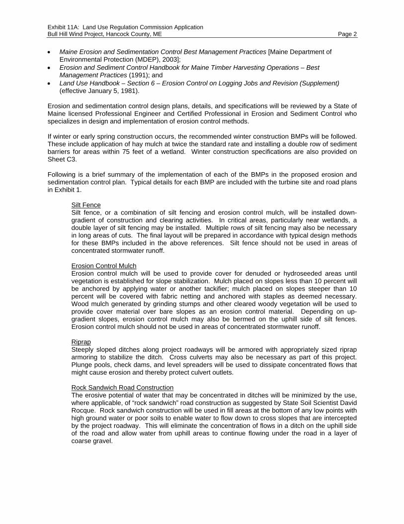
Exhibit 11A: Land Use Regulation Commission Application Bull Hill Wind Project, Hancock County, ME Page 2 Maine Erosion and Sedimentation Control Best Management Practices [Maine Department of
Environmental Protection (MDEP), 2003]; Erosion and Sediment Control Handbook for Maine Timber Harvesting Operations – Best
Management Practices (1991); and Land Use Handbook – Section 6 – Erosion Control on Logging Jobs and Revision (Supplement)
(effective January 5, 1981). Erosion and sedimentation control design plans, details, and specifications will be reviewed by a State of Maine licensed Professional Engineer and Certified Professional in Erosion and Sediment Control who specializes in design and implementation of erosion control methods. If winter or early spring construction occurs, the recommended winter construction BMPs will be followed. These include application of hay mulch at twice the standard rate and installing a double row of sediment barriers for areas within 75 feet of a wetland. Winter construction specifications are also provided on Sheet C3. Following is a brief summary of the implementation of each of the BMPs in the proposed erosion and sedimentation control plan. Typical details for each BMP are included with the turbine site and road plans in Exhibit 1.
Silt Fence Silt fence, or a combination of silt fencing and erosion control mulch, will be installed down-gradient of construction and clearing activities. In critical areas, particularly near wetlands, a double layer of silt fencing may be installed. Multiple rows of silt fencing may also be necessary in long areas of cuts. The final layout will be prepared in accordance with typical design methods for these BMPs included in the above references. Silt fence should not be used in areas of concentrated stormwater runoff. Erosion Control Mulch Erosion control mulch will be used to provide cover for denuded or hydroseeded areas until vegetation is established for slope stabilization. Mulch placed on slopes less than 10 percent will be anchored by applying water or another tackifier; mulch placed on slopes steeper than 10 percent will be covered with fabric netting and anchored with staples as deemed necessary. Wood mulch generated by grinding stumps and other cleared woody vegetation will be used to provide cover material over bare slopes as an erosion control material. Depending on up-gradient slopes, erosion control mulch may also be bermed on the uphill side of silt fences. Erosion control mulch should not be used in areas of concentrated stormwater runoff. Riprap Steeply sloped ditches along project roadways will be armored with appropriately sized riprap armoring to stabilize the ditch. Cross culverts may also be necessary as part of this project. Plunge pools, check dams, and level spreaders will be used to dissipate concentrated flows that might cause erosion and thereby protect culvert outlets. Rock Sandwich Road Construction The erosive potential of water that may be concentrated in ditches will be minimized by the use, where applicable, of “rock sandwich” road construction as suggested by State Soil Scientist David Rocque. Rock sandwich construction will be used in fill areas at the bottom of any low points with high ground water or poor soils to enable water to flow down to cross slopes that are intercepted by the project roadway. This will eliminate the concentration of flows in a ditch on the uphill side of the road and allow water from uphill areas to continue flowing under the road in a layer of coarse gravel.

Exhibit 11A: Land Use Regulation Commission Application Bull Hill Wind Project, Hancock County, ME Page 3
Ditch Turnouts and Level Spreaders Where ditches are necessary, primarily in cut sections of the roadway, appropriately sized and located cross-culverts and ditch turnouts will be used to dissipate collected stormwater runoff back to sheet flow. These ditches will be designed as suggested by MDEP and LURC Chapter 10 criteria, which requires a ditch turnout ending with a level spreader every 250 feet if both sides of a crowned road are being diverted, and every 400 feet if only one side of the road is discharged through the ditch and level spreader. In areas of long deep cuts, MDEP has found that the creation of the level spreaders themselves are an unnecessary disturbance and has allowed longer runs and oversized spreaders at the end of the cut section. The final erosion and sedimentation control plan will reflect these findings. Sediment retention when dewatering A high water table exists at several turbine pad locations throughout the project which will require dewatering during construction. As a result, the use of settlement ponds or sediment control devices such as “dirtbags” shall be employed to separate sediments from dewatering activities. Pumped water will be directed away from protected resources to natural buffer areas or other acceptable stabilized areas.
3.1 Site Plans James W. Sewall Company prepared the road and turbine site design plans for the site development application that identify vegetation types and locations, slopes, and other nature features near the disturbed areas. The plans and accompanying details show and describe temporary and permanent erosion control measures. 3.2 Sequence of Construction In general, erosion control measures will be implemented down-gradient of each work area before earthwork begins. Construction activities will be sequenced to minimize the project area that is disturbed and unstabilized at any point in time. Disturbed and stockpiled soil will be temporarily stabilized at the end of each workday. Temporary erosion control measures will be the first items installed and the last items to be removed after healthy vegetation is established. After preliminary layout and staking of the new road segments and areas to be cleared, erosion control measures will be installed. As the roads are constructed and areas are cleared, additional measures will be implemented. As roads reach final grade, permanent measures, such as ditch turnouts and level spreaders, will be constructed. Cleared areas will receive temporary mulching and seeding. Topsoil stockpiles will be protected by double measures such as temporary seeding and silt fences. After turbines are installed, a significant portion of each turbine clearing will be regraded with the stockpiled topsoil and permanently stabilized with mulch. Because stabilization of areas following completion of final grading is important to prevent erosion, areas will be stabilized within seven days of work completion. Final stabilization will consist of coarse gravel or blast rock (project roadways), mulch (turbine clearings), permanent seeding and erosion control mulch/matting (less steep cut and fill slopes), and riprap (steep cut/fill slopes, ditches and culvert outlets). 3.3 Maintenance and Inspection of Erosion Control Measures Maintenance of erosion control measures is key to their successful operation. BMPs will be inspected at least weekly and after any rainstorm greater than 0.5 inch by the project General Contractor, who will be certified in erosion control practices by the MDEP, and periodically by a Third-Party Inspection personnel under direct supervision of a licensed Professional Engineer. Inspections will be documented in writing and be made available to LURC upon request. Workers on-site will be instructed to report problems as they occur so remedial action can be taken as soon as possible.

Exhibit 11B: Land Use Regulation Commission Application Bull Hill Wind Project, Hancock County, ME Page 1 For all projects, it is the size and location of the development that determines the standards that must be met. Projects creating over one acre of impervious ground cover and that are within a lake watershed must meet the phosphorous standard, and with very few exceptions, all other watersheds must meet the general standard. Projects that will create over three acres of impervious must meet the flooding standard. The Bull Hill Wind Project lies within the Graham Lake, Narraguagus River, Narraguagus Lake and Spectacle Pond Watersheds. According to the Maine Department of Environmental Protection, Graham Lake is an exception because its algal productivity is not currently limited by phosphorus. It is a large, fairly shallow, man-made lake, with a lot of water level fluctuation. When the lake is drawn down, which is fairly often, and the wind blows, the bottom sediments, particularly in the large Union River delta in the north half of the lake, are re-suspended, and the lake becomes quite cloudy. The secchi disc readings are often less than 2 meters, but the chlorophyll concentrations indicate very low algal productivity because the suspended sediment is limiting light penetration and therefore limiting algal production. Because of this, the phosphorus standard is not applicable. The runoff from the Graham Lake and Narraguagus River watersheds are required to meet the general standards. Narraguagus Lake and Spectacle Pond need to meet phosphorous standards. The entire project is required to meet the flooding standard. The Graham Lake watershed is required to meet the general standard, 75 percent of the linear portion of the development must be treated. The project proposes 7.17 acres of new impervious in this watershed, and 75.50 percent is being treated through a combination of buffers. The Narraguagus River watershed is also required to meet the general standard, 75 percent of the linear portion of the development must be treated. The project proposes 13.38 acres of new impervious in this watershed, and 76.29 percent is being treated through a combination of buffers. Spectacle Pond lies within a lake watershed that is required to meet the phosphorous standard. The current calculated pound per acre phosphorus allocation (P) is 0.062 pounds/acre/year. T16 MD has 489 acres that are within the direct watershed of Spectacle Pond that are available to be developed. The Small Watershed Threshold is 24 acres. The project area for the phosphorous calculations is 22.49 acres. This results in a budget of 1.394 lbs P/year to be exported off the site. 1.21 acres of new impervious is being proposed in this watershed. The total proposed export is 1.196 lbs P/year which meets the standard. This standard was met by using a combination of buffers. Narraguagus Lake lies within a lake watershed that is required to meet the phosphorous standard. The current calculated pound per acre phosphorus allocation (P) is 0.041 pounds/acre/year. T16 MD has 1,075 acres that are within the direct watershed of Narraguagus Lake that are available to be developed. The Small Watershed Threshold is 54 acres. The project area for the phosphorous calculations is 2.48 acres. This results in a budget of 0.102 lbs P/year to be exported off the site. 0.11 acres of new impervious is being proposed in this watershed. The total proposed export is 0.080 lbs P/year which meets the standard. This standard was met by using a combination of buffers. The Operations and Maintenance (O&M) building is located within the Narraguagus River watershed and is required to meet the general standard. The O&M building is considered to be nonlinear and must treat 95 percent of the impervious area and 80 percent of the developed area. The project proposes 2.37 acres of impervious area, and 100 percent is being treated. A total of 3.57 acres of developed area (including the impervious area) is being proposed for the O&M building site, and 87.81 percent is being treated through buffers. The entire project must comply with the flooding standard, the post development runoff rate must be less than or equal to the pre development runoff rate. The table below summarizes the rates and compares the pre and post development conditions. The North analysis point (Spectacle Pond) shows an insignificant increase. Once the runoff reaches the property line there will be no increase in the rate.

Exhibit 11B: Land Use Regulation Commission Application Bull Hill Wind Project, Hancock County, ME Page 2 Flow (cfs) from Hydrocad Property Line Watershed 2-year 10-year 25-year
PRE North Spectacle Pond 25.95 79.21 108.67 POST North Spectacle Pond 26.97 82.74 113.53
CHANGE 1.02 3.53 4.86 PRE East Narraguagus River 176.95 542.19 742.39
POST East Narraguagus River 176.95 542.19 742.39 CHANGE 0.00 0.00 0.00
PRE South Narraguagus Lake 31.52 94.98 130.12 POST South Narraguagus Lake 31.52 94.98 130.12
CHANGE 0.00 0.00 0.00 PRE West Graham Lake 108.51 330.51 453.61
POST West Graham Lake 108.51 330.51 453.61 CHANGE 0.00 0.00 0.00
The attached stormwater calculations include computations that address meeting the Phosphorous Standard, the General Standard, and the Flooding Standard for the project.

Qual Calcs Lin Graham Lake (TM) Page 1
Project Name Bull Hill BA=Buffer Adjacent to Small Imp RB=Roadside buffer BRS=Roadside Buffer with Rock SandwichProject Number 74490E BL=Buffer w/level spreader DB=Detention basin
Date 10/12/2010 DT=Buffer w/ditch turnout WP=Wet pondDone by JAO USF=Underdrain Soil Filter INF=Infiltration
QUALITY CALCULATIONS FOR LINEAR PORTION
Graham Lake (T16 MD)
Phosphorous Requirement
Watershed per acre phosphorus budget (Appendix C): P N/A # P/acre/year Total ac of devel. parcel: TA acresSmall Watershed Threshold (Appendix C) SWT acres NWI wetland acreage: WA acres
Allowable increase in Town's share of annual phos (App C) FC lbs P/year Steep slope acreage: SA acresArea avail. For development (App C) AAD acres Existing imp area (Pre 1980) EIAB acres
Project acreage: A = TA - (WA + SA + EIAB + EIAA) A acres Existing imp area (post 1980) EIAA acresA/AAD R
Project Phos Budget: PPB = P x A PPB N/A lbs P/yearProject Phos Budget with small watershed adjustment: PPB N/A lbs P/year
Total Post Development Phos Export (lbs P/yr)= 0.0000 <= N/A Access rd width(Const)= 24 Crane path width(Const)= 36% of Project Treated for WS= 75.50% >= 75% Access rd width(Perm)= 24 Crane path width(Perm)= 36
Total Impervious Area for WS= 7.17 Acres Turbine pad imp area(Perm)= 12350 sq ft Met Tower Rd width= 12
Roadway Access Station to Station % of area BMP SIDE OF RD Tx BMP cover Imp. Area Treatment Export Pre- PostAlignment or Crane No. RIGHT, LEFT Forest (acres) Factor Coefficient Treatment TreatmentTurbine Site Turbine (or none) BOTH Meadow lbs P/Year lbs P/year
T10 Turbine 100% B10 Forest 0.2835 0.4NS Crane 224 830 50% BL1 RIGHT Forest 0.2504 0.4NS Crane 224 350 50% B10 LEFT Forest 0.0521 0.4NS Crane 600 830 50% BL21 LEFT Forest 0.0950 0.4NS Crane 830 1180 100% BL2 BOTH Forest 0.2893 0.4NS Crane 1180 1300 100% BL3 BOTH Forest 0.0992 0.4NS Crane 1300 1525 50% B11 LEFT Forest 0.0930 0.4NS Crane 1300 1575 50% BL3 RIGHT Forest 0.1136 0.4T11 Turbine 100% B11 Forest 0.2835 0.4T1-4 Crane 100150 100250 100% NONE BOTH 0.0826 1T1-4 Crane 100250 100550 50% RB3 RIGHT Forest 0.1240 0.4T1-4 Crane 100250 100650 50% NONE LEFT 0.1653 1T1-4 Crane 100650 101250 50% RB4 LEFT Forest 0.2479 0.4T1-4 Crane 100550 101025 50% NONE right 0.1963 1T1-4 Crane 101025 101100 50% RB5 RIGHT Forest 0.0310 0.4

Qual Calcs Lin Graham Lake (TM) Page 2
T1-4 Crane 101100 101600 50% BL15 RIGHT Forest 0.2066 0.4T1-4 Crane 101600 102100 100% BL17 BOTH Forest 0.4132 0.4T1-4 Crane 102100 102500 100% BL18 BOTH Forest 0.3306 0.4T1-4 Crane 102500 102850 50% BL19 RIGHT Forest 0.1446 0.4T1-4 Crane 102500 102750 50% BL19 LEFT Forest 0.1033 0.4T1-4 Crane 102850 103200 50% NONE RIGHT 0.1446 1T1-4 Crane 102750 103000 50% B2 LEFT 0.1033 0.4T2 Turbine 100% B2 Forest 0.2835 0.4
T1-4 Crane 103200 103700 50% RB6 RIGHT Forest 0.2066 0.4T1-4 Crane 103000 103575 50% NONE LEFT 0.2376 1T1-4 Crane 103700 103850 50% BL20 RIGHT Meadow 0.0620 0.4T1 Turbine 100% B1 Forest 0.2835 0.4
T1-4 Crane 103575 103700 50% NONE LEFT 0.0517 1T1-4 Crane 103700 104050 50% BL27 LEFT Forest 0.1446 0.4T1-4 Crane 104050 104235 50% NONE LEFT Forest 0.0764 1T1-4 Crane 103850 104235 50% B1 RIGHT Forest 0.1591 0.4T5-6 Crane 500050 500450 100% NONE BOTH 0.3306 1T8 Turbine 50% B8 Forest 0.1418 0.4T7 Crane 50000 50350 100% BL8 BOTH Forest 0.2893 0.4T7 Crane 50350 50500 50% BL25 LEFT Meadow 0.0620 0.4T7 Crane 50500 50900 50% B7 LEFT Forest 0.1653 0.4T7 Crane 50350 50900 50% BL26 RIGHT Forest 0.2273 0.4
T7 STUB Crane 100 250 100% BL8 BOTH Forest 0.1240 0.4T8-9 STUB A Crane 200 300 100% NONE BOTH 0.0826 1T8-9 STUB B Crane 200 300 100% NONE BOTH 0.0826 1
MET TOWER 1 Met 0 250 100% NONE BOTH 0.0689 1MET TOWER 2 Met 0 195 100% NONE BOTH 0.0537 1Yellow Gate Rd Improvements 0.1835 1
Total Impervious 7.170 acres Total Pre Tx Phos 0.0000 lbs P/year Total Post Tx Phos 0.0000 lbs P/year

Qual Calcs Lin Narr Lake (TM) Page 1
Project Name Bull Hill BA=Buffer Adjacent to Small Imp RB=Roadside buffer BRS=Roadside Buffer with Rock SandwichProject Number 74490E BL=Buffer w/level spreader DB=Detention basin
Date 10/12/2010 DT=Buffer w/ditch turnout WP=Wet pondDone by JAO USF=Underdrain Soil Filter INF=Infiltration
QUALITY CALCULATIONS FOR LINEAR PORTION
Narraguagus Lake (T16 MD)
Phosphorous Requirement
Watershed per acre phosphorus budget (Appendix C): P 0.041 # P/acre/year Total ac of devel. parcel: TA 2.48 acresSmall Watershed Threshold (Appendix C) SWT 54 acres NWI wetland acreage: WA acres
Allowable increase in Town's share of annual phos (App C) FC 8.78 lbs P/year Steep slope acreage: SA acresArea avail. For development (App C) AAD 1075 acres Existing imp area (Pre 1980) EIAB acres
Project acreage: A = TA - (WA + SA + EIAB + EIAA) A 2.48 acres Existing imp area (post 1980) EIAA acresA/AAD R 0.002
Project Phos Budget: PPB = P x A PPB 0.102 lbs P/yearProject Phos Budget with small watershed adjustment: PPB N/A lbs P/year
Total Post Development Phos Export (lbs P/yr)= 0.0804 <= 0.1017 Access rd width(Const)= 24 Crane path width(Const)= 36% of Project Treated for WS= 100.00% >= 75% Access rd width(Perm)= 24 Crane path width(Perm)= 36
Total Impervious Area for WS= 0.11 Acres Turbine pad imp area(Perm)= 12350 sq ft Met Tower Rd width= 12
Roadway Access Station to Station % of area BMP SIDE OF RD Tx BMP cover Imp. Area Treatment Export Pre- PostAlignment or Crane No. RIGHT, LEFT Forest or (acres) Factor Coefficient Treatment TreatmentTurbine Site Turbine (or none) BOTH Meadow lbs P/Year lbs P/year
MET TOWER 1 Met 250 667 100% BL35 BOTH Forest 0.1149 0.4 1.75 0.2010 0.0804
Total Impervious 0.115 acres Total Pre Tx Phos 0.201033058 lbs P/year Total Post Tx Phos 0.0804132 lbs P/year

Qual Calcs Lin Narr River (TM Page 1
Project Name Bull Hill BA=Buffer Adjacent to Small Imp RB=Roadside buffer BRS=Roadside Buffer with Rock SandwichProject Number 74490E BL=Buffer w/level spreader DB=Detention basin
Date 10/12/2010 DT=Buffer w/ditch turnout WP=Wet pondDone by JAO USF=Underdrain Soil Filter INF=Infiltration
QUALITY CALCULATIONS FOR LINEAR PORTION
Narraguagus River (T16 MD)
Phosphorous Requirement
Watershed per acre phosphorus budget (Appendix C): P N/A # P/acre/year Total ac of devel. parcel: TA acresSmall Watershed Threshold (Appendix C) SWT acres NWI wetland acreage: WA acres
Allowable increase in Town's share of annual phos (App C) FC lbs P/year Steep slope acreage: SA acres
Area avail. For development (App C) AAD acres Existing imp area (Pre 1980) EIAB acresProject acreage: A = TA - (WA + SA + EIAB + EIAA) A acres Existing imp area (post 1980) EIAA acres
A/AAD R
Project Phos Budget: PPB = P x A PPB N/A lbs P/yearProject Phos Budget with small watershed adjustment: PPB N/A lbs P/year
Total Post Development Phos Export (lbs P/yr)= 0.0000 <= N/A Access rd width(Const)= 24 Crane path width(Const)= 36% of Project Treated for WS= 76.29% >= 75% Access rd width(Perm)= 24 Crane path width(Perm)= 36
Total Impervious Area for WS= 13.38 Acres Turbine pad imp area(Perm)= 12350 sq ft Met Tower Rd width= 12
Roadway Access Station to Station % of area BMP SIDE OF RD Tx BMP cover Imp. Area Treatment Export Pre- PostAlignment or Crane No. RIGHT, LEFT Forest (acres) Factor Coefficient Treatment TreatmentTurbine Site Turbine (or none) BOTH Meadow lbs P/Year lbs P/year
NS Crane 1920 2210 100% BL22 BOTH Forest 0.2397 0.4NS Crane 2210 2635 50% BL5 RIGHT Forest 0.1756 0.4NS Crane 2210 2425 50% B12 LEFT Forest 0.0888 0.4NS Crane 2425 2635 50% BL5 LEFT Forest 0.0868 0.4NS Crane 2635 3000 50% BL6 RIGHT Forest 0.1508 0.4T12 Turbine 100% B12 Forest 0.2835 0.4NS Crane 2635 2975 50% RB1 LEFT Forest 0.1405 0.4T13 Turbine 50% BL32 Forest 0.1418 0.4
NS STUB 13 Crane 10000 10300 100% BL32 BOTH Forest 0.2479 0.4NS Crane 2975 3000 50% NONE LEFT 0.0103 1NS Crane 3000 3300 100% NONE BOTH 0.2479 1NS Crane 3300 3610 50% BL32 LEFT Forest 0.1281 0.4NS Crane 3300 3400 50% NONE RIGHT 0.0413 1NS Crane 3400 3610 50% BL32 RIGHT Forest 0.0868 0.4NS Crane 3610 4150 100% BL7 BOTH Forest 0.4463 0.4NS Crane 4400 4725 100% BL33 BOTH Forest 0.2686 0.4NS Crane 4725 5000 100% BL9 BOTH Forest 0.2273 0.4NS Crane 5000 5200 100% BL9 BOTH Forest 0.1653 0.4NS Crane 5200 5700 100% BL10 BOTH Forest 0.4132 0.4T16 Turbine 100% B16 Forest 0.2835 0.4NS Crane 5700 5950 50% B16 LEFT 0.1033 0.4NS Crane 5700 5950 50% BL11 RIGHT Forest 0.1033 0.4

Qual Calcs Lin Narr River (TM Page 2
NS Crane 5950 6200 100% NONE BOTH Forest 0.2066 1NS Crane 6200 6600 100% NONE BOTH 0.3306 1NS Crane 6600 7350 50% RB2 RIGHT Forest 0.3099 0.4NS Crane 6600 6850 50% NONE LEFT Forest 0.1033 1NS Crane 6850 7200 50% BL12 LEFT Forest 0.1446 0.4NS Crane 7200 7500 50% BL29 LEFT Forest 0.1240 0.4NS Crane 7350 7500 50% BL29 RIGHT Forest 0.0620 0.4T17 Turbine 100% B17 Forest 0.2835 0.4T18 Turbine 100% BL13 Forest 0.2835 0.4NS Crane 7500 7700 50% NONE LEFT 0.0826 1NS Crane 7700 8025 50% BL13 LEFT Forest 0.1343 0.4NS Crane 7500 8025 50% BL13 RIGHT Forest 0.2169 0.4NS Crane 8025 8425 50% BL14 BOTH Forest 0.1653 0.4NS Crane 8425 8725 50% BL36 LEFT Forest 0.1240 0.4NS Crane 8425 8800 50% BL30 RIGHT Forest 0.1550 0.4NS Crane 8800 8815 50% NONE RIGHT 0.0062 1NS Crane 8725 8815 50% NONE LEFT 0.0372 1T19 Turbine 100% BL36 Forest 0.2835 0.4T1-4 Crane 101250 101600 50% BL16 LEFT Forest 0.1446 0.4T4 Turbine 100% B4 Forest 0.2835 0.4T3 Turbine 100% B3 Forest 0.2835 0.4
T5-6 Crane 500450 500800 100% NONE BOTH 0.2893 1T5-6 Crane 500800 501025 50% BL28 RIGHT Forest 0.0930 0.4T5-6 Crane 500800 501025 50% BL28 RIGHT Forest 0.0930 0.4T5-6 Crane 501025 501400 50% B5 RIGHT Forest 0.1550 0.4T5 Turbine 100% B5 Forest 0.2835 0.4
T5-6 Crane 501025 502600 50% NONE LEFT 0.6508 1T5-6 Crane 501400 501550 50% NONE RIGHT 0.0620 1T5-6 Crane 501550 501800 50% RB8 RIGHT Forest 0.1033 0.4T5-6 Crane 501800 502525 50% NONE RIGHT 0.2996 1T5-6 Crane 502525 503100 50% B6 RIGHT Forest 0.2376 0.4T5-6 Crane 502600 503100 50% BL23 LEFT Forest 0.2066 0.4T6 Turbine 100% B6 Forest 0.2835 0.4T8 Turbine 50% B8 Forest 0.1418 0.4
T8-9 Crane 100000 100275 50% B8 LEFT Forest 0.1136 0.4T8-9 Crane 100000 100175 50% NONE RIGHT 0.0723 1T8-9 Crane 100175 100400 50% BL24 RIGHT Forest 0.0930 0.4T8-9 Crane 100275 100400 50% BL24 LEFT Forest 0.0517 0.4T8-9 Crane 100400 100650 50% BL24 LEFT Forest 0.1033 0.4T8-9 Crane 100400 100650 50% BL24 RIGHT Forest 0.1033 0.4T8-9 Crane 100650 100850 50% RB9 RIGHT Forest 0.0826 0.4T8-9 Crane 100650 100850 50% NONE LEFT 0.0826 1T8-9 Crane 100850 101350 100% BL31 BOTH Forest 0.4132 0.4T8-9 Crane 101350 102240 50% RB10 RIGHT Forest 0.3678 0.4T8-9 Crane 101350 102570 50% NONE LEFT 0.5041 1T8-9 Crane 102240 102570 50% NONE RIGHT 0.1364 1T9 Turbine 100% B9 Forest 0.2835 0.4
MET TOWER 4 Met 0 70 50% BL13 LEFT Forest 0.0096 0.4MET TOWER 4 Met 0 70 50% NONE RIGHT 0.0096 1MET TOWER 4 Met 70 220 100% BL34 BOTH Forest 0.0413 0.4MET TOWER 4 Met 220 845 100% RB11 BOTH Forest 0.1722 0.4
Total Impervious 13.38 acres Total Pre Tx Phos 0.0000 lbs P/year Total Post Tx Phos 0.0000 lbs P/year

Qual Calcs Lin Spect Pond (TM) Page 1
Project Name Bull Hill BA=Buffer Adjacent to Small Imp RB=Roadside buffer BRS=Roadside Buffer with Rock SandwichProject Number 74490E BL=Buffer w/level spreader DB=Detention basin
Date 6/23/2010 DT=Buffer w/ditch turnout WP=Wet pondDone by JAO USF=Underdrain Soil Filter INF=Infiltration
QUALITY CALCULATIONS FOR LINEAR PORTION
Spectacle Pond (T16 MD)
Phosphorous Requirement
Watershed per acre phosphorus budget (Appendix C): P 0.062 # P/acre/year Total ac of devel. parcel: TA 22.49 acresSmall Watershed Threshold (Appendix C) SWT 24 acres NWI wetland acreage: WA acres
Allowable increase in Town's share of annual phos (App C) FC 6.08 lbs P/year Steep slope acreage: SA acresArea avail. For development (App C) AAD 489 acres Existing imp area (Pre 1980) EIAB acres
Project acreage: A = TA - (WA + SA + EIAB + EIAA) A 22.49 acres Existing imp area (post 1980) EIAA acresA/AAD R 0.046
Project Phos Budget: PPB = P x A PPB 1.394 lbs P/yearProject Phos Budget with small watershed adjustment: PPB N/A lbs P/year
Total Post Development Phos Export (lbs P/yr)= 1.196 <= 1.3944 Access rd width(Const)= 24 Crane path width(Const)= 36% of Project Treated for WS= 69.30% >= 75% Access rd width(Perm)= 24 Crane path width(Perm)= 30
Total Impervious Area for WS= 1.21 Acres Turbine pad imp area(Perm)= 12350 sq ft Met Tower Rd width= 12
Roadway Access Station to Station % of area BMP SIDE OF RD Tx BMP cover Imp. Area Treatment Export Pre- PostAlignment or Crane No. RIGHT, LEFT Forest (acres) Factor Coefficient Treatment TreatmentTurbine Site Turbine (or none) BOTH Meadow lbs P/Year lbs P/year
T14 Turbine 100% B14 Forest 0.2835 0.4 1.75 0.4962 0.1985NS Crane 4150 4250 50% B14 LEFT Forest 0.0344 0.4 1.75 0.0603 0.0241NS Crane 4150 4250 50% NONE RIGHT 0.0344 1 1.75 0.0603 0.0603NS Crane 4250 4400 100% NONE BOTH Forest 0.1033 1 1.75 0.1808 0.1808T15 Turbine 100% B15 Forest 0.2835 0.4 1.75 0.4962 0.1985NS Crane 1575 1920 100% BL4 BOTH Forest 0.2376 0.3 1.75 0.4158 0.1247T13 Turbine 50% NONE 0.1418 1 1.75 0.2481 0.2481
MET TOWER 3 Met 0 335 100% NONE BOTH 0.0923 1 1.75 0.1615 0.1615
Total Impervious 1.211 acres Total Pre Tx Phos 2.119 lbs P/year Total Post Tx Phos 1.196 lbs P/year

RB Buffer Calcs Page 1
Project Name Bull Hill RB=Roadside Buffer L=LengthProject Number 74490E Imp=Impervious area W=Width
Date 10/12/2010 Land=Landscaped Area B=BufferDone by JAO
REQUIRED BUFFER FLOW PATH LENGTHS~BUFFER ADJACENT TO DOWN HILL SIDE OF ROAD~
# of Travel Ways Length of Flow Length of Flowto Buffer Forest Meadow
1 35 502 55 80
* Buffer slopes may not exceed 20%** Buffers may not be located in a wetland*** Roadside slopes may be included in a meadow buffer if the slope is less than 4:1 and if the soils allow infiltration
Graham Lake (TM)
BMP Type & # Roadway Align. # of Travel Buffer Type Treatment Standard Buffer Adjusted Bufferor Turbine Site Ways (1 or 2) (Forest or Meadow) Factor Length (ft) Length (ft)
RB3 T1-4 1 Forest 0.40 35 35RB4 T1-4 1 Forest 0.40 35 35RB5 T1-4 1 Forest 0.40 35 35RB6 T1-4 1 Forest 0.40 35 35
Spectacle Pond (TM)
BMP Type & # Roadway Align. # of Travel Buffer Type Treatment Standard Buffer Adjusted Bufferor Turbine Site Ways (1 or 2) (Forest or Meadow) Factor Length (ft) Length (ft)

RB Buffer Calcs Page 2
Narraguagus River (TM)
BMP Type & # Roadway Align. # of Travel Buffer Type Treatment Standard Buffer Adjusted Bufferor Turbine Site Ways (1 or 2) (Forest or Meadow) Factor Length (ft) Length (ft)
RB2 NS 1 Forest 0.40 35 35RB8 T5-6 1 Forest 0.40 35 35RB9 T8-9 1 Forest 0.40 35 35RB10 T8-9 1 Forest 0.40 35 35

BL Buffer Calcs Page 1
Project Name Bull Hill BL=Buffer with a Level Lip SpreaderL=LengthProject Number 74490E Imp=Impervious area W=Width
Date 10/12/2010 Land=Landscaped Area B=BufferDone by JAO C1=Loamy Sand or Sandy Loam C2=Silt Loam, Clay Loam or Silty Clay Loam
REQUIRED BUFFER FLOW PATH LENGTHS~BUFFERS WITH LEVEL LIP SPREADERS~
0-8% Buffer Slope 9-15% Buffer Slope
Soils Length of Flow Berm L for Forested Buffer(ft) Berm L for Meadow Buffer(ft) Length of Flow Berm L for Forested Buffer(ft) Berm L for Meadow Buffer(ft)
Thru Buffer (ft) Per acre Imp Per acre Land Per acre Imp Per acre Land Thru Buffer (ft) Per acre Imp Per acre Land Per acre Imp Per acre Land
A 75 75 25 125 35 75 90 30 150 42100 65 20 75 25 100 78 24 90 30150 50 15 60 20 150 60 18 72 24
B 75 100 30 150 45 75 120 36 180 54100 80 25 100 30 100 96 30 120 36150 65 20 75 25 150 78 24 90 30
C1 75 125 35 150 45 75 150 42 180 54100 100 30 125 35 100 120 36 150 42150 75 25 100 30 150 90 30 120 36
C2 100 150 45 200 60 100 180 54 240 72150 100 30 150 45 150 120 36 180 54
D 150 150 45 200 60 150 180 54 240 72
Graham Lake (TM)from table from table
BMP Type & # Roadway Align. Imp (acres) Buffer Type Treatment Soil Type Buffer Standard Buffer L of Berm Standard Berm Adjusted Buffer
or Turbine Site (forest/meadow) Factor Slope Length (ft) per ac. imp Length (ft) Length (ft)
BL1 NS 0.2504 Forest 0.4 C 6.0% 100 150 38 100BL2 NS 0.2893 Forest 0.4 C 6.5% 100 150 43 100BL3 NS 0.2128 Forest 0.4 C 7.0% 150 100 21 150BL15 T1-4 0.2066 Forest 0.4 C 3.5% 100 150 31 100BL17 T1-4 0.4132 Forest 0.4 C 10.5% 150 120 50 150BL18 T1-4 0.3306 Forest 0.4 C 6.5% 100 150 50 100BL19 T1-4 0.2479 Forest 0.4 C 6.0% 100 150 37 100BL20 T1-4 0.0620 Meadow 0.4 C 6.0% 100 200 12 100BL21 NS 0.0950 Forest 0.4 C 4.0% 100 150 14 100BL25 T7 0.0620 Meadow 0.4 C 6.5% 100 200 12 100BL26 T7 0.2273 Forest 0.4 C 4.0% 100 150 34 100BL27 T1-4 0.1446 Forest 0.4 C 5.0% 100 150 22 100BL8 T7 0.4132 Forest 0.4 C 4.0% 150 100 41 150

BL Buffer Calcs Page 2
Spectacle Pond (TM)from table from table
BMP Type & # Roadway Align. Imp (acres) Buffer Type Treatment Soil Type Buffer Standard Buffer L of Berm Standard Berm Adjusted Buffer
or Turbine Site (forest/meadow) Factor Slope Length (ft) per ac. imp Length (ft) Length (ft)
BL4 NS 0.2376 Forest 0.3 C 8% 100 150 36 133
Narraguagus River (TM)from table from table
BMP Type & # Roadway Align. Imp (acres) Buffer Type Treatment Soil Type Buffer Standard Buffer L of Berm Standard Berm Adjusted Buffer
or Turbine Site (forest/meadow) Factor Slope Length (ft) per ac. imp Length (ft) Length (ft)
BL5 NS 0.2624 Forest 0.4 C 10.0% 150 120 31 150BL6 NS 0.1508 Forest 0.4 C 8.0% 100 150 23 100BL7 NS 0.4463 Forest 0.4 C 6.5% 150 100 45 150BL9 NS 0.3926 Forest 0.4 C 7.0% 100 150 59 100BL10 NS 0.4132 Forest 0.4 C 4.0% 150 100 41 150BL11 NS 0.1033 Forest 0.4 C 5.0% 100 150 15 100BL12 NS 0.1446 Forest 0.4 C 4.0% 100 150 22 100BL13 T18 0.6444 Forest 0.4 C 6.0% 150 100 64 150BL14 NS 0.1653 Forest 0.4 C 9.0% 100 180 30 100BL16 T1-4 0.1446 Forest 0.4 C 3.5% 100 150 22 100BL23 T5-6 0.2066 Forest 0.4 C 3.5% 100 150 31 100BL24 T8-9 0.3512 Forest 0.4 C 4.5% 100 150 53 100BL28 T5-6 0.1860 Forest 0.4 C 17.5% 100 180 33 100BL22 NS 0.2397 Forest 0.4 C 6.0% 100 150 36 100BL29 NS 0.1860 Forest 0.4 C 6.0% 100 150 28 100BL30 NS 0.1550 Forest 0.4 C 13.0% 100 180 28 100BL31 T8-9 0.4132 Forest 0.4 C 4.0% 150 100 41 150BL32 T13 0.6046 Forest 0.4 C 4.0% 150 100 60 150BL33 NS 0.2686 Forest 0.4 C 5.0% 100 150 40 100BL34 MET TOWER 4 0.0413 Forest 0.4 C 4.5% 100 150 6 100BL36 NS 0.4075 Forest 0.4 C 12.0% 150 120 49 150
Narraguagus Lake (TM)from table from table
BMP Type & # Roadway Align. Imp (acres) Buffer Type Treatment Soil Type Buffer Standard Buffer L of Berm Standard Berm Adjusted Buffer
or Turbine Site (forest/meadow) Factor Slope Length (ft) per ac. imp Length (ft) Length (ft)
BL35 MET TOWER 1 0.1149 Forest 0.4 C 4% 100 240 28 100

Quality Calcs Non Linear pg 1
Project Name Bull Hill BA=Buffer Adjacent to Small Imp RB=Roadside bufferProject Number 74490E BL=Buffer w/level spreader DB=Detention basin
Date 10/12/2010 DT=Buffer w/ditch turnout WP=Wet pondDone by JAO USF=Underdrain Soil Filter INF=Infiltration
QUALITY CALCULATIONS FOR NON LINEAR PORTION
Total NEW NONLIN impervious area for project= 103341 sf = 2.37 acresTotal NEW NONLIN landscaped area for project= 52138 sf = 1.20 acresTotal NEW NONLINEAR area of project= 155479 sf = 3.57 acres
NONLinear AreaSubcatchment # BMP Type & # Imp (sf) Land (sf) Description If Applicable
1 68200 0 Substation2 B27 8058 03 B29 3417 189514 B28 23666 14236
TOTAL 103341 33187
SUMMARY FOR THE NONLINEAR PORTION OF THE PROJECT
IMP Area Required area to be treated (sf)= 98173.95Total NONLIN IMP Area Being Treated (sf)= 103341 100.0% >=95%DEVEL Area Required area to be treated (sf)= 124383.20
Total NONLIN DEVEL Area Being Treated (sf)= 136528 87.81% >=80%NONLinear Area Not Being Treated (sf)= 18951

Pre/Post Summary pg 1
Project Name Bull HillProject Number 74490E
Date 11/12/2010Done by JAO
Pre & Post Development Summary
Property Line # 2-year 10-year 25-yearPRE North Spectacle Pond 25.95 79.21 108.67
POST North Spectacle Pond 26.97 82.74 113.53CHANGE 1.02 3.53 4.86Percent Increase 3.93% 4.46% 4.47%
PRE East Narraguagus River 176.95 542.19 742.39POST East Narraguagus River 176.95 542.19 742.39
CHANGE 0.00 0.00 0.00Percent Increase 0.00% 0.00% 0.00%
PRE South Narraguagus Lake 31.52 94.98 130.12POST South Narraguagus Lake 31.52 94.98 130.12
CHANGE 0.00 0.00 0.00Percent Increase 0.00% 0.00% 0.00%
PRE West Graham Lake 108.51 330.51 453.61POST West Graham Lake 108.51 330.51 453.61
CHANGE 0.00 0.00 0.00Percent Increase 0.00% 0.00% 0.00%
Subcatchment Flow (cfs) from Hydrocad

Graham
Graham Lake
Narr
Narraguagus Lake
Narr R
Narraguagus River
Spect
Spectacle Pond
East
East
North
North
South
South
West
West
Drainage Diagram for 2010-11-10 Pre HydrologyPrepared by James Sewall Co., Printed 11/15/2010
HydroCAD® 9.00 s/n 01064 © 2009 HydroCAD Software Solutions LLC
Subcat Reach Pond Link

Type III 24-hr 2YR Rainfall=2.70"2010-11-10 Pre Hydrology Printed 11/15/2010Prepared by James Sewall Co.
Page 2HydroCAD® 9.00 s/n 01064 © 2009 HydroCAD Software Solutions LLC
Summary for Subcatchment Graham: Graham Lake
Runoff = 108.51 cfs @ 13.67 hrs, Volume= 29.952 af, Depth> 0.46"
Runoff by SCS TR-20 method, UH=SCS, Time Span= 5.00-20.00 hrs, dt= 0.05 hrsType III 24-hr 2YR Rainfall=2.70"
Area (ac) CN Description776.000 70 Woods, Good, HSG C776.000 100.00% Pervious Area
Tc Length Slope Velocity Capacity Description(min) (feet) (ft/ft) (ft/sec) (cfs)56.3 150 0.0200 0.04 Sheet Flow,
Woods: Dense underbrush n= 0.800 P2= 2.70"24.7 1,788 0.0580 1.20 Shallow Concentrated Flow,
Woodland Kv= 5.0 fps11.8 460 0.0170 0.65 Shallow Concentrated Flow,
Woodland Kv= 5.0 fps17.8 736 0.0190 0.69 Shallow Concentrated Flow,
Woodland Kv= 5.0 fps110.6 3,134 Total

Type III 24-hr 2YR Rainfall=2.70"2010-11-10 Pre Hydrology Printed 11/15/2010Prepared by James Sewall Co.
Page 3HydroCAD® 9.00 s/n 01064 © 2009 HydroCAD Software Solutions LLC
Summary for Subcatchment Narr: Narraguagus Lake
Runoff = 31.52 cfs @ 14.44 hrs, Volume= 10.513 af, Depth> 0.44"
Runoff by SCS TR-20 method, UH=SCS, Time Span= 5.00-20.00 hrs, dt= 0.05 hrsType III 24-hr 2YR Rainfall=2.70"
Area (ac) CN Description284.000 70 Woods, Good, HSG C284.000 100.00% Pervious Area
Tc Length Slope Velocity Capacity Description(min) (feet) (ft/ft) (ft/sec) (cfs)85.7 150 0.0070 0.03 Sheet Flow,
Woods: Dense underbrush n= 0.800 P2= 2.70"25.8 1,248 0.0260 0.81 Shallow Concentrated Flow,
Woodland Kv= 5.0 fps3.4 306 0.0460 1.50 Shallow Concentrated Flow,
Short Grass Pasture Kv= 7.0 fps43.4 2,637 0.0410 1.01 Shallow Concentrated Flow,
Woodland Kv= 5.0 fps158.3 4,341 Total

Type III 24-hr 2YR Rainfall=2.70"2010-11-10 Pre Hydrology Printed 11/15/2010Prepared by James Sewall Co.
Page 4HydroCAD® 9.00 s/n 01064 © 2009 HydroCAD Software Solutions LLC
Summary for Subcatchment Narr R: Narraguagus River
Runoff = 176.95 cfs @ 13.47 hrs, Volume= 45.041 af, Depth> 0.47"
Runoff by SCS TR-20 method, UH=SCS, Time Span= 5.00-20.00 hrs, dt= 0.05 hrsType III 24-hr 2YR Rainfall=2.70"
Area (ac) CN Description1,155.000 70 Woods, Good, HSG C1,155.000 100.00% Pervious Area
Tc Length Slope Velocity Capacity Description(min) (feet) (ft/ft) (ft/sec) (cfs)66.9 150 0.0130 0.04 Sheet Flow,
Woods: Dense underbrush n= 0.800 P2= 2.70"29.7 1,594 0.0320 0.89 Shallow Concentrated Flow,
Woodland Kv= 5.0 fps96.6 1,744 Total

Type III 24-hr 2YR Rainfall=2.70"2010-11-10 Pre Hydrology Printed 11/15/2010Prepared by James Sewall Co.
Page 5HydroCAD® 9.00 s/n 01064 © 2009 HydroCAD Software Solutions LLC
Summary for Subcatchment Spect: Spectacle Pond
Runoff = 25.95 cfs @ 13.62 hrs, Volume= 7.008 af, Depth> 0.46"
Runoff by SCS TR-20 method, UH=SCS, Time Span= 5.00-20.00 hrs, dt= 0.05 hrsType III 24-hr 2YR Rainfall=2.70"
Area (ac) CN Description181.000 70 Woods, Good, HSG C181.000 100.00% Pervious Area
Tc Length Slope Velocity Capacity Description(min) (feet) (ft/ft) (ft/sec) (cfs)61.6 150 0.0160 0.04 Sheet Flow,
Woods: Dense underbrush n= 0.800 P2= 2.70"22.6 1,268 0.0350 0.94 Shallow Concentrated Flow,
Woodland Kv= 5.0 fps22.3 1,100 0.0270 0.82 Shallow Concentrated Flow,
Woodland Kv= 5.0 fps106.5 2,518 Total

Type III 24-hr 2YR Rainfall=2.70"2010-11-10 Pre Hydrology Printed 11/15/2010Prepared by James Sewall Co.
Page 6HydroCAD® 9.00 s/n 01064 © 2009 HydroCAD Software Solutions LLC
Summary for Link East: East
Inflow Area = 1,155.000 ac, 0.00% Impervious, Inflow Depth > 0.47" for 2YR eventInflow = 176.95 cfs @ 13.47 hrs, Volume= 45.041 afPrimary = 176.95 cfs @ 13.47 hrs, Volume= 45.041 af, Atten= 0%, Lag= 0.0 min
Primary outflow = Inflow, Time Span= 5.00-20.00 hrs, dt= 0.05 hrs

Type III 24-hr 2YR Rainfall=2.70"2010-11-10 Pre Hydrology Printed 11/15/2010Prepared by James Sewall Co.
Page 7HydroCAD® 9.00 s/n 01064 © 2009 HydroCAD Software Solutions LLC
Summary for Link North: North
Inflow Area = 181.000 ac, 0.00% Impervious, Inflow Depth > 0.46" for 2YR eventInflow = 25.95 cfs @ 13.62 hrs, Volume= 7.008 afPrimary = 25.95 cfs @ 13.62 hrs, Volume= 7.008 af, Atten= 0%, Lag= 0.0 min
Primary outflow = Inflow, Time Span= 5.00-20.00 hrs, dt= 0.05 hrs

Type III 24-hr 2YR Rainfall=2.70"2010-11-10 Pre Hydrology Printed 11/15/2010Prepared by James Sewall Co.
Page 8HydroCAD® 9.00 s/n 01064 © 2009 HydroCAD Software Solutions LLC
Summary for Link South: South
Inflow Area = 284.000 ac, 0.00% Impervious, Inflow Depth > 0.44" for 2YR eventInflow = 31.52 cfs @ 14.44 hrs, Volume= 10.513 afPrimary = 31.52 cfs @ 14.44 hrs, Volume= 10.513 af, Atten= 0%, Lag= 0.0 min
Primary outflow = Inflow, Time Span= 5.00-20.00 hrs, dt= 0.05 hrs

Type III 24-hr 2YR Rainfall=2.70"2010-11-10 Pre Hydrology Printed 11/15/2010Prepared by James Sewall Co.
Page 9HydroCAD® 9.00 s/n 01064 © 2009 HydroCAD Software Solutions LLC
Summary for Link West: West
Inflow Area = 776.000 ac, 0.00% Impervious, Inflow Depth > 0.46" for 2YR eventInflow = 108.51 cfs @ 13.67 hrs, Volume= 29.952 afPrimary = 108.51 cfs @ 13.67 hrs, Volume= 29.952 af, Atten= 0%, Lag= 0.0 min
Primary outflow = Inflow, Time Span= 5.00-20.00 hrs, dt= 0.05 hrs

Type III 24-hr 10YR Rainfall=4.20"2010-11-10 Pre Hydrology Printed 11/15/2010Prepared by James Sewall Co.
Page 10HydroCAD® 9.00 s/n 01064 © 2009 HydroCAD Software Solutions LLC
Summary for Subcatchment Graham: Graham Lake
Runoff = 330.51 cfs @ 13.57 hrs, Volume= 82.315 af, Depth> 1.27"
Runoff by SCS TR-20 method, UH=SCS, Time Span= 5.00-20.00 hrs, dt= 0.05 hrsType III 24-hr 10YR Rainfall=4.20"
Area (ac) CN Description776.000 70 Woods, Good, HSG C776.000 100.00% Pervious Area
Tc Length Slope Velocity Capacity Description(min) (feet) (ft/ft) (ft/sec) (cfs)56.3 150 0.0200 0.04 Sheet Flow,
Woods: Dense underbrush n= 0.800 P2= 2.70"24.7 1,788 0.0580 1.20 Shallow Concentrated Flow,
Woodland Kv= 5.0 fps11.8 460 0.0170 0.65 Shallow Concentrated Flow,
Woodland Kv= 5.0 fps17.8 736 0.0190 0.69 Shallow Concentrated Flow,
Woodland Kv= 5.0 fps110.6 3,134 Total

Type III 24-hr 10YR Rainfall=4.20"2010-11-10 Pre Hydrology Printed 11/15/2010Prepared by James Sewall Co.
Page 11HydroCAD® 9.00 s/n 01064 © 2009 HydroCAD Software Solutions LLC
Summary for Subcatchment Narr: Narraguagus Lake
Runoff = 94.98 cfs @ 14.25 hrs, Volume= 29.151 af, Depth> 1.23"
Runoff by SCS TR-20 method, UH=SCS, Time Span= 5.00-20.00 hrs, dt= 0.05 hrsType III 24-hr 10YR Rainfall=4.20"
Area (ac) CN Description284.000 70 Woods, Good, HSG C284.000 100.00% Pervious Area
Tc Length Slope Velocity Capacity Description(min) (feet) (ft/ft) (ft/sec) (cfs)85.7 150 0.0070 0.03 Sheet Flow,
Woods: Dense underbrush n= 0.800 P2= 2.70"25.8 1,248 0.0260 0.81 Shallow Concentrated Flow,
Woodland Kv= 5.0 fps3.4 306 0.0460 1.50 Shallow Concentrated Flow,
Short Grass Pasture Kv= 7.0 fps43.4 2,637 0.0410 1.01 Shallow Concentrated Flow,
Woodland Kv= 5.0 fps158.3 4,341 Total

Type III 24-hr 10YR Rainfall=4.20"2010-11-10 Pre Hydrology Printed 11/15/2010Prepared by James Sewall Co.
Page 12HydroCAD® 9.00 s/n 01064 © 2009 HydroCAD Software Solutions LLC
Summary for Subcatchment Narr R: Narraguagus River
Runoff = 542.19 cfs @ 13.38 hrs, Volume= 123.504 af, Depth> 1.28"
Runoff by SCS TR-20 method, UH=SCS, Time Span= 5.00-20.00 hrs, dt= 0.05 hrsType III 24-hr 10YR Rainfall=4.20"
Area (ac) CN Description1,155.000 70 Woods, Good, HSG C1,155.000 100.00% Pervious Area
Tc Length Slope Velocity Capacity Description(min) (feet) (ft/ft) (ft/sec) (cfs)66.9 150 0.0130 0.04 Sheet Flow,
Woods: Dense underbrush n= 0.800 P2= 2.70"29.7 1,594 0.0320 0.89 Shallow Concentrated Flow,
Woodland Kv= 5.0 fps96.6 1,744 Total

Type III 24-hr 10YR Rainfall=4.20"2010-11-10 Pre Hydrology Printed 11/15/2010Prepared by James Sewall Co.
Page 13HydroCAD® 9.00 s/n 01064 © 2009 HydroCAD Software Solutions LLC
Summary for Subcatchment Spect: Spectacle Pond
Runoff = 79.21 cfs @ 13.50 hrs, Volume= 19.246 af, Depth> 1.28"
Runoff by SCS TR-20 method, UH=SCS, Time Span= 5.00-20.00 hrs, dt= 0.05 hrsType III 24-hr 10YR Rainfall=4.20"
Area (ac) CN Description181.000 70 Woods, Good, HSG C181.000 100.00% Pervious Area
Tc Length Slope Velocity Capacity Description(min) (feet) (ft/ft) (ft/sec) (cfs)61.6 150 0.0160 0.04 Sheet Flow,
Woods: Dense underbrush n= 0.800 P2= 2.70"22.6 1,268 0.0350 0.94 Shallow Concentrated Flow,
Woodland Kv= 5.0 fps22.3 1,100 0.0270 0.82 Shallow Concentrated Flow,
Woodland Kv= 5.0 fps106.5 2,518 Total

Type III 24-hr 10YR Rainfall=4.20"2010-11-10 Pre Hydrology Printed 11/15/2010Prepared by James Sewall Co.
Page 14HydroCAD® 9.00 s/n 01064 © 2009 HydroCAD Software Solutions LLC
Summary for Link East: East
Inflow Area = 1,155.000 ac, 0.00% Impervious, Inflow Depth > 1.28" for 10YR eventInflow = 542.19 cfs @ 13.38 hrs, Volume= 123.504 afPrimary = 542.19 cfs @ 13.38 hrs, Volume= 123.504 af, Atten= 0%, Lag= 0.0 min
Primary outflow = Inflow, Time Span= 5.00-20.00 hrs, dt= 0.05 hrs

Type III 24-hr 10YR Rainfall=4.20"2010-11-10 Pre Hydrology Printed 11/15/2010Prepared by James Sewall Co.
Page 15HydroCAD® 9.00 s/n 01064 © 2009 HydroCAD Software Solutions LLC
Summary for Link North: North
Inflow Area = 181.000 ac, 0.00% Impervious, Inflow Depth > 1.28" for 10YR eventInflow = 79.21 cfs @ 13.50 hrs, Volume= 19.246 afPrimary = 79.21 cfs @ 13.50 hrs, Volume= 19.246 af, Atten= 0%, Lag= 0.0 min
Primary outflow = Inflow, Time Span= 5.00-20.00 hrs, dt= 0.05 hrs

Type III 24-hr 10YR Rainfall=4.20"2010-11-10 Pre Hydrology Printed 11/15/2010Prepared by James Sewall Co.
Page 16HydroCAD® 9.00 s/n 01064 © 2009 HydroCAD Software Solutions LLC
Summary for Link South: South
Inflow Area = 284.000 ac, 0.00% Impervious, Inflow Depth > 1.23" for 10YR eventInflow = 94.98 cfs @ 14.25 hrs, Volume= 29.151 afPrimary = 94.98 cfs @ 14.25 hrs, Volume= 29.151 af, Atten= 0%, Lag= 0.0 min
Primary outflow = Inflow, Time Span= 5.00-20.00 hrs, dt= 0.05 hrs

Type III 24-hr 10YR Rainfall=4.20"2010-11-10 Pre Hydrology Printed 11/15/2010Prepared by James Sewall Co.
Page 17HydroCAD® 9.00 s/n 01064 © 2009 HydroCAD Software Solutions LLC
Summary for Link West: West
Inflow Area = 776.000 ac, 0.00% Impervious, Inflow Depth > 1.27" for 10YR eventInflow = 330.51 cfs @ 13.57 hrs, Volume= 82.315 afPrimary = 330.51 cfs @ 13.57 hrs, Volume= 82.315 af, Atten= 0%, Lag= 0.0 min
Primary outflow = Inflow, Time Span= 5.00-20.00 hrs, dt= 0.05 hrs
Type III 24-hr 25YR Rainfall=4.90"2010-11-10 Pre Hydrology Printed 11/15/2010Prepared by James Sewall Co.
Page 18HydroCAD® 9.00 s/n 01064 © 2009 HydroCAD Software Solutions LLC
Summary for Subcatchment Graham: Graham Lake
Runoff = 453.61 cfs @ 13.52 hrs, Volume= 111.303 af, Depth> 1.72"
Runoff by SCS TR-20 method, UH=SCS, Time Span= 5.00-20.00 hrs, dt= 0.05 hrsType III 24-hr 25YR Rainfall=4.90"
Area (ac) CN Description776.000 70 Woods, Good, HSG C776.000 100.00% Pervious Area
Tc Length Slope Velocity Capacity Description(min) (feet) (ft/ft) (ft/sec) (cfs)56.3 150 0.0200 0.04 Sheet Flow,
Woods: Dense underbrush n= 0.800 P2= 2.70"24.7 1,788 0.0580 1.20 Shallow Concentrated Flow,
Woodland Kv= 5.0 fps11.8 460 0.0170 0.65 Shallow Concentrated Flow,
Woodland Kv= 5.0 fps17.8 736 0.0190 0.69 Shallow Concentrated Flow,
Woodland Kv= 5.0 fps110.6 3,134 Total

Type III 24-hr 25YR Rainfall=4.90"2010-11-10 Pre Hydrology Printed 11/15/2010Prepared by James Sewall Co.
Page 19HydroCAD® 9.00 s/n 01064 © 2009 HydroCAD Software Solutions LLC
Summary for Subcatchment Narr: Narraguagus Lake
Runoff = 130.12 cfs @ 14.24 hrs, Volume= 39.500 af, Depth> 1.67"
Runoff by SCS TR-20 method, UH=SCS, Time Span= 5.00-20.00 hrs, dt= 0.05 hrsType III 24-hr 25YR Rainfall=4.90"
Area (ac) CN Description284.000 70 Woods, Good, HSG C284.000 100.00% Pervious Area
Tc Length Slope Velocity Capacity Description(min) (feet) (ft/ft) (ft/sec) (cfs)85.7 150 0.0070 0.03 Sheet Flow,
Woods: Dense underbrush n= 0.800 P2= 2.70"25.8 1,248 0.0260 0.81 Shallow Concentrated Flow,
Woodland Kv= 5.0 fps3.4 306 0.0460 1.50 Shallow Concentrated Flow,
Short Grass Pasture Kv= 7.0 fps43.4 2,637 0.0410 1.01 Shallow Concentrated Flow,
Woodland Kv= 5.0 fps158.3 4,341 Total

Type III 24-hr 25YR Rainfall=4.90"2010-11-10 Pre Hydrology Printed 11/15/2010Prepared by James Sewall Co.
Page 20HydroCAD® 9.00 s/n 01064 © 2009 HydroCAD Software Solutions LLC
Summary for Subcatchment Narr R: Narraguagus River
Runoff = 742.39 cfs @ 13.35 hrs, Volume= 166.908 af, Depth> 1.73"
Runoff by SCS TR-20 method, UH=SCS, Time Span= 5.00-20.00 hrs, dt= 0.05 hrsType III 24-hr 25YR Rainfall=4.90"
Area (ac) CN Description1,155.000 70 Woods, Good, HSG C1,155.000 100.00% Pervious Area
Tc Length Slope Velocity Capacity Description(min) (feet) (ft/ft) (ft/sec) (cfs)66.9 150 0.0130 0.04 Sheet Flow,
Woods: Dense underbrush n= 0.800 P2= 2.70"29.7 1,594 0.0320 0.89 Shallow Concentrated Flow,
Woodland Kv= 5.0 fps96.6 1,744 Total

Type III 24-hr 25YR Rainfall=4.90"2010-11-10 Pre Hydrology Printed 11/15/2010Prepared by James Sewall Co.
Page 21HydroCAD® 9.00 s/n 01064 © 2009 HydroCAD Software Solutions LLC
Summary for Subcatchment Spect: Spectacle Pond
Runoff = 108.67 cfs @ 13.47 hrs, Volume= 26.019 af, Depth> 1.73"
Runoff by SCS TR-20 method, UH=SCS, Time Span= 5.00-20.00 hrs, dt= 0.05 hrsType III 24-hr 25YR Rainfall=4.90"
Area (ac) CN Description181.000 70 Woods, Good, HSG C181.000 100.00% Pervious Area
Tc Length Slope Velocity Capacity Description(min) (feet) (ft/ft) (ft/sec) (cfs)61.6 150 0.0160 0.04 Sheet Flow,
Woods: Dense underbrush n= 0.800 P2= 2.70"22.6 1,268 0.0350 0.94 Shallow Concentrated Flow,
Woodland Kv= 5.0 fps22.3 1,100 0.0270 0.82 Shallow Concentrated Flow,
Woodland Kv= 5.0 fps106.5 2,518 Total

Type III 24-hr 25YR Rainfall=4.90"2010-11-10 Pre Hydrology Printed 11/15/2010Prepared by James Sewall Co.
Page 22HydroCAD® 9.00 s/n 01064 © 2009 HydroCAD Software Solutions LLC
Summary for Link East: East
Inflow Area = 1,155.000 ac, 0.00% Impervious, Inflow Depth > 1.73" for 25YR eventInflow = 742.39 cfs @ 13.35 hrs, Volume= 166.908 afPrimary = 742.39 cfs @ 13.35 hrs, Volume= 166.908 af, Atten= 0%, Lag= 0.0 min
Primary outflow = Inflow, Time Span= 5.00-20.00 hrs, dt= 0.05 hrs

Type III 24-hr 25YR Rainfall=4.90"2010-11-10 Pre Hydrology Printed 11/15/2010Prepared by James Sewall Co.
Page 23HydroCAD® 9.00 s/n 01064 © 2009 HydroCAD Software Solutions LLC
Summary for Link North: North
Inflow Area = 181.000 ac, 0.00% Impervious, Inflow Depth > 1.73" for 25YR eventInflow = 108.67 cfs @ 13.47 hrs, Volume= 26.019 afPrimary = 108.67 cfs @ 13.47 hrs, Volume= 26.019 af, Atten= 0%, Lag= 0.0 min
Primary outflow = Inflow, Time Span= 5.00-20.00 hrs, dt= 0.05 hrs

Type III 24-hr 25YR Rainfall=4.90"2010-11-10 Pre Hydrology Printed 11/15/2010Prepared by James Sewall Co.
Page 24HydroCAD® 9.00 s/n 01064 © 2009 HydroCAD Software Solutions LLC
Summary for Link South: South
Inflow Area = 284.000 ac, 0.00% Impervious, Inflow Depth > 1.67" for 25YR eventInflow = 130.12 cfs @ 14.24 hrs, Volume= 39.500 afPrimary = 130.12 cfs @ 14.24 hrs, Volume= 39.500 af, Atten= 0%, Lag= 0.0 min
Primary outflow = Inflow, Time Span= 5.00-20.00 hrs, dt= 0.05 hrs

Type III 24-hr 25YR Rainfall=4.90"2010-11-10 Pre Hydrology Printed 11/15/2010Prepared by James Sewall Co.
Page 25HydroCAD® 9.00 s/n 01064 © 2009 HydroCAD Software Solutions LLC
Summary for Link West: West
Inflow Area = 776.000 ac, 0.00% Impervious, Inflow Depth > 1.72" for 25YR eventInflow = 453.61 cfs @ 13.52 hrs, Volume= 111.303 afPrimary = 453.61 cfs @ 13.52 hrs, Volume= 111.303 af, Atten= 0%, Lag= 0.0 min
Primary outflow = Inflow, Time Span= 5.00-20.00 hrs, dt= 0.05 hrs

Graham
Graham Lake
Narr
Narraguagus Lake
Narr R
Narraguagus River
Spect
Spectacle Pond
East
East
North
North
South
South
West
West
Drainage Diagram for 2010-11-10 Post HydrologyPrepared by James Sewall Co., Printed 11/16/2010
HydroCAD® 9.00 s/n 01064 © 2009 HydroCAD Software Solutions LLC
Subcat Reach Pond Link

Type III 24-hr 2YR Rainfall=2.70"2010-11-10 Post Hydrology Printed 11/16/2010Prepared by James Sewall Co.
Page 2HydroCAD® 9.00 s/n 01064 © 2009 HydroCAD Software Solutions LLC
Summary for Subcatchment Graham: Graham Lake
Runoff = 108.51 cfs @ 13.67 hrs, Volume= 29.952 af, Depth> 0.46"
Runoff by SCS TR-20 method, UH=SCS, Time Span= 5.00-20.00 hrs, dt= 0.05 hrsType III 24-hr 2YR Rainfall=2.70"
Area (ac) CN Description768.830 70 Woods, Good, HSG C
7.170 98 Paved parking, HSG C776.000 70 Weighted Average768.830 99.08% Pervious Area
7.170 0.92% Impervious Area
Tc Length Slope Velocity Capacity Description(min) (feet) (ft/ft) (ft/sec) (cfs)56.3 150 0.0200 0.04 Sheet Flow,
Woods: Dense underbrush n= 0.800 P2= 2.70"24.7 1,788 0.0580 1.20 Shallow Concentrated Flow,
Woodland Kv= 5.0 fps11.8 460 0.0170 0.65 Shallow Concentrated Flow,
Woodland Kv= 5.0 fps17.8 736 0.0190 0.69 Shallow Concentrated Flow,
Woodland Kv= 5.0 fps110.6 3,134 Total
Type III 24-hr 2YR Rainfall=2.70"2010-11-10 Post Hydrology Printed 11/16/2010Prepared by James Sewall Co.
Page 3HydroCAD® 9.00 s/n 01064 © 2009 HydroCAD Software Solutions LLC
Summary for Subcatchment Narr: Narraguagus Lake
Runoff = 31.52 cfs @ 14.44 hrs, Volume= 10.513 af, Depth> 0.44"
Runoff by SCS TR-20 method, UH=SCS, Time Span= 5.00-20.00 hrs, dt= 0.05 hrsType III 24-hr 2YR Rainfall=2.70"
Area (ac) CN Description283.890 70 Woods, Good, HSG C
0.110 98 Paved parking, HSG C284.000 70 Weighted Average283.890 99.96% Pervious Area
0.110 0.04% Impervious Area
Tc Length Slope Velocity Capacity Description(min) (feet) (ft/ft) (ft/sec) (cfs)85.7 150 0.0070 0.03 Sheet Flow,
Woods: Dense underbrush n= 0.800 P2= 2.70"25.8 1,248 0.0260 0.81 Shallow Concentrated Flow,
Woodland Kv= 5.0 fps3.4 306 0.0460 1.50 Shallow Concentrated Flow,
Short Grass Pasture Kv= 7.0 fps43.4 2,637 0.0410 1.01 Shallow Concentrated Flow,
Woodland Kv= 5.0 fps158.3 4,341 Total

Type III 24-hr 2YR Rainfall=2.70"2010-11-10 Post Hydrology Printed 11/16/2010Prepared by James Sewall Co.
Page 4HydroCAD® 9.00 s/n 01064 © 2009 HydroCAD Software Solutions LLC
Summary for Subcatchment Narr R: Narraguagus River
Runoff = 176.95 cfs @ 13.47 hrs, Volume= 45.041 af, Depth> 0.47"
Runoff by SCS TR-20 method, UH=SCS, Time Span= 5.00-20.00 hrs, dt= 0.05 hrsType III 24-hr 2YR Rainfall=2.70"
Area (ac) CN Description1,141.620 70 Woods, Good, HSG C
13.380 98 Paved parking, HSG C1,155.000 70 Weighted Average1,141.620 98.84% Pervious Area
13.380 1.16% Impervious Area
Tc Length Slope Velocity Capacity Description(min) (feet) (ft/ft) (ft/sec) (cfs)66.9 150 0.0130 0.04 Sheet Flow,
Woods: Dense underbrush n= 0.800 P2= 2.70"29.7 1,594 0.0320 0.89 Shallow Concentrated Flow,
Woodland Kv= 5.0 fps96.6 1,744 Total

Type III 24-hr 2YR Rainfall=2.70"2010-11-10 Post Hydrology Printed 11/16/2010Prepared by James Sewall Co.
Page 5HydroCAD® 9.00 s/n 01064 © 2009 HydroCAD Software Solutions LLC
Summary for Subcatchment Spect: Spectacle Pond
Runoff = 26.97 cfs @ 13.57 hrs, Volume= 7.034 af, Depth> 0.47"
Runoff by SCS TR-20 method, UH=SCS, Time Span= 5.00-20.00 hrs, dt= 0.05 hrsType III 24-hr 2YR Rainfall=2.70"
Area (ac) CN Description179.790 70 Woods, Good, HSG C
1.210 98 Paved parking, HSG C181.000 70 Weighted Average179.790 99.33% Pervious Area
1.210 0.67% Impervious Area
Tc Length Slope Velocity Capacity Description(min) (feet) (ft/ft) (ft/sec) (cfs)38.1 150 0.0530 0.07 Sheet Flow,
Woods: Dense underbrush n= 0.800 P2= 2.70"0.2 42 0.0470 3.25 Shallow Concentrated Flow,
Grassed Waterway Kv= 15.0 fps0.3 235 0.0330 11.39 91.13 Trap/Vee/Rect Channel Flow,
Bot.W=0.00' D=2.00' Z= 2.0 '/' Top.W=8.00'n= 0.022 Earth, clean & straight
0.2 50 0.0100 5.26 6.46 Pipe Channel, 15.0" Round Area= 1.2 sf Perim= 3.9' r= 0.31'n= 0.013 Corrugated PE, smooth interior
32.3 150 0.0800 0.08 Sheet Flow, Woods: Dense underbrush n= 0.800 P2= 2.70"
30.3 1,930 0.0450 1.06 Shallow Concentrated Flow, Woodland Kv= 5.0 fps
101.4 2,557 Total
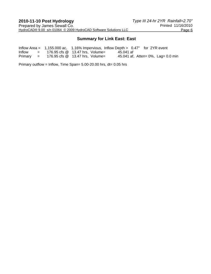
Type III 24-hr 2YR Rainfall=2.70"2010-11-10 Post Hydrology Printed 11/16/2010Prepared by James Sewall Co.
Page 6HydroCAD® 9.00 s/n 01064 © 2009 HydroCAD Software Solutions LLC
Summary for Link East: East
Inflow Area = 1,155.000 ac, 1.16% Impervious, Inflow Depth > 0.47" for 2YR eventInflow = 176.95 cfs @ 13.47 hrs, Volume= 45.041 afPrimary = 176.95 cfs @ 13.47 hrs, Volume= 45.041 af, Atten= 0%, Lag= 0.0 min
Primary outflow = Inflow, Time Span= 5.00-20.00 hrs, dt= 0.05 hrs

Type III 24-hr 2YR Rainfall=2.70"2010-11-10 Post Hydrology Printed 11/16/2010Prepared by James Sewall Co.
Page 7HydroCAD® 9.00 s/n 01064 © 2009 HydroCAD Software Solutions LLC
Summary for Link North: North
Inflow Area = 181.000 ac, 0.67% Impervious, Inflow Depth > 0.47" for 2YR eventInflow = 26.97 cfs @ 13.57 hrs, Volume= 7.034 afPrimary = 26.97 cfs @ 13.57 hrs, Volume= 7.034 af, Atten= 0%, Lag= 0.0 min
Primary outflow = Inflow, Time Span= 5.00-20.00 hrs, dt= 0.05 hrs

Type III 24-hr 2YR Rainfall=2.70"2010-11-10 Post Hydrology Printed 11/16/2010Prepared by James Sewall Co.
Page 8HydroCAD® 9.00 s/n 01064 © 2009 HydroCAD Software Solutions LLC
Summary for Link South: South
Inflow Area = 284.000 ac, 0.04% Impervious, Inflow Depth > 0.44" for 2YR eventInflow = 31.52 cfs @ 14.44 hrs, Volume= 10.513 afPrimary = 31.52 cfs @ 14.44 hrs, Volume= 10.513 af, Atten= 0%, Lag= 0.0 min
Primary outflow = Inflow, Time Span= 5.00-20.00 hrs, dt= 0.05 hrs

Type III 24-hr 2YR Rainfall=2.70"2010-11-10 Post Hydrology Printed 11/16/2010Prepared by James Sewall Co.
Page 9HydroCAD® 9.00 s/n 01064 © 2009 HydroCAD Software Solutions LLC
Summary for Link West: West
Inflow Area = 776.000 ac, 0.92% Impervious, Inflow Depth > 0.46" for 2YR eventInflow = 108.51 cfs @ 13.67 hrs, Volume= 29.952 afPrimary = 108.51 cfs @ 13.67 hrs, Volume= 29.952 af, Atten= 0%, Lag= 0.0 min
Primary outflow = Inflow, Time Span= 5.00-20.00 hrs, dt= 0.05 hrs

Type III 24-hr 10YR Rainfall=4.20"2010-11-10 Post Hydrology Printed 11/16/2010Prepared by James Sewall Co.
Page 10HydroCAD® 9.00 s/n 01064 © 2009 HydroCAD Software Solutions LLC
Summary for Subcatchment Graham: Graham Lake
Runoff = 330.51 cfs @ 13.57 hrs, Volume= 82.315 af, Depth> 1.27"
Runoff by SCS TR-20 method, UH=SCS, Time Span= 5.00-20.00 hrs, dt= 0.05 hrsType III 24-hr 10YR Rainfall=4.20"
Area (ac) CN Description768.830 70 Woods, Good, HSG C
7.170 98 Paved parking, HSG C776.000 70 Weighted Average768.830 99.08% Pervious Area
7.170 0.92% Impervious Area
Tc Length Slope Velocity Capacity Description(min) (feet) (ft/ft) (ft/sec) (cfs)56.3 150 0.0200 0.04 Sheet Flow,
Woods: Dense underbrush n= 0.800 P2= 2.70"24.7 1,788 0.0580 1.20 Shallow Concentrated Flow,
Woodland Kv= 5.0 fps11.8 460 0.0170 0.65 Shallow Concentrated Flow,
Woodland Kv= 5.0 fps17.8 736 0.0190 0.69 Shallow Concentrated Flow,
Woodland Kv= 5.0 fps110.6 3,134 Total

Type III 24-hr 10YR Rainfall=4.20"2010-11-10 Post Hydrology Printed 11/16/2010Prepared by James Sewall Co.
Page 11HydroCAD® 9.00 s/n 01064 © 2009 HydroCAD Software Solutions LLC
Summary for Subcatchment Narr: Narraguagus Lake
Runoff = 94.98 cfs @ 14.25 hrs, Volume= 29.151 af, Depth> 1.23"
Runoff by SCS TR-20 method, UH=SCS, Time Span= 5.00-20.00 hrs, dt= 0.05 hrsType III 24-hr 10YR Rainfall=4.20"
Area (ac) CN Description283.890 70 Woods, Good, HSG C
0.110 98 Paved parking, HSG C284.000 70 Weighted Average283.890 99.96% Pervious Area
0.110 0.04% Impervious Area
Tc Length Slope Velocity Capacity Description(min) (feet) (ft/ft) (ft/sec) (cfs)85.7 150 0.0070 0.03 Sheet Flow,
Woods: Dense underbrush n= 0.800 P2= 2.70"25.8 1,248 0.0260 0.81 Shallow Concentrated Flow,
Woodland Kv= 5.0 fps3.4 306 0.0460 1.50 Shallow Concentrated Flow,
Short Grass Pasture Kv= 7.0 fps43.4 2,637 0.0410 1.01 Shallow Concentrated Flow,
Woodland Kv= 5.0 fps158.3 4,341 Total

Type III 24-hr 10YR Rainfall=4.20"2010-11-10 Post Hydrology Printed 11/16/2010Prepared by James Sewall Co.
Page 12HydroCAD® 9.00 s/n 01064 © 2009 HydroCAD Software Solutions LLC
Summary for Subcatchment Narr R: Narraguagus River
Runoff = 542.19 cfs @ 13.38 hrs, Volume= 123.504 af, Depth> 1.28"
Runoff by SCS TR-20 method, UH=SCS, Time Span= 5.00-20.00 hrs, dt= 0.05 hrsType III 24-hr 10YR Rainfall=4.20"
Area (ac) CN Description1,141.620 70 Woods, Good, HSG C
13.380 98 Paved parking, HSG C1,155.000 70 Weighted Average1,141.620 98.84% Pervious Area
13.380 1.16% Impervious Area
Tc Length Slope Velocity Capacity Description(min) (feet) (ft/ft) (ft/sec) (cfs)66.9 150 0.0130 0.04 Sheet Flow,
Woods: Dense underbrush n= 0.800 P2= 2.70"29.7 1,594 0.0320 0.89 Shallow Concentrated Flow,
Woodland Kv= 5.0 fps96.6 1,744 Total

Type III 24-hr 10YR Rainfall=4.20"2010-11-10 Post Hydrology Printed 11/16/2010Prepared by James Sewall Co.
Page 13HydroCAD® 9.00 s/n 01064 © 2009 HydroCAD Software Solutions LLC
Summary for Subcatchment Spect: Spectacle Pond
Runoff = 82.74 cfs @ 13.42 hrs, Volume= 19.302 af, Depth> 1.28"
Runoff by SCS TR-20 method, UH=SCS, Time Span= 5.00-20.00 hrs, dt= 0.05 hrsType III 24-hr 10YR Rainfall=4.20"
Area (ac) CN Description179.790 70 Woods, Good, HSG C
1.210 98 Paved parking, HSG C181.000 70 Weighted Average179.790 99.33% Pervious Area
1.210 0.67% Impervious Area
Tc Length Slope Velocity Capacity Description(min) (feet) (ft/ft) (ft/sec) (cfs)38.1 150 0.0530 0.07 Sheet Flow,
Woods: Dense underbrush n= 0.800 P2= 2.70"0.2 42 0.0470 3.25 Shallow Concentrated Flow,
Grassed Waterway Kv= 15.0 fps0.3 235 0.0330 11.39 91.13 Trap/Vee/Rect Channel Flow,
Bot.W=0.00' D=2.00' Z= 2.0 '/' Top.W=8.00'n= 0.022 Earth, clean & straight
0.2 50 0.0100 5.26 6.46 Pipe Channel, 15.0" Round Area= 1.2 sf Perim= 3.9' r= 0.31'n= 0.013 Corrugated PE, smooth interior
32.3 150 0.0800 0.08 Sheet Flow, Woods: Dense underbrush n= 0.800 P2= 2.70"
30.3 1,930 0.0450 1.06 Shallow Concentrated Flow, Woodland Kv= 5.0 fps
101.4 2,557 Total

Type III 24-hr 10YR Rainfall=4.20"2010-11-10 Post Hydrology Printed 11/16/2010Prepared by James Sewall Co.
Page 14HydroCAD® 9.00 s/n 01064 © 2009 HydroCAD Software Solutions LLC
Summary for Link East: East
Inflow Area = 1,155.000 ac, 1.16% Impervious, Inflow Depth > 1.28" for 10YR eventInflow = 542.19 cfs @ 13.38 hrs, Volume= 123.504 afPrimary = 542.19 cfs @ 13.38 hrs, Volume= 123.504 af, Atten= 0%, Lag= 0.0 min
Primary outflow = Inflow, Time Span= 5.00-20.00 hrs, dt= 0.05 hrs

Type III 24-hr 10YR Rainfall=4.20"2010-11-10 Post Hydrology Printed 11/16/2010Prepared by James Sewall Co.
Page 15HydroCAD® 9.00 s/n 01064 © 2009 HydroCAD Software Solutions LLC
Summary for Link North: North
Inflow Area = 181.000 ac, 0.67% Impervious, Inflow Depth > 1.28" for 10YR eventInflow = 82.74 cfs @ 13.42 hrs, Volume= 19.302 afPrimary = 82.74 cfs @ 13.42 hrs, Volume= 19.302 af, Atten= 0%, Lag= 0.0 min
Primary outflow = Inflow, Time Span= 5.00-20.00 hrs, dt= 0.05 hrs

Type III 24-hr 10YR Rainfall=4.20"2010-11-10 Post Hydrology Printed 11/16/2010Prepared by James Sewall Co.
Page 16HydroCAD® 9.00 s/n 01064 © 2009 HydroCAD Software Solutions LLC
Summary for Link South: South
Inflow Area = 284.000 ac, 0.04% Impervious, Inflow Depth > 1.23" for 10YR eventInflow = 94.98 cfs @ 14.25 hrs, Volume= 29.151 afPrimary = 94.98 cfs @ 14.25 hrs, Volume= 29.151 af, Atten= 0%, Lag= 0.0 min
Primary outflow = Inflow, Time Span= 5.00-20.00 hrs, dt= 0.05 hrs

Type III 24-hr 10YR Rainfall=4.20"2010-11-10 Post Hydrology Printed 11/16/2010Prepared by James Sewall Co.
Page 17HydroCAD® 9.00 s/n 01064 © 2009 HydroCAD Software Solutions LLC
Summary for Link West: West
Inflow Area = 776.000 ac, 0.92% Impervious, Inflow Depth > 1.27" for 10YR eventInflow = 330.51 cfs @ 13.57 hrs, Volume= 82.315 afPrimary = 330.51 cfs @ 13.57 hrs, Volume= 82.315 af, Atten= 0%, Lag= 0.0 min
Primary outflow = Inflow, Time Span= 5.00-20.00 hrs, dt= 0.05 hrs

Type III 24-hr 25YR Rainfall=4.90"2010-11-10 Post Hydrology Printed 11/16/2010Prepared by James Sewall Co.
Page 18HydroCAD® 9.00 s/n 01064 © 2009 HydroCAD Software Solutions LLC
Summary for Subcatchment Graham: Graham Lake
Runoff = 453.61 cfs @ 13.52 hrs, Volume= 111.303 af, Depth> 1.72"
Runoff by SCS TR-20 method, UH=SCS, Time Span= 5.00-20.00 hrs, dt= 0.05 hrsType III 24-hr 25YR Rainfall=4.90"
Area (ac) CN Description768.830 70 Woods, Good, HSG C
7.170 98 Paved parking, HSG C776.000 70 Weighted Average768.830 99.08% Pervious Area
7.170 0.92% Impervious Area
Tc Length Slope Velocity Capacity Description(min) (feet) (ft/ft) (ft/sec) (cfs)56.3 150 0.0200 0.04 Sheet Flow,
Woods: Dense underbrush n= 0.800 P2= 2.70"24.7 1,788 0.0580 1.20 Shallow Concentrated Flow,
Woodland Kv= 5.0 fps11.8 460 0.0170 0.65 Shallow Concentrated Flow,
Woodland Kv= 5.0 fps17.8 736 0.0190 0.69 Shallow Concentrated Flow,
Woodland Kv= 5.0 fps110.6 3,134 Total

Type III 24-hr 25YR Rainfall=4.90"2010-11-10 Post Hydrology Printed 11/16/2010Prepared by James Sewall Co.
Page 19HydroCAD® 9.00 s/n 01064 © 2009 HydroCAD Software Solutions LLC
Summary for Subcatchment Narr: Narraguagus Lake
Runoff = 130.12 cfs @ 14.24 hrs, Volume= 39.500 af, Depth> 1.67"
Runoff by SCS TR-20 method, UH=SCS, Time Span= 5.00-20.00 hrs, dt= 0.05 hrsType III 24-hr 25YR Rainfall=4.90"
Area (ac) CN Description283.890 70 Woods, Good, HSG C
0.110 98 Paved parking, HSG C284.000 70 Weighted Average283.890 99.96% Pervious Area
0.110 0.04% Impervious Area
Tc Length Slope Velocity Capacity Description(min) (feet) (ft/ft) (ft/sec) (cfs)85.7 150 0.0070 0.03 Sheet Flow,
Woods: Dense underbrush n= 0.800 P2= 2.70"25.8 1,248 0.0260 0.81 Shallow Concentrated Flow,
Woodland Kv= 5.0 fps3.4 306 0.0460 1.50 Shallow Concentrated Flow,
Short Grass Pasture Kv= 7.0 fps43.4 2,637 0.0410 1.01 Shallow Concentrated Flow,
Woodland Kv= 5.0 fps158.3 4,341 Total

Type III 24-hr 25YR Rainfall=4.90"2010-11-10 Post Hydrology Printed 11/16/2010Prepared by James Sewall Co.
Page 20HydroCAD® 9.00 s/n 01064 © 2009 HydroCAD Software Solutions LLC
Summary for Subcatchment Narr R: Narraguagus River
Runoff = 742.39 cfs @ 13.35 hrs, Volume= 166.908 af, Depth> 1.73"
Runoff by SCS TR-20 method, UH=SCS, Time Span= 5.00-20.00 hrs, dt= 0.05 hrsType III 24-hr 25YR Rainfall=4.90"
Area (ac) CN Description1,141.620 70 Woods, Good, HSG C
13.380 98 Paved parking, HSG C1,155.000 70 Weighted Average1,141.620 98.84% Pervious Area
13.380 1.16% Impervious Area
Tc Length Slope Velocity Capacity Description(min) (feet) (ft/ft) (ft/sec) (cfs)66.9 150 0.0130 0.04 Sheet Flow,
Woods: Dense underbrush n= 0.800 P2= 2.70"29.7 1,594 0.0320 0.89 Shallow Concentrated Flow,
Woodland Kv= 5.0 fps96.6 1,744 Total

Type III 24-hr 25YR Rainfall=4.90"2010-11-10 Post Hydrology Printed 11/16/2010Prepared by James Sewall Co.
Page 21HydroCAD® 9.00 s/n 01064 © 2009 HydroCAD Software Solutions LLC
Summary for Subcatchment Spect: Spectacle Pond
Runoff = 113.53 cfs @ 13.41 hrs, Volume= 26.091 af, Depth> 1.73"
Runoff by SCS TR-20 method, UH=SCS, Time Span= 5.00-20.00 hrs, dt= 0.05 hrsType III 24-hr 25YR Rainfall=4.90"
Area (ac) CN Description179.790 70 Woods, Good, HSG C
1.210 98 Paved parking, HSG C181.000 70 Weighted Average179.790 99.33% Pervious Area
1.210 0.67% Impervious Area
Tc Length Slope Velocity Capacity Description(min) (feet) (ft/ft) (ft/sec) (cfs)38.1 150 0.0530 0.07 Sheet Flow,
Woods: Dense underbrush n= 0.800 P2= 2.70"0.2 42 0.0470 3.25 Shallow Concentrated Flow,
Grassed Waterway Kv= 15.0 fps0.3 235 0.0330 11.39 91.13 Trap/Vee/Rect Channel Flow,
Bot.W=0.00' D=2.00' Z= 2.0 '/' Top.W=8.00'n= 0.022 Earth, clean & straight
0.2 50 0.0100 5.26 6.46 Pipe Channel, 15.0" Round Area= 1.2 sf Perim= 3.9' r= 0.31'n= 0.013 Corrugated PE, smooth interior
32.3 150 0.0800 0.08 Sheet Flow, Woods: Dense underbrush n= 0.800 P2= 2.70"
30.3 1,930 0.0450 1.06 Shallow Concentrated Flow, Woodland Kv= 5.0 fps
101.4 2,557 Total

Type III 24-hr 25YR Rainfall=4.90"2010-11-10 Post Hydrology Printed 11/16/2010Prepared by James Sewall Co.
Page 22HydroCAD® 9.00 s/n 01064 © 2009 HydroCAD Software Solutions LLC
Summary for Link East: East
Inflow Area = 1,155.000 ac, 1.16% Impervious, Inflow Depth > 1.73" for 25YR eventInflow = 742.39 cfs @ 13.35 hrs, Volume= 166.908 afPrimary = 742.39 cfs @ 13.35 hrs, Volume= 166.908 af, Atten= 0%, Lag= 0.0 min
Primary outflow = Inflow, Time Span= 5.00-20.00 hrs, dt= 0.05 hrs

Type III 24-hr 25YR Rainfall=4.90"2010-11-10 Post Hydrology Printed 11/16/2010Prepared by James Sewall Co.
Page 23HydroCAD® 9.00 s/n 01064 © 2009 HydroCAD Software Solutions LLC
Summary for Link North: North
Inflow Area = 181.000 ac, 0.67% Impervious, Inflow Depth > 1.73" for 25YR eventInflow = 113.53 cfs @ 13.41 hrs, Volume= 26.091 afPrimary = 113.53 cfs @ 13.41 hrs, Volume= 26.091 af, Atten= 0%, Lag= 0.0 min
Primary outflow = Inflow, Time Span= 5.00-20.00 hrs, dt= 0.05 hrs

Type III 24-hr 25YR Rainfall=4.90"2010-11-10 Post Hydrology Printed 11/16/2010Prepared by James Sewall Co.
Page 24HydroCAD® 9.00 s/n 01064 © 2009 HydroCAD Software Solutions LLC
Summary for Link South: South
Inflow Area = 284.000 ac, 0.04% Impervious, Inflow Depth > 1.67" for 25YR eventInflow = 130.12 cfs @ 14.24 hrs, Volume= 39.500 afPrimary = 130.12 cfs @ 14.24 hrs, Volume= 39.500 af, Atten= 0%, Lag= 0.0 min
Primary outflow = Inflow, Time Span= 5.00-20.00 hrs, dt= 0.05 hrs

Type III 24-hr 25YR Rainfall=4.90"2010-11-10 Post Hydrology Printed 11/16/2010Prepared by James Sewall Co.
Page 25HydroCAD® 9.00 s/n 01064 © 2009 HydroCAD Software Solutions LLC
Summary for Link West: West
Inflow Area = 776.000 ac, 0.92% Impervious, Inflow Depth > 1.72" for 25YR eventInflow = 453.61 cfs @ 13.52 hrs, Volume= 111.303 afPrimary = 453.61 cfs @ 13.52 hrs, Volume= 111.303 af, Atten= 0%, Lag= 0.0 min
Primary outflow = Inflow, Time Span= 5.00-20.00 hrs, dt= 0.05 hrs