EV OF EN - index html — Fina EV CO FO Caro Meh Oct COL APP ort No. CD l Report ALUA MMIT R USE...
117
Rep Fina EV CO FO Caro Meh Oct COL APP ort No. CD al Report VALUA OMMIT OR USE oline M. C hmet E. Oz tober 201 LORADO PLIED RE DOT-2011 ATION TMENT E AT CD Clevenger zbek 11 O DEPART ESEARCH 1-13 OF EN T TRA DOT TMENT O H AND INN NVIRO CKING OF TRANS NOVATIO NMEN G SYST SPORTAT ON BRAN NTAL TEMS TION NCH
Transcript of EV OF EN - index html — Fina EV CO FO Caro Meh Oct COL APP ort No. CD l Report ALUA MMIT R USE...
RepFina
EVCOFO CaroMeh Oct COLAPP
ort No. CDal Report
VALUAOMMITOR USE
oline M. Chmet E. Oz
tober 201
LORADOPLIED RE
DOT-2011
ATION TMENTE AT CD
Clevenger zbek
11
O DEPARTESEARCH
1-13
OF ENT TRADOT
TMENT OH AND INN
NVIROCKING
OF TRANSNOVATIO
NMENG SYST
SPORTATON BRAN
NTAL TEMS
TION NCH

The contents of this report reflect the views of the
authors, who are responsible for the facts and
accuracy of the data presented herein. The contents
do not necessarily reflect the official views of the
Colorado Department of Transportation or the
Federal Highway Administration. This report does
not constitute a standard, specification, or regulation.

Technical Report Documentation Page 1. Report No. CDOT-2011-13
2. Government Accession No. 3. Recipient's Catalog No.
4. Title and Subtitle EVALUATION OF ENVIRONMENTAL COMMITMENT TRACKING SYSTEMS FOR USE AT CDOT
5. Report Date October 2011
6. Performing Organization Code
7. Author(s) Caroline M. Clevenger, P.h.D. and Mehmet E. Ozbek, P.h.D.
8. Performing Organization Report No. CDOT-2011-13
9. Performing Organization Name and Address Colorado State University Department of Construction Management Guggenheim Hall (1584) Fort Collins, CO, 80523
10. Work Unit No. (TRAIS) 11. Contract or Grant No. 33.10
12. Sponsoring Agency Name and Address Colorado Department of Transportation - Research 4201 E. Arkansas Ave. Denver, CO 80222
13. Type of Report and Period Covered Final, 9/22/10 – 9/30/11
14. Sponsoring Agency Code
15. Supplementary Notes Prepared in cooperation with the US Department of Transportation, Federal Highway Administration 16. Abstract: The purpose of this study is to review existing Environmental Tracking Systems (ETSs) used by other, select state Departments of Transportation (DOTs), as well as the existing Environmental Commitment Tracking System (ECTS) currently in use by Colorado Department of Transportation (CDOT) in an effort to determine which system would be the most beneficial for long-term implementation at CDOT. Implementation: Based on the quantitative evaluation assessing how well other state ETSs’ features correlate to CDOT’s preferences, this study recommends that CDOT adopt FDOT’s existing ETS for long-term implementation. Findings based on the Analytical Hierarchy Process (AHP) analysis performed comparing CDOT’s existing ECTS to eight other state DOT’s ETSs, show that FDOT’s existing ETS supports the highest number (93%) of CDOT’s weighted preferences, while CDOT’s existing ECTS supports only 35%. Secondary implementation recommendations are to have a number of CDOT end users familiar with CDOT’s ECTS test candidate ETSs for ease of use and user satisfaction, and that additional first cost and operational cost information be secured and analyzed to assist in making a final decision on which system to adopt. If CDOT elects to implement this second recommendation to further examine additional metrics prior to making a final decision, VDOT’s and TxDOT’s ETSs are the systems which currently provide the second (90%) and third highest (85%) number of desired features respectively. 17. Keywords: Analytical Hierarchy Process (AHP), Environmental Tracking Systems (ETSs), Environmental Commitment Tracking System (ECTS)
18. Distribution Statement No restrictions. This document is available to the public through the National Technical Information Service www.ntis.gov or CDOT’s Research website http://www.coloradodot.info/programs/research/pdfs
19. Security Classif. (of this report) Unclassified
20. Security Classif. (of this page) Unclassified
21. No. of Pages 115
22. Price
Form DOT F 1700.7 (8-72) Reproduction of completed page authorized

EVALUATION OF ENVIRONMENTAL
COMMITMENT TRACKING SYSTEMS FOR USE AT CDOT
Report No. CDOT-2011-13
Prepared by:
Caroline M. Clevenger, Ph.D. Assistant Professor
and
Mehmet E. Ozbek, Ph.D.
Assistant Professor and Graduate Program Coordinator
Colorado State University Department of Construction Management
Guggenheim Hall (1584) Fort Collins, CO, 80523
Sponsored by the Colorado Department of Transportation
In Cooperation with the U.S. Department of Transportation Federal Highway Administration
October 2011
Colorado Department of Transportation
DTD Applied Research and Innovation Branch 4201 E. Arkansas Avenue
Denver, CO 80222

ii
ACKNOWLEDGEMENTS
The research work described in this report has been funded by CDOT under Study No:
33.10, “The Evaluation of Environmental Commitment Tracking Programs for Use at the
Colorado Department of Transportation (CDOT).” The opinions and findings are those of the
authors and do not necessarily represent the views of CDOT. Authors would like to thank the
Study Panel members, Chuck Attardo, R1 Planning & Environmental, Janet Gerak, R1 Planning
& Environmental, Stephanie Gibson, FHWA, Mark Gosselin, R4 Engineering, Yates
Oppermann, HQ Environmental, David Singer, R6 Planning & Environmental, and interview
participants for their invaluable suggestions and contributions to this research. In addition, we
would like to thank the study managers, Vanessa Henderson and Roberto DeDios for their
support and guidance during the research. Finally, we would like to thank Andrew Fillion, a
graduate research assistant in Construction Management at Colorado State University for all of
his hard work executing various research tasks. His contributions were recognized by an award
from the National Association of Environmental Professionals for his work on this study.

iii
GLOSSARY OF ACRONYMS
AASHTO: American Association of State Highway and Transportation Officials
AHP: Analytic Hierarchy Process
ARTBA: American Road and Transportation Builders Association
C.R.: Consistency Ratio (as defined in AHP)
CalTrans: California Department of Transportation
CAP: Communicating All Promises tracking tool
CAT X: Categorical Exclusions
CDOT: Colorado Department of Transportation
CE: Categorical Exclusion
CEDAR: Comprehensive Environmental Data and Reporting
CEQ: Council on Environmental Quality
COTS: Commercial Off-The-Shelf software
CTS: Commitment Tracking System
DCEC: District Construction Environmental Coordinator
DOTs: Departments of Transportation
DTSD: Division of Transportation System Development
EA: Environmental Assessment
ECOPAC: Environmental Commitments & Obligations Package for Construction
ECTS: Environmental Commitment Tracking System (used to specifically refer to the
environmental tracking system currently in use by CDOT)
EIS: Environmental Impact Statement
EPA: Environmental Protection Agency
ETS: Environmental Tracking System
FDOT: Florida Department of Transportation
FHWA: U.S. Department of Transportation Federal Highway Administration
FLH: Federal Lands Highways
GOTS: Government Off-The-Shelf software
KYTC: Kentucky Transportation Cabinet
LDCA: Local Design and Concept Acceptance

iv
NEPA: National Environmental Policy Act
NYSDOT: New York State Department of Transportation
OIS: Office of Information Systems
OSS: Open Source Software
PD&E: Project Development & Environmental
PEL: Planning and Environment Linkages
PL&EM: District 4 Planning and Environmental Management
Precon: Oracle Preconstruction database
PS&E: Plans, Specifications, and Estimates
PSS: Program Support System
QAR: Quality Assurance Review
SEMS: Statewide Environmental Management System
STEVE: Standard Tracking and Exchange Vehicle for Environmental
TDOT: Tennessee Department of Transportation
TxDOT: Texas Department of Transportation
USACE: U.S Army Corps of Engineers
USFWS: U.S. Fish and Wildlife Service
VDOT: Virginia Department of Transportation
WisDOT: Wisconsin Department of Transportation
WSDOT: Washington State Department of Transportation
v
EXECUTIVE SUMMARY
The purpose of this study is to review existing Environmental Tracking Systems (ETSs)
used by other select state Departments of Transportation (DOTs), as well as the existing
Environmental Commitment Tracking System (ECTS) currently in use by Colorado Department
of Transportation (CDOT) in an effort to determine which system would be the most beneficial
for long-term implementation at CDOT. The findings of this study identify the system that best
meets CDOT’s needs for an ECTS with the ultimate purpose of adopting such a system.
ETSs are used by state DOTs as well as by Federal agencies to track environmental
commitments on construction projects from the project development stage through design,
construction, and project completion. The U.S. Department of Transportation Federal Highway
Administration (FHWA) and CDOT recently completed a Quality Assurance Review (QAR) of
CDOT’s Local Agency program. Several local agency projects failed to be able to demonstrate
whether environmental commitments had been completed, highlighting CDOT’s need for an
effective ETS.
Six research tasks are performed to evaluate existing ETSs from eight state DOTs as well
as CDOT’s existing ECTS. These are: (i) conduct interviews to get a better understanding of the
features that CDOT prefers to have in an ECTS, (ii) develop metrics based on the ECTS
currently used by CDOT to evaluate ETSs used by other state DOTs with respect to those
features, (iii) assign weights to those metrics to establish the importance of each feature (iv)
perform a qualitative evaluation of CDOT’s ECTS and other existing ETSs, (v) perform a
quantitative evaluation of CDOT’s ECTS and other existing ETSs, and (vi) perform a cost-
benefit analysis.
The study successfully completed all tasks. However, the data collected to perform the
cost benefit analysis was incomplete and inconsistent. In short, after concerted effort, the data

vi
available was insufficient to support a meaningful cost analysis. As a result, research task (vi) to
perform a cost-benefit analysis is not discussed in the final report. Cost data gathered for the
research is presented in Appendix F.
Based on the completion of the research tasks, the study finds that FDOT’s ETS achieves
the highest rating by providing the features most correlated with CDOT’s preferences. It
provides 16 of CDOT’s 18 desired features while supporting 93% of CDOT’s (weighted)
preferences. VDOT’s ETS achieves the second highest ranking, providing 14 features and
supporting almost 90% of CDOT’s weighted preferences. TxDOT’s ETS is third, also providing
14 features while supporting almost 85% of CDOT’s weighted preferences.
Implementation Statement
Based on the information available, the study finds that FDOT’s ETSs provides the most
desired features in support CDOT’s preferences for its ECTS and, therefore, recommends that
FDOT’s ETS be selected for long-term implementation at CDOT. Evaluating cost benefits, ease
of use, and stakeholder satisfaction fell beyond the scope of the study and are not considered in
this recommendation. Secondary recommendations from this study are to have a number of
CDOT end users familiar with CDOT’s ECTS test candidate ETSs for ease of use and user
satisfaction, and that additional first cost and operational cost information be secured and
analyzed to assist in making a final decision on which system to adopt. If CDOT elects to further
examine these additional metrics, VDOT’s and TxDOT’s are other ETSs which also rank highly
in providing the most desire features, and should be considered in further analysis.
Finally, the quantitative research methods presented in this paper can be used not only by
CDOT to assist them in selecting an ETS for long-term implementation, but also by other state
DOTs to identify and evaluate the extent to which an ETS(s) meets the DOT’s identified
preferences for such a system.
vii
TABLE OF CONTENTS
CHAPTER 1: INTRODUCTION ................................................................................................... 1
1.1 Background on Environmental Commitments.......................................................................... 1
1.2 The Federal Agencies’ Role in the NEPA Process ................................................................... 3
1.3 Overview of Environmental Commitment Tracking Systems .................................................. 4
1.4 Current Status............................................................................................................................ 4
1.5 Problem Statement .................................................................................................................... 5
1.6 Study Objective ......................................................................................................................... 5
1.7 Scope ......................................................................................................................................... 6
CHAPTER 2: LITERATURE REVIEW ........................................................................................ 7
2.1 Studies on Environmental Commitment Tracking Systems ..................................................... 7
2.1.1 WisDOT Study............................................................................................................... 7
2.1.2 ICF Study ....................................................................................................................... 8
2.1.3 FHWA Scan Tour…….……………………………………………..………………..…....…11
2.2 State DOT’s ETSs Carried Forward……………………………..…………………………..….…12
CHAPTER 3: METHODOLOGY ................................................................................................ 14
3.1 Step 1 - Conducting Interviews ............................................................................................... 14
3.2 Step 2 - Developing Metrics ................................................................................................... 16
3.3 Step 3 – Assigning Weights to Metrics................................................................................... 17
3.4 Step 4 - Qualitative Evaluation of Other States’ ETSs ........................................................... 18
3.5 Step 5 – Quantitative Evaluation of Other States’ ETSs ........................................................ 19
3.6 Step 6 – Cost Benefit Analysis of Other States’ ETSs ........................................................... 20
CHAPTER 4: FINDINGS............................................................................................................. 21
4.1 Conducting Interviews and Developing Metrics .................................................................... 21
4.2 Assigning Weights to Metrics ................................................................................................. 26
4.2.1 CDOT’s Existing Tracking System ............................................................................ 28
4.3 Qualitative Evaluation of Other States’ ETSs ........................................................................ 31
4.3.1 California Department of Transportation CalTrans).……………...……………….…31
viii
4.3.2 Florida DOT (FDOT)...…………………………………………………………….…33
4.3.3 Kentucky Transportation Cabinet (KYTC)……………...……………….…….….…..36
4.3.4 New York State Department of Transportation (NYSDOT)…………………….…...38
4.3.5 Tennessee Department of Transportation (TDOT)…………………………………...40
4.3.6 Texas Department of Transportation (TxDOT)……………………………………....42
4.3.7 Virginia Department of Transportation (VDOT)…………………………………..…43
4.3.8 Washington State Department of Transportation (WSDOT)…………………………45
4.4 Quantitative Evaluation of Other States’ ETSs ...................................................................... 48
4.5 Cost Benefit Analysis of Other States’ ETSs ......................................................................... 50
CHAPTER 5: CONCLUSIONS ................................................................................................... 51
5.1 Summary of the Study ............................................................................................................ 51
5.2 Recommendations and Conclusions ....................................................................................... 53
REFERENCES ............................................................................................................................. 57
APPENDIX A: PARTICIPANT RECRUITMENT LETTER ..................................................... 62
APPENDIX B: INTERVIEW QUESTIONS................................................................................ 63
APPENDIX C: ANALYTICAL HIERARCHY PROCESS ........................................................ 65
Consistency Ratio calculated for CDOT pairwise comparison results. ............................... 71
APPENDIX D: CONTACT INFORMATION FOR STATE DOT REPRESENTATIVES ........ 73
APPENDIX E: STATE DOT RECRUITMENT EMAIL ............................................................ 74
APPENDIX F: ETS COST DATA PROVIDED………………………………………………...75
APPENDIX G: PAIRWISE COMPARISON SURVEY .............................................................. 77

1
CHAPTER 1: INTRODUCTION
Environmental commitments are actions that are intended to avoid, minimize, or mitigate
environmental impacts on a construction project (American Association of State Highway and
Transportation Officials (AASHTO, 2006). Tracking environmental commitments on
construction projects can be a challenge for State Departments of Transportation (DOTs) and
Federal agencies. The implementation of an effective Environmental Commitment Tracking
System, (ECTS) or Environmental Tracking System (ETS), can provide the means necessary to
document and demonstrate to all stakeholders that such commitments have been or are being
met. From the time a project is in the development phase to the time it has been constructed, state
and Federal laws require commitments to be met as a basis for receiving project approval and
funding (AASHTO, 2006). Furthermore, the successful tracking of commitments on projects is
necessary for the execution of a successful environmental management strategy. In order to
maintain the public trust, DOTs and Federal agencies require reliable commitment tracking
systems (Venner, Allen et al. 2007). This chapter provides the introduction to CDOT’s need as
addressed by this study as well as the objectives and scope of this study.
1.1 Background on Environmental Commitments
The majority of environmental commitments come from the National Environmental
Policy Act (NEPA) process. Additional environmental commitments come from permit
requirements, or studies such as feasibility or planning and environment linkages (PEL). NEPA
was developed in 1969 and signed into law on January 1, 1970 (NEPA, 42 United States Code
[USC] § 4321 – 4347). NEPA requires that federal agencies use a systematic, interdisciplinary
approach to decision-making when actions may affect the quality of the human environment. The
Council on Environmental Quality (CEQ) regulations establish requirements to be followed for
any project that is “financed, assisted, conducted, or approved by a federal agency” (Federal
nexus). Under Federal law, NEPA applies to any proposed action or transportation project that
has a federal nexus, including but not limited to instances where:

2
Federal funds or assistance will be used at some phase of project development
Federal funding or assistance eligibility must be maintained
Federal permits or approvals are required
There will be new or revised access to the interstate system, which requires FHWA
approval
To account for the variability of project impacts, there are three basic “classes of action”
that prescribe the level of documentation required in the NEPA process:
Class I – Environmental Impact Statement (EIS)
Class II – Categorical Exclusion (CE)
Class III – Environmental Assessment (EA)
The class of action determines how compliance with NEPA is carried out and
documented. An EIS is prepared when a proposed action may significantly affect the quality of
the human environment. The purpose of an EIS is to “serve as an action-forcing device to
[ensure] that the policies and goals defined in the National Environmental Policy Act (NEPA)
are infused into the on-going programs and actions of the federal government” (CEQ 40 Code of
Federal Regulations [CFR] § 1502.1).
CEs are the most common NEPA documents and are actions that do not individually or
cumulatively have a significant environmental impact and are excluded from the requirement to
prepare an EA or an EIS. CE projects require no major Federal action and have impacts that are
generally well-understood. Classifying a project as a CE does not exempt it from other Federal
or state environmental requirements.

3
An EA is prepared for an action where the significance of impacts is uncertain. It may
also be prepared for projects that do not fit the CE categories and is not expected to require the
preparation of an EIS, or where the agency believes an EA would assist in determining the need
for an EIS (23 CFR § 771.119). The EA should concentrate attention on environmental
resources with impacts that may be significant or that could be a discerning factor in alternative
selection. If during the EA it is determined by the Federal agency that the proposed undertaking
may significantly affect the environment, than an EIS is prepared.
1.2 The Federal Agencies’ Role in the NEPA Process
The role that a Federal agency takes during the NEPA process is based on the Federal
agency’s expertise and relationship to the proposed undertaking. While there may be more than
one Federal agency involved in an undertaking, one will be designated as the lead agency and
will supervise the preparation of the environmental documentation. If there is a state, tribal,
local, or another Federal agency which has special expertise in regards to the environmental
issue or jurisdiction, they may act as a joint lead agency or as a cooperating agency with the
Federal agency in the NEPA process. As a cooperating agency, they assist the lead agency at the
earliest possible time in the NEPA process. This is done through assisting in the scoping process,
developing information and preparing environmental documentation in the cooperating agency’s
area of expertise, and providing additional staff support to assist the lead Federal agency, United
States Environmental Protection Agency (EPA) 2010.
Though the majority of environmental commitments are a result of the NEPA process,
environmental commitments can arise from various documents and at various stages in the
environmental review process. Example sources include those agencies cooperating in the
environmental review process such as state environmental agencies, the U.S Army Corps of
Engineers (USACE), local agencies, and the U.S. Fish and Wildlife Service, (USFWS)
(AASHTO, 2006). These agencies will often issue permits or statements which contain the
commitments that must be met as part of receiving project approval.

4
1.3 Overview of Environmental Commitment Tracking Systems
ETSs are used by state DOTs as well as by Federal agencies to track environmental
commitments on construction projects from the project development stage through design,
construction, and ultimately to project completion (Washington State Department of
Transportation, 2010). An ETS’s purpose is to provide those responsible for carrying out the
commitments with a means for tracking the status of the commitments as well as a framework to
maintain the necessary information tied to that commitment. This can include permits, locations,
and the ways and means to be used for carrying out the commitment.
Equally important is the accountability that a tracking system can provide. Having the
ability to provide documentation when requested which shows a commitment has been met is
another goal of an ETS. This can be done through creating a report that documents the date it
was completed and the responsible party who signed off on its completion (Venner, Allen et al.
2007).
1.4 Current Status
Given that the Federal government does not have a standard ETS, many state DOTs and
Federal agencies currently have many different methods for tracking environmental
commitments ranging from paper based tracking systems in the form of lists and spreadsheets to
specialized databases and web based systems. CDOT currently uses a Microsoft Excel
spreadsheet for its ECTS. Not part of a server or web based system, the spreadsheet exists as a
single hard copy throughout the life of a project. The Texas Department of Transportation
(TXDOT), Washington State Department of Transportation (WSDOT), and Florida Department
of Transportation (FDOT) are among the states which have web or server based systems in
varying degrees of functionality (Systematics, Brinckerhoff et al., 2006).

5
1.5 Problem Statement
The Federal Highway Administration (FHWA) and CDOT recently completed a Quality
Assurance Review (QAR) of CDOT’s Local Agency program. The QAR recommended
development of a standardized environmental commitment tracking process. Such a process was
deemed necessary after several local agency projects failed to be able to demonstrate whether
environmental commitments had been completed. While many times initial problems could be
identified, the need to be able to track environmental commitments for all CDOT projects
emerged as a serious concern. CDOT’s Environmental Advisory Committee (EAC) is currently
looking at identifying and implementing a long-term statewide environmental commitment
tracking system for CDOT. The EAC has been able to identify the basic components and needs
for the commitment tracking system and is pursuing an interim solution using basic spreadsheets.
However, they recognize that other systems exist that may provide more effective and efficient
means of commitment tracking. To further refine what should be pursued by CDOT, an
investigation and evaluation of existing tracking mechanisms used in Colorado and other states is
needed.
1.6 Study Objective
The purpose of this study is to review CDOT’s current ECTS as well as existing ETSs
used by other select state DOTs in an effort to determine which system would be the most
beneficial for long-term implementation at CDOT and thus to be pursued by CDOT. The
findings of this study will allow CDOT to identify the system(s) that best meets its needs with
the ultimate purpose of adopting that system.
As will be discussed in detail in Chapter 3, this study will identify and prioritize the
features that CDOT prefers to have in its ETS and evaluate existing ETSs used by other state
DOTs with respect to those features to be able to provide a final recommendation as to which

6
ETS should be adopted by CDOT. This study will also include a limited cost benefit analysis of
the ETSs evaluated.
1.7 Scope
As per the requirement in the Request for Proposals (RFP), the ETSs to be reviewed for
this study are the ones identified in the list of documents provided in the RFP. The final
determination of state ETSs evaluated resulted from the literature review built on the provided
list. California, Colorado, Florida, Kentucky, New York, Tennessee, Texas, Virginia, and
Washington are the states with ETSs that are evaluated in this study.

7
CHAPTER 2: LITERATURE REVIEW
In 2006, AASHTO developed a practitioner’s handbook for tracking environmental
commitments. This handbook highlights the importance of having established procedures for
communicating and tracking environmental commitments on complex projects. Complying with
environmental commitments is a legal requirement and the consequences of non-compliance can
be severe. Penalties for failing to implement commitments made during the NEPA process or for
violating permit conditions include losing Federal funding on projects, work stoppages, or
litigation. Such penalties can cause long-term damage to relationships with resource agencies
(AASHTO, 2006). Therefore, state DOTs need to utilize effective ETSs. This chapter provides
the findings of the literature review on ETSs.
2.1 Studies on Environmental Commitment Tracking Systems
The goal of an ETS is to track commitments from their inception (usually in project
development) to their completion. This can include tracking through the design and construction
phases and continue to the long term maintenance if required. The key components of an ETS
are (i) knowing exactly what the department is committed to doing, (ii) ensuring it gets
completed, (iii) documenting it was completed, and (iv) identifying ways to improve fulfilling
like commitments in the future (WSDOT, 2008). The following three sections discuss three
separate studies that investigated the ETSs implemented by different states.
2.1.1 WisDOT Study
In 2008, The Division of Transportation System Development (DTSD) within the
Wisconsin Department of Transportation (WisDOT) performed a study to locate states which
have developed successful tracking mechanisms to ensure that departments within their
organization communicated and that commitments remained linked to projects throughout their
life. Study findings were that some states were using forms and lists while others states such as

8
Illinois, Montana, New York, and Washington State had developed specialized databases to track
commitments (CTC & Associates LLC, 2008).
2.1.2 ICF Study
In 2006, a study was done by the independent consulting firm, ICF Consulting. The study
was conducted to benchmark six state DOTs’ ETSs. While numerous paper-based commitment
programs exist, this study was confined to state DOT’s using electronic systems. The objective
of the study was to provide the Federal Lands Highways (FLH) with an inventory of what was
available in terms of electronic tracking systems. Kentucky, Illinois, Maryland, New York,
Texas, and Washington were evaluated based on each state’s system’s features. These features
include reporting, filtering, and project management functions. The study identified the Texas
Department of Transportation (TxDOT) and the WSDOT as the lead states with active, web
based environmental commitment tracking systems (Venner, Allen et al. 2007).
The ICF report lists essential features of a centralized commitment tracking system. These
include (ICF Consulting, 2006):
Permit Tracking – Keeping track of permits, ensuring they are obtained and their
obligations are met.
Viewing Commitments and Permits – Ability to retrieve and update the details of
commitments and permits as wells as sort and filter by project name, expiration date, and
the party responsible for carrying out the commitment.
Configure Notifications and Alerts – Automatically generated emails to the appropriate
parties regarding deadlines, required activities, and changes to permits and commitments.
Document Management – Ability to store electronic copies of permits, contracts, and
other Microsoft Word and Adobe PDF documents.

9
Reporting – Ability to collect comprehensive data based on specified criteria and create
annual and ad-hoc reports for both internal use and those required by outside regulatory
agencies.
Performance Measurement – Facilitation of tracking environmental performance and
measurement of progress toward performance according to success criteria.
User Administration and Security – Provide access to partner agencies, construction
staff, and project staff in the field. Ability to change responsible party for commitments
when there is employee turnover and allow for multiple people to add new commitments.
The report also included commitment tracking in its list of essential features. For the
purpose of this research study commitment tracking is excluded as a desired ETS feature since it
is the overall objective of the framework and every ETS studied will have this capability.
As part of the 2006 study, ICF Consulting provided FLH with a report on
recommendations for what type of technology should be used to implement their ETS. The four
types of technology explored were custom software, open source software (OSS), a government
off-the-shelf (GOTS) system, and a commercial off-the-shelf (COTS) system. The four main
criteria used to measure the software options were feature sets, cost, flexibility, and the time it
would take to implement the software (ICF Consulting, 2006).
A custom software system would provide FLH with the flexibility of creating a system to
meet their requirements, modified to their own specifications. However, starting from a blank
slate and not making use of other systems’ existing features made this the most expensive option
with long implementation times and concerns regarding the customer support available (ICF
Consulting, 2006).

10
The OSS system would take advantage of existing systems’ features in the marketplace.
Existing features would serve as the foundation in the development of an ETS to meet FLH’s
needs, allowing for a much shorter implementation time. However, despite being less expensive
than the custom system, the OSS system is still expensive. Other cons include features being
limited to what is available; and similar to the custom software, there are concerns regarding the
customer support for these systems (ICF Consulting, 2006).
The GOTS system evaluated in this study was WSDOT’s web-based system. Utilizing
this previously developed system allows for a short implementation time and benefits from the
best practices developed by WSDOT. The cons of a GOTS system is that it only provides FLH
with a minimal set of the desired capabilities, and the necessary modifications would be
expensive. Similar to other non-commercial systems, customer support for this type of system
may be limited (ICF Consulting, 2006).
The fourth system analyzed, a COTS system, turned out to be the approach recommended
by the study. The study analyzed two commercially available systems which were both
continually revised and updated to meet the changing needs of environmental programs, and had
the capability to provide the feature set that met all of FLH’s requirements. Since both systems
had the majority of desired features built-in, a short implementation time could be achieved with
only minor modifications and configuring. The costs of both COTS systems were comparable to
the other systems; because they were commercial products, technical support would be provided
by the vendors. The cost for ongoing annual maintenance by the vendor was the main con, but
was not a sufficient deterrent. The report concluded by recommending that FLH pursue
implementation of a COTS system available from Intelex Technologies, Inc. (ICF Consulting,
2006).

11
2.1.3 FHWA Scan Tour
In 2002 the U.S. Federal Highway Administration (FHWA) sponsored a Domestic Scan
Tour on Environmental Commitment Implementation. The purpose of the scan tour was to
identify successful practices and procedures to ensure the follow through of commitments made
both during and after the NEPA process. The scan tour team consisted of members from Federal
and state departments as well as from other outside offices. Included in the scan tour were
representatives from the FHWA Headquarters Office of Project Development and Environmental
Review, FHWA Division Offices, state DOTs, the U.S. EPA, the U.S. DOT Volpe National
Transportation Systems Center, AASHTO, and the American Road and Transportation Builders
Association (ARTBA) (FHWA, 2002).
The ultimate objective of the study was to assist states, FHWA Divisions, environmental
resource agencies, and the private sector in successfully complying with environmental
commitments throughout the entire transportation design, development, and construction
processes (FHWA, 2002). The research team visited Colorado, Indiana, Kentucky, New Jersey,
New York, Texas, and Wyoming DOTs to review successful processes, procedures, and
methodologies used to fulfill environmental commitments. The team found a wide range of
programs and systems were being used, some more sophisticated than others. All of the states
reviewed, however, were dedicated to ensuring the successful implementation of environmental
commitments. During the scan tour, the team observed that to achieve success, implementation
must be a part of the transportation project development process. In addition, they observed that
communication throughout the entire process from planning to construction through maintenance
was essential because it supported an overall understanding of the commitments and permit
agreements (FHWA, 2002). Finally, the strategies collected during the domestic scan tour
provide a wide range of potential process improvements for tracking systems including
employing environmental coordinators, offering 3-day NEPA trainings, developing pocket
guides on environmental compliance issues, implementing a “Communicating All Promises”
(CAP) approach, developing of a Cultural Historic Preservation List, creating a public
involvement office and website, to name a few (FHWA, 2002).

12
2.2 State DOT’s ETSs Carried Forward
Based on the literature review performed and recommendations made directly to the
research team, we elected to carry the eight State DOT’s ETS forward in addition to CDOT’s
existing ECTS for evaluation and comparison. The States carried forward are listed here along
with their supporting references.
California (CTC & Associates LLC, 2008; Cambridge Systematics, 2006; Recommendation by Study Panel members)
Florida (Cambridge Systematics, 2006; Email correspondence between Stephanie Gibson and FDOT’s past District 4 NEPA Coordinator)
Kentucky (Venner Consulting, 2009; CTC & Associates LLC, 2008;ICF Consulting, 2006a; FHWA, 2002; CDOT Scan Tour, 2008; Cambridge Systematics, 2006)
New York (AASHTO, 2003; Venner Consulting, 2009; CTC & Associates LLC, 2008; ICF Consulting, 2006a; FHWA, 2002; Cambridge Systematics, 2006)
Tennessee (Cole, 2009; American Society of Highway Engineers, 2008) Texas (ICF Consulting, 2006a; FHWA, 2002; Cambridge Systematics, 2006) Virginia (The Volpe National Transportation System Center, 2005; Recommended by
NYSDOT) Washington State (CTC & Associates LLC, 2008; ICF Consulting, 2006a; CDOT Scan
Tour, 2008; Cambridge Systematics, 2006)
The following States were discussed in the literature cited, but not carried forward for evaluation:
CDOT Scan Tour, 2008 Ohio Oregon
CTC & Associates LLC, 2008
Arizona Maryland Oregon Illinois Montana Pennsylvania Turnpike Commission South Dakota Indiana Pennsylvania Utah Wisconsin

13
ICF Consulting, 2006a
Illinois Maryland
These States were not carried forward for a variety of reasons. One was their ETS was
shown in existing literature to lack several of the preferred features identified by the Study Panel
(for example: Illinois in ICF Consulting, 2006a). Another reason for elimination was having a
notable lack or only minimal reference in the more comprehensive and in-depth literature review
performed extending from the documents cited in the Request for Proposal (RFP). A third reason
was that the information uncovered in the comprehensive literature review did not support the
characterization of their state DOT’s ETS being and “leading ETS.” Finally one State
(Maryland) was eliminated because representatives never responded to the research survey after
several requests by the research team.

14
CHAPTER 3: METHODOLOGY
The methodology developed for this study consists of six steps: (i) conducting interviews
to get a better understanding of CDOT’s needs with respect to an ECTS, more specifically the
features that CDOT prefers to have in an ECTS; (ii) developing metrics based on those features
to be able to evaluate the ETSs used by other state DOTs with respect to those features; (iii)
assigning weights to those metrics to establish the importance of the features relative to each
other based on CDOT’s preferences using a rigorous quantitative method (i.e., Analytic
Hierarchy Process); (iv) performing a qualitative evaluation of CDOT’S existing ECTS and
ETSs implemented by other state DOTs; (v) performing a quantitative evaluation of CDOT’S
existing ECTS and ETSs implemented by other state DOTs; and (vi) performing a cost-benefit
analysis of existing ETSs implemented by other state DOTs. This chapter discusses these six
steps in detail.
3.1 Step 1 - Conducting Interviews
The first step of the methodology was to perform interviews to better understand CDOT’s
needs with respect to an ETS, more specifically, to better understand CDOT’s preferred features
for an ETS. The interviews included both open-ended questions and closed-ended questions.
Participants (as shown in Table 1) included professionals from the FHWA Colorado
Division, CDOT headquarters’ office, and CDOT’s regional offices. Specific participants were
chosen as target recruits based on the recommendations of the Study Panel due to their
knowledge of ECTSs, the fact that they would be ECTS end-users, or because of their
involvement with the CDOT NEPA process.

15
Table 1: Interviewees by Affiliation and Position
Interviewee Affiliation Position
1. CDOT Planning and Environmental Manager – Region 1
2. CDOT Deputy Water Quality Program Manager
3. CDOT Environmental Project Manager – Region 1
4. FHWA – Colorado Division Environmental Program Manager
5. CDOT South Program Manager – Region 4
6. Affiliation not reported Position not reported
7. FHWA - Colorado Division Program Delivery Team Leader
8. CDOT Environmental Planner
9. CDOT Program Engineer – Region 5
10. CDOT Resident Engineer -Pueblo Region 2
11. Affiliation not reported Position not reported
Recruitment of participants was done through letters sent via email (APPENDIX A:
PARTICIPANT RECRUITMENT LETTER) in accordance with the research protocol approved
by Colorado State University’s Institutional Review Board (IRB). Once the participants agreed
to be interviewed, they were sent a copy of the questions they would be asked (APPENDIX B:
INTERVIEW QUESTIONS). These questions were developed based on the literature review.
The list of questions each participant received also had a blank section with the words “to be
16
provided at interview”. In its complete form, this section included a list of ECTS proposed
features (APPENDIX B: INTERVIEW QUESTIONS, question #13). Leaving this section blank
prior to the interview was intended to not bias participants’ ability to prepare for and answer the
open-ended question, “What are some important technical features of an environmental tracking
system for CDOT?” (APPENDIX B: INTERVIEW QUESTIONS, question #12). It was
important to not overlook any preferred features and to get as much information as possible
about CDOT’s preferences because this information would subsequently be used to develop
metrics to evaluate the ETSs used by other state DOTs.
Nine interviews were conducted in person; and two were conducted over the phone. The
entire group of participants agreed to have the interviews recorded. The recordings will be kept
in a secure location in the Principal Investigator’s (PI’s) office until 10/1/2014 as stated in the
IRB approved research protocol. After conducting the interviews, the researcher summarized and
transcribed the interviews. The transcriptions were then sent back to the individual participants.
This allowed the participants the opportunity to make modification to the transcription in the
cases in which the interviewee felt that the interviewer had misinterpreted his/her responses, or
the interviewee wanted to make changes to his/her responses. Four of the eleven interviewees
made minor changes to their interview responses. Along with their individual transcribe, each
individual was also sent a transcribe presenting an anonymous summary of the group’s responses
to each question. The purpose of sending this comprehensive document was to give each
participant an opportunity to change his/her responses based on the other participants’ responses.
After reviewing the group’s summary of responses, no participant chose to make changes to
his/her responses. The final responses to interview questions were recorded after this stage.
3.2 Step 2 - Developing Metrics
In this step, the feedback gathered in the interviews was aggregated and used to develop a
comprehensive list of metrics to evaluate ETSs in use by other state DOTs. As discussed in the
previous section and as shown in APPENDIX B: INTERVIEW QUESTIONS,, during the

17
interview step, participants were asked both open-ended and closed-ended questions about
desired ECTS features. Features positively cited by the majority of the participants were
considered preferred and were included in the list of metrics, to be discussed further in Section
4.1 of this report.
3.3 Step 3 – Assigning Weights to Metrics
The list developed in 3.2 Step 2 - Developing Metrics is an unranked list of preferred
features for CDOT. To fully capture the expectations of CDOT with respect to its ECTS, it is
necessary to assess the importance of each metric relative to one another. By prioritizing the
desired features, it is then possible to quantitatively evaluate and compare other existing ETSs
(as explained in Section 3.5 Step 5 – Quantitative Evaluation of Other States’ ETSs) to CDOT’s
existing ECTS and to identify which system best captures CDOT’s preferences. Therefore, once
the final list of metrics was developed, the next step was to determine the importance of each
metric by assigning weights to those metrics. A well-structured quantitative multi-criteria
decision analysis method as discussed below, Analytic Hierarchy Process (AHP) was used to
accomplish this. See full description of AHP provided in APPENDIX C: ANALYTICAL
HIERARCHY PROCESS.
Following the AHP methodology, a pairwise comparison survey was developed and sent
to the seven Study Panel members (based on the recommendation from the Environmental
Research Manager at CDOT) asking each member to individually complete the survey. Six of
the seven Study Panel members completed the survey and returned it to the research team. The
completed survey for each respondent will be kept in a secure location in the PI’s office until
10/1/2014 as stated in the IRB approved research protocol. The survey defined the metrics and
provided instructions on how to indicate preference when making pairwise comparisons of the
metrics. It also included a brief description of AHP and how the data collected from the survey
was to be used in this method of data analysis (Creswell, 2009). The respondents were asked to
make the pairwise comparisons and indicate their preferences using the charts provided by

18
circling the appropriate value (an example of which is shown in Figure 1) as opposed to
completing matrixes to enable them complete the survey in the most efficient way and to prevent
possible confusions that may occur when dealing with large matrixes. The research team
transferred the survey responses into appropriate pairwise comparison matrixes in Microsoft
Excel to perform the computations as required by AHP.
Figure 1: Example Pairwise Comparison Chart Used in the AHP Surveys
To combine the judgments of the participants into a single group judgment for each
pairwise comparison, AHP literature suggests using the geometric mean of the individual
judgments (Saaty, 1989) (Aczél, 1983). Therefore, such process was followed to develop the
final pairwise comparison matrix which represents the overall judgment of the group of
respondents with respect to the importance of metrics. This final matrix was used to perform the
AHP computations and to eventually compute the weight assigned to each metric by the group of
Study Panel members. As discussed above, those weights represent CDOT’s views with respect
to the importance of an ETS’s features relative to each other. A consistency ratio (CR) was
calculated in accordance with AHP methods for the overall group to confirm the consistency of
the group’s responses.
3.4 Step 4 - Qualitative Evaluation of Other States’ ETSs
This step of the methodology included a qualitative evaluation of other states’ ETSs by
performing a thorough literature review and using a brief survey sent to eight state DOTs. The
states with ETSs qualitatively evaluated are: California, Florida, Kentucky, New York,
Tennessee, Texas, Virginia, and Washington. The contact information for the state DOT
9 7 5 3 1 97 53
Very Strong Importance
Extreme Importance Equal
Strong Importance
Moderate Importance
Extreme Importance
Moderate Importance
Strong Importance
Very Strong Importance
GIS Compatible
Document Management

19
representatives contacted is provided in APPENDIX D: CONTACT INFORMATION FOR
STATE DOT REPRESENTATIVES. The selection of these states was based on the fact that the
literature reviewed by the research team consistently mentioned these states as those with leading
ETSs. Originally, only seven states were included in this study. However, it was brought to the
research team’s attention during the initial stages of contacting these states, that the Virginia
Department of Transportation (VDOT) has an ETS worthy of inclusion in the study.
These states’ DOTs were contacted via email (see APPENDIX E: STATE DOT
RECRUITMENT EMAIL) and asked to participate in this study by completing a very short
survey to identify which of the features determined to be preferred by CDOT in 3.2 Step 2 -
Developing Metrics were present in their existing ETS. Each state was asked to respond to this
survey by simply placing a check mark in the appropriate box in a Microsoft Excel file, with an
option to elaborate in a comments section. Eight states of the nine solicited elected to respond to
the survey.
3.5 Step 5 – Quantitative Evaluation of Other States’ ETSs
Once the feedback from the eight states was received, a quantitative evaluation was
performed to determine which state’s ETS most closely matches the needs of CDOT. This
quantitative evaluation used the features that were identified by CDOT to be important (see 3.2
Step 2 - Developing Metrics) and their respective weights as obtained using the AHP process
(see3.3 Step 3 – Assigning Weights to Metrics). The quantitative score for each state’s ETS was
computed by assigning the determined weight to each feature that states identified as present in
their ETS (see 3.4 Step 4 - Qualitative Evaluation of Other States’ ETSs) and then adding all
those weights. This approach ensured the ETS with features that were ranked higher by CDOT
(in terms of their importance as deemed by CDOT) to receive the highest quantitative score as
opposed to the ETS with the most amount of features, albeit not necessarily the features most
preferred by CDOT.
20
3.6 Step 6 – Cost Benefit Analysis of Other States’ ETSs
In the same email sending the survey to nine state DOTs, the DOTs were asked to provide
information on two cost aspects of their ETSs.
1) The first cost. What the initial cost in terms of software was to develop the ETS?
2) The annual usage cost. What is the annual cost related to maintenance and the up keeping
of the system?
The final step of the research study, to be performed once the quantitative score for each
of the responding states was calculated, was to calculate a cost benefit ratio for each ETS based
on the formula
∗ . However, while eight states provided answers to
the first part of the survey, only three states provided any information related to cost.
Furthermore, the data provided was incomplete and inconsistent. After multiple attempts to seek
the outstanding cost information, due to schedule constraints and supported by CDOT’s
Environmental Research Manager, the research team moved forward without sufficient cost data.
As a result, this step was eliminated from the research study. The cost data collected is presented
in APPENDIX F: ETS COST DATA.

21
CHAPTER 4: FINDINGS
This chapter discusses the findings of this study as gathered through the implementation
of the six-step methodology discussed in Chapter 3.
4.1 Conducting Interviews and Developing Metrics
Table 2 presents the overall results of the interviews and metrics developed from the
applicable open-ended and closed-ended questions. More specifically, Table 2provides the
applicable questions focusing on the preferences of CDOT with respect to the features of the
ECTS they want to adopt, a summary of responses to those questions, and the metric developed
based on those responses. The detailed explanation for each metric is provided below Table 2.

22
Table 2: Metrics Developed from the Interview Results
Question Summary of the Responses Developed Metric*
Who should be able to input or edit information in the CDOT tracking system?
2 votes for everyone at CDOT
9 votes for selected individuals
Control which CDOT employees can input/edit information
Should information for a single project be entered by one person or multiple people?
9 votes for multiple people
2 votes for one person
Allow multiple CDOT employees to input/edit information
Allow external stakeholders to input/edit information
Who should be able to view (not edit) information in the CDOT tracking system, both internally and externally?
Internally - 5 votes for anyone within CDOT; 5 votes for only certain people within CDOT; 1 did not talk about internal access
Externally - 8 votes for allowing access to concerned stakeholders; 3 votes for not allowing access
Allow ALL CDOT employees to view information
Control which CDOT employees can view information
Allow external stakeholders to view information
Should each project’s data be stored in separate files or should data for all projects be linked or stored in a single, centralized system?
7 votes for single centralized file
1 vote for separate files
3 votes for having both
Store data in single centralized file
What is the best way to access such a system? (i.e. web based, oracle/server based).
7 votes for web based
1 vote for server based
1 vote for both
1 no opinion
1 response did not talk about either
Web based
What tools, currently used by CDOT, should the system be compatible with (e.g., ProjectWise, SharePoint, etc.)?
(Choosing multiple options was okay)
SharePoint -7 votes
ProjectWise - 7 votes
SAP - 2 votes
Escan - 2 votes
Integrate with SharePoint
Integrate with ProjectWise

23
Question Summary of the Responses Developed Metric*
What are some important technical features of an environmental tracking system for CDOT? (For example, ease of filtering or searching.)
“Filter/Search/Sort” was the feature chosen by 9 respondents
Sort and filter data
Should the system be able to sort or filter data?
11 - yes
Should the system provide document management and/or data storage functions? (i.e. hyperlinks to word documents or permits etc.)
8 - yes; 2 - no; 1 - maybe Document Management
Should the system be GIS compatible? 6 - yes; 5 - no GIS compatible
Should the system be able to generate notifications? (i.e. send notification prior to permit due date, or alert team after commitment has been fulfilled ).
8 - yes; 3 - no Generate notifications
Should the system have the capability to create standard reports? (i.e. for annual reporting to regulatory agencies).
9 - yes; 1 - no; 1- no opinion Standard Reports
Should the system differentiate between projects that are Categorical Exclusions (CAT X), Environmental Assessments (EA), or Environmental Impact Statements (EIS)?
7 - yes; 4 - no Differentiate between CAT X, EA, & EISs
How should the system deal with commitments that change or are dropped between the planning and construction phases of a project? (Do you want them to be grayed out, or disappear or show progression of changes etc.?)
All 11 interviewees were in favor of having the capability to track deleted or modified commitments in one way or another
Track deleted or modified commitments
How should the system deal with permits?
9 interviewees were in favor of having the capability to track permits; 2 thought it was not needed
Track permits
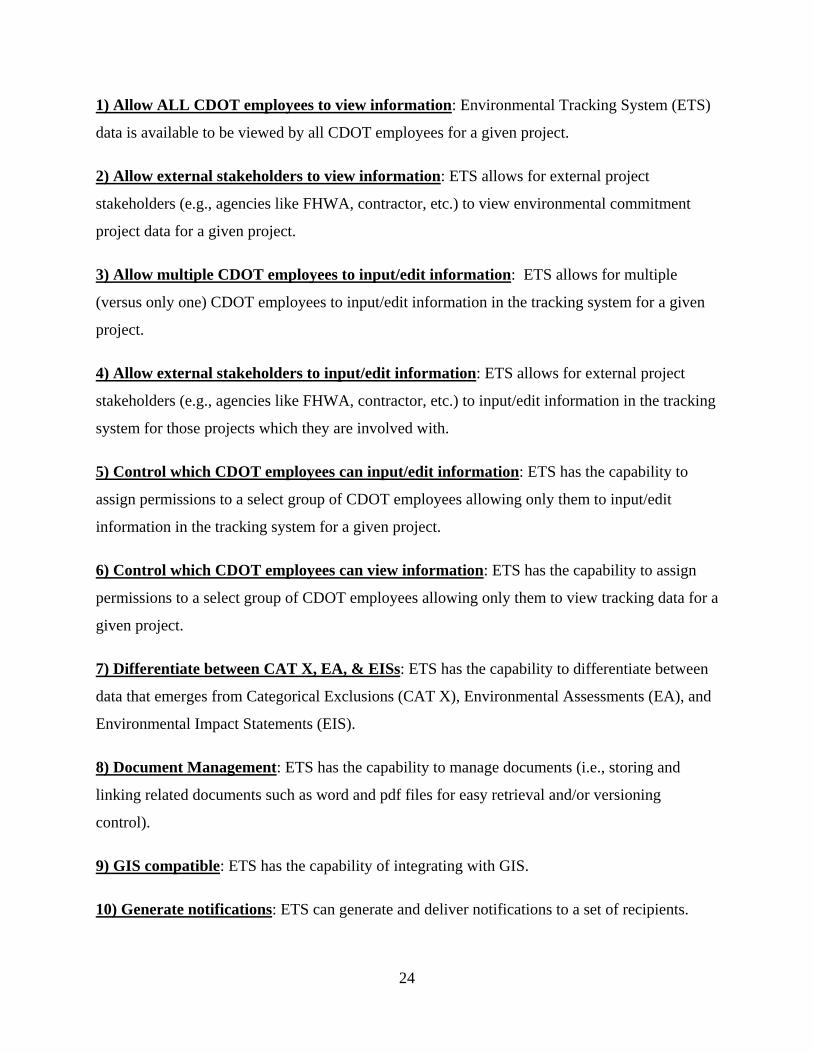
*The explanation for each of the 18 developed metrics is provided below. Metrics are listed in
alphabetical order.
24
1) Allow ALL CDOT employees to view information: Environmental Tracking System (ETS)
data is available to be viewed by all CDOT employees for a given project.
2) Allow external stakeholders to view information: ETS allows for external project
stakeholders (e.g., agencies like FHWA, contractor, etc.) to view environmental commitment
project data for a given project.
3) Allow multiple CDOT employees to input/edit information: ETS allows for multiple
(versus only one) CDOT employees to input/edit information in the tracking system for a given
project.
4) Allow external stakeholders to input/edit information: ETS allows for external project
stakeholders (e.g., agencies like FHWA, contractor, etc.) to input/edit information in the tracking
system for those projects which they are involved with.
5) Control which CDOT employees can input/edit information: ETS has the capability to
assign permissions to a select group of CDOT employees allowing only them to input/edit
information in the tracking system for a given project.
6) Control which CDOT employees can view information: ETS has the capability to assign
permissions to a select group of CDOT employees allowing only them to view tracking data for a
given project.
7) Differentiate between CAT X, EA, & EISs: ETS has the capability to differentiate between
data that emerges from Categorical Exclusions (CAT X), Environmental Assessments (EA), and
Environmental Impact Statements (EIS).
8) Document Management: ETS has the capability to manage documents (i.e., storing and
linking related documents such as word and pdf files for easy retrieval and/or versioning
control).
9) GIS compatible: ETS has the capability of integrating with GIS.
10) Generate notifications: ETS can generate and deliver notifications to a set of recipients.

25
11) Integrate with ProjectWise: ETS has the capability of integrating with ProjectWise.
12) Integrate with SharePoint: ETS has the capability of integrating with SharePoint.
13) Sort and filter data: Users can easily find and view only the commitments and permits that
are relevant to a particular person or project.
14) Standard Reports: ETS has the capability to generate standard reports (e.g., for annual
reporting to regulatory agencies or internal auditing purposes).
15) Store data in a single centralized file: ETS has the capability to link and store numerous
projects' tracking data into one single centralized file. In other words, ETS can store each
project’s environmental commitment tracking data in its’ own file as well as in a single
centralized master file.
16) Track deleted or modified commitments: Modified commitments are tracked showing a
progression of change and deleted commitments remain in system (e.g., grayed out) for future
referencing rather than being dropped from system.
17) Track permits: ETS has the capability to add, modify, and delete permit details.
18) Web based: ETS can be accessed via a web browser over the Internet.
Responses indicated that there was not enough support to develop metrics based on the
features included in certain questions. Table 3 lists those questions and the summary of the
responses. These features were eliminated from the list of metrics developed.
26
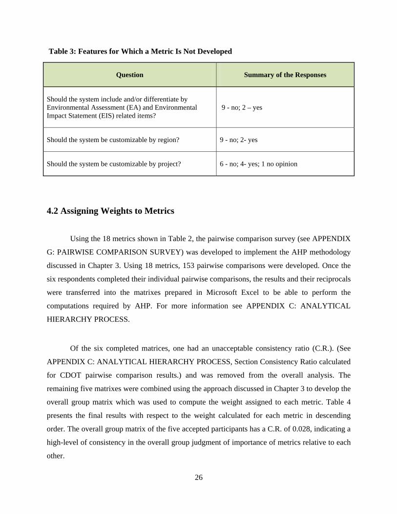
Table 3: Features for Which a Metric Is Not Developed
Question Summary of the Responses
Should the system include and/or differentiate by Environmental Assessment (EA) and Environmental Impact Statement (EIS) related items?
9 - no; 2 – yes
Should the system be customizable by region? 9 - no; 2- yes
Should the system be customizable by project? 6 - no; 4- yes; 1 no opinion
4.2 Assigning Weights to Metrics
Using the 18 metrics shown in Table 2, the pairwise comparison survey (see APPENDIX
G: PAIRWISE COMPARISON SURVEY) was developed to implement the AHP methodology
discussed in Chapter 3. Using 18 metrics, 153 pairwise comparisons were developed. Once the
six respondents completed their individual pairwise comparisons, the results and their reciprocals
were transferred into the matrixes prepared in Microsoft Excel to be able to perform the
computations required by AHP. For more information see APPENDIX C: ANALYTICAL
HIERARCHY PROCESS.
Of the six completed matrices, one had an unacceptable consistency ratio (C.R.). (See
APPENDIX C: ANALYTICAL HIERARCHY PROCESS, Section Consistency Ratio calculated
for CDOT pairwise comparison results.) and was removed from the overall analysis. The
remaining five matrixes were combined using the approach discussed in Chapter 3 to develop the
overall group matrix which was used to compute the weight assigned to each metric. Table 4
presents the final results with respect to the weight calculated for each metric in descending
order. The overall group matrix of the five accepted participants has a C.R. of 0.028, indicating a
high-level of consistency in the overall group judgment of importance of metrics relative to each
other.
27
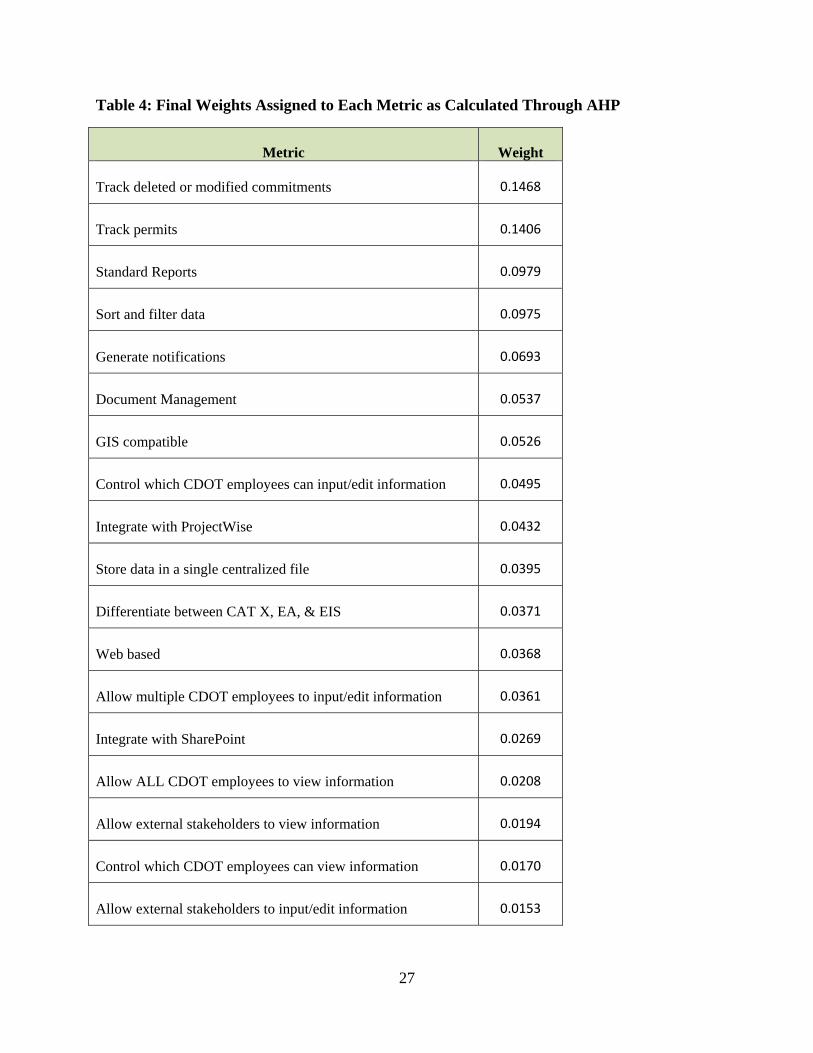
Table 4: Final Weights Assigned to Each Metric as Calculated Through AHP
Metric Weight
Track deleted or modified commitments 0.1468
Track permits 0.1406
Standard Reports 0.0979
Sort and filter data 0.0975
Generate notifications 0.0693
Document Management 0.0537
GIS compatible 0.0526
Control which CDOT employees can input/edit information 0.0495
Integrate with ProjectWise 0.0432
Store data in a single centralized file 0.0395
Differentiate between CAT X, EA, & EIS 0.0371
Web based 0.0368
Allow multiple CDOT employees to input/edit information 0.0361
Integrate with SharePoint 0.0269
Allow ALL CDOT employees to view information 0.0208
Allow external stakeholders to view information 0.0194
Control which CDOT employees can view information 0.0170
Allow external stakeholders to input/edit information 0.0153

28
As discussed earlier, the metrics in Table 4 represent the features considered to be
important by the Study Panel members. These, along with their weights, are used to evaluate
how closely the existing ETSs used various state DOTs match the preferences of CDOT. As seen
in Table 4, the “Track deleted or modified commitments” metric has the largest weighting factor
(0.147) among the 18 metrics (indicating the highest preference of CDOT in an ETS), followed
very closely by the “Track permits” (0.141). “Allow external stakeholders to input/edit
information” (0.015), “Control which CDOT employees can view information” (0.017), and
“Allow external stakeholders to view information” (0.019) metrics obtained the three lowest
weighting factors.
4.2.1 CDOT’s Existing Tracking System
Using the developed metrics, and based on interview feedback, the researchers developed
the following quantitative and qualitative assessment of CDOT’s existing ECTS which is an
excel-based spreadsheet. When assessing the following metrics, determinations of whether or not
the spreadsheet supported individual metrics (as defined) was not based on whether an individual
could manually complete a metric (i.e.; email out the data), but whether the system had the built-
in capability to complete the task.
29
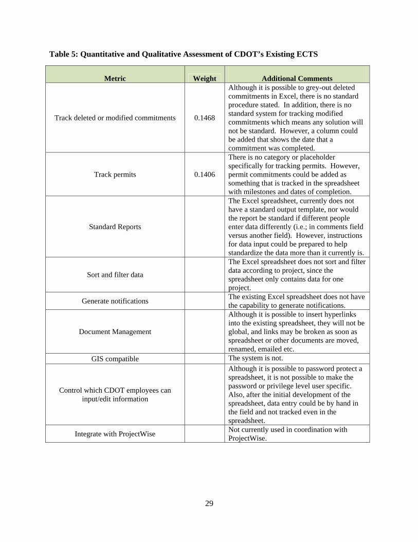
Table 5: Quantitative and Qualitative Assessment of CDOT’s Existing ECTS
Metric Weight Additional Comments
Track deleted or modified commitments 0.1468
Although it is possible to grey-out deleted commitments in Excel, there is no standard procedure stated. In addition, there is no standard system for tracking modified commitments which means any solution will not be standard. However, a column could be added that shows the date that a commitment was completed.
Track permits 0.1406
There is no category or placeholder specifically for tracking permits. However, permit commitments could be added as something that is tracked in the spreadsheet with milestones and dates of completion.
Standard Reports
The Excel spreadsheet, currently does not have a standard output template, nor would the report be standard if different people enter data differently (i.e.; in comments field versus another field). However, instructions for data input could be prepared to help standardize the data more than it currently is.
Sort and filter data
The Excel spreadsheet does not sort and filter data according to project, since the spreadsheet only contains data for one project.
Generate notifications The existing Excel spreadsheet does not have the capability to generate notifications.
Document Management
Although it is possible to insert hyperlinks into the existing spreadsheet, they will not be global, and links may be broken as soon as spreadsheet or other documents are moved, renamed, emailed etc.
GIS compatible The system is not.
Control which CDOT employees can input/edit information
Although it is possible to password protect a spreadsheet, it is not possible to make the password or privilege level user specific. Also, after the initial development of the spreadsheet, data entry could be by hand in the field and not tracked even in the spreadsheet.
Integrate with ProjectWise Not currently used in coordination with ProjectWise.

30
Metric Weight Additional Comments
Store data in a single centralized file
The spreadsheet only has the ability to save data in separate, individual files. Also, the data may only be electronic at the initial development of the spreadsheet so this spreadsheet might have to be scanned once all of the commitments have been completed just for file storage.
Differentiate between CAT X, EA, & EISs 0.0371 Yes, there is a field for this data. Web based No
Allow multiple CDOT employees to input/edit information
Even if the individual file is located on a shared server, there can be problems with versioning with multiple users if all is entered over time electronically. However, it is likely that after the initial development of the spreadsheet for a project, the rest of the data would be hand-entered which would allow multiple persons inside and outside of CDOT to input and edit information.
Integrate with SharePoint No. However, the file could be uploaded to SharePoint in a collection of tables.
Allow ALL CDOT employees to view information
The document can be saved in a central location. However, the data may not be current. Therefore, CDOT employees would have to go to the project trailer or to the RPEM office after the project is closed to view the hardcopy of the table.
Allow external stakeholders to view information Same comments as above.
Control which CDOT employees can view information
0.017
It is possible to only give certain employees the password. However, this is an unreliable, and non-user specific system of control. Also, if the current information is only available on the hard copy, anyone that goes to the project trailer or gains a copy of the table can view it.
Allow external stakeholders to input/edit information
External stakeholders do not have direct access to a CDOT stored file so they will not be able to edit the initial spreadsheet. However, the spreadsheet could be edited by hand by anyone having access to the hardcopy.
Total: 0.3415

31
This initial assessment of the metrics suggests that the existing ECTS in use by CDOT provides
approximately 35% of CDOT’s preferred functionalities. This reiterates the need to evaluate
other ETS’s in use by other state DOTs for consideration by CDOT.
4.3 Qualitative Evaluation of Other States’ ETSs
This section presents the qualitative evaluation of ETSs provided by eight different state
DOTs. The states with ETSs evaluated are: California, Florida, Kentucky, New York, Tennessee,
Texas, Virginia, and Washington. In the following sub-sections an overall description of the ETS
for each state is provided. All ETSs evaluated have the ability to track commitments. Since this
is a minimum system requirement it is not included in the evaluation of additional features.
4.3.1 California Department of Transportation (CalTrans)
CalTrans utilizes an environmental commitment tracking tool called the Standard
Tracking and Exchange Vehicle for Environmental (STEVE) projects that was developed in the
software FileMaker Pro. At the time that the survey was completed, STEVE was in the process
of being implemented statewide. This was expected to be completed by March 31, 2011.
Initially, CalTrans is focused on bringing all of their environmental planners on board with
STEVE, with future phases to include remaining internal partners and eventually with limited
access, the external partners (S. Yokoi, personal communication, March 1, 2011). Table 6
presents the survey that was returned by CalTrans, indicating STEVE’s features.

32
Table 6: CalTrans’ (STEVE’s) ETS’s Features
Features Yes No Comments
Track deleted or modified commitments X Tracks only modified commitments, not deleted.
Track permits X
Standard Reports X
Sort and filter data X
Generate notifications X Notification appears on their personalized dashboard, does not generate email.
Document Management X Initial phase is smaller scale document management.
GIS compatible X We are currently researching this opportunity as a future phase.
Control which state DOT employees can input/edit information
X
Integrate with ProjectWise X
Store data in a single centralized file X
Differentiate between CAT X, EA, & EISs X
Web based X Not at this time. Capability does exist and is being considered for use in a future phase.
Allow multiple state DOT employees to input/edit information
X
Integrate with SharePoint X
Allow ALL state DOT employees to view information
X
Allow external stakeholders to view information X We are currently researching this opportunity as a future phase.
Control which state DOT employees can view information
X Environmentally sensitive areas are protected.
Allow external stakeholders to input/edit information
X

33
To further explain results shown in Table 6, although the respondent selected “yes” for
the “Track deleted or modified commitments” feature, because the system tracks only modified
commitments, and does not track deleted commitments, an attribute critical to this feature, this
feature will be treated as “not existing” for the purpose of this study while performing the
quantitative evaluation in 4.4 Quantitative Evaluation of Other States’ ETSs. Cost data provided
by CalTrans is presented in APPENDIX F: ETS COST DATA.
4.3.2 Florida DOT (FDOT)
FDOT’s ETS was developed in Project Suite by the state’s District 4 Planning and
Environmental Management (PL&EM) services office. It is intended to inform the state’s district
design, construction, and maintenance departments of the environmental concerns and
commitments made during the NEPA process. This electronic database identifies commitments
made during the Project Development & Environmental (PD&E) phase and documents how
these commitments will be incorporated into final design and monitors their compliance during
construction (FDOT, 2011).
The commitments are entered into the ETS by assigned environmental liaisons who input
status updates during each phase of the project. However, during the construction phase, the
District Construction Environmental Coordinator (DCEC) will update the ETS. For major
projects, the PD&E phase is the first phase of documentation and coordination of the
commitments. In the past at FDOT, the challenge was to track and document the implementation
of the commitments made during the development of projects. Now the ETS documents the most
current status of each environmental commitment on the project (FDOT, 2011).
During each of the following phases of a project, the items that are input into the ETS at
FDOT are (FDOT, 2011):
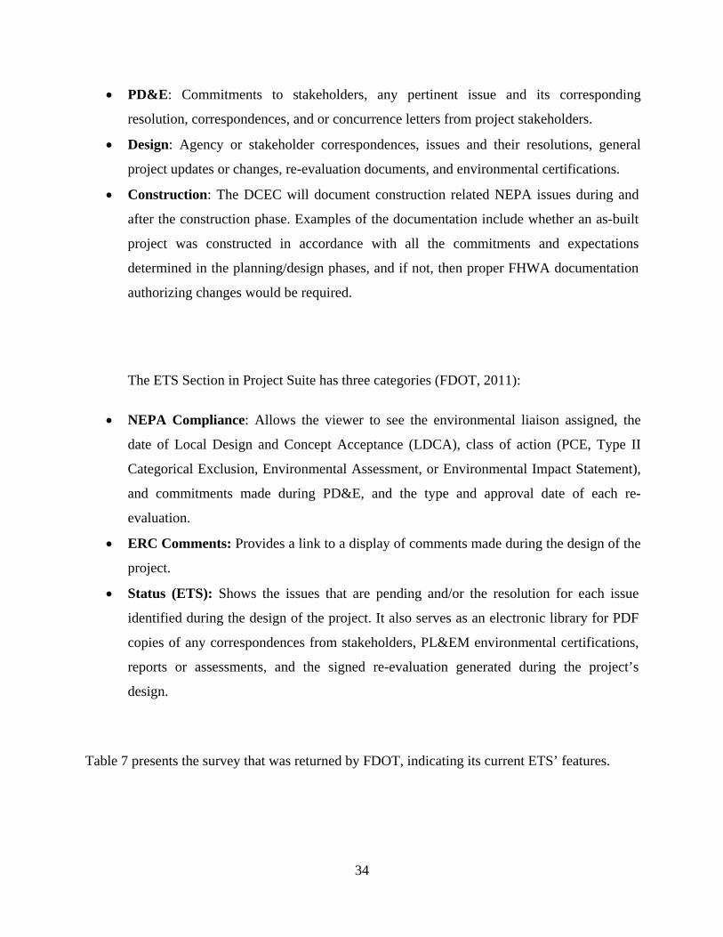
34
PD&E: Commitments to stakeholders, any pertinent issue and its corresponding
resolution, correspondences, and or concurrence letters from project stakeholders.
Design: Agency or stakeholder correspondences, issues and their resolutions, general
project updates or changes, re-evaluation documents, and environmental certifications.
Construction: The DCEC will document construction related NEPA issues during and
after the construction phase. Examples of the documentation include whether an as-built
project was constructed in accordance with all the commitments and expectations
determined in the planning/design phases, and if not, then proper FHWA documentation
authorizing changes would be required.
The ETS Section in Project Suite has three categories (FDOT, 2011):
NEPA Compliance: Allows the viewer to see the environmental liaison assigned, the
date of Local Design and Concept Acceptance (LDCA), class of action (PCE, Type II
Categorical Exclusion, Environmental Assessment, or Environmental Impact Statement),
and commitments made during PD&E, and the type and approval date of each re-
evaluation.
ERC Comments: Provides a link to a display of comments made during the design of the
project.
Status (ETS): Shows the issues that are pending and/or the resolution for each issue
identified during the design of the project. It also serves as an electronic library for PDF
copies of any correspondences from stakeholders, PL&EM environmental certifications,
reports or assessments, and the signed re-evaluation generated during the project’s
design.
Table 7 presents the survey that was returned by FDOT, indicating its current ETS’ features.

35
Table 7: FDOT’s ETS’s Features
Features Yes No Comments
Track deleted or modified commitments X
Track permits X
Standard Reports X
Sort and filter data X
Generate notifications X
Document Management X
GIS compatible X
Control which state DOT employees can input/edit information
X
Integrate with ProjectWise X We do integrate with other custom systems at FDOT
Store data in a single centralized file X X
Differentiate between CAT X, EA, & EISs
X
Web based X
Allow multiple state DOT employees to input/edit information
X
Integrate with SharePoint X Probably a nice to have
Allow ALL state DOT employees to view information
X
Allow external stakeholders to view information
X FHWA Partners & contractors granted access
Control which state DOT employees can view information
X .
Allow external stakeholders to input/edit information
X FHWA Partners & contractors granted access

36
Upon receiving the completed survey, it was not clear if FDOT’s ETS stored data in a
single centralized file. Upon receiving further clarification, it was understood that FDOT’s ETS
does store data in a single centralized file (P. McGilvray, personal communication, March 2,
2011) and will be treated so for the purpose of this study.
4.3.3 Kentucky Transportation Cabinet (KYTC)
KYTC utilizes an Oracle Preconstruction (Precon) database system for the tracking of
project commitments. Within the system, the state has developed a commitment tracking tool
called "Communicating All Promises" (CAP). CAP tracks and shows the progression of all
commitments from the planning through construction and maintenance phases. Commitments are
posted in the state's online tracking system for use by contractors and remain in the lead project
engineer's files. CAP institutionalizes commitments made by KYTC improving the efficiency
among all parties involved in the transportation process (Venner Consulting, 2009).
During the course of project development, many commitments (promises) are made by
different individuals associated with the project. In order to ensure that these promises are kept,
the project manager retains the responsibility of making sure that they are entered and tracked in
the Oracle Preconstruction database system (Kentucky Transportaton Cabinet, 2005; Venner
Consulting, 2009). All commitments made after the planning phase are communicated to the
Project Manager, and then must be approved by the Project Team before they are officially
logged into the CAP system by the Project Manager. The system allows for the entering of a
description of the promise, the date and to whom the promise was made, and the location of the
work or activities to fulfill the commitment. The system is not designed to allow deletions. If a
promise is to be modified or retracted, an additional entry is required to document this change
(Kentucky Transportaton Cabinet, 2005).
Table 8 presents the survey that was returned by KYTC, indicating its current ETS’ features.

37
Table 8: KYTC’s ETS’s Features
Features Yes No Comments
Track deleted or modified commitments X
Track permits X
Standard Reports X
Sort and filter data X
Generate notifications X
Document Management X
GIS compatible X
Control which DOT employees can input/edit information
X
Integrate with ProjectWise X
Store data in a single centralized file X
Differentiate between CAT X, EA, & EISs
X
Web based X
Allow multiple DOT employees to input/edit information
X
Integrate with SharePoint X
Allow ALL DOT employees to view information
X
Allow external stakeholders to view information
X
Control which DOT employees can view information
X Current permission is for everyone in Highway Department to view
Allow external stakeholders to input/edit information
X

38
Cost data provided by KYTC is presented in APPENDIX F: ETS COST DATA.
4.3.4 New York State Department of Transportation (NYSDOT)
NYSDOT's Program Support System (PSS) lists all state DOT projects in progress along
with information regarding project costs, status, and anticipated milestones. An Environmental
Commitments & Obligations Package for Construction (ECOPAC) records the actual
compliance of construction projects (Venner Consulting, 2009).
ECOPAC is a systematic, simple, and standardized form used to highlight and transfer
environmental commitments made during project design. ECOPAC tracks commitment
compliance throughout all construction activities with respect to the environmental issues
identified and highlighted during project development. Established in an effort to assure
consistency in reporting and tracking statewide environmental information, the form is
developed by NYSDOT design staff and allows for the environmental commitments to be
communicated to construction staff (AASHTO, 2003; Venner Consulting, 2009).
The ETS utilizes a Microsoft Access database located on regional servers with not all
users having access to the servers. However, those users who do have access to the server have
access to the database (S. Kappeller, personal communication, March 10, 2011). Table 9 presents
the survey that was returned by NYSDOT, indicating its current ETS’ features.

39
Table 9: NYSDOT’s ETS’s Features
Features Yes No Comments
Track deleted or modified commitments X
Track permits X
Standard Reports X
Sort and filter data X
Generate notifications X
Document Management X
GIS compatible X
Control which state DOT employees can input/edit information
X
Integrate with ProjectWise X
Store data in a single centralized file X
Differentiate between CAT X, EA, & EISs X
Web based X
Allow multiple state DOT employees to input/edit information
X
Integrate with SharePoint X
Allow ALL state DOT employees to view information
X
Allow external stakeholders to view information X
Control which state DOT employees can view information
X
Allow external stakeholders to input/edit information
X
Cost data provided by NYSDOT is presented in APPENDIX F: ETS COST DATA.

40
4.3.5 Tennessee Department of Transportation (TDOT)
TDOT utilizes the Statewide Environmental Management System (SEMS) aimed to
facilitate communication amongst TDOT and its partners during the project development phase.
This includes the FHWA, Federal resource agencies, state resource agencies, contractors, and
any other interested stakeholders. SEMS streamlines project delivery as well as documents,
monitors, and tracks commitments made between TDOT and various project stakeholders (Cole,
2009).
SEMS demonstrates accountability and helps with organizational management. It is
accessed through a web portal with the objective of improving communication and collaboration
amongst TDOT and the project stakeholders. The system tracks, communicates, and
demonstrates fulfillment of project commitments, and acts as a tool for collecting and preserving
the promises (American Society of Highway Engineers 2008). Table 10 presents the survey that
was returned by TDOT, indicating its current ETS’ features.

41
Table 10: TDOT’s ETS’s Features
Features Yes No Comments
Track deleted or modified commitments X
Track permits X Separate database tracks Permits info.
Standard Reports X
Sort and filter data X
Generate notifications X
Document Management X
GIS compatible X
Control which state DOT employees can input/edit information
X
Integrate with ProjectWise X We do not use ProjectWise
Store data in a single centralized file X
Differentiate between CAT X, EA, & EISs X
Web based X
Allow multiple state DOT employees to input/edit information
X
Integrate with SharePoint X We do not use SharePoint
Allow ALL state DOT employees to view information
X
Allow external stakeholders to view information X
Control which state DOT employees can view information
X
Allow external stakeholders to input/edit information
X
No numerical cost data was provided by TDOT.

42
4.3.6 Texas Department of Transportation (TxDOT)
TxDOT is in the process of implementing a new system called the Texas Environmental
Compliance Oversight System. The system is currently being built and will be released in
August 2011 (M. Coleman, personal communication, March 1, 2011). The new ETS is a
replacement for the current ETS that is a desktop application that was created 13 years ago using
PowerBuilder with a Structured Query Language (SQL) Server database. The survey filled out
by the TxDOT representative reflects the features of the new system as shown in Table 11 (M.
Coleman, personal communication, March 1, 2011). Because a new ETS will be implemented in
August, the features of the existing ETS are not discussed in this report.
Table 11: TxDOT’s New (to be released in August 2011) ETS’s Features
Features Yes No Comments
Track deleted or modified commitments X
Track permits X
Standard Reports X
Sort and filter data X
Generate notifications X
Document Management X
GIS compatible X There is currently no GIS integration but GIS is planned for in a future release.
Control which state DOT employees can input/edit information
X
Integrate with ProjectWise X Not used by Environmental staff at TxDOT. Application is compatible with web services.
Store data in a single centralized file X Centralized DMS and enterprise Oracle database
Differentiate between CAT X, EA, & EISs X
Web based X

43
Features Yes No Comments
Allow multiple state DOT employees to input/edit information
X
Integrate with SharePoint X
Allow ALL state DOT employees to view information
X View is limited to our application users.
Allow external stakeholders to view information X
Control which state DOT employees can view information
X
Allow external stakeholders to input/edit information
X
Although the feature “GIS compatible” was initially checked, after reviewing the related
comment in the survey, it was determined that despite the state having plans for implementing
this feature in the future, the new system will not possess this at the time of the initial
implementation. Therefore, this feature will be treated as “not existing” for the purpose of this
study while performing the quantitative evaluation of this state in4.4 Quantitative Evaluation of
Other States’ ETSs. Additionally, based on the comment for the “Integrate with ProjectWise”
feature, it will be treated as “not existing” for the purpose of this study while performing the
quantitative evaluation of this state in 4.4 Quantitative Evaluation of Other States’ ETSs. No
numerical cost data was provided by TxDOT.
4.3.7 Virginia Department of Transportation (VDOT)
VDOT utilizes the Comprehensive Environmental Data and Reporting (CEDAR) system.
VDOT has developed and enabled CEDAR for use on all types of environmental projects,
including those that receive Federal funding and are required to be submitted to NEPA, as well
as those that are fully funded by the state. Even though the state projects are outside of the NEPA
process, they are still required to undergo a state environmental review process that requires
agency consultation (The Volpe National Transportation System Center, 2005).

44
CEDAR is a spatially enabled project management tool that VDOT initiated in 2002.
CEDAR tracks project progress and improves internal, interagency, and consultant
communication. CEDAR enables users to notify other users in separate departments or agencies
with questions and concerns, track projects, send email notifications, and assign roles and
responsibilities (The Volpe National Transportation System Center, 2005). Table 12 presents the
survey that was returned by VDOT, indicating its current ETS’ features.
Table 12: VDOT’s ETS’s Features
Features Yes No Comments
Track deleted or modified commitments X
Track permits X
Standard Reports X
Sort and filter data X
Generate notifications X
Document Management X
GIS compatible X
Control which state DOT employees can input/edit information
X
Integrate with ProjectWise X
Store data in a single centralized file X
Differentiate between CAT X, EA, & EISs X
Web based X
Allow multiple state DOT employees to input/edit information
X
Integrate with SharePoint X
Allow ALL state DOT employees to view information
X

45
Features Yes No Comments
Allow external stakeholders to view information X We have a handful of people from FHWA that access CEDAR through our external secure portal to view environmental data. But as far as all our external business partners (DGIF, DCR, DHR, DEQ, Corp of Engineers, etc.) we do not have the application set up outside the agency; although this is the direction we’d like to go with the application. At this time, the application is still primarily internal to VDOT.
Control which state DOT employees can view information
X
Allow external stakeholders to input/edit information
X
After reviewing the related comment in the survey, it was determined that despite the state
having plans for fully implementing the “Allow external stakeholders to view information”
feature in the future, currently the system has a very limited application of this feature.
Therefore, this feature will be treated as “not existing” for the purpose of this study while
performing the quantitative evaluation of this state in 4.4 Quantitative Evaluation of Other
States’ ETSs. . No numerical cost data was provided by VDOT.
4.3.8 Washington State Department of Transportation (WSDOT)
The WSDOT Commitment Tracking System (CTS), developed in 2005, allows WSDOT
to store commitments in a secure computer network server and manage the responsibility
(WSDOT or contractor) and implementation method (guidance document or contract) for the
commitment. It allows for the storing of compliance records, documents the status of
commitments, and reports details about commitments from their inception through project
delivery and on to maintenance (Washington State Department of Transportation Environmental
Services Office 2010).

46
The CTS tracks commitments established in environmental documents, including those
prepared to meet NEPA, the State Environmental Policy Act, Endangered Species Act, permits,
approvals, letters, and agreements. Currently, the CTS tracks environmental commitments, but
the system can be expanded to track all types of commitments (e.g., design, utilities, and real
estate/right of way). However, no plan or budget exists to perform such an expansion. The CTS
allows users to assign staff to commitments and to identify existing guidance documents that
help them successfully comply with the commitments. The CTS facilitates developing the
contract during the Plans, Specifications, and Estimates (PS&E) process. It also allows the
design and construction offices to manage the status of their commitments, and provides
compliance recording and reporting features that support existing policy and permit requirements
(Washington State Department of Transportation Environmental Services Office 2010).
The decision of who will be the person responsible for entering commitments into the
CTS for each respective project is made by the project team, or the region. Traditionally, permit
coordinators are responsible for entering environmental commitments, and statewide
commitments are entered by WSDOT Headquarters Environmental Services Office staff.
Because commitments are sometimes made late in the project development process or even
during construction, the CTS also allows the design and construction office staff to enter
commitments (Washington State Department of Transportation Environmental Services Office
2010).
Table 13 presents the survey that was returned by WSDOT, indicating its current ETS’ features.
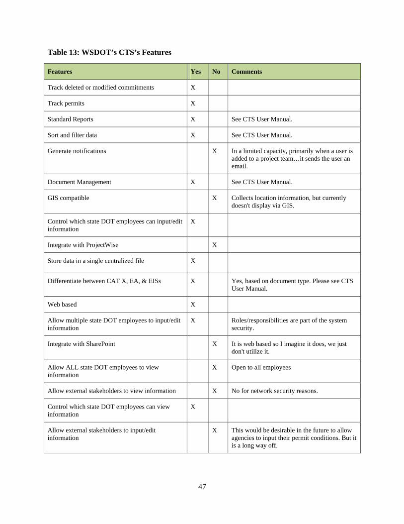
47
Table 13: WSDOT’s CTS’s Features
Features Yes No Comments
Track deleted or modified commitments X
Track permits X
Standard Reports X See CTS User Manual.
Sort and filter data X See CTS User Manual.
Generate notifications X In a limited capacity, primarily when a user is added to a project team…it sends the user an email.
Document Management X See CTS User Manual.
GIS compatible X Collects location information, but currently doesn't display via GIS.
Control which state DOT employees can input/edit information
X
Integrate with ProjectWise X
Store data in a single centralized file X
Differentiate between CAT X, EA, & EISs X Yes, based on document type. Please see CTS User Manual.
Web based X
Allow multiple state DOT employees to input/edit information
X Roles/responsibilities are part of the system security.
Integrate with SharePoint X It is web based so I imagine it does, we just don't utilize it.
Allow ALL state DOT employees to view information
X Open to all employees
Allow external stakeholders to view information X No for network security reasons.
Control which state DOT employees can view information
X
Allow external stakeholders to input/edit information
X This would be desirable in the future to allow agencies to input their permit conditions. But it is a long way off.

48
Although the two features, “GIS compatible” and “Generate notifications” were checked
as existing features in the CTS, further evaluation of the related comments revealed that these
features should be treated as “not existing” for the purpose of this study while performing the
quantitative evaluation of this state in 4.4 Quantitative Evaluation of Other States’ ETSs. The
ability to collect location information without displaying that information within a GIS interface
does not meet the criterion of having the capability of integrating with GIS. Similarly, only
sending a new project team member an email does not meet the criterion for the feature
“Generating notifications” as such feature’s intended purpose is to generate notifications for
other reasons (e.g., when environmental commitments are entered or met). Furthermore, even
though the comment about the “Integrate with SharePoint” alludes to the possibility of that
feature being existent, the mere fact that the system is web based does not guarantee its ability to
integrate with SharePoint; and since such feature is not being utilized as indicated by the
respondent, it will be treated as not existing” for the purpose of this study while performing the
quantitative evaluation of this state in 4.4 Quantitative Evaluation of Other States’ ETSs. Cost
data provided by WSDOT is presented in APPENDIX F: ETS COST DATA.
4.4 Quantitative Evaluation of Other States’ ETSs
The survey responses for all eight states are compiled in Table 14 along with their
assigned weights. FDOT (total count 16) and TxDOT and VDOT (total count 14) have the most
number of features consistent with the features CDOT prefers to have in its ETS. NYSDOT
(total count 7) and TDOT (total count 9) have the fewest.
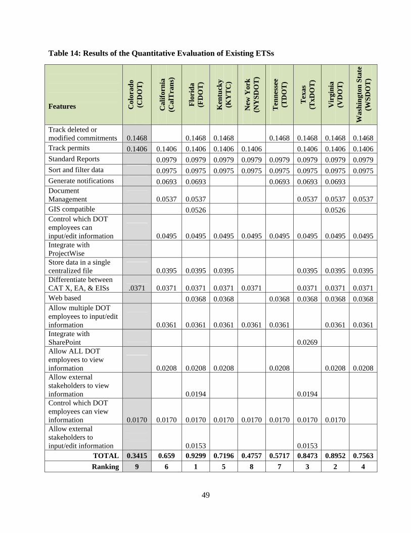
49
Table 14: Results of the Quantitative Evaluation of Existing ETSs
Features C
olor
ado
(C
DO
T)
Cal
ifor
nia
(C
alT
ran
s)
Flo
rid
a (F
DO
T)
Ken
tuck
y (K
YT
C)
New
Yor
k
(NY
SD
OT
)
Ten
nes
see
(TD
OT
)
Tex
as
(TxD
OT
)
Vir
gin
ia
(VD
OT
)
Was
hin
gton
Sta
te
(WS
DO
T)
Track deleted or modified commitments 0.1468
0.1468 0.1468
0.1468 0.1468 0.1468 0.1468
Track permits 0.1406 0.1406 0.1406 0.1406 0.1406 0.1406 0.1406 0.1406Standard Reports 0.0979 0.0979 0.0979 0.0979 0.0979 0.0979 0.0979 0.0979Sort and filter data 0.0975 0.0975 0.0975 0.0975 0.0975 0.0975 0.0975 0.0975Generate notifications 0.0693 0.0693 0.0693 0.0693 0.0693 Document Management
0.0537 0.0537
0.0537 0.0537 0.0537GIS compatible 0.0526 0.0526 Control which DOT employees can input/edit information
0.0495 0.0495 0.0495 0.0495 0.0495 0.0495 0.0495 0.0495
Integrate with ProjectWise
Store data in a single centralized file
0.0395 0.0395 0.0395
0.0395 0.0395 0.0395Differentiate between CAT X, EA, & EISs .0371 0.0371 0.0371 0.0371 0.0371
0.0371 0.0371 0.0371
Web based 0.0368 0.0368 0.0368 0.0368 0.0368 0.0368Allow multiple DOT employees to input/edit information
0.0361 0.0361 0.0361 0.0361 0.0361
0.0361 0.0361
Integrate with SharePoint
0.0269
Allow ALL DOT employees to view information
0.0208 0.0208 0.0208
0.0208
0.0208 0.0208
Allow external stakeholders to view information
0.0194
0.0194
Control which DOT employees can view information 0.0170 0.0170 0.0170 0.0170 0.0170 0.0170 0.0170 0.0170
Allow external stakeholders to input/edit information
0.0153
0.0153
TOTAL 0.3415 0.659 0.9299 0.7196 0.4757 0.5717 0.8473 0.8952 0.7563
Ranking 9 6 1 5 8 7 3 2 4
50
As discussed in Chapter 3, the quantitative score for each state’s ETS is computed
by assigning the predetermined weight (using AHP) to each feature and adding those weights
together. A higher quantitative score for an ETS indicates a higher correlation of available
features to CDOT’s preferred features. At the bottom, Table 14 ranks each state’s ETS’s ability
to meet CDOT’s need.
According to the results of the quantitative evaluation, FDOT’s ETS is the leading
candidate with a score of 0.9299 out of a possible score of 1.0. VDOT is second at 0.8952 and
TxDOT is third at 0.8473. While both VDOT’s and TxDOT’s ETSs possess 14 of 18 desired
features (a different 14 features), by using the weights identified by AHP this study demonstrates
that VDOT’s 14 features are more preferred by CDOT.
4.5 Cost Benefit Analysis of Other States’ ETSs
As discussed in Chapter 3, a cost benefit analysis was not performed due to insufficient
cost data available.

51
CHAPTER 5: CONCLUSIONS
This chapter presents a summary of this study and its conclusions as well as
recommendations from the research.
5.1 Summary of the Study
The purpose of this study, “The Evaluation of Environmental Commitment Tracking
Systems for Use at the Colorado Department of Transportation”, was to review and evaluate the
existing ECTS used by CDOT and existing ETSs used by other state DOTs in an effort to
determine which system would be the most beneficial for long-term implementation at CDOT
and thus to be pursued by CDOT. This was deemed necessary after the review of several local
agency projects failed to be able to demonstrate whether environmental commitments had been
completed. While the local agency projects identified the initial problem, the need to be able to
track environmental commitments for all CDOT projects, not just local agency projects, emerged
as a serious concern.
Throughout the study, the Colorado State University research team was under the
direction of the Study Panel consisting of seven members. The research team’s function was to
provide research expertise as well as evaluation services to assist CDOT in their selection and
adoption of an ETS. The analysis, findings, and recommendation provided herein are intended to
minimize program development and redevelopment costs and ultimately to provide CDOT with
an effective, efficient, and reliable method to assess and demonstrate environmental commitment
completion on all projects.
The research utilized both qualitative and quantitative research methods as supported by
the following six research tasks to achieve its purpose. A brief description of these tasks and
their outcomes are provided here:
52
Literature Review: Relevant studies and information regarding state DOTs’ ETSs
were reviewed and synthesized. State DOT ETSs to be carried forward in the study
were identified.
Interviews and Metric Development: Through interviewing 11 practitioners from
CDOT and FHWA, 18 features were identified as the features CDOT prefers to have
in its ETS. Appropriate metrics were developed based on those features.
Identification of Weights for the Metrics: AHP was utilized to identify the weights
of metrics relative to each other. Pairwise comparison surveys were sent to the Study
Panel members and required computations were performed on their responses to
assign weights to each of the 18 metrics. These weights indicate the importance of
each feature according to CDOT’s preferences and are summarized in Table 14 of this
report.
Qualitative Evaluation and Survey of State DOTs: CalTrans, CDOT, FDOT,
KYTC, NYSDOT, TDOT, TxDOT, and WSDOT were selected to be included in this
study based on the fact that the literature reviewed by the research team consistently
mentioned these states as those with leading ETSs. Furthermore, VDOT was added to
this study after one of the other seven participating states brought it to the research
team’s attention as a state with a leading ETS. Target state DOTs were contacted in
March 2011 and asked to complete a survey indicating which of the 18 features (that
CDOT prefers to have in its ETS) their ETS possesses. States were asked to provide
cost information in regards to the ETSs’ first cost and annual usage cost. The
information collected through this survey along with the information gathered through
the literature review enabled the research team to perform a comprehensive qualitative
evaluation of these states and present the findings in 4.3 Qualitative Evaluation of
Other States’ ETSs.
Quantitative Evaluation and Comparison of ETSs: The quantitative evaluation of
other states’ ETSs was performed to assess how well an ETS’s set of features
correlated to CDOT’s preferences. The quantitative score for each state’s ETS is
computed by assigning the predetermined weight (calculated using AHP) to each
feature supported by a given ETS (determined through the survey of state DOTs) and
adding all those weights together.

53
Cost Benefit Analysis of State DOTs: A cost benefit analysis was not performed.
All of the methods discussed above allowed the research team to fully understand
CDOT’s expectations for its ETS and perform a comprehensive evaluation of existing ETSs with
respect to those expectations.
5.2 Recommendations and Conclusions
The detailed findings of this research with respect to the ECTS currently used by CDOT
and the ETSs currently used by CalTrans, FDOT, KYTC, NYSDOT, TDOT, TxDOT, VDOT,
and WSDOT are presented in CHAPTER 4: FINDINGS. Based on the quantitative
evaluation assessing how well these ETSs’ features correlate to CDOT’s preferences, it is our
recommendation that CDOT adopt FDOT’s existing ETS for long-term implementation. Based
on the AHP analysis performed comparing CDOT’s existing ECTS to eight other state DOT’s
ETSs, FDOT’s existing ETS supports the highest number (93%) of CDOT’s weighted
preferences while CDOT’s existing ECTS supports only 35%.
Secondary recommendations from this study are to have a number of CDOT end users
familiar with CDOT’s ECTS test candidate ETSs for ease of use and user satisfaction, and that
additional first cost and operational cost information be secured, analyzed and compared to
CDOT’s existing ECTS to assist in making a final decision on which system to adopt.
FDOT’s ETS consists of an electronic, web-based database developed in Project Suite.
According to the product’s website (suprasoft.com), Project Suite is a tool used by developers to
implement full-scale project management software, or to embed specific features such as Gantt
charts, project calendars and project data sources. In its implementation in FDOT’s ETS, it is a

54
project management tool which can be used during the entire life-cycle of the project, and as a
web-based system allows flexible external control, access and viewing of the data stored in a
centralized location. In addition, the system is GIS compatible, is capable of filtering data,
tracking and deleting commitments, permits, etc., and can generate standard reports and project
team notifications. The only two features desired by CDOT that this system does not include are
“Integrate with ProjectWise” and “Integrate with SharePoint.” Nevertheless, the ETS has the
ability to integrate with custom systems used by FDOT, and, thus, CDOT can explore the
possibility of integrating this ETS with ProjectWise and SharePoint should it choose to adopt this
ETS.
This evaluation which identifies FDOT’s ETS as the leading candidate for adoption is
based exclusively on the number of weighted preferences for ECTS functionalities met by
existing ETSs. This evaluation does not take into account considerations such as cost benefits,
ease of use, and stakeholder satisfaction. It also does not consider the possibility of customizing
or hybridizing existing ETSs to meet CDOT’s preferences. In other words, this recommendation
does not include potentially significant metrics, and is potentially limited in its breath. As a
result, it may be prudent for CDOT to perform further research or at least consider additional
metrics when making the final selection of which ETS to adopt including the possibility of
retaining its existing ECTS. If CDOT elects to further examine additional metrics prior to
making a final decision, VDOT’s and TxDOT’s ETSs are other systems which currently provide
the second and third highest number of desired features respectively.
VDOT’s ETS achieved the second highest ranking supporting almost 90% of CDOT’s
weighted preferences. In addition to missing the integration feature similar to FDOT’s ETS,
VDOT’s ETS does not have the capability of allowing external stakeholders to view, input, and
edit information; though the survey respondent indicated that it is the direction they would like to
go with their ETS. VDOT’s ETS has been in use since 2002 and was recommended by other
state DOTs. For further information on VDOT’s ETS, refer to Section 4.3.7 of this report.
55
TxDOT’s ETS supports almost 85% of CDOT’s weighted preferences. Even though it
has the capability to allow external stakeholders to view, input, and edit information, it is more
limited internally since it does not allow multiple TxDOT employees to input/edit information
and does not allow all TxDOT employees to view information. Different from both FDOT’s and
VDOT’s ETSs, TxDOT’s ETS has the capability of integrating with SharePoint (which is not a
highly-ranked feature according to CDOT’s preferences), but is not GIS compatible (even
though it is planned for a future release). This is a brand new system that is still under
development and will be released in August 2011. While the system may reflect the most current
technology and may address the most recent NEPA requirements, it is yet to be tested in a full
scale implementation. For further information on TxDOT’s ETS, refer to Section 4.3.6 of this
report.
In aggregate, all of the three highest performing ETSs (FDOT, VDOT, and TxDOT) are
web-based and are capable of filtering data, tracking and deleting commitments, permits, etc.,
and can generate standard reports and project team notifications. The main differences include:
TxDOT’s ETS is not currently GIS compatible; and while both TxDOT’s and VDOT’s ETSs
store their data in a single, centralized location, their functionalities vary with regard to
controlling which and how many employees or external stakeholders can view, input, or edit
information.
CDOT’s existing ECTS currently supports approximately 35% of CDOT’s weighted
preferences. Notably, it supports the two most preferred features: to track or delete modified
commitments and to track permits. In addition, it supports being able to differentiate between
CAT Xs, EAs, and EISs and controls which CDOT employees can view information through the
use of password protection. While this system does not support fourteen other preferred features,
it has the advantage of being status quo in that it can fit into an existing process such as incorporation
into construction plan sets, is cost effective in its simplicity, and is readily available to CDOT at no
additional cost.

56
In conclusion, this research recommends FDOT’s ETS as the most eligible for long-term
implementation at CDOT based on the fact that it currently provides the highest number of
preferred features for an ECTS. A secondary recommendation is to further explore FDOT’s,
VDOT’s, and TxDOT’s ETSs as well as CDOT’s existing ECTS prior to final selection.
Specifically, it is our recommendation that a number of CDOT end users familiar with CDOT’s
ECTS test FDOT’s, VDOT’s, and TxDOT’s ETSs for ease of use and user satisfaction, and that
additional first cost and operational cost information be secured and analyzed prior to making a
final decision on which system to adopt.

57
REFERENCES
AASHTO. (2003). "CASE STUDY 8." New York State Department of Transportation
(NYSDOT) New York State DOT’s Environmental Initiative Retrieved May, 03, 2011,
from http://environment.transportation.org/pdf/programs/casestudy_8_ny.pdf.
Aczél, J., Saaty, T. L. (1983). "Procedures for Synthesizing Ratio Judgements." Journal of
Mathematical Psychology 27(1): 93-102.
American Association of State Highway and Transportation Officials (2006). AASHTO
Practitioner's Hanbook. Tracking Compliance with Environmental Commitments/Use of
Environmental Monitors. A. C. f. E. Excellence, American Association of State Highway
and Transportation Officials. 04.
American Society of Highway Engineers (2008). Tennessee Department of Transportation.
Statewide Storm Water Management Plan.
Carey, S. (April 5, 2011). EMS Coordinator - Washington State Department of Transportation.
Personal Communication.
Cole, E. (2009). Environmental Stewardship and Transportation in Tennessee. East Tennessee
Environmental Conference March 11, 2009 Kingsport, Tennessee.
Coleman, M. (March 1, 2011). Information Resource Coordinator Environmental Affairs
Division Texas Department of Transportation. Personal Communication.
Creswell, J. W. (2009). Research Design : Qualitative, Quantitative, and Mixed Methods
Approaches. Thousand Oaks, Calif., Sage Publications.
CTC & Associates LLC (2008). Transportation Synthesis Report. Tracking Environmental
Mitigation Projects: A Survey of Methods Used by State DOTs. WisDOT Research &
Library Unit, Wisconsin Department of Transportation.

58
Figueroa, C. F. (2010). Development of VDOT’S Maintenance Asset Weighting Factors. Master
of Science Degree in Civil Engineering, Virginia Polytechnic Institute and State
University, Blacksburg, VA.
Florida Department of Transportation (2011). Environmental Tracking System Fact Sheet.
Harker, P. T. (1989). The Art and Science of Decision Making: The Analytic Hierarchy Process
The Analytic Hierarchy Process: Applications and Studies. B. L. Golden, E. A. Wasil and
P. T. Harker. New York, Springer-Verlag.
ICF Consulting (2006). Federal Highway Administration (FHWA) Office of Federal Lands
Highways (FLH) Commitment Tracking System. Task 3: Benchmarking Findings and
Recommendations Report. Fairfax, ICF Consulting.
ICF Consulting (2006). Federal Highway Administration (FHWA) Office of Federal Lands
Highways (FLH) Commitmment Tracking System. Task 2: Current Practices and IT
Platforms Summary and Findings Report. Fairfax, ICF Consulting.
Kappeller, S. (March 10, 2011). "Main Office Operations Environmental Coordinator
Engineering Division - Environmental Analysis New York State Department of
Transportation." Personal Communication.
Kentucky Transportaton Cabinet. (2005). "Highway Design - Administrative Procedures."
Conceptual Design Retrieved May, 02, 2011, from
http://transportation.ky.gov/design/designmanual/admin/CHAPTER2.pdf.
Linkov, I., F. K. Satterstrom, et al. (2006). "From comparative risk assessment to multi-criteria
decision analysis and adaptive management: Recent developments and applications."
Environment International 32: 1072-1093.

59
Logsdon, P. (April 14, 2011). Assistant Director - Kentucky Transportation Cabinet -
Department of Highways - Division of Environmental Analysis. Personal
Communication.
McGilvray, P. (March 2, 2011). Environmental Quality Performance Administrator
Environmental Management Office Florida Department of Transportation. Personal
Communication.
Page, S. L. (1997). An Application of the Analytic Hierarchy Process and Conjoint Method to
Analyze Farm Management Decisions. Masters of Science, Colorado State University,
Fort Collins, CO.
Render, B., Stair, Jr., R.M (2000). Quantitative Analysis for Managment. Upper Saddle River,
Prentice-Hall, Inc.
Saaty, R. W. (1987). "The Analytic Hierarchy Process-What it is and How it is Used."
Mathematical Modelling 9(3-5): 161-176.
Saaty, T. L. (1977). "A Scaling Method for Priorities in Hierarchical Structures." Journal of
Mathematical Psychology 15(3): 234-281.
Saaty, T. L. (1980). The Analytic Hierarchy Process: Planning, Priority Setting, Resource
Allocation. New York, McGraw-Hill International Book Co.
Saaty, T. L. (1989). Group Decision Making and the AHP. The Analytic Hierarchy Process:
Applications and Studies. B. L. Golden, E. A. Wasil and P. T. Harker. New York,
Springer-Verlag.
Saaty, T. L. (1994). "How to Make a Decision: The Analytic Hierarchy Process." Interfaces
24(6): 19-43.

60
Saaty, T. L. and L. G. Vargas (2001). Models, methods, concepts & applications of the analytic
hierarchy process. Boston, Kluwer Academic Publishers.
Saaty, T. L., Vargas, L.G. (1991). Prediction, Projection, and Forecasting: Applications of the
Analytic Hierarchy Process in Economics, Finance, Politics, Games, and Sports. Boston,
Kluwer Academic Publishers.
Systematics, C., P. Brinckerhoff, et al. (2006). National Cooperative Highway Research Program
(NCHRP). Web-Only Document 103. Final Report for NCHRP Research Results Digest
317: Prototype Software for an Environmental Information Management and Decision
Support System. .
The Volpe National Transportation System Center (2005). GIS for Environmental Stewardship
and Streamlining. An Overview of State DOT Practices.
U.S. Department of Transportation Federal Highway Administration (FHWA). (2002).
"Domestic Scan: Environmental Commitment implementation Innovative and Successful
Approaches." Executive Summary Retrieved November 11, 2010, from
http://www.environment.fhwa.dot.gov/strmlng/domScanRpt/execsumm.asp.
U.S. Executive Branch (2011). Highways. Part 771-Environmental Impact and Related
Procedures. E. C. o. F. Regulations, GPO. 2011.
United States Environmental Protection Agency. (2010). "National Environmental Policy Act
(NEPA)." Basic Information Retrieved November 11, 2010, from
http://www.epa.gov/compliance/basics/nepa.html#requirement.
Venner Consulting (2009). NCHRP Project 25-25(04) Environmental Stewardship Practices,
Procedures, and Policies for Highway Construction and Maintenance. 2.3.2
Environmental Commitment Tracking Through Construction & Maintenance. M. Venner.

61
Venner, M., B. Allen, et al. (2007). Benchmarking State DOT Environmental Commitment
Tracking Systems.
Washington State Department of Transportation (2008). Statewide Assessment. Best Practices of
Incorporating Environmental Commitments into Contracts.
Washington State Department of Transportation. (2010). "WSDOT’s Environmental
Management System (EMS)." Retrieved November 11, 2010, from
http://www.wsdot.wa.gov/Environment/EMS/default.htm.
Washington State Department of Transportation Environmental Services Office (2010).
Commitment Tracking System User's Manual.
Yokoi, S. (March 1, 2011). Project Manager Environmental Tools Division of Environmental
Analysis, California Department of Transportation (CalTrans). Personal Communication.

62
APPENDIX A: PARTICIPANT RECRUITMENT LETTER
This e-mail is being sent to request your participation in a one-on-one interview for a study conducted by
Andrew Fillion under the supervision of Dr. Caroline Clevenger, Dr. Mehmet Ozbek, and the Department
of Construction Management at Colorado State University. The purpose of this study is to determine what
features and capabilities are important to you as an employee of the Colorado Department of
Transportation (CDOT) in an environmental commitment tracking system.
You were carefully selected for participation in this study and we are hopeful that you will agree to be a
part of the interviews being conducted for this study. It is important to note that there are no right or
wrong answers, but rather we are interested in hearing about what functional and technical features and
capabilities are important to you in an environmental commitment tracking system.
You will be asked to participate in 1 one-on-one interview. The one-on-one interview is expected to last
approximately 45-60 minutes. You will be asked to answer the following questions provided in the
attachment. We are providing you with these questions for two reasons:
1. We are sensitive to your already busy schedule and are extremely appreciative of any time you can
dedicate towards this study. We thought that it would helpful for you to have the opportunity to review
the questions before the interview.
2. By contemplating the answers ahead of time it will ensure that we are both able to maximize the results
of our 1 hour interview.
Please note that participation in this study is voluntary and there are no known direct risks or benefits to
the participants. If you are willing to participate in this study please respond to this e-mail and let me
know of your availability from 12/01/10 – 12/31/10. We will be scheduling the 1 hour one-on-one
interviews during this period. If you are not able to meet during those dates, please let me know and we
can make arrangements to meet at a time that is most convenient for you. The contribution that you will
make is an essential component to gaining a better understanding of what employees of CDOT are
looking for in an environmental commitment tracking system. Your decision to participate or not to
participate in this study will have NO impact on your employment status with CDOT.
Thank you for your time and I look forward to hearing from you.

63
APPENDIX B: INTERVIEW QUESTIONS
What should an Environmental Commitment Tracking System do?
1. In an ideal world, what are all of the elements (i.e. fields of data) that should be tracked in an environmental commitment tracking system for CDOT? (List all you can think of).
2. Are the fields used in the current CDOT mitigation commitment monitoring and reporting spreadsheet sufficient? a) What fields, if any, are unnecessary? b) What additional fields should be added?
3. How should the system deal with commitments that change or are dropped between the planning and construction phases of a project? (Do you want them to be grayed out, or disappear or show progression of changes etc.)
4. How should the system deal with permits?
How should it be implemented?
5. Who should be able to input or edit information in the CDOT tracking system? 6. Should information for a single project be entered by one person or multiple people? 7. Who should be able to view (not edit) information in the CDOT tracking system, both
internally and externally? 8. Should each projects data be stored in separate files or should data for all projects be
linked or stored in a single, centralized system? 9. If projects are linked, should individuals who can view a single project’s information be
able to view all projects or should there be hierarchical permission for viewing data? 10. What is the best way to access such a system? (i.e. web based, oracle/server based).
11. What tools, currently used by CDOT, should the system be compatible with (e.g.,
ProjectWise, SharePoint, etc.)?
Technical Features of an Environmental Tracking System (ETS)
12. What are some important technical features of an environmental tracking system for CDOT? (For example, ease of filtering or searching.)
13. Of the comprehensive list provided below, which technical features are important for CDOT?
a) Should the system provide document management and/or data storage functions? (i.e. hyperlinks to word documents or permits etc.)
b) Should the system be GIS compatible? c) Should the system be able to generate notifications? (i.e. send notification prior
to permit due date, or alert team after commitment has been fulfilled ). d) Should the system have the capability to create standard reports? (i.e. for annual
reporting to regulatory agencies). e) Should the system be able to sort or filter data?

64
f) Should the system differentiate between projects that are Categorical Exclusions (CAT X), Environmental Assessments (EA), or Environmental Impact Statements (EIS)?
g) Should the system include and/or differentiate by Environmental Assessment (EA) and Environmental Impact Statement (EIS) related items?
h) Should the system be customizable by region and/or project? i. If yes, does this differentiation require only different data element(s) or a
different technical approach? i) Should the system be customizable by region? j) Should the system be customizable by project?
Assessment, how will you know if it’s working properly?
14. How will you know if the ETS is working correctly? 15. What is the most important measure of success for the ETS?
Additional Questions?
16. What are examples of environmental commitments that are Colorado specific? 17. What are examples of environmental commitments that are relevant in every State? 18. What elements (fields of data) in an ETS implemented at CDOT do you feel would only
apply to Colorado? 19. What are universal elements (fields of data) necessary for every States DOT? 20. What is the most important technical feature for an ETS in Colorado? 21. What is the most important technical feature for an ETS for use in every State?
65
APPENDIX C: ANALYTICAL HIERARCHY PROCESS
Analytical Hierarchy Process (AHP) is a method that assists people to organize their thoughts
and judgments to make effective decisions by providing an objective mathematical calculation
which can identify the inescapably subjective and personal preferences present in individual or
group decision making (Saaty and Vargas 2001). AHP is a general theory of measurement (Saaty
1987), developed by Thomas L. Saaty for dealing with economic, socio-political, and complex
technological problems (Saaty 1991). The theory’s initial developments took place in the early
1970s while Saaty was doing contingency planning for the Department of Defense (Saaty 1980).
AHP allows for the application of data, experience, insight, and intuition in a logical and
thorough way during the decision making process.
The main purpose of AHP is to derive weights for the factors (in this case metrics) under
investigation, indicating their perceived importance (Saaty 1977). AHP involves making
pairwise comparisons between two factors at a time. In comparing two factors the question the
participant answers is: “Which of the two is more important, and how much more important is it
than the other?” (Aczél 1983). Pairwise comparisons are fundamental to the AHP process as
priorities are set through the judging of pairs for their relative importance (Saaty 1987). The
scale of importance used to assign values to the factors in question is shown in Table 2.

66
Table A1: Scale of Importance as Used in AHP (Saaty 1980)
Intensity of Importance Definition
1 Equal importance of both factors
3 Moderate importance of one factor over another
5 Strong importance of one factor over another
7 Very strong importance of one factor over another
9 Extreme importance of one factor over another
2,4,6,8 Intermediate values between adjacent scale values
Once the pairwise comparisons are completed, a mathematical procedure is used to
derive the quantitative values that represent the weights for each factor. AHP, by requiring
pairwise comparisons, structures complex decision problems into levels that allow the decision
maker to focus on smaller and simpler sets of decisions (Harker, 1989). The premise of AHP is
that humans are more capable of making relative rather than absolute judgments (Linkov,
Satterstrom et al., 2006).
A hypothetical example is presented herein to familiarize the reader with the AHP. In this
example, a construction contractor wants to assign weights to four different factors that can be
used in making a bid/no bid decision. The factors are (A) location of project, (B) project delivery
method to be employed on the project, (C) having a previous working relationship with the
project owner, and (D) the contractor’s current backlog. Table A2 presents the results of the
pairwise comparison made for this example through the use of a matrix.

67
Table A2: Pairwise Comparison Matrix for the Hypothetical Example
A B C D
A 1 5 7 3
B 1/5 1 3 1/3
C 1/7 1/3 1 1/7
D 1/3 3 7 1
For the pairwise comparisons, each of the factors in the leftmost column of the matrix is
compared to each of the factors in the row on top. In the example, where the factor A is
compared to factor C, A is considered to be of very strong importance over C, so a seven is
entered into cell (A,C). When this comparison is made, there is no need to compare factor C to
factor A as the reciprocal of the value that is used in comparing factor A to factor C is used in the
reciprocal cell of the matrix. Therefore, the reciprocal of seven (1/7), is entered into cell (C,A).
This can be done for all comparisons, resulting in the need to only empirically complete
comparisons for the upper right of the matrix. The lower left values are merely the reciprocals of
the values entered in the upper right. A factor is equally important when it is compared to itself,
so where column A meets row A, in cell (A,A) the number one is inserted. In any other instance
when a factor is compared to itself, the number one would be inserted into that cell, resulting in
all of the diagonal cells to have a value of one. (Saaty, 1980).
Once the pairwise comparisons are made and the matrix is completely filled out, the
mathematical procedure to derive the quantitative values that represent the weights for each
factor is performed. This procedure is discussed below and illustrated in Table A3.

68
The first step of the mathematical procedure is to multiply the entries in a row and take
the (n)th root of that product; where (n) represents the number of factors in the data set. For this
example, n = 4 because there are four factors compared. After the (n)th root is calculated (in this
case, the 4th root) for each of the rows, the obtained values are normalized, resulting in a good
approximation of the weights assigned to each factor as shown in the last column in Table 4
(Saaty 1980). To normalize the (n)th roots, the (n)th root of each row is divided by the sum of all
the (n)th roots. For example, to normalize the first row’s (n)th root, 3.201 is divided by 5.783. The
weights for each variable, shown in the last column, will sum to 1 (Render, 2000).
Table A3: Mathematical Computations to Determine Weights in AHP
A B C D
Product of Entries in Each
Row
(n)th Root of the
Product Weight
A 1.000 5.000 7.000 3.000 105 3.201 0.553
B 0.200 1.000 3.000 0.333 0.1998 0.669 0.116
C 0.143 0.333 1.000 0.143 0.0068 0.287 0.050
D 0.333 3.000 7.000 1.000 6.993 1.626 0.281
TOTAL 5.783 1.000
AHP also requires the calculation of the consistency ratio (C.R.). The C.R. is a measure
to identify how consistent the participant was in making pairwise comparisons. This measure of
consistency is important because inevitably inconsistencies will occur when making multiple
pairwise comparisons. For example, assume when factor F1 is compared to factor F2 the
participant gives it a value of three times as important (F1 = 3F2), and, subsequently, assume
when factor F2 is compared to factor F3 the participant gives it a value of two times as important

69
(F2 = 2F3). If when the same participant compares F1 to F3 and does not give it a value of six
times as important, it contradicts the transitive property of algebra (F1 = 6F3), and shows the
participant is inherently being inconsistent (Saaty, 1994).
Calculating the C.R. consists of four steps as illustrated in Table 6. The first step is taking
the sum of each column (resulting in the SUM row as shown in Table 6) and multiplying it by
the weight for that respective factor to get the SUM PV as shown in Table 6 (Saaty 1987;
Figueroa, 2010). In Table 3.5 the SUM PV for factor A is 1.676*0.553 = 0.927.
The second step is taking the sum of all the cells in the SUM PV row to get the value
known as Lambda-max 0.927 1.083 0.9 1.258 4.168 (Saaty, 1987; Figueroa, 2010).
The third step is calculating the consistency index (C.I.). The formula Lambdamax––1
,
where n is equals the total number of variables in the matrix being compared is used to compute
the C.I. (Saaty, 1980). The C.I. calculation for the example matrix is 4.168–44 1
0.056.
The final step in calculating the C.R. consists of taking the C.I. and dividing it by the
appropriate random index (RI) number from Table A4. The RI Table was developed by Saaty
and provides a different RI number for different matrix sizes, i.e., total number of factors (n)
included in the pairwise comparisons (Saaty, 1980). For this example, appropriate RI is 0.9
(corresponding to 4 factors) and thus the C.R. is equal to .
.0.062.

70
Table A4: Random Index (RI) According to Matrix Size (n) (Saaty 1980).
n 1 2 3 4 5 6 7 8 9 10 11 12 13 14 15
RI 0.00 0.00 0.58 0.90 1.12 1.24 1.32 1.41 1.45 1.49 1.51 1.48 1.56 1.57 1.59
Table A5: Mathematical Computations to Determine the Consistency Ratio (C.R.) in AHP
A B C D Weight
A 1.000 5.000 7.000 3.000 0.553
B 0.200 1.000 3.000 0.333 0.116
C 0.143 0.333 1.000 0.143 0.050
D 0.333 3.000 7.000 1.000 0.281
SUM 1.676 9.333 18.000 4.476 1.000
SUM PV 0.927 1.083 0.9 1.258
AHP literature suggests that when the C.R. is less than 0.10, the decision maker’s
responses (i.e., pairwise comparisons) are considered to be relatively consistent (Saaty, 1987;
Figueroa, 2010). The C.R. evaluates the probability that the matrix was filled in a completely
random manner by the participant. If consistent judgments are made, the C.R. decreases.
(Harker, 1989) sets 0.10 as the accepted upper limit for C.R.
When calculating a CR for a group (as performed in this research), the calculation is
similar to that used to determine individual C.R.s except that for the individual matrixes C.I. is

71
calculated using the formula –
–. For the overall group matrix, the formula
Lambdamax– is used to obtain the C.I. (Saaty, 1989).
Consistency Ratio calculated for CDOT pairwise comparison results.
The first computation performed determined the C.R. each individual respondent to see how
consistent she/he was. Table 9 presents the results for C.R. It is important to note that in
computing the C.R. for each respondent, the random index (RI) was assumed to be 1.59 (i.e., the
value that corresponds to a 15*15 matrix as shown in Table A5) even though the matrices
developed in this study were 18*18. The original RI table provides the values for RI for matrices
up to 15*15; and it is conservative to use the value that corresponds to a 15*15 matrix. (Figueroa
2010) showed that the RI value does not significantly change for matrixes greater than 13*13.
Table A6: C.R. for Each Respondent
Participant
#1
Participant
#2
Participant
#3
Participant
#4
Participant
#5
Participant
#6
C.R. 0.124 0.082 0.155 0.199 0.370 0.148
A C.R. of 0.10 or less is generally considered acceptable in the literature (Saaty, 1980)
(as was discussed in Chapter 3). However, for this study, there were 18 items included in the
pairwise comparison matrix. To account for any added complication for the respondents, the
threshold of 0.20 was used since it is also considered to be satisfactory (Page, 1997). Given this
threshold, the pairwise comparison survey of participant # 5 (C.R. of 0.370) was decided not to
be used in the development of the pairwise comparison matrix. The significantly high C.R.
indicates a high-level of inconsistency by the respondent when completing the pairwise

72
comparison matrix which may adversely affect the accuracy of the results; hence the researchers
decided to not include her/his responses in developing the overall group judgment matrix.

73
APPENDIX D: CONTACT INFORMATION FOR STATE DOT
REPRESENTATIVES
State Contact Position Email Phone #
Washington State Scott Carey EMS Coordinator [email protected] 360-705-7432
Texas Maya Coleman
Information Resource Coordinator Environmental Affairs Division [email protected] 512-416-2578
Florida Peter McGilvray
Environmental Quality Performance Administrator Environmental Management Office [email protected] 850-414-5209
Kentucky Phil Logsdon Department of Highways Division of Environmental Analysis [email protected] 502-564-7250
New York Scott Kappeller Main Office Operations Environmental Coordinator [email protected] 518-485-7106
California Sally Yokoi
Project Manager Environmental Tools Division of Environmental Analysis [email protected] 916-653-6806
Tennessee Suzanne Herron Director of TN Environmental Division [email protected] 615-741-3655
Tennessee Carma H. Smith Environmental Permits [email protected] 615-253-2441
Virginia Geraldine S. Jones VDOT Environmental Division [email protected] 804-786-6678

74
APPENDIX E: STATE DOT RECRUITMENT EMAIL
Dear Mr./Ms. ----
My name is Andrew Fillion and I am a graduate research assistant in the Construction Management Department at Colorado State University. I am part of the research team from the University working with the Colorado Department of Transportation (CDOT) on a study titled “The Evaluation of Environmental Commitment Tracking Programs for Use at CDOT.”
As CDOT is looking to update its environmental commitment tracking system, the goal of the project is to evaluate other state DOTs’ tracking systems, which will allow the research team to make a recommendation to CDOT as to which existing system currently being used by another state DOT best matches CDOT’s needs.
I have come across your contact information while researching and performing literature reviews of other states’ environmental commitment tracking systems. We are reaching out to a few states in an effort to gain a better understanding of their environmental commitment tracking systems’ features.
Within this context, I was wondering if you could take a few minutes to fill out the attached excel spreadsheet survey, by marking with an X in the appropriate box next to each feature indicating whether your state’s environmental commitment tracking system has that feature or not and email it back to me by 3/11/11. I have also included a word document as an attachment that can be referred to for further explanation of each feature included in the survey.
The individual at CDOT that we are working with is the Environmental Research Manager, Ms. Vanessa Henderson. I have included her contact information in the case you have any additional questions regarding this research project.
Sincerely,
The Colorado State University research team: Principle Investigator: Caroline Clevenger, Assistant Professor Co-Principal Investigator: Mehmet Ozbek, Assistant Professor Co-Principle Investigator: Andrew Fillion, Graduate Student Vanessa Henderson, CDOT’s Environmental Research Manager [email protected] Phone (303) 757-9787

75
APPENDIX F: ETS COST DATA PROVIDED
The following cost data was provided by select state DOTs in response to the cost questions
outlined in 3.6 Step 6 – Cost Benefit Analysis of Other States’ ETSs.
CalTrans:
The first cost of the CalTrans ETS was approximately $40,000. Despite the system being in its
first year of operation, the annual usage cost including maintenance is anticipated to be
$338,000, with the majority of this cost residing in personnel time (S. Yokoi, personal
communciation, March 1, 2011).
FDOT:
FDOT’s ETS is an enterprise resource and was developed by their Office of Information Systems
(OIS) with in-house staff (programmers/analysts/project managers/etc.) Many of these
individuals are contractors working as staff augmentation (P. McGilvray, personal
communication, March 2, 2011). Therefore, it is very difficult to assign a cost to the ETS
because the individuals brought on to build and support this enterprise application support other
FDOT enterprise applications as well. The protocol for getting an enterprise application built
allows any office manager within an FDOT department to submit an Information Resource
Request where they identify the department’s need. At the end of the year, all the needs are
evaluated and prioritized and presented to the Executive Board. The Executive Board either
approves or disapproves the requests on the list and identifies what will or will not end up on the
OIS work plan (P. McGilvray, personal communication, March 2, 2011). In effect the budget and
the people are already in place at the time of the Executive Board meeting. The cost for the OIS
in-house staff remains the same, whether they are developing and supporting the ETS or not.
Furthermore, it is difficult to assign cost because the OIS staff supports many different efforts
simultaneously (P. McGilvray, personal communication, March 2, 2011). No numerical cost data
was provided by FDOT.
76
KYTC:
The cost information estimated by the developer for the KYTC ETS included (P. Logsdon,
personcal communication, April 14, 2011):
1) Development: 3,500 hours x $50.00 = $175,000
2) Annual maintenance: 100 hours x $50.00 = $5,000
3) Annual Operation costs (share of various server software licensing fees): = $2,000
NYSDOT:
The cost information provided by NYSDOT indicates that the system’s first cost was minimal
because Microsoft Access was used to develop the system. Furthermore, the system is
maintained by NYSDOT staff, keeping costs nominal.
WSDOT:
The cost information provided by WSDOT stated the initial development cost (first cost) of the
CTS in 2005 was approximately $400,000. This cost includes all the information technology (IT)
related items such as staff, hardware, and software (S. Carey, personal communcation, April 5,
2011). Since 2005, an estimated $150,000 has been spent on large upgrades to the CTS. These
upgrades do not reflect the subject matter experts involved in scoping and testing the
enhancements, only the IT costs (S. Carey, personal communcation, April 5, 2011).

77
APPENDIX G: PAIRWISE COMPARISON SURVEY

Page 1 of 29
Name: ………………………………………… Date: …………………………..
Project Title: Evaluation of Environmental Commitment Tracking Programs for Use at CDOT
The objective of this survey is to collect information from CDOT Study Panel members. This information will enable the CSU research team to prioritize the metrics1 that were developed to evaluate environmental commitment tracking systems currently used by other state DOTs. It will help us determine how important one metric is compared to another according to CDOT’s preferences . This survey is a part of a structured technique, Analytic Hierarchy Process2 (AHP), which will be used to assign a quantitative value (i.e., a weight) to each metric. We will then use these weights to objectively assess the existing environmental commitment tracking systems with the ultimate purpose of identifying the one that best fits CDOT’s needs.
Instructions: Please perform pairwise comparisons between the metrics shown on the diagrams provided on pages 3-28 of this document by circling the number which best represents the relative importance of one metric in comparison to the other. Table 1 below provides the scales to be used for those comparis ons. There are 18 metrics resulting it 153 pairwise comparisons. It is estimated that completing the survey will take approximately 1 hour. Ifyou have any questions with respect to this survey, please contact one of the CSU research team members.
Table 1: Scale of Importance Numerical
value* Scale
1 Equal importance of both metrics3 Moderate importance of one metric over another5 Strong importance of one metric over another
7 Very strong importance of one metric over another
9 Extreme importance of one metric over another*: Intermediate values (2, 4, 6, and 8) are not shown on the diagrams but respondents can also choose and mark those intermediate values between adjacent scale values (1, 3, 5, 7, and 9) shown on diagrams.
Example:
You, the expert, circle “5” on the left side of the pairwise comparison diagram if you feel that having “document management” capabilities (as explained on page 2) is strongly more important than being “GIS compatible” (as explained on page 2) for an environmental commitment tracking system:
NOTE: The full explanations of metrics are provided on page 2 and should be referred to while performing the pairwise comparisons.
1 For a l ist of metrics in alphabetical order, please refer to page 2 of this document. 2 For a brief overview of Analytic Hierarchy Process, please refer to page 29 of this document.
9 7 5 3 1 9 7 53
Very Strong ImportanceVExtreme
Importance Equal Strong
ImportanceModerate
ImportanceExtreme
ImportanceModerate
ImportanceStrong
ImportanceVery Strong Importance
GIS compatible
Document Management
��

Page 2 of 29
LIST AND EXPLANATION OF METRICS IN ALPHABETICAL ORDER
Allow ALL CDOT employees to view information: Environmental Tracking System (ETS) data is available to be viewed by all CDOT employees for a given project.
Allow external stakeholders to view information: ETS allows for external project stakeholders (e.g., agencies like FHWA, contractor, etc.) to view environmental commitment project data for a given project.
Allow multiple CDOT employees to input/edit information: ETS allows for multiple (versus only one) CDOT employees to input/edit information in the tracking system for a given project.
Allow external stakeholders to input/edit information: ETS allows for external project stakeholders (e.g., agencies like FHWA, contractor, etc.) to input/edit information in the tracking system for those projects which they are involved with.
Control which CDOT employees can input/edit information: ETS has the capability to assign permissions to a select group of CDOT employees allowing only them to input/edit information in the tracking system for a given project.
Control which CDOT employees can view information: ETS has the capability to assign permissions to a select group of CDOT employees allowing only them to view tracking data for a given project.
Differentiate between CAT X, EA, & EISs:ETS has the capability to differentiate between data that emerges from Categorical Exclusions (CAT X), Environmental Assessments (EA), and Environmental Impact Statements (EIS).
Document Management:ETS has the capability to manage documents (i.e., storing and linking related documents such as word and pdf files for easy retrieval and/or versioning control).
GIS compatible :ETS has the capability of integrating with GIS.
Generate notifications:ETS can generate and deliver notifications to a set of recipients.
Integrate with ProjectWise:ETS has the capability of integrating with ProjectWise.
Integrate with SharePoint: ETS has the capability of integrating with SharePoint.
Sort and filter data: Users can easily find and view only the commitments and permits that are relevant to a particular person or project.
Standard Reports :ETS has the capability to generate standard reports (e.g., for annual reporting to regulatory agencies or internal auditing purposes).
Store data in a single centralized file : ETS has the capability to link and store numerous projects' tracking data into one single centralized file. In other words, ETS can store each project’s environmental commitment tracking data in its’ own file as well as in a single centralized master file.
Track deleted or modified commitments: Modified commitments are tracked showing a progression of change and deleted commitments remain in system (e.g., grayed out) for future referencing rather than being dropped from system.
Track permits:ETS has the capability to add, modify, and delete permit details.
Web based: ETS can be accessed via a web browser over the Internet.
��

Page 3 of 29
9 7 5 3 1 9 7 5 3
Very Strong Importance
Extreme Importance Equal
Strong Importancee
Moderate Importance
Extreme Importance
Moderate Importance
Strong Importance
Very Strong Importance
Allow external stakeholders to
view information
Allow ALL CDOT
employees to view
information
9 7 5 3 1 9 7 5 3
Very Strong Importance
Extreme Importance Equal
Strong Importancee
Moderate Importance
Extreme Importance
Moderate Importance
Strong Importance
Very Strong Importance
Differentiate between CAT X, EA, & EISs
Allow ALL CDOT
employees to view
information
9 7 5 3 1 9 7 5 3
Very Strong Importance
Extreme Importance Equal
Strong Importancee
Moderate Importance
Extreme Importance
Moderate Importance
Strong Importance
Very Strong Importance
Allow external stakeholders to
input/edit information
Allow ALL CDOT
employees to view
information
9 7 5 3 1 9 7 5 3
Very Strong Importance
Extreme Importance Equal
Strong Importancee
Moderate Importance
Extreme Importance
Moderate Importance
Strong Importance
Very Strong Importance
Control which CDOT
employees can view
information
Allow ALL CDOT
employees to view
information
9 7 5 3 1 9 7 5 3
Very Strong Importance
Extreme Importance Equal
Strong Importancee
Moderate Importance
Extreme Importance
Moderate Importance
Strong Importance
Very Strong Importance
Control which CDOT
employees can input/edit
information
Allow ALL CDOT
employees to view
information
9 7 5 3 1 9 7 5 3
Very Strong Importance
Extreme Importance Equal
Strong Importancee
Moderate Importance
Extreme Importance
Moderate Importance
Strong Importance
Very Strong Importance
Allow multiple CDOT
employees to input/edit
information
Allow ALL CDOT
employees to view
information
��
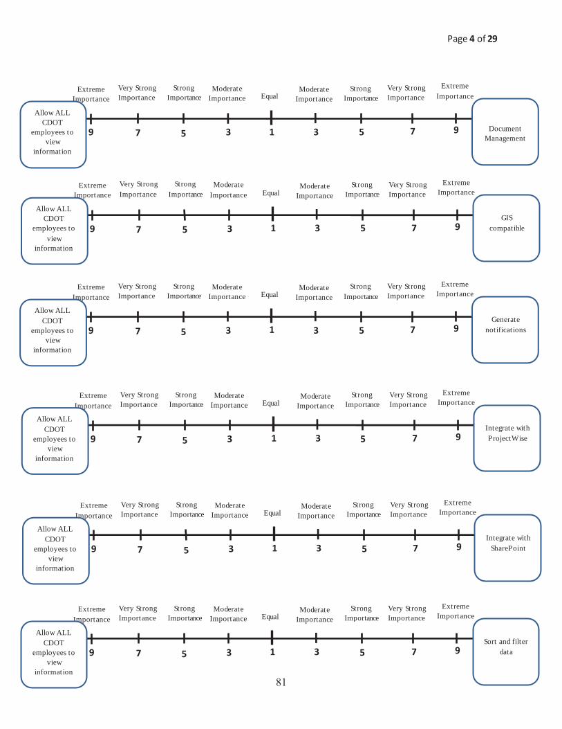
Page 4 of 29
9 7 5 3 1 9 7 5 3
Very Strong Importance
Extreme Importance Equal
Strong Importancee
Moderate Importance
Extreme Importance
Moderate Importance
Strong Importance
Very Strong Importance
Document Management
Allow ALL CDOT
employees to view
information
9 7 5 3 1 9 7 5 3
Very Strong Importance
Extreme Importance Equal
Strong Importancee
Moderate Importance
Extreme Importance
Moderate Importance
Strong Importance
Very Strong Importance
Sort and filter data
Allow ALL CDOT
employees to view
information
9 7 5 3 1 9 7 5 3
Very Strong Importance
Extreme Importance Equal
Strong Importancee
Moderate Importance
Extreme Importance
Moderate Importance
Strong Importance
Very Strong Importance
Generate notifications
Allow ALL CDOT
employees to view
information
9 7 5 3 1 9 7 5 3
Very Strong Importance
Extreme Importance Equal
Strong Importancee
Moderate Importance
Extreme Importance
Moderate Importance
Strong Importance
Very Strong Importance
Integrate with SharePoint
Allow ALL CDOT
employees to view
information
9 7 5 3 1 9 7 5 3
Very Strong Importance
Extreme Importance Equal
Strong Importancee
Moderate Importance
Extreme Importance
Moderate Importance
Strong Importance
Very Strong Importance
Integrate with ProjectWise
Allow ALL CDOT
employees to view
information
9 7 5 3 1 9 7 5 3
Very Strong Importance
Extreme Importance Equal
Strong Importancee
Moderate Importance
Extreme Importance
Moderate Importance
Strong Importance
Very Strong Importance
GIS compatible
Allow ALL CDOT
employees to view
information
��

Page 5 of 29
9 7 5 3 1 9 7 5 3
Very Strong Importance
Extreme Importance Equal
Strong Importancee
Moderate Importance
Extreme Importance
Moderate Importance
Strong Importance
Very Strong Importance
Standard Reports
Allow ALL CDOT
employees to view
information
9 7 5 3 1 9 7 5 3
Very Strong Importance
Extreme Importance Equal
Strong Importancee
Moderate Importance
Extreme Importance
Moderate Importance
Strong Importance
Very Strong Importance
Allow multiple CDOT
employees to input/edit
information
Allow external stakeholders to
view information
9 7 5 3 1 9 7 5 3
Very Strong Importance
Extreme Importance Equal
Strong Importancee
Moderate Importance
Extreme Importance
Moderate Importance
Strong Importance
Very Strong Importance
Track deleted or modified
commitments
Allow ALL CDOT
employees to view
information
9 7 5 3 1 9 7 5 3
Very Strong Importance
Extreme Importance Equal
Strong Importancee
Moderate Importance
Extreme Importance
Moderate Importance
Strong Importance
Very Strong Importance
Web based Allow ALL
CDOT employees to
view information
9 7 5 3 1 9 7 5 3
Very Strong Importance
Extreme Importance Equal
Strong Importancee
Moderate Importance
Extreme Importance
Moderate Importance
Strong Importance
Very Strong Importance
Track permits Allow ALL
CDOT employees to
view information
9 7 5 3 1 9 7 5 3
Very Strong Importance
Extreme Importance Equal
Strong Importancee
Moderate Importance
Extreme Importance
Moderate Importance
Strong Importance
Very Strong Importance
Store data in a single
centralized file
Allow ALL CDOT
employees to view
information
��

Page 6 of 29
9 7 5 3 1 9 7 5 3
Very Strong Importance
Extreme Importance Equal
Strong Importancee
Moderate Importance
Extreme Importance
Moderate Importance
Strong Importance
Very Strong Importance
Allow external stakeholders to
input/edit information
Allow external stakeholders to
view information
9 7 5 3 1 9 7 5 3
Very Strong Importance
Extreme Importance Equal
Strong Importancee
Moderate Importance
Extreme Importance
Moderate Importance
Strong Importance
Very Strong Importance
GIS compatible
Allow external stakeholders to
view information
9 7 5 3 1 9 7 5 3
Very Strong Importance
Extreme Importance Equal
Strong Importancee
Moderate Importance
Extreme Importance
Moderate Importance
Strong Importance
Very Strong Importance
Control which CDOT
employees can view
information
Allow external stakeholders to
view information
9 7 5 3 1 9 7 5 3
Very Strong Importance
Extreme Importance Equal
Strong Importancee
Moderate Importance
Extreme Importance
Moderate Importance
Strong Importance
Very Strong Importance
Document Management
Allow external stakeholders to
view information
9 7 5 3 1 9 7 5 3
Very Strong Importance
Extreme Importance Equal
Strong Importancee
Moderate Importance
Extreme Importance
Moderate Importance
Strong Importance
Very Strong Importance
Differentiate between CAT X, EA, & EISs
Allow external stakeholders to
view information
9 7 5 3 1 9 7 5 3
Very Strong Importance
Extreme Importance Equal
Strong Importancee
Moderate Importance
Extreme Importance
Moderate Importance
Strong Importance
Very Strong Importance
Control which CDOT
employees can input/edit
information
Allow external stakeholders to
view information
��

Page 7 of 29
9 7 5 3 1 9 7 5 3
Very Strong Importance
Extreme Importance Equal
Strong Importancee
Moderate Importance
Extreme Importance
Moderate Importance
Strong Importance
Very Strong Importance
Generate notifications
Allow external stakeholders to
view information
9 7 5 3 1 9 7 5 3
Very Strong Importance
Extreme Importance Equal
Strong Importancee
Moderate Importance
Extreme Importance
Moderate Importance
Strong Importance
Very Strong Importance
Store data in a single
centralized file
Allow external stakeholders to
view information
9 7 5 3 1 9 7 5 3
Very Strong Importance
Extreme Importance Equal
Strong Importancee
Moderate Importance
Extreme Importance
Moderate Importance
Strong Importance
Very Strong Importance
Integrate with SharePoint
Allow external stakeholders to
view information
9 7 5 3 1 9 7 5 3
Very Strong Importance
Extreme Importance Equal
Strong Importancee
Moderate Importance
Extreme Importance
Moderate Importance
Strong Importance
Very Strong Importance
Standard Reports
Allow external stakeholders to
view information
9 7 5 3 1 9 7 5 3
Very Strong Importance
Extreme Importance Equal
Strong Importancee
Moderate Importance
Extreme Importance
Moderate Importance
Strong Importance
Very Strong Importance
Sort and filter data
Allow external stakeholders to
view information
9 7 5 3 1 9 7 5 3
Very Strong Importance
Extreme Importance Equal
Strong Importancee
Moderate Importance
Extreme Importance
Moderate Importance
Strong Importance
Very Strong Importance
Integrate with ProjectWise
Allow external stakeholders to
view information
�

Page 8 of 29
9 7 5 3 1 9 7 5 3
Very Strong Importance
Extreme Importance Equal
Strong Importancee
Moderate Importance
Extreme Importance
Moderate Importance
Strong Importance
Very Strong Importance
Track deleted or modified
commitments
Allow external stakeholders to
view information
9 7 5 3 1 9 7 5 3
Very Strong Importance
Extreme Importance Equal
Strong Importancee
Moderate Importance
Extreme Importance
Moderate Importance
Strong Importance
Very Strong Importance
Control which CDOT
employees can view
information
Allow multiple CDOT
employees to input/edit
information
9 7 5 3 1 9 7 5 3
Very Strong Importance
Extreme Importance Equal
Strong Importancee
Moderate Importance
Extreme Importance
Moderate Importance
Strong Importance
Very Strong Importance
Web based Allow external stakeholders to
view information
9 7 5 3 1 9 7 5 3
Very Strong Importance
Extreme Importance Equal
Strong Importancee
Moderate Importance
Extreme Importance
Moderate Importance
Strong Importance
Very Strong Importance
Control which CDOT
employees can input/edit
information
Allow multiple CDOT
employees to input/edit
information
9 7 5 3 1 9 7 5 3
Very Strong Importance
Extreme Importance Equal
Strong Importancee
Moderate Importance
Extreme Importance
Moderate Importance
Strong Importance
Very Strong Importance
Allow external stakeholders to
input/edit information
Allow multiple CDOT
employees to input/edit
information
9 7 5 3 1 9 7 5 3
Very Strong Importance
Extreme Importance Equal
Strong Importancee
Moderate Importance
Extreme Importance
Moderate Importance
Strong Importance
Very Strong Importance
Track permits Allowexternal stakeholders to
view information
�

Page 9 of 29
9 7 5 3 1 9 7 5 3
Very Strong Importance
Extreme Importance Equal
Strong Importancee
Moderate Importance
Extreme Importance
Moderate Importance
Strong Importance
Very StrongImportance
Differentiate between CAT X, EA, & EISs
Allow multiple CDOT
employees to input/edit
information
9 7 5 3 1 9 7 5 3
Very Strong Importance
Extreme Importance Equal
Strong Importancee
Moderate Importance
ExtremeImportance
Moderate Importance
Strong Importance
Very Strong Importance
Integrate with SharePoint
Allow multiple CDOT
employees to input/edit
information
9 7 5 3 1 9 7 5 3
Very Strong Importance
Extreme Importance Equal
Strong Importancee
Moderate Importance
Extreme Importance
Moderate Importance
Strong Importance
Very Strong Importance
GIS compatible
Allow multiple CDOT
employees to input/edit
information
9 7 5 3 1 9 7 5 3
Very Strong Importance
Extreme Importance Equal
Strong Importancee
Moderate Importance
Extreme Importance
Moderate Importance
Strong Importance
Very Strong Importance
Integrate with ProjectWise
Allow multiple CDOT
employees to input/edit
information
9 7 5 3 1 9 7 5 3
Very Strong Importance
Extreme Importance Equal
Strong Importancee
Moderate Importance
Extreme Importance
Moderate Importance
Strong Importance
Very Strong Importance
Generate notifications
Allow multiple CDOT
employees to input/edit
information
9 7 5 3 1 9 7 5 3
Very Strong Importance
Extreme Importance Equal
Strong Importancee
Moderate Importance
Extreme Importance
Moderate Importance
Strong Importance
Very Strong Importance
Document Management
Allow multiple CDOT
employees to input/edit
information
��

Page 10 of 29
9 7 5 3 1 9 7 5 3
Very Strong Importance
Extreme Importance Equal
Strong Importancee
Moderate Importance
Extreme Importance
Moderate Importance
Strong Importance
Very Strong Importance
Sort and filter data
Allow multiple CDOT
employees to input/edit
information
9 7 5 3 1 9 7 5 3
Very Strong Importance
Extreme Importance Equal
Strong Importancee
Moderate Importance
Extreme Importance
Moderate Importance
Strong Importance
Very Strong Importance
Web based Allow multiple
CDOT employees to
input/edit information
9 7 5 3 1 9 7 5 3
Very Strong Importance
Extreme Importance Equal
Strong Importancee
Moderate Importance
Extreme Importance
Moderate Importance
Strong Importance
Very Strong Importance
Store data in a single
centralized file
Allow multiple CDOT
employees to input/edit
information
9 7 5 3 1 9 7 5 3
Very Strong Importance
Extreme Importance Equal
Strong Importancee
Moderate Importance
Extreme Importance
Moderate Importance
Strong Importance
Very Strong Importance
Track permits Allow multiple
CDOT employees to
input/edit information
9 7 5 3 1 9 7 5 3
Very Strong Importance
Extreme Importance Equal
Strong Importancee
Moderate Importance
Extreme Importance
Moderate Importance
Strong Importance
Very Strong Importance
Track deleted or modified
commitments
Allow multiple CDOT
employees to input/edit
information
9 7 5 3 1 9 7 5 3
Very Strong Importance
Extreme Importance Equal
Strong Importancee
Moderate Importance
Extreme Importance
Moderate Importance
Strong Importance
Very Strong Importance
Standard Reports
Allow multiple CDOT
employees to input/edit
information
��

Page 11 of 29
9 7 5 3 1 9 7 5 3
Very Strong Importance
Extreme Importance Equal
Strong Importancee
Moderate Importance
Extreme Importance
Moderate Importance
Strong Importance
Very Strong Importance
Control which CDOT
employees can input/edit
information
Allow external stakeholders to
input/edit information
9 7 5 3 1 9 7 5 3
Very Strong Importance
Extreme Importance Equal
Strong Importancee
Moderate Importance
Extreme Importance
Moderate Importance
Strong Importance
Very Strong Importance
Generate notifications
Allow external stakeholders to
input/edit information
9 7 5 3 1 9 7 5 3
Very Strong Importance
Extreme Importance Equal
Strong Importancee
Moderate Importance
Extreme Importance
Moderate Importance
Strong Importance
Very Strong Importance
Differentiate between CAT X, EA, & EISs
Allow external stakeholders to
input/edit information
9 7 5 3 1 9 7 5 3
Very Strong Importance
Extreme Importance Equal
Strong Importancee
Moderate Importance
Extreme Importance
Moderate Importance
Strong Importance
Very Strong Importance
GIS compatible
Allow external stakeholders to
input/edit information
9 7 5 3 1 9 7 5 3
Very Strong Importance
Extreme Importance Equal
Strong Importancee
Moderate Importance
Extreme Importance
Moderate Importance
Strong Importance
Very Strong Importance
Document Management
Allow external stakeholders to
input/edit information
9 7 5 3 1 9 7 5 3
Very Strong Importance
Extreme Importance Equal
Strong Importancee
Moderate Importance
Extreme Importance
Moderate Importance
Strong Importance
Very Strong Importance
Control which CDOT
employees can view
information
Allow external stakeholders to
input/edit information
��

Page 12 of 29
9 7 5 3 1 9 7 5 3
Very Strong Importance
Extreme Importance Equal
Strong Importancee
Moderate Importance
Extreme Importance
Moderate Importance
Strong Importance
Very Strong Importance
Integrate with ProjectWise
Allow external stakeholders to
input/edit information
9 7 5 3 1 9 7 5 3
Very Strong Importance
Extreme Importance Equal
Strong Importancee
Moderate Importance
Extreme Importance
Moderate Importance
Strong Importance
Very Strong Importance
Track deleted or modified
commitments
Allow external stakeholders to
input/edit information
9 7 5 3 1 9 7 5 3
Very Strong Importance
Extreme Importance Equal
Strong Importancee
Moderate Importance
Extreme Importance
Moderate Importance
Strong Importance
Very Strong Importance
Sort and filter data
Allow external stakeholders to
input/edit information
9 7 5 3 1 9 7 5 3
Very Strong Importance
Extreme Importance Equal
Strong Importancee
Moderate Importance
Extreme Importance
Moderate Importance
Strong Importance
Very Strong Importance
Store data in a single
centralized file
Allow external stakeholders to
input/edit information
9 7 5 3 1 9 7 5 3
Very Strong Importance
Extreme Importance Equal
Strong Importancee
Moderate Importance
Extreme Importance
Moderate Importance
Strong Importance
Very Strong Importance
Standard Reports
Allow external stakeholders to
input/edit information
9 7 5 3 1 9 7 5 3
Very Strong Importance
Extreme Importance Equal
Strong Importancee
Moderate Importance
Extreme Importance
Moderate Importance
Strong Importance
Very Strong Importance
Integrate with SharePoint
Allow external stakeholders to
input/edit information
��
Page 13 of 29
9 7 5 3 1 9 7 5 3
Very Strong Importance
Extreme Importance Equal
Strong Importancee
Moderate Importance
Extreme Importance
Moderate Importance
Strong Importance
Very Strong Importance
Track permits
Allow external stakeholders to
input/edit information
9 7 5 3 1 9 7 5 3
Very Strong Importance
Extreme Importance Equal
Strong Importancee
Moderate Importance
Extreme Importance
Moderate Importance
Strong Importance
Very Strong Importance
GIS compatible
Control which CDOT
employees can input/edit
information
9 7 5 3 1 9 7 5 3
Very Strong Importance
Extreme Importance Equal
Strong Importancee
Moderate Importance
Extreme Importance
Moderate Importance
Strong Importance
Very Strong Importance
Control which CDOT
employees can view
information
Control whichCDOT
employees can input/edit
information
9 7 5 3 1 9 7 5 3
Very Strong Importance
Extreme Importance Equal
Strong Importancee
Moderate Importance
Extreme Importance
Moderate Importance
Strong Importance
Very Strong Importance
Document Management
Control which CDOT
employees can input/edit
information
9 7 5 3 1 9 7 5 3
Very Strong Importance
Extreme Importance Equal
Strong Importancee
Moderate Importance
Extreme Importance
Moderate Importance
Strong Importance
Very Strong Importance
Differentiate between CAT X, EA, & EISs
Control which CDOT
employees can input/edit
information
9 7 5 3 1 9 7 5 3
Very Strong Importance
Extreme Importance Equal
Strong Importancee
Moderate Importance
Extreme Importance
Moderate Importance
Strong Importance
Very Strong Importance
Web based Allow external stakeholders to
input/edit information
��

Page 14 of 29
9 7 5 3 1 9 7 5 3
Very Strong Importance
Extreme Importance Equal
Strong Importancee
Moderate Importance
Extreme Importance
Moderate Importance
Strong Importance
Very Strong Importance
Generate notifications
Control which CDOT
employees can input/edit
information
9 7 5 3 1 9 7 5 3
Very Strong Importance
Extreme Importance Equal
Strong Importancee
Moderate Importance
Extreme Importance
Moderate Importance
Strong Importance
Very Strong Importance
Store data in a single
centralized file
Control which CDOT
employees can input/edit
information
9 7 5 3 1 9 7 5 3
Very Strong Importance
Extreme Importance Equal
Strong Importancee
Moderate Importance
Extreme Importance
Moderate Importance
Strong Importance
Very Strong Importance
Integrate with SharePoint
Control which CDOT
employees can input/edit
information
9 7 5 3 1 9 7 5 3
Very Strong Importance
Extreme Importance Equal
Strong Importancee
Moderate Importance
Extreme Importance
Moderate Importance
Strong Importance
Very Strong Importance
Standard Reports
Control which CDOT
employees can input/edit
information
9 7 5 3 1 9 7 5 3
Very Strong Importance
Extreme Importance Equal
Strong Importancee
Moderate Importance
Extreme Importance
Moderate Importance
Strong Importance
Very Strong Importance
Sort and filter data
Control which CDOT
employees can input/edit
information
9 7 5 3 1 9 7 5 3
Very Strong Importance
Extreme Importance Equal
Strong Importancee
Moderate Importance
Extreme Importance
Moderate Importance
Strong Importance
Very Strong Importance
Integrate with ProjectWise
Control which CDOT
employees can input/edit
information
��
Page 15 of 29
9 7 5 3 1 9 7 5 3
Very Strong Importance
Extreme Importance Equal
Strong Importancee
Moderate Importance
Extreme Importance
Moderate Importance
Strong Importance
Very Strong Importance
Track deleted or modified
commitments
Control which CDOT
employees can input/edit
information
9 7 5 3 1 9 7 5 3
Very Strong Importance
Extreme Importance Equal
Strong Importancee
Moderate Importance
Extreme Importance
Moderate Importance
Strong Importance
Very Strong Importance
GIS compatible
Control which CDOT
employees can view
information
9 7 5 3 1 9 7 5 3
Very Strong Importance
Extreme Importance Equal
Strong Importancee
Moderate Importance
Extreme Importance
Moderate Importance
Strong Importance
Very Strong Importance
Web based Control which
CDOT employees can
input/edit information
9 7 5 3 1 9 7 5 3
Very Strong Importance
Extreme Importance Equal
Strong Importancee
Moderate Importance
Extreme Importance
Moderate Importance
Strong Importance
Very Strong Importance
Document Management
Control which CDOT
employees can view
information
9 7 5 3 1 9 7 5 3
Very Strong Importance
Extreme Importance Equal
Strong Importancee
Moderate Importance
Extreme Importance
Moderate Importance
Strong Importance
Very Strong Importance
Differentiate between CAT X, EA, & EISs
Control which CDOT
employees can view
information
9 7 5 3 1 9 7 5 3
Very Strong Importance
Extreme Importance Equal
Strong Importancee
Moderate Importance
Extreme Importance
Moderate Importance
Strong Importance
Very Strong Importance
Track permits Control which
CDOT employees can
input/edit information
��

Page 16 of 29
9 7 5 3 1 9 7 5 3
Very Strong Importance
Extreme Importance Equal
Strong Importancee
Moderate Importance
Extreme Importance
Moderate Importance
Strong Importance
Very Strong Importance
Generate notifications
Control which CDOT
employees can view
information
9 7 5 3 1 9 7 5 3
Very Strong Importance
Extreme Importance Equal
Strong Importancee
Moderate Importance
Extreme Importance
ModerateImportance
Strong Importance
Very Strong Importance
Store data in a single
centralized file
Control which CDOT
employees can view
information
9 7 5 3 1 9 7 5 3
Very Strong Importance
Extreme Importance Equal
Strong Importancee
Moderate Importance
Extreme Importance
Moderate Importance
Strong Importance
Very Strong Importance
Integrate with SharePoint
Control which CDOT
employees can view
information
9 7 5 3 1 9 7 5 3
Very Strong Importance
Extreme Importance Equal
Strong Importancee
Moderate Importance
Extreme Importance
Moderate Importance
Strong Importance
Very Strong Importance
Standard Reports
Control which CDOT
employees can view
information
9 7 5 3 1 9 7 5 3
Very Strong Importance
Extreme Importance Equal
Strong Importancee
Moderate Importance
Extreme Importance
Moderate Importance
Strong Importance
Very Strong Importance
Sort and filter data
Control which CDOT
employees can view
information
9 7 5 3 1 9 7 5 3
Very Strong Importance
Extreme Importance Equal
Strong Importancee
Moderate Importance
Extreme Importance
Moderate Importance
Strong Importance
Very Strong Importance
Integrate with ProjectWise
Control which CDOT
employees can view
information
��
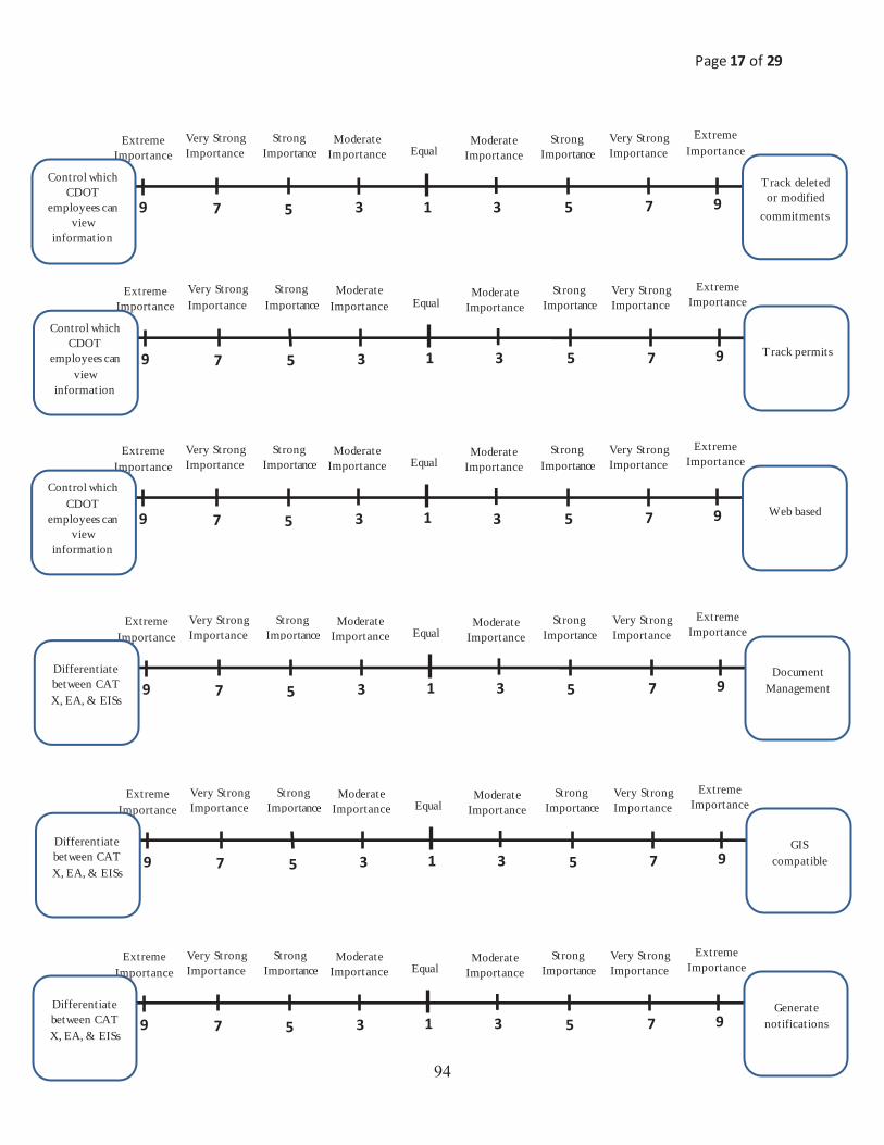
Page 17 of 29
9 7 5 3 1 9 7 5 3
Very Strong Importance
Extreme Importance Equal
Strong Importancee
Moderate Importance
Extreme Importance
Moderate Importance
Strong Importance
Very Strong Importance
Track deleted or modified
commitments
Control which CDOT
employees can view
information
9 7 5 3 1 9 7 5 3
Very Strong Importance
Extreme Importance Equal
Strong Importancee
Moderate Importance
Extreme Importance
Moderate Importance
Strong Importance
Very Strong Importance
Generate notifications
Differentiate between CAT X, EA, & EISs
9 7 5 3 1 9 7 5 3
Very Strong Importance
Extreme Importance Equal
Strong Importancee
Moderate Importance
Extreme Importance
Moderate Importance
Strong Importance
Very Strong Importance
Web based Control which
CDOT employees can
view information
9 7 5 3 1 9 7 5 3
Very Strong Importance
Extreme Importance Equal
Strong Importancee
Moderate Importance
Extreme Importance
Moderate Importance
Strong Importance
Very Strong Importance
GIS compatible
Differentiate between CAT X, EA, & EISs
9 7 5 3 1 9 7 5 3
Very Strong Importance
Extreme Importance Equal
Strong Importancee
Moderate Importance
Extreme Importance
Moderate Importance
Strong Importance
Very Strong Importance
Document Management
Differentiate between CAT X, EA, & EISs
9 7 5 3 1 9 7 5 3
Very Strong Importance
Extreme Importance Equal
Strong Importancee
Moderate Importance
Extreme Importance
Moderate Importance
Strong Importance
Very Strong Importance
Track permits Control which
CDOT employees can
view information
�

Page 18 of 29
9 7 5 3 1 9 7 5 3
Very Strong Importance
Extreme Importance Equal
Strong Importancee
Moderate Importance
Extreme Importance
Moderate Importance
Strong Importance
Very Strong Importance
Integrate with ProjectWise
Differentiate between CAT X, EA, & EISs
9 7 5 3 1 9 7 5 3
Very Strong Importance
Extreme Importance Equal
Strong Importancee
Moderate Importance
Extreme Importance
Moderate Importance
Strong Importance
Very Strong Importance
Track deleted or modified
commitments
Differentiate between CAT X, EA, & EISs
9 7 5 3 1 9 7 5 3
Very Strong Importance
Extreme Importance Equal
Strong Importancee
Moderate Importance
Extreme Importance
Moderate Importance
Strong Importance
Very Strong Importance
Sort and filter data
Differentiate between CAT X, EA, & EISs
9 7 5 3 1 9 7 5 3
Very Strong Importance
Extreme Importance Equal
Strong Importancee
Moderate Importance
Extreme Importance
Moderate Importance
Strong Importance
Very Strong Importance
Store data in a single
centralized file
Differentiate between CAT X, EA, & EISs
9 7 5 3 1 9 7 5 3
Very Strong Importance
Extreme Importance Equal
Strong Importancee
Moderate Importance
Extreme Importance
Moderate Importance
Strong Importance
Very Strong Importance
Standard Reports
Differentiate between CAT X, EA, & EISs
9 7 5 3 1 9 7 5 3
Very Strong Importance
Extreme Importance Equal
Strong Importancee
Moderate Importance
Extreme Importance
Moderate Importance
Strong Importance
Very Strong Importance
Integrate with SharePoint
Differentiate between CAT X, EA, & EISs
�

Page 19 of 29
9 7 5 3 1 9 7 5 3
Very Strong Importance
Extreme Importance Equal
Strong Importancee
Moderate Importance
Extreme Importance
Moderate Importance
Strong Importance
Very Strong Importance
Track permits
Differentiate between CAT X, EA, & EISs
9 7 5 3 1 9 7 5 3
Very Strong Importance
Extreme Importance Equal
Strong Importancee
Moderate Importance
Extreme Importance
Moderate Importance
Strong Importance
Very Strong Importance
Integrate with SharePoint
Document Management
9 7 5 3 1 9 7 5 3
Very Strong Importance
Extreme Importance Equal
Strong Importancee
Moderate Importance
Extreme Importance
Moderate Importance
Strong Importance
Very Strong Importance
GIS compatible
Document Management
9 7 5 3 1 9 7 5 3
Very Strong Importance
Extreme Importance Equal
Strong Importancee
Moderate Importance
Extreme Importance
Moderate Importance
Strong Importance
Very Strong Importance
Integrate with ProjectWise
Document Management
9 7 5 3 1 9 7 5 3
Very Strong Importance
Extreme Importance Equal
Strong Importancee
Moderate Importance
Extreme Importance
Moderate Importance
Strong Importance
Very Strong Importance
Generate notifications
Document Management
9 7 5 3 1 9 7 5 3
Very Strong Importance
Extreme Importance Equal
Strong Importancee
Moderate Importance
Extreme Importance
Moderate Importance
Strong Importance
Very Strong Importance
Web based Differentiate between CAT X, EA, & EISs
��

Page 20 of 29
9 7 5 3 1 9 7 5 3
Very Strong Importance
Extreme Importance Equal
Strong Importancee
Moderate Importance
Extreme Importance
Moderate Importance
Strong Importance
Very Strong Importance
Sort and filter data
Document Management
9 7 5 3 1 9 7 5 3
Very Strong Importance
Extreme Importance Equal
Strong Importancee
Moderate Importance
Extreme Importance
Moderate Importance
Strong Importance
Very Strong Importance
Web based Document Management
9 7 5 3 1 9 7 5 3
Very Strong Importance
Extreme Importance Equal
Strong Importancee
Moderate Importance
Extreme Importance
Moderate Importance
Strong Importance
Very Strong Importance
Store data in a single
centralized file Document
Management
9 7 5 3 1 9 7 5 3
Very Strong Importance
Extreme Importance Equal
Strong Importancee
Moderate Importance
Extreme Importance
Moderate Importance
Strong Importance
Very Strong Importance
Track permits Document Management
9 7 5 3 1 9 7 5 3
Very Strong Importance
Extreme Importance Equal
Strong Importancee
Moderate Importance
Extreme Importance
Moderate Importance
Strong Importance
Very Strong Importance
Track deleted or modified
commitments Document
Management
9 7 5 3 1 9 7 5 3
Very Strong Importance
Extreme Importance Equal
Strong Importancee
Moderate Importance
Extreme Importance
Moderate Importance
Strong Importance
Very Strong Importance
Standard Reports Document
Management
��
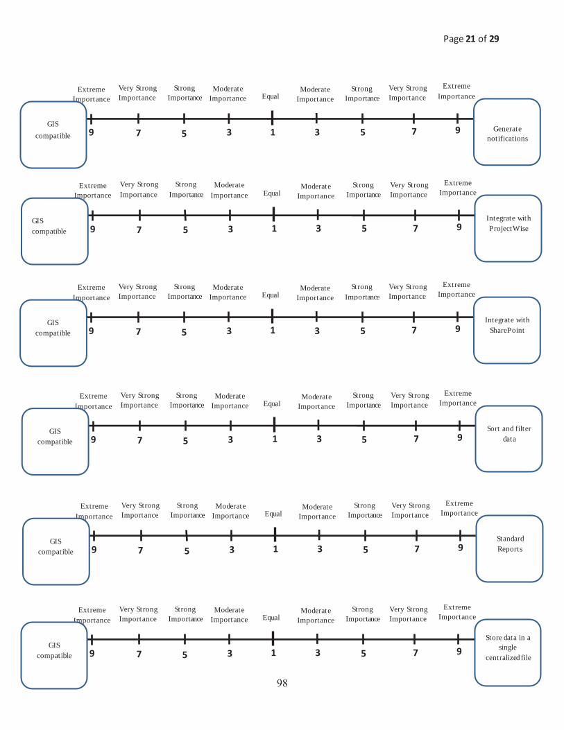
Page 21 of 29
9 7 5 3 1 9 7 5 3
Very Strong Importance
Extreme Importance Equal
Strong Importancee
Moderate Importance
Extreme Importance
Moderate Importance
Strong Importance
Very Strong Importance
Generate notifications
GIS compatible
9 7 5 3 1 9 7 5 3
Very Strong Importance
Extreme Importance Equal
Strong Importancee
Moderate Importance
Extreme Importance
Moderate Importance
Strong Importance
Very Strong Importance
Store data in a single
centralized file GIS
compatible
9 7 5 3 1 9 7 5 3
Very Strong Importance
Extreme Importance Equal
Strong Importancee
Moderate Importance
Extreme Importance
Moderate Importance
Strong Importance
Very Strong Importance
Integrate with SharePoint
GIS compatible
9 7 5 3 1 9 7 5 3
Very Strong Importance
Extreme Importance Equal
Strong Importancee
Moderate Importance
Extreme Importance
Moderate Importance
Strong Importance
Very Strong Importance
Standard Reports
GIS compatible
9 7 5 3 1 9 7 5 3
Very Strong Importance
Extreme Importance Equal
Strong Importancee
Moderate Importance
Extreme Importance
Moderate Importance
StrongImportance
Very Strong Importance
Sort and filter data
GIS compatible
9 7 5 3 1 9 7 5 3
Very Strong Importance
Extreme Importance Equal
Strong Importancee
Moderate Importance
Extreme Importance
Moderate Importance
Strong Importance
Very Strong Importance
Integrate with ProjectWise
GIS compatible
��
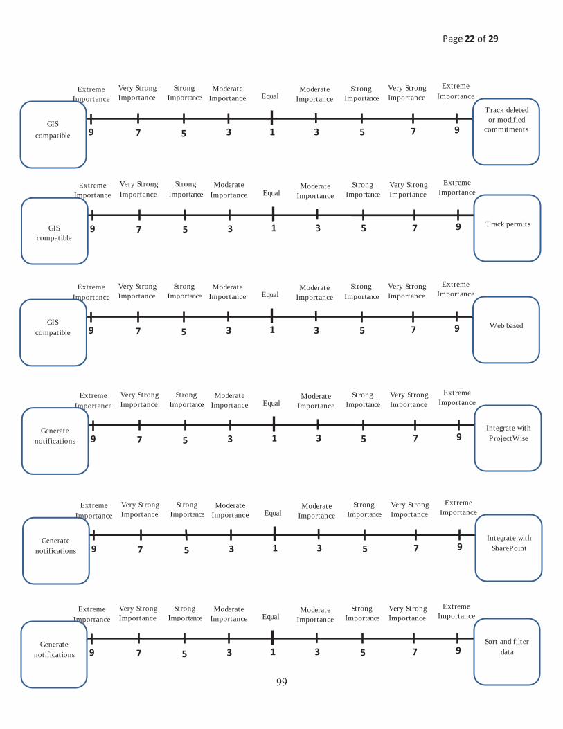
Page 22 of 29
9 7 5 3 1 9 7 5 3
Very Strong Importance
Extreme Importance Equal
Strong Importancee
Moderate Importance
Extreme Importance
ModerateImportance
Strong Importance
Very Strong Importance
Track deleted or modified
commitments
GIS compatible
9 7 5 3 1 9 7 5 3
Very Strong Importance
Extreme Importance Equal
Strong Importancee
Moderate Importance
Extreme Importance
Moderate Importance
Strong Importance
Very Strong Importance
Sort and filter data
Generate notifications
9 7 5 3 1 9 7 5 3
Very Strong Importance
Extreme Importance Equal
Strong Importancee
Moderate Importance
Extreme Importance
Moderate Importance
Strong Importance
Very Strong Importance
Web based GIS compatible
9 7 5 3 1 9 7 5 3
Very Strong Importance
Extreme Importance Equal
Strong Importancee
Moderate Importance
Extreme Importance
Moderate Importance
Strong Importance
Very Strong Importance
Integrate with SharePoint
Generate notifications
9 7 5 3 1 9 7 5 3
Very Strong Importance
Extreme Importance Equal
Strong Importancee
Moderate Importance
Extreme Importance
Moderate Importance
Strong Importance
Very Strong Importance
Integrate with ProjectWise
Generate notifications
9 7 5 3 1 9 7 5 3
Very Strong Importance
Extreme Importance Equal
Strong Importancee
Moderate Importance
Extreme Importance
Moderate Importance
Strong Importance
Very Strong Importance
Track permits GIS compatible
��

Page 23 of 29
9 7 5 3 1 9 7 5 3
Very Strong Importance
Extreme Importance Equal
Strong Importancee
Moderate Importance
Extreme Importance
Moderate Importance
Strong Importance
Very Strong Importance
Standard Reports
Generate notifications
9 7 5 3 1 9 7 5 3
Very Strong Importance
Extreme Importance Equal
Strong Importancee
Moderate Importance
Extreme Importance
Moderate Importance
Strong Importance
Very Strong Importance
Integrate with SharePoint
Integrate with ProjectWise
9 7 5 3 1 9 7 5 3
Very Strong Importance
Extreme Importance Equal
Strong Importancee
Moderate Importance
Extreme Importance
Moderate Importance
Strong Importance
Very Strong Importance
Track deleted or modified
commitments Generate
notifications
9 7 5 3 1 9 7 5 3
Very Strong Importance
Extreme Importance Equal
Strong Importancee
Moderate Importance
Extreme Importance
Moderate Importance
Strong Importance
Very Strong Importance
Web based Generate notifications
9 7 5 3 1 9 7 5 3
Very Strong Importance
Extreme Importance Equal
Strong Importancee
Moderate Importance
Extreme Importance
Moderate Importance
Strong Importance
Very Strong Importance
Track permits Generate notifications
9 7 5 3 1 9 7 5 3
Very Strong Importance
Extreme Importance Equal
Strong Importancee
Moderate Importance
Extreme Importance
Moderate Importance
Strong Importance
Very Strong Importance
Store data in a single
centralized fileGenerate notifications
���

Page 24 of 29
9 7 5 3 1 9 7 5 3
Very Strong Importance
Extreme Importance Equal
Strong Importancee
Moderate Importance
Extreme Importance
Moderate Importance
Strong Importance
Very Strong Importance
Sort and filter data
Integrate with ProjectWise
9 7 5 3 1 9 7 5 3
Very Strong Importance
Extreme Importance Equal
Strong Importancee
Moderate Importance
Extreme Importance
Moderate Importance
Strong Importance
Very Strong Importance
Web based Integrate with ProjectWise
9 7 5 3 1 9 7 5 3
Very Strong Importance
Extreme Importance Equal
Strong Importancee
Moderate Importance
Extreme Importance
Moderate Importance
Strong Importance
Very Strong Importance
Store data in a single
centralized file Integrate with ProjectWise
9 7 5 3 1 9 7 5 3
Very Strong Importance
Extreme Importance Equal
Strong Importancee
Moderate Importance
Extreme Importance
Moderate Importance
Strong Importance
Very Strong Importance
Track permits Integrate with ProjectWise
9 7 5 3 1 9 7 5 3
Very Strong Importance
Extreme Importance Equal
Strong Importancee
Moderate Importance
Extreme Importance
Moderate Importance
Strong Importance
Very Strong Importance
Track deleted or modified
commitments Integrate with ProjectWise
9 7 5 3 1 9 7 5 3
Very Strong Importance
Extreme Importance Equal
Strong Importancee
Moderate Importance
Extreme Importance
Moderate Importance
Strong Importance
Very Strong Importance
Standard Reports Integrate with
ProjectWise
���

Page 25 of 29
9 7 5 3 1 9 7 5 3
Very Strong Importance
Extreme Importance Equal
Strong Importancee
Moderate Importance
Extreme Importance
Moderate Importance
Strong Importance
Very Strong Importance
Sort and filter data
Integrate with SharePoint
9 7 5 3 1 9 7 5 3
Very Strong Importance
Extreme Importance Equal
Strong Importancee
Moderate Importance
Extreme Importance
Moderate Importance
Strong Importance
Very Strong Importance
Web based Integrate with SharePoint
9 7 5 3 1 9 7 5 3
Very Strong Importance
Extreme Importance Equal
Strong Importancee
Moderate Importance
Extreme Importance
Moderate Importance
Strong Importance
Very Strong Importance
Store data in a single
centralized file Integrate with
SharePoint
9 7 5 3 1 9 7 5 3
Very Strong Importance
Extreme Importance Equal
Strong Importancee
Moderate Importance
Extreme Importance
Moderate Importance
Strong Importance
Very Strong Importance
Track permits Integrate with SharePoint
9 7 5 3 1 9 7 5 3
Very Strong Importance
Extreme Importance Equal
Strong Importancee
Moderate Importance
Extreme Importance
Moderate Importance
Strong Importance
Very Strong Importance
Track deleted or modified
commitments Integrate with
SharePoint
9 7 5 3 1 9 7 5 3
Very Strong Importance
Extreme Importance Equal
Strong Importancee
Moderate Importance
Extreme Importance
Moderate Importance
Strong Importance
Very Strong Importance
Standard Reports Integrate with
SharePoint
���

Page 26 of 29
9 7 5 3 1 9 7 5 3
Very Strong Importance
Extreme Importance Equal
Strong Importancee
Moderate Importance
Extreme Importance
Moderate Importance
Strong Importance
Very Strong Importance
Standard Reports
Sort and filter data
9 7 5 3 1 9 7 5 3
Very Strong Importance
Extreme Importance Equal
Strong Importancee
Moderate Importance
Extreme Importance
Moderate Importance
Strong Importance
Very Strong Importance
Store data in a single
centralized file Standard Reports
9 7 5 3 1 9 7 5 3
Very Strong Importance
Extreme Importance Equal
Strong Importancee
Moderate Importance
Extreme Importance
Moderate Importance
Strong Importance
Very Strong Importance
Track deleted or modified
commitments Sort and filter
data
9 7 5 3 1 9 7 5 3
Very Strong Importance
Extreme Importance Equal
Strong Importancee
Moderate Importance
Extreme Importance
Moderate Importance
Strong Importance
Very Strong Importance
Web based Sort and filter data
9 7 5 3 1 9 7 5 3
Very Strong Importance
Extreme Importance Equal
Strong Importancee
Moderate Importance
Extreme Importance
Moderate Importance
Strong Importance
Very Strong Importance
Track permits Sort and filter data
9 7 5 3 1 9 7 5 3
Very Strong Importance
Extreme Importance Equal
Strong Importancee
Moderate Importance
Extreme Importance
Moderate Importance
Strong Importance
Very Strong Importance
Store data in a single
centralized fileSort and filter data
���

Page 27 of 29
9 7 5 3 1 9 7 5 3
Very Strong Importance
Extreme Importance Equal
Strong Importancee
Moderate Importance
Extreme Importance
Moderate Importance
Strong Importance
Very Strong Importance
Track deleted or modified
commitments Standard Reports
9 7 5 3 1 9 7 5 3
Very Strong Importance
Extreme Importance Equal
Strong Importancee
Moderate Importance
Extreme Importance
Moderate Importance
Strong Importance
Very Strong Importance
Web based Store data in a
single centralized file
9 7 5 3 1 9 7 5 3
Very Strong Importance
Extreme Importance Equal
Strong Importancee
Moderate Importance
Extreme Importance
Moderate Importance
Strong Importance
Very Strong Importance
Web based Standard Reports
9 7 5 3 1 9 7 5 3
Very Strong Importance
Extreme Importance Equal
Strong Importancee
Moderate Importance
Extreme Importance
Moderate Importance
Strong Importance
Very Strong Importance
Track permits Store data in a
single centralized file
9 7 5 3 1 9 7 5 3
Very Strong Importance
Extreme Importance Equal
Strong Importancee
Moderate Importance
Extreme Importance
Moderate Importance
Strong Importance
Very Strong Importance
Track deleted or modified
commitments
Store data in a single
centralized file
9 7 5 3 1 9 7 5 3
Very Strong Importance
Extreme Importance Equal
Strong Importancee
Moderate Importance
Extreme Importance
Moderate Importance
Strong Importance
Very Strong Importance
Track permits Standard Reports
��

Page 28 of 29
9 7 5 3 1 9 7 5 3
Very Strong Importance
Extreme Importance Equal
Strong Importancee
Moderate Importance
Extreme Importance
Moderate Importance
Strong Importance
Very Strong Importance
Track permits
Track deleted or modified
commitments
9 7 5 3 1 9 7 5 3
Very Strong Importance
Extreme Importance Equal
Strong Importancee
Moderate Importance
Extreme Importance
Moderate Importance
Strong Importance
Very Strong Importance
Web based Track permits
9 7 5 3 1 9 7 5 3
Very Strong Importance
Extreme Importance Equal
Strong Importancee
Moderate Importance
Extreme Importance
Moderate Importance
Strong Importance
Very Strong Importance
Web based Track deleted or modified
commitments
��

Page 29 of 29
An overview of Analytic Hierarchy Process (AHP)
AHP is a systematic procedure that will enable us to find the relative importance of the metrics developed for this study. Such a task is performed by forming a panel of expert decision makers (of the relevant field) to investigate the most influencing factors. AHP allows for the application of data, experience, insight, and intuition in a logical and thorough way. The main purpose of AHP is the development of a vector of weights indicating the relative importance of the factors under investigation. For this purpose, AHP consists of the following steps.
1. Structuring the elements under analysis (e.g., metrics for this study) 2. Assessment made by the decision makers through pairwise comparisons of such elements 3. Obtaining the weights (indicating the relative importance) of the elements
The critical step is the second step at which the matrices of pairwise comparison are formed. Humans are more capable of making relative rather than absolute judgments. By using the AHP pairwise comparison process, weights or priorities are derived from a set of judgments. Pairwise comparisons are basic to the AHP methodology. When comparing a pair of factors, a ratio of relative importance of the factors can be established. Usually, ratio scales (i.e. the integers 1-9 and their reciprocals) are utilized to represent the judgments of decision makers in each pairwise comparison.
���