EPTEMBER POTENTIAL ENVIRONMENTAL EFFECTS ON … · PDA . Project development area . PR . Provincial...
89
MANITOBA – MINNESOTA TRANSMISSION PROJECT Environmental Impact Statement ASSESSMENT OF POTENTIAL ENVIRONMENTAL EFFECTS ON TRADITIONAL LAND AND RESOURCE USE CHAPTER 11 SEPTEMBER 2015
Transcript of EPTEMBER POTENTIAL ENVIRONMENTAL EFFECTS ON … · PDA . Project development area . PR . Provincial...

MANITOBA – MINNESOTA TRANSMISSION PROJECT Environmental Impact Statement
ASSESSMENT OF POTENTIAL ENVIRONMENTAL EFFECTS ON TRADITIONAL LAND AND RESOURCE USE
CHAPTER 11 SEPTEMBER 2015

MANITOBA – MINNESOTA TRANSMISSION PROJECT ENVIRONMENTAL IMPACT STATEMENT
11: ASSESSMENT OF POTENTIAL ENVIRONMENTAL EFFECTS ON TRADITIONAL LAND AND RESOURCE USE
TABLE OF CONTENTS
TABLE OF CONTENTS Page
11 ASSESSMENT OF POTENTIAL ENVIRONMENTAL EFFECTS ON TRADITIONAL LAND AND RESOURCE USE ................................... 11-1
11.1 Introduction ............................................................................... 11-1
11.1.1 Goals and Guiding Documents ....................................................... 11-3
11.1.1.1 Manitoba Hydro Principles .............................................. 11-3
11.1.2 Regulatory and Policy Setting ......................................................... 11-3
11.1.2.1 Primary Regulatory Guidance ......................................... 11-3
11.1.3 The First Nation and Metis Engagement Process and Key Findings .......................................................................................... 11-4
11.2 Scope of Assessment ............................................................... 11-6
11.2.1 Spatial Boundaries .......................................................................... 11-7
11.2.2 Temporal Boundaries ...................................................................... 11-8
11.2.3 Learnings from Past Assessments ................................................. 11-9
11.3 Methods .................................................................................. 11-10
11.3.1 Existing Conditions Methods ........................................................ 11-10
11.3.1.1 Self-directed ATK Studies and Oral Histories ............... 11-11
11.3.1.2 First Nation and Metis Engagement Process ................ 11-12
11.3.1.3 Secondary Sources ....................................................... 11-12
11.3.1.4 Other VC Assessments for the Project ......................... 11-12
11.3.2 Assessment Methods .................................................................... 11-13
11.3.2.1 Assessment Approach .................................................. 11-13
11.3.2.2 Potential Environmental Effects, Effect Pathways and Measurable Parameters ................................................ 11-13
11.3.2.3 Provision of Mitigation Measures for Environmental Effects ........................................................................... 11-21
11.3.2.4 Residual Environmental Effects Description Criteria .... 11-21
11.4 Existing Conditions for Traditional Land and Resource Use ... 11-23
11.4.1 Preliminary Routing ....................................................................... 11-23
September 2015 11-i

MANITOBA – MINNESOTA TRANSMISSION PROJECT ENVIRONMENTAL IMPACT STATEMENT 11: ASSESSMENT OF POTENTIAL ENVIRONMENTAL EFFECTS ON TRADITIONAL LAND AND RESOURCE USE TABLE OF CONTENTS
11.4.2 Plant Harvesting ............................................................................ 11-24
11.4.2.1 Plant Harvesting Information from the Self-Directed ATK Studies and Oral Histories .................................... 11-24
11.4.2.2 Plant Harvesting Information from the First Nation and Metis Engagement Process .......................................... 11-26
11.4.2.3 Plant Harvesting Information from Secondary Sources and Other VC Assessments for the Project .................. 11-26
11.4.3 Hunting and Trapping ................................................................... 11-28
11.4.3.1 Hunting and Trapping Information from the Self-Directed ATK Studies and Oral Histories ...................... 11-28
11.4.3.2 Hunting and Trapping Information from the First Nation and Metis Engagement Process ................................... 11-29
11.4.3.3 Hunting and trapping information from Secondary Sources and Other VC Assessments for the Project .... 11-29
11.4.4 Trails and Travelways ................................................................... 11-30
11.4.4.1 Trails and Travelways Information from the Self-Directed ATK Studies and Oral Histories ...................... 11-30
11.4.4.2 Trails and Travelways Information from the First Nation and Metis Engagement Process ................................... 11-31
11.4.4.3 Trails and Travelways Information from Secondary Sources and Other VC Assessments for the Project .... 11-32
11.4.5 Cultural Sites ................................................................................. 11-32
11.4.5.1 Cultural Sites Information from the Self-Directed ATK Studies and Oral Histories ............................................ 11-32
11.4.5.2 Cultural Sites Information from the First Nation and Metis Engagement Process .......................................... 11-34
11.4.5.3 Cultural Sites Information from Secondary Sources and Other VC Assessments for the Project ......................... 11-34
11.5 Assessment of Project Environmental Effects on Traditional Land and Resource Use ......................................................... 11-34
11.5.1 Project Interactions with Traditional Land and Resource Use ...... 11-35
11.5.2 Assessment of Change in Land and Resources Used for Plant Harvesting ..................................................................................... 11-37
11.5.2.1 Pathways for Change in Plant Harvesting .................... 11-37
11.5.2.2 Mitigation for Change in Plant Harvesting ..................... 11-40
11.5.2.3 Characterization of Residual Environmental Effects for Plant Harvesting ............................................................ 11-43
11-ii September 2015

MANITOBA – MINNESOTA TRANSMISSION PROJECT ENVIRONMENTAL IMPACT STATEMENT
11: ASSESSMENT OF POTENTIAL ENVIRONMENTAL EFFECTS ON TRADITIONAL LAND AND RESOURCE USE
TABLE OF CONTENTS
11.5.3 Assessment of Change in Land and Resources Used for Hunting and Trapping ................................................................................. 11-44
11.5.3.1 Pathways for Change in Hunting and Trapping ............ 11-44
11.5.3.2 Input on Hunting and Trapping from Other VC Assessments for the Project ......................................... 11-46
11.5.3.3 Mitigation for Change in Hunting and Trapping ............ 11-47
11.5.3.4 Characterization of Residual Environmental Effect for Hunting and Trapping .................................................... 11-49
11.5.4 Assessment of Change in Land and Resources Used for Travel . 11-50
11.5.4.1 Pathways for Change in Travel ..................................... 11-50
11.5.4.2 Mitigation for Change in Travel ..................................... 11-52
11.5.4.3 Characterization of Residual Environmental Effect for Travel ............................................................................ 11-53
11.5.5 Assessment of Change in Cultural Sites ...................................... 11-54
11.5.5.1 Pathways for Change in Cultural Sites ......................... 11-54
11.5.5.2 Mitigation for Change in Cultural Sites .......................... 11-56
11.5.5.3 Characterization of Residual Environmental Effects for Cultural Sites ................................................................. 11-58
11.5.6 Summary of Environmental Effects on Traditional Land and Resource Use ............................................................................... 11-59
11.6 Assessment of Cumulative Environmental Effects on Traditional Land and Resource Use ....................................... 11-60
11.6.1 Identification of Project Effects Likely to Interact Cumulatively .... 11-60
11.6.2 Cumulative Effect Pathways for Change in Traditional Land and Resource Use ............................................................................... 11-62
11.6.3 Mitigation for Cumulative Effects Change in Traditional Land and Resource Use ............................................................................... 11-62
11.6.4 Residual Cumulative Effects ......................................................... 11-63
11.7 Determination of Significance ................................................. 11-64
11.7.1 Significance of Environmental Effects from the Project ................ 11-65
11.7.2 Significance of Cumulative Environmental Effects ....................... 11-66
11.7.3 Project Contribution to Cumulative Environmental Effects ........... 11-66
11.7.4 Sensitivity of Prediction to Future Climate Change ...................... 11-67
11.8 Prediction Confidence ............................................................ 11-68
September 2015 11-iii
MANITOBA – MINNESOTA TRANSMISSION PROJECT ENVIRONMENTAL IMPACT STATEMENT 11: ASSESSMENT OF POTENTIAL ENVIRONMENTAL EFFECTS ON TRADITIONAL LAND AND RESOURCE USE TABLE OF CONTENTS
11.9 Follow-up and Monitoring ....................................................... 11-68
11.10 Summary ................................................................................ 11-68
11.11 References ............................................................................. 11-70
11.11.1 Literature Cited ............................................................................. 11-70
11-iv September 2015
MANITOBA – MINNESOTA TRANSMISSION PROJECT ENVIRONMENTAL IMPACT STATEMENT
11: ASSESSMENT OF POTENTIAL ENVIRONMENTAL EFFECTS ON TRADITIONAL LAND AND RESOURCE USE
LIST OF TABLES
LIST OF TABLES Page
Table 11-1 First Nations and Metis Engaged for the Project, Engagement Status and Associated Studies ......................................................................................... 11-4
Table 11-2 Project VCs Related to Traditional Land and Resource Use ......................... 11-5 Table 11-3 Potential Environmental Effects, Effect Pathways and Measurable
Parameters for Traditional Land and Resource Use .................................... 11-15 Table 11-4 Characterization of Residual Environmental Effects on Traditional Land
and Resource Use ........................................................................................ 11-22 Table 11-5 Potential Project-Environment Interactions and Effects on Traditional Land
and Resource Use ........................................................................................ 11-35 Table 11-6 Mitigation for Change in Land and Resources Used for Plant Harvesting ... 11-42 Table 11-7 Mitigation for Change in Land and Resources Used for Hunting and
Trapping........................................................................................................ 11-48 Table 11-8 Mitigation for Change in Land and Resources Used for Travel ................... 11-53 Table 11-9 Mitigation for Change in Cultural Sites ......................................................... 11-57 Table 11-10 Summary of Residual Environmental Effects on Traditional Land and
Resources Use ............................................................................................. 11-59 Table 11-11 VC Assessment Sections that Inform Cumulative Effects on TLRU ............ 11-60 Table 11-12 Potential Cumulative Environmental Effects on TLRU ................................. 11-61 Table 11-13 Summary of Cumulative Environmental Effects on Traditional Land and
Resource Use ............................................................................................... 11-64
September 2015 11-v

MANITOBA – MINNESOTA TRANSMISSION PROJECT ENVIRONMENTAL IMPACT STATEMENT 11: ASSESSMENT OF POTENTIAL ENVIRONMENTAL EFFECTS ON TRADITIONAL LAND AND RESOURCE USE LIST OF FIGURES
LIST OF FIGURES Page
Figure 11-1 Effects Pathways for Traditional Land and Resource Use ........................... 11-17
11-vi September 2015

MANITOBA – MINNESOTA TRANSMISSION PROJECT ENVIRONMENTAL IMPACT STATEMENT
11: ASSESSMENT OF POTENTIAL ENVIRONMENTAL EFFECTS ON TRADITIONAL LAND AND RESOURCE USE
LIST OF MAPS
LIST OF MAPS Map 11-1 First Nations Map 11-2 Metis Natural Resource Harvesting Areas Map 11-3 First Nation Areas of Concern Identified During Preliminary Routing Map 11-4 Plant Harvesting Map 11-5 Hunting and Trapping Map 11-6 Cultural Sites
September 2015 11-vii

MANITOBA – MINNESOTA TRANSMISSION PROJECT ENVIRONMENTAL IMPACT STATEMENT 11: ASSESSMENT OF POTENTIAL ENVIRONMENTAL EFFECTS ON TRADITIONAL LAND AND RESOURCE USE APPENDICES
APPENDICES Appendix 11A Black River First Nation, Long Plain First Nation, Swan Lake First Nation
Terminology
11-viii September 2015
MANITOBA – MINNESOTA TRANSMISSION PROJECT ENVIRONMENTAL IMPACT STATEMENT
11: ASSESSMENT OF POTENTIAL ENVIRONMENTAL EFFECTS ON TRADITIONAL LAND AND RESOURCE USE
ABBREVIATIONS AND ACRONYMS
ABBREVIATIONS AND ACRONYMS
AMP Access Management Plan
ATK Aboriginal traditional knowledge
ATKS Aboriginal traditional knowledge study
ATV all-terrain vehicle
CEAA 2012 Canadian Environmental Assessment Act, 2012 (S.C. 2012, c. 19, s. 52)
CEnvPP Construction Environmental Protection Plan
CHRPP Cultural and Heritage Resources Protection Plan
EA environmental assessment
EIS environmental impact statement
EPP Environmental Protection Program
EPRI-GTC Electric Power Research Institute-Georgia Transmission Corporation
FNMEP First Nation and Metis engagement process
HRB Historic Resources Branch (Government of Manitoba)
LAA local assessment area
MB Manitoba
MMF Manitoba Metis Federation
MMTP Manitoba–Minnesota Transmission Project
NEB National Energy Board
PDA Project development area
PR Provincial Road
PTH Provincial Trunk Highway
September 2015 11-ix

MANITOBA – MINNESOTA TRANSMISSION PROJECT ENVIRONMENTAL IMPACT STATEMENT 11: ASSESSMENT OF POTENTIAL ENVIRONMENTAL EFFECTS ON TRADITIONAL LAND AND RESOURCE USE ABBREVIATIONS AND ACRONYMS
RAA regional assessment area
RM rural municipality
ROW right-of-way
RVTC Riel–Vivian Transmission Corridor
SLTC Southern Loop Transmission Corridor
TEK traditional ecological knowledge
TLE treaty land entitlement
TLU traditional land use
TLRU Traditional Land and Resource Use
VC valued component
WMA Wildlife Management Area
11-x September 2015

MANITOBA – MINNESOTA TRANSMISSION PROJECT ENVIRONMENTAL IMPACT STATEMENT
11: ASSESSMENT OF POTENTIAL ENVIRONMENTAL EFFECTS ON TRADITIONAL LAND AND RESOURCE USE
GLOSSARY OF TECHNICAL TERMS
GLOSSARY OF TECHNICAL TERMS Traditional ecological knowledge (TEK)
A First Nation or Metis’s body of ecological knowledge regarding a particular natural and cultural environment, accumulated through generations of living within a traditional territory or occupancy area. TEK frequently pertains to animal and plant species, and can include information such as migration patterns, habitat, population health and diversity, vegetation growth, spawning areas, or changes in any of these. TEK may also be provided regarding water or air quality, weather patterns (temperature or precipitation), soil stability, flooding, or other environmental features (Butler 2006).
Traditional land use (TLU) The knowledge held by a First Nation or Metis regarding the group’s use of land, water and resources. “Use refers to harvesting of resources” (Tobias 2000) and includes information such as hunting, trapping, fishing, and plant gathering locales; lists of harvested species; information regarding harvesting practices (such as seasonality); sites such as trails, cabins or campsites; and sacred areas such as burials or ceremonial sites. Additional contextual information related to TLU may be provided by First Nations and Metis, including temporal information (e.g., when certain sites are used or harvesting occurs, whether use occurred in the past or present) or information regarding the uses of harvested plants or animals (e.g., subsistence, medicinal, ceremonial) (Government of Manitoba 2009a).
September 2015 11-xi
MANITOBA – MINNESOTA TRANSMISSION PROJECT ENVIRONMENTAL IMPACT STATEMENT
11: ASSESSMENT OF POTENTIAL ENVIRONMENTAL EFFECTS ON TRADITIONAL LAND AND RESOURCE USE
11 Assessment of Potential Environmental Effects on Traditional Land and Resource Use
11.1 Introduction Manitoba Hydro is proposing construction of the Manitoba–Minnesota Transmission Project (MMTP, or the Project), which involves the construction of a 500 kilovolt (kV) AC transmission line in southeastern Manitoba. The transmission line would originate at the Dorsey Converter Station northwest of Winnipeg, continue south around Winnipeg and within the Existing Transmission Corridor (Existing Corridor), the Southern Loop Transmission Corridor (SLTC) and the Riel–Vivian Transmission Corridor (RVTC), to just east of Provincial Trunk Highway (PTH) 12. The transmission line then continues southward on a New Right-of-way (New ROW) across the rural municipalities of Springfield, Tache, Ste. Anne, La Broquerie, Stuartburn and Piney to the Manitoba–Minnesota border crossing south of the community of Piney. The Project also includes the construction of terminal equipment at the Dorsey Converter Station, electrical upgrades within the Dorsey and Riel converter stations, and modifications at the Glenboro South Station requiring realignment of transmission lines entering the station.
Based on the above description, the assessment of the Project is divided into three components:
• transmission line construction in the Existing Corridor, extending from Dorsey Converter Station to just east of PTH 12
• transmission line construction in a New ROW, extending south from the Anola area to the border by Piney
• station upgrades—at Glenboro South Station, Dorsey Converter Station and Riel Converter Station—and transmission line realignment work at Glenboro South Station
An environmental impact statement (EIS), prepared by Manitoba Hydro, is required to obtain approval for the Project from provincial and federal regulators. The EIS assesses the potential effects of the Project on valued components (VCs) of the biophysical and socio-economic environment. Manitoba Hydro selected traditional land and resources use (TLRU) as a VC because the Project potentially affects valued traditional activities, practices, sites, areas and resources that are of cultural importance to First Nation and Metis. The National Energy Board (NEB) Electricity Filing Manual (2015) also requires Project assessment of current use of lands and resources for traditional purposes when proposed projects cross Crown land, which is the case for this Project (Section 11.1.2).
September 2015 11-1

MANITOBA – MINNESOTA TRANSMISSION PROJECT ENVIRONMENTAL IMPACT STATEMENT 11: ASSESSMENT OF POTENTIAL ENVIRONMENTAL EFFECTS ON TRADITIONAL LAND AND RESOURCE USE
Manitoba Hydro’s communication with First Nations and Metis is described in Chapter 4 – First Nations and Metis Engagement Process. In addition to the First Nations and Metis Engagement Process (FNMEP), Manitoba Hydro offered First Nations and the MMF the opportunity to conduct self-directed Aboriginal traditional knowledge (ATK) studies or land use and occupancy studies by providing funding for these studies. Three such studies were received before EIS submission:
• Black River First Nation, Long Plain First Nation, Swan Lake First Nation Aboriginal Traditional Knowledge Study Community Report (2015)
• draft report to Peguis First Nation and Manitoba Hydro – Peguis First Nation Land Use and Occupancy Interview Project for the Manitoba-Minnesota Transmission Project (2015)
• Roseau River Anishinabe First Nation Aboriginal Traditional Knowledge Report (2015)
During the finalization of the EIS, Sagkeeng First Nation submitted their final report, which will help inform the Environmental Protection Program (EPP):
• SAGKEENG O-PIMATIZIIWIN 2 Traditional Knowledge Study - Manitoba-Minnesota Transmission Line Project
The anticipated studies to be conducted by Dakota Plains First Nation, Dakota Tipi First Nation, and the MMF will help inform the EPP for the Project. Manitoba Hydro intends to continue engagement activities throughout the regulatory process, as well as the construction and operation and maintenance phases of the Project.
The assessment of environmental effects on TLRU is organized according to the process of effect assessment. It begins with a statement of goals and principles and the regulatory guidance employed in the assessment in Section 11.1. Section 11.2 is a description of the scope of the assessment, including the spatial and temporal boundaries used. The methods used to describe existing conditions and to assess the potential effects on TLRU are in Section 11.3. Section 11.4 provides a description of the existing conditions, including the preliminary route in the regional landscape context as well as the categories of TLRU. The assessment and mitigation of Project effects follows in Section 11.5. Section 11.6 describes how the Project may act cumulatively with other projects and how these effects are mitigated. The significance of environmental effects and cumulative effects are described in Section 11.7
11-2 September 2015

MANITOBA – MINNESOTA TRANSMISSION PROJECT ENVIRONMENTAL IMPACT STATEMENT
11: ASSESSMENT OF POTENTIAL ENVIRONMENTAL EFFECTS ON TRADITIONAL LAND AND RESOURCE USE
11.1.1 Goals and Guiding Documents
11.1.1.1 Manitoba Hydro Principles The following principles guided Manitoba Hydro’s approach to First Nation and Metis engagement for this Project:
• The diversity of First Nation and Metis cultures and worldviews should be understood and appreciated.
• Manitoba Hydro should work with First Nations and Metis to better understand perspectives and determine mutual approaches to address concerns and build relationships.
• First Nation and Metis should be provided opportunities to communicate on an ongoing basis and early on in the process.
• First Nation and Metis should have a responsibility to respond to engagement requests and participate in relationship building in good faith in order to make their concerns known.
11.1.2 Regulatory and Policy Setting
11.1.2.1 Primary Regulatory Guidance A list of the various regulatory requirements that were considered in developing this EIS can be found in the Project description (Chapter 2, Section 2.3). Particular consideration was given to the following federal and provincial legislation and guidelines in the preparation of this environmental assessment:
• the Project Final Scoping Document, issued on June 24 2015 by Manitoba Conservation and Water Stewardship’s Environmental Approvals Branch, which represents the Guidelines for this EIS;
• the relevant filing requirements under the National Energy Board Act (R.S.C., 1985, c. N-7), and guidance for environmental and socio-economic elements contained in the National Energy Board (NEB) Electricity Filing Manual, Chapter 6; and
• the Canadian Environmental Assessment Act, 2012 (S.C. 2012, c. 19, s. 52) and its applicable regulations and guidelines.
Manitoba Hydro has adopted a sustainable development policy and 13 guiding principles that influence corporate decisions, actions and day-to-day operations to achieve environmentally sound and sustainable economic development (Manitoba Hydro 1993). Manitoba Hydro applies the principles of sustainable development in all aspects of its operations. Through corporate decisions and actions to provide electrical services, Manitoba Hydro endeavours to meet the needs of the present without compromising the ability of future generations to meet their needs (Manitoba Hydro n.d.1).
September 2015 11-3

MANITOBA – MINNESOTA TRANSMISSION PROJECT ENVIRONMENTAL IMPACT STATEMENT 11: ASSESSMENT OF POTENTIAL ENVIRONMENTAL EFFECTS ON TRADITIONAL LAND AND RESOURCE USE
11.1.3 The First Nation and Metis Engagement Process and Key Findings
Manitoba Hydro has an extensive First Nation and Metis engagement process (FNMEP) (Chapter 4 – First Nation and Metis Engagement Process). Eleven First Nations, the Manitoba Metis Federation, and four Aboriginal organizations were invited to participate in the process. The opportunity for input to Project planning was available over multiple rounds of engagement. Manitoba Hydro designed the FNMEP for the MMTP to engage First Nations, Metis and Aboriginal Organizations early in the process and at every stage. The FNMEP provided an opportunity for Manitoba Hydro to gather and understand local concerns and interests and integrate those interests and concerns into the TLRU assessment for the Project.
This engagement process is separate from any Crown-Aboriginal consultation process to be undertaken by the Government to inform any Crown decisions about the Project. No aspects of the Crown-Aboriginal Consultation process have been delegated to Manitoba Hydro.
Manitoba Hydro made initial contact with the MMF and the following First Nations and Aboriginal organizations. Table 11-1 summarizes the status of Project-specific traditional land use (TLU) studies. Map 11-1 – First Nations identifies the locations of the First Nation reserves; Map 11-2 – Metis Natural Resource Harvesting Areas identifies Metis natural resource harvesting areas in Manitoba.
Table 11-1 First Nations and Metis Engaged for the Project, Engagement Status and Associated Studies
Community Project-Specific TLU Study
Black River First Nation Preliminary Aboriginal Traditional Knowledge Study Community Report November 2014; Aboriginal Traditional Knowledge Study Community Report May 2015
Brokenhead Ojibway Nation Discussions regarding TLU study pending community meeting
Buffalo Point First Nation Participation in this Project was declined by leadership
Dakota Plains Wahpeton First Nation
Discussions regarding TLU study in progress
Dakota Tipi First Nation Discussions regarding TLU study in progress
Long Plain First Nation Preliminary Aboriginal Traditional Knowledge Study Community Report November 2014; Aboriginal Traditional Knowledge Study Community Report May 2015
Peguis First Nation Draft Report to Peguis First Nation and Manitoba Hydro – Peguis First Nation Land Use and Occupancy Interview Project for the Manitoba−Minnesota Transmission Project June 2015
Roseau River Anishinabe First Nation
Aboriginal Traditional Knowledge Report, 2015; Oral History Interview - Eagle Songs - May 19, 2015; Oral History Interview - Bishew (Lynx) - May 13, 2015
11-4 September 2015

MANITOBA – MINNESOTA TRANSMISSION PROJECT ENVIRONMENTAL IMPACT STATEMENT
11: ASSESSMENT OF POTENTIAL ENVIRONMENTAL EFFECTS ON TRADITIONAL LAND AND RESOURCE USE
Community Project-Specific TLU Study
Swan Lake First Nation Preliminary Aboriginal Traditional Knowledge Study Community Report November 2014; Aboriginal Traditional Knowledge Study Community Report May 2015
Sagkeeng First Nation SAGKEENG O-PIMATIZIIWIN 2 Traditional Knowledge Study - Manitoba-Minnesota Transmission Line Project
Sandy Bay Ojibway First Nation
Discussions regarding TLU study pending
Manitoba Metis Federation Discussions regarding TLU study in progress
For more information, refer to Chapter 4 – First Nation and Metis Engagement Process, Section 4.3.
A goal of the FNMEP was to gather and understand local interests and concerns. These concerns together with information from the self-directed ATK studies and existing literature allowed the identification of the following key concerns related to potential environmental effects of the Project:
• plant harvesting (food, medicinal and cultural purposes)
• hunting and trapping (food, economic and cultural purposes)
• trails and travelways (e.g., trail systems, waterways, landmarks)
• cultural sites (e.g., burial sites, sacred sites, spiritual sites and sacred geography)
This assessment focuses on potential Project environmental effects on physical and cultural heritage, and current use of lands and resources for traditional purposes or the use of places of cultural importance to First Nation and Metis.
The TLRU assessment also considered the conclusions of other VC effects assessments that could be related to land use activity (Table 11-2).
Table 11-2 Project VCs Related to Traditional Land and Resource Use
Valued Component TLRU Category
Wildlife and Wildlife Habitat (Chapter 9) Hunting and Trapping
Vegetation and Wetlands (Chapter 10) Plant Harvesting
Heritage Resources (Chapter 12) Trails and Travelways, Cultural Sites
Land and Resource Use (Chapter 16) All categories
September 2015 11-5

MANITOBA – MINNESOTA TRANSMISSION PROJECT ENVIRONMENTAL IMPACT STATEMENT 11: ASSESSMENT OF POTENTIAL ENVIRONMENTAL EFFECTS ON TRADITIONAL LAND AND RESOURCE USE
Through engagement activities, ATK studies and secondary research, First Nations and Metis confirm current and historical use the lands and resources in the LAA. Based on this current and historical use of the land, the Project has the potential to interact with traditional land and resource use activities.
Routing is an effective step in mitigating the potential effects of a transmission line. Through the engagement process, Manitoba Hydro considered concerns raised in specific TLRU areas in the transmission line routing process. These concerns helped inform the routing process and in many cases resulted in the avoidance of sensitive areas, reducing the effects on land and resource use.
Plant harvesting, fishing, hunting and trapping, travel and use of cultural sites will be widely available in the RAA and these activities will still be possible, except during active construction within the Project ROW. Manitoba Hydro is committed to implementing a variety of mitigation measures. A number of these measures will reduce or eliminate adverse effects on VCs that are relied upon for TLRU activities.
After the application of mitigation measures, there will be residual effects on plant harvesting, hunting and trapping, travel and cultural sites. However, considering the extent of Crown land in the PDA, findings of the assessment related to TLRU, the characterization of effects on known and assumed TLRU sites, and the fact that there will be no restrictions to access of traditional use sites on Crown lands within the Project easement, Manitoba Hydro anticipates the effects of the Project on the TLRU will be not significant.
The following sections describe the baseline data, methods and effects assessment process and the mitigation measures that resulted in this determination of the Project effects being not significant.
11.2 Scope of Assessment This chapter assesses potential Project and cumulative effects on the current use of traditional land and resources used by First Nations and Metis. The scope of this assessment includes the spatial and temporal boundaries for which Project effects are considered and the types of data that contribute to the assessment of effects and determination of significance. The objective of the TLRU assessment is to understand and document current use of land and resources for traditional purposes based on available information from First Nations and Metis, characterize potential Project and cumulative effects, and identify mitigation strategies. Project construction and operation and maintenance have the potential to affect current TLRU.
Manitoba Hydro is also considering Project-specific information and publically available documents for this application. Six First Nations have submitted self-directed Project-specific TLU studies: Black River First Nation, Long Plain First Nation, Swan Lake First Nation, Roseau River Anishinabe First Nation, Peguis First Nation and Sagkeeng First Nation. Secondary sources were reviewed to provide additional relevant information regarding First Nation and Metis current use of land in the RAA. Results of the review have been incorporated into this EIS; relevant publically available reports are also sources of information related to TLRU within this EIS.
11-6 September 2015

MANITOBA – MINNESOTA TRANSMISSION PROJECT ENVIRONMENTAL IMPACT STATEMENT
11: ASSESSMENT OF POTENTIAL ENVIRONMENTAL EFFECTS ON TRADITIONAL LAND AND RESOURCE USE
TLU and traditional ecological knowledge (TEK) are closely related, but these two types of information are subject to different NEB filing requirements, and are therefore used differently in the EIS. The NEB requires TLU information to complete an assessment of effects on current use of lands and resources for traditional purposes.
The NEB suggests that TEK information be used throughout the EIS and in Project planning, in addition to other sources of information such as scientific literature or previous environmental assessment or monitoring reports (NEB 2015).
TEK information shared during the FNMEP and within self-directed TLU was provided to the relevant biophysical disciplines for this EIS. This information added to the understanding of existing ecological or socio-economic conditions and provided examples of potential adverse effects. The remaining component of this chapter will primarily address TLU.
11.2.1 Spatial Boundaries Spatial boundaries describe the geographic extent of the assessment. The following spatial boundaries were used to assess the Project’s environmental and cumulative environmental effects on TLRU (Map 11-1 – First Nations and Map 11-3 – First Nation Areas of Concern Identified during Preliminary Routing):
• Project development area (PDA): encompasses the Project footprint and is the anticipated area of physical disturbance associated with the construction and operation and maintenance of the Project (see Map Series 7-100 – Project Development Area).
• local assessment area (LAA): (the area in which Project-related environmental effects can be predicted or measured) follows the LAA described for the wildlife and wildlife habitat assessment because it is the most inclusive biophysical LAA and includes all components of the PDA plus a 1 km buffer surrounding each component. The LAA was established to consider the area in which the Project activities could have direct or indirect effects on TLRU.
• regional assessment area (RAA): (the area within which potential cumulative effects are assessed) also follows the RAA described for the wildlife and wildlife habitat assessment because, in the absence of community-determined boundaries, it is the most inclusive biophysical assessment boundary and includes all components of the PDA and LAA and a 15 km buffer around all components of the PDA. The width of the RAA was determined based on the largest extent of home ranges for many wildlife species inhabiting the RAA (such as black bear, white-tailed deer and elk [Chapter 9 – Wildlife and Wildlife Habitat]). The assessment applies the wildlife and wildlife habitat RAA to be most inclusive and provide a measure of conformity given that different spatial boundaries may be used for self-directed ATK studies. The wildlife and wildlife habitat RAA was applied to this assessment because of the importance of understanding Project environmental and cumulative effects on wildlife and how these may affect TLRU. The RAA was established to assess the potential effects of the Project on TLRU and how those effects could contribute to the cumulative effects of other past, present and reasonably foreseeable future projects.
September 2015 11-7

MANITOBA – MINNESOTA TRANSMISSION PROJECT ENVIRONMENTAL IMPACT STATEMENT 11: ASSESSMENT OF POTENTIAL ENVIRONMENTAL EFFECTS ON TRADITIONAL LAND AND RESOURCE USE
11.2.2 Temporal Boundaries Temporal boundaries refer to the periods of time with regard to both the Project life cycle and the current and future use of lands for TLRU for which Project effects are assessed. The temporal boundaries for the TLRU assessment are the Project construction, and operation and maintenance phases.
Project phases are defined as follows:
• Construction: activity period during which there are physical disturbances in the PDA. Subject to regulatory approval, construction of the transmission lines will span from Q3 2017 to Q1 2020; modifications to the Dorsey and Riel converter stations and Glenboro South will span from Q3 2017 to Q4 2019.
• Operation and maintenance: The in-service date is expected to be in 2020; the Project is expected to have a service life of at least 100 years.
Temporal boundaries for TLRU consider each group’s current and future use of traditional lands. To respond to the guidance provided in the NEB Filing Manual to assess current use of lands and resources for traditional purposes (NEB 2015), current or present has been defined for this assessment as within the last 25 years (or one generation). The boundary for past TLRU information is limited only by the living memory of traditional knowledge holders who provided information for this assessment.
Future use refers to the ability for First Nations and Metis to continue the use of lands and resources for traditional purposes beyond the life of the Project. For signatory First Nations, the treaties affirm rights to use unoccupied Crown land in perpetuity. The temporal reference is beyond the life of the Project. Understanding of any places, species or practices considered important for future use can aid in understanding potential Project effects on TLRU.
Oral traditions (collective memories of the group passed through the generations in teaching and stories) are considered to be relevant to TEK and can contribute to other VCs as evidence of long term baseline conditions and observed changes over time.
The TLRU assessment’s temporal boundary considers Project-specific effects and their overlap with effects of past, present, and reasonably foreseeable future activities (i.e., cumulative effects).
11-8 September 2015

MANITOBA – MINNESOTA TRANSMISSION PROJECT ENVIRONMENTAL IMPACT STATEMENT
11: ASSESSMENT OF POTENTIAL ENVIRONMENTAL EFFECTS ON TRADITIONAL LAND AND RESOURCE USE
11.2.3 Learnings from Past Assessments CEAA 2012 requires that Aboriginal traditional knowledge (ATK) or traditional land and use1 be incorporated into the EA and that any effects on traditional activities and resources be determined (Section 11.1.2) (CEAA 2012). In addition, the National Energy Board electricity filing Manual provides general guidance on addressing these issues (NEB 2015). However, there is little specific guidance offered on how this should be accomplished. The developing legal and regulatory context and the rapid rate of resource development in Canada have meant that the TLU2 discipline has changed greatly over the past decade.
The discipline has shifted from screenings for effects on TLU to conducting isolated assessments, and recently, producing thorough effects characterizations and incorporating TLU information throughout the EA. Initially, effects screenings were conducted for applications; they identified existing conditions, potential Project effects and mitigation but stopped short of assessing and characterizing the effects on specific activities or use areas. The discipline progressed to assess residual effects on TLU; however, because these assessments lacked integration with the other portions of the EA, they were critiqued as being isolated assessments that treated TLU information as a discrete and additional VC that could be tacked onto an application. When considering the other VC assessments (e.g., wildlife and vegetation and wetlands), it is assumed that the results will inform an assessment of traditional harvesting activities. Additional consideration was given to the other VC assessments that provide information about changes in environment that may also affect TLU. Relying on the results of other VC assessments TLU has limitations. First, there can be a lack of clear or complete concordance between other VCs and TLU. For example, it may be problematic to use the vegetation and wetlands assessment to identify effects on plant harvesting if the species considered do not adequately reflect traditionally harvested species. In many cases, species assessed by other biophysical VCs are chosen based on their general interest, or status as species of conservation concern, rather than traditional use potential. This potential discrepancy was reduced by working closely with the other disciplines to determine the extent of overlap between species and resources assessed by other biophysical VCs and the species and resources that TLRU relies upon. In considering potential effects, conservative assumptions have been adopted which acknowledge that traditional use activities may occur near the Project, even if these activities or site-specific uses are not specifically identified by First Nations and Metis.
1 The Canadian Environmental Assessment Act (2012) identifies requirements for consideration of Aboriginal traditional knowledge and the National Energy Board Filing Manual (2015) discusses the requirements for traditional land resource use.
2 As regulators and industry proponents use various terms the TLU discipline as discussed here is seen to encompass the First Nation and Metis use of land, traditional land and resource use and Aboriginal traditional knowledge disciplines.
September 2015 11-9

MANITOBA – MINNESOTA TRANSMISSION PROJECT ENVIRONMENTAL IMPACT STATEMENT 11: ASSESSMENT OF POTENTIAL ENVIRONMENTAL EFFECTS ON TRADITIONAL LAND AND RESOURCE USE
The conclusions in this section were derived from (a) information provided in Project-specific self-directed ATK studies, (b) assessment for the Project and (c) information from secondary sources, First Nation and Metis engagement process, past project experience and professional judgment. A conservative approach was taken to identify potential interactions between the Project and TLRU activities, whereby activities with a degree of uncertainty are assumed to contribute to the environmental effect.
11.3 Methods
11.3.1 Existing Conditions Methods Existing conditions are documented through a number of sources:
• self-directed ATK studies and oral histories
• the Project’s First Nation and Metis engagement process
• review of secondary sources
• other VC assessments for the Project
Each section will include information from these four sources to describe the existing conditions of TLRU.
Data presented as existing conditions focus on TLRU within the temporal boundaries (Section 11.2.2), but historic TLRU information and information based on living memory is considered and documented as contextual information. Similarly, information regarding future land and resource use was also recorded and considered when provided during the FNMEP or self-directed ATK studies. Future use pertains to the opportunities for generations of descendants to practice traditional activities and maintain traditional cultural and spiritual values. An understanding of any places, species or practices considered important for future use can aid in understanding Project effects on TLRU.
Baseline TLRU information that may be relevant for Project planning and the regulatory assessment process includes:
• description of traditional territory or lands
• cultural and historical background information
• locations of harvesting sites and areas (including hunting, trapping, fishing, plant harvesting)
• locations of sites and areas of importance identified during the FNMEP or self-directed ATK studies (including sacred sites, burial sites, trails or other travelways, archaeological or paleontological sites, cabins, camping areas, fishing villages, spawning areas, calving areas, mineral licks, quarries)
• lists of species or resources harvested (including wildlife, plants, fish)
11-10 September 2015
MANITOBA – MINNESOTA TRANSMISSION PROJECT ENVIRONMENTAL IMPACT STATEMENT
11: ASSESSMENT OF POTENTIAL ENVIRONMENTAL EFFECTS ON TRADITIONAL LAND AND RESOURCE USE
• timing or seasons for harvesting (if applicable)
• changes in the territory that have affected TLRU within the last 25 years (or more)
11.3.1.1 Self-directed ATK Studies and Oral Histories The most appropriate sources of baseline TLRU information are self-directed ATK studies. These studies contain the most geographically relevant data, the most current information possible, and frequently also provide contextual information regarding concerns with the Project and mitigation recommendations. The information provided in self-directed ATK studies should not be regarded as exhaustive or comprehensive, and a lack of TLU information does not imply an absence of use or occupancy. As new TLU studies are completed, additional information about current use of lands and resources for traditional purposes will become available.
Information from the following self-directed ATK studies and oral history interviews was incorporated into this assessment:
• Preliminary Aboriginal Traditional Knowledge Study Community Report submitted by Black River First Nation, Long Plain First Nation, Swan Lake First Nation, 2014
• Aboriginal Traditional Knowledge Study Community Report submitted by Black River First Nation, Long Plain First Nation, Swan Lake First Nation, 2015
• Roseau River Anishinabe First Nation Aboriginal Traditional Knowledge Report, 2015
• Roseau River Anishinabe First Nation Oral History Interview (May 13, 2015)
• Roseau River Anishinabe First Nation Oral History Interview (May 19, 2015)
• Draft Report to Peguis First Nation and Manitoba Hydro – Peguis First Nation Land Use and Occupancy Interview Project for the Manitoba-Minnesota Transmission Project, 2015
During the finalization of the EIS, Sagkeeng First Nation submitted their final report, which will help inform the EPP.
Manitoba Hydro is currently in discussions about conducting ATK studies with:
• Dakota Tipi First Nation
• Dakota Plains Wahpeton First Nation
• Manitoba Metis Federation (MMF)
September 2015 11-11

MANITOBA – MINNESOTA TRANSMISSION PROJECT ENVIRONMENTAL IMPACT STATEMENT 11: ASSESSMENT OF POTENTIAL ENVIRONMENTAL EFFECTS ON TRADITIONAL LAND AND RESOURCE USE
11.3.1.2 First Nation and Metis Engagement Process During the Project First Nation and Metis Engagement Process (Chapter 4), Project concerns, constraints and opportunities were recorded. The First Nation and Metis Engagement Process refers to the communication that took place between Manitoba Hydro and First Nations, Metis and Aboriginal Organizations from August 2013 through to filing the EIS, including leadership meetings, open houses, field visits, letters, phone calls and understandings from self-directed studies. Information relevant to existing conditions were provided to the VC discipline leads were incorporated into the VC sections where applicable.
11.3.1.3 Secondary Sources A review of existing, publically available information was conducted to inform the summary of existing conditions for TLRU for the Project. Each publically available source was reviewed for information pertaining to First Nations and Metis in general. The use of publically available data is undertaken in good faith, and the information is used to provide context and background, as well as demonstrate knowledge of current use of land and resources for traditional purposes in the TLRU RAA, and previously documented concerns from First Nations and Metis.
Secondary sources include previously completed studies for regulatory purposes, such as environmental and socio-economic assessments from other projects in the RAA, and existing TLU studies. Of special note, in this chapter, there is reference to a literature review that Manitoba Hydro commissioned North/South Consultants to conduct that included a desktop review of available information on use of lands and resources by Metis. This literature review, Manitoba Métis: A Review of Available Information on the Use of Lands and Resources for Traditional Purposes in the MMTP Study Area with Gap Analyses, compiled existing baseline information on the use of land and resources by Metis in the Project area and is attached as an appendix. While reviewing this chapter, please note that references to Metis are from this source. Manitoba Hydro is still in discussions and is hopeful that information from the MMF will be received.
11.3.1.4 Other VC Assessments for the Project While information from the engagement process and self-directed ATK studies is the foundation of a TLRU assessment, other VC assessments can also provide relevant baseline information regarding plant and animal species, and aspects of the biophysical and socio-economic environment that may affect TLRU. Other VC effects assessments referenced in this chapter include:
• Chapter 9 (Wildlife and Wildlife Habitat)
• Chapter 10 (Vegetation and Wetlands)
• Chapter 12 (Heritage Resources)
• Chapter 16 (Land and Resource Use)
11-12 September 2015
MANITOBA – MINNESOTA TRANSMISSION PROJECT ENVIRONMENTAL IMPACT STATEMENT
11: ASSESSMENT OF POTENTIAL ENVIRONMENTAL EFFECTS ON TRADITIONAL LAND AND RESOURCE USE
11.3.2 Assessment Methods See Chapter 7 for methods used for assessing environmental effects. The specific techniques used to carry out the assessment for TLRU include:
• assessment approach
• potential environmental effects, effect pathways and measureable parameters
• provision of mitigation measures for environmental effects
• residual environmental effects description criteria for TLRU
11.3.2.1 Assessment Approach Information from the self-directed ATK studies contributes to the TLRU assessment; relevant information from the Project FNMEP was also used to characterize potential Project effects on TLRU. Other VC assessments provided additional relevant information regarding effects on plant and animal species, and aspects of the biophysical and socio-economic environment that may affect TLRU. The objective of the TLRU assessment is to understand and document current use of land and resources for traditional purposes based on available information from First Nations and Metis, characterize potential Project and cumulative effects, and identify mitigation strategies. Mitigation for change in land and resources used for traditional activities is accomplished ideally by route evaluation and selection informed by the FNMEP.
11.3.2.2 Potential Environmental Effects, Effect Pathways and Measurable Parameters
The ability to undertake traditional activities is dependent on many factors, including access to lands and resources (including animal and plant species), a sustainable environment, having the knowledge of where and how to conduct these activities, and sites such as trails, sacred areas, campsites, and harvesting areas.
In order to assess effects on TLRU, potential environmental effects are described with reference to measurable parameters. Measurable parameters facilitate quantitative or qualitative measure of potential residual Project and cumulative effects, and provide a means to determine the level or amount of change. Two measurable parameters have been identified for TLRU: availability of resources and access to land. These measureable parameters are broad and intended to reflect a wide range of potential changes in TLRU. It is acknowledged that the scope of these measurable parameters does not reflect the importance of these potential changes to First Nations and Metis.
Manitoba Hydro will be offering to hold EPP Meetings with First Nations, the MMF and interested Aboriginal Organizations to provide an opportunity to demonstrate how input, including local and traditional knowledge, has been considered and interpreted and how concerns that were identified with the Project were addressed.
September 2015 11-13

MANITOBA – MINNESOTA TRANSMISSION PROJECT ENVIRONMENTAL IMPACT STATEMENT 11: ASSESSMENT OF POTENTIAL ENVIRONMENTAL EFFECTS ON TRADITIONAL LAND AND RESOURCE USE
Potential environmental effects on TLRU can occur when there is an interaction between Project components or activities and the resources that are the foundation of the TLRU activity. The environmental effects of concern in this assessment include changes in the ability to harvest plants, hunt, trap, or access sites and areas that are used for traditional or cultural purposes. The assessment considers changes in the availability, including abundance and distribution, of traditionally used resources and changes in access to harvesting and cultural use areas.
First Nations and Metis may choose not to practice traditional activities or use traditional sites and areas near the Project for spiritual, aesthetic or other reasons. There are beliefs held by some First Nations members that EMF and herbicides will have an overall negative effect that will preclude use of the land. These views and concerns about the Project (which informed this assessment and was considered as an effect pathway) may influence their use of traditional lands and resources. Beliefs, or perceptions, around adverse effects are difficult to quantify and not easily amenable to assessment in the same way as other Project effects. Given the subjective nature of this effect pathway and the limited site-specific information provided by First Nations regarding beliefs and concerns regarding the Project, a full effects characterization was not carried forward. This topic was considered narratively in the assessment of Project effects on plant gathering, hunting and trapping, trails and travelways, and cultural sites. Given the prevalence of the term, perceived effect, in previous EISs and academic literature it has been used in this assessment.
Change in land and resources used for fishing has not been considered as a potential environmental effect because no residual effects were determined for fish and fish habitat. There are no instream works associated with the Project and the fish and fish habitat assessment (Chapter 8) concluded that after mitigation has been applied there will be no measurable change in fish habitat and no net change in fish mortality and health. As a result, potential effects on fishing were not carried through this assessment. There will be a short period where access to active construction zones will be restricted based on safety concerns to Project staff and the public. These zones, specifically during stringing of the conductor and overhead ground wires, may temporarily reduce access to TLRU sites. This effect pathway is considered in the assessment of change in land and resources used for travel.The potential environmental effects and measureable parameters used in the assessment of effects on TLRU, and the rationale for their selection, are provided in Table 11-3. Linkages between potential environmental effects and VCs are also provided.
Effects pathways for TLRU are presented in Figure 11-1.
11-14 September 2015

MANITOBA – MINNESOTA TRANSMISSION PROJECT ENVIRONMENTAL IMPACT STATEMENT
11: ASSESSMENT OF POTENTIAL ENVIRONMENTAL EFFECTS ON TRADITIONAL LAND AND RESOURCE USE
Table 11-3 Potential Environmental Effects, Effect Pathways and Measurable Parameters for Traditional Land and Resource Use
Potential Environmental Effect
Effect Pathway
Measurable Parameter(s) and Units of Measurement
Notes or Rationale for Selection of the Measureable Parameter
Linkages to other VCs
Change in land and resources used for plant harvesting
Disruption to plant habitat, change in access conditions and perceived effects
Availability of resources or access to plant gathering areas
Construction and operation of the Project may result in change in the availability of resources traditionally used by First Nations and Metis by temporary or permanent removal of these resources from the PDA. Construction and operation of the Project may result in temporary or permanent change in access to traditional lands used by First Nations and Metis by limiting access during construction, restricting traditional activities at or near constructed Project facilities, and reducing lands available for First Nations and Metis use.
Vegetation and Wetlands; Land and Resource Use
Change in land and resources used for hunting and trapping
Disruption of wildlife habitat, change in access conditions and perceived effects
Availability of resources or access to hunting and trapping areas
Construction and operation of the Project may result in change in the availability of resources traditionally used by First Nations and Metis by temporary or permanent removal of these resources from the PDA. Construction and operation of the Project may result in temporary or permanent change in access to traditional lands used by First Nations and Metis by limiting access during construction, restricting traditional activities at or near constructed Project facilities, and reducing lands available for First Nations and Metis use
Wildlife and Wildlife Habitat; Land and Resource Use
September 2015 11-15

MANITOBA – MINNESOTA TRANSMISSION PROJECT ENVIRONMENTAL IMPACT STATEMENT 11: ASSESSMENT OF POTENTIAL ENVIRONMENTAL EFFECTS ON TRADITIONAL LAND AND RESOURCE USE
Potential Environmental Effect
Effect Pathway
Measurable Parameter(s) and Units of Measurement
Notes or Rationale for Selection of the Measureable Parameter
Linkages to other VCs
Change in land and resources used for travel
Disruption or reduced ability to use of trails and travelways and perceived effects
Disturbance to trails or travelways and reduced ability to access or use trails and travelways
Trails and travelways may be affected by the construction or operation of the Project. Construction and operation of the Project may result in temporary or permanent change in access to traditional lands used by First Nations and Metis by limiting access during construction, restricting traditional activities at or near constructed Project facilities, and reducing lands available for First Nations and Metis use.
Heritage Resources; Land and Resource Use
Change in cultural sites
Disruption or reduced use of cultural sites and perceived effects
Disturbance to cultural sites or access to cultural sites
Sites that hold cultural, spiritual or sacred value may be affected by the construction or operation of the Project. Construction and operation of the Project may result in temporary or permanent change in access to traditional lands used by First Nations and Metis by limiting access during construction, restricting traditional activities at or near constructed Project facilities, and reducing lands available for First Nations and Metis use.
Heritage Resources; Land and Resource Use
11-16 September 2015

MANITOBA – MINNESOTA TRANSMISSION PROJECT ENVIRONMENTAL IMPACT STATEMENT
11: ASSESSMENT OF POTENTIAL ENVIRONMENTAL EFFECTS ON TRADITIONAL LAND AND RESOURCE USE
Figure 11-1 Effects Pathways for Traditional Land and Resource Use
September 2015 11-17

MANITOBA – MINNESOTA TRANSMISSION PROJECT ENVIRONMENTAL IMPACT STATEMENT 11: ASSESSMENT OF POTENTIAL ENVIRONMENTAL EFFECTS ON TRADITIONAL LAND AND RESOURCE USE
Figure 11-1 Effects Pathways for Traditional Land and Resource Use (continued)
11-18 September 2015

MANITOBA – MINNESOTA TRANSMISSION PROJECT ENVIRONMENTAL IMPACT STATEMENT
11: ASSESSMENT OF POTENTIAL ENVIRONMENTAL EFFECTS ON TRADITIONAL LAND AND RESOURCE USE
Figure 11-1 Effects Pathways for Traditional Land and Resource Use (continued)
September 2015 11-19

MANITOBA – MINNESOTA TRANSMISSION PROJECT ENVIRONMENTAL IMPACT STATEMENT 11: ASSESSMENT OF POTENTIAL ENVIRONMENTAL EFFECTS ON TRADITIONAL LAND AND RESOURCE USE
Figure 11-1 Effects Pathways for Traditional Land and Resource Use (continued)
11-20 September 2015

MANITOBA – MINNESOTA TRANSMISSION PROJECT ENVIRONMENTAL IMPACT STATEMENT
11: ASSESSMENT OF POTENTIAL ENVIRONMENTAL EFFECTS ON TRADITIONAL LAND AND RESOURCE USE
11.3.2.3 Provision of Mitigation Measures for Environmental Effects
Once potential environmental effects, the effect pathways and the measureable parameters are identified, key mitigation measures from other VCs for avoiding or reducing potential effects of the Project on land and resources are reviewed in a TLRU context. These include standard industry practices and avoidance measures, along with Project-specific mitigation measures that will be implemented during construction and operation, as listed in Chapter 22 – Environmental Protection, Follow-up and Monitoring. Manitoba Hydro has a long history of successfully constructing and operating transmission lines and has developed a suite of mitigation measures that are reviewed and updated on a regular basis. An Access Management Plan (AMP) will be developed as part of the EPP to safeguard and support the preservation of environmental, socio-economic, cultural and heritage values within the Projects’ area of direct effect related to the creation of new access. The Culture and Heritage Resource Protection Plan (CHRPP), to be developed prior to construction, outlines protection measures in the event of the discovery of previously unrecorded cultural and heritage resources during construction and describes the ongoing monitoring of known cultural and heritage resources for disturbance.
Key mitigation measures for the Project will be shared with First Nation and Metis through the engagement process. Manitoba Hydro will continue to engage through the First Nation and Metis engagement process, which will include discussions on proposed mitigation measures and will consider new mitigation measures brought forward by First Nations and Metis throughout the environmental assessment process.
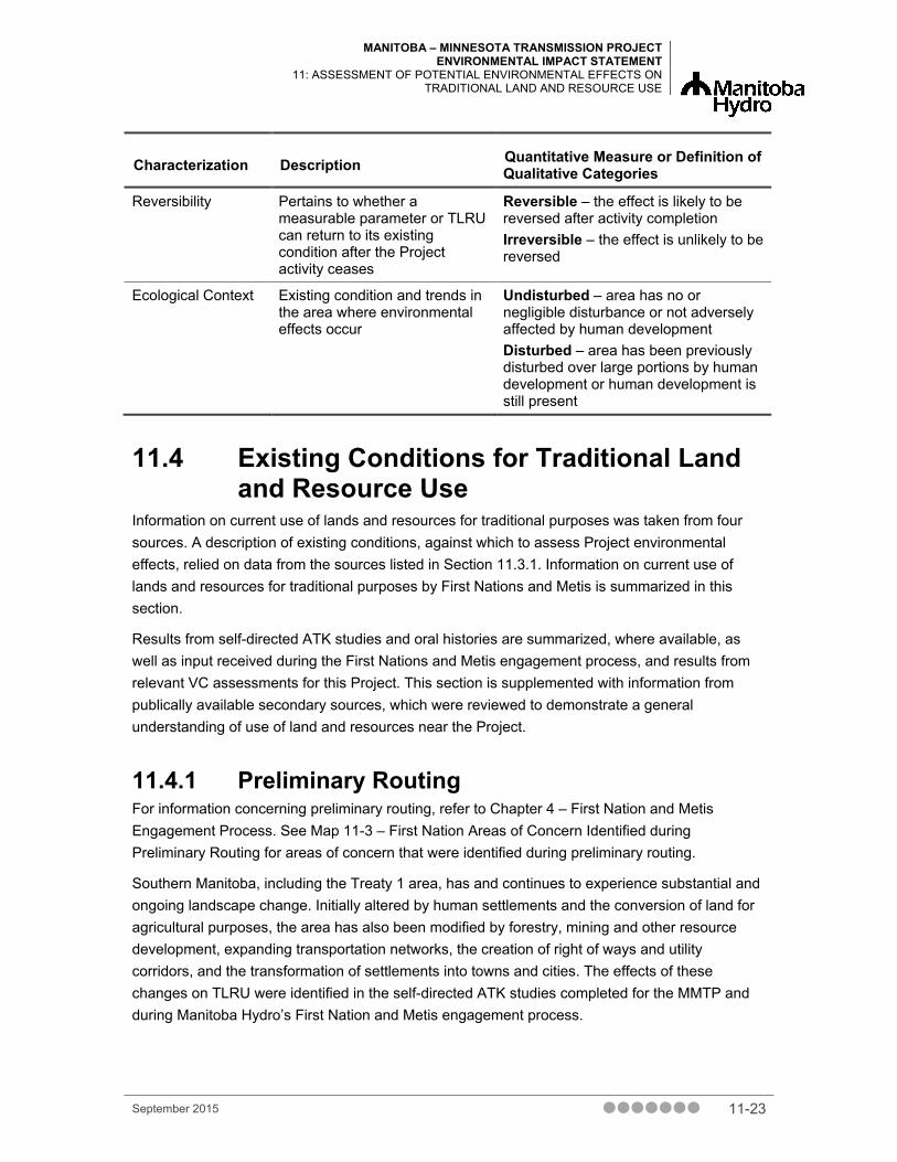
11.3.2.4 Residual Environmental Effects Description Criteria Environmental effects that remain after the application of mitigation measures are referred to as residual environmental effects. Terms used to characterize residual environmental effects on TLRU are summarized in Table 11-4.
September 2015 11-21

MANITOBA – MINNESOTA TRANSMISSION PROJECT ENVIRONMENTAL IMPACT STATEMENT 11: ASSESSMENT OF POTENTIAL ENVIRONMENTAL EFFECTS ON TRADITIONAL LAND AND RESOURCE USE
Table 11-4 Characterization of Residual Environmental Effects on Traditional Land and Resource Use
Characterization Description Quantitative Measure or Definition of Qualitative Categories
Direction The trend of the residual effect Positive – measurable effect that increases opportunities for TLRU activities relative to baseline Adverse – measureable effect that reduces opportunities for TLRU activities relative to baseline Neutral – no change in opportunities for TLRU activities relative to baseline
Magnitude The amount of change in measurable parameters or TLRU relative to existing conditions
Negligible – no measurable change from baseline Low – effect will increase the effort necessary to undertake TLRU activities but will not reduce the ability to undertake the activities Moderate – effect will reduce the ability to undertake TLRU activities to the same extent as previously High – effect will eliminate TLRU
Geographic Extent The geographic area in which an environmental effect occurs
PDA – residual effects are restricted to the PDA LAA – residual effects extend into the LAA RAA – residual effects interact with those of other projects in the RAA
Frequency Identifies when the residual effect occurs and how often during the Project or in a specific phase
Single event effect – occurs once Multiple irregular event (no set schedule) – effect occurs at irregular intervals throughout the Project Multiple regular event – effect occurs on a regular basis and at regular intervals throughout the Project Continuous – effect occurs continuously throughout the life of the Project
Duration The period of time required until the measurable parameter or TLRU returns to its existing condition, or the effect can no longer be measured or otherwise perceived
Short-term – residual effect restricted to construction phase Medium-term – residual effect extends more than the construction phase but less than the life of the Project Permanent – residual effect extends for the lifetime of the Project or more
11-22 September 2015
MANITOBA – MINNESOTA TRANSMISSION PROJECT ENVIRONMENTAL IMPACT STATEMENT
11: ASSESSMENT OF POTENTIAL ENVIRONMENTAL EFFECTS ON TRADITIONAL LAND AND RESOURCE USE
Characterization Description Quantitative Measure or Definition of Qualitative Categories
Reversibility Pertains to whether a measurable parameter or TLRU can return to its existing condition after the Project activity ceases
Reversible – the effect is likely to be reversed after activity completion Irreversible – the effect is unlikely to be reversed
Ecological Context Existing condition and trends in the area where environmental effects occur
Undisturbed – area has no or negligible disturbance or not adversely affected by human development Disturbed – area has been previously disturbed over large portions by human development or human development is still present
11.4 Existing Conditions for Traditional Land and Resource Use
Information on current use of lands and resources for traditional purposes was taken from four sources. A description of existing conditions, against which to assess Project environmental effects, relied on data from the sources listed in Section 11.3.1. Information on current use of lands and resources for traditional purposes by First Nations and Metis is summarized in this section.
Results from self-directed ATK studies and oral histories are summarized, where available, as well as input received during the First Nations and Metis engagement process, and results from relevant VC assessments for this Project. This section is supplemented with information from publically available secondary sources, which were reviewed to demonstrate a general understanding of use of land and resources near the Project.
11.4.1 Preliminary Routing For information concerning preliminary routing, refer to Chapter 4 – First Nation and Metis Engagement Process. See Map 11-3 – First Nation Areas of Concern Identified during Preliminary Routing for areas of concern that were identified during preliminary routing.
Southern Manitoba, including the Treaty 1 area, has and continues to experience substantial and ongoing landscape change. Initially altered by human settlements and the conversion of land for agricultural purposes, the area has also been modified by forestry, mining and other resource development, expanding transportation networks, the creation of right of ways and utility corridors, and the transformation of settlements into towns and cities. The effects of these changes on TLRU were identified in the self-directed ATK studies completed for the MMTP and during Manitoba Hydro’s First Nation and Metis engagement process.
September 2015 11-23

MANITOBA – MINNESOTA TRANSMISSION PROJECT ENVIRONMENTAL IMPACT STATEMENT 11: ASSESSMENT OF POTENTIAL ENVIRONMENTAL EFFECTS ON TRADITIONAL LAND AND RESOURCE USE
Roseau River Anishinabe First Nation (2015c) noted that clear cutting for farming, gas lines, oil pipelines, railways, highways and power lines/wind farms have destroyed most wildlife habitat. Specifically, the birthing areas for deer, fox and rabbits along the Red River, Roseau River and Rapids River have been disturbed by farming activities. Roseau River Anishinabe First Nation noted that because of human-related destruction of habitat, game has become scarce and difficult to hunt. Roseau River Anishinabe First Nation also explained that clear-cutting to make way for residential and commercial buildings has threatened the life cycle of many plants harvested for traditional purposes.
In their joint ATK report, Black River First Nation, Long Plain First Nation, Swan Lake First Nation (2015) stated clear cutting, farming and gas lines, oil pipelines, railways, highways, power lines and wind farms have negatively affected hunting and trapping. The report also noted concerns that the creation of new access points will render traditional hunting areas more easily accessible to non-aboriginal hunters and animal predation, and that the resulting contamination from road activity will have a negative effect on the vegetation wildlife depends on. Long Plain First Nation Elders stated that hunting areas are becoming too small to sustain livelihoods and that young people are no longer trapping.
In their traditional knowledge study (2015), Sagkeeng First Nation stated that development is limiting the community members’ ability to exercise their Treaty rights, their way of life was disappearing and these are affecting their health and well-being.
11.4.2 Plant Harvesting First Nations and Metis identified plant harvesting among the current use of land and resources for traditional purposes. First Nations and Metis harvest native plants for food, medicinal and cultural purposes throughout the RAA.
Black River First Nation, Long Plain First Nation and Swan Lake First Nation provided a list of traditional use plant species in the ATK report (Appendix 11A). The vegetation and wetlands team cross-referenced the list during field surveys to evaluate the abundance and distribution of traditional use plant species in the Project PDA, LAA and RAA. Refer to Chapter 10 – Vegetation and Wetlands and the Vegetation and Wetlands TDR for information and maps regarding the location and abundance of traditional use plant species.
11.4.2.1 Plant Harvesting Information from the Self-Directed ATK Studies and Oral Histories
The self-directed botanical study undertaken jointly by Black River First Nation, Long Plain First Nation and Swan Lake First Nation (2015) identified traditional use plant species along the proposed New ROW along the western and southern edges of Watson P. Davidson Wildlife Management Area (WMA). The ATK report noted the following geographic areas within the RAA where people travel to harvest medicinal plants (identified as Zone 3 in the study): the village of
11-24 September 2015

MANITOBA – MINNESOTA TRANSMISSION PROJECT ENVIRONMENTAL IMPACT STATEMENT
11: ASSESSMENT OF POTENTIAL ENVIRONMENTAL EFFECTS ON TRADITIONAL LAND AND RESOURCE USE
Marchand, south of the Watson P. Davidson WMA, including the areas around Pocock Lake Ecological Reserve and Sandilands Provincial Forest.
Black River First Nation Elders indicated that the southern part of Manitoba from south of the Watson P. Davidson WMA, southeast to the Spur Woods WMA and south of Piney in the RAA, as an area where medicines such as cedar, sage and sweetgrass would be harvested. Long Plain First Nation Elders recall Elders from Roseau River remembering many people from Black River traveling to Piney in the RAA as well as the Whiteshell area and Lake of the Woods, Ontario and farther south to pick wild rice and berries. The 2015 botanical study also noted that the Marchand area has weke patches, cedar bogs and harvesting areas.
Black River First Nation, Long Plain First Nation and Swan Lake First Nation (2015) identified bogs and marshes as areas of specific use. These three communities also indicated that the Lonesand area in the RAA contains sand dunes and the boreal forest edge of former Lake Agassiz and a water aquifer; this is where asarum (wild ginger), cedar and pine are found. Further, the report noted that the Piney area contains black ash, turtlehead snapdragon and a rare anemone (flower).
Long Plain First Nation noted concerns regarding potential effects on rare species, including rare orchids and Manitoba snapdragons, located in La Broquerie. These species are important to the Long Plain First Nation and need to be protected.
According to the Roseau River Anishinabe First Nation study (2015c), members harvest plants as far east as the Ontario border and as far north as the Sandilands Provincial Forest. Plants harvested by Roseau River Anishinabe First Nation for medicinal purposes include sweet grass, sage, Seneca, and cedar. Berries harvested by the Nation include plums, chokecherries, raspberries, blueberries, blackberries, and hazelnuts. In the study, members of the First Nation identified the following geographic areas for plant harvesting:
• sage and blueberries near Sandilands Provincial Forest
• wild rice (harvested annually) near the Manitoba–Ontario border
• cedar and sage near La Broquerie
• cedar and berries near Watson P. Davidson WMA
• seneca root southeast of Sundown
• berries south of Carrick and northwest of Piney, and near Spur Woods WMA in the RAA
The bush near St. Malo, west of the proposed line, was identified as a highly used area by Roseau River Anishinabe First Nation.
A Roseau River Anishinabe First Nation Elder stated in an oral history interview on May 19 (2015b) that blueberries and cranberries were harvested near Piney and Menisino in the LAA on land owned by the Elders’ family since the 1950s. In oral history interview conducted on May 13 (2015a), a Roseau River Anishinabe First Nation Elder indicated that weekay, black poplar, tamarack and birch were harvested as medicines near Roseau River Anishinabe First Nation
September 2015 11-25
MANITOBA – MINNESOTA TRANSMISSION PROJECT ENVIRONMENTAL IMPACT STATEMENT 11: ASSESSMENT OF POTENTIAL ENVIRONMENTAL EFFECTS ON TRADITIONAL LAND AND RESOURCE USE
reserve. Crow Wing Trail, which is west of Roseau River Anishinabe First Nation reserve, was identified as a place where a rare orchid was observed. The Elder also stated, “we do our medicines there”, referring to land privately owned by a Roseau River Anishinabe First Nation Elder.
Peguis First Nation indicated in the Land Use and Occupancy Interview Project Report (2015) that community members gathered cedar, ginger, sweet grass, Seneca root, yarrow and weekay near Roseau River Anishinabe First Nation reserve lands and other areas for medicinal and cultural purposes (Map 11-4 – Plant Harvesting). A Sagkeeng First Nation community member stated in the Sagkeeng O-Pimatiziiwin 2 Traditional Knowledge Study (2015) that he still picks medicines in several areas within the PDA with his teacher. Community members did not disclose specific information regarding the location of specific plants due to the risk of others appropriating traditional medicines.
11.4.2.2 Plant Harvesting Information from the First Nation and Metis Engagement Process
Roseau River Anishinabe First Nation indicated high levels of interest in medicines along the east and west sides of the Watson P. Davidson WMA and diagonally southeast to the Spur Woods WMA and areas directly south in the RAA (Chapter 4 – First Nation and Metis Engagement Process). High usage by the Nation for berry picking occurs along the east boundary and to the west of the Watson P. Davidson WMA and between the Watson P. Davidson and Spur Woods WMAs in the RAA. Roseau River Anishinabe First Nation members pick medicines such as sage around Sandilands Provincial Forest in the RAA, as well as berries.
Peguis First Nation identified the following as areas in the RAA used for gathering berries, sweetgrass, eggs, ginger, rice, mushrooms, medicinal plants and other plants: the Riel Converter Station heading east to south of Anola and north of Dufresne; along the east and west sides of the Watson P. Davidson WMA and southeast to the Spur Woods WMA; directly south to the U.S. border.
11.4.2.3 Plant Harvesting Information from Secondary Sources and Other VC Assessments for the Project
In Manitoba Metis: A Review of Available Information on the Use of Lands and Resources for Traditional Purposes in the MMTP Study Area with Gap Analysis (North/South Consultants Inc., 2014) it is reported that harvesting Seneca root in the region occurred in the past. Numerous types of plants were identified for use as medicines, food and crafts, including birch, cedar, dandelion, milkweed, berries, wood products, roots, nuts and mushrooms. Plant harvesting as occurring primarily in summer months, and four gathering areas were depicted in the study area: one northeast of Ste. Anne, MB and three to the southwest of Ste. Anne in the RAA.
11-26 September 2015

MANITOBA – MINNESOTA TRANSMISSION PROJECT ENVIRONMENTAL IMPACT STATEMENT
11: ASSESSMENT OF POTENTIAL ENVIRONMENTAL EFFECTS ON TRADITIONAL LAND AND RESOURCE USE
According to the vegetation and wetlands assessment (Chapter 10), vegetation along the transmission line transitions from a prairie landscape near Winnipeg to a boreal forest landscape near Monominto in the RM of Springfield. Approximately 66.3% of the PDA has been modified by human activity, including land drainage, conversion to agricultural land and residential, commercial and industrial development. The Existing Corridor is largely disturbed, whereby the conversion of native vegetation for agriculture and development has reduced the amount and size of intact patches on the landscape. The Existing Corridor originates at Dorsey Converter Station near Rosser and falls within the Lake Manitoba Plain Ecoregion in the Prairie Ecozone. As the transmission line moves south at Anola, it changes from the Existing Corridor to the New ROW and from the Prairie Ecozone to the Boreal Plain Ecozone. The New ROW is a mosaic of upland and wetland areas. The landscape is dominated by native vegetation (65.1%). and is relatively undisturbed with only 28.2% of the LAA as agricultural land and 3.8% as other development. Representative traditionally used species identified through the First Nation and Metis engagement process have been used to focus the assessment of potential effects on traditional use plant species abundance and distribution. See Chapter 10 for more information on existing conditions for plant harvesting.
The land and resource use assessment (Chapter 16) noted that the transmission line will intersect residential developments and areas currently used for both commercial (e.g., forestry, mining, trapping, and guide outfitting) and non-commercial (e.g., hunting) land use. Privately owned lands and agricultural land use are predominant in southern Manitoba. The northwestern part of the LAA is characterized by urban and residential land use, particularly in Winnipeg and nearby municipalities. Industrial development and related resource development activities occur in reaches of southern Manitoba. Agricultural cropland is the dominant land use cover in most of the RAA going from north to south, with more contiguous forest cover encompassing larger sections of the far easterly portions the RAA, including Sandilands Provincial Forest.
Most of the land (approximately 79%) within the LAA is privately owned. However, there are portions of the land base which are owned by the Crown (approximately 21%), some of which are currently leased in the RM of Piney and to some extent in the RM of Stuartburn. Crown lands are more common in the eastern parts of the RAA and include commercial forestland, high value forest sites (i.e., silviculture enhancements, research and monitoring sites, managed woodlots, shelterbelts and private forestland), quarry and mineral leases, permits and withdrawal areas, as well as designated lands, parks and protected areas and other conservation lands. See Chapter 16 – Land and Resource Use for more information on existing conditions for plant harvesting.
September 2015 11-27

MANITOBA – MINNESOTA TRANSMISSION PROJECT ENVIRONMENTAL IMPACT STATEMENT 11: ASSESSMENT OF POTENTIAL ENVIRONMENTAL EFFECTS ON TRADITIONAL LAND AND RESOURCE USE
11.4.3 Hunting and Trapping First Nations and Metis identified hunting and trapping among the current use of land and resources for both economic and cultural purposes. As described below, First Nations and Metis harvest a variety of big game, small mammals, birds, and waterfowl throughout the region.
11.4.3.1 Hunting and Trapping Information from the Self-Directed ATK Studies and Oral Histories
Hunting and trapping remains an important sustenance and cultural activity for the Black River First Nation, Long Plain First Nation and Swan Lake First Nation (2015). The area from Marchand south to Watson P. Davidson WMA, including Pocock Lake Ecological Reserve and Sandilands Provincial Forest in the RAA is noted in their TLU study as an area past and presently used for hunting, trapping and other traditional practices.
Black River First Nation Elders (2015) stated that otter, mink, beaver, coyote, wolf and rabbit were trapped in this area while deer, elk, moose and black bears were hunted in this area.
Long Plain First Nation Elders stated in the ATK report that young people no longer trap animals, and that hunting areas are becoming too small to sustain livelihoods. Fox, coyotes and raccoons were trapped (area not specified) and the presence of Prairie chickens, grouse, ducks and turkeys were noted (area not specified).
Roseau River Anishinabe First Nation (2015c) stated that community members harvest game such as moose, deer, fox, rabbit, wild turkey, muskrat and beaver, elk, wolverine, marten, lynx and beaver.
According to the Roseau River Anishinabe First Nation ATK report, deer, fox and rabbit birthing areas along the Red River, Roseau River and Rapids River are affected by both environmental and farming activities. Roseau River Anishinabe First Nation noted that wildlife game is scarce, identifying cumulative effects from industrial development (clearing land for agriculture, oil and gas pipelines, railways, highways and power lines/wind farms), and environmental effects (harsh winters, floods and drought) on traditional lands. The TLU notes that these effects contribute to the diminishing hunting areas available.
A Roseau River Anishinabe First Nation Elder stated in an oral history interview on May 19 (2015b) that moose and deer are and were hunted in the LAA in areas such as Piney and in swampy areas near Menisino. The area is actively used for hunting, camping and game meat processing. Elders noted that rabbit, lynx, muskrat, beaver, squirrel and weasel were trapped in this area as well.
Peguis First Nation stated in its Draft Land Use and Occupancy Interview Project Report (2015) (Map 11-5 – Hunting and Trapping) that members hunt game such as deer and mentioned the presence of bears in the RAA on a trail between Ste. Anne and Woodridge, MB. Members trap rabbit and prairie chickens in the RAA, north of Ste. Anne, and east of Steinbach near Woodridge as well as along the Whitemouth River and near Whitemouth Lake. The TLU report notes that
11-28 September 2015

MANITOBA – MINNESOTA TRANSMISSION PROJECT ENVIRONMENTAL IMPACT STATEMENT
11: ASSESSMENT OF POTENTIAL ENVIRONMENTAL EFFECTS ON TRADITIONAL LAND AND RESOURCE USE
ducks and geese are hunted in these areas, as well as adjacent to the Rat and Seine Rivers in the RAA.
11.4.3.2 Hunting and Trapping Information from the First Nation and Metis Engagement Process
The RAA areas south of the Watson P. Davidson WMA ranging southeast to the Spur Woods WMA and south of Piney, Roseau River Anishinabe First Nation identified moose habitat, especially near Piney (Chapter 4 – First Nation and Metis Engagement Process).
Peguis First Nation stated in the FNMEP (Chapter 4) that animals such as beaver, muskrat, mink, and fox are trapped in the RAA northwest of Dufresne and along the east and west sides of the Watson P. Davidson WMA and diagonally southeast to the Spur Woods WMA, as well as areas south of Piney. Peguis First Nation has hunting interests in the RAA area south of Piney and trapping interests in the RAA area southeast of Piney. Peguis First Nation also indicated in the FNMEP that there are important areas within the RAA along the east and west sides of Watson P. Davidson WMA that include fresh water springs, animal sittings, nesting areas, spawning areas, calving areas and wetlands.
Sagkeeng First Nation noted members have traplines near wildlife refuges (Chapter 4).
11.4.3.3 Hunting and trapping information from Secondary Sources and Other VC Assessments for the Project
The literature review entitled Manitoba Metis: A Review of Available Information on the Use of Lands and Resources for Traditional Purposes in the MMTP Study Area with Gap Analysis (2014) indicated that moose, followed by deer and elk are the primary big game species hunted by Metis. Metis hunt deer in a large area in the RAA, southeast of Ste. Anne extending as far south as the Manitoba border. Recently, a small satellite herd of elk has reestablished in the RAA near the Vita (Manitoba Conservation and Water Stewardship 2014). The extent of elk hunting by Metis in the study area is unknown.
The research cited in literature review (North/South Consultants Inc. 2014) indicates that both big and small game are harvested, and Metis harvest upland birds, such as grouse, partridge and ptarmigan, as well as ducks, geese, and rabbit. Metis trap beaver, coyote, fisher, fox, lynx, marten, mink, muskrat, otter, rabbit, raccoon, squirrel, weasel, wolf and wolverine and noted most species are trapped for commercial purposes, while beaver, muskrat and lynx are also harvested for consumption.
According to the wildlife and wildlife habitat assessment (Chapter 9), approximately 38% of the RAA is composed of natural wildlife habitat (e.g., forest, grassland, wetland), most of which exists in the eastern part of the RAA. Notable managed wildlife lands include Sandilands, Wampum and Cathills provincial forests; Pocock Lake and Wampum ecological reserves; and Watson P. Davidson and Spurwoods WMAs. Notable waterbodies include the Red, Assiniboine, Seine and Rat rivers, the Caliento, Sundown, and Carrick bogs; the Richer (south of Richer on Hwy 302),
September 2015 11-29

MANITOBA – MINNESOTA TRANSMISSION PROJECT ENVIRONMENTAL IMPACT STATEMENT 11: ASSESSMENT OF POTENTIAL ENVIRONMENTAL EFFECTS ON TRADITIONAL LAND AND RESOURCE USE
Lac Bosse (a.k.a. Salmon Lake), Lonesand (south of Lonesand), and Sundown lakes; Deacon Reservoir; and Oak Bluff Lagoon.
According to Manitoba Conservation and Waters Stewardship (and outlined in Chapter 9), moose were a common ungulate species in southeastern Manitoba prior to the late 1990s but populations in the region have since collapsed. Despite the presence of suitable moose habitat, moose have become rare in southeastern Manitoba due to a combination of factors such as habitat fragmentation, predation by wolves, parasites, fire suppression, disease and hunting. White-tailed deer are an important game species to resource users, including the public, First Nations and Metis.
See the wildlife and wildlife habitat assessment (Chapter 9) and land and resource use assessment (Chapter 16) for more information on existing conditions for hunting and trapping.
11.4.4 Trails and Travelways First Nations and Metis continue to use long-established trails and travelways that connect communities, harvesting areas and gathering places in a network of traditional use and cultural patterns.
11.4.4.1 Trails and Travelways Information from the Self-Directed ATK Studies and Oral Histories
A self-directed TLU study undertaken jointly by Black River First Nation, Long Plain First Nation and Swan Lake First Nation (2015) noted that travelways in the area include trade routes, escape routes from U.S. military and travel corridors to reach gathering areas. Several trails were identified in the study, notably the area identified as Zone 3: the village of Marchand, and extending south of the Watson P. Davidson WMA, including the areas around Pocock Lake Ecological Reserve and Sandilands Provincial Forest in the RAA. The Dawson Trail was noted in the study as an established economic trade route used by the Anishinabe prior to the fur trade era. The Boundary Commission Trail just north of the 49th parallel was also identified within the TLU study as an established travel and trade route in this area. The Red Coat Trail that began at Fort Dufferin and paralleled the Boundary Commission Trail into Saskatchewan was also described in the study. Other travelways noted in the ATKS Report include the following:
• Yellow Quill’s Trade Routes to the United States, from Minnesota to Manitoba, were used by the Ojibway people to escape persecution by the U.S. military in the 1870s, and to escape the outlaw of tribal practices as late as the 1930s.
• The six primary and secondary river systems intersecting the PDA were used as transportation routes for thousands of years. These systems include the Assiniboine River, La Salle River, Red River, Seine River, Rat River and Pine Creek. It was mentioned that part of a cart trail followed the course of the Seine River.
11-30 September 2015
MANITOBA – MINNESOTA TRANSMISSION PROJECT ENVIRONMENTAL IMPACT STATEMENT
11: ASSESSMENT OF POTENTIAL ENVIRONMENTAL EFFECTS ON TRADITIONAL LAND AND RESOURCE USE
Black River First Nation Elders mentioned that people would travel from the Lake of the Woods, ON area to a gathering place where Cree people came from the north to meet them to trade (area not specified). Community members indicated that they travelled to a fishing area near the village of Marchand, which extended south of the Watson P. Davidson WMA, including the areas around Pocock Lake Ecological Reserve and Sandilands Provincial Forest
Long Plain First Nation Elders recall medicine people from Black River First Nation reserve picking blueberry and Seneca roots along a route used for commerce and trade (area not specified).
Roseau River Anishinabe First Nation (2015c) noted that the Roseau River was used as a way to travel from one destination to another; the Crow Wing Trail is an important heritage site located off Provincial Roads (PR) 201 and 218. The Crow Wing Trail is traversed by the SLTC portion of the Existing Corridor. A Roseau River Anishinabe First Nation Elder indicated in oral history interview on May 19 (2015a) that they “worked” along the Crow Wing Trail (in reference to gathering medicines).
Peguis First Nation indicated in the Land Use and Occupancy Interview Project Report (2015) that community members travelled from Winnipeg to Niverville, Ste. Anne, Steinbach and Woodridge to Piney in the RAA to various occupancy sites (camping, residences, canoeing) as well as near Roseau River Anishinabe First Nation reserve, Morris, MB, and north to Shoal Lake First Nation reserve. Community members travelled to access fishing areas along the Seine, Red and Rat Rivers in the RAA, Roseau, Brokenhead and Whitemouth Rivers as well as Whitemouth Lake, north of Shoal Lake First Nation reserve and one site within 1.5 km of the Project.
Sagkeeng First Nation stated in their TK study (2015) that the lands and waterways are a part of the economic well-being and transportation system of the community. The Sandilands area was identified as an important travel route for family members travelling from the United States to participate in ceremonies on Black Island to the north of the Project on Lake Winnipeg.
11.4.4.2 Trails and Travelways Information from the First Nation and Metis Engagement Process
Through the FNMEP (Chapter 4), Roseau River Anishinabe First Nation indicated interest regarding access roads to traditional areas from east of La Coulee, MB on the east and west sides of Watson P. Davidson WMA and southeast to Spur Woods WMA in the RAA.
As a result of the FNMEP, Dakota Plains Wahpeton First Nation identified a historical route and burial site from Red Lakes area (east of Woodland Caribou Provincial Park in Ontario) and large tipi groupings along trade routes and tobacco trade routes.
Peguis First Nation community members referred to travel to fishing locales, which include important spawning and fishing areas. These sites span from the Riel Converter Station heading east to south of Anola, as well as north of Dufresne, areas along the east and west sides of the Watson P. Davidson WMA and southeast to the Spur Woods WMA and areas directly south in the RAA.
September 2015 11-31

MANITOBA – MINNESOTA TRANSMISSION PROJECT ENVIRONMENTAL IMPACT STATEMENT 11: ASSESSMENT OF POTENTIAL ENVIRONMENTAL EFFECTS ON TRADITIONAL LAND AND RESOURCE USE
11.4.4.3 Trails and Travelways Information from Secondary Sources and Other VC Assessments for the Project
The heritage resources assessment (Chapter 12) noted that cultural sites can include habitation sites, gathering places, sacred sites and heritage resources that include archaeological sites, provincially and municipally designated sites, centennial farms school sites, and cemeteries. An east-west cart trail extended parallel to the Existing Corridor and was probably used by First Nations during the Precontact Period to travel from the level prairie along the Red and Assiniboine Rivers to the wooded areas of the east edge of Manitoba. During the Historic Period, this trail was probably used by Metis to connect centres such as St. Norbert, Lorette and Ste. Anne with resource areas in the eastern portion of the province. The present-day Dawson Road, formerly the Dawson Trail, is approximately 2.4 km north of the undated Precontact site and was probably a pedestrian corridor used to access these areas during the Precontact Period. See Chapter 12 – Heritage Resources for more information on existing conditions for trails and travelways.
The MMF (2011) found that Metis travelled to fish for pickerel (walleye) and jackfish (northern pike) usually by rod and reel at an area near St. Malo and on the Roseau River near Stuartburn, east of the Project.
See the land and resource use assessment (Chapter 16) for more information on existing conditions for trails and travelways.
11.4.5 Cultural Sites Cultural sites include areas such as burial sites, sacred sites, spiritual sites and sacred geography.
11.4.5.1 Cultural Sites Information from the Self-Directed ATK Studies and Oral Histories
The Black River First Nation, Long Plain First Nation and Swan Lake First Nation (2015) TLU report identified the following cultural sites:
• Pre-Treaty archaeological sites were identified through archival research at the Historic Resources Branch (HRB) in the RAA, from Rosser along the south side of Winnipeg.
• 1870-era Orkney-Metis farms are located along the Assiniboine River in the RAA, and have high potential for other pre and post contact sites.
• Historic structures west of an old cart trail also dating to the 1870s were found along the La Salle River south of St. Norbert in the LAA.
• Pre-contact potsherds, fired clay and charcoal were found south of Prairie Grove Road along the Seine River and east of Highway 59, south of Winnipeg in the RAA.
11-32 September 2015

MANITOBA – MINNESOTA TRANSMISSION PROJECT ENVIRONMENTAL IMPACT STATEMENT
11: ASSESSMENT OF POTENTIAL ENVIRONMENTAL EFFECTS ON TRADITIONAL LAND AND RESOURCE USE
• Additional archaeological sites are present that require further study, located in an area from Dufresne to the north edge of Sandilands Provincial Forest in the RAA.
• Large gathering areas where people traveled long distances to camp, hunt, fish and harvest (confirmed by oral history) are located in Zone 3, described in the study as the village of Marchand, and extending south of the Watson P. Davidson WMA, including the areas around Pocock Lake Ecological Reserve and Sandilands Provincial Forest in the RAA.
• Pre-Treaty archaeological sites were identified through the HRB as requiring further study, and an abandoned town was identified.
• High potential areas for undisturbed heritage cultural gathering sites, and pre-Treaty settlements are located in the area from the southwest corner of Watson P. Davidson WMA extending southeast to Spur Woods WMA and farther east to an area south of Piney in the RAA.
A Long Plain First Nation Elder stated that his father hunted in the Sandilands area in the RAA, there was quicksand and the area was considered sacred.
Roseau River Anishinabe First Nation (2015c) identified a heritage site off PR 201 and PR 218, in the form of a rock that is believed to be a spirit of a female traveler who died there and turned into a rock. Roseau River Anishinabe First Nation noted that this site hosts a yearly gathering and feast. This site is identified as a heritage site and The Crow Wing Trail passes this site.
A Roseau River Anishinabe First Nation Elder stated in the oral history interview on May 19 (2015b) that a 100-year-old log house still stood on the property purchased by the Elder’s grandfather in the 1950s near Piney and Menisino in the LAA.
A Roseau River Anishinabe First Nation Elder noted in oral history interview in May 13 (2015a) that Wounded Warrior Rock is located north of Highway 218 and Highway 201 and is considered a spiritual site.
Peguis First Nation indicated in its Land Use and Occupancy Interview Project Report (2015) that community members identified sacred sites, cultural and ceremonials areas and burials sites within the RAA. These sites are located near St. Norbert, MB, Roseau, Ste. Anne, Steinbach, Woodridge, and near Watson P. Davidson WMA and outside of the RAA near Shoal Lake First Nation reserve and Buffalo Point First Nation reserve (Map 11-6 – Cultural Sites). Noted cultural sites include a calving area, a pow wow site, a sweat lodge site and a Sundance site.
Sagkeeng First Nation community members recalled in their TK study (2015) that their ancestors travelled to Sandilands to conduct sun dance ceremonies in secret as they had been banned by the government.
September 2015 11-33

MANITOBA – MINNESOTA TRANSMISSION PROJECT ENVIRONMENTAL IMPACT STATEMENT 11: ASSESSMENT OF POTENTIAL ENVIRONMENTAL EFFECTS ON TRADITIONAL LAND AND RESOURCE USE
11.4.5.2 Cultural Sites Information from the First Nation and Metis Engagement Process
Peguis First Nation stated that cultural sites, including burial sites, petro forms and rock paintings are located near PR 501, PTH 1, east of La Coulee on the east and west sides of Watson P. Davidson WMA and south of Piney and Spur Woods WMA in the RAA, FNMEP (Chapter 4). Ceremonial practices such as sweat lodges and gatherings take place at these cultural sites as well.
11.4.5.3 Cultural Sites Information from Secondary Sources and Other VC Assessments for the Project
The heritage resources assessment (Chapter 12) noted that cultural sites include habitation sites, gathering places, sacred sites and heritage resources that include archaeological sites, provincially and municipally designated sites, centennial farms school sites, and cemeteries. Most of the previously recorded archaeological sites throughout the RAA were artifact scatters collected from the surfaces of cultivated fields. Many of these are isolated finds or are related to First Nation campsites. All have been disturbed or partially disturbed through cultivation, erosion or development. Several Early Precontact Period sites were recorded in the southern portion of the New ROW RAA in the Sandilands Provincial Forest. These sites relate to cultural groups moving into the southern portion of the province following the retreat of Lake Agassiz. See Chapter 12 – Heritage Resources for more information on existing conditions for cultural sites.
11.5 Assessment of Project Environmental Effects on Traditional Land and Resource Use
This assessment assumes that TLRU activities occur in the RAA and LAA, even if these activities or site-specific uses are not specifically identified by First Nations and Metis. Project activities have the potential to change land and resources used for traditional activities by altering the availability of resources or access to land used for traditional activities. Potential Project effects on TLRU shared by participants during preliminary routing discussions included Aboriginal and Treaty rights, historical use (heritage resources), harvesting (berry picking and gathering), sacred and traditional practices (sacred areas), gathering places and burial sites (sacred and sensitive areas), TLE (pressure on TLE interests) and Medicine Line burials (disturbance of burials).
11-34 September 2015

MANITOBA – MINNESOTA TRANSMISSION PROJECT ENVIRONMENTAL IMPACT STATEMENT
11: ASSESSMENT OF POTENTIAL ENVIRONMENTAL EFFECTS ON TRADITIONAL LAND AND RESOURCE USE
11.5.1 Project Interactions with Traditional Land and Resource Use
Effects pathways as described in Section 11.3.2.2 are the mechanisms considered in this assessment by which the Project interacts with TLRU. Table 11-5 identifies physical activities and components of the Project that might interact with TLRU for each potential effect. These interactions are identified by check marks and are discussed in detail in the following sections.
A conservative approach was used to identify effect pathways between the Project and TLRU activities, whereby activities with a degree of uncertainty have been assumed to contribute to the environmental effect and it is assumed that TLRU activities occur in the RAA.
Table 11-5 Potential Project-Environment Interactions and Effects on Traditional Land and Resource Use
Project Components and Physical Activities
Potential Environmental Effects
Cha
nge
in la
nd a
nd
reso
urce
s us
ed fo
r pl
ant h
arve
stin
g
Cha
nge
in la
nd a
nd
reso
urce
s us
ed fo
r hu
ntin
g an
d tr
appi
ng
Cha
nge
in la
nd a
nd
reso
urce
s us
ed fo
r tr
avel
Cha
nge
in c
ultu
ral
site
s
Transmission Line Construction
Mobilizing (staff and equipment)
Access Route and Bypass Trail Development
Right-of-way Clearing/Geotechnical Investigation
Marshalling Yards, Borrow Sites, Temporary Camp Setup
Transmission Tower Construction and Conductor Stringing
Demobilization
Transmission Line Operation/Maintenance
Transmission Line Operation/Presence
Inspection Patrols
Vegetation Management (tree control)
Station Construction
Station Site Preparation – – – –
Electrical Equipment Installation – – – –
September 2015 11-35

MANITOBA – MINNESOTA TRANSMISSION PROJECT ENVIRONMENTAL IMPACT STATEMENT 11: ASSESSMENT OF POTENTIAL ENVIRONMENTAL EFFECTS ON TRADITIONAL LAND AND RESOURCE USE
Project Components and Physical Activities
Potential Environmental Effects
Cha
nge
in la
nd a
nd
reso
urce
s us
ed fo
r pl
ant h
arve
stin
g
Cha
nge
in la
nd a
nd
reso
urce
s us
ed fo
r hu
ntin
g an
d tr
appi
ng
Cha
nge
in la
nd a
nd
reso
urce
s us
ed fo
r tr
avel
Cha
nge
in c
ultu
ral
site
s
Station Operation/Maintenance
Station Operation/Presence – – – –
Vegetation Management (weed control) – – – –
NOTES: “” = Potential interactions that might cause an effect. “–“ = Interactions between the Project and the VC are not expected.
Construction, operation and maintenance of the transmission line could result in a change in TLRU due to changing the availability of resources and access to lands used for traditional purposes by First Nations and Metis during active construction. Approximately 750 ha, or 24%, of the PDA will be on Crown land. Following construction there will be no restrictions on access to traditional use sites or areas within the Project easement on Crown lands. Crown lands occupied by the PDA will remain available for TLRU activities after active construction is complete. The presence of equipment, vehicles and workers during construction, and the physical presence of the transmission line during operation and maintenance may deter TLRU (see Chapter 17 – Visual Quality).
Operation and maintenance of the Project may result in sensory disturbance. Some users may choose not to conduct TLRU activities based on beliefs and concerns about the site having reduced value.
Specific information regarding potential Project effects on plant harvesting, hunting and trapping, travel and cultural sites due to construction, operation and maintenance of the transmission line is provided in the corresponding assessments (Sections 11.5.2.1, 11.5.3.1, 11.5.4.1, 11.5.5.1 and 11.5.6.1).
With the small-scale nature of modifications and additional equipment being required at the Dorsey and Riel converter stations and Glenboro South Station, and their location on private lands, it is anticipated that there will be no interactions with TLRU.
11-36 September 2015
MANITOBA – MINNESOTA TRANSMISSION PROJECT ENVIRONMENTAL IMPACT STATEMENT
11: ASSESSMENT OF POTENTIAL ENVIRONMENTAL EFFECTS ON TRADITIONAL LAND AND RESOURCE USE
11.5.2 Assessment of Change in Land and Resources Used for Plant Harvesting
11.5.2.1 Pathways for Change in Plant Harvesting Information collected from Project-specific studies and the FNMEP indicate that First Nations harvest plants for traditional use throughout southeastern Manitoba in which the Project is situated. Concerns were identified during the FNMEP relating to the change of land and resources used for plant harvesting because of the Project.
Table 11A-1 (Appendix 11A) provides a list of traditional use plant species identified by Black River First Nation, Long Plain First Nation and Swan Lake First Nation. The vegetation and wetlands team cross-referenced this list during field surveys to evaluate the abundance and distribution of traditional use plant species in the PDA, LAA and RAA. During the field surveys, 39 traditional use plant species were observed at 106 locations in the PDA, In the PDA, 35 of the species were observed along the New ROW, 26 along the Existing Corridor, and three at the station locations. Traditional use species are also widely distributed in the LAA and RAA. These sampled sites have not been confirmed as plant harvesting areas by First Nations and Metis; however, a conservative approach to the assessment has been taken whereby it is assumed that the existence of traditional use plant species means there is a potential for effects on plant harvesting. Refer to the Vegetation and Wetlands TDR for additional information regarding the location and abundance of traditional use plant species in the PDA, LAA and RAA.
First Nations general comments on pathways for change in plant harvesting include the following:
• Peguis First Nation indicated in the Land Use and Occupancy Interview Project Report (2015) that community members are concerned that their gathering rights will be affected.
• Roseau River Anishinabe First Nation identified the areas around and between the Watson P. Davidson and Spur Woods WMAs in the RAA as areas of concern with respect to berry picking and gathering practices. Specific concerns were noted by the First Nation regarding road access and effects on medicinal plants surrounding the Watson P. Davidson WMA and south of the Spur Woods WMA in the RAA.
• Swan Lake First Nation expressed concerns about vegetation management for the Project during FNMEP (Chapter 4 – First Nation and Metis Engagement Process), and noted they do not want the area “clear-cut.”
• Sagkeeng First Nation stated in their TK study (2015) that development is limiting community members’ ability to exercise their Treaty rights
September 2015 11-37
MANITOBA – MINNESOTA TRANSMISSION PROJECT ENVIRONMENTAL IMPACT STATEMENT 11: ASSESSMENT OF POTENTIAL ENVIRONMENTAL EFFECTS ON TRADITIONAL LAND AND RESOURCE USE
11.5.2.1.1 Construction Clearing and disposal of trees on the New ROW will be completed before construction to provide clearance between vegetation and transmission lines. Clearing of the ROW may result in a direct loss of traditional use plants or the alteration of vegetation communities that support traditional use plant species.
Equipment and vehicle movement during mobilization and demobilization and the establishment of access routes, marshalling yards, borrow sites, and temporary camps may cause physical damage to or decrease the quality of traditional use plant species and could introduce or spread invasive and non-native plant species and cause changes in vegetation community composition. Many invasive and non-native species can aggressively invade disturbed areas and may out-compete traditional use plant species. Heavy equipment and vehicle use on access roads may alter vegetation communities due to soil compaction, rutting and admixing.
Sensory disturbances (e.g., noise, light) and increased access because of transmission tower construction activities may affect the experience of traditional land use activities.
Specific pathways during construction identified from FNMEP, TLU studies, and oral histories include the following:
• The Roseau River Anishinabe First Nation report (2015c) indicated the need to work with Manitoba Hydro to protect and monitor traditional areas during Project construction. The study stated that clear cutting for residential and commercial buildings as well as destruction by flooding has threatened the lifecycle of many plants harvested for traditional purposes.
• The Black River First Nation, Swan Lake First Nation and Long Plain First Nation study (2015) identified concerns regarding effects on berries, wild rice, wee-kai and medicinal plants. The study noted specific cultural protocols are followed when harvesting medicinal plants. Traditional knowledge holders stated that the medicinal properties of plants come from the roots, and expressed concern that if the roots are taken away during construction, the plants will not come back, or if they do it will take a long time for them to regrow, and are concerned about the permanent removal of berry patches and medicinal plants.
• Other concerns from the Black River First Nation, Swan Lake First Nation and Long Plain First Nation study (2015) included potential effects on bogs and peat moss resulting from the removal of peat moss and the draining of bogs, along with concurrent effects on water quality and the water table. Traditional knowledge holders noted concerns about Project effects on willows in low-lying, wet areas since these areas provide feed for wildlife as well as the loss of plants for domestic and medicinal use.
11-38 September 2015

MANITOBA – MINNESOTA TRANSMISSION PROJECT ENVIRONMENTAL IMPACT STATEMENT
11: ASSESSMENT OF POTENTIAL ENVIRONMENTAL EFFECTS ON TRADITIONAL LAND AND RESOURCE USE
• The Black River First Nation, Swan Lake First Nation and Long Plain First Nation study (2015) raised concerns regarding the effects of accidental releases of contaminates on vegetation within the Project area as well as effects that access roads and the ROW will have on vegetation. Additionally, concerns were expressed by traditional knowledge holders about the use of herbicides and pesticides to control vegetation and maintain the ROW after construction.
• Sagkeeng First Nation members indicated in their TK study (2015) that the clearing of the route had a “ripple effect” – if particular trees and other species were removed from an area, other species disappear as a result which increases the difficulty in gathering traditional medicines.
11.5.2.1.2 Operation and Maintenance The maintenance of infrastructure and inspection of transmission towers and lines during patrols may disturb traditional use plant species and alter the experience of traditional practices. In addition, equipment and vehicles could spread non-native or invasive species during periodic maintenance that would persist over the life of the Project.
Vegetation management on the ROW may also affect plant harvesting. For example, trees and tall shrubs will be removed from beneath the transmission line and maintained by herbicide application or brushing to control the growth of woody vegetation in accordance with Manitoba Hydro’s Vegetation Management Program. The application of herbicide will affect native plant species abundance and distribution. Manitoba Hydro will consider non-chemical vegetation management in clearly identified sensitive sites that contain plants that are of importance to Aboriginal harvesters.
Operation and maintenance of the Project may result in sensory disturbance. Some users may choose not to conduct TLRU activities based on beliefs and concerns about the site having reduced value.
Specific pathways during operation and maintenance identified from the FNMEP, ATK studies, and oral histories include the following:
• A Roseau River Anishinabe First Nation Elder indicated concerns during an oral history interview (2015a) about the effect the Project will have on plants and that specific ways to harvest plants (protocol) must be followed. The Elder noted there is a responsibility to speak on behalf of the plants and you “can’t compensate what is going to be changed.” The Elder also explained that some community members no longer gather plants along transmission right of ways for sustenance or medicinal use as the plants growing near developments are not of the same quality and value.
• The Peguis First Nation report identified concerns regarding harvesting of berries, sweetgrass, eggs, ginger, rice, mushrooms, and medicinal plants from the Riel Converter Station to south of Anola, north of Dufresne, along PTH 1, on the east and west sides of Watson P. Davidson WMA and from the southwest corner of the Watson P. Davidson WMA
September 2015 11-39

MANITOBA – MINNESOTA TRANSMISSION PROJECT ENVIRONMENTAL IMPACT STATEMENT 11: ASSESSMENT OF POTENTIAL ENVIRONMENTAL EFFECTS ON TRADITIONAL LAND AND RESOURCE USE
heading diagonally southeast to Spur Woods WMA in the RAA. Specific concerns were noted by Peguis First Nation regarding the use of herbicides for the Project, including the potential for runoff and its effect on water, as well as potential effects on traditional medicines.
• Sagkeeng First Nation community members stated in their TK study (2015) that they avoided harvesting plants along transmission lines because they considered them to be “unhealthy” due to the chemicals used to the keep the ROW clear.
11.5.2.1.3 Input on Plant Harvesting from Other VC Assessments for the Project
Other VC assessments are particularly relevant to this assessment of plant harvesting because they provide information about potential Project effects on vegetation species and access conditions. This information has been used to assist in the characterization of Project effects related to plant gathering interests.
The vegetation and wetlands assessment (Chapter 10) addresses potential Project effects on species, including traditional use species identified by during the FNMEP and ATK studies. The assessment evaluates Project effects through six primary effects pathways: change in vegetation landscape intactness; change in native upland vegetation cover class abundance; change in wetland cover, class abundance, distribution, structure and function; change in native vegetation cover class integrity; change in rare plant species abundance and distribution; and change in traditional use plant species abundance and distribution. Residual effects on vegetation and wetlands may in turn have a residual effect on plant harvesting.
The land and resource use assessment (Chapter 16) addresses potential Project effects on residential development; designated lands and protected areas; recreational areas; and resource use (e.g., timber harvesting, mining and quarrying, surface water and groundwater use, and trapping, guiding and hunting activities). The assessment evaluates Project effects through six primary effects pathways: change in residences and property; change in designated lands, protected areas and recreation; change in forested areas; change in mining/aggregate extraction; and change in hunting and trapping. According to the assessment for Land and Resource Use, there is potential for the Project to create new or improved access opportunities, which could in turn increase recreational activity levels in important traditional use areas. Residual effects on land and resource use may in turn have a residual effect on plant harvesting.
These pathways, if not adequately mitigated, could influence plant species distributions and abundance, and in turn, disrupt local plant harvesting activities.
11.5.2.2 Mitigation for Change in Plant Harvesting Overall, transmission line routing is a preferred form of mitigation for potential effects on plant harvesting. Concerns raised during the First Nation and Metis engagement process about sensitive plant harvesting areas were considered in the transmission line routing process. Key areas identified by Black River First Nation, Long Plain First Nation and Swan Lake First Nation,
11-40 September 2015

MANITOBA – MINNESOTA TRANSMISSION PROJECT ENVIRONMENTAL IMPACT STATEMENT
11: ASSESSMENT OF POTENTIAL ENVIRONMENTAL EFFECTS ON TRADITIONAL LAND AND RESOURCE USE
including an area that contains a weke patch, cedar bog, and harvesting area were avoided through the transmission line routing process. General concerns regarding effects on native vegetative cover were also addressed through the transmission line routing process.
Transmission line routing has resulted in a Final Preferred Route:
• that is located primarily on developed and agricultural land (more than 65% of the PDA occurs on agricultural or developed lands)
• that avoids areas of key vegetation species used for traditional purposes, including Watson P. Davidson, Pocock Lake Ecological Reserve and Spur Woods WMA
• that avoids tallgrass prairie grassland areas
• that avoids key sites identified by Swan Lake, Long Plain and Black River First Nations in the Marchand area
• that avoids an area of concern by Roseau River Anishinabe First Nation representatives where the line traverses a private property that is of importance to the First Nation near Sundown. The property is an important area for medicinal plant gathering. Manitoba Hydro developed and subsequently adopted a modification as part of the Final Preferred Route.
Manitoba Hydro has proposed further mitigation measures to reduce or limit effects on plant harvesting:
• First Nations and MMF will be given opportunities to identify sensitive sites to help inform the Environmental Protection Program for the Project.
• Herbicides will not be used for ROW clearing. For maintenance of the ROW, an Integrated Vegetation Management Program will be developed. Manitoba Hydro will consider non-chemical vegetation management in clearly identified sensitive sites that contain plants that are of importance to Aboriginal harvesters.
• Construction techniques will be applied that limit effects on vegetation and plant harvesting, including limitations to grubbing, restrictions for contractors to use only established roads and trails, and cleared construction areas, the use of construction mats in situations where the ROW does not have completely frozen or dry ground conditions and contractor-specific Erosion Protection and Sediment Control Plans.
• Where appropriate, regional native grass mixtures will be used to assist revegetation of disturbed areas to control erosion or prevent invasion of non-native species. The mixtures will not contain non-native or invasive species.
• The Botanical Survey of the Manitoba-Minnesota Transmission Project included as part of Black River First Nation, Long Plain First Nation and Swan Lake First Nation’s ATK report will help inform the Environmental Protection Program for the Project.
September 2015 11-41

MANITOBA – MINNESOTA TRANSMISSION PROJECT ENVIRONMENTAL IMPACT STATEMENT 11: ASSESSMENT OF POTENTIAL ENVIRONMENTAL EFFECTS ON TRADITIONAL LAND AND RESOURCE USE
A summary of key mitigation relevant to plant harvesting is provided in Table 11-6. An inclusive list of mitigation measures is provided in Chapter 22 – Environmental Protection, Follow-Up and Monitoring.
Table 11-6 Mitigation for Change in Land and Resources Used for Plant Harvesting
Traditional Activity Proposed Mitigation
Plant harvesting • Contractors will be restricted to established roads and trails, and cleared construction areas in accordance with the Access Management Plan.
• In situations where the ROW does not have completely frozen or have dry ground conditions, alternative products such as construction mats will be used.
• Contractor-specific Erosion Protection and Sediment Control Plans will be prepared by the contractor, accepted by Manitoba Hydro prior to construction and updated annually.
• For clearly identified plant harvesting areas, Manitoba Hydro may utilise a variety of measures, including flagging of area, selective clearing methods, construction matting, non-chemincal vegetation management, specific measures are assigned on a site by site basis.
• Manitoba Hydro will consider non-chemical vegetation management in clearly identified sensitive sites that contain plants that are of importance to Aboriginal harvesters.
• Clearing within environmentally sensitive areas will be conducted in a manner that limits disturbance to existing organic soil layer.
• Areas identified for selective clearing (e.g., buffer zones, sensitive sites) will be flagged prior to clearing.
• Vehicles, equipment and machinery must arrive onsite in clean condition free of fluid leaks and weed seeds.
• Where access to agricultural land is necessary, the agricultural biosecurity transmission standard operating procedure must be followed.
• Weed control along access roads and trails, borrow pits, quarries, construction camps, marshalling yards will be in accordance with Rehabilitation and Weed Management Plan.
11-42 September 2015

MANITOBA – MINNESOTA TRANSMISSION PROJECT ENVIRONMENTAL IMPACT STATEMENT
11: ASSESSMENT OF POTENTIAL ENVIRONMENTAL EFFECTS ON TRADITIONAL LAND AND RESOURCE USE
Traditional Activity Proposed Mitigation
• Disturbed areas along transmission line rights-of-way will be rehabilitated in accordance with site Rehabilitation and Weed Management Plan.
• Locations of equipment cleaning sites (when not contained within station boundaries) will be recorded and monitored during the following growing season as part of weed control in accordance with Rehabilitation and Weed Management Plan.
• Where appropriate, regional native grass mixtures will be used to assist re-vegetation of disturbed areas to control erosion or prevent invasion of non-native species. The mixtures will not contain non-native or invasive species.
• No herbicides will be used in the clearing phase of construction.
11.5.2.3 Characterization of Residual Environmental Effects for Plant Harvesting
Although Project routing avoided many of the important areas identified for plant harvesting, including the Watson P. Davidson and Spur Woods WMAs, and the Pocock Lake Ecological Reserve, residual adverse effects on plant harvesting remain.
The vegetation and wetlands VC identified that there will be a loss of 0.3% of native vegetation on Crown land in the RAA as a result of the Project. Although this loss to native vegetation is low, it is not negligible and has been carried through to this assessment. As a result of this reduction in native vegetation, the availability of traditional use plant species and the land base available for traditional plant harvesting activities will be reduced.
The vegetation and wetlands assessment also concluded that the Project will result in a decrease in the abundance and distribution of traditional use plant species and an increase in non-native and invasive species. Although the Project-related introduction or spread of invasive plant species is not expected to threaten the viability of native vegetation, and many species will continue to grow in the PDA and remain available for harvest, this change in non-native and invasive species may result in residual effects on traditional plant harvesting. However, several plant harvesting areas were identified by First Nations in the RAA that will not be affected by the Project; therefore, it is expected that there will continue to be viable traditional use plant populations available for harvesting.
First Nations and Metis identified plant harvesting areas in the PDA that will be affected by the Project. Manitoba Hydro identified 39 traditional use plant species at 106 locations in the PDA with are considered traditional plant harvesting locations. The vegetation and wetlands assessment characterized the magnitude of effects on traditional use plant species as low, although temporary shifts in distribution might occur. Given the number of potential and confirmed
September 2015 11-43

MANITOBA – MINNESOTA TRANSMISSION PROJECT ENVIRONMENTAL IMPACT STATEMENT 11: ASSESSMENT OF POTENTIAL ENVIRONMENTAL EFFECTS ON TRADITIONAL LAND AND RESOURCE USE
plant harvesting sites in the PDA, the effect on plant harvesting has been characterized as moderate; the effect may reduce but not eliminate TLRU.
It is anticipated that effects will be limited to the PDA. The duration of Project effects are permanent, irreversible and the frequency is continuous due to periodic herbicide application on the ROW and as there are no plans for decommissioning.
11.5.3 Assessment of Change in Land and Resources Used for Hunting and Trapping
11.5.3.1 Pathways for Change in Hunting and Trapping First Nation general comments on pathways for change in hunting and trapping included the following:
• The Black River First Nation, Swan Lake First Nation and Long Plain First Nation ATK report (2015) identified concerns regarding hunting and trapping, specifically the potential for the Project to affect moose and the loss of moose habitat. Concern was expressed regarding accidental releases of contaminants and the consequent negative effects on wildlife, including population scarcity caused by other industrial and environmental effects. The ATK Report notes that the potential creation of new access points and roads may increase predation and render traditional hunting areas more accessible to recreational hunters, and that the resulting contamination from road activity will have a negative effect on the vegetation wildlife depends on. Concern for bird collisions with the line was noted in the ATK report.
• The Roseau River Anishinabe First Nation ATK report identified the “bush” around St. Malo (likely St. Malo Provincial Park west of the Project) within the RAA as important habitat and noted subsistence hunting occurs throughout the Project area. The report indicated that there is a concern about wildlife within the RAA, including moose around Sandilands and west of Sundown, MB; deer in areas around Vita to Caliento and south of Marchand, west of Watson P. Davidson WMA; elk and moose northwest of Caliento; elk in Spur Woods WMA; deer and moose north of South Junction, MB; wolverine, marten, lynx in areas encompassing Watson P. Davidson WMA; and lynx and beaver southeast of Spur Woods EMA and Wampum Ecological Reserve. Roseau River Anishinabe First Nation expressed concern about hunting south of Spur Woods WMA in the RAA.
• Concerns regarding road access and hunting were identified in the Roseau River Anishinabe First Nation ATK report on the east side of Watson P. Davidson WMA to south of the Spur Woods WMA in the RAA. Roseau River Anishinabe First Nation expressed concern regarding road access for trapping areas in segments in the same area. Concerns were raised regarding trapping southeast of Piney in the RAA.
11-44 September 2015

MANITOBA – MINNESOTA TRANSMISSION PROJECT ENVIRONMENTAL IMPACT STATEMENT
11: ASSESSMENT OF POTENTIAL ENVIRONMENTAL EFFECTS ON TRADITIONAL LAND AND RESOURCE USE
• A Roseau River Anishinabe First Nation Elder indicated in an oral history interview on May 13 (2015a) that the effect of the lines on plant health and animals eating these plants was a concern.
• In the Draft Land Use and Occupancy Interview Project Report (2015), Peguis First Nation stated that wildlife may be affected by the building of transmission corridors, affecting the communities hunting and trapping rights.
• Sagkeeng First Nation members stated in the TK study (2015) that wildlife will avoid the right of way and the creation of a right of way will change the path the wildlife follow.
• Long Plain First Nation expressed concern about the potential effects on hunting and trapping because of increased access to the area during the First Nation and Metis engagement process (Chapter 4 – First Nation and Metis Engagement Process).
• Through the First Nation and Metis engagement process (Chapter 4), Peguis First Nation identified concerns for hunting small and large game on the east side of Watson P. Davidson WMA in the RAA. Important areas related to hunting activities were also identified, including areas of animal sightings, nesting areas and calving areas on both east and west sides of Watson P. Davidson WMA, in the RAA. Peguis First Nation TLU report identified concerns for trapping north of Dufresne on the east side of the Watson P. Davidson WMA and south to the Spur Woods WMA in the RAA.
11.5.3.1.1 Construction Clearing of the ROW may alter wildlife movement and breeding, as well as alter the experience of traditional practices. The ROW will be cleared and logged trees will be disposed of in advance of construction to provide clearance between vegetation and transmission lines.
Indirect effects on wildlife may occur because of sensory disturbances, and activity associated with site preparation, site access, and mobilizing and demobilizing of staff and equipment. Physical disturbance to vegetation that wildlife relies on will occur due to the presence of heavy equipment during transmission line construction.
Transmission tower construction may result in sensory disturbances to TLRU users and wildlife, decreased access and may alter traditional harvesting practices.
11.5.3.1.2 Operation and Maintenance Use of patrols for transmission line inspection may disturb wildlife movements and breeding areas and alter the experience of traditional practices.
Vegetation management on the ROW may also affect hunting and trapping. For example, trees and tall shrubs will be removed from beneath the transmission line and maintained by herbicide application or brushing to control the growth of woody vegetation in accordance with Manitoba Hydro’s Vegetation Management Program. These activities may deter some wildlife from using
September 2015 11-45

MANITOBA – MINNESOTA TRANSMISSION PROJECT ENVIRONMENTAL IMPACT STATEMENT 11: ASSESSMENT OF POTENTIAL ENVIRONMENTAL EFFECTS ON TRADITIONAL LAND AND RESOURCE USE
these areas. Increased access for recreational hunters along the new ROW may alter traditional harvesting practices.
Operation and maintenance of the Project may result in sensory disturbance. Some users may choose not to conduct TLRU activities based on beliefs and concerns about the site having reduced value.
Specific pathways during operation and maintenance identified from First Nations TLRU studies included the following:
• The Roseau River Anishinabe First Nation (2015) indicated that farmers have closed off access to hunting areas by digging roads, putting up fences and threatening to charge for trespassing. The creation of new roads and access points associated with this Project will render traditionally used areas more accessible to recreational hunters and animal predation. An Elder stated, “We are all emotionally connected to these sites no matter where they are.” The degradation of the forest by the physical presence of the transmission line was also mentioned.
11.5.3.2 Input on Hunting and Trapping from Other VC Assessments for the Project
Other VC assessments are particularly relevant to this assessment of hunting and trapping because they provide information about potential Project effects on wildlife species and access conditions. This information has been used to assist in the characterization of Project effects related to hunting and trapping interests.
The wildlife and wildlife habitat assessment (Chapter 9) addresses potential Project effects on wildlife species, including traditional use species identified by First Nations (ATK reports) and Metis (North/South Consultants Inc., 2014). The assessment evaluates Project effects through two primary effects pathways. The first is change in habitat availability, through the direct loss of habitat from clearing and grubbing in areas where forest occurs and indirect loss of habitat due to temporary limitations on movement through sensory and activity disturbances. The second pathway is change in mortality risk due to collision of birds with wires and conductors and wildlife collisions with equipment and vehicles. The wildlife and wildlife habitat assessment acknowledges the potential for the Project to create increased access opportunities for recreational hunters, leading to increased predation and recreational hunting. The effect of increased access is minimal, as a large portion of the Project is routed on private lands and the remainder of the Project routed on Crown lands has an existing high level of access. The effect of increased access will be minimal. A large portion of the Project is routed on private lands with existing access restrictions, and the remainder of the Crown lands traversed by the Project have a high level of existing access trails. As a result of routing process and the high level of existing trails on Crown land in the Project area, it is not anticipated that any new access trails will need to be developed for the Project.
11-46 September 2015

MANITOBA – MINNESOTA TRANSMISSION PROJECT ENVIRONMENTAL IMPACT STATEMENT
11: ASSESSMENT OF POTENTIAL ENVIRONMENTAL EFFECTS ON TRADITIONAL LAND AND RESOURCE USE
The land and resource use assessment (Chapter 16) addresses potential Project effects on residential development; designated lands and protected areas; recreational areas; and resource use (e.g., timber harvesting, mining and quarrying, surface water and groundwater use, and trapping, guiding and hunting activities). The assessment evaluates Project effects through six primary effects pathways: change in residences and property; change in designated lands, protected areas and recreation; change in forested areas; change in mining/aggregate extraction; and change in hunting and trapping. The Land and Resource Use assessment acknowledges the potential for the Project to create new or improved access, noise, sensory disturbance, and loss of local wilderness attributes, which could in turn change recreational activity in important harvesting areas. However, many of these effects will be temporary, and physical disturbance effects on hunting and trapping will occur on a small portion of Crown land available for hunting and trapping activities in the RAA. Residual effects on land and resource use may in turn have a residual effect on hunting and trapping.
These pathways, if not adequately mitigated, could influence wildlife distributions and abundance, and in turn, disrupt local hunting and trapping activities.
11.5.3.3 Mitigation for Change in Hunting and Trapping Early in the FNMEP participants indicated that although hunting and trapping occurred broadly in the study area, the eastern portion of the route planning area that included more intact forest and Crown lands were highly valued for hunting and trapping activities. This understanding helped inform the route evaluation and selection process. Transmission line routing resulted in a Final Preferred Route that occurs primarily on developed lands, with less than 25% of the PDA occurring on Crown lands.
Specific descriptions of key hunting and trapping areas, as well a broad guidance received through the FNEMP have resulted in a Final Preferred Route:
• that is located primarily on developed and agricultural land (more than 65% of the PDA occurs on agricultural or developed lands)
• that is located in an area where few new access routes will need to be constructed due to availability of existing infrastructure
• that avoids key areas identified by Roseau River Anishinabe First Nation, including the Sandilands area, the area west of Sundown, the Marchand area, Spur Woods and Watson P. Davidson WMA
• that where possible, is located away from key areas identified during wildlife field investigations, including grouse leks, and areas in close proximity to wetlands
• that avoids critical areas important for the sustainability of many wildlife populations, including those mentioned above and the Crown lands included throughout the eastern route
• that avoids tallgrass prairie grassland areas
September 2015 11-47
MANITOBA – MINNESOTA TRANSMISSION PROJECT ENVIRONMENTAL IMPACT STATEMENT 11: ASSESSMENT OF POTENTIAL ENVIRONMENTAL EFFECTS ON TRADITIONAL LAND AND RESOURCE USE
• that avoids key sites identified by Swan Lake, Long Plain and Black River First Nations in the Marchand area
• that is located adjacent existing ROWs for much of Existing Corridor, reducing the need to clear intact forest
Manitoba Hydro has proposed further mitigation measures to reduce or limit effects on hunting and trapping by:
• Providing opportunities for First Nations and MMF to identify sensitive sites to help inform the Environmental Protection Program for the Project.
• Reducing bird-wire collisions by installing bird diverters in areas of high collision risk
• Conducting preconstruction surveys for stick nests, mineral licks, and den sites to identify areas for setbacks and buffers.
• Respecting Reduced Risk Timing Windows for Wildlife to avoid works during periods of the year when wildlife species are sensitive to disruptive operations because of a sensitive lifecycle activity such as calving, nesting, and hibernation. These windows are based on federal and provincial regulatory requirements. Timing periods may be expanded or refined based on further data collection, transmission line final design and regulatory approvals to be issued for the Project.
• Continuing to adapt with changing conditions or unexpected events that may occur through the operation of the Project.
A summary of key mitigation relevant to hunting and trapping is provided in Table 11-7. An inclusive list of mitigation measures is provided in Chapter 22 – Environmental Protection, Follow-up and Monitoring.
Table 11-7 Mitigation for Change in Land and Resources Used for Hunting and Trapping
Traditional Activity Proposed Mitigation
Hunting and trapping • Reduced risk timing windows for wildlife will be respected to avoid works during periods of the year when wildlife species are sensitive to disruptive operations because of a sensitive lifecycle activity such as calving, nesting and hibernation. These windows are based on federal and provincial regulatory requirements. Timing periods may be expanded or refined based on further data collection, transmission line final design and regulatory approvals to be issued for the Project.
• Bird diverters will be installed on skywires in areas of high collision risk potential.
11-48 September 2015

MANITOBA – MINNESOTA TRANSMISSION PROJECT ENVIRONMENTAL IMPACT STATEMENT
11: ASSESSMENT OF POTENTIAL ENVIRONMENTAL EFFECTS ON TRADITIONAL LAND AND RESOURCE USE
Traditional Activity Proposed Mitigation
• Applicable buffers and setbacks for bird nesting and breeding sites will be established during clearing activities.
• Pre-construction surveys will be conducted for elements such as stick nests and mineral licks to identify areas for setbacks and buffers.
• Bypass trails, sensitive sites and buffer areas will be clearly marked prior to clearing. The contractor will be responsible for developing, implementing and maintaining Erosion Protection and Sediment Control Plans and procedures to be put in place prior to commencement of construction activities.
• Through ongoing engagement processes, interested First Nations and the MMF will be notified about when/where construction is occurring.
11.5.3.4 Characterization of Residual Environmental Effect for Hunting and Trapping
Although transmission line routing has resulted in a Final Preferred Route that avoids many of the areas identified as important for hunting and trapping by the FNMEP, Project construction, operation and maintenance activities will result in adverse effects by removing and reducing wildlife habitat and disrupting wildlife relied upon for traditional purposes (Table 11-5).
Residual environmental effects on hunting and trapping are characterized based on information provided during the FNMEP and ATK studies as well as relevant VC residual environmental effect assessments. This characterization includes consideration of residual environmental effects identified in the wildlife and wildlife habitat assessment (Chapter 9) and land and resource use (Chapter 16). Residual environmental effects on TLRU are summarized in Table 11-10.
Residual environmental effects on wildlife and wildlife habitat were characterized as low in magnitude, meaning the Project is unlikely to have a measurable effect on wildlife abundance in the LAA. However, the effect on hunting and trapping is characterized as moderate, given that First Nations identified a number of specific hunting and trapping sites in the PDA and the reduction in use that may occur as a result of the presence of the Project (Chapter 4 – First Nation and Metis Engagement Process). This characterization aligns with the wildlife and wildlife habitat assessment, which suggests that there will be direct and indirect habitat loss or alteration and an increase in wildlife mortality risk.
September 2015 11-49

MANITOBA – MINNESOTA TRANSMISSION PROJECT ENVIRONMENTAL IMPACT STATEMENT 11: ASSESSMENT OF POTENTIAL ENVIRONMENTAL EFFECTS ON TRADITIONAL LAND AND RESOURCE USE
The wildlife and wildlife habitat assessment determined that for habitat loss, direct effects will be confined to the PDA and indirect effects (i.e., sensory disturbance) will extend into the LAA. For hunting and trapping, effects will also extend into the LAA. The duration of Project effects is permanent and the frequency is multiple regular events due to periodic maintenance on the ROW. The effect is irreversible because there are no plans for decommissioning.
Results from the wildlife and wildlife habitat assessment suggest that 38% of the RAA is in natural wildlife habitat, whereas the remainder is previously disturbed. In the RAA, 236,321 ha of land retain native vegetation cover, with 46% of that area located on Crown land and providing alternative areas for hunting and trapping. The area surrounding the Project area may be subject to increased use due to the creation of a new corridor and increased access to previously inaccessible areas. Harvesters may instead choose access areas located in adjacent areas to the Project to conduct traditional harvesting activities. Furthermore, it is expected that many traditionally harvested animals will continue to be abundant in the PDA and remain available for harvest, as has been identified on other nearby Manitoba Hydro ROWs.
11.5.4 Assessment of Change in Land and Resources Used for Travel
11.5.4.1 Pathways for Change in Travel First Nations general comments on pathways for change in land used for travel included the following:
• In the Land Use and Occupancy Interview Project Report (2015), Peguis First Nation members indicated that they engage in guiding and recreational activities such as snowshoeing and ATV use near St. Adolphe, Ste. Anne, Steinbach and Morris and in the Watson P. Davidson WMA in the RAA.
• Through the First Nation and Metis engagement process (Chapter 4), Roseau River Anishinabe First Nation indicated interest regarding access roads to traditional areas from east of La Coulee on the east and west sides of Watson P. Davidson WMA and southeast to Spur Woods WMA in the RAA.
11.5.4.1.1 Construction Disturbance of trails and travelways may result from construction activities, including loss or disturbance through brush removal, compaction, vehicle traffic, grading for access roads, and tower construction. Ground disturbance can affect trails and travelways, which in turn could result in changes in traditional cultural practices.
Transmission tower construction may result in sensory disturbances to TLRU users, decreased access and may alter traditional practices.
11-50 September 2015

MANITOBA – MINNESOTA TRANSMISSION PROJECT ENVIRONMENTAL IMPACT STATEMENT
11: ASSESSMENT OF POTENTIAL ENVIRONMENTAL EFFECTS ON TRADITIONAL LAND AND RESOURCE USE
11.5.4.1.2 Operation and Maintenance The experience of traditional practices could be altered during inspection and maintenance of transmission towers and lines.
First Nations and Metis continue to use long-established trails and travelways that connect communities, harvesting areas and gathering places in a network of traditional use and cultural patterns throughout southeastern Manitoba where the Project is situated.
Operation and maintenance of the Project may result in sensory disturbance. Some users may choose not to conduct TLRU activities based on beliefs and concerns about the site having reduced value.
11.5.4.1.3 Input on Travel from Other VC Assessments for the Project Other VC assessments are particularly relevant to this assessment of trails and travelways because these provide information about potential Project effects on heritage resources and access conditions. This input from other VCs was used to assist in the characterization of Project effects related to trails and travelways.
The heritage resources assessment (Chapter 12) addresses potential Project effects on historical and archaeological sites. Trails and travelways are recognized as important cultural heritage features, and heritage and archaeological artifacts could be associated with these sites and areas. The heritage resources assessment evaluates Project effects through the primary pathway of disturbance to historical and archaeological sites from construction activities, including loss or disturbance to site contents and site contexts through brush or topsoil removal, compaction, vehicle traffic, grading for access roads, tower construction and station modification or expansion; and secondary pathways of disturbance, including vandalism if the Project creates new human access opportunities, or damage to surface sites through artifact collection. Residual effects on heritage resources may in turn have a residual effect on trails and travelways.
The land and resource use assessment (Chapter 16) addresses potential Project effects on residential development; designated lands and protected areas; recreational areas; and resource use (e.g., timber harvesting, mining and quarrying, surface water and groundwater use, and trapping, guiding and hunting activities). The land and resource use assessment acknowledges the potential for the Project to create new or improved access opportunities, which could in turn increase recreational activity levels in important traditional use areas. The effect of increased access will be minimal. A large portion of the Project is routed on private lands with existing access restrictions, and the remainder of the Crown lands traversed by the Project have a high level of existing access trails. As a result of routing process, and the high level of existing trails on Crown land in the Project area, it is anticipated that few access trails will need to be developed for the Project.
TLRU information provided by Peguis First Nation and Roseau River Anishinabe First Nation indicates use of trails and travelway in the RAA. While this information does not specifically state that users would experience increased access as an adverse effect, information in relation to
September 2015 11-51

MANITOBA – MINNESOTA TRANSMISSION PROJECT ENVIRONMENTAL IMPACT STATEMENT 11: ASSESSMENT OF POTENTIAL ENVIRONMENTAL EFFECTS ON TRADITIONAL LAND AND RESOURCE USE
other potential effects (e.g., hunting) indicate that First Nations and Metis regard increased access by recreational users as an adverse effect. While the land and resource use assessment (Chapter 16) considered increased access for recreational users as a positive effect based on experience working with First Nations and Metis and professional judgment this assessment regards increased access for recreational users as an adverse effect.
These pathways, if not adequately mitigated, could interfere with First Nations and Metis’ ability to use trails and travelways.
11.5.4.2 Mitigation for Change in Travel Overall, transmission line routing is a preferred form of mitigation for potential effects on travel and travelways. The Final Preferred Route is located primarily in lands with prior disturbance, with more than 65% of the Project located on developed or agricultural land, and it avoids Zone 3, or the route planning area closest to the Ontario border, which was identified as having many historical travelways through the FNMEP. Transmission line routing has resulted in a Final Preferred Route that:
• avoids areas identified by community members from the Swan Lake, Long Plain and Black Rivers First Nation indicated that they travelled to a fishing area near the village of Marchand, which extended south of the Watson P. Davidson WMA, including the areas around Pocock Lake Ecological Reserve and Sandilands Provincial Forest
• is located primarily on private lands, with less than 25% of PDA located on Crown lands
Further mitigation measures have been proposed to reduce or limit effects on travel:
• First Nations and MMF will be given opportunities to identify sensitive sites to help inform the Environmental Protection Program for the Project.
• A Cultural and Heritage Resources Protection Plan (CHRPP) will be developed as part of the Environmental Protection Program and make it available as a standalone document. The CHRPP sets out Manitoba Hydro’s commitment to safeguard cultural and heritage resources and describes how to appropriately handle human remains or cultural and heritage resources discovered or disturbed during the construction of the Project.
• Existing access roads, trails or cut lines will be used to the extent possible. Permission to use existing resource roads will be obtained, where accessible.
A summary of key mitigation relevant to travel is provided in Table 11-8. An inclusive list of mitigation measures is provided in Chapter 22– Environmental Protection, Follow-up and Monitoring.
11-52 September 2015

MANITOBA – MINNESOTA TRANSMISSION PROJECT ENVIRONMENTAL IMPACT STATEMENT
11: ASSESSMENT OF POTENTIAL ENVIRONMENTAL EFFECTS ON TRADITIONAL LAND AND RESOURCE USE
Table 11-8 Mitigation for Change in Land and Resources Used for Travel
Traditional Activity Proposed Mitigation
Trails and Travelways
• A Cultural and Heritage Resources Protection Plan (CHRPP) is part of the Environmental Protection Program and available as a standalone document. The CHRPP sets out Manitoba Hydro’s commitment to safeguard cultural and heritage resources and describes how to appropriately handle human remains or cultural and heritage resources discovered or disturbed during the construction of the Project. Existing access roads, trails or cut lines will be used to the extent possible. Permission to use existing resource roads will be obtained, where applicable. Existing all-weather roads and access will be used wherever possible
• Mud, dust and vehicle emissions will be managed in a manner that will allow safe, continuous public activities near construction sites
• Information signs and the placement of warning markers will be used to identify the active construction site where it intersects a designated recreational trail.
11.5.4.3 Characterization of Residual Environmental Effect for Travel
The Project is not expected to affect the ability to use or access trails and travelways outside the PDA, and it is anticipated the Project will be able to mitigate effects on trails and travelways within the PDA. Residual environmental effects on travel were characterized based on information provided by First Nation and on relevant VC residual environmental effect assessments (Table 11-10).
Although through mitigation many key trails and travelways were avoided, effects remain, particularly during transmission line construction where access will be reduced. The direction of the residual effect is adverse. The magnitude of the residual effect is low. Geographical extent is confined to the PDA. Duration is permanent due to periodic vegetation management on the ROW. The residual effects will extend for the lifetime of the Project until natural conditions are restored in the PDA. The frequency is continuous due to access limitations; First Nation and Metis travel will be affected at irregular intervals throughout the Project. The effect is irreversible because there are no plans for decommissioning.
September 2015 11-53

MANITOBA – MINNESOTA TRANSMISSION PROJECT ENVIRONMENTAL IMPACT STATEMENT 11: ASSESSMENT OF POTENTIAL ENVIRONMENTAL EFFECTS ON TRADITIONAL LAND AND RESOURCE USE
The land and resource use assessment (Chapter 16) stated that no concerns were raised on designated snowmobile crossings and active ATV trails for recreational use that cross the PDA and no issues related to boat or snowmobile use along navigable rivers were identified. Any interaction regarding recreational use along trails relates to the visual quality of the line’s presence and any vegetation management along the ROW.
The ecological context of the Project region has been previously disturbed by human development, including land conversion for agricultural activities, expansion of transportation networks, creation of rights of way and utility corridors, transformation of settlements into towns and cities and modifications by forestry, mining and other resource development. Additionally, unaffected travelways may experience increased usage as people find alternative routes for travel.
11.5.5 Assessment of Change in Cultural Sites
11.5.5.1 Pathways for Change in Cultural Sites First Nations general comments on pathways for change in cultural sites included the following:
• Long Plain First Nation voiced concerns about potential effects on archaeological sites and requested the opportunity to conduct archaeological surveys for the Project (see the Black River First Nation, Swan Lake First Nation and Long Plain First Nation ATK report [2015]).
• Through the First Nation and Metis engagement process (Chapter 4), Swan Lake First Nation voiced concern that provincial heritage sites do not recognize First Nation sacred sites, especially if there is nothing physical on the land, and noted that regulators have not fully defined what constitutes a sensitive site.
• Through the First Nation and Metis engagement process (Chapter 4), Peguis First Nation identified burial sites in the Project area as a concern, as well as sweat lodges and gathering locations southeast of Winnipeg, to the east of the Watson P. Davidson WMA and to the west of the Spur Woods WMA in the RAA. Road access to traditional areas east of La Coulee south to the Spur Woods WMA in the RAA is also a concern. Concern were expressed about cultural areas, including burials, petro forms and rock painting identified north of Dufresne east of the Watson P. Davidson WMA and west of the Spur Woods WMA in the RAA.
• Through the First Nation and Metis engagement process (Chapter 4), Roseau River Anishinabe First Nation identified cultural sites burials northwest of Spur Woods WMA in the RAA. Concerns regarding burials and gathering sites were identified south of Watson P. Davidson WMA heading south to Spur Woods WMA in the RAA. Concerns regarding road access to traditional areas east of La Coulee and along the western edge of the Watson P. Davidson WMA were identified in the RAA. High levels of concern were raised regarding Historical Use areas from east of Winnipeg southwest to the Spur Woods WMA in the RAA. Roseau River Anishinabe First Nation identified concerns related to heritage resources. There is ongoing heritage research in the Stuartburn WMA southeast of Stuartburn west of
11-54 September 2015

MANITOBA – MINNESOTA TRANSMISSION PROJECT ENVIRONMENTAL IMPACT STATEMENT
11: ASSESSMENT OF POTENTIAL ENVIRONMENTAL EFFECTS ON TRADITIONAL LAND AND RESOURCE USE
the RAA and southeast of Watson P. Davidson WMA heading south past the Spur Woods WMA in the RAA
• Through the First Nation and Metis engagement process (Chapter 4), several participating First Nations identified burial sites as a concern. Burial sites are typically unmarked and difficult to identify, though the tradition of handing down burial site information generationally is practiced.
11.5.5.1.1 Construction Disturbance of cultural sites may result from construction activities, including loss or disturbance to site contents and site contexts through brush or topsoil removal, compaction, vehicle traffic, grading for access roads, and tower construction and station modification or expansion. Ground disturbance can affect cultural sites and areas, including unmarked burials. Vandalism or alteration of cultural sites is a potential concern if the Project creates new human access opportunities.
Construction of the transmission towers may result in sensory disturbances and increased access, thereby affecting the experience of traditional land use activities.
11.5.5.1.2 Operation and Maintenance Maintenance and inspection activities may alter the experience of traditional practices.
Operation and maintenance of the Project may result in sensory disturbance. Some users may choose not to conduct TLRU activities based on beliefs and concerns about the site having reduced value.
First Nations use cultural sites throughout the RAA and have identified numerous concerns regarding potential project-related changes and disturbance to cultural sites. Concerns were expressed about Project effects on cultural and heritage resources, including the potential discovery of unknown cultural, heritage and burial sites within the Project area.
11.5.5.1.3 Input on Cultural Sites from Other VC Assessments for the Project
Other VC assessments are particularly relevant to this assessment of cultural sites because they provide information about potential Project effects on historical and archaeological sites and access conditions. This information has been used to assist in the characterization of Project effects related to cultural sites.
The heritage resources assessment (Chapter 12) addresses potential Project effects on heritage and archaeological sites. Trails and travelways, habitation sites, gathering areas and cultural sites are recognized to have important cultural heritage features and there is potential for heritage and archaeological artifacts to be associated with these sites and areas. The assessment evaluates Project effects through the primary pathway of disturbance to historical and archaeological sites from construction activities, including loss or disturbance to site contents and site contexts
September 2015 11-55

MANITOBA – MINNESOTA TRANSMISSION PROJECT ENVIRONMENTAL IMPACT STATEMENT 11: ASSESSMENT OF POTENTIAL ENVIRONMENTAL EFFECTS ON TRADITIONAL LAND AND RESOURCE USE
through brush or topsoil removal, compaction, vehicle traffic, grading for access roads, tower construction and station modification or expansion. Secondary pathways of disturbance, including vandalism if the Project creates new human access opportunities, unauthorized artifact collection by workers during construction. Residual effects on heritage resources may in turn have a residual effect on trails and travelways.
The land and resource use assessment (Chapter 16) addresses potential Project effects on residential development; designated lands and protected areas; recreational areas; and resource use (e.g., timber harvesting, mining and quarrying, surface water and groundwater use, and trapping, guiding and hunting activities). The land and resource use assessment acknowledges the potential for the Project to create new or improved access opportunities, which increase recreational activity levels in important traditional use areas and in turn could disturb cultural sites and practices. However, the effect of increased access is minimal, as a large portion of the Project is routed on private lands and remainder routed on Crown lands has an existing high level of access routes. As a result of routing, and the large number of existing trails in on Crown land, few new access trails are anticipated to be developed for the Project.. Residual effects on land and resource use may in turn have a residual effect on cultural sites.
These pathways, if not adequately mitigated, could interfere with First Nations and Metis’ ability to use cultural sites.
11.5.5.2 Mitigation for Change in Cultural Sites Manitoba Hydro heard preferences and concerns early in the FNMEP about the importance of avoiding culturally important sites. This understanding helped inform the route evaluation and selection process. Transmission line routing resulted in a Final Preferred Route that avoided potential cultural and archaeological sites along the eastern border crossing.
Specific descriptions of key cultural sites and broad guidance received through the FNEMP has resulted in a Final Preferred Route:
• that is located primarily on developed and agricultural land (more than 65% of the PDA occurs on agricultural or developed lands)
• that is located in an area where few new access routes will need to be constructed due to availability of existing infrastructure
• that avoids a sacred area near the Sandilands area, identified in the Black River First Nation, Long Plain First Nation and Swan Lake First Nation Report
• that avoids a cultural area identified by Roseau River Anishinabe First Nation located in South Rapids
11-56 September 2015

MANITOBA – MINNESOTA TRANSMISSION PROJECT ENVIRONMENTAL IMPACT STATEMENT
11: ASSESSMENT OF POTENTIAL ENVIRONMENTAL EFFECTS ON TRADITIONAL LAND AND RESOURCE USE
Further mitigation measures have been proposed to reduce or limit effects on cultural sites:
• Developing and implementing a Cultural and Heritage Resources Protection Plan that describes processes and protocols to protect discovered cultural and heritage resources during construction.
• Providing opportunities to MMF and First Nations to develop Cultural and Heritage Resources Protection Protocols outlining processes and protocols in the event of a discovery of a previously unrecorded heritage or culture resource. The protocol identifies the area of interest, key contacts and includes any ceremonial or spiritual activities First Nations or Metis would like to conduct prior to construction or during specific phases throughout construction.
• Marking identified cultural and heritage sites for protection.
• Conducting pre-construction investigations along the route.
• Pre-construction investigation by a professional archaeologist in areas that are considered to be heritage sensitive such as sites identified as being culturally sensitive by First Nation and Metis, extant buildings or building foundations, stone features, burial sites and any other heritage resources sites as defined by The Heritage Resources Act (1986).
A summary of key mitigation relevant to cultural sites is provided in Table 11-9. An inclusive list of mitigation measures is provided in Chapter 22– Environmental Protection, Follow-up and Monitoring.
Table 11-9 Mitigation for Change in Cultural Sites
Traditional Activity Proposed Mitigation
Cultural Sites • Construction activities will not be carried out within established buffer zones for heritage resources except as approved by Project Archaeologist .
• Protection measures such as fencing of a heritage resource site will be used within the ROW.
• Evaluation of any route change or added development will be conducted.
• Orientation for Project staff working in construction areas will include heritage resource awareness and training, including the nature of heritage resources and the management of any resources encountered.
• All archaeological finds discovered during site preparation and construction will be left in their original position until the Project Archaeologist is contacted and provides instruction. Environmental protection measures for heritage resources will be reviewed with the contractor and employees prior to commencement of any construction activities.
September 2015 11-57

MANITOBA – MINNESOTA TRANSMISSION PROJECT ENVIRONMENTAL IMPACT STATEMENT 11: ASSESSMENT OF POTENTIAL ENVIRONMENTAL EFFECTS ON TRADITIONAL LAND AND RESOURCE USE
Traditional Activity Proposed Mitigation
• Orientation information will include typical heritage resource materials and reporting procedures.
• The contractor will report heritage resource materials immediately to the Construction Supervisor will cease construction activities in the immediate vicinity until the Project Archaeologist is contacted and prescribes instruction.
• A Cultural and Heritage Resources Protection Plan (CHRPP) is part of the Environmental Protection Program and available as a standalone document. The CHRPP sets out Manitoba Hydro’s commitment to safeguard cultural and heritage resources and describes how to appropriately handle human remains or cultural and heritage resources discovered or disturbed during the construction of the Project.
11.5.5.3 Characterization of Residual Environmental Effects for Cultural Sites
The Project is not expected to affect the ability to use or access cultural sites outside the PDA, and it is anticipated the Project will be able to mitigate effects on cultural sites within the PDA. Residual environmental effects on cultural sites were characterized based on information provided by First Nations and on relevant VC residual environmental effect assessments (Table 11-4).
Although through mitigation many cultural sites were avoided, any disturbance of cultural sites or alteration to the experience of traditional cultural practices will impair the ability to use that site. The direction for residual effect is adverse. Magnitude for residual effect is low. The geographical extent of the residual effect is within the PDA based on the Project description and the location of known cultural sites. The duration of the residual effect is permanent: if avoidance is not possible, the cultural sites are unlikely to recover. The frequency of the residual effect is a continuous event during construction, operation and maintenance as cultural sites will be affected repeatedly during access route and by-pass trail development, ROW clearing, geotechnical testing and tower construction and the presence of the transmission line. The effect is irreversible: the effect is unlikely to be reversed as there are no plans for decommissioning the Project and if avoidance is not possible for burials and sacred areas, they are non-renewable.
The heritage resources assessment (Chapter 12) states that no designated church, school, centennial farms or cemeteries are located in the PDA or LAA. There is one archaeological site in the PDA and four previously recorded sites in the Existing Corridor.
This characterization includes consideration of residual environmental effects identified in Project assessments for heritage resources (Chapter 12), and land and resource use (Chapter 16). Residual environmental effects on TLRU are summarized in Table 11-10.
11-58 September 2015

MANITOBA – MINNESOTA TRANSMISSION PROJECT ENVIRONMENTAL IMPACT STATEMENT
11: ASSESSMENT OF POTENTIAL ENVIRONMENTAL EFFECTS ON TRADITIONAL LAND AND RESOURCE USE
The ecological context of the Project region has been previously disturbed by human development, including land conversion for agricultural activities, expansion of transportation networks, creation of rights of way and utility corridors, transformation of settlements into towns and cities and modifications by forestry, mining and other resource development.
11.5.6 Summary of Environmental Effects on Traditional Land and Resource Use
The residual environmental effects consider all TLRU within the RAA. The effects may vary for each First Nation and the Metis. Because the availability resources (e.g., abundance and distribution of vegetation and wildlife) and land access affect TLRU, in some cases the characterizations of residual environmental effects on TLRU differ from the findings of related VC assessments.
Residual environmental effects on TLRU are summarized in Table 11-10.
Table 11-10 Summary of Residual Environmental Effects on Traditional Land and Resources Use
Residual Environmental Effects Characterization
Dire
ctio
n
Mag
nitu
de
Geo
grap
hic
Exte
nt
Dur
atio
n
Freq
uenc
y
Rev
ersi
bilit
y
Ecol
ogic
al
Con
text
Change in Land and Resources Used for Plant Harvesting
A M PDA P C I D
Change in Land and Resources Used for Hunting and Trapping
A M LAA P R I D
Change in Land and Resources Used for Travel
A L PDA P C I D
Change in Cultural Sites A L PDA P C I D
KEY See Table 11-4 for detailed definitions Direction: A: Adverse; N: Neutral; P: Positive Magnitude: N: Negligible; L: Low; M: Moderate; H: High Geographic Extent: ROW/Site: PDA; Local: LAA; Regional: RAA
Duration: ST: Short-term; MT: Medium-term; P: Permanent Frequency: S: Single event; IR: Irregular event; R: Regular event; C: Continuous Reversibility: R: Reversible: I: Irreversible
Ecological Context: U:Undisturbed, D:Disturbed N/A Not applicable
September 2015 11-59
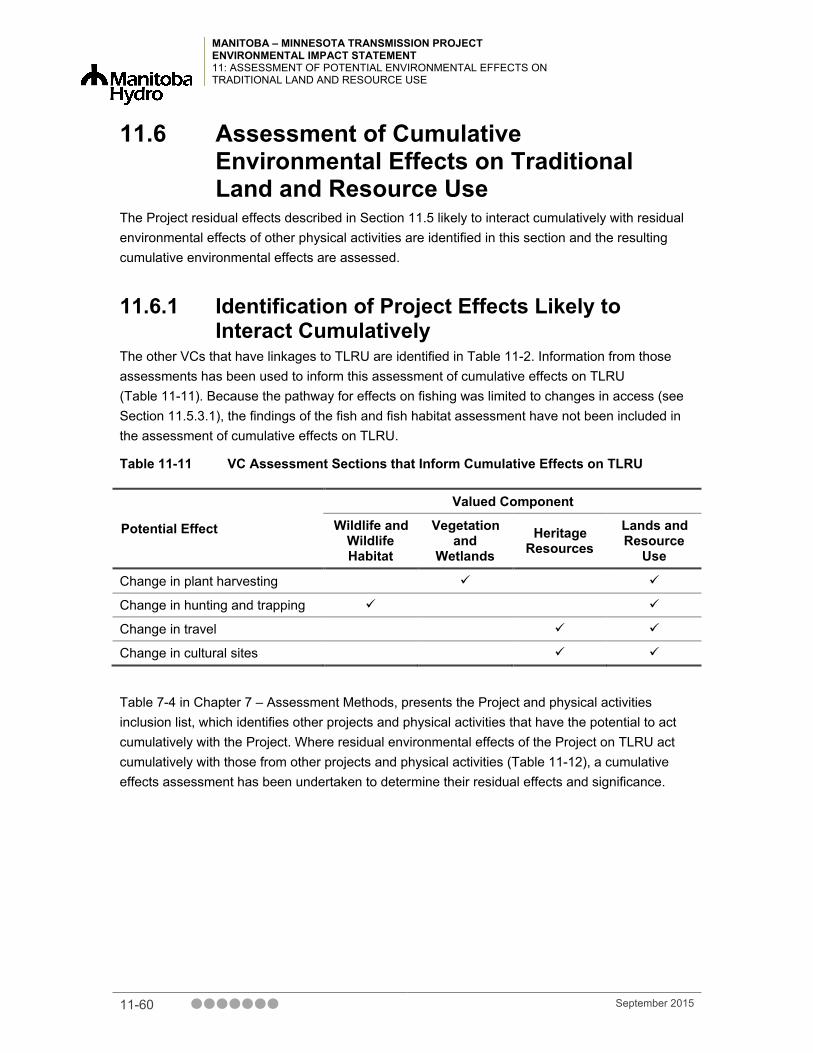
MANITOBA – MINNESOTA TRANSMISSION PROJECT ENVIRONMENTAL IMPACT STATEMENT 11: ASSESSMENT OF POTENTIAL ENVIRONMENTAL EFFECTS ON TRADITIONAL LAND AND RESOURCE USE
11.6 Assessment of Cumulative Environmental Effects on Traditional Land and Resource Use
The Project residual effects described in Section 11.5 likely to interact cumulatively with residual environmental effects of other physical activities are identified in this section and the resulting cumulative environmental effects are assessed.
11.6.1 Identification of Project Effects Likely to Interact Cumulatively
The other VCs that have linkages to TLRU are identified in Table 11-2. Information from those assessments has been used to inform this assessment of cumulative effects on TLRU (Table 11-11). Because the pathway for effects on fishing was limited to changes in access (see Section 11.5.3.1), the findings of the fish and fish habitat assessment have not been included in the assessment of cumulative effects on TLRU.
Table 11-11 VC Assessment Sections that Inform Cumulative Effects on TLRU
Potential Effect
Valued Component
Wildlife and Wildlife Habitat
Vegetation and
Wetlands Heritage
Resources Lands and Resource
Use
Change in plant harvesting
Change in hunting and trapping
Change in travel
Change in cultural sites
Table 7-4 in Chapter 7 – Assessment Methods, presents the Project and physical activities inclusion list, which identifies other projects and physical activities that have the potential to act cumulatively with the Project. Where residual environmental effects of the Project on TLRU act cumulatively with those from other projects and physical activities (Table 11-12), a cumulative effects assessment has been undertaken to determine their residual effects and significance.
11-60 September 2015

MANITOBA – MINNESOTA TRANSMISSION PROJECT ENVIRONMENTAL IMPACT STATEMENT
11: ASSESSMENT OF POTENTIAL ENVIRONMENTAL EFFECTS ON TRADITIONAL LAND AND RESOURCE USE
Table 11-12 Potential Cumulative Environmental Effects on TLRU
Potential Cumulative Environmental Effects
Other Projects and Physical Activities with Potential for Cumulative Environmental Effects
Change in Land and
Resources Used for
Plant Harvesting
Change in Land and
Resources Used for Hunting
and Trapping
Change in Land and
Resources Used for
Travel
Change in Cultural
Sites
Past and Present Physical Activities and Resource Use Agriculture (Conversion, Livestock Operations, Cropping and Land Drainage)
Residential Developments Existing Linear Developments Other Resource Activities (Forestry, Mining, Hunting, Trapping, Fishing)
Recreational Activities Project-Related Physical Activities
Future Physical Activities Bipole III Transmission Project St. Vital Transmission Complex Dorsey-Portage South 230 kV Northwest Winnipeg Natural Gas Pipeline Project
Richer South Station to Spruce Station Transmission Project
Energy East Pipeline Project Southend Water Pollution Control Centre Upgrade Project
– – – –
St. Norbert Bypass Headingley Bypass Oakbank Corridor Residential Development Natural Gas Upgrade Projects MIT Capital Projects (Highway Renewal)
Piney-Pinecreek Border Airport Expansion
NOTES: “” = Other projects and physical activities whose residual effects are likely to interact cumulatively with Project residual
environmental effects. “–“ = Interactions between the residual effects of other projects and those of the Project residual effects are not
expected.
September 2015 11-61

MANITOBA – MINNESOTA TRANSMISSION PROJECT ENVIRONMENTAL IMPACT STATEMENT 11: ASSESSMENT OF POTENTIAL ENVIRONMENTAL EFFECTS ON TRADITIONAL LAND AND RESOURCE USE
11.6.2 Cumulative Effect Pathways for Change in Traditional Land and Resource Use
The landscape of southern Manitoba and TLRU has been altered over time and the Project’s contribution to cumulative effects will be taking place within a disturbed landscape.
The Project has the potential to contribute to cumulative effects on the distribution, abundance and health of the resources that are relied upon to exercise TLRU (Table 11-12). Assessment of the cumulative effect pathways identified for the VCs related to TLRU can be found in Chapter 8 – Fish and Fish Habitat, Chapter 9 – Wildlife and Wildlife Habitat, Chapter 10 – Vegetation and Wetlands, Chapter 12 – Heritage Resources and Chapter 16 – Land and Resource Use.
In addition to potential cumulative effects on resources relied upon to exercise TLRU, the Project may also contribute to perceived effects on the landscape. Transmission lines, traffic bypasses, pipelines, airports and the other future physical activities listed in Table 11-12 will alter the sensorial environment in which TLRU takes place. These cumulative effects can deter First Nations and Metis land users, including through perceived effects of these project components on TLRU.
Operation and maintenance of the Project may result in sensory disturbance. Some users may choose not to conduct TLRU activities based on beliefs and concerns about the site having reduced value.
Alteration of the quality and value of medicinal plants growing near developments was raised as a concern by Roseau River Anishinabe First Nation (2015a). A Roseau River Anishinabe First Nation Elder noted that some community members no longer gather plants along transmission right of ways for sustenance or medicinal use.
However, the area disturbed by the Project will be relatively small with respect to the large amount of available undisturbed native habitat available (approximately 0.3% of the total native vegetation within the RAA on Crown land is located within the PDA). The areas of undisturbed native habitat will not be substantially changed, even when considering the potential cumulative environmental effects as listed in Table 11-12. In addition, MH will not place restrictions on use of the ROW for TLRU after construction, if anyone chooses to do so.
11.6.3 Mitigation for Cumulative Effects Change in Traditional Land and Resource Use
Manitoba Hydro is committed to implementing a variety of mitigation measures, a number of which will reduce or eliminate adverse effects on VCs that are relied upon for TLRU activities. Detailed descriptions of the relevant mitigation measures can be found in Chapter 9 – Wildlife and Wildlife Habitat, Chapter 10 – Vegetation and Wetlands, Chapter 12 – Heritage Resources, and Chapter 16 – Land and Resource Use. Manitoba Hydro acknowledges that First Nations and the Metis often have unique land use practices and that in order to implement effective mitigation measures, ongoing engagement is required. Accordingly, Manitoba Hydro is committed to
11-62 September 2015

MANITOBA – MINNESOTA TRANSMISSION PROJECT ENVIRONMENTAL IMPACT STATEMENT
11: ASSESSMENT OF POTENTIAL ENVIRONMENTAL EFFECTS ON TRADITIONAL LAND AND RESOURCE USE
endeavoring to meet with the MMF and those First Nations who have advised that they want such continued engagement with respect to this Project’s mitigation measures. This might result over time in the advancement of suggestions for new mitigation measures and the modification of measures that are currently proposed.
11.6.4 Residual Cumulative Effects The area in which the Project is located has experienced disturbance as a result of human settlement, the creation of agricultural land and ongoing development. Plant harvesting, hunting and trapping, travelways and cultural sites located within the RAA were identified through the FNMEP and in Project-specific TLU studies. Most of these sites were located outside of the Project LAA and would not be directly affected by the Project; however, they may be affected by future and planned activities. Adverse cumulative effects were identified for the VCs on which TLRU relies. As a result, unaffected TLRU sites and resources may be subject to more intensive use by First Nations, Metis and recreational users due to increased accessibility via transmission corridor and the removal of certain resources along the transmission corridor, which places more pressure on other harvesting areas nearby. Harvesters may instead access areas located in adjacent areas to the Project to conduct traditional harvesting activities.
The vegetation and wetlands assessment (Chapter 10) identified that the Project has the potential to interact cumulatively with other projects and permanently affect traditional use plant species in the vegetation and wetlands RAA as a result of clearing of native vegetation, vegetation management and the creation of permanent structures. A permanent loss of productive forestland within the RAA was identified by the land and resource use assessment (Chapter 16).
The wildlife and wildlife habitat assessment (Chapter 9) noted that the Project will contribute to wildlife mortality risk over a permanent duration in the wildlife and wildlife habitat RAA. Birds were identified as being the most vulnerable to cumulative effects. Bird hunting sites were identified by Peguis First Nation and are located within the wildlife and wildlife habitat RAA.
Cumulative effects on heritage resources (Chapter 12) were characterized as neutral and are not anticipated to contribute to cumulative effects on TLRU. While it is important to acknowledge that beliefs and concerns about Project effects may influence how traditional lands and resources are used in the vicinity of the Project, beliefs or perceptions around adverse effects are difficult to quantify and not easily amenable to assessment in the same way as other Project effects. Given the subjective nature of this effect and the limited site-specific information, a full effects characterization was not carried forward, however beliefs or perceptions of adverse effects was considered narratively in the assessment.
Overall, cumulative effects on TLRU will be continuous and permanent in duration, as several of the VCs that influence TLRU will also experience continuous and permanent effects. The effects will be moderate in magnitude, reducing but not eliminating TLRU throughout the RAA. Table 11-13 summarizes cumulative environmental effects on TLRU.
September 2015 11-63

MANITOBA – MINNESOTA TRANSMISSION PROJECT ENVIRONMENTAL IMPACT STATEMENT 11: ASSESSMENT OF POTENTIAL ENVIRONMENTAL EFFECTS ON TRADITIONAL LAND AND RESOURCE USE
Table 11-13 Summary of Cumulative Environmental Effects on Traditional Land and Resource Use
Cumulative Effect
Residual Cumulative Environmental Effects Characterization
Dire
ctio
n
Mag
nitu
de
Geo
grap
hic
Exte
nt
Dur
atio
n
Freq
uenc
y
Rev
ersi
bilit
y
Ecol
ogic
al
Con
text
Cumulative Change in Traditional Land and Resource Use
Cumulative environmental effect with the Project
A M RAA P C I D
Contribution from the Project to the overall cumulative environmental effect
The Project is located in an area that has been considerably disturbed by past and present physical activities. Although characterized as not significant, adverse cumulative effects were identified for the VCs on which the exercise of TLRU relies. When past, current and future project effects on the landscape are considered, the Project’s contributions to cumulative effects on TLRU are anticipated to be incremental and minor.
KEY See Table 11-4 for detailed definitions Direction: A: Adverse; N: Neutral; P: Positive Magnitude: N: Negligible; L: Low; M: Moderate; H: High Geographic Extent: ROW/Site: PDA; Local: LAA; Regional: RAA
Duration: ST: Short-term; MT: Medium-term; P:Permanent Frequency: S: Single event; IR: Irregular event; R: Regular event; C: Continuous Reversibility: R: Reversible: I: Irreversible
Ecological Context: U:Undisturbed, D:Disturbed N/A Not applicable
11.7 Determination of Significance There are generally accepted thresholds for TLRU, which makes determining the significance of effects on TLRU challenging. Additionally, the subjective nature of describing and understanding the importance of effects on TLRU means that any determination may not adequately apply across all First Nations and Metis. Under CEAA 2012, there is a requirement to make a determination of significance in the TLRU assessment and in compliance with that requirement, significance of Project and cumulative effects is discussed below.
It is also acknowledged that additional effects may be identified through TLU studies currently in process. Manitoba Hydro will continue to work with First Nations and the MMF to identify and discuss Project-specific issues related to potential residual effects. Manitoba Hydro is committed to working with First Nations and Metis to understand and, where possible, address Project-specific concerns that may adversely affect their use of lands and resources for traditional purposes.
11-64 September 2015

MANITOBA – MINNESOTA TRANSMISSION PROJECT ENVIRONMENTAL IMPACT STATEMENT
11: ASSESSMENT OF POTENTIAL ENVIRONMENTAL EFFECTS ON TRADITIONAL LAND AND RESOURCE USE
11.7.1 Significance of Environmental Effects from the Project
Given the Project’s size and the extent of the traditional territories of First Nations and Metis in southern Manitoba, Project overlap with traditional territories is inevitable. Nevertheless, Manitoba Hydro has worked to reduce the potential effects on TLRU by route evaluation and selection and by taking concerns and recommendations from the FNMEP into account during the Project planning process. Following construction there will be no restrictions on access on Crown lands to traditional use sites and areas, other than during active construction, within the Project easement and Manitoba Hydro anticipates that lands occupied by the PDA will remain available for TLRU activities. For more information on Project routing, see Chapter 4 – First Nation and Metis Engagement.
TLRU is dependent upon the distribution, abundance and health of resources relied upon to practice traditional activities. The environmental effects assessments for wildlife and wildlife habitat (Chapter 9), vegetation and wetlands (Chapter 10), heritage resources (Chapter 12) and land and resource use (Chapter 16) concluded that the Project environmental effects would be not significant for all phases of the Project. As discussed in Section 11.2.3: Learnings from Past Assessments, there are limitations to relying on the results of other VC assessments in order to understand effects on TLRU. As such, non-significant findings for related VCs do not by themselves indicate non-significant effects on TLRU.
Plant harvesting, hunting and trapping, travelways and cultural sites located within the RAA were identified through the FNMEP and in Project-specific TLU studies. Most of these sites were located outside the LAA and would not be directly affected by Project activities or works. The assessment adopted the conservative assumption that traditional use activities may occur near the Project even if these activities or site-specific uses were not specifically identified by First Nations and Metis. In consideration of known and potential use sites, and with mitigation, the effects on TLRU were characterized as low to moderate and extending from the PDA to the LAA.
Based on the extent of Crown land covered by the PDA, findings assessment related to TLRU, the characterization of effects on known and assumed TLRU sites, and the fact that there will be no restrictions to access of traditional use sites on Crown lands within the Project easement, The effects of the Project on the TLRU are assessed as not significant.
September 2015 11-65
MANITOBA – MINNESOTA TRANSMISSION PROJECT ENVIRONMENTAL IMPACT STATEMENT 11: ASSESSMENT OF POTENTIAL ENVIRONMENTAL EFFECTS ON TRADITIONAL LAND AND RESOURCE USE
11.7.2 Significance of Cumulative Environmental Effects
In keeping with the methods used for the residual environmental effects assessment (Section 11.3.2), the assessment of cumulative effects on TLRU considers the conclusions of the assessment, as well as past project experience and professional judgment.
Plant harvesting, hunting and trapping, travelways and cultural sites located within the RAA were identified through Manitoba Hydro’s engagement process and in Project-specific TLU studies, and may be affected by future and planned activities. Although characterized as non-significant, adverse cumulative effects were identified for the VCs on which the exercise of TLRU relies. As a result, resources and TLRU areas that are not anticipated to experience residual effects may be subject to increased usage.
Over the last 150 years, the landscape in southern Manitoba and within Treaty 1 territory has been modified by land conversion for agricultural purposes, resource development, transportation networks, the creation of ROWs and utility corridors and the transformation of small human settlements into towns and cities. As a result, TLRU has experienced cumulative effects and with the addition of the Project and other projects and planned activities will continue to experience cumulative effects. Considering the cumulative effects assessments for VCs related to TLRU and the characterization of effects on known and assumed TLRU sites, the cumulative effects on TLRU are assessed as not significant.
11.7.3 Project Contribution to Cumulative Environmental Effects
The Project is located in an area that has experienced substantial and ongoing landscape change. Adverse cumulative effects were identified for the VCs on which the exercise of TLRU relies; as a result, unaffected TLRU sites and resources may be subject to more intensive use by First Nations, Metis and recreational users by the removal of certain resources along the transmission corridor, which places more pressure on other harvesting areas nearby. When past, current and future project effects on the landscape are considered, the Project’s contributions to cumulative effects on TLRU are anticipated to be incremental and negligible.
Additional cumulative effects may be identified through TLU studies currently in process. Manitoba Hydro acknowledges that First Nations and Metis have unique land use practices and that ongoing engagement is required in order to implement effective mitigation measures. Manitoba Hydro will endeavor to work with First Nations and the MMF to discuss mitigation potential effects, and will take First Nations and Metis concerns and recommendations into account during the Project planning process.
11-66 September 2015

MANITOBA – MINNESOTA TRANSMISSION PROJECT ENVIRONMENTAL IMPACT STATEMENT
11: ASSESSMENT OF POTENTIAL ENVIRONMENTAL EFFECTS ON TRADITIONAL LAND AND RESOURCE USE
11.7.4 Sensitivity of Prediction to Future Climate Change
Climate change scenarios presented in the Manitoba – Minnesota Transmission Historic and Future Climate Study state that seasonal growing temperature is expected to increase in the future. Growing season temperatures are projected to increase to 1.5°C by 2020, 2.9°C by 2050, and 4.1°C by 2080. Predicted total precipitation amounts are projected to increase 3.5% in 2020, 4.2% in 2050 and 6.7% in 2080. Greater changes in precipitation are expected to be observed in the winter months, with precipitation amounts projected to be lower than present levels during the summer months.
Climate change could have a long-term effect on the quality, distribution and abundance of resources relied upon to exercise TLRU activities. Access to harvesting and culturally important areas (e.g., through change in snowfall and water levels) could also be affected.
The most appropriate sources of information on the effects of future climate change on TLRU are the individuals exercising TLRU activities in the RAA. The effects of climate change on TLRU was not addressed in the self-directed ATK studies, First Nation and Metis engagement process or secondary sources reviewed for this assessment. In the absence of First Nations and Metis specific information, this prediction of sensitivity is based on the findings of Chapter 9 – Wildlife and Wildlife Habitat, Chapter 10 – Vegetation and Wetlands, Chapter 12 – Heritage Resources, and Chapter 16 – Land and Resource Use.
Potential effects of climate change identified in Chapter 9 include:
• change in habitat availability resulting from extreme weather events such as wildfire
• reduced food availability (e.g., shifts in the seasonal timing of insect emergence, rotting of food caches due to warmer temperatures)
• shifts in species ranges
Potential effects of climate change identified in Chapter 10 include:
• change in plant species composition as a result of increased water deficits for vegetation and wetlands during the summer
• conversion of previously wet areas into agricultural land
Potential effects of climate change identified in Chapter 16 include:
• a gradual shift of forest habitat northward
• increases in the frequency and intensity of forest fires, insect outbreaks and extreme weather events
• species that have been viewed or hunted may no longer inhabit certain protected areas
These potential effects of climate change may affect TLRU.
September 2015 11-67

MANITOBA – MINNESOTA TRANSMISSION PROJECT ENVIRONMENTAL IMPACT STATEMENT 11: ASSESSMENT OF POTENTIAL ENVIRONMENTAL EFFECTS ON TRADITIONAL LAND AND RESOURCE USE
All of the VCs relevant to the TLRU assessment predicted that the climate change scenarios would not change the determination of significance provided in their individual assessments. Due to the limitations of relying on the results of other VC assessments in order to understand effects on TLRU and in the absence of First Nations and Metis site-specific information, we are unable to determine if the predicted determination of significance would alter given the climate change scenarios.
11.8 Prediction Confidence Using the results of other VC assessments and the findings of TLU studies submitted for the Project and in keeping with the conservative approach to assessment, confidence in the assessment of effects on TLRU is moderate. As information that is more specific has been – and will continue to be – gathered through ongoing Project First Nation and Metis engagement activities and Project-specific self-directed ATK studies, and mitigation discussions are undertaken with First Nations and Metis, assessment findings may be refined and the prediction confidence is anticipated to increase.
11.9 Follow-up and Monitoring Follow-up and monitoring programs specific to TLRU First Nations and Metis interests or concerns have been proposed where a mitigation measure is new or is being applied in a unique way and there is a high level of uncertainty in the effectiveness of the proposed mitigation measure.
The objectives of the follow-up and monitoring programs are to confirm the predicted effects and to verify the implementation and effectiveness of the mitigation measures. The need for and nature of follow-up and monitoring programs will be discussed with First Nations and the MMF as part of Manitoba Hydro’s ongoing engagement process.
11.10 Summary The TLRU assessment considered changes in the availability, including abundance and distribution, of traditionally used resources and changes in access to harvesting and cultural use areas. Key issues for TLRU, as identified in the self-directed ATK studies completed for the Project and during Manitoba Hydro’s First Nation and Metis engagement process, include:
• limitation of the extent of unoccupied Crown land available to practice traditional activities as a result of the Project
• loss of traditional use plant species in the PDA
• removal or alteration of wildlife habitat and disruption of wildlife relied upon for hunting and trapping
• reduced land base available for travel and to practice cultural activities
11-68 September 2015

MANITOBA – MINNESOTA TRANSMISSION PROJECT ENVIRONMENTAL IMPACT STATEMENT
11: ASSESSMENT OF POTENTIAL ENVIRONMENTAL EFFECTS ON TRADITIONAL LAND AND RESOURCE USE
Standard industry practices and avoidance measures will be implemented during construction and operation, as listed in the Construction Environmental Protection Plan (CEnvPP) (Chapter 22– Environmental Protection, Follow-up and Monitoring). In addition, key mitigation measures to reduce or eliminate effects on the resources TLRU relies upon will in turn reduce effects on TLRU. Detailed information about mitigation measures for the VCs that are related to TLRU is provided in the fish and fish habitat assessment (Chapter 8), wildlife and wildlife habitat assessment (Chapter 9), vegetation and wetlands assessment (Chapter 10), heritage resources assessment (Chapter 12), and land and resource use assessment (Chapter 16).
After the application of mitigation measures, the residual environmental effects on TLRU are considered adverse, permanent in duration, of regular to continuous frequency and irreversible. The residual environmental effects on fishing, hunting and trapping, travel and cultural sites are of low magnitude, while effects on plant harvesting are moderate in magnitude. The geographic extent of effects will be limited to the PDA for all categories of TLRU, with the exception of hunting and trapping, for which effects are anticipated to extend into the LAA.
Based on the findings of the assessment and TLRU information provided by First Nations and Metis, the effects of the Project on TLRU will be not significant. First Nations and Metis plant harvesting, fishing, hunting and trapping, travel and use of cultural sites will still be possible within the LAA.
Additional potential residual effects may be identified based on TLU studies that are currently being conducted. Manitoba Hydro will continue to work with First Nations and Metis to reasonably address Project-specific issues related to potential residual effects.
The Project will contribute to cumulative effects on the distribution, abundance and health of the resources that are relied upon to exercise TLRU and the beliefs or perceived effects, which may deter TLRU. Overall, cumulative effects on TLRU will be continuous and permanent in duration, and moderate in magnitude. When past, current and future project effects on the landscape are considered, the Project’s contributions to cumulative effects on TLRU in the context of the RAA are anticipated to be incremental and minor.
First Nations and Metis confirmed current and historical use the lands and resources in the LAA through engagement activities, ATK studies and secondary research. Based on this current and historical use of the land, the Project has the potential to interact with traditional land and resource use activities.
Routing is an effective step in mitigating the potential effects of a Transmission line. Manitoba Hydro considered concerns raised through the FNMEP in specific TLRU areas in the transmission line routing process. These concerns helped inform the routing process and in many cases resulted in the avoidance of sensitive areas, reducing the effects on land and resource use.
Manitoba Hydro is committed to implementing a variety of mitigation measures. A number of these measures will reduce or eliminate adverse effects on VCs that are relied upon for TLRU activities. Plant harvesting, fishing, hunting and trapping, travel and use of cultural sites will be
September 2015 11-69

MANITOBA – MINNESOTA TRANSMISSION PROJECT ENVIRONMENTAL IMPACT STATEMENT 11: ASSESSMENT OF POTENTIAL ENVIRONMENTAL EFFECTS ON TRADITIONAL LAND AND RESOURCE USE
widely available in the RAA and these activities will still be possible, except during active construction within the Project ROW.
There will be residual effects on plant harvesting, hunting and trapping, travel and cultural sites after the application of mitigation measures. However, considering the extent of Crown land in the PDA, findings of the assessment related to TLRU, the characterization of effects on known and assumed TLRU sites, and the fact that there will be no restrictions to access of traditional use sites on Crown lands within the Project easement, Manitoba Hydro anticipates the effects of the Project on the TLRU will be not significant.
11.11 References
11.11.1 Literature Cited AANDC (Aboriginal Affairs and Northern Development Canada). 2014. Treaty Land Entitlement –
Manitoba Treaty Land Entitlement. Available from http://www.aadnc-aandc.gc.ca/eng/1100100034822/1100100034823 (accessed February 2015).
BRFN, LPFN, SLFN (Black River First Nation, Long Plain First Nation, Swan Lake First Nation). 2014. Preliminary Aboriginal Traditional Knowledge Study Community Report submitted by Black River First Nation, Long Plain First Nation, Swan Lake First Nation. 13, 16 pp.
BRFN, LPFN, SLFN (Black River First Nation, Long Plain First Nation, Swan Lake First Nation). 2015. Aboriginal Traditional Knowledge Study Community Report submitted by Black River First Nation, Long Plain First Nation, Swan Lake First Nation. 72 pp.
Butler, C. 2006. Traditional Ecological Knowledge and Natural Resource Management. University of Nebraska Press, Lincoln, NE
Cain, N. L., and Nelson, H. T. 2013. What drives opposition to high-voltage transmission lines? Land Use Policy 33: 204-213 pp. Available from http://ac.els-cdn.com/S0264837713000227/1-s2.0-S0264837713000227-main.pdf?_tid=3903effa-24c3-11e5-9080-00000aacb360&acdnat=1436285840_684a6a79674a1cd205fb77c848657f97 (accessed July 2015).
Chandler, M.J., and Lalonde C.E. 1998. Cultural continuity as a hedge against suicide in Canada's First Nations. Transcultural Psychiatry 35: 191-219 pp. doi:10.1177/136346159803500202
Electric Power Research Institute. 2006. EPRI-GTC Overhead Electric Transmission Line Sitting Methodology. Available from http://www.epri.com/abstracts/Pages/ProductAbstract.aspx?ProductId=000000000001013080 (accessed April 2015).
11-70 September 2015
MANITOBA – MINNESOTA TRANSMISSION PROJECT ENVIRONMENTAL IMPACT STATEMENT
11: ASSESSMENT OF POTENTIAL ENVIRONMENTAL EFFECTS ON TRADITIONAL LAND AND RESOURCE USE
Government of Manitoba. 2009a. Interim Provincial Policy for Crown Consultations with First Nations, Métis Communities and Other Aboriginal Communities. Available from http://www.gov.mb.ca/ana/pdf/pubs/interim_aboriginal_consultation_policy_and_guidelines.pdf (accessed May 2015).
Government of Manitoba. 2009b. Fishing, Hunting & Gathering: The Rights and Responsibilities of First Nations People in Manitoba. Available from https://www.gov.mb.ca/conservation/firstnations/hunting_fishing_oct_09.pdf (accessed May 2015).
Kavika. 2011. The Secret Society of the Midewiwin – Ojibwe Healers – Yesterday, Today and Tomorrow. Available from http://kavika.newsvine.com/_news/2011/07/02/6998924-the-secret-society-of-the-midewiwin-ojibwe-healers-yesterday-today-and-tomorrow (accessed June 2015).
Kuhnlein, H.V., and Receveur, O. 1996. Dietary change and traditional food systems of Indigenous peoples. Annual Review of Nutrition. 16, 417-442 pp. doi:10.1146/annurev.nu.16.070196.002221.
Loppie, R.C., and Wien, F. 2009. Health Inequalities and Social Determinants of Aboriginal Peoples’ Health. National Collaborating Centre for Aboriginal Health, Prince George, BC. 42 pp. Available from http://www.nccah-ccnsa.ca/docs/social%20determinates/nccah-loppie-wien_report.pdf (accessed March 2015).
Manitoba Conservation and Water Stewardship. 2014. Elk Fact Sheet. Available from http://www.gov.mb.ca/conservation/wildlife/mbsp/fs/elk.html (accessed July 29, 2015).
Manitoba Conservation and Water Stewardship. 2013. Hunting Guide. Available from http://www.gov.mb.ca/conservation/wildlife/hunting/ (accessed July 29, 2015).
Manitoba Hydro. 1993. Sustainable Development Policy. Available from https://www.hydro.mb.ca/environment/env_management/sdp.shtml (accessed June 2015).
Manitoba Hydro. n.d. Community Engagement Summary Sandy Bay Ojibway First Nation. Available from http://www.gov.mb.ca/conservation/eal/registries/5433bipole/april10_2015/sandy_bay_ojibway_first_nation_community_engagement_summary.pdf (accessed May 2015).
MMF (Manitoba Metis Federation), 2011. Manitoba Metis traditional use, values and knowledge of the Bipole III project study area. Winnipeg. Manitoba Metis Federation. August 201.. 44 pp. + appendices.
September 2015 11-71

MANITOBA – MINNESOTA TRANSMISSION PROJECT ENVIRONMENTAL IMPACT STATEMENT 11: ASSESSMENT OF POTENTIAL ENVIRONMENTAL EFFECTS ON TRADITIONAL LAND AND RESOURCE USE
MMF (Manitoba Metis Federation). 2012a. News Release: Province Partners with Manitoba Metis Federation to Uphold Métis Harvesting Rights, Natural Resource Conservation (online). Available from http://www.mmf.mb.ca/docs/MMF%20Harvesting%20Rights%20Media%20Release.pdf (accessed February 2015).
MMF (Manitoba Metis Federation). 2012b. Metis Laws of the Harvest Revised 3rd Edition: Guide to Metis Hunting, Fishing, Trapping and Gathering (online). Available from http://www.mmf.mb.ca/docs/Metis-Laws-of-the-Harvest_FINAL.pdf (accessed April 2015).
NEB (National Energy Board). 2015. Electricity Filing Manual. Available from https://www.neb-one.gc.ca/bts/ctrg/gnnb/lctrct/lctrctflngmnl/lctrctyflngmnl-eng.pdf (accessed May 2015).
North/South Consultants Inc. 2014. Manitoba Métis: A Review of Available Information on the Use of Lands and Resources for Traditional Purposes in the MMTP Study Area with Gap Analyses. 25 pp.
Peguis First Nation. 2015. Report to Peguis First Nation and Manitoba Hydro - Peguis First Nation Draft Land Use and Occupancy Interview Project for the Manitoba-Minnesota Transmission Project. 32 pp.
Roseau River Anishinabe First Nation. 2015a. Oral History Interview – Bishew (Lynx). Recorded and Transcribed by June Thomas, Community Project Coordinator. May 13, 2015. 3 pp.
Roseau River Anishinabe First Nation. 2015b. Oral History Interview – Eagle Songs. Recorded and Transcribed by June Thomas, Community Project Coordinator. May 19, 2015. 3 pp.
Roseau River Anishinabe First Nation. 2015c. Roseau River Anishinabe First Nation Aboriginal Traditional Knowledge Report. 8 pp.
Sagkeeng First Nation. 2015. Sagkeeng O-Pimatiziiwin 2 – Traditional Knowledge Study – Manitoba-Minnesota Transmission Line Project. 28 pp.
Tobias, T. 2000. Chief Kerry’s Moose: A Guidebook to Land Use and Occupancy Mapping, Research and Design. Union of BC Indian Chiefs and Ecotrust Canada. 61 pp.
11-72 September 2015
MANITOBA – MINNESOTA TRANSMISSION PROJECT ENVIRONMENTAL IMPACT STATEMENT
APPENDIX 11A: BLACK RIVER FIRST NATION, LONG PLAIN FIRST NATION, SWAN LAKE
FIRST NATION TERMINOLOGY
Appendix 11A Black River First Nation, Long Plain First
Nation, Swan Lake First Nation Terminology
September 2015

MANITOBA – MINNESOTA TRANSMISSION PROJECT ENVIRONMENTAL IMPACT STATEMENT
APPENDIX 11A: BLACK RIVER FIRST NATION, LONG PLAIN FIRST NATION, SWAN LAKE
FIRST NATION TERMINOLOGY
11A Black River First Nation, Long Plain First Nation, Swan Lake First Nation Terminology
Cultural sites* Areas that are used for food gathering, medicine picking, trapping, hunting areas, fishing camps, and non-spiritual activities such as recreational events like competitions.
Heritage site* An area of past land use by First Nations for survival purposes such as camps, travel routes, gardens, events, and areas where First Nations people gathered for trade, this is not a complete list of activities. This definition is for use in this chapter and may not coincide with definitions of a heritage site used elsewhere for other valued components.
Historical sites* Areas where First Nations have specific activities related to who First Nations people are, as an example the following are considered historical sites: the site of the Dakota - Ojibwa Peace Treaty, the incident at Round Lake or Eagles Nest, Round Plain and Grassy Lake. This definition is for use in this chapter and may not coincide with definitions of historical sites used elsewhere for other valued components.
Sacred sites* Areas where First Nations people held ceremonial events like sundance grounds and Midewin3 areas. Graves (cemetery style) are considered sacred sites as these areas would have been attached to lengthy stays by First Nations people in certain locations, as are graves that are located in non-cemetery locations.
3 Midewin is defined as the mystic or ''Grand Medicine Society'' is a highly structured society, open to both men and women. Its members perform elaborate healing ceremonies to deal with sickness, long-term health, and matters of a spiritual nature. The Midewiwin consists of an individual who has been initiated into the society in a ceremony that took place in four stages. Each stage conferred a greater level of power upon the initiate (Kavika 2011).
September 2015 11A-1

MANITOBA – MINNESOTA TRANSMISSION PROJECT ENVIRONMENTAL IMPACT STATEMENT APPENDIX 11A: BLACK RIVER FIRST NATION, LONG PLAIN FIRST NATION, SWAN LAKE FIRST NATION TERMINOLOGY
Table 11A-1 Traditional Use Plant Species Identified by Black River First Nation, Long Plain First Nation, Swan Lake First Nation
Provincial Scientific Name Common Name
Abies balsamea balsam fir
Achillea millefolium yarrow
Acorus americanus weke, wee-kai, weekay, American sweet flag
Actaea racemose black snakeroot
Actaea rubra baneberry
Agastache foeniculum giant hyssop
Alnus incana speckled alder
Amelanchier alnifolia saskatoon berry
Apocynum androsaemifolium dogbane
Aquilegia sp. columbine
Aralia nudicaulis wild sarsaparilla
Arctostaphylos uva‐ursi common bearberry
Artemisia sp. sage
Asarum canadense wild ginger
Asclepias incarnate swamp milkweed
Betula papyrifera paper birch
Caltha palustris marsh marigold
Campanula sp. harebell
Cannabis sativa hemp
Chamerion angustifolium fireweed
Conyza canadensis Canada fleabane
Cornus canadensis bunchberry
Cornus sericea red osier dogwood
Corylus americana American hazelnut
Corylus cornuta beaked hazelnut
Corylus sp. hazelnut
Cratagus sp. hawthorn
Dasiphora fruticose shrubby cinquefoil
11A-2 September 2015

MANITOBA – MINNESOTA TRANSMISSION PROJECT ENVIRONMENTAL IMPACT STATEMENT
APPENDIX 11A: BLACK RIVER FIRST NATION, LONG PLAIN FIRST NATION, SWAN LAKE
FIRST NATION TERMINOLOGY
Provincial Scientific Name Common Name
Fragaria virginiana wild strawberry
Geranium bicknellii Bicknell's geranium
Geum aleppicum yellow avens
Heuchera richardsonii alumroot
Hierochloe odorata sweetgrass
Hypericum perforatum St. John's wort
Larix laricina tamarack
Rhododendron groenlandicum Labrador tea
Lilium philadelphicum wood lily
Lycopus uniflorus northern bugle-weed
Maianthemum canadense Canada mayflower
Mentha sp. wild mint
Oenothera flava yellow evening primrose
Polygala senega seneca
Populus balsamifera balsam poplar
Potentilla argute tall cinquefoil
Prenanthes sp. rattlesnake root
Prunella vulgaris self-heal
Prunus nigra Canada wild plum
Prunus pensylvanica pin cherry
Prunus pumila sand cherry
Prunus sp. plum
Prunus virginiana chokecherry
Pyrola sp. wintergreen
Quercus macrocarpa burr oak
Ribes americanum wild black currant
Ribes oxyacanthoides ssp. oxyacanthoides northern gooseberry
Rosa arkansana prairie rose
Rosa sp. wild rose
Rubus pubescens dewberry
September 2015 11A-3
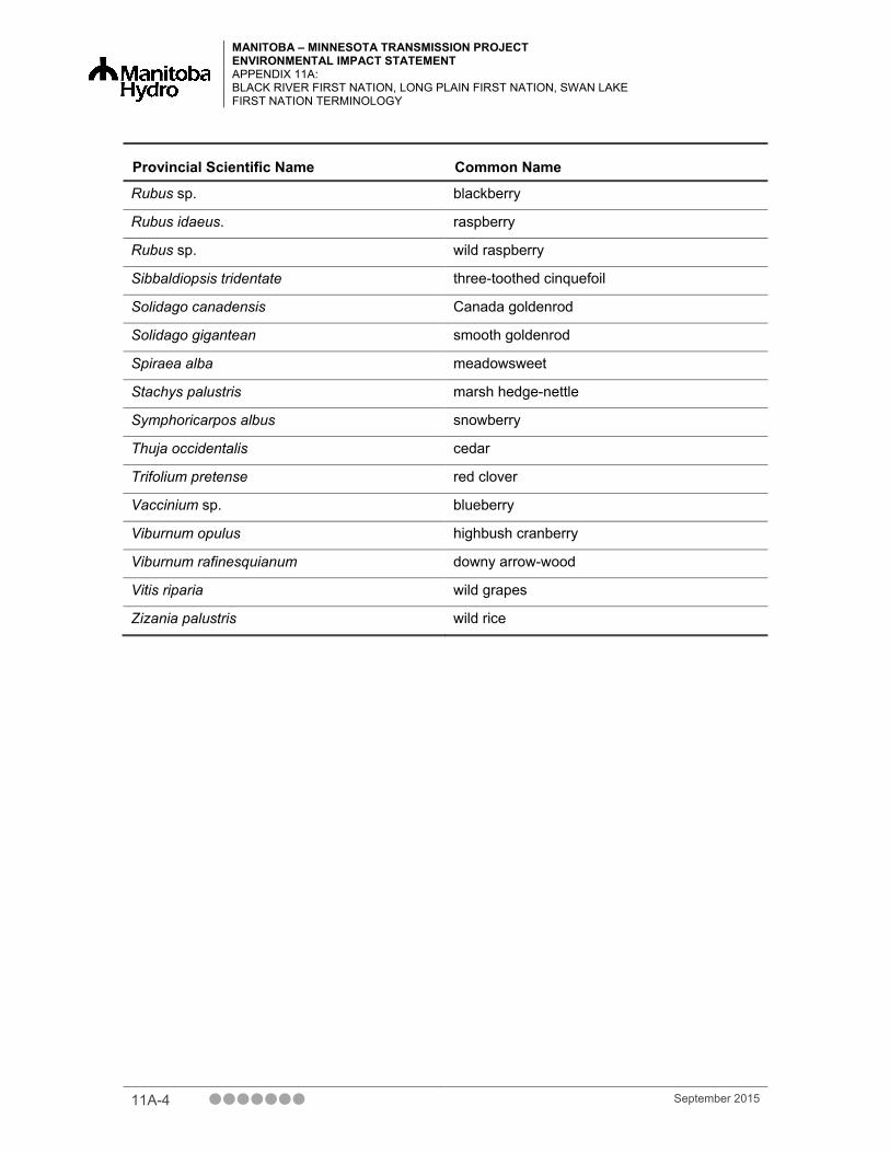
MANITOBA – MINNESOTA TRANSMISSION PROJECT ENVIRONMENTAL IMPACT STATEMENT APPENDIX 11A: BLACK RIVER FIRST NATION, LONG PLAIN FIRST NATION, SWAN LAKE FIRST NATION TERMINOLOGY
Provincial Scientific Name Common Name
Rubus sp. blackberry
Rubus idaeus. raspberry
Rubus sp. wild raspberry
Sibbaldiopsis tridentate three-toothed cinquefoil
Solidago canadensis Canada goldenrod
Solidago gigantean smooth goldenrod
Spiraea alba meadowsweet
Stachys palustris marsh hedge-nettle
Symphoricarpos albus snowberry
Thuja occidentalis cedar
Trifolium pretense red clover
Vaccinium sp. blueberry
Viburnum opulus highbush cranberry
Viburnum rafinesquianum downy arrow-wood
Vitis riparia wild grapes
Zizania palustris wild rice
11A-4 September 2015