EPIPOLAR RECTIFICATION FOR CARTOSAT-1 … RECTIFICATION FOR CARTOSAT-1 STEREO IMAGES ......
4
*Corresponding author EPIPOLAR RECTIFICATION FOR CARTOSAT-1 STEREO IMAGES USING SIFT AND RANSAC A. Akilan a,* , D. Sudheer Reddy, V. Nagasubramanian, P.V. Radhadevi, GeetaVaradan Advanced Data Processing Research Institute Dept. of Space, Manovikas Nagar P.O., Secunderabad-9 a [email protected] KEY WORDS: Epi-polar rectification , image matching , SIFT, Ransac, Cartosat-1 stereo ABSTRACT: Cartosat-1 provides stereo images of spatial resolution 2.5m with high fidelity of geometry. Stereo camera on the spacecraft has look angles of +26 degree and -5 degree respectively that yields effective along track stereo. Any DSM generation algorithm can use the stereo images for accurate 3D reconstruction and measurement of ground. Dense match points and pixel-wise matching are prerequisite in DSM generation to capture discontinuities and occlusions for accurate 3D modelling application. Epipolar image matching reduces the computational effort from two dimensional area searches to one dimensional. Thus, epipolar rectification is preferred as a pre-processing step for accurate DSM generation. In this paper we explore a method based on SIFT and RANSAC for epipolar rectification of cartosat-1 stereo images. 1. INTRODUCTION There are several methodologies available on epipolar rectification using Rigorous Sensor Modelling (RSM), Rational Functional Model (RFM), etc.,. In this paper we exploit the fine characteristics of CARTOSAT-1 such as stable geometric fidelity and invariant perspective centre of linear CCD array across the entire image. Here we propose a method for constructing epipolar image pairs using SIFT (Scale Invariant Feature Transformation) based matching and filtering the wrong matches by RANSAC (RANdomSAmple Consensus) algorithm. SIFT match produces initial level correspondence between the stereo images to construct fundamental matrix. Epipolar line and the rotation matrices are derived from the fundamental matrix. Then the epipolar rectified images are generated by resampling stereo images with respect to the rotation matrices. RANSAC algorithm is used to weed out wrong match points resulted from the SIFT. The proposed method produces epipolar rectified images and achieves sub- pixel accuracy for better anaglyph viewing. This method was carried out on different image pairs of cartosat-1 and the results are presented. The paper is organized as follows first we present epipolar rectification followed by SIFT and then we outline RANSAC algorithm tuned for the present application. 2. EPIPOLAR RECTIFICATION Epipolar geometry is the geometry of stereo pair of images. The general methods of solving epipolar rectification are by parallel projection and rigorous sensor model (RSM). The later one using RSM requires proper resampling technique to preserve consistent scan line difference between stereo pairs. Alternatively, we adopted affine transformation based solution to reduce scan line disparity between left and right images as all the epipolar lines are parallel [ref]. Importantly, due to cartosat- 1 platform stability, non-agile camera mount and consistent geometry of payload parameters, the affine based approach offers an alternate solution to the problem. Figure 1.epipolar geometry As a first step, we construct affine epipolar fundamental matrix using accurate match points obtained by SIFT and filtered by RANSAC. Fundamental matrix is the algebraic representation of epipolar geometry. An affine fundamental matrix differs from a regular fundamental matrix in the sense that its epipoles are at infinity. This makes the top left 2×2 area of the matrix zero. Only the remaining 5 elements contain information. Solving for those elements we force the constraint that: and where and are the corresponding (match) points on left and right image. The epipoles of the left and right image are represented by the last row and column of the affine fundamental matrix ( . The parameters in the matrix are solved by finding the Eigen vector with the smallest singular value. Next, we use these results to solve for rotation matrices to flatten the epipolar lines, The International Archives of the Photogrammetry, Remote Sensing and Spatial Information Sciences, Volume XL-8, 2014 ISPRS Technical Commission VIII Symposium, 09 – 12 December 2014, Hyderabad, India This contribution has been peer-reviewed. doi:10.5194/isprsarchives-XL-8-1095-2014 1095
Transcript of EPIPOLAR RECTIFICATION FOR CARTOSAT-1 … RECTIFICATION FOR CARTOSAT-1 STEREO IMAGES ......
*Corresponding author
EPIPOLAR RECTIFICATION FOR CARTOSAT-1 STEREO IMAGES
USING SIFT AND RANSAC
A. Akilana,*
, D. Sudheer Reddy, V. Nagasubramanian, P.V. Radhadevi, GeetaVaradan Advanced Data Processing Research Institute
Dept. of Space, Manovikas Nagar P.O., Secunderabad-9 [email protected]
KEY WORDS: Epi-polar rectification , image matching , SIFT, Ransac, Cartosat-1 stereo
ABSTRACT:
Cartosat-1 provides stereo images of spatial resolution 2.5m with high fidelity of geometry. Stereo camera on the spacecraft has look
angles of +26 degree and -5 degree respectively that yields effective along track stereo. Any DSM generation algorithm can use the
stereo images for accurate 3D reconstruction and measurement of ground. Dense match points and pixel-wise matching are
prerequisite in DSM generation to capture discontinuities and occlusions for accurate 3D modelling application. Epipolar image
matching reduces the computational effort from two dimensional area searches to one dimensional. Thus, epipolar rectification is
preferred as a pre-processing step for accurate DSM generation. In this paper we explore a method based on SIFT and RANSAC for
epipolar rectification of cartosat-1 stereo images.
1. INTRODUCTION
There are several methodologies available on epipolar
rectification using Rigorous Sensor Modelling (RSM), Rational
Functional Model (RFM), etc.,. In this paper we exploit the fine
characteristics of CARTOSAT-1 such as stable geometric
fidelity and invariant perspective centre of linear CCD array
across the entire image. Here we propose a method for
constructing epipolar image pairs using SIFT (Scale Invariant
Feature Transformation) based matching and filtering the wrong
matches by RANSAC (RANdomSAmple Consensus)
algorithm. SIFT match produces initial level correspondence
between the stereo images to construct fundamental matrix.
Epipolar line and the rotation matrices are derived from the
fundamental matrix. Then the epipolar rectified images are
generated by resampling stereo images with respect to the
rotation matrices. RANSAC algorithm is used to weed out
wrong match points resulted from the SIFT. The proposed
method produces epipolar rectified images and achieves sub-
pixel accuracy for better anaglyph viewing. This method was
carried out on different image pairs of cartosat-1 and the results
are presented.
The paper is organized as follows first we present epipolar
rectification followed by SIFT and then we outline RANSAC
algorithm tuned for the present application.
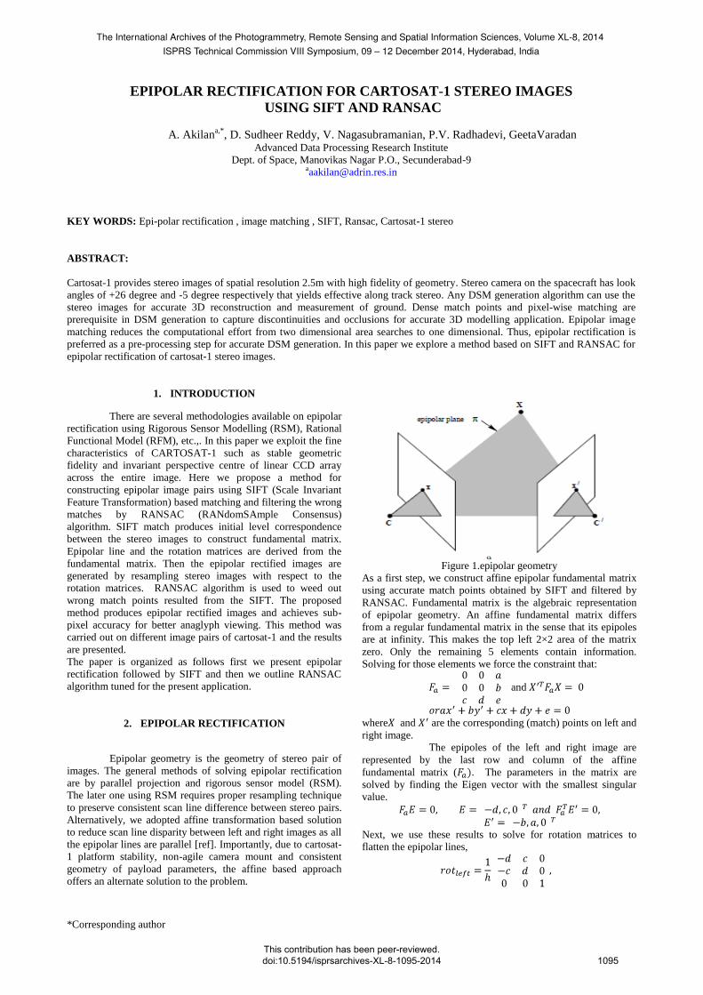
2. EPIPOLAR RECTIFICATION
Epipolar geometry is the geometry of stereo pair of
images. The general methods of solving epipolar rectification
are by parallel projection and rigorous sensor model (RSM).
The later one using RSM requires proper resampling technique
to preserve consistent scan line difference between stereo pairs.
Alternatively, we adopted affine transformation based solution
to reduce scan line disparity between left and right images as all
the epipolar lines are parallel [ref]. Importantly, due to cartosat-
1 platform stability, non-agile camera mount and consistent
geometry of payload parameters, the affine based approach
offers an alternate solution to the problem.
Figure 1.epipolar geometry
As a first step, we construct affine epipolar fundamental matrix
using accurate match points obtained by SIFT and filtered by
RANSAC. Fundamental matrix is the algebraic representation
of epipolar geometry. An affine fundamental matrix differs
from a regular fundamental matrix in the sense that its epipoles
are at infinity. This makes the top left 2×2 area of the matrix
zero. Only the remaining 5 elements contain information.
Solving for those elements we force the constraint that:
and
where and are the corresponding (match) points on left and
right image.
The epipoles of the left and right image are
represented by the last row and column of the affine
fundamental matrix ( . The parameters in the matrix are
solved by finding the Eigen vector with the smallest singular
value.
Next, we use these results to solve for rotation matrices to
flatten the epipolar lines,
The International Archives of the Photogrammetry, Remote Sensing and Spatial Information Sciences, Volume XL-8, 2014ISPRS Technical Commission VIII Symposium, 09 – 12 December 2014, Hyderabad, India
This contribution has been peer-reviewed. doi:10.5194/isprsarchives-XL-8-1095-2014
1095
where In the next step, scale and offset for Y axis is computed by
solving using least square method, where
here the subscript j ( j
= 0,1) denotes the element at position j after forming the
product i.e.,
similarly, In the same way, all the transformations including skew are
solved for X axis,
Once again forming an equation of the form to solve
for scale, skewness and off-set along x-direction. Finally affine matrix for left and right are
constructed based on the scale, skew and offset values estimated
from the above equations. Skewness applies to both left and
right imagesequally to minimize distortion. Affine matrices for
left and right image are given by,
(1)
where .
3. FEATURE DETECTION AND MATCHING
Efficient matching between images is obtained by first finding
as a set of robust features which are invariant to scale, rotation
and translation. SIFT (Scale Invariant Feature Transform)
proposed by David Lowe (2004) belongs to the class of feature-
based matching built on two main processing phases – keypoint
extraction and keypoint matching.
The main steps of SIFT are as follows
(1) images and their sub-sampled images are convolved
with Laplacian of Gaussian operator to
generate images into corresponding scale-space.
Extremum points are selected in scale-space as
keypoint candidates, which are likely to generate the
most stable image feature points.
(2) Keypoint candidates are located accurately and points
are rejected that have low contrast or are poorly
located along an edge.
(3) Dominant orientations are computed and assigned to
each keypoint.
(4) The local image descriptors are constructed according
to the gradient information in the area around the
keypoints.
(5) The ratio of the distance of the closest neighbour and
that of the second-closest neighbour serves as a
criterion to determine whether two keypoints are
matching.
SIFT approach transforms local image features relative to
coordinate frames that are expected to be stable across multiple
views of an object. To achieve the computational efficiency step
(1) is approximated with a difference of Gaussian (DOG) eq.(1)
at different image pyramid level to detect the extreme values.
(2)
Pixels with these extreme values are selected as keypoints,
described by means of a feature descriptor defined by a 128
dimensional vector step (3). Then keypoint matching is to
calculate the Euclidean distances from one keypoint descriptor
on the left image to another keypoint descriptors on the right
image. If the distance ratio (between the shortest Euclidean
distance divided by the subsequent second shortest distance) is
smaller than the threshold, then the keypoint is matched step
(5). Thus, the one on the left image is matched to another one
on the right image. Otherwise, the matching for this keypoint on
the left image fails. The matching and searching operations will
be done repeatedly until all keypoints are processed. The
accuracy of generated match-points by SIFT are at sub-pixel
level which also ensures the accuracy of epipolar rectification
up to sub-pixel level.
4. AFFINE FITTING AND RANSAC
Matching by SIFT generates a large set of points which may
contain wrong matches. To eliminate the wrongly matched
points we use RANSAC. Let …,
in the Left image and the corresponding matched
points in Right image are …, .
We fit an Affine transform (2) which takes care of rotation,
scaling and shearing of the points.
(3)
or in short e use RANSAC paradigm for
estimation of affine transform parameters and .
RANSAC is an iterative method to estimate parameters of a
mathematical model from a set of observed data which contains
outliers. It is a non-deterministic algorithm and can produce a
reasonable result for parameters. The main steps of RANSAC
algorithm are as follows Input: matched points and a known model(Affine Transform).
Initialize :inlier_set = , percentage of inliers = 50% of
data size, .
(1) Randomly select a subset of data sufficient enough
number of points to fit a model . [3
distinct points are sufficient to find 6 affine Transform
coefficients]
(2) Estimate the parameters of the model from the
sample. [ ]
(3) Calculate the number of inliers which support the
hypothesis with a predefined tolerance [ count the
number of points that satisfy ].
(4) If the number of inliers is greater than that of the
inliers in the current set, keep this set of inliers as the
new current set of inliers. [ if assign ].
(5) If the necessary number of iterations is enough, re-
estimate the model parameters using all the identified
inliers in the current set and terminate. Else repeat
step 1 through 5.
The International Archives of the Photogrammetry, Remote Sensing and Spatial Information Sciences, Volume XL-8, 2014ISPRS Technical Commission VIII Symposium, 09 – 12 December 2014, Hyderabad, India
This contribution has been peer-reviewed. doi:10.5194/isprsarchives-XL-8-1095-2014
1096

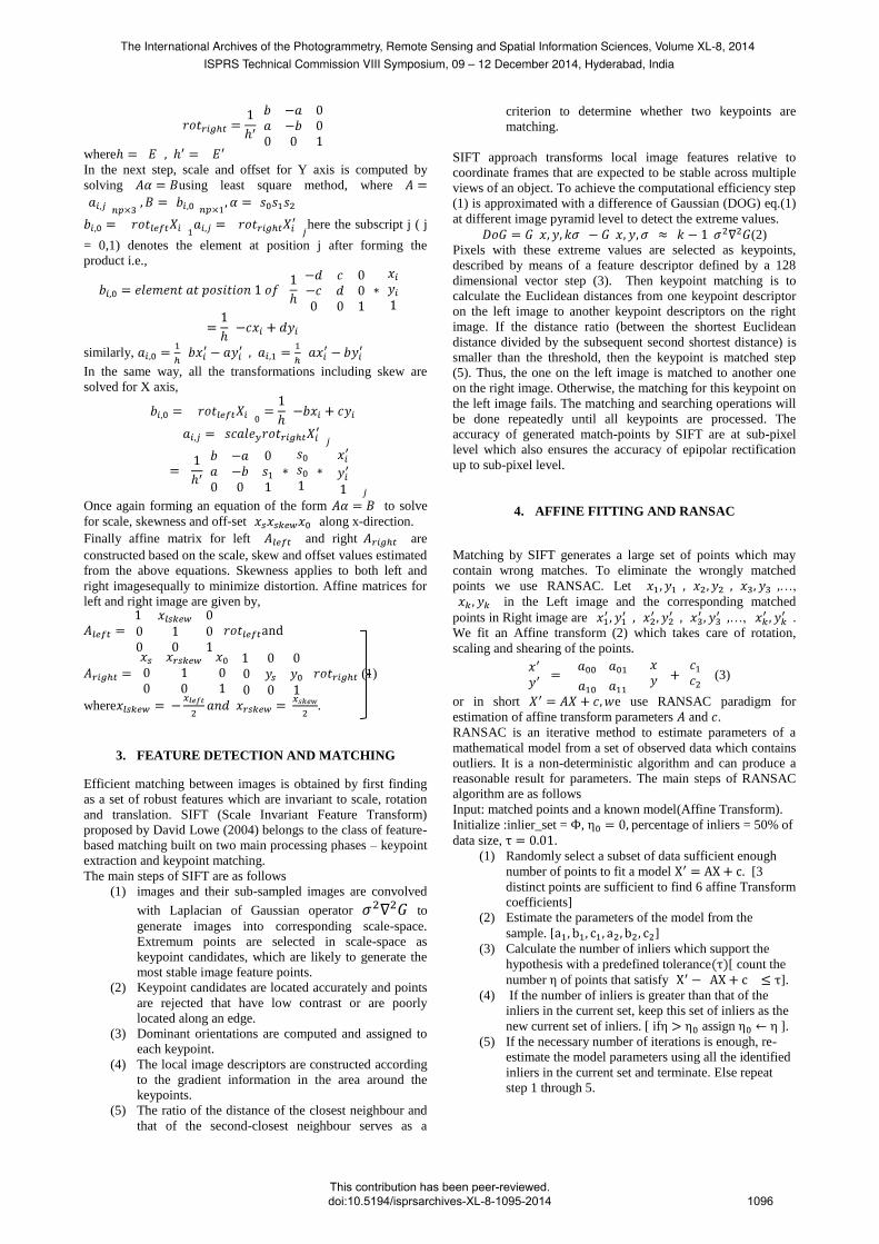
5. CURRENT PROCEDURE
The following figure [2] shows our workflow of the scheme
adopted for epipolar rectification of Cartosat-1 images. Rotation
matrices for left and right images are derived from fundamental
matrix estimation. Then the matrices are corrected for scale,
offset and skew/shear differences.
Figure (2) schema for epipolar geometry rectification
6. DATA SETS AND RESULTS
A description of the Cartosat-1 mission is given in Cartosat-1
Handbook (2006). We recall some of the satellite parameters
that results quality stereo images and stable geometry. Cartosat-
1 has a fore (F) and aft (A) panchromatic camera for along-track
stereo, with a tilt in flight direction of and ,
respectively. Each sensor is comprised of 12,000 pixel CCDs
with 7 microns pixel spacing. A roll steering of the satellite
allows across-track pointing up to 23 degrees, increasing thus
the revisit frequency. Dynamic changes, especially the
continuous yaw steering and pitch bias (if applied during
imaging) may affect both geometric stability and radiometric
quality (image smearing). The stereo pairs with above geometry
quality is well fitting into our methodology for generating high
precision epipolar images. An image over Jammu and Kashmir
contatining high terrain undulations was taken as to study the
effect of this procedure. The result is show in Figure(3). The
anaglyph is formed with this stereo image and a portion was
shown in Figure(4). We noted that the procedure adopted
produced best results and are visually verified by generating
Anaglyph.
7. CONCLUSIONS
We have experimented a procedure based on SIFT and
RANSAC for generating epipolar rectified images from
Cartosat-1 stereo image pairs by fitting an affine transform. The
results are producing the best epi-polar rectified images.
Figure (3) Result of matching after filtering with RANSAC.
Figure(4) a portion of Figure(3) taken for anaglyph viewing
8. ACKNOWLEDGEMENTS
The authors gratefully acknowledge Sri..R. Ramachandran,
Associate Director and Dr. J Saibaba, Deputy Director (SDAA),
ADRIN for their encouragement and support for this work.
REFERENCES
Oh, Jaehong. 2011, Novel Approach to Epipolar
Resampling of HRSI and Satellite Stereo Imagery-based
Georeferencing of Aerial Images.Diss.The Ohio State
University.
Morgan, Michel, et al. 2006.Epipolar resampling of space-
borne linear array scanner scenes using parallel
projection. PE &RS, 72.11, 1255-1263.
Wang, Mi, Fen Hu, and Jonathan Li. 2011.Epipolar
resampling of linear pushbroom satellite imagery by a new
epipolarity model. ISPRS Journal of Photogrammetry and
Remote Sensing 66.3: 347-355.
Hartley, Richard, and Andrew Zisserman. 2000. Multiple
view geometry in computer vision. Vol. 2. Cambridge.
Liansheng, Sui, Zhang Jiulong, and Cui Duwu.2008,
Image rectification using affine epipolar geometric
constraint. ISCSCT’08.IEEE Int. Symposium on.Vol. 2.
Pablo d’Angelo, Peter Schwind, Thomas Krauss,
FrithjofBarner, and Peter Reinartz "Automated DSM based
Georeferencing of Cartosat-1 Stereo Scenes”.
Cartosat-1 Handbook, 2006. Available at http://www
.nrsa.gov.in/IRS_Documents/Handbook/cartosat1.pdf
(accessed 29 January, 2008).
The International Archives of the Photogrammetry, Remote Sensing and Spatial Information Sciences, Volume XL-8, 2014ISPRS Technical Commission VIII Symposium, 09 – 12 December 2014, Hyderabad, India
This contribution has been peer-reviewed. doi:10.5194/isprsarchives-XL-8-1095-2014
1097

G.L.David., “Distinct image features from scale-invariant
keypoints”, International journal of computer vision, 60(2),
91-110(2004).
M.A. Fischler, R.C. Bolles, “Random Sample Consensus:
A paradigm for model fitting with applications to image
analysis and automated cartography”, Communications of
the ACM, 24(6), 381-395, 1981.
O Chum, Tomas Werner, Jiri Matas, “Epipolar geometry
estimation via RANSAC benefits from the oriented
Epipolar Constraint”, pp 112-115, Vol.1, ICPR, 2004.
T Kim, “A Study on the Epipolarity of Linear Pushbroom
Images”, PE&RS, pp-961-966, Vol.66, No. 8, Aug, 2000.
V. Nagasubramanian, P. V. Radhadevi, R. Ramachandran,
R. Krishnan, 3D Reconstrution with Rational Function
Model, pp 1-9, Vol-36, ISRS, March, 2008.
P.V.Radhadevi , V.Nagasubramanian,
ArchanaMahapatra , S.S.Solanki, D Sudheer Reddy,
Krishna Sumanth&GeetaVaradan. New Era of Cartosat
Satellites for Large Scale Mapping, PE & RS., Vol. 76,
No. 9, pp. 1031-1040, Sep-2010.
The International Archives of the Photogrammetry, Remote Sensing and Spatial Information Sciences, Volume XL-8, 2014ISPRS Technical Commission VIII Symposium, 09 – 12 December 2014, Hyderabad, India
This contribution has been peer-reviewed. doi:10.5194/isprsarchives-XL-8-1095-2014
1098