Efl'ects of Flow Regulation on Shallow-Water Habitat ... · Efl'ects of Flow Regulation on...
15
of ! .'\me:nCl1'I SuCit':lY 2(0) Efl'ects of Flow Regulation on Shallow-Water Habitat Dynamics and Floodplain Connectivity ZACHARY H. BOWEN.'" KEN D. BOVEE, AND TERRY J. WADD1.E US. Gpological S"rw:y, Fori Collins Scien,:e Cpl11er. 2150 Ct!nlre Avenue. Building C. Fon Co/lim, Colomdo 80526-8118, USA AbsITaCI.-Our st.uu)' ex.amjneu the effects of flow regulation on the .>patiotemporal availability of ,hallnw hahitat WIlh slll\\' curn:m \'elocil)' (SSCV patches) and Illundalllm in t.be unregul,ll"'u R1VC! :lflll the r",gulaled Rlvcr in Nort.h Dak0ta. Wc "mapped sites ancl med hydraulic modtls and data In dcscflbe Tile and eXlel11 of Aoodplain inulldation and the ,lva1labilit)' of SSCV habit,H over time Juring differenl wal.cr ye,u·s. Tn the Yellowstone River the distflbution. locallon. and .>!ze of sse\' p3IChe-;. varied bUI fnlll)weJ an annual patlern that "",ns tIed to runoff hyurograph. Thcrc W,lS Ie,., vallation 111 parch ul.,tllbl.lliOn rn the Mi,souri RIver. Jild the patrern of hahn,l! aV"lIabtlll} was IntlnenccJ by flow regul:lllOn. Regulaled flows and thclr cttCCIS on channel f1HH- phology anu parte.rns of vegel'Hion esrabitshment. resulted in 3.0-3.5 tlmes less drea of inundaled woody ve-getatlon dUring normal and dry yea.rs in the Mi.<;;oUJi River compared with the Yellow- stone River. The JilTcrc:nce.<; we observed in SSCV palch uynamic, between river., may havt implication, for fish population:. and communit), st.ruelure through affecting the survival of carl)' life stages. Al a larger scale. the smaller a.rea of veget.uion inundatcd in thc Mls·;iUl.lri River suggests th,u nut.rient cycling ;lad the ccolugical bcndits with a moving IlI10ral Zone are reduced hy the altere.r! fh,\><· and In that rive!". Accurare ,!sseSSl11euts of the effects of flow altcratioil anu ciTorl, tn river,inc willlcquire con.,iJcnuion oi'phy;'lt:al anu biotic processes thal operate al muiliple _patial tcmpond scales. The character and persistence of large-rivE'.r eco- noodplai n connectivity (\\lard and Stanford 1989; are increasingly dependent on flow man- Sparks 1992), and <l!rered rates of channel migra- agemcnt and orhcr human aClivilies in river cor- tion (Shankman and Drake 19901. ridors. Large rivers throug.hoUT the world are af- Human-induced changes in the river corridor fected by dams. diversions. chanueliz<ltion, levce and the Hu\<ial geomorphological that construction, groundwatcr pumping, and changes follow disrupt functions thm support heal\hy river in watershed land use (Ward and St<lnford 1989: eeos)stems. Successional processes and the main- Benke 1990; Dudgeon 1992; Dynesius and Nilsson tcnance of ecologic:!1 diversity in floodplain for- 1994). The type, magnitude, and extent of <lller- ests require rhe periodic disturbances associated alions strongly infllle.nce the interrelated reSponses wirhflooding(Johnson 1992:;'vl'arslOnctaI.1995). of the river hydmgr<lph, geomorphology, and cCO- Similarly, the ,tructure of the riparian plant COlll- sYHcrn. Dams caplllre sedimenl and often re·duce munlty strongly influenced by rhe liming, du- the magnitUde and frequency of peak flows. re- ration, and magnitude of no()ding \SCOl[ et al. sulting to downstream channel degr<ldation. ctlan- I Y<}7; Auble :!nd Scott 10(8). Changes in ripMian neJ narrowing. and Iriblllary headclluing (Pelts forest.s or plant a&&OciaICd wit.h levee 1984, 1985; Williams and Wolman 1984; Johnson construction by humans t1fteTI exaccrbat.e down- 1994) :!nd changes in subSlrate eomposllion (Chien clluing, increase bank heighl, and increase the J985; Stevens et a1. 1995), channel morphology. need for channel sf.abilizarion activities aftcr al- and migration rales (Chien 1985; Copp 1989; terations ill flow or sediment regimcs (Stanford Sbields et al. 2000). Physic;t( I-esponses to chan- 1994; Wick 19(7). Chlmnel stabilization and re- nelization, levee and ground'kater ductions in peak !lows discol1ned (he river channel pUTIlp.ing are similar and include downcU(ting from the !loodplain, reducing both channel mIgra- (Dal\lels 1960; Prestergaard et al. 1994), reduced tion rate; and channel (rapid channelshllt dUflllg flood Aows; Shlclds Cl al. 2000). Addition- ally, changes in 110w llnd sedimcm regimes can • CorrcspunJln& author zack_bowen affect the formmion and maintenance of Islands. Rcceiv"d Mal' 16, 201n; accepted January 21. 200;\ and low-velocity backwmer habitaL' that are 809
Transcript of Efl'ects of Flow Regulation on Shallow-Water Habitat ... · Efl'ects of Flow Regulation on...
TraJlmcr;(m~ of !h~ Ar.J(~nc(JJI F'f/l"n.·~ S(JL'h>~ ! l~.W.:l9-R2J. ~OO\
.'\me:nCl1'I Fl.:>hC"il("~ SuCit':lY 2(0)
Efl'ects of Flow Regulation on Shallow-Water Habitat Dynamics and Floodplain Connectivity
ZACHARY H. BOWEN.'" KEN D. BOVEE, AND TERRY J. WADD1.E
US. Gpological S"rw:y, Fori Collins Scien,:e Cpl11er.
2150 Ct!nlre Avenue. Building C. Fon Co/lim, Colomdo 80526-8118, USA
AbsITaCI.-Our st.uu)' ex.amjneu the effects of flow regulation on the .>patiotemporal availability of ,hallnw hahitat p'Jtche~ WIlh slll\\' curn:m \'elocil)' (SSCV patches) and nO(ldpl~;n Illundalllm in t.be unregul,ll"'u Yello\l,"~wne R1VC! :lflll the r",gulaled Mi~,()uri Rlvcr in \1[)rll~lla ~nu Nort.h Dak0ta. Wc"mapped rcpre~elltatlvc sites ancl med hydraulic modtls and hydro~raph data In dcscflbe Tile fr,~q\le.ncy and eXlel11 of Aoodplain inulldation and the ,lva1labilit)' of SSCV habit,H over time Juring differenl wal.cr ye,u·s. Tn the Yellowstone River the distflbution. locallon. and .>!ze of sse\' p3IChe-;. varied bUI fnlll)weJ an annual patlern that "",ns tIed to th~,nowmell runoff hyurograph. Thcrc W,lS Ie,., vallation 111 parch ul.,tllbl.lliOn rn the Mi,souri RIver. Jild the patrern of hahn,l! aV"lIabtlll} was IntlnenccJ by flow regul:lllOn. Regulaled flows and thclr cttCCIS on channel f1HH
phology anu parte.rns of vegel'Hion esrabitshment. resulted in 3.0-3.5 tlmes less drea of inundaled woody ve-getatlon dUring normal and dry yea.rs in the Mi.<;;oUJi River compared with the Yellowstone River. The JilTcrc:nce.<; we observed in SSCV palch uynamic, between river., may havt implication, for fish population:. and communit), st.ruelure through affecting the survival of carl)' life stages. Al a larger scale. the smaller a.rea of veget.uion inundatcd in thc Mls·;iUl.lri River suggests th,u nut.rient cycling ;lad the ccolugical bcndits a~soci~Led with a moving IlI10ral Zone are reduced hy the altere.r! fh,\><· and ",~dlmcnl rcgllll~ In that rive!". Accurare ,!sseSSl11euts of the effects of flow altcratioil anu ~ucce~srul ciTorl, tn re,lOr~ river,inc ct:o,y~tcm;. willlcquire con.,iJcnuion oi'phy;'lt:al anu biotic processes thal operate al muiliple _patial ~nd tcmpond scales.
The character and persistence of large-rivE'.r eco noodplai n connectivity (\\lard and Stanford 1989; system~ are increasingly dependent on flow man Sparks 1992), and <l!rered rates of channel migraagemcnt and orhcr human aClivilies in river cor tion (Shankman and Drake 19901. ridors. Large rivers throug.hoUT the world are af Human-induced changes in the river corridor fected by dams. diversions. chanueliz<ltion, levce and the Hu\<ial geomorphological re.~p()nse, that construction, groundwatcr pumping, and changes follow disrupt functions thm support heal\hy river in watershed land use (Ward and St<lnford 1989: eeos)stems. Successional processes and the mainBenke 1990; Dudgeon 1992; Dynesius and Nilsson tcnance of ecologic:!1 diversity in floodplain for1994). The type, magnitude, and extent of <lller ests require rhe periodic disturbances associated alions strongly infllle.nce the interrelated reSponses wirhflooding(Johnson 1992:;'vl'arslOnctaI.1995). of the river hydmgr<lph, geomorphology, and cCO Similarly, the ,tructure of the riparian plant COlll
sYHcrn. Dams caplllre sedimenl and often re·duce munlty 1~ strongly influenced by rhe liming, duthe magnitUde and frequency of peak flows. re ration, and magnitude of no()ding \SCOl[ et al. sulting to downstream channel degr<ldation. ctlan I Y<}7; Auble :!nd Scott 10(8). Changes in ripMian neJ narrowing. and Iriblllary headclluing (Pelts forest.s or plant COmlTIllJllI.ic~ a&&OciaICd wit.h levee 1984, 1985; Williams and Wolman 1984; Johnson construction by humans t1fteTI exaccrbat.e down1994) :!nd changes in subSlrate eomposllion (Chien clluing, increase bank heighl, and increase the J985; Stevens et a1. 1995), channel morphology. need for channel sf.abilizarion activities aftcr al and migration rales (Chien 1985; Copp 1989; terations ill flow or sediment regimcs (Stanford Sbields et al. 2000). Physic;t( I-esponses to chan 1994; Wick 19(7). Chlmnel stabilization and renelization, levee c:()n~rructjon, and ground'kater ductions in peak !lows discol1ned (he river channel pUTIlp.ing are similar and include downcU(ting from the !loodplain, reducing both channel mIgra(Dal\lels 1960; Prestergaard et al. 1994), reduced tion rate; and channel aVl1l~ion (rapid channelshllt
dUflllg flood Aows; Shlclds Cl al. 2000). Addition
ally, changes in 110w llnd sedimcm regimes can • CorrcspunJln& author zack_bowen (1'·tI~g,.gov affect the formmion and maintenance of Islands. Rcceiv"d Mal' 16, 201n; accepted January 21. 200;\ bar~. and low-velocity backwmer habitaL' that are
809
810 BOWEN ET AI
important LO a variety or Lerrestrial lind aqnatie
organisl11.~ (He~s~ ~t al. 1989; Gore and Shield~
1995; Ligon t't aL 1995; Sbield, et al. 20(0). The ~vidence demonstrating ecological respon~es by various groups of organisms LO alterations in flo'W and channels is extensive and compelling (re
viewed in Poff et al. 1997). Hov.·ever. our knowl
edge of how large 311uviaJ rivers function IS li fnJ ted
by (he range of lime scales involved and the com
plexity of interactions among How. sedimcnt, and
biOla (Holly and Ettema 1993). UndersLanding how How alteration an-ee{s largc
river ecosystems is particularly important given the level of alteration along most large alluvial
rivers. In the Mi~s()uri River basin. more than 20 1I,h speci~s are currently listed as rare, threatened,
or of spccial concern by stares or the federal governrnem (U.S. Geological Survey 1(98). Eight of
th~ species of concern cited hy the U.S. Geological SlIl'vey \ 19<;18) reside in the warl11water portions
of the Missouri and Yellow~tone nvcrs. The pallid
sturgeon Scaph!rhync/!IIs altms I' listed as end an
gcJ't~d (U.S. Fi~h and Wildlik Service J990) and
two others, t.he sturgeon chub Macrhybopris gelidl/ and ,kkle!in chub ,'14. meek!, have heen proposed
as candidates for such listing (U.S. Pi~h and Wild
life Ser"ice 1995). Five additionaJ species indig
enlJUS to the :-"1issouri and Ycllo"".~tone rivers are regartkd a, species of special concern (U.S. Geological Survey 19()8): the paddleftsh PolyoJ(JJl spal/lUlu, flathead chub P/ol)'gobio graciUs, western <;ilvcry minnow Hvbognathu,\ argynlis, plains min
now H. placitl/s, and blue sucker Cydepws elon.gUll/I". Proximate e;:luses for the declinc of native
rishe~ in the Mj,SOllrl River include changcs in
rlow regime. ~edill1cnt tran~pon. habitat. availabil
ity, and ('ood weh dynamics (Hesse et al. 19l)9).
Although th>: long-term "Iahillty of a species may be regulated by dillen'nt factOrs at dirfaenl life sLage<;, poor recruitmellt arising from a lack (li ~hallow-depth,slow-curreill-velocity (SSCV) habIrat is a habitat-related bor!leneck for Inany fish species. The SSCV hahilat (for which quantitative dctinitlOn> vary in different studies) has been dem
ollScrated rcpeatcdly to be an Important growth and survival factor for young !ish (WeJcomme 197<;1; Kwak I<;I8l); Nehring and i\ndcr,,>on 1<;193; Bovee
cl at. 1994; Scheidegger and Bain 1<;1<;15; Copp
1997: Bowen el a1. 1<;193; Framan ~l aJ. 2001). The Iarv,le and prOlolarvac of VIrtually all species
share the conllnOIl characreristic, of diminutive
!>ize, poor "wimming capahility, and r~liance on zooplankton. small insects, and detritus as pnmary
food items tHal1 et a1. 1979: l'apoulias and Minek
ley 1990, 1992: Muir et a.l. 20(0). ZooplanklOn
densities can, at times. be two or more order, of
magnitude greater in backwate.rs than in the main channel (Mabey 1993; Ward and Stanford 1995). In addition. shallov.· water in combination with
structural cover can reduce predation rIsk for "nall
ti,h (Schlosser 1991; Ward and Stanford 1995).
Therefore. the larvae of most hsh spL~cics probably
require sballow, slow-water refugia for some thne
between the free-embryo qage and full development of the ax ial skeleton, int,,~rnal organs, and
fins. The length of time thal SSCV habitat is nece~.<,ary undoubtedly vari>:s among species.
ln tb is study we used the genera.! rencb of patch dynamics (Pringle et al. 1988; Townsend 1<;189)
and flood pube \Junk et al. J98<;1) concept> to guide an analy;,;is of spatintemporal variation in physical
habitat in flow-regulated and unrcgulated reaches of tv.-o Great Plains rivers in the United States.
Severa] studies si nce the early 1990, h<l"'c eval
uated the applicability of the flood-pulse conccpt
in large. northern temperate rivers, mo~t hy relac
ing hydrographs to ti,h abundance and communiry
~lructurc (Bayley 199J: Rutherfurd cl a!. 1995:
Gutreuter et al. 1999: Galat and Zweimuller 20(1).
Studies of habitat patche, and patch dynamics In
IOlic systems lypically have involved zoobenlhos
te.g.. Han and Resh 1<;180; Wicbtrom and Wiegert 1980; Kohler 1985; Slatzner and Higler 1986) or
fishes (Angermeier and Karr J984: Power 1984:
Petry 1998) and focused on bioti ... and abIOtic iotcractJOm al relatively small .~patial scale,. Be
callSc both targe-~... alc sparial and tcmporal proc,~~ses (floodIng) and smal1cr scale processes (1'01'
matlon and pcrsistence of habitat patches) arc im
porLant in rIver ecosYStclllS, analyses of the crrects
of flow regulation should include multiple spatial and temporul ;,;cales.
Our study examined the effects of now regu
lation on the spatiotemporal availability or SSCV habitat patches and floodplain inundation. We mapped representative \itcs in the unr~gulatcd
lov.-er Yellowstone River and the regulated .vlissour: River and used hydraulIC rnodels and hydrograph data to describe borh the' availability of
SSCV habirar patches and the rrequcncy and eAtent
of floodplain inundation over lime during differelll water year;. Vor/e focused on fioodplain inundation
because ol'the irnponan..:e or nClodJng 10 river mechaniCS (1longxlIl J9Y7: Shields et al. 2000), hab
itat formation (Hesse and Sheets I ':193: Ward ct al. 1999), and nutrient cycling (Meyer and Likens J979; Junk et al. 1989). We evaluated the spatial
and temporal availabiliry or SSCV habiral because
FLOW REGULATION AND SHAl.LOW-WATCR HAl3TTAT R11
2Sf.1i3 ..._--------------, j 1
_. 1500 ' -p , ~. <> '" iil
~ ,~nc
5
,\;~~ i f I
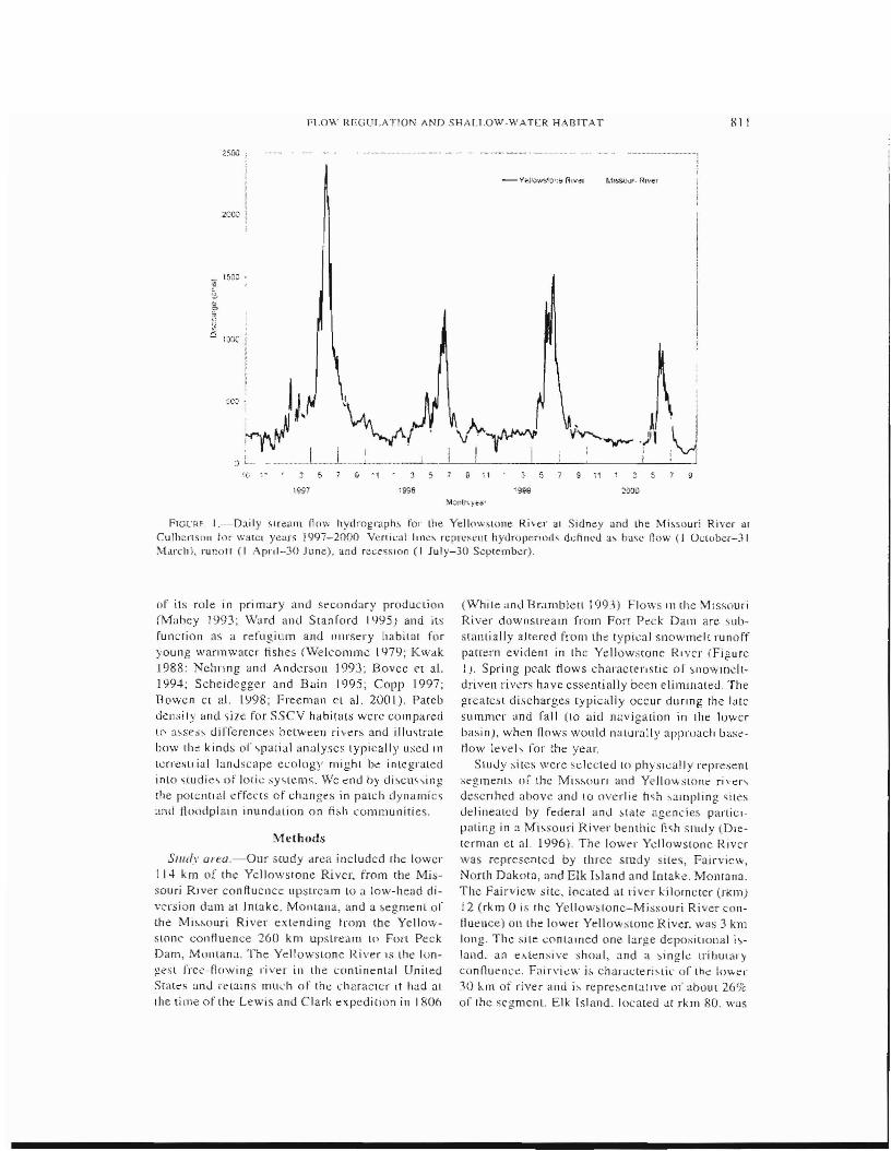
F1GL'FH. I.-[)aily ~I[ealll flo,'" hydrograph.;, for the Yellowstone Rive,' ~I Sicln~y and the Mi~souri River OIl Culbertson lor walet years 1997-2000 VerLi~al !tne, rcpn:'~1lt hydH)lleriods ddincd a, base flow (I C)(;[{Jber-) I ]I.·Llrchl, runotr (I .'\[>1';,1-30 June), and reces.sloo (I July-30 September).
of its role in primary and secondary production (Mabey 1993; Ward and Stanford 1995) and its function as a refl1gium and nursery habiLnl for young wanmValer fishes (\Velcomme 1979; Kwak 1988: Nchnng and AnderSOn 1993; Bovee e( a!. ! 994; Scheidegger and Bain 1995; Copp 1997; Bl'wen C[ at lY98; I~reeman Cl aJ. 2OCH). Pateb den~j,y and size for S.5CV habit,lCs wcrc compared le' a,ses;, uilTerenees between ri ver~ and illustrate bow the kinds or ~pa[jal analyses lypically lIsed III
terresLrial lanJscape e~ology mighL b~ integraLed inlO studie~ of loti,; -'Y'>lt:l1ls. We ~nd by di~cm\ing
[he potentIal effects of chang~s in palch dynamic> and Hoodplain inundation on fish communities.
Methods
Sl1ldy are.a.-Our scudy area ineludcd the lower 114 km of the Yellowstone Ri vel', from lhe Missouri Rn.'er can fl uCllce lIpstrc.am to a low-head divcrsion dam al Intake, MOlltana, and a ,<,egmenl 01the MisMlUri River extenuing trom the YellowsLone coni1uence 260 km upslream Lp FOll Peek Darn, MOlltana. The Yellowstone River 15 the longest rreC'-Oowing river in the continental Unileu Slale's anJ n~lalns mud, of the character It had :11
Ihe time of thl" Lewis and Clark expedition in 1806
(Whi Ie and Br:lJllbJell 1993) Flows III (he 1'.1 lssouri River downstream from Fon Peck Daln are substantially altered frolll the typil~aJ snowmelt runoff pattern evident in thG Yellowscone RiveI' (Figure l). Spri ng Ixak Hows charaetenstic Dr sl1owmeltdriven rivers have es~entially been eliminated. The greatcst discharges typically occur dUring the latc summer and fall (to aid n"vigation in the lo\ver basi nJ, when flows would nalurally appruach basctlow leveh for the year.
Study sites were selected lo phySically represenl segmenl~ 01' the MissoufJ and Yellowslone ri\'er~
descnhed above and to overlie hsh ;,ampling siLes delineaLed by federal and ~{<ite ag~ncie~ parLicl~aling in a Missouri River benthic fish sLudy (Dlelerman et OIL 1996), The lower Yellowstone River was represented by three study sites, Fairvicw, North Dakota, <lnd Elk bland and Intake_ Montana. The Fairview sitc, located at river kilorneter (rkmj i 2 (rk m 0 is the Yellowslone-M issouri River confluence) on the lower Yello'Wslone River. was 3 km long. The ~jle cpntalned one large depositional i~land. an el,lensive shoal, and ,\ ~ingle trihutary connuencc:. Fairvic:w is characteri,Lic or lh~ lo"'er 30 IUTI of river and i.\ repre~entatlve 01' about 26'lc or the seg.ment. Elk Island. located at rkrn 80. was

~12 AOWr.N E1" AT.
the most complex. site. with 18-22 island~ (at various discharges) and three small tributary conl'lucncc" in the 5.S-km reach. One of the most slriking features oj' tili., site wa~ a very large avulsion island on the east ~ide of the river. Elk Island is repre.,entative of abmH 50 km, or approxImately 44% of the segment. Intake, loc~Hed at rkm 100. i~ rcprc<;cntalivC of the remaining 30r-,;- of the' segmem. Thi~ sile was 4.9 kill long and comaincd IJ blands or llIid-eh;Jll11el bars but had no tributary II1flows. Mcan annual flow for the Yellowslone Rivcr lie'll' Sidncy. [vlontana, was 363 Jl13h, (19111999).
Two sites. ;JI Frazer and Culbertson, Montana. were used LO describe the Missouri River study segment. Culbertson was located at rkm 58 and \Vas ri.2. kill in length. Frazer Wa.<, located ::tt rkm 224 and was 6.7 km long. Mean annual flow (during 1942...20(0) for the Mis~ouri River Ileal' Culbertson was 295 m 'Is. Both, i tcs were charaercriSllc of th<: srudy ,egmelll dOI'.'Ilstrc;Jrt1 tram rOri
Peck Dam. and repre$~lllation l)f rhc s<:gment was divided equally bctween them. StrucLlIral complexity or thes~ ,i les gcnerally was less than that in the lower Yellowstone River sites. There were ,even islands or bars in Ihe study site at Culbert.'on and six at Frazer. Both site~ had e:w.tensive shoals that extelldcd out from the banks and formed between the j~1 ands. At 10"''' discharge" these shoab appeared as large, barren sandflat, or mudflats. Remnants (1( avulsion islands are also apparent at both sitt~S, om the Side challllcis formIng them largely have becn abandoncd :\lthollgh thc absencc oJ trihutary confluenCeS in thc m~]pped area ar eilher sitc could introduce ;J potcllti;J] bias in habitat area cakul;JtioLis. the lribuwrics in the Yellowstone River sLUdy 'lites were small. AecOl"ding tn the mean daily flows during the runoff periods for 1997-2000 l64() m'/s), tribularies accounted for les.s than DAYle of the lotal wetted are,] of the three Yellow"lOne stndy ,ires. The proportionally small area of tributaries in rhe YellowslOne sites suggests thal .lily bias in habitat calculations was negligible.
5tudj approach.--As a genenli procedure. wc llsed u two-dlmcnsional hydrodynamic simulaLion model and a geographical informal/on sy~l.ems
(GIS) approach to generate habital classilicalion maps of each site for lIo""s ranging from about 28 m'/,) (1,000 cubic fed per ~econd [cfs I) to more than 2.XOO mJ/s (J 00.000 cL.). We extracted varion:- statistic,; (e.g., da~s area. mean patch sile, parch deilsily) from e~ch map and performed habilat tillle scries analyses of SSCV (depth less [han
1 m. velocity less than 0.25 m/s) habitat. Wc al so used the GIS to ;Jnalyze the sp;JLJal distribution of SSCY habitat and the ;Jrea of inundated riparian veger3tion in tbe river corridor at various discharges for eaeh 5i re.
DC/fa colleclir)fl.-fnput to the two-dimenSlOnai hydraulic model consi.qed of a topographic (.r, y. ;ol descnplion of the study sitc. a rOllghl1cs~ paramCler for each Ix. y) location. inflow discharge, 'Inc! dOWllstrC;Jm (exlting cross ,ectJOn) watcr surfaec elcvation. TopographiC data tor floodplains, permancnl islands. and other ;Jbo\>c-watcr featurcs wcrc obtained from aerial pho(ogrammetry. Echo <,ounding and convenLll)Oal ground survey, were used to oht;Jin hathymetric dat;J for rhe underwater channel bed (see Cluer 1999 for a,imilar application). All data were projected ,1:- Universal Transverse t\-ferC;Jwr (UTM) coordinate..,. re.fc:;r
cllced to the nearcst National Geodetie Survey bcnt'hmark.
COlllractol'S conduClcd the phowgralTIlnetnc analY$i~ u~ ing 1AO,tlOO-scale Pll,iu vc transparcncics (U.S. Gcological Survey National Aerial Photogramrnetry Program). We u~cd ,urvcy-grade GPS and cOllvcmiunal surveying techniques to obtain ground conu'ol and calibrallon data for lhe photograrnmetric an a]ysis. In addi lion, we surveyed the lOps and toes of hanks and Ihe perimeters and surfaces of i,<,lands, bars, and shoah to groundtruth alld sLlpplement thc pholOgralllrnetry dura.
Bathymetric data were collccted by Ll~ing. a boatmounted echo sounder in conjunction w'lth a survey-grade GPS I·cceivcr. Chanllel (eatures such a~ margins. bars and i.,land~, secondary ;;hannds. and Inbutaries \1,iac traced wlth thc ceh" sounder /\ddlliondl dala wcre collected longJiudinally along traces spaced 10-20 m upan hel ween the channel feature traces. v;,.'here the water wa.' 1.00
shallow rorecho sounding «30 em deep). weused an electronic total station (which measures horizOnfal and vertical di~tance~ and angles) or a GPS rover.
Water surface eJevations and positions were measured at intervals of 200-300 In along both sides of the cllanneJ to gcnerate' a map of the waier surface throughout each study ,ite. In subsequent postprocessing, echo sounder depths wcrc subtracted from corresponding water surfacc elc\'aliollS lo Dbtain the e1evatioJl Df the streambed ;n each sounded point. Because the discharge varied throughout the measurement period, a stall ~auge
was inslalled ncar the center Dr each ~ile :md read al periodic intervals (1-2 h). FrOI1l the recorded times and stage change data, we could nOflnaliu
FLOW RJ:::GCU.. no" i\.1'\[) 5HAII.OW-WATf:R HAl.llT" r
Lhe bathymetric and water surface data 10 a single disch,;;rge and wa[er ~mface profile before calculaLing Lhe bed elevations.
At the completion of the waLeI' ,urface profile survey. discharge was measured at one or more locations in eaeh site. The mea.'llred discharge, were Llsed to set boundary condiLions for the calibration of The Lwo-dimensional hydranlic model. At sites with mult.iple channels, we also Jncas\lred the flow in ,orne of lhe larger side ehanJlel~, Although not neccssary a~ bound ary condi rions, the additional discharge measurement·, were u~cd LO (ine-lune the models to correclly parlition discharge amund th(; hlancb.
HyJrauiic \'imulatiun.--The River-2D LwOdimensipnal (deplh-al·erageJ) model developed at the Univer,i(y of />,Iberta (Ghanem cL al. 1995, 1996) was used to simulate depLhs and water vel(lcitie~ at unmeasllI'E'd Hows. V-l.;: chose this model because i[ can predict regions of sllpereririeal fiow and a~:>ocjaled transitions aud can dceommodate lateral weHinglc.h yin~ boundaries of the surface How t\. ithout llser Illlervcn,ion,
A L\Vo-dimen::;ional linite-element computation.Ii mesh clln~isting of Ijnear triangular elemenLs wa, generated for each ,,,i teo The mesh was created In an L1n~lrU(·lUre.d fashion with lhe primary criteTioll for refinemenl heing Lnpographic maLching. assessed vi,ually by overlaying contour maps in (he mesh generalion program. At each tlode, bed elevation and roughness height were specified and were assumed to vary linearly aver each triangle. The computational domain was extended aboLH 120 m ill th<:> upstream and downsrream dire,ctiol1i; to Jninimizc 1he effect of mftow and outfJow boundary couclitions on flow characleriSlic;; at the up~t.ream and dnwnsu'eam limll~ or the ,tudy ~ite~.
For call~rallon, we provided houndary condili(\n~ or inOow di,charge and the measured wnter sllrface dev:itiol1 at the ouLfIOlY. CalihraLion was achieved by scaling [he roughnes, values for different pans of each sLudy site. Our primary eri[erion for calibration was matching the predicted and measured water surface profiles for the site. In general, this criterion was satisfied if the prcdieted water surface elevations welc within 2 em! kill of [he measured values. Calihratlons were finewned by malching the partiLioning of di~L'harges
around i~lalJ(h and har~.
Sirnul:llIon run, reqLHred boundary condilions (II1(lOW discharge and outllow water ,urrac:e elevation! from slage-discharge relations thaL were either developed on-site or extrapolated frorn a nearby U,S. Geological Survey Slrea.tn gauge. A
file of node aLtrj~utes wa.' created at the completion of each simulatIOn, for input to habitat mapping and spatial analysb programs. These files contained information regarding locuti.on (coordinates). predicted depLh, and predicted velocily at each node in the mesh.
Habirat mapping.-The ArclInfo GIS (ESRI 2000) was llsed [(l constru(:[ grid maps from the auribute files generated by the hydraulic simulations. These grids were r<:>dassi tied mto eatt'gOrl<:>" of depth and velocity ,lnd then combined to clealc composiLe maps of deprh-velocHy classes We then converted the gri d map~ Lo a polygon formal (i.e., r'nlin ra.\ler 10 vector formal) Lo raeiiilaLe spatial analysis. We generated composile babirat maps represe:nling 18 Jiflaent discharges (23-2,946 Hi ;!s) for the lhree Ye nowstone Rive: r sjle:~ and 1:3 disdlarges (2f>-2,720 IT\l!S) for the Missouri Ri vcr sites.
Thrt~e spatial metries wcre selected rn describe tht~ availability and distribution of SSCV hahilat over lime: normalize.d da~s area, mean patch SltC.
and pmeh density. Thc b,ISic unit for spatIal analy~i~ is lbe patch, defined as a relatively homagcne:ous ecolugical nnit that i~ mort: alike in ~ome
aLtribUle (or combination of attributes) than i~ the l<lnd~cape as a whole (McGarigal and :vlarb J(95). A clas.~ is .in aggregation or all Ii ke palche~
...... ithin a l<lndscape. In the C()\l[ext of this study, a patch is equivalenL LO a single polygon of SSCV habitat in the mosaic, whereas :1 class is the ,mm of all polygons belonging !O the same dcpth·_· v('[ocity categories. Normalized clas, area was ealculClLed as total class area di vidcd hy the length of the main channel in the Slle. Clas~ areas were normalized Lo compensate for ihe din erent lcngths of lbe ,;tudy SILe~. Likewi~e. paLch den~iLY wa, calculated d~ the number of patches (p()lygon~) 01 SSCV hahllat di\'ided by main-channel length. Mean patch ~ize was cakLllatcd a~ LULal area of a class d.lvided hy the lotal numher of patches.
We po,tulated lhat the location of a habitat patch might influence its biological value. For example, a patch of SSCV habitat 10caLt~d over a sand bar might not be as valuable as the same patch typ", located iu a ~econclary channel or on the fto(ldplain. "'-ie analY7ed [he disuibutlon of SSCV habilal arlllw,g ~cven mCSt)habHaLS within each ,tudy $ite: maJn challuel. main-channel margin, ,econdary channd,<,. $econdary-channel margins, s:lI1d hal'S, vegelated islands, and (1oodplain.
Mesohahilal~ were manually digilized from 01'
thorectiflcd aerial photos in conjunction with map' of the water's edge at differenL discharges. Edges
314 BOWEN FT AI.
of banb and pertnanelll island,; were located
where the ~atne willer line occurred at several di.;charges. A c:hannd margin was defined a~ a poly
gon t:xlt:nding from the t:dge of a hank into the channel for 10 Ill. Locations of,econdar)' channeh
were determined from the photographic unage, ~u
pelirnposed wIth the water lines from high-flow simulations Conversely, locllions of sand bars
were dclineatt"d as exposed areas frolll low-flow
water lines. Vegetated areas were digitized directly from the aerial photographs. The distribution of
SSCV habitat patd1es among the seven mesoha
hitat types was determined hy intersect ing the
polygons fJ'On1 both maps. Where a SSCV polygon
was intersected by one or more mesohabitat poly
gons, it was partitjoned according 1O the boundarie.s of the rne~()hahit;H femure and redassilied.
FI,)odplain connel,tivity was evaluated by quan
tifying the area of tree canopy in dH~ mundmion
zone (CTZ) at various discharges, Tn thIS study, wc
induded canopied areas on permanent Islands 1I~
well as on tile aCWid floodplain, but we made 110
dl~tincl.jon between cOlton wood (PUpUhH de/TOidesl stands <lnd willow thickcts (prcdominantly Salix euigu(J and S. amygdaloides). PlllygOIlS of canopied arc;as were digiti7e.d manually from the
orthophotos and clipped with tho: area o( inunda
tion as determined froll) lhe hydraulic simulation."
The re'llit was a map of cooccurrence of surface watl'! WIth canopy ill different discharge;.. This
method was chosen because semipcrmanelll veg.
clatH)1l IS a source of allochthonous nutnefH input, provides srructural cover for small fish, and is correlated WIth lhe c:>.rent of the prescnt-day floodplain.
!iabilal lime series,~We based the babitat time series analysis on the daily dischllrge records (or water yellrs 1'197-2()()O. Thi, period COincided
wilh the benthic fish-sampling program conducted by the Montana Deparlment o( Fi,sh, Wildli(e, and
Parks (Dleterman et al 19(6) and included a range
of waier year type". \-Vater year 1997 was wetler than normal (recurrellce illtt:rval, approximately
once In 5 years) 1998 and I lJ99 were ncar 1l000mni.
and 2000 W<l" drier than normai. Strc':am (low records for the Yellowstone River were ohtained
from the U S. GeologIcal Survey gauge at Sidney, Montana, and tJlOse for the Missouri by using toe gauges at Wolr Point amI Culberl;;on.
Time serie,~ of normaLized c1a.~" area, patch dt:n
~ily. mean patch "ize. and normalized CIZ values were conslrllcle.d I"or each sile following the basic
procedUl"cs outlined 111 Bovee ct al. ~ 1991n. Hahital
value~ fOI each day in the tilTle "erie~ were \veight
eel according to the length of "Iream represented hy each site and then were averaged. This pro
cednre allowed us to estimate the eharacteriMic.~
of the river segments from individual site data. Each time serie<; was parsed into hydropenod,
based on hydrologic and biological c:onsiderarwrJs.
The hase-flow hydroperiod wa" defined from I Oc
tober to 31 March for each year. The runoff period was defined from I April to .30 June. This hydroperiod eneompasseo. the annual snowmelt runoff.
a;, well as the spawnmg period of most of the fish species endemic Lo the upper Missouri River basin.
The period from I July lhrough 30 Septemher wa." defined a~ the reces~ion hydroperiod, during which
stream nows transition from runoff to ba"e Ilow.
Results
l'iurmali:ed Class A rea
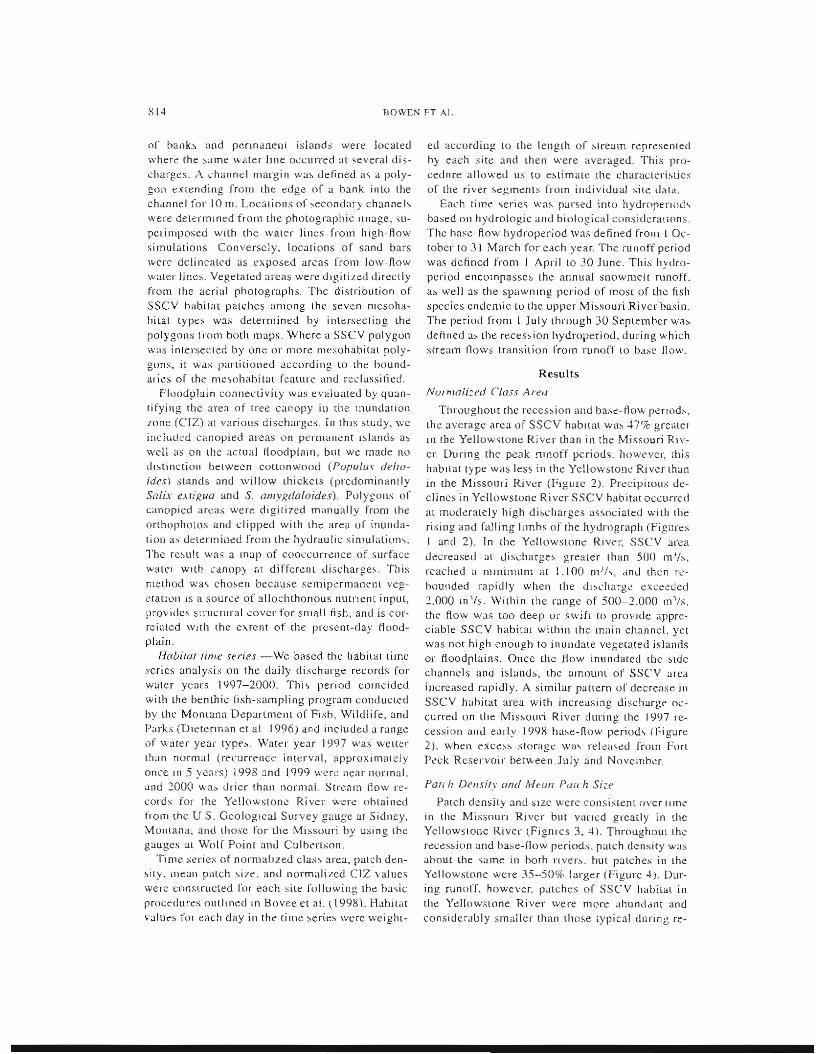
T!\I\mghoU[ rhe reces"ion and ha..,o:-flow perll)d."
tIle average area of SSCV hablrat W,b .:1-7% greater
III the Yellow~tone River [han in the Missouri River. During the peak nll10ff pcriod~. howe-vcr, (his
habitat type was less in the Yellowstone River than
in the Missouri River (FIgure 2). Precipitous declines i.n Yellowstone River SSCV h<lbiwl.occurred at moderately high dio.charges as~ocialed with the
risillg and falling Il1nhs of the hydrograph (Figures
I and 2). In the Ydl()w~;[unc: River, SSCV area
uecrease.d at uisc:harge~ greater than SOO m'js,
reached a nJmimllm ill 1.100 (llJj" dnu then re"hounded rapidly when [he dl,,('harg,~ exc:eded
2.000 m'/s. Within lhe range of 500-2.000 III 'Is. the flow was too deep or swift to prOVide appreciable SSCV habirar within lhe main channel. yet was not high enough to inundate vegetated islands
or ttoodplains. Once the flow inundatecl the ~tde
channels and islands, lhe amoulH 01' SSCV area increased rapidly. A similar pattern or decrease ill
SSCV hahitat area with incre.asing discharge occurred on the Missouri River during the 1997 re
cession and early 199R ha"e-fiow period\ (j;igure 2), when exees,", storage wa, reli:'l\ed rrom FOrl Peck Reservoir bet\-\·een July and NoveiTloer.
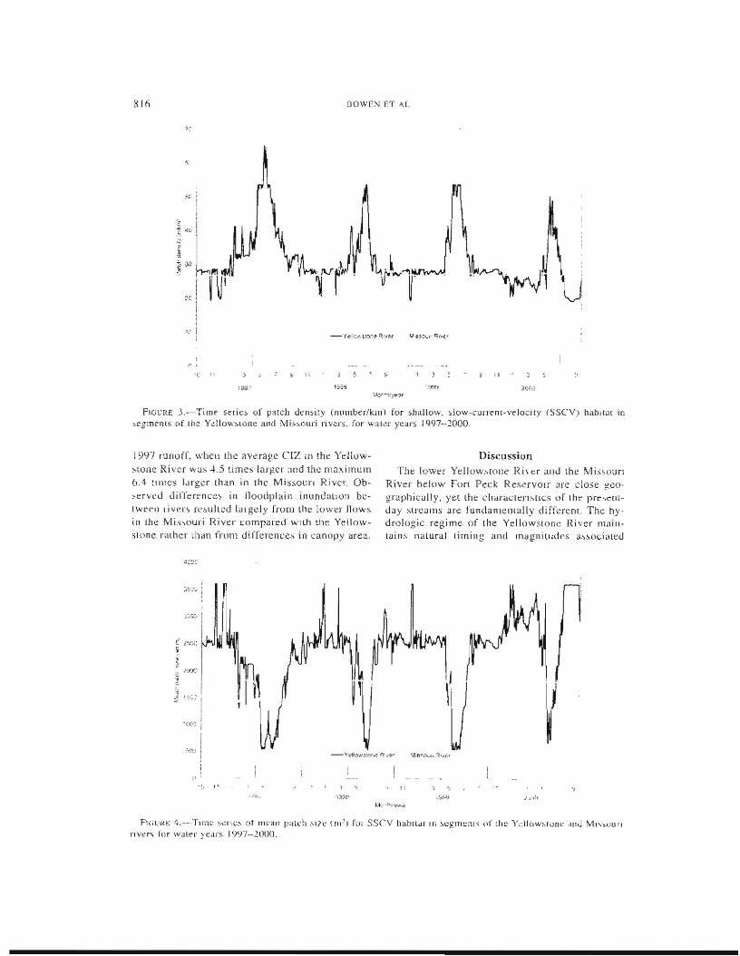
Pal( Il DenJ;'.Y and Mum Pure h Si~e
Parch density ancl sIze were consistent (Jver tlln~
in the MiSSOUri River but vaned greatly in the Yellowstone River ~Fignrcs 3, 4\. Throughout the
reces"ion and base-flow periods. patch density was ahout lhe same in horh nve.r". hut patche;; in the Yellowstone were 35-50% larger (Figure 4). During runor'L however. patches or SSCV habitat ill
the Yellowslone River were nH)re ahunddllt and
considerably smaller than those typical during; re
1'l15
:;. .; ::
" 'f~
M)'11·,V<?,'
F1Gl'RC 2.-Time "aies (,i "vrm~li/ed ci~,s "rca~ lm'ikm) for shallow. ;;low-CUrrCl1l-Vclocny hab'llLl III 5,CglllCnlS
of rhe Y(:1l0'l;\lUI1~ an(1 IVli",(lur; rlVe'-, fur wala year' i997-:'0()()
cession and base now. Thi~ phenomenon ,nggests that SSCV habitat may be,~ome more dispersed in tbe Yellowstone River during runolT periods. and more contiguous during reCe'\lOn and base flow. This pattern of change in patch distribution \Va.> not as evident in the Missol1l'1 River.
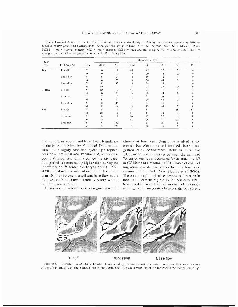
Sp({lwl Dis!! ilw}lun oJ SSCV Habil'}}
DUrl!lg runoff 10 " w¢t year ( j 997). mo~t of dlC SSCY habitat in thc Yellow\tone Rlvcr wa~ a~
soci:lled with sillc-channel nla.rgln~, vegetated island,~. and noodplain,.; (Table I; Figure 5). In tbe :VfrS~Ollri River, this habitat was f'ound predollllnalltly in side channels, <dong the main channel and over ullvegetaled ,and bars (Figurc 6). As disch<1rge decreased in the Yellowstone River, SSCV habitat migratcd and expanded into side channels, bar-so and the margins of vegetated islands. Lo,arions of SSCV habitat gener~djy remalflcd the same in the M I$SOlHi Ri\'er, but habimt area decreased. Thi~ leduction 111 habitat area wa~ caused by grearcr ul~(.'harges dunng I July-30 September (typical rcce~sion period) than during I Apl'l\-30 June (typical runol r periou) in the Missouri. llnder ba;,e-tlow conditions, SSCV hahltat III the Yellowstone River migrate.d farther away from the ,mall sec(}ndar~ channeh. occurring lllure extensively along the main channel and in the lilrgcr >ide channcl~, During the same period. SSey habitat in the
Missoun OCClllTCd primarily over extcn,<,ive sand bars, in Lhe main channel. and in wme or the larger side channel;,.
A similar paltern was observed in normal and dry water years r1998--2000). with a few notable e\ceptions (Table I). In the Yellow,tone, ssev habitat during runoff was Ic:ss associated with vegetatcd i.slands and floodplains and morc clo~cly lIed fO side channeh and channel lllar~iIlS, The paltcrn of mlgratron and cxpanslon of SSCY babltat mto lar'ge secondary channcls and main-channel margillS during recession and h11,t; /low was .'Imilar dUTll1g all WaleI' years ill the YeJlowstone. Tn the Missouri, the pattenl of habitat distribution during normal and dry year~ was the reverse of Ihe weI year distrihmion. As wa~ true for 1997. mO.~t of the SSCV habitat in the Missouri occurred over sand bars and in main-channel margins; durin£, the bai';eflow period. however, instead of increasing in area Lht: patches bccame smaller during norlllal and dr~
yean. Thj~ difference (~ related to I'elea~es j rom FOri Peck Dam to augrnc1ll base jjow~ I n (he fal! to .'CryC down.,Eream na\'igauon.
Floodplain Corlfleetivil)'
During years of l10rlnal to below-normal runoff, the crz area in Ihe YelloVvslOne River wa:'. .3.03.5 time" larger than in the Missouri River (Figure 7). The greatest difference occurred dUring the
811l BOWE:-:1 ET ""L
;.~
" II
FIGt:Rf: J.-Timt sef"ie& of pat.ch density (number/kill) for shallow, slow-currenr-velocity (SSev) hllb:tu{ in ,egmenls of (he Ydlowslone and Mi"ouri river&. for "'ili~r years 1997-2000.
1997 runoff, when the average CIZ 10 the Yellow Discussion stone River ,,·as -L5 times lar!!-er :md the mn .... imum Tht: loWt;r Yellow"wlle R i\ cr alld the iV)j;:.'OUfl 6.4 [IJl1CS lurgcr than in the Mis&Ollri River. Ob River belav-' Fon Peck ReserVOir are close geo,erved dii"l'en::ncc~ in lloodpl'lin inundallOIl bc grapbicully, yet the ch"raClen~[LCS of the prt;,ellllwt;CIl Ijver~ re.,ullcd I,Jlgely from the lower nows day streams arc fundamemally diff~renL The hyill Ihe rvJi",ouri River compart;d wlih the Yellow drologic regi me of [he Yellowstone Ri ver mainslone ruther tban from di fferences in canopy area. lains IllllUral liming and magnitudes a~.~()ci'Hed
i :,!rltt !
[' i')GC• ~ J. ]
i~ \I
:;,
u I -ceon. !,
frf'f.J -V\.·lio'l.'~""~ ~""'l!'" 'J,Gc;.O'.<f.R, ......~
" -{, " 11 1
• -<v, \~~';:l' ,&0 ) ~.;')
"'+':··t·;·V(~
F'll;IIRIO 4.-TIT111: s~nc~ ot I11can patch ."7,, Un'l flll SSCV hllblldf IT. ,cglTlCIlI$ ('1' the Y"lIowsfune dllJ M",..llll·, nv"r~ for waleI' years I 997-21100.
FLOW HeGel-AnON Al'f) <;H,\f.LOW·WATr:R HAHlTAT 817
T:\Jli.l" 1.-O"lnbulI(l1) (perCenl ar..:a) or "haHo\\', ~low-<:U.IT~.nI-vt:locity paldoe.' by mCM)habital typl: dunng d,llc'clll types uf \\'atcr y~ar" anJ hyclropenod\. A bbrevialion;, arc ,1;; f()ll()w~' Y Yellowstone Rivc:.r. M (vll.';(Jun R,vcr.~
_.lvlCM main-channel nl;lIgln. rvlC .- ma!n channel. SCM -- Side-channel tnargm, SC = sld.c channel. BAR '" unvcgclalccI b,lf. VI - vegelill'ed i:;laITd\, ,uld FP -. noodpl:iin.
Mcsoh,h'tal lypeYCi.ir
tyre Hyetrf'penou River MCM MC SCM SC BAR '1'1 f'p
Dry RlIn(,rr Y I:> 8 20 ~2 22 2 0 M (, 21 ') 20 44 2 0
H1o?ccsslon Y (, G4 2 I~ 8 I 0 M 6 23 5 ~O 44 2 (J
8a,0 Aow Y 8 49 1 24 15 I Ii M 39 7 ') 22 27 0 iJ ,
~'l)mlal f(llno.l.:. Y 10 4\ 22 I ~ 4 TvI 6 •.? 20 -14 2 (l0' ')
Re(:(" "ion Y 7 17 l...j ~7 ~4 I ()
!VI (, l3 5 20 44 2. LJ Ba,.,e r]o\.... y II 49 1 24 I III'
M 1I 16 II 19 ~4 5 ()
\Vrt Runotr 5 () 28 II II 28 Py
tv! 11) ~' ()10 II 17 .> 9 Rl;·I..I,;'~,"'!OIl II S 2(\ 42 22 2 0y
M r, 11 :;4 )I D (I
Basl" flow Is 4~ 24 15 1 Uy M I> 2:\ }O 44 2 1I
with runoff. rccessjon, an<.l ba~e tlows. RegulatIOn ,)1 the MiSSClun River by Fori Peck Dam \1,1> re
sulred ill a highly modllied hydlolog\l' r~glrne:
peak 1'1ows are suosranrwlly truncated, recession IS
poorly dclincd, and discharges during the base!low period arc cOJnlnunly higher than during the runoff period. Whereas drscharges dllring 1097
2000 ranged over an order or magnilude (i.e .. more than lO·rold) between runoff anti b;lse How in Lhe YCJ](lWSIOne River, they differed by bardy rWllfol<.l lIT the Missouri River.
Changc.~ in !low alld sediment regime ,since Lhe
closure of Fort Peck Dam haVe resulted in decreased b~d elevations and reducL'd channel rmgration rUles downstream. Between 1936 [,nd 1q7 J. m~an bed elevations between the dam and 76 km downstream decreased by as much as 1.7
m IWiJ]iams and Wolman 1984). Rates of channel migration have decreased by a faclOr of four ~illee
closure or Fort Peck Dam (Shields el al. 20(0).
Thes~ geomorpholugical r~sponses [0 altel arion in How aud sed.i.mclU regime in the Miswuri R.iver have resulLed in <.Ii rrerences in cbannd dynamlc~
and vegelaLion succe,ssion bel.we~n the Lwo ri VeL"
Runoff ReceSSion Base flow
FIGI.'tn, 5.~DIS[flbutll)f) or SSCY hablllll ,hlJck ,badingl dUi'Hlg rlllwff. rece>;sion. and bas~ now In a p(lnwn 01' lh~ Elk hland ;:He Oil rbc Yellov,slnne River during. the 1997 waler ye~r, Halehl11g rcprc'ellt~ rhe Illndel boundary.
f\O\VEN ET A r ,
Runoff Recession Base flow
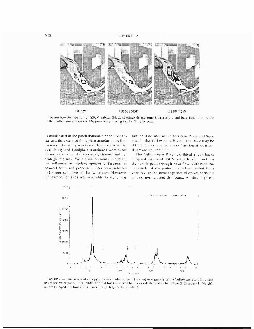
F1GURE 6,-DIS[ribntioll of ssev habilat (black shading) dnnng ((lnoH, n.'cession, and base flow ill a portion or the CulberL:;on ~il~ on lhe Mi~;o\lri River during the) 997 water year.
,lS m,ll1ifcsted ill thc patch dynamics ot SSCY habItal and thc extent of floodplain Illundution, A liln
i\<lliol1 of' thi~ ~tudy "'as thal dJiTcrence, in hahilul
avaJld\)rlJly dnd 11110dplaln inundalloll \",ere based
on mea,urc;nenl~ of the exi~llng chanllel and hydrologic regime'. We did IWI account directly for
the influence of prcdeveloprnelH dlfi'erellees In
ch,wnel form and processes. Sil~S were selected lO be represelHati ve of the tWO ri verso However, the number of sites we were able to study was
limited (two SilCS in the f\,1is<ouri River and three Sill'S in ihe Yellowstone Riv<:r), and there may be dilTercnces in how lhe rJver, fU.I\Clioi) at locatIOn' Ihm were nOl sampled.
The Ydlnw,tone Ri, a exhibited a con~i,lenl
temporal patkrn or SSCV palch di ~lribuli011 from the runoff peak through ba\c flo\\-. Allhougn the amplitude or the paLltTIl varied ~omewhat frorn
year to )lear, the same sequence of events occurred in wet, normal, and dry years. As discharge lD
FIGu/{J; 7.-TIIll~ ,eric> (Ii l';lnopy ~re<l in InundaLlon 1,011" (m·/km) tn :-.egm"nLS, O[l.h~ Yellowsl()n~ and \ft~~out'1
ri\'ers for waleI' year, 1997-'1000. Veni-.:al lines ccpr\.OsenlhyJrn[)erioJs Jefined as ba,e flow (I Ouwber-31 MardI), runoff (1 Ap ..d-10 June), and ree~ssi,)n t I July-JO September),

819 FLOW RrGCL.".TrON AND SHALLOW·WATER H.'1nlTAT
crea~ed on the ri~ing limh of the runnrr hydrograrh, SSCv p~Hch~s in the Ydlowstone River became ~ma)ler bllL more abund'ml. resulting in a di<,persed patch dislnbulion. At flow, typi,;al of the mean <lnnual ftood (around 1.'i00 111 'Is), ~lboUl
5 I% of the ssev habital in lhe YellowsLOne River was localed in eonnected side channel" and in extended area~ of back-flooded tributaries (eupotamon '1I1d parapotamoll rt'spect.ivcly, as described hy Ward :lnd S lanford 1995) Overb::lnk flooding W,l, nO{ extensive along the Yellowstone River during the study period, ,0 lhe advancing litloraJ a, described hy Junk et al. (1939) and Bayley (I ':l91) (lL'curred m(lrt: on the permanent, vegetated island~ I.han on the Iloodplaili. Secondary channeb. classi lled as eup,Hamon (\\'ard and Slan Ford ! 9(5), lended LO be rei atively IOllg and narrow compared with those in tile Missouri. Periodic wetting and drying in these small channels allowed colonization by hydrophilic vcgetation such as wtllow and dogwood CorrruJ spp .. In addilion. leaf !liter and snow lcnded to collect in these ehannd~
dUring the dry periods of autumn and winter, proYiding a ready ~O\Il'<:C of panially decomposed organic material in .~pring. During reces<,ion. ssev patches III the YellowsLOne River mlgnlled 100\·ard the main channel through the larger side channels and ronned large conliguous patches. The tOlal ar"a of SSey habilat eluTIng re\:e\~ion and hase flow was approximately double the amOllnt availahle during runoff. and mean patch size increa~ed
from around 1.700 01 2 dnring runoff w 2,600 0)2
at base flow. Although extcn~ivc areas at ssev hnbitat oc
CUlTed II) rhe MI~.>l)uri River. the patehcs were c\lJllraratlvdy ,t,nic. Bccau,c of the relatively COJl\"ant dj<,charge. the 'veiling and drying 01 vegetaled areas was IeI,s cOITlJOon In the Mh<,OUfJ Riv· er. Patches or ssev habitat generally remained in the same location<, over time, with lillie variation in .,ize or !lumher. In addition, the rersi,<,tence of shallow water (perhaps in combination Wilh a highly mobile sub';rrate) in the secondary channels appcared to preVt~nt establishmem of higher woody plants. eonscquently. 85% of the ssev habitat of the Mi5sol1l'i River occurred ovcr sandbars. in large ,c.::ondary channel), and in the In~Jln channel, all or wbich had Iitlle 'Jr no vegctation. Only during lhe 1997 recession and early 1998 base-flow periods wa& a <,t1h,lanllaJ area 01 vegelateJ I.<,land habllal inundated In the \:l'issouri River [Figure 7) This minor flooding period resulted rrom releases of cxccss swrage from Fort Peck thaI had aCCLl
lllulakd during the high 1997 runoff penllJ. The
unusual ti rning oj' peak tlow;; dUflng 1997·-1998 probably reduced any heneficlal elieL'(~ (,I' 111\111
dalion for <l<Juatic and rip::man ()rganii>o)~ with Id'e cycles lied LO natllral now pallerll~.
Our analysis of CJZ areas ,erves a'\ a corollary LO the ssev patch dynamics obs<:rved in rhe two rivers. The maXilnLlln area or flooded woody vegetmion wa" 3.0-3.5 times greater during runoff In the Yellowstone River than in tbe MissoHn duri ng normal and dry years and more than 6 ti mes higher dUflng 1997 (Figure 7) Comparison of CTZ verws discharge relatIOn" among ;ilcs indicated thaI Ics~
extensive lloodplain inundation in Ihe Mi<,souri River \~ at!rihutahle to low dl<,charges rather than dirrerence;; in canopy area between fiver,. The 'Jbserve,l inundalion of vegclat~d ~rea~ dunng the 1997 runoff SUpP,)rts the concepl of a moving littoral in the Yellowstone River of greater eXlern than indicated by ssev hahitat area alone.
During recession and base flow. ssev habitat patchcs in the Ycllowstone migrated loward (he main channel and consolidated into large contigllOUS patches. Several aspects of these patch dyn:l.lnIC" may be benehcial lo growth and ~ur\,jval
0(' age-O 1ish, First. the rece<.sion Jrom vegetaled "de channel, and I~land<, Inay re:o.ult in an exp()n o[ nutrients, Looplankton. lerre<,ll'iai and henthIC illvenebratcs, and organic dehris to ssev areal, in the main channel. Thi~ phenomenon has heen widely re.porlcd in V"rlOllS Aoodplain rjver~ (Ca~
tella el at. 1984; Weleornme 191\5; Shaeffer and Nickum 1986; Saunders and Lewi~ 1988). Second, small fish may benefit from thc increase in patch size that occurrcd during reecs~ion and base flow. ,\, the patch siEs incrcascd. 5ba.l10\1I ..,low warer wa~ superi mposcd over a variety or lJle~ohabH'\I.;"
erlel'l ively i ncrea,i ng the di versity oj' the sseV' arcas. For example. during ~J lyplcal Yellnwiilone Riva rcces"ion !low or ,u'ound 425 mj/s, ssev habitat was distributed among main-channel lTIJ.f
gins, the rnaln ch~nnel, side channels. side-channel margins, and 'and bars (Table I). Such spatial helerogeneity may provide upportunities for segregation of species nnd siz.e classes, thereby rcdnClOg interspecific competition and predation risk. The increased size of the Yellowsrone River ssev patches might also allow a reduction in larval densities within a patch. further redUCing c()mpetilinn and predation risk. The cOlHinueu migrali'Jn 01
SSCV patches toward (he maln-cbannel <lI'c',l~
would faci litale transition to flowing water habItats for the flUVial specialist '1I1d !luvial-dependel1l"recie;; during olltogenic ,bifts in habltat use.
Because thert' was httle variation in di,',Gharge
820 ROWEN F.T AL.
between the runorr, reces,)(on, :lnd base-l1ow pe
riods, ssev habilab In the rvJi"ourl River generally were stalic, They remained in ~imilar lo
cation' year-ruund and did not l1ul:tu<ltc <lppi eClably in ;;ize or number. F'unherTnort'. there wa~ little
,'(lntact between ssev drC,IS and terrestrial veg
eLJlWT:. During "II hydroperiocb. the ,paLLal chstribu(Joll of ssev habir.S( was more homogcneolls
in the Missouri River than in thc Ycllowswnc Riv
eI'. At a discharge of around 280 m';', typical of
all periods in a normal water year, ssev habitat
arc:! in tht: Mis~ouri was mosl cornmonly :lssoci
:l.led with the main channel, brge ~ide channels. and ~andbar., (T:lb\e I). Rela(Jve!y linle ssev hahital wa, created in the margIn., or the main CIl<lflllel
or ,iue channels. \Ve 'lISpel:t that In hOlh river" c,'lonization of ssev habitat~ by drifting larvae is lacilirateu by eddies and e,)untercurrents around
~hallilel irrcgulalltie;,. However. the ssev areas
tbat could be colonized in thc Missoun River wcre
less cxrens ivc, less ui verse in Illcsohabilat loca
tiOll, and pmsibly not as producl.lve as those in the YcLlow,LOne River.
C0I1,·/u.l'iO/lS
Change, in now dnd ,ediment reginlt' in the Mis
souri River since the closure or Purt Peck DJm h::nc altcreu river geomorphology dllwn<;lream (Williams and Wo/man 19R4: Shields Ct al. 2(00). \Ve postulate Ihal the inrerrelaled effecl, 01 chang
c~ In geoln'Hvhoiogy and altered Row regime contributed lO differences in rhe dynamics of SSVC
babilat patchcs Jnd thc cxtent of floodplain in
undation bcrween lhc Missouri and Yellow~lone
rivers. In r.hc Yellowstonc River. the distribUtion.
location, ;]nu sizc of ssev palchcs follllweu <Ill
aunua.1 puttCfll tied to the snowmelt runoff' hydro
graph: small, di.spersed patches in ~ide eh:lnneh and lri buury hackwaler, migrated l,) Ibe mai n channel during recessipn and formeu lurge. conliguous patches. Because of rel:Hively conqam discharge, variation in mean patch size, parch den,ity. and I,)calioil of pau.:he, was smaller in the
Missouri River than in thc Yellowstone River. Sim
i lady, more consistent nows, and thei I' cffccts on
channclmorphology and patterns 01 vegetaliou establishmcnr resulted In 3.0-3.5 titnes less arc:r of lllundaled woody vcget.ation during rlorm,d and c1r y years in lbe \1i,souri Ri vcr ,hJI1 in tbe Yel
lowstone R I vee Based on ev idence from other
,wdie.s, the dillerenccs we· oh,ervt>d III ssev patch dyndmic~ between lhe lWO riven may have
implications for lish populations and comITlunlty ~lrU(;[l1n~ by affecting the ,un'ival of ,~(lrly life
swge,. Al a larger ,sc,de. the <;malkr area 01' inundated canopy In the MiSSOUri River Ihan in tbe
Yellowstone suggests that nutrient l:yding anu ecologic;]1 bendit.; associated with a mO\'1llg lit
lOral zone are reduced by alteration In ~ow Jnd
sediment regime in the \1i"ouri River.
Accurate assessmenl of the erfeu< of ~ow Ltlteratioll and efforts ro restore riverine ecosystcms
will rl~quire consiueration of physical and biotic processes that operate at multiple spatial and tem
poral scales. Th is study demonstrated effcct~ of
llow allcration on brge scale (llooding) and small scale (habitat palch) variables. Our neXl .,tep en
tails u~ing ii.,h collection data to help evaluate lhe
biol\lgical signiJic:rnce of these re~ult~. In addiuon 10 lhe scale.~ we studied. future work should examine effects at intermedi;He <,pJriOlemporal scales
r.har. influence longiLudinal connectivity in IOlic
systems.
Acknowledgments
We thank Mike Ruggles and Dave Fuller with the Montnna Depanment of Fisb \VildJifc and
Parks for logistieal support and help with field work. 'INc extend 0\11' ;lppn:ciatlOn to Bob Waltermire with the U.S. Geological Survey 1'01 CXpUI
help ""ilh GIS que<,t;on,. ReViews alld L'ommcnh by Tammy Newcomb. Butch Roelle, Md,e Scott.
Jim Terrell. and an anonymous revIewer greully
improved the manuscript. Funding for this work
wa~ provided by the U.S. BurcJu of Rf.clarn:ltlOll
ami the U,S. Ge()logi~al Survey
Reference!;
Angermeier, P 1.., dnd J. R K<lri. 198,~ ReJarlon,h,p;, h,:tween woody dd.'r1s and ti~il hatHt,'t 111 U '1TI~11
W3.l'ITl\l,lau::r ":;lre.al'll. "'ri anS3CU\HI" nf' the Arn..:-n"':i.t1\ fJshelJe'S SOCielY I U:716·-726.
Auble, G. T.. and M. L S~,)lt I~9X. FlU"jal dlqnrh,mt'(' patche<.. and cotlonwooJ re-crui(rnenr ;Jlong the upp.:r Vl'S,OUfi River. Montana Wetland,; 1!l:~4tJ-55n.
8~ylcy, P B ! 991. The flood pulsc ~dvanlage and the reSTOration of river-fluodplill n system, Regulaled Riven,: Research ,1I1d Management 6:75-86.
Bcnkc, iI C ! 990. A perspective on J\m~rka'" vanishing qr<':~ms. Journnl of the. Norih Am~ricail 8<':[1· IhoJogical Society 9 77-88.
Bovce', K. D.. T. J. Newcomb, and 1'. G. COOIl. i994. Relat.ions heLWeen hahir.at "<lnabtlity and populillinn drnarnlC:~ of ha" 111 the Hur(Jn RI\cr, iVlich'gdn. U.S. i'i.JLlonal Biological Sun-c>' 13Jt)lo~lc,d RqhHt
21 Rovce. K. D . R L 1.:lIl1b, J Iv[ Bartholow. C B SL~Jn;,kcl.
J Ta) lur, "nd J H,'nriben. 1998 Srrcdnl habn:u .il1alY"l~ \l,~lng lhc tn.;;lrearn f-]O\y IrH.'rcnJc.fHallnelhodology
l.' .S. GeologiC") Survey. Infol'm3tlOn and Technology
FI.OW REGULATrON AND SHAl LOW-\VATER HABITAT ;>i21
Report USGSfBRD-( 998-()004, Fon C(lllin~. Colorado
Bowen, Z H, M C. heeman, and K. n Uovec. J99X. EvaluQlJ0n of gencr:tliLcd habllat cntcna for as"e.... f,ing 'lllP~iCh of regul::lled {lcn\' regime~ ,In Vvarnlwall" l'.,hc~. TrJIl!>acllon;, of the AmCl'lcan T'JshcrJc;,
SiXlelY I 27:45:'i-4f>S. Ca'lc.ihL f.., M. RtcIHlrdot-Coulol, C ROll', and P. R,
choux. 1984 l\'faCfl)l11vcrtcbraIC, a" "deSCllber~"
01 ml>rp!lol,'g;cdl 'll'd hydroltlg.iea! lYI)C\ ,)1' aqnatlc ccr"y~tern, <,handnned by [hc Rhtin" River Hydrobiolog)a I 19:21 '1-225.
Chicn, N. I 'ISS. Changes in rivcl t'cgirne alter lhe eon~Iruc[jon of upsneam reservoirs. Earth Surface Proccsses and Landforms J 0: 14,,-159.
Clu",,., IJ. l.. 199'1 (;reen Rlvcr channel Hood How mapping lInd nwdcllop: Profcs<;lonal Surveyor 3:8-14.
Copp, U. H I \l&9 The hahital dlvcr"l) and ti~h reproductive rUnClIOn of Iloodplaj,\ eco'y,>re"" Environmental Biology 01 F"hes 2f,: 1-27.
Copp, (,. H. 19»7 fnlponarl(c of rnarln,lS and 01'1'channel watcr bodlc, ih rerugcs tor youllg tishc~ ItI a regll·la.tcd k)\\'land rtver. Regulaled Rivers: Rc,;carch' "nd Management I ~ 303~307.
Daniels, R. B. 1960. Entrellchl1lcnr of the willow draInage dil.:;h, Harn'on Counly. 101'<a. Al1lenc:,n JOllrnal of SCIence 2511: I f, 1-176.
Dic[errnan, D. J., M. P. Ruggles, M. L. \Vlldhaher, and D. L. Gnlcl. cd: iors. j '01'16. PO]lula[ion SlrUelttre a.nd h"hit"t usc of bc'lHhic flshe~ alolll~ the Mi"ouri ,uld LowGr YclltJI,,.,'lnne ri\·us. 11)96 Anr,ual Reporl of lhe Missnnrl Henlh,c Fish SInd}' In Ihe U.S ....\I11JY Corp.< 01 Eng!nccr~ "Ild [he U.S. Burcau Of RecLlITlatlOll, i'O-95-5832. OITl;lh,l, Nebraskd.
Dudgeon, D 1992. E.ndangercd eeosYSICIT\S' 1\ review of the conscrvatlon .'latus of [ropleal ASian nVfr~.
Hydrohl,)lngii( 24ll: I f,7-·-1 'II. D:l'ncsllIs, .\1.. and C. Nii'son. 1994. Ftagm,'nlati,'n and
How rcgulat.>nn "rriver 'ystem<; ill the nonheln lhird of Ihe ","orld. Selc:nce 2f>6:751-·762.
['SRT (Envlmnl1lerllal Sys[ems Research TnstiIlHc). 2000. ,Arclinfo geographIC inrOrmdiiorl sy"etll, vcr"Oil 8.0.1. ESRT, RedLt.nds, California.
F'r~cill"';" M C" Z H, Bowen, K. D. Bovee. and E. R. Trwll!. }fll) I How ,Hid habltal d'r'ecl.' on Juvcnik 11,1: abundallec HI ildlllr:1I and ahcrc:d How regilnc~
[c'llogleal Applic~[Ior,., 11: 17<)-19lJ, (';,11<1[, D L., ailu r. ZWCintllllcr 21)0 i Con~el vlng large
river tLshcs: is the highway analogy ,In appropriat.e pur;td igm') Journal of [bc North American Benthologica! Society 20:2f,fl-279
Ghanem. A.. P, Sleffler, F Hicks. and C. Katopouis. 1995, Two-dimensional finite clernent rtlodeling of Anw In aqualic hahilat~. Univer"ly of Albcna, 'Wa[cr Resources Engineeflilg Reporl 95-S i. Edmon[on.
Ghanem. A. P. Stettler, F Hid~, and C. Katopod". 1tjl)fl Two-di,"cnSlnn,11 simulallon of physical h<lh1[Ill ~ondi(lOIll". Hl ,h)Wlng Slfcall1'"! Rt'gulalcd Rlv
cr~ Rcscar.;n 'H\d Managclll.;nl. 11'! 85-200 (iU[I'Cll[c.r, S , A D. B,1fl~h, K. 1roil', and M B Sartd
hClnlJch. 1>;>'19, EvaltJa(,on of [he tlood·pui';c C0n
cepl b"sed on siatistical models oi' growth or ,elecled tl,he;, or' the upper Mls'ls~IPPI RiVer' 'y,tern. Canadian Journal of Fishcfle,' and AquatIC Scier.ccs 56:n82-229 J.
Gore, J. !\ .. ,.jnd F D. Shield" 1L 1995. c'm lclrg(~ 1'lI'c:r,
be rc,u)red" ;\ [e>cll' on Ichahilllauon. Fl,o$c1c:nee AS·142·-152.
Hall, D. J ,I:: b. \\!crnel, L 1'. Gilliam, G. G. Millclhach. D. Howard, C. G. Doner. J A Dickellnan. and A ,I. SltWan 1979. DIe! f,)raglng bdl<lviol and prey selee[, (In in [he golden "hintr (NmI!JIIigoJJu.I' cly.,ol"ilea.I). Journal of lhe Pishcrjes Research Board of Canada :'\6: 1029-10:'19.
H'H1. D. D .. and V. H. Resh. 1980. Movernent paueflls ,lIlu foraging ecology of a ,lream eaddislly larva Canadinn Journal of Zoology 51;: I 174-1 I X5.
Be"c, L W., L C. Schrnulbach, J. M. Carr, K. D. KC'enlync:, D. G. Unkenhnlz. J. W. Robinson, vncl G L. Me,>[1 19~'1 MI,souri River fishe, 'j rcsourcC'; III
rel,uion to pa"t, presenl, and fulure s[re,'Ses. Canadian Special PubliclillOn of Fishel'll" and AquatiC Scicnce., I Of>:352-3 71
Hcsse, L. W.. and W. Sheet~. 1993, The Mis\Gun River hydrosy,w;I\l, Fishcnes I X(5):5-14.
Holly, F M., Jr., and R. Enema. 19'1:1. Sediment i'l\halanee in rivers: simulation possibilities and problems. ·U.S. Naliollal B iologieal Survey B ioJogical Report Itj:415-4~5,
J;ongxin. X. 1997 Evolution of mid-channel bars in a braided river and complex response lO r<:,erv(,ir construction: an example fronl the nllddk HanJlang River, ChIna. Earth Suriaec ProLcsscS and Landlorms 22'95:'\-%5.
J Ohll\On, 'N. C i'l92. Darns ,trod Ilparian loreq.<, C:iSC
~ILJJy from [hc Upper M"soun R 1vcr Rn'n, 3 2~9-242
Johnson, \'v. C. 1994. Woodland expansion In ilie Plan.' Rivel, \!cbraska: pallern, and Gause, Ecologll'al Monographs M:45·-H4.
Junk. W J., P. B. Bayley. and R. L. Spark,. 1'189. The Hood pulse concept ,n river-H')('Jdplnil1 <;ysterns. Canadian Journal of Fisheries and Aquatic Se,cw·t'S Special Publiealion 106:110-127.
Kohler, S. L. i 985. Tclcntincation or 5lre.\m urttL mcdttllli.;;n1.'i. an (:),rcI'IIlK~ntal and ob")cl v.\llonai Jp~
proach. Ecology 66: 1749--1761 Kwak, T. J. 19~8, Laleral mOH'mCn! anti lI'e 01 11.)"u
pl:lin habitat by t~hc~ of lhe Kank:tk·~c R,ve'r, I11o1l0lS AlTlencan M:dland Naturaltq 120,241-249
Ligon, F K .. W. E. Dtclrich, and W. 1. Trush :"9S. DOWnqrelllll ecologIcal eftec~5 or dams. a FeoOlOlphil' pcrspec[ivc. BiOSCience 45: ISJ- 192.
Mabey, L. W. 199.3. Planktonic and henthie tnicrocrusIaeean,;; from Iloodplain and river habitats of [l\l~
Ouray Refuge on [he Green River, L't~h. MaS[Cr'5 (hc~is. Bngham Yonng C,llversity, Provo, Llah.
Marslon, R. A., J. Gircl, G. l'amolJ, H. P,egay, J P. Brnvard, a'iel C Arneson. 1995. Channel mcral11orpho<is, floodpl,lIn di5turbant'c. and I'cgcl<1ilnr; developmenl: A,r; R,ver. [';rancc Geomorphology 11:121-ill.
Ml'G:l1Igal, K .. and B J. Marl(~. 1995, r·R·'1GST/\TS
S22 ROWEN ET AL.
spdljal pilllcrn analy"" proglalll fOi ljuanllfying hHld,scape stmclUre. U.S. Fore,st Se[\'lce Gencral Techn.cal Report PN\\'-GTR-35I .
Meycr. 1. L.. and G. E. Likens. 1979 Transpon and transform<l.lion of phn~ph(lru, In a forest "lr~all1 e.;o~ysl",m. Ewlogy 00: I ~55-12(\9.
Mull', W. D., G. T. McCahe, Jr.. M, J. Parsley. and S A. Ilinron. 20(lO. Diet of tirSl-feeding nnd YOllng-oft.he-year white ,t\Jl'geon ill the lowel Columbia River. NOrl.hw~si SC:lcnce 74:25-33
\!dlrlng, R B., and IL M. Arnler.""l. 1993. DnerlTli naUCln o( population-lIllllting cnrlc.l1 'ialmonid habIt:H~ in Colorado s(rCam.' uSing Ih<.' PhySical Habital Simulation Sy,tnn. R,yc:n. 4:1-1<,).
Papolllia.~, D., and W. L. Mindlcy. 19<,)0. Food lilnileLl ~nr\'ival of IZI,n:,jJ! razorback ,:;uckcr, Xyra((cht:.~n fex
WIlIS, HI []lC laborawry EnVlronmenlal Hio!,,\!y 01 Fislles 29 73--78.
Paj1outlas. D., and W. L. Mlndlev. 1992. [Ikc" 01 lood availability on survival and growlh nt larval razorback ,ucku~ ill ponds. Tr,lnsaC[Jons or tllC I\JTl<.'l'Ican F'tsh(;ric~ SOL:lety 121 :3·Hl-355
Pew:, G. E. 1484 rmpounded river,: pcrsp.:etl ws for ecological mallagcmen[. Wilcy. New York
Pcus, G. E. 1985 Tim.: 5calcs for ecological concern in l'l'gulated ri\'er~ Pagn 257-26b III J. r. Craig and J. B Kemper, r.dltor~. Regulated srreams. :Jdvancc~
in <'c(,logy. Plellum. New York F'Clly, J. 1<)98 MOltled Sculpin ill a dynillmc lanLlseapc:
linking enVlfl)nmenull hClcrog.enei()'. Hldividual bchavlOr~, and population dYI1.Jflllc, ill a ~omhCfll Appalachian 'lrl~am. Donnral dl~scrtation. Unlvnsity of Georgia. Atht",.
PofF, N. L. 1. D. Allen. M. U. Batn, J. R. Karl', K L. Prc;,tGgaald, B. D Richter, R. E. Spades, and J. C. Stromberg. I'N7 The natural now rcgllllc: a pnradigrn fen riv~r conSCfviHion and prcscrvfHion. B,OSCIence 47:7ti9·-784.
1'owe,·. M. E. ! 9H4. Dcpth dl,>lributLOns of armorcd .:atn;h: pr\~dalOl-lnt.luecd rc",urcc avoidarll'c. Ecology 05.52J-52l\.
Preqt:rgaard, K. L .• A. \-1. Ma,llcrllc, B. Shalle. K Hnughmll. M O'Collnell, and N. Kat>,!. 1\194. Spu("II variatIon, In rhc rnagnlilld.: ot the IY4.1 tluods, R"ccoon River 13,1.'111, low.1. Gcomorphology I(J: 169-IS2
Pl'Il!glc, C. M., R. J. :-"uHnHII, G. Brctschko, J. R. Karl', M. 'W. O~wo0d, J. R. WebSter, R. L. Wekornrnc, and M. J \Vlfllerboortl. 1988. Parch dynanIlC., II)
Il111C <;Y":;lCIII s: til..: ~~rcal1) as (.l mO$;tlL"':. Jouriwl of th~
NOrlh American BClllholnglt'al SOCICLy 7:503-524 Rutherford. D A .. W. E. Kelso, C. F Bryan, ant.l G. C.
Con,tant 1995. Influcllce of physicochcmical chilraC[er"ties (HI '''lIlU,'' gwwth increrncnrs or four fishes from the lower MiSSISSippi R,vtl. Tran~ae;jons
('I' lh" r\l1lcrican Fishcrie': Socieiy 124:b87-697. Sau)I(ttls. J. F.. lIT. and W. M. Lewl;, 1.-. IY88. Zoo
plallkton ,1hunLlancc HI thc Caura Rive .. Vellezucla. BlolropicH 20:206-214.
Sch~llkggcr. K. J, and M, B. B~1I1 1995. Larval hsh di~lllburton and mlCf()habilat u~(' in frcc-tlowing 'lllt.l r<>gulalct.l I'I\·C!'S. Copcla 1<')95'125-1 J5
Seh losser, T .J 1991. Strcarn fi~h l'cology: a IHnchcapc perspecii ve. B loScienc~ 41 :7.H-712
$('ot!, M. L, G. T. Auble. and J. 8. Fncdman. 11)lJ7 Flood dependency ot CO(lorlwood c,:tabl!shment along rhe tv1lssoun River, Monrana, USA. Ecological Applications 7:677-690.
Shaeff~r, W. A . allJ.J G. Nlekuln. j 98b. Relative abundance of macroi nvenebraLes found in h.lbil.al~ a,soeia!.<.'d with bllckwater arca contlucnces In Pool 13 ot tbe upper tvl1ssissippl River. Hydrobllllt,gp 116: 113-120.
Shanklnan. D . and I). L. Drake. 1990. Channel migralion and regenerar;on of bald cypress ,n west~rn
Tcnnessce. PhySical Geogn\ploy I i :34 )-.. ~52
Shield" F. D.. Jr, A. Silllon. and Lyle J. Srdfen. ~OOO
Rt":'CTVOlt erfcct~ on dO""'l1sl.ream riVer Ch.llHle1 rlll
gratiun. Envirollmental Con~ervalion 27.'4-6(, Sparks, R. E. 1992 R"ks of allcrJng the hyJrologic
regirn<' or large rivers Png,l's I 19-1')2 It! r. LiUrl\S, B. R N!ct.lerlchner, and D. R. Orvo.\, et.litt,r' Predicring eeo'y~(t:11l 1'1,1;. volume XX Advanc~s In l1lodern <.'nVil onmenl..1i LQAicolugy. Pnn"erl·n 511enrinc Pnblisillng, Pnnccton, New krsey.
Slanford • .I. A. 199-1. In,lrl"arn flows rn as'ilSI [he recovery or cndangered ti~he~ of the LIpper Coloradu River ba,in. US. Fish and Wildlife Sel vice BiOlogical Report 24.
Sla(Zner. B., and B. ~lJglcl 19l\il. Stream hydrauliCS <I,S a ITlaJOr cictcrmin:!nt of benthiC rnvertebralC 70naliOn pallenh Fr~shwal~r BIOlogy 16'1 ~7-13'.J
S(e....cns, T.. E .. J. C. Schmtdt, alld R. T. Brown 19'i5 Flow r~gu"\fIon, geomorphology, and Colorado RIYCl' marsh c1evelClpme'H in thc Grand Canyon, A,17.011--\. Ecologlcal Appll\;aUOr1s 5: I 025-1 0:19
Tlw,n,end, C R. 1989. The palch dyOllllllCS cOllcept or .Il.r~al1l eommullity ecology. Journal ot' the NOrlh American Bcnthological Society 1\:36-50.
U.S. Fish ant.l W,ldlife SerYlce. 1990. D~tt'l'mi.nal.lonor endangered .SlalllS for rhe pallid sturgeon. f:e.ieral Regi~ler 55: (Septcmber 6, 1990) :<0641-306-17
US. 10..,11 and Wl1dEfe S~rVlc~. I \195. Endangered :locl thrt:arened wi Idlifc alld plant': r,'ollce ot 90-day f1nd.ing 011 the pel.lllOn to li.,t tile >ltllgcon chl)b ane] 'Jckclhn chub as cndan~erct.l Federal Rcg"t~1 ()(): (Dee-emher 29. J 994) 36 J 1-36 I')
U.S ecological Survey 1998. Missoun RI\'er benthic COIl
,,,mu,,, 19<JR l.' S GeollJglcal Sur""y A\'iulable ww w ce rc.c r.u ~g~ .g(l .... /pll b,/hell Ii ~h!i ntft>. h tm (ivl"y 20m)
\V:ml, ] V, dllcl J A Slani'llrt.l 1989. f{nenne eeo,)', lelns: Th~ intlueuce of man on catchment dyn~lnic"
and fi~h ec:ology. P(tge~ 56-64 it, D. P. Dodge, et.lilor Pro~cedillgs of the internatiollal large lIver ~ymposl\Im CanadIan SpeCial Pubh:atlon of Fi<hcne~
and AqUalJl' Science.~ l06 \\'ard, J V. and J A Srant'ord 19\15 Et'ologrc~i rOIl
nrcllvlLy in allUvial n\'iCr eCl>~y:-'ler\i~ Jnd it-- \)h
ruption by tlo'" regulation. Reglll'lled RI\'~I': Research anLl Mall,Jgnncnl I I: 105-1 14.
W~rt.l,.J V., J<. lockner, 'Inri F. Schiemer. 1999. HiolLllversily of lioodplaill nvcr CCosY~lclns eCOlon..:s
1"10\\' Hf,(,trT ATION ·\ND SHAlI.OW-WATf'R HAr\lT.\T
and l'Oilnr:cli\·ily R~gllla(~d Ri\·t'r~. RL":-.carch and
M<in~gell!CIH 15 125-·119
\Ve!corll'Tlc. R L. 1979. P"I,crie\ ecology or t100tlplalrl ri VLl\. L,'ngm<in Grnup Llrllited. 01ew York
We!comrnc:. R. L. In5. Riwr (isherie,. pAO (food Hild Agri<.:uliure OrganI7.~110n or the Unlled Nation,)
f"hc' ie' Technical Paper 26~.
Wick.. E. J 1997. Phy"ieal proce~\es ancl habitat crnical to thl>' I>"ldangered ra/orb'll'k ~uck"r on tbc Green Rlvc,. Utah. DoClor:l1 di~serla(ion. Colorado S[;jt~
l.;niveni!)', DCp<HlrllCnt 01 I~arl:h Re"'t1r('c,. porl C<llltn,
Wlckslrom, C. E" ,Lnd R. G. Wlegen. l'iRO. Rc,pol1!>C or rht'rmal algal-bJCleriCiI mal to gnl/..ing hy l)rIne 11ie. :'vlicrobia) Ecol.ogy 6:303-315.
Wol)Jam~. G. P.. Jnd M. G. \Volman. 1')84. Down~lreal1l
effeClS of dams on alluvial river~. U.S. GeologlCJI SUI vey, Pnll e"ion,,1 Pup",., J 286.
White, R G. "l1d R. G Bramhlcu 1903 The Yelln\V~t(lnf'. Riv~r: Its ti,h and Ii ,her;.:,. U S NutJOn,jl fl,ologl(;al SurH;y Biologiu.l Report 19:,46-414