east asian monsoon
26
Meteorol Atmos Phys 89, 117–142 (2005) DOI 10.1007/s00703-005-0125-z 1 Nation al Climate Center, China Meteor ologic al Admin istrat ion, Beijin g, China 2 Department of Physics and Materials Science, City University of Hong Kong, Hong Kong, China The East Asian summer monsoon: an overview Ding Yihui 1 and Johnny C. L. Chan 2 With 17 Figures Received August 16, 2004; revised October 13, 2004; accepted November 7, 2004 Published online: June 20, 2005 # Springer-Verlag 2005 Summary The present paper provides an overview of major problems of the East Asian summer monsoon. The summer monsoon system over East Asia (including the South China Sea (SCS)) cannot be just thought of as the eastward and northward extension of the Indian monsoon. Numerous studies have wel l doc ume nte d tha t the huge Asi an summer monsoo n system can be divided into two subsystems: the Indian and the East As ian monsoon syst em which are to a gr eater ext ent independent of eac h other and, at the same time, interact with each other. In this context, the major findings made in recent two decades are summarize d below: (1) The earliest onset of the Asian summer monsoon occurs in most of cases in the central and southern Indochina Peninsula. The onset is preceded by development of a BOB (Bay of Bengal ) cyc lone, the rapid acc eleration of low-le vel westerlies and significant increase of convective activity in both areal extent and intensity in the tropical East Indian Ocean and the Bay of Bengal. (2) The seasonal march of the East Asian summer monsoon displays a di stinct stepwise northward and northeastward advance, with two abrupt northward jumps and three stationary periods. The monsoon rain commenc es over the region from the Indochina Peninsula-the SCS-Philippines during the period from early May to mid-May, then it extends abruptly to the Yangtze River Basin, and western and southern Japan, and the southwestern Philippine Sea in early to mid-June and finally penetrates to North China, Korea and part of Japan, and the topical western West Pacific. (3) After the onset of the Asian summer monsoon, the moisture transport coming from Indochina Peninsula and the South China Sea plays a crucial ‘‘switch’’ role in moisture supply for precipitation in East Asia, thus leading to a dramatic change in climate regime in East Asia and even more remote areas through teleconnection. (4) The East Asian summer monsoon and relate d seasonal rain belts assumes signi ficant variabili ty at intraseasonal, interannual and interdecadal time scales. Their interaction, i.e., phase locking and in-phase or out- pha se sup eri mposin g, can to a gre ate r ext ent con trol the behaviors of the East Asian summer monsoon and produce unique rythem and singularities. (5) Two external forcing i.e., Pacific and Indian Ocean SSTs and the snow cover in the Eurasia and the Tibetan Plateau, are believed to be pri- mary contributing factors to the activity of the East Asian summer monsoon. However, the internal variability of the atmospheric circulation is also very important. In particular, the blocking highs in mid-and high latitudes of Eurasian continents and the subtropical high over the western North Pacific play a more important role which is quite different from the condition for the South Asian monsoon. The later is of tropical monsoon nature while the former is of hybrid nat ure of tropic al and sub tropic al monsoon wit h inte nse impact from mid-and high latitudes. 1. Introduction Based on studies mainly by Chinese meteorolog- ists over many years, it has been found that many diff eren ces exist between the mons oon circul a- tion over India and that over East Asia. This fact suggests that the structure and main components of the monsoon system over East Asia is likely to be ind epe nde nt of the Ind ian mon soo n sys tem, even though there exist some significant interac- tions. In other words, the huge Asian monsoon sy stem ca n be di vi de d into two subs ys tems,
-
Upload
atul-verma -
Category
Documents
-
view
219 -
download
0
Transcript of east asian monsoon

7/29/2019 east asian monsoon
http://slidepdf.com/reader/full/east-asian-monsoon 1/26
Meteorol Atmos Phys 89, 117–142 (2005)
DOI 10.1007/s00703-005-0125-z
1 National Climate Center, China Meteorological Administration, Beijing, China2 Department of Physics and Materials Science, City University of Hong Kong, Hong Kong, China
The East Asian summer monsoon: an overview
Ding Yihui1 and Johnny C. L. Chan2
With 17 Figures
Received August 16, 2004; revised October 13, 2004; accepted November 7, 2004Published online: June 20, 2005 # Springer-Verlag 2005
Summary
The present paper provides an overview of major problems
of the East Asian summer monsoon. The summer monsoon
system over East Asia (including the South China Sea (SCS))
cannot be just thought of as the eastward and northward
extension of the Indian monsoon. Numerous studies have
well documented that the huge Asian summer monsoon
system can be divided into two subsystems: the Indian and
the East Asian monsoon system which are to a greaterextent independent of each other and, at the same time,
interact with each other. In this context, the major findings
made in recent two decades are summarized below: (1) The
earliest onset of the Asian summer monsoon occurs in most
of cases in the central and southern Indochina Peninsula.
The onset is preceded by development of a BOB (Bay
of Bengal) cyclone, the rapid acceleration of low-level
westerlies and significant increase of convective activity in
both areal extent and intensity in the tropical East Indian
Ocean and the Bay of Bengal. (2) The seasonal march of
the East Asian summer monsoon displays a distinct
stepwise northward and northeastward advance, with two
abrupt northward jumps and three stationary periods. The
monsoon rain commences over the region from theIndochina Peninsula-the SCS-Philippines during the period
from early May to mid-May, then it extends abruptly to the
Yangtze River Basin, and western and southern Japan, and
the southwestern Philippine Sea in early to mid-June and
finally penetrates to North China, Korea and part of Japan,
and the topical western West Pacific. (3) After the onset of
the Asian summer monsoon, the moisture transport coming
from Indochina Peninsula and the South China Sea plays a
crucial ‘‘switch’’ role in moisture supply for precipitation
in East Asia, thus leading to a dramatic change in climate
regime in East Asia and even more remote areas through
teleconnection. (4) The East Asian summer monsoon and
related seasonal rain belts assumes significant variability
at intraseasonal, interannual and interdecadal time scales.
Their interaction, i.e., phase locking and in-phase or out-
phase superimposing, can to a greater extent control the
behaviors of the East Asian summer monsoon and produce
unique rythem and singularities. (5) Two external forcing
i.e., Pacific and Indian Ocean SSTs and the snow cover in
the Eurasia and the Tibetan Plateau, are believed to be pri-
mary contributing factors to the activity of the East Asiansummer monsoon. However, the internal variability of the
atmospheric circulation is also very important. In particular,
the blocking highs in mid-and high latitudes of Eurasian
continents and the subtropical high over the western North
Pacific play a more important role which is quite different
from the condition for the South Asian monsoon. The later
is of tropical monsoon nature while the former is of hybrid
nature of tropical and subtropical monsoon with intense
impact from mid-and high latitudes.
1. Introduction
Based on studies mainly by Chinese meteorolog-ists over many years, it has been found that manydifferences exist between the monsoon circula-tion over India and that over East Asia. This fact
suggests that the structure and main componentsof the monsoon system over East Asia is likely tobe independent of the Indian monsoon system,even though there exist some significant interac-
tions. In other words, the huge Asian monsoonsystem can be divided into two subsystems,

7/29/2019 east asian monsoon
http://slidepdf.com/reader/full/east-asian-monsoon 2/26
the South Asian (or Indian) and the East Asianmonsoon systems, which are independent of eachother and, at the same time, interact with each
other (Zhu, 1934; Yeh et al, 1957; Tao and Chen,1987). Thus, the summer monsoon over East-Asia (including the South China Sea) cannot be
just thought of as the eastward extension of theIndian monsoon, on the one hand, and, on theother hand, the summer monsoon over the main-land of China cannot fully be taken to be the
northward extension of the Indian monsoon. Onemust take into account their own unique regionalcharacters. But Zhu et al (1986) emphasized theinteraction between them. They pointed out that
this interaction may be accomplished through en-ergy exchange, the propagation of low-frequencyoscillation, and moisture transport. The recentwork made by Wang and Lin (2002) has lent aconfirmative support to the existence of the EastAsian monsoon system and further extends theAsian summer system to incorporate the western
North Pacific region (the Asian-Pacific monsoon).Thus, the Asian-Pacific monsoon is demarcatedinto three sub-systems: the Indian summer mon-soon (ISM), the western North Pacific summer
monsoon (WNPSM) and the East Asian summermonsoon (EASM) (Fig. 1). The EASM domaindefined by them includes the region of 20–45 N
and 110–140 E, covering eastern China, Korea,
Japan and the adjacent marginal seas. This defi-nition does not fully agree with the conventionalnotion used by Chinese meteorologists (Tao and
Chen, 1987; Ding, 1994), who usually includesthe South China Sea (SCS) in the EASM.
Wang and Lin (2002) believe that the ISM andWNPSM are tropical monsoons in which the low
level winds reverse from winter easterlies tosummer westerlies, whereas the EASM is a sub-tropical monsoon in which the low-level winds
reverse primarily from winter northerlies tosoutherlies. However, if the SCS region is in-cluded in the EASM, the EASM should be a
hybrid type of tropical and subtropical monsoon.In Fig. 1, one can also note that the ISM andWNPSM are separated by a broad transitionalzone over Indochina Peninsula and Yun-Gui
plateau. This discontinuity provides a broad‘‘buffer’’ zone or corridor between the ISM andWNPSM. Over Indochina Peninsula, the rainyseason sets in late April or early May, reaches
its maximum in intensity in autumn and has dou-ble peaks occurring in May and September–October (Matsumoto, 1997; Lau and Yang, 1997),respectively, a characteristic that differs substan-tially from the rainy seasons in the adjacent ISMand WNPSM.
The Asian monsoon region assumes the most
distinct variation of the annual cycle and thealternation of dry and wet seasons which is inconcert with the seasonal reversal of the mon-soon circulation features (Webster et al, 1998).
However, for different parts of the Asian mon-soon region, the durations of dry and wet seasonsmay be different, depending on their climate re-
gions and the degree of effects of the Asian mon-
soon. In South Asia, the dry and wet seasons arevery well-defined while in East Asia four seasonscan be evidently perceived, although the dry and
wet seasons are main modes of annual march of the precipitation in this region. In mid-latituderegions of East Asia such as the central Chinaalong the Yangtze and Huaihe River Basins and
Fig. 1. This map divides the Asian-Pacific monsoon into three subregions. The ISM and western WNPSM (see the text) are
tropical monsoon regions. A broad corridor in the Indochina Peninsula separates them. The subtropical monsoon region is
identified as the EASM. It shares a narrow borderline with the WNPSM. (Wang and Lin, 2002)
118 D. Yihui and J. C. L. Chan

7/29/2019 east asian monsoon
http://slidepdf.com/reader/full/east-asian-monsoon 3/26
Korean Peninsula, they are not generally includ-ed in the dry and wet alternative regions becausethe wet period for theses regions is shorter than
one month. These short rainy periods mainlyoccur during prevalence of the summer monsoonin these regions.
For many years, a large amount of literatureshas been contributed to the study of the Indiansummer monsoon. However, during recent twodecades, a more and more attention has been
paid to study the East Asian summer monsoon.Recent studies on the East Asian summer mon-soon have been devoted to the following aspects(Ding, 1994; Lau et al, 2001; Ding et al, 2004;
Chang, 2004): (1) the onset of the East Asiansummer monsoon, especially in the South ChinaSea (SCS); (2) the seasonal march of the EastAsian summer monsoon and associated majorseasonal rain belts; (3) the Meiyu=Baiu and asso-ciated weather disturbances; (4) multiple-scalevariability of the East Asian summer monsoon
and their effects on anomalous climate events(droughts=floods), especially intraseaonal (ISO),interannual (e.g., ENSO-monsoon relationship)and interdecadal-scale variability; (5) the remote
effect of the East Asian summer monsoon throughteleconnection patterns; (6) the physical process-es and mechanisms related to the East Asian
summer monsoon, and (7) the predictability and
prediction of the East Asian summer monsoon.One major thrust for these studies is the SouthChina Sea Monsoon Experiment (SCSMEX,
1996–2001) and the GEWEX Asian MonsoonExperiment (GAME, 1995-present) (Lau et al,2001; Yasunari, 2000; Ding and Liu, 2001; Dinget al, 2001; Ding et al, 2004). The present paperwill make a comprehensive review to highlightmajor achievements and findings concerning theabove-described problems, except for the item (7).
2. Onset of the East Asian summer monsoon
The onset of the Asian summer monsoon is a keyindicator characterzing the abrupt transition fromthe dry season to the rainy season and subsequentseasonal march. Numerous investigators havestudied this problem from the regional perspec-
tives. It is to some extent difficult to obtain aunified and consistent picture of the climatolog-ical onset dates of the Asian summer monsoonin different regions due to differences in data,
monsoon indices and definitions of monsoon onsetused in these investigations. Ding (2004) has sum-marised the climatological dates of the onset of
the Asian summer monsoon in different monsoonregions based on various sources, with dividingthe whole onset process into four stages: (1)
Stage 1 (late in April or early in May): the ear-liest onset in the continental Asia is often ob-
served in the central Indochina Peninsula late inApril and early in May, but in some cases, the
onset may first begin in the southern part orthe western part of the Indochina Peninsula. (2)Stage 2 (from mid to late May): this stage ischaracterized by the areal extending of the sum-
mer monsoon, advancing northward up to theBay of Bengal and eastward down to the SCS.(3) Stage 3 (from the first dekad to second dekadof June): this stage is well known for the onset of the Indian summer monsoon and the arrival of the East Asian rainy season such as the Meiyuover the Yangtze River Basin and the Baiu sea-
son in Japan. (4) Stage 4 (the first or seconddekad of July): the summer monsoon at thisstage can advance up to North China, the KoreanPeninsula (so-called Changma rainy season) and
even Central Japan.Figure 2 presents an illustrative description of
this onset process (Zhang et al, 2004). During thefirst pentad of May (Fig. 2a), the summer monsoon
is established only over Sumatra. In the next twopentads (Fig. 2b, c), the tropical monsoon advancesup to the land bridge, first establishing itself
over the southwestern Indochina Peninsula andthen expanding to the entire southern peninsula.During the pentad of May 16–20 (Fig. 2d),the build-up of the summer monsoon is observedover the central Indochina Peninsula. At the sametime, the onset location extends into the centraland southern SCS, accompanied by a rainfall rate
of >5 mm dayÀ1 over the entire SCS. In the next
pentad, onset expands quickly and almost coversthe entire SCS (Fig. 2f). On the other hand, theAsian summer monsoon also advances north-
westward to the Indian monsoon region fromthe near-equatorial East Indian Ocean and the
Indochina Peninsula starting from mid-May(Fig. 2d). Earliest onset of the Asian summer mon-soon in this region may be observed over thesouthern tip of the Indian subcontinent. In earlyJune (Fig. 2g, f ), the Asian summer monsoon
rapidly advances northwestward, arriving in the
The East Asian summer monsoon 119

7/29/2019 east asian monsoon
http://slidepdf.com/reader/full/east-asian-monsoon 4/26
Fig. 2. Climatological pentad-averaged precipitation rates (mm dayÀ1) for the period from May 1–5 (a) to June 6–11 (h) in
sequence. Light and dark shadings indicate precipitation regions greater than 5 mm dayÀ1 and 10mm dayÀ1, respectively. The
black dots represent the location of onset of the summer monsoon (Zhang et al, 2004)
120 D. Yihui and J. C. L. Chan

7/29/2019 east asian monsoon
http://slidepdf.com/reader/full/east-asian-monsoon 5/26
central Indian subcontinent. Meanwhile, the onsetover the Arabian Sea and the western coast of theIndian subcontinents is observed, due mainly to
the enhancement of the cross-equatorial airflowoff the Somali coast and the development of theonset vortex in the central and northern Arabian
Sea (Krishnamurti et al, 1981; Ding, 1981). Thisdate is generally believed to be normal onsetdates for the Indian summer monsoon. So, theonset of the East-and Southeast Asian summer
monsoon and the South Asian summer monsoonis closely interrelated in the context of the Asiansummer monsoon system. However, the earliestonset of the Asian summer monsoon occurs over
the Indochina Peninsula and the SCS.The onset process over the SCS and the
Indochina Peninsula is very abrupt, with dramat-ic changes of large-scale circulation and rainfallpatterns occurring during a quite short timeperiod of about one week. After this suddenonset, low-level easterlies and upper-level wes-
terlies rapidly switch to westerlies and easterlies,respectively. At the same time, the dry seasonwhich lasts for the cold season rapidly changesinto the wet season, indicating the earliest arrival
of the summer monsoon rainy season in theAsian–western North Pacific monsoon region.This sudden change in rainfall is clearly illus-
trated in Fig. 3. Over the SCS, the major pre-
cipitation belt is steadily located in the zonalband of 15 S–10 N before mid-May. Anotherrain belt located in South China (20–28 N) cor-
responds to the pre-summer rainy season there.Around mid-May the near-equatorial rain beltsuddenly moves northward and merges with the
South China rain belt. It can be seen that thisprocess is accomplished in a quite short time pe-riod (Fig. 3b). In contrast, over the Indian long-
itudes (Fig. 3a) this onset process is more orless gradual, although a large increase in rainfallamount in this region may be noted. This sudden-ness of the onset process in the SCS has been
well documented by numerous investigators withboth climatological and case studies, based on thelarge-scale wind, geopotential height, rainfall andOLR patterns (Lau and Yang, 1997; Matsumoto,
1997; Fong and Wang, 2001; Wang and Lin,2002). From Figs. 4–5, it can be seen that adramatic change clearly occurs from the pentadof May 11–15 to the pentad of May 16–20 forthese fields. The southwesterlies rapidly expandfrom the equatorial East Indian Ocean region,across the Indochina Peninsula, down to most
of the South China Sea (Fig. 4a–d). At the sametime, the OLR values significantly decrease from240WmÀ2 to values below 240 W mÀ2 duringthis short trainsition period (Fig. 5), implyingthat convective clouds and precipitation abruptlydevelop over the SCS during the onset process,heralding the end of the dry season and the arriv-
al of the wet season in this region. The most
significant change of the low-level wind patternbetween prio-and post-onset is the accelerationand eastward extension of tropical westerlies
Fig. 3. Latitude-time cross-sections of mean precipitation (1979–2001) along 70–80 E (a) and 110–120 E (b). The CMAP
precipitation dataset is used here. Unit: mm dayÀ1 (Sun, 2002)
The East Asian summer monsoon 121

7/29/2019 east asian monsoon
http://slidepdf.com/reader/full/east-asian-monsoon 6/26
from the tropical East Indian Ocean to the centraland southern SCS (Fig. 4e). The Somali jet up-stream also undergoes a considerable intensi-fication. From the northern part of the Bay of
Bengal to the northern SCS, a wind shear linewith two cyclonic circulations embedded is gen-erated. This fact indicates the development of themonsoon trough which is connected with the tail-
ing part of mid-latitude frontal systems in thenorthern SCS. Therefore, the onset of the sum-mer monsoon in the SCS should to be consideredas a regional demonstration of the rapid seasonalintensification of the whole Asian summer
monsoon. Correspondingly, the most significantchange in the OLR pattern is also seen in theArabian Sea, the tropical East IndianOcean and the Bay of Bengal, and the SCS
and the tropical West Pacific (Fig. 5e). Thesechanges reflect abrupt enhancement of cloudand rainfall in these regions. Among them, thechange in the SCS is most marked. Another sud-
den change is the rapid weakening and eastwardretreat of the subtropical high over the WestPacific from the Indochina Peninsula and theSCS (figure not shown). At the same time, atrough over the Bay of Bengal continuously
Fig. 4. 21-yr (1979–1999) mean 850 hPa wind patterns:
(a) for the pentad of May 6–10, (b) for the pentad of
May 11–15, (c) for the pentad of May 16–20, (d) for the
pentad of May 21–25, and (e) the difference of mean
850 hPa wind patterns between May 21–25 and May 6– 10.
Unit: m sÀ1. Shading areas denote regions with wind speed
greater than 8 m sÀ1 (Ding and Sun, 2001)
122 D. Yihui and J. C. L. Chan

7/29/2019 east asian monsoon
http://slidepdf.com/reader/full/east-asian-monsoon 7/26
extends southward and deepens, which greatlyfavors local development of intensive con-vective activity as well as the acceleration andeastward propagation of low-level westerlies in
the tropical East Indian Ocean. Now it is notclear which one, eastward extension of low-level southwesterlies or the eastward retreat of the subtropical high, is the primary cause forleading to large-scale abrupt changes in theabove chain of events.
The most salient feature of the 200 hPa windpatterns is the significant development and north-ward movement of the South Asian high over the
eastern part of the Indochina Peninsula. Beforethe onset of the SCS summer monsoon, the SouthAsian high is located in the southern part of theIndochina Peninsula, and has a weaker intensity
(figure not shown). Thereafter, this high movestoward the northwest and significantly intensifies.The upper-level westerly jet and the easterly jeton either flank of the high correspondinly accel-erates, thus leading to intensification of upperlevel divergence and convective activity in the
Indochina Peninsula and the SCS (Zhang et al,2004). From the heating pattern during thisperiod, it can be known that this major outflow
Fig. 5. Same as Fig. 5, but for OLR patterns. Unit: W mÀ2.
The areas with OLR magnitudes less than 230 W mÀ2 are
shaded (Ding and Sun, 2001)
The East Asian summer monsoon 123

7/29/2019 east asian monsoon
http://slidepdf.com/reader/full/east-asian-monsoon 8/26
region corresponds to an extensive area of theheat source (Q1>0) in these regions.
Based on the above analysis, the chain of sig-
nificant events during the onset of the SCS sum-mer monsoon may be identified below:
– the development of a cross-equatorial currentin the equatorial East Indian Ocean (80–90 E) and off the Somali coast and the rapidseasonal enhancement of heat sources over
the Indochina Peninsula, South China, TibetanPlateau, and neighboring areas;
– the acceleration of low-level westerly windin the tropical eastern Indian Ocean;
– the development of a monsoon depression orcyclonic circulation and the breaking of thecontinuous subtropical high belt around theBay of Bengal;
– the eastward expansion of tropical southwestmonsoon from the tropical East Indian Ocean;
– the arrival of the rainy season in the regions of Bay of Bengal and Indochina Peninsula withinvolvement of impacts from mid-latitudes;
– further eastward expansion of the southwes-terly monsoon into the SCS region;
– the significant weakening and eastward retreat
of the main body of the subtropical high, andeventual onset of the SCS summer monsoonwith convective clouds, rainfall, low-levelsouthwesterly wind and upper-level northeast-
erly wind suddenly developing in this region.
The case of the onset the SCS summer mon-soon in 1998 has been extensively studied, be-
cause a complete dataset acquired during theSCSMEX field phase (May–August) is available(Ding and Li, 1999; Lau et al, 2001; Johnson andCiesielski, 2002; Ding et al, 2004). The onset
process in this year is in many ways similar toclimatological conditions illustrated above, butwith the earliest onset occurring over Indochina
Fig. 6. Vertically integrated (from surface to
300 hPa) moisture budgets averaged for 1990–
1999 for various monsoon regions prior to the
onset (the 1st pentad of April–the 2nd of May)
(a) and after the onset of the SCS summer mon-
soon (June–August) (b). Unit: 106 Kg sÀ1 (Ding
and Sun, 2002)
124 D. Yihui and J. C. L. Chan
7/29/2019 east asian monsoon
http://slidepdf.com/reader/full/east-asian-monsoon 9/26
Peninsula and the northern part of the SCS con-currently. Intense cold air activity coming frommid-latitudes induced extensive area of vigorous
meso-scale convective systems (MCSs) in thenorthern SCS (Ding and Liu, 2001; Johnson andCiesielski, 2002). The monsoon trough or a sta-
tionary tailing part of the cold front was intensi-fied through the feedback effect of atmosphericconvective heating caused by the subsequent de-velopment of MCSs in the trough. Thus, the
tropical southwest monsoon to the south of themonsoon trough rapidly intensified and propa-gated northward, leading to the onset of the sum-mer monsoon in this region.
The onset of the Asian summer monsoon, as akind of switch, plays a crucial role in heat andmoisture transport and hydrological cycle. FromFig. 6, it can be seen that before the onset of the SCS summer monsoon, the interhemisphericmoisture transport is rather weak and even south-ward. The northward moisture transport across
the northern boundaries of various regions isgenerally weak, except for the regions of theIndochina Peninsula and the SCS. The moisturesinks occur in the regions of Bay of Bengal, the
Indochina Peninsula and South China, wherethe enhanced precipitation may be observed.After the onset the whole picture of the moisture
transport and budget rapidly changes and be-
comes well-organized. The cross-equatorial flowhas its maximum moisture transport in the wes-tern part of the equatorial Indian Ocean. The
second maximum moisture transport is locatedin the equatorial East Indian Ocean. In the SouthAsian and Southeast Asian monsoon regions, onemay see consistent eastward moisture transport,all the way to the SCS. The moisture sinks fromthe Indian Peninsula to the SCS are consistentwith the major observed precipitation regions,
with the Bay of Bengal having the maximum.
The northward moisture transport through thenorthern boundaries has its maximum in the re-gion of the Bay of Bengal. The SCS takes the
second place. But, if one combines together themoisture transport coming from the IndochinaPeninsula and the SCS, the northern moisturetransport into the East Asian region will obvious-ly exceeds the northward transport through theBay of Bengal. This fact implies the critical roleof the moisture transport from the SCS in the
precipitation in East Asia.
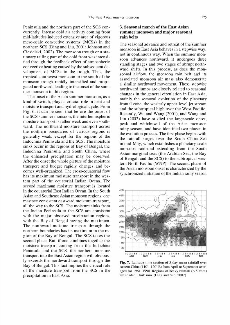
3. Seasonal march of the East Asian
summer monsoon and major seasonalrain belts
The seasonal advance and retreat of the summermonsoon in East Asia behaves in a stepwise way,not in continuous way. When the summer mon-soon advances northward, it undergoes three
standing stages and two stages of abrupt north-ward shifts. In this process, as does the mon-soonal airflow, the monsoon rain belt and itsassociated monsoon air mass also demonstratea similar northward movement. These stepwisenorthward jumps are closely related to seasonal
changes in the general circulation in East Asia,mainly the seasonal evolution of the planetaryfrontal zone, the westerly upper-level jet streamand the subtropical high over the West Pacific.
Recently, Wu and Wang (2001), and Wang andLin (2002) have studied the large-scale onset,peak and withdrawal of the Asian monsoonrainy season, and have identified two phases inthe evolution process. The first phase begins withthe rainfall surges over the South China Seain mid-May, which establishes a planetary-scale
monsoon rainband extending from the SouthAsian marginal seas (the Arabian Sea, the Bayof Bengal, and the SCS) to the subtropical wes-tern North Pacific (WNP). The second phase of the Asian monsoon onset is characterized by thesynchronized initiation of the Indian rainy season
Fig. 7. Latitude-time section of 5-day mean rainfall over
eastern China (110–120 E) from April to September aver-
aged for 1961–1990. Regions of heavy rainfall (>50mm)
are shaded. Unit: mm. (Ding and Sun, 2002)
The East Asian summer monsoon 125

7/29/2019 east asian monsoon
http://slidepdf.com/reader/full/east-asian-monsoon 10/26
and the Meyu=Baiu in early to mid-June. Thepeak rainy seasons tend to occur primarily in threestepwise phases, in late June over the Meiyu=Baiu regions, the northern Bay of Bengal andthe vicinity of the Philippines; in late July overIndia and northern China; and in mid-August over
the tropical WNP. The first two stepwise jumpsoccurs in the East Asian region.
Based on the time-latitude cross-section of 5-day rainfall amount for eastern China (Fig. 7)
(Sun, 2002), the most conspicuous feature is themonsoon onset between 18 and 25 N as indi-cated by the steep rise in precipitation startingfrom the first 10-day period of May. This rainy
episode is so-called pre-summer rainy season inSouth China, Hong Kong and Taiwan (e.g., Lauet al, 1988). The first standing stage of the majorrain belt generally continues into the first 10-dayperiod of June, and afterwards it rapidly shifts tothe valley of the Yangtze River. This second sta-tionary phase initiates the Meiyu rainy season in
central China. The time span of the season on theaverage lasts for 20–30 days (12th June-8th July).The wind and thermal fields in the Meiyu re-gion are usually characterized by a low-pressure
trough (the so-called the East Asian summermonsoon trough), a weak stationary front atsurface, significant horizontal wind shear across
the front and frequent occurrence of prolonged
heavy rainfall. The heaviest rainfall is mostly as-sociated with eastward-moving meso- to syn-optic scale disturbances along the front. The
Meiyu=Baiu and associated disturbances will bediscussed in more details in the next section.
The Baiu in Japan and Changma in Korea alsooccur in a similar situation, but with a regionaldifference in locations, timing and duration. Asindicated by Ninomiya and Muraki (1986), theBaiu in Japan begins in early June when rainfall
in Okinawa reaches its peak. In the last ten days
of June, the rainfall peak moves to the westernand southern parts of Japan. Then the rainfallpeak further moves northward in the first ten
days of July. North of 40 N, no rainfall peaksassociated with the Baiu can be observed. So,
the Baiu season in Japan mainly lasts from earlyJune to mid-July, almost concurrently with theoccurrence of the Meiyu in China. The rainy sea-son in Korea, the so-called Changma, accompa-nied with a belt-like peak rainfall zone, begins
with the influence of the quasi-stationary con-
vergence zone between the tropical maritime air-mass from the south, and both continental andmaritime polar airmasses from the north (Oh
et al, 1997). Based on the precipitation peak andlower tropospheric circulation features, the onsetdate of the Northeast Asia summer monsoon or
Changma rainy season can be determined as theperiod of the 37th to 39th pentad (late June–mid-July), with a significant interannual variability(Qian and Lee, 2000). Therefore, the Changma
is a shorter monsoonal rainy season, with meanperiod being 20 days long.
From mid-July, the rain belt rapidly jumpsover North China and Northeast China again, the
northernmost position of summer monsoon rain-fall. This standing stage of the rain belt causesthe rainy season in the North China that generallylasts for one month. In the early or middle part of August the rainy season of North China comes toend, with the major monsoon rain belt disappear-ing. From the end of August to early September
the monsoon rain belt quite rapidly moves back to South China again. At this time, most of theeastern part of China is dominated by a dry spell.
The East Asian summer monsoon assumes a
marked active-break cycle. As indicated above,the active periods corresponds to major monsoonrainy seasons such as the presummer rainy sea-
son in South China, and Meiyu=Baiu rainy sea-
son in the Yangtze River Basin and Japan duringMay–mid-July. Afterwards, a break of the mon-soonal rainy period occurs from late July to early
August in Japan (Chen et al, 2003). This break of different spans is also observed in SouthChina, central China, Northeast China, Taiwan,and Korea, but with different occurrence time.From mid-July, the second rainy season or the re-vival of the rainy period (Chen et al, 2003) pre-dominates over South China, with a gap of a time
period of about 20 days or one month between
the pre-summer rainy season and this rainy sea-son that is mainly caused by typhoons, the move-ment of the ITCZ and other tropical disturbances
in the monsoonal airflow.For other regions, after the break spell, mon-
soon rain resumes for a period from Augustto September–October. Therefore, the monsoonrainfall variation during the warm season in EastAsia is generally characterized by two activerainfall periods separated by a break spell. It is
clearly seen from Fig. 8 that the Meiyu rain band,
126 D. Yihui and J. C. L. Chan

7/29/2019 east asian monsoon
http://slidepdf.com/reader/full/east-asian-monsoon 11/26
forming in early May, progresses northward untilthe end of July, and diminishes between 40 and45 N in Northeast China and Korea, and about40 N in Japan. The passage of the Meiyu rain
band is followed by a break spell (monsoon break)which also propagates northward. Then, themonsoon rainfall revival after the break is clearly
observed. Chen et al (2003) has shown that themonsoon revival in East Asia is caused by a dif-
ferent mechanism associated with the develop-ment of other monsoon circulation componentsincluding the ITCZ and weather systems in mid-latitudes. The Changma break in late July is veryshort, with the duration of a half month. Startingfrom late August, the revival of the monsoon
rainy period is also observed in Fig. 8. The sec-ond rain spell is not long based on the study byChen et al (2003). But, Qian et al (2002) pointed
out that this precipitation surge can maintainuntil early September, forming the autumn rainyseason in Korea.
4. The Meiyu=Baiu and associatedweather disturbances
Meiyu=Baiu is a unique rainy season in the sea-sonal march of the East Asian summer monsoon.It starts nearly concurrently with the onset of the East Asian summer monsoon onset in theSouth China Sea. Then, as the summer mon-soon propagates northward, the Meiyu rain belt
sequentially establishes itself in South China andTaiwan, the Yangtze and Huaihe River Basinsand Japan, and the Korean Peninsula. As pointedout by Chen (2004), the different terminology
has been used for this major seasonal rain belt
Fig. 8. Latitudinal-time cross-sections of CMAP rainfall averaged over longitudinal zones of (a) 120–125 E, (b) 125–
130 E, and (c) 130–140 E, and rainfall histograms of three regions: (d) Taiwan (120–125 E, 20–25 N), (e) Korea (125–
130 E, 35–40 N), and (f ) Japan (130–140 E, 32.5–40 N). Different phases of summer monsoons in three regions are
indicated by active, break and revival. The contour interval of CMAP rainfall in (a)–(c) is 1 mm dayÀ1, while rainfall amounts
larger than 5 mm dayÀ1 are stippled by different colors indicated by the scale shown in the lower left corner of the three upper
panels. (Chen et al, 2003)
The East Asian summer monsoon 127

7/29/2019 east asian monsoon
http://slidepdf.com/reader/full/east-asian-monsoon 12/26
in different regions. In China, the term ‘‘Meiyu’’is used for the rainy season from mid-Juneto mid-July over the Yangtze River Valley (Taoand Chen, 1987). In Japan, the term ‘‘Baiu’’ isused both for the rainy season over Okinawaregion from early May to mid-June and over
the Japanese Main Islands from mid-June tomid-July (Saito, 1985). In Taiwan, on the otherhand, the term ‘‘Meiyu’’ is used both for the
rainy season over Taiwan and over South Chinafrom mid-May to mid-June (Chen, 1983; 1988;
Wang, 1970). Therefore, the ‘‘Meiyu’’ season overSouth China and Taiwan discussed in this paper
corresponds to the ‘‘South China pre-summerrainy period’’ used by many Chinese meteo-rologists (Tao and Chen, 1987; Ding, 1992), andthe ‘‘pre-Meiyu’’ period used by Chang et al(2000 a, b).
Figure 9 presents the annual mean frequencydistribution of 850 hPa fronts in the Meiyu sea-
son of South China and Taiwan (mid-May tomid-June) and of the Yangtze River Valley (mid-June to mid-July) (Chen, 1988). For the formercase, the axis of maximum frequency, indicat-
ing the mean position of the Meiyu front, isoriented approximately in an east–west direc-tion extending from southern Japan to southernChina. The mean position shifts northward toJapan and central China in the Meiyu season of
the Yangtze River Valley. The Meiyu front oftenmoves southeastward slowly in the early stage
of its lifetime and appears as a quasi-stationaryfront in the late stage with an average lifetime of 8 days.
Although Meiyu in China and Baiu in Japanboth occur in the early summer rainy season inEast Asia, their structure and dynamics are not
fully same, due to different locations of the plan-etary frontal zone. As indicated by Chen andChang (1980), the structure of the eastern (near
Japan) and central (the East China Sea) resem-bles a typical midlatitude baroclinic front with
strong vertical filting toward a upper level coldcore and a strong horizontal temperature, whereasthe western (Southern China and the YangtzeRiver Basin) section resembles a semitropical dis-turbance with an equivalent borotropic warm corestructure (Ding, 1992), a weak temperature gra-dient, and a rather strong horizontal wind shear
in the lower troposphere. Figure 10 clearly il-lustrates the synoptic conditions where the Baiu
in Japan and Meiyu in China form (Ninomiya,2004). In this conceptual model the Meiyu=BaiuBaiu cloud zone consists of a few cloud systemfamilies, each of which consists of two parts:
a sub-synoptic scale cloud system associated witha sub-synoptic-scale Meiyu=Baiu frontal depres-sion (indicated by S), and a few meso--scalecloud systems (indicated by ). The latter arealigned along the trailing portion of the preced-
ing sub-synoptic-scale cloud system. Cold lowsand a midlatitude blocking ridge and the Pacific
Fig. 9. Annual mean (1975–1986) frequency distribution of 850 hPa fronts in (a) southern China and Taiwan Meiyu season
(15 May–15 June), and (b) Yangtze River Valley Meiyu season (16 June–15 July). Front frequency is counted at 12 h intervals
and analyzed at 1 latÂ1 long grid intervals. Heavy dashed line indicates maximum axis (from Chen, 1988)
128 D. Yihui and J. C. L. Chan

7/29/2019 east asian monsoon
http://slidepdf.com/reader/full/east-asian-monsoon 13/26
subtropical anticyclone all have strong influences
on the Meiyu=Baiu cloud systems, but with astronger effect of cold lows on Baiu (eastern
section). The subtropical and tropical monsoonairflows have a more significant influence onMeiyu in China. Rows of large and small arrows
in Fig. 10 indicate the 500-hPa and 850-hPa max-
imum wind axes, respectively. The short-wavetrough that propagates along the northern maxi-
mum wind zone becomes coupled with the short-wave trough in the Meiyu=Baiu frontal zoneunder the influence of the cold low over Siberia,
Fig. 11. Climatology of the Meiyu composited for Meiyu periods based on 30-yr NCEP datasets and 740 station data in
China: (a) total rainfall amount (Unit: mm), (b) the se field at 850 hPa (Unit: K), (c) 850 hPa temperature fields (Unit: K), and
(d) the moisture transport at 850 hPa (Unit: kg(ms)À1). The maximum transport zone is shaded, (Ding and Liu, 2003)
Fig. 10. Conceptual model of
the Meiyu-Baiu frontal cloud
zone (Ninomiya, 2004)
The East Asian summer monsoon 129
7/29/2019 east asian monsoon
http://slidepdf.com/reader/full/east-asian-monsoon 14/26
leading to the development of a sub-synoptic-scalefrontal depression. Subsequently, a few meso--scale cloud clusters form along the trailing portion
of the preceding sub-synoptic scale cloud system.Figure 11 show the climatological aspects of
Meiyu over the Yangtze and Huaihe River Basins
based on the 30-yr (1971–2000) NECP datasetsand 740 surface station data in China (Ding andLiu, 2003). It can be seen that Meiyu rainfallsare mainly distributed over the middle and lower
valley of the Yangtze River, with the latter hav-ing the maximum rainfall amount ($260 mm),accounting for 45% of total rainfall amount forsummer (June, July and August) (Fig. 11a).
Therefore, nearly half of summer rainfalls comesfrom the Meiyu season that on the average lastsfor about 25 days (from June 12 to July 8). In theMeiyu zone, the air is very moist, with a highspecific humidity belt at low-level along theMeiyu zone observed. Overall, the Meiyu zoneis characterized by a high se region (Fig. 11b).
An interesting feature of the low-level tempera-ture field is its sandwich pattern, with the warmerair to south and the north, respectively, and rela-tively colder air in between (Fig. 11c). This cool-
ing in the Meiyu zone is also noted by Kato(1987). Three reasons may be used to illustratethe colder temperature zone along the Meiyu
precipitation region: (1) intrusion of low-level
cold air from northeast accompanied by the low-level northeasterlies to north of the Meiyu zone;(2) cooling effect of precipitation evaporation
at low-level and near the surface; and (3) theintense airmass modification over North andNorthwest China through the surface sensible
heating (Kato, 1987). This reverses meridionalthermal contrast between the Meiyu zone and theregion to its north. From the view point of wind
fields, to the south of the Meiyu zone, there areextensive southwest and southeast monsoon at850 hPa that merge together in the Meiyu andBaiu zones. The strong low-level jet (LLJ) and
its vertical coupling with the upper level jet maybe observed (Chen, 2004), and the Meiyu preci-pitation zone is located in between. Major Meiyurainfalls generally occurs in the right quadrant of
entrance sector of upper-level jet which is dom-inated by upward motion (Cressman, 1981). Thepositive vorticity to the left side of the LLJ isalso favorable for occurrence of rainfalls. Alarge amount of moisture is transported into theMeiyu=Baiu zone by the summer monsoon. TheSouth China Sea is a major moisture channel for
the Meiyu precipitation (Fig. 11d). Significantmoisture convergence is observed in the middleand lower valleys of the Yangtze River and thewestern Japan where the Meiyu and Baiu precip-
itation is highly concentrated.Chen and Chang (1980) studied dynamics of
the Meiyu front. The vorticity budget calculat-
ed by them showed that generation of cyclonic
vorticity by horizontal convergence was counter-acted by cumulus damping in the eastern sectionand by boundary layer friction in the mountainous
Fig. 12. Climatologically aver-
aged (1971–2000) Meiyu frontal
structure along 117.5 E. Solid
lines are se isolines (Unit: K)
and dashed lines are isolines of
specific humidity (Unit: g kgÀ1).
Horizontal bar at the bottom re-
presents the averaged latitudinal
range of precipitation greater
than 200 mm (27–30 N) (Ding
and Liu, 2003)
130 D. Yihui and J. C. L. Chan

7/29/2019 east asian monsoon
http://slidepdf.com/reader/full/east-asian-monsoon 15/26
western section. Results from theoretical, mod-eling and observational studies suggest thatthe Meiyu frontogenetic process is initiated and
maintained by the CISK mechanism through theinteraction between the potential vorticity (PV)anomaly and the convective latent heating (Chen
et al, 1998; Chen, 2003). The Meiyu front affect-ing South China and Taiwan forms in the subtrop-ical latitude, which is a distinct area from thatfor the formation of polar front in the Meiyu
season. It resembles a semitropical disturbancewith an equivalent barotropic warm core struc-ture, a weak horizontal temperature gradient, arather strong horizontal wind shear, and a posi-
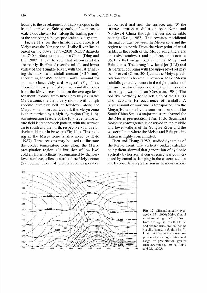
tive low-level PV anomaly (Chen, 2004).Figure 12 is the mean structure of the Meiyu
front averaged for 1971–2000. An interestingfeature is the highly moist air column ahead of the Meiyu front which very much resembles theeye-wall region of a typical tropical cyclone. TheMeiyu rainfall intensively occurs in this region.
This implies the significant importance of con-vective precipitation and associated latent heatrelease. Generally, the frontal structure at low-level or near the surface disappears or even
changes its sloping from northward tilting tosouthward tilting. So, Xie (1956) previously de-fined the low-level part of the Meiyu front as the
equatorial front, with the relatively cold air in the
south of the Meiyu front and relatively warm airin the north. Corresponding to the Meiyu frontshown in Fig. 12, the mean cross-front vertical
circulation is characterized by strong upwardmotion throughout the entire troposphere locatedin the region of Meiyu rainfalls, the southerlycomponent at low-level and the northerly compo-nent at upper-level in the region to the south of the Meiyu front. Therefore, a so-called monsooncirculation cell (anti-Hadley cell) is clearly evi-
dent. To the north of the Meiyu front, there is a
thermally direct cell.From Fig. 12, it can be seen that the Meiyu-Baiu frontal zone associated with intense con-
vective precipitation is not characterized by thestrong convective instability, but by nearly moistneutral stratification. This indicates the releaseof the convective instability associated with thecumulus convection. For the sustenance of thestrong convective precipitation during the Meiyuperiod, some large-scale process must generate
convective instability against the stabilizing ef-
fect of the convective clouds. The local timechange of convective stability is due to the dif-ferential advection of e. Ninomiya (2004) has
indicated that area of negative differential ad-vection (generation of convective instability) arepresent over the Meiyu=Baiu frontal zone, which
indicates that the differential advection generatessuccessively convective instability against the re-lease of the instability by the convective clouds.As the result of these two processes, the large
precipitation and nearly moist neutral stratifica-tion are maintained within the frontal precipita-tion zone.
The heavy rainfalls during the Meiyu period
are mainly generated by the meso-- and meso- -scale disturbances which are embedded withinand propagated along the Meiyu-Baiu cloud andrain band or frontal zone with horizontal lengthscale of several thousand kilometers (Ding, 1992).Results of a case study of the heavy rain event in23–25 June 1983 over the Yangtze River Valley
by Ma and Bosart (1987) revealed that a quasi-stationary frontal boundary, separating very warmand moist tropical Pacific air from slightly coolerbut still moist air, served to focus the rains in a
relatively narrow latitudinal band. The meso--scale systems during the Meiyu period maybe classified into two types: the Yangtze River
Valley shear line and the low-level vortex. The
Yangtze River Valley (112–120
E, 30–35
N)shear line is the major synoptic system, whichgenerates heavy rainfalls in this region (Chen,
2004). There were at least two kinds of low-levelvortices that generated heavy rains during theMeiyu season. One was the SW (southwest) vortex.It was generated on the lee-side of the TibetanPlateau and tended to be stationary if therewas no upper-level trough to steer it out of theSichuan Basin. It could produce heavy rainfalls
locally in Sichuan Basin. Once it is steered out
and moves eastward, it moves along the Meiyushear line in most cases and moves northeast-ward or southeastward in some cases. Another
kind of low vortex is the intermediate-scale cy-clone which forms along the Meiyu front with ahorizontal scale of 1000–3000 km (Ninomiya andMurakami, 1987; Ninomiya, 2001).
In general, the SW vortex is defined as a700 hPa closed cyclonic circulation over south-western China, mainly over the western part of
the Sichuan Basin. It is a low-level circulation
The East Asian summer monsoon 131

7/29/2019 east asian monsoon
http://slidepdf.com/reader/full/east-asian-monsoon 16/26
system, often only visible on 850 and 700 hPaanalyses. On the surface weather map, one mayoften observe a negative pressure tendency dur-ing 24 hours over the low-vortex region. In thissense, the SW vortex is also called the SW low
vortex. The SW vortex may provide strong oro-
graphic lifting to trigger convection and, conse-quently, a large amount of rainfalls on the steeptopography surrounding the Sichuan Basin. Manycases may be exemplified, for example, the heavyrainfalls in the Sichuan Basin on 1–14 July of 1981 which have been extensively studied by nu-
merous meteorologists (Chen and Dell’Osso,1984; Kuo, Cheng and Anthes, 1986; Wang andOrlanski, 1987). Figure 13 is a notable example of consecutive genesis, development and eastward
movement of a SW vortex in the 1999 Meiyu
season (Ding et al, 2001).From the synoptic viewpoint, the genesis anddevelopment of the SW vortex needs to meettwo requirements: (1) the existence of a vigoroussoutherly airflow from the eastern slope of theTibetan Plateau to the Sichuan Basin. It may play
a dual role in the genesis of the SW vortex.Dynamically, this southerly wind produces‘‘differential frictional effects’’, a mechanism firstdiscussed by Newton (1956) in connection with
Colorado cyclone formation, thus leading to the
formation of a cyclonic circulation at low level.Thermally, the southerly wind may transportabundant warm, moist air into the eastern slopeof the Plateau and the Sichuan Basin, providingthe major moisture source for precipitation and
the release of latent heat; (2) the necessary trig-
gerning mechanism. Most of the time, the lowpressure troughs passing over the Tibetan Plateaumay act as a triggering mechanism for the SW
vortex. Chang et al (1998) has studied the de-velopment of a low-level SW vortex which wasinvolved in its coupling with two upper-level dis-
turbances. Both disturbance appeared later thanand upstream of the low-level vortex. Faster east-ward movements allowed them to catch up withthe low-level vortex and led to a strong vertical
coupling and deep tropopause folding. From
the regional viewpoint, the topography of theTibetan Plateau is extremely important.The development of the SW vortex is expected
to depend greatly on the effect of latent heatrelease, due to the fact that this vortex is usuallyaccompanied by a large amount of rainfall and
convective activity. In order to document betterthe effects of strong latent heat release associatedwith convection, Kuo et al (1986) calculated me-soscale heat and moisture budget associated with
a SW vortex which resulted in a flood catastrophe
Fig. 13. Distributions of daily geopotential height and
wind vector (unit: msÀ1) at 850 hPa during the Meiyu peri-
od from June 29 to July 1, 1999. C3 denotes a southwest
vortex which brought about a heavy rainfall episode in the
middle and lower Yangtze River basin (Ding et al, 2001)
132 D. Yihui and J. C. L. Chan

7/29/2019 east asian monsoon
http://slidepdf.com/reader/full/east-asian-monsoon 17/26
in the Sichuan Basin, on 11–15 July, 1981. Withweak stability at the middle levels, latent heatrelease can induce strong, upward vertical motion,
which in turn enhances low-level convergencespin-up and convective cloud development, es-tablishing a positive feedback between the cir-
culation of the SW vortex and the cumulus(Chang et al, 2000). Wang et al (1993) furtherindicate that the mesoscale vortex in the lee of the Tibetan Plateau is driven diabatically.
As indicated by Chen (2004), due to the ob-servational spatial data limitations in China, verylittle work has been done on meso- -scale sys-tems. The Meiyu experiment over the middle and
lower reaches of the Yangtze River (1980–1983)for the first time provided an opportunity forstudying this system on the horizontal scale of 25–250 km, by using the denser network of theupper-air and surface observations. The majorfindings have been summarized in the mono-graph by Zhang (1990). It was found that the
meso- -scale systems occurred in advance of the forward tilting minor wave trough whichwas located near the Meiyu cloud and rain bands,on the right side of the upper-level jet, and the
left side of the low-level jet. In general, this sys-tem was associated with the mesoscale shear line.During past ten years, the availability of meso-
scale observational data has been considerably
improved due to several Meiyu rainstorms experi-ment projects carried out in South China, Taiwan
and the Yangtze and Huaihe River Basins, suchas HUAMEX, TAMEX, GAME=HUBEX and the Meso-scale Rainstrom Experiment in the Yangtze River
Basin. Some new results have been achievedin relation to meso-scale disturbances in Meiyufronts.
A typical example of Meiyu=Baiu frontal meso-scale disturbances is shown in Fig. 14 (Ninomiya,2004). The Meiyu-Baiu cloud zone appears as thechain of cloud systems on the subsynoptic-scale
and mesoscale. The wavelength of the major dis-turbances in Fig. 14 is estimated to be $2000 km,which falls on the border between macro- - andmeso--scale. Therefore, these disturbances are
identified as subsynoptic-scale Meiyu=Baiu frontaldisturbances in the present report. Some authors(Matsumoto and Nimomiya, 1971) classified themas medium-scale disturbances.
The meso--scale cloud systems are very fa-vorable for occurrence of meso-scale convectivesystems (MCSs). The MCSs are often observed to
develop in the region of the meso--scale cloudsystems. By definition, mesoscale convective sys-tems (MCS) are a well organized, meso--scale(with horizontal resolution of 200–2000 km) con-
vective system which has a nearly elliptic shapeand smooth edge. MCS includes the meso-scaleconvective complex (MCC) that has been exten-
sively studied. Activities of the MCSs are quite
frequent in China. They mainly occur in South-west China, but are often observed in connection
Fig. 14. The longitude-time sec-
tion of TBB at 32.5 N for 1991
Meiyu=Baiu period The iso-
pleths are at 10C intervals,
and the minus sign of TBB is
omitted (Ninomiya, 2000; 2004)
The East Asian summer monsoon 133

7/29/2019 east asian monsoon
http://slidepdf.com/reader/full/east-asian-monsoon 18/26
with the major seasonal rain belts such as thoseduring the presummer rainy season in SouthChina and Meiyu in the Yangtze-Huaihe River
Basins. During the Baiu season in Japan MCSare sometimes observed as an important intenserain-producing system (Ninomiya and Murakami,
1987). The preferred locations of occurrence of MCS are the northwestern periphery of the sub-tropical high over the western North Pacificwhere the warm and cold air have a frequent
and vigorous interaction. Sometimes, the MCSsalso may be produced in East and South Chinadue to strong surface heating and local unstablestratification.
The MCC have been intensively studied in80’s and early 90’s. In the figure produced byMiller and Fritsch (1991), the MCCs in Chinawere only observed in Southwest China whichare associated with the Southwest Vortex. But,based on studies by Chinese meteorologists, thegensis regions of MCCs are not only confined in
this region, they may occur over a number of otherregions. In late spring and early summer, MCCsoften occur over the southern part of China (Xiangand Jiang, 1995) in relation to Meiyu season. Their
mean lifetime is about 18 hours, slightly longerthan that (about 10 hours) in North America.MCCs generally generate and develop in late
afternoon and early evening, further grow into
MCC at nighttime and disspate in the morningof the next day. Wu and Chen (1988) studied thecomposite structure of environment conditions
for the 12 cases of meso--scale MCS (i.e., MCC)
over South China selected in May–June 1981–1986 at their formation and mature stages. Theoverall structure was quite similar to that for the
midlatitude MCCs in the North America as ob-tained by Maddox (1983). The MCCs form andintensify in the warm sector to the south of the
Meiyu front=shear line. The strong warm advec-tion and speed convergence (i.e., convergence due
to the downstream speed decrease) in the lower-tropospheric southwesterlies, possible lifting me-
chanisms at the formation and intensificationstages, prevail over the area of MCCs. The MCCstended to form and to intensify on the cyclonicside of the LLJ exit region. Anticyclonic circula-
tion and diffluent flow in the upper troposphereprovided conditions favorable for the intensifi-cation of MCCs. At the genesis and developmentstages, the precipitation amount is relativelysmall, with severe convective weather dominating.The heavy rainfalls mainly occur at the maturestage, with intense rainfall rate of 30–50 mm hrÀ1.
Therefore, the MCCs are an important rain-producing system in the summer monsoon seasonin South China and the Yangtze River Basin.
Finally, the conceptual model of the Meiyu
front in the Yangtze River Basin and South Chinais presented (Fig. 15). Ahead of the Meiyu front,a so-called monsoon vertical circulation is ob-
served, with the upward motion in Meiyu preci-
pitation region and downward motion in thesouth. The Meiyu front at low-level evolves intothe so-called equatorial front or nearly disap-
pears. In the Meiyu precipitation zone, the air
Fig. 15. Synoptic model of the
Meiyu season in East China (Liu
et al, 2003)
134 D. Yihui and J. C. L. Chan

7/29/2019 east asian monsoon
http://slidepdf.com/reader/full/east-asian-monsoon 19/26
in the deep troposphere is highly moist, with highe observed. The LLJ is observed to the south of the Meiyu front within the lower return branch of
the secondary circulation. It is often verticallycoupled with the upper-level jet stream.
5. Intraseasonal oscillations (ISO)and teleconnection patterns
During last two decades, a large amount of research works have been devoted to study theintraseasonal oscillation of the Asian monsoon.
On the intraseasonal scale, the monsoon fluc-tuateds mainly on two preferred time scales:10–20-day and 30–60-day, with the latter oftenreferred to as the Madden-Julian Oscillation(MJO). In the South China Sea and the East Asiansummer monsoon regions, the ISO can play three
fold roles: the triggering of the onset of the sum-mer monsoon, modulation of active and break cy-cles of the summer monsoon and rainy seasons
and connection of summer monsoon activity of the neighbouring regional monsoon systems of the South Asian, the East Asian and Western
North Pacific. When the ISO can propagate orfluctuate on an even larger-scale or the hermi-spheric scale, this remote connection may excitesome kind of atmospheric teleconnection pat-
terns or Rossby wave trains.Figure 16a is the Morlet wavelet analysis of
850 hPa zonal wind in the SCS region forMay–August of 1998 during the SCSMEX field
experiment (Xu and Zhu, 2002). Two main modesof 30–60-day and 10–20-day low frequencyoscillations can be identified. Figure 16b hasshown that the phase of the westerly wind of the
Fig. 16a. Morlet wavelet analyses of zonal
wind at 850 hPa in the SCS. Unit: day (Xu
and Zhu, 2002). (b) Observed 850 hPa zonal
wind over the SCS region (5–20 N, 105–
120 E) in 1998 (shaded) and the temporal var-
iations of the 30–60 day low-frequency oscilla-
tion (solid line) and corresponding kinetic
energy (dashed line). Unit: msÀ1 for wind and
m2 sÀ2 for kinetic energy (Mu and Li, 2000)
The East Asian summer monsoon 135

7/29/2019 east asian monsoon
http://slidepdf.com/reader/full/east-asian-monsoon 20/26
30–60-day mode occurred concurrently with burst-ing of the westerly monsoon at 850 hPa in thisregion (Mu and Li, 2000). Also based on the data
from the SCSMEX in 1998, Chan et al (2002)have shown that the onset and maintenance of 1998 SCS summer monsoon were controlled by
the 30–60-day oscillation and further modifiedby the 10–20-day mode. Chen and Chen (1995)previously indicated that the onset of the 1979SCS summer monsoon occurs under the condition
of a phase-lock between the 30–60-day and the10–20-day modes over the Northern SCS.
Recently, Mao and Chan (2004) have obtaineda more general conclusion that the 30–60-day
mode and 10–20-day mode oscillations controlthe behavior of the SCS summer monsoon ac-tivities for most of years. The 30–60-day oscilla-tion of the SCS summer monsoon exhibits atrough-ridge seesaw over the SCS, with anoma-lous cyclones (anticyclones) along with enhanced(suppressed) convection migrating northward. On
the other hand, the 10–20-day oscillation man-ifests as an anticyclone=cyclone system over thewestern tropical Pacific with a largely zonal ori-entation propagating westward into the SCS.
The arrival of the ISO oscillation is not only tobe a possible triggering mechanism for the sud-den onset, but also can play a crucial role in the
stepwise northward advance of the East Asian
summer monsoon and in modulating the regionalrainy seasons. Qian et al (2002) have shown thatthe onset of the East Asian summer monsoon
occurs when a wet phase of the climatologicalintraseasonal oscillation (ISO) arrives or develops,and the northward propagating summer monsoonconsists of several phase-locking wet ISO. In theEast Asian summer monsoon region, the seasonalprocess of the summer monsoon and the ISOpropagation are both northward and they are
interconnected at all the stages of the seasonal
march and in all the subregions of East Asia.Wang and Xu (1997) have further identified fourcycles of statistically significant climatological
intraseasonal oscillation (CISO) from May toOctober in the Asian summer monsoon regions.The peak wet phase of these cycles correspondsto active stage of the summer monsoon while thedry phase corresponds to the monsoon break. Itshould be pointed out that though the climatolog-ical ISO is often the primary reason for the sud-
den onset, the onset is paced by the seasonal
evolution of large-scale circulation and thermo-dynamics that determines the direction of theonset advance. With the large-scale background
established by the seasonal evolution, the arrivalof several one-after-another ISO wet phases trig-gers the development of deep convection. Due to
the seasonal regulation, the ISO has a tendencyto be phase-locked with respect to the calendar
year so that the climatological onset displaysmultiple stages. The stepwise march of the onset
is observed each year (Wu and Wang, 2001).Two teleconnection patterns associated with
the Asian summer monsoon have been revealed.Nitta (1986), and Huang and Li (1988) indicated
that heating sources caused by convective ac-tivity over the SCS and the region around thePhillipines (over the Warm Pool) may excite astationary wave train, thus producing a tele-connection pattern, so-called JP pattern (Japan-Pacific). The immediated downstream effect of the propagation of this wave train is exerted upon
the behavior of the subtropical high over thewestern Pacific, and especially on its position.Then, the summer rainfall will be influenced bythe anomalous behavior of the subtropical high.
Huang and Sun (1990) further analyzed the re-lationship between the conditions of anomaloussummer precipitation in the eastern China andthe temperature in surface and subsurface layers
of the Warm Pool at depths of between 50 and300 m. Recently, Li and Zhang (1999), and Lauand Wang (2002) have indicated that the thermal
forcing excited by convective activity and rain-falls in the SCS and western tropical Pacific,through this teleconnection pattern, may affectweather and climate not only in China, Koreaand Japan, but also possibly in North America.
Another teleconnection pattern originates froma large amount of monsoon rainfalls and as-
sociated intense heating forcing in India, which
can exert a significant remote effect on thegeneral circulation on a large-scale basis. Liang(1988) has found that the summer rainfall be-
tween India and North China has a stable andsignificant positive correlation relationship, es-pecially with a fairly consisitent occurrence of droughts and flooding events in these two re-gions. Meanwhile, Guo and Wang (1988) useda longer set of data (1951–1980) for 110 stationsin China and 31 subregions in the Indian
Peninsula to further study this problem, and have
136 D. Yihui and J. C. L. Chan

7/29/2019 east asian monsoon
http://slidepdf.com/reader/full/east-asian-monsoon 21/26
justified the above relationship indicating thatthe most significant correlative region with asignificance level of 0.95 is North China which
demonstrates a positive correlation, with theircorrelation coefficient being 0.65 (the confidencelevel exceeding 99.9%). In recent years, a num-
ber of investigators have paid attention to thisteleconnection patterns and have well documen-ted its existence with significant statistical rela-tionship and physical explanation (Hu and Nitta,
1996; Kripalani and Kulakarni, 1997; 2001). Inaddition, a negative correlation between summerrainfall variations in India and southern Japan isfurther found, which reflects downward propa-
gation of a wave-type circulation pattern overmid-latitude Asia.
6. Physical processes and mechanismsrelated to the onset and the seasonal marchof the East Asian summer monsoon
In the Asian monsoon region, the thermal con-trast due to differential heating between land and
sea in the process of seasonal march of solarradiation acts as a seasonal precondition for theonset. However, the Asian monsoon is not onlyforced by the thermal effect of land-sea contrast,but also by the elevated heat source produced by
the huge massif of the Tibetan Plateau (Yeh andGao, 1979; Murakami and Ding, 1982; Luo andYanai, 1984; Ding, 1992). Based on the estimate
of heat budget made by Yeh and Gao (1979) andothers, the total energy supplied by the TibetanPlateau has its maximum in late spring and early
summer, with a peak occurring in May. This heatflux from the surface to the atmosphere has itsmaximum contribution from the sensible heat.Thus, the atmosphere over the Tibetan Plateau
in May and June becomes the strongest atmo-spheric heat source in a year, and has abnormallyhigh temperature with the warmest region in Julyand August found in the region of the longitudi-
nal range of 50–110 E. It is very interestingthat during the transition season from spring tosummer, the warming in this region occurs ear-lier than in other zones of the same latitude. InMarch, the increase in thickness (500–300 hPa)is also evident and attains its maximum in Mayand June (Yeh and Gao, 1979), preceding the
onset of the Asian summer monsoon in timing.All of these studies have well documented thethermal forcing of land-sea contrast, especiallythe Tibetan Plateau and its surrounding areas,
on the onset of the Asian summer monsoon.Next, one may naturally ask why the earliest
onset occurs in the Indochina Peninsula and the
Fig. 17. Hovemoller diagrams of vertical shear of zonal wind (m sÀ1) between a 200 hPa and 850 hPa averaged over
10–20 N, (b) temperature difference (C) between 20 N and 10 N averaged over the 850–200 hPa layer and (c) instability
index (K =1000 hPa) averaged over 10–20 N. Shading in (a), (b) and (c) denotes, respectively, easterly vertical shear,
positive temperature difference, and instability index over 65 K =1000 hPa. The instability index is defined as the difference
of the saturated equivalent potential temperature between 1000 hPa and 700 hPa (divided by the pressure difference) (Wu and
Wang, 2001)
The East Asian summer monsoon 137

7/29/2019 east asian monsoon
http://slidepdf.com/reader/full/east-asian-monsoon 22/26
SCS, rather than in other locations. The study byHe et al (1987) made an initial attempt to providesome evidence to address this important problem
by using the data of 1979. They found that asudden temperature increase over the easternPlateau and the central China plain (85–115 E)
occurred during the period from 6 May to 15 May.At the same time, the reversal of the meri-donal temperature gradient first occurred overthe longitudes east of 85 E and then over the
longitudes west of 85 E. The two stages of thereversal of the temperature gradient (as well asthe geopotential height gradient) coincide withthe two stages of the onset of the low-level south-
westerlies and organized rains over the Bay of Bengal and the Arabian Sea. The dominant roleplayed by the temperature increases over the landareas including the plateau in this reversal hasbeen further documented by the works of Wuand Wang (2001), and Zhang et al (2004).
Wu and Wang (2001) also pointed out that the
change of the wind direction or the vertical shear(200–850 hPa) (Fig. 17a) can be explained by thereversal of the meridional temperature gradient(Fig. 17b). The meridional temperature gradient
averaged over the layer of 850–200 hPa reversesfirst over the Indochina Peninsula because theatmosphere heats up more quickly over the land
than over the ocean. The thermal advection of the
warm air from the Tibetan Plateau in relation tothe westerly winds at middle and upper levelsbefore the onset is also important. The latent heat
released by the pre-summer or spring rainfall inSouth China and the Indochina Peninsula possi-bly make some contribution to heating of theatmosphere. This view is supported by the devel-opment of the zone of high convective instability(Fig. 17c). As a result, the easterly vertical shearand the onset of the Asian summer monsoon de-
velops first along Southeast Asian longitudes.
The arrival of the MJO oscillation is likely tobe a triggering mechanism for the sudden onsetand northward propagation of the summer mon-
soon. But, the MJO alone is not sufficient to trig-ger the onset of the summer monsoon in someyears and some regions. In such cases, the mid-latitude events (troughs and ridges) may play asubstantial role in the monsoon onset (Davidsonet al, 1983; Chang and Chen, 1995; Hung andYanai, 2002; Liu et al, 2002). However, very
few investigators have studied the physical pro-
cesses and mechanisms of triggering the onset bythe intrusion of mid-latitude troughs or frontalsystems in detail. Ding and Liu (2001) summa-
rized the possible triggering mechanisms in theirstudy on the effect of change in circulation fea-tures at mid-latitudes on the onset of the northern
SCS summer monsoon based on various previousstudies: (1) lifting effect to release the existing
convectively potential instability for occurrenceof convection and precipitation; (2) accelerating
the low-level northeasterly wind with enhancingthe meridional pressure gradient to increase theshear vorticity and cyclonic circulation of windshear line; (3) enhancing the baroclinicity due to
increase of horizontal temperature gradient, thusproviding some amount of available potentialenergy for development of disturbances or meso-scale systems in the frontal zone; (4) exciting thegrowth of extensive convective cloud systems,which is a favorable environment for develop-ment of meso-scale systems in the low-level wind
shear zone between northeasterly and southwest-erly winds and associated low troughs whichmay force the subtropical high to retreat south-ward and eastward through some kind of feed-
back process. Chan et al (2000) also emphasizedthe importance of southward intrusion of cold airfrom mid-latitudes to trigger the onset of the SCSsummer monsoon. Its role is to lift the warm,
moist and unstable air to release the convectiveavailable potential energy (CAPE), when the at-mospheric convective instability is already estab-
lished before the onset through the heat andmoisture transport by the low-level tropical orsubtropical southwesterlies.
The impact from mid-latitudes may be ob-served not only for the onset of the East Asiansummer monsoon, but also for all stages of itsseasonal progress. The continuous southward in-
trusion of cold air and accompanying frontal sys-
tems (the so-called Meiyu=Baiu front) is excitedby the development and prevailing of blockinghighs in the mid-and high latitudes over Eurasia.
The dual blocking high situation, one locatedover the Ural Mountains and another locatedover the Okhotsk Sea, is the most favorable sit-uation for prolonged Meiyu=Baiu heavy rainfall(Ding, 1991; Zhang and Tao, 1998; Wu, 2002).So, one of the main differences between theIndian and East Asian summer monsoon is the
different effect of mid-latitudes events.
138 D. Yihui and J. C. L. Chan

7/29/2019 east asian monsoon
http://slidepdf.com/reader/full/east-asian-monsoon 23/26
The East Asian summer monsoon assumes agreat interannual variability. Numerous investi-gators have linked this variability to changes in
Eurasian or Tibetan snow cover (Liu and Yanai,2002) and the Pacific SST. National ClimateCenter of China (1998) has identified a positive
correlative relationship between the snow coverover the Tibetan Plateau in preceding winterand spring and rainfalls in the following sum-mer in the region of the Yangtze River Basin.
Recently, Zhang et al (2003) has further indi-cated the existence of a close relationship be-tween the interdecadal increase of snow depthover the Tibetan Plateau during the preceeding
spring, and the excessive summer rainfall overYangtze River Basin. It is proposed that the ex-cessive snow results in decrease in heat sourcesover the Tibetan Plateau, through the increasedalbedo and spring snow melting, thus reducingthe land-sea thermal contrast, the driving forceof the Asian summer monsoon (Ding and Sun,
2003).The effect of ENSO events on the East Asian
summer monsoon and related seasonal rainfallshas been extensively studied. It has been found
that the most significant influence occurs in thefollowing year after the onset of El Ni~nno events(NCCC, 1998) with above-normal rainfalls ob-
served in the Yangtze River Basin. Under this
condition, the weak summer monsoon may beexpected. Recently, Wang et al (2000) havefound that ENSO events can affect the East
Asian climate through a Pacific-East Asian (PEA)teleconnection, with an anomalous anticycloniceast of the Phillipines during El Ni~nno eventsoften observed over West-Pacific and the south-ward shift of the seasonal rain belt.
The interdecadal variability of the East Asiansummer monsoon is now of considerable concern
for many investigators (Lau and Wang, 1999;
Wang et al, 1999; Chang et al, 2000; Ding andSun, 2003). They have linked the interdecadalvariability of the East Asian monsoon to an inter-
decadal change in the background state of thecoupled ocean-atmospheric system or a long-term warming tend in the tropical Indian Oceanand Pacific. Among these contributing factors,the Pacific Decadal Oscillation (PDO) and IndianOcean Dipole (IOD) may play a very importantrole. Their relationship to the East Asian summer
monsoon remains to be further studied.
7. Conclusions
The present paper provides an overview of majorproblems of the East Asian summer monsoon.The major conclusions drawn upon this reviewcan be summarized below:
(1) The earliest onset of the Asian summer mon-soon occurs in most of cases in the centraland southern Indochina Peninsula. The on-set process over the SCS and the IndochinaPeninsula is very abrupt, with dramatic
changes of large-scale circulation and rainfalloccurring during a quite short time period of about one week.
(2) The onset of the summer monsoon over theIndochina Peninsula and the SCS is precededby development of circulation features andconvective activity in the tropical East Indian
Ocean and the Bay of Bengal that is charac-terized by the development of a twin cyclonecrossing the equator, the rapid acceleration of low-level westerlies and significant increaseof convective activity in both areal extentand intensity.
(3) The seasonal march of the East Asian sum-mer monsoon displays a distinct stepwisenorthward and northeastward advance, withtwo abrupt northward jumps and three sta-tionary periods. The monsoon rain com-
mences over the region from the IndochinaPeninsula-the SCS-Philippines during theperiod from early May to mid-May, then itextends abruptly to the Yangtze River Basin,and western and southern Japan, and the south-western Philippine Sea in early to mid-Juneand finally penetrates to North China, Korea
and part of Japan, and the topical westernWest Pacific.
(4) After the onset of the Asian summer mon-soon, the moisture transport coming from
Indochina Peninsula and the South ChinaSea plays a crucial ‘‘switch’’ role in moisturesupply for precipitation in East Asia, thusleading to a dramatic change in climate re-gime in East Asia and even more remoteareas through teleconnection.
(5) The East Asian summer monsoon and related
seasonal rain belts assumes significant vari-ability at intraseasonal, interannual and inter-decadal time scales. They can strongly affectand modulate the onset, active-break cycle
The East Asian summer monsoon 139

7/29/2019 east asian monsoon
http://slidepdf.com/reader/full/east-asian-monsoon 24/26
and propagation of the East Asian summermonsoon. Their interaction, i.e., phase lock-ing, and in-phase or out-phase superimposing,
can to a greater extent control the behaviorsof the East Asian summer monsoon and pro-duce unique rythem and singularities.
(6) Tow external forcing, i.e., Pacific and IndianOcean SSTs and the snow cover in theEurasia and the Tibetan Plateau, are believedto be primary contributing factors to physical
processes and mechanism related to the EastAsian summer monsoon. However, the inter-nal variability of the atmospheric circulationis also very important to affect the activity of
the East Asian summer monsoon. In partic-ular, the blocking highs in mid-and highlatitudes of Eurasian continents and the sub-tropical high over the western Pacific play amore important role which is quite differentfrom the condition for the South Asian mon-soon. The later is of of tropical monsoon na-
ture while the former is of hybrid nature of tropical and subtropical monsoon with in-tense impact from mid-and high latitudes.
Acknowledgements
This work is jointly supported by National Climbing Project
‘‘South China Sea Monsoon Experiment (SCSMEX)’’ and
the Research Grants Council of the Hong Kong Special
Administrative Region Government of China Grant CityU 2=00C.
References
Chan JCL, Wang YG, Xu XJ (2000) Dynamic and thermo-
dynamic characteristics associated with the onset of the
1998 South China Sea summer monsoon. J Meteor Soc
Japan 78: 367–380
Chan JCL, Ai WX, Xu JJ (2002) Mechanisms responsible
for the maintenance of the 1998 South China Sea summer
monsoon. J Meteor Soc Japan 80: 1103–1113
Chang CP (2004) The East Asian monsoon. Singapore:
World Scientific, 560 ppChang CP, Chen GT-J (1995) Tropical circulation associated
with southwest monsoon onset and westerly surge over
the South China Sea. Mon Wea Rev 123: 3221–3267
Chang CP, Hou SC, Kuo HS, Chen CTJ (1998) The devel-
opment of an intense East Asian summer monsoon dis-
turbance with strong vertical coupling. Mon Wea Rev 126:
2692–2712
Chang CP, Yi L, Chen GTJ (2000a) A numerical simulation
of vortex development during the 1992 East Asian sum-
mer monsoon onset using the Naveys regional model.
Mon Wea Rev 128: 1604–1631
Chang CP, Zhang Y, Li T (2000b) Interannual and inter-
decadal variations of the East Asian summer monsoon and
the tropical sea-surface temperatures. Part 1: Relation-
ships with Yangtze River Valley rainfall. J Climate 13:
4310–4325
Chen GTJ (1983) Observational aspects of the Meiyu phe-
nomena in subtropical China. J Meteor Soc Japan 61:
306–312Chen GTJ (1988) On the synoptic-climatological character-
istics of the East Asian Meiyu front. Atmos Sci 16:
435–446 (in Chinese with English abstract)
Chen GTJ (2004) Research on the phenonena of Meiyu
during the past quarter century: An overview. In: The East
Asian Monsoon (Chang CP, ed). Singapore: World Scien-
tific, 560 pp
Chen GTJ, Chang CP (1980) The structure and vorticity
budget of an early summer monsoon trough (Mei-Yu)
over southeastern China and Japan. Mon Wea Rev 108:
942–953
Chen SJ, Dell’ Osso L (1984) Numerial prediction of the
heavy rainfall vortex over Eastern Asia monsoon region.
J Meteor Soc Japan 62: 730–747Chen SJ, Kuo YH, Wang W, Tao ZY, Cu B (1998) A
modeling case study of heavy rainstorms along the
Mei-Yu front. Mon Wea Rev 126: 2330–2351
Chen TC, Chen JM (1995) An observational study of the
South China Sea monsoon during the 1979 summer: Onset
and life cycle. Mon Wea Rev 123: 2295–2318
Cressman GP (1981) Circulation of the West Pacific jet
streams. Mon Wea Rev 109: 2450–2463
Davidson NE, McBride JL, McAvaney BJ (1983) The onset
of the Australian monsoon during winter MONEX:
synoptic aspects. Mon Wea Rev 111: 496–516
Ding YH (1981) A case study of formation and structure of a
depression over the Arabian Sea. Chinese J Atmos Sci 5:267–280 (in Chinese)
Ding YH (1991) Advanced synoptic meteorology. China
Meteorological Press, pp 792 (in Chinese)
Ding YH (1992) Summer monsoon rainfalls in China.
J Meteor Soc Japan 70: 373–396
Ding YH (1994) Monsoons over China, Dordrecht Boston
London: Kluwer Academic Publisher, 419 pp
Ding YH (2004) Seasonal march of the East Asian summer
monsoon. In: The East Asian Monsoon (Chang CP, ed).
Singapore: World Scientific Publisher, 560 pp
Ding YH, Li CY (eds) (1999) Onset and evolution of the
South China Sea monsoon and its interaction with the
ocean. China Meteorological Press, 423 pp
Ding YH, Liu JJ (2003) Climatology of the Meiyu. ActaMeteorol Sinica (submitted)
Ding YH, Liu YJ (2001) Onset and the evolution of the
summer monsoon over the South China Sea during
SCSMEX field experiment in 1998. J Meteor Soc Japan
79: 255–276
Ding YH, Sun Y (2002) Seasonal march of the East Asian
summer monsoon and related moisture transport. Wea
Climate 1: 18–23
Ding YH, Sun Y (2003) Interdecadal variation of the tem-
perature and precipitation patterns in the East-Asian
monsoon region. Proc. Int. Symp. on Climate Change
140 D. Yihui and J. C. L. Chan

7/29/2019 east asian monsoon
http://slidepdf.com/reader/full/east-asian-monsoon 25/26
(ISCC). Beijing, China, 31 March–3 April, 2003,
WMO=TD-No. 1172, 66–71
Ding YH, Zhang Y, Ma Q, Hu GQ (2001) Analysis of the
large scale circulation features and synoptic systems in
East Asia during the intensive observation period of
GAME=HUBEX. J Meteor Soc Japan 79: 277–300
Ding YH, Li CY, Liu YJ (2004) Overview of the South
China Sea monsoon experiment. Adv Atmos Sci 21:343–360
Fong SK, Wang AY (eds) (2001) Climatological atlas for
Asian Summer monsoon. Macau Meteorological and
Geophysical Bureau and Macau Foundation, 318 pp
Guo Q, Wang J (1988) A comparison of the summer pre-
cipitation in India with that in China. J Trop Meteorol 4:
53–60 (in Chinese)
He HY, McGinnis JW, Song ZS, Yanai M (1987) Onset of the
Asian summer monsoon in 1979 and the effect of the
Tibetan Plateau. Mon Wea Rev 115: 1966–1995
Huang RH, Li WJ (1988) Influence of heat source anomaly
over the western tropical Pacific on the subtropical high
over East Asia and its physical mechanism. Acta Atmos
Sinica (special issue), 107–116Huang RH, Sun FY (1990) The impacts of the western
Pacific warm pool on the summer climate anomaly in
East Asia. Training Workshop on Diagnosis and Predic-
tion of Monthly and Seasonal Atmospheric Variations,
Nanjing, China, 15–19 October, 1990, pp 71–74
Johnson RH, Ciesielski PE (2002) Characteristics of the
1998 summer monsoon onset over the northern South
China Sea. J Meteor Soc Japan 80: 561–578
Kato K (1987) Airmass transformass over the semiarid
region around North China and about change in the
structure of the Baiu front in early summer. J Meteor
Soc Japan 15: 737–750
Kriplani RH, Kulkarni A (1997) Rainfall variability oversouth-east Asia connections with Indian monsoon and
ENSO extremes: New perspectives. Int J Climatol 17:
1155–1168
Kriplani RH, Kulkarni A (2001) Monsoon rainfall variations
and teleconnections over south and east Asia. Int J
Climatol 21: 603–616
Krishnamurti TN, Ardanuy P, Ramanathan Y, Pasch R
(1981) On the onset vortex of the summer monsoon.
Mon Wea Rev 109: 341–363
Kuo YH, Cheng L, Anthes RA (1986) Mesoscale analyses of
Sichuan flood catastrophe, 11–15 July, 1981. Mon Wea
Rev 114: 1984–2003
Lau K-M, Song Yang (1997) Climatology and interannual
variability of the Southeast Asian monsoon. Adv AtmosSci 14: 141–162
Lau K-M, Weng H (2002) Recurrent teleconnection pat-
terns linking summer time precipitation variability over
East China and North America. J Meteor Soc Japan 80:
1309–1324
Lau K-M, Yang GJ, Shen SH (1988) Seasonal and intra-
seaonal climatology of summer monsoon rainfall over
East Asia. Mon Wea Rev 116: 18–37
Lau K-M, Ding YH, Wang JT, Johnson R, Cifelli R, Gerlach
J, Thjiely O, Rikenbach T, Tsay SC, Lin PH (2000) A
report of the field operation and early results of the South
China Sea monsoon experiment (SCSMEX). Bull Amer
Meteor Soc 81: 1261–1270
Li CY (2001) Activities of the summer monsoon over the
South China Sea and its anomaly as well as influence.
Research Project of the Environment and Resources.
In: The South China Sea (Su Jilan, ed). China Ocean
Press, 150 pp (in Chinese)
Li CY, Zhang LP (1999) Activity of the South China Seasummer monsoon and it effect. Acta Atmos Sinica 23:
257–266
Lian PD (1988) Indian summer monsoon and rainfall
in North China, Acta Meteorol Sinica 46: 75–81
(in Chinese)
Liu JJ, Ding YH, He JH (2003) The structure analysis
of a typical Meiyu front. Acta Meteorol Sinica 61:
291–301
Liu XD, Yanai M (2002) Influence of Eurasian spring
snow cover on Asian summer rainfall. Int J Climatol
22: 1075–1089
Liu YM, Chan JCL, Mao JY, Wu GX (2002) The role of
Bay of Bengal convection in the onset of the 1998
South China Sea summer monsoon. Mon Wea Rev130: 2731–2744
Luo HB, Yanai M (1984) The large-scale circulation and
heat sources over the Tibetan Plateau and surrounding
areas during the early summer of 1979, part II: Heat and
moisture budgets. Mon Wea Rev 112: 966–989
Ma JY, Chan JCL (2004) Intraseasonal variability of the
South China Sea summer monsoon. J Climate (accepted)
Ma KY, Bosart LF (1987) A synoptic overview of a heavy
rain event in southern China. Wea Forecast 2: 89–112
Maddox (1983) Large-scale meteorological conditions asso-
ciated with midlatitude, mesoscale convective complexes.
Mon Wea Rev 111: 1475–1493
Matsumoto J (1997) Seasonal transition of summer rainyseason over Indochina and adjacent monsoon region. Adv
Atmos Sci 14: 231–245
Matsumoto S, Ninomiya K (1971) On the meso-scale and
medium-scale structure of a cold front and the relevant
vertical circulation. J Meteor Soc Japan 49: 648–662
Miller D, Fritch JM (1991) Mesoscale convective com-
plexes in the western Pacific region. Mon Wea Rev 119:
2978–2992
Mu MQ, Li CY (2000) On the outbreak of the South China
sea summer monsoon in 1998 and activities of the atmo-
spheric intraseasonal oscillation. Clim Environ Res 5:
375–387 (in Chinese)
Murakami T, Ding YH (1982) Wind and temperature
changes over Eurasia during the early summer of 1979.J Meteorol Soc Japan 60: 183–196
National Climate Center of China (1998) Heavy flooding
and climate anomalies in China in 1998. China Meteor-
ological Press, 139 pp
Newton CW (1956) Mechanisms of circulation change
during a lee cyclogenesis. J Meteorol 13: 528–539
Ninomiya K (2000) Large- and meso--scale characteristics
of Meiyu-Baiu front associated with intense rainfalls in
1–10 July 1991. J Meteor Soc Japan 78: 141–157
Ninomiya K (2004) Large- and mesoscale features of
Meiyu-Baiu front associated with intense rainfalls. In:
The East Asian summer monsoon 141

7/29/2019 east asian monsoon
http://slidepdf.com/reader/full/east-asian-monsoon 26/26
The East Asian Monsoon (Chang CP, ed). Singapore:
World Scientific, 560 pp
Ninomiya K, Murakami T (1987) The early summer rainy
season (Baiu) over Japan. In: Monsoon meteorology
(Chang C-P, Krishnamurti TN, eds). Oxford Univ. Press,
pp 93–121
Ninomiya K, Muraki H (1986) Large scale circulation over
East Asia during Baiu period of 1979. J Meteor SocJapan 64: 409–429
Nitta TS (1986) Long-term variations of cloud amount in the
western Pacific region. J Meteor Soc Japan 64: 373–390
Oh T-H, Kwon W-T, Ryoo S-B (1997) Review of the
researches on Changma and future observational study
(KORMEX). Adv Atmos Sci 14: 207–222
Qian WH, Lee DK (2000) Seasonal march of Asian summer
monsoon. Int J Climatol 20: 1371–1378
Qian WH, Kang H-S, Lee D-K (2002) Distribution of
seasonal rainfall in the East Asian monsoon region. Theor
Appl Climatol 73: 151–168
Saito N (1995) Quasi-stationary waves in mid-latitudes and
Baiu in Japan. J Meteor Soc Japan 63: 983–995
Sun Y (2002) A study of 1998 anomalous summer monsoonactivity and its mechanism. Ph.D. thesis, 280 pp. Avail-
able from National Climate Center, CMA, Beijing (in
Chinese)
Tao S, Chen L (1987) A review of recent research on the
East Asian summer monsoon. In: China, Monsoon
meteorology (Chang C-P, Krishnamurti TN, eds). Oxford
University Press, 60–92
Wang B, Lin H (2002) Rainy season of the Asian-Pacific
summer monsoon. J Climate 15: 386–396
Wang B, Orlanski I (1987) Study of a heavy rain vortex
formed over the eastern flank of the Tibetan Plateau. Mon
Wea Rev 115: 1370–1393
Wang B, Xu XH (1997) Northern Hemisphere summermonsoon singularities and climatological intraseasonal
oscillation. J Climate 10: 1071–1085
Wang B, Wu R, Fu X (2000) Pacific-East Asian tele-
connection: How does ENSO affect East Asian Climate?
J Climate 13: 1517–1536
Wang ST (1970) On the plum rain in Taiwan. Quart J Meteor
44: 14–22 (in Chinese with English abstract)
Wang W, Kuo YH, Warner TT (1993) A diabatically driven
mesoscale vortex in the lee of the Tibetan Plateau. Mon
Wea Rev 121: 2542–2561
Weng H, Lau K-M, Xue Y (1999) Multi-scale summer
rainfall variability over China and its long-term link to
global sea-surface temperature. J Meteor Soc Japan 77:
845–857Wu CW, Chen GTJ (1988) Composite structure of environ-
ment conditions associated with MCCs in Taiwan Mei-Yu
season. Proc. Conf. on Weather Analysis and Forecasting,
Central Weather Bureau, Taipei, 95–106 (in Chinese with
English abstract). [Available from the Central Weather
Bureau, 64 Kung Yuan Rd., Taipei, Taiwan, R.O.C.]
Wu R, Wang B (2001) Multi-stage onset of the summer
monsoon over the Western North Pacific. Clim Dyn 17:
277–289
Wu RG (2002) A mid-latitude Asian circulation anomaly
pattern in boreal summer and its connection with the
Indian and East Asian summer monsoons. Int J Climatol22: 1879–1895
Xiang XK, Jiang JX (1995) Mesoscale convective com-
plexes over the southern China mainland. J Appl Meteorol
6: 9–17
Xie YP, co-authors (1956) A study of several precipitating
weather systems in summer in China. Acta Meteorol
Sinica 27: 1–23
Xu GQ, Zhu QG (2002) Feature analysis of summer mon-
soon LFO over the SCS in 1998. J Tropical Meteor 18:
309–316 (in Chinese)
Yasunari T (ed) (2001) Scientific Report I: GEWEX Asian
Monsoon Experiment (GAME). GAME Publication No.
29, 605 pp. Also available as special issue of J Meteor Soc
Japan, vol 79, no. 1BYeh TC, Tao SY, Li MC (1959) The abrupt change of
circulation over the Northern Hemisphere during June
and October. In: The atmosphere and the sea in motion
(Bolin B, ed). New York: Rockefeller Inst. Press,
pp 249–267
Zhang BC (1990) A study of the Meiyu rainstorms over
the Yangtze valley. China Meteorological Press, 269 pp
(in Chinese)
Zhang QY, Tao SY (1998) Influence of Asian mid-high
latitude circulation on East Asian summer rainfall. Acta
Meteorol Sinica 56: 199–211 (in Chinese)
Zhang Y, Li T, Wang B (2003) Decadal change of snow
depth over the Tibetan plateau in spring: The associatedcirculation and its relationship to the East Asian, summer
monsoon. J Climate (submitted)
Zhang ZQ, Chan CLJ, Ding YH (2004) Characteristics,
evolution and mechanisms of the summer monsoon onset
over Southeast Asia. Int J Climatol (accepted)
Zhu BZ, Ding YH, Luo HB (1990) A review of the atmo-
spheric general circulation and monsoon in East Asia.
Acta Meteorol Sinica 48: 4–16
Zhu KZ (1934) Monsoons in Southeast Asia and rainfall
amount in China. Acta Geogr Sinica 1: 1–27
Authors’ addresses: Ding Yihui, National Climate Center,
China Meteorological Administration, Beijing 100081(E-mail: [email protected]); Johnny C. L. Chan, Depart-
ment of Physics and Materials Science, City University of
Hong Kong, 83 Tat Chee Ave., Kowloon, Hong Kong, China
(E-mail: [email protected])
142 D. Yihui and J. C. L. Chan: The East Asian summer monsoon